Embed Size (px)
Citation preview
128
THE DEVELOPMENT OF HILLSIDE SLOPES.By ALAN WOOD, PH.D., F.G.S.
[Re('eil'ed 41lr May. 1942.1
[Read 3rd Iutv, 1942.]
INTRODUCTION.
THE succession. of slope-forms is already known in its broad outlines. Gentleslopes occur on a land surface when it is first raised from the sea ; these arefollowed by steeper slopes as the land attains its maximum relief, and later slopes
become gradually more gentle as the land is worn down nearly to sea-level by thecontinued action of rain and rivers.
Details of slope development are still a controversial matter. Davis consideredthat initial earth movement was, in general, rapid compared with the speed ofdenudation,so that the maximum relief was attained after earth movements had finished. Thedevelopment ofhillside slopes as figured in one of his later papers (1930)shows a gradualreduction of relief and a flattening of slopes as erosion proceeds. The earlier stagesof slope development are only briefly considered, but the steepest slopes are held tocharacterise the beginning of the cycle. In contrast Penck (1924) considered that earthmovement increased in intensity to a maximum, then gradually decreased again. Asthe land rose more rapidly rivers were able to incise their channels more speedily andthe characteristic hill slope of this stage would increase in steepness towards the stream,that is, it would be convex upwards. Later, a slope would be cut during a period ofuniform, rapid, uplift and this slope would be steep with a constant angle. Finallythe period of diminishing uplift would be marked by a slope concave upwards. Therecan be no doubt that this type of slope convex above, concave below, andwith a straight intermediate portion, is common and if it could be connected with adefinite type of uplift the result would be highly important. The steep slope onceformed was considered to retreat back parallel to itself and to remain steep until theretreat of the hills and the necessary rise of the upper portions of the concave slopecaused the steep slope to vanish.
Penck's ideas concerning the connection between mountain-building movementsand land-form have been severely criticised (Davis 1932, Baulig 1939) but one of theiatest papers of that eminent physiographer Kirk Bryan (1940) is concerned with areassessment of the Davis and Penck theories. The conclusion is reached that Penck'sideas particularly with regard to the retreat of slopes parallel to themselves may be true,but that iurther observations are needed.'
The present paper attempts to outline a reasoned cycle of slope development interms which are applicable to all climates. Reference to the most important previouswork is given in footnotes so that the development of the general theory shall be clear,and for the same reason all controversial matter is kept out of the text: the authorsimply gives his own reading of the phenomena in terms of the cycle concept.
THE EROSION OF VERTICAL FACES.In arid regions where fault block mountains occur, and in alpine regions, vertical
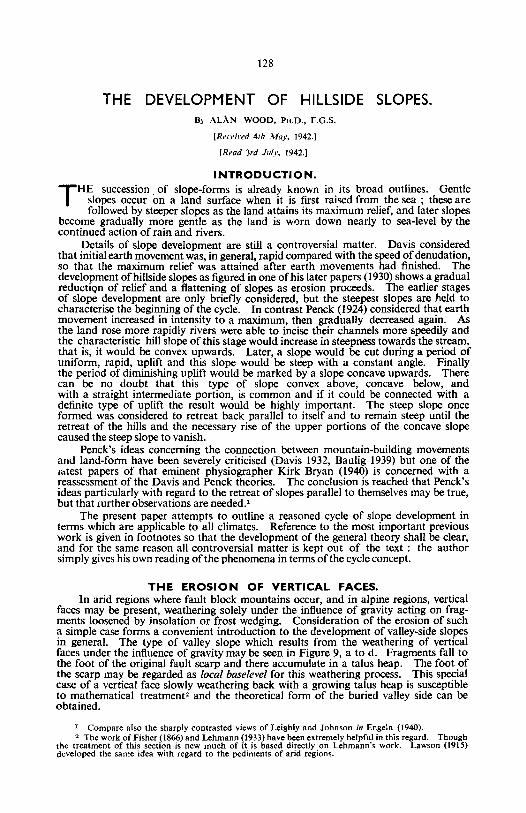
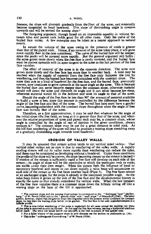
faces may be present, weathering solely under the influence of gravity acting on fragments loosened by insolation or frost wedging. Consideration of the erosion of sucha simple case forms a convenient introduction to the development of valley-side slopesin general. The type of valley slope which results from the weathering of verticalfaces under the influence of gravity may be seen in Figure 9, a to d. Fragments fall tothe foot of the original fault scarp and there accumulate in a talus heap. The foot ofthe scarp may be regarded as local baselevel for this weathering process. This specialcase of a vertical face slowly weathering back with a growing talus heap is susceptibleto mathematical treatment' and the theoretical form of the buried valley side can beobtained.
I Compare also the sharply contrasted views of Leighly and Johnson in Engeln (1940).2 The work of Fisher (1866) and Lehmann (1933) have been extremely helpful in this regard. Though
the treatment of this section is new much of it is based directly on Lehmann's work. Lawson (1915)developed the same idea with regard to the pediments of arid regions.
THE DEVELOP~ENT OF HILLSIDE SLOPES. 129
It is necessary first to consider an ideal case where the talus heap is not weatheredand it has the same volume as the parent rock. Let the face be assumed to be verticaland homogeneous. Under the conditions postulated-free gravity fall of fragmentsloosened from the face-there is no reason why any portion of the face should weatherback more rapidly than any other, and in fact the vertical wall will weather back parallelto itself leaving a scree or talus heap at its foot. Obviously when the scree forms itprotects the base of the rock face from weathering, and as the face above retreats, addingto the scree as it goes, a nose of rock will be left protruding into the scree (Fig. 9 b-e), Ifthe scree increased in height at a constant rate and the rock face weathered back at aconstant rate the buried face would have a uniform slope. This is never the case. Asthe wall weathers back and its base is buried there is less and less surface exposed tofurnish material for the scree. Also, as the scree grows its surface area increases. Hence
A
A:/.... :...:
A B
c DFIG. 9-DEVELOPMENT OF A CONSTANT SLOPE FROM A FAULT BLOCK SCARP WITH
FORMATION OF A CONVEX BURIED FACE.
This becomes tangent to the screeat the moment the last portion of the free facevanishes.
fewer and fewer fragments are spread over a constantly increasing area, and as thevertical face retreats it will do so more and more rapidly compared with the growth ofthe scree. Eventually the last remnants of the face will weather back and will furnisha very small amount of material to the scree, so that the buried face becomes tangentto the scree the moment the last portion of the vertical face is completely buried (Fig. 9 d).
Henceforth the face which weathers freely and whose slope is not subject to therestraint of baselevel will be termed the free face, while the surface of the scree or talusheap which accumulates under the influence of baselevel at a constant angle will betermed the constant slope. Though the scree has so far been assumed merely to pileup at the foot of the free face, in nature portions of it will usually be weathered to afiner state and will be carried by rainwash further from the foot of the hill. Since,in the presence of a local baselevel, the distance the material is carried depends on its
130 A. WOOD,
fineness, the slope will diminish gradually from the [foot of the scree. and eventuallybecome tangential to local baselevel. This slope of diminishing angle is concaveupwards and will be termed the waning slope.'
The foregoing argument. though based on an impossible equality in volume between talus and parent rock holds good for all other cases. Only the curve of theburied face varies. A few examples may be taken as a nearer approach to naturalevents.
In nature the volume of the scree owing to the presence of voids is greaterthan that of the parent rock. Hence, ifno removal of the scree takes place, it will growmore rapidly than in the case considered . The curve of the buried face will be steeper,since the peaks will be covered more rapidly. But the general argument still holds:the scree graws more slowly when the free face is partly covered, and the buried facemust be convex upwards with its apex tangent to the scree as the last portion of the freeface vanishes. .
The effect of removal of the scree is in the opposite direction . .The scree nowgrows more slowly and the free face hasmore time to weather back. A time may bereached when the supply of material from .the free face only balances the loss byweathering, and then the buried face becomes coincident with the constant slope. Thescree then acts as a kind of baselevel for tbe free face, and the buried face, previouslyconvex, now continues to grow upwards at the same angle as the scree. This is becausethe buried face can never become steeper than the constant slope, otherwise' materialwould roll down the scree and diminish its angle and it can never become less steep,otherwise materialwould fill in the hollows and raise its angle to that of the scree.
Should the angle of the free face be less than 90° the amount of material availableto build a scree is less, since this amount is controlled by the difference between tbeangle of the free face and that of the scree. The buried face here must have a gentlercurve, becoming coincident with the constant slope throughout when the angle of freeface 'was initially that of the scree. .
Therefore, as-a first approximation, it may be said that whatever be the angle ofthe initial slope (the free face), so long as it is greater than that of the scree, and whatever the relative proportions of scree and parent rock may be, a constant slope, whoseangle is controlled by the angle of rest of detritus in the given condit ions, alwaysreplaces it.' The constant slope may be cut for a great distance in solid rock. Atthe hill foot weathering of the scree will tend to produce a waning slope stretching awayat a gradually diminishing angle towards local baseleveJ.3
EROSION OF VALLEY WALLS.It may be assumed that stream action tends to cut vertical sided valleys. That
vertical sided valleys are so rare is due to weathering of the valley walls. A rapidlyeroding stream will cut its valley more rapidly than weathering can reduce the sides,and these may be considered as developing without a baselevel. Under these conditionsthe profile of'the slope will be convex. the slope becoming steeper as the stream is incised. 4
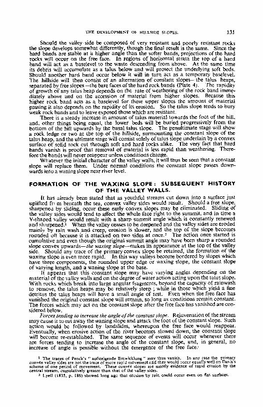
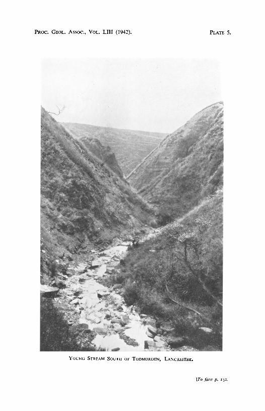
If erosion of the stream is sufficiently rapid a free face will develop on each side of thestream ; its angle of slope will be the maximum at which the particular rock or rocksare stable under their own weight. When the stream feels the influence of local ortemporary baselevel and ceases to cut down rapidly, a talus heap will accumulate oneach side of the stream as the free faces weather back (plate 5). The free faces retreatat an unchanged angle, for the slope is already at the maximum possible angle. As thetalus heap forms it grows up the side of the free face and the developmental history isexactly the same as that already considered for vertical walls. When the last remnantof the free face vanishes there is a constant slope down the hillside tailing off into awaning slope as the base of the hill is approached.
r The conseantslope and the wanina slope appear to correspond to the "Steilwand "and" Haldenhana" ofW. Penclc(l92-4) and to the "llIavity slope" and" wash slope" of Meyerholf(t9<CO). Tho latterauthor, howe ver, stated that his grevity slope was unllrlded while the present writer conoiden the constantslaDe, no 1_ than the waninll slope below, to be llIaded. The free face i. the only unanded element in ahilfaideprofile.
2 This iI true (when weatherina of the scree is nCll1ccted) for all casa eXCC\lt the 1imiq one whenall tho talua is removed as soon as formed . In this case the free face retreats, Iavq a horizontal plalfonnbelow ibelt. 'J1Ic wave cut bench below our Jea-clilfs is the best ex.ample of this ipCICiaI case,
3 For a fuller history of the conotant .Iope in arid climalel see the oection on ped.imenta (p . IJ().
of 1bII illbe" auf.teiaende Entwickluna .. ofW. ~""Ic (192-4).
PRO
C.
GEO
L.A
ssoc.,V
OL.
LU
I(1942).
PL
AT
E4.
[To
facep.
13
0.
THE DEVELOPMEI'T 0 1- HILLSI1)E SLOPES. 131
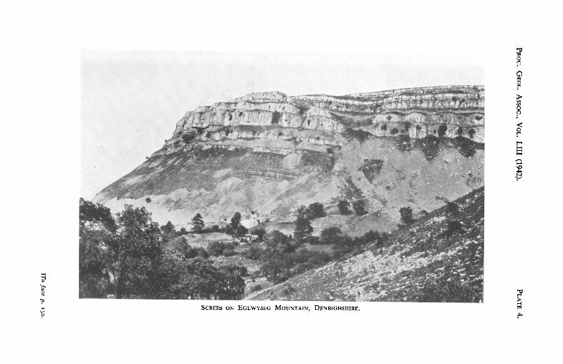
Should the valley side be composed of very resistant and poorly resistant rocksthe slope develops somewhat differently, though the final result is the same. Since thehard bands are stable at it higher angle than the softer bands, projections of the hardrocks will occur on the free face. In regions of horizontal strata the top of a hardband will act as a baselevel to the waste descending from above. At the same timeits debris will accumulate as a talus below and will protect the underlying soft beds.Should another hard band occur below it will in turn act as a temporary baselevel.The hillside will then consist of an alternation of constant slopes-the talus heaps,separated by free slopes-the bare faces ofthe hard rock bands (Plate 4). The rapidityof growth of any talus heap depends on the rate of weathering of the rock band immediately above and on the accession of material from higher slopes. Because thishigher rock band acts as a baselevel for these upper slopes the amount of materialpassing it also depends on the rapidity of its erosion. So the talus slope tends to bur yweak rock bands and to leaveexposed those which are resistant.
There is a steady increase in amount of talus mater ial towards the foot of the hill.and. other things being equal. the lower beds will be buried progressi vely from thebottom of the hill upwards by the basal talus slope. The penultimate stage will showa rock ledge or two at tbe top of the hillside, surmounting the constant slope of thetalus heap, and the ultimate stage will consist solely of talus slope underlain by a convexsurface of solid rock cut through soft and hard rocks alike. The very fact that hardbands vanish is proof that removal of materi al is less rapid than weathering. Therefore the bands will never reappear unless conditions change.
Whatever the initial character of the valley walls, it will thus be seen that a constantslope will replace them. Under normal conditions the constant slope passes downwards into a waning slope near river level.
FORMATION OF THE WAXING SLOPE: SUBSEQUENT HISTORYOF THE VALLEY WALLS.
It has already been stated that as youthful streams cut down into a surface justuplifted fr" m beneath the sea, convex valley sides would result. Should a free slope,sharpeneu by sliding, occur these early convex slopes may be eliminated. Sliding ofthe valley sides would tend to affect the whole face right to the summit. and in time aV-shaped valley would result with a sharp summit angle which is constantly renewedand sharpened.' When the valley ceases to be deepened and the valley sides are erodedmainly by rain washand creep, erosion is slower, and the top of the slope becomesrounded off because it is attacked on two sides at once.' The action once started iscumulative and even though the original summit angle may have been sharp a roundedslope convex upwards-the waxing slope-makes its appearance at the top of the valleyside. Should any trace of the primary convex slope be retained, the formation of thewaxing slope is even more rapid. In this way valleys become bordered by slopes whichhave three components, the rounded upper edge or waxing slope , the constant slopeof varying length, and a waning slope at the base.
It appears that this constant slope may have varying angles depending on thematerial of the valley walls and on the degree of water action act ing upon the talus slope.With rocks which break into large angular fragments, beyond the capacity of ra inwashto remove, the talus heaps may be relatively steep ; while in those which yield a finedetritus the talus heaps will have a smal1 angle of rest. Even when the free face hasvanished the original constant slope will remain, so long as conditions remain constant.The forces which may act on the constant slope after the free face has vanished are considered below.
Forces tending to increase the angle ofthe constant slope. Rejuvenation of the streammay cause it to eat away the waning slope and attack the foot of the constant slope . Suchaction would be followed by landslides, whereupon the free face would reappear.Eventually, when erosive action of the river becomes slowed down, the constant slopewill become re-established. The same sequence of events will occur whenever thereare forces tending to increase the angle of the constant slope. and, in general, noincrease of angle is possible without the emergence of the free face:
1 "he traces of Penck's ., aufste igende Entwicklung " may thus vanish. In any case the pr imaryconvex valley sides are not the trace of more rapid movement r nd they wo uld occur equally well on Davis'sscheme of one period of movement , These convex slopes are merely evidence of rapid erosion by thecentral stream, cumulatively greater than that of the valley sides.
2 l.ye ll (I83~ , p_ 186) showed long ago that erasion by rain could occur even on lIat surfaces.
132 A. WOOD,
Forces tending to keep the angle of the constant slope the same . The foremost ofthese is probably the formation of a cover of vegetation whereby erosion is restrictedand lessened. The material which can be removed is limited, and a grass or tree coveracts both by breaking the force of raindrops and by binding the soiltogether. Probablyonly material Brought up by earthworms' and other burrowing creatures is normallyremoved from grass-covered hill slopes . Because the amount of this material normallyavailable over a given area isconstant the slope retreats parallel to itself.
Forces tending to reduce the angle of the constant slope. The chief of these is undoubtedly weathering. When the free face has vanished the supply of talus materialfalls off. The surface material of the constant slope becomes weathered more finelyand hence more easily distributed down the slope, so that the angle becomes reduced.When the weathering takes place chiefly beneath a grass or tree cover, surfaceerosion is restricted and chemical action is more intense . The subsoil becomesmore finely divided and weathered more deeply. Since the original constant angle wasone based on a particular size of fragments the slopes become gradually more unstableand sliding may occur.' The free face may emerge from the top of the slide and willtend to form the old constant slope again. Landslides may again occur when the newfree face has vanished, until, by repetition of perhaps several such periods of sliding andstability, a new constant slope at a lower angle is established when the free face fails toreappear. .
Another factor tending to cause decreases of slope would be increased rainfalIwhereby rainwash erosion is accentuated. Again adjustment will tend to take placeby landslides with exposure ofa new free face at the top of the hill. Under the changedconditions however.. the new constant slope formed from the free face will be morestable since it developed under the influence of the new conditions.
It would thus appear that whether factors tending to increase or to decrease theconstant slope are in operation, a new constant slope will always form and it will liebetween the waxing and waning slopes. The constant slope is a prominent feature ofregions of high or moderately high relief but it is absent in regions of low relief. Theremust be some factors which cause the constant slope to vanish after long periods of time.
A typical valley side with waxing, constant and waning slopes, may be consideredto border a stream which has completed most of its work and is cutting down relativelyslowly. As the hillside weathers back the constant slope will retreat back paralIel toitself for a while, but the action of the factors just considered causes a gradual lesseningin steepness of the constant slope. This means that more material is delivered to thewaning slope and the latter rises up the hillside. Also, as the distance from the streamincreases the waning slope has to rise up the constant slope to retain "no ugh inclinationto carry away detritus. This action is only very partially checked by a decrease inangle of the waning slope caused by increased weathering and comminution of the rockparticles. As the hill tops weather down, the waxing slope also wilI encroach on theconstant slope and attacked from above and below the constant slope finally vanishes.The only relic of its existence is the point of inflexion from the convex waxing to theconcave waning slope on the hillside and henceforth, if conditions remain constantthe constant slope never reappears in the landscape. As the hill tops weather down thewaxing slopes are reduced from above, their angle of slope diminishes and the waningslopes continue to grow upwards at their expense. Finally a very subdued topographyresults.
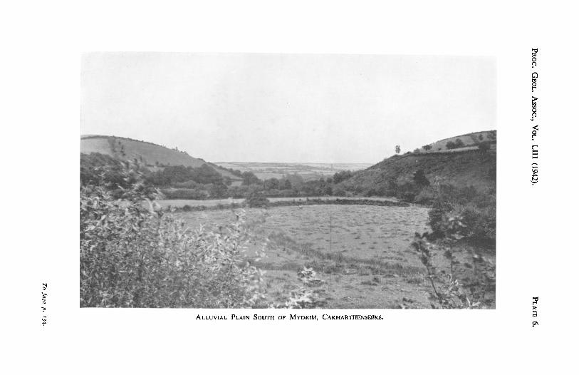
The growth of a delta at the mouth of the river may cause alluviation of the riverbed and interference with the previously considered ideal cycle. Whereas lateralcorrasion by the stream has previously been at a minimum, because the river has beencontinualIy eroding its bed and thus entrenching itself and the work has continualIy tobe started anew, now this process has fulI play. The building of an alluvial plainand the erosion and burial of the waning slopes will occur in those portions of the streamdirectly related to general base level. In these regions the waning slope may be entirelydestroyed or buried and the flat flood plain may abut directly against the constant orwaxing slopes (Plate 6). It is obviously important to distinguish such convex valleysides from those of the youthful period of development, but fortunately distinctionis easy. In the former case the convex valley sides will abut abruptly against a broadflat flood plain, while in the youthful stage they will descend to the narrow boulderstrewn bed of an actively eroding stream.
, Sec Darwin (1881) for an estimate of its amount.. ' Such .lidinll may be started by earthquakes. See Cotton (1940), Text Fill. I.
PROC. G EOL. Assoc. , VOL. LIII (1942). PLATE 5.
YOUNG S TREAM S OUTH OF TODMORDEN , L ANCASIII RE.
[To face p, 132 .
THE DEVELOPMENT OF HILl.SIDE SLOPES. 133
There is another more general factor which assists peneplanation, particularlyin the mature and old age portions of the cycle. This is the rise in sea-level causedby sediment poured into the sea.' Baselevel will rise continuously as rivers carrymaterial into the sea and the conclusion seems inescapable that widespread alluviationand latesal corrasion must occur in all rivers all over the world in periods of relativecrustal stability. This must be an important factor in the mak ing of peneplanes.
A B c
D E
F
. . •....•...: \~ :-: :.:.:-:.:::.:-.::.::>-,: :.:.•... :.: ~; , .
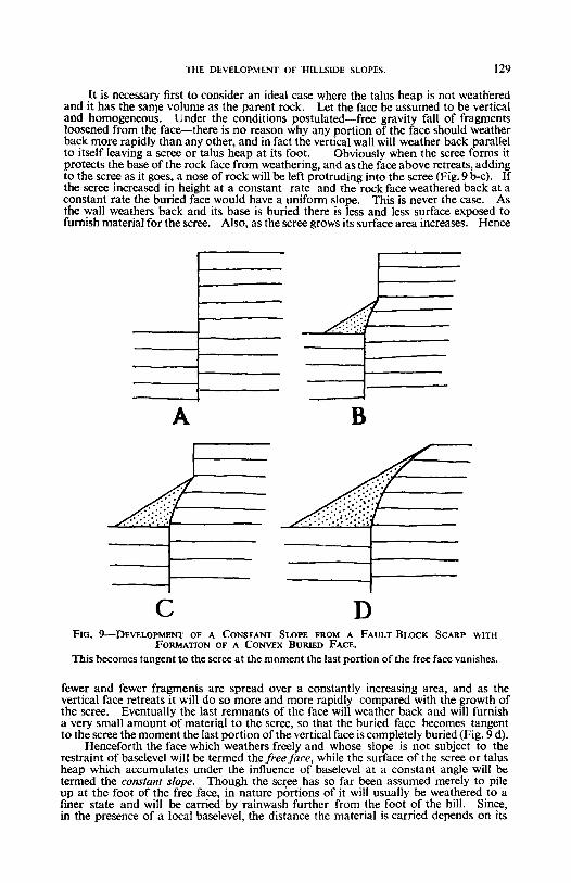
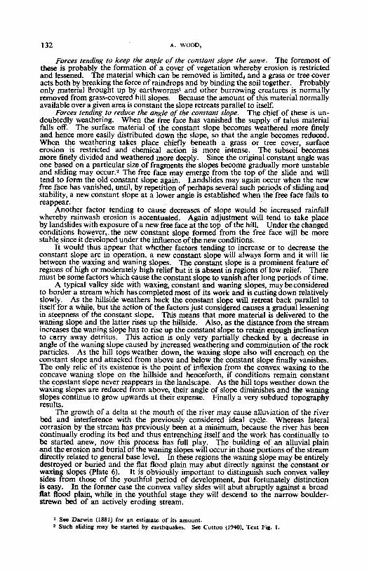
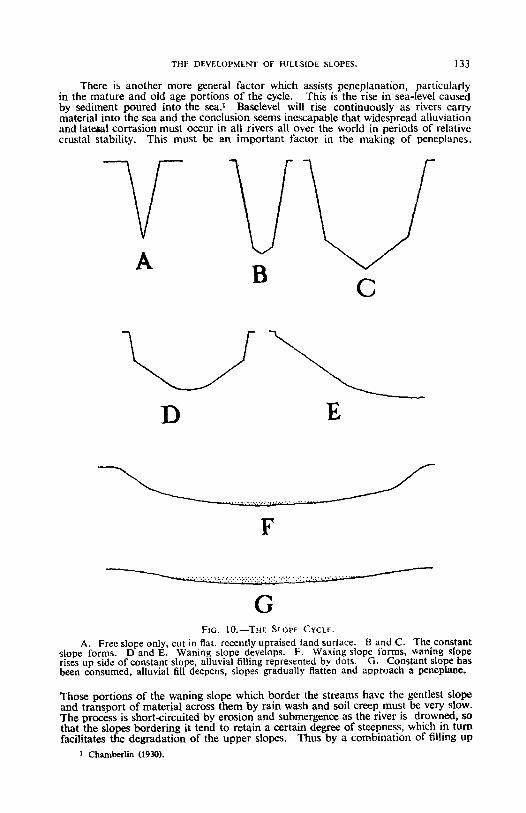
GFIG. IO.-T!lF. SLOPE CYCLE.
A. Free slope only, cut in flat, recently upraised land surface. Band C. The constantslope forms. D and E. Waning slope develops. P. Waxing slope forms, waning sloperises up side of constant slope, alluvial filling represented by dots. G. Constant slope hasbeen consumed, alluvial fill deepens, slopes gradually flatten and approach a peneplane,
Those portions of the waning slope which border the streams have the gentlest slopeand transport of material across them by rain wash and soil creep must be very slow.The process is short-circuited by erosion and submergence as the river is drowned, sothat the slopes bordering it tend to retain a certain degree of steepness. which in tumfacilitates the degradation of the upper slopes. Thus by a combination of filling up
I Chamberlin (1930).
134 A. WOOD,
of the valleys, lateral corrasion by meandering streams, and slow degradation of theinterftuves the land surface is reduced to a peneplane.
The slope cycle may be summarized as follows (Fig. 10). The first rivers on anuplifted land surface of low relief will cut tiny valleys, with convex sides. As reliefincreases and streams cut down more vigorously the free slope appears and becomesintensified. When downward erosion slackens the constant and waning slopes appear,and the constant slope grows upwards and buries the free face. As the free facevanishes the waxing slope develops, The waning slope and waxing slope growupwards and downwards respectively, eventually causing the constant slope to vanish.Finally alluviation and lateral corrasion become dominant, the waning slope isprogressively eroded and submerged from the base, and it climbs ever more slowlyup the face of the waxing slope. A very subdued relief, closely similar to that of theoriginal uplifted surface, results.
In nature many variations of this cycle must occur. The most divergent caseis when uplift of the original surface is slow in comparison with erosion. The constantslope then never appears, and waxing and waning slopes will dominate· the landscapefrom the earliest times. Between this and the first case all possible variations lie, sothat this cycle of slope development may be considered to be of general application.
DEVELOPMENT OF COMPLEX NATURAL SLOPES.The foregoing discussion has dealt with simple cases only. In nature things are
much more complicated. Moulding of actual valley walls depends on four interdependent factors, the erosive activity of the stream which borders the slope, theintensity of transport on the slope itself, the material making up the valley side, andthe intensity and products of weathering. There can be no doubt that there is aclose relation between the steepness of the valley sides and the rate of downcuttirigof the central stream. If sufficient time is allowed the slopes will so change thatthe vertical thickness of material removed by the stream is exactly equal to the verticalthickness of material removed from the valley sides. In other words, as the streamcuts down more rapidly the slopes become steeper; if it cuts down more slowly theyflatten. Owing to the differing rates of stream and valley side erosion there is alwaysa lag in the adjustment of erosive action which complicates discussion of actual slopeforms.
If transport ofmaterial on the hillsides is active, and material is available, the slopesbecome adjusted more rapidly to the vagaries of the bordering stream-that is theybecome flatter if the stream has ceased to erode, and become steeper if it is eroding morerapidly than before.
Resistant valley walls become adjusted more slowly ; should the valley wallsbecome more steep they retain their original low angles longer and they also take alonger time to flatten than do valley walls made up of less resistant rocks. Shouldthe same stream be passing through shale and sandstone country it is commonplacethat the shale regions will show wide valleys with concave waning slopes well developed while the sandstones form narrow valleys with craggy free faces still remaining.
Finally, the intensity of weathering also affects valley form. Only material thatcan be transported can be removed, and in some cases the rate of weathering may bethe limiting factor. Also, should the material of the rock attacked and the intensityof weathering be such that large fragments result, the slope will be steeper than in theweathering of materials such as clay which readily breaks up into easily transportablematerial.
Notwithstanding the complication of the interaction of all these different processes,it is felt that the present cycle of slope forms affords a rational method of slope description and can beadapted to the most diverse conditions.
DISCUSSION AND APPLICATION OF THESE PRINCIPLES.The graded river and graded slope. Strong criticism has recently been directed'
against the concept of grade in rivers. A river was considered to be graded by Davis(1902) when it neither eroded its bed nor deposited material thereon. Grade wasdefined as .. a condition of essential balance between corrasion and deposition usuallyreached by rivers in the mature stage of their development, when their slopes have been
r Kesselli (1940) states .. Balance between the power of a stream and its load is maintained,neither in youth. maturity nor old .'C."
PR
OC
.G
EO
L.
Assoc.,
VO
L.
LU
I(1942).
PL
AT
E6.
To
jacen-
134·
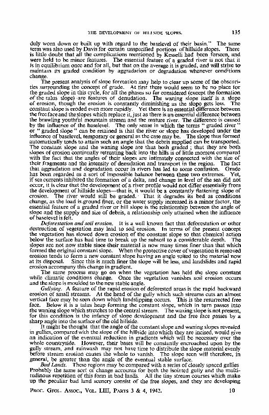
THE DEVELOPMENT OF HILLSIDE SLOPES. 135
duly worn down or built up with regard to the baselevel of their basin." The sameterm was also used by Davis for certain unspecified portions ofhillside slopes. Thereis little doubt that all the complications mentioned by Kesselli had been forseen, andwere held to be minor features. The essential feature of a graded river is not that itis in equilibrium once and for all, but that on the average it is graded, and will strive to"maintain its graded condition by aggradation or degradation whenever conditionschange.
The present analysis of slope formation may help to clear up some of the obscurities surrounding the concept of grade. At first there would seem to be no place forthe graded slope in this cycle, for all the phases so far considered (except the formationof the talus slope) -are features of denudation. The waning slope itself is a slopeof erosion, though the erosion is constantly diminishing as the slope gets less. Theconstant slope is eroded even more rapidly. Yet there is an essential difference betweenthe free face and the slopes which replace it, just as there is an essential difference betweenthe brawling youthful mountain stream and the mature river. The difference is causedby the influence of the baselevel. The only sense in which the terms .. graded river"or .. graded slope" can be retained is that the river or slope has developed under theinfluence of baselevel, temporary or general as the case may be. The slope thus formedautomatically tends to attain such an angle that the debris supplied can be transported.The constant slope and the waning slope are thus both graded ; that they are bothslopes of erosion continually retreating back into the hills is of little moment comparedwith the fact that the angles of their slopes are intimately connected with the size oftheir fragments and the intensity of denudation and transport in the region. The factthat aggradation and degradation occur in rivers has led to some confusion. Gradehas been regarded as a sort of impossible balance between these two extremes. Yet,if sea currents inhibited the formation of a delta, and change in level of the sea did notoccur, it is clear that the development of a river profile would not differ essentially fromthe development of hillside slopes-that is, it would be a constantly flattening slope oferosion. The river would still be graded. That it degrades its bed as conditionschange, as the load is ground finer, or the water supply increased is a minor factor, theessential feature of a graded river or hill slope is the relationship between the angle ofslope and the supply and size of debris, a relationship only attained when the influenceof baselevel is felt.
Deforestation and soil erosion. It is a well known fact that deforestation or otherdestruction of vegetation may lead to soil erosion. In terms of the present conceptthe vegetation has slowed down erosion of the constant slope so that chemical actionbelow the surface has had time to break up the subsoil to a considerable depth. Theslopes are not now stable since their material is now many times finer than that whichformed the original constant slope. When the protective cover ofvegetation is removederosion tends to form a new constant slope having an angle suited to the material nowat its disposal. Since this is much finer the slope will be less, and landslides and rapiderosion accompany this change in gradient.
The same process may go on when the vegetation has held the slope constantwhile climatic conditions change. Once the vegetation vanishes soil erosion occursand the slope is moulded to the new stable angle.
Gullying. A feature of the rapid erosion of deforested areas is the rapid backwarderosion of small streams. At the head of the gully which such streams cuts an almostvertical face may be seen down which landslipping occurs. This is the resurrected freeface. Below it is a talus heap forming the constant slope, which in turn passes intothe waning slope which stretches to the central stream. The waxing slope is not present,for this condition is the infancy of slope development and the free face passes by asharp angle into the surface of the old hillside.
It might be thought that the angle of the constant slope and waning slopes revealedin gullies, compared with the slope of the hillside into which they are incised, would givean indication of the eventual reduction in gradients which will be necessary over thewhole countryside. However, their bases will be constantly encroached upon by thegully stream, and rainwash may not have time to distribute the slope material evenlybefore stream erosion causes the whole to vanish. The slope seen will therefore, ingeneral, be greater than the angle of the eventual stable surface.
Bad Lands. These regions may be compared with a series of closely spaced gulliesProbably the same sort of change accounts for both the isolated gully and the multitudinous repetition of this form in bad lands. All the tiny stream courses which makeup the peculiar bad land scenery consist of the free slopes, and they are developing
PROC. GEOL. Assoc., VOL. LUI, PARTS 3 & 4, 1942. 10
136 A. WOOD,
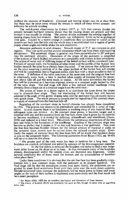
without the restraint of baselevel. Constant and waning slopes may lie at their foot.but these may be eaten away should the stream (0 which all these minor streams aretributary be actively eroding.
The well-known observation by Gilbert (1877, p. 122) that convex divides arepresent between bad land streams shows that the waxing slopes are present and thaterosion is not usually by sliding. The convex divides represent the coming together ofwaxing slopes from two streams. Bad lands are ephemeral forms so far as geologicaltime goes. Caused by a recent change in conditions they are doomed to vanish as thestreams eat back into the hills and "thewhole area is reconstituted into a region of gentleslopes whose angles are stable under the new conditions.
Mountain pediments in arid climates. Smooth slopes of 3°-5" are common in aridregions. They rise up to and lap around mountains which rise from them with startlingabruptness.' The mountain slopes in general vary from perpendicular to 20° and passinto the pediment abruptly. Discussion of the origin of the pediment is simplifiedif the erosion of block faulted mountains in a completely arid climate is first considered.The action of water and of differing slopes of the initial surface will be considered later.Erosion of vertical walls, the formation of talus slopes and the profile of the buried facehidden beneath the talus have already been discussed. [fwe assume that deflation actson the talus removing a portion of it, the upper portion of the buried face will emergeand will be transformed into a fragment strewn rock face with a slope parallel to that ofthe scree. If deflation of the talus continues at the same rate and the original free faceis continually worn back, a time is reached when supply of material from the mountain above falls off and the scree tends to vanish. As the scree diminishes the buriedface will be truncated as it becomes exposed, always at a constant angle limited by thatof the talus slope. The end stage will show a few vertical walled inselberge risingabruptly from a slope cut at a constant angle from the solid rock."
The action of water in a desert region is to distribute the scree down the slopesand to diminish their angle. Then the weathering of the buried face will becomeadjusted to the angle of this gently sloping talus and the pediment may ultimately have avery gentle slope. The whole process is complicated by regrading of the constant slope.as supply ofmaterial from the free face falls olf.
Regrading of the constant slope in humid climates has already been considered(p .132). The process was shown to be intermittent and controlled by a cover of vegetation . In arid climates there is no hindrance to washing away of any material that theinfrequent rains can remove. As the constant slope grows, it becomes longer and issupplied with less and less material from the free face, more time is given for its materialto become weathered, it is eroded by deflation, streamfloods and sheetfloods (Davis,1938) and reduced to a lower level. This entails the continuous resurrection of the freeface and helps in the formation of the inselberge . Grading of the constant slope maybecome so perfect that it slopes at 5° or less and becomes a true pediment. Now eventhe free face becomes boulder strewn, for the limited amount of material it yields tothe constant slope cannot now be carried down the reduced constant slope. Eventually the supply of material from the free faces falls olf so much that boulders decayin situ on the mountain slopes . The following quotations from Bryan (1922, pp. 44-45)will serve to describe this phase .
" The greater part of the rock waste has been in position for a long time. Theboulders are cracked. exfoliated and pitted by solution of the ferromagnesian minerals. . . . . As the fine debris is removed the boulders roll down to find a new lodgement either lower on the slope or at its base . In this movement many of the bouldersalready disintregrated within the outside crust, are shattered into fragments. Undernormal conditions few of them reach the bottom and no accumulation of boulderstakes place there."
Under these conditions it is obvious that the old free face has been gradually transformed into a new constant slope, with the pediment as its present baselevel. Thefinal stage will be that the mountains retreat ever more slowly, the pediments are regraded by sheet flood and stream flood until they unite over the worn down summits.Should occasional rains continue the pediments will be worn down to lower and lowerangles as the rock of their surface is weathered even more finely and the final result willbe a desert peneplane.
I See Bryan (1922. t925) for an excellent description and discussion of these features.Z The theory of Lawson (t915) was essentially the same as this, though he deals with an aggrading
talus only.
THE DEVELOPMENT OF HILLSIDE SLOPES. 137
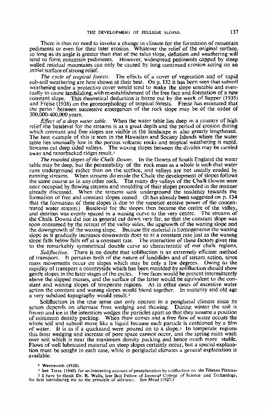
There is thus no need to invoke a change in climate for the formation of mountainpediments or even for their later erosion. Whatever the relief of the original surface,so long as its angie is greater than that of the talus slope, deflation and weathering willtend to form mountain pediments. However, widespread pediments capped by steepwalled residual mountains can only be caused by long continued erosion acting on aninitial surface ofstrong relief.
The cycle of tropical forests. The effects of a cover of vegetation and of rapidsub-soil weathering are here shown at their best. On p. 132 it has been seen that subsoilweathering under a protective cover would tend to make the slope unstable and eventually to cause landsliding, with re-establishment of the free face and formation of a newconstant slope. This theoretical deduction is borne out by the work of Sapper (1935)and Freise (1938) on the geomorphology of tropical forests . Freise has estimated thatthe perio. i between successive ernergences of the rock slope may be of the order of300,QOO.400,OOO years .
Effect ofa deep water table. When the water table lies deep in a country of highrelief the baselevel for the streams is at a great depth and the period of erosion duringwhich constant and free slopes are visible in the landscape is also greatly lengthened.The best example of this is seen in the Hawaiian and Society Islands where the watertable lies unusually low in the porous volcanic rocks and tropical weathering is rapid.Streams cut deep sided valleys. The waxing slopes between the divides may be carriedaway and razorbacked ridges result.'
The rounded slopes of the Chalk Downs. In the Downs of South England the watertable may be deep, but the permeability of the rock mass as a whole is such that waterruns underground rather than on the surface, and valleys are not usually eroded byrunning streams. When streams do erode the Chalk the development of slopes followsthe same course as in any other rock . The many dry valleys of the Chalk Downs wereonce occupied by flowing streams and moulding of their slopes proceeded in the manneralready discussed. When the streams sank underground the tendency towards theformation of free and constant slopes ceased. (It has already been suggested on p. 134that the formation of these slopes is due to the superior erosive power of the concentrated water stream .) Baselevel for the slopes then became the centre of the valley,and detritus was evenly spaced in a waning curve to the very centre. The streams ofthe Chalk Downs did not in general cut down very far, so that the constant slope wassoon consumed by the retreat of the valley sides, the upgrowth of the waning slope andthe downgrowth of the waxing slope . Because the material is homogeneous the waxingslope as it gradually increases downwards does so at a constant rate just as the waningslope falls below falls off at a constant rate . The interaction of these factors gives riseto the remarkably symmetrical double curve so characteristic of our chalk regions.
Solifluction. There is no doubt that solifluction is an extremely efficient methodof transport. It partakes both of the nature of landslides and of stream action, sincemass movements occur on slopes which may be only a few degrees . Owing to therapidity of transport a countryside which has been moulded by solifluction should showgentle slopes in the later stages of the cycles. Free faces would be present intermittentlyabove the slipped masses, and the surface of the latter would be equivalent to the constant and waning slopes of temperate regions. As in other cases of excessive wateraction the constant and waning slopes would blend together. In maturity and old agea very subdued topography would result .>
Solifluction in the true sense can only operate in a periglacial climate since itsaction depends on alternate frost wedging and thawing. During winter the soil isfrozen and ice in the interstices wedges the particles apart so that they assume a positionof minimum density packing. When thaw comes and a free flow of water occurs thewhole soil and subsoil move like a liquid because each particle is cushioned by a filmof water. It is as if a quicksand were poured on to a slope.r In temperate regionsthis frost wedging and increase of pore space cannot occur, and the spring rains washover soil which is near the maximum density packing and hence much more stable.Flows of well lubricated material on steep slopes certainly occur, but a special explanation must be sought in each case, while in periglacial climates a general explanation isavailable.
, Wentworth «928).1 See Terra (l94O) for an interesting account of peneplanation by solifluction on the Tibetan Plateau.3 I have to thank Dr. R. Walls, late Beit fellow of Imperial College o f Science and Technology,
for first introducing me to the principle of dilatancy: See Me-ad (1925.)
138 A. WOOD,
Once the fine material which traps the water essential for solifluction has beenwashed away, solifluction ceases. The rock rivers of the Falkland Isles are relativelystationary now and are only the relics offormer flows under a severer clirnate.r
Dr. Gilbert Wilson has very kindly read this paper in typescript and made a numberof helpful suggestions, and the photographs shown on Plates 4-6 are reproduced by permission of the Director of the Geological Survey and Museum.
REFERENCES.ANDERSSON, J. G. 1906. Solifluction, a Component of Subaerial Denudation. Journ,
Geol., vol. xiv, p, 91.BAULlG, H. 1939. Sur les " Gradins de Piedmont." Journ. Geomorph, vol. ii, p. 28\.BRYAN, K. 1922. Erosion and Sedimentation in the Papago Country, Arizona. U.S.
Geol. Survey sun; 730-B.----. 1925. The Papago Country, Arizona. U.S. Geol. Survey, Water Supply
Paper 499.----. 1940. The Retreat of Slopes. Annals Assoc. Amer. Geographers, vol. 30,
p.254.CHALLINOR, J. 1930. The Curve of Stream Erosion. Geol. Mag., p. 61.CHAMBERLIN, R. T. 1930. The Level of Baselevel. Journ. Geol., vol. xxxviii, p. 166.Corrox, C. A. 1941. Landscape, as developed by the Processes 0/ Normal Erosion. Camb.
Univ. Press.DARWIN, C. 1881. The Formation 0/ Vegetable Mould through the Action 0/ Worms, etc.,
London. .DAVIS, W. M. 1902. Baselevel, Grade and Peneplain. Journ. Geol., vol. x, p. 77.----. 1930. Rock Floors in Arid and in Humid Climates. Journ. Geol., vol. xxxviii,
pp. I, 136.----. 1932. Piedmont Benchlands and Primarrumpfe. Bull. Geol. Soc. Am., vol. xliii,
p.399.----. 1938 Sheetfloods and Streamfloods. Bull. Geol. Soc. America, vol. xlix, p. 1337.ENGELN, O. D. YON. 1940. Symposium: Walther Penck's Contribution to Geomor
phology. Ann. Assoc. Amer, Geographers, vol, xxx, p. 219.FISHER, O. 1866. On the Disintegration of a Chalk Cliff. Geol. Mag., vol. iii, p. 354.FREISE, F. W. 1938. Inselberge und Inselberg-Landschaften im Granit und Gneissgebiete
Brasiliens. Zeitschr, f. Geomorph., vol. 10, p. 137GILBERT, G. K. 1877. Report on the Geology of the Henry Mountains. U.S. Geogr,
and Geol. Survey Rocky Mt, Region.KEssELl, J. E. 1941. The Concept of the Graded River. Journ. Geol., vol. xlix, p. 561.LAWSON, A. C. 1915. The Epigene Profiles of the Desert. Univ. Calif. Publ. Geol.,
vol, ix, no. 3.LEHMANN, O. 1933. Morphologische Theorie der Verwitterung von Steinschalgwanden.
Vierteljahrsch, d. Naturforsch, Gesell. Zurich, vol. 87, p. 83.LYELL, C. 1835. Principles of Geology, vol. iii, 4th ed. London.MEYERHOFF. H. A. 1940. Migration of Erosional Surfaces. Ann. Soc. Amer. Geographers
vol. xxx, p. 247.PENCK, W. 1924. Die Morphologische Analyse. Stuttgart.RICH, J. L. 1935. Origin and Evolution of Rock Fans and Pediments. Bull. Geol. Soc.
America, vol. xlvi, p. 999.SAPPER, K. 1935. Geomorphologic der Feuchten Tropen. Geogr. Schriften, Heft 7.TERRA, H. DE. 1940. Some Critical Remarks concerning W. Penck's Theory of Piedmont
Benchlands in Mobile Mountain Belts. Ann. Assoc. ArneI'. Geographers, vol. xxx,p.241.
WENTWORTH, C. K. 1928. Principles of Stream Erosion in Hawaii. Journ. Geol., vol.37, p. 385.
DESCRIPTION OF PLATES 4-6.PLATE 4.
Eglwyscg Mountain; from ncar Tan-y-Craig, Denbighshire, looking North-East.Showing the development of constant slopes below the free faces formed by resistant limestone beds, and burial of the lower limestones by scree. The formation of a constant slopecut in solid rock is well seen on the left of the picture and its angle is visibly controlled bythe angle of repose of the scree. (H.M. Geological Survey photograph.)
PLATE 5.Stream in Ramsden Wood, two miles south of Todmorden, Lanes. A young valley,
with rapidly downcutting stream. Valley sides showing free faces on the convex side of a
I See Andersson (1906).
THE DEVELOPMENT OF HILLSIDE SLOPES. 139
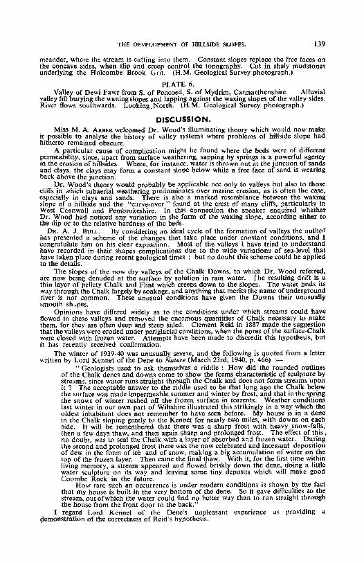
meander, whcre the stream is cutting into them. Constant slopes replace the free faces onthe concave sides, when slip and creep control the topography. Cut in shaly mudstonesunderly ing the H olcombe Brook Grit. (H .M. Geological Survey photograph .)
PLATE 6.Valley of Dewi Fawr from S. of Pcncoed, S. of Mydrim, Carmarthenshire. Alluvial
valley fill burying the waning slopes and lapping against the waxing slopes of the valley sides.River flows southwards. LookingNorth. (H.M. Geological Survey photograph .)
DISCUSSION,Miss M. A. ARBER welcomed Dr. Wood's illuminating theory which would now make
it possible to analyse the history of valley systems where problems of hillside slope hadhitherto remained obscure.
A particular cause of complication might be found where the beds were of differentpermeability, since, apart from surface weathering, sapping by springs is a powerful agencyin the erosion of hillsides. Where, for inslance, water is thrown out at the junction of sandsand clays. the clays may form a con stant slope below while a free face of sand is wearingback above the junction.
Dr. Wood's theory would probably be applicable not only to valleys but also to thosecliffs in which subaerial weathering predominates over marine erosion, as is often the case,especially in clays and sands. There is also a marked resemblance between the waxingslope of a hillside and the "curve-over" found at the crest of many cliffs, particularly inWest Cornwall and Pembrokeshire. In this connection the speaker enquired whetherDr. Wood had noticed any variation in the form of the waxing slope, according either tothe dip or to the relative hardness of the beds.
DR. A. J . BULL. By considering an ideal cycle of the formation of valleys the authorhas presented a scheme of the changes that take flace under constant conditions, and Icongratulate him on his clear exposition. Most 0 the valleys I have tried to understandhave recorded in their shapes complications due to the wide variations of sea-level thathave taken place during recent geological times; but no doubt this scheme could be appliedto the details.
The slopes of the now dry valleys of the Chalk Downs, to which Dr. Wood referred,-are now bein g denuded at the surface by solution in rain water . The resulting drift is athin layer of pellcty Chalk and Flint which creeps down to the slopes. The water finds itsway through the Chalk largely by soakage, and anything that merits the name ofundergroundriver is not common. These unusual cond itions have given the Downs their unusuallysmooth sh i oes,
Op inions have differed widely as to the conditions under which stre ams could haveflowed in these valleys and removed the enormous quantities of Chalk necessary to makethem, for they are often deep and steep sided. Clement Reid in 1887 made the suggestionthat the valleys were eroded under periglacial conditions, when the pores of the surface-Chalkwere closed with frozen water. Attempts have been made to discredit this hypothesi s, butit has recentl y received confirmation.
The winter of 1939-40 was unusually severe, and the following is quoted from a letterwritten by Lord Kennet of the Dene to Nature (March 23rd, 1940, p. 466) :-
" Geologists used to ask. themsel ves a riddle : How did the rounded outlinesof the Chalk denes and downs come to show the forms characteristic of sculpture bystreams. since water runs straight through the Chalk: and does not form streams uponit ? The acceptable answer to the riddle used to be that long ago the Chalk belowthe surface was made impermeable summer and winter by frost, and that in the springthe snows of winter rushed off the frozen surface in torrents. Weather conditionslast winter in our own part of Wiltshire illustrated this strikingly in a way which theoldest inhabitant does not remember to havc seen before. My house is in a denein the Chalk sloping gently to the Kenner for nearly two miles, with downs on eachside. It will be remembered that there was a sharp frost with heavy snow-falls,then a few days thaw, and then again sharp and prolonged frost. The effect of this,no doubt, was to seal the Chalk with a layer of absorbed and frozen water . Duringthe second and prolonged frost there was the now celebrated and incessant depositionof dew in the form of ice and of snow, making a big accumulation of water on thetop of the frozen layer. Then came the final thaw. With it, for the first time withinliving memory, a stream appeared and flowed briskly down the dene, doing a littlewater sculpture on its way and leaving some tiny deposits which will make goodCoombe Rock in the future .
How rare such an occurrence is under modern conditions is shown by the factthat my house is built in the very bottom of the dene. So it gave difficulties to thestream, out ofwhich the water could find no better way than to run straight throughthe house from thc front doo r to the back ."
] regard Lord Kennet of thc Dene 's unpleasant experience as pro viding ademonstration of the correctness of Reid's hypothe sis.
140 THE DEVELOPMENT OF HILLSIDE SLOPES.
Mr. A, S. KENNARD wished to congratulate the author on the careful work hehad given, but doubted if there were any analogy between arid regions and a country like theSouth East of England with a mantle of vegetation. One thing was certain that a sectionacross the valleys of the Chalk streams of Kent did not show the hypothetical valley withequally sloping sides. The Cray, Darenth, Elbsfleet and Medway all had a long gentleslope on the East with but little deposition and on the west there were buried Chalk cliffsnearly vertical sometimes with Pleistocene deposits at their base. At a later period hugesludge streams had poured over the cliffs from the ground above burying them and thepresent slope of the hill was not due to erosion but later deposition.
Mr. WILLIAM PLATT. Dr. Wood has presented a carefully argued paper, for which wethank him ; but 1 regret the absence of any reference to the tilt of strata and of joints,because in the study of hill or mountain scenery this may prove to be a very important, or,indeed, a dominating feature. I recall instances in the Millstone Grit of the Pennines, andespecially in some of the coast scenery of Pembrokeshire, where the angle of displacementis ninety degrees and the whole scenic effect is derived from this dramatic dislocation.And there are countless other examples.
I would also like to add that in discussing arid regions the effect of the wind is veryimportant. Those who, like myself; have seen a minor sand-storm in the Sahara will realisethe enormous part played by the desert winds in the distribution of sediments, the moreespecially as there is no vegetation to bind together the land surface. I offer these suggestionspurely in the interest of completeness.
MIss M. M. SWEETING said from observations in areas of massive limestone it seemedpossible that Dr. Wood's waxing or convex slope developed much earlier in the cycle heproposed than in landscapes formed on other rock types. The speaker inquired whetherthe effects of chemical weathering would very much modify the cycle of hillside slopes theauthor had outlined, as convexity of profile is dominant in even youthful limestone landscapes. In the North of England separation between the limestone scars and the screebelow-e-corresponding to the author's 'free face' and 'constant slope '-is clearly seen ;to what extent has this analysis been disturbed by the Quaternary glaciation which depositedboulder clay at a similar angle to the scree, thereby causing a pseudo-constant slope ?
The speaker also asked how recent observations by the American gcomorphologist,Kirk Bryan, on the relative speed of weathering and solution processes during the latterstages of the erosion cycle would affect Dr. Wood's cycle of hillside slopes.
PROF. A. E. TRUEMAN welcomed this attempt to develop a hypothesis of valley slopes.Even if Dr. Wood's views were not accepted in detail the terminology proposed afforded auseful basis for the recording of information regarding slopes, and he hoped that field studiesin various areas would make it possible to determine how far these terms could be appliedwhere differences of structure, altitude, etc., introduced modifications. If the paper stimulated such an interest in valley slopes it would be fully justified.
THE AUTHOR, in reply, stated that the scenery of the present day had been moulded bya great number of partial cycles. The complete cycle was a theoretical concept serving toplace these partial cycles into their position in an ordered sequence. It coordinated eachevent with previous ones, and related them one with another. The Tertiary Period wasparticularly rich in these partial cycles, for mountain building, glacial periods, and rise andfall of sea level had all had their share in modifying the present landscape. Many of thepoints raised in the discussion could be answered by this concept of partial cycles, each ofwhich fell into place and developed according to the scheme outlined till interrupted by arelatively sudden change in conditions.
Miss Arber was perfectly correct in considering that this hypothesis could be appliedto cliffs. The erosion of sea cliffs is comparable to the lateral erosion of valley sides by ameandering stream. When the stream or the sea erodes rapidly sliding controls the formof the valley side or the cliff, and the free face becomes the dominant feature in the landscape,but if basal sapping ceases the cycle proceeds along the suggested lines in both cases, sothat the presence of a waxing slope at the top of a cliff may be a common feature in somedistricts.
The question of the effect of solution on slopes was a moot one. The limestone sceneryof the North of England was not youthful, but, so to speak, resurrected. During the Pleistocene glaciation the "hillsides, which may well have shown a mature topography mantledwith scree and with few bare rock outcrops, were swept clear. The scree of such a regionas that shown on Plate 4 was post main glaciation and the slopes of the bare rock above,particularly that of the crest of the hill, may well be inherited from a previous stage of development. So the apparent earlier development of the waxing slope may be illusory.
He regretted that he had not had time to touch on the relationship betweenscenery and joints, folds, or different types of rock. The rock structure and dip of the bedswere undoubtedly very important in determining the angle of the slopes and the ruggednessof the scenery. Differences between the two sides of a valley were common, and these usuallydepended on some difference of rock structure or inclination. It was hoped at a later dateto extend this outline account of the principles of slope formation.