Embed Size (px)
Citation preview
-~
MARSHALL HALL
The Development of a Water Quality Monitoring Protocolat Caddo Lake, a Ramsar Wetland
Conference Paper: Communities Working for WetlandsAlexandria, Virginia, May 7-9, 1997
Roy Darville and Dwight ShellmanEast Texas Baptist University and Caddo Lake Institute
IntroductionCaddo Lake, a forested bald cypress wetland, is located in northeast Texas and northwestLouisiana. In recent years the lake has enjoyed increased attention and protection. Thelake has been classified as a Resource Category 1 Habitat by the U.S. Fish & WildlifeService and in October, 1 993, 6500 acres was declared the U.S.‘s 13th Wetland ofInternational Importance by the Ramsar Convention (Fig. 1). Caddo Lake Institute (the“Institute”) supported the nomination of Caddo Lake as a Rarnsar wetland. The RarnsarConvention is an intergovernmental treaty that provides a framework for internationalcooperation for the conservation of wetland habitats. Currently, 101 countries aremembers of the convention with 872 wetlands world-wide designated as Ramsar wetlands.The Caddo Lake Ramsar wetland is a wildlife management area managed by the TexasParks and Wildlife Department.
Though Caddo Lake has a surface area of over 30,000 acres, it is shallow with an averagedepth of one meter and maximum depth of about three meters. There are three majorhabitat types at Caddo Lake -- riverine, wetland, and open water. Approximately one-thirdof the Iake is dominated by a bald cypress swamp, while the remainder is more open waterwith interspersed baldcypress islands. The riverine habitat is represented by several majortributaries that enter the lake from the north (Kitchen Creek and James Bayou), west (BigCypress Bayou), and south (Harrison Bayou), At the east end of the lake is a U.S. ArmyCorps of Engineers constructed dam which maintains the water at 168.5 feet above MSL.Recent studies of the lake and its watershed by the Texas Parks and Wildlife Department(Campo, 1986), U.S. Fish and Wildlife Service (Cloud, 1993) and the Institute (Shellmanand Darville, 1995) suggest that the lake supports a very high biodiversity. The lake isalso important in the region for economic benefits gained from tourism, nature-relatedactivities, hunting, fishing, and other activities.
Monitoring of Caddo LakeDuring the past 50 years sporadic ecological monitoring has occurred at Caddo Lake bystate (Texas Natural Resources Conservation Commission, Louisiana Department ofEnvironmental Quality), national agencies (U.S. Environmental Protection Agency, U S
cm001
07/16/9S THU 15:2S FAX 903 938 1705 MARSHALL HALL
Army Corps of Engineers, U.S. Geological Survey, National Wetlands Research Center),and universities (East Texas Baptist University, Wiley College, Stephen F. Austin StateUniversity, and Louisiana State University in Shreveport), and the institute. The onlyconsistent monitoring by agencies has been water quality by the Texas Natural ResourceConservation Commission (TNRCC, 1995) but this is generally done only once per yearat only one open water site.
In addition to water quality monitoring, personnel from the National Wetlands ResearchCenter and the Institute began a bald cypress monitoring project three years ago at thelake (Keeland et al. 1996). Since the 1940s Texas Parks and Wildlife Department fisheriespersonnel have done fish species and creel surveys, but due to funding limitations, theseare done on an irregular basis. Recently annotated checklists for the birds (Ingold, 1995)amphibians and reptiles (Hardy, 1995) have been prepared for the Caddo Lake watershedin Texas and Louisiana. Only in the past several years has an extensive floristic study ofthe lake been done. Botanists fi-om Stephen F. Austin State University identified 450species of herbaceous and woody plants in Caddo Lake State Park and WildlifeManagement Area (Hine and Van Kley, 1994) .
Monitoring of Ramsar wetlands to detect ecological change is recommended by theRamsar Convention (Davis, 1994). Resolution VI. 1, adopted at Brisbane, Australia inMarch 1996, calls on contracting parties to support the development of early warningsystems for detecting, and initiating action in response to change in ecological character ofRamsar wetlands, The resolution goes on to require that change in the ecologicalcharacter of a listed site should be assessed against the baseline status presented in theTnformation Sheet on Ramsar Wetlands. This assessment should be linked to the Ramsarcriterion or criteria fulfilled by the site at the time of Ramsar designation. An effectivemonitoring program is a prerequisite for assessing whether or not a wetland hasundergone a change in its ecological character, The Ramsar Convention does not specifyhow wetlands are to be monitored but does provide a framework for monitoring. Theframework consists of a series of logical steps that can be used to design a monitoringprogram based on particular circumstances and needs. Additional guidance on monitoringis found in Ran-tsar Resolution 5.6 from the Kushiro Conference of the Parties in 1993.
A monitoring program that is designed to detect ecological change can be used to suggestthat a wetland be placed on the Montreux Record of the Ramsar Convention. TheMontreux Record, adopted in 1990 at the Fourth Conference of the Contracting Partiesheld in Montreux, Switzerland, is a register of wetland sites on the List of Wetlands ofInternational Importance where changes in ecological character have occurred, areoccurring, or are likely to occur as a result of technological developments, pollution orother human interference. The purpose of the list is to identify Ramsar sites that are inneed of corrective action.
As can be seen from the history of Caddo Lake monitoring, governmental agencies canonly sporadically monitor the Caddo Lake watershed due to limited funding andpersonnel.Therefore, other groups must take on this challenge. At the Sixth Conference
1@loo2 1I
7
07/16/98 THI' 15:29 FAX 903 935 1705 MARSHALL HALL @loo3
3
of the Contracting Parties at Brisbane, Australia, Resolution VI 19 was adopted whichsupports the need for and enlargement of wetland education and public awareness. Theresolution affirms that education and public awareness are essential instruments forsuccessful and sustainable wetland management. Also during the Sixth ConferenceRecommendation 6.3 noted that the Technical Session on community-based managementheld in Brisbane disclosed several promising non-government organization models foractive and informed participation of local people in the wise-use of their resources, such asthose initiated by the Caddo Lake institute in the United States. Because of the monitoringmandate from the Ramsar Convention and the problem of sporadic monitoring, theInstitute has decided to take a leadership role in the monitoring of Caddo Lake and inwetland education of the local public.
From its inception, the Institute has supported the creation of a basin-wide water qualitymonitoring network conducted by the academic members of the Institute. These membersinclude Marshall High School, Karnack High School, Texarkana College, Panola College,East Texas Baptist University, Wiley College, and Louisiana State University inShreveport. Initially this took the form of academic monitoring which used protocolscapable of application in an education program. These protocols include: Texas WatchProgram, Issac Walton League Save Our Streams Program, and Project GREEN.
L A M O P a n d t h e T e x a s W a t c h =Water Quality Monitoring: In order to routinely monitor the water quality at Caddo Lake, the Institute began theLake Monitoring Program (LAMOP) in 1994 under the direction of Mike Buttram, achemistry professor at Texarkana College. He was responsible for setting up the watermonitoring network, training volunteer monitors, and finding appropriate sites formonitoring. The first sites monitored were at Caddo Lake State Park and at variousmarinas and restaurants along the lake shore. Selection of sites was difficult because thearea around the lake is almost completely privately owned. Also, at this time the Institutedid not own a boat so monitoring the open water was not generally possible.
For routine water quality monitoring the Institute adopted the state sanctioned TexasWatch Program for chemical water testing, which is a state-wide volunteer program forthe monitoring of all types of water bodies. Monitoring began in the summer of 1994 andLAMOP has now been conducted monthly for almost three years. Twenty-nine sites arecurrently monitored, however the number and location of sampling sites has varied overtime depending on the number and interests of the volunteers. Recently, there has beenincreased attention paid to quality assurance/quality contro1 with the result that annualQA/QC workshops are held. The Institute financially supports LAMOP by providing thetest kits, paying for the training of volunteers, reimbursing for travel expenses, and payinga minimum wage stipend for time spent monitoring.
The Texas Watch program uses field kits produced and sold by the LaMotte ChemicalCompany for $275. At each sampling site various observations are recorded and surfacewater is tested. Tests included in the kit include temperature, dissolved oxygen, pH,conductivity and the Secchi disk depth. These tests monitor key water quality parameters,
07/16/98 THr 15:29 FAX 903 938 1705 MARSHALL HALL
4
but the number and quality of tests is limited. In order to have a more complete chemicalmonitoring program, the institute soon added several additional tests including alkalinity,carbon dioxide, nitrate, ammonia, phosphate, sulfide, zinc, copper, and turbidity. Thesewater test kits are also purchased from LaMotte Chemical Company for approximately $40 per kit.
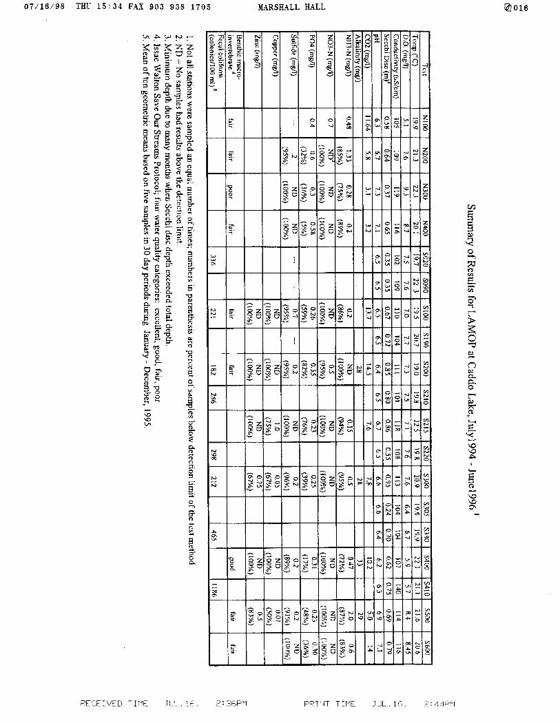
Table 1 shows a summary of the LAMOP data from 19 stations for July 1994 throughJune 1996. All stations are located along the lake’s shore and not every station hasreceived the same intensity of monitoring. These data are within natural ranges for waterparameters in east Texas and reveal no specific water quality problems. One of thelimitations with this approach is that most of the tests are based on the development of acolor in a test solution and the subsequent comparison to a standard color chart. Colordiscrimination by different observers can be highly variable. Also, the natural level ofmany of these chemicals is very low, which in many cases (e.g. nitrate-nitrogen, sulfide,copper, and zinc) are often below the detection limits of the test kits. Thus, much of thewater quality data would not be regarded as scientifically valid, although it has“presumptive” value. For example, it might provide data that suggests the need for amore rigorous monitoring program.
LAMOP BiomonitorinqTo complement the chemical monitoring program, the Institute has adopted twobiomonitoring protocols: benthic biodiversity and fecal coliform bacteria. Benthicmacroinvertebrates are monitored using a protocol from the Issac Walton’s Save OurStreams; program. The protocol involves sampling of benthic macro-invertebrates using‘D’-frame nets at each sampling site four times per year The protocol requires thevolunteer to sample the lake substrate and as randomly as possible pick out and identify asmany organisms as possible in a 20 minute time period. The benthic biomonitoring resultsin the assignment of a semi-quantitative water quality index of excellent, good, fair, orpoor to each site. Results from this biomonitoring program are shown in Table 1 andindicate that the sampled water reflects fair to good water quality. Two problems withthis approach have been noticed: (1) the protocol was designed for use in streams, thusmany o f the organisms found in Caddo Lake were not on the Issac Walton water qualitylist; and (2) because there is no pre-determined number of organisms to sample, somevolunteers put more effort into the work than others which results in uneven samplingefforts
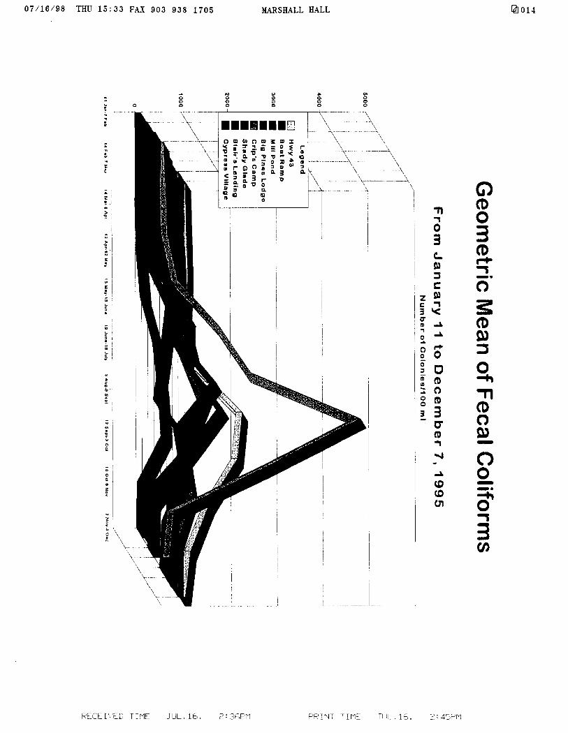
Coliform bacteria monitoring, based on the scientifically rigorous protocol of theAmerican Public Health Association, was begun in the fall of 1994 by Roy Darville and anundergraduate student at East Texas Baptist University of Marshall, Texas (Darville andBrock, 1995). Monitoring was done at 10 lake sites for total coliforms, fecal coliforms,and fecal streptococci. In order to meet State of Texas standards, each site was sampledfive times within a 30 day time period. Personnel from Wiley College of Marshall, Texas,led by Alexandrine Randriamehefa took over this monitoring in the spring of 1995(Randriamehefa, 1996) This protocol remained in place for over one year Results fromDr Randriamehefa’s work are show in Table 1 and in Figure 2. During this time period
@loo4
07/16/98 THU 15:30 FAX 903 938 1705
the mean of all stations except one exceeded the State of Texas criterion of 200 coloniesper 100 ml Highest fecal coliform levels were found during the late summer and earlyfall, Fecal coliform monitoring indicates that a significant coliform problem exists incertain areas of the lake This type of monitoring is expensive, reflects only shorelineconditions, and is limited to the identification of only one type of pollution.
Specific chemical pollutants in the lake have been monitored recently by the Institute(1995) and by various agencies: Texas Natural Resource Conservation Commission(Crowe, 1997), Louisiana Department of Environmental Quality (Cormier, 1996) U.S.Geological Survey (1996), and the U.S. Army Corps of Engineers (1994). These groupsexamined surface water and/or sediment in Caddo Lake and in Harrison Bayou whichempties into Caddo Lake. For example, the Texas Department of Health issued a fishconsumption advisory for Caddo Lake during January, 1995. The advisory recommendsthat people do not consume largemouth bass greater than 18 inches in length, orfreshwater drum of any size from Caddo Lake due to elevated mercury concentrations.Other chemicals of concern are: heavy metals such as arsenic, barium, cadmium, nickel,and zinc; organic compounds such as trichloroethene, dichloroethene, vinyl chloride, andacetone; and several pesticides. These studies suggest that chemical pollution of CaddoLake may be a significant ecological and human health issue. Thus, over the past fewyears some data for chemical pollutants have become available for a few areas of CaddoLake. However, there needs to be a more systematic, rigorous sampling approach so thatall areas of the lake are examined and long-term trends can be identified.
Conclusions Drawn from LAMOPLAMOP has provided monthly water quality data for almost four years. This monitoringhas been highly successful in the educational aspect in that over 100 local citizens havebeen trained to use the Texas Watch protocol throughout the Cypress Basin. DR.Buttram’s efforts received special recognition in 1997 when the Texas Watch organizationnamed rhe Institute as an “outstanding lead partner” and gave special recognition to twoof the 1nstitute’s public school teachers. However, the utility of the data for determiningwater quality at Caddo Lake is limited. For instance, all of the sites that have beenmonitored so far are located along the shoreline. In a lake that is as large and ashydrologically complex as Caddo Lake, there is a significant need for sites located in theopen water and in areas where specific water quality questions need to be answered.Second, many of the kits used in the chemical testing are not sensitive enough to detectsmall changes in surface water quality. In many cases the test results are below detectionlimits. More sensitive analytical methods for metals and nutrients were needed in order tomore accurately monitor these chemicals of concern While the academic monitoring haspresumptive value, there was a growing recognition by the Tnstitute that it is notcomprehensive or rigorous enough to satisfy the requirements of Resolution VI. 1.Therefore, the Institute proceeded to develop a need for a more comprehensive, rigorouswater quality monitoring approach.Accordingly in 1996 the Institute assembled a discussion group of scientists for thepurpose of designing a more comprehensive and rigorous monitoring protocol.Participants included, Dwight K. Shellman, President of the Institute, Roy Darville of
I@Jo05

07/16/98 THL 15:30 FAX 903 935 1705 MARSHALL HALL @loos
East Texas Baptist University, Alexandrine Randriamehefa of Wiley College, MikeButtram of Texarkana College, James B. Johnston and Carroll Cordes of the NationalWetlands Research Center, Virginia Engel of USGS-BRD, and Tom Hardaway of theLouisiana Department of Environmental Quality. As a result of this dialog an initialdesign was created for the first Caddo Lake Institute Protocol (CLIP) for Rapid IntensiveBiomonitoring (RIB).
Development of CLIP/RIBIn order to address these concerns a more advanced intensive monitoring protocol(CLIP/RIB) has been developed. Two chemical sampling programs have been designedwith the assistance of Virginia Engel of the USGS-BRD. The first sampling program wasdesigned to answer the question: How does the water quality of Caddo Lake varyseasonally and how can we identify long-term trends in improvement or degradation ofwater quality at representative sites within Caddo Lake? Starting in February 1997, fouropen water sites are being sampled monthly (Fig. 3). These sites were chosen based onprior knowledge of the sites’ ecology, limnology, and pollution status. Big Cypress Bayouand James Bayou were chosen because they represent the largest inflows into the lake.Harrison Bayou has several known pollution problems, and the mid-lake site representsthe deepest area of the lake. In addition all of these sites have on at least one previousoccasion been sampled by the Texas Natural Resources Conservation Commission, whichallows for some data comparison.
The second program is attempting to answer the question: What is the overall conditionor health of Caddo Lake from a water quality perspective? In order to answer thisquestion all areas of the lake will be sampled using a design similar to that of theEnvironmental Monitoring and Assessment Protocol (EMAP). EMAP was originallydeveloped by the USEPA to provide improved information on the current status of, andlong-term trends in the condition of the nation’s ecological resources. EMAP for surfacewaters incorporated the random selection of lakes in a specific region of the country andthe intensive monitoring of those lakes. From the monitoring of these lakes, conclusionscould be drawn about the environmental status of lakes in the entire region (Larsen andChristie, 1993).
In the case of Caddo Lake we are monitoring only one lake and its wetlands, so wemodified EMAP to accommodate our specific needs. Using a LANDSAT base map ofCaddo Lake and National Wetlands Inventory data, a geographical information system(GIS) was used to divide the lake into three habitat types: riverine, wetland, and openwater (Figs 4,5,6,7). Within each habitat type equal-sized hexagons were created whereeach habitat type used a different sized hexagon. From the hexagons thirty randomgenerated sampling points were derived for each habitat type The sampling stations werethen superimposed over the base map and plotted These ninety sites will be monitoredduring a two or three week period this summer, typically the time when a lake’s waterquality is at a minimum.
07/16/95 THY 15:31 FAX 903 938 1705 MARSHALL HALL
7
For both the monthly monitoring program and the intensive summer monitoring program,the following water quality parameters will be tested at the surface and bottom of eachsite: water temperature, dissolved oxygen, carbon dioxide, pH, alkalinity, conductivity,chloride, total solids, suspended solids, dissolved solids, hardness, nitrate, ammonia, totalphosphorus, reactive phosphorus, Secchi disk depth, true color, apparent color, turbidity,chlorophyll a, and biological oxygen demand (BOD). All sampling and testing will followUSEPA. or APHA approved methodology with appropriate QA/QC procedures.Appropriate blanks and standards are run monthly. Sample preservation follows APHAguidelines, which includes cooling the water samples to 4°C and in some casespreservation with sulfuric acid. All tests are run within 48 hours of sampling.
BiomonitoringCLIP/RIB will now use the USEPA’s Rapid Biomonitoring Protocol (Plafkin et al. 1995),instead of the Issac Walton League’s protocol. This will result in a much better estimationof water quality using benthic macroinvertebrates. Five benthic samples are being takenquarterly at the same four open water sites using a petite Ponar dredge. Samples arepreserved with formalin until analyzed in the laboratory.
Biomordtoring using fecal coliform bacteria will continue with monthly sampling at thesurfaceland bottom of each site. The protocol will follow rigorous APHA methods.
Data Management and AnalysisData will be entered into an Excel spreadsheet, mapped into a GIS (ArcView 2), andsubjected to statistical analysis by SPSS, a statistical software package. Differencesamong the four monthly sites and between the surface and bottom will be determined,Seasonally and long-term trends will be analyzed following an USEPA method (Recklowet al. 1995). Also, the Project GREEN water quality index (WQI), derived from theNational Sanitary Foundation, will be calculated for each site (Mitchell and Stapps, 1995).Nine tests are conducted: dissolved oxygen, fecal coliforms, pH, 5-day biochemicaloxygen demand (BOD), change in water temperature, total phosphate, nitrate, turbidity,and total solids. The index results in a water quality assessment of excellent, good, fair, orpoor. This index is used nationwide by many volunteer groups which allows for easycomparison and communication of results.
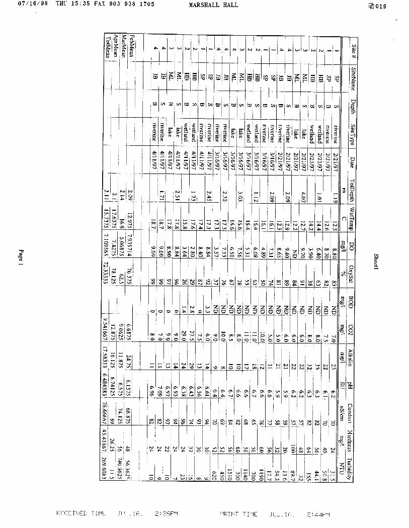
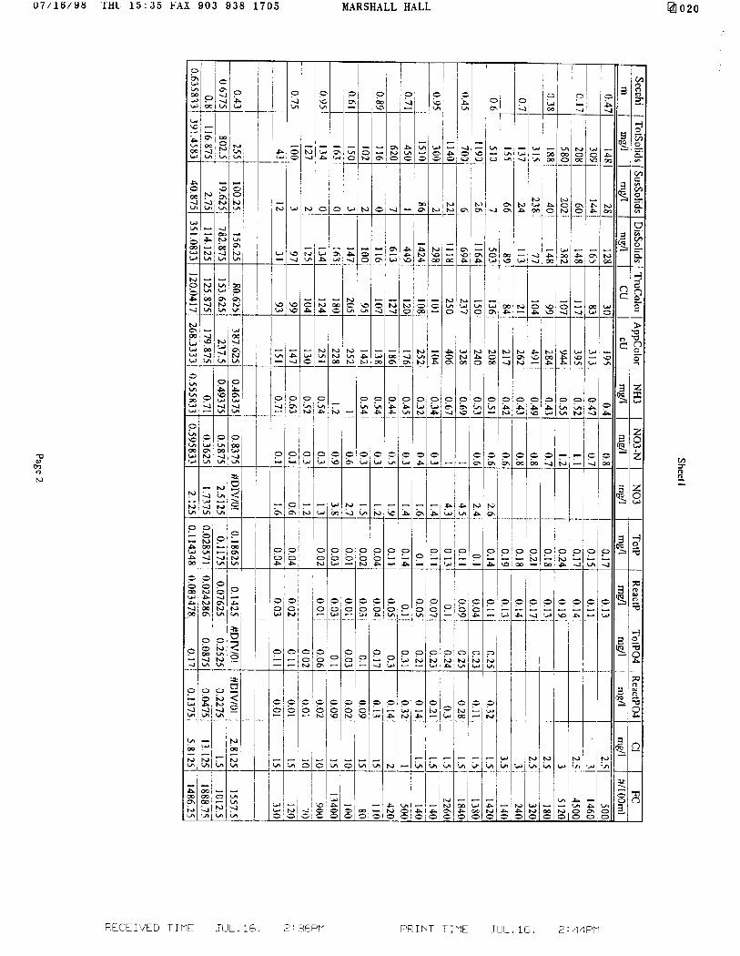
Results from the first three months of CLIPMonitoring has been completed at the four fixed stations for the months of Februarythrough April Results for water quality parameters are summarized in Table 2. VirginiaEngel of USGS-BRD has assisted with some of the statistical analysis. One-wayANOVAs performed on the physicochemical parameters found that 10 of the 25parameters measured were statistically significant between the stations at the a = 0.05level. Independent samples t-tests comparing the surface and bottom means for allparameters across all four months resulted in no statistical differences, thus the watercolumn during February - April was fairly homogenous. This result was expected becausethe region has experienced above normal rainfall and winds during these months whichserves t o thoroughly mix the water column. Bonferroni’s multiple range test of the
L?looi
07/16/98 THU 15:31 FAX 903 938 1705 MARSHALL HALL
8
@IO08
parameters by site shows that the Harrison Bayou site is significantly different from theother three sites. Most of the statistically significant parameters are indicators of poorwater quality: low dissolved oxygen, high ammonia, high nitrates, high color, and highfecal califorms. In addition, several parameters exceed State of Texas or federal surfacewater quality criteria. After more data is collected, trend analysis will be conducted toexamine for long-term trends.
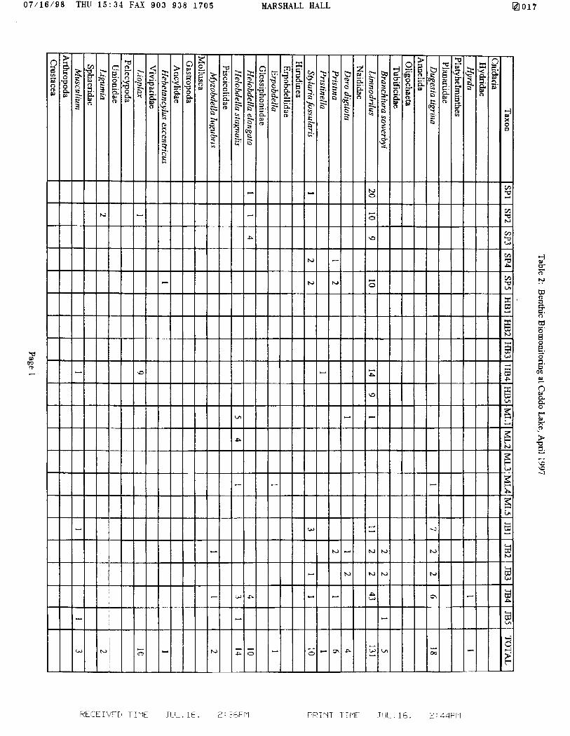
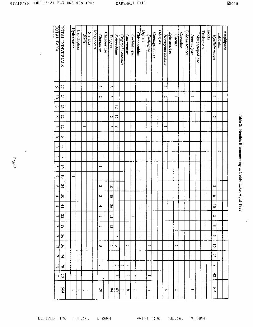
The first benthic sampling was conducted in April at all four open water sites.Tdentificarion of the benthic macroinvertebrates resulted in the identification of 30 taxa and564 individuals (Table 2). The fauna was dominated by tolerant species of oligochaetes,leeches,. amphipods, and chironomids. Preliminary results suggest that the water quality atHarrison Bayou is significantly worse than at the other three sites. Additional analyses ofthis data will occur at a later date.
Monitoring CostsThe Institute has made a substantial financial investment in the design and implementationof this intensive monitoring design. The data below shows most of the costs incurred todate.
16’ Go-Devi l boat, trailer, 25 hp motor, accessoriesmultiparameter water quality meter (Yellow Springs Instrument Co.)water test kit (model DREL/2010, Hach Company)turbidimeter (model 21OOP, Hach Company)fecal coliform equipment: oven, filtration apparatus, vacuum pump,
and supplies (Hach Company)Ponar dredge and benthic sampling supplies (Forestry Suppliers Co.)water and benthic sample bottles (Hach Company)water sampler (Forestry Suppliers Co.)chemicals, glassware, etc.
$7200$3000$2300$ 900$2500
$ 600$ 500$ 200$ 500
$17,700
labor (field work, lab analysis, and data management and analysis): 30 hours/month
Future MonitoringIn addition to chemical and biological monitoring of water quality, future CLIP plans callfor the idetermination of specific pollutant concentrations including endocrine disrupters,monitoring of the bird life, and monitoring the unique ecological features of Caddo Lake.in water, sediment, fish, and possibly other biota. This monitoring of toxic chemicals isbased on Ramsar Recommendation 6.14 on toxics in wetlands. This recommendation callson contracting parties to determine how these chemicals are effecting the ecologicalcharacter of the wetland. Sampling of these chemicals will follow EPA or APHAapproved procedures. Specific chemicals (heavy metals, pesticides, priority pollutants)will be chosen based on the results of prior screening by various agencies. The laboratoryanalysis; for these pollutants is beyond the present capabilities of the Institute, therefore
RECEVFD TIMF .TLIL. 16. 2 : :~f,F'rI PRINT TTMF 51 :I 1 F,. % : 45F’Pl
I 07/16/98 THU 15:32 FAX 903 938 1705 MARSHALL HALL
this analysis will be contracted out to agency partners or private laboratories. In addition,because: Caddo Lake was designated as a Ramsar wetland because of its bird life andunique ecological character, the Institute will develop monitoring protocols in support ofResolution VI. 1.
RECEWED TIME JLIL. 16. 2: 36PM PRINT TIME JUL.16. " : 45,F'M
@loo9
07/16/98 THU 15:32 FAX 903 938 1705 MARSHALL HALL @IO10
10
References
Caddo Lake Institute. 1995. Water Quality Reference Materials Notebook. Caddo LakeInstitute* Aspen, Colorado.
Campo,. Joseph J. 1986. The Big Cypress Wildlife Unit: A Characterization of Habitatand Wlidlife. F.A. Series No. 25. Texas Parks and Wildlife Department: Austin, Texas
Cloud, Tom. 1995 A Characterization of Habitats and Fish and Wildlife ManagementOpportunities at Cypress Bayou Basin, Texas and Louisiana. U.S. Fish and WildlifeService: Arlington, Texas.
Cormier, Kirk A. 1995. Mercury Levels in Largemouth Bass Micropterus salmoides inTwelve North Louisiana Lakes. Louisiana Department of Environmental Quality:Monroe, Louisiana.
Crowe, Arthur L. 1996. A Survey of Mercury Concentrations in the Cypress Creek andUpper Sabine River basins of Northeast Texas. Texas Natural Resource ConservationCommission: Austin, Texas.
Crowley, C.M. 1993. A Study of the Ecological Integrity of Caddo Lake Texas andLouisiana. Stephen F. Austin State University; Nacogdoches, Texas,
Darville, Roy G. and G. Brock. 1994. Fecal Coliform Contamination in Caddo Lake,Texas. East Texas Baptist University; Marshall, Texas.
Davis, T.J. (ed.) 1994. The Ramsar Convention Manual: A Guide to the Convention onWetlands of International Importance especially as Waterfowl Habitat. RamsarConvention Bureau: Gland, Switzerland.
Hardy, Laurence M. 1995. Checklist of the amphibians and reptiles of the Caddo Lakewatershed in Texas and Louisiana. Louisiana State University: Shreveport, LA.
Hine, Doug and J. E Van Kley. 1994. Preliminary checklist of the vascular plants ofCaddo take State Park and Wildlife Management Area: Stephen F. Austin StateUniversity; Nacogdoches, Texas.
Ingold, James L. 1995. Checklist of the birds of the Caddo Lake Watershed in Texas andLouisiana. Louisiana State University in Shreveport Shreveport, LA.
Keeland, B.D., M.A. Townson, and J.A. Allen. 1996. Effects of flooding and herbivoryon baldcypress seedlings planted at Caddo Lake, TX: First year results. Pages: 44-48, inK.M. Flynn (ed.) Proceedings of the Southern Forested Wetlands Ecology andManagement Conference. Consortium for Research on Southern Forested Wetlands,Clemson University, Clemson, South Carolina.
RECE WED TIME JUL. 16. 2 : 36PM PRINT T IME Jl-IL- 1 ct ; : 35F’pq
07/16/98 THU 15:32 F A X 9 0 3 9 3 8 1 7 0 5 MARSHALL HALL
11
@lo11
Larsen, David P. and S.J. Christie, eds. 1993. EMAP-Surface Waters 1991 Pilot Report.EPA 620/R-93/003.
Mitche l l , Mark and William Stapp. 1995. Field Manual for Water Quality Monitoring,9th Ed. Thomson-Shore Printers: Dexter, Michigan.
Plafkin, James L., M. Barbour, K. Porter, S. Gross, and R. Hughes. 1989. RapidBioassbsment Protocols_for Use in Streams and Rivers: Benthic Macroinvertebratesand Fish EPA 440/4-89-00 1.
Randriamehefa, Alexandrine. 1996. Fecal Coliform Results from Caddo Lake. WileyCollege:: Marshall, Texas.
Recklow, K.H., K. Kepford, and W. Warren Hicks. 1995. Statistical Methods for theAnalysis of Lake Water Quality Trends. EPA-84 1-R-93-003,
Shellman, Dwight K. and R. Darville. 1995. Initial Species Inventory for LonghornArmy Ammunition Plant, Kamack, Texas. Caddo Lake Institute: Aspen, Colorado.
Texas Natural Resources Conservation Commission. 1995. Water Quality Data forCaddo Lake. TNRCC: Austin, Texas.
US Geological Survey. 1996. Water Resources Data, Texas, Water Year 1996. USGS:Austin, Texas.
US Army Corps of Engineers. 1994. Red River Waterway Project Shreveport, LA toDaingerfield, TX Reach Reevaluation Study In-Progress Review. USACE: Vicksburg,Mississippi.
US Environmental Protection Agency. 1977. National Eutrophication Survey. Report onCaddo take: Caddo Parish, Louisiana, Marion and Harrison Counties, Texas. USEPA:Las Vegas, Nevada.
Williams, Christy, J. Vincentz, and K. Firehock. 1996. Handbook for WetlandsConservation and Sustainability. Issac Walton League of America: Gaithersburg,Maryland.
RECEWED T I M E Tl_IL. 16. 2 : :16PM PRINT TINE JI-IL 1 Cl 2 : 45F’M
07/16/98 THU 15:32 FAX 903 938 1705 MARSHALL HALL
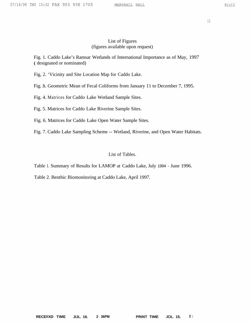
List of Figures(figures available upon request)
Fig. 1. Caddo Lake’s Ramsar Wetlands of International Importance as of May, 1997( designated or nominated)
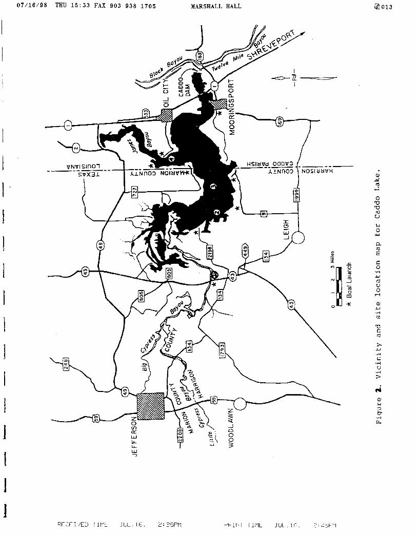
Fig, 2. ‘Vicinity and Site Location Map for Caddo Lake.
Fig. 3. Geometric Mean of Fecal Coliforms from January 11 to December 7, 1995.
Fig. 4. Matrices for Caddo Lake Wetland Sample Sites.
Fig. 5. Matrices for Caddo Lake Riverine Sample Sites.
Fig. 6. Matrices for Caddo Lake Open Water Sample Sites.
Fig. 7. Caddo Lake Sampling Scheme -- Wetland, Riverine, and Open Water Habitats.
List of Tables.
Table 1. Summary of Results for LAMOP at Caddo Lake, July 1994 - June 1996.
Table 2. Benthic Biomonitoring at Caddo Lake, April 1997.
@lo12
12
RECEI!XD TIME JIJL. 16. 2 : 36PM PRINT TIME JCIL. 15. 2 : cjyrq