Embed Size (px)
Citation preview
INTERNATIONAL HYDROLOGICAL PROGRAMME
The design and implementation strategy of the HELP initiative
Produced by the HELP Task Force January 2001 Doc. No. H00/1
______________________________________________________________________________
IHP-V Technical Documents in Hydrology No. 44 UNESCO, Paris, 2001
Hydrology for the Environment, Life and Policy
HELP
HELP is a joint initiative of the United Nations Educational, Scientific and Cultural Organization (UNESCO)
and the World Meteorological Organization (WMO)

The Design and Implementation Strategy of the HELP Initiative
2
The designations employed and the presentation of material throughout the publication do not imply the expression of any
opinion whatsoever on the part of UNESCO concerning the legal status of any country, territory, city or of its authorities, or concerning the delimitations of its frontiers or boundaris.
(SC-2001/WS/7)

The Design and Implementation Strategy of the HELP Initiative
3
REAL PEOPLE, REAL CATCHMENTS, REAL ANSWERS
T H E D E S I G N A N D I M P L E M E N TAT I O N S T R AT E G Y O F
T H E H E L P I N I T I AT I V E
PRODUCED BY THE HELP TASK FORCE
The 5th Joint UNESCO/WMO Conference on International Hydrology (Geneva, 8-12 February 1999) unanimously endorsed a new global initiative, entitled HELP (Hydrology for the Environment, Life and Policy), which would seek to establish a global network of catchments to improve the links between hydrology and the needs of society. The conference recommended the establishment of a task force, consisting of hydrological scientists, water resources managers and water policy specialists, to develop the concept. The conference also requested the preparation of a project document by the Task Force. This document fulfils that request. It provides a guide to the history of HELP, the issues it addresses, its objectives, and the strategy for implementing the initiative.
This document presents the state of HELP planning in October 2000. It is a final draft and includes comments from a wide range of stakeholders. Further information can be obtained on the HELP web page –
www.unesco.org/science/HELP or from Dr. M. Bonell, UNESCO Division of Water Sciences, 1 rue Miollis, 75732 Paris Cedex 15, France. Email: [email protected]

The Design and Implementation Strategy of the HELP Initiative
5
T H E D E S I G N A N D I M P L E M E N T A T I O N S T R A T E G Y O F
T H E H E L P I N I T I A T I V E JANUARY 2001
CONTENTS
GLOSSARY OF ACRONYMS .................................................................................................................... 7
EXECUTIVE SUMMARY ........................................................................................................................... 9
1. INTRODUCTION .............................................................................................................................. 11
1.1 BACKGROUND................................................................................................................................... 11 1.2 THE PURPOSE AND OBJECTIVES OF HELP.......................................................................................... 14 1.3 HELP IN RELATION TO UNESCO AND WMO .................................................................................. 15 1.4 THE FORM AND FUNCTION OF HELP ................................................................................................. 15
1.4.1 The questions driving HELP.................................................................................................... 16 1.4.2 The roles of the participating disciplines................................................................................. 17
2. HELP IN LAND AND WATER MANAGEMENT ......................................................................... 19
2.1 INTEGRATED LAND AND WATER MANAGEMENT ................................................................................ 19 2.2 WATER AND FOOD............................................................................................................................. 19
2.2.1 Food and water policy ............................................................................................................. 19 2.2.2 Food and water management .................................................................................................. 20 2.2.3 The hydrological sciences contribution ................................................................................... 20
2.3 WATER QUALITY AND HEALTH.......................................................................................................... 21 2.3.1 Water quality and policy.......................................................................................................... 22 2.3.2 Water quality and management ............................................................................................... 22 2.3.3 The hydrological science contribution..................................................................................... 24
2.4 WATER AND THE ENVIRONMENT ....................................................................................................... 24 2.4.1 The environment and water policy........................................................................................... 25 2.4.2 The environment and water management ............................................................................... 25 2.4.3 The hydrological science contribution..................................................................................... 26
2.5 WATER AND CLIMATE ....................................................................................................................... 26 2.5.1 Climate, water policy and management................................................................................... 27 2.5.2 The hydrological science contribution..................................................................................... 28
2.6 WATER AND CONFLICT...................................................................................................................... 28 2.6.1 Conflict, water policy and management .................................................................................. 29 2.6.2 Water and conflict within HELP.............................................................................................. 30 2.6.3 The hydrological science contribution..................................................................................... 30
3. WHAT HELP MEANS IN PRACTICE ........................................................................................... 33
3.1 THE HELP GLOBAL NETWORK OF CATCHMENTS............................................................................... 33 3.2 ATTRIBUTES OF HELP CATCHMENTS................................................................................................ 33 3.3 IDENTIFICATION OF HELP CATCHMENTS .......................................................................................... 33 3.4 CAPACITY BUILDING ......................................................................................................................... 35

The Design and Implementation Strategy of the HELP Initiative
6
3.5 COMMUNICATION ..............................................................................................................................35
4. THE ORGANISATION AND MANAGEMENT OF HELP...........................................................37
4.1 WHAT IS NEEDED............................................................................................................................... 37 4.2 THE PROPOSED ORGANISATIONAL STRUCTURE ..................................................................................37 4.3 IMPLEMENTATION AND MANAGEMENT ..............................................................................................38
5. HELP'S RELATIONSHIP TO OTHER INTERNATIONAL PROGRAMMES..........................41
5.1 GLOBAL PROGRAMMES......................................................................................................................41 5.1.1 UNESCO International Hydrological Programme (IHP)........................................................41 5.1.2 Flow Regimes from Experimental and Network Data (FRIEND) ............................................41 5.1.3 World Meteorological Organisation (WMO)...........................................................................42 5.1.4 World Hydrological Observing System (WHYCOS) ................................................................42 5.1.5 World Climate Programme (WCP) ..........................................................................................42 5.1.6 The Global Climate Observing System (GCOS).......................................................................43 5.1.7 The Global Terrestrial Observing System (GTOS) ..................................................................43 5.1.8 Global Water Partnership (GWP)............................................................................................43 5.1.9 Global Environment Monitoring System (GEMS/WATER)......................................................43 5.1.10 The International Council of Scientific Unions (ICSU) .......................................................43
5.2 REGIONAL PROGRAMMES...................................................................................................................44 5.2.1 UNESCO ..................................................................................................................................44 5.2.2 WMO regional working groups................................................................................................44 5.2.3 Regional intergovernmental structures ....................................................................................44 5.2.4 CATHALAC..............................................................................................................................44 5.2.5 Inter-American Water Resources Network (IWRN) ................................................................44
6. NEXT STEPS.......................................................................................................................................45
6.1.1 Phase I – developing the strategic framework .........................................................................45 6.1.2 Phase 2 – establishing an operational plan .............................................................................45 6.1.3 Phase 3 – implementing catchment projects ............................................................................46 6.1.4 Phase 4 – international reporting ............................................................................................46
APPENDIX I : TASK FORCE ORGANOGRAM....................................................................................47
APPENDIX II : TASK FORCE TERMS OF REFERENCE...................................................................49
APPENDIX III : WORLD WATER COUNCIL’S VISION OF WATER, LIFE AND ENVIRONMENT IN THE 21ST CENTURY .............................................................................................51
APPENDIX IV : EXCHANGE OF HYDROLOGICAL DATA ..............................................................53
APPENDIX V : WATER LAW AND POLICY ISSUES..........................................................................57
APPENDIX VI : A HYPOTHETICAL EXAMPLE OF A HELP CATCHMENT................................61
APPENDIX VII : AN EXAMPLE OF A HELP CATCHMENT STUDY IN NEW ZEALAND..........65

The Design and Implementation Strategy of the HELP Initiative
7
GLOSSARY OF ACRONYMS
ACC SWR Administrative Committee on Co-ordination, Sub-Committee on Water Resources
ADR Alternative Dispute Resolution AMHY Alpine and Mediterranean FRIEND AMIGO Asian-Pacific and Caribbean FRIEND AOC West and Central Africa FRIEND BALTEX Baltic Sea Experiment BAHC Biospheric Aspects of the Hydrological Cycle CATHALAC Water Center for the Humid Tropics for Latin America and the Caribbean CLIVAR Climate Variability Research Programme CSD Commission for Sustainable Development DFID UK Department for International Development FAO Food and Agriculture Organisation FRIEND Flow Regimes from International Experimental Network Data GAME GEWEX Asian Monsoon Experiment GCIP GEWEX Continental-scale International Programme GCOS Global Climate Observing System GCTE Global Change and Terrestrial Ecosystems GECHS The Global Environmental Change and Human Security GEMS/WATER Global Environment Monitoring System GEWEX Global Energy and Water Experiment GIS Geographical Information System GPCC Global Precipitation and Climatology Centre GRDC Global Runoff Data Center GTOS Global Terrestrial Observing System GWP Global Water Partnership HELP Hydrology for the Environment, Life and Policy HKH Hindu Kush – Himalayan FRIEND HWRP Hydrology Water Resources Programme IAEA International Atomic Energy Authority IAHS International Association of Hydrological Sciences ICM Integrated Catchment Management ICSU International Council of Scientific Unions ICWE International Conference on Water and the Environment IGBP International Geosphere-Biosphere Programme IHD International Hydrology Decade IHDP International Human Dimensions Programme IHP International Hydrology Programme IIASA Institute of Islamic and Arabic Sciences in America IOC Intergovernmental Oceanographic Commission IPCC Intergovernmental Panel on Climate Change IWRN Inter-American Water Resources Network LBA Large Scale Biosphere-Atmosphere Experiment in Amazonia LOICZ Land-Ocean Interaction in the Coastal Zone LUCC Land-Use and Land-Cover Change MAB Man and the Biosphere MAGS Mackenzie GEWEX Study MOST Management of Social Transformations NGO Non-governmental Organisation
The Design and Implementation Strategy of the HELP Initiative
8
NWRI National Water Research Institute, Canada OHP Operational Hydrology Programme PON Program on Negotiations RCU Regional Co-ordinating Unit UN United Nations UNEP United Nations Environment Programme UNESCO United Nations Educational, Scientific and Cultural Organisation UNGASS UN General Assembly Special Session WCASP World Climate Application and Service Programme WCDP World Climate Data Programme WCIP World Climate Implication Programme WCP World Climate Programme WCRP World Climate Research Programme WEC Water Environment Capacity WHYCOS World Hydrological Observing System WMO World Meteorological Organisation WWAP World Water Assessment Programme WWC World Water Council WWF World Water Forum WWV World Water Vision

The Design and Implementation Strategy of the HELP Initiative
9
EXECUTIVE SUMMARY
HELP is a joint UNESCO/WMO programme which is designed to establish a global network of catchments to improve the links between hydrology and the needs of society. It is a cross cutting programme of the UNESCO International Hydrological Programme and will contribute to the World Water Assessment Programme (WWAP), and the Hydrology and Water Resources Programme of WMO. The vital importance of water in sustaining human and environmental health has been recognised in numerous national and international fora (e.g. the 1997 UN General Assembly Special Session), policy reviews by the UN (e.g. the UN Commission on Sustainable Development, 1994) and non-UN agencies (e.g. the European Commission, 1998). Several recent international conferences culminating in the Second World Water Forum on Water Security in the 21st Century (The Hague, March 2000) have highlighted ‘water’ as the emerging, most critical environment issue of the 21st Century. The greatest pressure on freshwater resources has been identified as the continued escalation of the global population. Climate variability and potential climate change further exacerbate water scarcity. At the same time, degradation in water quality is causing a critical reduction in the amount of fresh water available for potable, agricultural and industrial use. However, despite this plethora of high profile activities no international research programme in hydrology has been forthcoming which would address key water resource issues in the field and integrate them with policy and management needs. HELP will change this by creating a new approach to integrated catchment management. The new approach is to use real catchments, with real water related problems as the environment within which hydrological scientists, water resources managers and water law and policy experts can be brought together. This integration is required because of the traditional separation between the water policy, water resource management and scientific communities, especially in terms of setting of research agenda and free flow of information for use in management and policy making. A result is that there is a significant time lag in the implementation of scientific outputs to the benefit of society. In addition, water management policy is generally based on outdated knowledge and technology. In many cases, procedures are followed where stakeholders are unaware of what technical alternatives are available and scientists not realising what is required. This "Paradigm Lock” (Figure 1) has come about because the two main groups have become isolated: scientists by the lack of proven utility of their findings, and stakeholders by legal and professional precedents and disaggregated institutions. At present, there is no global initiative which encourages the water policy, water resources management and scientific communities to work together within a field-oriented context so that science is closely integrated with policy and management needs. The HELP initiative aims to fill this gap. HELP is therefore a problem-driven and demand-responsive initiative that will focus on five1 key issues: • Water and climate2 • Water and food • Water quality and human health • Water and the environment • Water and conflict The relative importance of these issues will vary regionally and priorities for each HELP catchment will be set by local stakeholders. 1 The 29th Session of the IHP Bureau, April 2000 also recommended the addition of the following: improved communications between hydrologists and society, and water for socio-economic development. These are seen as issues which are pertinent to all five of the original issues and should, therefore, not be separated from them. 2 This includes natural disaster prevention (floods and droughts).
The Design and Implementation Strategy of the HELP Initiative
10
HELP will make appropriate links to a number of other water related international initiatives (eg GEWEX, IGBP, GWP etc) and will provide a major vehicle for the delivery of scientific information in support of water resources management and policy making. The outputs of HELP will be new data and models in all of the above five areas which are more suitable for the formulation of beneficial water management and policy, with the objective of meeting human needs and increasing societal benefits through the appropriate use of water and sustainable development.. The overarching goal of HELP is therefore to:
contribute social, legal, economic and environmental benefits to communities through sustainable and appropriate use of water by deploying hydrological science in support of improved integrated catchment management.
Information on the HELP programme can be found at – http://www.unesco.org/science/help or from – Dr. Mike Bonell, UNESCO Division of Water Sciences, 1 rue Miollis, 75732 Paris Cedex 15, France Email: [email protected]
Dr. Wolfgang Grabs Hydrology and Water Resources Deaprtment World Meteorological Organisation 7 bis avenue de la Paix Case postale 2300 CH 1211 Genève 2 Switzerland E-mail: [email protected]

The Design and Implementation Strategy of the HELP Initiative
11
1 . INTRODUCTION
1.1 BACKGROUND
The vital importance of water in sustaining human and environmental health has been recognised in numerous national and international fora. Several recent international conferences and policy documents emphasise the need to make sustainable use of our limited freshwater resources. The greatest pressure on these resources is the continued escalation of the global population. Climate variability and potential climate change further exacerbate water scarcity. At the same time, degradation in water quality is causing a critical reduction in the amount of fresh water available for potable, agricultural and industrial use. In response to these concerns, United Nations agencies have for more than four decades been encouraging the collection and analysis of hydrological data, and capacity building. All their most recent assessments support the urgent need for action to address global water management issues. For example, the UN Commission on Sustainable Development (CSD) emphasised the emerging issue of global water scarcity, partly in response to the recommendations of the Rio Conference and Agenda 21. In 1994 the CSD called for “a comprehensive assessment of freshwater resources, with the aim of identifying the availability of such resources, making projections of future needs, and problems to be considered”. Three years later, the “Comprehensive Assessment of the Freshwater Resources of the World” was presented to CSD 5 and the UN General Assembly Special Session (UNGASS). This document was prepared by a steering committee comprising all UN agencies involved in fresh water, and in co-operation with the Stockholm Environment Institute. A further important step towards realising the CSD objective is the publication of the UNESCO-IHP monograph “World Water Resources”. This establishes broad baseline information, but concluded that –
much is still to be achieved and many aspects need to be improved, in particular global hydrology networks and the collection and processing of data to ensure greater accuracy and reliability in water resources assessment.
The European Commission has examined water issues across Europe (Freshwater: a challenge for innovation, 1998). This widely consulted document highlights water as a strategic resource, and recognises that –
even in areas with high precipitation and in major river basins, over-use and mismanagement of water resources have created severe constraints on supply. Such problems are widespread and will be made more acute by the growing demand on freshwater arising from increasing economic development.
A recent UNESCO-IHP international conference addressed the issue of “The looming world water crisis”, and concluded that positive action was needed in a number of areas to avoid the worst disasters. Most recently, the World Water Council’s Vision on life, and Environment in the 21st Century and the associated Second World Water Forum on Water Security in the 21st Century (The Hague, March 2000) have highlighted ‘water’ as the emerging, most critical environment issue of the 21st
The Design and Implementation Strategy of the HELP Initiative
12
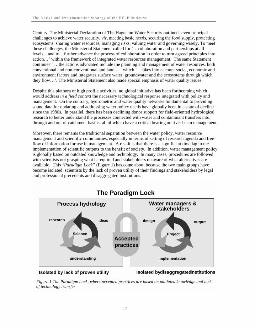
Century. The Ministerial Declaration of The Hague on Water Security outlined seven principal challenges to achieve water security, viz, meeting basic needs, securing the food supply, protecting ecosystems, sharing water resources, managing risks, valuing water and governing wisely. To meet these challenges, the Ministerial Statement called for ‘…collaboration and partnerships at all levels…and to…further advance the process of collaboration in order to turn agreed principles into action…’ within the framework of integrated water resources management. The same Statement continues ‘ …the actions advocated include the planning and management of water resources, both conventional and non-conventional and land …’ which ‘…takes into account social, economic and environment factors and integrates surface water, groundwater and the ecosystems through which they flow…’. The Ministerial Statement also made special emphasis of water quality issues. Despite this plethora of high profile activities, no global initiative has been forthcoming which would address in a field context the necessary technological response integrated with policy and management. On the contrary, hydrometric and water quality networks fundamental to providing sound data for updating and addressing water policy needs have globally been in a state of decline since the 1980s. In parallel, there has been declining donor support for field-oriented hydrological research to better understand the processes connected with water and contaminant transfers into, through and out of catchment basins; all of which have a critical bearing on river basin management. Moreover, there remains the traditional separation between the water policy, water resource management and scientific communities, especially in terms of setting of research agenda and free-flow of information for use in management. A result is that there is a significant time lag in the implementation of scientific outputs to the benefit of society. In addition, water management policy is globally based on outdated knowledge and technology. In many cases, procedures are followed with scientists not grasping what is required and stakeholders unaware of what alternatives are available. This "Paradigm Lock” (Figure 1) has come about because the two main groups have become isolated: scientists by the lack of proven utility of their findings and stakeholders by legal and professional precedents and disaggregated institutions.
The Paradigm Lock
Process hydrology Water managers &stakeholders
ideasresearch
understanding implementation
outputdesign
Isolated by lack of proven utility Isolated bydisaggregatedinstitutions
Acceptedpractices
Science Project
Figure 1 The Paradigm Lock, where accepted practices are based on outdated knowledge and lack of technology transfer

The Design and Implementation Strategy of the HELP Initiative
13
At present, there is no global initiative which encourages the water policy, water resources management and scientific communities to work together within a field-oriented context so that science is closely integrated with policy and management needs. The Hydrology for the Environment Life and Policy (HELP) initiative aims to fill this gap. The background to HELP can be traced back to the first International Hydrology Decade (IHD). This ran from 1965 to 1974 and included systematic studies of the hydrological environment. This was very successful and led to a series of follow-up programmes including the successive phases of the International Hydrology Programme (IHP) of UNESCO. To date there have been five phases of the IHP, and the sixth is currently being planned to run from 2002 to 2007. The idea that there should be a major new international initiative emerged in 1996 at the United Nations Administrative Committee on Co-ordination Sub-Committee on Water Resources (UN ACC SWR) 17th Session (Paris, October 1996) which recommended that there should be a Global Water Quality Initiative. Meanwhile, individuals and groups of scientists independently recognised a similar need and calls were made for a science-driven international project. These were followed by approaches from members of the GEWEX community who proposed consideration of a second IHD by UNESCO. The concept of a policy- and development-driven international initiative, around which HELP has developed, first emerged at the British Hydrological Society International Conference on “Hydrology and Water Resources Development in an Uncertain Environment” in Exeter 5-10 July 1998. That conference adopted and developed that concept in the form of a formal call in the so-called ‘Exeter statement’ that recommended -
consideration be given to a Second International Hydrological Decade as a major project within the current framework of activities of UNESCO, WMO and others. It would recognize the existing world observation programmes in related sciences, and be targeted at providing those comprehensive datasets and interpretive science needed to lower the uncertainty in hydrological prediction in areas of environmental, economic and social importance.
In response to the above requests, UNESCO and WMO co-sponsored a meeting of an informal expert group (held at Wallingford, UK, in December 1998), which recommended the development of a new international hydrology initiative. The conceptual framework of this initiative was to combine experimental hydrology with water resource management and policy issues. This concept was presented at the 5th Joint UNESCO/WMO Conference on International Hydrology (Geneva, February 1999) where it was unanimously endorsed. The conference recommended the creation of a new global initiative, which would, through the establishment of a global network of catchments, set a new scientific agenda which is more relevant to the most critical water policy and water management issues. This new initiative is entitled HELP (Hydrology for the Environment, Life and Policy). The conference recommended the establishment of a task force, consisting of hydrological scientists, water resources managers and water policy and law specialists, to develop the concept further. The structure of the resultant Task Force and its Terms of Reference are shown in Appendices I and II. The conference also requested the preparation of this project document by the task force. HELP was approved by the 28th Session of the IHP Bureau, which recommended that HELP, like FRIEND, should become a distinctive cross-cutting programme of the UNESCO IHP. The Bureau

The Design and Implementation Strategy of the HELP Initiative
14
also recommended that HELP should develop strong links with appropriate parts of other global programmes such as the WMO/WCRP, ICSU/IGBP, other UN agencies, non-governmental organisations, international programmes and the World Water Council’s Vision on Water, Life and Environment in the 21st Century (Appendix III). To this end, these communities were invited to send representatives and participate in the first HELP task force meeting in Arizona (20–26 November 1999). Most relevant organisations were represented and the few not able to be present expressed strong interest in HELP and asked to be informed of the outputs of the meeting. Further details on the Arizona meeting are contained in the report of this meeting available on request from UNESCO in Paris. This document presents the strategic framework developed by the task force.
1.2 THE PURPOSE AND OBJECTIVES OF HELP
The overarching purpose of HELP is to -
contribute social, legal, economic and environmental benefits to communities through sustainable and appropriate use of water by deploying hydrological science in support of improved integrated catchment management.
HELP will work on the principle that research is responsive to water-related policy and development issues, through the primary activity of establishing a global network of experimental hydrological catchments. Building on existing networks and developing new scientific knowledge where gaps exist, the key objectives of HELP are to: 1. Create a framework; that enables water law and policy experts, water resources managers and
water scientists to work more closely together on water-related problems; 2. Break the “Paradigm Lock”; change the perspective of hydrological science, so that water-
related observations are obtained in real, operational catchments, both physical (technical, hydrological, climatological, ecological) and non-physical (sociological, economic, administrative and legal). Such observations will address the most critical policy and management issues, as perceived by users under different biophysical and socio-economic environments, taking into account the need for sustainable development;
3. Focus results; by involvement of key stakeholders produce scientific results that are more
directly beneficial to the needs of society. The above will be achieved by creating an integrated long-term programme with process hydrology undertaken at larger drainage basin scales than previously, so that it can be of more practical value to land and water resources managers and water policy and legal experts. Recognising the inequality of opportunity between developed and developing countries, HELP will emphasise the technology-transfer, education and capacity-building initiatives needed to allow these objectives to be achieved throughout the world.

The Design and Implementation Strategy of the HELP Initiative
15
1.3 HELP IN RELATION TO UNESCO AND WMO
HELP is a global initiative to which interested individuals and organisations involved in integrated water resources management can contribute. Contribution to this programme can be in many forms, but should follow the basic guidelines set out in this document. The main institutional leadership behind HELP is from UNESCO and WMO. UNESCO sees HELP as a geographically based, cross-cutting programme which can potentially contribute to all five of the scientific themes in the upcoming phase of IHP (IHP-VI): • global changes and water resources; • integrated catchment and aquifer dynamics; • regional perspectives; • water and society; • knowledge, information and technology transfer. HELP will also potentially contribute to subsequent phases of IHP, with the additional themes of water resources management, law and policy. The IHP-VI document contains details of the key linkages, but it is the catchment-based focus of HELP, involving scientists, water resources managers and water policy and legal experts in a field context and within an integrated manner, that mainly distinguishes it from the existing IHP-VI programme. The HELP initiative can integrate and complement the various syntheses and innovative “upstream” thinking of the IHP working groups and national contributions arising from the current themes of IHP-VI, by incorporating and testing their outputs in a field setting. WMO supports efforts to improve the effectiveness of national Hydrological Services in support of water resources planning and disaster reduction. The activities of these Services in water resource assessment and in flood risk assessment and forecasting rely on an adequate scientific understanding of the natural and socio-economic processes involved and the provision of an adequate supply of data, both of which should benefit from the implementation of HELP. WMO’s concern with the need to collect data and make them available is reflected in its adoption of resolution 25 (Cg-XIII) – Exchange of Hydrological Data and Products (Appendix IV). In this resolution, WMO members adopted “a stand of committing to broadening and enhancing, whenever possible, the free and unrestricted international exchange of hydrological data and products". It added that -
members should also provide additional data and products, where available, which are required to sustain programs and projects of WMO, other UN agencies, ICSU and other organisation of equivalent status, related to operational hydrology and water resources research at the global, regional and national levels.
For this reason the WMO Congress has agreed that the organisation should further investigate the aims and feasibility of the HELP initiative, with the proviso that the extent and nature of WMO’s involvement in the project should fall within WMO’s field of interest and serve its objectives.
1.4 THE FORM AND FUNCTION OF HELP
Because the catchment is the natural unit of hydrology, HELP is specifically catchment based. Conventionally, hydrologists study the flow of water through a catchment and then derive the
The Design and Implementation Strategy of the HELP Initiative
16
impacts of changes in that flow. However, because HELP is people and environment centred – problem-driven and demand-responsive – it takes a different approach, starting with the problems of society and then looking for hydrological answers. This requires a multi-disciplinary approach that has questions of environment, life and policy as its starting points and hydrology as the vehicle for their solution. HELP will therefore undertake new interdisciplinary studies at a range of appropriate scales that foster integrated solutions to locally defined water-related environment, life, and policy problems. To ensure that it achieves this from the outset, HELP will involve physical and social scientists from both the operational and research communities, water policy experts, managers and users. Where expertise is lacking, HELP will endeavour to stimulate its creation it through education and capacity building. HELP will therefore provide a multi-disciplinary framework to address the following five global freshwater policy issues: • water and food • water quality and human health • water and the environment • water and climate* • water and conflicts * Note: Disaster prevention (floods and droughts) is a component of water and climate.
1.4.1 THE QUESTIONS DRIVING HELP
Environment As the environment is increasingly seen as a legitimate water user in addition to its vital role as the water storage medium, it is now recognised that the environment itself has intrinsic economic value. The environment is prone, however, to both point source and non-point source (diffuse) pollution as a result of various water user activities. This reduces its effectiveness in delivering wholesome water for consumption, and reduces yields. Siltation is a form of pollution that reduces water availability in time and space. An integrated approach involving environmental engineering, process hydrology, environmental policy, law and economics, and environmental management will comprise part of HELP, to address problems associated with the environment. HELP will advocate better environmental management in order to sustain water resources in any given catchment. Climate variability and change may also have profound impacts on water resources. The Intergovernmental Panel on Climate Change (IPCC) recently concluded that the increasing costs of climate change and variability, in terms of loss of human life and capital due to floods, storms and droughts, are the result of society’s lack of adjustment and response in its policies and use of resources. This places the emphasis on water resources management, and the need to quantify and account for possible future changes in water resources due to climate change and variability. Life Current projections estimate that by 2025 most of the world’s population may not have sufficient water to grow its basic food requirements. This enormous food gap seems unavoidable in water-scarce regions unless we can make more efficient use of existing water resources. We need to look at the technical and non-technical aspects of increasing the efficiency of water use in both rain-fed

The Design and Implementation Strategy of the HELP Initiative
17
and irrigated agriculture. To ensure that any consequent impacts on downstream (and/or upstream) water users are taken into account, this work needs to be carried out within a catchment framework. Competition for water is also an increasing source of potential conflict. Expanding populations in water-scarce regions will inevitably lead to increased competition, at both national and international levels, for the limited water available in rivers and aquifers. On the other handwater also provides a powerful tool for co-operation and has often been the means for bringing various parties together. Improved information on water resources is essential in order to anticipate, prevent and address potential conflicts over water. Human health is severely compromised by a lack of safe drinking water, which is a serious problem in many developing countries. This problem is likely to increase as growing populations put pressure on existing supplies. Globally, information on water quality is extremely scarce, but is essential if the risks to much of the world’s population are to be properly assessed and addressed. Policy and law HELP will provide more reliable information to law and policy makers (and enforcers), which will allow them to address the key issues arising out of the inevitable conflicts of use affecting stakeholders at local, regional and international levels. Sustainable water resources management laws and policies require a sound understanding of hydrological processes and an appreciation of the needs and constraints of all water users. Scientists must play a vital role in the development of an effective legal and policy framework that ensures equitable and rational use of water in each particular case. The Second World Water Forum supports the closer integration of science and policy saying that “Wise decision making must be based on sound knowledge which in turn requires scientific analyses. Science is therefore not a luxury. What is more, it needs adequate databases in order to draw conclusions” and calling for “Encouragement of the scientific community to be more actively involved in public debate and of policy makers to heed the advice of scientists.” A first step involves identifying, with greater certainty, the quality and quantity of water available, so as to define the scope of the framework. A second step is to identify the different water users and the needs of each, together with a range of schemes for possible water allocation, including, ideally, an indication of the optimal and sustainable use in each case. An effective working interface between water law and policy makers, water managers and scientists should result in a regime for water allocation agreeable to all stakeholders. This regime needs to be monitored in some way for ongoing compliance, and this monitoring evaluated. In the event of a dispute between uses or users, HELP can provide integrated models of alternative scenarios that would best accommodate the competing needs for water. In short, HELP will enable the development of a rational and equitable schemes for water allocation, capable of evolving with time and aimed at conflict avoidance and sustainable use of the resource.
1.4.2 THE ROLES OF THE PARTICIPATING DISCIPLINES
Water scientists The science should be delivered through innovative experimental field designs, linking water-related physical and non-physical observations. It should comprehensively address the effects of scale, recognising that these may differ for the physical and non-physical issues. The main motivation is to improve understanding of hydrological processes controlling both water quality and quantity, their
The Design and Implementation Strategy of the HELP Initiative
18
relationship to ecological processes (biodiversity, land/water exchanges, hydromorphology) and how these affect or are affected by social, economic and legal structures. Water scientists also need to communicate their research results to appropriate water resources managers. Law and policy makers Law and policy makers need to have adequate appreciation of the science and deliver relevant questions to scientists, with the aim of ensuring equitable access to adequate water for all current and future users. The fundamental concerns for law and policy makers are identifying the scope of the resource, the needs of all the stakeholders, and devising a flexible, predictable and enforceable framework that fairly allocates the uses of the resource among all the stakeholders. Appendix V gives excerpts from the UN Convention on Non-Navigational Uses of Water that require scientific support. Water resources managers Water resources managers are responsible for producing the practical results that HELP is working towards; they are also likely to be people who are most aware of the problems of moving from ideas to implementation. Because they are also at the interface between science, law and policy they can provide important information on conflict avoidance and resolution. They thus have a vital role in formulating the agenda of HELP.
The Design and Implementation Strategy of the HELP Initiative
19
2 . HELP IN LAND AND WATER MANAGEMENT
2.1 INTEGRATED LAND AND WATER MANAGEMENT
The work of HELP will take place within the context of holistic, integrated land and water management. When considering water resource management on a catchment (or larger) scale we must take into account the interactions between different parts of the landscape (for example forests, savannahs, grasslands, crops and wetlands). We must also think about water in economic, social and environmental terms as well as physical terms. Technologies and management techniques that can significantly improve water management at the field scale may reduce water supply to users further down the catchment. Local changes in runoff and drainage may also change streamflow, reservoir storage and groundwater recharge. Consequently, improvements in water-use management at one level may benefit users in that location, but at the expense of water users in other parts of the catchment. The challenge is to understand how water is used in different parts of a catchment in order to improve the management of the catchment as a whole.
2.2 WATER AND FOOD
By far the largest user of fresh water is agriculture, which now accounts for around three-quarters of global water consumption. If, as is almost certain, the population increases by 65 per cent over the next 50 years, around 70 per cent of this future world population will face water shortages and 16 per cent will have insufficient water to grow their basic food requirement. The necessary increases in food production cannot be achieved without higher productivity on existing land and with existing water resources. A central question for HELP is therefore "what is the scope for increasing the efficiency with which water is used in agriculture?" Although irrigation is often proposed as the way to achieve higher productivity per unit area of land, it increases the pressure on freshwater resources. Further, because irrigated agriculture only provides about a third of the world’s food, a relatively large increase in production would be required. On the other hand, increasing the efficiency of rain-fed agriculture would both increase food production and also reduce the demand on freshwater resources. Most global assessments of future food production ignore the possibility of increasing rain-fed food production per unit area. However, in regions such as sub-Saharan Africa where population growth is very high, most (>90 per cent) food comes from rain-fed agriculture, and this is likely to remain the case for the foreseeable future. It is therefore essential to increase water-use efficiency in rain-fed, as well as in irrigated, agriculture.
2.2.1 FOOD AND WATER POLICY
Five key policy issues are identified in respect of water and food: • the extent of future additional irrigation, and the degree of predicted food shortage if irrigation is
not expanded; and the predicted downstream water shortages if irrigation is expanded; • national food security versus international trade in food; • increases in total food productivity (both rain-fed and irrigated); • closing the yield gap, rather than extending the yield frontier (focusing on reducing below-
average variations in within-farm yields, rather than increasing the average yield per unit of input);

The Design and Implementation Strategy of the HELP Initiative
20
• the transition of irrigation organisations to service businesses, and the transfer of the management of smaller systems to users.
2.2.2 FOOD AND WATER MANAGEMENT
We can only improve agricultural water management and at the same time increase food production by improving water-use efficiency. This is true for irrigated as well as rain-fed agriculture. It means producing the same or a larger amount of food with less water. While improving water-use efficiency relates mainly to water quantity, improving or maintaining water quality is also a central task for agricultural water management. While the increase of food production is the most pressing issue in many countries, the maintenance and improvement of water quality is of prime concern in others. We can improve water-use efficiency through: • modifications in agricultural tillage practices • changes in crop type • reduction of soil evaporation • optimised crop selection • technological improvements • reduction of transportation loss • pricing policy Water-use efficiency must be measured with respect to the whole catchment, taking into account possible reuse of water. While the reduction of unproductive evaporation loss is a central goal of improving water-use efficiency, reduction in groundwater recharge might be undesirable for downstream withdrawals. Thus water management has carefully to distinguish different water pathways within the catchment and must account for interactions and feedbacks within the system. To secure future food and water supplies, we need to take several interventions and actions, as follows: 1. reform of institutional and regulatory actions; 2. technology advancement; 3. environmental and ecological preservation; 4. social and cultural amendments; 5. recognition of urban and rural demands; 6. recognition of demand and participatory management approaches; 7. building capacity and technology transfer;
2.2.3 THE HYDROLOGICAL SCIENCES CONTRIBUTION
The technical basis for improving agricultural water-use efficiency is to increase the total amount of the water made available to plants, and/or to increase the efficiency with which transpired water produces biomass. The main ways in which the former can be achieved is to improve infiltration (that is, reduce surface runoff), reduce direct evaporation of water from the soil (or irrigation water) and reduce drainage. We know some of the basic techniques for reducing surface runoff, soil

The Design and Implementation Strategy of the HELP Initiative
21
evaporation and drainage, but the suitability and net effect of a particular approach in a given environment require further study. We can achieve another form of efficiency improvement by fixing more carbon per unit of water transpired. This "transpiration efficiency" varies with crop type and atmospheric humidity, with higher efficiencies in more humid environments. In principle, therefore, more biomass could be produced using the same amount of water by selecting species with high transpiration efficiencies or by growing plants in more humid air. The latter could be done on a macro scale, that is, by growing plants and/or using irrigation water at times, or in places, where air humidity is high. There is also some scope for microclimate manipulation in semi-arid regions where the relative humidity around crops can be increased using an over-storey of trees. Again the scope for improving transpiration efficiency has been identified, but there is a need for systematic study of which options are likely to work in particular environments. It should also be noted that too much water can lead to waterlogging and salinity problems. In brief, the main scientific question about food and water that requires research is:
how can the efficiency with which water is used in agriculture be improved and how do the need, scope and methods for achieving this vary regionally and locally?
Subsidiary issues for study include: • the most appropriate techniques for reducing water losses from agricultural fields due to surface
runoff, soil evaporation and drainage; • how much water could be saved by improving transpiration, and what techniques can be used to
do this; • how much water efficiency could be improved by using different crops and/or crop mixtures; • the relative savings to be made in rain-fed and irrigated agriculture, and potential for the
complementary use of water between the two; • whether significant efficiency gains can be made through assessing the way water can be used
in different places and at different times across an entire catchment; • the downstream impacts of increasing water-use efficiency in agricultural areas; • the reasons local farmers do not adapt apparently straightforward technologies for improving
water-use efficiency. There is much scope for improving water-use efficiency in agriculture, but appropriate solutions need to be developed for particular physical, social and economic conditions. We need to increase efforts to introduce technical innovations to the social, political and institutional structures that can encourage farmers to adopt the improvements. If this was achieved, then more areas of the world would be able to produce the food they need for their current and future populations.
2.3 WATER QUALITY AND HEALTH
In 1992, 20 per cent of the world's population did not have a safe supply of water, and about 50 per cent of the population lacked adequate sanitation. A recent UN report states that more than 5 million people die annually from diseases caused by unsafe drinking water, and lack of sanitation and water for hygiene. According to the World Health Organisation, billions of people are at risk due to water-borne diseases. An increasing population is leading to water-quality degradation, which may be
The Design and Implementation Strategy of the HELP Initiative
22
more immediate and serious than the projected water resource impacts from other phenomena such as global climate change.
2.3.1 WATER QUALITY AND POLICY
A wide range of chemical and biological agents adversely affects human health, and it is important to establish policies regarding activities that affect water quality and the health of downstream users. Legal and other vehicles, including the establishment of water-quality standards, need to be instituted, using an interdisciplinary and inter-institutional approach. The relative importance of chemical and biological agents varies according to differences in culture, and socio-economic and hydrological conditions. These differences need to be recognised in policies. For developed countries, key issues are micro-organic pollutants and micro-organisms, and appropriate policies need to be continually developed as we increase our understanding of the transport and fate of these constituents. The provision of potable water and sanitation are high priorities for developing countries, which require carefully crafted policies that accommodate human and environmental needs. Even in developed countries, particular subgroups may require special policy considerations. Water-quality laws (standards) for drinking water, recreational water and agriculture, as well as for wastewater effluents, are essential policy components for the protection of human health. Policies are required that not only support capacity building in water quality, but that also empower qualified individuals and organisations to implement appropriate action. Raising public awareness and participation are important elements of policies and actions for water quality and human health protection and management. Land-use and other policies (for example biotechnology and the release of genetically engineered organisms) need to consider the implications for water quality and human health. An important objective for HELP is to prevent narrow approaches to resolving water and health issues. These are cross-cutting issues, to be approached from several directions concurrently and in partnership.
2.3.2 WATER QUALITY AND MANAGEMENT
Water-quality management is becoming one of the most important aspects of water management. Some countries, particularly developing countries, focus only on point-source pollution issues because of their severe impact on the environment. In developed countries, where most point-source pollution has now been controlled, concern focuses on diffuse pollution and the hydro-ecology of water bodies. Management procedures are thus very different in different countries. More complete knowledge of the hydrological cycle will assist resource managers, because water is a primary conveyance for pollutants in the landscape. Evaporation increases concentrations, which can ultimately lead to poisoning of the landscape through land salinisation. In contrast, rainfall and associated runoff mobilise contaminants through and over the landscape, and the relative magnitude of contributions of water along the various hydrological pathways has major consequences for the resulting pollutant transport. The water environment capacity (WEC) is important for determining the limit for pollutant control. Knowing the WEC for different contaminants in varying environments will help managers prioritise source controls and determine appropriate best-management practices. The WEC has several features that are important for water-quality management. The WEC is a kind of resource, which is limited and can be consumed. Therefore, we need to clarify the maximal capacity for a body of water to receive a pollutant, so as to determine the limit to which the water can be utilised. Parts of
The Design and Implementation Strategy of the HELP Initiative
23
the WEC may be renewable, however, so that if the extent to which it used is soundly controlled we can achieve sustainable utilisation. When the WEC is destroyed, recovery is very difficult. Diffuse pollution is more common and severe than point-source pollution, and more challenging to manage. Diffuse pollution originates from extensive areas that produce soluble or solid pollutants. When these pollutants enter water bodies, such as rivers, lakes and reservoirs, water pollution and eutrophication can be induced. The main sources are normally soil erosion, applications of pesticide, chemical fertiliser and animal manure to farmland, and surface runoff from urban areas. Diffuse pollution is thus a complex, random process. Even more alarmingly, we do not know the transit and residence times of contaminants in sub-surface water to be able to advise water managers on changes in water-land management policy. The management of diffuse pollution will be an important aspect of HELP. Water for human health is another important aspect that should be adequately emphasized in water quality management. Drinking water and water for sanitation account for small proportion of the total water consumed by mankind. However, it is this water that is vital to human health, and is the component which causes or potentially causes water-related diseases through unsafe drinking water and skin-contact with contaminated water. The water for drinking and sanitation is either abstracted from surface water or underground water. Surface water sources need to take into account the effect of the discharge and emissions upstream. Underground water is also a very important water source for drinking and sanitation in many countries, especially the countries in arid and semi-arid land. Therefore, the key challenge in water quality management is to take appropriate measures to prevent, control and reduce the underground water pollution and to mitigate the impact of pollution (including the transboundary impact) on drinking water and water for sanitation. We know that integrated catchment management is an effective way to manage both water resources and water quality. Several institutions have recently been established to manage international river basins according to signed agreements. Examples are the Mekong River Commission, the International Commission for the Protection of the Danube, the International Commission for the Protection of the Meuse and the International Commission for the Protection of the Scheldt. The provisions of the agreements define the powers and functions of such committees. Their main tasks include harmonising actions between users of the riparian zone, establishing unified monitoring systems, information exchange and ensuring that the participants follow the agreement. The convention or agreement is thus a precondition of the establishment of any such unified institution for international river-basin protection. Domestic catchment institutions have been established for a long time, with successful examples in some developed countries, such as the USA, France and the UK. The experience of these institutions is that when catchments are separately managed by several independent bodies, the environment quality tends to degrade. When the catchment is managed as a unit, the maximum potential of multiple uses and economy can be achieved. At the same time such institutions can co-ordinate the conflicts between different tributaries, reaches and sectors. No one generalised model to be applied to all catchments, because the form, structure and function of such institutions depend on local conditions. The power and function of such integrated management may include water resources management, water pollution control, fisheries, flood protection, soil conservation, hydro-ecology and the preservation of water bodies, and collection of charges.

The Design and Implementation Strategy of the HELP Initiative
24
Water-quality management procedures lay the foundation for water-quality management in implementing related laws and policies. Each country has drawn up its own procedures. These procedures can apply to water pollution control of existing projects, proposed projects, pollutants, or the protection of the hydro-ecology and the water environment. While the procedures will be different in each country because of different environmental conditions, they should all: • formulate unified protection planning; • implement an integrated monitoring programme; • use GIS to assist in decision making; • focus on hydro-ecological recovery; • identify links between water quality and human health; • promote the mutual understanding, information exchange, and participation of institutions and
the public at all levels. Many countries do not plan for water environment protection uniformly for each catchment. Planning is either particular to individual catchments or regional, only applying to some sectors or sub-areas of the catchment. Some countries have constituted integrated planning, but lack an integrated evaluation of the impacts of water resources fluctuations (due to climatic variability) on water quality. In addition, the legal, institutional issues and the participation of the public are not emphasised. It is therefore very important to formulate integrated plans for water environment protection in water environment management, according to the present conditions and future tendency of each catchment, taking into consideration the harmonisation of the economy, society and environmental development.
2.3.3 THE HYDROLOGICAL SCIENCE CONTRIBUTION
The main scientific objective is to develop the necessary integrated view of how catchments work, in order to understand the relations between water quality and water quantity at variable spatial and temporal scales. We have to understand how water quality is affected by varying land uses and management approaches – that is, to understand the basic evolution of water quality. So far, there has been an inadequate research effort in combined process hydrology and water quality processes. Our understanding of processes linked with contaminant transfer and temporary adsorption (or absorption) through the land system – before entry into organised surface drainage – is extremely poor. With understanding, it will be possible to evaluate the cause-and-effect relationships between physical, chemical, and biological processes, for example between hydrology and pathogens, or between hydrochemistry and toxin-producing species. To meet the above objective, the first priority is to establish appropriate water-quality monitoring programmes.
2.4 WATER AND THE ENVIRONMENT
The natural environment, and the biodiversity it contains, is threatened by both water withdrawals and water pollution. We must find a balance between the protection of crucial ecological services and the human need for water. Where there is insufficient water for both, some consistent quantitative basis for deciding on the value of different water uses must be found. The implicit value of the environment, rather than its immediate economic value, must be included in any analysis that allocates priorities to different water uses. Wetlands are an obvious example, where water is needed to maintain ecological functioning, but any area of environmental or ecological significance must be
The Design and Implementation Strategy of the HELP Initiative
25
valued. It is also not just the quantity of water, but the degree and extent of water pollution that can affect ecosystems. The levels of pollution that can be tolerated, and the possible role of the environment in mitigating the effects of pollution, also need to be more clearly identified if this escalating problem is to be managed to the advantage of the whole hydrological system.
2.4.1 THE ENVIRONMENT AND WATER POLICY
Water and the environment are a recent issue, which is mainly being addressed by developed countries able to fulfil the basic water needs of their population. For example, in California instream flows are legally mandated for preservation of wild and scenic rivers, protection of endangered fish and wildlife species and prevention of saltwater intrusion. In any society, the level of environmental protection to be provided will be a matter of political choice and commitment. Developing countries will usually be least able or willing to consider the issue of the water required for environmental protection – their first priority will be taking care of the immediate, basic needs of their population. Efforts should be made to raise the awareness so that these two objectives are not contradictory. Environmental economics is a relatively new discipline, which is developing methodologies for valuing the benefits of ecological services provided by nature, but these are not always included in conventional economic analyses. It is essential that these methodologies are developed and accepted by decision makers so that action is taken to allocate scarce water for the protection of the environment in a cost-effective way. An excellent example is how, in 1976, the environment protection agency of the Rio de Janeiro State was able to save the Baia da Guanabara’s mangroves. This action prompted the enactment of federal legislation for the protection of mangroves throughout Brazil.
2.4.2 THE ENVIRONMENT AND WATER MANAGEMENT
Even if it is a truism, it must be reaffirmed that not only people but also the environment – that is, ecosystems – need water. The natural framework of water management is the catchment, which includes not only the aquatic but also the related terrestrial ecosystems. A critical requirement for integrated river-basin management is the introduction of land-use and water planning and management mechanisms that focus at the river-basin scale. The ecological water demands are not always obvious and may be difficult to quantify. They have consequently often been ignored or underestimated in terms of total water demand, but such practices may lead to environmental and social problems. Although all the ecosystems of a basin have to be taken into account for water management, given the limited space available here the stress will be on wetlands and, for large lowland rivers, on the importance of the alluvial floodplain. Although wetlands usually occur as small and scattered patches, they occupy approximately 6 per cent of the Earth's surface and contribute about 25 per cent of the net production of the planet’s ecosystems. Beyond this contribution to the Earth’s productivity, wetlands act as natural infrastructures and hydrological regulators. Some of the most important functions of wetlands related to the water cycle are water storage (flow regulation, flow mitigation, groundwater recharge, groundwater discharge), water-quality control (water purification, retention of pollutants, nutrients and sediments) and local climate regulation (rainfall, temperature and evaporation). The wise use of wetlands, and their protection and restoration, could thus be considered a means of sustaining supplies of water for a range of human uses.

The Design and Implementation Strategy of the HELP Initiative
26
In lowland floodplain systems, engineering works for flood defence, hydropower and water transfer, or dredging, deforestation and intensification of agriculture are the main causes of the decline of river quality, the perturbation of the flow regime, and loss of floodplain forests and wetlands. Most of these modifications have harnessed, straightened, “fossilised” the rivers. Natural lowland rivers are very dynamic hydrosystems, continuously creating and destroying sets of diverse and complex water bodies in their floodplain, which play an important role in the water cycle. “Fossilised” rivers cannot assume these functions. Therefore it is vital to ensure “free space” for rivers to maintain natural dynamics and ecological processes and to encourage wise use of river ecosystems. This need does not mean that no embankment, dike or engineering work can be constructed in lowland rivers; but it does mean that we must find a balance between human needs and natural ecosystem functioning.
2.4.3 THE HYDROLOGICAL SCIENCE CONTRIBUTION
We still have little or no ability to model and reliably predict the combined effects of multiple land-use changes in operational scale catchments (10000 km2 or larger), or the cumulative effects of such changes over time. This is because, even after 65 years of catchment studies and 35 or more years of process studies and mathematical modelling, too little work has been done on the integrating processes within catchments. Not enough is known about the key processes that combine the various inputs, state variables and modulating processes to generate the output signals of flow and chemistry. We have relied on the integrating nature of the catchment itself, but no studies have been done on how it takes place. The result is that model predictions of the effects of multiple changes are not good enough to be useful, and the interactions and feedbacks of hydrology with the ecosystem and environment remain largely unknown. There is a need to identify, describe and model these processes – and models should be tested against real world changes. Pressing issues include the potential impacts on the environment of: • population growth • industrialisation and pollution • land cover/land-use changes • species extinction and introduction of new species • perceptions and attitudes of society towards the environment Research questions include: • What role does the environment play in securing water resources? • How do we place a value on the “natural” environment? • How can we identify the impacts of environmental change on water resources? • How do we minimise conflicting environmental and human requirements? • What is the effectiveness of environmental law on water resources?
2.5 WATER AND CLIMATE
Over the last decade much attention and many resources have been devoted to the documentation and prediction of climate variability and change. Simultaneously, there has been rapid development in advanced data capture and advanced data transfer technologies. Substantially less progress, however, has been made towards translating technical and scientific advances into information

The Design and Implementation Strategy of the HELP Initiative
27
useful to water managers and policy makers world wide. Water resources and water resource systems are still generally managed under a “business as usual” framework.
2.5.1 CLIMATE, WATER POLICY AND MANAGEMENT
Since about 1980 there has been a distinct change in our understanding of the nature and origin of the statistics of hydrological variables, as measured in an individual catchment or region. Previously the assumption was that these statistics are entirely haphazard in nature and indeterminate in origin, and do not change with time. Thus the most important hydrological variables (such as precipitation, runoff and potential evaporation) are sampled over a calibration period (of perhaps only a few decades), and the statistics observed within that period are then used as the basis for hydrological design and water resources management. Now, however, there is increasing realisation that the nature of the locally observed statistics of hydrological variables is not stationary and may contain long-term trends caused by global-scale phenomena. At the seasonal to interannual timescale, the influence of El Niño and La Niña on hydrological statistics (and the occurrence of extreme hydrological events such as floods and droughts) is now well recognised – even catchments remote from the Pacific may be affected. There is also observational evidence of a relationship between the strength of the Asia-Australian monsoon and El Niño, and indications that these phenomena are together related to seasonal variations in Siberian snow cover. Similarly, recent studies suggest an association between the North Pacific Oscillation and precipitation in Europe and the Middle East. These relationships (and others yet to be identified) can generate seasonal distortions in the statistics of hydrological variables, thus threatening the validity of the operational rules applied to water management systems. There are indications that the strength of important fluctuations in the global climate (such as those associated with El Niño and the Asian-Australian monsoon) may themselves vary at the decadal timescale, which brings into question hydrological designs based on observations made over 30 years or less. Moreover, model studies suggest, and observational evidence tends to confirm, that an enhanced hydrological cycle is likely to be an important consequence of global climate change caused by "greenhouse warming”. Some developed countries now have the capability to use models and data gathered with advanced technologies (such as remote sensing) to improve the prediction of the impact of multiple stresses present in individual catchments. Such improved management tools are, however, rarely applied in the extensive regions of the world where water-resource issues are most extreme and where their potential benefit for human welfare is greatest. Thus, it is clear that the basic paradigm, that is, the assumption of stationarity that underlies hydrological design and management (e.g. flood management), is open to question, but, in the absence of reliable alternative understanding and methods, current practice is locked in place by professional and legal precedents. There are now huge opportunities to develop hydrological understanding relevant to these policy issues. The past success of the scientific community now involved in the Global Energy and Water Cycle Experiment (GEWEX), the International Geosphere Biosphere Program (IGBP), and the Climate Variability and Predictability programme (CLIVAR) engenders optimism. It is likely that new and beneficial understanding of the Earth's hydrological cycle will emerge in the course of the next decade under the World Climate Research Program. Remote-sensing systems are now better able to provide global observations to monitor fluctuations and change in the Earth's atmosphere, oceans and continents. Field measurements using reliable, unsupervised hardware with remote data capture is now feasible. Meanwhile, the explosive growth of computer technology promises the
The Design and Implementation Strategy of the HELP Initiative
28
capability to describe the entire globe with models having a grid scale of just a few tens of kilometres within a few years. Further, it has fostered a revolution in information transfer, bringing the capability to transfer data and knowledge at unprecedented rates. HELP will complement the global data that GEWEX and CLIVAR will provide with simultaneous, in situ hydrological observations in representative research catchments around the world. A particular focus of attention will be on extreme events (floods and droughts). An education programme is also required, to promulgate the use of modern hydrological monitoring and data transfer techniques and to disseminate the understanding and application of the relationship between global processes and regional hydrology.
2.5.2 THE HYDROLOGICAL SCIENCE CONTRIBUTION
The overarching question that motivates research into water and climate is:
how can knowledge, understanding, and predictive modelling of the influence of global variability and change on hydrological variables and remotely sensed data be used to improve the management and design of water resource, agro-hydrological and eco-hydrological systems?
Subsidiary issues for study include: • How significant is the relationship between the statistics of hydrological variables and
observable global phenomena, and how does this change with location? • How can remote data capture, and advanced information transfer technologies best be applied to
improve the management and design of water systems? • How can predictions of seasonal-to-interannual variations be used to improve the management
of water, including for disaster prevention (floods and droughts)? • How significant are multi-decadal fluctuations in climate, and how can knowledge of such
fluctuations be used to improve the design of water systems? • What is the hydrological significance of potential anthropogenic climate change, and how can
predictions of such change best be used to improve design of water systems?
2.6 WATER AND CONFLICT
Expanding demands for water are certain to increase the competition among uses and users at the local, national and international levels, and thus the potential for conflicts. In the developing world, agriculture is an important component of national economies and the social fabric. Two-thirds or more of total water consumption (and sometimes as much as 90 per cent) is used for agriculture, but farmers cannot pay the full cost of water and are often charged much less than the cost. In many developing countries water is thus almost fully subsidised, and provided by the state to farmers essentially as a free good. In developed countries, where agriculture is less important in the national economy, it has become more a business and less a way of life. The percentage of people living off farming has dropped below 5 per cent, usually to 2-3 per cent, but water use for agriculture is often still between 50 and 65 per cent of the total, which means competition for water between agriculture and all other sectors. Water for irrigation is almost always subsidised. Most nations thus subsidise water for agriculture, which leads to inefficient use. As urban water needs rise, so does public concern that more water

The Design and Implementation Strategy of the HELP Initiative
29
should be allocated to maintaining environmental quality. The competition with agriculture thus becomes more acute, and the inefficient use of water for irrigation becomes a national concern. Efficient utilisation of water in agriculture, on the one hand, and the national attitude to water for agriculture, on the other, should therefore be cornerstones of water policy and management. Another cornerstone of water policy must be attitudes towards the environment. Developed countries are placing greater value on the environment and are allocating more water to it than before. This is creating many conflicts with the urban, industrial and agricultural consumer sectors. Developing countries claim they cannot afford the luxury of allocating water for environmental quality, as they are still faced with poverty and inadequate water supply and sanitation for much of the population. While developed nations cannot impose their environmental standards on developing nations, they can, and should, indicate to those nations how to avoid the mistakes they made when they themselves were in the development phase. Competition among user sectors – agriculture, urban, industrial, environment – is therefore widespread, and increasing. This often leads to conflict among the sectors, and also feeds into the positions taken by political entities (cities, counties, provinces, nations) towards co-operation with their neighbours. Competition also arises among districts within the same country, as with objections to water-transfer schemes. Political entities are reluctant to give up sovereign control over water, and are not convinced by the argument that expanding the geographical horizon of joint management can yield significant economic advantages to all parties. This stems from the attitude that water is a strategic resource, and that its allocation is linked with the internal competition among sectors.
2.6.1 CONFLICT, WATER POLICY AND MANAGEMENT
The key challenge for water policy and management is to move from competition and conflict to co-operation. Water knows no political boundaries, and its optimal management is best achieved when done at the basin level, across political boundaries where necessary. Co-operation is thus a critical element in regional water management, when inter-basin water transfers may in certain cases be a preferred option. Quantity and quality must be considered simultaneously and jointly when thinking about co-operative or co-ordinated management of water among users and across political boundaries. Avoiding conflicts over water, and resolving them when they do arise, is much more likely with the provision of sound data and interpretation of hydrology and water quality, as well as the uses, social dimensions, institutions and politics. These data and their interpretation must be cast in forms usable in the decision-making arena. HELP has a unique opportunity to contribute in this respect, by providing indicators that assist with determining legal entitlement, facilitation of dispute avoidance, and monitoring compliance. International law provides a normative framework for water allocation and management. National laws are expressions of national goals and policies, and therefore differ between countries; they should be compatible with the principles of international law. Laws are one component of a whole system necessary for management of water, but in themselves do not provide the basis for conflict management.
The Design and Implementation Strategy of the HELP Initiative
30
2.6.2 WATER AND CONFLICT WITHIN HELP
For HELP to serve society, it must consider not only the formal decision makers but the entire public as well. HELP will therefore include a component of public education: casting the results in forms and formats that make them accessible to those members of the public who need this information. HELP will include a distinct component that examines the cross-cutting aspects of water policy and management, as they emerge from the study of the selected experimental basins. We should pay particular attention to the role that hydrology can and should play in evolving management strategies, institutions, and policies. A strong component of communication with the public and the decision makers will be included in HELP; This will be conducted jointly with social and political scientists, so that scientific insights will be more likely to form the basis for public opinion and political decision making. HELP will also include a component on the role of hydrological data, information and process understanding in management of water resources, as well as in co-operation on water management and avoidance and resolution of conflicts. In establishing experimental basins for HELP, the guidelines should include present and forecast future water users and uses, as well as cultural, social, legal, political, and institutional dimensions. From the beginning, the study of the basin should include observation and analysis of these dimensions, and how they interact with all physical aspects of the basin’s water, to result in water policy and management, existing or potential conflicts, and how they might be managed.
2.6.3 THE HYDROLOGICAL SCIENCE CONTRIBUTION
Management of water resources is hindered by lack of adequate understanding and information about the temporal and spatial variation of water quantity and quality. The role of hydrology is to provide a solid basis for decision making by: • assessment of the water inventory, and its variability over short (hours, days), intermediate
(seasons, year) and long (decades) time periods; • assessment of water quality and its relation to quantity. An established discipline of conflict analysis and management already exists, both in theory and practice. This is referred to by terms such as alternative dispute resolution (ADR), negotiations, mediation, consensus building, partnering. One area of interest in this discipline is resource management, with some specific activities on water. HELP will make links with professional and international efforts that develop and implement ADR techniques, especially on water management, with a view to bringing these considerations into its programmes. The components of a programme on development and application of ADR techniques to water management that should be promoted and supported include: • studying the role of hydrological information in creating the basis for rational management of
water by a nation and among neighbouring countries; • encouraging basic studies of conflict management integrated with a research programme that
has the necessary databases linked with process hydrology. This can be achieved, for example, through co-operation with the Program on Negotiations (PON) at IIASA;
The Design and Implementation Strategy of the HELP Initiative
31
• supporting studies of specific cases in selected river basins; • conducting real-world simulations in support of joint management.

The Design and Implementation Strategy of the HELP Initiative
33
3 . WHAT HELP MEANS IN PRACTICE
3.1 THE HELP GLOBAL NETWORK OF CATCHMENTS
HELP will be founded on a global network of catchments where issues concerning the interfaces between hydrology, environment, life and policy can be investigated and potentially resolved, to the benefit of the population within those catchments. Benefits of the HELP programme will result from communication between different water specialists and stakeholders within and between participating basins, and include: • knowledge of new technologies of data acquisition and analysis; • using new knowledge within catchment management agencies; • sharing expertise among those participating in the HELP programme; • the opportunity to address existing and emerging conflicts through access to external expertise
and experience in conflict management; • learning from experience and knowledge from other HELP basins.
3.2 ATTRIBUTES OF HELP CATCHMENTS
For catchments to contribute to the HELP programme, they should possess attributes that relate to the goals and guiding principles of the programme as a whole. Some attributes are deemed essential, while others are desirable. The following are considered essential: • the catchment provides an opportunity to study a water policy or water management issue for
which hydrological process studies are needed; • to ensure sustained participation, the relevant national and local agencies agree to co-operate in
the execution of the HELP programme; • there is adequate local capacity to participate in the programme as a full partner; • a minimum range of key variables and parameters will be monitored; • data, information and technological expertise are shared openly, and international data
standards, quality assurance and quality control are followed.
3.3 IDENTIFICATION OF HELP CATCHMENTS
HELP will concentrate on “real catchments” where multiple issues relating to process hydrology, water law and policy, water resources management and stakeholder participation can be solved in an integrated manner. Experience has shown that even relatively small catchments in some parts of the world, such as the UK, have a wide variety of physical, management and policy issues. A range of catchments within the global network is therefore necessary to capture the range of issues. Issues are thus a more important criterion for selection than the size of the catchment.

The Design and Implementation Strategy of the HELP Initiative
34
Different issues will have different priorities in different parts of the world, but criteria for identifying catchments might include: • threats to sustainability • impact of global-scale problems (for example, climate change) • trans-boundary aspects • long-term trends • ecological damage • social and political impacts • economic growth/decline • population pressure, potential future demand growth with increasing affluence • risks to human health • potential for demand management Once the key problems, and their primary causes, in a catchment have been established, the following aspects will also need to be specified: • physical setting; • water use and users; • existing and forecast conflicts related to water use and management; • the legal and institutional framework for water management and related resources, such as land
and energy, and the agencies involved in such management; • the national water policy, and its implications to water management in the basin; • relevant existing professional capabilities, and how they will be brought to bear in executing the
programme; • the present situation and any known deficiencies in data acquisition and analysis; • the current use of hydrological models for data analysis and water management. To demonstrate how proposals for inclusion in the HELP programme could be prepared, an example case for a hypothetical basin is included as Appendix VI. The latter is supplemented by an actual case study from New Zealand (Motueka Catchment) operated by the NZ Crown Research Institute, Landcare Research, (Appendix VII). It should be noted that the planning of this case study took more than two years before field implementation could be considered. This process included several systematic steps of consultation between stakeholders, landholders, land-water managers, and scientists. Key guidance principles which emerged from the Motueka Catchment study are – • A priori consultation with relevant, interested communities about the key real-world issues • Researchers then determine which issues are researchable using current scientific methods and
those which are not • Collaborative design of the research, including how it will be conducted and incorporated into
learning by managers, policy makers, and researchers • Communal definition of conceptual models of how catchment-scale mechanisms operate,
interact and exert downstream effects • Concerted effort to gather historic information on climate, land use, social/economic change to
help: check model predictions using past conditions; envisage scenarios of future states of the catchment
• Formalise conceptual models into simulation models appropriate for integrated management use
The Design and Implementation Strategy of the HELP Initiative
35
• Field data collection of not just biophysical information, but also relevant social and economic processes
• Exploring scenarios of change and variability to guide management and process decisions Further information on the way in which this catchment was implemented and progress on its research objectives can be obtained from Dr. A. Pearce at the CRI, Landcare Research, P.O. Box 40, Lincoln 8152, Canterbury, New Zealand. Tel: 64 3 325 6700, Fax: 64 3 325 2127.
3.4 CAPACITY BUILDING
Capacity building, or the strengthening of existing institutions, will be important in all of HELP. This section describes the type of capacity building that HELP aims to achieve. When faced with the need for capacity building in developing countries, there is an understandable temptation for senior, qualified professionals to advocate training to produce more senior, qualified professionals – often with qualifications gained in the developed world. This "Eurocentric" view of capacity building is considered inappropriate, because it is built on two flawed assumptions. These are, firstly, that the opportunity for basic education is the same in developing as in developed countries, and, secondly, that the water management problems of developing countries are the same as those of developed countries. In HELP a more cross-cutting approach is proposed, whereby institutional strengthening takes place at all levels within an organisation. For example, in Africa an "Africentric" approach would mean attaching equal importance to the training given to the technician who operates river gauging stations, as to the database manager who quality controls and stores the data, or to the scientist who is using the data in a catchment model. They are all critical members of the team. Equally, it means attaching the same importance to training the legal expert who draws up water-sharing agreements at the national level, as to the person who, on a daily basis, organises, interacts with and has to gain the trust of, the village-level groups who put those agreements into practice. Just as a holistic, "treat the patient not the disease", approach should be taken to catchment management, so it should be applied to a regionally appropriate strengthening of organisations and institutions. The exact nature of the capacity building in terms of education, training and institution strengthening will, like the scientific agenda, be determined by local stakeholders.
3.5 COMMUNICATION
A serious lack of communication frequently occurs between the scientific community, managers, planners, policy makers, and end-users or stakeholders. Too often, stakeholders in the water sector are isolated by legal and professional precedents from the best available scientific knowledge. A major objective of HELP is to ensure that water management and design practice reflects current understanding of hydrological processes. This objective will not be achieved without good communication between hydrology and those charged with managing the water environment. For HELP, achieving this good communication is an objective in itself. The hydrological community is therefore responsible for presenting information in such a way that it is understandable to non-specialists. HELP will encourage the development of methods to: • provide a reduced set of reliable and comparable information on the state of catchments;

The Design and Implementation Strategy of the HELP Initiative
36
• interpret science in a way useful to managers; • include water resources, environment, social and economic criteria; • capture the “essence” of the catchment in a few statistics; • provide comparison between countries and regions; • indicate trends over time and space; • measure success (and failure) of catchment management, programmes and policies. • ensure comparability between projects. Communication needs to take place at many different levels, both formally and informally. Examples of formal communication would be through participating in drawing up international conventions, or national policy and catchment management plans. Informal communication can be through the media, that is, television, radio, newspapers, the Internet, and public meetings. In all cases, timing and relevance are vital. It is frequently said that the best water manager is the water user. Public education is probably the most effective, long-term way to effect change at the lowest unit of water management, whether it is in the home, in the field, or at work. However, there is no one “channel” through which this can be done. Long-term media and education campaigns are needed, in co-operation with governments, utilities, and water management agencies. Research is required on the most effective way to disseminate hydrological knowledge in different cultures and situations. HELP can enhance the communication process by using its own network. There should be constant communication among HELP projects to exchange information, findings and results, techniques, and approaches to water problems – in science, management and policy. Individual HELP projects will need to establish their own formal project community committees, to set up two-way communication with the end-users and the general public, and to ensure the involvement of the media.
The Design and Implementation Strategy of the HELP Initiative
37
4 . THE ORGANISATION AND MANAGEMENT OF HELP
4.1 WHAT IS NEEDED
The science to be undertaken in the HELP programme will be determined by the policy and development needs of individual catchments, through local and regional consultation. The management of the HELP scientific programme is therefore distinct from that of other international programmes, in that scientific content is not determined centrally. HELP will have a decentralised structure, responsive to the balance of regional initiatives. It will support the establishment of national or regional interdisciplinary institutions to implement HELP effectively. It is also important that there is a central, interdisciplinary group of hydrologists, water managers and policy specialists who can regularly monitor and review the evolving HELP programme as a whole and ensure that its activities comply with the programme’s fundamental principles and objectives. This group is also needed to provide the interface between HELP and other centrally guided, purely science-driven international programmes. For effective implementation of HELP, a technical secretariat is needed at the global level, to link with HELP units at regional or national levels. The secretariat should provide communication between the participating projects and service their requests for guidance and advice. Regional co-ordinating units will help stimulate projects and provide guidance on technical standards. Some broad guidelines for project selection will need to be given and projects to be implemented should follow these as far as possible. It is expected that most HELP projects will incorporate a training and knowledge transfer component as part of capacity building, particularly in developing countries. During the scientific implementation of HELP it is important that outputs, indicators and milestones are established. This is so that progress towards providing the hydrological information required to address the water-related management, environmental and policy issues can be assessed.
4.2 THE PROPOSED ORGANISATIONAL STRUCTURE
At the global level, HELP will be guided by a steering committee of about 15 international experts, including three from each of the policy, management and scientific areas (see Figure 2). In addition, there should be representatives from partner organisations (for example WMO, IAEA, IGBP, GEWEX, IAHS, NGOs). Maintaining a balanced regional representation will be a consideration. The steering committee will be advised by specialist panels, and seek opportunities to draw in existing specialist committees. It will be supported by a secretariat consisting of three professionals, one communications specialist and one secretary. It is critical that the HELP programme receive the full support of national governments. In most countries, the water management organisation directly reports to government agencies from which it often receives policy, guidance, and technical and financial support. To be successful, and have the desired long-term effects of improving water resources management, HELP studies must be conducted in full partnership with water management agencies and governments. Such arrangements

The Design and Implementation Strategy of the HELP Initiative
38
will generate government interest in the programme results, encourage the dissemination and uptake of knowledge and results from one catchment study to others, and assist in developing funding for existing and future catchment studies.
Regional and national structures should therefore be flexible to accord with local institutional arrangements, but in each region a HELP regional co-ordinating unit (RCU) should be established within an existing national or regional institution. Typically, each RCU might consist of a senior scientist, water resource manager or water policy expert supported by a secretary. Through the progressive adoption of the HELP framework by member states and regional organisations, a considerable proportion of the HELP programme should be financed from national sources, especially in developed countries. Such steps are already starting to be taken in Germany, Ireland, Japan and the UK. To support HELP in developing countries, bi-national co-operating partner support is likely to be needed to reinforce existing national activities. Many benefits of the scientific programme are likely to accrue to the private sector, which will be asked to assume a major role in funding HELP.
4.3 IMPLEMENTATION AND MANAGEMENT
A wide variety of institutional arrangements already exist within catchments, and the implementation of HELP must be flexible and in accord with the existing mechanisms for delivering hydrological science. Implementation mechanisms for HELP should, therefore, not be over-prescriptive, but four key stages are likely to be necessary to establish a successful HELP project:
HELP Steering Committee (at the Global Level)
Secretariat (at the Global Level)
HELP Coordinating Unit (at National / regional)
HELP Coordinating Unit(at National / regional)
HELP Coordinating Unit(at National / regional)
HELP Projects (local, national, regional)
HELP Projects (local, national, regional)
HELP Projects (local, national, regional)
Figure 2 Proposed HELP Structure
3 scientists 3 water managers 3 policy specialists 6 representatives from partner agencies / NGOs
The Design and Implementation Strategy of the HELP Initiative
39
Stage 1 Initial project proposal The originators of a new local HELP project will probably come from one of the participating communities – science, management or policy. In preparing an initial proposal they are likely to establish contacts with other disciplines representing the full range of HELP participants. The global secretariat will provide guidance on the recommended framework for an initial HELP project proposal through regional co-ordinating units. Stage 2 Communication and consultation An initial project proposal should be produced and circulated for comment and support from a wide range of institution, organisations and individuals. The objective is to identify: • problems and issues to be addressed in the project catchment; • institutional frameworks needed to run the project; • partners and sponsors. Stage 3 Establishing partnerships Partnerships across the scientific, management and policy disciplines are a distinguishing feature of HELP. These must be clearly established with appropriate terms of reference. This should include funding and sponsorship arrangements in cash or kind. Stage 4 Final project proposal The final project proposal should be submitted to the HELP Secretariat. Those projects substantially fulfilling HELP objectives will be accredited and included in the International HELP Register. Data policy HELP catchments will use a variety of sources of data and information from both established and new sources, and data-sharing agreements will be needed with other scientific and social programmes in specific areas. Wherever possible these agreements should be written so as to comply with WMO’s guidelines (Appendix IV) thereby enabling free exchange of data and information for mutual benefit.

The Design and Implementation Strategy of the HELP Initiative
41
5 . HELP'S RELATIONSHIP TO OTHER INTERNATIONAL PROGRAMMES
5.1 GLOBAL PROGRAMMES
Currently, a number of projects within the UN system as well as within NGOs (such as ICSU) are engaged in research related to the goals of HELP. Examples include UNESCO and the ongoing water activities in the IHP, MAB and other related scientific efforts such as MOST, and the Hydrology and Water Resources Programme ofWMO. These programmes have different mandates and thus address different scientific questions, but many have areas of common interest.
5.1.1 UNESCO INTERNATIONAL HYDROLOGICAL PROGRAMME (IHP)
The science mandate of UNESCO in oceans, coasts, hydrology, geology, the biosphere, and social sciences provides for the study of liquid and solid Earth in an integrated manner, with ecological and social considerations as cross-cutting themes. With water relevant within each of the scientific themes, water science is principally advanced through the International Hydrological Programme (IHP). International hydrology has been advanced by Paris-based UNESCO since 1965, through the governance of the Intergovernmental Council, the Bureau, national committees and the secretariat. The present objectives of the IHP are to stimulate stronger relationships between scientific research, application and education. During the period 2002–2007, the IHP will concentrate its activities on water systems at risk and the associated social challenges through its five themes (global changes, watershed dynamics, regional perspectives, water and society and knowledge transfer). It proposes cross-cutting initiatives to reinforce its regional programme implementation and to strengthen the application of science results.
5.1.2 FLOW REGIMES FROM EXPERIMENTAL AND NETWORK DATA (FRIEND)
The primary aim of FRIEND, a component programme within the UNESCO IHP, is to develop, through a mutual exchange of data, knowledge and techniques, a better understanding of hydrological variability and similarity across time and space. Since its inception in Northern Europe in 1985 the project has grown considerably and now involves about 100 countries world-wide. To date, eight regional FRIEND groups have been established in Northern Europe, the Alpine and Mediterranean region (AMHY), Southern Africa, Nile Basin, West and Central Africa (AOC), the Hindu-Kush Himalayan region (HKH), Asian-Pacific region and the Caribbean (AMIGO). The development of further projects in the USA and Central Asia is currently under discussion. Opportunities clearly exist for using this established international FRIEND network in the development of the HELP initiative. This could have benefits for both projects. For example, it may be possible, in those regions of the world where FRIEND is active, to use existing FRIEND networks to support/initiate HELP projects. This could be achieved through a sub-project within each FRIEND region. For example, in Northern Europe, this might be Project 5 (Catchment Hydrology and Biochemical Processes in a changing environment). HELP regional projects could also be established in those regions where FRIEND does not currently exist, for instance in South America, Middle East, islands outside the Caribbean and parts of India, which would in turn spawn FRIEND research in those regions. Regional HELP projects could then be networked in a similar way to FRIEND.

The Design and Implementation Strategy of the HELP Initiative
42
5.1.3 WORLD METEOROLOGICAL ORGANISATION (WMO)
WMO, through its Hydrology and Water Resources Programme (HWRP), is the link with the National Hydrological Services, that is, the operational hydrology community. This is a fundamental component of the implementation of new hydrological networks needed within HELP catchments. The Global Runoff Data Centre (GRDC) in Koblenz, Germany collects runoff data on regional and global bases and operates under the auspices of WMO as a contribution to the HWRP and, through it, to the WCP and other international programmes.
5.1.4 WORLD HYDROLOGICAL OBSERVING SYSTEM (WHYCOS)
WHYCOS is an increasingly important activity of the HWRP. Opportunities for links between HELP and the World Hydrological Cycle Observation System (WHYCOS) occur through the WHYCOS objectives, which include: • strengthening the technical and institutional capabilities of national hydrological services to
capture and process hydrological data and meet the needs of their end users for information on the status and trend of water resources;
• establishing a global network of national hydrological observation that provides information of a consistent quality, transmitted in real time to national and regional databases;
• promoting and facilitating the dissemination and use of water-related information, using modern information technology.
5.1.5 WORLD CLIMATE PROGRAMME (WCP)
WMO’s WCP consists of four components: • World Climate Research Programme (WCRP), which is implemented with ICSU and
IOC/UNESCO. The Global Energy Water Experiment (GEWEX) is an important part of this programme that is implemented regionally in six large river basins (GCIP, MAGS, LBA, BALTEX, GAME, CATCH). There is an opportunity to undertake joint GEWEX/HELP activities in selected drainage basins.
• World Climate Application and Service Programme (WCASP), which concerns the application of climate information.. Within this programme there is a special water programme (WCASP-Water) which deals with all water-relevant components of WCP issues. The Global Runoff Data Center (GRDC) in Koblenz, Germany, in which globally runoff data are collected, is part of this programme.
• World Climate Impact Assessment and Response Programme (WCIRP), which is implemented with UNEP. This programme contains a socio-economic component.
• World Climate Data and Monitoring Programme (WCDMP). The Global Precipitation and Climatology Center (GPCC) in Offenbach, Germany is part of this programme.
Water-related activities are undertaken in each of the above four programmes, with the joint WMO/UNESCO programme of activities under WCP-Water offering an additional integrating component. All these WCP programmes contain important global data collection and analyses components which can be brought closer to the practical water resources management and policy area by establishing close links with HELP.
The Design and Implementation Strategy of the HELP Initiative
43
5.1.6 THE GLOBAL CLIMATE OBSERVING SYSTEM (GCOS)
GCOS is a collaboration between WMO, UNESCO-IOC, UNEP and ICSU to meet the data needs for climate system monitoring, for assessing impacts of climate variability and change, and for applications to national economic development. There is scope for some joint HELP/GTOS activities.
5.1.7 THE GLOBAL TERRESTRIAL OBSERVING SYSTEM (GTOS)
GTOS is a shared programme between UNEP, UNESCO, FAO, ICSU and WMO for gathering the data needed to detect, quantify, locate, understand and warn of changes in the capacity of terrestrial ecosystems to support sustainable development. The activities of GTOS are of importance to HELP.
5.1.8 GLOBAL WATER PARTNERSHIP (GWP)
The Global Water Partnership is an international non-governmental organisation advancing the integration of water resources management through a wide range of stakeholders. Global governance structures include a consultative group, steering committee, financial support group and secretariat. Regional governance structures exist in eight regions of the world. GWP advances the integration of water management through creating platforms for dialogue, strategic assistance (through the Framework for Action and associated programmes) and enhanced communications. HELP will provide an important vehicle for delivering key aspects of the GWP Framework for Action.
5.1.9 GLOBAL ENVIRONMENT MONITORING SYSTEM (GEMS/WATER)
GEMS/Water is a UNEP programme implemented through WHO in collaboration with WMO. It is devoted to the quality status and trends of surface and subsurface inland waters. The main activities include international co-operative data programmes and monitoring; data and information sharing; global and regional assessments; capacity building and technical expertise; quality assurance/quality control; advice to governments and international agencies; information products; and partnerships. The GEMS/Water Collaborating Centre is located at Environment Canada’s National Water Research Institute (NWRI) in Ontario. Ongoing strategic planning of GEMS/Water seeks closer co-operation with global archives of water quantity and increased participation of countries. Data from HELP can be used to expand the GEMS/Water databases and vice versa.
5.1.10 THE INTERNATIONAL COUNCIL OF SCIENTIFIC UNIONS (ICSU)
The global change programmes sponsored by ICSU, their unions and associations (IAHS and others), including the IGBP, IHDP and WCRP (together with WMO) have components highly relevant to hydrological issues (GEWEX (see above), CLIVAR, BAHC, LOICZ, LUCC, GECHS). All these programmes have at least some level of societal relevance in their objectives, but most have found it challenging to transfer their results to the policy and management sectors. The global change programmes (IGBP, IHDP and WCRP) intend to launch a new cross-programme effort on water in their areas of expertise. This will link the existing efforts within these programmes and identify gaps in research that need to be filled. Collaboration is planned between HELP and several of the components of the IGBP (e.g. IGBP-IHDP, IGBP-BAHC and IGBP-GCTE).

The Design and Implementation Strategy of the HELP Initiative
44
5.2 REGIONAL PROGRAMMES
5.2.1 UNESCO
UNESCO's regional offices and programmes may play an important role, together with the IHP national committees, in selecting suitable catchments and in co-ordinating relevant activities within their regions.
5.2.2 WMO REGIONAL WORKING GROUPS
WMO’s regional working groups on hydrology are studying the effects of climate change on regional water resources. In some regions they are also considering questions about experimental basins. Their knowledge and experience should be useful when finding suitable catchments for HELP.
5.2.3 REGIONAL INTERGOVERNMENTAL STRUCTURES
Well-established regional intergovernmental structures, composed of officials of line ministries, will be important in the political mobilisation of HELP, and in creating opportunities for using HELP outputs. There are many potential regional programmes to which HELP could form mutually productive links. Two examples from the Americas are given here.
5.2.4 CATHALAC
In the Latin American and Caribbean region, the Water Center for the Humid Tropics for Latin America and the Caribbean (CATHALAC) is ideally suited for co-ordinating and managing the HELP programme. The Center has had extensive experience in the implementation and management of research programmes dealing with air-sea-land interactions, hydrological process studies, and information and technology transfer. CATHALAC is also the regional node for Latin America and the Caribbean of the Inter-American Water Resources Network (IWRN). CATHALAC can provide a mechanism for disseminating information about the HELP programme and encouraging governments to participate.
5.2.5 INTER-AMERICAN WATER RESOURCES NETWORK (IWRN)
There are opportunities to work with the IWRN, which has the general goal of fostering implementation of integrated water and land resources management in the Americas. Potential for collaboration exists in the selection of basins and the dissemination and exchange of information.

The Design and Implementation Strategy of the HELP Initiative
45
6 . NEXT STEPS
6.1.1 PHASE I – DEVELOPING THE STRATEGIC FRAMEWORK
The first phase of the development of HELP will be completed when the international agencies fostering HELP (UNESCO and WMO) accept the HELP strategic framework into their existing programme frameworks. The timetable leading to endorsement is: • UNESCO IHP Bureau meeting 29th Session, April 2000 (HELP now approved) • The 14th Session of the 4th IHP Intergovernmental Council, June 2000 (HELP now approved) • WMO Commission on Hydrology, (CHy - XI), November 2000 • The 31st Session of the UNESCO General Conference, October - November 2001 It is also important, however, that there is opportunity for feedback from all those who may be involved in the programme, either as sponsors or participants. This feedback will be incorporated into the strategic framework before the final endorsement. Feedback will be sought from: • 2nd World Water Forum, The Hague, March 2000 • Global Water Partnership • Regional intergovernmental structures • Operational water management bodies • Non-governmental organisations • UN agencies and interagency co-ordination structures With this feedback and the endorsement of the strategic framework by UNESCO IHP and WMO HELP can proceed to Phase 2.
6.1.2 PHASE 2 – ESTABLISHING AN OPERATIONAL PLAN
The priorities will be to: • secure budgets and timetable for establishing an international plan; • establish the HELP secretariat; • establish regional HELP contacts and communications; • define global and regional structure and protocols; • draft a model Memorandum of Understanding for agreements with partner agencies, institutions
and programmes; • negotiate international partnerships for promoting and funding HELP; • develop a global and regional communications and promotion strategy; • prepare HELP guidance documents; • establish HELP advisory, review and accreditation procedures; • establish a “think-tank” of experts to guide the technical implementation of HELP; • stimulate the establishment of HELP catchment projects through the World Wide Web.

The Design and Implementation Strategy of the HELP Initiative
46
6.1.3 PHASE 3 – IMPLEMENTING CATCHMENT PROJECTS
The distributed and varied nature of HELP means that each case will be different, but in general the implementation of a catchment-based project will involve: • specialised workshops to guide the implementation of HELP; • preparing a local project plan to HELP guidelines; • submitting a draft catchment project proposal for guidance and accreditation; • securing funding; • local implementation of the catchment project plan; • annual project progress reports submitted to HELP secretariat.
6.1.4 PHASE 4 – INTERNATIONAL REPORTING
One of the roles of the international secretariat will be to bring together the results of the various regional and national initiatives and to disseminate their results. The secretariat will produce: • bi-annual global reports of HELP catchment outputs; • a synthesis report to HELP programme partners on progress in meeting HELP objectives; • an up to date global website.
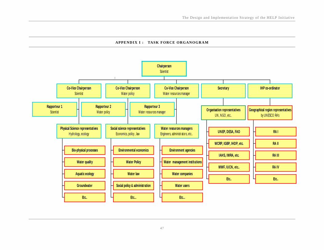
The Design and Implementation Strategy of the HELP Initiative
47
APPENDIX I : TASK FORCE ORGANOGRAM
Rapporteur 1Scientist
Bio-physical processes
Water quality
Aquatic ecology
Groundwater
Etc..
Physical Science representativesHydrology, ecology
Co-Vice ChairpersonScientist
Rapporteur 2Water policy
Environmental economics
Water Policy
Water law
Social policy & administration
Etc...
Social science representativesEconomics, policy , law
Co-Vice ChairpersonWater policy
Rapporteur 3Water resources manager
Environment agencies
Water management institutions
Water companies
Water users
Etc...
Water resources managersEngineers, administrators, etc..
Co-Vice ChairpersonWater resources manager
UNEP, DESA, FAO
WCRP, IGBP, IHDP, etc.
IAHS, IWRA, etc.
WWF, IUCN, etc..
Etc..
Organisation representativesUN , N GO, etc..
Secretary
RA I
RA II
RA III
RA IV
Etc..
Geographical region representativesby UN ESCO RA's
IHP co-ordinator
ChairpersonScientist
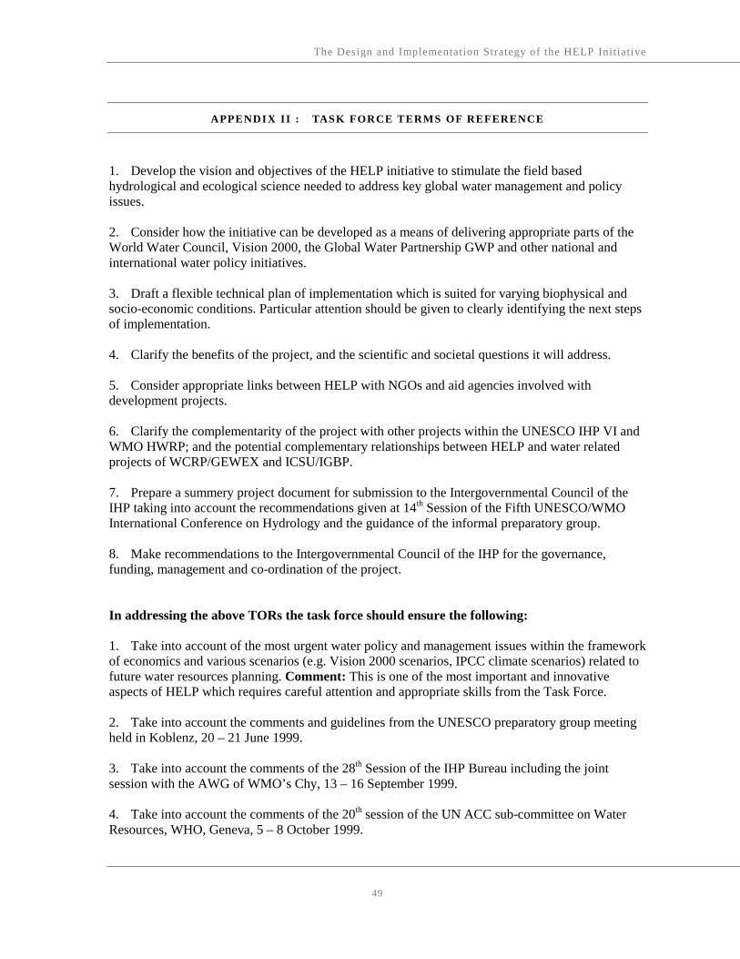
The Design and Implementation Strategy of the HELP Initiative
49
APPENDIX II : TASK FORCE TERMS OF REFERENCE
1. Develop the vision and objectives of the HELP initiative to stimulate the field based hydrological and ecological science needed to address key global water management and policy issues. 2. Consider how the initiative can be developed as a means of delivering appropriate parts of the World Water Council, Vision 2000, the Global Water Partnership GWP and other national and international water policy initiatives. 3. Draft a flexible technical plan of implementation which is suited for varying biophysical and socio-economic conditions. Particular attention should be given to clearly identifying the next steps of implementation. 4. Clarify the benefits of the project, and the scientific and societal questions it will address. 5. Consider appropriate links between HELP with NGOs and aid agencies involved with development projects. 6. Clarify the complementarity of the project with other projects within the UNESCO IHP VI and WMO HWRP; and the potential complementary relationships between HELP and water related projects of WCRP/GEWEX and ICSU/IGBP. 7. Prepare a summery project document for submission to the Intergovernmental Council of the IHP taking into account the recommendations given at 14th Session of the Fifth UNESCO/WMO International Conference on Hydrology and the guidance of the informal preparatory group. 8. Make recommendations to the Intergovernmental Council of the IHP for the governance, funding, management and co-ordination of the project. In addressing the above TORs the task force should ensure the following: 1. Take into account of the most urgent water policy and management issues within the framework of economics and various scenarios (e.g. Vision 2000 scenarios, IPCC climate scenarios) related to future water resources planning. Comment: This is one of the most important and innovative aspects of HELP which requires careful attention and appropriate skills from the Task Force. 2. Take into account the comments and guidelines from the UNESCO preparatory group meeting held in Koblenz, 20 – 21 June 1999. 3. Take into account the comments of the 28th Session of the IHP Bureau including the joint session with the AWG of WMO’s Chy, 13 – 16 September 1999. 4. Take into account the comments of the 20th session of the UN ACC sub-committee on Water Resources, WHO, Geneva, 5 – 8 October 1999.

The Design and Implementation Strategy of the HELP Initiative
50
5. That initiative is a process-oriented, hydrological, field based, scientific project addresses societal needs for freshwater management. At the same time the plan meshes with the varying socio-economic water needs of different regions coupled with the most innovative and appropriate experimental hydrological designs. 6. Advise on the most appropriate means for field testing, existing hydrological knowledge in different bio-physical and socio-economic environments. 7. That the project is designed for the scientific analyses of hydrological, ecological and socio-economic data required for integrated water resources management. 8. Consult with appropriate international programmes, national institutions and NGOs, and provide advice on opportunities for collaboration with HELP. 9. That the project is designed as a distinctive but cross-cutting programme of the IHP following the models of multidisciplinary integrated programms such as the FRIEND project. 10. That the project is designed as a long term initiative with clearly defined intermediate objectives/deliverables.

The Design and Implementation Strategy of the HELP Initiative
51
APPENDIX III : WORLD WATER COUNCIL’S VISION OF WATER, LIFE AND ENVIRONMENT IN THE 21 S T CENTURY
The Water Vision Project attempts to sketch the transition between today’s practices and those we will need if we are to meet our water needs in the future. As a part of this Project we developed three scenarios based on different water use strategies and different outcomes, viz, the Conventional Water World Scenario (Business as Usual), the Water Crisis Scenario, and the Sustainable Water World Scenario. We also convened thematic panels to discuss the effect of future developments in institutions, biotechnology, energy technology, and information technology. The World Water Vision describes the goals of sound water management and the actions we need to take to sustain water resources. The three primary objectives of integrated water resource management are: 1. Empower women, men, and communities to decide on the level of access to safe water and
hygienic living conditions and the types of water using economic activities that they wish and to organise to obtain it.
2. Produce more food, create more sustainable livelihoods for women and men per unit of water applied (more crops and jobs per drop), and ensure access for all to food required for healthy and productive lives.
3. Manage human water use to conserve the quantity and quality of freshwater and terrestrial ecosystems that provide services to humans and all living things.
The five key actions to achieve these objectives are to: 1. Involve all stakeholders in integrated management. 2. Move to full-cost pricing of water services for all human uses. 3. Increase public funding for research and innovation in the public interest. 4. Recognise the need for cooperation to improve international water resource management in
international water basins. 5. Massively increase the investments in water. References World Water Council. ‘Global Vision’ page at www.watervision.org. 1999. World Water Vision: Making Water Everybody’s Business.
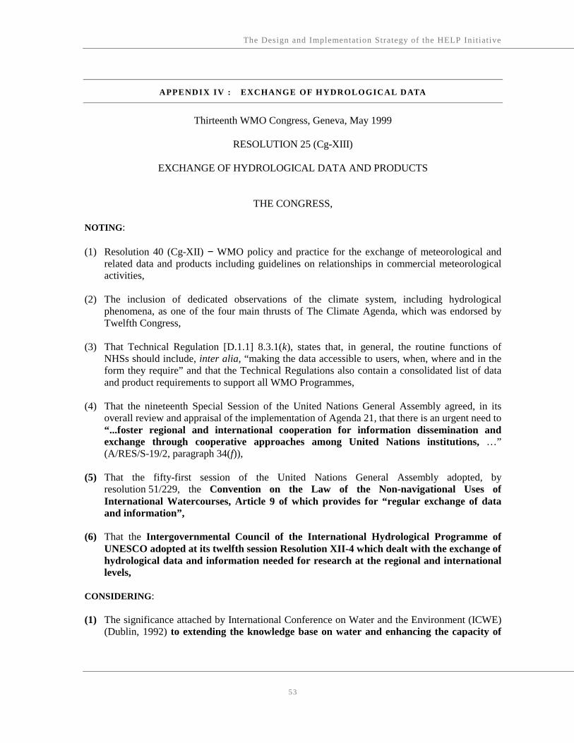
The Design and Implementation Strategy of the HELP Initiative
53
APPENDIX IV : EXCHANGE OF HYDROLOGICAL DATA
Thirteenth WMO Congress, Geneva, May 1999
RESOLUTION 25 (Cg-XIII)
EXCHANGE OF HYDROLOGICAL DATA AND PRODUCTS
THE CONGRESS, NOTING: (1) Resolution 40 (Cg-XII) − WMO policy and practice for the exchange of meteorological and
related data and products including guidelines on relationships in commercial meteorological activities,
(2) The inclusion of dedicated observations of the climate system, including hydrological
phenomena, as one of the four main thrusts of The Climate Agenda, which was endorsed by Twelfth Congress,
(3) That Technical Regulation [D.1.1] 8.3.1(k), states that, in general, the routine functions of
NHSs should include, inter alia, “making the data accessible to users, when, where and in the form they require” and that the Technical Regulations also contain a consolidated list of data and product requirements to support all WMO Programmes,
(4) That the nineteenth Special Session of the United Nations General Assembly agreed, in its
overall review and appraisal of the implementation of Agenda 21, that there is an urgent need to “...foster regional and international cooperation for information dissemination and exchange through cooperative approaches among United Nations institutions, …” (A/RES/S-19/2, paragraph 34(f)),
(5) That the fifty-first session of the United Nations General Assembly adopted, by
resolution 51/229, the Convention on the Law of the Non-navigational Uses of International Watercourses, Article 9 of which provides for “regular exchange of data and information”,
(6) That the Intergovernmental Council of the International Hydrological Programme of
UNESCO adopted at its twelfth session Resolution XII-4 which dealt with the exchange of hydrological data and information needed for research at the regional and international levels,
CONSIDERING: (1) The significance attached by International Conference on Water and the Environment (ICWE)
(Dublin, 1992) to extending the knowledge base on water and enhancing the capacity of

The Design and Implementation Strategy of the HELP Initiative
54
water sector specialists to implement all aspects of integrated water resources management,
(2) The call of world leaders at the United Nations Conference on Environment and Development
(UNCED)(Rio de Janeiro, 1992) for a significant strengthening of, and capacity building in,
water resources assessment, for increasing global commitment to exchange scientific data and analyses and for promoting access to strengthened systematic observations,
(3) That the United Nations Commission on Sustainable Development (CSD) in its Decision
6/1 “Strategic Approaches to Freshwater Management” has strongly encouraged States to promote the exchange and dissemination of water-related data and information, and has recognized “the need for periodic assessments … for a global picture of the state of freshwater resources and potential problems”,
(4) The call by the nineteenth Special Session of the United Nations General Assembly “for the
highest priority to be given to the serious freshwater problems facing many regions, especially in the developing world” and the “urgent need … to strengthen the capability of Governments and international institutions to collect and manage information … and environmental data, in order to facilitate the integrated assessment and management of water resources”,
(5) The requirements for full, open and prompt exchange of hydrological data and products in
support of various international conventions, such as the Convention on Biological Diversity, the United Nations Framework Convention on Climate Change, and the Convention to Combat Desertification,
(6) The requirement for the global exchange of hydrological information in support of scientific
investigations of world importance such as those on global change and the global hydrological cycle, and as a contribution to relevant programmes and projects of WMO, other United Nations agencies, ICSU and other organizations of equivalent status,
(7) The opportunities for more efficient management of water resources and the need for
cooperation in mitigating water-related hazards in transboundary river basins and their water bodies which depend on the international exchange of hydrological data and information,
(8) The increasing recognition through scientific and technical endeavours, such as GEWEX, of the
importance of hydrological data and products in improving the understanding of meteorological processes and subsequently the accuracy of meteorological products,
RECOGNIZING: (1) The responsibility of Members and their NHSs to provide for the security and well-being of the
people of their countries, through mitigation of water-related hazards and sustainable management of water resources,
The Design and Implementation Strategy of the HELP Initiative
55
(2) The potential benefits of enhanced exchange of hydrological data and information within shared river basins and aquifers, based on agreements between the Members concerned,
(3) The continuing need for strengthening the capabilities of NHSs, particularly in developing
countries,
(4) The right of Governments to choose the manner by which, and the extent to which, they make hydrological data and products available domestically and internationally,
(5) The right of Governments also to choose the extent to which they make available
internationally data which are vital to national defense and security. Nevertheless, Members shall cooperate in good faith with other Members with a view to providing as much data as possible under the circumstances,
(6) The requirement by some Members that their NHSs earn revenue from users, and/or adopt
commercial practices in managing their businesses, (7) The long-established provision of some hydrological products and services on a commercial
basis and in a competitive environment, and the impacts, both positive and negative, associated with such arrangements,
ADOPTS a stand of committing to broadening and enhancing, whenever possible, the free and unrestricted3 international exchange4 of hydrological data and products, in consonance with the requirements for WMO’s scientific and technical programmes; FURTHER ADOPTS the following practice on the international exchange of hydrological information: (1) Members shall provide on a free and unrestricted basis those hydrological data and products
which are necessary for the provision of services in support of the protection of life and property and for the well-being of all peoples;
(2) Members should also provide additional hydrological data and products, where available,
which are required to sustain programmes and projects of WMO, other United Nations agencies, ICSU and other organizations of equivalent status, related to operational hydrology and water resources research at the global, regional and national levels and, furthermore, to assist other Members in the provision of hydrological services in their countries;
3 “Free and unrestricted” means non-discriminatory and without charge. “Without charge”, in
the context of this resolution means at no more than the cost of reproduction and delivery, without charge for the data and products themselves.
4 “Exchange”, in the context of this resolution, means the movement of data and products between countries or, as is more likely the case in the field of hydrology, the movement of data and products from one country to another.

The Design and Implementation Strategy of the HELP Initiative
56
(3) Members should provide to the research and education communities, for their non-commercial
activities, free and unrestricted access to all hydrological data and products exchanged under the auspices of WMO;
(4) Respecting (2) and (3) above, Members may place conditions on the re-export5, for commercial
purposes, of these hydrological data and products, outside the receiving country or group of countries forming a single economic group;
(5) Members should make known to all Members, through the WMO Secretariat, those
hydrological data and products which have such conditions as in (4) above;
(6) Members should make their best efforts to ensure that the conditions placed by the originator
on the additional hydrological data and products are made known to initial and subsequent
recipients;
(7) Members shall ensure that the exchange of hydrological data and products under this resolution
is consistent with the application of Resolution 40 (Cg-XII) – WMO policy and practice for the exchange of meteorological and related data and products including guidelines on relationships in commercial meteorological activities;
URGES Members, in respect of the operational and scientific use of hydrological data and products, to: (1) Make their best efforts to implement the practice on the international exchange of hydrological
data and products, as described in FURTHER ADOPTS (1) to (7); (2) Assist other Members, to the extent possible, and as agreed upon, in developing their capacity
to implement the practice described in FURTHER ADOPTS (1) to (7); REQUESTS the Executive Council to: (1) Invite the Commission for Hydrology to provide advice and assistance on technical aspects of
the implementation of the practice on the international exchange of hydrological data and products;
(2) Keep the implementation of this resolution under review and report to Fourteenth Congress; DECIDES to review the implementation of this resolution at Fourteenth Congress.
5 “Re-export”, in the context of this resolution, means to redistribute, physically or
electronically, outside the receiving country, group of countries forming a single economic group, or regional and global data centres, directly or through a third party.

The Design and Implementation Strategy of the HELP Initiative
57
APPENDIX V : WATER LAW AND POLICY ISSUES
Excerpts from International Water Convention That Require Science Support Excerpts from The 1997 UN Convention on the Law of the Non-Navigational Uses of International
Watercourses:
Article 2 Use of terms
For the purposes of the present Convention: (a) "Watercourse" means a system of surface waters and groundwaters constituting by virtue of their physical relationship a unitary whole and normally flowing into a common terminus;
Article 5 Equitable and reasonable utilization and participation
1. Watercourse States shall in their respective territories utilize an international watercourse in an equitable and reasonable manner. In particular, an international watercourse shall be used and developed by watercourse States with a view to attaining optimal and sustainable utilization thereof and benefits therefrom, taking into account the interests of the watercourse States concerned, consistent with adequate protection of the watercourse.
Article 6 Factors relevant to equitable and reasonable utilization
1. Utilization of an international watercourse in an equitable and reasonable manner within the meaning of article 5 requires taking into account all relevant factors and circumstances, including: (a) Geographic, hydrographic, hydrological, climatic, ecological and other factors of a natural character; (b) The social and economic needs of the watercourse States concerned; (c) The population dependent on the watercourse in each watercourse State; (d) The effects of the use or uses of the watercourses in one watercourse State on other watercourse States; (e) Existing and potential uses of the watercourse; (f) Conservation, protection, development and economy of use of the water resources of the watercourse and the costs of measures taken to that effect; (g) The availability of alternatives, of comparable value, to a particular planned or existing use. 2. In the application of article 5 or paragraph 1 of this article, watercourse States concerned shall, when the need arises, enter into consultations in a spirit of cooperation. 3. The weight to be given to each factor is to be determined by its importance in comparison with that of other relevant factors. In determining what is a reasonable and equitable use, all relevant factors are to be considered together and a conclusion reached on the basis of the whole.
Article 7 Obligation not to cause significant harm
1. Watercourse States shall, in utilizing an international watercourse in their territories, take all appropriate measures to prevent the causing of significant harm to other watercourse States.

The Design and Implementation Strategy of the HELP Initiative
58
2. Where significant harm nevertheless is caused to another watercourse State, the States whose use causes such harm shall, in the absence of agreement to such use, take all appropriate measures, having due regard for the provisions of articles 5 and 6, in consultation with the affected State, to eliminate or mitigate such harm and, where appropriate, to discuss the question of compensation.
Article 9 Regular exchange of data and information
1. Pursuant to article 8, watercourse States shall on a regular basis exchange readily available data and information on the condition of the watercourse, in particular that of a hydrological, meteorological, hydrogeological and ecological nature and related to the water quality as well as related forecasts. 2. If a watercourse State is requested by another watercourse State to provide data or information that is not readily available, it shall employ its best efforts to comply with the request but may condition its compliance upon payment by the requesting State of the reasonable costs of collecting and, where appropriate, processing such data or information. 3. Watercourse States shall employ their best efforts to collect and, where appropriate, to process data and information in a manner which facilitates its utilization by the other watercourse States to which it is communicated.
Article 10 Relationship between different kinds of uses
1. In the absence of agreement or custom to the contrary, no use of an international watercourse enjoys inherent priority over other uses. 2. In the event of a conflict between uses of an international watercourse, it shall be resolved with reference to articles 5 to 7, with special regard being given to the requirements of vital human needs.
Article 11 Information concerning planned measures
Watercourse States shall exchange information and consult each other and, if necessary, negotiate on the possible effects of planned measures on the condition of an international watercourse.
Article 12 Notification concerning planned measures with possible adverse effects
Before a watercourse State implements or permits the implementation of planned measures which may have a significant adverse effect upon other watercourse States, it shall provide those States with timely notification thereof. Such notification shall be accompanied by available technical data and information, including the results of any environmental impact assessment, in order to enable the notified States to evaluate the possible effects of the planned measures.
Article 19 Urgent implementation of planned measures
1. In the event that the implementation of planned measures is of the utmost urgency in order to protect public health, public safety or other equally important interests, the State planning the measures may, subject to articles 5 and 7, immediately proceed to implementation, notwithstanding the provisions of article 14 and paragraph 3 of article 17. 2. In such case, a formal declaration of the urgency of the measures shall be communicated without delay to the other watercourse States referred to in article 12 together with the relevant data and information.

The Design and Implementation Strategy of the HELP Initiative
59
3. The State planning the measures shall, at the request of any of the States referred to in paragraph 2, promptly enter into consultations and negotiations with it in the manner indicated in paragraphs 1 and 2 of article 17.
Article 20 Protection and preservation of ecosystems
Watercourse States shall, individually and, where appropriate, jointly, protect and preserve the ecosystems of international watercourses.
Article 21 Prevention, reduction and control of pollution
1. For the purpose of this article, "pollution of an international watercourse" means any detrimental alteration in the composition or quality of the waters of an international watercourse which results directly or indirectly from human conduct. 2. Watercourse States shall, individually and, where appropriate, jointly, prevent, reduce and control the pollution of an international watercourse that may cause significant harm to other watercourse States or to their environment, including harm to human health or safety, to the use of the waters for any beneficial purpose or to the living resources of the watercourse. Watercourse States shall take steps to harmonize their policies in this connection. 3. Watercourse States shall, at the request of any of them, consult with a view to arriving at mutually agreeable measures and methods to prevent, reduce and control pollution of an international watercourse, such as: (a) Setting joint water quality objectives and criteria; (b) Establishing techniques and practices to address pollution from point and non-point sources; (c) Establishing lists of substances the introduction of which into the waters of an international watercourse is to be prohibited, limited, investigated or monitored.
Article 22 Introduction of alien or new species
Watercourse States shall take all measures necessary to prevent the introduction of species, alien or new, into an international watercourse which may have effects detrimental to the ecosystem of the watercourse resulting in significant harm to other watercourse States.
Article 23 Protection and preservation of the marine environment
Watercourse States shall, individually and, where appropriate, in cooperation with other States, take all measures with respect to an international watercourse that are necessary to protect and preserve the marine environment, including estuaries, taking into account generally accepted international rules and standards.
Article 25 Regulation
1. Watercourse States shall cooperate, where appropriate, to respond to needs or opportunities for regulation of the flow of the waters of an international watercourse. 2. Unless otherwise agreed, watercourse States shall participate on an equitable basis in the construction and maintenance or defrayal of the costs of such regulation works as they may have agreed to undertake.

The Design and Implementation Strategy of the HELP Initiative
60
Article 33 Settlement of disputes
1. In the event of a dispute between two or more Parties concerning the interpretation or application of the present Convention, the Parties concerned shall, in the absence of an applicable agreement between them, seek a settlement of the dispute by peaceful means in accordance with the following provisions. 2. If the Parties concerned cannot reach agreement by negotiation requested by one of them, they may jointly seek the good offices of, or request mediation or conciliation by, a third party, or make use, as appropriate, of any joint watercourse institutions that may have been established by them or agree to submit the dispute to arbitration or to the International Court of Justice. 3. Subject to the operation of paragraph 10, if after six months from the time of the request for negotiations referred to in paragraph 2, the Parties concerned have not been able to settle their dispute through negotiation or any other means referred to in paragraph 2, the dispute shall be submitted, at the request of any of the parties to the dispute, to impartial fact-finding in accordance with paragraphs 4 to 9, unless the Parties otherwise agree. 4. A Fact-finding Commission shall be established, composed of one member nominated by each Party concerned and in addition a member not having the nationality of any of the Parties concerned chosen by the nominated members who shall serve as Chairman. 5. If the members nominated by the Parties are unable to agree on a Chairman within three months of the request for the establishment of the Commission, any Party concerned may request the Secretary- General of the United Nations to appoint the Chairman who shall not have the nationality of any of the parties to the dispute or of any riparian State of the watercourse concerned. If one of the Parties fails to nominate a member within three months of the initial request pursuant to paragraph 3, any other Party concerned may request the Secretary-General of the United Nations to appoint a person who shall not have the nationality of any of the parties to the dispute or of any riparian State of the watercourse concerned. The person so appointed shall constitute a single-member Commission. 6. The Commission shall determine its own procedure. 7. The Parties concerned have the obligation to provide the Commission with such information as it may require and, on request, to permit the Commission to have access to their respective territory and to inspect any facilities, plant, equipment, construction or natural feature relevant for the purpose of its inquiry. 8. The Commission shall adopt its report by a majority vote, unless it is a single-member Commission, and shall submit that report to the Parties concerned setting forth its findings and the reasons therefor and such recommendations as it deems appropriate for an equitable solution of the dispute, which the Parties concerned shall consider in good faith. 9. The expenses of the Commission shall be borne equally by the Parties concerned. 10. When ratifying, accepting, approving or acceding to the present Convention, or at any time thereafter, a Party which is not a regional economic integration organization may declare in a written instrument submitted to the Depositary that, in respect of any dispute not resolved in accordance with paragraph 2, it recognizes as compulsory ipso facto and without special agreement in relation to any Party accepting the same obligation: (a) Submission of the dispute to the International Court of Justice; and/or (b) Arbitration by an arbitral tribunal established and operating, unless the parties to the dispute otherwise agreed, in accordance with the procedure laid down in the annex to the present Convention. A Party which is a regional economic integration organization may make a declaration with like effect in relation to arbitration in accordance with subparagraph (b).

The Design and Implementation Strategy of the HELP Initiative
61
APPENDIX VI : A HYPOTHETICAL EXAMPLE OF A HELP CATCHMENT
The purpose of this section is to demonstrate how proposed basins should be presented for inclusion in the HELP programme. To this end, an imaginary basin has been constructed: the Rio Aqua Basin in MyLand. It was deemed best not to use a real basin, since this would require a degree of specificity and accuracy not achievable while preparing this document. It would also risk raising arguments regarding the reality in that basin. This imaginary example is not meant to be a required template for all HELP basins; it is merely a suggested guiding format for preparing a proposal to include a basin in the HELP programme. HELP basins will differ with respect to their physical characteristics, the legal and institutional setup, and the issues and problems needing attention and which can be aided by participation in the HELP programme. The Rio Aqua Basin in MyLand Size: 8,000 km2 Rivers: Rio Aqua and two tributaries: Rio Beta and Rio Gamma Under 3,000 km2 of the basin there is a phreatic aquifer Average annual precipitation: 400 mm Seasons: six-month summer with no rainfall, six-month winter Annual water quantities under current conditions: • Rio Aqua flow at the outlet from the basin: 200 million m3 per year; • Rio Beta flow at the confluence with Rio Aqua: 30 million m3 per year; • Rio Gamma at the confluence with Rio Aqua: 45 million m3 per year; • annual recharge of the aquifer estimated at 120 million m3 per year; • current withdrawal from the aquifer 150 million m3 per year. Topography: mostly flat with rising mountains on the boundaries of the catchment to the north and west. Population: 1 million, of which 500,000 live in Villa, the main and only large city of the basin, and the remainder in the rural area. A quarter of Villa’s population lives in MyTown, a shantytown downstream of the main city. In Villa there are water supply, sewerage and storm water drainage systems. In MyTown there are none: the people take their water directly from the river, and discharge untreated sewage into the river. Land uses: • agriculture, of which 150,000 hectares are irrigated; main crops: corn, wheat, cotton, fruit
orchards: 380,00 hectares; • forest, in the western parts: 80,000 hectares; • urban and other settlements: 70,000 hectares; • open land, including a nature reserve below the city, and a large wetland at the confluence of
Tributary Gamma and Rio Aqua: 270,000 hectares.

The Design and Implementation Strategy of the HELP Initiative
62
A dam located on Rio Aqua, upstream of the city, is used for: • power generation (which does not supply all of the energy to the basin; the rest is imported); • flood control; • a reliable water supply to the city; • recreation. Water users in the basin: • urban, from the river; • agricultural, from river and groundwater; • instream for fish on Rio Beta and Gamma and downstream from the city; • the wetland on Rio Gamma; • power generation in the dam upstream from the city. Existing and forecasted uses and concerns: • urban demands are growing rapidly; • environmental uses – fish in the rivers and especially the wetlands – are gaining attention; • flood control in the city is a growing concern; • water quality below the city has been deteriorating; • water supply and sanitation in MyTown are a major concern, to improve the health of residents
and restore water quality in Rio Aqua downstream of MyTown. Legal and institutional framework A national water law states that: • water is owned by the state; • management and implementation are delegated to basin authorities; • basic human needs are first priority; • allocation to users is by licence, which may be modified by the authority in response to
hydrological conditions; • environmental protection is a component of this law; • risk management should be considered; • all water-related information is in the public domain. Water policy and management issues are: • how to allocate water to all uses and users – principles and practice; • maintaining water quality for human health and environmental protection – fish in the rivers,
wetland. Institutional structure: • a national water authority, responsible for issuing policy, setting principles for management; • a national environmental protection authority with no office in the basin; • a local Rio Aqua River Basin Authority (RARBA) is responsible for water management in the
basin. Agencies: • national Met Service with no local office; • national Hydrological Service with a local office in the basin;

The Design and Implementation Strategy of the HELP Initiative
63
• national authority for groundwater management, separate from the water authority, with a local representative;
• national Environmental Agency with no local office; • agricultural authority with a local office; • a local power company. NGOs: • A small but active NGO is fighting to maintain the wetland; • A citizens’ action group is pressing for water supply and sanitation in MyTown. Professional capabilities: • good professional capability in the central met and hydrologic offices in the capital, which is
1000 km away; • medium-level hydrologic capability in the local city; • The RARBA has good planning capabilities, but no experience in the use of models to aid
decision making. Data and models: • existing data: 30 years of extensive met data, 25 years of streamflow data, with many gaps,
some water-quality data of a few parameters; • access to data: restricted by the agencies to their own staff; • existing models: preliminary GIS model and some statistical analysis, some conventional
hydrological modelling but no comprehensive water resources management modelling – all in the capital with very little in the basin itself.
Problems and conflicts: • excessive extraction of groundwater by farmers has resulted in: • a declining water table in the aquifer; • reduced flows in the river; • competition with downstream users (power, flows and water quality in the river, water supply in
the city). Maintaining flows for the wetland is in competition with increasing the flows in the river for all downstream users (who are demanding that wetlands be reduced, even eliminated). Salinisation of the soil is causing reduction of agricultural production; farmers are asking for water from the river. Agricultural return flows are causing quality problems in Rio Aqua. There is a lack of adequate co-operation among the local offices of the agencies, and lack of adequate linkages between some of the local offices and their headquarters in the capital. Justification for becoming a HELP basin The RARBA is seeking to improve the integrated basin management, in order to: • improve the benefits to all stakeholders within the basin; • resolve or at least manage existing conflicts;
The Design and Implementation Strategy of the HELP Initiative
64
• avoid future conflicts. RARBA and the national agencies have agreed that: • demand management options have not been developed adequately; • both supply and demand management options need to be considered jointly; • hydrological and related data are incomplete; • new data collection and analysis technologies may be useful; • water-quality information is lacking; • socio-economic aspects require study and integration with the water resources management
aspects; • environmental problems are increasing and require better integration into the management
structure; • policies exist to allow better management, but they are not implemented for a variety of reasons,
including inadequate understanding of the hydrological and related physical processes; • lack of adequate professional capacity at the appropriate (local) levels of management is
hindering progress. The authority therefore wishes to benefit from being a HELP basin. The main contact with HELP will be at RARBA, with participation of designated professionals from the headquarter offices. RARBA and the national authorities are prepared to: • conform to the stated HELP policy on data and information exchange and sharing; • participate in the HELP process and share information, techniques and results within the HELP
structure.

The Design and Implementation Strategy of the HELP Initiative
65
APPENDIX VII : AN EXAMPLE OF A HELP CATCHMENT STUDY IN NEW ZEALAND
MOTUEKA CATCHMENT, NEW ZEALAND
Integrating Hydrology, Freshwater Ecology and Social Processes Research for
Catchment-Scale Management
A. Pearce, Landcare Research, New Zealand
W.B. Bowden, Landcare Research, New Zealand T. Dunne, University of California, Santa Barbara, USA
A. Fenemor, Tasman District Council, New Zealand J. Harding, Cawthron Institute, New Zealand
G. Likens, Institute of Ecosystem Studies, New York, USA
1. Overview of Motueka Catchment • A real catchment (2000+km²), not an experimental catchment • Real issues: 1) land-use effects on water yield, 2) conflict over surface and ground water
use, 3) low flow and sediment impacts on trout fishery, 4) land-use effects on water quality (nutrients, bacteria)
• How can research help to manage the effects of all uses and to resolve or manage conflicts over resources?
2. Land Uses
• Mountains (1600+m) to sea; 3500+mm rainfall to <1000mm • National and conservation parks in primary forest – tourism, conservation • Extensive plantation forests • Sheep and beef farming on hills, changing to plantations • Dairy farming on valley floors – supplementary irrigation • Berry fruit, hops, kiwi fruit under irrigation on valley floors and flood plain
3. Conflicts
• Forest harvesting on some hill country generates a lot of fine sediment • Sediment damage to trout habitat and fishery • Conflict over surface water – irrigation vs minimum flow/fish habitat • Legal action to protect minimum low flow for trout fishery • Livestock access to streams causes nutrient and bacterial contamination • Conflict over groundwater use: 1) near-stream extraction vs low flows and 2) plantations vs
groundwater recharge 4. Overview of Process • Initial 2 day meeting of 40 stakeholders and users to scope regional issues and research
opportunities (March 1998). Report sent to all attendees. • Follow-up discussion in 1998 and 1999 to confirm issues identified.
The Design and Implementation Strategy of the HELP Initiative
66
- Consensus emerges on key issues and Motueka catchment as research focus - Tasman District Council (TDC) supports proposals
• International experts (Dunne and Likens of the USA) agree mid-1999 to undertake review and design project in early 2000
• Experts convene for 3 weeks in New Zealand for next 3 stages • Four interest group meetings to check and refine issues identified (January
2000) - Upstream farmers - Downstream farmers - Iwi and economic sector representatives - Marine resource users
• A questionnaire sent to 160 community stakeholders to prioritise catchment research issues • Seven meetings with research staff of Cawthron, Landcare Research, Tasman District
Council and 5 other collaborating research institutes - Define key researchable questions
• Expert panel reports on issues, researchable questions, and proposed research February 2000 • Research agreed with funders and implemented (July 2000 onwards)
5. The Key Issues: Water
• Effects of plantation forestry on stream-flow and groundwater recharge • Effect of near-stream groundwater pumping on low stream-flows • Effect of floods on stratifying Tasman Bay and transporting sediment, chemical and
microbial contaminants to shellfish beds
6. The Key Issues: Sediment • Risk to channels and trout habitat from sediment supplied after forest harvesting • Short and long-term sediment impacts in Tasman Bay (very shallow)
7. The Key Issues: Water Quality • Nitrogen and bacterial loads in downstream reaches and Tasman Bay • Animal access to streams and berry fruit irrigation fertiliser suspected
8. The Key Issues: Aquatic Biota • Significant decline in famous trout fishery – diametrically opposed views on causes • Concerns about native fish, invertebrates, and maintaining freshwater biodiversity
9. The Key Issues: Riperian Zones
• No consensus and little information on condition of riparian zones, their effect on water quality, or habitat for birds and other terrestrial biota
10. The Researchable Questions
• Compile historical information on Motueka catchment from early settlement by humans (<1000 years ago) to the present
• The ground and surface water supply • Sources and dispersal of sediment • Nature and spatial distribution of aquatic habitat • Nature, distribution, and function of riparian zones • Water quality and the export of nutrients and contaminants to Tasman bay

The Design and Implementation Strategy of the HELP Initiative
67
• Designing how research results are to be used in decision-making and evaluating how and what learning occurs in such a process
11. Research for the First 2 Years
• Knowledge integration and delivery for Integrated Catchment Management - Construct knowledge base of historic and current environment with key users and
stakeholders (maps, database, narrative)
- Develop web site for access, retrieval and contributions - Establish and work with Community Advisory Group for community involvement and
communication • Land-use influences on water quality and quantity
- Quantify components of surface water balance for the major land uses and land forms
- Quantify primary components of sub-surface water balance for primary aquifers in the upper catchment
- Simulate catchment-wide water balance with simple, fast spatially explicit model for current, historic, and future land use scenarios
- Produce model results as visualisations, incorporate into knowledge base and discuss them with users and community groups
- Determine key gaps in process knowledge to refine these simulations and design field experiments to fill the highest priority gaps (future work)
- Design and establish network of environmental sampling stations for water, sediment, nutrients, contaminants, and pathogens
• Riparian zones - Develop typology of riparian zones and map the catchment - Place maps on website - Establish study of stream health, habitat quality, and riparian conditions at
representative sites • Land-use effects on fresh water and coastal ecosystems
- Develop model of whole stream benthic invertebrate production - Produce GIS maps of distribution of substrate types and biota for inter-tidal and delta
zones - Develop conceptual coastal ecosystem model for distribution of microalgae over scallop
beds in Motueka river plume - Determine dynamics of microalgal community structure and quantity/quality of
suspended particulates in near-bottom water • Social learning
- Work with stakeholders and indigenous landholders to develop ways to link diverse knowledge bases, improve uptake and enhance learning
- Use these findings to develop and improve web site and simulation models - Trial participatory approach to further develop research priorities and management tools
for 2 selected issues - Estimate marginal economic benefits to anglers from maintaining fish habitat, and to
land users from water used for irrigation - Develop and test indicators of understanding and use of science in integrated catchment
management


![Chapter [6] Strategy Implementation and Control Strategy Implementation and Control](https://img.pdfslide.us/doc/110x75/56649cdb5503460f949a5895/chapter-6-strategy-implementation-and-control-strategy-implementation-and.jpg)