Embed Size (px)
Citation preview

Proc. IAHS, 372, 49–52, 2015
proc-iahs.net/372/49/2015/
doi:10.5194/piahs-372-49-2015
© Author(s) 2015. CC Attribution 3.0 License.
Open Access
Pre
ventio
nand
mitig
atio
nofnatu
raland
anth
ropogenic
hazard
sdue
tola
nd
subsid
ence
The deformation behavior of soil mass in the subsidence
region of Beijing, China
F. Tian1, J.-R. Liu1, Y. Luo1,2, L. Zhu3, Y. Yang1,4, and Y. Zhou1,4
1Beijing Institute of Hydrogeology and Engineering Geology, Beijing, China2College Of Earth Science, University of Chinese Academy Of Sciences, Beijing, China
3College of Resources Environment and Tourism, Capital Normal University, Beijing, China4School of Earth and Space Sciences, Peking University, Beijing, China
Correspondence to: F. Tian ([email protected])
Published: 12 November 2015
Abstract. Land subsidence induced by excessive groundwater withdrawal has been a major environmental and
geological problem in the Beijing plain area. The monitoring network of land subsidence in Beijing has been
established since 2002 and has covered the entire plain area by the end of 2008. Based on data from extensome-
ters and groundwater observation wells, this paper establishes curves of variations over time for both soil mass
deformation and water levels and the relationship between soil mass deformation and water level. In addition,
an analysis of deformation behavior is carried out for soil mass with various lithologies at different depths de-
pending on the corresponding water level. Finally, the deformation behavior of soil mass is generalized into five
categories. The conclusions include: (i) the current rate of deformation of the shallow soil mass is slowing, and
most of the mid-deep and deep soil mass continue to compress at a more rapid speed; (ii) the sand strata be-
haves elastically, while the clay soil mass at different depths is usually characterized by elastic-plastic and creep
deformation, which can be considered as visco-elastoplastic.
1 Introduction
Serious land subsidence problems due to excessive ground-
water withdrawal have emerged in more than 150 cities all
over the word (Hu et al., 2004; Tomás et al., 2010). Ground-
water is the main supply source of public water in Beijing. In
the past few decades, groundwater supply has accounted for
approximately two-thirds of the total water supply in Beijing
(Zhang et al., 2008). At the same time, some environmen-
tal geological problems arising from excessive groundwater
exploitation, especially land subsidence and ground fissures,
have attracted much attention. A land subsidence monitor-
ing system in Beijing began to be constructed in 2002. In
2008, the system began collecting data from extensometers,
leveling networks, InSAR and GPS surveys. The monitoring
results show that by the end of 2012, the region has expe-
rienced a cumulative subsidence more than 50 mm and has
affected about 4300 km2, accounting for about 68 % of the
Beijing plain area.
Many stress-strain analyses for the aquifer-system were
carried out based on borehole extensometers (Burbey, 2001;
Zhang et al., 2006). This paper presents a comprehensive
analysis of data from the extensometers to reveal the defor-
mation behavior of soil mass in the subsidence prone area of
Beijing.
2 Deformation behaviors of soil mass at different
depth
Research has shown that temporal relation patterns exist be-
tween land subsidence and groundwater withdrawal. The pri-
mary subsidence layers have gradually shifted from shallow
to deeper formations (with depth more than 100 m) coincid-
ing with the increase of the mining depth of groundwater.
F1, F2 and F3 are three subsidence stations which are
equipped with a series of extensometers and, pore pressure
transducers yielding groundwater level observations at dif-
ferent depths (Fig. 1). Generally, the Quaternary unconsoli-
Published by Copernicus Publications on behalf of the International Association of Hydrological Sciences.
50 F. Tian et al.: The deformation behavior of soil mass in Beijing
Figure 1. Location of three monitoring stations (F1, F2 and F3) for land subsidence in Beijing.
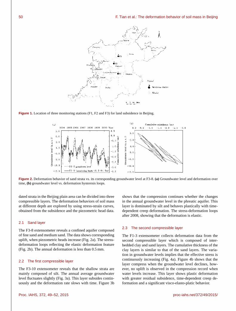
Figure 2. Deformation behavior of sand strata vs. its corresponding groundwater level at F3-8. (a) Groundwater level and deformation over
time, (b) groundwater level vs. deformation hysteresis loops.
dated strata in the Beijing plain area can be divided into three
compressible layers. The deformation behaviors of soil mass
at different depth are explored by using stress-strain curves,
obtained from the subsidence and the piezometric head data.
2.1 Sand layer
The F3-8 extensometer reveals a confined aquifer composed
of fine sand and medium sand. The data shows corresponding
uplift, when piezometric heads increase (Fig. 2a). The stress-
deformation loops reflecting the elastic deformation feature
(Fig. 2b). The annual deformation is less than 0.5 mm.
2.2 The first compressible layer
The F3-10 extensometer reveals that the shallow strata are
mainly composed of silt. The annual average groundwater
level fluctuates slightly (Fig. 3a). This layer subsides contin-
uously and the deformation rate slows with time. Figure 3b
shows that the compression continues whether the changes
in the annual groundwater level in the phreatic aquifer. This
layer is dominated by silt and behaves plastically with time-
dependent creep deformation. The stress-deformation loops
after 2008, showing that the deformation is elastic.
2.3 The second compressible layer
The F1-3 extensometer collects deformation data from the
second compressible layer which is composed of inter-
bedded clay and sand layers. The cumulative thickness of the
clay layers is similar to that of the sand layers. The varia-
tion in groundwater levels implies that the effective stress is
continuously increasing (Fig. 4a). Figure 4b shows that the
layer compress when the groundwater level declines, how-
ever, no uplift is observed in the compression record when
water levels increase. This layer shows plastic deformation
with greater residual subsidence, time-dependent creep de-
formation and a significant visco-elasto-platic behavior.
Proc. IAHS, 372, 49–52, 2015 proc-iahs.net/372/49/2015/

F. Tian et al.: The deformation behavior of soil mass in Beijing 51
Figure 3. Deformation behavior of shallow soil mass vs. its corresponding groundwater level at layered mark F3-10. (a) Groundwater level
and deformation over time, (b) groundwater level vs. deformation hysteresis loops.
Figure 4. Deformation behavior of the mid-deep soil mass vs. its corresponding groundwater level at layered mark F1-3. (a) Groundwater
level and deformation over time, (b) groundwater level vs. deformation hysteresis loops.
Figure 5. Deformation behavior of the deep soil mass vs. its corresponding groundwater level at layered mark F2-2. (a) Groundwater level
and deformation over time, (b) groundwater level vs. deformation hysteresis loops.
2.4 The third compressible layer
The F2-2 extensometer monitors a thick clay layer in the up-
per part accounting for 75 % of the total thickness of this
layer. The groundwater level declined from 2004 to August
2008 and then increased. Initially, the layer continuously
compressed regardless of whether the groundwater level in-
creased or declined, and subsequent to 2008 the compression
rate decreased (Fig. 5a). The deformation is in the plastic
range and creep deformation reveals an obvious lag effect
(Fig. 5b). The compression shows obvious lag effect with the
changes in groundwater level.
The F3-3 extensometer monitors the deformation of the
layer composed of thick silts and clays with a cumulative
thickness accounting for 80 % of this layer. The groundwater
level of this layer continuously declines and behaves plasti-
proc-iahs.net/372/49/2015/ Proc. IAHS, 372, 49–52, 2015

52 F. Tian et al.: The deformation behavior of soil mass in Beijing
Figure 6. Deformation of the deep soil mass vs. its corresponding groundwater level at layered mark F3-3. (a) Groundwater level and
deformation over time, (b) groundwater level vs. deformation hysteresis loops.
cally, while creep is largely elastic with visco-elasto-platic
features (Fig. 6).
The above reveals the different deformation patterns asso-
ciated with different groundwater levels at different depths.
The deformation occurs mainly in the second compressible
layer. In recent years, the discharge from the deep aquifers
drastically increased, and the groundwater level has subse-
quently declined. The deformation of the third compressible
layer accounts for the greater quantity of the total land sub-
sidence in the region.
3 Conclusions
Five deformation patterns exist for different depths and
groundwater change patterns in land subsidence region of
Beijing. The sandy layer shows elastic deformation. The clay
layers at different depths show elastic, plastic and creep de-
formations with visco-elasto-platic features. The deforma-
tion is controlled by the thickness of the compressible de-
posit, lithology and the physical and mechanical properties
when the pattern of groundwater level change is provided.
The deformation of the first compressible layer accounts for
least amount of total land subsidence. Most of the deforma-
tion occurs in the second and third compressible layers.
Acknowledgements. This study was supported by the project of
land subsidence monitoring operation in Beijing and the authors
would also like to acknowledge colleagues for their contribution
to this paper.
References
Burbey, T. J.: Stress-strain analyses for aquifer-system characteri-
zation, Ground Water, 39, 128–136, 2001.
Hu, R. L., Yue, Z. Q., Wang, L. C., and Wang, S. J.: Review on
current status and challenging issues of land subsidence in China,
Eng. Geol., 76, 65–77, 2004.
Tomás, R., Herrera, G., Delgado, J., Lopez-Sanchez, J. M., Mal-
lorquí, J. J., and Mulas, J.: A ground subsidence study based on
DInSAR data: Calibration of soil parameters and subsidence pre-
diction in Murcia City (Spain), Eng. Geol., 111, 19–30, 2010.
Zhang, A. J., Ye, Ch., Li, Y., and Xie, Z. H.: Beijing Groundwater,
China Land Press, Beijing, 2008 (in Chinese).
Zhang, Y., Xue, Y. Q., Ye, S. J., Wu, J. C., and Li, Q. F.: Analy-
sis of deformation of sand strata and land subsidence based on
modes of groundwater level changes in Shanghai City, The Chi-
nese Journal of Geological Hazard and Control, 17, 103–108,
2006 (in Chinese with English abstract).
Proc. IAHS, 372, 49–52, 2015 proc-iahs.net/372/49/2015/

![Study of land subsidence around the city of Shirazscientiairanica.sharif.edu/article_2167_b3bb54f3fcf13e2c...tectonic subsidence, and etc. [2]. Land subsidence, as a serious crisis,](https://img.pdfslide.us/doc/110x75/5f81603bf7f7323e190f6f7c/study-of-land-subsidence-around-the-city-of-s-tectonic-subsidence-and-etc.jpg)