Embed Size (px)
Citation preview

STU
DY
The Deep-Sea Frontier:Science challenges for a sustainable future

Interested in European research? Research*eu is our monthly magazine keeping you in touch with main developments (results, programmes, events, etc.). It is available in English, French, German and Spanish. A free sample copy or free subscription can be obtained from:
European Commission Directorate-General for Research Communication Unit B-1049 Brussels Fax (32-2) 29-58220 E-mail: [email protected] Internet: http://ec.europa.eu/research/research-eu EUROPEAN COMMISSION
Directorate-General for Research Directorate I – Environment Unit I.4 – Management of Natural Resources
E-mail: [email protected]
Contact: Alan Edwards
European Commission Office CDMA 03/156 B-1049 Brussels
Tel. (32-2) 29-58301 Fax (32-2) 29-50568 E-mail: [email protected]

EUROPEAN COMMISSION
The Deep-Sea Frontier
Science challenges for a sustainable future
Edited by
Pierre Cochonat Sören Dürr Vikki Gunn
Peter Herzig Catherine Mevel Jürgen Mienert
Ralph Schneider Philip P.E. Weaver
Amelie Winkler
Directorate-General for Research 2007 Environment/Management of Natural Resources EUR 22812 EN
Europe Direct is a service to help you find answers to your questions about the European Union
Freephone number:
00 800 6 7 8 9 10 11 (*) Certain mobile telephone operators do not allow access to 00 800 numbers or these calls may be billed
LEGAL NOTICE
Neither the European Commission nor any person acting on behalf of the Commission is responsible for the use which might be made of the following information.
The views expressed in this publication are the sole responsibility of the author and do not necessarily reflect the views of the European Commission. A great deal of additional information on the European Union is available on the Internet. It can be accessed through the Europa server (http://europa.eu). Cataloguing data can be found at the end of this publication. Luxembourg: Office for Official Publications of the European Communities, 2007 ISBN 92-79-05266-8 © European Communities, 2007 Reproduction is authorised provided the source is acknowledged. Printed in Belgium PRINTED ON WHITE CHLORINE-FREE PAPER
The deep-sea frontier
3
Contents
Foreword 5
Introduction 7
1. History, monitoring and prediction of geohazards P. Cochonat, D. Masson, A. Armigliato, B. Bornhold, A. Camerlenghi, N. Cagatay, P. Favali, T. Kvalstad, A. Kopf, V. Lykousis, J.M. Miranda & R. Urgeles Esclasans
9
2. Biosphere-geosphere interactions: fluid flow and gas seepage at continental margins J. Mienert, J. Parkes, B.B. Jørgensen, A. Boetius, P.A. Bjørkum, G. Bohrmann, M. de Batist, G. Etiope, K. Kormas, V. Heuer, G. Aloisi, V. Diaz del Rio & R. del Gaudio
16
3. Past climate changes and the deep-sea environment: windows to the future R. Schneider, I. Cacho, J.A. Flores, I. Hall, M. Kucera, U. Röhl, M. Schulz, F. Trincardi & R. Zahn
23
4. Evolution of deep-sea ecosystems: functioning, diversity and conservation R. Danovaro, P. Weaver, V. Ballu, D. Billett, B. Christiansen, A. Freiwald, N. Le Bris, O. Pfannkuche, E. Ramirez-Llodra, R. Santos, A. Tselepides & P. Tyler
28
5. The deep-sea landscape: sediment transport and fluxes M. Canals, S. Heussner, S. Berné, A. Camerlenghi, C. Dullo, N. Mitchell, L. Pratson, P. Puig, P.P.E Weaver & A. Wheeler
34
6. Sustainable use of deep-sea resources A. Grehan, C. Armstrong, O. Bergstad, A. Edwards, Y. Fouquet, J. Herrera, R. Person, D. Pickrill, A. Skinner, L.Thomsen, S. van den Hove,
38
7. Infrastructure and critical technology A. Boetius, I.G. Priede & C. Mevel
44
8. References and further reading 50
The deep-sea frontier
4
The Deep-Sea Frontier Steering Committee
Pierre Cochonat Sören Dürr Peter Herzig Catherine Mevel Jürgen Mienert (chair) Ralph Schneider Philip P.E. Weaver Amelie Winkler
Front cover images, from left:
Cold-water coral ecosystems: A cod (Gadus morhua) on a Lophelia reef at Loppphavet, Northern Norway. Image courtesy Institute of Marine Research, Norway.
The manned submersible Jago and RV Polarstern in action on the Norwegian margin. Image courtesy Beck, IPAL-Erlangen.
Schematic cartoon showing installation of a submarine observatory. Image courtesy ESONET.
Acknowledgements
We wish to thank DG Research of the European Commission for its encouragement in bringing together scientists from the European Consortium of Ocean Drilling (ECORD) and European ocean margin research projects to produce this foresight document. Grateful acknowledgement goes to all scientists who were involved in the DSF Naples workshop in 2006, and the subsequent preparation, writing and editing of this Deep-Sea Frontier (DSF) paper. Sincere thanks and special acknowledgements are expressed to the ECORD-Net and ERA-net project for financing and organising the Naples workshop. We are particularly grateful to Amelie Winkler and Søren Dürr from the DFG (German Science Foundation), Vikki Gunn from the National Oceanographic Centre, Southampton, and Alan Edwards from the European Commission for their help at various stages from the start of the DSF Initiative to the publication of this foresight document.

The deep-sea frontier
5
Foreword
The deep sea has always fascinated mankind as the most remote and cryptic habitat on earth. Today, understanding the functioning and role of the deep ocean as part of the Earth system in the past, present and future is imperative for our society. The remoteness of the deep sea leads to a heavy reliance on technology to provide the information needed to carry out forefront research, and as equipment has improved over the years we have begun to see the deep-sea environment with increasing clarity. The marine environment is particularly important to the European Union because 50% of its territory lies offshore, 25 member states have coastlines, nearly 50% of its citizens live within 50 km of the coast and 3.5 million EU inhabitants are directly employed in maritime activities.
The seafloor can be divided into four major areas: the continental shelf, the continental slope, the deep ocean basin, and the mid-ocean ridge. In terms of human interaction with the ocean, the deep sea begins beyond the continental shelf break at approximately 200 m water depth. Much of the seafloor and its habitats remain unexplored and unmapped, yet, as we learn more, we are beginning to realise that the seafloor is a dynamic environment in which even the ecosystems themselves can change due to external influences. Thus, today scientists are increasingly using platforms such as research vessels and submersibles to send specialised laboratories to the deep seafloor in order to continuously observe these remote bio-, hydro- and geospheres that are so important for life on Earth.
About 90% of all known species live in the oceans and seas, but within this environment the seabed contains the highest biodiversity on the planet with about 98% of all marine species. Many of these species are highly specialised, some are very long lived, and we understand almost none of the ecosystems in any detail. These areas are now under varying degrees of pressure due to bottom trawling, hydrocarbon extraction, deep-sea mining and bioprospecting.
The discovery of potentially unique genetic resources has increased the commercial interest in deep-sea research but at the same time has raised questions about ownership of these resources. The legal framework for sustainable exploitation of seabed resources is currently under discussion and is being addressed through initiatives such as the EU’s Green Paper on the Future European Maritime Policy. Outside national jurisdictions, additional legal mechanisms consistent with the United Nations Convention on the Law of the Sea will be needed.
Naturally occurring marine geohazards are also of high concern for human society. Earthquakes or submarine slides can trigger tsunamis and lead to major devastation of populated coastal areas. The installation of early warning systems and observation technologies is a task of global relevance. These examples show that modern ocean sciences must take into account and interact with societal, legal and policy aspects.
A move towards a sustained economic growth using the deep seafloor requires the expansion, modernisation and integration of marine research across Europe. Basic European research and science-driven technological development plays a major role in this respect, and continuous improvement of research and infrastructure integration is needed. Sharing of knowledge, pooling of existing research and new technology development are essential for developing, strengthening and implementing deep-sea frontier research to achieve European excellence in marine science.
In this respect we are hoping that this foresight document encompassing the deep-sea frontier initiative will be considered as a pivotal contribution in enhancing our understanding of the role the deep-sea plays in a complex and dynamic Earth system.
The Steering Committee, Deep-Sea Frontier Initiative

The deep-sea frontier
6
The deep-sea frontier
7
Introduction
The deep seafloor is a complex environment in the world’s ocean where the Earth’s geo-, bio- and hydrosphere interact. Although the spatial and temporal variability of this system is not well understood, current research suggests that the deep-sea environment modulates both global climate and ocean circulation. The deep seafloor is also important because it contains a wealth of marine resources, and supports the largest part of the Earth’s biosphere. Many of these resources are already being exploited, and the ever-increasing world population is continuously placing greater demand on them. The pressure of human population growth and increasing consumption of ocean resources is therefore an urgent concern. We also need to understand man’s impact on the deep sea environment through pollution, exploitation and climate change, and how the deep-sea can impact on mankind, for example through the risk from marine geohazards. A major investment in deep ocean research is therefore needed so that we can improve our knowledge of this poorly understood environment. This in turn will enable us to predict the effects of anthropogenically-induced change and enable us to exploit marine resources in a sustainable and risk-controlled manner.
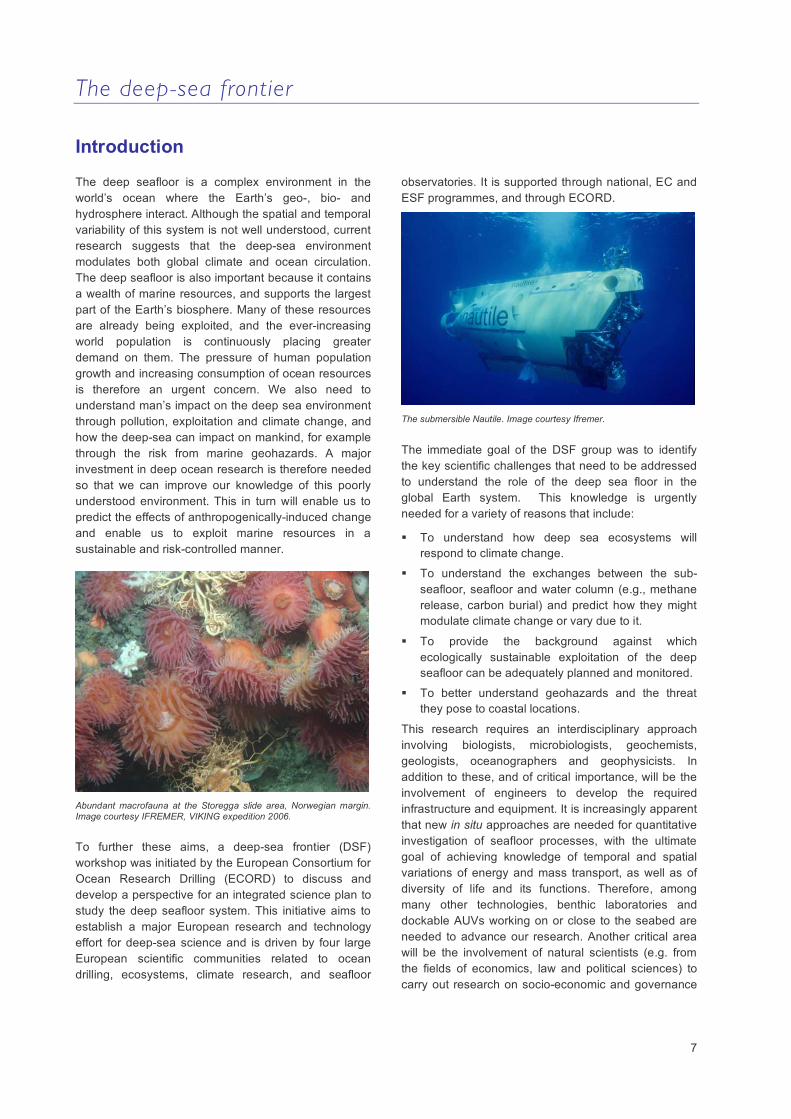
Abundant macrofauna at the Storegga slide area, Norwegian margin. Image courtesy IFREMER, VIKING expedition 2006.
To further these aims, a deep-sea frontier (DSF) workshop was initiated by the European Consortium for Ocean Research Drilling (ECORD) to discuss and develop a perspective for an integrated science plan to study the deep seafloor system. This initiative aims to establish a major European research and technology effort for deep-sea science and is driven by four large European scientific communities related to ocean drilling, ecosystems, climate research, and seafloor
observatories. It is supported through national, EC and ESF programmes, and through ECORD.
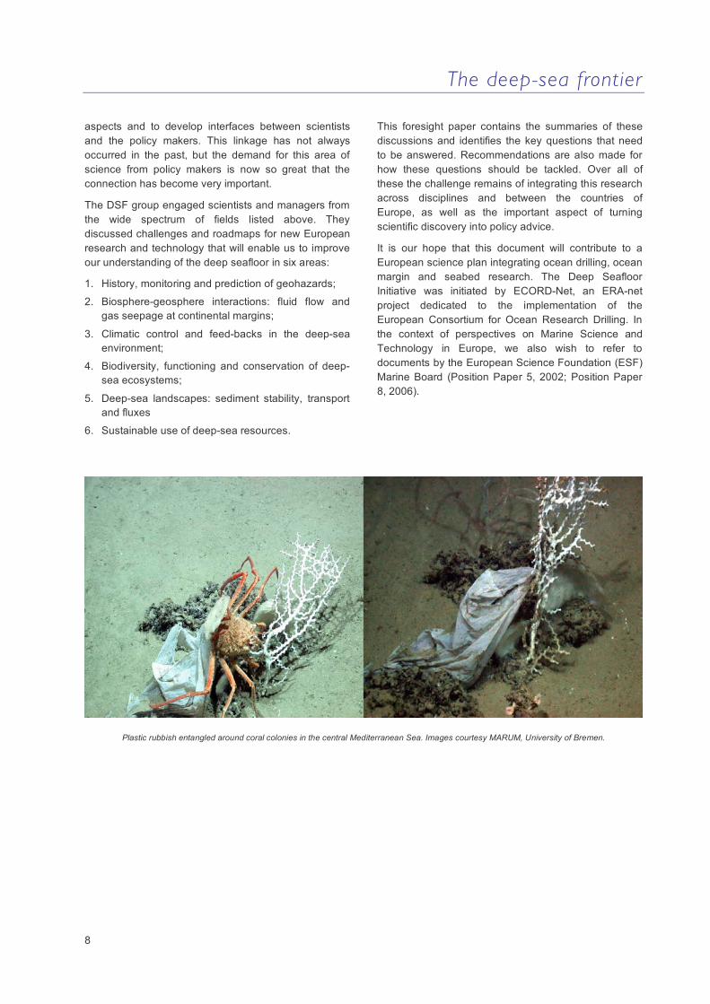
The submersible Nautile. Image courtesy Ifremer.
The immediate goal of the DSF group was to identify the key scientific challenges that need to be addressed to understand the role of the deep sea floor in the global Earth system. This knowledge is urgently needed for a variety of reasons that include:
To understand how deep sea ecosystems will respond to climate change.
To understand the exchanges between the sub-seafloor, seafloor and water column (e.g., methane release, carbon burial) and predict how they might modulate climate change or vary due to it.
To provide the background against which ecologically sustainable exploitation of the deep seafloor can be adequately planned and monitored.
To better understand geohazards and the threat they pose to coastal locations.
This research requires an interdisciplinary approach involving biologists, microbiologists, geochemists, geologists, oceanographers and geophysicists. In addition to these, and of critical importance, will be the involvement of engineers to develop the required infrastructure and equipment. It is increasingly apparent that new in situ approaches are needed for quantitative investigation of seafloor processes, with the ultimate goal of achieving knowledge of temporal and spatial variations of energy and mass transport, as well as of diversity of life and its functions. Therefore, among many other technologies, benthic laboratories and dockable AUVs working on or close to the seabed are needed to advance our research. Another critical area will be the involvement of natural scientists (e.g. from the fields of economics, law and political sciences) to carry out research on socio-economic and governance
The deep-sea frontier
8
aspects and to develop interfaces between scientists and the policy makers. This linkage has not always occurred in the past, but the demand for this area of science from policy makers is now so great that the connection has become very important.
The DSF group engaged scientists and managers from the wide spectrum of fields listed above. They discussed challenges and roadmaps for new European research and technology that will enable us to improve our understanding of the deep seafloor in six areas:
1. History, monitoring and prediction of geohazards;
2. Biosphere-geosphere interactions: fluid flow and gas seepage at continental margins;
3. Climatic control and feed-backs in the deep-sea environment;
4. Biodiversity, functioning and conservation of deep-sea ecosystems;
5. Deep-sea landscapes: sediment stability, transport and fluxes
6. Sustainable use of deep-sea resources.
This foresight paper contains the summaries of these discussions and identifies the key questions that need to be answered. Recommendations are also made for how these questions should be tackled. Over all of these the challenge remains of integrating this research across disciplines and between the countries of Europe, as well as the important aspect of turning scientific discovery into policy advice.
It is our hope that this document will contribute to a European science plan integrating ocean drilling, ocean margin and seabed research. The Deep Seafloor Initiative was initiated by ECORD-Net, an ERA-net project dedicated to the implementation of the European Consortium for Ocean Research Drilling. In the context of perspectives on Marine Science and Technology in Europe, we also wish to refer to documents by the European Science Foundation (ESF) Marine Board (Position Paper 5, 2002; Position Paper 8, 2006).
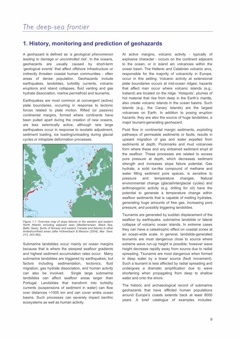
Plastic rubbish entangled around coral colonies in the central Mediterranean Sea. Images courtesy MARUM, University of Bremen.
The deep-sea frontier
9
1. History, monitoring and prediction of geohazards
A geohazard is defined as ‘a geological phenomenon leading to damage or uncontrolled risk’. In the oceans, geohazards are usually caused by short-term ‘geological events’ that affect offshore infrastructure or indirectly threaten coastal human communities - often areas of dense population. Geohazards include earthquakes, landslides, turbidity currents, volcanic eruptions and island collapses, fluid venting and gas hydrate dissociation, marine permafrost and tsunamis.
Earthquakes are most common at convergent (active) plate boundaries, occurring in response to tectonic forces related to plate motion. Rifted (or passive) continental margins, formed where continents have been pulled apart during the creation of new oceans, are less seismically active, although rare large earthquakes occur in response to isostatic adjustment, sediment loading, ice loading/unloading during glacial cycles or intraplate deformation processes.
Figure 1.1: Overview map of slope failures in the western and eastern North Atlantic including adjacent seas (Mediterranean, Black Sea, Baltic Seas), fjords of Norway and eastern Canada and failures in other limited/confined areas (after Hühnerbach & Masson (2004), Mar. Geol. 213, 343-362).
Submarine landslides occur mainly on ocean margins because that is where the steepest seafloor gradients and highest sediment accumulation rates occur. Many submarine landslides are triggered by earthquakes, but factors including sedimentation, tectonics, fluid migration, gas hydrate dissociation, and human activity can also be involved. Single large submarine landslides can affect seafloor areas larger than Portugal. Landslides that transform into turbidity currents (suspensions of sediment in water) can flow over distances >1000 km and can cover entire ocean basins. Such processes can severely impact benthic ecosystems as well as human activity.
At active margins, volcanic activity - typically of explosive character - occurs on the continent adjacent to the ocean, or in island arc volcanoes within the ocean basin. The Hellenic and Calabrian volcanic arcs, responsible for the majority of volcanicity in Europe, occur in this setting. Volcanic activity at extensional plate boundaries occurs at mid-ocean ridges; hazards that affect man occur where volcanic islands (e.g., Iceland) are located on the ridge. ‘Hotspots’, plumes of hot material that rise from deep in the Earth’s mantle, also create volcanic islands in the ocean basins. Such islands (e.g., the Canary Islands) are the largest volcanoes on Earth. In addition to posing eruption hazards, they are also the source of huge landslides, a major tsunami-generating geohazard.
Fluid flow in continental margin sediments, exploiting pathways of permeable sediments or faults, results in upward migration of gas and water expelled from sediments at depth. Pockmarks and mud volcanoes form where these and any entrained sediment erupt at the seafloor. These processes are related to excess pore pressure at depth, which decreases sediment strength and increases slope failure potential. Gas hydrate, a solid ice-like compound of methane and water filling sediment pore spaces, is sensitive to pressure and temperature changes. Natural environmental change (glacial/interglacial cycles) and anthropogenic activity (e.g. drilling for oil) have the potential to generate a temperature change within seafloor sediments that is capable of melting hydrates, generating huge amounts of free gas, increasing pore pressure, and possibly triggering landslides.
Tsunamis are generated by sudden displacement of the seafloor by earthquake, submarine landslide or lateral collapse of volcanic ocean islands. In extreme cases they can have a catastrophic effect on coastal zones at an ocean-wide scale. In general, landslide-generated tsunamis are most dangerous close to source where extreme wave run-up height is possible; however wave height decrease rapidly away from source due to radial spreading. Tsunamis are most dangerous when formed in deep water by a linear source (fault movement). Such a tsunami is less affected by radial spreading and undergoes a dramatic amplification due to wave shortening when propagating from deep to shallow water and onto the shore.
The historic and archaeological record of submarine geohazards that have afflicted human populations around Europe’s coasts extends back at least 8000 years. A brief catalogue of examples includes:
The deep-sea frontier
10
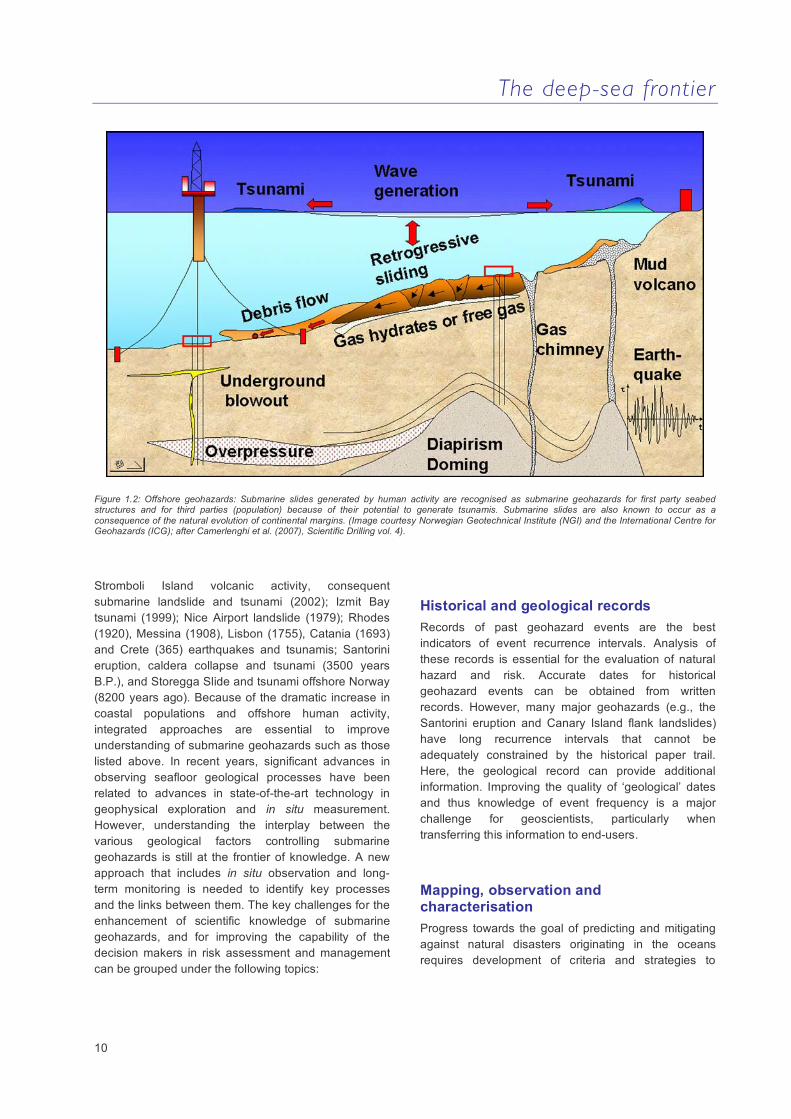
Figure 1.2: Offshore geohazards: Submarine slides generated by human activity are recognised as submarine geohazards for first party seabed structures and for third parties (population) because of their potential to generate tsunamis. Submarine slides are also known to occur as a consequence of the natural evolution of continental margins. (Image courtesy Norwegian Geotechnical Institute (NGI) and the International Centre for Geohazards (ICG); after Camerlenghi et al. (2007), Scientific Drilling vol. 4).
Stromboli Island volcanic activity, consequent submarine landslide and tsunami (2002); Izmit Bay tsunami (1999); Nice Airport landslide (1979); Rhodes (1920), Messina (1908), Lisbon (1755), Catania (1693) and Crete (365) earthquakes and tsunamis; Santorini eruption, caldera collapse and tsunami (3500 years B.P.), and Storegga Slide and tsunami offshore Norway (8200 years ago). Because of the dramatic increase in coastal populations and offshore human activity, integrated approaches are essential to improve understanding of submarine geohazards such as those listed above. In recent years, significant advances in observing seafloor geological processes have been related to advances in state-of-the-art technology in geophysical exploration and in situ measurement. However, understanding the interplay between the various geological factors controlling submarine geohazards is still at the frontier of knowledge. A new approach that includes in situ observation and long-term monitoring is needed to identify key processes and the links between them. The key challenges for the enhancement of scientific knowledge of submarine geohazards, and for improving the capability of the decision makers in risk assessment and management can be grouped under the following topics:
Historical and geological records Records of past geohazard events are the best indicators of event recurrence intervals. Analysis of these records is essential for the evaluation of natural hazard and risk. Accurate dates for historical geohazard events can be obtained from written records. However, many major geohazards (e.g., the Santorini eruption and Canary Island flank landslides) have long recurrence intervals that cannot be adequately constrained by the historical paper trail. Here, the geological record can provide additional information. Improving the quality of ‘geological’ dates and thus knowledge of event frequency is a major challenge for geoscientists, particularly when transferring this information to end-users.
Mapping, observation and characterisation Progress towards the goal of predicting and mitigating against natural disasters originating in the oceans requires development of criteria and strategies to
The deep-sea frontier
11
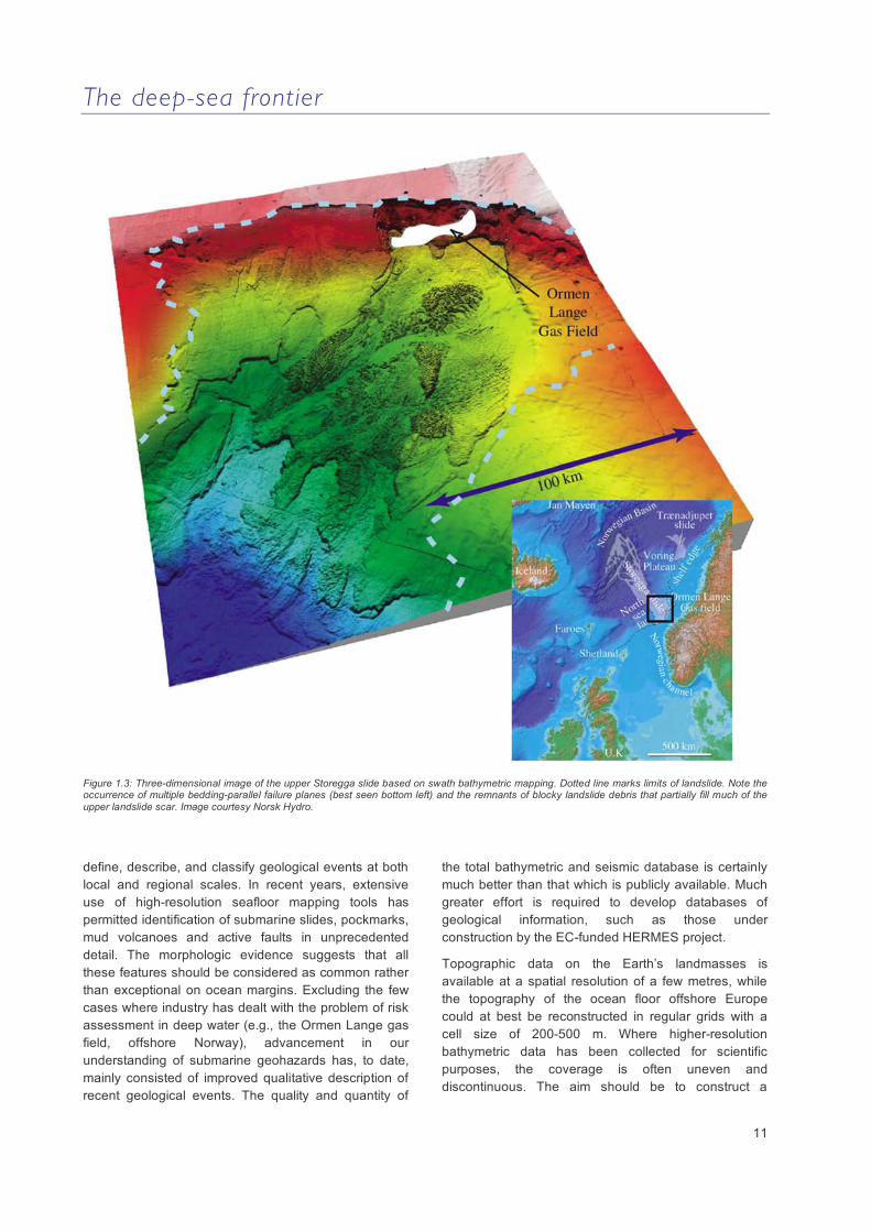
Figure 1.3: Three-dimensional image of the upper Storegga slide based on swath bathymetric mapping. Dotted line marks limits of landslide. Note the occurrence of multiple bedding-parallel failure planes (best seen bottom left) and the remnants of blocky landslide debris that partially fill much of the upper landslide scar. Image courtesy Norsk Hydro.
define, describe, and classify geological events at both local and regional scales. In recent years, extensive use of high-resolution seafloor mapping tools has permitted identification of submarine slides, pockmarks, mud volcanoes and active faults in unprecedented detail. The morphologic evidence suggests that all these features should be considered as common rather than exceptional on ocean margins. Excluding the few cases where industry has dealt with the problem of risk assessment in deep water (e.g., the Ormen Lange gas field, offshore Norway), advancement in our understanding of submarine geohazards has, to date, mainly consisted of improved qualitative description of recent geological events. The quality and quantity of
the total bathymetric and seismic database is certainly much better than that which is publicly available. Much greater effort is required to develop databases of geological information, such as those under construction by the EC-funded HERMES project.
Topographic data on the Earth’s landmasses is available at a spatial resolution of a few metres, while the topography of the ocean floor offshore Europe could at best be reconstructed in regular grids with a cell size of 200-500 m. Where higher-resolution bathymetric data has been collected for scientific purposes, the coverage is often uneven and discontinuous. The aim should be to construct a

The deep-sea frontier
12
complete topographic database (with a 100 m or better grid) for all deep waters offshore Europe. Nearshore zones may require higher resolution grids. The ready availability of bathymetric maps of the ocean around Europe, at comparable scales and resolution, is mandatory as a starting point for any assessment of submarine geohazards at a regional scale. Knowledge of the European margin’s stratigraphy also needs to be improved. This will, for example, improve assessment of the movement history of active faults through time and dating of buried landslides. Any gaps identified in this inventory need to be filled by new data acquisition.
Understanding landslide trigger mechanisms requires integrated investigations that include seafloor imaging, in situ physical and geotechnical data acquisition, monitoring and modelling of all processes involved. For example, it has only recently been realised that the deep-sea environment, as well as the terrestrial environment, is sensitive to natural climatic changes. Slope failure results in landslides, turbidity currents and tsunamis. Vertical variability in the texture and mechanical state of sedimentary strata (shear strength, water content, pore pressure) defines potential slip planes in the sediments. Understanding the engineering properties of these ‘weak’ layers is an important challenge. High water content or gas-charged sediments, turbidite sands, gas hydrate zones and organic-rich layers, amongst others, have all been suggested but as yet the key engineering properties of weak layers have not been defined, and they cannot be recognised in advance of failure.
Geohazard dynamics and processes Risk analysis requires a high level of understanding of marine geohazard processes that can only be achieved by combining knowledge of the physical, mechanical, biological and chemical processes that govern geohazard occurrence in the marine geosphere. Many parameters and processes need to be evaluated: stress state in rocks and sediments, tectonic processes, geotechnical properties, sediment compaction, fluid/gas migration, gas hydrate properties, submarine erosion, slope oversteepening by rapid deposition, wave and bottom current influence on the seabed, climate change (including sea level effects), magmatic activity and human activities. Understanding the balance between the parameters that trigger or resist the geological process responsible for geohazards is as yet limited. Geohazard events are generated when this balance is pushed out of equilibrium, often by an external trigger such as gas or mud eruption, gas hydrate dissociation,
sediment failure, earthquake, tectonic rupture or volcanic eruption.
Earthquakes and associated tsunamis are among the most frightening natural hazards, not only because of the magnitude of the resulting damage, but also because they typically occur with little warning. We need to understand the functioning of fault mechanisms and especially the role of fluid circulation in earthquake nucleation within submarine fault zones. For instance, recent observations show the existence of precursors prior to large earthquakes in oceanic fracture zones. Can this type of observation be used to understand the role of fluids in active tectonic settings, near coastal areas exposed to seismic hazards?
The compaction of submarine sediments releases fluids that migrate upward towards the seabed. There is growing evidence that fluid expulsion varies considerably over small distances and with time. Understanding the spatial and temporal changes in fluid flow through sediments is critical to understanding submarine slope failure potential. Gas hydrate dissociation may also be capable of triggering slope failures as well as contributing to the atmospheric greenhouse effect. The implications of methane hydrate dissociation for geohazards are not clear and require urgent study.
Figure 1.4: Pore pressure, very close to lithostatic pressure in the lower portion where the clays are overcompacted, can cause hydrofracturing in the stiff clay, and sliding of the package above (After Stegman et al. (2007) Geophys. Res. Lett. 34 (7), L07607).
The deep-sea frontier
13
Submarine landslides pose a major threat to seabed infrastructure, and to human life in coastal areas, because they can cut into onshore areas (Nice airport, France, 1979; Finneidfjord, Norway, 1996) and because of the risk of associated tsunamis (Grand Banks, Canada, 1929; Papua New Guinea, 1998). Submarine landslides, small and large, have been extensively mapped on all continental margins and in all geodynamic settings. However, landslides are not evenly distributed on the continental slope. Why, for example, have some areas been prone to repeated landslides through time, whereas nearby areas with similar geology have been stable? Identifying pre-conditioning factors that make areas prone to landsliding is a major challenge in quantifying geohazard risk.
Monitoring, modelling and prediction of geohazards and their consequences Earthquakes have proved to be the deadliest of all geohazards in Europe over the past decade, costing the continent €25 billion in damage, without taking human suffering into account. A repeat of an earthquake similar to those that have occurred in the recent past (Lisbon, 1755; Messina, 1908) would result in hundreds of thousands of victims and billions of Euros in damage. There is a clear need for stations at strategic offshore locations to monitor seismicity. Long time-series data from key provinces around Europe would provide continuous records of geophysical, biogeochemical, oceanographic and biological phenomena on and below the seafloor. Seafloor monitoring must extend from geophysical measurements to observation of fluid flow and biological activity. Ecosystems often provide proxies for geological processes such as fluid venting or gas hydrate stability, and their study is an essential component of geohazard assessment. Borehole instrumentation will allow subsurface monitoring of parameters such as micro-seismicity, pore pressure and fluid flow that may be key to understanding geohazard precursors. Establishing long-term monitoring systems in the deep sea is of primary importance to geohazard risk assessment. This will give better understanding of links between seafloor phenomena, for example tectonic stress and earthquakes, pore pressure and slope failure. Such systems might also capture precursory geohazard signals that are not presently recognised.
A long-term monitoring system (observatory) is characterised by a multiple sensor payload, long-term autonomy, communication systems and remote set-up of mission parameters. Observatories are already
recognised as key to understanding submarine (and geological) processes. IODP has developed specialised borehole seals (CORKs) that allow fluid flow to be measured in sealed boreholes. The European programme ‘Global Monitoring for Environment and Security’ (GMES) has identified a need for a sub-sea component of proposed surveillance systems. This will monitor the solid earth as well as seafloor and water column processes. Under FP6, the ESONET Network of Excellence, involving fifty partners, is studying the feasibility of long-term submarine monitoring systems in European seas. In parallel with ESONET, the EMSO project (European Multidisciplinary Seafloor Observatories), now registered on the road map for the European Research Infrastructures, will address the difficulty and cost of developing and putting in place a network of seafloor observatories. This requires the establishment of a critical mass at pan-European level, and network development based on collaboration between academia, government and industry.
Geohazard prediction must be understood as an assessment of the probability of an event, rather than a precise forecast. Modelling should necessarily be treated as a key part of prediction. Our capabilities on modelling geohazards vary considerably depending on the phenomena modelled and its complexity. Tsunami modelling is a clear example of this complexity as it involves several parameters such as the trigger process (e.g., earthquake or landslide), the mechanics of water wave propagation in the ocean depending on the source characteristics, and finally the interaction of the water waves with coastal morphology – a process that leads to coastal flooding. The key uncertainties in this case are the reproducibility of the trigger (ground motion or sediment/rock sliding) and the bathymetric detail in the coastal zone, which is critical for the prediction of tsunami wave height and run-up distance.
In addition to improving current numerical codes and analogue modelling facilities, an essential step is to substantially increase the quality of information on the physical properties of sediments and rocks involved. Such improvement can be achieved with in situ observations and sampling, as well as with better petrophysical analysis of seismic and wire line logging data. Modelling should be developed for a wide spectrum of processes: fluid migration, gas hydrate dissociation, slope failure, landslides and turbidity currents. In general, modelling improvements can be achieved in two ways: by providing more accurate input data and by enhancing the numerical codes, which in turn means both identifying better models to describe complex processes, and improving numerical techniques to solve the governing equations.

The deep-sea frontier
14
Figure 1.5: Sketch of the deep-sea observatory in the submarine Var canyon, Ligurian Sea, western Mediterranean (courtesy ESONET NoE)
Implementation and strategy Submarine geohazards represent a significant concern for any human activity on the seafloor and in coastal zones. Any disaster that occurs, whether it is due to a natural event or anthropogenic activity, will likely see three parties involved: operators (any company affected in terms of responsibility or damage), public administrators (as governors of the areas affected) and insurance companies, who will have to reimburse damaged parties. Before a disaster of such kind happens, the same actors should be involved in prevention activity, setting guidelines, following them, and assessing the risk of any activity. All of this requires reciprocal information transfer between academia and all other parties. Academic institutions must play a fundamental role in guaranteeing the highest quality of the scientific information involved in this process. In addition, the scientific community must play a major role in training the next generation of experts (scientists, operators, administrators) in matters concerning submarine geohazards and risk evaluation.
Prior to the Indian Ocean tsunami of December 2004, the general public had limited awareness of submarine geohazards. The main objective of outreach and training must therefore be to raise awareness of such
geohazards and to ensure that an accurate and balanced appraisal of the risks is available to the general public and educators. This requires development and support of effective European programmes for research, education and public outreach. In the same way that society and industry can benefit from academic expertise, academia also needs feedback from society and industry. Major scientific advances in geohazard processes have been accomplished when industry has provided access to data, such as borehole and 3D seismic data.
Submarine geohazards are an international problem, crossing national and oceanographic boundaries. Many non-European research programmes already exist, and collaboration with programmes in North America and Asia should be established to allow cross-fertilisation of ideas and technological approaches. Specifically, the European scientific community involved in several important initiatives in FP6 and FP7 (HERMES, ESONET, EMSO, ECORD, Deep Sea Frontier, etc.) need to strengthen their links with:
(i) CDP and the IODP: both have shifted their attention towards long-term instrumentation of their boreholes, which could be vital for collecting data relevant to geohazard mitigation.
The deep-sea frontier
15
(ii) GMES GEO: A network of seafloor observatories is fundamental to the implementation of the Global Monitoring for Environment and Security initiative (GMES). The network may contribute to warning of short and medium-term hazard events (e.g. tsunamis, submarine landslides, gas eruption). This type of organisation is essential if decision makers are to set up effective strategies for risk and security management that will improve the
protection of European society against geohazards
(iii) Other initiatives undertaken for deep seafloor observations and monitoring, including ORION (USA), NEPTUNE (Canada) and ARENA (Japan). All will, in some measure, address geohazards such as submarine slides, earthquakes and tsunamis.
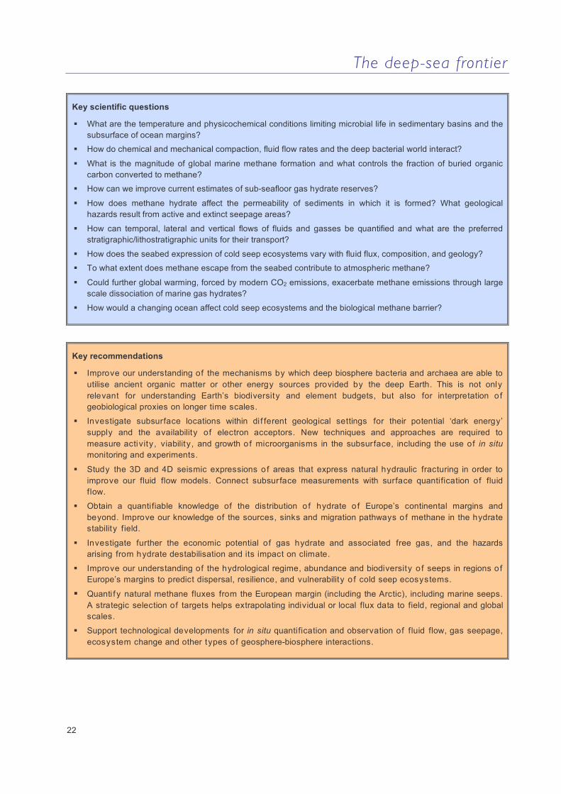
Key scientific questions
How complete is the signature of geohazards in the geological record and can we use historical/geological geohazard records to establish recurrence time of geohazard events?
What techniques do we need to improve for the dating of geohazard events?
Can we identify physical parameters that are indicators or precursory signs of geohazard events? How can we measure and understand the background levels of the parameters to be monitored?
Do we understand the linkages between geohazard triggers and preconditioning factors (natural and anthropogenic)? For example can we prove a link between gas hydrate dissociation and submarine landslides?
What is the role of fluids in submarine geohazard dynamics? Can seafloor observations be used to understand the role of fluids?
What is the role of global climate change in geohazard dynamics?
Can we model (and ultimately predict) submarine geohazards, and with what level of uncertainty? What are the key parameters needed to improve modelling? Are the available analogue and numerical tools sufficient? Can we improve them?
How do we improve understanding of the impact of geohazard events on ocean margins, coastal zones, benthic ecosystems, and seabed installations?
What information is needed to accomplish a zonation of European ocean margins in terms of hazards?
How do we address the challenge of transferring new knowledge to end-users in government and industry?
Key recommendations
Complete an inventory of submarine geohazards at a European scale.
Identify areas of ongoing seafloor deformation that could evolve into submarine landslides.
Select some representative sites as case studies for experiments and instrumentation.
Improve understand the role of fluid flow in geohazard (submarine landslide or fault movement) generation.
Develop in situ long-term measurements of seafloor deformation and hydro-mechanical behaviour through use of multidisciplinary long-term observatories and scientific drilling.
Develop modelling of seafloor failure and sediment transport.
Develop understanding of the impacts and consequences of geohazards.
Increase public awareness through better outreach.
Develop strong links with industry and public administration at all levels.

The deep-sea frontier
16
2. Biosphere-geosphere interactions: fluid flow and gas seepage at continental margins
Study of biosphere-geosphere interactions at fluid and gas seeps brings together key expertise in interdisciplinary research to describe and quantify the emissions of fluids through the ocean floor to the atmosphere and their effect on the ecosystem. Natural fluid seepage of greenhouse gases such as methane and carbon dioxide would have an important influence on the biosphere and global atmospheric changes if they were not controlled by physiochemical and biological factors. It is known today that most methane rising from subsurface horizons is either stored as hydrate or consumed by microorganisms within the seafloor. What is not known is the number of seep sites where greenhouse gases escape subsurface storage and the biological filters in both the seafloor and the water column. Little is known about the processes regulating the efficiency of microbial methane turnover and carbon sequestration. This research is of regional and global relevance providing opportunities for fundamental, forefront interdisciplinary research
involving biogeochemistry, microbiology, biology, ocean floor geology and geophysics in times of global climate change.
Ocean margins and sedimentary basins are complex systems in which different fluid flow processes are at work simultaneously. Both diffuse and focused emission of fluids from the deep seafloor occurs in passive and active ocean margins around Europe, from the Black Sea to the Mediterranean, and the northeastern Atlantic to the Arctic. Fluid flow alters the seabed through which it passes and may trigger gas and mud eruptions, shaping the seabed and sub-seafloor and influencing the stability of continental slopes. Fluid flow processes are also fundamental for the migration of oil and gas and their emission from the seabed. Furthermore, fluid flow reaching the seabed has substantial influence on ocean life and biodiversity, primarily due to its supply of energy to the highly adapted and diverse macro- and microfauna communities that make up cold seep ecosystems.
Figure 2.1: Sketch of gas seep related processes. The processes shown include thermogenic oil and deeper gas generation (to the left) and biogenic methane generation (to the right). Gas from either source can migrate upwards, either rapidly through faults and fractures or more slowly by diffusion through sediments into overlying oil and gas reservoirs. If methane concentrations reach saturation in the seafloor, methane hydrate deposits form within the hydrate stability zone. When gas migrates further up to the sediment-water interface it is consumed by anaerobic methanotrophs (bottom right), or by aerobic methanotrophs at the seafloor or in the water column. If gas bubbles escape the seafloor and survive to within 100m of the surface ocean, they can emit methane into the atmosphere. After Whelan et al. (2005) Mar. Pet. Geol. 22, 479-497.
The deep-sea frontier
17
Fluid flow on continental margins Understanding the causes and consequences of fluid flow and gas seepage requires research at a range of spatial and temporal scales. Very little is known about pervasive, low-rate fluid flow which can be active over large areas, where the effects of tidal loading and storm surges can be important, and disequilibrium compaction of sediments, tectonic loading and dehydration of minerals during diagenesis provide the background driving mechanisms. Driven at high rates by the genesis of hydrocarbons and dissociation of methane hydrate, focused flow through vents and seeps associated with faults, mud volcanoes and gas chimneys is more easily detected but also not yet quantified.
Quantifying the transport of fluids, gases and solid materials and the natural filter systems from the lithosphere to the deep seafloor into the hydrosphere and atmosphere at different types of seeps is an overarching research theme. This contributes to our understanding of relevant global methane fluxes, the role of the ocean in the carbon cycle and climate system, and the diversity of ecosystems on Europe’s margins. It also connects to more applied topics of the earth and life sciences such as hydrocarbon exploration, seafloor stability, blue technology and protection of hot spot ecosystems. A wide range of expertise and technology is needed to stimulate a programme of research that can reveal, describe and quantify the emissions of gas and fluid from the deep subsurface to the atmosphere, and the associated geological, geochemical and biological processes. Such endeavour requires both focused and extensive investigations of various aspects of fluid flow, comprising primary objectives such as improving geophysical detection and long-term observation of active, methane-emitting seeps. Other objectives are quantification of microbiological controls on the flux of methane and other hydocarbons, including interaction with its different phases, and understanding the biodiversity, function and distribution of seep-associated biota.
Both methane and CO2 can occur in solid, liquid and gaseous phases, depending on the physical and chemical conditions. In cold-water environments deeper than 500 m, the migration of methane is controlled by the methane hydrate stability zone, in which hydrate forms and builds a methane reservoir. Little is known about the origin, formation process and turnover of methane in hydrate deposits. It is not clear to what extent microorganisms interact with methane held within hydrate and if they contribute to its dissociation. The role of microbes in the formation of authigenic
carbonates, which may sequester a substantial fraction of the hydrocarbon-derived CO2 and alter transport pathways of fluids and gases, is poorly known.
Bacterial and archaeal communities inhabiting the seafloor to hundreds of metres below can be affected positively or negatively by fluid flow, depending on its composition and influence on the supply of energy. A variety of animal-microbe symbioses have been detected at fluid flow-driven habitats with fascinating adaptations to the use of subsurface energy.
Methane in the oceans The seabed is a giant anaerobic bioreactor in which vast amounts of methane are produced. The estimated global methane flux in marine sediments is 70-300 Tg yr-1 or 0.5-2 x 10¹³ mol CH4 yr-1. This is equivalent to 2-8% of the annual organic carbon mineralisation in the seabed. These calculations do not include hotspots of methane flux from cold seeps, hydrothermal vents or surficial gas hydrates, since reliable estimates of the total areal distribution of such sites are not yet available. An estimate of the global flux of methane from the seabed is 16-40 Tg y-1 or 0.1-0.25 x 10¹³ mol CH4 yr-1 – in other words, a significant fraction of the total estimated subsurface flux. Compiled data also indicate that, even if the area affected by methane seepage at continental margins is below 1%, this may still have a significant impact on the total methane budget.
Sub-seafloor biosphere-geosphere interactions are globally important in terms of element cycles and biodiversity. The sub-seafloor may represent the largest prokaryotic habitat on Earth despite the apparent extreme conditions of high pressure (approximately 70% of the marine environment is at a pressure of 38 MPa or above), covers a broad temperature range (<0°C at the seafloor to >150°C in the subsurface), and is characterised by low energy supply. In fact, the energy and carbon source for an estimated 30% of earth’s biomass residing in the deep biosphere remains unknown. A key question arises as to the source of electron acceptors in the deep biosphere. Possibly, considerable ‘dark energy’ is supplied to this habitat by geosphere energy sources. This means that our understanding of deep-sea sediments and their major role in global biogeochemical cycles and the climate system, based solely on their accumulation of photosynthetically produced organic matter, may well be inaccurate. Known and unknown bacteria have been found widespread in deep sediments (> 1 km), but we still know very little about these organisms that can apparently function on geological timescales. They

The deep-sea frontier
18
Figure 2.2: An oblique view grey-shaded bathymetry map of the western Black Sea, with seep locations plotted as red dots. Some seeps are shown as 3D flares. Seeps are abundant upslope of the gas hydrate stability zone (GHSZ), delineated by the 725 m contour line. After Naudts et al. (2006), Mar. Geol. 227, 177-199.
seem to be intimately involved in or stimulated by subsurface geosphere processes previously thought to be abiotic such as gas hydrate systems, oil and gas generation, mineral formation and dissolution, and even in deep crustal fluids and basalts.
The deep-seafloor is very dynamic: it is hot at ocean ridges, it is moving as a result of seafloor spreading, and it is constantly changing its surface appearance due to sediment transport by ocean currents or natural fluid and gas emissions through the seabed. To a great extent, we are unaware of these enormous dynamics because we cannot easily see or feel them in the way we notice volcanic eruptions or earthquakes. Fluid flow through the seabed and its subsequent emission via the hydrosphere to the atmosphere is a highly dynamic process in space and time. Fluid flow sustains distinct and highly diverse ecosystems on the seabed, and is
affecting ocean chemistry at an unknown rate, controlling the cycling of elements. Important microbial processes in the seabed involve biological mediation of mineral precipitation or the anaerobic oxidation of methane (AOM) and other hydrocarbons with sulphate, producing large quantities of sulphide. Quantitative analysis of organic and inorganic components in fluids and adjacent sediments in relation to microbial activity is needed to understand the complex biogeochemical processes involved, which have consequences on the development of sediment structure and seabed morphology. Quantifying major fluid flow pathways and turnover is critical in constraining global budgets of natural element cycling and fluid emissions affecting the ocean and the atmosphere.
The deep-sea frontier
19
Fluid flow in sedimentary basins Fluid flow in sedimentary basins is a long term but highly dynamic process. New research has shown that a siliciclastic sedimentary basin can be divided into two zones: a mechanical compaction zone (from the surface to approximately 60-80°C) and a chemical compaction zone (from 60-80°C to approximately 200°C). Both zones are inhabited by microorganisms, but their role in mineral transformation is not well understood. In the mechanical compaction zone, porosity reduction is related to increased effective stress (due to loading of sediments), leading to classic mechanical rearrangement and closer packing of grains. In the chemical compaction zone, starting at around 60°C in shales and 80°C in sandstones, porosity reduction is due to chemical reactions where the minerals in the sediment are subject to a chemical dissolution and precipitation processes.
The importance of these chemical mineral reactions is that they are primarily controlled by temperature, and are insensitive to pressure. Hence, at temperatures above ca. 80°C, the flux of water in a given sedimentary basin is mainly controlled by the temperature profile. This also implies that the flux is not limited by the permeability of the shales as traditionally believed. As the permeability in the shales decreases as a result of mineral metamorphosis, the pore pressure increases in the underlying sediments due to continued thermally-controlled, stress-insensitive porosity reduction, causing the fluid to be expelled in a rate unaffected by the shale permeability. The flux of water through the low permeability pore network in the shales cannot accommodate the expelled water, thus the system generates hydrofractures. These fractures serve as an extra escape route for the fluid, in addition to the flux through the matrix. Due to the overall control of temperature on these processes, overpressure development is also strongly controlled by temperature. It appears that at 120°C the pore pressure in sedimentary basins is close to hydrofracturing pressure. This may represent a universal pattern that applies to all sedimentary basins except for the few (5%) where the fluid flow is free to follow high permeability sand layers (sub-lateral, up-dipping continuous layers). This new knowledge has strong implications for our understanding of the behaviour of fluid escape structures such as mud volcanoes, or local seeps, which could be linked to an underlying hard overpressure zone providing fluid to mud volcanoes at a semi-constant rate. Dissolved gases are likely to constitute a significant portion of the total flux of gas from the sedimentary basins to the seafloor. This flux is not as easy to detect as free gas (bubbles) escaping
from sedimentary basins, but volumetrically it may be more important.
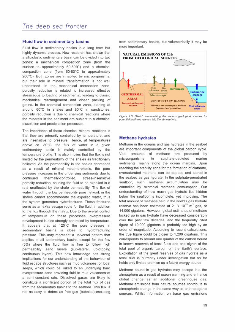
Figure 2.3: Sketch summarising the various geological sources for potential methane release into the atmosphere.
Methane hydrates Methane in the oceans and gas hydrates in the seabed are important components of the global carbon cycle. Vast amounts of methane are produced by microorganisms in sulphate-depleted marine sediments, mainly along the ocean margins. Upon reaching the stability zone for the formation of clathrate, oversaturated methane can be trapped and stored in the seabed as gas hydrate. In the sulphate-penetrated seafloor, such methane accumulation may be controlled by microbial methane consumption. Our understanding of how much gas hydrate lies hidden below the seafloor is incomplete, yet improving. The total amount of methane held in the world’s gas hydrate reserve has been estimated at 21 x 1015 m3 gas, or 14,000 gigatons. However, global estimates of methane locked up in gas hydrate have decreased considerably over the past few decades, and the frequently cited figure of 10,000 gigatons is probably too high by an order of magnitude. According to recent calculations, the true figure could be closer to 1,200 gigatons. This corresponds to around one quarter of the carbon bound in known reserves of fossil fuels and one eighth of the total pool of organic carbon on the Earth's surface. Exploitation of the great reserves of gas hydrate as a fossil fuel is currently under investigation but so far holds only limited promise as a future energy source.
Methane bound in gas hydrates may escape into the atmosphere as a result of ocean warming and enhance global change as an additional greenhouse gas. Methane emissions from natural sources contribute to atmospheric change in the same way as anthropogenic sources. Whilst information on trace gas emissions
The deep-sea frontier
20
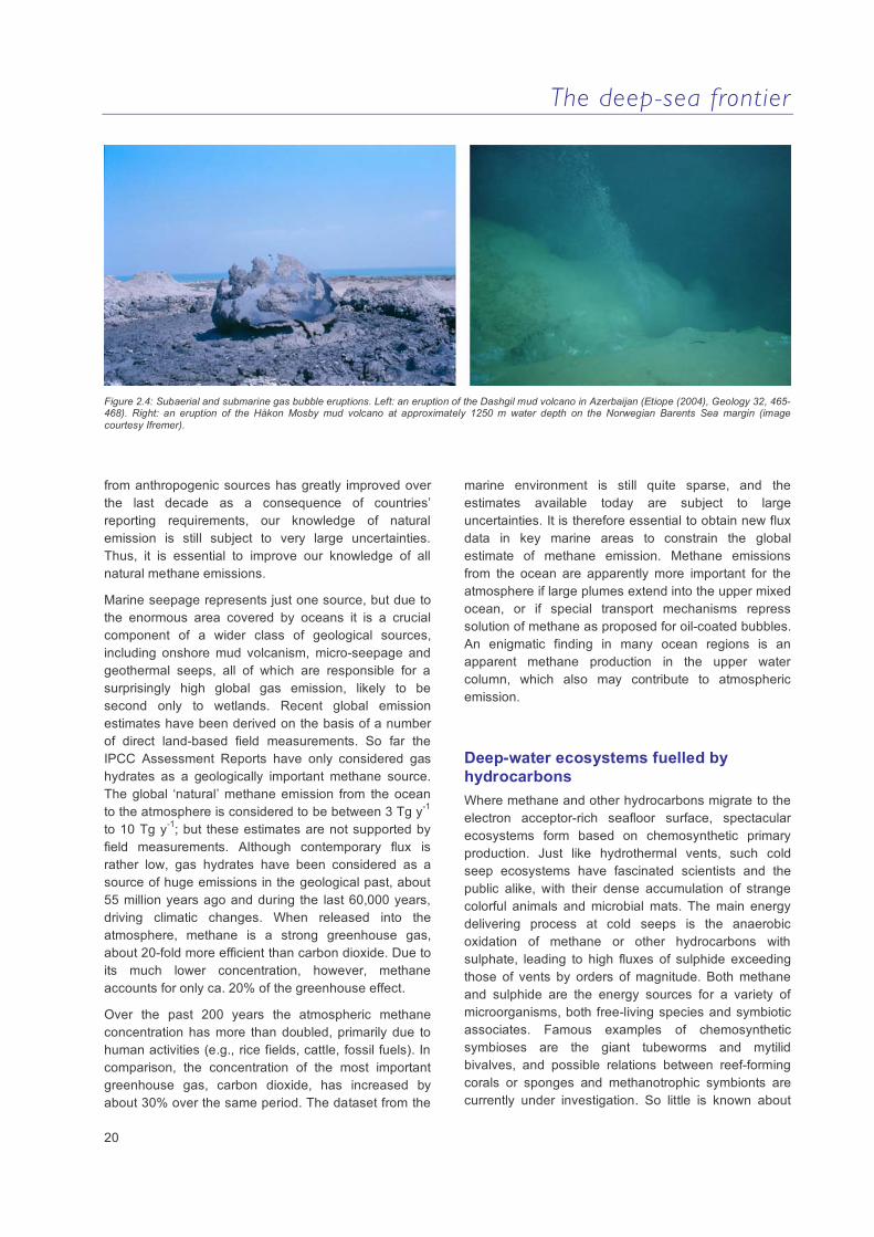
Figure 2.4: Subaerial and submarine gas bubble eruptions. Left: an eruption of the Dashgil mud volcano in Azerbaijan (Etiope (2004), Geology 32, 465-468). Right: an eruption of the Håkon Mosby mud volcano at approximately 1250 m water depth on the Norwegian Barents Sea margin (image courtesy Ifremer).
from anthropogenic sources has greatly improved over the last decade as a consequence of countries’ reporting requirements, our knowledge of natural emission is still subject to very large uncertainties. Thus, it is essential to improve our knowledge of all natural methane emissions.
Marine seepage represents just one source, but due to the enormous area covered by oceans it is a crucial component of a wider class of geological sources, including onshore mud volcanism, micro-seepage and geothermal seeps, all of which are responsible for a surprisingly high global gas emission, likely to be second only to wetlands. Recent global emission estimates have been derived on the basis of a number of direct land-based field measurements. So far the IPCC Assessment Reports have only considered gas hydrates as a geologically important methane source. The global ‘natural’ methane emission from the ocean to the atmosphere is considered to be between 3 Tg y-1 to 10 Tg y-1; but these estimates are not supported by field measurements. Although contemporary flux is rather low, gas hydrates have been considered as a source of huge emissions in the geological past, about 55 million years ago and during the last 60,000 years, driving climatic changes. When released into the atmosphere, methane is a strong greenhouse gas, about 20-fold more efficient than carbon dioxide. Due to its much lower concentration, however, methane accounts for only ca. 20% of the greenhouse effect.
Over the past 200 years the atmospheric methane concentration has more than doubled, primarily due to human activities (e.g., rice fields, cattle, fossil fuels). In comparison, the concentration of the most important greenhouse gas, carbon dioxide, has increased by about 30% over the same period. The dataset from the
marine environment is still quite sparse, and the estimates available today are subject to large uncertainties. It is therefore essential to obtain new flux data in key marine areas to constrain the global estimate of methane emission. Methane emissions from the ocean are apparently more important for the atmosphere if large plumes extend into the upper mixed ocean, or if special transport mechanisms repress solution of methane as proposed for oil-coated bubbles. An enigmatic finding in many ocean regions is an apparent methane production in the upper water column, which also may contribute to atmospheric emission.
Deep-water ecosystems fuelled by hydrocarbons Where methane and other hydrocarbons migrate to the electron acceptor-rich seafloor surface, spectacular ecosystems form based on chemosynthetic primary production. Just like hydrothermal vents, such cold seep ecosystems have fascinated scientists and the public alike, with their dense accumulation of strange colorful animals and microbial mats. The main energy delivering process at cold seeps is the anaerobic oxidation of methane or other hydrocarbons with sulphate, leading to high fluxes of sulphide exceeding those of vents by orders of magnitude. Both methane and sulphide are the energy sources for a variety of microorganisms, both free-living species and symbiotic associates. Famous examples of chemosynthetic symbioses are the giant tubeworms and mytilid bivalves, and possible relations between reef-forming corals or sponges and methanotrophic symbionts are currently under investigation. So little is known about

The deep-sea frontier
21
the diversity of the host animals as well as their symbionts that biologists discover new species during every expedition to a cold seep system. The EU-funded Integrated Project HERMES is the first programme to study cold seeps of the entire European margin in detail and with an interdisciplinary focus. Main scientific questions include the relationship between the morphology, source and dynamics of cold seep systems and the diversity, biomass and productivity of the associated ecosystems. Novel and abundant chemosynthetic ecosystems have been discovered in association with mud volcanoes and pockmarks in the Eastern Mediterranean, the Gulf of Cadiz, and the Norwegian margin, and a recent key advance in our understanding is that cold seep systems are more abundant on European margin than previously assumed. Further research topics are the dispersal, dynamics, succession and resilience of such seep ecosystems, as well as the quantitative assessment of carbon and energy flow from the subsurface to the
seep ecosystem, and further on to the surrounding deep-sea habitats. So far, no long-term observation of the temporal change of a seep ecosystem with regard to variations in fluid flow and gas seepage has been possible. In the study of chemosynthetic symbioses, geosciences meet the life sciences with common questions about their evolution, the role of seep communities in mineral precipitation and the formation of reefs and mound systems, as well as the metabolic and genomic functioning of microbial methane conversion to heterotrophic substrates nourishing large biomasses of animals. Certainly, cold seep ecosystems with their high diversity, potential significance for biotechnology and natural product research, and important function as barriers against methane emission are important hotspot ecosystems on Europe’s margins that deserve special observation, study and protection.
Figure 2.5: Cold seep ecosystems of Europe’s margins. Upper left: Dense carpets of giant sulphide oxidising bacteria mark areas of high methane turnover on the Håkon Mosby Mud Volcano. Upper right: Anoxic cold seep ecosystems of the Black Sea are characterised by the densest accumulations of microbial biomass known on earth. Lower left: Active seeps of the Eastern Mediterranean host masses of chemosynthetic tubeworms. Lower right: On the Norwegian margin extinct seeps are marked by carbonate cements populated by echinoderm filter feeder communities (images courtesy IFREMER and MARUM).
The deep-sea frontier
22
Key scientific questions
What are the temperature and physicochemical conditions limiting microbial life in sedimentary basins and the subsurface of ocean margins?
How do chemical and mechanical compaction, fluid flow rates and the deep bacterial world interact?
What is the magnitude of global marine methane formation and what controls the fraction of buried organic carbon converted to methane?
How can we improve current estimates of sub-seafloor gas hydrate reserves?
How does methane hydrate affect the permeability of sediments in which it is formed? What geological hazards result from active and extinct seepage areas?
How can temporal, lateral and vertical flows of fluids and gasses be quantified and what are the preferred stratigraphic/lithostratigraphic units for their transport?
How does the seabed expression of cold seep ecosystems vary with fluid flux, composition, and geology?
To what extent does methane escape from the seabed contribute to atmospheric methane?
Could further global warming, forced by modern CO2 emissions, exacerbate methane emissions through large scale dissociation of marine gas hydrates?
How would a changing ocean affect cold seep ecosystems and the biological methane barrier?
Key recommendations
Improve our understanding of the mechanisms by which deep biosphere bacteria and archaea are able to utilise ancient organic matter or other energy sources provided by the deep Earth. This is not only relevant for understanding Earth’s biodiversity and element budgets, but also for interpretation o f geobiological proxies on longer time scales.
Investigate subsurface locations within di f ferent geological settings for their potential ‘dark energy’ supply and the availability of electron acceptors. New techniques and approaches are required to measure activity, viability, and growth o f microorganisms in the subsurface, including the use of in situ monitoring and experiments.
Study the 3D and 4D seismic expressions o f areas that express natural hydraulic fracturing in order to improve our fluid flow models. Connect subsurface measurements with surface quantification of fluid flow.
Obtain a quantifiable knowledge of the distribution o f hydrate o f Europe’s continental margins and beyond. Improve our knowledge of the sources, sinks and migration pathways o f methane in the hydrate stability field.
Investigate further the economic potential of gas hydrate and associated free gas, and the hazards arising from hydrate destabilisation and its impact on climate.
Improve our understanding of the hydrological regime, abundance and biodiversity o f seeps in regions o f Europe’s margins to predict dispersal, resilience, and vulnerability o f cold seep ecosystems.
Quanti f y natural methane fluxes from the European margin (including the Arctic), including marine seeps. A strategic selection of targets helps extrapolating individual or local flux data to field, regional and global scales.
Support technological developments for in situ quantification and observation of fluid flow, gas seepage, ecosystem change and other types o f geosphere-biosphere interactions.

The deep-sea frontier
23
3. Past climate changes and the deep-sea environment: windows to the future
The rising concentrations of greenhouse gases in the atmosphere are increasingly affecting the Earth’s climate and ecosystems. There is an urgent need to understand how and when the various elements of the Earth system will respond to these changes. In this context, the deep ocean is of particular importance. Not only does it represent the Earth’s largest reservoir of latent heat and CO2, potentially driving global climate, but its ecosystems, their resilience and natural dynamics are the least understood.
Models are particularly useful here because they can potentially provide a globally integrated dynamic picture of the climate system (Figure 3,1). But even the most sophisticated models produce large uncertainties in predictions of subsurface ocean dynamics longer than a few decades. The brevity of instrumental records is particularly critical in the deep ocean and palaeoceanographic proxies provide the only source of climate data from this environment. Thus, the best test
cases for advancing our understanding of climate variability against a natural background are provided by time series of quantitative palaeoclimate data that document the rate and magnitude of past climatic and environmental changes. Marine palaeoclimatology in particular provides the opportunity to gain access to climate data over timescales that extend the short instrumental period, across the onset of anthropogenic perturbations and far beyond. The deep seafloor constitutes the largest archive for climate data, stored in sedimentary deposits at up to multi-annual temporal resolution and a wide stratigraphic range. Palaeoclimatic profiles from deep-sea sediments therefore enable investigation of the Earth’s climate and its dynamics over a wide range of timescales. Current climate change and the potential acceleration of these changes in the future make research into past climatic and environmental change an extremely timely topic of great societal immediacy and visibility.
Figure 3.1: Temperature anomaly (ºC) at about 800 m depth due to a reduction in NADW by 60 % (not a complete shut-down) in a freshwater-hosing experiment using a comprehensive climate model (NACR CCSM 2, M. Prange, Geosciences, Bremen University, unpublished data)..

The deep-sea frontier
24
A primary objective of marine climate and environmental research is to extend our understanding of the natural variations and dynamics of Earth’s climate. Over the last three decades or so marine palaeoclimatology - a field that reconstructs past climates from deep-sea sediments - has evolved from a purely descriptive art into a leading quantitative, interdisciplinary science. This has involved a tremendous level of international collaboration and engages scientists from the specialist disciplines of oceanography, geology, palaeontology, physics, chemistry, biology, mathematics and meteorology. For example, microfossil trace element biochemistry, radioisotope chemistry, molecular biology and geochemical sedimentology are only some of the many evolving disciplines that are now providing novel quantitative methods for the reconstruction of ocean state and past variability. Such advances will ultimately allow us to achieve a fuller picture of the range of ocean and climate changes (e.g., pattern and rates of ocean circulation, deep-sea ventilation, marine carbon cycle, and carbonate chemistry) over long timescales. These developments have matured to a point where further timely advancement and attainment of their full potential requires better coordinated, multidisciplinary, collaborative investigations and mobilisation of large infrastructure at a European level.
Reconstructions of past global change Past changes in climatology, ecology, and geochemistry of the deep ocean can be used as a window to understand and help predict future changes. Together they provide a dynamic picture and understanding of deep-ocean variability and help to reduce the uncertainties associated with predictions of future climate change and its impact on deep-sea ecosystems. Paleoceanographic reconstructions will expand the instrumental deep-ocean observational record to longer timescales, and can be used as a primary means to quantify the range of changes that are physically, chemically, and biologically plausible. This will provide the only benchmark of natural variations of the deep-sea environment that confound our ability to detect human-induced changes. It is crucial that we investigate changes in large-scale deep-ocean circulation, storage of heat and carbon dioxide, transport of salt and biologically mediated constituents (C, O, P, N, Si, etc.), and carbonate saturation state. These primary research targets can be defined on the basis of timescales on which transitions in climate and the concomitant shifts in deep-ocean environments occur. The temporal resolution to be achieved in many of these reconstructions will therefore be high (i.e.,
multi-annual-decadal) in order to assess deep-sea dynamics in terms of response times, phasing of various ocean climate and physical parameters, regimes in regions that are particularly sensitive to changes, and across a range of latitudes.
Figure 3.2: Evidence for surface and deep ocean links during the 8.2 kyr abrupt climate change event in the sub-polar North Atlantic Ocean. From top to bottom (i) the GISP2 temperature (δOice) record (ii) Core MD99-2251 N. pachyderma s. percent abundance data (higher abundances indicate sea surface cooling), (iii) surface ocean salinity, and (iv) sortable silt mean palaeocurrent speed index. Shaded bars indicate the two pulses of cooling and freshening of surface ocean conditions that appear to correlate with a larger (3.6 Sv) Lake Agassiz outburst at ~7,700 C years B.P. and a second, smaller meltwater discharge (1.6 Sv) dated at ~7,600 C years B.P. The 8.2 kyr abrupt climate change event has a duration of ~70 years in both ice and ocean records.
Quantifying variability Palaeoceanographic reconstructions provide clear evidence for fundamental changes in past deep-ocean circulation. Specifically, abrupt climate changes appear to be closely linked to variations in surface to deep ocean thermohaline coupling (figures 3.2 and 3.3). A comprehensive quantitative understanding of the processes that link ocean dynamics with the climate system, in particular the controls and thresholds involved with non-linear climate forcing and response, will be paramount in predicting how the Earth is likely to respond in the future to concerted natural changes in
The deep-sea frontier
25
forcing and anthropogenic perturbations. Quantitative estimates of past climate variability and deep-ocean feedback mechanisms can now be obtained with a much higher degree of accuracy and precision. Palaeoenvironmental proxies are available that are quantitatively linked with physical and chemical ocean parameters such as ocean heat and salt inventories (Mg/Ca, UK37, TEX86, δ18O, δD, TFT/MAT/ANN), rates of physical overturn (Pa/Th, Sortable Silt, Nd, Sr) ocean carbon cycle (11B, δ13C, Cd/Ca, Ba/Ca) and marine biological productivity (biomarkers, Th, δ15N).
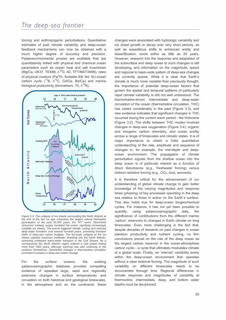
Figure 3.3: The collapse of ice sheets surrounding the North Atlantic at the end of the last ice age comprises the largest natural freshwater perturbation of the past 20,000 years, the "H1" event. Short-lived 'precursor' iceberg surges heralded the event, signifying increasingly unstable ice sheets. The events triggered climate cooling and reduced deep-water formation over several hundred years, promoting transient shifts of deep-sea carbon budgets. The full-scale collapse of the ice sheets sparked maximum meltwater shedding into the North Atlantic, restricting northward warm-water transport in the Gulf Stream. As a consequence the North Atlantic region entered a cold phase lasting more than 1000 years, although warming was well underway in the southern hemisphere. Substantial changes in thermohaline circulation promoted increases in deep-sea carbon storage.
For the surface oceans, the existing palaeoceanographic database provides compelling evidence of repeated large, rapid and regionally extensive changes in surface temperatures and circulation on both historical and geological timescales. In the atmosphere and on the continents, these
changes were associated with hydrologic variability and ice sheet growth or decay over very short periods, as well as expeditious shifts to enhanced aridity and desertification, some within as little as 20 years. However, research into the response and adaptation of the subsurface and deep ocean to such changes is still developing, and information on the magnitude, speed and regional to basin-wide pattern of deep-sea changes are currently sparse. While it is clear that Earth’s climate is much more variable than previously thought, the importance of potential deep-ocean factors that govern the spatial and temporal patterns of particularly rapid climate variability is still not well understood. The thermohaline-driven intermediate and deep-water circulation of the ocean (thermohaline circulation, THC) has varied considerably in the past (Figure 3.3), and new evidence indicates that significant changes in THC occurred during the current warm period - the Holocene (Figure 3.2). The shifts between THC modes involved changes in deep-sea oxygenation (Figure 3.4), organic and inorganic carbon chemistry, and ocean acidity across a range of timescales and climatic states. It is of major importance to obtain a fuller quantitative understanding of the rate, amplitude and sequence of changes in, for example, the mid-depth and deep-ocean environment. The propagation of climate perturbation signals from the shallow ocean into the deep ocean is of particular interest as a function of direct disturbance (e.g., freshwater forcing) versus indirect radiative forcing (e.g., CO2, dust, aerosols).
It is therefore critical for the advancement of our understanding of global climate change to gain better knowledge of the varying magnitudes and response times (phasing) of key processes operating in the deep sea relative to those in action on the Earth´s surface. This also holds true for deep-ocean biogeochemical cycles. For instance, it has not yet been possible to quantify, using palaeoceanographic data, the significance of contributions from the different marine ‘carbon’ reservoirs to changes in Earth climate on long timescales. Even more challenging is the fact that, despite decades of research on past changes in ocean plankton productivity and nutrient cycling, no firm conclusions prevail on the role of the deep ocean as the largest carbon reservoir in the ocean-atmosphere carbon cycle – a cycle that ultimately modulates climate at a global scale. Finally, an ‘internal’ variability exists within the deep-ocean environment that operates without a clear external forcing. The magnitude of such variability on different timescales needs to be documented through time. Regional differences in climate response and magnitudes of variability at thermocline, intermediate, deep, and bottom water depths must be deciphered.

The deep-sea frontier
26
Figure 3.4: Impact of low oxygen minimum conditions in the eastern Mediterranean Sea in 1300 m water depth on benthic ecosystems. The dark brownish sediment color between 19 and 34 cm in the sediment core indicates reduced to zero oxygen concentration levels in the deeper water levels, leading to enhanced organic carbon preservation and the formation of a sapropel 9.000 to 6.000 years ago. The ecosystem response is apparent in profound changes in numbers of certain benthic foraminifera species (unicellular rhizopods forming calcite shells and living in the sediment surface) adapted to high or low oxygen concentrations levels until environmental conditions became uninhabitable for any benthic foraminifera (figure and foraminifera electron microscopy photographs courtesy G. Schmiedl, and Y. Milker, Hamburg University).
Figure 3.5: Sediment cores retrieved by the international Ocean Drilling Program in the South Atlantic at different water depths show the sudden lack of calcite at the seafloor (change of sediment colour from whitish to brownish) at about 55 Million years ago. The change from continuous calcite deposition to complete calcite dissolution in the deep ocean occurred within only a few thousands of years. This indicates a tremendous change in the deep-ocean carbonate chemistry that is assumed to be related to massive dissociation of gas hydrates under extremely warm climate conditions, the Paleocene-Eocene Thermal Maximum (courtesy U. Röhl, MARUM Bremen). Modified after Zachos et al. (2005), Science 308, 1611.
The deep-sea frontier
27
Key scientific questions
Which processes exert direct control on natural deep-ocean variability in terms of temperature, water mass structure, chemical properties and nutrient inventories on timescales ranging from sub-decadal to multi-multimillennial?
Do the shifts observed over the past decade in deep ocean climatology and carbon/carbonate systems fall within the range of their natural variability, or do they exceed that range?
Is there a human-induced climate perturbation imposed on the deep ocean that can be recognised in trends of deep ocean parameters?
Can we identify early warning signs from the sedimentary record that herald changes in the deep-sea environment associated with periods of rapid climate change?
What is the interaction between deep-ocean circulation and the polar cryosphere during different modes of climate variability?
How do shifts in deep-ocean circulation modes affect deep-sea ecosystems and biogeochemical cycles? Can we quantify the feedback mechanisms between deep-ocean biosphere, biogeochemistry and climate?
Key recommendations
Detail the dynamics and geochemistry of the deep-ocean environment to achieve a fuller understanding of the controls that define the state of the deep-ocean physical and biogeochemical dynamics.
Identify an optimum array of global locations and palaeo-data streams that help to minimise uncertainties in constraining changes in the deep-ocean environment and its link to major climate changes.
Enhance hydro-acoustic mapping capabilities and facilitate access to seismic profiling surveys, including 3D reconstruction of sedimentary structures.
Optimise retrieval of high quality and large volume sediment cores by means of state-of-the-art deep-sea drilling and large diameter piston/box coring from locations that will allow reconstruction of past variations of the deep-ocean environment at a temporal scale relevant to the pace of both natural and anthropogenic climate change.
Combine borehole logging and non-destructive sediment core scanning with in situ sedimentological, micropalaeontological, physical and chemical properties at the deep seafloor.
Advance installation of centralised sediment core repositories in Europe with state-of-the art sampling facilities and innovative core logging/scanning devices.
Conduct open-ocean culturing experiments under natural conditions with improved mesocosm and/or benthic chamber facilities to optimise calibration of palaeoenvironmental proxies from benthic organisms to deep-sea parameters, and allow retrieval of quantitative information on past deep-ocean dynamics and biogeochemical cycles.
Develop techniques for assimilating palaeoenvironmental datasets into climate models.
Provide advanced synoptic presentation tools to visualise the continuous change of the deep-ocean environment as documented in palaeo-data streams.
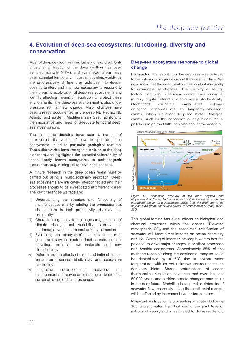
The deep-sea frontier
28
4. Evolution of deep-sea ecosystems: functioning, diversity and conservation
Most of deep seafloor remains largely unexplored. Only a very small fraction of the deep seafloor has been sampled spatially (<1%), and even fewer areas have been sampled temporally. Industrial activities worldwide are progressively shifting their activities into deeper oceanic territory and it is now necessary to respond to the increasing exploitation of deep-sea ecosystems and identify effective means of regulation to protect these environments. The deep-sea environment is also under pressure from climate change. Major changes have been already documented in the deep NE Pacific, NE Atlantic and eastern Mediterranean Sea, highlighting the importance and need for adequate temporal deep-sea investigations.
The last three decades have seen a number of unexpected discoveries of new ‘hotspot’ deep-sea ecosystems linked to particular geological features. These discoveries have changed our vision of the deep biosphere and highlighted the potential vulnerability of these poorly known ecosystems to anthropogenic disturbance (e.g. mining, oil reservoir exploitation).
All future research in the deep ocean realm must be carried out using a multidisciplinary approach. Deep-sea ecosystems are intricately interconnected and their processes should to be investigated at different scales. The key challenges we face are:
i) Understanding the structure and functioning of marine ecosystems by relating the processes that shape them to their productivity, diversity and complexity;
ii) Characterising ecosystem changes (e.g., impacts of climate change and variability, stability and resilience) at various temporal and spatial scales;
iii) Evaluating an ecosystem’s capacity to provide goods and services such as food sources, nutrient recycling, industrial raw materials and new biotechnology;
iv) Determining the effects of direct and indirect human impact on deep-sea biodiversity and ecosystem functioning;
v) Integrating socio-economic activities into management and governance strategies to promote sustainable use of these resources.
Deep-sea ecosystem response to global change For much of the last century the deep sea was believed to be buffered from processes at the ocean surface. We now know that the deep seafloor responds dynamically to environmental changes. The majority of forcing factors controlling deep-sea communities occur at roughly regular intervals; others occur stochastically. Geohazards (tsunamis, earthquakes, volcanic eruptions, landslides etc) are long-term stochastic events, which influence deep-sea biota. Biological events, such as the deposition of salp bloom faecal pellets or large food falls, can also occur stochastically.
Figure 4.1: Schematic overview of the main physical and biogeochemical forcing factors and transport processes at a passive continental margin on a bathymetric profile from the shelf sea to the abyssal plain (from Pfannkuche (2005), in Kristensen et al. (eds), p251-266).
This global forcing has direct effects on biological and chemical processes within the oceans. Elevated atmospheric CO2 and the associated acidification of seawater will have direct impacts on ocean chemistry and life. Warming of intermediate-depth waters has the potential to drive major changes in seafloor processes and benthic ecosystems. Approximately 85% of the methane reservoir along the continental margins could be destabilised by a 3°C rise in bottom water temperature, with as yet unknown consequences on deep-sea biota. Strong perturbations of ocean thermohaline circulation have occurred over the past 60,000 years and sudden climate changes may occur in the near future. Modelling is required to determine if seawater flow, especially along the continental margin, will be affected by increases in water temperature.
Projected acidification is proceeding at a rate of change 100 times greater than that during the past tens of millions of years, and is estimated to decrease by 0.5
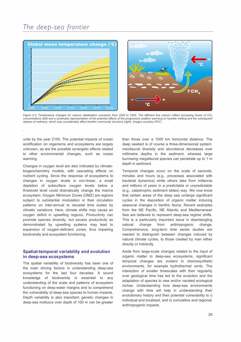
The deep-sea frontier
29
Figure 4.2: Temperature changes for various stabilisation scenarios from 2000 to 2300. The different line colours reflect increasing levels of CO2 concentrations (left) and a schematic representation of the potential effects of the progressive seafloor warming on hydrate melting and the subsequent release of methane, which may considerably affect benthic community structure (right). Images courtesy IPCC.
.
units by the year 2100. The potential impacts of ocean acidification on organisms and ecosystems are largely unknown, as are the possible synergetic effects related to other environmental changes, such as ocean warming.
Changes in oxygen level are also indicated by climate-biogeochemistry models, with cascading effects on nutrient cycling. Since the response of ecosystems to changes in oxygen levels is non-linear, a small depletion of subsurface oxygen levels below a threshold level could dramatically change the marine ecosystem. Oxygen Minimum Zones (OMZ) are regions subject to substantial modulation in their circulation patterns on inter-annual to decadal time scales by climatic variations. Here, climate shifts may cause an oxygen deficit in upwelling regions. Productivity can promote species diversity, but excess productivity as demonstrated by upwelling systems may lead to expansion of oxygen-deficient zones, thus impairing biodiversity and ecosystem functioning.
Spatial-temporal variability and evolution in deep-sea ecosystems The spatial variability of biodiversity has been one of the main driving factors in understanding deep-sea ecosystems for the last four decades. A sound knowledge of biodiversity is essential to any understanding of the scale and patterns of ecosystem functioning on deep-water margins and to comprehend the vulnerability of deep-sea species to human impacts. Depth variability is also important: genetic changes in deep-sea molluscs over depth of 100 m can be greater
than those over a 1000 km horizontal distance. The deep seabed is of course a three-dimensional system: meiofaunal diversity and abundance decreases over millimetre depths in the sediment, whereas large burrowing megafaunal species can penetrate up to 1 m depth in sediment.
Temporal changes occur on the scale of seconds, minutes and hours (e.g., processes associated with bacterial dynamics) while others take from millennia and millions of years in a predictable or unpredictable (e.g., catastrophic sediment slides) way. We now know that certain areas of the deep sea undergo significant cycles in the deposition of organic matter inducing seasonal changes in benthic fauna. Recent examples from the NE Pacific, NE Atlantic and Mediterranean Sea are believed to represent deep-sea regime shifts. This is a particularly important issue in disentangling natural change from anthropogenic change. Comprehensive, long-term time series studies are needed to distinguish between changes induced by natural climate cycles, to those created by man either directly or indirectly.
Aside from large-scale changes related to the input of organic matter to deep-sea ecosystems, significant temporal changes are evident in chemosynthetic environments, for example hydrothermal vents. The interaction of smaller timescales with their regularity over geological time has led to the evolution and the adaptation of species to new and/or vacated ecological niches. Understanding how deep-sea environments change with time will help in understanding their evolutionary history and their potential vulnerability to i) individual and localised, and ii) cumulative and regional, anthropogenic impacts.
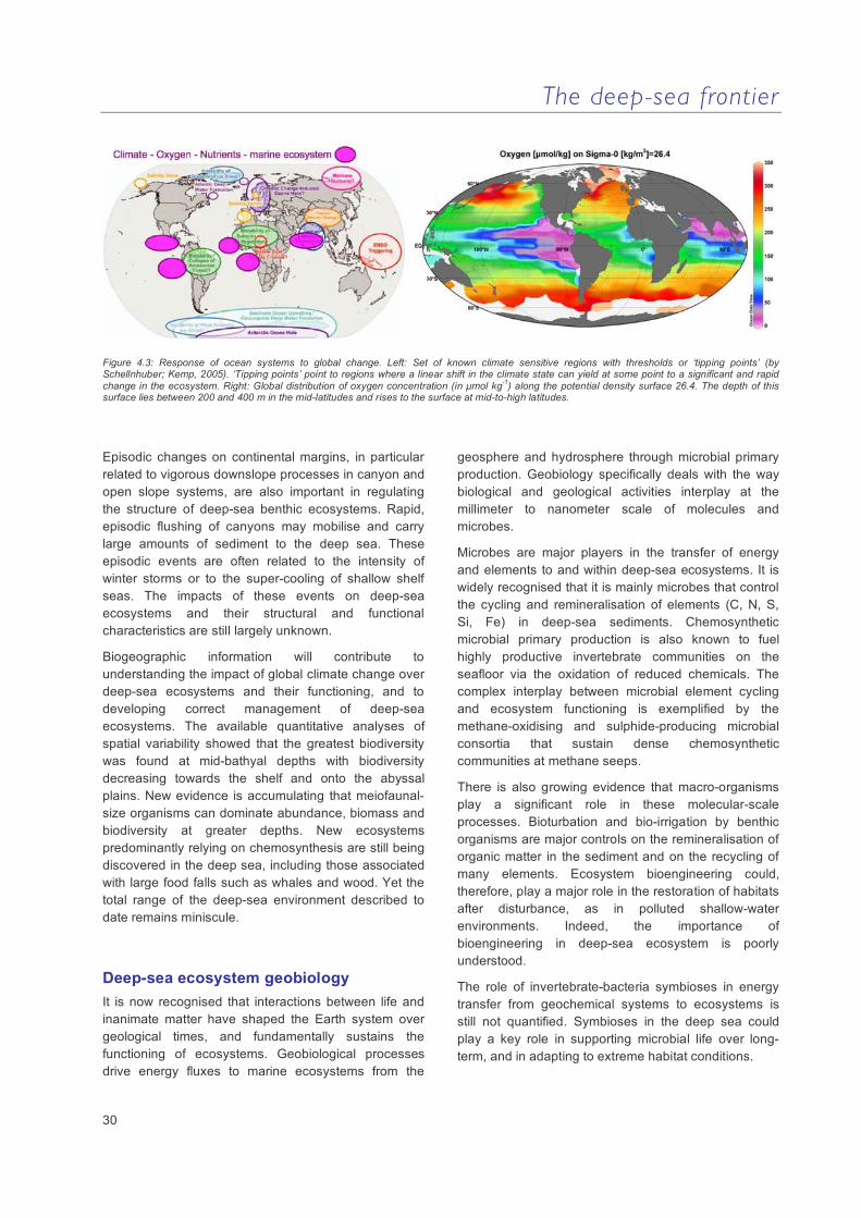
The deep-sea frontier
30
Figure 4.3: Response of ocean systems to global change. Left: Set of known climate sensitive regions with thresholds or ‘tipping points’ (by Schellnhuber; Kemp, 2005). ‘Tipping points’ point to regions where a linear shift in the climate state can yield at some point to a significant and rapid change in the ecosystem. Right: Global distribution of oxygen concentration (in µmol kg-1) along the potential density surface 26.4. The depth of this surface lies between 200 and 400 m in the mid-latitudes and rises to the surface at mid-to-high latitudes.
Episodic changes on continental margins, in particular related to vigorous downslope processes in canyon and open slope systems, are also important in regulating the structure of deep-sea benthic ecosystems. Rapid, episodic flushing of canyons may mobilise and carry large amounts of sediment to the deep sea. These episodic events are often related to the intensity of winter storms or to the super-cooling of shallow shelf seas. The impacts of these events on deep-sea ecosystems and their structural and functional characteristics are still largely unknown.
Biogeographic information will contribute to understanding the impact of global climate change over deep-sea ecosystems and their functioning, and to developing correct management of deep-sea ecosystems. The available quantitative analyses of spatial variability showed that the greatest biodiversity was found at mid-bathyal depths with biodiversity decreasing towards the shelf and onto the abyssal plains. New evidence is accumulating that meiofaunal-size organisms can dominate abundance, biomass and biodiversity at greater depths. New ecosystems predominantly relying on chemosynthesis are still being discovered in the deep sea, including those associated with large food falls such as whales and wood. Yet the total range of the deep-sea environment described to date remains miniscule.
Deep-sea ecosystem geobiology It is now recognised that interactions between life and inanimate matter have shaped the Earth system over geological times, and fundamentally sustains the functioning of ecosystems. Geobiological processes drive energy fluxes to marine ecosystems from the
geosphere and hydrosphere through microbial primary production. Geobiology specifically deals with the way biological and geological activities interplay at the millimeter to nanometer scale of molecules and microbes.
Microbes are major players in the transfer of energy and elements to and within deep-sea ecosystems. It is widely recognised that it is mainly microbes that control the cycling and remineralisation of elements (C, N, S, Si, Fe) in deep-sea sediments. Chemosynthetic microbial primary production is also known to fuel highly productive invertebrate communities on the seafloor via the oxidation of reduced chemicals. The complex interplay between microbial element cycling and ecosystem functioning is exemplified by the methane-oxidising and sulphide-producing microbial consortia that sustain dense chemosynthetic communities at methane seeps.
There is also growing evidence that macro-organisms play a significant role in these molecular-scale processes. Bioturbation and bio-irrigation by benthic organisms are major controls on the remineralisation of organic matter in the sediment and on the recycling of many elements. Ecosystem bioengineering could, therefore, play a major role in the restoration of habitats after disturbance, as in polluted shallow-water environments. Indeed, the importance of bioengineering in deep-sea ecosystem is poorly understood.
The role of invertebrate-bacteria symbioses in energy transfer from geochemical systems to ecosystems is still not quantified. Symbioses in the deep sea could play a key role in supporting microbial life over long-term, and in adapting to extreme habitat conditions.
The deep-sea frontier
31
Exploring multi-layer biodiversity in the deep-sea Deep-sea organisms represent by far the richest collection of molecular and chemical diversity in the natural world. A diverse spectrum of organisms is essential for a sustainable biosphere. They are able to recycle nutrients, produce biomass and consume gases that affect global climate, destroy pollutants and treat our wastes. The global loss of biological diversity is rapidly spreading down to the ocean interior, with as yet unknown consequences.
Exploring the multilayer biodiversity involves investigating for the first time, synoptically, the diversity of all life forms, from microbes (Bacteria, Archaea, fungi, protozoa), to unicellular eukaryotes and all metazoans (from meiofauna to macrofauna and megafauna), and their interactions (trophic, symbiosis, reproductive). Exploring multilayer biodiversity at a global scale is potentially the most ambitious project ever conceived.
Deep-sea ecosystems are characterised by high (macrobial) species diversity, much of which (from 500,000 to more than 8 million species) remains undescribed. This gap in knowledge is particularly evident for smaller organisms and prokaryotes. We have snapshots of deep-sea faunal diversity patterns, but we don’t know whether similar patterns hold true for the micro-organisms, which dominate the oceans. New molecular and genetic techniques, together with more conventional taxonomic methods, are enabling studies that may lead to knowledge of species interconnectivity and evolutionary lineages.
Life cycles, life histories and adaptation of deep-sea species Reproduction ensures the maintenance of the population and genetic recombination, facilitating evolution. Understanding reproductive patterns and adaptations of organisms to their habitats is essential to explain the functioning and sustainability of the deep-sea communities. Our knowledge of life cycles is extremely limited, particularly in the deep-sea environment.
We now know that the deep sea is not a homogenous and constant environment as previously perceived, but instead is a complex and dynamic environment affected by benthic storms, turbidity currents, and seasonal deposition of organic matter from the photic zone. This heterogeneity allows biological adaptation to occur. Symbiosis between invertebrates and bacteria is one of the most efficient adaptations of these species to their
environment. Much remains to be understood about the diversity of symbioses, their physiological functioning and role in ecosystems. Species adaptation to high temperature, low pH, low oxygen, high levels of toxic sulphide, heavy metals or CO2 provide unique models to study how life evolved to deal with such threats.
Our understanding of the life-history patterns of deep-sea species is still very limited. We know the whole life cycle of very few species. We do not know the role played by phylogenetic and environmental factors in the evolution of major life-history variables such as age at maturity, gametogenesis and fecundity. The larval phase and recruitment are among the least understood processes in the deep sea, and the effects of abiotic factors in dispersal and colonisation at different spatial scales are unknown.
Functional understanding of deep-sea biological production The quantity and quality of food availability is one of the key factors driving biological production and in shaping abundance, biomass, the structure of the food web, the composition of the fauna and biodiversity. Understanding the quantity and functioning of biological production in the deep sea is a prerequisite in evaluating whether deep-sea biological resources can be exploited in a sustainable way.
The main food resource for deep-sea organisms is the organic matter produced in the euphotic zone and channelled to the deep sea. The only autotrophic production in the deep sea is based on highly localised chemoautotrophy (e.g., hydrothermal vents and cold seeps), which may influence the surrounding deep-sea area despite their limited spatial footprint.
To date, little is known about trophic interactions and production in the deep sea. Estimates of the food demand from deep-sea biota have regularly shown that the flux of small particles as measured by sediment traps is not sufficient to maintain biological production in the deep sea. Alternative pathways of organic matter transport to the deep sea (e.g., migrating animals or large food falls) have rarely been quantified. Only rough estimates of energy fluxes and transfer efficiencies between different compartments of the food web are available.
The deep-sea frontier
32
Direct anthropogenic impacts on deep-sea ecosystems and habitat conservation Deep-sea species and habitats are intrinsically more vulnerable and less resilient than their shallow water counterparts. A growing number of deep-sea species and habitats are being included in priority lists and there is an urgent need for new conservation and management tools for the deep-sea.
Deep-sea fishing is the primary imminent threat to deep-sea ecosystems, particularly in areas of cold-water coral reefs and sponge aggregations. Additional potential impacts are hydrocarbon drilling and seabed mining. Some deep-sea habitats may re-establish easily; others such as seamount habitats may take thousands of years.
Global landings of biotic resources have shifted to deeper-living species over the last 50 years. Deep-sea fish are known to be highly vulnerable due to their life history characteristics. There is a need for further comparison between population dynamics of fish stocks explored under traditional fishing methods and those fished by industrial methods.
Oil and gas extraction must minimise negative impacts on deep-sea ecosystems. Mineral exploitation (e.g., nodule mining) is expected to grow in importance in the coming years. The impact of the plumes produced during the extraction process, and the effects of mining manganese crusts and massive polymetallic sulphide deposits have been not investigated. New technological solutions for exploitation of non-renewable resources are becoming available. Impact studies on the biodiversity and deep-sea are urgently needed.
Many countries may consider the deep-sea floor as a solution for waste disposal or CO2 sequestration. Impacts of these activities on the local fauna may be important. International conventions, committees and directives (e.g., OSPAR, ICES, IUCN) have defined a number of deep-sea habitats and species requiring urgent action, such as the designation of Marine Protected Areas, MPAs. International conventions and agreements, authority bodies (e.g. International Seabed Authority) and NGOs (e.g., Deep Sea Conservation Coalition) need to focus on concerted initiatives.
Key scientific questions
How do deep-sea ecosystems respond to global change?
What is the relative importance of biotic and abiotic time-varying factors in structuring deep sea communities?
What are the impacts of episodic and extreme events on deep-sea ecosystems?
How does biodiversity and ecosystem functioning vary over very small regional and global scales, and with environmental heterogeneity, latitude and depth?
What are the effects of geobiological processes on deep-sea ecosystem functioning? What are the relative contributions of geosphere-biosphere and bentho-pelagic coupling to deep-sea biogeochemistry?
Are biodiversity patterns consistent from microbes to megafauna, and how the two components interact? Do all biodiversity layers respond in the same way to driving forces in the deep sea?
What are the life cycles and dispersal for deep-sea organisms, and what are their physiological adaptations?
What is the deep-sea food web structure and the energy fluxes through trophic levels? Is chemosynthetic production (dark energy) relevant to the other deep-sea systems?
How resilient are deep-sea ecosystems to deep-sea fisheries, oil, gas and mineral extraction? Can deep-sea areas be used for waste disposal?
Can deep-sea resources be managed in an ecologically sustainable way? What ecosystems/ecoregions should be given conservation priority? Is the existing legal framework sufficient to support adequate deep-sea conservation?
The deep-sea frontier
33
Key recommendations
Focus future research on environmental changes in deep-sea ecosystems governed by ocean surface coupled processes.
Expand sampling strategies to cover annual to decadal time-scales in order to understanding episodic events, including landslides, earthquakes or volcanic eruptions.
Improve our understanding of deep-sea ecosystem functioning and how different ecosystems interact.
Carry out In situ analysis and colonisation experiments, including high-pressure in vivo studies of whole communities, to study community response to changes in habitat.
Instigate high-pressure, in vivo studies of whole communities.
Understand the origins, driving forces and patterns of microbial and macrobial biodiversity, and investigate fine-scale species distribution in relation to environmental gradients.
Investigation of global dispersal, evolution, and extinction rates of deep-sea species, combining traditional and novel molecular methods techniques and integrating ecological and genetic information.
Identify and quantify the functional role of the key components of the food web via measurements of physiological rates either in situ or under in situ conditions.
Study of trophic relationships (including food supply based on new techniques isotopic, biochemical and molecular approaches) and planning focused experimental studies.
Contribute to globally-integrated databases (including genotypic, taxonomic, habitat, biogeographic, and accession information).

The deep-sea frontier
34
5. The deep-sea landscape: sediment transport and fluxes
The deep-sea landscape is the cumulative result of a number of processes of highly variable duration (e.g. near-instantaneous submarine landslides or deep-sea fan formation encompassing millions of years), and from continental margin down to particle scale. Global processes such as climate-driven sea-level oscillations also have a profound influence in the long-term shaping of continental shelves, slopes and abyssal plains. The evolution and shaping of Europe’s seascape has also been strongly influenced by extraordinary geological events such as the Messinian desiccation of the Mediterranean Sea.
After nearly two decades of high-resolution seabed and subseabed observations eased by rapidly improving survey techniques, the scientific community is now in the best position ever to observe and quantify the modern sedimentary processes impacting the seafloor, and assess their capacity to imprint the resulting sedimentary deposits. This opens unprecedented opportunities to better interpret and understand the record of global change in the recent past.
Particle fluxes play a fundamental role in global element cycling and, consequently, in fuelling deep-sea ecosystems. Transport of sedimentary particles connects atmosphere, hydrosphere, lithosphere and biosphere, and is reflected in their changing composition and concentration.
Human activities started to significantly affect sediment transport and particle fluxes to and into the ocean a few centuries ago. Such interactions increased dramatically through the 20th century and an increasing trend is foreseen for the near future. Dam construction, for instance, and water extraction or diversion of major rivers in Europe, especially in the Mediterranean region, has led to dramatic reduction of water and sediment discharge to the ocean.
Not only the quantity, but also the entry modes and the quality of the substances transferred to the ocean have been substantially modified as a result of human activity. Highly impacting activities such as trawling have significantly altered the micro-topography of the seabed nearly everywhere on continental margins at depths shallower than 1000 m, and have contributed to increasing suspended sediment loads at basin scale.
The tremendous variety of spatial and temporal scales involved in seascaping processes represents a challenge that can only be addressed through a multi- and interdisciplinary approach.
Process observation and resulting sediment bodies Through a combination of (i) fieldwork at sea during which sedimentary material is sampled and geophysically imaged, and (ii) modelling (theoretical and using scaled laboratory and numerical experiments), we now have a sense of the range of processes occurring and of the deposits produced.
Samples and geophysical data have been used to interpret sediment transport processes, as illustrated by the use of grain-size measurements to reconstruct the characteristics of turbidity currents. These events have also been inferred indirectly, for example from cable breaks. Small submarine landslides have been detected through the sound they produce via sonar arrays, or from the tsunamis generated. Areas of deep-water formation and cascading are known as potential drivers of continental and climatic signals to the deep-sea and its sediment record.
However, one of the main difficulties in the deep-sea domain is that direct observation of the active processes is extremely difficult. Monitoring efforts (e.g., with sediment traps and current meters) have been substantial so far, but capturing highly significant events is rather more difficult as they are short-lived and/or located at specific sites. Therefore, the quality and quantity of in situ observations is still very scarce.
Figure 5.1: Combined backscatter (grey scale) and bathymetry (colours) data unveil the horsetail pattern of flow lines associated with the BIG’95 submarine landslide in the NW Mediterranean Sea. The tsunamigenic potential of BIG’95 is currently under investigation (Image courtesy University of Barcelona).
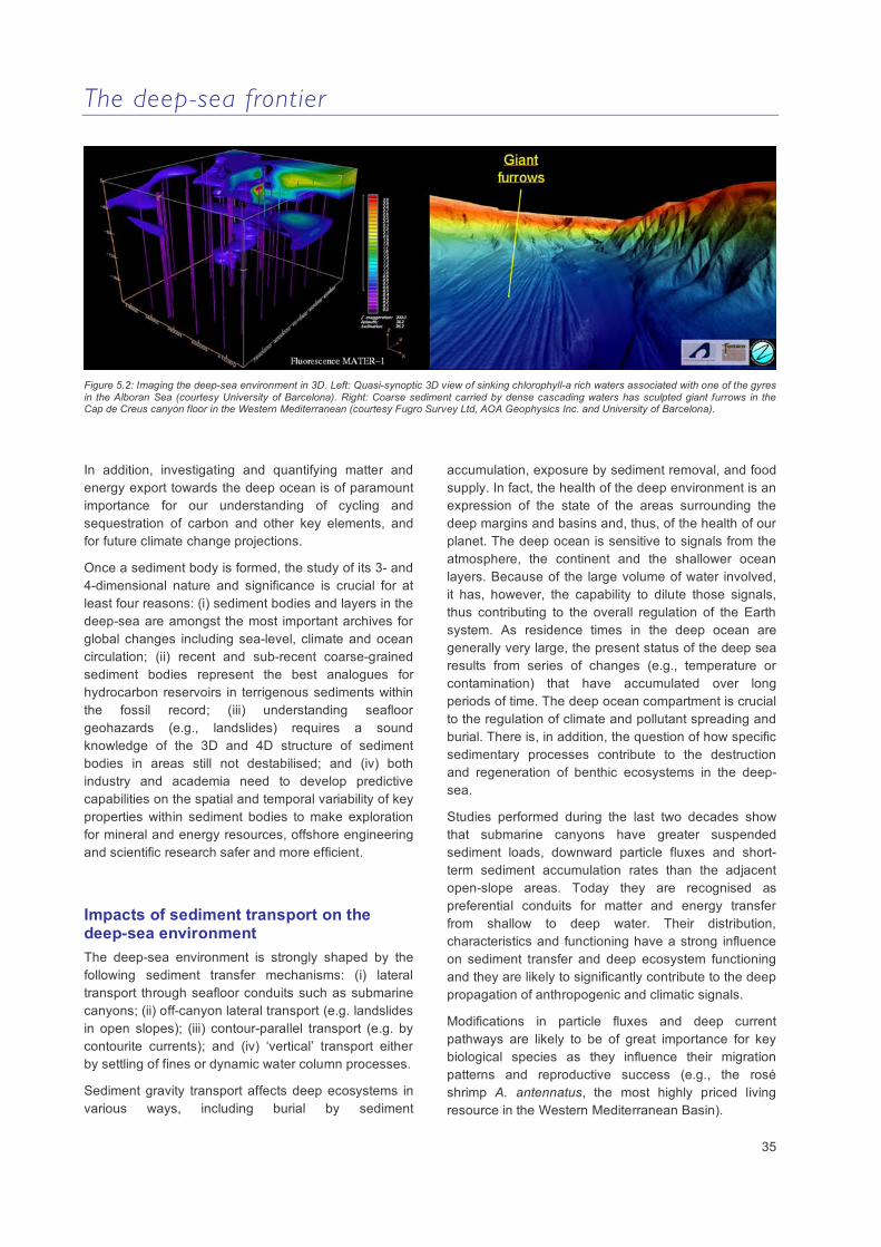
The deep-sea frontier
35
Figure 5.2: Imaging the deep-sea environment in 3D. Left: Quasi-synoptic 3D view of sinking chlorophyll-a rich waters associated with one of the gyres in the Alboran Sea (courtesy University of Barcelona). Right: Coarse sediment carried by dense cascading waters has sculpted giant furrows in the Cap de Creus canyon floor in the Western Mediterranean (courtesy Fugro Survey Ltd, AOA Geophysics Inc. and University of Barcelona).
In addition, investigating and quantifying matter and energy export towards the deep ocean is of paramount importance for our understanding of cycling and sequestration of carbon and other key elements, and for future climate change projections.
Once a sediment body is formed, the study of its 3- and 4-dimensional nature and significance is crucial for at least four reasons: (i) sediment bodies and layers in the deep-sea are amongst the most important archives for global changes including sea-level, climate and ocean circulation; (ii) recent and sub-recent coarse-grained sediment bodies represent the best analogues for hydrocarbon reservoirs in terrigenous sediments within the fossil record; (iii) understanding seafloor geohazards (e.g., landslides) requires a sound knowledge of the 3D and 4D structure of sediment bodies in areas still not destabilised; and (iv) both industry and academia need to develop predictive capabilities on the spatial and temporal variability of key properties within sediment bodies to make exploration for mineral and energy resources, offshore engineering and scientific research safer and more efficient.
Impacts of sediment transport on the deep-sea environment The deep-sea environment is strongly shaped by the following sediment transfer mechanisms: (i) lateral transport through seafloor conduits such as submarine canyons; (ii) off-canyon lateral transport (e.g. landslides in open slopes); (iii) contour-parallel transport (e.g. by contourite currents); and (iv) ‘vertical’ transport either by settling of fines or dynamic water column processes.
Sediment gravity transport affects deep ecosystems in various ways, including burial by sediment
accumulation, exposure by sediment removal, and food supply. In fact, the health of the deep environment is an expression of the state of the areas surrounding the deep margins and basins and, thus, of the health of our planet. The deep ocean is sensitive to signals from the atmosphere, the continent and the shallower ocean layers. Because of the large volume of water involved, it has, however, the capability to dilute those signals, thus contributing to the overall regulation of the Earth system. As residence times in the deep ocean are generally very large, the present status of the deep sea results from series of changes (e.g., temperature or contamination) that have accumulated over long periods of time. The deep ocean compartment is crucial to the regulation of climate and pollutant spreading and burial. There is, in addition, the question of how specific sedimentary processes contribute to the destruction and regeneration of benthic ecosystems in the deep-sea.
Studies performed during the last two decades show that submarine canyons have greater suspended sediment loads, downward particle fluxes and short-term sediment accumulation rates than the adjacent open-slope areas. Today they are recognised as preferential conduits for matter and energy transfer from shallow to deep water. Their distribution, characteristics and functioning have a strong influence on sediment transfer and deep ecosystem functioning and they are likely to significantly contribute to the deep propagation of anthropogenic and climatic signals.
Modifications in particle fluxes and deep current pathways are likely to be of great importance for key biological species as they influence their migration patterns and reproductive success (e.g., the rosé shrimp A. antennatus, the most highly priced living resource in the Western Mediterranean Basin).

The deep-sea frontier
36
Figure 5.3: Bathymetric image showing how the seafloor in the northern Antarctic Peninsula has been carved by huge ice streams in the past (courtesy University of Barcelona)
In carbonate and glaciated margins, shelf-edge spillover processes may be more significant than along canyon transport. Particle fluxes tend to diminish by orders of magnitudes from marginal settings to open ocean settings, where contributions of autochthonous biogenic debris are proportionally more important. Seasonality and interannual variability at mid-latitudes are highly significant, and some severe events affecting the deep-sea may occur on decadal or larger intervals (e.g., deep water cascading impacting the basin floor). Such events, sometimes referred to as ‘transients’, may dramatically alter the status of the deep-sea environment within a very short time (i.e., days or weeks). It is suspected that their impact may persist for years or decades until a new event occurs. Some authors have used the expression ‘benthic storm’ to refer to particularly energetic processes affecting the seafloor ecosystem.
Sediment transport to the deep-sea under a changing environment and a growing human pressure The Earth’s changing environment has largely influenced sediment transport and particle fluxes in the past and will continue to do so in the future. There are indisputable signs that in recent decades both global change and its effects on the sediment cycle are accelerating under human pressure on the entire Earth system. Studying their nature and monitoring human impacts (e.g., trawling) is mandatory to obtain the baseline information needed to detect deleterious changes. It is also essential to establish informed policies and implement measures to improve the health of the ocean.
Investigating changes in sediment transport and particle fluxes on a decadal to centennial scale is
particularly important to: (i) better understand the ocean response under fast climate change; (ii) determine long term trends in oceanic properties and behavior; (iii) develop predictive capabilities on the future state of the ocean and its living resources; (iv) sustain ocean living resources; (v) provide baseline information to detect changes; and (vi) anticipate both insidious and abrupt changes in ocean regimes.
It is generally accepted that during high sea level stands, as at present, most of the sediment discharge from the land mass is trapped on continental shelves. However, recent observations have demonstrated that even during high stands sediment transfer to the deep-sea is episodically very active. Turbidity currents and sediment-laden dense water cascades have been measured and shown to carry out large amounts of sediment to the deep-sea over a period of days to weeks.
Figure 5.4: The human imprint on the seafloor is widespread. High-resolution multibeam image showing trawl marks (above) and suspended sediment concentration distribution of a sediment resuspension plume at various times after its generation by a bottom trawl (Image courtesy University of Barcelona and CEFREM Perpignan).
Sedimentation on glaciated margins is dramatically influenced by the Earth’s changing environment, causing large sedimentary systems to be turned off and on in response to climatic oscillations. When grounded on the shelf edge, ice shelves and ice streams carry large volumes of subglacial sediment that eventually spill over the slope off the ice grounding line. In contrast, when ice retreats, subglacial sediment transport and accumulation is confined to inner shelf positions. This implies that during warm epochs, deep-sea depositional systems are disconnected from their main source areas and become starved or deactivated until a new glacial epoch occurs. The impact of such
The deep-sea frontier
37
climatically driven changes on deep-sea ecosystems is suspected to be enormous. Ice rafting, which peaks after massive collapse of former ice mantles and during
transitional epochs, has a direct impact on the deep ecosystem as most of the rock fragments released by iceberg melting travel directly to the ocean bottom.
Key scientific questions
What controls the high-resolution 3D architecture, distribution and physical properties of deep-sea sediment bodies, and how can we link the stratigraphic record to processes that occur at seasonal to centennial scales? Where and why does sand concentrate on modern deep ocean margins?
What are the specific processes involved in canyon initiation, development and functioning, and what is the importance of oceanographic processes like internal waves and cascading events on sediment transport to the deep sea? Are submarine canyons oases for hidden biodiversity?
What is the role of sediment injections (as food carriers) in driving deep-sea ecosystems in time and space, and how do benthic ecosystems mediate burial of sedimentary particles and the formation of the sediment record?
What are the feedbacks between organisms and mass sediment transport events (e.g. alteration of the soil fabric both by organisms and by sediment transport
How do processes occurring on ocean margins determine the condition and functioning of deep-sea ecosystems, and how are human impacts altering the links of the deep ocean with the Earth’s fluid layers and which consequences will this have in the short-, mid- and long-term?
What are the main paths and the efficiency of the processes involved in the dissemination of pollutants to the deep sea?
What is the impact of sediment resuspension, including human-induced activities, and how does it contribute to sustaining benthic ecosystems?
What are the links between ocean dynamics, particle fluxes, seabed condition, seascape and valuable commercial species?
Will the buffering capacity of the deep ocean against changes in its properties (e.g. acidification) be exceeded in the near future? Are continental margins a carbon source or a sink?
Key recommendations
Large, multinational, and interdisciplinary research consortia are required to address the challenges of deep-sea research. Strengthening collaboration between academy and industry is essential.
Public commitment for long term funding to implement data collection and, in particular, deep-sea monitoring (from ‘exploratory research’ to ‘focused research’) is needed.
New technological developments for high quality, efficient sampling. Event-targeted and long-term continuous seafloor and subseafloor observation and in situ monitoring are necessary.
Establish fast, realistic event response plans that could be implemented to address the challenge of research on episodic events.
Better modeling capabilities to integrate field data.
Development of more user-friendly data banks, GIS and WebGIS facilities.

The deep-sea frontier
38
6. Sustainable use of deep-sea resources
Economics The important life support functions of marine ecosystems are increasingly recognised as part of the global ecosystem, while deep-sea ecosystems goods and services are of growing economic significance. The potentially vast reservoir of renewable and non-renewable resources present in European and international deep waters have received renewed attention in the past decade. Established industries such as fisheries and hydrocarbon extraction have moved rapidly and steadily downslope as shallower and more accessible resources become depleted. Deep-sea fisheries and oil and gas exploration now occur in depths below 2000m, while emerging industries such as blue biotechnology – obtaining useful products through the exploitation of deep-sea genetic biodiversity – are not limited by depth.
New deep-water fisheries may still be developing on a global scale, but in the North Atlantic some have been exploited for a century or more, or developed over the last 30-40 years. Scope for further growth appears to be limited as it is clear that the life history characteristics of deep-sea fish are unsuited to industrial harvest. Deep-water trawling is particularly problematic as it leaves a large environmental footprint, especially where fishing occurs in areas of vulnerable habitat such as cold-water coral reefs.
In contrast, extraction of energy from the oceans will rise dramatically in the coming decades. Oil and gas exploitation in deep waters will continue to increase over the next 20 years as higher prices make deeper exploitation economically viable. Gas hydrate deposits may provide a new source of energy and research into renewable ocean energies, such as wave, geothermal and ocean-thermal sources, is gaining importance. In tandem with the exploitation of new reserves comes increased pressure to actively remove fossil fuel-derived greenhouse gases from the atmosphere. In the future the deep sea may be used as a reservoir for the sequestration of CO2, thus providing capital in the potentially lucrative carbon trading market.
The number of existing and planned large deep-sea infrastructure projects is set to expand in the near future due to an increase in the installation of submarine cables, oil and gas pipelines, sub-sea production platforms and cabled ocean observatories. This will create opportunities for innovation as the major technological and engineering challenges are met and overcome. These developments can be drivers of new surveys, maintenance, monitoring and reduced
environmental impact engineering products and methodologies. The provision of information and communication technology (ICT) infrastructure for cabled observatories and sub-sea platforms will similarly drive innovation in mass data storage and processing, sensors and autonomous platform technologies.
The Lisbon Agenda sets out the European Union’s strategy for competitiveness, growth and employment. Therefore, a key driver of research and development in the deep sea over the next 5 to 10 years will be to fulfill the vision, in the marine context, that the European Union will become, ‘the most dynamic and competitive knowledge-based economy in the world, capable of sustainable economic growth with more and better jobs and greater social cohesion, and respect for the environment’. The recent Green Paper ‘Towards a Maritime Policy for the European Union’ clearly articulates that any future European Maritime Policy will fully contribute to the Lisbon Agenda by exploiting the economic potential of the oceans and seas in harmony with the marine environment. This requires research to better understand the effects of climate change, improve the competitiveness of European maritime industry, and improve the groundwork for the implementation of an ecosystem-based management approach that will ensure environmentally sustainable economic development on a regional basis. Research underpinning the development of new sustainable management policies and practices, experience of sustainable exploitation of offshore resources, and the knowledge capital these represent, will create opportunities for Europe to provide leadership in the global economy.
Environment The current and anticipated economic activity in deep-sea areas of European and international waters described above does not come without a price. Already there is much evidence of damage to fragile deep-water corals and other vulnerable habitats by trawling. It is likely that the multiplicity of anticipated future activities will lead to user conflicts requiring the development of new decision-making processes. To address these issues, data must be integrated from different sources, including oceanographic, geophysical, geological, sedimentary, hydrological, biological, microbiological, social, economic and legal studies. Assessments of the impact of different management strategies on the resource base, the
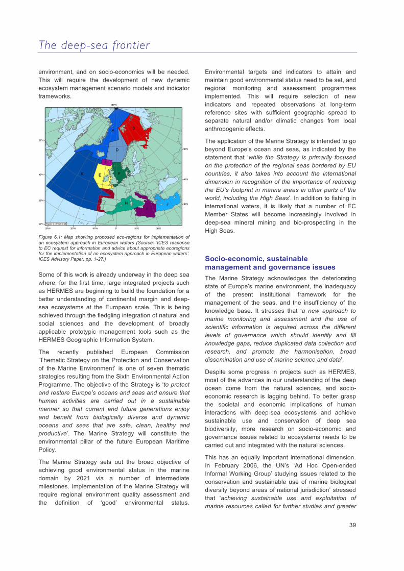
The deep-sea frontier
39
environment, and on socio-economics will be needed. This will require the development of new dynamic ecosystem management scenario models and indicator frameworks.
Figure 6.1: Map showing proposed eco-regions for implementation of an ecosystem approach in European waters (Source: ‘ICES response to EC request for information and advice about appropriate ecoregions for the implementation of an ecosystem approach in European waters’. ICES Advisory Paper, pp. 1-27.)
Some of this work is already underway in the deep sea where, for the first time, large integrated projects such as HERMES are beginning to build the foundation for a better understanding of continental margin and deep-sea ecosystems at the European scale. This is being achieved through the fledgling integration of natural and social sciences and the development of broadly applicable prototypic management tools such as the HERMES Geographic Information System.
The recently published European Commission ‘Thematic Strategy on the Protection and Conservation of the Marine Environment’ is one of seven thematic strategies resulting from the Sixth Environmental Action Programme. The objective of the Strategy is ‘to protect and restore Europe’s oceans and seas and ensure that human activities are carried out in a sustainable manner so that current and future generations enjoy and benefit from biologically diverse and dynamic oceans and seas that are safe, clean, healthy and productive’. The Marine Strategy will constitute the environmental pillar of the future European Maritime Policy.
The Marine Strategy sets out the broad objective of achieving good environmental status in the marine domain by 2021 via a number of intermediate milestones. Implementation of the Marine Strategy will require regional environment quality assessment and the definition of ‘good’ environmental status.
Environmental targets and indicators to attain and maintain good environmental status need to be set, and regional monitoring and assessment programmes implemented. This will require selection of new indicators and repeated observations at long-term reference sites with sufficient geographic spread to separate natural and/or climatic changes from local anthropogenic effects.
The application of the Marine Strategy is intended to go beyond Europe’s ocean and seas, as indicated by the statement that ‘while the Strategy is primarily focused on the protection of the regional seas bordered by EU countries, it also takes into account the international dimension in recognition of the importance of reducing the EU’s footprint in marine areas in other parts of the world, including the High Seas’. In addition to fishing in international waters, it is likely that a number of EC Member States will become increasingly involved in deep-sea mineral mining and bio-prospecting in the High Seas.
Socio-economic, sustainable management and governance issues The Marine Strategy acknowledges the deteriorating state of Europe’s marine environment, the inadequacy of the present institutional framework for the management of the seas, and the insufficiency of the knowledge base. It stresses that ‘a new approach to marine monitoring and assessment and the use of scientific information is required across the different levels of governance which should identify and fill knowledge gaps, reduce duplicated data collection and research, and promote the harmonisation, broad dissemination and use of marine science and data’.
Despite some progress in projects such as HERMES, most of the advances in our understanding of the deep ocean come from the natural sciences, and socio-economic research is lagging behind. To better grasp the societal and economic implications of human interactions with deep-sea ecosystems and achieve sustainable use and conservation of deep sea biodiversity, more research on socio-economic and governance issues related to ecosystems needs to be carried out and integrated with the natural sciences.
This has an equally important international dimension. In February 2006, the UN’s ‘Ad Hoc Open-ended Informal Working Group’ studying issues related to the conservation and sustainable use of marine biological diversity beyond areas of national jurisdiction’ stressed that ‘achieving sustainable use and exploitation of marine resources called for further studies and greater
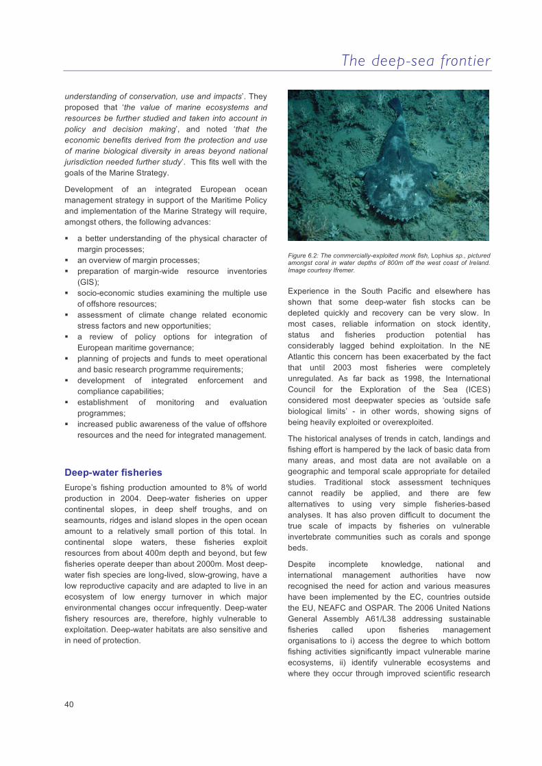
The deep-sea frontier
40
understanding of conservation, use and impacts’. They proposed that ‘the value of marine ecosystems and resources be further studied and taken into account in policy and decision making’, and noted ‘that the economic benefits derived from the protection and use of marine biological diversity in areas beyond national jurisdiction needed further study’. This fits well with the goals of the Marine Strategy.
Development of an integrated European ocean management strategy in support of the Maritime Policy and implementation of the Marine Strategy will require, amongst others, the following advances:
a better understanding of the physical character of margin processes;
an overview of margin processes; preparation of margin-wide resource inventories
(GIS); socio-economic studies examining the multiple use
of offshore resources; assessment of climate change related economic
stress factors and new opportunities; a review of policy options for integration of
European maritime governance; planning of projects and funds to meet operational
and basic research programme requirements; development of integrated enforcement and
compliance capabilities; establishment of monitoring and evaluation
programmes; increased public awareness of the value of offshore
resources and the need for integrated management.
Deep-water fisheries Europe’s fishing production amounted to 8% of world production in 2004. Deep-water fisheries on upper continental slopes, in deep shelf troughs, and on seamounts, ridges and island slopes in the open ocean amount to a relatively small portion of this total. In continental slope waters, these fisheries exploit resources from about 400m depth and beyond, but few fisheries operate deeper than about 2000m. Most deep-water fish species are long-lived, slow-growing, have a low reproductive capacity and are adapted to live in an ecosystem of low energy turnover in which major environmental changes occur infrequently. Deep-water fishery resources are, therefore, highly vulnerable to exploitation. Deep-water habitats are also sensitive and in need of protection.
Figure 6.2: The commercially-exploited monk fish, Lophius sp., pictured amongst coral in water depths of 800m off the west coast of Ireland. Image courtesy Ifremer.
Experience in the South Pacific and elsewhere has shown that some deep-water fish stocks can be depleted quickly and recovery can be very slow. In most cases, reliable information on stock identity, status and fisheries production potential has considerably lagged behind exploitation. In the NE Atlantic this concern has been exacerbated by the fact that until 2003 most fisheries were completely unregulated. As far back as 1998, the International Council for the Exploration of the Sea (ICES) considered most deepwater species as ‘outside safe biological limits’ - in other words, showing signs of being heavily exploited or overexploited.
The historical analyses of trends in catch, landings and fishing effort is hampered by the lack of basic data from many areas, and most data are not available on a geographic and temporal scale appropriate for detailed studies. Traditional stock assessment techniques cannot readily be applied, and there are few alternatives to using very simple fisheries-based analyses. It has also proven difficult to document the true scale of impacts by fisheries on vulnerable invertebrate communities such as corals and sponge beds.
Despite incomplete knowledge, national and international management authorities have now recognised the need for action and various measures have been implemented by the EC, countries outside the EU, NEAFC and OSPAR. The 2006 United Nations General Assembly A61/L38 addressing sustainable fisheries called upon fisheries management organisations to i) access the degree to which bottom fishing activities significantly impact vulnerable marine ecosystems, ii) identify vulnerable ecosystems and where they occur through improved scientific research

The deep-sea frontier
41
and data collection, and iii) close such areas to bottom fishing unless conservation and management measures have been established to prevent significant adverse impacts on the ecosystems.
The science community is faced with the challenge of analysing the effects of factors such as landings, quota systems, area closures, effort and gear regulations, often without sufficient information to carry out these assessments and give well-founded advice in support of ecosystem based-management of fisheries. In addition, the term ‘ecosystem based’ is ill-defined. What is implied is that the implementation of any management system should not only manage fisheries and the target resources, but also avoid lasting destruction of the biotic and abiotic environment in which the resources live.
Oil and gas exploration Despite the challenges of offshore ocean exploration, exploitation and monitoring, some 35% of global oil production and 27% of gas production is from offshore areas. Since fossil hydrocarbon resources are predicted to last for at least another fifty years, the industry will continue to invest in infrastructure and new techniques for optimised exploitation, leading to more and enhanced underwater facilities. In the future, it is likely that the huge fixed rigs used today will be increasingly replaced by floating production platforms and smaller-scale sub-sea production technology deployed directly on the seabed, similar to those already in existence on the Norwegian margin and in the Gulf of Mexico.
Figure 6.3: Deep-water oil and gas production platform and infrastructure (image courtesy Statoil).
Underwater platforms, wells, and pipelines will be equipped with sensors providing continuous data transmission describing operational status. This should lead to a reduced need for large ships and manpower
at sea and a concomitant reduction in the pollution risk and hazards relating to large platform operation. The control and operation of the facilities will be possible from land as demonstrated by a number of existing and near-operational systems. These integrated systems are currently a hot topic in the petroleum industry. Most operators have built onshore operation support centers for real-time optimisation of drilling operations and production. Real-time onshore monitoring and control of wells and offshore processing are likely ingredients of the subsea-to-shore concepts in the future. Increasing the number of such platforms will lead to the creation of new power and data cable networks along continental margins.
These developments will open up new possibilities for cooperation between the petroleum industry and ecological research. It may be possible to integrate hydrocarbon field development with cabled seafloor observatories. As the petroleum industry moves to deeper waters and higher latitudes, online monitoring around underwater platforms and pipelines using state-of-the-art sensor and instrument systems is possible. This can be achieved through close collaboration between the petroleum industry and the European science community.
Of course, with this expansion of offshore exploration and development comes increased opportunities for conflict with other resource users, as well as environmental concerns related to potential oil spills and other pollution. It is up to resource managers to balance these conflicting uses with conservation priorities. The oil and gas industry are eager to improve the science and methodologies used in regional strategic (SEA) and local environmental impact (EIA) risk assessments. The industry may also have a role to play in regional monitoring initiatives developed to underpin the Marine Strategy.
Seafloor mining The ocean covers 71% of the surface of the earth and 60% of the floor of the ocean lies deeper than 2000 m. This huge area remains relatively unexplored. Scientific investigations during the last 30 years have revealed various types of mineral concentrations that are only now becoming the focus of economic interest. Seafloor mineral resources may one day be critical for society to meet its future needs as many of the large, easy to find and highly concentrated mineral reserves on land have already been mined out. An example is copper ore, where the average grade mined on land has decreased from 3 to 0.5 % in less than a century. An immediate consequence of this reduction in ore quality is an

The deep-sea frontier
42
increase in extractive energy costs and the environmental footprint required to extract the metal. In contrast, marine seafloor deposits such as polymetallic sulphides, are extremely rich in metals. Thus, even though deposits may be so small that they would never be mined on land, the expense associated with moving from one deposit to another at sea using ship-based operations would be much less than on land.
Ocean mining of various mineral resources therefore has enormous economic potential. Equally, there is considerable potential for environmental impact. A number of European countries are involved in the fledgling development of the industry and the establishment of environmental best practice. As most of the potentially exploitable resources lie within the EEZ of non-European countries or in international waters, a key issue is the development of legislation to regulate the industry. The International Seabed Authority (ISA) has started to develop specific
regulations for exploiting polymetallic sulphides in the High Seas, and in 2001 the International Marine Mineral Society produced a ‘Code for Environmental Management for Marine Mining’.
Our known supply of minerals will be exhausted early in the third millennium. We are now reaching the limits of reserves for many minerals. Unsustainable consumption rates, human population growth and the rapid industrialisation of highly populated countries (e.g., China, India and Brazil) result in the depletion of available resources at increasing rates. The higher demand for metal has impacted metal prices - for example, the prices of steel, copper and zinc have increased by several hundred percent in the last three years. Marine mining will become a reality this century. The oceans in this context are a major resource for mankind, which are yet to be explored and exploited to their full potential.
Figure 6.4. Left: Active smokers in the Lau Basin SW Pacific. Chimneys on the left are primarily made zinc and copper sulfides with high gold concentration. Right: Ferromanganese crusts dredged from the French Polynesia area (Images courtesy IFREMER).
Type Location Commodity Depth Mining status
Economic interest
Salt Coastal Salt Shore Operational Moderate Sand and gravels Beach, shallow water Aggregates Shallow Operational High Marine placer Beach, shallow water Tin, gold, chromium,
zirconium, Rare Earth Elements, titanium
Shallow Operational Moderate
Diamonds Coastal Diamonds < 250 m Operational High Phosphates Shallow water and
seamounts Phosphate Shallow to medium
depth Non operational
Low
Nodules Deep Ocean Copper, cobalt, nickel 4500m to 5500 m Potential resources
Moderate
Manganese crust Intraplate seamounts Cobalt, copper, platinum 1000m to 2500m Potential resources
Moderate
Deep-sea sulphides Volcanic ridges Copper, zinc, silver, gold, cobalt, lead
1000 to 4000m Potential resources
High
Table 6.1: Summary of the principal types of mineral resources in the oceans. Compositions vary greatly depending on the geological setting. Most operational mining is in shallow water. Recent advances in industrial capability have increased the potential economic interest of deep-sea mineralisation.

The deep-sea frontier
43
Key scientific questions
What is the socio-economic importance of deep sea biodiversity and the impact of human activities on it?
What are the key economic and valuation issues, and what are the socio-economic drivers of change?
What are the governance principles that are key in decision-making, and can we develop better policy instruments and appropriate management tools? How can we assess their effectiveness?
Can we provide the scientific knowledge necessary to underpin the development of tools supporting an ecosystem-based management strategy?
How can we improve the science-policy interface?
Key recommendations
Assess deep-sea ecosystem goods and services, including provisioning services (food, raw material, fuel etc.), regulating services (climate regulation, disease regulation etc.), cultural services (recreational, aesthetic, spiritual etc.), supporting services (nutrient cycling, primary production etc.).
Catalogue the human activities having a direct or indirect impact on marine biodiversity, in particular in sensitive habitats such as deep-water corals, seamounts, hydrothermal vents and cold seeps.
Carry out monetary and non-monetary socio-economic valuations addressing non-market and non-use values. Assess costs and benefits (including restoration costs) and addressing the issue of discounting (long term benefits vs. short term costs). Assess the loss of value due to biodiversity loss, and develop multicriteria analyses to underpin strategies for the conservation and sustainable use of deep-sea biodiversity.
Strengthen European expertise in socio-economics and governance research on the deep sea.
Provide support for democratic decision making underpinning marine spatial planning.
Improve data sharing through integrated and long-term management of industry, government and margin research and environmental databases in line with the INSPIRE directive. Further develop Geographic Information System tools, standardise metadata cataloguing and improve data visualisation methods to improve data access.
Study past and present fleet dynamics and behaviour, at the finest possible geographical and temporal scale.
Develop joint oil and gas industry/research/government approaches to maximise the potential of cabled network on a regional basis.
Involve industry in long-term ecosystem and environmental monitoring, and at an early stage in Strategic Environmental Assessment exercises. Update industry environmental (risk) assessment and monitoring protocols.
Develop a European deep-sea mining strategy to ensure future autonomy of metal supply. Close the technological gap existing between Europe and countries such as USA, Japan and Russia.
Co-ordinate at a European level, Member State science and exploration in international waters in relation to mineral exploitation and assessment of environmental impact.
Develop the support infrastructure (e.g., ships) and technologies necessary to recover metal deposits from the seafloor on a commercial scale. Encourage the development of specific technologies that have minimal environmental impact when mining ore deposits in the deep ocean.
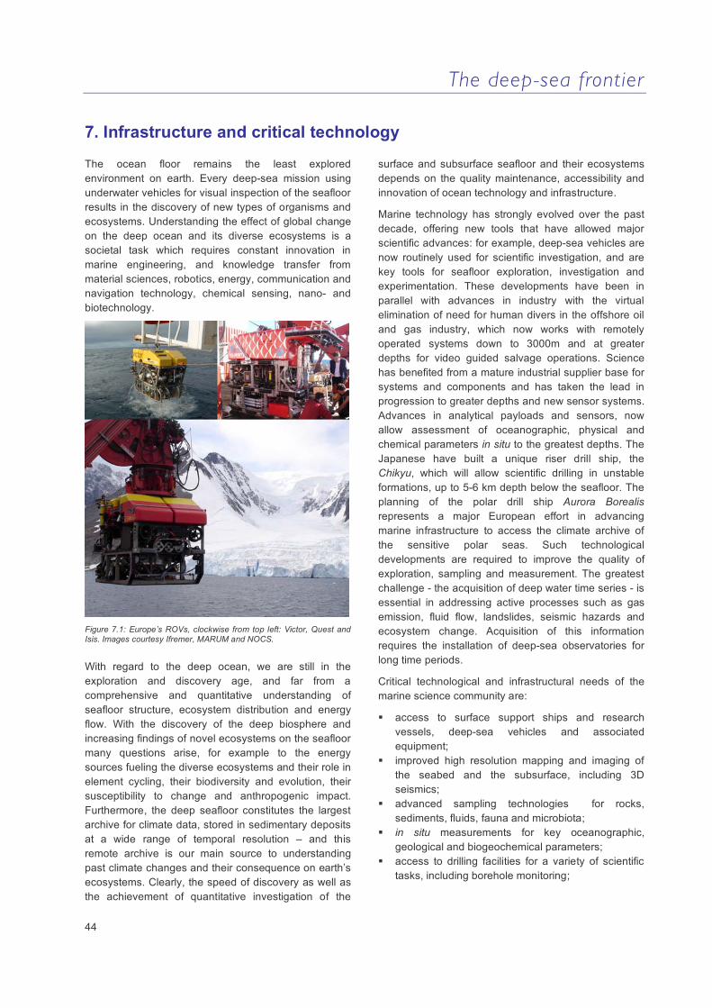
The deep-sea frontier
44
7. Infrastructure and critical technology
The ocean floor remains the least explored environment on earth. Every deep-sea mission using underwater vehicles for visual inspection of the seafloor results in the discovery of new types of organisms and ecosystems. Understanding the effect of global change on the deep ocean and its diverse ecosystems is a societal task which requires constant innovation in marine engineering, and knowledge transfer from material sciences, robotics, energy, communication and navigation technology, chemical sensing, nano- and biotechnology.
Figure 7.1: Europe’s ROVs, clockwise from top left: Victor, Quest and Isis. Images courtesy Ifremer, MARUM and NOCS.
With regard to the deep ocean, we are still in the exploration and discovery age, and far from a comprehensive and quantitative understanding of seafloor structure, ecosystem distribution and energy flow. With the discovery of the deep biosphere and increasing findings of novel ecosystems on the seafloor many questions arise, for example to the energy sources fueling the diverse ecosystems and their role in element cycling, their biodiversity and evolution, their susceptibility to change and anthropogenic impact. Furthermore, the deep seafloor constitutes the largest archive for climate data, stored in sedimentary deposits at a wide range of temporal resolution – and this remote archive is our main source to understanding past climate changes and their consequence on earth’s ecosystems. Clearly, the speed of discovery as well as the achievement of quantitative investigation of the
surface and subsurface seafloor and their ecosystems depends on the quality maintenance, accessibility and innovation of ocean technology and infrastructure.
Marine technology has strongly evolved over the past decade, offering new tools that have allowed major scientific advances: for example, deep-sea vehicles are now routinely used for scientific investigation, and are key tools for seafloor exploration, investigation and experimentation. These developments have been in parallel with advances in industry with the virtual elimination of need for human divers in the offshore oil and gas industry, which now works with remotely operated systems down to 3000m and at greater depths for video guided salvage operations. Science has benefited from a mature industrial supplier base for systems and components and has taken the lead in progression to greater depths and new sensor systems. Advances in analytical payloads and sensors, now allow assessment of oceanographic, physical and chemical parameters in situ to the greatest depths. The Japanese have built a unique riser drill ship, the Chikyu, which will allow scientific drilling in unstable formations, up to 5-6 km depth below the seafloor. The planning of the polar drill ship Aurora Borealis represents a major European effort in advancing marine infrastructure to access the climate archive of the sensitive polar seas. Such technological developments are required to improve the quality of exploration, sampling and measurement. The greatest challenge - the acquisition of deep water time series - is essential in addressing active processes such as gas emission, fluid flow, landslides, seismic hazards and ecosystem change. Acquisition of this information requires the installation of deep-sea observatories for long time periods.
Critical technological and infrastructural needs of the marine science community are:
access to surface support ships and research vessels, deep-sea vehicles and associated equipment;
improved high resolution mapping and imaging of the seabed and the subsurface, including 3D seismics;
advanced sampling technologies for rocks, sediments, fluids, fauna and microbiota;
in situ measurements for key oceanographic, geological and biogeochemical parameters;
access to drilling facilities for a variety of scientific tasks, including borehole monitoring;
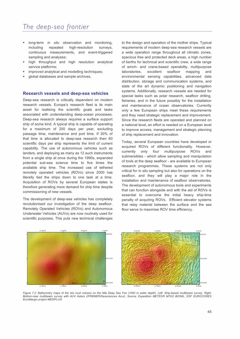
The deep-sea frontier
45
long-term in situ observation and monitoring, including repeated high-resolution surveys, continuous measurements, and event-triggered sampling and analyses;
high throughput and high resolution analytical service platforms;
improved analytical and modelling techniques; global databases and sample archives.
Research vessels and deep-sea vehicles Deep-sea research is critically dependent on modern research vessels. Europe’s research fleet is its main asset for realising the scientific goals and tasks associated with understanding deep-ocean processes. Deep-sea research always requires a surface support ship of some kind. A typical ship is capable of operating for a maximum of 200 days per year, excluding passage time, maintenance and port time. If 30% of that time is allocated to deep-sea research then 60 scientific days per ship represents the limit of current capability. The use of autonomous vehicles such as landers, and deploying as many as 12 such instruments from a single ship at once during the 1990s, expanded potential sub-sea science time to five times the available ship time. The increased use of tethered remotely operated vehicles (ROVs) since 2000 has literally tied the ships down to one task at a time. Acquisition of ROVs by several European states is therefore generating more demand for ship time despite commissioning of new vessels.
The development of deep-sea vehicles has completely revolutionised our investigation of the deep seafloor. Remotely Operated Vehicles (ROVs) and Autonomous Underwater Vehicles (AUVs) are now routinely used for scientific purposes. This puts new technical challenges
to the design and operation of the mother ships. Typical requirements of modern deep-sea research vessels are a wide operation range throughout all climatic zones, spacious free and protected deck areas, a high number of berths for technical and scientific crew, a wide range of winch- and crane-based operability, multipurpose laboratories, excellent seafloor mapping and environmental sensing capabilities, advanced data distribution, storage and communication systems, and state of the art dynamic positioning and navigation systems. Additionally, research vessels are needed for special tasks such as polar research, seafloor drilling, fisheries, and in the future possibly for the installation and maintenance of ocean observatories. Currently only a few European ships meet these requirements and they need strategic replacement and improvement. Since the research fleets are operated and planned on a national level, an effort is needed on a European level to improve access, management and strategic planning of ship replacement and innovation.
Today, several European countries have developed or acquired ROVs of different functionality. However, currently only four multipurpose ROVs and submersibles - which allow sampling and manipulation of tools at the deep seafloor - are available to European research programmes. These systems are not only critical for in situ sampling but also for operations on the seafloor, and they will play a major role in the installation and maintenance of seafloor observatories. The development of autonomous tools and experiments that can function alongside and with the aid of ROVs is essential to overcome the initial heavy ship-time penalty of acquiring ROVs. Efficient elevator systems that relay material between the surface and the sea floor serve to maximise ROV time efficiency.
Figure 7.2: Bathymetry maps of the Isis mud volcano on the Nile Deep Sea Fan (1000 m water depth). Left: Ship-based multibeam survey. Right: Bottom-near multibeam survey with AUV Asterx (IFREMER/Geosciences Azur). Source: Expedition METEOR M70/2 BIONIL, ESF EUROCORES EuroMargin project MEDIFLUX.
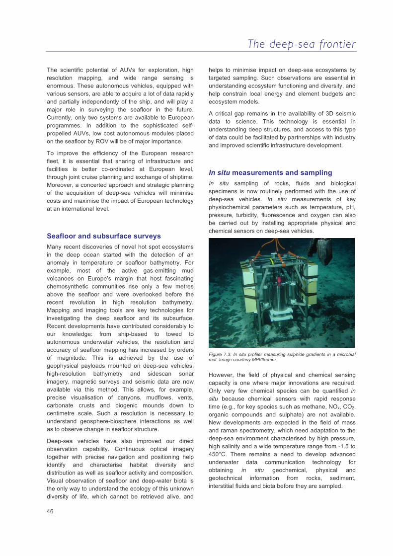
The deep-sea frontier
46
The scientific potential of AUVs for exploration, high resolution mapping, and wide range sensing is enormous. These autonomous vehicles, equipped with various sensors, are able to acquire a lot of data rapidly and partially independently of the ship, and will play a major role in surveying the seafloor in the future. Currently, only two systems are available to European programmes. In addition to the sophisticated self-propelled AUVs, low cost autonomous modules placed on the seafloor by ROV will be of major importance.
To improve the efficiency of the European research fleet, it is essential that sharing of infrastructure and facilities is better co-ordinated at European level, through joint cruise planning and exchange of shiptime. Moreover, a concerted approach and strategic planning of the acquisition of deep-sea vehicles will minimise costs and maximise the impact of European technology at an international level.
Seafloor and subsurface surveys Many recent discoveries of novel hot spot ecosystems in the deep ocean started with the detection of an anomaly in temperature or seafloor bathymetry. For example, most of the active gas-emitting mud volcanoes on Europe’s margin that host fascinating chemosynthetic communities rise only a few metres above the seafloor and were overlooked before the recent revolution in high resolution bathymetry. Mapping and imaging tools are key technologies for investigating the deep seafloor and its subsurface. Recent developments have contributed considerably to our knowledge: from ship-based to towed to autonomous underwater vehicles, the resolution and accuracy of seafloor mapping has increased by orders of magnitude. This is achieved by the use of geophysical payloads mounted on deep-sea vehicles: high-resolution bathymetry and sidescan sonar imagery, magnetic surveys and seismic data are now available via this method. This allows, for example, precise visualisation of canyons, mudflows, vents, carbonate crusts and biogenic mounds down to centimetre scale. Such a resolution is necessary to understand geosphere-biosphere interactions as well as to observe change in seafloor structure.
Deep-sea vehicles have also improved our direct observation capability. Continuous optical imagery together with precise navigation and positioning help identify and characterise habitat diversity and distribution as well as seafloor activity and composition. Visual observation of seafloor and deep-water biota is the only way to understand the ecology of this unknown diversity of life, which cannot be retrieved alive, and
helps to minimise impact on deep-sea ecosystems by targeted sampling. Such observations are essential in understanding ecosystem functioning and diversity, and help constrain local energy and element budgets and ecosystem models.
A critical gap remains in the availability of 3D seismic data to science. This technology is essential in understanding deep structures, and access to this type of data could be facilitated by partnerships with industry and improved scientific infrastructure development.
In situ measurements and sampling In situ sampling of rocks, fluids and biological specimens is now routinely performed with the use of deep-sea vehicles. In situ measurements of key physiochemical parameters such as temperature, pH, pressure, turbidity, fluorescence and oxygen can also be carried out by installing appropriate physical and chemical sensors on deep-sea vehicles.
Figure 7.3: In situ profiler measuring sulphide gradients in a microbial mat. Image courtesy MPI/Ifremer.
However, the field of physical and chemical sensing capacity is one where major innovations are required. Only very few chemical species can be quantified in situ because chemical sensors with rapid response time (e.g., for key species such as methane, NOx, CO2, organic compounds and sulphate) are not available. New developments are expected in the field of mass and raman spectrometry, which need adaptation to the deep-sea environment characterised by high pressure, high salinity and a wide temperature range from -1.5 to 450°C. There remains a need to develop advanced underwater data communication technology for obtaining in situ geochemical, physical and geotechnical information from rocks, sediment, interstitial fluids and biota before they are sampled.
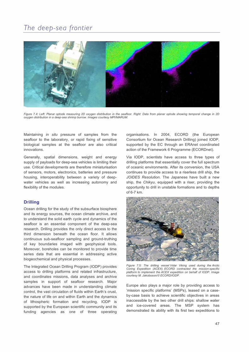
The deep-sea frontier
47
Figure 7.4: Left: Planar optode measuring 2D oxygen distribution in the seafloor. Right: Data from planar optode showing temporal change in 2D oxygen distribution in a deep-sea shrimp burrow. Images courtesy MPI/MARUM.
Maintaining in situ pressure of samples from the seafloor to the laboratory, or rapid fixing of sensitive biological samples at the seafloor are also critical innovations.
Generally, spatial dimensions, weight and energy supply of payloads for deep-sea vehicles is limiting their use. Critical developments are therefore miniaturisation of sensors, motors, electronics, batteries and pressure housing, interoperability between a variety of deep-water vehicles as well as increasing autonomy and flexibility of the modules.
Drilling Ocean drilling for the study of the subsurface biosphere and its energy sources, the ocean climate archive, and to understand the solid earth cycle and dynamics of the seafloor is an essential component of the deep-sea research. Drilling provides the only direct access to the third dimension beneath the ocean floor. It allows continuous sub-seafloor sampling and ground-truthing of key boundaries imaged with geophysical tools. Moreover, boreholes can be monitored to provide time series data that are essential in addressing active biogeochemical and physical processes.
The Integrated Ocean Drilling Program (IODP) provides access to drilling platforms and related infrastructure, and coordinates missions, data analyses and archive samples in support of seafloor research. Major advances have been made in understanding climate control, the vast circulation of fluids within Earth’s crust, the nature of life on and within Earth and the dynamics of lithospheric formation and recycling. IODP is supported by the European scientific community and its funding agencies as one of three operating
organisations. In 2004, ECORD (the European Consortium for Ocean Research Drilling) joined IODP, supported by the EC through an ERAnet coordinated action of the Framework 6 Programme (ECORDnet).
Via IODP, scientists have access to three types of drilling platforms that essentially cover the full spectrum of oceanic environments. After its conversion, the USA continues to provide access to a riserless drill ship, the JOIDES Resolution. The Japanese have built a new ship, the Chikyu, equipped with a riser, providing the opportunity to drill in unstable formations and to depths of 6-7 km.
Figure 7.5: The drilling vessel Vidar Viking used during the Arctic Coring Expedition (ACEX). ECORD contracted the mission-specific platform to implement the ACEX expedition on behalf of IODP. Image courtesy M. Jakobsson/© ECORD/IODP.
Europe also plays a major role by providing access to ‘mission specific platforms’ (MSPs), leased on a case-by-case basis to achieve scientific objectives in areas inaccessible by the two other drill ships: shallow water and ice-covered areas. The MSP system has demonstrated its ability with its first two expeditions to
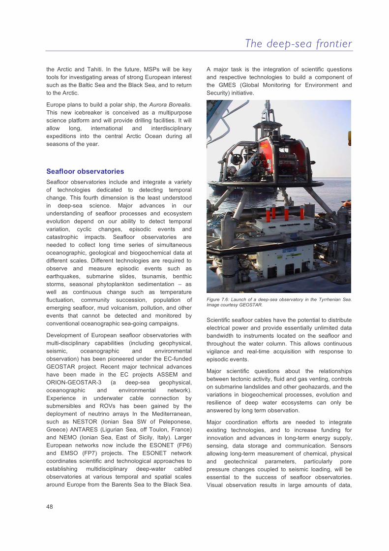
The deep-sea frontier
48
the Arctic and Tahiti. In the future, MSPs will be key tools for investigating areas of strong European interest such as the Baltic Sea and the Black Sea, and to return to the Arctic.
Europe plans to build a polar ship, the Aurora Borealis. This new icebreaker is conceived as a multipurpose science platform and will provide drilling facilities. It will allow long, international and interdisciplinary expeditions into the central Arctic Ocean during all seasons of the year.
Seafloor observatories Seafloor observatories include and integrate a variety of technologies dedicated to detecting temporal change. This fourth dimension is the least understood in deep-sea science. Major advances in our understanding of seafloor processes and ecosystem evolution depend on our ability to detect temporal variation, cyclic changes, episodic events and catastrophic impacts. Seafloor observatories are needed to collect long time series of simultaneous oceanographic, geological and biogeochemical data at different scales. Different technologies are required to observe and measure episodic events such as earthquakes, submarine slides, tsunamis, benthic storms, seasonal phytoplankton sedimentation – as well as continuous change such as temperature fluctuation, community succession, population of emerging seafloor, mud volcanism, pollution, and other events that cannot be detected and monitored by conventional oceanographic sea-going campaigns.
Development of European seafloor observatories with multi-disciplinary capabilities (including geophysical, seismic, oceanographic and environmental observation) has been pioneered under the EC-funded GEOSTAR project. Recent major technical advances have been made in the EC projects ASSEM and ORION-GEOSTAR-3 (a deep-sea geophysical, oceanographic and environmental network). Experience in underwater cable connection by submersibles and ROVs has been gained by the deployment of neutrino arrays In the Mediterranean, such as NESTOR (Ionian Sea SW of Peleponese, Greece) ANTARES (Ligurian Sea, off Toulon, France) and NEMO (Ionian Sea, East of Sicily, Italy). Larger European networks now include the ESONET (FP6) and EMSO (FP7) projects. The ESONET network coordinates scientific and technological approaches to establishing multidisciplinary deep-water cabled observatories at various temporal and spatial scales around Europe from the Barents Sea to the Black Sea.
A major task is the integration of scientific questions and respective technologies to build a component of the GMES (Global Monitoring for Environment and Security) initiative.
Figure 7.6: Launch of a deep-sea observatory in the Tyrrhenian Sea. Image courtesy GEOSTAR.
Scientific seafloor cables have the potential to distribute electrical power and provide essentially unlimited data bandwidth to instruments located on the seafloor and throughout the water column. This allows continuous vigilance and real-time acquisition with response to episodic events.
Major scientific questions about the relationships between tectonic activity, fluid and gas venting, controls on submarine landslides and other geohazards, and the variations in biogeochemical processes, evolution and resilience of deep water ecosystems can only be answered by long term observation.
Major coordination efforts are needed to integrate existing technologies, and to increase funding for innovation and advances in long-term energy supply, sensing, data storage and communication. Sensors allowing long-term measurement of chemical, physical and geotechnical parameters, particularly pore pressure changes coupled to seismic loading, will be essential to the success of seafloor observatories. Visual observation results in large amounts of data,

The deep-sea frontier
49
which need to be transferred and monitored in an efficient manner. Intelligent systems are needed that can react to events and carry out sampling and observation autonomously from the central nodes of benthic or pelagic observatories.
Laboratory facilities and data centres Rock, core, and biological sample repositories equipped with innovative analytical devices are of great importance to the community, and their maintenance and further improvement needs concerted European strategies. The IODP Bremen core repository, hosted by MARUM at the University of Bremen, is one of the best examples: support by IODP/ECORD, it provides archiving facilities and is open to sample requests from the international scientific community. Developing a network of rock, core and biological sample repositories equipped with innovative analytical devices, and the maintenance and upkeep requires concerted European strategies.
Equally important are oceanographic data centres ranging from visual to physical, chemical and biological data. Existing databases such as the world data center for marine environmental sciences (WDC-MARE), the EurOceans data portal and the Ocean Biogeographic Information System (OBIS) are examples of international and integrative data centres.
A major gap in deep-water sciences is the lack of European infrastructure for advanced analytical technologies. For many European scientists, access to land-based technology platforms such as for element-, mass spectrum- and isotope-analysis, biomarker, tracer and pollutant detection, high thoughput gene sequencing, taxonomic identification, or data modeling is difficult.
There is a clear need to improve infrastructure for sample and data storage, analysis and modeling capacities to facilitate the processing of data and the transfer of knowledge on a European scale.
Key recommendations
Better integration in the use, maintenance and innovation of research platforms and deep sea vehicles (research vessels, ROVs, AUVs and associated equipment) at the European level;
Concerted approach to the development of critical equipment for improved imaging, sampling and measuring technologies for deep sea sciences;
Maintained access to and strategic planning of scientific drilling through European membership of IODP (ECORD);
Development of in situ long-term monitoring capabilities, including long-term cabled and autonomous seafloor observatories and moorings capable of multi-parameter measurements;
Improvement of analytical and modelling facilities through the development of a network of laboratories in Europe and implementation of European technology platforms;
Development of data banking and computer-based handling facilities able to deal with transfer, maintenance and storage of large datasets;
Improvement of the partnership with industry;
Support initiatives for training, education and capacity building to ensure long-term expertise in deep-sea research across Europe and beyond.

The deep-sea frontier
50
8. Recommended further reading
Billett, D.S.M., Bett, B.J., Rice, A.L., Thurston, M.H., Galéron, J., Sibuet, M. and Wolff, G.A. (2001) Long-term change in the megabenthos of the Porcupine Abyssal Plain (NE Atlantic). Progress in Oceanography 50, 325-348.
Billett, D.S.M., Lampitt, R.S., Rice, A.L. and Mantoura, R.F.C. (1983) Seasonal sedimentation of phytoplankton to the deep-sea benthos. Nature 302, 520-522.
Bjørkum, P.A. and Nadeau, P.H. (1998) Temperature controlled porosity/permeability reduction, fluid migration and petroleum exploration in sedimentary basins. APPEA Journal 38, 453-464.
Boetius, A., Ravenschlag, K., Schubert, C., Rickert, D., Widdel, F., Gieseke, A., Amann, R., Jørgensen, B.B., Witte, U., and Pfannkuche, O. (2000) A marine microbial consortium apparently mediating anaerobic oxidation of methane. Nature 407, 623-626.
Buffett B. and Archer D. (2004) Global inventory of methane clathrate: Sensitivity to changes in the deep ocean. Earth and Planetary Science Letters 227, 185-199.
Caldeira, K. and Wickett, M.E. (2003) Anthropogenic carbon and ocean pH. Nature 425, 365.
Canals, M., Puig, P., Durrieu de Madron, X., Heussner, S., Palanques, A. and Fabres, J. (2006) Flushing submarine canyons. Nature 444, 354-357. doi:10.1038/nature05271
Canals, M., Lastras, G., Urgeles, R., Casamor, J.L., Mienert, J., Cattaneo, A., De Batist, M., Haflidason, H., Imbo, Y., Laberg, J.S., Locat, J., Long, D., Longva, O., Masson, D.G., Sultan, N., Trincardi, F. and Bryn, P. (2004) Slope failure dynamics and impacts from seafloor and shallow sub-seafloor geophysical data: An overview. Marine Geology 213, 9-72.
Christiansen, B., Beckmann, W. and Weikert, H. (2001) The structure and carbon demand of the bathyal benthic boundary layer community: a comparison of two oceanic locations in the NE-Atlantic. Deep-Sea Research II 48, 2409-2424.
Cowen, J.P., Giovannoni, S.J., Kenig, F., Johnson, H.P., Butterfield, D., Rappe, M.S., Hutnak, M., and Lam, P. (2003) Fluids from aging ocean crust that support microbial life. Science 299, 120-123.
D'Hondt, S.L., Rutherford, S., and Spivack, A.J. (2002) Metabolic activity of subsurface life in deep-sea sediments. Science 295, 2067-2070.
Danovaro, R., Dell’Anno, A. and Pusceddu, A. (2004) Biodiversity response to climate change in a warm deep sea. Ecological Letters 7, 821-828.
Dasgupta, P. (2003) Sediment gravity flow - the conceptual problems. Earth Science Reviews 62, 265-281.
Davis, E., Becker, K., Dziak, R.P., Cassidy, J., Wang, K., Lilley, M. (2004) Hydrological response to a seafloor spreading episode on the Juan de Fuca ridge. Nature 430, 335-338.
Douglas-Westwood Limited (2005) Marine industries global market analysis. Marine Foresight Series No. 1. Marine Institute/Foras na Mara, Galway, Ireland. 128 pp.
Ellison, C.R.W., Chapman, M.R. and Hall, I.R. (2006) Surface and deep ocean interactions during the cold climate event 8200 years ago. Science 312, 1929-1932.
European Science Foundation (2006) Navigating the Future – III: Updated synthesis of perspectives on marine science and technology in Europe. European Science Foundation Marine Board Position Paper N°8, pp. 67.
European Science Foundation (2002) Integrating Marine Science in Europe. European Science Foundation Marine Board Position Paper N°5, pp. 150.
Fischer, G. and Wefer, G. (eds) (1999) Use of Proxies in Paleoceanography: Examples from the South Atlantic. Springer, Berlin, Heidelberg, 735 pages.
Freiwald, A., Fosså, J.H., Grehan, A., Koslow, A. and Roberts, J.M. (2004) Cold-water coral reefs: out of sight – no longer out of mind. UNEP-WCMC report, Cambridge, UK, 84pp.
Gaudin, M., Berné, S., Jouanneau, J-M., Palanques, A., Puig, P., Mulder, T., Cirac, P., Rabineau, M. and Imbert, P. (2006) Massive sand beds attributed to deposition by dense water cascades in the Bourcart canyon head, Gulf of Lions (northwestern Mediterranean Sea). Marine Geology 234, 111-128.
Gianni, M. (2004) High seas bottom trawl fisheries and their impacts on the biodiversity of vulnerable deep-sea ecosystems. IUCN, Gland, Switzerland: 90 pp.
Gjerde, K. (2006) Critical Ocean Issues: Ecosystems and biodiversity in deep waters and high seas. UNEP/IUCN Regional Seas Report and Studies 178: 58pp.
The deep-sea frontier
51
Harbitz, C.B., Løvholt F., Pedersen, G., Glimsdal, S. and Masson, D.G. (2006) Mechanisms of tsunami generation by submarine landslides - a short review. Norwegian Journal of Geology 86, 255-264.
Henderson, G.M. (2002) New oceanic proxies for paleoclimate, Earth and Planetary Science Letters 203, 1-13.
Heussner, S., Durrieu de Madron, X., Calafat, A., Canals, M., Carbonne, J., Delsaut, N. and Saragoni, G. (2006) Spatial and temporal variability of downward particle fluxes on a continental slope: Lessons from an 8-year experiment in the Gulf of Lions (NW Mediterranean). Marine Geology 234, 63-92.
Horner-Devine, M.C., Lage, M., Hughes, J.B. and Bohannan, B.J.B. (2004) A taxa–area relationship for bacteria. Nature 432: 750-753.
Ivanov, V.V., Shapiro, G.I., Huthnance, J.M., Aleynik, D.L. and Golovin, P.N. (2004) Cascades of dense water around the world ocean. Progress in Oceanography 60, 47-98.
Jørgensen, B.B. and Kasten, S. (2006) Sulfur cycling and methane oxidation. In H. D. Schulz and M. Zabel (eds.) Marine Geochemistry, 2nd edition. Springer, Berlin, pp. 271-309.
Judd, A.G. and Hovland, M. (2007) Seabed Fluid Flow: The Impact on Geology, Biology and the Marine Environment. Cambridge University Press, pp. 492; doi: 10.2277/0521819504
Kemp, M. (2005) Science in culture: inventing an icon. Hans Joachim Schellnhuber’s map of global “tipping points” in climate change. Nature 437, 1238.
Kenneth, J.P., Cannariato, K.G. Hendy, I.L., and R.J. Behl (2000) Carbon isotopic evidence for methane hydrate instability during Quaternary interstadials. Science 288, 128-133.
Locat, J. (2001) Instabilities along ocean margin: a geomorphological and geotechnical perspective. Marine and Petroleum Geology 18, 503-512.
Lopez-Jurado, J-L., Gonzalez-Pola, C. and Velez-Belchi, P. (2005) Observation of an abrupt disruption of the long-term warming trend at the Balearic Sea, western Mediterranean Sea, in summer 2005. Geophysical Research Letters 32, L24606; doi: 10.1029/2005GL024430.
Lynch-Stieglitz, J., Adkins, J.F., Curry, W.B., Dokken, T., Hall, I.R., Herguera, J-C., Hirschi, J.-M., Ivanova, E.V., Kissel, C., Marchal, O., Marchitto, T. M., McCave, I.N. McManus, J.F., Mulitza, S., Ninnemann, U., Peeters, F., Yu, E.-F. and Zahn, R. (2007) Atlantic
Meridional Overturning Circulation During the Last Glacial Maximum. Science 316, 66-69.
Masson, D.G., Harbitz, C.B., Wynn, R.B., Pedersen, G. and Løvholt, F. (2006) Submarine landslides - processes, triggers and hazard prediction. Proceedings of the Royal Society, London, Series A 364, 2009-2039.
Michaelis, W., Seifert, R., Nauhaus, K., Treude, T., Thiel, V., Blumenberg, M., Knittel, K., Gieseke, A., Peterknecht, K., Pape, T., Boetius, A., Amann, R., Jorgensen, B.B., Widdel, F., Peckmann, J., Pimenov, N.V. and Gulin, M.B. (2002) Microbial reefs in the Black Sea fueled by anaerobic oxidation of methane. Science 297, 1013-1015.
Mienert, J., Vanneste, M., Bünz, S., Andreassen, K., Haflidason, H., and Sejrup, H.P. (2005) Ocean warming and gas hydrate stability on the mid-Norwegian margin at the Storegga Slide. Marine and Petroleum Geology 22, 233-244.
Milkov, A.V. (2004) Global estimate of hydrate-bound gas in marine sediments: how much is really out there? Earth Science Reviews, 66, 183-197.
Niemann, H., Lösekann, T., de Beer, D., Elvert, M., Nadalig, T., Knittel, K., Amann, R., Sauter, E.J., Schlüter, M., Klages, M., Foucher, J-P., Boetius, A. (2006) Novel microbial communities of the Haakon Mosby mud volcano and their role as methane sink. Nature 443, 854-858.
Ottesen, D., Dowdeswell, J.A. and Rise, L. (2005) Submarine landforms and the reconstruction of fast-flowing ice streams within a large Quaternary ice sheet: The 2500-km-long Norwegian-Svalbard margin (57°–80°N); Geological Society of America Bulletin 117, 1033-1050.
Palanques, A., Durrieu de Madron, X., Puig, P., Fabres, J., Guillén, J., Calafat, A., Canals, M., Heussner, S. and Bonnin, J. (2006) Suspended sediment fluxes and transport processes in the Gulf of Lions submarine canyons: the role of storms and dense water cascading. Marine Geology 234, 43-61.
Parkes, R.J., Webster, G., Cragg, B.A., Weightman, A.J., Newberry, C.J., Ferdelman, T.G., Kallmeyer, J., Jorgensen, B.B., Aiello, I.W. and Fry, J.C. (2005) Deep sub-seafloor prokaryotes stimulated at interfaces over geological time. Nature 436, 390-394.
Roberts, J.M., Wheeler, A.J. and Freiwald, A. (2006) Reefs of the deep: The biology and geology of cold-water coral ecosystems. Science 312, 543-547.

The deep-sea frontier
52
Ruhl, H.A. and Smith, K.L. (2004) Shifts in deep-sea community structure linked to climate and food supply. Science 305, 513-515.
Sibuet, M. and Olu-Le Roy, K. (2003) Cold seep communities on continental margins: structure and quantitative distribution relative to geological and fluid venting patterns. In: Wefer, G., Billett, D.S.M., Hebbeln, D., Jørgensen, B.B., Schlüter, M. and van Weering, T.C.E. (eds) ‘Ocean Margin Systems’. Springer-Verlag, Berlin, p235-251.
Smith, C.R. and Baco, A.R. (2003) Ecology of whale falls at the deep-sea floor. Oceanography and Marine Biology: an Annual Review 41, 311-354.
Solheim, A., Bryn, P., Sejrup, H.P., Mienert, J., Berg,K. (2005) Ormen Lange - an integrated study for the safe development of a deep-water gas field within the Storegga Slide Complex, NE Atlantic continental margin; executive summary. Marine and Petroleum Geology 22, 1-9.
Sultan, N., Cochonat, P., Canals, M., Cattaneo, A., Dennielou, B., Haflidason, H., Laberg, J.S., Long, D., Mienert, J., Trincardi, F.,Urgeles, R., Vorren, T., Wilson, C. (2004) Triggering mechanisms of slope instability processes and sediment failures on continental margins: a geotechnical approach. Marine Geology 213, 291-321.
Tsunogai, S., Watanabe, S. and Sato, T. (1999) Is there a ‘continental shelf pump’ for the absorption of atmospheric CO2? Tellus B 51, 701-712; doi: 10.1034/j.1600-0889.1999.t01-2-00010.x.
Tyler, P.A. (2003) Disposal in the deep sea: analogue of nature or faux ami? Environmental Conservation 30 (1), 26-39.
United Nations Environment Programme (2006) Ecosystems and Biodiversity in Deep Waters and High Seas. UNEP Regional Seas Reports and Studies No. 178. UNEP/ IUCN, Switzerland 2006.
Weaver, P.P.E., Billett, D.S.M., Boetius, A., Danovaro, R., Freiwald, A. and Sibuet, M. (2004) Hotspot ecosystem research on Europe´s deep-ocean margins. Oceanography 17, 132-143.
Witte, U., Wenzhofer, F., Sommer, S., Boetius, A., Heinz, P., Aberle N., Cremer, A., Abraham, W-R., Jørgensen, B.B., Pfannkuche, O. (2003) In situ experimental evidence of the fate of a phytodetritus pulse at the abyssal sea floor. Nature 424, 763-766.
Xu, J.P., Noble, M.A. and Rosenfeld, L.K. (2004) In situ measurements of velocity structure within turbidity currents. Geophysical Research Letters 31, L09311; doi:10.1029/2004GL019718.
Websites:
ECORD www.ecord.org
HERMES www.eu-hermes.net
ESONET www.ifremer.fr/esonet
IMAGES www.images-pages.org
ESF Euromargins www.ig.uit.no/euromargins

European Commission EUR 22812— The Deep-Sea Frontier: Science Challenges for a Sustainable Future Luxembourg: Office for Official Publications of the European Communities 2007 — 53 pp. — 21.0 x 29.7 cm ISBN 92-79-05266-8


SALES AND SUBSCRIPTIONS
Publications for sale produced by the Office of Official Publications of the European Communities are available from our sales agents throughout the world. You can find the list of sales agents on the Publications Office website (http://publications.europa.eu) or you can apply for it by fax (352) 29 29-42758. Contact the sales agent of your choice and place your order.
KI-N
A-22812-E
N-S
The deep-sea is a complex bio-geosphere system in the world's ocean environment. This system supports the largest biosphere on earth, modulates the global climate and contains vast natural resources for use both today and in the future. However, it is not well understood. The emerging Marine Strategy for Europe requires more co-ordinated research to underpin the objectives of sustainable exploitation in the oceans, and this initiative aims to identify the key questions that need to be addressed. The complex nature of the deep-sea environment requires a multidisciplinary approach that takes account of the complex and interlinked physical, geological, chemical, biological and microbial processes operating throughout the global deep sea, and this must be underpinned by technology development. The emerging marine science research plan will enable the necessary support to be put in place to carry out this ambitious programme.
This publication describes the research challenges of working in the deep ocean and outlines the strategies required to carry out multi-disciplinary research in this domain.