Embed Size (px)
Citation preview

3800
3000
2400
2600
2800
3000
3200
3600
3200
2200
2000
3000
2800
2600
2400
22002000
1800
1600
3800
3000
2000
2000
Tin
k e r Brook
Madden Brook
Kent
Bro
ok
Sargent B
rook
Eddy Brook
Falls B r ook
Black River
Roaring Broo k
Great
Rese
rvoi
r Bro
ok
Ottauquechee River
WoodardReservoir
Black Pond
Ottauquechee
River
Pico Pond
Great R oaring Broo k
Brewers Brook
Kent Pond
Robinson Hill2747’
Killington Peak4235’
Shrewsbury Peak3710’ Smith Peak
3205’
Burnt Mtn2803’
Jockey Hill2640’
Rams Head Mtn3618’
Snowdon Peak3592’
Skye Peak3816’
Bear Mtn3262’
Pico Peak3957’ Little Pico
3110’
Deer Leap Mtn2782’
Shagback Mtn2688’
Russell Hill2545’
Ingalls Hill2654’
Mendon Peak3840’
Little Killington Peak3939’
Round Top Mtn Rd
4
4
4
Wheelerville Rd
Notch Rd
Whe
elerv
ille R
d
Killington Rd
Wes
t Hill
Rd
Rive
r Rd
Thundering
Brook Rd
East Roaring Brook Rd
CCC Road
Tin
Shan
ty R
d
Northam Rd
Upper Cold River RdCold River Rd
Old Plymouth Rd
VERMONT
100
VERMONT
100
to Coolidge State Parkvia Rt 100A 3 mi.
VERMONT
100
VERMONT
100
Deer LeapOverlook
Willard Gap
Old Maine Jct.
Tinker Brook
RussellHill
Shrewsbury Peak
Cooper Lodge
Pico Camp/spring
Churchill Scott
Tucker Johnson
Gov. Clement
Brewers Corners
North Shrewsbury
Gi�ord WoodsState Park
4
3
9
8
7
3
2
1
Stone Hut
3
Long Trail NorthTHE COOLIDGE RANGESUMMER RECREATION TRAILS
Coolidge State ForestGi�ord Woods State ParkCoolidge State ParkPlymsbury Wildlife Management AreaGreen Mountain National ForestAppalachain Trail CorridorRutland City ForestForest Legacy Public Access Easments
North
GMNF/NPS
VT FPR (SF/SP)
VTFW
RCF
FL EASEMENT (FPR)
0 1000 2000 4000 6000
feet
Legend
U.S. Forest Service(Green Mountain National Forest, Appalachian Trail Corridor)
Vt. Dept. of Forests, Parks & Recreation(State Forest/State Park)
Vt. Fish & Wildife Dept.(Wildlife Management Area, Access Area)
Municipal lands(Rutland City Forest, Shrewsbury TownForest, Rutland County Grammar Lot)Forest Legacy Easement lands(see text side for details)
Mountain peak or unique feature
Stream
Federal or state highway
Secondary road
Forest access road
Other hiking trail
Trail shelter or lean-to
Ski chairlift
State forest land under long-term lease to Killington-Pico Ski Resort Partners
Mendon Peak State Natural Area
Appalachian Trail/ Long Trail
Shrewsbury Peak State Natural Area
Tinker Brook State Natural Area
Gate
Kent Pond
Thun
derin
gBr
ook R
d
4
North
18001600
2000
VERMONT
100
Gi�ord Woods State Park Trails
1000 500 0 1000 2000
feet
5
6
CCC Trail
SlackHillTrail
Slack Hill2174’
Coolidge State Park Trails North
1000 500 0 1000 2000
feet
John
son
Farm
Rd
Cool
idge
SP
Rd
Fiver CornersRd
VERMONT
100A
2000
1800
1600
1400
1200
10
11
Land Management Key
ephelps - revised 11/2010
THE COOLIDGE RANGESUMMER RECREATION TRAILS GUIDE
Coolidge State ForestCoolidge State Park
Gifford Woods State ParkPlymsbury Wildlife Management Area
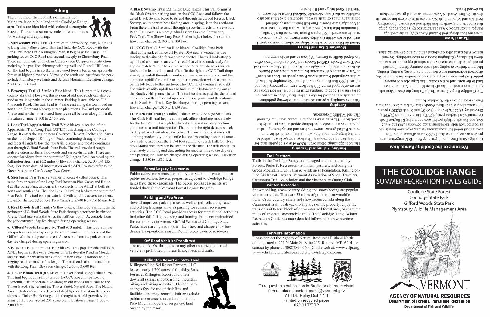
HikingThere are more than 30 miles of maintained hiking trails on public land in the Coolidge Range area. Trails are identified with colored rectangular blazes. There are also many miles of woods roads for walking and exploring.1. Shrewsbury Peak Trail (1.8 miles to Shrewsbury Peak, 4.0 milesto Long Trail) Blue blazes. This trail links the CCC Road with theLong Trail near Little Killington Peak. It begins at the Russell Hillparking lot on CCC Road and ascends steeply to Shrewsbury Peak.There are remnants of Civilian Conservation Corps-era constructionincluding the pavilion chimney, wishing well and Russell Hill lean-to. The trail begins in northern hardwood forests but enters spruce-firforests at higher elevations. Views to the south and east from the peakinclude Plymsbury wetlands and Saltash Mountain. Elevation change:2,340 to 3,500 feet.
2. Bessenyey Trail (1.5 miles) Blue blazes. This is primarily a cross-country ski trail. However, this system of old skid roads can also beused as walking paths in the summer. Parking is available on OldPlymouth Road. The trail head is ¼ mile east along the town road onnorth side. Remnant Norway spruce plantations, lowland spruce-firforests and northern hardwood forests can all be seen along this trail.Elevation change: 2,100 to 2,400 feet.
3. Long Trail/Appalachian Trail White blazes. A section of theAppalachian Trail/Long Trail (AT/LT) runs through the CoolidgeRange. It enters the region near Governor Clement Shelter and leaveson the north slope of Killington Peak, continuing through privateand federal lands before the two trails diverge and the AT continueseast through Gifford Woods State Park. The trail travels throughhigh elevation northern hardwoods and spruce-fir forests. There arespectacular views from the summit of Killington Peak accessed by theKillington Spur Trail (0.2 miles). (Elevation change: 3,300 to 4,235feet). For more detailed information on the AT/LT system refer to theGreen Mountain Club’s Long Trail Guide.
4. Sherburne Pass Trail (2.9 miles to Route 4) Blue blazes. Thisis the former route of the Long Trail between Pico Camp and Route4 at Sherburne Pass, and currently connects to the AT/LT at both itsnorth and south ends. The Pico Link (0.4 miles) leads to the summit ofPico Peak. This trail is on private land with a public access easement.Elevation change: 3,600 feet (Pico Camp) to 2,700 feet (Old Maine Jct).
5. Kent Brook Trail (1 mile) Yellow blazes. This loop trail follows theperimeter of Gifford Woods State Park through a northern hardwoodforest. Trail intersects the AT at the halfway point. Accessible fromthe park entrance; day fee charged during operating season.
6. Gifford Woods Interpretive Trail (0.3 mile). This loop trail hasinterpretive exhibits exploring the natural and cultural history of theGifford Woods old-growth forest. Accessible from the park entrance;day fee charged during operating season.
7. Bucklin Trail (3.4 miles). Blue blazes. This popular side trail to theAT/LT begins at Brewer’s Corners on Wheelerville Road in Mendonand ascends the western flank of Killington Peak. It follows an oldlogging road for much of its length. The trail ends at an intersectionwith the Long Trail. Elevation change: 1,800 to 3,600 feet.
8. Tinker Brook Trail (0.4 Miles to Tinker Brook gorge) Blue blazes.This trail begins at a sharp turn on the CCC Road in the Town ofPlymouth. This moderate hike along an old woods road leads to theTinker Brook Shelter and the Tinker Brook Natural Area. The NaturalArea includes 65 acres of Hemlock-Red Spruce Forest on the rockyslopes of Tinker Brook Gorge. It is thought to be old growth withmany of the trees around 200 years old. Elevation change: 1,800 to2,000 feet.
Trail PartnersTrails in the Coolidge Range are managed and maintained by Forests, Parks & Recreation with many partners, including the Green Mountain Club, Farm & Wilderness Foundation, Killington-Pico Ski Resort Partners, Vermont Association of Snow Travelers, Catamount Trail Association and the Shrewsbury Outing Club.
Winter RecreationSnowmobiling, cross-country skiing and snowshoeing are popular winter activities. There are 33 miles of groomed snowmobile trails. Cross-country skiers and snowshoers can ski along the Catamount Trail, bushwack to any area of the property, enjoy the trails on a 600-acre block of non-motorized forest area, or share the miles of groomed snowmobile trails. The Coolidge Range Winter Recreation Guide has more detailed information on wintertime activities.
For More InformationPlease contact the Agency of Natural Resources Rutland North office located at 271 N Main St, Suite 215, Rutland, VT 05701, or contact by phone at (802)786-0060. On the web at: www.vtfpr.org, www.vtfishandwildlife.com and www.vtstateparks.com.
To request this publication in Braille or alternate visual format, please contact [email protected]
VT TDD Relay Dial 7-1-1Printed on recycled paper
02/10 LT/ERP Department of Fish and Wildlife
Welcome to the Coolidge Range Area
Coolidge State Forest and Plymsbury Wildlife Management Area provide access to more than 18,600 acres of state lands. The area is most noted for mountainous terrain, expansive forests and associated wetlands. Elevations range between 1,900 and 4,235 feet, and include a “high peaks” area containing Killington Peak (Vermont’s 2nd highest peak, 4,235’), Little Killington (3,939’), Shrewsbury (3,720’), Mendon (3,840’) and Smith (3,220’) peaks. This area, along with Gifford Woods State Park and Coolidge State Park is referred to as the ‘Coolidge Range.’
The Coolidge Range forms a “bridge” along the Green Mountain spine that connects blocks of Green Mountain National Forest land to the north and to the south. This large block of remote public land provides nearly endless opportunities for low intensity, dispersed recreational activities including hiking, hunting, fishing, birding, primitive camping and cross-country skiing. Focused parcels provide more intensive recreational opportunities such as down-hill skiing (Killington Resort) or snowmobiling. Several nearby state parks offer developed camping and day use facilities.
Natural Areas There are four designated Natural Areas (NA) in the Coolidge Range. Tinker Brook NA is characterized by a steep, rocky gorge that supports old growth yellow birch and red spruce. Shrewsbury Peak NA and Mendon Peak NA consist of high elevation spruce-fir forests. Gifford Woods NA encompasses an old-growth northern hardwood forest.
Hunting, Fishing and TrappingThe Coolidge Range offers over 18,600 of acres of public land for hunting, fishing and trapping. This large acreage is well suited to hunting large game including white-tailed deer, black bear, and moose. Ruffed grouse, snowshoe hare and turkey hunting is also popular. Several brooks offer fishing opportunities, primarily for brook trout. These activities require a license from the Vermont Fish and Wildlife Deparment.
CampingPrimitive camping is permitted within the following guidelines: no permits are required for stays of less than 4 days or for groups of less than 11 people; camping must be at least 100 feet from any stream or body of water, 200 feet from a trail or property line; and at least 1,000 feet from any traveled road. No camping is allowed within designated Natural Areas. Please practice “leave no trace” or “carry in carry out” camping techniques. There are 3 lean-to shelters available for overnight use (Russell Hill, Shrewsbury Peak and Tinker Brook). Gifford Woods and Coolidge State Parks offer developed facilities for tent, RV, lean-to and cabin camping.
Mountain Bikes and HorsesMountain bikes and horseback riding are allowed only on gravel surfaced roads within Coolidge State Forest and gravel or paved roads in state parks. Killington Resort has more than 30 miles of mountain bike trails (fees charged) within the ski lease area of Coolidge State Forest; Pine Hill Park in nearby Rutland offers many miles of trails as well. Mountain bike trails are also available on the Green Mountain National Forest to the north in Pittsfield, Stockbridge and Rochester.
Forest Legacy EasementsPublic access easements are held by the State on private land for public recreation. Several properties adjacent to Coolidge Range lands have these easements. The public access easements are funded through the Vermont Forest Legacy Program.
Parking and Fee AreasSeveral improved parking areas as well as pull-offs along roads and old log landings serve as parking for summer recreation activities. The CCC Road provides access for recreational activities including fall foliage viewing and hunting, but is not maintained for automobiles in winter. Gifford Woods and Coolidge State Parks have parking and modern facilities, and charge entry fees during the operations season. Do not block gates or roadways.
Off-Road Vehicles ProhibitedThe use of ATVs, dirt bikes, or any other motorized, off-road vehicle is prohibited on these lands, roads and trails.
Killington Resort on State LandKillington/Pico Ski Resort Partners, LLC leases nearly 1,700 acres of Coolidge State Forest at Killington Resort and offers downhill skiing, snowboarding, mountain biking and hiking activities. The company charges fees for use of their lifts and facilities, and may control, limit or exclude public use or access in certain situations. Pico Mountain operates on private land owned by the resort.
FORESTS, PARKS & RECREATIONVERMONT
AGENCY OF NATURAL RESOURCES
9. Black Swamp Trail (2.1 miles) Blue blazes. This trail begins atthe Black Swamp parking area on the CCC Road and follows thegated Black Swamp Road to its end through hardwood forests. BlackSwamp, an important bear feeding area in spring, is to the northeast.From there the trail ascends through spruce-fir forests to ShrewsburyPeak. This route is a more gradual ascent than the ShrewsburyPeak Trail. The Shrewsbury Peak Shelter is just below the summit.Elevation change: 2,400 to 3,500 feet.
10. CCC Trail (1.5 miles) Blue blazes. Coolidge State Park.Start at the park entrance off Route 100A near a wooden bridgeleading to the site of a former picnic shelter. The trail leads steeplyuphill and connects to an old fire road that climbs moderately forapproximately ½ mile to an intersection. Straight ahead a spur trailleads to the lean-to loop and office. To the right the CCC Trail dropssteeply downhill through a hemlock grove, crosses a brook, and thencontinues uphill for ½ mile to another intersection where a spur trailon the left leads to the tent loop. The CCC Trail continues straightand winds steadily uphill for the final ½ mile before coming out atthe Bradley Hill picnic shelter. The trail continues past the shelter andcomes out on the park road opposite a parking area and the entranceto the Slack Hill Trail. Day fee charged during operating season.Elevation change: 1,050 to 1,850 feet.
11. Slack Hill Trail (2.5 miles) Blue blazes. Coolidge State Park.The Slack Hill Trail begins at the park office, climbing moderatelyfor the first ½ mile through hardwoods; then a short steep sectioncontinues to a trail intersection. The trail on the right descends backto the park road just above the office. The main trail continues leftclimbing moderately for one mile before descending a short distanceto a vista located near the 2,174 foot summit of Slack Hill. On cleardays Mount Ascutney can be seen in the distance. The trail continuesalternately climbing and descending for another mile to the day usearea parking lot. Day fee charged during operating season. Elevationchange: 1,550 to 1,850 feet.