Embed Size (px)
Citation preview
1
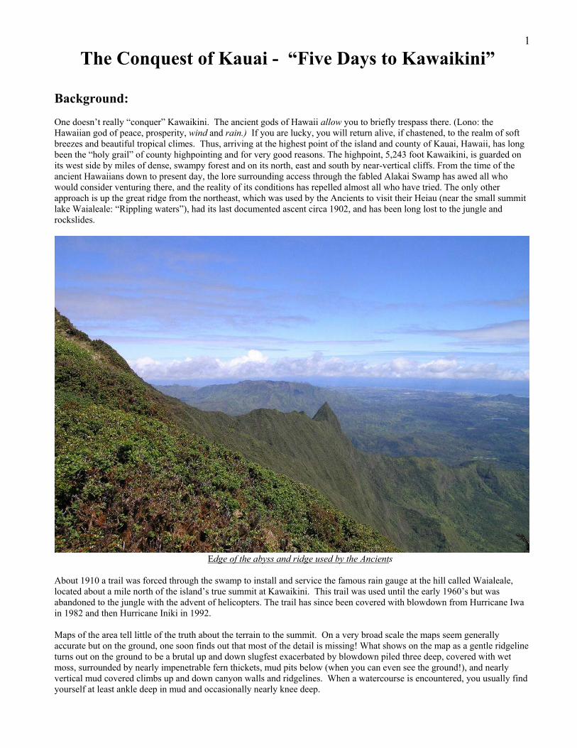
The Conquest of Kauai - “Five Days to Kawaikini” Background: One doesn’t really “conquer” Kawaikini. The ancient gods of Hawaii allow you to briefly trespass there. (Lono: the Hawaiian god of peace, prosperity, wind and rain.) If you are lucky, you will return alive, if chastened, to the realm of soft breezes and beautiful tropical climes. Thus, arriving at the highest point of the island and county of Kauai, Hawaii, has long been the “holy grail” of county highpointing and for very good reasons. The highpoint, 5,243 foot Kawaikini, is guarded on its west side by miles of dense, swampy forest and on its north, east and south by near-vertical cliffs. From the time of the ancient Hawaiians down to present day, the lore surrounding access through the fabled Alakai Swamp has awed all who would consider venturing there, and the reality of its conditions has repelled almost all who have tried. The only other approach is up the great ridge from the northeast, which was used by the Ancients to visit their Heiau (near the small summit lake Waialeale: “Rippling waters”), had its last documented ascent circa 1902, and has been long lost to the jungle and rockslides.
Edge of the abyss and ridge used by the Ancients About 1910 a trail was forced through the swamp to install and service the famous rain gauge at the hill called Waialeale, located about a mile north of the island’s true summit at Kawaikini. This trail was used until the early 1960’s but was abandoned to the jungle with the advent of helicopters. The trail has since been covered with blowdown from Hurricane Iwa in 1982 and then Hurricane Iniki in 1992. Maps of the area tell little of the truth about the terrain to the summit. On a very broad scale the maps seem generally accurate but on the ground, one soon finds out that most of the detail is missing! What shows on the map as a gentle ridgeline turns out on the ground to be a brutal up and down slugfest exacerbated by blowdown piled three deep, covered with wet moss, surrounded by nearly impenetrable fern thickets, mud pits below (when you can even see the ground!), and nearly vertical mud covered climbs up and down canyon walls and ridgelines. When a watercourse is encountered, you usually find yourself at least ankle deep in mud and occasionally nearly knee deep.
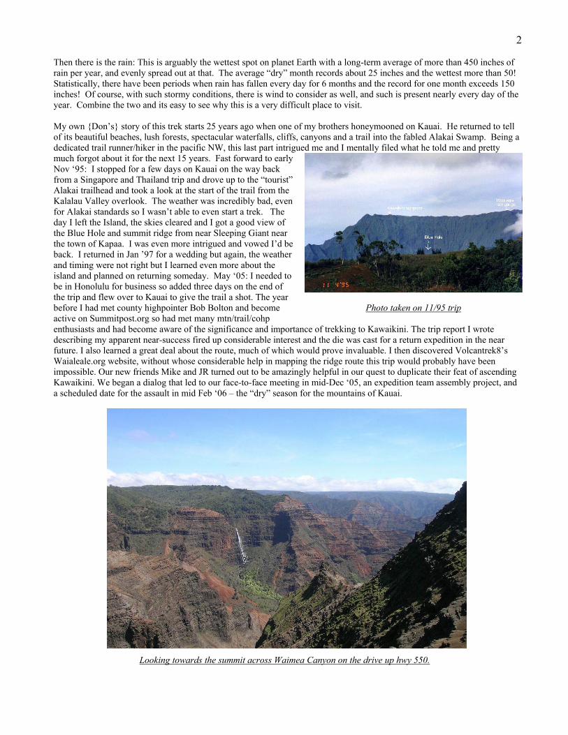
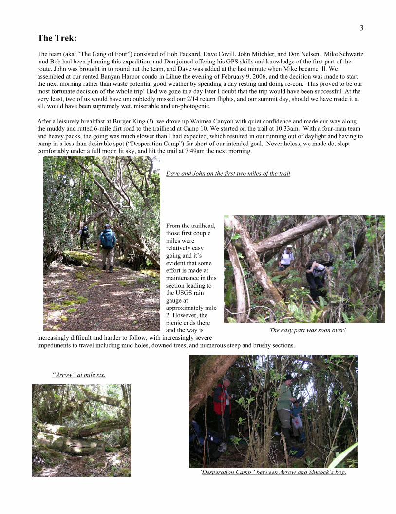
2 Then there is the rain: This is arguably the wettest spot on planet Earth with a long-term average of more than 450 inches of rain per year, and evenly spread out at that. The average “dry” month records about 25 inches and the wettest more than 50! Statistically, there have been periods when rain has fallen every day for 6 months and the record for one month exceeds 150 inches! Of course, with such stormy conditions, there is wind to consider as well, and such is present nearly every day of the year. Combine the two and its easy to see why this is a very difficult place to visit. My own {Don’s} story of this trek starts 25 years ago when one of my brothers honeymooned on Kauai. He returned to tell of its beautiful beaches, lush forests, spectacular waterfalls, cliffs, canyons and a trail into the fabled Alakai Swamp. Being a dedicated trail runner/hiker in the pacific NW, this last part intrigued me and I mentally filed what he told me and pretty much forgot about it for the next 15 years. Fast forward to early Nov ‘95: I stopped for a few days on Kauai on the way back from a Singapore and Thailand trip and drove up to the “tourist” Alakai trailhead and took a look at the start of the trail from the Kalalau Valley overlook. The weather was incredibly bad, even for Alakai standards so I wasn’t able to even start a trek. The day I left the Island, the skies cleared and I got a good view of the Blue Hole and summit ridge from near Sleeping Giant near the town of Kapaa. I was even more intrigued and vowed I’d be back. I returned in Jan ’97 for a wedding but again, the weather and timing were not right but I learned even more about the island and planned on returning someday. May ‘05: I needed to be in Honolulu for business so added three days on the end of the trip and flew over to Kauai to give the trail a shot. The year before I had met county highpointer Bob Bolton and become Photo taken on 11/95 trip active on Summitpost.org so had met many mtn/trail/cohp enthusiasts and had become aware of the significance and importance of trekking to Kawaikini. The trip report I wrote describing my apparent near-success fired up considerable interest and the die was cast for a return expedition in the near future. I also learned a great deal about the route, much of which would prove invaluable. I then discovered Volcantrek8’s Waialeale.org website, without whose considerable help in mapping the ridge route this trip would probably have been impossible. Our new friends Mike and JR turned out to be amazingly helpful in our quest to duplicate their feat of ascending Kawaikini. We began a dialog that led to our face-to-face meeting in mid-Dec ‘05, an expedition team assembly project, and a scheduled date for the assault in mid Feb ‘06 – the “dry” season for the mountains of Kauai. Looking towards the summit across Waimea Canyon on the drive up hwy 550.
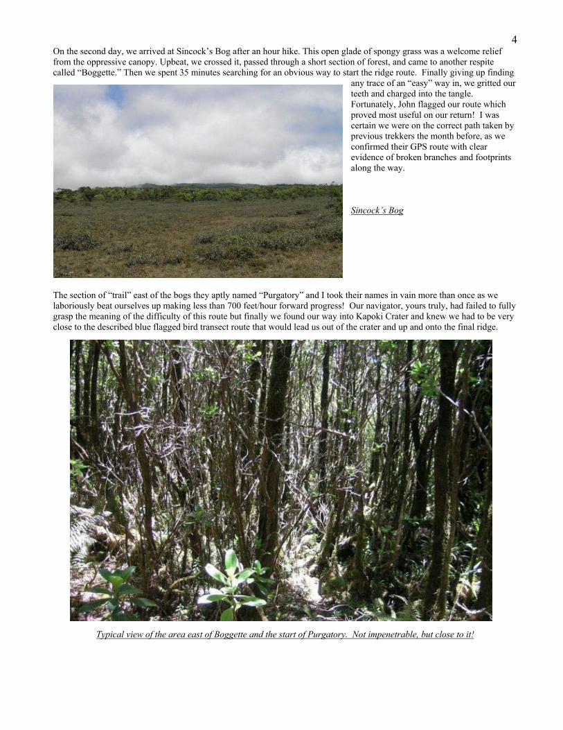
3The Trek: The team (aka: “The Gang of Four”) consisted of Bob Packard, Dave Covill, John Mitchler, and Don Nelsen. Mike Schwartz and Bob had been planning this expedition, and Don joined offering his GPS skills and knowledge of the first part of the route. John was brought in to round out the team, and Dave was added at the last minute when Mike became ill. We assembled at our rented Banyan Harbor condo in Lihue the evening of February 9, 2006, and the decision was made to start the next morning rather than waste potential good weather by spending a day resting and doing re-con. This proved to be our most fortunate decision of the whole trip! Had we gone in a day later I doubt that the trip would have been successful. At the very least, two of us would have undoubtedly missed our 2/14 return flights, and our summit day, should we have made it at all, would have been supremely wet, miserable and un-photogenic. After a leisurely breakfast at Burger King (!), we drove up Waimea Canyon with quiet confidence and made our way along the muddy and rutted 6-mile dirt road to the trailhead at Camp 10. We started on the trail at 10:33am. With a four-man team and heavy packs, the going was much slower than I had expected, which resulted in our running out of daylight and having to camp in a less than desirable spot (“Desperation Camp”) far short of our intended goal. Nevertheless, we made do, slept comfortably under a full moon lit sky, and hit the trail at 7:49am the next morning.
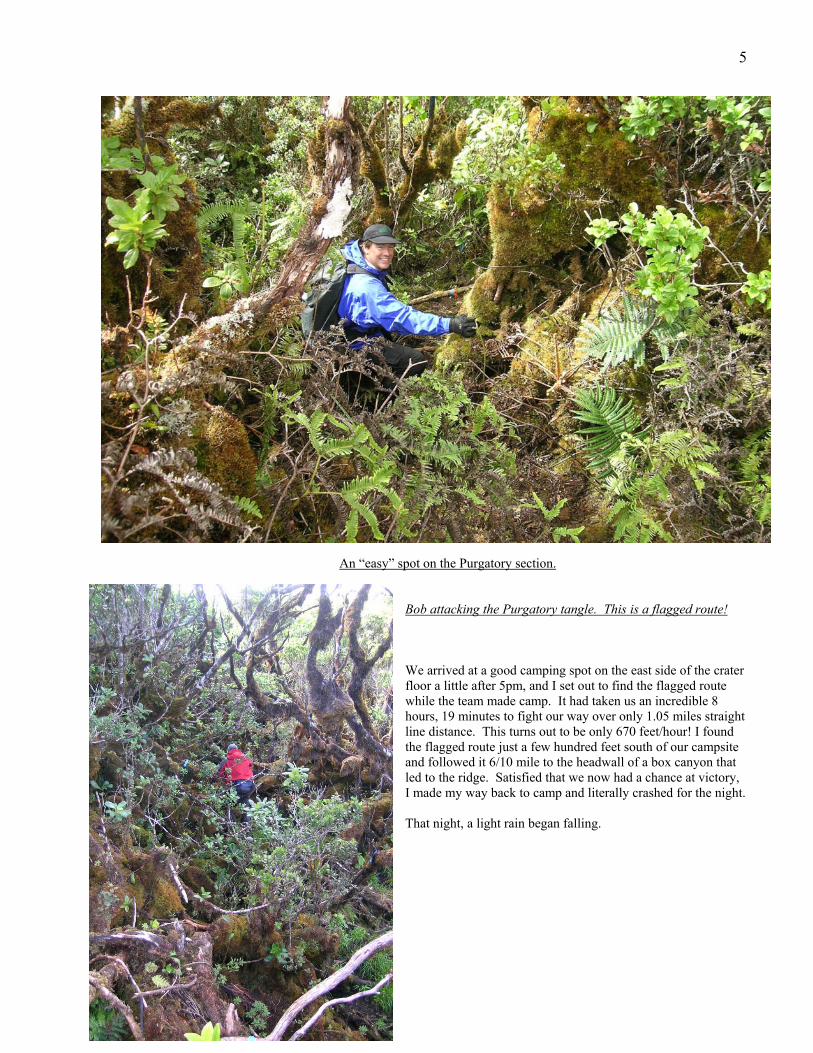
Dave and John on the first two miles of the trail From the trailhead, those first couple miles were relatively easy going and it’s evident that some effort is made at maintenance in this section leading to the USGS rain gauge at approximately mile 2. However, the picnic ends there and the way is The easy part was soon over!
increasingly difficult and harder to follow, with increasingly severe impediments to travel including mud holes, downed trees, and numerous steep and brushy sections. “Arrow” at mile six.
“Desperation Camp” between Arrow and Sincock’s bog.
4On the second day, we arrived at Sincock’s Bog after an hour hike. This open glade of spongy grass was a welcome relief from the oppressive canopy. Upbeat, we crossed it, passed through a short section of forest, and came to another respite called “Boggette.” Then we spent 35 minutes searching for an obvious way to start the ridge route. Finally giving up finding
any trace of an “easy” way in, we gritted our teeth and charged into the tangle. Fortunately, John flagged our route which proved most useful on our return! I was certain we were on the correct path taken by previous trekkers the month before, as we confirmed their GPS route with clear evidence of broken branches and footprints along the way. Sincock’s Bog
The section of “trail” east of the bogs they aptly named “Purgatory” and I took their names in vain more than once as we laboriously beat ourselves up making less than 700 feet/hour forward progress! Our navigator, yours truly, had failed to fully grasp the meaning of the difficulty of this route but finally we found our way into Kapoki Crater and knew we had to be very close to the described blue flagged bird transect route that would lead us out of the crater and up and onto the final ridge.
Typical view of the area east of Boggette and the start of Purgatory. Not impenetrable, but close to it!
5
An “easy” spot on the Purgatory section. Bob attacking the Purgatory tangle. This is a flagged route! We arrived at a good camping spot on the east side of the crater floor a little after 5pm, and I set out to find the flagged route while the team made camp. It had taken us an incredible 8 hours, 19 minutes to fight our way over only 1.05 miles straight line distance. This turns out to be only 670 feet/hour! I found the flagged route just a few hundred feet south of our campsite and followed it 6/10 mile to the headwall of a box canyon that led to the ridge. Satisfied that we now had a chance at victory, I made my way back to camp and literally crashed for the night. That night, a light rain began falling.
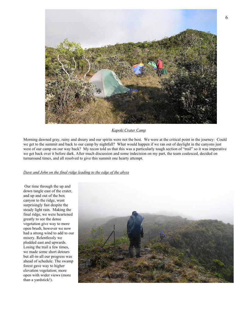
6 Kapoki Crater Camp Morning dawned gray, rainy and dreary and our spirits were not the best. We were at the critical point in the journey: Could we get to the summit and back to our camp by nightfall? What would happen if we ran out of daylight in the canyons just west of our camp on our way back? My recon told us that this was a particularly tough section of “trail” so it was imperative we get back over it before dark. After much discussion and some indecision on my part, the team coalesced, decided on turnaround times, and all resolved to give this summit one hearty attempt. Dave and John on the final ridge leading to the edge of the abyss Our time through the up and down tangle east of the crater, and up and out of the box canyon to the ridge, went surprisingly fast despite the steady light rain. Making the final ridge, we were heartened greatly to see the dense vegetation give way to more open brush, however we now had a strong wind to add to our misery. Relentlessly we plodded east and upwards. Losing the trail a few times, we made some short detours but all-in-all our progress was ahead of schedule. The swamp forest gave way to higher elevation vegetation; more open with wider views (more than a yardstick!).
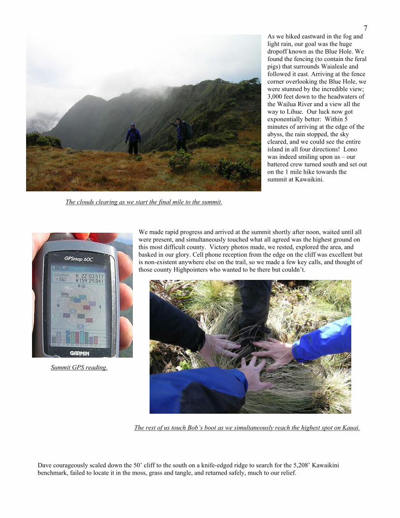
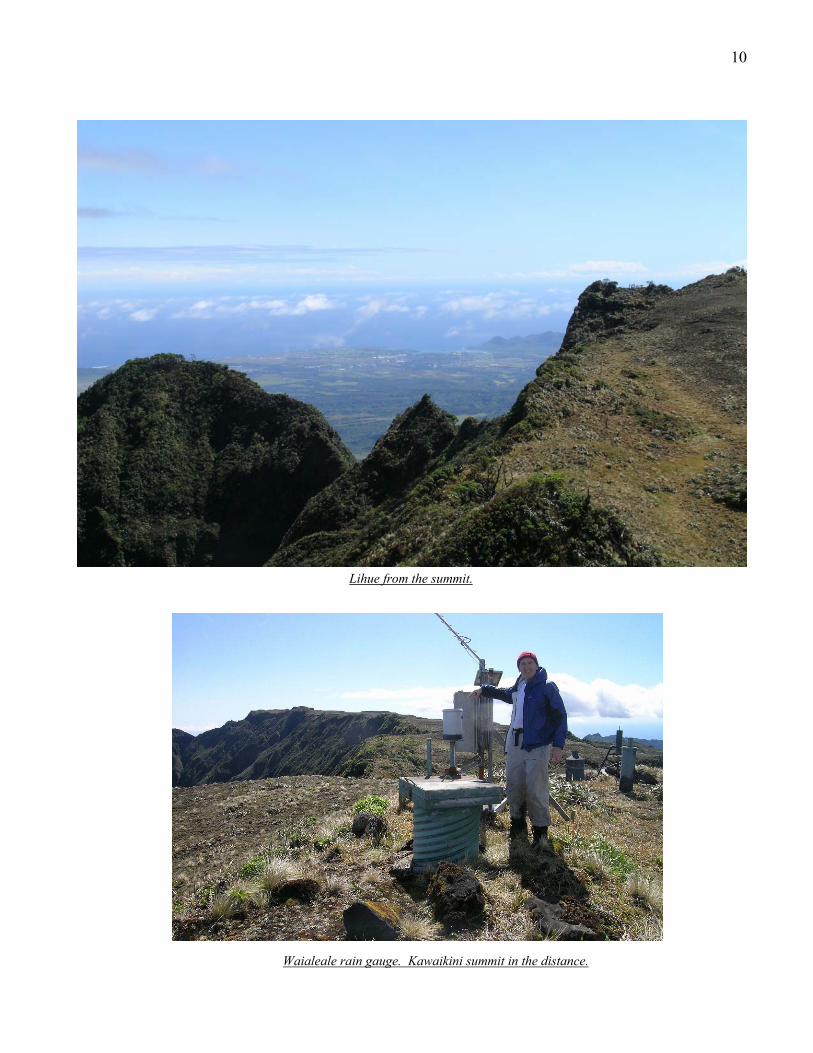
7As we hiked eastward in the fog and light rain, our goal was the huge dropoff known as the Blue Hole. We found the fencing (to contain the feral pigs) that surrounds Waialeale and followed it east. Arriving at the fence corner overlooking the Blue Hole, we were stunned by the incredible view; 3,000 feet down to the headwaters of the Wailua River and a view all the way to Lihue. Our luck now got exponentially better: Within 5 minutes of arriving at the edge of the abyss, the rain stopped, the sky cleared, and we could see the entire island in all four directions! Lono was indeed smiling upon us – our battered crew turned south and set out on the 1 mile hike towards the summit at Kawaikini.
The clouds clearing as we start the final mile to the summit.
We made rapid progress and arrived at the summit shortly after noon, waited until all were present, and simultaneously touched what all agreed was the highest ground on this most difficult county. Victory photos made, we rested, explored the area, and basked in our glory. Cell phone reception from the edge on the cliff was excellent but is non-existent anywhere else on the trail, so we made a few key calls, and thought of those county Highpointers who wanted to be there but couldn’t.
Summit GPS reading. The rest of us touch Bob’s boot as we simultaneously reach the highest spot on Kauai. Dave courageously scaled down the 50’ cliff to the south on a knife-edged ridge to search for the 5,208’ Kawaikini benchmark, failed to locate it in the moss, grass and tangle, and returned safely, much to our relief.
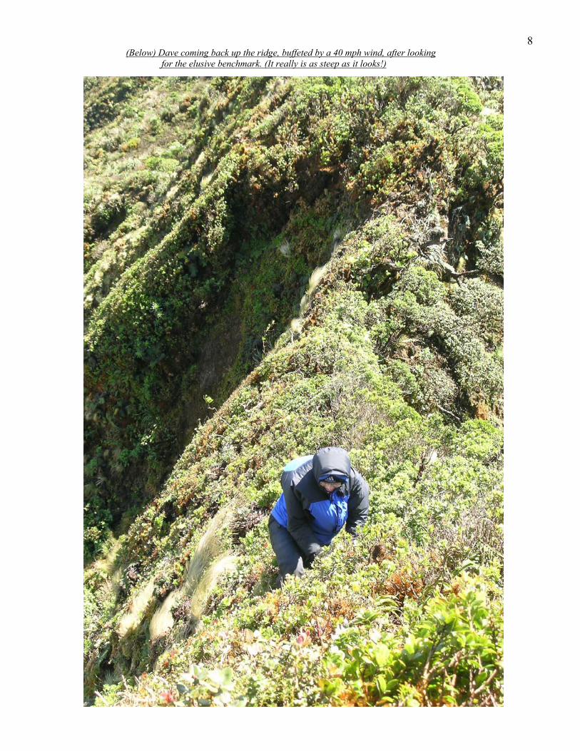
8 (Below) Dave coming back up the ridge, buffeted by a 40 mph wind, after looking for the elusive benchmark. (It really is as steep as it looks!)
9
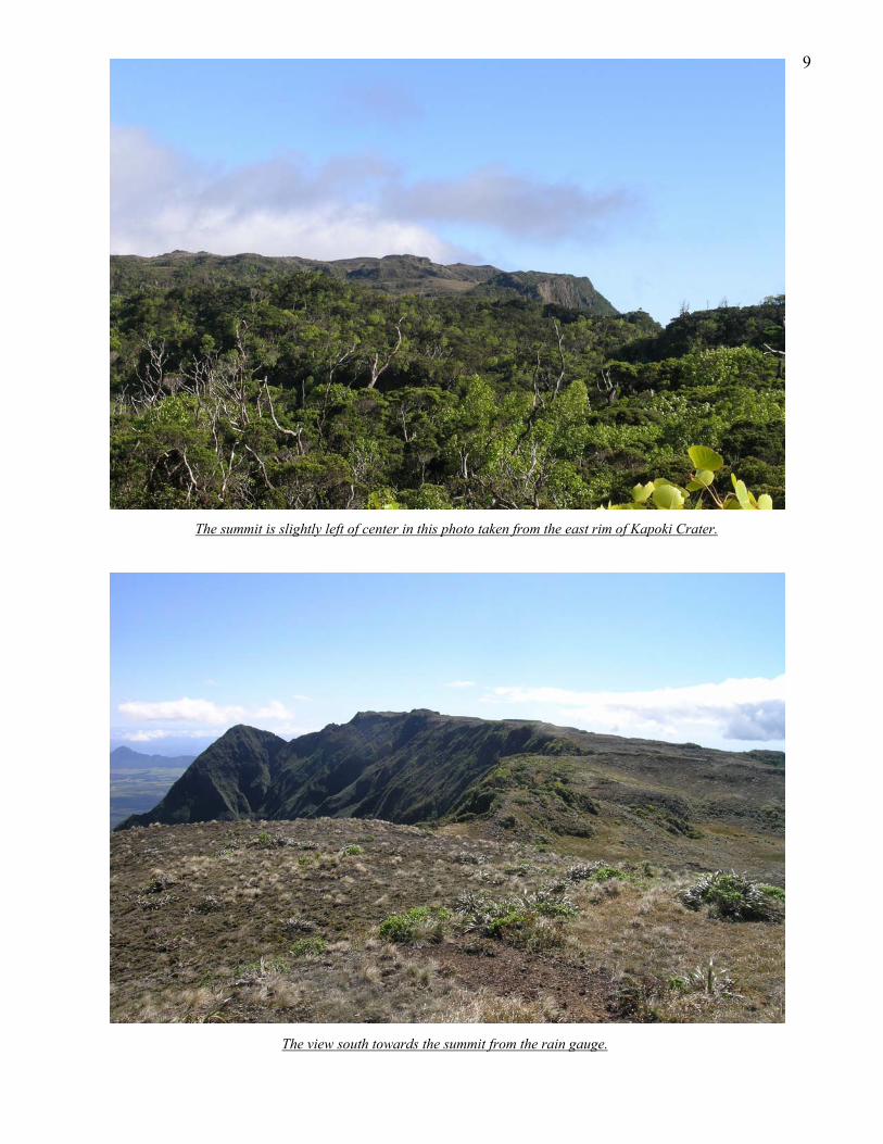
The summit is slightly left of center in this photo taken from the east rim of Kapoki Crater.
The view south towards the summit from the rain gauge.
10
Lihue from the summit. Waialeale rain gauge. Kawaikini summit in the distance.
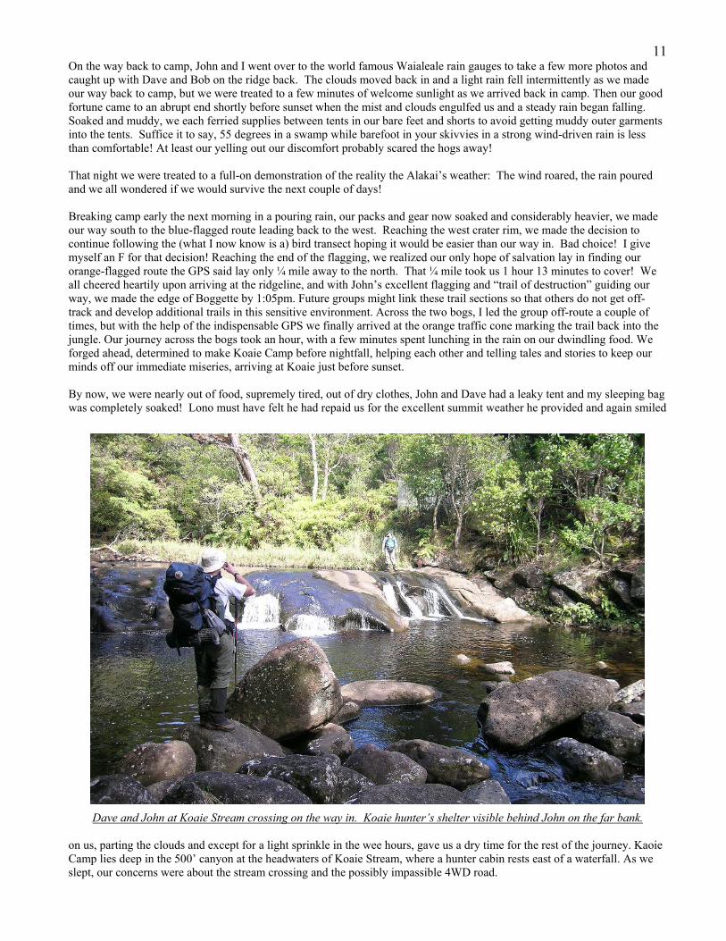
11On the way back to camp, John and I went over to the world famous Waialeale rain gauges to take a few more photos and caught up with Dave and Bob on the ridge back. The clouds moved back in and a light rain fell intermittently as we made our way back to camp, but we were treated to a few minutes of welcome sunlight as we arrived back in camp. Then our good fortune came to an abrupt end shortly before sunset when the mist and clouds engulfed us and a steady rain began falling. Soaked and muddy, we each ferried supplies between tents in our bare feet and shorts to avoid getting muddy outer garments into the tents. Suffice it to say, 55 degrees in a swamp while barefoot in your skivvies in a strong wind-driven rain is less than comfortable! At least our yelling out our discomfort probably scared the hogs away! That night we were treated to a full-on demonstration of the reality the Alakai’s weather: The wind roared, the rain poured and we all wondered if we would survive the next couple of days! Breaking camp early the next morning in a pouring rain, our packs and gear now soaked and considerably heavier, we made our way south to the blue-flagged route leading back to the west. Reaching the west crater rim, we made the decision to continue following the (what I now know is a) bird transect hoping it would be easier than our way in. Bad choice! I give myself an F for that decision! Reaching the end of the flagging, we realized our only hope of salvation lay in finding our orange-flagged route the GPS said lay only ¼ mile away to the north. That ¼ mile took us 1 hour 13 minutes to cover! We all cheered heartily upon arriving at the ridgeline, and with John’s excellent flagging and “trail of destruction” guiding our way, we made the edge of Boggette by 1:05pm. Future groups might link these trail sections so that others do not get off-track and develop additional trails in this sensitive environment. Across the two bogs, I led the group off-route a couple of times, but with the help of the indispensable GPS we finally arrived at the orange traffic cone marking the trail back into the jungle. Our journey across the bogs took an hour, with a few minutes spent lunching in the rain on our dwindling food. We forged ahead, determined to make Koaie Camp before nightfall, helping each other and telling tales and stories to keep our minds off our immediate miseries, arriving at Koaie just before sunset. By now, we were nearly out of food, supremely tired, out of dry clothes, John and Dave had a leaky tent and my sleeping bag was completely soaked! Lono must have felt he had repaid us for the excellent summit weather he provided and again smiled
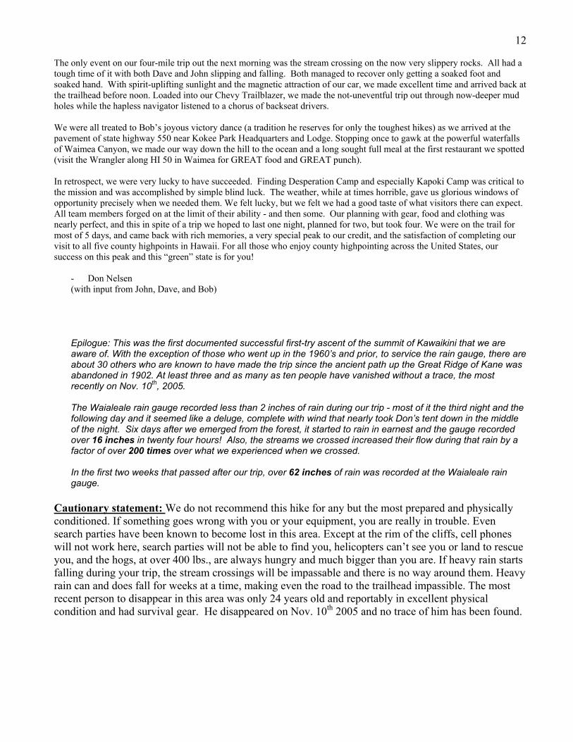
Dave and John at Koaie Stream crossing on the way in. Koaie hunter’s shelter visible behind John on the far bank.
on us, parting the clouds and except for a light sprinkle in the wee hours, gave us a dry time for the rest of the journey. Kaoie Camp lies deep in the 500’ canyon at the headwaters of Koaie Stream, where a hunter cabin rests east of a waterfall. As we slept, our concerns were about the stream crossing and the possibly impassible 4WD road.
12 The only event on our four-mile trip out the next morning was the stream crossing on the now very slippery rocks. All had a tough time of it with both Dave and John slipping and falling. Both managed to recover only getting a soaked foot and soaked hand. With spirit-uplifting sunlight and the magnetic attraction of our car, we made excellent time and arrived back at the trailhead before noon. Loaded into our Chevy Trailblazer, we made the not-uneventful trip out through now-deeper mud holes while the hapless navigator listened to a chorus of backseat drivers. We were all treated to Bob’s joyous victory dance (a tradition he reserves for only the toughest hikes) as we arrived at the pavement of state highway 550 near Kokee Park Headquarters and Lodge. Stopping once to gawk at the powerful waterfalls of Waimea Canyon, we made our way down the hill to the ocean and a long sought full meal at the first restaurant we spotted (visit the Wrangler along HI 50 in Waimea for GREAT food and GREAT punch). In retrospect, we were very lucky to have succeeded. Finding Desperation Camp and especially Kapoki Camp was critical to the mission and was accomplished by simple blind luck. The weather, while at times horrible, gave us glorious windows of opportunity precisely when we needed them. We felt lucky, but we felt we had a good taste of what visitors there can expect. All team members forged on at the limit of their ability - and then some. Our planning with gear, food and clothing was nearly perfect, and this in spite of a trip we hoped to last one night, planned for two, but took four. We were on the trail for most of 5 days, and came back with rich memories, a very special peak to our credit, and the satisfaction of completing our visit to all five county highpoints in Hawaii. For all those who enjoy county highpointing across the United States, our success on this peak and this “green” state is for you!
- Don Nelsen (with input from John, Dave, and Bob) Epilogue: This was the first documented successful first-try ascent of the summit of Kawaikini that we are aware of. With the exception of those who went up in the 1960’s and prior, to service the rain gauge, there are about 30 others who are known to have made the trip since the ancient path up the Great Ridge of Kane was abandoned in 1902. At least three and as many as ten people have vanished without a trace, the most recently on Nov. 10th, 2005. The Waialeale rain gauge recorded less than 2 inches of rain during our trip - most of it the third night and the following day and it seemed like a deluge, complete with wind that nearly took Don’s tent down in the middle of the night. Six days after we emerged from the forest, it started to rain in earnest and the gauge recorded over 16 inches in twenty four hours! Also, the streams we crossed increased their flow during that rain by a factor of over 200 times over what we experienced when we crossed. In the first two weeks that passed after our trip, over 62 inches of rain was recorded at the Waialeale rain gauge.
Cautionary statement: We do not recommend this hike for any but the most prepared and physically conditioned. If something goes wrong with you or your equipment, you are really in trouble. Even search parties have been known to become lost in this area. Except at the rim of the cliffs, cell phones will not work here, search parties will not be able to find you, helicopters can’t see you or land to rescue you, and the hogs, at over 400 lbs., are always hungry and much bigger than you are. If heavy rain starts falling during your trip, the stream crossings will be impassable and there is no way around them. Heavy rain can and does fall for weeks at a time, making even the road to the trailhead impassible. The most recent person to disappear in this area was only 24 years old and reportably in excellent physical condition and had survival gear. He disappeared on Nov. 10th 2005 and no trace of him has been found.

13 Specific Directions: Located in the center of the island of Kauai, the western-most county in Hawaii, this highpoint requires expert navigation through jungle, careful negotiation of mud slopes and slick fallen trees, patience for a slow pace, and an upbeat attitude that is not diminished by rain. The 4WD dirt road approach is 6 miles, and the hike is 13 miles one-way with about 6,000 feet of gain. At least there is no glacier travel. Lihue can be reached by direct flights from the mainland (especially American), by twin prop flights from other islands (Hawaiian Air and Island Air), and by cruise ship. Alamo rents 4WD vehicles and a variety of lodging is available on this tourist-oriented isle. Keep in mind that your approach to Waimea Canyon will be westward along the south shore. Near the trailhead, Kokee Lodge rents cabins at a very reasonable price (808) 335-6061. Camping is available at Kokee State Park ($5 with reservations (808) 274-3444) and at Sugi Grove and Kawaikoi (free with reservations (808) 274-3433). The only backpacker store is Da Life, located in central Koloa, west of Lihue, and is accessed by the famous “tree tunnel” road that extends south of HI 50. The trek to Kawaikini can be broken into several segments, each of deteriorating quality. In succession you will enjoy the following distinct segments which describe the approximate mileage, type of trail, and landmarks. 1) 38 miles of paved highway from Lihue, 2) 6 miles of 4WD dirt road to the trailhead, 3) 2 miles east on the wide, signed Mohihi-Waialae trail to the USGS station, 4) 2 miles east on the narrower, signed Mohihi-Waialae trail to Koaie Camp (aka hunter & cabin camp), 5) 2 miles south on the narrow but obvious Mohihi-Waialae trail to Arrow, 6) 1 mile southeast on primitive trail (but good by Alakai standards) to fencing at Sincock’s Bog, 7) 1 mile southeast across two bogs, connected by a forest trail, 8) 2 miles of jungle bushwhack (with or without flagging) southeast to Kapoki Crater Camp, 9) 1 mile of hideous bushwhack (with or without flagging) southeast to the final ridge, 10) 1 mile of relatively open hiking southeast to the Blue Hole, 11) 1 mile of open strolling south to the summit, Kawaikini From Lihue, zero your odometer at the intersection of HI 58 and HI 50, and travel west on HI 50 (Kaumualii Highway) for 22.3 miles to Waimea, which is located along Kauai’s southern coast. Turn right (north) on Waimea Canyon Road (HI 550) at the Western Kauai Technology & Visitor Center building. Drive north on this good but narrow paved road as it ascends the western edge of Waimea Canyon. After 6.7 miles, pass the intersection with HI 552 on the left (west), and begin to watch for many tourists pulling off to snap photos. At mile 15.3 turn right (east) on Kumuwela Road which is a dirt forest road. This dirt road provides access to the trailhead and is about 6 miles in length. It is wet in dry weather and impassible during rainy periods. There are several deep mud holes, two un-bridged stream crossings (i.e: the stream flows over the road!), and a couple of particularly rocky and steep sections. The worst of the mud holes are near the end of the road. There are several unmarked junctions so consult a map along the way! Consider having someone drive you to the trailhead, so you are not stuck there if the rain gods unleash their treasure while you are hiking. After leaving the pavement of US 550, carefully continue east toward the trailhead at Camp 10, passing several picnic areas, trail crossings, and dirt roads along the way. Camp 10 is the site of a covered picnic table at an elevation of 3,560’. Park your vehicle in the open grassy area on your left, just before the road turns right and goes downhill. There is a wood sign identifying the start of the Mohihi-Waialae Trail, as well as a small metal “start” sign. This is “mile 0” of the trail, which has small metal mileage signs every quarter mile for the first 3.75 miles. Hike down the 4WD road for about 0.2 mile, and cross a small wood bridge to arrive at the covered picnic tables. Find the trail behind a large wood sign. Descend and cross the creek. Go uphill a few dozen yards following what seems to be an old road towards a shack used for stream monitoring. About 50 feet before the shack, notice a trail on your right heading uphill. There is a sign marked “trail” but if this sign is missing, you may miss the trail which cuts sharply away from the old road. Follow this trail as it ascends a ridge, passing through a pleasant Sugi forest (relatives of the Redwood brought here from Japan). Several knolls provide excellent rest stops, although do not tarry as you still have a long way to go! At about 2 miles you will pass a USGS remote weather facility and the trail gets rougher and narrower. As you approach the metal facility (located on an open grassy knoll), the trail descends to the right. Watch for the small metal mileage signs low to the ground along the trail. There are great views along the way of valleys on either side as you travel this east-west ridge, attaining an

14elevation of about 4,200 feet. At mile 3.75, the trail takes a plunge of nearly 500 feet towards Koaie Camp which boasts a metal hunters’ cabin along a swift stream. The descent is a glimpse of things to come; a steep, muddy affair that has you grabbing at roots and grass for belay. Hop the rocks to cross the stream and ascend the far bank to reach the open area at the shack. Pump water here, and relax a moment before leaving Koaie Camp. Take a hard right and follow the obvious trail as it goes due south for about 50 yards. The trail then arcs to the left and begins the relentless climb out of Koaie Stream canyon. The trail is narrow and clings to the cliff side. One spot is particularly difficult – be careful! The trail remains narrow and harder to follow for another 2 miles to “Arrow.” Watch for several horizontal logs on the left at a point where the Mohihi Trail turns right and begins a descent. An arrow was carved on the lower log, mockingly pointing back towards the trailhead from whence you came. But Arrow is your friend and you will be glad to see it. Here, you leave the official Mohihi Trail and enter the off-trail world of the Alakai Swamp. Turn left off the Mohihi Trail, step over Arrow, and start using your skills at following flagging (the skills which you boasted about at the last county highpoint gathering). The trail is primitive and narrow with numerous obstacles across the path. Watch for dual signs. If you can’t see flagging you should see an obvious opening through the forest. Don’t rush. Be observant. Notice a small campsite on your right in the tangled vegetation. After a mile of this nonsense, you will reach the hog fence surrounding Sincock’s Bog. There should be an orange traffic cone. Cross the fence and cross the bog, carefully noting the landscape for when you return. Consider taking a digital photo of where you exit the forest solely for the purpose of reviewing it when you come back. Bog borders all look the same. After crossing Sincock’s Bog, enter the forest and follow a short section of good trail until you emerge to find “Boggette.” Either cross the fence directly in front of you or go left 30 yards to an orange gate. Enter Boggette and cross it. On the far side of Boggette there is a fence which you will cross at the midway point. [Note that there is a blue-flagged bird transect that extends out of Boggette at the NE and SE corners – do not follow these at all] There is some higher vegetation at the midway point of the fence, and a circular metal marker clipped to the fence with “50” stamped on it. Here, search the brush a few feet east of this and you should find the first of our orange flags marking the “Ridge Route” and the start of the Purgatory Trail. The fun begins. With waypoint-loaded GPS in-hand, follow the orange flags and the relative openings through the forest in an ESE direction (also have a compass in hand). The trail wiggles from right to left and back again, so be aware of direction changes. The Kapoki Crater has rims that are definitely higher than the surrounding land, but while your attention is spent on fighting attacking plants the rim is not so obvious, so heighten your awareness. Once on the western edge of Kapoki, the orange flagging ends, so follow the rim due south until you encounter the blue-flagged bird transect and follow it due east until you reach the deep forest and start steeply uphill. At this point you may wish to continue making progress eastward or you may wish to camp. Thus you can either continue up the hill, or you can take a NNW bearing and bushwhack 400 feet through dense trees to the clearing and the campsites we found on the crater floor. It took our group 8 hours, 19 minutes to traverse this section from the bog to the floor of Kapoki crater. A strong hiker might do it in under four hours utilizing our flagged route and given good conditions, but don’t count on either! There is a small stream a few dozen yards north of the camping spot where water should be available. Because of the possible presence of pigs and hunters in the area, you may want to filter, boil, and use iodine. The next possible camping spot is Ridge Camp at the junction of the “old Trail” (old mule team trail to the rain gauge) and the start of the final ridge that leads directly to the edge of the Blue Hole. The route east of the Kapoki Crater campsite is the worst of all, so the Kapoki camp is a good place to put up your tents and call it a day! Assuming you camp at our crater location, you proceed eastward through dense trees, following blue flagging, and ascend 20’ of muddy steep slope to ascend the box canyon west of Kapoki. The route goes over two more ridges until it comes to the final ridge. You will sense this is the final ridge because the trail turns right on the ridge crest and follows a relatively open path among bushes. This final ridge route may be harder to follow as it weaves among close-set bushes, but your compass should lead you along the higher ground which becomes more open, with ever-expanding views (assuming no rain or fog). Continue east on the ridge and come to pig fencing. Follow it as the vegetation gives way and the walking becomes positively easy. The fence extends almost to the very lip of the rim which overlooks the abyss that is the Blue Hole. This rim is lined with relatively higher bushes. Turn right (south) and precede across open countryside for 1 mile towards Kawaikini at the coordinates N 22 deg, 03.517 min., W 159 deg. 29.841 min. There may be several very wet bogs to cross along this final stretch as well as several steep benches of exposed rock which may be slippery. The final ascent is relatively steep and may be windy. The summit is open and exposed, but there are some trees on the south side, at the edge of the 50’ cliff that separates Kawaikini from the lower hills to the south. With clear skies, Waimea Canyon is visible as is Lihue. Although an oxymoron, we all urge you to Have Fun Visiting Kawaikini!

15 Gear Tips: Pack. Streamlined is the best form to have when diving into jungle vegetation. Oversized packs that are good for national park trails do not belong here. Avoid having anything in side pockets. Avoid hanging or strapping things to the outside of the pack. Insert everything into the pack and zip it up. Be prepared to crawl under logs with it. Ferns love to cling to things. Our packs weighed about 40 pounds. Go light! John took a large daypack. Two-person teams can share a tent, stove, and filter, and reduce pack size. Take a quality pack cover that has secure tightening. Keep the dirt and moisture off your pack. Line your pack with a plastic bag. Then store your clothes & sleeping bag inside dry bags or plastic bags inside your lined pack. A dry hiker is a happy camper. Dry socks are pure luxury on your 3rd night in the Alakai. Clothing. Expect wet. No cotton. Capilene and nylon is good. Wool or fleece for cooler nights is needed. Wool cap. Raincoat and rainpants are typically worn at all times because the vegetation is as wet as the rain. Take 3 or 4 sets of socks and maintain a dry pair for evenings. Expect 50 degrees at night. Sleeping Bag. There is not much need for a bag rated for 30 degrees or less. Save weight and take a 30 or 40 degree bag. More importantly, save space in your reduced size pack. Tent. Due to relatively warm temperatures and sheltered sites, our 3- and 2-season tents worked well. Bring a tent with minimal floor space, as the campsites are minimal in size. Gloves. No cotton or fleece, as these become wet and heavier. Use a thinner skin with reinforced palm and finger grip (Sirius and OR make good models). Boots. Take leather boots, not fabric trail shoes. Bob & John had great success with their Vasque Sundowners. John used ankle-high OR gaitors. Dave and Don used full length gaitors. Bob did not use gaitors and found his feet to be dry until the morning of the fourth day. Thoroughly dry your boots after your hike, or a grotesque stench will develop during the plane ride home. Trekking Poles. They may be of some value on the steep mud embankments but overall they do not help much in jungle environment. Addicts may cache them at mile 3.75 before the steep descent to Kapoki Camp. If you do take one, be sure it is a modern 3-section pole, collapsible to 24” in length for pack stuffing. Rope. Consider taking a 60’ length to cache at Koaie Camp so it may be used to cross Koaie Stream if the water is too high to safely cross. In that event, be sure to unbuckle your pack before you cross. This stream can and does rise and fall quickly so waiting it out for a day may be the safest bet. The stream can become very deep. Consider taking the rope the entire trip in the event that someone hurts themselves enroute and needs a belay on steep sections. Sunglasses & Sunlotion. Ha! GPS. Take two. We know of one that is still lost along the trail up there. Carry them in a ziplock bag. Take compass. Take topo maps for each trail section. Waterproof them. Tie orange flagging to all valuables (phone, radios, GPS) in case they are dropped. Seriously! We failed to do this initially, dropped the GPS in ferns, and almost blew the expedition right there, before finding it a minute after losing it. Radios, Phones. A cell phone call can be done at the top and is nice. Two-way radios are good insurance but don’t carry far in the undulating terrain. Save the weight and leave at home. Water. Depending on your thirst buds, take two one- liter bottles and a filter or iodine. There should be enough water to pump, but we did run dry a couple times. Two filters is a good idea, if one clogs. Maps. Rather than using the publicly available USGS topo maps or the recreational maps of the area, we used maps generated by TOPO! software, overlain with numerous GPS routes, annotations, etc. Stove. Dave’s MSR pocket rocket worked well. We used one can of fuel, although we did not fire it up for breakfast or lunch. Come to think of it, we never ate breakfast or lunch…. Overall. Go light. Go tight. This peak requires full-contact bushing.
16 How to Approach This Climb Tips: Stay High. The objective is to stay on high ground (i.e., a gentle ridge) as you hike east and southeast toward the rim. The Mohihi-Waialae Trail keeps you on a ridge, but the primitive trails tend to go up and down as they necessarily cross ridges and follow streams and gulleys. Keeping to a ridge is especially critical in the Purgatory section. We were successful in the fog on summit morning largely by sticking to the highest ground possible and walking generally ESE. There is a balance between staying high on a ridge, following a GPS route, and following flagging. Sometimes the three don’t jive. We strived to follow the flags which generally corresponded to the GPS route we had, but there were a couple key bushwhacks we had to do to link up two flagged routes. See Don’s annotated topo map with route. Flagged Routes. We encountered a good deal of Light Blue and Pink flagging, most likely placed by state forestry employee birders. There was some ancient Dark Blue flagging, which is now crackled and moss-covered. The newer routes have Orange flagging. Humans Contact. We saw two ornithologists (birders) with the HI State Forestry Department who were conducting research. They were slightly curious of our presence but did not seem alarmed or mind our recreational interest in the area. We met them on the Mohihi-Waialae Trail. We did not see signs about restrictions. Campsites. Koaie Camp has small usable tent sites and a dusty cabin that leaks. We spotted a small camp area before the bogs and in Kapoki Crater which were relatively dry. Flat ground in the bogs will be damp and may be covered with endangered plants, so look at the grassy edges outside the bog fencing. Hauling a pack past Kapoki Crater on to the Ridge Camp (or further on to the Blue Hole rim) is not necessary and will take much energy as the route is a complicated bushwhack. Given that the route is now flagged and Mitchlerized, a moderately strong team can easily make the summit and return to Crater Camp in a day. Animals. The Alakai is the land of vegetation. There is an amazing lack of bugs, flying or crawling. No need to haul bug dope, netting, etc. The pigs did not bother our food, although Don smartly hung his during the summit day hike. Obstacles. The hurricanes blew down 90% of the big trees on the island, so be prepared to crawl over or under them. They lie across the trail, often near mud flats and near steep sections. It is part of the game so be prepared. Watch for the numerous steep sections which would ruin the trip if anyone slipped. If a comrade is going very slowly in a given section (cliff, stream, etc.), it may be in the best interests of group expediency to assist that person by carrying a pack, doing a short-roped belay, spotting a foot/hand hold, etc…. This is no place to let one’s pride get in the way of safety. We all did a great job of agreeing that the greater good of the group was more important than a little pride. Orientation. The sun is obscured by clouds and the tree canopy all looks the same. It is extremely easy to become disoriented as to proper compass directions. At a point on the Purgatory section, it was John’s compass that saved the day, not a GPS, nor dead reckoning. Group Size. This becomes critical because of the lack of tent sites. There is plenty of parking at the trailhead. 1 or 2 person teams are efficient in the jungle but there is no safety factor in case of accident. Our 4 man team worked well. Groups larger than this are not advised. Use group consensus as much as possible. Do not depend solely on one person to lead. We got out of trouble several times by having everyone participate in route finding and leading. Group consensus prevents finger pointing. Bring along some tenacity and great group spirit. Our team was fantastic. No one griped a single time about anything that was within our control (i.e., anything other than the weather and an occasional stick in the face). Reward. Leave dry clothes, shoes & socks, and a quart of water in the car. This will be appreciated. Resources: www.waialeale.org – background information, trip reports, annotated topo maps, photos www.cohp.org – trip reports, photos, annotated topo map http://waterdata.usgs.gov/hi/nwis/uv/?site_no=16019000&PARAmeter_cd=00065,00060 – real time observations of the Waialeale raingauge