Embed Size (px)
Citation preview
LISA J. LUCERO
New Answers to Old Questions: What Happened to Classic MayaCivilization?
The Collapse of the Classic Maya: A Case for theRole of Water Control
ABSTRACT This article focuses on the role of water control in the emergence and demise of Classic Maya political power (c. C.E.
250-950), one that scholars have long underestimated. The scale of water control correlates with the degree of political power, re-
flected in three levels of Maya civic-ceremonial centers—regional, secondary, and minor. Such power derives from a complex relation-
ship among center location, seasonal water supply, amount of agricultural land, and settlement density. Maya kings monopolized
artificial reservoirs and other water sources during annual drought, providing the means to exact tribute from subjects. Climate change
undermined the institution of rulership when existing ceremonies and technology failed to provide sufficient water. The collapse of rul-
ers' power at regional centers in the Terminal Classic (c. C.E. 850-950) had differing impacts on smaller centers. Secondary and minor
centers not heavily dependent on water control survived the drought and the collapse of regional centers. [Keywords: political power,
water control, Classic Maya collapse]
SCHOLARS HAVE LONG speculated about the causesof both the rise and the dramatic collapse of the Clas-
sic Maya (c. C.E. 250-950) of Mesoamerica.1 Their rise hasbeen considered anomalous because Maya civilizationseemed to deviate from the many examples documentinga close relationship between the control of water and po-litical power (e.g., Fagan 1999:248-252; Weber 1964:31;Wittfogel 1957; Wortman 1985). In Mesopotamia, Egypt,China, the Indus Valley, Andean South America, and cen-tral Mexico, for example, ancient civilizations emerged inareas with natural water sources and agricultural land thatsupported a densely settled subject populace; elite controlof water for agricultural production allowed leaders to ex-act tribute from the local population. In contrast, south-ern Maya kings in lowland jungles often ruled from civic-ceremonial centers in areas with fertile land, but withoutnatural water sources, suggesting that power was unrelatedto water control in these cases.
I argue that scholars have overlooked the importanceof the control of artificial reservoirs by Maya rulers andsuggest that control of this type of water resource played acritical role in the florescence of Maya civilization and inits later collapse. Further, I suggest that a focus on the con-
trol of artificial reservoirs helps explain differences in thehistorical trajectories of large and small Maya settlements.In large regional civic-ceremonial centers, Maya rulers lostthe means to control water in the Terminal Classic (c. C.E.850-950) because of climatic changes, resulting in the col-lapse of power. Minor and secondary centers in areas lessdependent on water control, by contrast, survived thedrought and avoided collapse.
The power of Maya rulers—particularly their ability toexact tribute, or surplus labor and goods, from others—de-rived from a complex relationship among a number of fac-tors, particularly the location of the center from wherethey ruled, its seasonal water supply, the amount of agri-cultural land, and settlement density. I outline the specificrelationship among these factors below.
A problem with any model is that it cannot accountfor every situation, as is the case when attempting to ex-plain the Maya collapse. The model I present does not ac-count for the political histories of every Maya center butprovides a general organizational framework by which toevaluate how water control and political power figured inthe rise and fall of political leadership among the Maya. 1focus on the processes of collapse that occur once they are
AMERICAN ANTHROPOLOGIST 104(3):814-826. COPYRIGHT © 2002, AMERICAN ANTHROPOLOGICAL ASSOCIATION
Lucero • Classic Maya Collapse 815
set in motion rather than presenting a new cause. This ap-proach, thus, does not discount earlier perspectives but viewsthem as local events rather than pan-Maya explanations.
THE POLITICS OF WATER CONTROL
Generally, densely settled areas where people are tied tothe land because of subsistence technology (e.g., plowedfields, canals, dams, agricultural terraces, fish ponds, trans-portation, storage facilities) facilitate the rise of consolidatedpolitical power (Gilman 1981) because leaders can moreeasily control access to critical resources, people, and theirsurplus (Earle 1997:7). Conversely, scattered resources areharder to monopolize and result in dispersed populationsthat are more difficult to integrate. Maya rulers faced par-ticular difficulties in drawing farmers close to the ceremo-nial-civic centers over which they ruled. The majority offarmers lived dispersed in farmsteads throughout noncen-ter or hinterland areas, mirroring the patchlike distribu-tion of fertile land (Dunning 1998; Fedick and Ford 1990;Rice 1993; Sanders 1977). Maya farmers used a combina-tion of agricultural techniques including house gardens;short-fallow infields; long-fallow outfields to grow maize,beans, and squash (Flannery 1982; Harrison and Turner1978; Killion 1990); and various types of intensive agricul-tural techniques such as raised fields, dams, canals, andterraces (Dunning 1997). However, few or none of thesetechniques appear to have been under elite control (Demarest1992; Tourtellot 1993; cf. Marcus 1982). Other farmerslived near or in centers, where they may not have stayedduring the labor-intensive rainy seasons, especially if theirfields were at some distance, requiring the use of fieldhouses (e.g., Ford 1992; Lucero 1999a; Webster 1992). In ad-dition, some farmers may have had to find new land inthe face of growing population and increasing competi-tion over land, especially during the Classic period (Ford1991b; Tourtellot 1993). Hinterland Maya farming com-munities also may have been relatively economically self-sufficient (Lucero 2001). Consequently, the ruling eliteneeded to integrate not only a relatively dispersed andself-sufficient populace but also one that may have beensomewhat mobile (Drennan 1988; Ford 1990; Santley 1990).
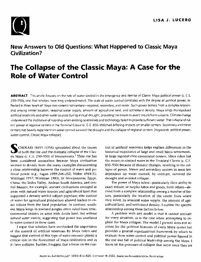
That these rulers were able to do so is primarily be-cause of the nature of seasonal rainfall and water availabil-ity in the area. Particularly significant is the four-monthannual drought, from January to May. This had particularconsequences in regions lacking rivers and lakes such asthose where the regional centers Tikal, Caracol, and Calak-mul emerged (Figure 1). The lack of surface water for fourmonths every year required the Maya to devise ways tostore water. Rather than concentrate people through a de-pendence on agricultural technologies, rulers concentratedan even more vital resource, drinking water. The earliestrulers of Tikal, Caracol, Calakmul, and other centers or-ganized the construction and maintenance of large artifi-cial reservoirs in center cores next to temples and othermonumental architecture.2 Rulers' control of reservoirs
during seasonal drought combined with tlnir perform-ance of associated rituals, facilitated dry-season nucleationat these centers, and lessened the need for hinterlandcommunities to build their own reservoirs (Lucero 1999c).
A challenge the Maya faced, however, concerned stand-ing water during the dry season. Standing water can becomestagnant, can provide prime conditions for insects andparasites, and, more significantly, can result in the build-up of noxious chemicals, especially nitrogen (Burton 1979).The natural wetland biosphere acts to sustain water purityif correctly maintained (Hammer and Kadlec 1980; Nelson1980). Maya rulers became responsible not only for pro-viding enough potable water to last through the dry sea-son by organizing the continual maintenance required tokeep the reservoirs clean (Ford 1996), but also for perform-ing rites necessary to propitiate deities such as Chac, therain god.
A visible sign of clean water is the water lily. Water lil-ies, Nyinphaea ampla, are sensitive hydrophytic plants thatcan only grow in shallow (1-3 meter), clean, still waterthat is not too acidic and does not have too much algae ortoo much calcium (Conrad 1905:116; Lundell 1937:18,26). Thus, the presence of water lilies on the surface ofaguadas, or rain-fed natural basins, and reservoirs is a vis-ible indicator of clean water. The water lily was a symbolof royalty in Classic Maya society, as clearly expressed inthe distribution of water lily motifs on stelae, monumen-tal architecture, murals, and mobile wealth goods such aspolychrome ceramic vessels (e.g., Rands 1953). Water im-agery, and possible evidence for associated rituals, aboundsat regional and secondary centers (Fash in press; Fash andDavis-Salazar 2001; Puleston 1977; Scarborough 1998),suggesting the important link between maintaining cleanwater and royal power in these areas.
The continued supply of clean water must have meantto the local populations that rulers were successful in sup-plicating gods and ancestors and that rulers had specialties to the supernatural world, which they used to benefitall—for a price, of course. Worldwide, rulers often are as-sociated with fertility, purification, and associated rites(Helms 1993:78-79). Subjects often believe that holders ofexclusive knowledge and skill are in closer proximity tothe gods or are gods themselves (Friedman and Rowlands1978; e.g., Weber 1964; Wortman 1985). The inscriptionsand iconography found throughout civic-ceremonial cen-ters amply illustrate that Classic Maya rulers had closerties to important Maya deities, to ancestors, and to the su-pernatural world than the rest of Maya society (e.g., Hous-ton and Stuart 1996; Marcus 1978; McAnany 1995; Scheleand Freidel 1990; Schele and Miller 1986).
Hinterland communities in areas without lakes or riv-ers did not build their own large-scale water catchmentsystems and did not develop equally complex political sys-tems for several reasons. For one, artificial reservoirs in-itially required a substantial output of labor to construct,as well as continual maintenance that was not available insparsely populated regions. In addition, hinterland aguadas
816 American Anthropologist • Vol. 104, No. 3 • September 2002
stat-. \ j > y ^ \ N ^ . IUA*J
ATM
CaribbeanSea
*&."
. .OJalPedl '
FIGURE 1. The Maya area with sites discussed in bold.
are small and would not have supported large, nucleatedpopulations throughout the dry seasons, especially becausewater in smaller aguadas would likely evaporate morequickly than that in larger, maintained reservoirs (Scarbor-ough 1996). Such communities may not have built watercatchment systems or expanded and maintained aguadasbecause of the nature of standing water, which, as dis-cussed above, requires significant effort to keep clean.
I do not claim that Maya farmers did not know aboutthe properties of water, rather, as Scarborough (1998) argues,Maya rulers appropriated traditional water rituals to suit apolitical agenda. Nor do I posit that all hinterland Mayaconverged at centers every dry season. Instead, I suggestthai prehistoric Maya farmers, especially in the southern
Maya lowlands, were more mobile than previously be-lieved and that some of this mobility involved gravitatingto stable water sources.
The ultimate result of the distribution of resourcesand subsistence practices was a somewhat fluid residentialpattern whereby farmers may have had the option to par-ticipate in ceremonies sponsored by different rulers or per-haps even not at all. Consequently, this system was sus-ceptible to fluctuations in the water supply that hadreverberations throughout the lowlands, affecting all royalcourts. In the Terminal Classic (c. C.E. 850-950), a seriesof events resulted in a situation in which rulers could notprevent their subjects from migrating out of the interior ordispersing permanently into hinterland areas. Consequently,
Lucero • Classic Maya Collapse 817
these centers were abruptly abandoned. Other centershave different, but related, histories, as I discuss below.
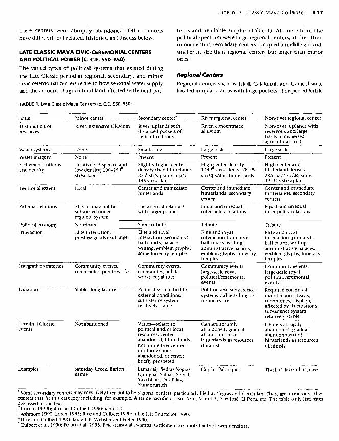
LATE CLASSIC MAYA CIVIC-CEREMONIAL CENTERSAND POLITICAL POWER (C. C.E. 550-850)
The varied types of political systems that existed duringthe Late Classic period at regional, secondary, and minorcivic-ceremonial centers relate to how seasonal water supplyand the amount of agricultural land affected settlement pat-
terns and available surplus (Table 1). At one end of thepolitical spectrum were large regional centers; at the other,minor centers; secondary centers occupied a middle ground,smaller in size than regional centers but larger than minorones.
Regional Centers
Regional centers such as Tikal, Calakmul, and Caracol werelocated in upland areas with large pockets of dispersed fertile
TABLE 1 . Late Classic Maya Centers (c. C.E. 550-850).
Scale Minor center Secondary centera River regional center
Distribution ofresources
Water systems
River, extensive alluvium
None
River, uplands withdispersed pockets ofagricultural soils
Small-scale
River, concentratedalluvium
Large-scale
Non-river regional centerNon-river, uplands withreservoirs and largetracts of dispersedagricultural land
Large-scale
Water imagery None Present Present PresentSettlement patternsand density
Territorial extent
Relatively dispersed andlow density; 100-150b
str/sq km
Slightly higher centerdensity than hinterlands275C str/sq km v. up to145 str/sq km
High center density1449d str/sq km v. 28-99str/sq km in hinterlands
High center andhinterland density235-557e str/sq km v.39-313 str/sq km
Local Center and immediatehinterlands
Center and immediatehinterlands, secondarycenters
Center and immediatehinterlands, secondarycenters
External relations May or may not besubsumed underregional system
Hierarchical relationswith larger polities
Equal and unequalinter-polity relations
Equal and unequalinter-polity relations
Political economy No tribute Some tribute Tribute Tribute
Interaction Elite interaction;prestige-goods exchange
Elite and royalinteraction (secondary):ball courts, palaces,writing, emblem glyphs,some funerary temples
Elite and royalinteraction (primary):ball courts, writing,administrative palaces,emblem glyphs, funerarytemples
Elite and royalinteraction (primary):ball courts, writing,administrative palaces,emblem glyphs, funerarytemples
Integrative strategies Community events,ceremonies, public works
Community events,ceremonies, publicworks, royal rites
Community events,large-scale royalpolitical/ceremonialevents
Community events,large-scale royalpolitical/ceremonialevents
Duration Stable, long-lasting Political system tied toexternal conditions;subsistence systemrelatively stable
Political and subsistencesystems stable as long asresources are
Terminal Classicevents
Not abandoned
Examples Saturday Creek, BartonRamie
Varies—relates topolitical and/or localresources; centerabandoned, hinterlandsnot, or neither centernor hinterlandsabandoned, or centerbriefly prospered
Lamanai, Piedras Ncgras,Quirigua, Yalbac, Seibal,Yaxchilan, Dos Pilas,Xunantunich
Centers abruptlyabandoned, gradualabandonment ofhinterlands as resourcesdiminish
Copan, Palenque
Required continualmaintenance (feasts,ceremonies, display);affected by fluctuations;subsistence systemrelatively stable
Centers abruptlyabandoned, gradualabandonment ofhinterlands as resourcesdiminish
Tikal, Calakmul, Caracol
Some secondary centers may very likely turn out to be regional centers, particularly Piedras Negras and Yaxchilan. There are numerous othercenters that fit this category including, for example, Altar de Sacrificios, Rio Azul, Motul de San Jose, El Peru, etc. The table only lists sitesdiscussed in the text.b Lucero 1999b; Rice and Culbert 1990: table 1.1.c Ashmore 1990; Loten 1985; Rice and Culbert 1990: table 1.1; Tourtellot 1990.d Rice and Culbert 1990: table 1.1; Webster and Freter 1990.e Culbert et al. 1990; Folan et al. 1995. Bajo (seasonal swamps) settlement accounts for the lower densities.
818 American Anthropologist Vol. 104, No. 3 • September 2002
ouu-
500-
400-
300-
200-
100-
0-
©EOB
• •
Minor CenterLocal CenterRegional Center
mtA !J\ /4W1\
0 Annual rainfall (cm)• Elevation (m)
Saturday Quirigua Piedras Yaxchilan Copan TikalCreek Barton Seibal Ne9ras £,« Palenque Calakmul Caracol
RamiePilas
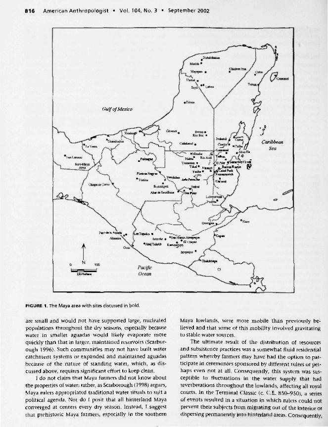
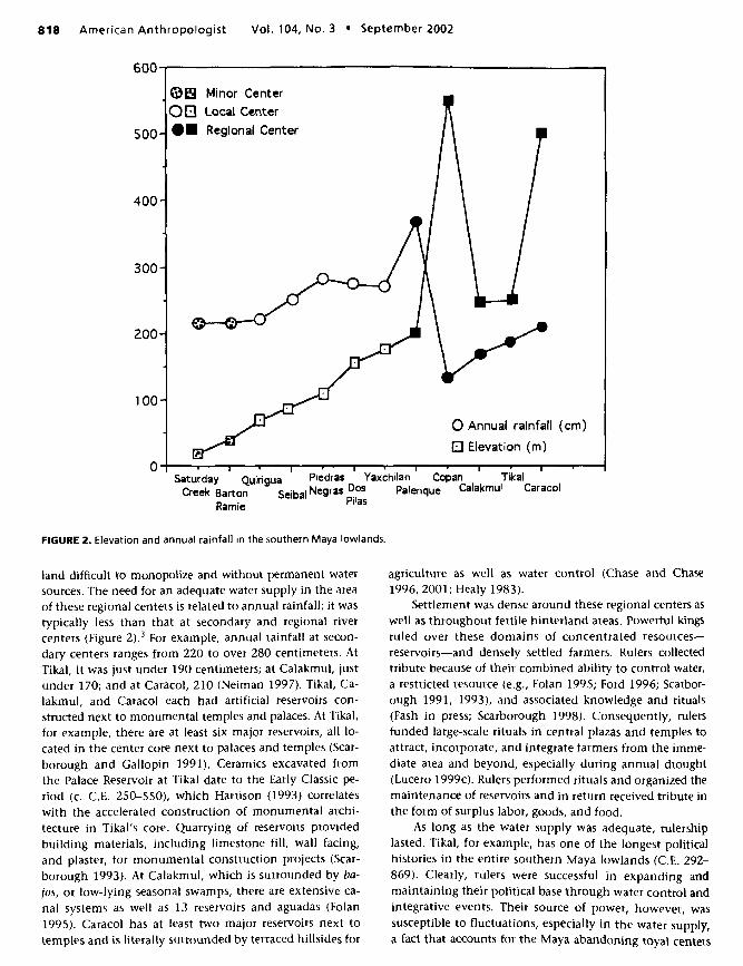
FIGURE 2. Elevation and annual rainfall in the southern Maya lowlands.
land difficult to monopolize and without permanent watersources. The need for an adequate water supply in the areaof these regional centers is related to annual rainfall; it wastypically less than that at secondary and regional rivercenters (Figure 2).3 For example, annual rainfall at secon-dary centers ranges from 220 to over 280 centimeters. AtTikal, it was just under 190 centimeters; at Calakmul, justunder 170; and at Caracol, 210 (Neiman 1997). Tikal, Ca-lakmul, and Caracol each had artificial reservoirs con-structed next to monumental temples and palaces. At Tikal,for example, there are at least six major reservoirs, all lo-cated in the center core next to palaces and temples (Scar-borough and Gallopin 1991). Ceramics excavated fromthe Palace Reservoir at Tikal date to the Early Classic pe-riod (c. C.E. 250-550), which Harrison (1993) correlateswith the accelerated construction of monumental archi-tecture in Tikal's core. Quarrying of reservoirs providedbuilding materials, including limestone fill, wall facing,and plaster, for monumental construction projects (Scar-borough 1993). At Calakmul, which is surrounded by ba-jos, or low-lying seasonal swamps, there are extensive ca-nal systems as well as 13 reservoirs and aguadas (Folan1995). Caracol has at least two major reservoirs next totemples and is literally surrounded by terraced hillsides for
agriculture as well as water control (Chase and Chase1996, 2001; Healy 1983).
Settlement was dense around these regional centers aswell as throughout fertile hinterland areas. Powerful kingsruled over these domains of concentrated resources—reservoirs—and densely settled farmers. Rulers collectedtribute because of their combined ability to control water,a restricted resource (e.g., Folan 1995; Ford 1996; Scarbor-ough 1991, 1993), and associated knowledge and rituals(Fash in press; Scarborough 1998). Consequently, rulersfunded large-scale rituals in central plazas and temples toattract, incorporate, and integrate farmers from the imme-diate area and beyond, especially during annual drought(Lucero 1999c). Rulers performed rituals and organized themaintenance of reservoirs and in return received tribute inthe form of surplus labor, goods, and food.
As long as the water supply was adequate, rulershiplasted. Tikal, for example, has one of the longest politicalhistories in the entire southern Maya lowlands (C.E. 292-869). Clearly, rulers were successful in expanding andmaintaining their political base through water control andintegrative events. Their source of power, however, wassusceptible to fluctuations, especially in the water supply,a fact that accounts for the Maya abandoning royal centers

Lucero • Classic Maya Collapse 819
by the ninth or tenth century. As long as subsistence re-sources were available, however, farmers did not necessar-ily abandon hinterland areas, for events taking place atroyal centers did not always affect them. They continuedto practice subsistence activities in small communities andto participate in local events; they also maintained small-scale water systems (e.g., aguadas).
Not all regional centers were located in areas withoutlakes or rivers; Palenque and Copan are prime examples.More typical of most other ancient civilizations, thesesites are found along rivers with concentrated alluviumthat supported regional hierarchical polities. Settlementwas typically dense around these centers and noticeablyless dense in areas beyond the alluvium. Rulers collectedtribute because of their ability to monopolize concen-trated alluvium and acquire tribute from nucleated settle-ments. Rulers sponsored large-scale rituals in central plazasand temples to incorporate and integrate larger numbersof farmers from the immediate area as well as to legitimatetheir rule. For example, alluvial soils around Copan arefound within a 24 square kilometer area (Webster 1999).Rulers also built artificial reservoirs, which Barbara Fash(in press) argues were managed and controlled by the po-litical elite, based on their distribution and analysis of ico-nography. Additionally, although the presence of ruralaguadas signifies some degree of self-reliance, at least foraccess to water, relatively low annual rainfall (132 centi-meters) and undrinkable river water during the height ofthe dry season meant that local farmers relied on water-management systems part of the year. Rulers also control-led trade with highland areas for jade and obsidian (Fash1991). Similarly, Palenque is situated at the foothills of theChiapas mountains above a fertile valley (de la Garza1992:51-52). Inhabitants of Palenque, located in a hillyarea with several streams and springs, built water systemsconsisting of aqueducts and canals to drain water awayfrom the center—a not-too-surprising fact given that an-nual rainfall is over 360 centimeters. It is interesting tonote that although water lilies cannot grow in Palenque'ssprings and flowing streams, their ubiquity in the iconog-raphic record at Palenque is undeniable and indicates theimportance of water symbolism in political ideology andrituals throughout the Maya region.
Rulers at regional river centers lasted as long as re-sources did. Demand for surplus production instituted byrulers could have contributed to the overexploitation ofresources. Any decrease in surplus undermined the politicalsystem, whether it was resource degradation or decreasingwater supply. Regional powers abandoned the trappings ofwhat formerly defined Classic Maya political life—palaces,temples, inscribed sculpture, and so on. Consequently,Copan and Palenque, but not necessarily their hinter-lands, were largely abandoned by the ninth or tenth cen-tury. Because of close ties, the decline of regional rulersalso contributed to the disruption of secondary centers, aswe will see below.
Secondary Centers
The histories of secondary centers show great variability,which is not surprising given their status as secondarypolities. They do, however, have several factors in com-mon. For example, Lamanai, Yalbac, Seibal, Piedras Ne-gras, Dos Pilas,4 and Xunantunich are typically foundalong rivers largely in upland areas with dispersed pocketsof agricultural land that supported local polities. Settle-ment was typically dense near centers and not as dense inhinterland areas. Rulers acquired some tribute because oftheir ability to monopolize nearby agricultural land andprestige goods exchange. These centers arose as secondarypolities because of their rulers' participation in a royal in-teraction sphere established by regional rulers: rulers fromsecondary centers interacted with those in regional centersin such activities as intercenter alliances, marriages, war-fare, prestige goods exchange, and royal rites. This patternis borne out in the inscriptions in which regional royalhistories begin earlier (C.E. 292-435) than secondary royalhistories (C.E. 480 and later) (see Martin and Grube 2000).
At most secondary centers, residents lived above riverson ridges and hills, which meant that saturated hillsidesduring the rainy season likely posed problems and influ-enced building plans and agricultural practices (Turner1974). Because of the dispersed agricultural soils, Mayafarmers used scattered small-scale water systems includingaguadas, dams, canals, and drainage ditches (e.g., Dun-ning 1997; Fedick 1994). Their inconsistent distributionsuggests that water systems had less of a political role inthese areas.
The impact of climatic change in the tenth century onthese centers varied and was related to the level of in-volvement of the local rulers with those in larger, regionalcenters. Secondary rulers were linked to regional rulers be-cause nonlocal royal ties played a major role in maintain-ing political power. Any change in external relations, suchas regional centers' loss of power, trade disruption, or di-minishing surplus, reverberated throughout the royal in-teraction sphere. Local subsistence practices and wealthdifferentiation were not necessarily affected as long as re-sources were available. Consequently, there were variedresponses to the collapse of power at regional centers.Many secondary centers where rulers had close ties withregional rulers were largely abandoned by the ninth ortenth century, though not necessarily their hinterland ar-eas (e.g., Quirigua and Yaxchilan). Weakening power at re-gional centers at the end of the Late Classic resulted inseveral secondary rulers claiming independence. For ex-ample, Quirigua became independent from Copan, andYaxchilan broke with Palenque and Tikal (Ashmore 1984;Mathews and Willey 1991). In such cases, rulers did notimmediately lose power, so neither their centers nor thesurrounding hinterlands were abandoned. Clearly, meansother than water control existed to underwrite politicalsystems, such as the monopolization of agricultural land,trade in nonexotics, and the use of alternative trade routes

820 American Anthropologist • Vol. 104, No. 3 • September 2002
and partners. Rulers at some secondary centers even pros-pered. For example, leaders at Seibal and Xunantunichwitnessed a brief florescence (Leventhal and Ashmore1997; Mathews and Willey 1991). Other secondary centerscontinued, but without royal trappings.
Minor Centers
Minor centers such as Barton Ramie and Saturday Creekwere located along the Belize River with extensive allu-vium. These centers were located in lower elevations andhad higher annual rainfall than the majority of regionalcenters (see Figure 2). These communities were made up ofrelatively low densities of dispersed farmsteads, a condi-tion not conducive for aspiring leaders to monopolize re-sources and acquire surplus. Wealth differences accountedfor various-sized residences and differential access to pres-tige items. Elites or wealthy families sponsored local small-scale public rituals and feasts at small temples and plazas(Arie 2001) and organized the construction of publicworks to promote solidarity in the face of economic in-equality. Residents of these areas did not rely on large-scale water systems because they tailored their agriculturalschedules and building practices to the annual floodingand subsiding of the river (e.g., flood-recession agricul-ture). Annual inundation of the poorly drained soils of thelower terrace deterred the Maya from building or plantingtoo close to the river. There is no obvious iconographicevidence at such centers for water imagery, which, by con-trast, is pervasive on monumental architecture, sculpture,and mobile goods at secondary and regional centers (e.g.,Cuauc or Witz Monster, Water Lily Monster, fish, croco-diles, water lilies, turtles, etc.). Communities around mi-nor centers were stable and lasted as long as there wereenough resources to sustain people. For example, SaturdayCreek and Barton Ramie were occupied long after secon-dary and regional centers were abandoned (c. 900 B.C.E.up to c. C.E. 1500; Conlon and Ehret 2002; Willey 1965).
In sum, rulers at regional centers acquired politicalpower through their ability to access concentrated allu-vium and reservoirs and to acquire tribute from denselysettled farmers. Similarly, secondary rulers attained somedegree of power through controlling prestige goods ex-change, but not to the extent found in regional politiesbecause they were not able to completely control access toa critical resource. Elites at minor centers did not have po-litical power but relied on their wealth, as landowners inparticular, to procure prestige goods and conduct localceremonies. A major factor preventing elites at minor cen-ters from acquiring political power was their inability tomonopolize extensive agricultural land and politically in-tegrate dispersed people.
THE POLITICAL COLLAPSE
Events occurring during the Terminal Classic period at re-gional centers affected lower-order centers in various waysor not at all: some were abandoned, some became inde-
pendent, some experienced brief spurts of power, andsome continued as they had (Marcus 1976:186-190, 1994).After the Terminal Classic, traditional ceremonies contin-ued; rituals vital in defining Classic Maya rulership, how-ever, disappeared, along with the power that had allowedkings to maintain such rich ritual and political lifestyles.
What set in motion the erosion of Classic Maya ruler-ship in the Terminal Classic (c. C.E. 850-950)? Numerousexplanations have been proffered; factors suggested tohave affected Maya rulership include climate changes(Curtis 1996; Dahlin 1983; Folan 1983; Gill 2000; Gunn1995; Hodell 1995; Hodell 2001; Lowe 1985); increasedmonocropping (Atran 1993); environmental and ecologicaldegradation in the face of increasing population (Abramsand Rue 1988; Culbert 1977; Hosier 1977; Sabloff andWilley 1967; Santley 1986); foreign intrusion (Cowgill1964); internal warfare (Demarest 1997); increasing com-petition (Bove 1981; Cowgill 1979); peasant revolt (Ham-blin and Pitcher 1980; Thompson 1966); failures in man-agement (Willey and Shimkin 1973), trade (Rathje 1973;Webb 1973), and subsistence (Culbert 1988; Turner 1974);yellow fever (Wilkinson 1995); and diminishing subsis-tence returns (Tainter 1988).
Increasingly, studies show that climate change oc-curred at the end of the Classic period, beginning in thelate C.E. 700s (e.g., Curtis 1996; Curtis and Hodell 1993;Dahlin 1983; Folan 1983; Gill 2000; Gunn 1995; Hodell1995; Leyden 1996; Messenger 1990). I argue that thismay have set in motion several of the "causes'' mentionedabove or have exacerbated existing local problems.
While local climate patterns varied, evidence indi-cates that long-term climate change affected the entireMaya lowlands. For example, Gunn, Folan, and Robichaux(1995) propose a model, based on current global climatepatterns, in which periods of florescence in lowland Mayahistory are related to periods when there was an optimalbalance between wet and dry seasons. According to them,the Maya collapse was related to a period when an imbal-ance existed between wet and dry seasons that affected ag-ricultural schedules. Pollen data from the lakes region inthe Peten suggest that deforestation was already in placeby the Early Classic, which may have further added to theburden of unstable seasonal patterns, not to mention asteadily increasing population (Deevey 1979; Rice 1993,1996). Hodell, Curtis, and Brenner (1995; see also Curtis1996), using lake core date from Lake Chichancanab andPunta Laguna in the Yucatan to assess temporal changesin oxygen isotopes and sediment composition, argue foran arid period beginning c. C.E. 750, lasting through c.C.E. 1000, perhaps because of periodic episodes of in-creased solar activity that occurred every 200 years or so(Hodell 2001).
I suggest that decreasing rainfall resulted in water-management systems failing, which shook the foundationof regional rulers. Drier conditions particularly affectedthose areas in higher elevations with relatively low annualrainfall (see Figure 2). Artificial reservoirs no longer could
Lucero Classic Maya Collapse 821
adequately fulfill daily water needs. Consequently, Tikal'score was largely abandoned in the 900s,5 as was Calakmul's(Marcus 1998), the latter dealing not only with droughtbut possibly with the Putun Maya from the Gulf Coast ofTabasco, Mexico, taking advantage of a weakened ruler-ship. Caracol's epicenter was abruptly abandoned by c.C.E. 890 and burned, though a remnant population re-mained for another 200 years or so (Chase and Chase1996, 2001; Chase and Chase 2000).
For rulers of Copan and Palenque, the disruption inthe royal interaction sphere resulted in the disappearanceof royal hallmarks, including monumental architecture,inscriptions, and water symbolism. There are also indica-tions that decreasing subsistence resources contributed tothe disintegration of power, as indicated at Copan, whereleaders were not only faced with depleting resources (Fash1991:170-183; Paine and Freter 1996; Webster 1999; Win-gard 1996) but also with in-fighting among elite lineages(Fash and Stuart 1991; Freter 1994). These factors wouldalso explain why their last inscribed date (C.E. 822) is ear-lier than Tikal's (C.E. 869) and Caracol's (C.E. 859). An-other factor affecting Copan more so than other river cen-ters may have been similar to those influencing nonriverregional centers: changing rainfall patterns. Copan's an-nual rainfall is significantly less than at most other rivercenters, just over 130 centimeters. Although annual rain-fall at Palenque is over 360 centimeters, royal power none-theless would have disintegrated when changing condi-tions exacerbated internal political instability resultingfrom Palenque's defeat twice in the 700s at the hands ofrulers from Tonina, a secondary center 65 kilometers tothe south (Martin and Grube 2000:172-174, 182). Theselosses also explain why Palenque has one of the earliest,last-known inscribed dates in the southern lowlands, C.E.799, much earlier than Tonina, which has the latest last-known inscribed date, C.E. 909.
Decreasing rainfall and its possible effects, such as in-creased disease and decreasing resources and health, set inmotion the erosion of political power at regional centers.Diminishing subsistence returns would have been blamedon those in power who had in the past claimed close inti-macy with supernatural powers associated with rain andsubsistence. As a result, the foundation of political powerdissipated, with the final outcome consisting of a combi-nation of farmers emigrating from the interior or perma-nently living in hinterland areas and some population lossbecause of decreasing health and fertility (Culbert 1977,1988; Lowe 1985:62; Santley 1986; Willey and Shimkin1973).
Even though at first glance it may seem that there wasmassive population loss during and after the collapse, in-creasing evidence from hinterland studies suggests thatwhat might have happened, instead, was both migrationout of these areas and a reversion to nonplatform housesconstructed of thatch or wattle and daub, resulting in "in-visible" mounds in the archaeological record (cf. Rice 1996).The collapse of Classic Maya polities resulted in people or-
ganizing at the community level in some areas, lor exam-ple, the Peten Itza lakes region was inhabited in the Post-classic period until the conquest (Rice 1996). lord (1986)has recorded a notable presence of Terminal Classic occu-pation in the intercenter area between Tikal and Yaxha, 29kilometers apart, after the Maya had abandoned the cen-ters. For those Maya who migrated, some went north, per-haps attracted by a new religion revolving around Kukul-can and trade centered at Chichen Itza, others may haveheaded to Belize and to the highlands of Chiapas.
At secondary centers in areas with higher annual rain-fall and small-scale water systems, the disruption felt else-where did not automatically result in dramatic change; in-stead, restructuring may have taken place and, in somecases as mentioned above, a florescence. Lamanai's loca-tion at a lagoon on fertile land, for example, coupled withtrade with the Yucatan Maya, provided its inhabitantswith the means to survive the political disintegrationthrough the 17th century (Loten 1985; Pendergast 1986).The Maya continued to live for a time at Quirigua, perhapsbecause of "its apparent isolation, its self sufficiencywithin the rich lower Motagua Valley, and a continuedcontrol over the lucrative highland-Caribbean trade route'(Sharer 1978:69). Leaders at Seibal and Xunantunich wit-nessed a brief florescence, with Seibal's leaders likely tak-ing advantage of the upheavals happening throughout thePasion region, perhaps with a little help from the PutunMaya; and Xunantunich's leaders benefiting from thewaning power at Naranjo (Leventhal and Ashmore 1997;Mathews and Willey 1991). Even though Dos Pilas is in aresource-rich zone, historic circumstances, specifically itslocation in a region with several competing center rulers,resulted in its eventual abandonment after Ruler Four wasdefeated in C.E. 761 by a neighboring king from Tama-randito (Demarest 1997). However, recent paleoecologicalresearch on landscape changes conducted by Johnston,Breckenridge, and Hansen (2001) indicates that LagunaLas Pozas in the Pasion drainage of Guatemala was occu-pied in the Early Postclassic (c. C.E. 900-1200) afternearby centers including Dos Pilas and Aguateca wereabandoned (see also Palka 1997). Classic political lifeeventually ceased at most secondary river centers becauseof the disruption in the royal interaction sphere and de-creasing resources.
Finally, the Maya who lived at minor centers were theleast affected by dramatic events taking place at larger,more politically integrated centers. For example, the Mayawho occupied Saturday Creek until at least C.E. 1500(Conlon and Ehret 2002) did not have to face failing watersystems. Their location along a major river with plentifulalluvium provided them the means to weather changingclimate and to continue with community life. Local eliteshad less access to exotic goods, but they soon obtainedlong-distance wares from different routes, particularly seatrade from the north. Political shifts occurring elsewherein the southern Maya lowlands had little impact on a
822 American Anthropologist Vol. 104, No. 3 • September 2002
community that was not much involved in Classic Mayapolitical machinations from the start.
SUMMARY
Creating and controlling critical resources in the form ofwater-management systems in conjunction with the useof integrative strategies such as ceremonies provided apowerful, centripetal political tool for Maya rulers of re-gional centers. Centers lacking permanent or adequatewater sources in higher elevations with relatively low rain-fall, and in which water systems and ritual were vital topolitical life, were greatly affected by climatic changes. Asdrier conditions became more common, water-manage-ment systems and crops failed, as did ceremonies that pre-viously had resulted in bountiful rain and food. Decreasedrainfall combined with increasing soil depletion, defores-tation, and susceptibility to disease, resulted in the migra-tion and dispersal of Maya farmers who once nucleatedaround centers. In the end, rulers were probably blamedfor all the mishaps occurring as a result of climate change,as well as for decreasing resources.
Repercussions were felt throughout the southern Mayalowlands. At secondary centers where rulers controlled someresources, such as nearby agricultural land and prestigegoods exchange, the collapse of a strong royal interactionsphere may account for their political disintegration. TheMaya at minor centers, however, continued performingdaily subsistence and social activities, largely unaffectedby what was happening elsewhere.
The majority of Maya did not disappear or die off afterpolitical disintegration; they only permanently left thefold of political leadership, which could no longer providethem with a strong inducement to remain. Postcollapse re-organization in the interior is, thus, best understood as aprocess unfolding at the community and local levels. Inthe southern Maya lowlands after the Terminal Classic,former subjects no longer had to supply tribute to a rulingclass; they only had to work for their families and thecommunity to which they belonged, although this mayhave included local elites.
The Classic Maya were similar to other ancient civili-zations where water control underwrote political power.As in these other societies, subjects perceived rulers as pro-tectors and providers of water. When conditions changedand rainfall decreased, rulers were the first ones blamed.This resulted in them losing the surplus of others, theirprimary means of support, and ultimately in their loss ofpower.
LISA J. LUCERO Department of Sociology and Anthropology,
New Mexico State University, Las Cruces, NM 88003-8001,
NOTESAcknowledgments. 1 want to thank several colleagues for their in-sightful comments on various versions of this article: Barbara Fash,
Susan Lees, Scott Rushforth, William H. Walker, and anonymousreviewers.
1. Some Mayanists contest the term collapse. Sabloff (1992) de-scribes Terminal Classic events as a population shift to the north-ern Yucatan lowlands, perhaps because of economic opportunitiessuch as salt trade. Marcus (1993, 1998), using ethnohistoric ac-counts of Postclassic and colonial Maya political institutions, pro-poses that there were neither "golden ages" nor "collapses" but,rather, a series of cyclic "peaks" and "troughs" across the region.Peaks are periods when centers incorporated a number of secon-dary centers/provinces under their control. Troughs are periodswhen provinces "broke away" from primary centers because secon-dary royals were able to attract supporters from regional centers.
2. Although sites such as Uaxactun, Nakbe, El Mirador, and othersare located in similar settings, historical and environmental cir-cumstances prevented them from becoming regional powers. Inthe former case, nascent rulers at the less powerful centers weresubsumed into political systems of their more powerful neighborsearly on (e.g., Uaxactun/Tikal, Nakbe/El Mirador/Calakmul, etc.).In the latter case, not enough agricultural land prevented largegroups of people from settling some areas (Fedick and Ford 1990;Ford 1991a). El Mirador, with one of the earliest massive temples(El Tigre) in the Preclassic, might have lost most of its inhabitantsat the end of the Late Preclassic (c. C.E. 250) (Matheny 1987), per-haps because of problems with reservoirs silting up (Scarborough1993) as well as drought (Dahlin 1983).
The ancient Maya began to build water systems before they con-structed monumental architecture (Scarborough 1993). The earli-est known water systems in the southern Maya lowlands (c. 1000B.C.E) are found in northern Belize and consist of "shallow ditchesdraining the margin of swamps" (Evans and Webster 2001:354).The construction of water systems accelerated after 1000 B.C.E andincluded wetland reclamation (e.g., Cerros, Belize, and Edzna,Campeche) and "passive" or concave microwatershed systems thattook advantage of the natural landscape, particularly depressions(e.g., El Mirador, Peten) (Scarborough 1993). Water symbolism alsoappears in the Preclassic in association with early public monu-mental architecture (Scarborough 1998). Water storage—particu-larly reservoirs—became important in the Early Classic (c. C.E.250-550) when more Maya moved into upland areas with fertileland but without permanent water sources (e.g., Tikal). Even areaswith water sources such as Copan and Rio Azul began to build res-ervoirs (Fash and Davis-Salazar 2001; Harrison 1993). Water man-agement reached its height in complexity and scale in the LateClassic period (c. C.E. 550-850), epitomized in convex microwa-tershed systems where reservoirs, dams, and channels were de-signed to capture and store water (e.g., Tikal, Caracol) (Scarbor-ough 1993; Scarborough and Gallopin 1991).
3. Although pre-Hispanic annual rainfall may have been differentthan that at present, the relative differences of rainfall between dif-ferent areas should be similar.
4. Although Dos Pilas is not located along a river, it is an atypicalsecondary center for several reasons. It is located in an upland areawith a perennial spring close to the main plaza, and inhabitantshad access to underground water (caves) near El Duende, the majortemple (Brady 1997; Demarest 1997). It is classified as a secondary,rather than regional, center for the following reasons: (1) it hasconcentrated water resources, (2) it is located in the politically cir-cumscribed Petexbatun area, and (3) it has specific historical cir-cumstances—rulers arose to power when a branch from the Tikalroyal family moved to Dos Pilas and later allied with a major rivalof Tikal, Calakmul. Consequently, this center participated in long-distance interactions with regional centers when its rulers brokeaway from Tikal and became an autonomous power.
5. The last known inscriptions from several nonriver regional cen-ters date from C.E. 810 to 869, regional centers along rivers datefrom C.E. 799 to 822, and secondary centers date from c. C.E. 761to 810 (not including Seibal—C.E. 889). Archaeological evidence,however, indicates that the majority of centers were abandoned bythe 900s.

Lucero • Classic Maya Collapse 823
REFERENCES CITEDAbrams, Elliot M., and David J. Rue
1988 The Causes and Consequences of Deforestation among thePrehistoric Maya. Human Ecology 16:377-395.
ArieJaneC.2001 Sun Kings and Hierophants: Geocosmic Orientation and the
Classic Maya. M.A. thesis, Department of Sociology and Anthro-pology, New Mexico State University.
Ashmore, Wendy1984 Quirigua Archaeology and History Revisited. Journal of Field
Archaeology 11:365-386.1990 Ode to a Dragline: Demographic Reconstruction at Classic
Quirigua. In Precolumbian Population History in the Maya Low-lands. T. PatrickCulbert and Don S. Rice, eds. Pp. 63-82. Albu-querque: University of New Mexico Press.
Atran, Scott1993 Itza Maya Tropical Agro-Forestry. Current Anthropology
34:633-700.Bove, Frederick J.
1981 Trend Surface Analysis and the Lowland Classic Maya Col-lapse. American Antiquity 46:93-112.
Brady, James E., with Ann Scott, Allan Cobb, lrma Rodas, JohnFogarty, and Monica Urquizu Sanchez
1997 Glimpses of the Dark Side of the Petexbatiin Project: ThePetexbarun Regional Cave Survey. Ancient Mesoamerica8:353-364.
Burton, Thomas M., with Darrell L. King, Robert C. Ball, andThomas G. Baker
1979 Utilization of Natural Ecosystems for Waste Water Renova-tion. U.S. Environmental Protection Agency, Region V. Chicago:Great Lakes National Programs Office.
Chase, Aden F., and Diane Z. Chase1996 A Mighty Maya Nation: How Caracol Built an Empire by Cul-
tivating Its Middle Class. Archaeology 49(5):66-72.2001 The Royal Court of Caracol, Belize: Its Palaces and People. In
Royal Courts of the Ancient Maya, vol. 2: Data and Case Studies.Takeshi Inomata and Stephen D. Houston, eds. Pp. 102-137.Boulder: Westview Press.
Chase, Diane Z., and Arlen F. Chase2000 Inferences about Abandonment: Maya Household Archaeol-
ogy and Caracol, Belize. Mayab 13:67-77.Conlon, James M., and Jennifer J. Ehret
2002 Time and Space: The Preliminary Ceramic Analysis for Satur-day Creek and Yalbac, Cayo District, Belize, Central America. InResults of the 2001 Valley of Peace Archaeology Project: SaturdayCreek and Yalbac. Lisa J. Lucero, ed. Pp. 8-20. Report submittedto the Department of Archaeology, Ministry of Tourism, Bel-mopan, Belize.
Conrad, Henry S.1905 The Waterlilies: A Monograph of the Genus Nymphaea.
Carnegie Institute of Washington Publication, 4. Washington,DC: Carnegie Institute.
Cowgill, George L.1964 The End of Classic Maya Culture: A Review of Recent Evi-
dence. Southwestern Journal of Anthropology 20:145-159.1979 Teotihuacan, Internal Militaristic Competition, and the Fall
of the Classic Maya. In Maya Archaeology and Ethnohistory. Nor-man Hammond and Gordon R. Willey, eds. Pp. 51-62. Austin:University of Texas Press.
Culbert, T. Patrick1977 Maya Development and Collapse: An Economic Perspective.
In Social Process in Maya Prehistory. Norman Hammond, ed. Pp.509-530. London: Academic Press.
1988 The Collapse of Classic Maya Civilization. In The Collapse ofAncient States and Civilizations. Norman Yoffee and George L.Cowgill, eds. Pp. 69-101. Tucson: University of Arizona Press.
Culbert, T. Patrick, with Laura J. Kosakowsky, Robert E. Fry, andWilliam A. Haviland
1990 The Population of Tikal, Guatemala. In Precolumbian Popu-lation History in the Maya Lowlands. T. Patrick Culbert and DonS. Rice, eds. Pp. 103-121. Albuquerque: University of New Mex-ico Press.
Curtis, Jason H., and David A. Hodell1993 An Isotopic and Trace Element Study of Ostracods from Lake
Miragoane, Haiti: A 10,500 Year Record of Paleosalinity and Pa-
leotemperarure Changes in the C laribbean. In c :iimate Change inContinental Isotopic Records. P. K. Swart, K. C. Lohmann, J.McKenzie, and S. Savin, eds. Pp. 135-152. Geophysical Mono-graph, 78. Washington, DC: American Geophysical Union.
Curtis, Jason H., with David A. Hodell and Mark Brenner1996 Climate Variability on the Yucatan Peninsula (Mexico) dur-
ing the Past 3500 Years, and Implications for Maya Cultural Evo-lution. Quaternary Research 46:37-47.
Dahlin, Bruce H.1983 Climate and Prehistory on the Yucatan Peninsula. Climatic
Change 5:245-263.Deevey, E. S., with Don S. Rice, Prudence M. Rice, H. H. Vaughn,Mark Brenner, and M. S. Flannery
1979 Mayan Urbanism: Impact on a Tropical Karst Environment.Science 206:298-306.
de la Garza, Mercedes1992 Palenque. Chiapas Eterno, Mexico: Gobierno del Estado de
Chiapas.Demarest, Arthur A.
1992 Ideology in Ancient Maya Cultural Evolution: The Dynam-ics of Galactic Polities. In Ideology and Pre-Columbian Civiliza-tions. Arthur A. Demarest and Geoffrey W. Conrad, eds. Pp.135-157. Santa Fe: School of American Research Press.
1997 The Vanderbilt Petexbarun Regional Archaeological Project1989-1994: Overview, History, and Major Results of a Multidisci-plinary Study of the Classic Maya Collapse. Ancient Mesoamerica8:209-227.
Drennan, Robert D.1988 Classic to Postclassic Maya Household Transitions in the
Central Peten, Guatemala. In Household and Community in theMesoamerican Past. Richard R. Wilk and Wendy A. Ashmore,eds. Pp. 273-293. Albuquerque: University of New Mexico Press.
Dunning, Nicholas P., with Timothy Beach, Pat Farrell, and SherylLuzzadder-Beach
1998 Prehispanic Agrosystems and Adaptive Regions in the MayaLowlands. Culture and Agriculture 20:87-101.
Dunning, Nicholas P., with Timothy Beach and David Rue1997 The Paleoecology and Ancient Settlement of the Petexbarun
Region, Guatemala. Ancient Mesoamerica 8:255-266.Earle, Timothy
1997 How Chiefs Come to Power: The Political Economy in Prehis-tory. Stanford: Stanford University Press.
Evans, Susan Toby, and David L. Webster, eds.2001 Archaeology of Ancient Mexico and Central America: An En-
cyclopedia. New York: Garland Publishing.Fagan, Brian
1999 Floods, Famines, and Emperors: El Nino and the Fate of Civi-lizations. New York: Basic Books.
Fash, Barbara W.In press Iconographic Evidence for Water Management and Social
Organization at Copan. In Copan: The Rise and Fall of a ClassicMaya Kingdom. William L. Fash, ed. Santa Fe: School of Ameri-can Research.
Fash, Barbara W., and Karla L. Davis-Salazar2001 Copan Water Ritual and Management: Imagery and Saa-ed
Place. Paper presented at the 66th Annual Meeting of the Societyfor American Archaeology, New Orleans, April 18-22.
Fash, William L.1991 Scribes, Warriors and Kings: The City of Copan and the An-
cient Maya. London: Thames and Hudson.Fash, William L., and David S. Stuart
1991 Dynastic History and Cultural Evolution at Copan, Hondu-ras. In Classic Maya Political History. Hieroglyphic and Archae-ological Evidence. T. Patrick Culbert, ed. Pp. 147-179.Cambridge: Cambridge University Press.
Fedick, Scott L.1994 Ancient Maya Agricultural Terracing in the Upper Belize
River Area: Computer-Aided Modeling and the Results of InitialField Investigations. Ancient Mesoamerica 5:107-127.
Fedick, Scott L., and Anabel Ford1990 The Prehistoric Agricultural Landscape of the Central Maya
Lowlands: An Examination of Local Variability in a Regional Con-text. World Archaeology 22:18-33.
Flannery, Kent V., ed.1982 Maya Subsistence: Studies in Memory of Dennis E. Puleston.
New York: Academic Press.
824 American Anthropologist • Vol. 104, No. 3 • September 2002
Folan, William J., with Joel Gunn, Jack D. Eaton, and Robert W.Patch
1983 Paleoclimatological Patterning in Southern Mesoamerica.Journal of Field Archaeology 10:453-468.
Folan, William J., with Joyce Marcus, Sophia Pincemin, Maria delRosario Dominguez Carrasco, Laraine Fletcher, and Abel MoralesLopez
1995 Calakmul: New Data from an Ancient Maya Capital in Cam-peche, Mexico. Latin American Antiquity 6:310-334.
Ford, Anabel1986 Population Growth and Social Complexity: An Examination
of Settlement and Environment in the Central Maya Lowlands.Anthropological Research Papers, 35. Tempe: Arizona State Uni-versity.
1990 Settlement and Environment in the Upper Belize River Areaand Variability in Household Organization. In Prehistoric Popula-tion History in the Maya Lowlands. T. Patrick Culbert and Don S.Rice, eds. Pp. 167-182. Albuquerque: University of New MexicoPress.
1991a Economic Variation of Ancient Maya Residential Settle-ment in the Upper Belize River Area. Ancient Mesoamerica2:35-46.
1991b Problems with Evaluation of Population from SettlementData: Examination of Ancient Maya Residential Patterns in the Ti-kal-Yaxha IntersiteArea. Estudios de Culrura Maya 18:157-186.
1992 The Ancient Maya Domestic Economy: An Examination ofSettlement in the Upper Belize River Area. In Memorias delPrimer Congreso Internacional de Mayistas: Mesas Redondas Ar-queologia Epigraphia. Pp. 57-86. Institute de InvestigacionesFilologiacas. Mexico, DF: Universidad Nacional Autonoma deMexico.
1996 Critical Resource Control and the Rise of the Classic PeriodMaya. In The Managed Mosaic: Ancient Maya Agriculture and Re-source Use. Scott L. Fedick, ed. Pp. 297-303. Salt Lake City: Uni-versity of Utah Press.
Freter, AnnCorrine1994 The Classic Maya Collapse at Copan, Honduras: An Analysis
of Maya Rural Settlement Trends. In Archaeological Views fromthe Countryside: Village Communities in Complex Society.Glenn. M. Schwartz and Steven E. Falconer, eds. Pp. 160-176.Washington, DC: Smithsonian Institution Press.
Friedman, Jonathan, and Michael J. Rowlands1978 Notes toward an Epigenetic Model of the Evolution of "Civi-
lisation. "In The Evolution of Social Systems. Jonathan Friedmanand Michael J. Rowlands, eds. Pp. 201-267. London: Duckworth.
Gill, Richardson B.2000 The Great Maya Droughts: Water, Life, and Death. Albuquer-
que: University of New Mexico Press.Gilman, Antonio
1981 The Development of Social Stratification in Bronze AgeEurope. Current Anthropology 22:1-23.
Gunn, Joel D., with William J. Folan and Hubert R. Robichaux1995 A Landscape Analysis of the Candeleria Watershed in Mex-
ico: Insights into Paleoclimate Affecting Upland Horticulture inthe Southern Yucatan Peninsula Semi-Karst. Geoarchaeology10:3-42.
Hamblin, Robert L., and Brian L. Pitcher1980 The Classic Maya Collapse: Testing Class Conflict Hypothe-
ses. American Antiquity 45:246-267.Hammer, David E., and Robert H. Kadlec
1980 Wetland Utilization for Management of Community Water:Concepts and Operation in Michigan. Industrial DevelopmentDivision, Institute of Science and Technology. Ann Arbor: Uni-versity of Michigan.
Harrison, Peter1993 Aspects of Water Management in the Southern Maya Low-
lands. Research in Economic Anthropology Supplement7:71-119.
Harrison, Peter, and B. L. Turner II, eds.1978 Pre-Hispanic Maya Agriculture. Albuquerque: University of
New Mexico Press.Healy, Paul F., with John D. H. Lambert, J. T. Arnason, and RichardJ. Hebda
1983 Caracol, Belize: Evidence of Ancient Maya Agricultural Ter-races. Journal of Field Archaeology 10:397-410.
Helms, Mary W.1993 Craft and the Kingly Ideal: Art, Trade, and Power. Austin:
University of Texas Press.Hodell, David A., with Mark Brenner, Jason H. Curtis, and ThomasGuilderson
2001 Solar Forcing of Drought Frequency in the Maya Lowlands.Science 292:1367-1370.
Hodell, David A., with Jason H. Curtis and Mark Brenner1995 Possible Role of Climate in the Collapse of Classic Maya Civi-
lization. Nature 375:391-394.Hosier, Dorothy, with Jeremy A. Sabloff and Dale Runge
1977 Simulation Model Development: A Case Study of the ClassicMaya Collapse. In Social Process in Maya Prehistory. NormanHammond, ed. Pp. 553-590. London: Academic Press.
Houston, Stephen, and David Stuart1996 Of Gods, Glyphs and Kings: Divinity and Rulership among
the Classic Maya. Antiquity 70:289-312.Johnston, Kevin J., with AndrewJ. Breckenridge and Barbara C.Hansen
2001 Paleoecological Evidence of an Early Postclassic Occupationin the Southwestern Maya Lowlands: Laguna Las Pozas, Guate-mala. Latin American Antiquity 12:149-166.
Killion, Thomas W.1990 Cultivation Intensity and Residential Site Structure: An Eth-
noarchaeological Examination of Peasant Agriculture in the Si-erra de los Tuxtlas, Veracruz, Mexico. Latin American Antiquity1:191-215.
Leventhal, Richard M., and Wendy Ashmore1997 Xunanrunich: An Ancient and Modern City. Paper pre-
sented at the Third Belize Interdisciplinary Conference, BelizeCity, March 6-8.
Leyden, Barbara W., with Mark Brenner, Tom Whitmore, Jason H.Curtis, Dolores R. Piperno, and Bruce H. Dahlin
1996 A Record of Long-and Short-Term Climatic Variation fromNorthwest Yucatan: Cenote San Jose Chulcaca. In The ManagedMosaic: Ancient Maya Agriculture and Resource Use. Scott L.Fedick, ed. Pp. 30-50. Salt Lake City: University of Utah Press.
Loten, H. Stanley1985 Lamanai Postclassic. In The Lowland Maya Postclassic. Arlen
F. Chase and Prudence M. Rice, eds. Pp. 85-90. Austin: Universityof Texas Press.
Lowe, John W. G.1985 The Dynamics of Apocalypse: A Systems Simulation of the
Classic Maya Collapse. Albuquerque: University of New MexicoPress.
Lucero, LisaJ.1999a Classic Lowland Maya Political Organization: A Review.
Journal of World Prehistory 13:211-263.1999b Test Excavations at Saturday Creek. In The Third (1999)
Field Season of the Valley of Peace Archaeological (VOPA) Pro-ject. LisaJ. Lucero, ed. Pp. 29-43. Report submitted to the Depart-ment of Archaeology, Ministry of Tourism, Belmopan, Belize.
1999c Water Control and Maya Politics in the Southern MayaLowlands. In Complex Polities in the Ancient Tropical World.Elisabeth A. Bacus and LisaJ. Lucero, eds. Pp. 34-49. Archaeologi-cal Papers of the American Anthropological Association, 9.Arlington, VA: American Anthropological Association.
2001 Social Integration in the Ancient Maya Hinterlands: CeramicVariability in the Belize River Area. Anthropological Research Pa-per, 53. Tempe: Arizona State University.
Lundell, Cyrus1937 The Vegetation of Peten. Carnegie Institute of Washington
Publication, 478. Washington, DC: Carnegie Institute.Marcus, Joyce
1976 Emblem and State in the Classic Maya Lowlands: An Epi-gTaphic Approach to Territorial Organization. Washington, DC:Dumbarton Oaks.
1978 Archaeology and Religion: A Comparison of the Zapotec andMaya. World Archaeology 10:172-191.
1982 The Plant World of the Sixteenth- and Seventeenth-CenturyLowland Maya. In Maya Subsistence: Studies in Memory of Den-nis E. Puleston. Kent V. Flannery, ed. Pp. 239-273. New York: Aca-demic Press.
1993 Ancient Maya Political Organization. In Lowland Maya Civi-lization in the Eighth Century A.D.Jeremy A. Sabloff and John SHenderson, eds. Pp. 111-183. Washington, DC: Dumbarton Oaks
Lucero • Classic Maya Collapse 825
1994 The Collapse of Maya States: A Dynamic Model. Paper pre-sented at the Annual Meeting of the American AnthropologicalAssociation, Atlanta, December.
1998 The Peaks and Valleys of Ancient States: An Extension of theDynamic Model. In Archaic States. Gary M. Feinman and JoyceMarcus, eds. Pp. 59-94. Santa Fe: School of American ResearchPress.
Martin, Simon, and Nicolai Grube2000 Chronicle of the Maya Kings and Queens: Deciphering the
Dynasties of the Ancient Maya. London: Thames and Hudson.Matheny, Ray T.
1987 An Early Maya Metropolis Uncovered: El Mirador. NationalGeographic 172:317-339.
Mathews, Peter, and Gordon R. Willey1991 Prehistoric Polities of the Pasion Region: Hieroglyphic Texts
and Their Archaeological Settings. In Classic Maya Pol itical His-tory: Hieroglyphic and Archaeological Evidence. T. Patrick Cul-bert, ed. Pp. 30-71. Cambridge: Cambridge University Press.
McAnany, Patricia A.1995 Living with the Ancestors: Kinship and Kingship in Ancient
Maya Society. Austin: University of Texas Press.Messenger, Lewis C, Jr.
1990 Ancient Winds of Change: Climatic Settings and PrehistoricSocial Complexity in Mesoamerica. Ancient Mesoamerica1:21-40.
Neiman, Fraser D.1997 Conspicuous Consumption as Wasteful Advertising: A Dar-
winian Perspective on Spatial Patterns in Classic Maya TerminalMonument Dates. In Rediscovering Darwin: Evolutionary The-ory and Archaeological Explanation. C. Michael Barton and Geof-frey A. Clark, eds. Pp. 267-290. Archaeological Papers of theAmerican Anthropological Association, 7. Arlington, VA: Ameri-can Anthropological Association.
Nelson, Stephen G., with Barry D. Smith and Bruce R. Best1980 Nitrogen Uptake by Tropical Freshwater Macrophytes.
Water Resources Research Center Technical Report, 10. San Juan:University of Guam.
Paine, Richard R., and AnnCorrine Freter1996 Environmental Degradation and the Classic Maya Collapse
at Copan, Honduras (A.D. 600-1250). Ancient Mesoamerica7:37-47.
PalkaJoelW.1997 Reconstructing Classic Maya Socioeconomic Differentiation
and the Collapse at Dos Pilas, Peten, Guatemala. AncientMesoamerica 8:293-306.
Pendergast, David M.1986 Stability through Change: Lamanai, Belize, from the Ninth
to Seventeenth Century. In Late Lowland Maya Civilization: Clas-sic to Postclassic. Jeremy A. Sabloff and E. Wyllys Andrews V, eds.Pp. 223-249. Albuquerque: University of New Mexico Press.
Puleston, Dennis1977 The Art and Archaeology of Hydraulic Agriculture in the
Maya Lowlands. In Social Process in Maya Prehistory. NormanHammond, ed. Pp. 449-467. London: Academic Press.
Rands, Robert L.1953 The Water Lily in Maya Art: A Complex of Alleged Asiatic
Origin. Bureau of American Ethnology Bulletin, 151, Anthropo-logical Papers, 34. Pp. 75-153. Washington, DC: Smithsonian In-stitution Press.
Rathje, William L.1973 Classic Maya Development and Denouement: A Research
Design. In The Classic Maya Collapse. T. Patrick Culbert, ed. Pp.405-454. Albuquerque: University of New Mexico Press.
Rice, Don S.1993 Eighth-Century Physical Geography, Environment, and
Natural Resources in the Maya Lowlands. In Lowland Maya Civili-zation in the Eighth Century A.D.Jeremy A. Sabloff and John S.Henderson, eds. Pp. 11-63. Washington, DC: Dumbarton Oaks.
1996 Paleolimnological Analysis in the Central Peten, Guatemala.In The Managed Mosaic: Ancient Maya Agriculture and ResourceUse. Scott L. Fedick, ed. Pp. 193-206. Salt Lake City: University ofUtah Press.
Rice, Don S., and T. Patrick Culbert1990 Historical Contexts for Population Reconstruction in the
Maya Lowlands. In Precolumbian Population History in the
Maya Lowlands. T. Patrick Culbert and Don S. Rice, eds. Pp. 1-36.Albuquerque: University of New Mexico Press.
Sabloff, Jeremy A.1992 Interpreting the Collapse of Classic Maya Civilization: A
Case Study of Changing Archaeological Perspectives. In Meta-Ar-chaeology: Reflections by Archaeologists and Philosophers.Lester Embree, ed. Pp. 99-119. Dordrecht, the Netherlands: Klu-wer Academic Publisher.
Sabloff, Jeremy A., and Gordon R. Willey1967 The Collapse of Maya Civilization in the Southern Lowlands:
A Consideration of History and Process. Southwestern Journal ofAnthropology 23:311-336.
Sanders, William T.1977 Environmental Heterogeneity and the Evolution of Lowland
Maya Civilization. In The Origins of Maya Civilization. Richard E.W. Adams, ed. Pp. 287-297. Albuquerque: University of NewMexico Press.
Santley, Robert S.1990 Demographic Archaeology in the Maya Lowlands. In Preco-
lumbian Population History in the Maya Lowlands. T. PatrickCulbert and Don S. Rice, eds. Pp. 325-343. Albuquerque: Univer-sity of New Mexico Press.
Santley, Robert S., with Thomas W. Killion and Mark T. Lycett1986 On the Maya Collapse. Journal of Anthropological Research
42:123-159.Scarborough, Vernon L.
1991 Water Management Adaptations in Non-Industrial Com-plex Societies: An Archaeological Perspective. In ArchaeologicalMethod and Theory, vol. 3. Michael B. Schiffer, ed. Pp. 101-154.Tucson: University of Arizona Press.
1993 Water Management in the Southern Maya Lowlands: An Ac-cretive Model for the Engineered Landscape. Research in Eco-nomic Anthropology Supplement 7:17-69.
1996 Reservoirs and Watersheds in the Central Maya Lowlands. InThe Managed Mosaic: Ancient Maya Agriculture and ResourceUse. Scott L. Fedick, ed. Pp. 304-314. Salt Lake City: University ofUtah Press.
1998 Ecology and Ritual: Water Management and the Maya. LatinAmerican Antiquity 9:135-159.
Scarborough, Vernon L., and Gary C. Gallopin1991 A Water Storage Adaptation in the Maya Lowlands. Science
251:658-662.Schele, Linda, and David Freidel
1990 A Forest of Kings: The Untold Story of the Ancient Maya.New York: William Morrow.
Schele, Linda, and Mary Ellen Miller1986 The Blood of Kings: Dynasty and Ritual in Maya Art. New
York: George Braziller.Sharer, Robert J.
1978 Archaeology and History at Quirigua, Guatemala. Journal ofField Archaeology 5:51-70.
Tainter, Joseph A.1988 The Collapse of Complex Societies. Cambridge: Cambridge
University Press.Thompson, J. EricS.
1966 The Rise and Fall of Maya Civilization. 2nd edition. Norman:University of Oklahoma Press.
Tourtellot, Gair1990 Population Estimates for Preclassic and Classic Seibal, Peten.
In Precolumbian Population History in the Maya Lowlands. T.Patrick Culbert and Don S. Rice, eds. Pp. 83-102. Albuquerque:University of New Mexico Press.
1993 A View of Ancient Maya Settlements in the Eighth Century.In Lowland Maya Civilization in the Eighth Century A.D.JeremyA. Sabloff and John S. Henderson, eds. Pp. 219-241.'Washington,DC: Dumbarton Oaks.
Turner, B. L., II1974 Prehistoric Intensive Agriculture in theMayan Lowlands. Sci-
ence 185:118-124.Webb, Malcolm C.
1973 The Peten Maya Decline Viewed in the Perspective of StateFormation. In The Classic Maya Collapse. T. Patrick Culbert, ed.Pp. 367-404. Albuquerque: University of New Mexico Press.
Weber, Max1964[ 1951] The Religion of China: Confucianism and Taoism.
Hans H. Gerth, trans. New York: Macmillan.
826 American Anthropologist • Vol. 104, No. 3 • September 2002
Webster, David L.1999 The Archaeology of Copan, Honduras. Journal of Archae-
ological Research 7:1-53.Webster, David L., and Ann Corinne Freter
1990 The Demography of Late Classic Copan. In PrecolumbianPopulation History in the Maya Lowlands. T. Patrick Culbert andDon S. Rice, eds. Pp. 37-61. Albuquerque: University of New Mex-ico Press.
Webster, David L., with William T. Sanders and P. van Rossum1992 A Simulation of Copan Population History and Its Implica-
tions. Ancient Mesoamerica 3:185-197.Wilkinson, Robert L.
1995 Yellow Fever: Ecology, Epidemiology, and Role in the Col-lapse of the Classic Lowland Maya Civilization. Medical Anthro-pology 16:269-294.
Willey, Gordon R., with William R. Bullard, John B. Glass, andJames C. Gifford
1965 Prehistoric Maya Settlements in the Belize Valley. PeabodyMuseum of Archaeology and Ethnology Papers, 54. Cambridge,MA: Harvard University.
Willey, Gordon R., and Demitri B. Shimkin1973 The Maya Collapse: A Summary View. In The Classic Maya
Collapse. T. Patrick Culbert, ed. Pp. 457-501. Albuquerque: Uni-versity of New Mexico Press.
WingardJohnD.1996 Interactions between Demographic Processes and Soil Re-
sources in the Copan Valley, Honduras. In The Managed Mosaic:Ancient Maya Agriculture and Resource Use. Scott L. Fedick, ed.Pp. 207-235. Salt Lake City: University of Utah Press.
Wittfogel, Karl A.1957 Oriental Despotism: A Comparative Study of Total Power.
New Haven: Yale University Press.Wortman, Richard
1985 Moscow and Petersburg: The Problem of Political Center inTsarist Russia, 1881-1914. In Rites of Power: Symbolism, Ritual,and Politics since the Middle Ages. Sean Wilentz, ed. Pp.244-271. Philadelphia: University of Pennsylvania Press.