Embed Size (px)
Citation preview
The Coastal Plainer3381 Skyway Drive, P.O. Box 311, Auburn, AL 36830
Phone: (334) 887-4549 Fax: (334) 887-4551Http://www.mo15.nrcs.usda.gov/
Fall 2011 Volume 15, No. 2
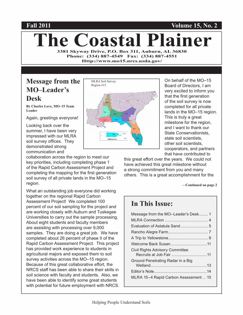
MLRA Soil SurveyRegion #15
Message from the MO–Leader’s DeskBy Charles Love, MO–15 Team Leader
Again, greetings everyone!
Looking back over the summer, I have been very impressed with our MLRA soil survey offices. They demonstrated strong communication and collaboration across the region to meet our key priorities, including completing phase 1 of the Rapid Carbon Assessment Project and completing the mapping for the first generation soil survey of all private lands in the MO–15 region.
What an outstanding job everyone did working together on the regional Rapid Carbon Assessment Project! We completed 100 percent of our soil sampling for the project and are working closely with Auburn and Tuskegee Universities to carry out the sample processing. About eight students and faculty members are assisting with processing over 9,000 samples. They are doing a great job. We have completed about 26 percent of phase II of the Rapid Carbon Assessment Project. This project has provided work experience to students in agricultural majors and exposed them to soil survey activities across the MO–15 region. Because of this great collaborative effort, the NRCS staff has been able to share their skills in soil science with faculty and students. Also, we have been able to identify some great students with potential for future employment with NRCS.
On behalf of the MO–15 Board of Directors, I am very excited to inform you that the first generation of the soil survey is now completed for all private lands in the MO–15 region. This is truly a great milestone for the region, and I want to thank our State Conservationists, state soil scientists, other soil scientists, cooperators, and partners that have contributed to
this great effort over the years. We could not have achieved this great milestone without a strong commitment from you and many others. This is a great accomplishment for the
—Continued on page 2
Helping People Understand Soils
In This Issue:Message from the MO–Leader’s Desk ........ 1MLRA Connection ....................................... 4Evaluation of Astatula Sand ......................... 5Rancho Alegre Farm .................................... 7A Trip to Yellowstone .................................... 8Welcome Back Susan .................................11Civil Rights Advisory Committee
Recruits at Job Fair ................................11Ground Penetrating Radar in a Big
Wetland ...................................................13Editor’s Note................................................14MLRA 15–4 Rapid Carbon Assessment ... 15
2 The Coastal Plainerbenefit of natural resources in the region and is something we can all be proud of. Of course, we are still working hard to finish the American Indian and Federal lands in the region in the very near future.
Well, what’s next for the MO–15 soil survey program? I am glad you asked. We want to complete an evaluation and harmonization initiative of the soil survey information from the first generation of the soil survey program. The first step of the phase I initiative for the MLRA update concept is to identify inconsistencies that require little or no fieldwork to correct and that can be addressed using the MLRA update approach. We want to use a “do no harm approach” for harmonizing information between soil survey offices. The technical teams will definitely need to help with soil data re-correlations. Then we will proceed to refresh the NASIS database with known soil information. The Soil Survey Division is asking us to complete phase I within the next 3 years. I really think we can accomplish this regional priority as well as maintain a good workflow of some of our existing project plans from the MLRA soil survey offices. So, join me in kicking off the first part of the next generation of MO–15 soil survey updates.
We here at MO–15 have had some great brainstorming sessions leading to the development of a comprehensive workflow chart for project plans. The chart documents our method for obtaining the board of director’s approval for implementing MLRA-based project plans in the region. This workflow method ensures that all draft MLRA SSO project plans undergo quality control and quality assurance before being sent to the board for approval and that the plans are properly populated in NASIS. (See next page.) This workflow chart really gives us a good vision of project planning processes throughout the region.
During fiscal year 2011, we held a number of meetings, conferences, and teleconferences that contributed to strong communication, including state soil survey work planning conferences, meetings and teleconferences in
support of the rapid carbon assessment and the ecological site inventory, and meetings of the Board of Directors, management teams, technical teams, and MLRA soil survey leaders. During fiscal year 2012, we will expand the use of teleconferences.
I have asked Scott Anderson, senior regional soil scientist, to conduct quarterly teleconferences with the MLRA soil survey leaders. The teleconferences will help monitor milestones of the evaluation and harmonization project plans for each MLRA soil survey office. These meetings will also serve as a collective voice from the MLRA soil survey leaders to the management team.
We want to welcome the new ecological site inventory (ESI) specialists in the region. They are Dee Pederson, Athens, Georgia; Susan Carr, Tavares, Florida; and Karrie Pennington, Jackson, Mississippi. The ESI quality-control specialist position at Auburn has been advertised and should be filled by the end of December. Also, the MO–15 management team has drafted a proposal for identifying areas of responsibilities for the ecological site inventory specialists by MLRA and MLRA SSO. The management team envisions the nine MLRA SSOs and the ecological site inventory specialists collaborating on all phases of the inventory for developing ecological site descriptions across the region. Before implementation, the proposal for the areas of responsibilities will be presented to the Board of Directors for review and approval.
I know we will continue with strong communication and collaboration as we move forward with the MLRA update and maintenance. We will meet the exciting challenges of the next generation soil survey program across the MLRA soil survey office boundaries and across our MO boundaries in the southeast.
As always, thank you for your support.
—Charles
Helping People Understand Soils
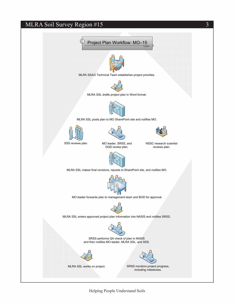
MLRA Soil Survey Region #15 3
MLRA SSL drafts project plan in Word format.
MLRA SSL posts plan to MO SharePoint site and notifies MO.
NSSC research scientistreviews plan.
SSS reviews plan.
MLRA SSL makes final revisions, reposts to SharePoint site, and notifies MO.
MO leader forwards plan to management team and BOD for approval.
MLRA SSL enters approved project plan information into NASIS and notifies SRSS.
1/12/2011
Project Plan Workflow: MO–15
MLRA SSL works on project.
MO leader, SRSS, andDQS review plan.
SRSS performs QA check of plan in NASISand then notifies MO leader, MLRA SSL, and SSS.
SRSS monitors project progress,including milestones.
MLRA SSAO Technical Team establishes project priorities.
Helping People Understand Soils
4 The Coastal Plainer
Helping People Understand Soils
MLRA Connection: Field Reviews under the MLRA ConceptBy Scott Anderson, Senior Regional Soil Scientist, MO–15
Field reviews and field assistance visits will continue to be integral part of soil survey work under the MLRA concept. Formal reviews promote progressive correlation, maintain quality control and quality assurance, and ensure that technical standards are met. However, the number and intensity of these reviews will be quite different from those covering initial soil survey projects.
Initial soil survey projects and update projects requiring “extensive revision” (usually complete remapping) still require formal field reviews at the initial, progress, and final stages. See part 609 of the National Soil Survey Handbook (NSSH). MO–15 also requires a final correlation conference for these type of surveys. The MO senior regional soil scientist (SRSS) conducts these reviews. He also prepares and distributes the review reports and final correlation documents.
MLRA update projects will have a more loosely defined review process, which will depend on the type of project. For example, a simple “harmonization” project involving only literature review and NASIS work would not justify expenditure of funds for a formal field review. The MO can easily provide guidance and conduct a QA review remotely. Projects involving significant recorrelation, however, will require actual onsite field reviews. The number and intensity of field reviews will be worked out between the soil survey office (SSO) leader and the SRSS at the beginning of each project.
We also need to discuss the differences between quality control reviews, quality assurance reviews, and field assists.
Quality control (QC) is the first cut of official review. Whenever spatial or tabular soils data is changed, the data need a 100 percent QC review by the MLRA SSO leader (NSSH, parts 609 & 610). The SSO leader is the correlator!
QC reviews can be conducted at any time but must be conducted at the completion of a project. The SSO leader conducts all QC reviews and certifies QC is completed by populating the “Data Mapunit Certification” table in NASIS. In MO–15, we also require the SSO leader to send a QC certification letter with supporting documentation to the SRSS at the completion of the project. MO staff are not required to be present for QC reviews.
Once the SRSS receives the QC certification letter, the project data receives a quality assurance (QA) review by the MO. This review involves an evaluation of the methods used, the final correlation decisions, and the final tabular and spatial products. The MO ensures that the policies and procedures of the National Cooperative Soil Survey (NCSS) are followed and certifies that the completed work meets NCSS standards. QA certification is populated in the appropriate NASIS tables and documented by letter. QA reviews may be handled in the field or in-house at the MO, depending on the complexity of the project.
Sometimes an SSO leader comes across a particularly difficult correlation situation that requires a field assist visit. The MO will make every effort to provide as much field assistance as our budget allows. SSO leaders should, however, first exhaust all other options, such as contacting adjacent SSO leaders or resource soil scientists who may have experienced similar situations.
Parts 609 and 610 of the NSSH provide guidance for conducting field reviews. Please refer to these sections for more information. In addition, there are several exhibits in the NSSH that are worth looking over:
• “Project Review Checklist for MLRA Soil Surveys” (Exhibit 609-6)
• “Quality Assurance Worksheet for Initial Soil Surveys and for Update Soil Surveys Requiring Extensive Revision” (Exhibit 609-8)
• “Quality Assurance Worksheet for MLRA Soil Surveys” (Exhibit 609-9)
—Continued on page 5
MLRA Soil Survey Region #15 5
Helping People Understand Soils
Now, let’s get real. In MO–15, we have about 15 MLRA projects in various stages of approval. We still have initial and extensive-update work going on. Who out there thinks we will have the money in the fiscal year 2012 budget for 15 or more weeks of travel for field reviews and field assists? I don’t think so. I think the reality is that we will only be able to afford travel for the initial and extensive-revision projects.
It’s time to start thinking outside the box. Not all MLRA soil survey projects require a formal field visit by the MO. We can have teleconferences, we can have net-meetings, or the SSO leader
can just send in a final QC/project report with supporting data.
When we do come out on a field visit, we need the SSO leader to make the best use of our time. We need to review as many different projects and correlation issues as possible. We need to see as much as we can because we probably won’t be back for another year. The SSO leaders should plan for us to stay in the field for most of the field review. The rest we can handle via telecommunication as necessary.
Evaluation of Astatula Sand in the South-Central Florida RidgeBy the Tavares MLRA Team: Julie Ruh, Alison Steglich, and Manuel Matos
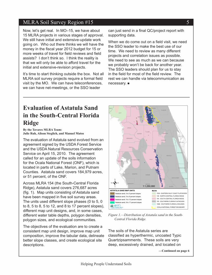
The evaluation of Astatula sand evolved from an agreement signed by the USDA Forest Service and the USDA Natural Resources Conservation Service on April 15, 2010. The agreement called for an update of the soils information for the Ocala National Forest (ONF), which is located in parts of Lake, Marion, and Putnam Counties. Astatula sand covers 184,979 acres, or 51 percent, of the ONF.
Across MLRA 154 (the South-Central Florida Ridge), Astatula sand covers 276,687 acres (fig. 1). Map units consisting of Astatula sand have been mapped in five soil survey areas. The units used different slope phases (0 to 5, 0 to 8, 5 to 8, 5 to 12, and 8 to 17 percent slopes), different map unit designs, and, in some cases, different water table depths, polygon densities, polygon sizes, and ecological communities.
The objectives of the evaluation are to create a consistent map unit design, improve map unit composition, improve the tabular data, delineate better slope classes, and create ecological site descriptions.
—Continued on page 6
The soils of the Astatula series are classified as hyperthermic, uncoated Typic Quartzipsamments. These soils are very deep, excessively drained, and located on
POLK
LAKE
MARION
LEVY
OSCEOLA
VOLUSIA
ORANGE
PASCO
HIGHLANDS
BREVARD
CITRUS
MANATEEHARDEE
SUMTER
HILLSBOROUGH
DESOTO
OKEECHOBEE
HERNANDO
SARASOTA
FLAGLER
SEMINOLE
ST. LUCIE
INDIAN RIVER
PINELLAS
PUTNAMDIXIE
GLADES
ALACHUA
MARTIN
BREVARD
BREVARD
. 1:1,250,000
MLRA152A - EASTERN GULF COAST FLATWOODS
138 - NORTH-CENTRAL FLORIDA RIDGE
154 - SOUTH-CENTRAL FLORIDA RIDGE
155 - SOUTHERN FLORIDA FLATWOODS
156B - SOUTHERN FLORIDA LOWLANDS
ASTATULA SAND MAP UNITSAstatula sand, 0 to 5 percent slopes
Astatula sand, 0 to 8 percent slopes
Astatula sand, 5 to 12 percent slopes
Astatula sand, 8 to 17 percent slopes
OCALA NATIONAL FOREST BOUNDARY
ONF
Figure 1.—Distribution of Astatula sand in the South-Central Florida Ridge.
6 The Coastal Plainer
—Continued on page 7
Helping People Understand Soils
broad ridges adjacent to sinks and small lakes (https://soilseries.sc.egov.usda.gov/OSD_Docs/A/ASTATULA.html). These soils formed in sandy marine, eolian, or fluvial sediments. They are considered limited for supporting production of specialty crops and have very low natural fertility. This series, however, supports the largest sand pine ecosystem in the world. The Sand Pine Scrub ecological community is one of the oldest ecosystem types in Florida, and 40 to 60 percent of the plants and animals are considered endemic species. Additional information about this unique ecological community is available at http://www.ocala.com/article/20080218/NEWS/802180315.
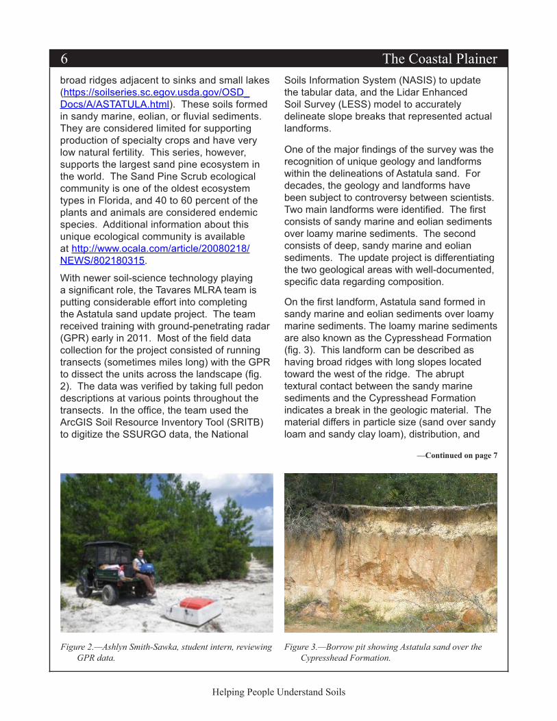
With newer soil-science technology playing a significant role, the Tavares MLRA team is putting considerable effort into completing the Astatula sand update project. The team received training with ground-penetrating radar (GPR) early in 2011. Most of the field data collection for the project consisted of running transects (sometimes miles long) with the GPR to dissect the units across the landscape (fig. 2). The data was verified by taking full pedon descriptions at various points throughout the transects. In the office, the team used the ArcGIS Soil Resource Inventory Tool (SRITB) to digitize the SSURGO data, the National
Soils Information System (NASIS) to update the tabular data, and the Lidar Enhanced Soil Survey (LESS) model to accurately delineate slope breaks that represented actual landforms.
One of the major findings of the survey was the recognition of unique geology and landforms within the delineations of Astatula sand. For decades, the geology and landforms have been subject to controversy between scientists. Two main landforms were identified. The first consists of sandy marine and eolian sediments over loamy marine sediments. The second consists of deep, sandy marine and eolian sediments. The update project is differentiating the two geological areas with well-documented, specific data regarding composition.
On the first landform, Astatula sand formed in sandy marine and eolian sediments over loamy marine sediments. The loamy marine sediments are also known as the Cypresshead Formation (fig. 3). This landform can be described as having broad ridges with long slopes located toward the west of the ridge. The abrupt textural contact between the sandy marine sediments and the Cypresshead Formation indicates a break in the geologic material. The material differs in particle size (sand over sandy loam and sandy clay loam), distribution, and
Figure 2.—Ashlyn Smith-Sawka, student intern, reviewing GPR data.
Figure 3.—Borrow pit showing Astatula sand over the Cypresshead Formation.

MLRA Soil Survey Region #15 7
Helping People Understand Soils
mineralogy (siliceous over siliceous-kaolinitic-iron oxide). Based on studies by the University of Florida, the top of the Cypresshead Formation exhibits evidence of clay movement that represents a horizon associated with an older, eroded soil.
On the second landform, Astatula sand formed in deep, sandy marine and eolian sediments (beaches, ridges, and dunes of the Quaternary to Pleistocene/Holocene). This landform can be described as having transverse dune patterns
Georgia Producer Highlight: Rancho Alegre FarmBy Cindy Haygood, Chairperson, Georgia NRCS Civil Rights Advisory Committee, and Chris Groskreutz, Georgia Hispanic Special Emphasis Program Manager
The Georgia Civil Rights Advisory Committee strives to ensure equitable program delivery to all NRCS customers. We have all had the opportunity to meet and interact with a wonderfully diverse group of farmers and landowners across the state. Although we may all have different backgrounds, we are obviously linked by our common love for the land and our passion for agriculture.
Because National Hispanic Heritage Month was honored recently (September 15th to October 15th), I’d like to take this opportunity to introduce you to the Quintero family. First-generation farmers Pilar and Juan Quintero started their farm in 2004 after acquiring a 21-acre event center in Gwinnett County, Georgia. After being inspired by farmers in their native Colombia, they realized the potential of agritourism and have developed the “Rancho Alegre Farm.” They soon delved into raising Paso Fino horses and offering riding lessons and later transitioned into producing and marketing locally grown and organic fruits and vegetables. They also host educational events for the public as well as private special events.
Pilar and Juan are originally from Colombia, but their three sons were born in the United States.
They have lived in Gwinnett County (a booming suburb about 30 miles northeast of Atlanta) since Pilar was 7 years old. Pilar says, “Even though farming and agriculture is very strong in our country, neither my husband nor I had ever farmed before.” They were greatly influenced by family and friends in agricultural operations in Colombia. In addition to their Paso Fino operation, Pilar and Juan now have a large garden that uses organic practices; they raise milk cows, goats, meat chickens, and layers; and they grow worms and make compost. They also have plans to expand soon.
The Quintero family enjoyed partnering with the Upper Ocmulgee River RC&D Council to
with short slopes located toward the east of the ridge.
The work of the Tavares MLRA team using GPR, ArcGIS technology, soils data, and geology data has made the Astatula sand update move swiftly. The team anticipates delivery of the updated project by the scheduled due date (December 31, 2011). The data should be available from the Soil Data Mart and Web Soil Survey by the beginning of the second quarter of fiscal year 2012.
The Quintero family.
—Continued on page 8
8 The Coastal Plainer
Helping People Understand Soils
host an equine management workshop as well as developing and implementing their NRCS-developed conservation plan. They have participated in the EQIP program to enhance the farm’s natural resources and reduce the impact of their livestock. Pilar states, “We have had lots of visits from NRCS on ways to improve our natural resources, of which I am very passionate about.”
Civil rights is more than just equal opportunity…it’s about celebrating our diversity and rich heritages and sharing experiences. For more information on the Georgia NRCS Civil Rights Advisory Committee and Georgia civil rights programs, feel free to visit our Web site at http://www.ga.nrcs.usda.gov/about/civilrights/crindex.html or call Chairperson Cindy Haygood at (770) 832–8942 (ext. 3).
A Trip to YellowstoneBy Gregory R. Brannon, Soil Data Quality Specialist; Sandy Page, Soil Scientist; and Joey Koptis, District Conservationist
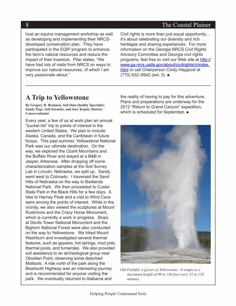
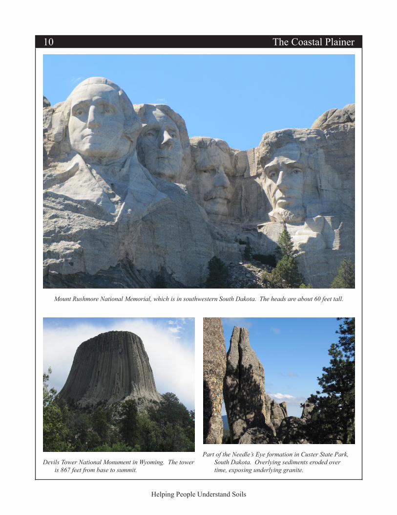
Every year, a few of us at work plan an annual “bucket list” trip to points of interest in the western United States. We plan to include Alaska, Canada, and the Caribbean in future forays. This past summer, Yellowstone National Park was our ultimate destination. On the way, we explored the Ozark Mountains and the Buffalo River and stayed at a B&B in Jasper, Arkansas. After dropping off some characterization samples at the Soil Survey Lab in Lincoln, Nebraska, we split up. Sandy went west to Colorado. I traversed the Sand Hills of Nebraska on the way to Badlands National Park. We then proceeded to Custer State Park in the Black Hills for a few days. A hike to Harney Peak and a visit to Wind Cave were among the points of interest. While in the vicinity, we also viewed the sculptures at Mount Rushmore and the Crazy Horse Monument, which is currently a work in progress. Stops at Devils Tower National Monument and the Bighorn National Forest were also conducted on the way to Yellowstone. We hiked Mount Washburn and investigated several thermal features, such as geysers, hot springs, mud pots, thermal pools, and fumaroles. We also provided soil assistance to an archeological group near Obsidian Point, observing some disturbed Mollisols. A ride north of the park along the Beartooth Highway was an interesting journey and is recommended for anyone visiting the park. We eventually returned to Alabama and
the reality of having to pay for this adventure. Plans and preparations are underway for the 2012 “Return to Grand Canyon” expedition, which is scheduled for September.
Old Faithful, a geyser at Yellowstone. It erupts to a maximum height of 90 to 184 feet every 35 to 120 minutes.

MLRA Soil Survey Region #15 9
Helping People Understand Soils
Badlands National Park, South Dakota. The stratification is the result of the geologic processes that influenced the region. The oldest rocks exposed in the park are sediments that accumulated beneath the Western Interior Seaway, an inland sea that intermittently inundated much of central North America during the Cretaceous Period. The inland sea drained as the Rocky Mountains and Black Hills formed.
Grand Prismatic Spring, which is the largest hot spring in the United States and the third largest in the world. The vivid colors are the result of multi-colored Archaea, which are single-celled microorganisms that grow around the edges of the mineral-rich water. The Archaea produce colors ranging from green to red, depending on the ratio of chlorophyll to carotenoids and the temperature of the water.
10 The Coastal Plainer
Helping People Understand Soils
Mount Rushmore National Memorial, which is in southwestern South Dakota. The heads are about 60 feet tall.
Part of the Needle’s Eye formation in Custer State Park, South Dakota. Overlying sediments eroded over time, exposing underlying granite.
Devils Tower National Monument in Wyoming. The tower is 867 feet from base to summit.
MLRA Soil Survey Region #15 11
Helping People Understand Soils
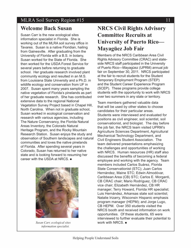
Welcome Back SusanSusan Carr is the new ecological sites information specialist in Florida. She is working out of the MLRA soil survey office in Tavares. Susan is a native Floridian, hailing from Gainesville. After graduating from the University of Florida with a B.S. in botany, Susan worked for the State of Florida. She then worked for the USDA Forest Service for several years before returning to graduate school. Her graduate research involved plant community ecology and resulted in an M.S. from Louisiana State University and a Ph.D. in wildlife ecology and conservation from UF in 2007. Susan spent many years sampling the native vegetation of Florida’s pinelands as part of her graduate research. She has contributed extensive data to the regional National Vegetation Survey Project based in Chapel Hill, North Carolina. When not in graduate school, Susan worked in ecological conservation and research with various agencies, including The Nature Conservancy, the Florida Natural Areas Inventory, the Colorado Natural Heritage Program, and the Rocky Mountain Research Station. Susan enjoys the study and observation of Southern landscapes and natural communities and loves the native pinelands of Florida. After spending several years in Colorado, Susan has returned to her native state and is looking forward to resuming her career with the USDA at NRCS.
Susan Carr, ecological sites information specialist.
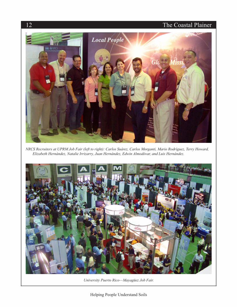
NRCS Civil Rights Advisory Committee Recruits at University of Puerto Rico—Mayagüez Job FairMembers of the NRCS Caribbean Area Civil Rights Advisory Committee (CRAC) and state-side NRCS staff participated in the University of Puerto Rico—Mayagüez (UPRM) annual job fair on September 30, 2011. NRCS participated at the fair to recruit students for the Student Temporary Employment Program (STEP) and the Student Career Experience Program (SCEP). These programs provide college students with the opportunity to work with NRCS over two summers in any state or territory.
Team members gathered valuable data that will be used by other states to choose candidates for their particular areas. Students were interviewed and evaluated for positions as civil engineer, soil scientist, soil conservationist, and biologist. The day before the job fair, the NRCS team visited UPRM’s Agriculture Sciences Department, Agricultural Mechanical Technology Department, and Civil Engineers Student Association. The team delivered presentations emphasizing the challenges and opportunities of working with NRCS. Human resources (HR) staff also discussed the benefits of becoming a federal employee and working with the agency. Team members included Carlos Suárez, Florida State Conservationist (STC); Juan Carlos Hernández, Maine STC; Edwin Almodóvar, Caribbean Area (CB) STC; Carlos E. Morganti, CB CRAC chair; Mario Rodríguez, CB CRAC vice chair; Elizabeth Hernández, CB HR manager; Terry Howard, Florida HR specialist; Luis Hernández, Arkansas state soil scientist; Natalie Irizarry, Wisconsin Hispanic emphasis program manager (HEPM); and Jorge Lugo, CB HEPM. Over 350 students visited the NRCS booth and received information on work opportunities. Of these students, 65 were interviewed to further evaluate their potential to work with NRCS.
12 The Coastal Plainer
Helping People Understand Soils
NRCS Recruiters at UPRM Job Fair (left to right): Carlos Suárez, Carlos Morganti, Mario Rodríguez, Terry Howard, Elizabeth Hernández, Natalie Irrizarry, Juan Hernández, Edwin Almodóvar, and Luis Hernández.
University Puerto Rico—Mayagüez Job Fair.
MLRA Soil Survey Region #15 13
Helping People Understand Soils
Ground Penetrating Radar in a Big WetlandBy Howard Yamataki, MLRA Leader, MLRA Soil Survey Office 15–8, Fort Myers, Florida, and Martin Figueroa, MLRA Senior Soil Scientist, Fort Myers, Florida
Ground penetrating radar (GPR) has been used for soils work in Florida for over 30 years. Our sandy soils and drained Histosols have been good media for this technology. GPR has been used to help determine composition of map units and to help understand the effects of drainage (especially subsidence) over time. James Doolittle, now a national leader, was one of the pioneers of GPR in Florida.
Despite our successes with GPR, we have always found it challenging to map soils and use GPR in areas with surface water. When we started fieldwork in the Water Conservation Area (WCA) in 2009, we did not use GPR because of these challenges. The WCA is a large area of Histosols underlain by limestone bedrock in the southeastern part of Florida. It is used as an urban water supply and a conservation area. Portions of this large wetland are owned by the State of Florida and by Native American tribes. My office has been charged with mapping the northern part of the area. Our previous bad experiences dragging the GRP over grassy vegetation gave us some doubts about using it in the WCA. But we also realized the technology had advanced over a 30-year period, so in September 2011 we decided to give it a try.
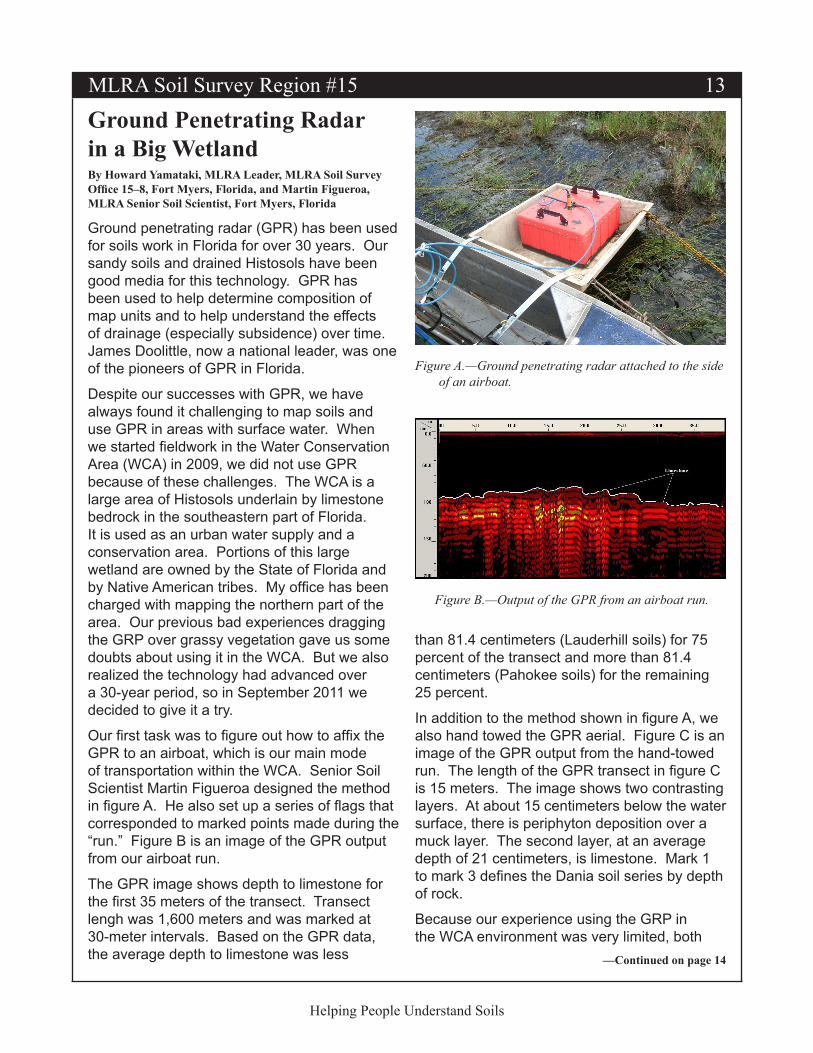
Our first task was to figure out how to affix the GPR to an airboat, which is our main mode of transportation within the WCA. Senior Soil Scientist Martin Figueroa designed the method in figure A. He also set up a series of flags that corresponded to marked points made during the “run.” Figure B is an image of the GPR output from our airboat run.
The GPR image shows depth to limestone for the first 35 meters of the transect. Transect lengh was 1,600 meters and was marked at 30-meter intervals. Based on the GPR data, the average depth to limestone was less
than 81.4 centimeters (Lauderhill soils) for 75 percent of the transect and more than 81.4 centimeters (Pahokee soils) for the remaining 25 percent.
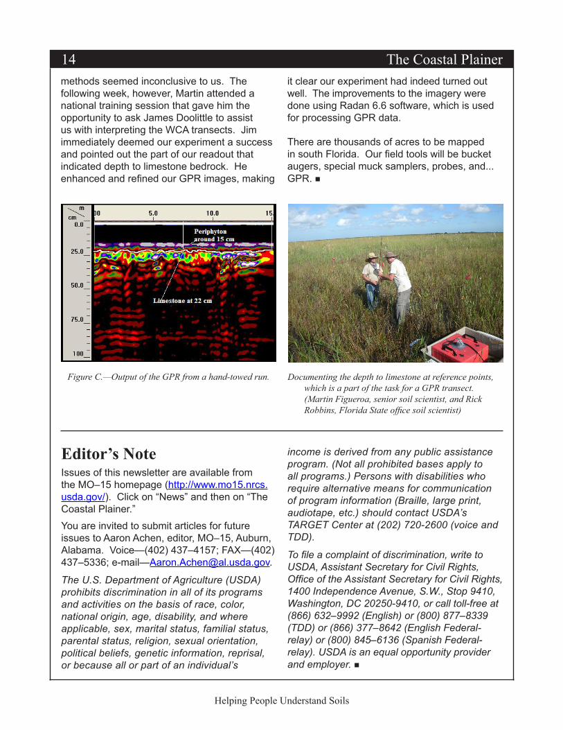
In addition to the method shown in figure A, we also hand towed the GPR aerial. Figure C is an image of the GPR output from the hand-towed run. The length of the GPR transect in figure C is 15 meters. The image shows two contrasting layers. At about 15 centimeters below the water surface, there is periphyton deposition over a muck layer. The second layer, at an average depth of 21 centimeters, is limestone. Mark 1 to mark 3 defines the Dania soil series by depth of rock.
Because our experience using the GRP in the WCA environment was very limited, both
Figure A.—Ground penetrating radar attached to the side of an airboat.
Figure B.—Output of the GPR from an airboat run.
—Continued on page 14
14 The Coastal Plainer
Helping People Understand Soils
methods seemed inconclusive to us. The following week, however, Martin attended a national training session that gave him the opportunity to ask James Doolittle to assist us with interpreting the WCA transects. Jim immediately deemed our experiment a success and pointed out the part of our readout that indicated depth to limestone bedrock. He enhanced and refined our GPR images, making
Documenting the depth to limestone at reference points, which is a part of the task for a GPR transect. (Martin Figueroa, senior soil scientist, and Rick Robbins, Florida State office soil scientist)
Figure C.—Output of the GPR from a hand-towed run.
it clear our experiment had indeed turned out well. The improvements to the imagery were done using Radan 6.6 software, which is used for processing GPR data.
There are thousands of acres to be mapped in south Florida. Our field tools will be bucket augers, special muck samplers, probes, and... GPR.
Editor’s NoteIssues of this newsletter are available from the MO–15 homepage (http://www.mo15.nrcs.usda.gov/). Click on “News” and then on “The Coastal Plainer.”You are invited to submit articles for future issues to Aaron Achen, editor, MO–15, Auburn, Alabama. Voice—(402) 437–4157; FAX—(402) 437–5336; e-mail—[email protected].
The U.S. Department of Agriculture (USDA) prohibits discrimination in all of its programs and activities on the basis of race, color, national origin, age, disability, and where applicable, sex, marital status, familial status, parental status, religion, sexual orientation, political beliefs, genetic information, reprisal, or because all or part of an individual’s
income is derived from any public assistance program. (Not all prohibited bases apply to all programs.) Persons with disabilities who require alternative means for communication of program information (Braille, large print, audiotape, etc.) should contact USDA’s TARGET Center at (202) 720-2600 (voice and TDD).
To file a complaint of discrimination, write to USDA, Assistant Secretary for Civil Rights, Office of the Assistant Secretary for Civil Rights, 1400 Independence Avenue, S.W., Stop 9410, Washington, DC 20250-9410, or call toll-free at (866) 632–9992 (English) or (800) 877–8339 (TDD) or (866) 377–8642 (English Federal-relay) or (800) 845–6136 (Spanish Federal-relay). USDA is an equal opportunity provider and employer.
MLRA Soil Survey Region #15 15
Helping People Understand Soils
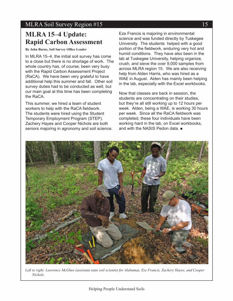
MLRA 15–4 Update: Rapid Carbon AssessmentBy John Burns, Soil Survey Office Leader
In MLRA 15–4, the initial soil survey has come to a close but there is no shortage of work. The whole country has, of course, been very busy with the Rapid Carbon Assessment Project (RaCA). We have been very grateful to have additional help this summer and fall. Other soil survey duties had to be conducted as well, but our main goal at this time has been completing the RaCA.This summer, we hired a team of student workers to help with the RaCA fieldwork. The students were hired using the Student Temporary Employment Program (STEP). Zachery Hayes and Cooper Nichols are both seniors majoring in agronomy and soil science.
Eze Francis is majoring in environmental science and was funded directly by Tuskegee University. The students helped with a good portion of the fieldwork, enduring very hot and humid conditions. They have also been in the lab at Tuskegee University, helping organize, crush, and sieve the over 9,000 samples from across MLRA region 15. We are also receiving help from Alden Harris, who was hired as a WAE in August. Alden has mainly been helping in the lab, especially with the Excel workbooks.
Now that classes are back in session, the students are concentrating on their studies, but they’re all still working up to 12 hours per week. Alden, being a WAE, is working 30 hours per week. Since all the RaCA fieldwork was completed, these four individuals have been working hard in the lab, on Excel workbooks, and with the NASIS Pedon data.
Left to right: Lawrence McGhee (assistant state soil scientist for Alabama), Eze Francis, Zachery Hayes, and Cooper Nichols.