Embed Size (px)
Citation preview

THE COAST GUARD
AT WAR
IV
LORAN
VOLUME II
Prepared in the Historical Section
Public Information Division
U.S. Coast Guard Headquarters
Aug. 1, 1946
NOTE: ETCM Bill Dietz, USCG (Ret.) transcribed the following volume from the Coast
Guard at War official history series and we thank him for his efforts to help preserve the
history of Coast Guard LORAN activities.
The majority of the images included in the original publication appeared on the even
numbered pages of the book. Unfortunately they were simply mimeographed paper
copies of the original photos and they have faded or were of poor quality originally and
most were therefore not included in this electronic version. Each caption is faithfully
reproduced, however, and if the image is available, please click on the hyper-linked
"Image Caption" to access the image.
TABLE OF CONTENTS
Loran as an aid to navigation....................................................................... 1
The Development of Loran equipment........................................................ 3
First experimental stations................................................................. 5
Early tests............................................................................................. 5
Northwest Atlantic Loran chain......................................................... 7
Loran made responsibility of the Coast Guard............................... 7
Civil engineering aspects of Loran construction................................ 11
Joint Chiefs of Staff lay down Loran program................................... 11
Development of Coast Guard Construction Detachments.......................... 13

Headquarters offices concerned......................................................... 13
Formation of field forces.................................................................... 15
Bering Sea Loran Chain.............................................................................. 19
St. Matthew Island (Unit 5)................................................................. 29
St. Paul Island (Unit 60)...................................................................... 25
Umnak Island (Unit 40)....................................................................... 33
Cape Sarichef (Unit 25).................................................................... 37
St. George Island (Unit 95)............................................................... 37
Western Aleutians Loran chain.................................................................. 41
Attu (Unit 62)...................................................................................... 49
Amchitka (Unit 63)............................................................................ 53
Adak (Unit 64)................................................................................... 47
Hawaiian Islands Loran chain................................................................... 59
French Frigate (Unit 204)................................................................ 63
Niihau (Unit 205)............................................................................... 61
Hawaii (Unit 206).............................................................................. 63
Kauai (Unit 207)................................................................................. 65
Sand Island Depot...................................................................................... 69
Command Unit 203............................................................................. 69
Advanced Base Stating Detachment (Unit 390)................................ 69
Phoenix Loran chain...................................................................................... 77
Baker (Unit 91).................................................................................... 81
Gardner (Unit 92)................................................................................ 89
Atafu (Unit 93)..................................................................................... 95
Canton (Unit 94).................................................................................. 79
- I -
Marshall-Gilbert Islands Loran Chain..........................................................103
Kwajalein Kwadack (Augustine) (Unit 82)........................................109
Majuro Rogeron (Loraine) (Unit 83)..................................................113
Makin Bikati (Varsity) (Unit 84)........................................................113
Majuro Enigu (Marilyn) (Unit 85)........................................................117
Mariana Islands Loran chain........................................................................121
Guam Cocos (Unit 336).....................................................................119
Ulithi (Portangeras Island).................................................................125
Ritidian Point (Guam) (Unit 339)......................................................123
Subic Bay Engineering Base.....................................................................129
Guam Advanced Base.................................................................................135
Command Unit 203............................................................................135
Palau-Morotai Loran chain..........................................................................143
Angaur (Unit 246)...............................................................................145
Pulo Anna (Unit 344)......................................................................... 153
Ngesebus (Pelelio) (Unit 343)...........................................................147

Morotai Pangeo (Unit 345).................................................................153
Japan Loran chain.........................................................................................147
Iwo Jima Kangoku Iwa (Unit 348).....................................................171
Tokyo O Shima (Unit 349)..................................................................187
Okinawa Ichi Banare (Ike Shima) (Unit 350).....................................177
China Sea Loran chain.................................................................................191
Aguni (Unit 437)..................................................................................195
Yonakuni (Unit 416)............................................................................193
Kyushu (Unit 472)...............................................................................193
APPENDICES
Appendix A - Officers who served with Pacific Construction
Detachments..............................................................................................198
Appendix B - List of Loran stations showing name, unit
number, and type of station.......................................................................199
Appendix C - List of Loran stations, showing Construction
Detachment by which built, construction officer in
charge, and officer in charge of manning crew.......................................200
Appendix D - Dates when chains went on air..............................................202
Appendix E - Route of the MENKAR...........................................................203
- II -

Image Caption: MANNER IN WHICH LORAN SIGNALS ARE PROPAGATED
COAST GUARD
CONSTRUCTION DETACHMENTS
in the
PACIFIC THEATRE
SCOPE OF THIS MONOGRAPH
The Coast Guard‟s Construction Detachments, the major portion of which served in the
combat area of the Pacific Ocean, were created for the purpose of carrying out the civil
engineering work necessary to the success of the Loran program. The history of the

Construction Detachments, therefore, is a history of the establishment of Loran stations
as aids to navigation. This monograph lays greatest emphasis upon the civil engineering
aspects of the Loran installations leaving to others the task of preparing a history of the
electronics features of the work. The brief introductory section on the history and
development of Loran serves only to lead up to the principal features of this account.
LORAN AS AN AID TO NAVIGATION
Loran, its name compounded of the initial letters of the words – Long Range Navigation,
is a system whereby a vessel with suitable equipment, comparatively simple to operate,
and with special charts may determine its position even when hundreds of miles from
shore.
This new electronics development is a method of navigation having a long effective
range. It may be used with reliability, as far as approximately 800 miles from the
transmitting station in daytime and 1,400 miles at night. Loran uses a wave length similar
to those used for long range radio communications at night time. Its waves are reflected
from the ionosphere and follow around the earth‟s surface as do the familiar radio
broadcasting waves. The speed and time of travel of these radio waves are very reliable
and stable. One of the basic characteristics f the Loran system is that it utilizes pulse
transmission, which permits measurement of the time of travel of the signals.
- 1 -

Image Caption: A LORAN RECEIVER ABOARD SHIP
-2 -
Navigation with the aid of Loran signals has been demonstrated to be entirely practical.
In this new system, an infinite number of lines of position are laced over the earth‟s
surface by radio. To provide the necessary signals, ground stations are appropriately
located to cover the areas to be served. Two shore stations, operating as a Loran “Pair”,
lay down a set of these lines of position over a portion of the earth. By means of a Loran
receiver-indicator aboard ship, connected to an ordinary antenna, the navigator selects a
pair of signals, depending on the area in which he is operating. The difference in time of
travel of the radio waves from the two ground stations is measured, and a line of position
deduced from this time difference. The time difference, not the direction of the waves, is
the factor that determines the line of position.
Thus, by taking two or more readings on two or more pairs of signals, the navigator may
obtain his fix. The average operator requires approximately 2 minutes to obtain the
readings which provide a line of position. A rotatable antenna is not required, and the
ship (or aircraft) does no sending. Special charts for the areas served by Loran, show the

lines of position necessary to utilize the system. The readings taken from the receiver
aboard ship are plotted on the Loran chart for the determination of the fix.
Loran does not use continuous wave radio transmission, but special types of pulsed
signals. This is probably the most important electronic characteristic of the Loran system.
Pulse transmission systems make possible the measurement of time of travel of radio
signals whereas continuous wave transmission is not suited to such measurement. Loran
is not a radio direction finding system and can more properly be classed as a new system
of radio distance finding. Since the speed of travel of radio waves is much more stable
and reliable than any other radio wave propagation characteristics, this accounts in part
for the high order of accuracy of the Loran system.
THE DEVELOPMENT OF LORAN EQUIPMENT
Loran was developed by the radiation laboratory of the Massachusetts Institute of
Technology during 1941 from ideas proposed earlier, this development work was under
the supervision of the National Defense Research Council.
Specialists working at the Massachusetts Institute of Technology built experimental
models of transmitting and receiving equipment, surveyed sites, installed transmitters,
computed tables, and demonstrated the possibilities of the system. Original experiments,
made in 1941, used frequencies of 2.5 to 8 megacycles with low power. The attemps [sic]
to obtain the desired ground wave were unsatisfactory, but with a frequency of
approximately 2 megacycles, the sky wave was deemed practical.
- 3 -

Image Caption: LORAN SIGNALS ARE A FORM OF TRIANGULATION
-4 -
FIRST STATIONS BUILT

First experimental transmitting stations were located at Montauk Point, Long Island, and
Fenwick, Delaware, in two abandoned Coast Guard lifeboat stations. These stations
operated on 1950 kilocycles, 25 pulses per second, specific pulse recurrence rate 0.
Synchronization of the stations was attempted in December, 1941; success was attained
by January, 1942, when the observers went to Bermuda to test the effectiveness of the
system at long range.
The first demonstration of the use of Loran was made on 12 June, 1942, with a laboratory
model of an LRN receiver and indicator installed on the airship K-2 during a flight south
from Lakehurst along the coast of New Jersey and Delaware to Ocean City, Md. Since
only the Montauk-Fenwick stations were in operation at the time, it was impossible to
obtain fixes. Good ground wave signals were observed, however, to the 250-mile
extremity of the trip. The procedure of homing on a Loran hyperbola was used, and
position-line accuracy of the system along the baseline was verified.
On 4 July, 1943, the first readings from a plane were made on a laboratory built receiver-
indicator installed in a B-24, during a test flight from Boston to Cape Sable, N.S. Good
signals were received and useful data obtained on the range of the signals from stations
M and F.
The first observations from a ship were made on the Coast Guard Cutter MANASQUAN
during a weather cruise off Newfoundland from 18 June to 17 July, 1942. Observations
of both ground and sky wave signals during that period indicated a total range of 1300
nautical miles and an overlap of ground and sky coverage. The results were considered
good enough to warrant the expansion of the system and its recommendation to
navigational agencies.
Experimental service was extended by the construction of a slave station at Baccaro,
Nova Scotia, to operate with a double pulsed master at Montauk Point, on specific pulse
recurrence rate 2. This station was constructed during the late summer, and placed in
service on 1 October, 1942, being operated by the Royal Canadian Navy.
Preliminary tables for the three rates were computed at the Radiation Laboratory during
August, September, ad October, 1942, and were reproduced by hectograph for temporary
experimental use.
On 1 November, 1942, a test flight was made to Bermuda in a PBY for the purpose of
demonstrating the use of Loran in obtaining fixes. Representatives of the Bureau of
Aeronautics, the Radiation Laboratory, the Army Air Forces, and other interested
activities were in the flight party. The demonstration was so successful that the observers
were convinced
- 5 -

Image Caption: AREA SERVED BY THE PACIFIC LORAN STATIONS
-6 -

that Loran could perform an important service in the war effort.
COAST GUARD ASSUMES CONTROL
In 1942, the National Defense Research Committee started the construction of the
Northwest Atlantic Loran chain, and completed it in early 1943.
On 1 January, 1943, the administration of Loran was officially transferred to the Navy.
After a short period of test operation, the Montauk and Fenwick stations were transferred
from the operational cognizance of the Radiation Laboratory to that of the Coast Guard.
Three stations in Nova Scotia had been transferred on 1 October, 1942, to the Royal
Canadian Navy. The Loran chain then stretched from Fenwick, Delaware, to
Fredericksdal, Greenland. This chain provided coverage to points about 600 miles from
continental limits in the daytime, and about 1,400 miles at night. This included coverage
of Davis Strait. Originally no coverage was provided for the Gulf of St. Lawrence.
Monitor stations were established in the United States by the Coast Guard and in Canada
by the Canadian Navy, as soon as the system passed from the experimental stage, early in
1943.
The Coast Guard had been directed on 31 October, 1943, to establish three new stations,
as follows: A single master station at Fredericksdal (Narsak), Greenland; a double slave
at Battle Harbor, Labrador; and a single master at Bonavista, Newfoundland. Siting had
already been done by the Radiation Laboratory, the Royal Canadian Navy, and the
United States Coast Guard during the summer of 1942. Surveys were also made during
November and December to establish coordinates; and in December arrangements were
made by the Division of Research of the Hydrographic Office for the computation of a
table for utilization of the Loran service from stations V-L, at Bonavista and Battle
Harbor.
The Navy had followed the development of the system with interest, through its office of
Research and Inventions. The Hydrographic Office had become concerned at an early
date because of the obvious necessity for the production of special tables and charts. On
13 June, 1942, Comdr. Gordon A. Patterson, USN (ret.), Officer in Charge of the
Division of Research of the Hydrographic Office, and Mr. E. B. Collins, Senior Nautical
Scientist of the Division, had met with Rear Admiral Julius A. Firer, Director of Research
and Inventions, to review progress of Loran. On 29 July a conference of all interested
parties was held. Progress reports given at Nomtack[sic] and Fenwick were in operation;
the Canadians were building two stations in Nova Scotia (Baccaro and Deming) under
the supervision of the Radiation Laboratory; sites had been chosen for stations in
Newfoundland; and Greenland was suggested as a possible location. On 15 August,
1942,
- 7 -
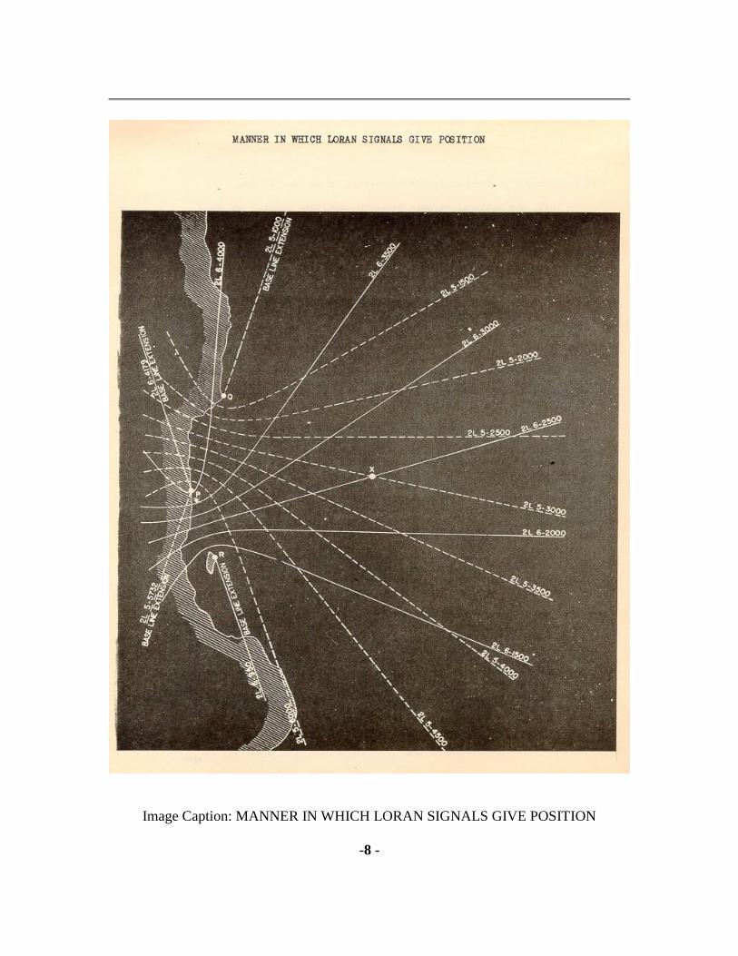
Image Caption: MANNER IN WHICH LORAN SIGNALS GIVE POSITION
-8 -

Dr. Fletcher G Watson, then of the Radiation Laboratory visited the Hydrographic Office
to exhibit sample tables prepared at the Radiation Laboratory and to report on further
developments.
The practicability of Loran as an aid to both surface and air navigation, and particularly
its military value, have been demonstrated, through the erection of stations on the
Atlantic coast, by the Radiation Laboratory of the Massachusetts Institute of Technology,
the Army and Navy assumed cognizance. The Navy became responsible for future Loran
installations and procuring Loran receiving equipment for shipboard use. The Army took
on the work of procuring Loran receiving apparatus for use in planes. Construction and
operation of new Loran stations was assigned to the Coast Guard.
While the first Loran stations were constructed and manned by personnel of the Radiation
Laboratory, this organization soon realized that it had neither the experience or the
personnel to construct and man a large number of such stations, especially if these were
to be located beyond the confines of continental United States.
To provide reliable Loran service from an isolated location, it was necessary that the
units be entirely self sustaining. From experience already gained, it was apparent that a
typical station would consist of several buildings. There was need for a building to house
the technical apparatus and the communications system, a power hut for the Diesel-
electric generators and other parts of the power plant, and a building serving as an office
and as quarters for the officers, and two buildings to be used as crew‟s quarters, mess
hall, galley, and sick bay. In addition, the antenna and ground system for Loran
transmission and receiving consisted of seven 85-foot poles, and various wires and
cables. Sewage disposal arrangements, a water system, and other similar items would
also need to be provided.
As the rapidity with which service could be provided after a new chain of Loran stations
was authorized was of utmost importance, the type of construction would need to be that
lending itself to speedy erection. However, quick construction was not the only important
feature. Reliability of service would depend on careful installation, for the replacement of
parts was a difficult and time consuming process. Too, the crews would live for many
months under conditions of extreme isolation. Extremes of climate were also to be
expected for most stations would be either close to the Arctic circle or the equator.
There was some difference in the technical equipment of the various types of Loran
stations. A double master station would have one transmitter and one timer for each
“rate”, with a duplicate of each of these pieces of equipment on standby service. A slave
station would have one transmitter and one timer, with spares for each of these. A
monitor station would require a receiver-indicator, and would have four or five of these.
All types of stations would have substantially the same power requirements.
- 9 -

Image Caption: SEQUENCE OF OPERATION OF LORAN STATION.

-10 -
The antenna and ground systems would alike for all but the monitor stations, which
required less elaborate equipment of this type.
CIVIL ENGINEERING ASPECTS OF WORK
At this stage it became obvious that there was need for a definite organization for the
building and operating of Loran stations. With the experimental work completed, and
with machinery already in existence through which contracts for equipment could be
awarded, the problem divided itself into two major and several minor parts. Of first
magnitude was the civil engineering work necessary to place such stations in effective
operation in many remote and extremely isolated spots over a large portion of the world.
It was obvious that this engineering work would have to be carried out at great distances
from normal sources of supplies, and also that when the stations were commissioned they
would have to be self sustaining to a high degree. Where the experimental stations has
been hastily constructed with chief thought the prompt testing of the apparatus, the
permanent stations presented many other problems.
The civil engineering aspects of the Loran construction program were turned over to the
Coast Guard‟s civil engineering division, operating under the Engineer in Chief. This
division, had a background of invaluable experience, for many of the small shore stations,
lighthouses, and similar facilities of the Coast Guard had been built under the same type
of conditions to be encountered in erecting Loran stations.
The second major problem was the operation and maintenance of the Loran stations once
they were built. This was a two-fold task, shared by the Coast Guard‟s communications
division and the civil engineering division. Equipment strictly Loran was the
responsibility of the communications engineering group, while buildings, power, and
other equipment, were civil engineering matters.
A general Loran program was laid down by the Joint Chiefs of Staff in November, 1943,
to conform with anticipated military needs. This plan listed various chains of Loran
stations in the forward areas, and indicated the order in which the would probably be
needed. As the war progressed, the Joint Chiefs of Staff indicated which stations were
most urgently needed and thus guided the actual construction program. The Coast Guard,
knowing in advance the probable order in which chains would be needed, anticipated the
individual directives and assembled material and personnel and made most of its
arrangements in advance, greatly shortening the time between the receipt of orders and
the on-the-air date.
In the planning of the Loran system, it was the policy to first establish chains in the bad
weather areas where military operations were being conducted. On the Atlantic coast, in
Labrador, Newfoundland, and Greenland.

- 11 -
Image Caption: MEN ON WATCH AT TIMER EQUIPMENT AT A LORAN
STATION
-12 -
These stations provided much needed assistance to navigators in areas where celestial
navigation was frequently impossible, and served the major routes of overseas traffic
between the United States and Europe. In the Pacific, the first Loran stations were
constructed in the Bering Sea and among the Aleutian Islands, easily classed as among
the foggiest spots of the world.
Coast Guard headquarters developed two types of personnel for its Loran work.
Construction detachments were formed to handle the actual construction and installation
of the stations, and operating units were created to serve as the permanent crews after the
stations were “on the air”. During the construction period, the operating forces were
merged with those of the construction units, to expedite the building operations. The

Coast Guard crew of the USS MENKAR, after this vessel was assigned to Loran work,
also became a special group experienced in the handling of construction material between
the ship and open beaches.
Officers of all Coast Guard Construction Detachments were under the command of the
Chief of Civil Engineering Division at Headquarters, Captain Ralph R. Tinkham, who
directed the work and operations of the detachments through the Advanced Base Section
of that division, of which his Executive Assistant, Lt. Comdr. Edward P. Wagner, was
chief.
The fact that several Divisions of the Navy Department, as well as other Divisions of the
Coast Guard were involved in planning, implementing, and finally operating the system
of Loran chains, required close liaison between all these groups throughout the
construction period. This was effected through representatives of the various divisions
and occasional conferences of their chiefs.
Lt. Comdr. Edward P. Wagner, USCGR, Executive Assistant of the Chief of the Civil
Engineering Division, Coast Guard Headquarters, and chief of its Advance Base Station,
responsible for the procurement and supply for Construction Detachments and for the
construction and installation of all Loran Stations up to the point of final commissioning
in an operating status, represented the Civil Engineering Division of the Coast Guard.
Comdr. Lawrence M. Harding, USCG, Assistant Chief of the Communications
Engineering Division, Coast Guard Headquarters, represented that Division, responsible
for the electronic equipment supplied for Loran Stations.
Comdr. Frederick G. Wild, USCG, represented the Aids to Navigation Division Coast
Guard Headquarters, responsible for operating Loran stations when placed in
commission.
Lt. Comdr. Arthur F. Van Dyke, USNR, represented the office of the Chief of Naval
Operations, responsible for planning Loran Chains for the
- 13 -
Image Caption: LORAN CONSTRUCTION NORTHERN LATITUDES
-14 -
approval of the Joint Chiefs of Staff, and for the development of Loran apparatus.

Four Coast Guard Construction Detachments were organized as the program developed,
each with a commanding officer and an executive officer, and essential field office
personnel. Each detachment was further divided into three sections, each with a
commanding officer and technical assistants, to permit simultaneous construction of three
stations in a chain at widely separated sites. All officers were civil engineers and
experience construction men, and enlisted personnel were selected for experience and
skill in essential trades.
Construction Detachment A (Unit 26) was organized to complete the Bering Sea chain
and to construct the Western Aleutians (Alaska) Loran chain. Subsequently transferred to
the Central Pacific, this construction detachment constructed the Marshall Island chain
and later performed the work of converting the previously completed Hawaiian, Phoenix,
and Marshall chains from DC to AC power.
Construction Detachment B (Unit 192)* [*The work of this detachment is not covered in
the present history] was organized to carry out work on the Atlantic Coast. It stood in
readiness to extend Loran coverage in the eastern Atlantic for European combat
operations, and subsequently installed new stations in Newfoundland and on the
southeast Atlantic Coast of the United States. After V-J Day this construction detachment
was assigned to the construction of the United States Pacific coast Loran chain.
Construction Detachment C (Unit 80) built the Hawaii chain, the Mariana Islands chain,
and the Japan chain.
Construction Detachment D (Unit 211) built the Phoenix Islands chain, Palau-Morotai
chain, and the China Sea chain.
The Command Unit of the Coast Guard Construction Detachments of the Pacific Ocean
areas (Unit 203) was organized to direct field operations of Construction Detachments A,
B, and D, and maintain liaison with CinPac & CincPoa USN, therefore its headquarters
were first at Honolulu, Hawaii, and then at Guam. Lt. Comdr. John F. Martin was the first
commanding officer, and on 17 September, 1944, was relieved by Lt. Comdr. (later
Commander) Kenneth W. Donnell, who completed the program in the Pacific.
Construction Detachment Supply Base (Unit 290) was established at Sand Island,
Honolulu Harbor.
From their inception until the close of the war, Loran activities were designated as “Top
Secret” or “Secret”. Comparatively few persons in the
- 15 -
Image Caption: LORAN STATION ON ATTU ISLAND, ALASKA

-16 -
Coast Guard, outside the divisions directly involved, were aware of this new electronic
development and of the plans for providing coverage of a large portion of the world with
these signals. Necessary as was the secret designation of the work, it acted, many times,
as a handicap, for in dealing with multitude of military commands, the Loran
construction personnel were not always able to clearly indicate the nature of their work,
and thus demonstrate the need for prompt cooperation. Too, the Coast Guard‟s Loran
personnel served throughout the entire war with no public recognition, for the very
existence of this work remained largely unknown.
- 17 -
Image Caption: LOCATION OF THE BERING SEA LORAN STATIONS
-18 -

ST. MATTHEW ISLAND Unit 5 Single Slave
ST PAUL ISLAND Unit 60 Double Master
UMNAK ISLAND Unit 40 Single Slave
CAPE SARICHEF Unit 25 Monitor
ST GEORGE ISLAND Unit 95 Monitor
Built by
Construction Detachment A (Unit 26)
BERING SEA LORAN CHAIN
The first full-scale program for the establishment of a chain of Loran stations, in which
the Coast Guard undertook both construction and operation was the erection of the
Bering Sea Loran chain in western Alaska. At this time Loran was no longer considered
as experimental but as having been developed to a point where it was entirely practicable
as an aid to both air and surface navigation over long distances.
The Bering Sea area was one where normally there were prolonged periods of bad
weather which hampered navigation, and one in which both the Army and Navy were
operating, being the confronted with the problem of dislodging the Japanese in the
western-most island of the Aleutian chain, and making full use of the Alaska area for
military activities directed toward the western Pacific. The Aleutians, while the fact was
not generally realized, lay very close to the most direct route from United States ports to
Japan.
During September, 1942, a survey party, made up of representatives of the Army Air
Force, the Coast Guard, and the Radiation Laboratory went into the Bering Sea and
selected sites on St. Matthew, St Paul, and Umnak Islands. The Coast Guard was directed
on 28 January, 1943, to establish stations on each of these sites.
With this directive in hand, Coast Guard Headquarters organized a special detachment for
the purpose of constructing and manning the stations. There was to be one officer and 18
men for each of the slave stations, and 7 men at the monitor station. These permanent
manning crews were to be used also as the construction force. At this time the Coast
Guard construction detachments having sole function of building stations had not yet
been organized.
The selection of men for the construction and manning force to build and operate the
Bering Sea Loran chain was carried out largely by the
- 19 -

Image Caption: LANDING SUPPLIES AT AN ALASKA LORAN STATION
-20 -
Coast Guard Headquarters Office of Personnel, of which the Training Division was a
part. Later, as the various construction detachments were formed, and additional Loran
stations were completed, this supplying of personnel became very important to the Loran
program.
BERING SEA NETWORK AUTHORIZED
In January, 1943, Lt. Comdr. John F. Martin, USCGR, was designated as commanding
officer, and as a preliminary was assigned to the Massachusetts Institute of Technology
for a short course in Loran work. An order of 19 February, called for carrying on
construction work simultaneously at four sites, and directed that the work be expedited.
One of the first problems in undertaking the construction of this Loran chain was the
ordering and assembly of the necessary construction material. As almost all previous
Loran field construction had been done by the staff of the Massachusetts Institute of
Technology Radiation Laboratory, and private contractors, Coast Guard personnel were
not familiar with the details. Lists of materials used had not been kept, and it was also
known that conditions in Alaska would be different from those in the North Atlantic
where the earlier stations had been built. Because of a lack of time, a visit to the Atlantic
sites could not be made, and the ordering of materials had to be done solely on the basis
of a report on the nature of the sites made by an officer not trained in engineering.
For the four stations to be constructed, approximately 1400 tons of building material,
electronics equipment, and tools had to be assembled.
Much of the construction equipment and tools was obtained from the Navy Construction
Battalion advance base stock already in California. From the Army were secured some
special foods and clothing developed for life on the northern islands.
Purchasing went on both at Alameda, Calif., and at Seattle, Wash., the latter the port
selected for the final assembly of the cargo. The date set for departure of the construction
materials and the crews for Alaska was 1 April, 1943.
While the construction materials were being assembled, it was also necessary to secure
appropriate personnel, almost all of which would need to have special qualifications in
electrical or mechanical fields. A group of 11 men, then assisting in the construction of a
Loran station on Nantucket Island, Massachusetts, became the nucleus of these crews,
and 35 additional personnel were assigned from the Alameda Training Station, being
selected on the basis of previous construction experience. As construction officers were
required, two civil engineering graduates were assigned. One of these had 8 months‟

experience and service, the other had just been commissioned. They were Ensign David
R. Permar and Ensign John J. O‟Meara.
- 21 -
Image Caption: CONSTRUCTION DIFFICULTIES WERE CHIEFLY THOSE OF
TRANSPORTATION
-22 -
A large group of the personnel who were to operate the Loran equipment after the
stations were commissioned were sent to Loran school, and became available to assist in
assembling and packing the materials and equipment shortly before sailing date.
In anticipation of the operation of Loran stations, and also the use of Loran receiving
apparatus aboard both surface ships and planes of the service, the Coast Guard had
established courses in Loran at the Coast Guard Training Station, Groton, Conn. There
were courses for both officers and enlisted men. Technicians were trained in the
installation, operation, and maintenance of Loran apparatus; while operators received
instruction in the complete operating procedure for all main types of Loran equipment.
Officers were trained in the fundamental principles of Loran, the methods of determining
lines of position by means of Loran signals, and in the operation of Loran transmitting
equipment.
Prior to the sailing of the unit, it developed that an executive officer was needed to handle
the general duties and paper work normal to an independent unit, and Lt. (j.g.) Garrett
Horder was assigned to this post.
A major portion of the materials and equipment, and the crew, departed from Seattle
aboard the USS HENRY FAILING (or JONATHAN HARRINGTON) on 12 April,
1943, for Dutch Harbor in the Aleutian Islands. Dutch Harbor was on the north coast of
Unalaska Island, which placed it about 130 miles off the tip of the Alaska Peninsula.
The Bering Sea Loran group was to consist of three transmitting stations and one monitor
station, on widely separated islands. The locations selected for the stations of this chain
extended from Umnak, about midway of the Aleutian chain, in general northerly line into
the Bering Sea, passing through the Pribilof Islands, to a point about halfway to Bering
Strait. This was a distance of about 550 miles, and all of the islands being about 300
miles from the mainland of Alaska. From Dutch Harbor, Umnak Island was to the
southwest, Cape Sarichef to the northeast, while St. Matthew and St. Paul islands were
further away in the northwest. This was the Dutch Harbor which had been attacked by the

Japanese in June, 1942. St. Paul Island was to be a double master station, St. Matthew
Island and Umnak Island were to be slave stations, and Cape Sarichef a monitor station.
On 20 April, 1943, Lt. Comdr. Martin, the commanding officer of the Loran Detachment,
and Lt. (j.g.) Horder departed from Seattle by plane for Dutch Harbor via Ketchikan. At
Ketchikan details of the work were discussed with Captain Frederick A. Zeusler, USCG,
District Coast Guard Officer of the 17th (Alaska) Naval District, under whose jurisdiction
the station would be operated.
- 23 -
Image Caption: TENT FRAMES FOR A CONSTRUCTION CAMP
-24 -
The ship carrying the construction crew and their material arrived at Dutch Harbor on 25
April, and unloading began at once. An office was established as the headquarters of the
detachment, and CSK James M. Santee placed in charge. It was immediately apparent
that the original site surveys had resulted in somewhat optimistic estimates of the
materials and construction equipment which would be required. One definite need was
for heavier and more tractors than was originally estimated. Some of this additional
equipment was available at Dutch Harbor, which was being used by the Army and Navy
as an assembly base for men and equipment for the campaign to drive the Japanese from
the Aleutians.
During the unloading of the HENRY FAILING, the construction material was divided
up, for dispatch to the four widely separate sites. The Cutter CLOVER* [*CLOVER: A
single screw diesel electric vessel of 935 tons displacement, having a length of 180 feet,
a beam of 37 feet, and a draft of 12 feet.] a vessel designed for the servicing of
navigational aids, had been detailed by Headquarters to carry personnel and materials
from Dutch Harbor to the individual station sites, and was standing by. An examination
of the various sites from the air, by means of the Coast Guard plane, was a preliminary to
the first loading of the CLOVER.
UMNAK LANDING ATTEMPTED
St. Matthew Island was completely inaccessible at this time of year, and ice floes were
still around St. Paul Island, so it was decided to first the landing of materials on Umnak
Island, the most southerly of the sites. It was apparent that some sort of landing barge
would be required for transporting the materials from ship to landing beach and
accordingly, one was requested from the Commander, Alaskan Sector, Admiral John W.
Reeves, Jr. It developed that only three landing barges were in the sector. These were not

available, for they had been shipped from Seattle with cooling water in the engines,
which upon freezing, had done considerable damage. However, the Navy authorities
agreed to release an LCM-2 barge if the detachment could obtain engines. Two Lincoln
Zephyr engines were secured in Seattle and flown to Dutch Harbor. Coast Guard motor
machinist mates installed them in the barge, and on 12 May, 1943, the cutter CLOVER
departed from Dutch Harbor for Umnak Island, with a cargo of equipment and supplies,
and towing the landing barge. Just outside the harbor entrance the barge capsized, it being
towed at too great a speed (10 knots). It was towed back into the harbor, righted, and
work started immediately on tearing down the engines.
LANDING MADE ON ST. PAUL ISLAND
Because of this mishap, and in order not to lose the time which would be required to
recondition the barge, it was decided to postpone the Umnak landing and to undertake a
landing at St. Paul Island (57? N Lat.) where unloading was to be done using barges
belonging
- 25 -
Image Caption: ARRANGEMENT OF TYPICAL EQUIPMENT HUT

-26 -
to the Army garrison on the island. The cutter CLOVER departed on 21 May on the 250
mile journey to St. Paul. Two trips were required to transport the materials and equipment
needed.
St. Paul Island was approximately 14 miles long by 10 miles wide, with most of its very
small pre-war population concentrated at Village Cove, a natural harbor at the south end
of the island. The site selected for the Loran station was on the most westerly point of the
island. From Village Cove to this site a route 16 miles in length, had been selected by the
original siting party. However, a more direct route was surveyed, cutting the distance to 7
miles. A road existed for 2 miles of this latter route, but the balance of the distance was
over rugged terrain, consisting of tundra heavily covered with volcanic boulders.
The material which had to be taken to the site weighed more than 450 tons. There were
the trucks, cranes, bulldozers, concrete mixers, and other heavy items which would be
used during the construction period. There were the Quonset huts, the lumber, cement,
pipe, and other items which would enter into the construction of the various buildings.
There was also the electronic equipment, including the parts for the antenna system, the
transmitters and timers, the switchboards, electric generators, and other items for
completely self-sustaining station.
The site which had been selected for the station was a promontory, with the sea on the its
west and south sides. The shoreline consisted of rocky cliffs and ledges rising to a height
of about 45 feet. All the materials were hauled from the dock to the end of the existing
road by truck. From this point, where a temporary camp was established, to the site, the
supplies were carried on Athey trailers and sledges built by the crew, over rugged rock
terrain. The Army had made available 2 large caterpillar tractors with trailers. Without
this assistance the completion of this station would have been materially delay as the
detachment had only one small tractor, in accordance with siting report
recommendations.
ST. PAUL MATERIALS REACH SITE
With all the construction material on the site, and a temporary camp erected, the
construction crew began the erection of the permanent buildings. At this time heavy snow
covered the entire island, and when it melted the conditions were indescribable. The
antenna towers and the station buildings would be on ground about 60 to 70 feet above
the sea. The station buildings and appurtenances would cover an area approximately 1200
by 1800 feet in size. Ensign Permar was in charge of the construction of this station.
Foundations were placed, bases for the poles of the antenna system prepared, and water
and electric lines placed underground. All this had to be accomplished during alternating
periods of snow and freezing, and warmer and melting weather. Much heavy digging had
to be done, because of the depth to which the frost penetrated in this region.

- 27 -
Image Caption: INVASION OF MOROTAI WHERE A LORAN STATION WAS
LATER ESTABLISHED
- 28 -
When the technical equipment was unpacked, it was discovered that the Loran timers and
transmitters were not in good shape. Defective parts and poor connections caused trouble,
and because of a shortage of spare parts and test equipment, considerable difficulty was
encountered in getting both this and the Umnak Island station on the air. This situation
became so acute that the commanding office of the Loran Detachment flew to Seattle and
brought all the resistors, condensers, and other small electrical parts available, in an effort
to remedy the situation. The technicians did valiant work in assembling and testing this
Loran equipment.
PBY-189 ASSIGNED
On 31 May. 1943, Coast Guard plane PBY-189, under command of Lt. Comdr. Richard
Baxter, Pilot, and Ensign Harold Bennett, Co-Pilot, reported for duty, having been
assigned by Headquarters to transport the commanding officer of the Loran Detachment,
mail, personnel, supplies, and materials, to the various sites, to expedite the construction.
An inspection of the sites for the Loran stations where construction had not started, was
made as soon as weather conditions permitted. These inspections furnished a good idea of
the problems involved in the landing of materials and the construction of the stations.
ST. MATTHEW ISLAND LANDING MADE
A particularly close watch was kept on the ice conditions at St. Matthew Island, by
frequent flights of the PBY-189. St. Matthew was the most northerly of the Loran station
sites, being in latitude 68? 30‟ north, which placed it 200 miles north of St. Paul Island
and over 400 miles north of Dutch Harbor. When it was observed that the ice had receded
sufficiently and that the sea was calm, a landing of the plane was risked. The plane was
successfully brought to an anchorage close to where movement had been observed on the
beach. A small boat came out, carrying an Army sergeant. It developed that an Army
weather reporting detachment of nine men under command of a noncommissioned officer
were stationed on the island. They had been placed there in September, 1942, and had not
had mail or supplies since, a period of 8 months.
The site selected for the Loran station was located on the south-western shore of the
island, within a quarter of a mile of a suitable beach landing. It was situated on a 50-foot
bluff overlooking the Bering Sea. The beach at the site was sandy but changed

considerably in shape due to sea conditions. Landing conditions were nearly perfect
immediately after a heavy storm. The island, typical for this area, was a series of rolling
hills covered with tundra. Considerable quantities of ligneous rock are just below the
surface. On the seaward side of the island, numerous sheer cliffs, many of them several
hundred feet in height, drop directly to the water‟s edge, with no beach at all.
- 29 -

Image Caption: MANNER IN WHICH LORAN RATES GIVE POSITION
- 30 -

There was considered wild life on the island at certain seasons of the year, consisting of
white foxes, lemmings, sea fowl of various types, and sea lions near the western end of
the island. There were also 29 reindeer which had been transported here from Nunivak
Island.
The climate was colder than that of the Aleutians. During the summer months there was
an average of only days per month which were even partially clear. Rain or drizzles could
be expected on all except a few days. It was consistently windy. When it rains in any
quantity the whole island was literally a sea of mud since the tundra was thin and the
muskeg beneath, when wet, offered no support to man or machine. Snow ordinarily
began in early October. The population of the island consisted only of the Army weather
detachment.
On the return to the base at Dutch Harbor, plans were immediately made for the landing
on St. Matthew Island. The cutter CLOVER loaded the materials and construction crew,
took the landing barge aboard, and sailed for the island on 17 June, 1943. As snow and
ice covered the site of the Loran station, and the tundra, which was 18 inches to 8 feet
thick and unstable when not frozen, it was necessary to prepare unusually elaborate
foundations for structures. Foundations for six Quonset huts and generators required over
600 sacks of cement. Adverse weather conditions and the 400 mile distance from the base
at Dutch Harbor slowed progress, and the one tractor furnished in accordance with the
siting report was too small. The trail from the landing to the site was over volcanic sand
two to three feet deep in which the small tractor was constantly bogged. The technical
gear was found to be in the same condition as was the case at St. Paul and Umnak Island
and several trips for spare parts were required before the station could begin testing. The
station started testing 11 September, 1943.
During the testing period, five enlisted men set out from St. Matthew Island in a small
surfboat for a trip along the shore to an Army weather station about 9 miles away, to pick
up a small gasoline engine generator. The men, boat, and all equipment disappeared
without a trace, despite the fact that the sea was calm and that they had orders to remain
within 200 yards of the shore. Searching parties failed to find any clue other than a 5-
gallon oil can which was known to have been in the boat. The men lost were:
HAGLUND, Floyd O. (220-806 RM1c; BREIMO, Elmer O. (538-963) Cox. (R); and
MACLEAN, Thomas L. (636-878) Sea.1c (R).
After repairs to the landing barge which had capsized at Dutch Harbor were completed,
plans were made for another attempt at a landing on Umnak Island. Umnak Island was
the next large island to the westward of the Unalaska Island, on which Dutch Harbor was
situated, and from Dutch Harbor to the station site on the westerly end of Umnak was a
trip of about 150 miles. The Cutter CLOVER set out on this journey on 5 June, with
cargo for the construction of the station, and also the construction crew, under
- 31 -

Image Caption: QUONSET HUT FITTED WITH LOOKOUT TOWER
- 32 -
command of Ensign John J O‟Meara aboard. The next day it was skirting the
northwesterly shore of Umnak Island, with its peaks some of them rising to a height of
nearly 7,000 feet; it approached the lower land at the southwesterly end of the island, and
anchored in the cove on which Nikolski Village was located.
SECOND ATTEMPT AT UMNAK LANDING
A landing was made, a temporary camp established in the village, and the cargo gotten to
shore. In getting the construction material ashore, a 16 by 32 foot barge which had been
constructed by carpenters in the crew was used. This barge was towed to and from the
shore by the CLOVER‟s motor launches.
The station site, at Cape Starr, was five miles from the village of Nikolski. Rugged terrain
was encountered and as no road existed, all materials and supplies had to be hauled the
entire distance over tundra. Traveling had to be done either when it was quite dry, or
when it was frozen and without too much snow. In wet weather it was impossible to drive
vehicles over the route. While this station was difficult of access, because of a lack of an
all-weather road, the island could be reached by vessels throughout the entire year, as
later, Army vessels arrived and departed at least once a month, the Army having an air
station here. From this air station, incomplete at the time, in 1942, a squadron of P-40
fighter planes bad knocked down several of the Japanese fighter planes and bombers
which had attacked Dutch Harbor.
The Loran station was located upon a cape, the two sides facing the Bering Sea being at
right angles to each other. From the sea, the land rose abruptly to a knoll having an
elevation of about 300 feet, on which the antenna system was erected. About 200 feet
away and also about 200 feet lower, were the officers and crew‟s quarters, and galley.
The power hut, storage hut, well, and water supply tank were separated from the other
buildings, the entire group of buildings being sufficiently dispersed to reduce the
possibility of damage from bombing. Machine gun emplacements overlooked the two sea
faces of the site.
The stations of this chain began transmitting intermittently in September, but signals
were not immediately accepted as reliable for navigational use. Ten-hour service was
instituted 18 October, 1943; 16-hour service on 10 November; 22-hour service on 1
January, 1944; and 24-hour service on 10 July, 1944.

During the first winter, the operating personnel of the St. Matthew Island station were
able to render satisfactory service despite the difficulties of weather and hasty
construction. Principal source of trouble was the climate. Snow was extremely heavy and
continuous, the station being covered with drifts ranging from 3 to 25 feet in depth during
most of the winter. There were prolonged snow blizzards of hurricane
- 33 -
Image Caption: HEAVY SKID FOR LANDING CARGO ON OPEN BEACHES
- 34 -
velocity, each averaging 10 in length. Several times during these blizzards men lost their
bearings traveling between huts not more than 50 feet apart. Guide ropes and tunnels
through the snow drifts had to be provided.
Early in the winter the water and sewer lines froze up and became useless. Outside heads
had to be built, and for water, it was necessary to melt snow.
During the second summer, various improvements were made in the buildings and
equipment of the station, providing better living conditions. When personnel had a year‟s
service at the station they were relieved before the last supply trip of the season was
made. During the winter of 1944-1945, while technical equipment continued to operate
normally, the station crew had many unusual experiences, including those connected with
the delivery of the mail.
Christmas packages, delivered in December by being dropped by plane at an abandoned
camp several miles from the Loran station, were not recovered until about the first of
April. The unretrieved mail was a subject for constant discussion among the station crew,
for it was so close and yet so far away. One attempt was made in December to recover it,
but because of severe weather conditions, official and first class mail were the only items
which could be carried back to the station at that time. Common desire was to attempt
another trip to get the packages, but this was forbidden by the commanding officer, due
to the danger involved, and inability to supply proper medical treatment in the case of
serious accident or frozen members. The five men lost at this unit in 1943 were lost in an
attempt to get to this camp.
Mail was dropped at this same distant spot again in March, at which time it was
necessary to make another trip, for it was known that Army codes and official mail were
included in the lot. As this was during the coldest part of the winter; the trip was delayed
two weeks hoping for better weather. The expedition was made up of three groups, two
five-man and one twelve-man parties. One five-man group started out pulling the

toboggan loaded with sleeping bags, guns, food, etc. belonging to the twelve-man group.
They pulled the toboggan seven miles to the first hill and then returned to the station to
stand the regular watches. The twelve-man group left about an hour and one half after the
first group left and pulled the toboggan over the hills to the camp. This group remained at
the camp all night, and in the morning began pulling the toboggan , now loaded and
weighting about 500 pounds; back to the station. When they reached the top of the hills
one man was sent ahead to send out the relief crew while the remaining eleven continued.
These eleven men were relieved about three miles from the station by the third group,
another five-man group. It had been planned to move the load a short distance each day,
leaving it and returning to the station. The next day
- 35 -
Image Caption: HEAVY SKID FOR LANDING CARGO ON OPEN BEACHES
- 36 -
it would be moved a bit farther. This would continue until the load was carried over the
entire distance. This was not done, as it would have been impossible to leave a guard, and
the foxes chew to pieces sleeping bags, mail bags and mail if given an opportunity. A
number of the Christmas packages left in December had been destroyed by foxes. A
walkie-talkie radio was carried, but was not practical as the batteries furnishing power
froze about 10 or 15 minutes after departure. There was no communication between the
station and members of the expedition. All mail was recovered with the exception of
magazines and a few packages either destroyed by foxes or belonging to some one not
stationed here.
CAPE SARICHEF STATION BUILT
On 22 July, 1943, the commanding officer of the Loran detachment left Dutch Harbor for
Cape Sarichef, 80 miles to the northeast, to inspect the site where it was planned to erect
the monitor station. There was a light station at this point with sufficient quarters to house
the Loran manning personnel, and this materially lessened the construction problem.
Construction materials for the necessary buildings were landed at the site, and the men of
the construction detachment proceeded with their work. The conditions at the site were
comparatively favorable, and work on the station was completed without incident.
However, due to poor electronic results, this station was decommissioned on 4
December, 1944, when St. George Island took over the monitoring duties.
ST. GEORGE ISLAND BECOMES MONITOR

The monitor station of this group, at Cape Sarichef, having proven unsatisfactory from an
electronic point of view, surveys were ordered to determine a more suitable location. On
8 and 9 July, 1944, a party which, included several radio technicians, and a group from
the Cutter CLOVER, set up a temporary monitor station on St. George Island, one of the
Pribilof group, with which they observed the signals of the Loran rates one and two. The
location of this temporary installation was on a knoll to the southeast of St. George
Village. Not only were the electronics results satisfactory at this location, but the
surroundings were such as to make the establishment of a permanent station quite
feasible.
At the village of St. George, there was a landing with a small derrick for handling
supplies, roads leadings toward the proposed Loran site, a water supply, and electric
power which would be available in an emergency. The other sites visited by this survey
party were less desirable in one way or another.
Headquarters, on receipt of the recommendations of the District Coast Guard Officer,
authorized the establishment of this new station, which was to be constructed by a district
engineering force. A party for this purpose left Ketchikan on 21 August, and construction
began immediately upon their arrival. The station was commissioned on 4 December,
1944, becoming Unit 95. The Cape Sarichef station, Unit 25, relinquished the monitoring
duty
- 37 -
Image Caption: QUONSETS PARTLY BURIED TO WITHSTAND WINTER STORMS
- 38 -
on this date, and was dismantled shortly thereafter.
The crew of plane PBY-189 played an important part in the building of the Alaskan
Loran chain. A total of 96 flights of 354 hours were made mostly under extremely
adverse weather conditions. Approximately 200 hours of the total was instrument flying.
At all three destinations no handling facilities existed for the plane, it being necessary to
anchor in the open sea. Incidental to its regular assignment, the plane made one offshore
rescue mission in the Bering Sea and rescued four injured men from a wrecked Army
plane. Much mail and many passengers were flown, for both Coast Guard and Army
installation on the island.
- 39 -

Image Caption: LOCATION OF THE WESTERN ALEUTIANS LORAN STATIONS
- 40 -
ATTU Unit 62 Single Slave
AMCHITKA Unit 63 Single Master
ADAK Unit 64 Monitor
Built by
Construction Detachment A (Unit 26)
WESTERN ALEUTIANS LORAN CHAIN
Late in the summer of 1943, while the Bering Sea stations were nearing completion, a
decision was reached to expand the Loran coverage in Alaska by the construction of
second chain of stations in the Western Aleutians.

The work of building these new Loran stations was covered by a directive of 11 August
authorizing a Western Aleutians Loran chain, to consist of a monitor station on Adak
Island, a single master station on Amchitka Island, and a single slave on Attu Island.
Attu, the westernmost of these islands, was but one hundred miles from the boundary
between the United States and the U.S.S.R., and less than 200 miles from the nearest of
the Russian Komandorski Islands. In relation to the islands of Japan, it was as close to the
northern most of these as the Philippines were to the southern tip of the group.
Building of stations at these points had become possible, as the last of the Japanese forces
were being driven from the area. On 15 August, American and Canadian troops had
landed on Kiska Island in the Aleutians and had found that the enemy had departed.
There was immediate need for Loran signals, for on 18 July, the first air attack on
Paramushiru had been made. The six planes on this mission took off from Attu and made
the 2,000 mile run to Paramushiru and back to Attu. A second raid was made on 11
August. The weather was so uncertain, however, the Kuriles, which also were fogbound
most of the year, that bombing was both hazardous and uncertain. Loran was looked as a
means of reducting the hazards of navigation.
Amchitka Island lay 250 miles to the east of Attu, and was within 60 miles of Kiska,
which had been occupied by the Japanese.
Adak Island, the most easterly of the group, was 180 miles from Amchitka and 400 miles
from Attu. This placed it further west than the
- 41 -
Image Caption: ATTU LORAN STATION IN THE WESTERN ALEUTIANS
- 42 -
Hawaiian Islands, on about the same longitude as Midway Island.
SURVEY IN WESTERN ALEUTIANS
Late in August, 1943, a party was ordered to survey sites for these new stations. Using
the Coast Guard plane PBY-189, the party, consisting of two Coast Guard, one Army,
and one Navy officer, left Dutch Harbor on 31 August for Adak, where the situation was
discussed with both ComAlSec, Admiral Reeves, and Commander North Pacific Fleet,
Vice Admiral Thomas C. Kincaid. The party were furnished transportation by destroyer
to Amchitka and Attu, where site surveys were made. The group then returned to Adak
and made a site survey for a monitor station on that island, and then departed for Kiska to
investigate an alternate monitor site there.

INDEPENDENT CONSTRUCTION UNIT ORGANIZED
Because of the magnitude of the work which would be required to establish this chain,
disclosed by the site surveys, particularly the station at Attu, the fact that work would be
carried on during the winter, and that experience to date with personnel assigned only
temporary to construction duty was very unsatisfactory, new plans were formulated for
an independent construction unit operating under Headquarters. The unit would consist of
130 men and 8 officers, divided into 4 detachments of 30 men, each under the command
of a construction officer, and each entirely self-sufficient to the extent that personnel
would include carpenters mates, motor machinists mates, cook, pharmacists mate,
electricians mates, and seamen. Detachment headquarters would consist of the remaining
10 enlisted personnel, including yeoman, storekeepers and general duty men, and four
officers. The men assigned were to be carefully picked for appropriate trade skills
acquired in civilian life.
A directive for the new chain, designated as the Western Aleutians Loran chain, having
been issued by the Chief of Naval Operations, Headquarters directed Lt. Comdr. J. F.
Martin the commanding officer of the newly organized Coast Guard Construction
Detachment A (Unit 26) to proceed with the work. He departed for Seattle, Wash., on 22
September, 1943, to assemble personnel, supplies, and equipment for the contemplated
construction. Ensign David Permar had been relieved of other duty upon the formation of
the new construction detachment and assigned to Headquarters to handle its supply
problems. Two new construction officers were designated, namely, Lt. (j.g.) Thomas P.
Kiely and Lt. (j.g.) Anthony Windheim. CBM William M. Goodwin, who had seven
year‟ construction experience in Alaska, was also assigned to the unit.
With the experience gained in building the Bering Sea Loran chain, it was possible to
make better preparation for the construction of the new Aleutian chain. Detailed
allowances lists had been prepared, embodying an improved selection of construction
materials.
- 43 -
Image Caption: HAULING MATERIALS UP THE CLIFFSIDE AT ATTU
- 44 -
CONSTRUCTION PERSONNEL REACH ALASKA
The cargo was assembled at pier 41 in Seattle during the latter part of September and
October, 1943. On 26 October, Lt. Comdr. Martin left Seattle for Dutch in a JRF airplane
piloted by Ensign Harold Bennett, which had been assigned to relieve plane PBY-189,

ordered in for major overhaul. The plane arrived in Dutch Harbor 28 October, 1943, and
work was begun immediately packing construction equipment secured there and
assembling the crew for the move westward. The commanding officer, and the executive
officer, Lt. (j.g.) Horder left Dutch Harbor 4 November, by plane for Adak, Amchitka,
and Attu, to make arrangements at each of these islands for the housing and messing of
personnel and the storage of the gear. At Attu, Commander J. A. Boyd, (CEC) USN,
furnished Quonset huts, materials, and men, so that it was possible to establish a base
camp and housing at the Theodore Point landing prior to the arrival of the ship carrying
the detachment‟s equipment and personnel. By this time, about 100 construction men and
manning personnel, and equipment and supplies for the Alaska stations had left Seattle on
the SS GEORGE FLAVEL. This vessel was routed to Ketchikan, Dutch Harbor, Adak,
and Attu. The buoy tender CEDAR* [*CEDAR: A single screw, oil burning steamer, of
1,970 tons displacement having a length of 201 feet, a beam of 36 feet, and a draft of
14 feet.] was to handle the cargo movements between Dutch Harbor and the islands on
which the Loran stations were to be built.
LOSS OF JRF PLANE
On 15 November, 1943, the commanding officer of Construction Detachment A, Lt.
Comdr. Martin, being ordered to San Francisco, Calif., to a join a party which was to
make surveys for new stations in the southwest Pacific, Lt (j.g.) Horder was left in charge
in the Aleutians pending the arrival of a relief. Lt. Comdr. Martin left Attu on 16
November, aboard the JRF airplane the assigned to the unit, no other transportation being
available. Because of its extremely short range and the prevailing bad weather, this plane
was not considered adequate for the Loran work in Alaska, and the previous day the
orders of the plane commander had been endorsed to this effect, and he had been directed
to return to his base, Port Angeles, Wash. At Dutch Harbor a Naval Air Transport Plane
was departing for Kodiak and as this plane was much faster and was proceeding non-stop
Lt. Comdr. Martin transferred to it. The JRF airplane left Dutch Harbor 20 minutes
previously for Kodiak, via Cold Bay and Port Heiden where gasoline was to be taken
aboard. After leaving Port Heiden the plane disappeared and was never found.
- 45 -
Image Caption: WINTRY SEAS AT ATTU LORAN STATION
- 46 -
In the meantime, the SS GEORGE FLAVEL, after a stop at Ketchikan, proceeded to
Adak Island, the site of the monitor station, and the most easterly station of the group.
Cargo for this station was taken off the ship at the dock and hauled to the foot of the hill
where the station was to be built.

ADAK MONITOR STATION BEGUN
The site of the station was the top of a hill rising 634 feet above the level of the sea. The
hill rose rather steeply from the surrounding country, and the site was about 340 feet
above the level of the nearest road. The greatest difficulty was in getting the cargo up the
hill. The building of a road to the top of the hill would have been a major job, for which
there was no time, so the gear was hauled over the ground on Athey wagons, a slow
process. The officer in charge of the construction of this station was Lt. (j.g.) Anthony J.
Windheim, who had a crew of 20 men. All of the buildings had to be built on spaces dug
out of the hillside, and were then well banked with soil to reduce the amount os[sic]
surface exposed to the very high prevailing winds. In addition, each building was
securely anchored with cables, made fast to dead men well buried in the earth. Some of
the buildings were formerly those of a Navy radar station located at this point.
In the erection of the buildings, the galley and mess hall were placed side by side; two
other Quonsets were placed end to end, as recreation hall and living quarters respectively;
the generator building was close to this latter group; and the Loran equipment hut was
close to the antenna. Water, for the use of the unit, was pumped from Lake D‟Marie,
about a thousand feet away, a pumphouse being built at the edge of the lake. When the
station was turned over to the regular manning personnel, supplies were obtained from
the Naval Operating Base being developed on the island. Eventually the Loran station
was entirely surrounded by the Navy Base.
In the first part of December, 1943, Lt. Comdr. Russell E. Yates relieved Lt. Comdr.
Martin as commanding officer of Construction Detachment A.
From Adak, the GEORGE FLAVEL went to Attu, with the first of the material for the
master station to be built there. This was unloaded at Massacre Bay on 7 December,
1943. As recently as May of that year, there had been a Japanese installation at Massacre
Bay.
The island of Attu was about 40 miles in length from east to west, and half that distance
north and south. Massacre Bay was on the south side, near the easterly end, and Theodore
Point, site of the Loran station, lay at the center of the island‟s south shore, being its most
southerly point. Thirty miles to the southeast was the small Agattu Island, otherwise there
was nothing but the board expanse of the Pacific Ocean. Inland the land rose abruptly to
heights of about 2,000 feet.
- 47 -

Image Caption: LEARNING THE INTRICACIES OF LORAN OPERATION
- 48 -
ATTU UNDER CONSTRUCTION
This was to be particularly difficult construction job, as the materials and equipment
would have to be moved 11 miles by barge from Massacre Bay to a landing of an
extremely rocky beach on the tip of Theodore Point. From there a road would have to be
constructed having grades of from 10% to 15%, and with the last mile passing over an
abrupt 1600-foot hill. It was apparent that the heavy gales would delay transportation of
the supplies and equipment, and that most of the work would have to be done when there
was from 7 to 10 feet of snow on the ground.
CUTTER CITRUS AT ATTU
The cutter CITRUS* [*CITRUS: A single screw diesel-electric vessel of 935 tons,
displacement having a lenght of 180 feet, a beam of 37 feet, and a draft of 12 feet.]
soon arrived at Massacre Bay, having been sent to relieve the cutter CLOVER. Aboard

the CITRUS was the construction crew consisting of Lt. Thomas Kiely, CBM William
Goodwin, and 80 men. There was additional construction material aboard. On 4
December the CITRUS took the first load of material from Massacre Bay to Baxter Cove.
However, there was not enough put ashore that day to start a temporary camp. The
weather was not again good enough to return until 7 December but from that day, until
after the first of the year, the CITRUS came out from Massacre Bay whenever the
weather permitted a landing at the cove. Various types of small craft were used to get the
cargo ashore from the CITRUS, including ships, boats, LCM‟s, and pontoon barges. The
landing conditions in Baxter Cove were far from good, and four barges were lost in
getting the cargo ashore. The chief difficulty was the fact that a storm could make up
with less than a half hour‟s warning. The worst day was 24 December. The CITRUS sent
in two loaded 4 by 7 pontoon barges about eleven in the morning. The unloading of one
was started immediately. About two in the afternoon a bad storm came in and soon the
barges were pounding in a 10-foot surf. There was no way to get the barges out of the
surf, and no alternative remained except to get the cargo ashore if possible. Both barges
were finally unloaded, but it required steady work through the night and until late the
afternoon of Christmas day. Landing of cargo was made difficult by the fact that every
piece of material taken off the barges had to handled by hand or snaked off with
bulldozers.
Even with the cargo on the beach, there were many other difficulties ahead, the first of
which was the transportation of the building material and the station equipment from the
landing to the station site. Had there been no covering of snow, not even a bulldozer
could have gotten over the ground, due to the depth of the soft tundra. However, there
was a vast amount of snow, and Goodwin designed a bobsled capable of carrying 20
tons.
- 49 -
Image Caption: STATION BUILDINGS HALF BURIED IN SNOW - ATTU
- 50 -
Without this, it is doubtful if the job would ever have been done, for it would have taken
at least a month for even a completely equipped construction battalion to build a road,
One of the three HD-10 bulldozers was rigged as a caterpillar to pull the bobsled. Even
this rig could not get over the steepest part of the route until a road with two switchbacks
had been built there. While working on the road, one of the bulldozer operators was
killed when his dozer rolled down the side of the mountain. He was William A.
Baughman, S1c.(1)* [* (1): Later, a recommendation of the commanding officer of the
unit and the personnel attached thereto, that the cove located at the westward of
Theodore Point, Attu Island, be named "Baughman Cove", in memory of William A.

Baughman, S1c, USCGR, was approved by Headquarters and forwarded to the United
States Board of Geographic Names.]
It was 11 January when the first sled load reached the station site, but from that time on,
cargo was hauled over the mountains 24 hours of the day, despite the bad weather, and
was even moved at night when the wind was blowing forty knots and the snow so thick
that the “cat” operator could hardly see the controls. The average time for a round trip
from landing to station site was four hours. No temporary camp was built on the site, for
that would have meant more building material to handle, so until the time when two of
the permanent huts were erected, the men who worked at the station site hiked from the
camp at the landing three and one half miles over the mountain in two feet of snow
before dawn, and then returned the same way after it turned dark. As fast as quarters were
put up at the station site, the men moved in.
ATTU ON THE AIR
The construction problems were brought about by extremely cold weather, blizzards,
deeply frozen ground, and the need for haste. Despite all those, the station site soon took
on the aspect of a typical construction job, with foundations in evidence, Quonset huts in
process of erection, and the electronics and other equipment ready for installation. Three
weeks after the first of the cargo was hauled to the site the construction was completed,
except for a few minor details. The hauling of fuel continued for another week, as 800
drums of fuel had been left for the station. The station was on air and testing 11 February,
1944.
One of the special problems at this station was that of providing a water supply system.
For this, two 1300-gallon tanks, which were previously sections of a floating dock, were
installed. Water was obtained from a spring on the side of a ravine, 90 feet below the
level of the main storage tanks, where another floating dock tank section was installed to
- 51 -

Image Caption: ERECTING AN ANTENNA POLE IN THE ALEUTIANS
-52 -

collect it. A gasoline motor driven water pump was used to force the water up to the main
storage tanks. An alternate supply source consisted of a 1300-gallon tank installed in a
ravine approximately 500 feet from the man storage tanks.
It was the consensus of opinion that this station was the most difficult to build of all
Loran stations so far built in the Pacific.
The complement of a typical single slave station, such as Attu, consisted of 23 men. The
commanding officer was an ensign or junior grade lieutenant. There were 8 radarmen and
5 electronics technician‟s mates standing regular watch. Two motor machinist‟s were in
charge of maintenance of power equipment. There were 2 radiomen for communications
watches. Four seamen stood scope watches, served as mess cooks, and performed general
station maintenance. There were also 2 ship‟s cooks.
After the Attu station was built and in operation, supplies were delivered to it by Navy
ships, and had to be landed by means of a 20-foot dory, which the station had to send out
to the ship in the open sea. From the rocky shore the supplies were next hauled up a 230-
foot hill, with a maximum grade of 46 per cent, on a cart pulled by a cable and winch.
These deliveries of supplies occupied a considerable portion of the time of the station
personnel.
Later, a telephone line was installed, connecting the Loran station with the Coast Guard
hut at Massacre Bay and also with the Navy switchboard at the point. It proved useful in
procuring supplies for the station. This 25-mile line consisted almost entirely of wire laid
on the ground.
AMCHITKA STATION UNDER CONSTRUCTION
While the Attu station was under construction, another field force under Ensign John J
O‟Meara began the erection of a slave station on Amchitka Island. The Army had landed
on Amchitka on 12 January, 1943, and the Army Engineers had begun the construction of
what soon became a major base there. A fighter strip had been completed on 16 February,
and shortly thereafter Army planes began their bombing of Kiska. The Aleutian weather
constituted a difficulty, but construction otherwise proceeded normally. The cargo for the
Loran station was landed there about 10 December.
As was usual with most Loran installations, the station site was far removed from other
military units, chiefly to avoid interference from other radio stations. It was located on
the south side of the island near its easterly extremity, on St. Makarius Point, on a bluff
overlooking the Pacific Ocean. The Loran receiver and transmitter poles occupied a large
open area, with the edge of the bluff circling it through nearly 260?. The living quarters
and other buildings of the station were close by on the north. There was an Army
searchlight installation on the edge of the
- 53 -

Image Caption: COCOS ISLAND LORAN STATION FROM THE AIR
-54 -
bluff, with a small building and tent for the personnel.
AMCHITKA STATION IS BUILT
Rapid progress was made in the construction of the Western Aleutian chain despite the
winter season. Work had begun late in November, 1943, and stations were on the air
about 17 February, and operating on a 24-hour a day basis by 8 June, 1944. The
difficulties encountered were many – the rugged Aleutian winter weather; rough,
mountainous terrain; extremely hazardous beaching conditions; and delays in shipping of
cargo from the states to the sites. The Attu station had offered the most difficulties.
Construction of the monitor station at Adak was also made difficult by the continual high
winds and the fact that the site was on a steep hill where construction of a road was not
possible. The slave station at Amchitka was also subject to very bad weather conditions
which hampered operations.
With placing of the Western Aleutian chain of Loran stations in regular operation,
various comments upon the use of the signals were heard from time to time. Officers
attached to the fleet task force which made frequent raids on the Kurile Islands, a
northeastern elongation of the main Japanese island chain, were among those who
employed the signals. By then the Loran gear was held in high esteem, for with it
positions could be determined during the thick weather which provided a protective cover
for the ships but rendered celestial navigation impossible.
A vessel performing guard-ship duty, kept her station with the assistance of Loran signals
through a two-week period of adverse weather. Although the ship was outside the ground
wave range of rates 1 and 2, satisfactory readings were secured 24 hours a day by using
the day time sky waves which persist in this area during most seasons.
Navigators on patrol missions made by Navy Catalinas used Loran extensively. They said
that it was especially useful in providing accurate wind data. In the complex weather
condition which existed in this region, winds of many directions and velocities were
frequently encountered in the course of a six-hour patrol flight. Loran gave drift data free
from in the inaccuracies of drift sights taken on the ocean‟s surface.
A Ventura bomber, while on a mission over the Kuriles, was hit by a burst of anti-aircraft
fire which threw the plane over on its back and destroyed the radar, compass, and other
instruments. The Loran gear was still in operating condition, however, and by homing on
a line of position from rate 0, the plane was able to reach its home base.

The western Aleutian Loran chain proved extremely valuable to the Air Forces in their
attacks on the Kurile Islands, stretching northward from the main Japanese islands toward
Kamchatka. This value was recognized
- 55 -
Image Caption: LORAN QUARTERS AT CANTON ISLAND
-56 -
by an order of the Commanding Officer General of the Army Air Forces forbidding
Army bombers to take off on missions to the westward unless their Loran sets had been
checked and found to be working properly. It was a difficult task to train the Army Air
Force navigators in the use of Loran, but these men were high in their praise of this
navigational aid when they became familiar with it.
- 57 -

Image Caption: LOCATION OF HAWAIIAN ISLANDS LORAN STATIONS
-58 -
FRENCH FRIGATE Unit 204 Single Slave
NIIHAU Unit 205 Single Master
HAWAII Unit 206 Single Slave
KAUAI Unit 207 Monitor
Built by
Construction Detachment C (Unit 80)
HAWAII ISLANDS LORAN CHAIN
At a meeting of the Joint Loran Planning Committee, of the Joint Chiefs of Staff, held in
Washington on 12 November, 1943, it had been decided that Loran coverage should be
provided for the area lying to the southwest of the Hawaiian Islands as soon as
practicable. Through this area passed the all important supply route from the Hawaiian

Islands to Australia, which at this time was much traveled by both surface ships and
planes. The invasion of Tarawa, Makin, and Apamama in the Gilbert Islands, in this area
had been made, and other operations between Hawaii and Australia were in progress. To
achieve this coverage, a chain of mobile Loran stations was to be moved in to provide
service until permanent sites could be determined upon and fixed stations built.
HAWAIIAN SITES SURVEYED
A siting party consisting of representatives of the Coast Guard, the Chief of Naval
Operations, the Army Air Forces, and the Air Service Command, met with
representatives of the various military commands in the Pacific theater, and then
proceeded to survey various sites in the Hawaiian Islands, from which Loran bearings
could be made available over the area east of the Caroline Islands. These surveys were
made in November and December of 1943.
The Hawaiian Islands Loran chain was third group of permanent Loran stations to be
built in the pacific area. The chain was to consist of the following four stations: One
monitor on the island of Kauai, a single slave station on the island of Hawaii, a double
master station on the island Niihau, and a single slave station on the French Frigate
Shoals. These stations were located along a line approximately 660 miles in length,
tending in a southeast-northwest direction through the entire Hawaiian group.
For the construction of these Hawaiian fixed stations, Coast Guard Headquarters created
a new construction detachment, designated as Construction Detachment C (Unit 80). Lt.
Comdr. Frank L. Busse was named
- 59 -

Image Caption: TRACTOR HOLDS A LANDING BARGE IN TO BEACH
-60 -
as commanding officer, and later succeeded by Lt. Comdr. Merton W Stoffle. This unit
left San Francisco on March, 1944.
UNIT 80 REACHED SAND ISLAND
Construction Detachment C encountered certain difficulties which delay the work, but
actual construction of stations progressed in a normal manner once material, supplies, and
equipment were placed on the sites, and enlisted personnel and officers had become
familiar with the operations involved. The assembling and delivery activities proved to be
the greater portion of the task.
LANDING MADE AT NIIHAU
The double master station on the island of Niihau, to be manned by Unit 205, was the
first to be built. Niihau, one of the smaller islands of the Hawaiian group, lay about 130
miles west of Honolulu. The location selected for the station was about midway between

Keelinawi Point and Leahi Point. On the southwestern shore of the island. Two landing
points were considered: Kii Landing, 23 miles by road from the site, where there was a
stone dock; and Nonopapa Landing about 8 miles from the site, where another small
stone dock was located.
LCM‟s (landing craft mechanized) were obtained from the Navy Amphibious Section at
Pear Harbor, and 7-D caterpillars, a size necessary to negotiate the heavy sand formation
at the landing site, and operators, were secured from the Army. With this assistance, and
the service of the Cutter WALNUT* [*WALNUT: A twin screw, steam propelled vessel,
of 824 tons displacement, having a length of 175 feet, a beam of 34 feet, and a draft of
13 feet.] landings were begun.
The point selected for landings was at Nonopapa landing, 8 miles from the station site.
The first attempt was made on 27 April, but great difficulty was experienced, because of
coral formations and generally prevailing heavy seas or ground swells. Landings were
made directly on the beach, two tractors and one 2 ½-ton truck, loaded with equipment,
were put shore. However, nothing more could be landed that day, as weather conditions
were so severe as to create undue risk to men and equipment. Landings were resumed on
4 May, and were carried through the fifth and part of the sixth of May. On these days,
about 85 tons of equipment and supplies were landed. Two construction detachment
officers, Lt. Comdr. Merton W. Stoffle and Lt. Paul C. Edmunds, and 40 enlisted men
were also landed. The tender WALNUT returned to Sand Island after this operation.
The construction problems which confronted the men here were in many respects
different from those encountered in the Alaskan chains. Not only was the terrain of a
different nature, but the Hawaiian Islands were in the tropics, and buildings and other
features needed to be altered to
- 61 -
Image Caption: LANDING MATERIALS ON OPEN BEACH
-62 -
provide reasonable comforts. There also was introduced for the first time, the possibility
of air or other attack, because of which consideration was given to dispersion of the
various buildings, their concealment under natural vegetation, and their camouflage by
means of paint.
Following the building of the Niihau station, materials were shipped to the station on the
French Frigate Shoals, which lie 400 miles west northwest of Kauai and Niihau. The
Loran site was actually on East Island lying about 7 miles southeast of the air strip on

Tern Island. East Island was government owned and a sandy expanse rising to a height of
little more than 10 feet above sea level, under which were coral reefs. It was
approximately 1,500 feet long and about 400 feet wide, and was uninhabited except for
Gooney birds.
FRENCH FRIGATE SHOALS SITE
There was some delay in the landing of cargo at this site, because of the weather, and the
extensive shoal area surrounding the island which made it necessary to have the
approaches buoyed. Eventually, a large enclosed type barge, which was towed there from
Honolulu by a Navy vessel, was used for landings. Shuttle trips with LCM craft were also
made between Tern Island and the station site. The bulk of the material was finally set
ashore on 3 July, and the construction crew immediately went to work on the station.
Camp facilities required included the erection of the 5,000-gallon water storage tank and
the installation of a water distillation system. These were completed by 2 July. The
following day the remainder of the job was laid out, and the assembly of the vertical
radiator was begun. This vertical radiator, 120 feet high, which was the main antenna,
was of skeleton steel construction, made in 20-foot sections to facilitate shipping. Its
lower end rested on a cast concrete base, and its upper end was braced by a system of guy
wires. Foundations for the huts were started and steel framing for these buildings was
assembled. By the end of July, construction was 100 per cent complete and the
installation of the Loran equipment was 85 per cent complete.
HAWAII STATION SITE
Under construction at the same time was the station on the island of Hawaii, to be
manned by Unit 206. The site was approximately 11 miles northwest of Mahukona
Harbor, from which it could be reached by an existing road. It was in the Upola section of
the island, and was a part of a large sugar estate. Its elevation was about 60 feet above the
sea. In Mahukona Harbor was a concrete dock, at which there was 9 feet of water at low
tide. On the dock was an electric crane with a capacity of 10 tons. A railroad owned by
the Kohala Sugar Company passed within 1000 feet of the station site.
All materials, equipment, and supplies were shipped from Sand Island
- 63 -
Image Caption: TRAINING OF LORAN OPERATORS
-64 -

to Mahukona via Army Transport. In reasonably short time, the material was on the site
and the actual construction of the station had begun. The job laid out by Lt. Marshall T
Munz, the construction officer, and the clearing the site of rock, and general grading
progressed rapidly. Holes for five, seventy-five-foot poles for the antenna were dug, and
anchors and guy wires rigged. This antenna system, typical of all Loran stations, covered
about three acres, and served both for Loran service and radio communication. Forms for
the concrete foundations for huts were promptly placed and made ready for concrete
pouring; likewise the base for the vertical radiator. Vertical steel antenna mast sections
were assembled. A two-inch pipe line from an existing water supply source was extended
to the site. By 22 July, the station was sufficiently complete to begin operation.
KAUAI MONITOR STATION
The monitor station built adjacent to Port Allen on the island of Kauai (Unit 207)
involved little or no difficulty, as there were commercial loading and transportation
facilities available, from which the station site was readily accessible. By the first of June
the east and west antenna poles had been erected and the ground system installed. The
steel framework for six of the Quonset huts had been erected and the corrugated iron
sheathing and interior masonite had been installed on five of them. Outside underground
distribution systems covering water, power, and sewage were completed. Installation of
the equipment in the equipment hut was 30% complete, and in the power hut, 40%
complete. By 7 July, the station was completed, and testing began the next day.
HAWAIIAN CHAIN COMPLETED
Construction of the Hawaiian chain as a whole was completed and tests were begun on
22 July, 1944. It went on the air on 23 July and system accuracy tests were completed by
4 November, after considerable delay, some of which was due to inexperienced
personnel. Stations were commissioned and turned to the District Coast Guard Officer of
the 14th Naval District on 8 November, 1944.
TRAINING OF LORAN PERSONNEL
While the Hawaiian chain of Loran stations was under construction and plans were being
made for other stations, the Bureau of Naval Personnel and Coast Guard Headquarters
were working on the problem of the speedy training of adequate personnel for the
operation of the new stations. In February, 1944, the Navy transferred several of its Loran
courses, which it was giving at the Massachusetts Institute of Technology, to the
jurisdiction of the Coast Guard. Steps were immediately taken to move these schools to
the Coast Guard Training Station at Groton, Conn. Equipment was quickly installed
there, and by March of that year Coast Guard personnel; and also Army personnel were
being assigned to Groton for Loran training.
In July, 1944, considerable improvement was made in the Loran instruction,
- 65 -

Image Caption: LANDING CRAFT BROACHING IN SURF
-66 -
and the size of the classes was expanded, for the Navy had indicated that there should be
an immediate 100 per cent increase in trained Loran personnel. Beginning 22 July, radio
technicians were being trained at the rate of 20 every ten weeks, and 20 radiomen Loran
were turned out every five weeks. The construction program, was at that time set at four
new Loran stations every ten weeks, for the operation of which personnel had to be
provided. Instruction facilities at Groton were at this time being operated on a 24-hour
basis.
This school also trained small groups of nationals from six foreign countries.
- 67 -

Image Caption: LOCATION OF COAST GUARD BASE IN HONOLULU HARBOR
-68 -
COMMAND UNIT 203,
ADVANCE BASE STAGING DETACHMENT 390
and
SAND ISLAND DEPOT
(Unit 290)
With the Hawaiian Loran chain under construction, the Construction Detachment D
formally commissioned and with orders in hand to construct the Phoenix chain, Coast
Guard Headquarters saw a need for the general supervision of this construction work
from a point much closer to the activities than Washington. As a result, Command Unit
203, with Lt. Comdr. John F. Martin as commanding officer* [*On 17 September, 1944,
Lt. Comdr. Kenneth W. Donnell relieved Lt. Comdr. John F. Martin as commanding
officer of Unit 203, at which time Lt. Comdr. Martin was returned tot he states for
hospitalization,] was established early in April, 1944, to take general charge of all Loran
construction in the Pacific ocean area. Commander Martin had been commanding officer
of Construction Detachment A (Unit 26) when the Bering Sea and Western Aleutian
chains had been built.
With the establishment of Command Unit 203, it soon became apparent that the functions
of the unit would require a fixed base of operations, where administrative work could be
carried on, and where construction personnel could be assembled for assignment, and
materials and equipment stored for future work. Plans were made by Headquarters for the
establishment of a base at Sand Island in Honolulu harbor, adjacent to the Coast Guard
aids to navigation depot.
SAND ISLAND BASE BEGUN
Approval being given, construction of this base was begun. Plans called for housing for
350 men and storage facilities for materials sufficient for three chains of Loran stations.
Construction Detachment C (Unit 80), upon the completion of the Hawaiian Loran chain,
began construction of the Loran portion of this base. Before it was ordered to the
Marianas it had completed ninety per cent of a barracks for 120 men; poured and finished
concrete slabs for the 40 by 100 foot mess hall and galley and for one 40 by 100 foot
storage hut; and completed quarters for 15 officers.
Working in conjunction with this base were the Advance Base Section of the Coast
Guard Headquarters Civil Engineering Division, the construction detachment supply

officers at the Coast Guard Supply Depot, Alameda, Calif., and the district supply
personnel at Seattle, Wash.
- 69 -
Image Caption: USS MENKAR - COAST GUARD MANNED LORAN SHIP
-70 -
Coast Guard planes were assigned to Command Unit 203, to facilitate the control of the
various detachments which were widely distributed over the advance areas of the Pacific,
for transporting officers and men, for the emergency delivery of equipment, for
conducting site surveys, and for making checks of signals once stations were on the air.
The first of these planes to go to the western Pacific was the PBY-189 which left the
Coast Guard Air Station at South San Francisco in May, 1944, to take up its assignment
to Loran duties. This plane had operated in the Alaska area when Loran stations were
under construction there, and the crew was thoroughly familiar with this type of work.

Shortly after its organization, Command Unit 203 attacked the problems of expediting the
delivery of Loran construction material. As one of the earliest and ever present
difficulties which had been encountered in the construction of Loran stations,
regarless[sic] of their location, had been the securing of prompt delivery of construction
equipment and its landing adjacent to the station sites, it was apparent that a permanent
solution of this problem was necessary. The securing of cargo space from the other
military services for comparatively small shipments had proven very unsatisfactory
because of sudden changes in schedule, reporting, and other exigencies of ship
movements completely beyond the control of the Coast Guard.
ASSIGNMENT OF MENKAR
Too, many vessels assigned to transport Loran materials were not equipped with suitable
lifting gear for the type of landing operations frequently involved. A solution of these
transportation problems was sought in the request for the assignment of a Victory type
vessel to the Coast Guard solely for Loran work. As the result of this request, the Navy
Transportation Service in October, 1944, assigned to the Coast Guard the USS MENKAR
(AK-123)* [*MENKAR (AK-123): A single screw, oil-burning, reciprocating engine
propelled Liberty ship, having a lenght of 445 feet, a beam of 57 feet, and a loaded
draft of 23 feet.] a standard type Victory ship from which it removed the Navy crew. The
MENKAR was placed under the command Lt. Comdr. Niels P. Thomson, USCG, (after
26 July, 1945, Lt. Comdr. Jens B. Krestensen) with full Coast Guard crew, and was
assigned to Command Unit 203, for the purpose of transporting Loran station gear and
personnel to the various sites.
Arriving at Sand Island on 12 September, 1944, the MENKAR was promptly loaded, and
started on its first trip to the forward area 3 days later, with materials for the Mariana
Islands Loran chain. In spite of an inexperienced crew and junior officers who, for the
most part, had little or no sea experience, the landings at various sites in the Marianas
- 71 -
Image Caption: CARGO TRAILER COMES ASHORE THROUGH SURF
-72 -
and the Lesser Carolines were made in good time and with no serious mishaps. This is
due, in no small measure, to the excellent work of a beach landing party of 15 picked
construction detachment men under the supervision of Carpenter Buza, which was placed
aboard the MENKAR for the express purpose of carrying out the operations of beaching
cargo. There is no question but that the use of a ship devoted exclusively to Loran work
was making possible earlier on-the-air dates.

In analyzing the various aspects of Loran construction, Headquarters and the Command
Unit had discovered that delays had been due not only to the transportation methods, but
to the fact that considerable time was consumed, after the issuance of a directive for the
construction of a new Loran chain, in the assembling of construction materials. The Coast
Guard upon its own responsibility had done something toward remedying this difficulty
by ordering certain materials in advance, but a more effective solution was needed. This
was secured when the Navy officially authorized the Coast Guard to assemble all Loran
construction and electronics material sufficient for a complete chain in advance of the
actual authorization for the construction of the stations. Sand Island was selected as the
point of final assembly, and this greatly changed the nature of the work of the base. From
being a point where cargoes were temporary landed for sorting while enroute to their
final destinations, the base became the depot from which all construction materials were
procured. A considerable expansion of the storage and shipping facilities was necessary.
UNIT 211 REACHES SAND ISLAND
In December, 1944, further construction work at the Sand Island was carried out, all of
the officers and men of Construction Detachment D (Unit 211) having arrived there after
the completion of the Phoenix Loran chain. Work, typical of that for which the base was
designed, also commenced immediately. This was the checking over manifests of cargo
which was already arriving from the States and which would be used by Unit 211 on its
next assignment, the construction of a Loran chain from the Palau Islands, in the Western
Carolines, to the island of Morotai in the Halmaheras. On its first assignment the unit had
gained valuable experience as to what items could be used to best advantage in the
“forward area” and those that could not, both in construction work and in everyday life in
camp. The men themselves advanced many useful ideas and suggestions as to means and
methods that would materially lessen the amount of time necessary to put a station on the
air once the material was beached. While stationed at Sand Island, the radio technicians
prefabricated much of their work, the carpenter‟s mates prefabricated Quonset hut pier
forms, radio operating tables, doors and frames, saw horses, table saws, etc. The
machinist‟s mates sorted and overhauled their tools, and the gunner‟s mates overhauled
ordnance equipment.
Training was not neglected. A motor machinist‟s mate from each section was sent to a
Navy refrigeration school, as it had been found that refrigeration maintenance was an
important item. The radiomen set up
- 73 -
Image Caption: SNAKING OUT A HEAVILY LADEN TRAILER
-74 -

a raid school and gave additional information to the new manning personnel which was to
accompany the unit. All men and officers spent a day on the Naval Rifle Range at
Barbers Point.
Upon completion of the construction of the Marshall Islands chain late in 1944,
Construction Detachment A (Unit 26)* [*On 9 January, 1945, the commanding officer
of Construction Detachment A, Lt. Frank P. Ishmael, was relieved by Lt. Comdr.
Frank A. Murray.] returned to Sand Island, which had been designated as its permanent
duty station. Later, personnel of this Detachment returned to the various stations of this
same chain to carry out the work of converting them to alternating current operation, and
also carried out the conversion work on the Hawaiian, Phoenix, and Marshall chains.
Following this, they again returned to Sand Island, via surface craft and air transportation,
the final group arriving on 19 August, 1945. The unit was decommissioned on 17
October, 1945. Enlisted personnel were reassigned to duty with Unit 192, and officer
personnel were reassigned to various units and bases, or released to inactive duty.
This reception and temporary housing of various groups of construction personnel was a
regular function of the Sand Island Base and a responsibility of the Command Unit.
UNIT 203 STAGING & DETACHMENT NO. 390
Late in 1944, when it was decided that Command Unit 203 should be based at a point
nearer the Loran stations then under construction, and that Guam would serve this
purpose, Advance Base Staging Detachment (Unit 390) was projected to accumulate
personnel and construction material components at Sand Island and ship them to the
detachments as needed and as directed by Unit 203. This unit was commissioned in
January, 1945, with Lt. Garrett Horder, formerly executive officer of Unit 203, as
commanding officer. The unit began operation at the time Command Unit 203 departed
for Guam. This staging function, formerly an integral part of Unit 203, was most valuable
and necessary to the successful completion of the Loran program in the Pacific. As many
as 500 men, and components for eight complete stations, were at Sand Island at one time.
The successful and expeditions handling of this personnel with its rapid turn-over and the
handling of much bulky construction material was an accomplishment worthy of note.
The staging unit was decommissioned early in November, 1945.
- 75 -


Image Caption: LOCATIONS OF PHOENIX ISLANDS LORAN STATIONS
-76 -
BAKER 91 Single Slave
GARDNER 92 Double Master
ATAFU 93 Single Slave
CANTON 94 Monitor
Built by
Construction Detachment D (Unit 211)
PHOENIX LORAN CHAIN
The Chief of Naval Operations, authorized the Coast Guard to proceed with the
construction of a chain of Loran stations in the Phoenix Islands on 5 February, 1944. This
order came at the time that U.S. planes had just bombed Wake and the Japanese
mandated Marshall Islands followed by the landing of Army and Marine forces in the
vicinity of Roi and Kwajalein. The chain would not only serve naval operations in the
area, but was on the South Pacific air route from Hamilton Field, Calif., to Hawaii,
Canton, Christmas, Fiji, and New Caledonia, to Amberly Field, Australia, over which the
Army Air Transport Command was operating planes.
The Phoenix Loran chain was to be built on a group of islands lying about midway
between the Hawaiian Islands and Australia. It would consist of a master station at
Gardner Island, a monitor station at Canton Island, and slave stations at Baker and Atafu
Islands. These stations would provide Loran coverage in the area adjoining that covered
by the Hawaiian chain, excellent coverage through the Fiji, Ellice, and Gilbert Islands
and fair coverage over the lower Marshall Islands. Therefore the southern transport route
would be covered and also part of the future transport route from Honolulu to Johnson
Islands and to the Marshalls and Gilberts. The chain was to be constructed by the newly
organized Construction Detachment D (Unit 211) with Lt. George L. Kelly as
commanding officer, Lt. (j.g.) Gary S. Morgan as executive officer and Lt. (j.g.)
Theodore Maddux and Ensigns Bobby D. Pomeroy and John H. McGuire as construction
officers.
The officers and men proceeded to the Alameda training station on 31 December, 1943,
with the exception of Ensign McGuire, who remained at the Coast Guard Depot,
Brooklyn, to supervise the shipping of gear to the west coast. Assembling of gear began
under the immediate supervision of Lt. (j.g.) McGuire at the 9th Avenue Pier, Oakland,
Calif. To profit by recent experiences, the shortages of equipment on the original
allowance list were made up by numerous requisitions and local purchases.

- 77 -
Image Caption: BAKER ISLAND LORAN STATION - UNIT 91
-78 -
UNIT 211 COMMISSIONED
The complement of 8 officers and 130 men had been filled and the unit was formally
commissioned 7 April, 1944. In addition to the above named officers, the following were
also assigned to the unit; Lt. (j.g.) Paul F. Hannigan, pay and supply officer; Past
Assistant Surgeon William A. Miller and Radio Electrician Angelo M. Serino. Lt. (j.g.)
Maddex had been relieved by Lt. (j.g.) John O‟Meara.
The majority of the crew and officers boarded the APA 66 (SS BRULE) on 21 April, at
Oakland. This ship would take them to Honolulu from which they could proceed to
Canton Island which was to be the base of operations. Lts. (j.g.) Morgan and McGuire,
with 10 men, boarded the SS COAST SHIPPER which was to proceed directly to Canton

Island. The unit left San Francisco on 12 May, 1944, aboard the SS JOHN B. FLOYD.
Upon arrival at Sand Island in Honolulu, equipment and supplies were unloaded for
transshipment to Canton Island.
The voyage to Honolulu aboard the APA 66 (SS BRULE) was uneventful, and was
completed in five days. After a delay of several days, caused by conflicting opinions as to
responsibility for making the arrangements, the personnel of the construction detachment
boarded the Army Transport HONOLULU, for Canton Island.
Upon their arrival at Canton Island, in May, 1944, the construction detachment found that
flights had been made to Atafu, the site selected for Unit 93, which was to be the first
station constructed, and that the Cutter BALSAM* [*BALSAM: A single screw, diesel-
electric vessel of 935 tons displacement, having a length of 180 feet, a beam of 37 feet,
and a draft of 12 feet.] had been standing by for several weeks awaiting their arrival and
that of the construction material.
UNLOADING DIFFICULTIES AT CANTON
The construction material, accompanied by Lts. Morgan and McGuire arrived at Canton
Island 20 May, aboard the COAST SHIPPER, but since a liberty ship, the NATHANIEL
BOWDITCH, was tied up to the only existing dock, unloading was not then possible. At
Honolulu, the number 1 between decks sections of the 3 holds of the COAST SHIPPER
had been topped with Army gear. The Army did not intend to begin unloading until the
ship could be placed alongside the dock, and would not allow the Coast Guard to open
the hatches. In the meantime, however, the COAST SHIPPER being alongside the
Liberty ship, two LCM‟s about 50 feet in length and weighing 27 tons each, and 10 other
heavy items which had been carried on deck were unloaded by using the Liberty ship‟s
jumbo gear at odd times whenever, throughout the 24 hours, it could be spared for an
hour or so. Had not a Liberty ship
- 79 -

Image Caption: BUILDING MATERIALS BROUGHT ASHORE BY LANDING
BARGE
-80 -
been available, the LCM‟s would have had to be skidded over the side, for neither the
COAST SHIPPER or the BALSAM had heavy enough gear to make these lifts.
When the Liberty ship departed, about 1 June, the COAST SHIPPER was moved
alongside the Army dock. Army personnel removed Army cargo, and then the Coast
Guard was able to get at its supplies on the lower holds.
Unloading of the balance of deck cargo proceeded very slowly, as it had to be lowered
into LCM‟s and carried across the lagoon from the Army pier, which was on the south
side, to the Navy pier near Loran site 94, and then beached and trucked to an open
storage area. There is no possibility of storing material on the Army dock area, as this
was completely covered, and the Army could only offer space from ¼ to ½ mile away.
Hence nearly all supplies were brought to site 94 and subsequently moved back by truck
to LCM‟s on the Navy side and over the lagoon to the BALSAM for shipment to sites 92,
93, and ultimately 91.

While originally it had been planned to send construction material to Atafu first, a change
in plans was made when it was learned that surf conditions at Baker Island would be
worse as time went on, and this island was designated for first attention.
Baker Island, on which a single slave station was to be built, was a possession of the
United States which occupied by American citizens in 1935. By and Executive Order of
1936, the island was placed under the jurisdiction of the Secretary of the Interior for
administration by the United States and Great Britain for a period of 50 years.
LOADING FOR BAKER ISLAND
Immediately after cargo was unloaded from the COAST SHIPPER, loading of the
BALSAM for the trip to Baker Island began. It was found that this cutter could carry all
the materials and supplies for this installation in one load, except for technical equipment.
This made it necessary to rehandle a great deal of the cargo which had already been
unloaded and carried to a storage area. She departed 5 June, 1944 towing an LCM.
BAKER ISLAND SITE
The next day, when the BALSAM was off Baker Island, a message was received that 12
aviators from a crashed PBM (Mariner) plane were down off Howland Island, 31 miles to
the north. The BALSAM and tow set sail to render assistance. Upon arrival at Howland
Island, the LCM, Manned by the men of the construction detachment, in charge of Lt.
(j.g.) Bobby D Pomeroy, rescued the aviators under difficult circumstances. It was then
necessary to stand by with them until a submarine chaser, dispatched from Canton Island,
arrived late Monday morning. When the aviators were transferred to it, the BALSAM
returned to Baker Island.
- 81 -
Image Caption: INVASION, THEN LORAN CONSTRUCTION
-82 -
Landing operations being resumed, the LCM was again manned and sent ashore. Repairs
on the landing barge and one tractor were begun immediately, but it was soon determined
that these repairs were extensive and that the barge would need to be beached. To
accomplished the beaching, it was held against the tide with cables from the winches of
two trucks. As soon as one tractor was repaired, it was used to assist in pulling the
landing barge high on the beach.

Landing conditions at this island were very bad, as its small size afforded practically no
lee, and there was a treacherous surf. The BALSAM discharged cargo only in daylight,
and lay off the island at night.
The next morning, the LCM was pushed off, and directed to bring the rest of the crew
ashore. The next landing was made without incident, and the barge was then beached and
repairs begun. It was necessary to remove the entire reduction gear to replace a small
melted needle bearing. These repairs were necessary, as it was too dangerous making
landings with only one engine. The barge and all the tractors were repaired with spare
parts left behind by the Army.
BAKER ISLAND DIFFICULTIES
It was also necessary to begin the repair of all other mechanical equipment on the island,
including tractors, evaporator, refrigerators, pumps, generators, trucks and weapon
carrier. All of this gear had been reported as in operative condition, but the four Coast
Guard men were acting as custodians, while doing their best, did not have experience
enough to keep everything running.
After repairs to equipment were made, unloading operations were resumed. One load per
day was the best that could be accomplished, as landings with full loads could be made
only at high tide. Usually it was necessary for the landing craft to cruise off shore until
late afternoon before landing.
During the two weeks when landings were being made there were high winds and surf
and torrential downpours. The engine room of the LCM flooded one night and it was
necessary to completely dismantle and overhaul the engines. It was also necessary,
several times, to haul the barge high and dry and change propellers and straighten the
skags. All of these delays were tiresome, time consuming, and unavoidable, but the last
of the cargo was finally beached on July 9.
When actual construction work was about to begin there was a question as to the exact
location of the station, as field data had been misinterpreted in the office, and landmarks
were no longer visible. After much consultation with Headquarters, via dispatch, this
matter was
- 83 -
Image Caption: MIXING CONCRETE FOR BUILDING FOUNDATIONS - ATAFU
-84 -

cleared up. It was found that the ground radials, antenna or vertical radiator, and the
equipment hut were to be erected on an old coral “borrow” pit. While this introduced
certain difficulties, a last minute change in location was undesirable as in locating of
Loran stations there had to be very close coordination between the Coast Guard
construction groups and the Hydrographic Office of the Navy Department in Washington,
in order that accurate charts for navigational purposes might be made available at the
earliest possible moment after a chain of stations went on the air.
The accurate determination of the position of future Loran stations was made in advance
of actual construction, to enable the Hydrographic Office to proceed with the printing of
the special Loran charts, each of which went through the press several times because of
the many colors required. Failure to place the station at the exact point agreed upon
would affect the accuracy of positions obtained by the use of the Loran signals.
To facilitate the revision of existing nautical charts and the issuance of the many new
charts which be required, the Hydrographic Office had the survey ship SUMMER in the
Pacific area. On all islands where Loran stations were to be located, the SUMMER had
established what were known as astro points. There were monuments marking spots the
exact latitude and longitude of which had been determined as a part of the general survey
network. Survey parties from the SUMMER, by triangulation, using these astro points,
determined the exact latitude and longitude of the points where Loran antennas were to
be erected.
BAKER ISLAND CONSTRUCTION BEGINS
The site of the station being in a deep excavated area, over 12,000 cubic yards of coral
had to be moved to grade it off, and give it a gentle slope from the huts to the natural sea
wall. This task was accomplished by a single tractor equipped with a blade. The actual
construction work consisted largely of the salvaging of equipment abandoned by other
services and putting it in the best possible condition. The seven Quonset huts, which were
the usual buildings of a Loran station, were found at various locations within a radius of a
mile. Each of these was jacked up and a cribbed sled placed under it to facilitate hauling
to its new location. Here they were placed on creosoted 12 by 12 cribbing to provide a
two-foot elevation. The power hut and galley were set on concrete decks with huts raised
18 inches on a creosoted braced wall. Huts were in poor condition when found, but all
rusted members were wirebrushed and given a prime coat of zinc chromate. Finish coats
of paint were applied later, when material was available. Cement, however, was very
scarce. The construction crew lived in old Army quarters. Additional personnel and the
- 85 -
Image Caption: WATER SUPPLY AT THE CANTON ISLAND LORAN STATION
-86 -

electronic equipment were flown in by the Marine operated C-46 transport aircraft.
Early in August the ground system was 85% complete, the vertical antenna and poles
were 100% complete, and the equipment hut was 85% complete with technical
installation work under way. The galley was 80% complete, and the sewage system,
emptying into the sea, was complete.
The water system consisted of a distillation unit left by the Army, and three 3,000-gallon
wood-stave tanks. Since sufficient fuel had already been delivered at the site for the
operation of a water distillation unit for over a year, and since no cement was available
for a cistern, a supplementary rainwater system was not deemed necessary. This was one
of the first stations where sentry dogs to be used, and to accommodate these dogs, six
kennels were constructed.
BAKER ISLAND STATION COMPLETED
The station was ready for testing by August 20, and on September 19, the construction
personnel were ready to leave the island, several men already having been sent to other
jobs. The net tender SPICEWOOD arrived on the 19th to remove construction
equipment. Early that morning when the barge was loaded with about 30 tons of gear and
ready to shove off, an inexperienced coxswain at the helm allowed it to broach to, but
thinking quickly the tractor operator pushed the stern out to sea, after a few anxious
seconds. Enroute to the SPICEWOOD, one engine failed, and before it was restarted the
rudder gears gave way. Finally the barge was maneuvered alongside the SPICEWOOD
and made fast.
Soon one of the mooring bits gave way, then when back alongside the ramp cable parted
and the ramp fell down. During the attempts to raise the ramp, BM2c James O.
McKeehan was lost in the sea. Two of his shipmates, BM1c Kenneth E. Foreman and
MoMM2c Joseph Letko, immediately dived into the shark infested water to search for
him, but no trace of him was ever found. Life jackets were not available on the barge.
With the ramp down, and operations stopped to look for the lost man, the barge continued
to take water. The pumps did not keep up with the inflow and soon the barge had to be
cast adrift, and subsequently sunk by gun fire.
BAKER ISLAND ON AIR
After making his report at Canton Island, the officer-in-charge returned by air to Baker
Island to arrange for the transfer of the remaining construction equipment and personnel
from that point to Canton by Army planes making regular weekly supply trips. On 27
September, 1944, command of the station was turned over to Ennis T. Adams, Radio
Electrician, USCG. The following day, 28 September, the station
- 87 -

Image Caption: STEEL FRAME AND INTERIOR SHEATHING OF A QUONSET
HUT
-88 -
was visited by Lt. Comdr. K. W. Donnell* [*Lt. Comdr. Kenneth W. Donnell had
relieved Lt. Comdr. John F. Martin as commanding officer of Construction
Detachment D on 17 September, 1944.] and Lt. G. L. Kelly, Jr. Operation of the station
started on that date. Tests proved very satisfactory. The remaining men and equipment
returned to Canton Island within the next few days.
The station was visited by Comdr. Frederick G. Wild of the Headquarters Aids to
Navigation Division, Lt. Comdr. Edward P. Wagner of Headquarters Civil Engineering
Division, and Lt. Comdr. John F. Martin on 21 July.
With the undertaking of the construction of this chain of Loran stations, the Coast Guard
was faced for the first time with the possibility that the Japanese might attempt a
commando or similar attack on a comparatively isolated station for the purpose of getting

possession of the equipment. While the basis principles of Loran has been classified as
secret, it was entirely probable that the [Japanese] were aware of the existence of this
type of navigational aid and would be extremely anxious to obtain further details.
Security measures for the protection of the Loran stations, to guard against surprise
attacks and give the crews an opportunity to carry out the prescribed demolition
procedure, included the use of sentries and dogs, machine guns, grenades, and other light
weapons. It was not expected that station crews could offer sustained resistance to any
large landing force.
GARDNER ISLAND SURVEYED
A survey of Gardner Island, which was about 200 miles west of Canton Island, was made
in June, while the landings were being made at Baker Island. Coast Guard plane PBY-5
(Catalina) piloted by Lt. Comdr. Clement Vaughn, USCG, left Canton Island on 8 June,
with the survey party, including Lt. Comdr. John F. Martin, USCGR, at that time in
charge of Pacific construction; Lt. George L. Kelly, Jr., USCG, commanding officer of
Construction Detachment D; and Lt. (j.g.) John H. McGuire, USCGR, who was to build
the station there. This island was a British possession under a Resident Administrator
residing at Canton Island. It was approximately four miles long and one mile wide, and
was to be the site of the master station. A picturesque lagoon was enclosed by the island,
with its opening on the south side. A day and a half was spent in examining the station
site and in making notes on the condition of the reef, the surf, and the amount of clearing
to be done.
- 89 -
Image Caption: CONCRETE FOUNDATIONS AND STEEL FRAME OF A QUONSET
HUT
-90 -
GARDNER ISLAND LANDING
Landing of cargo could not be undertaken immediately, for the BALSAM at this time
was unloading cargo at Baker Island. However, in mid July, the USS SPICEWOOD*
[*SPICEWOOD: A Navy Net Tender, having a single screw, diesel-electric propulsion,
a displacement of 1329 tons, a length of 194 feet, a beam of 37 feet, and a draft of 13
feet.], a net tender, arrived to relieve the BALSAM of its cargo hauling duties, and before
the BALSAM left, it landed a small party at Gardner Island on 24 July, so that the
preliminary work of clearing the site could begin immediately. An LCM was towed from
Canton Island and the landing was made three and one half miles from the site on the

south side of the island at appoint where the surf seemed the least hazardous. The
bulldozer was taken ashore on the first load, and with this the work began. The clearing
party consisted of Lt. (j.g.) McGuire, and 14 enlisted personnel. The cargo of 35 tons
included only the barest essentials for this party to exist for a month. An Athey wagon,
pulled by the bulldozer, was used to carry the cargo of tents, cots, commissary, clearing
tools, kerosene lanterns, and personal gear from the beach to the site.
The following day was spent setting up the camp. This was located on the southeastern
tip of the island on top of a coral ridge, five feet above sea level. Locating the camp on
the ridge took advantage of ocean breezes to cool the nights. There was no fresh water
available, so sea water had to be evaporated in a unit which, at best, supplied eight
gallons of fresh water an hour. By running this evaporator eight to ten hours a day,
enough water could be distilled to fill the cooking and drinking needs, but there was little
left over for washing. The party experienced all the hardships of life in the south Pacific.
Without any refrigeration, fresh food could not be taken along, so the party ate canned
food. Gasoline lanterns were used at night for light, until the electric power plant was put
in operation. Only the presence of the enemy was lacking. The Japanese forward
movement had not carried them as far west as Gardner.
CLEARING GARDNER ISLAND SITE
The job of clearing a circle of 300 feet radius, for the antenna poles and ground cables,
and enough area outside the circle to build the station, was begun by cutting a path from
the camp to the center of the circle. Standing in the center of this circle, the trees and
vines were so dense that the sky could not be seen, and no sea breeze could penetrate.
Palm trees, native hardwood trees, and dense jungle growth covered the entire area. The
bulldozer began pushing
- 91 -
Image Caption: QUONSET FRAME WITH INTERIOR SHEATHING IN PLACE
-92 -
the brush and vines out of the way, and then attacked the smaller trees. Soon the
remaining trees were too deeply rooted for the bulldozer to uproot and fell by itself.
These trees were out down by the men, and the stumps were blown out with charges of
dynamite. Most of the work had to be done by the bulldozer, not only because it was the
most logical way of handling the job, but also because the men could not stand up under
the terrific tropical sun. Gardner Island is only four degrees from the equator. These men,
who were picked for their physical stamina, found themselves exhausted after a few hors
in the jungle. By the second week in August, the site had been cleared, and since the

Loran ground system had to be buried about eight inches, the bulldozer next began
cutting eight inches off the entire circle and piling the coral up around the rim.
On 18 August, one month from the date of the first landing, the SPICEWOOD arrived
with the remainder of the station equipment and building supplies. She was loaded to her
full capacity of 100tons, and had in tow a 300-ton Army barge and two LCM‟s with
which to land the cargo.
Landings were begun immediately. The only apparent lee in which to transfer cargo from
the SPICEWOOD to the landing barges was at the extreme northwestern tip of the island,
about two miles from the landing. The distance from the landing combined with four and
one half-mile haul to the site, resulted in slow progress being made, so a test landing was
tried at the southeastern tip of the island, about 600 yards from the site. This was
successful, and all subsequent unloading was done at this point. With an LCM on each
side of its stern, the barge, which had arrived with cargo aboard, was started for the reef.
As a large wave came up behind it, the engines were gunned. Riding on the crest, the
barge cleared the reef, the lines were cast off, letting the barge ride in by itself until it
grounded about 50 yards off the beach. While the barge was being unloaded, the camp
was enlarged to accommodate the remaining construction personnel and the manning
personnel, with Ensign Charles Sopko in charge, which had arrived on the
SPICEWOOD. The LCM‟s, during this time, were unloading the SPICEWOOD, an
operation which was completed the following day.
GARDNER ISLAND STATION READY
The actual construction of the station began about 1 September. The concrete base for the
vertical radiator was poured first. Work on the equipment hut and the power hut went on
simultaneously, while a pole gang erected the radiator and the six 75-foot poles. In setting
a pole, a hole was dug by the bulldozer and the butt laid in on the slope. With temporary
rope guys rigged to the permanent guy anchors, the Athey wagon, with an improvised A-
frame, was backed up to the slot. With the winch cable from the bulldozer around the
pole, it was raised by taking in on the winch. The pole
- 93 -
Image Caption: COMPLETED QUONSET HUTS AT THE ATAFU LORAN STATION
-94 -
was held in place while the guys were secured, and then the pole hole was back filled.
With the copper wire ground system in place, the coral, which had been pushed outside
the circle, was brought back in and leveled with the bulldozer. On 10 September, radio

communications were completed and the first message sent to Canton Island. By 20
September, the station was ready to provide Loran service, but did not actually begin
operation until December, 1944.
Work on the station continued. Two storage huts, a galley, and a mess hall, the crew‟s
quarters, and the officers‟ quarters, and a tower of creosoted piling 20 feet long, for two
3000-gallon wood storage tanks was erected as a water supply system. This provided a
gravity-feed fresh water supply to the galley and lavatories. Brackish water, from a well
blasted in the coral, was evaporated, and pumped to one of the elevated tanks, to supply
the water closets. Rain water was caught in gutters on four huts and stored in a 7000-
gallon concrete cistern, constituting an additional source of fresh water.
Electric power for the Loran equipment and the station buildings was provided by three
13.75 KVA diesel driven generators, and one 15 KW direct current generator, using a
bank of batteries for starting purposes. All cable was buried, with the lines to the huts
running along the front of the buildings.
With Gardner Island station operating properly, and construction completed, the
SPICEWOOD removed the construction personnel and equipment on 14 October, leaving
the station in the hands of the manning unit, with Ensign Charles Sopko as commanding
officer.
SITING PARTY REACHES ATAFU
A survey of the site for the Atafu station, the southern slave of the group, had been made
about the middle of May. This island lay approximately 300 miles south of Canton
Island, and was under the New Zealand District, with an administrator resident at Samoa.
It was an atoll consisting of a number of islets, about eight to ten feet high, lying on a
triangular shaped reef which enclosed a lagoon. The islets were covered with coconut,
pandanus, and low trees. When the party reached the area, they located a small peg, with
the aid of the natives, which an earlier survey party had left. From the information
obtainable, it was through that no boundary markers had been established, so five long
stakes with white flags were posted, one on each corner, to mark the approximate
boundaries. These were placed for future reference, and also so that the native council of
elders would have some idea of the area which would have to be cleared for military use.
This also gave them time to salvage coconuts from the trees which were to be cut down.
The area to be used for Loran installation was approximately 15 areas in size. The natives
were aware
- 95 -

Image Caption: CANTON ISLAND STATION UNDER CONSTRUCTION
-96 -
of the fact that Mr. F. J. H. Grattan, the Secretary of Native Affairs, whose headquarters
were at Apia, Somoa, would come to the Loran site as soon as construction was about to
start, in order to make arrangements for paying them for the use of the land, for cutting
down of the trees, and for any labor that they might furnish.
At Canton Island, cargo for this station was loaded on a Navy net tender and a large steel
barge which this vessel was to tow, and these craft left for the 360-mile trip to Atafu.
When nearing Atafu, a tropical squall struck the vessels. The LCM‟s broke loose, and the
net tender being unable to pick them up again in the heavy seas, crews were put aboard,
and they finished the last 40 miles under their own power. The heavy rain continued, and
dusk was approaching as the net tender and the self-propelled barge neared the Loran
site, but it was decided that a landing should be made immediately upon arrival. The net
tender lay offshore and put two LCM‟s over the side.
MAKE LANDING AT ATAFU ISLAND

A bulldozer and a beach party were landed, and then the two LCM‟s were lashed along
each side of the barge near the stern. The towing hawser was cast off and the barge was
headed for the coral shelf which had been ascertained to be reasonably smooth. Men were
stationed forward on the barge with heaving lines bent to a large hawser and bridle, to
throw to those in the surf, so that the cable on the bulldozer could be hooked to the barge.
The barge slid half of its length up on the reef, then with the seas striking the flat stern
and the bulldozer taking a strain forward, it was finally worked nearly its full length on to
the reef.
When the construction crew reached shore, the Polynesian village elders, insisted upon
vacating and making available to them eight native houses, for use until a camp could be
up at the site. Their hospitality was gratefully accepted for the four days of unloading
operations, during which the natives‟ amazement shown toward our mobile equipment
and other gear was almost unbelievable.
At this site, little difficulty was experienced in getting the construction material from the
beach to the location of the station, for the distance was not great. The station was to have
water on both sides, for the distance from the ocean to the center of the site was only 250
feet and from the lagoon to the center of the site was 375 feet. There were no mosquitoes
on this part of the island, but flies were prevalent. There was also an abundance of ants,
lizards, land crabs, and pigs.
Construction did not proceed as rapidly as was at first expected, as there proved to be
from four to five times as many trees to be removed as
- 97 -
Image Caption: QUONSET HUT WITH SCREENED PORCH USED AS MESSHALL
-98 -
had originally been estimated. These trees, mostly coconuts, were about 30 years old,
were about 70 feet high, and had very large roots, which made it difficult to remove
them. The one caterpillar available was inadequate for the volume of the work, and
frequently broke down, necessitating extensive repairs. During most of the clearing work,
this “cat” was worked two shifts each day, beginning at 0400 and ending at 2000.
The last of the cargo for this site was landed by means of a barge which was towed there
by the SPICEWOOD.

Stations in this chain went on the air 29 September, 1944. System accuracy tests were
completed on 15 November, and the chain was commissioned and turned over to the
District Coast Guard Officer on 16 December of that year.
In the construction of this chain, the Construction Detachment was considerably aided by
the PBY-5A Navy plane piloted by Lt. Palmer, the PBY-5 Navy plane piloted by Lt.
White, and a B-47 Army plane piloted by Major Tilton.
By this time Loran had passed well out of the initial experimental stage, as was evidenced
by the fact that there then was Loran coverage for practically all the Pacific war front,
and over all important targets. Many factors had contributed to this rapid expansion, but
particularly were the efforts of the construction and operating personnel deserving of high
praise. The demands for service had been exacting and had necessitated that newly
trained personnel be completely responsible for manning and operating the new Loran
stations.
Shipboard and airborne Loran receivers, the production of which lagged far behind the
original Loran transmitting station installations, were then installed in over 1000 surface
vessels and 7000 aircraft, with production and installation proceeding more rapidly each
month. There were more than 50,000 ships and aircraft receivers then in production.
Between January 6 and May 18, 1945, shortly after the Phoenix Islands chain had been
placed in operation, Unit 26 carried out the reconstruction work at the stations necessary
to change them over from direct current to alternating current operation. The new
electrical equipment was shipped from Sand Island to Canton Island aboard the USS
LAKE FRANCIS on My 11, 1945, and on May 20, the personnel of this Unit had
embarked on the Army inter-island transport, HALEAKALA, for the same destination.
The men arrived on May 26, and between then and June 5, unloading the cargo from the
LAKE FRANCIS and reassembled it for reshipment.
- 99 -
Image Caption: POWER HUT AT ATAFU ISLAND STATION
-100 -
These deliveries were made by the buoy tender PLANETREE* [*PLANETREE: A
single screw, diesel-electric vessel of 935 tons displacement, having a length of 180
feet, a beam of 37 feet, and a draft of 12 feet.] to Baker Island (Unit 91), Gardner Island
(Unit 92) and Atafu Island (Unit 93).. Complete installation of alternating current
equipment and removal of direct current installations of all stations in the Phoenix Islands
was accomplished by 15 July, 1945.

- 101 -
Image Caption: LOCATION OF THE MARSHALL-GILBERT LORAN STATIONS
-102 -

KWAJALIEN Kwadack (Augustine) 82 Single Slave
MAJURO Rogeron (Loraine) 83 Double Master
MAKIN Bikati (Varsity) 84 Single Slave
MAJURO Enigu (Marilyn) 85 Monitor
Built by
Construction Detachment A ( Unit 26 )
MARSHALL – GILBERT ISLANDS LORAN CHAIN
Shortly after the beginning of the construction of the Hawaiian and Phoenix Loran
chains, it became possible to undertake also the Marshall-Gilbert chain, plans for which
had been made previously, all [Japanese] then having been driven out this area.
The construction of this new chain was apart of the general military plan for a further
advance in the direction of the Philippines, which was then developing. Our forces had
established bases and airfields in the Marshalls, Admiralties, and north central New
Guinea. These positions threatened enemy bases in the Carolines, eastern Netherland East
Indies, and the southern Philippines. Japanese communications to the Carolines had
become insecure, and their air strength in that area was deteriorating. As result of this, the
Japanese were strengthening their positions in the Marianas. Allied military operations in
that direction were being planned, and Loran coverage, which could be supplied by
stations in the Marshalls, was urgently needed.
LOCATION OF THE CHAIN
The Marshall and the Gilbert Islands were situated northwesterly of the Phoenix group,
which placed them on line between the Hawaiian Islands and the northern coast of
Australia. From the Marshalls, one of the three groups of former German owned islands
in the Pacific which had been mandated to Japan by the League of Nations, Japan lay in a
northwesterly direction, and the Philippines due west. From the Gilberts, from which U.
S. land based planes were operating, the general directions were the same and the
distances only slightly greater. Bikini, later of atom-bomb fame but then of little
importance, lay only 200 miles to the northwest of Kwajalein.
In the building of this chain, Loran service was following the new trend of the warfare in
the Pacific, which was now moving from the Hawaii-Australia alignment to one
extending from Hawaii toward the Philippines.
- 103 -
Image Caption: AERIAL VIEW OF A TYPICAL PACIFIC LORAN STATION

-104 -
The chain was to extend from the Makin Atoll, through the Majuro Atoll, to the
Kwajalein Atoll, a distance of 450 miles, the line extending in a southeast-northwest
direction. It was to consist of a single slave at Bikati (Varsity) Island, Makin Atoll; and a
monitor station at Rogeron (Loraine) Island, Majuro Atoll.
Surveys of the sites had been made by a party which included Lt. Comdr. Martin of the
Command Unit, shortly after the first American landing on Makin Island has taken place
on 20 November, 1943.
Construction Detachment A ( Unit 26 ) which had built the two Alaska chains was to
erect the stations. The commanding officer was Lt. Frank P. Ishmael, Lt. (j.g.) Peter P.
Bruzgulis, Boatswains James Santee, and William Goodwin.
Assembly of material for the construction of this chain began early in April, 1944.
Requisitions for electronic materials had been sent to the Supply Depot, Brooklyn, N. Y.,
and Construction Detachment A began assembling cargo at Pier 9 in Oakland, California.
The electronics material was shipped from Brooklyn, N. Y., by motor truck, and arrived
in Oakland 30 April. By the middle of May the unit was ready to move, but transportation
was not available until the first of June. However, on 6 June, the bulk of the personnel
sailed on the troop transport YARMOUTH from San Francisco, arriving at Majuro 28
June. There the personnel assigned to construct the double master and the monitor station
on that atoll, Units 83 and 85, were disembarked. The construction force for Makin, Unit
84, also landed and was flown the rest of the way. The men for Kwajalein stayed aboard
and reached their destination on 30 June. On 29 June an office for the construction
detachment ( Unit 26 ) was set up on Rosalie Island, Majuro Atoll, and subsequently
moved to Rita, the adjacent island.
Construction materials for these stations were shipped from the States aboard several
Navy cargo vessels, which had previously been partially loaded with ammunition for the
Guam-Saipan operation, the locale of which lay somewhat further westward. (The first
landing on Saipan was made on 15 June.)* [*Because of the closeness of this chain of
LORAN stations to the international date line, there may be apparent or actual
discrepancies in the dates mentioned.]
- 105 -

Image Caption: A TYPICAL SOUTH PACIFIC ATOLL
-106 -
CARGO IS SHIPPED
Material for the Kwajalein (Kwadack) station left San Francisco 22 June in the SS
JAMES B. KENDRICK destined for Kwajalein; cargo for the two stations on Majuro
Atoll ( Unit 83 and Unit 85 ) left Oakland 21 June in the SS AMERICAN PACKER for
Makin Island. A breakdown of the engines of the JAMES B . KENDRICK necessitated
her return to San Francisco Bay, and brought the movement of Kwajalein ( Unit 82 )
material to a stillstill.[sic] Just before the middle of July this cargo was transferred to the
merchant ship CAPE LILLIBEO, berthed at Encinal Terminal, Alameda. This ship sailed
from San Francisco Bay on 16 July for Honolulu. She carried not only the bulk of the
material for Unit 82, but small shipments for Units 83 and 85. One officer and four men
of the Construction Detachment accompanied the cargo. Cargo intended for the two
Majuro stations, which had been shipped on the RUTLAND VICTORY, was delayed two
months or more, due to the rerouting of the vessel by the Commander, Forward Area, for
operational reasons, and its being reloaded on other ships as many as five times before
finally arriving at the sites. In the course of the rehandling, many pieces of cargo were
lost. The cargo intended for Makin was similarly delayed some six weeks.
A vessel, with Loran equipment aboard, eventually arrived at Eniwetok Atoll, where
United States forces landed after the capture of Kwajalein, ( “D” day being 17 February,
1944. ) This was only 340 miles west northwest of Kwajalein. Here the preparations for
the Saipan invasion were in full swing, and the ammunition which formed an important
part of her cargo was vitally needed. Consequently, the Navy unloaded the Coast Guard
Loran equipment and supplies on to lighters, barges, and LCT‟s. All the cement, lumber,
commissary supplies, and a good portion of the tools disappeared. A considerable period
of time elapsed before transportation was available for the balance of the materials
destined for the use of this detachment, and in the meantime the Command Unit made
arrangements with Army and Navy supply sources in Honolulu for the shipping of
supplies and materials to replace those lost. In the construction of this chain over two
months‟ time was lost due to this mishap.
While awaiting the arrival of their equipment, the various groups of Coast Guard
construction personnel were supplied with quarters and subsistence by Gropac 2 at
Kwajalein, by the Naval Air Base at Majuro, and by the Port Director at Makin. In all
cases, the units supplied cooks and mess details. The crews began the work of clearing
the sites but it was some time before the men on any of the sites had material with which
to begin any construction, for the cargo was long in coming. All three of the cargo ships
were tied up in Eniwetok Harbor for one reason or another, and despite all efforts of the
Coast Guard personnel, arrangements for the shipment of the gear could not be made.
- 107 -

Image Caption: CLEARING FOR THE GROUND SYSTEM AND AERIALS
-108 -
PRELIMINARY WORK AT KWAJALEIN
The construction force at Kwajalein, while awaiting the arrival of their material, were
able to do considerable preliminary work. On 11 July, an LCT made available by the Port
Director, was loaded with borrowed construction material and equipment at Kwajalein
Island, proceeded to Berlin Island, where a “cat” was loaded, and then went to Kwadack
Island, on the east rim of the atoll and 17 miles north of Kwajalein Island. Here the
borrowed material was unloaded at the site at high tide the following day, without
difficulty and under favorable conditions. No rooks or coral heads were present to
hamper unloading. Nine men were in this first party and the next day two more men and
an officer reached the site in a 26-foot motor boat. First work undertaken was the cutting
of a road to the construction camp site. Next, a large clearing was made, not only for
immediate needs, but also for the permanent camp requirements. Tents were put up, and a
temporary galley established. On the 13th, a crew of 25 men arrived on a LCVP (
Landing craft, vehicle and personnel ) and made a thorough search of the island. No signs

of the enemy were discovered. The 25 men returned to Kwajalein the same day. On the
morning of the 13th the “cat” started work on the clearing of space for the ground system.
Boatswain Santee was in charge of the work at this station. He had a great deal of
clearing to do, but otherwise there were no major obstacles.
Kwajalein Atoll was 66 miles in length, and was the largest atoll of the Marshall Islands.
On it were over 90 small, flat, sandy islands, mostly covered with coconut palms.
Kwajalein, the largest of the islands, lay at the southeastern extremity of the atoll. It had
been one of the biggest of the Japanese bases in the southwest Pacific. Here the planes of
the U. S. carrier ENTERPRISE, on which Admiral Nimitz flew his flag, in February,
1942, found a large aircraft carrier, a modern light cruiser, several submarines, three
10,000 ton fleet oilers, and other small tenders and supply ships. The cargo for this
station (Unit 82) was the first to be delivered, arriving on 1 August, aboard the SS
LILLIBEO. It was unloaded at the docks on Kwajalein Island and then reloaded on
LCT‟s for the 23-mile trip to the site on the island Kwadack. This island was also called
Augustine Island.
The first load, which was unloaded on 6 August, contained oil, gas, and Kerosene in
drums. Since tents, and other necessary items required immediately did not arrive on this
load, several tarpaulins were obtained and were used to build an extension on the galley
already built. All hands had shelter that night, and food was obtained from the Army.
Two loads arrived 7 August, and unloading proceeded all day and most of the night. As
tents and cots were not on either of these LCT‟s, living facilities were not greatly
expanded that day.
- 109 -

Image Caption: COMMUNICATIONS EQUIPMENT AT A LORAN STATION
-110 -
One LCT reached the island on 8 August, but considerable difficulty was encountered in
unloading it, as generators had been placed fully ten feet off the deck on top of other
general cargo. The limited capacity of the borrowed D-4 “cat”, and the position of the
generators, prevented the utilization of the full crew. A group of ten men was selected
and the generators were finally removed at 0430, 9 August. Damage to the general cargo
was negligible although the oil in the generators had leaked when they were loaded and
left on their sides. The final load arrived in an LCM at noon, 9 August, and this vessel
and the LCT which arrived on 8 August were completely unloaded by that evening.
Tents with plywood decks were next set up, the 1 ½ KVA generator was placed in
operation for temporary lighting, and galley facilities were greatly improved. Chief
Merwin K. Beam worked at unpacking the technical equipment. Work had been started
building the form for the base of the vertical radiator, and concrete was poured within the
next 48 hours. Work had also been started cutting out the joists for the equipment hut,
and actual construction started immediately thereafter. The vertical radiator was being
assembled and when completed was erected. The antenna poles and the tractor arrived
later, on the SS JAMES B. KENDRICK.
By 1 September this station was in an advanced state of completion. Seven tropical type
Quonset huts had been erected, each 20 by 56 feet in size. Two of these were for use as
officers‟ quarters, one for a galley and mess hall, and four for crews‟ quarters and general
purposes. The crews‟ quarters were practically complete, with the exception of some
additional painting. In the alternating current power hut, both generators were in
operation and much of the wiring was completed. The direct current power hut was in the
process of erection. Concrete footings had been pored, and the direct current generators
placed on the foundations. An oil tank tower had been constructed and one pontoon tank
was to be placed on it, to supply fuel to the alternating current and direct current
generators. The station‟s vertical radiator, 100-feet in height, was erected and three sets
of guys were in place. The seven 75-foot poles and the gin pole had arrived, and as
anchors were in place, and holes dug for the poles, installation was to take place
immediately. The equipment hut was practically completed.
In the equipment hut, the exhaust and ventilating fans, and the bulkhead between the
shielded timer room and the transmitter section of the hut were yet to be installed. Light
and power outlets were installed. The hut erected at this station was a new tropical type,
designed to provide much needed ventilation, and was erected with the continuous
screened ridge ventilator and base ventilators. At this location it was not anticipated that
either rain or spindrift would cause damage or trouble by leaking or filtering through the
ridge ventilator. This type hut turned out to be appreciably cooler than the old type.
- 111 -
Image Caption: FREQUENTLY A LANDING WAS MADE AT THE COST OF A
DISABLED BARGE
-112 -

The cargo for the Makin station of the Marshall-Gilbert chain was the second to be
delivered. The Makin Atoll was the most northerly of the group of small islands known
as the Gilbert Islands. It was a British possession which the [Japanese] had seized soon
after the outbreak of the war. The Gilberts lie on the equator, and 174 degrees east of
Greenwich. The center of the atoll was an irregular shaped lagoon into which there were
two reasonably good ship entrances and several boat passes. On an island on the north
side of the lagoon was Butaritari, which had become the main United States base in the
atoll. The site of the Loran station was on Bikati ( Varsity ) Island, on the northwest side
of the atoll and about ten miles across the lagoon from Butaritari.
MAKIN (BIKATI) CARGO ARRIVES
When the Loran construction material arrived, it was unloaded in the lagoon, opposite
Butaritari, into LCT‟s and LCM‟s. These smaller craft could then cross the lagoon and
approach fairly close to the station site. Boatswain Goodwin had been assigned to
construct this station, and because of his ability to improvise, he had made a very good
start by the time the cargo arrived. A temporary office, quarters, and galley had been set
up, and a temporary water supply had been installed. All clearing was done, and the
concrete footings for the buildings and the concrete slab for the galley were poured. Coral
heads in the landing area were removed by blasting and a road built from the landing to
the station site. He was also able to get a ten-ton crane to aid in the unloading of the
barges, work which began on 30 August.
Arrangements were made through the British Resident on the island to secure native
labor to assist in the unloading of the cargo upon it arrival; this labor, however, proved
very unsatisfactory. By 6 September, the station was approximately 40% completed.
MAJURO STATIONS BEING BUILT
It was not until the 4th (or 1st) of September that the cargo for the two stations on the
Majuro Atoll finally arrived there. It was in the liberty ship RUTLAND VICTORY, and
was in poor condition, due to the many times that it had been handled while at Eniwetok.
The ship first anchored just off the site of the double master station on Marilyn Island
(Enigu). This island was on the northeasterly margin of the oval-shaped Majuro Atoll, on
which at one time there had been extensive Japanese installations, but which were found
abandoned when American forces landed late in January, 1944. To expedite the
unloading, the crews for the two stations were combined and went to work on the cargo.
The Coast Guard supplied the men to work the cargo in the ship, and also the winch
operators. Two LCT‟s were borrowed from the Navy, and with two LCM‟s, were used
for transporting the cargo to the beach. After the material for the double master station
was unloaded, the ship was moved to the monitor site on Rogeron Island on the
- 113 -

Image Caption: ERECTING THE MAIN ANTENNA POLE AT A LORAN STATION
-114 -

northwesterly rim of the atoll, and the same process was employed. Five days was
occupied in making these two landings, the work being completed on 1 September.
Landing conditions at both stations were good, for all the cargo could be put ashore from
the lagoon sides of the islands. The greatest difficulty in the construction of these two
stations, which developed later, was the many missing items lost in the frequent
handlings. Lt. (jg) Peter P. Bruzgulis was the construction officer on the master station.
Lt. Thomas P. Kiely worked on the monitor station until he was relieved by Lt. (jg)
Nathaniel W. Causey, executive officer of the unit. Despite the difficulties encountered, it
is believed that the stations in the Marshall chain were about the best built, and that these
stations were the most uniform of all the chains.
Stations in this chain were ready to on the air on 29 September, 1944, and all were
beginning their shakedown tests by 15 October, but technical difficulties, mainly
defective timer high voltage transformers, delayed the actual on-the-air date to 20
October. Service accuracy tests wee completed on 25 November, and stations were
commissioned and turned over to the District Coast Guard Officer of the 14th Naval
District on 16 December, 1944.
Upon completion of the Marshall Islands chain, Construction Detachment “A” (Unit 26)
returned to its permanent duty station at Sand Island, Honolulu. A few months later,
equipment for the work of converting the stations of this group from direct current to
alternating current operations became available, and was shipped by buoy tender from
Sand Island. Personnel of Construction Detachment A were then flown from Canton
Island to the various stations by air. This conversion work was completed by 16 August,
1945.
- 115 -

Image Caption: LOCATION OF THE MARIANAS LORAN STATIONS
-116 -
GUAM (Cocos) 336 Double Slave
SAIPAN 337 Single Master
ULITHI (Potangeras Island) 338 Single Master
RITIDIAN POINT (Guam) 339 Monitor
Built by
Construction Detachment C (Unit 80)
MARIANA ISLANDS LORAN CHAIN
The construction of the Mariana Islands Loran chain was decided upon during the
summer of 1944, when the appropriate islands had been captured, for the purposes of
covering the area from the Philippines to Japan. The war was rapidly approaching the
Japanese home islands, and American bombers in increasingly greater numbers were

headed in the general direction of Tokyo. This chain was to consist of stations on Saipan,
Guam, and Ulithi, islands which lay approximately 1200 miles east of the Philippines.
These points extended in a northeast-southeast line 500 miles in length.
The new Loran chain was to consist of a single master station on Saipan Island, a single
master station on Potangeras Island in the Ulithi Islands, a double slave station on Cocs
Island (Guam), and a monitor station at Ritidian Point, Guam. Surveys for the stations on
Saipan and Guam were during September and October, 1944 about four months after the
first U. S. troops landed on these islands.
Saipan, seven years before the war, had a population of about 19,000, of which nearly
16,000 were Japanese.
At the opening of hostilities there were doubtless many more of the enemy on this island,
which, however, had not been strongly fortified. The island differed from many others in
the south Pacific in being mountainous, with a central extinct volcano 1554 feet high.
Parts of this mountain range were steep, and facilitated the stiff Japanese resistance when
the allied forces landed. 15 June, 1944, had been designated as the day on which the
initial landing of the United States forces would take place. Landings were to be made on
Guam three days later and on Tinian 20 days later. The resistance at Saipan was strong
but was eventually overcome, and American forces gained complete possession by 9
July.
- 117 -
Image Caption: A LORAN CONSTRUCTION PARTY LAND THEIR PERSONAL
GEAR
-118 -
Preparation of air fields was begun immediately, and American planes were soon ready
for a long range bombing offensive. The first American bomber command to begin
operations from the Marianas was the 73rd Bombardment Wing, followed later by the
71st Wing. The mission of these units was to bomb Japan, but in doing this it was
necessary to route the flights far to the west of those islands, due to the presence of
Japanese forces in the islands between the Marianas and Japan. This meant 1500 miles of
open water flight, with no radio or radar check points until within 100 miles of the
Japanese coast. A sun line was the only position check against dead reckoning. Since
attacks were being conducted at extremely high altitudes, where winds up to 200 knots
were encountered, accurate navigation was essential. A landfall made too far downwind
meant a mission failure since the fuel supply which could be carried at these high
altitudes would not permit long upwind runs.

Loran signals offered a means of overcoming these difficulties and were urgently needed
for air operations of the character. Later it was found that they were the navigational aids
on which the navigators leaned most heavily.
UNIT 80 TO BUILD CHAIN
Construction of the chain was assigned to Construction Detachment C (Unit 80),
commanded by Lt. Comdr. Merton W. Stoffle, which had built the Hawaiian chain. Lt.
Comdr. Italo W. Ricciuti reported to this unit as executive officer in time to supervise the
loading of equipment and personnel aboard the USS MENKAR.
The MENKAR departed from Sand Island, Honolulu, for the Mariana Islands on 15
October, 1944, and reached Saipan on 31 October. On 2 November she was alongside a
pontoon dock, only recently constructed of gear for the station on this island began. This
was the first case where Loran construction material was brought in by a Coast Guard
operated ship. By 4 November all gear was on site, and 35 construction men and the
manning crew were at their temporary camp, erected during the unloading. Work on the
station, to be occupied by Unit 337, was begun early on the morning of 5 November,
under the direction of Warrant Carpenter Joseph E. Buza. The first difficulty was in
getting the Army to cooperate in the removal of a temporary camp of a field artillery
battalion occupying approximately half of the area necessary for the ground system. A
road leading to a bomb dump which passed through the Loran site also needed to be
relocated. However, this matter was adjusted when Colonel Wilson of the 21st Bomber
Command learned of the problem. Through him, the Army Ground Forces realized the
urgency of establishing Loran service, and they promptly cooperated. This urgency was
dramatically demonstrated a few day later.
On 25 November, 1944, one hundred and eleven B-29‟s of this same 21st
- 119 -

Image Caption: A LORAN SCOPE OPERATOR
-120 -
Bomber Command bombed Tokyo, the first bombing attack on that city since the
Doolittle raid in 1942. This was the first of many such raids which were literally to
obliterate every target in Japan that was worth the bombing.
SAIPAN STATION READY
The station was ready to go on the air by 16 November, but there was at this time no
other with which it could operate.
As this station was close to the Marianas airfield which was being used by the B-29‟s,
enemy air raids were frequent. During the construction period, there were several
dogfights close by, and two enemy planes crashed about a thousand yards away. There
was also considerable danger from falling shrapnel from the American anti-aircraft firing.
COCOS ISLAND STATION BEGUN

Upon the completion of the unloading of the gear for Unit 337, the MENKAR departed
from Saipan for Guam, arriving there 6 November. At Guam, or rather at the small island
called Cocos Island, two miles off the town of Merizo on the south end of Guam, a
double slave station was to be built, and was to be manned by Unit 336. Cocos Island was
700 feet wide and approximately 2500 feet long; very low, sandy, and densely covered
with tropical growth. The first difficulty encountered was the unloading, for the
MENKAR had to anchor well offshore in the open sea, and the small boats had to travel
approximately three miles to the landing. After an attempt to land on the north shore,
where the water was shallow, a channel that would accommodate LCM‟s and LCVP‟s
was blasted through the reefs on the south shore. This allowed the gear to be put ashore
without danger of its getting wet. Good weather prevailed all during the landing operation
greatly facilitating the work. All gear was ashore by 10 November. The only loss in the
procedure was one box.
The crew were then living in a temporary quarters constructed during the unloading.
Under direction of Lt. (jg) Marshall T. Munz, construction of the station began early on
the morning of 11 November, and the station paired with Saipan and went on the air 27
November.
The bombers, the transport planes of the Air Transport Command, the ships of the fleet,
and other users of the Loran signals were usually totally unknown to the Coast Guard
crews of the isolated Loran stations, and part which Loran played became known to them
only indirectly. Their view of the war was, of necessary, a narrow one, such as the
morning early in December when the security guard of the Cocos Island station
discovered a blood stained native canoe on the beach, and within an hour had tracked
down and shot a Japanese straggler from Guam.
- 121 -
Image Caption: ERECTION OF QUONSET HUTS AT CANTON ISLAND
-122 -
While it was not customary to operate only two stations of a chain, without the third
station, the Guam-Saipan stations provided a Loran rate which gave planes and vessels
the benefit of a single line of position which could be combined with dead reckoning and
which proved extremely useful. At this time, the matter of constructing a second single
master station was still under consideration. A site on a sunken reef known as Parece
Vela had been tentatively decided upon, but this involved many construction difficulties,
and there seemed little likelihood of it being possible to operate Loran equipment at such
a location during time of storm or high seas.

A siting party was considering other locations for the second single master station,
including Potangeras Island in the Ulithi Atoll.
After landing the construction material at Cocos Island, the MENKAR was ordered to
Apra harbor, 15 miles away on the west side of the island of Guam, sailing along the
beaches where the assault landings had been made the previous July. She passed inside
the Orote Peninsula, on which the [Japanese] had built airfields, passed the famous
Cabras Island, from which stubborn Japanese resistance had come, and anchored in the
coral-reef studded harbor. She arrived on 11 November, just three months after Japanese
resistance on Guam had ended.
RITIDIAN POINT MONITOR STATION
The materials for the construction of the monitor station which was to be constructed on
the island, and which eventually would be manned by Unit 339, were gotten ashore,
through the terrific wreckage still remaining from the naval and air bombardment. On the
beach, the cargo was loaded on trucks and other vehicles for the 30-mile haul along the
shore road through the town Agana and then inland through the heavily wooded country
to the Loran site on Point Ritidian, at the very northern end of Guam.
GUAM STATION READY
The first gear reached the site on 18 November. The delay was due to exceptionally
heavy cargo handling in the harbor at Guam which slowed down the unloading.
Construction of the station was started immediately, using equipment and materials as
fast as they arrived. Construction Detachment C established its advanced headquarters in
an abandoned native house, where the storekeepers and yeoman were put to work
cleaning a space that could serve for an office. The office crew put the place in orderly
condition in minimum time. Despite the fact that the daily receipt of materials was small,
the construction officer-in-charge, Lt. Ralph L. Bernard, and his crew did an excellent job
of building a station. On 4 December this station was operating, and monitored the rate
then on the air. At this time there were an estimated 400
- 123 -
Image Caption: GROUND IS CLEARED FOR THE CONSTRUCTION CAMP
-124 -
to 500 Japanese soldiers still at large on Guam. Several times at night the guards shot at
prowlers but none were captured or killed.
POTANGERAS ISLAND SELECTED
About this time the commanding officer of Construction Detachment C and Lt. Albert J.
Summerfield received orders to proceed to Ulithi to look into the possibilities of locating
the transmitting station there, the site of which was not yet definitely decided upon. The
Ulithi Atoll lay about 380 miles southwest of Guam. The survey progressed rapidly,
through the cooperation of Commodore Oliver O. Kessing, USN, Island Commander of
the Ulithi Atoll, but it was apparent that the most desirable islands of the group were
already very crowded. Potangeras having been suggested as the most likely island, the
siting party visited that point. The entire north portion of the island was found to be
heavily wooded, mainly with Buka trees, some of which were four to six feet in diameter
at the base. The ground was covered to a depth of several feet with loose chucks of coral,
most of which were more than six inches in diameter, and a coral reef extended off the
lagoon shore of the island for a distance of about 200 yards. An LCM landing could be
made at high tide, but it would be very difficult to make a landing at low tide. The siting
party felt that while a station could be built here, the additional time which would be
required in clearing the ground was a drawback. Other islands in the group were visited,
but it was found that they were either inaccessible or already crowded with military
installations. The objection to the Potangeras site, however, was largely removed when
Commodore Kessing offered to have the ground cleared by a Navy Construction
Battalion.
ULITHI UNDER CONSTRUCTION
A sub unit of Construction Detachment C, under Carpenter Buza, had at this time
completed the station on Saipan. The MENKAR, after having landed Detachment Fox in
the Carolines, was ordered to pick up this group and its construction equipment and to
land them at Ulithi. The MENKAR left Saipan on 9 December and reached Ulithi on 13
December. The crew under Carpenter Buza, by this time well experienced in the highly
specialized Loran construction work, started work at Ulithi on 17 December. The 88th
Navy Construction Battalion, assigned to clear this site, was very cooperative and had
started work on 6 December. Stevedores, furnished by Commodore Kessing, were also
available, and when the MENKAR arrived and anchored close to the site, assisted in the
unloading. This station, which was designated Unit 338 (Rate 2, Ulithi-Guam) was on the
air 26 December, pairing with Unit 336. It is believed that this Loran station was put in
operation in less time than any other station constructed in the Pacific area.
MARIANAS CHAIN ON THE AIR
Several factors entered into the remarkably short period of time elapsing between
landings at the sites of this chain and the stations going on the air. Construction
- 125 -

Image Caption: CLEARING, VERTICAL RADIATOR, AND HUTS, KWAJALEIN
-126 -
Detachment C had just completed the Hawaiian chain and had the benefit of the
experience gained thereby; this was the first chain in which a ship devoted solely to Loan
work was available for cargo movements; and all sites had been at least partially cleared
by other agencies prior to the arrival of cargo. Radio Electrician Harold I. Pendleton had
supervised the installation of the electronic equipment, as a leader of the inexperienced
technicians. This in no way detracts from the accomplishment of Unit 80 in erecting the
stations so quickly.
Construction of this chain was completed in February, 1945, and the stations were
commissioned on 1 March. Immediately the signals were used by the 21st Bomber
Command.
At this stage of the war in the Pacific, the strategic area had shifted northward. From the
United States bases at Saipan, Tinian, and Guam, in the Marianas, heavy bombers were
attacking Tokyo and other industrial cities of Japan proper. The long-range B-29‟s could
make the flight to Tokyo and return, but intervening was Iwo Jima – Japanese held – and

almost exactly half way from Guam to Tokyo. As its three airfields would serve far better
if in American hands, Iwo Jima became the next military objective. Plans for this new
amphibious assault, along with the bomber operations against the Japanese mainland,
made the Marianas Loran stations extremely important, as was indicated by comments
such as the following: “Captain Crabtree, Signal Corps, Radar Officer for the 30th
Bomber Group, 7th AAF, „We have been waiting for Loran service in this area. Your
speed in getting a signal on the air has undoubtedly stepped up the accuracy and
repetition on bombing runs‟.”
“Lt. Byrnes, Loran Maintenance Officer, 30th Bomber Group, 7th AAF, „The speed with
which you erected your stations and put signals on the air has caught us short. Now our
navigators are clamoring for service on their sets and also charts for the area‟.”
The Guam-Saipan-Ulithi rates, provided excellent means of position finding for both
surface ships and planes enroute between the Marianas and Iwo Jima.
The Loran stations in the Marianas were also much used by the Army Air Transport
Command in its many operations, which included the great medical air evacuations
between that area and Hawaii.
- 127 -

Image Caption: MANILA BAY AND THE SUBIC BAY ENGINEERING BASE
-128 -

SUBIC BAY ENGINEERING BASE
Because of expending Coast Guard activities in the western Pacific, including not only
the erection and maintenance of Loran station, but the maintenance of other aids to
marine navigation, and the carrying out of marine inspection functions, plans were made
in 1945, for erecting an engineering base in the Philippines. The islands had been
recaptured in actions beginning in December, 1944, and the scene was altering rapidly.
The Bataan Peninsula was no longer being bitterly contested by the slowly southward
retreating line of the American forces. The Mariveles mountains and the more northerly
Mount Natib were free of [Japanese]. The Naval Base at Alogapo on Subic Bay, just to
the northwest of the Bataan Peninsula, was again in American hands. Activities were
being rapidly restored and expanded.
SITE FOR PHILIPPINE BASE IS SELECTED
Comdr. Clarence Herbert, USCG, was detailed to select a site for this engineering base,
and chose a point about five miles inland from the town of Subic on Subic Bay, just north
of the town of Castillegos, Zambales Province, about 50 miles northwest of Manila.
Granting of authority for the construction of this base was coincident with the issuance of
preliminary instructions for the construction of a chain of Loran stations in the
Philippines.
Construction and electronics material was soon being shipped from the States. Since it
had been supposed that the new Philippine base would be in or near Manila, the cargo
leaving on several ships was routed to that port. Two of seven ships unloaded at Subic
Bay; two unloaded at Manila; one unloaded at San Fernando, 100 miles north of Subic
Bay, and two unloaded in Tokyo Bay, but eventually all material reached Subic Bay, or
the point where it was to be used.
Actual construction of base facilities began about 10 June, 1945, when Section 2 of
Construction Detachment D (Unit 211) arrived in Subic Bay aboard the MENKAR.
Mobile Detachment Fox was also aboard and had with it some construction material
which was used in the building of the base.
The 50 men of Section 2, with Lt. (jg) John H. McGuire as officer in charge, promptly
went work and continued at it when not engaged on Loran construction, as it had been
planned to erect the necessary buildings with
- 129 -
Image Caption: QUONSETS FOR STORAGE OF LORAN MATERIALS, GUAM

-130 -
whatever construction personnel were not otherwise engaged.
CONSTRUCTION OF BUILDINGS
As soon as a temporary camp for the construction personnel was completed, the work of
erecting the Quonset huts began. The building supplies were from the stocks of the two
mobile detachments, but it had been obvious, as soon as the cargo arrived at the site, that
these supplies were entirely inadequate. What little lumber there was, had been used
before and was all different sizes. Other materials were equally scanty. Soon another
group of men from Unit 211 arrived at Subic Bay, aboard the MENKAR, following the
completion of the Palau-Morotai chain. They were to work on Cargo Units AB-21
through AB-24, which contained materials for fixed stations intended to replace the
mobile stations in the Philippine Loran chain, and were also to assist in the construction
of the Subic Bay base when not working on the cargo units.
The incomplete state of the base, as well as other factors, made the assembling of the
cargo difficult. Shipments arriving at Manila, or other ports had to be trans-shipped to
Subic Bay, from which they had to be hauled 15 miles to the base. There was very little
covered storage space and therefore it was difficult to protect the material from the rain.
UNIT 211 AT SUBIC BAY
On 15 August, 1945, the remained of Construction Detachment 211 departed from Guam
on an LST for Subic Bay, arriving there a few days later.* [*The commanding officer of
Construction Detachment D (Unit 211) Lt. Gary S. Morgan contracted malaria in
Subic Bay in July, 1945, and on 8 August, in Guam, turned over command of the unit
to Lt. Thomas P. Kiely. At that time 103 of the original crew of 130 were still together
after almost 20 months of service.]
About the middle of August, manning personnel also began to arrive from Sand Island,
and at the same time the USS CLEARFIELD arrived in Manila with 85 tons of cargo.
From the ship, this cargo went to a trans-shipping storage area and from there was
reloaded on the USS CENTRIM which docked at the Olongapo Navy Yard, Subic Bay.
The cargo was trucked to the Navy Supply Depot, Subic, (about four miles north of
Olongapo) and transferred there to Coast Guard trucks for hauling to the base.
At the base, two Quonset huts had been erected and a third one, for the storage of
technical equipment, was being worked upon. A large platform was built for open storage
of empty oil drums. Shortly thereafter,
- 131 -

Image Caption: A MARSHALL ISLAND LORAN STATION
-132 -
the SS JOHN BURGESS arrived in Manila with 200 tons of Coast Guard cargo on board.
This cargo was trans-shipped by LCT and LSM from Manila to Subic Bay, and there
unloaded by Coast Guard personnel and moved to the base in Coast Guard trucks, most
of which belonged to the two mobile units. There was very little damage or loss to cargo
in this operation.
Additional Loran construction material arrived in Subic Bay about 15 September on the
SS EL RENO VICTORY. This shipment consisted of about 700 tons, and was unloaded
into LCT‟s, by the 21st Naval Construction Battalion. From the beach, the cargo was
hauled to the base by Coast Guard trucks. As the ship was ordered to Manila before all
the cargo could be removed, Lt. (jg) Alton F. Atteberry was put aboard and stayed with it
until the unloading of the remaining cargo was complete.
By the time the SS JOHN LINIG arrived in Manila, it seemed likely that Unit 211 would
not build the Philippine chain, but would move with the cargo to another location. Almost
immediately after its arrival, the ship was ordered to Tokyo, and when it left Manila, Lt.
(jg) Nelson went aboard with orders from Lt. T. P. Kiely to remain with the cargo. The
JOHN LINIG was accompanied by the SS PRESIDENT TAFT, carrying a few tons of
material of cargo units AB-21 through AB-24.
The USS CORINGA, with generators and spare parts from Sand Island, was unloaded at
San Fernando, northern Luzon. This material was trans-shipped by FS to Manila, and
trucked from Manila to Subic Bay by the Navy. Several items were missing from the
original shipment, including generators, which later were replaced from Army Signal
Corps stock in Manila.
The SS CAPE FEAR was unloaded at Subic Bay by means of LCM‟s, Coast Guard
personnel performing the entire operation.
In October, orders were received at Subic Bay to reload Cargo Units Ab-21 and AB-24
onto two LCT‟s for shipment to Okinawa. Loading of the first of these, the LST 466
began immediately and continued around the clock. In this loading operation, all manning
personnel and about half the construction personnel were utilized, no Navy trucks or
Navy working parties being used. The long haul from the base to the LST at Subic Bay
lengthened the loading time considerably. The night before the LST 466 was fully
loaded, the LST 465 arrived, and was scheduled to take Cargo Units AB-22 and AB-23.
A crew from the Navy Receiving Station, and trucks from the Navy motor pool were
used for loading operation. The cargo designated AB-22 was the last to be loaded, the

ship then being completely filled. With the two ships so fully loaded, it was impossible to
load the technical gear on board, and separate transportation was required.
The two LST‟s left Subic Bay soon thereafter for Okinawa, with all personnel aboard.
- 133 -
Image Caption: PERSONNEL GOING ASHORE AT A LORAN STATION
-134 -
GUAM ADVANCE BASE
Command Unit 203
With the moving of the headquarters of the CincPac and CincPoa from Pearl Harbor to
Guam at the beginning of 1945, the Coast Guard decided that Command Unit 203 should
move also, as it was important to this unit that it maintain close liaison with the Navy
Headquarters offices. It was also becoming increasingly difficult to exercise supervision
over the more recent Loran construction projects as each new chain of stations was
further away from Honolulu. Plans were therefore made to transfer the command unit to
new quarters at Guam and to operate a new unit to handle the parts of the Loran work
which would be retained at Sand Island.
COMMAND UNIT 203
Early in January, Command Unit 203, commanded by Lt. Comdr. (later Comdr.) K. W.
Donnell, was ordered to move to Guam, and at the same time its functions were newly
defined. It was made operationally responsible to Commander in Chief, Pacific Ocean
Area, and Commander in Chief, Southwest Pacific Area, and was itself responsible for
the movement and operation of the three construction detachments, the plane, the
MENKAR, the Advance Base Staging Detachment, and the Charting Element. All
matters of design, siting, and the supervision of construction and testing in the Pacific
were included.
GUAM ADVANCE BASE
With authority granted to erect an advance base at Guam, all Construction Detachment C
(Unit 80) personnel was assembled there after the completion of the Ulithi station, to
carry out the construction. After some difficulty in obtaining a site from the Island
Commander, the work was begun. At the assigned location dense jungle growth had to be
cleared from an area approximately 400 feet by 500 feet. The first building erected was a
Quonset hut, to used as an office for the Command Unit, which had reached Guam in

February. By the time this building was finished, the area had been sufficiently cleared to
erect pyramidal tents as quarters for the enlisted personnel of the construction force.
When construction first began, it was necessary to house the personnel of Construction
Detachment C in various camps on the island, chiefly in those of Navy Seabee units. In
less than a week after the area was cleared, sufficient quarters were available to house the
entire unit. A mess hall
- 135 -
Image Caption: OFFICERS QUARTERS AT A MARSHALL ISLANDS STATION
-136 -
and galley, consisting of two Quonset huts in a “T” plan and a 40 by 100 foot storage
Quonset with concrete floor, were erected simultaneously. Two 20 by 48 foot Quonset
huts for enlisted quarters, a water tower, showers, a small laundry and generator house
were soon erected. Finally the carpenter shop, technicians shop, and garage were finished
and the base took on the appearance of a well planned station.
About this time, the effectiveness of the unit was strengthened by the assignment of new
personnel. Lt. Albert J. Summerfield* [*Lt. Albert J. Summerfield was awarded the
Bronze Star Medal, accompanied by the following citation: "For meritorious conduct
in operations against the enemy as Electronics Engineer of the Pacific Area
Construction Detachment, United States Coast Guard. He was responsible for the
technical aspects of the installation and operation, from the Aleutians to Australia, of
the LORAN stations which aided the safe navigation of air, surface and submarine
forces, and contributed substantially to the early defeat of Japan. His arduous work
was carried out with consistent success despite difficult and often dangerous
conditions. His leadership was an inspiration to all with whom he served and his
performance of duty throughout was in keeping with the highest traditions of the Naval
Service."] was assigned to the unit in March to supervise the electronics design,
installation, and testing. Lt. Comdr. Richard M. Baxter was assigned as executive officer
at the same time. In April, Lt. Comdr. Fletcher Watson, USNR,** [**Dr. Fletcher
Watson, a well-known astronomer, who had been secretary of the National Defense
Research Council, under which the early Loran development had been carried out at
the Massachusetts Institute of Technology] was assigned to the unit by the Navy
Hydrographic Office to assist Lt. Bobby D. Pomeroy in the organization of the Charting
Element, one of the functions of Command Unit 203 being the issuing of temporary
Loran charts, which served to make the signals available immediately upon a station
being announced as operating for navigational purposes. These charts, which were issued
to all ships and air groups having a use for them, served Loran users until such time as
the Hydrographic Office of the Navy was able to distribute more permanent material.

Lt. Mohl and, later, Lt. Therrell were assigned to the unit to obtain astronomical fixes at
the various sites. Lt. Kiely was the unit‟s civil engineering officer until he became
commanding officer of Unit 211. Lt. John F. Will assisted in the electronics work.
Selection of sites and the making of system accuracy was a major portion of the unit‟s
work. The control and assignment of all construction detachment personnel kept a fair
sized office force busy seven days a week.
- 137 -
Image Caption: A LORAN CONSTRUCTION CAMP IN THE PACIFIC
-138 -
Coast Guard Plane, PBY-5 no. 189 piloted by Lt. Comdr. Clement Vaughn, the first
plane to be assigned to western Pacific Loran construction work, was still in continuous
use. This plane which carried the siting parties to the various sites, was used in inspection
of the stations, and made many long flights in the running of system accuracy checks on
the completed Loran chains. The conditions under which the plane and crew worked
were, at times, extremely hazardous.
Coast Guard plane, PBY-5A piloted by Lt. (later Lt. Comdr.) O‟Neill, was also assigned
to this Loran work. This plane in turn was exchanged at Kaneohe Air Station, Hawaii, for
a Liberator, No. 490, and with the same crew was based at Guam. Later the Liberator was
exchanged at Tinian Air Station for a Privateer, No. 598, which proved even more
valuable in the work, due to greater carrying capacity and higher speed. Over 180
missions and 700 flight hours were performed by this crew. The Privateer was transferred
to DCGO, 14ND, late in December.
UNIT 80 AT GUAM
After the completion of the station on Iwo Jima, the Construction Detachment C (Unit
80) crew returned to the Advance Base on Guam, where they undertook several small
construction jobs. The commanding officer of the Marianas chain requested that a dock
be built at the nearby Cocos Island to facilitate supplying that station. Approval for the
construction, and materials for the project, were obtained from the Island Command,
Guam, and small boat pier 12 feet wide and 68 feet long was constructed by Lt. (jg)
Munz and 12 men in the short time of two weeks. This included driving approximately 30
piles and framing the heavy timber, and considerable dredging alongside the pier. A
shorter pier, approximately 40 feet long, was also constructed on the main island side.
Here a boat hoist was provided in order that the manning crew could haul their boat out
of the water for boat repairs.

Construction Detachment C also painted several B-29 bombers for the Army, erected
huts for joint communication activities, performed work for the Telephone Service of the
Signal Corps and erected a light tower on Point Ritidian.
After the completion of the Okinawa station, another group of construction men of Unit
80 were returned to Guam, in anticipation of a directive for the building of the third
transmitting station. While “standing by” these men also were turned to doing small
construction jobs around the Advance Base. At this time a request for construction men
coming from the Joint Communications Activities, approximately 20 men, in charge of a
chief carpenter, were detailed and were put to work erecting Quonset huts.
By 11 September, the whole of Unit 80, with few exceptions, was eligible for rotation,
and was sent back to the States as transportation
- 139 -
Image Caption: WATER STORAGE TANKS AND PUMPS, MARSHALL ISLANDS
-140 -
became available. The ineligible men and all Unit 80 equipment were transferred to Unit
203 at this time and the unit officially decommissioned. Sufficient replacements had
reported for duty to form a crew for the construction of the third transmitting station of
the Iwo-Okinawa chain, under the supervision of Lt. (jg) Wilson Mulheim. The last
assignment of Unit 80 was the loading of the MENKAR with the materials and personnel
for this station which was to be built in the Tokyo area after V-J Day at a point not yet
selected.
The work of the Command Unit during 1945 may be summed up as follows: Completed
the construction, the system checking, and the commissioning of the Marianas chain, the
Palau-Morotai chain, and the stations at Okinawa, Iwo Jima, and Oshima (Tokyo Bay),
transported components AB-5 to AB-12 inclusive, AB-21 to AB-24 inclusive,
components of Mobile Detachment Fox, and components of AB-12 to AB-16 inclusive to
the forward area; sited stations of the Palau-Morotai chain, the West Philippines chain,
the Okinawa-Iwo-Tokyo chain, and the North China Sea chain, as well as selected the
location for a station on northern Luzon and northern Okinawa; erected numerous
buildings and facilities for the Coast Guard Engineering Base at Subic Bay; completed
various projects on Guam for Loran operating stations and other agencies; installed a
light at Ritidian Point, Guam; converted the Hawaiian, Phoenix, and Marshalls chains
from AC-DC power supply to all AC; assembled at Sand Island Depot (Unit 390) the
components of Units AB-13 to AB-20 inclusive; decommissioned all the Pacific

construction detachments except Unit 203; assigned personnel, procured material,
designed stations, and inspected construction incidental to the work outlined above.
- 141 -
Image Caption: A CONSTRUCTION CAMP IN THE MARSHALLS
-142 -
ANGAUR 346 Monitor
PULO ANNA 344 Double Master
NGESEBUS (Pelelieu) 343 Single Slave
MOROTAI (Pangeo) 345 Single Slave
Built by
Construction Detachment D (Unit 211)
PALAU-MOROTAI LORAN CHAIN
REPLACEMENT OF MOBILE STATIONS AUTHORIZED
The Joint Chiefs of Staff, through the Chief of Naval Operations, on 13 January, 1945,
directed the Coast Guard to proceed with the installation, operation, and maintenance of
three fixed Loran stations in the Palau-Morotai Island, to take the place of the units of
Mobile Detachment Fox which had gone on the air in this area on 1 December, 1944, at
Pulo Anna, Palau, and Morotai. This directive was but one more step in the advancement
of Loran coverage to the westward. This coverage already included the Philippines,
where fighting was still in progress. (The Leyte operation had began on 17 October,
1944.)
This new chain was to consist of a double master station at Pulo Anna Island, a single
slave station on Ngesebus (Pelelieu) Island, a single slave station at Pangeo (Morotai),
and a monitor station on the former Japanese island of Angaur. These stations would
provide coverage for the Mindanao area of the Philippines. The islands selected for the
Palau-Morotai chain lay immediately to the southwest of the Marianas, and were off the
southeast end of the Philippine group. Morotai and Pulo Anna were only 240 and 360
miles respectively from Mindanao, the nearest of the Philippines, and a little over 500
miles from Leyte, where the first landings had eventually been made. Ngesebus
(Pelelieu), and Angaur, in the Palau Islands, lay to the northeast, but about the same
distance from Leyte.

The importance of Loran stations in this particular area had been so great in the planning
of the military operations that the Navy‟s Seventh Amphibious Force had made landings
to secure territory for this special purpose.
The transportable units of Detachment Fox had been the best means of providing Loran
service of the earliest practicable date, after the taking of the islands, but they could not
be expected to supply permanent service, for their power plants were insufficient to give
the greatest practicable range, and the quarters for the crews were so meager that
permanent occupancy was out of the question.
- 143 -
Image Caption: A CLEARING FOR A SOUTH PACIFIC LORAN STATION
-144 -
Military operations against the Palau Islands had been undertaken early in September,
1944, with attacks by carrier based planes, and U. S. cruisers and destroyers. These
attacks centered mainly on Peleliu and Angaur Islands. By the middle of October, the
assault phase was over. Amphibious landings at Morotai in the Halmahera Islands had
taken place on 15 September, when over 50,000 troops were disembarked, and secured
the island for the operation of land based planes, Loran, and other purposes. In another
operation, relatively small, in the same area in November, 1944, U. S. troops landed
unopposed to establish radar and Loran stations on Asia and Mapia Islands as aids to
future naval operations.
This new chain of fixed Loran stations was followed the northerly swing of military
operations in the Pacific. When for a few months before, activities had been chiefly in the
southwest Pacific, and the principal air routes led in the general direction of Australia,
action was now nearly due west of the Hawaiian Islands, and the air routes led to the
Philippines. The routes of air evacuation of medical cases were a direct indication of the
location of the fighting, and those routes through the Phoenix Islands were falling into
disuse and the heaviest traffic was passing through the Marianas.
The construction of permanent stations of the Palau-Morotai chain, was assigned to
Construction Detachment D (Unit 211) which had built the Phoenix chain. The
commanding officer of the detachment, Lt. Gary S. Morgan, left Sand Island on 26
January, 1945, by air, for the Palua-Morotai Islands to conduct a survey for the proposed
stations, and to make necessary preliminary arrangements for the landing of that unit and
its equipment at the various sites. The personnel of the detachment remained at Sand
Island, where they were preparing the material, which was already arriving from the

United States, until 9 February, 1945, when the entire detachment, except the
commanding officer, boarded the MENKAR for the new station sites.
UNIT 211 REACHES ANGAUR
The trip form Sand Island to Guam was uneventful. Guam was reached on 1 March, and
here some cargo was unloaded for Unit 203, the command unit having headquarters at the
Guam base. The ship then proceeded to Ulithi and Angaur.
On 5 March, the MENKAR arrived at Angaur, at the southern extremity of the Palau
Islands, and began the discharge of men and equipment for the construction of the
monitor station on that island, which was to be manned by Unit 346.
The principal settlement on Angaur Island was the town of Saipan on the western shore,
but this place should not be confused with the more famous Saipan Island in the
Marianas. In pre-war days, the principal
- 145 -

Image Caption: ANTENNA AND GROUND SYSTEM, KWAJALEIN
-146 -
activity on the island was working of the phosphate deposits, for which there was a
phosphate refinery. The United States was now using the island as a base of operations
for land based planes. The site selected for the Loran station was on the southern end of
the island, just over a mile from the settlement. This end of the island was flat, and
covered with trees.
LCM‟s were used for the landing operation, and conditions being favorable, the
unloading was completed on 7 March, only two days after arrival. Gropac 10 vehicles
were used to transport the cargo directly to the site. Heavy equipment for use in raising
the antenna poles was borrowed from the Army Engineers.
The construction of this station was a comparatively simple matter. In addition to the
necessary antennas, ground system, and communications equipment, three receiver-
indicators had to be installed and tested. This work, with the exception of the
communication booth, was completed by 16 March.
This station was ready for monitoring operation by 15 March, at which time construction
was about 30 per cent complete. Testing adjustments and practice operation continued
until 2 April, when the unit relieved the mobile monitor station of both Loran monitoring
and communication duties.
At this site there was adequate fresh water due to abnormally large rainfall. The fresh
water supply was easily tapped by sinking caissons to a depth of about six feet. The water
was rendered potable by being treated with the puro-pumper with which the unit was
furnished.
NGESEBUS [sic] (PELELIEU) MATERIAL LANDED
The MENKAR next proceeded to Pelelieu Island only ten miles away, to discharge the
cargo for the Ngesebus station, the northern slave of the Palau-Morotai chain. Pelelieu
lay at the southern end of the long irregular patch of reefs constituting the Palau Islands.
The station site was actually located on Ngesebus Island, a small horseshoe-shaped island
just north of Pelelieu, from which it was separated by a 2 ¾-mile wide channel. Unit 331,
a mobile unit forming part of Detachment Fox, with Lt. (jg) David R. Domke, USCG, in
command, was already established on Ngesebus and had been providing Loran service
for about four months, having reached the island about two months after it capture. The
new fixed station was to replace this unit and was to be built by Section 3 of Construction
Detachment D, with Lt. (jg) John H. McGuire in charge.

On 9 March, 1945, the unloading at Pelelieu began and continued for five days. The
cargo was unloaded from the MENKAR into LCM‟s and landed on the beach, from
which it was trucked to a storage area adjacent to the
- 147 -
Image Caption: SITE OF THE NIIHAU STATION IN THE HAWAIIAN ISLANDS
-148 -
port. Here it was reloaded into DUKW‟s for transportation to Ngesenus. Equipment too
heavy for the DUKW‟s, such as generators and refrigerators, was hauled across the
swallow channel on a trailer towed by a bulldozer. This hauling had to be done at low
tide, and as the lowest tides the occurred between 2300 and 0100, the difficulties of night
work were encountered. Ngesebus Island was “Beach Crimson” of the invasion days, and
on it had been a 3,000-foot [Japanese] air strip.
All cargo had reached the station site by 14 March, and by this time, a camp was also
established. The bulldozer dug a pit in the soft sand and struck brackish water at a depth
of only five feet. This provided enough water for showers and for the evaporator, which
could make 150 gallons of fresh water an hour. A screened-in hospital tent made a very
satisfactory galley and mess hall.
This Ngesebus site was a very difficult one on which to install a Loran ground system
and erect poles. To seaward to the west, the coral dropped off abruptly 20 feet to a coral
shelf, awash at high tide. To the northwest, there was a sandy beach only 174 feet from
the vertical radiator, and to the northeast and east was a jagged coral ridge covered by a
tangled mass of vines and underbrush. The ridge rose steeply from a line about ten feet
back of the proposed location of the equipment hut. Only to the south could 300 feet of
clear ground be found for the radials.
The major difficulty in erecting the 75-foot creosoted poles of the fixed station was
arranging the guys so that they would not conflict with the existing guys of the mobile
unit‟s antenna, which went out in four directions, and also place the pole so that it could
be raised.
The carpenters began work on the equipment hut and the power hut. As soon as the pole
gang had erected the vertical radiator and two of the six poles, the technicians began the
installation of the ground system. The poles were raised by slipping the butt down in the
slot next to the hole and having the “cherry picker” in line with the pole behind the hole.
Sand bags placed on the tail of the “cherry picker” kept it from turning over as the cable
was taken up on the winch with the boom fully extended.

In pulling the power cables from the power hut to the equipment hut, it was necessary to
use all personnel, both construction and manning, and space them from five to ten feet
apart along a trail blazed over the ridge and down through the intervening hollow.
Obstacles to the placing of the ground system were three tents occupied by Army and
Marines Corps personnel responsible for the defense of the sector. Rather than move the
tents, the ground wires were run under them and buried by hauling in sand.
The site of the Quonset huts of the fixed station was on the eastern side of the ridge,
behind the equipment hut, where were already located the tents of the mobile unit. All
these tents had to be moved to make room for the Quonset huts.
- 149 -
Image Caption: INSTALLING RADIAL GROUND WIRING AT A LORAN STATION
-150 -
Installation of technical equipment was started on 21 March, at which time the inside
screening of the timer room had been erected and soldered. The installation of timers,
transmitters and associated equipment inside the equipment hut was completed by 24
March. By this time the power cables had been laid, and power was applied to the
transmitters and timers. By 27 March, installation of the antenna tuning units, coaxial
lines and receiving antenna ground system had been completed.
In spite of many difficulties, the station was ready to go on the air 28 March, 14 days
after the last of the material reached the site. Previous to that date the transmitters and
timers had been thoroughly dried out and the tubes given over 24 hours “baking”. Timers
were adjusted to the proper frequency and rate. Both transmitters had been adjusted and
tested on internal and external dummy loads for 12 hours or more.
At 0345, 28 March, power was applied to the antenna of the new fixed station, and
Mobile Unit 311 ceased transmission. The change from a mobile Loran transmitting
station to a fixed station was accomplished with no interruption to the service. As a fixed
station went on the air, the mobile unit went off, but remained on standby while final
tuning adjustments were made. When the transmissions of the fixed station proved to be
stable, the mobile unit ceased operation. Immediately, the gear of the mobile unit was
prepared for shipment, and the trucks left the site. This and the other Mobile Fox stations
were picked up by the MENKAR between 29 May and 7 June, and were taken to the sites
already chosen for them in west Philippines.
With the fixed station on the air, all hands turned to completing the various station
buildings and facilities, including the living quarters and the galley. A storage hut was
erected next to the power hut, forming one side of a “U”. North of the crew‟s quarters
was the officers‟ quarters. A concrete rainwater cistern was built behind the galley, along
with a pump house and an elevated tower for two 300-gallon tanks.
From the elevated tower, could be seen, during the invasion of the [Japanese]-held island
to the north, the men going ashore, the bombers blasting the targets, and fighters strafing
installations. At night the two red lights on top of the vertical radiator were used as a
range for the coast artillery to shell [Japanese] positions. Ngesebus and Kongauru were
the northern-most islands held by American forces, some of the [Japanese]-held islands
being only a stone‟s throw away, and Babelthaup only a little further northeast. On dark
nights when the tide was low, the [Japanese] could wade across the shallow coral shelf to
the American held islands. When these nearby islands were in Allied hands, the Loran
personnel felt more secure in their isolated position.
The routing of the MENKAR, since its assignment to the Coast Guard
- 151 -
Image Caption: LANDING CARGO WITH A MOBILE CRANE

-152 -
as a Loran ship, was entirely in the hands of the commanding officer of the Loran
Command Unit (Unit 203) under whose direction all this construction work was being
performed. To facilitate the landing of the large quantities of construction material, and
its transportation from the open beaches to the station site, Command Unit 203 had
organized a special landing party, consisting of officers and men who had already gained
valuable experience in this unusual type of work. This landing detail traveled aboard the
MENKAR, and performed or supervised the landing operations once the cargoes reached
the beach.
Construction at Ngesebus was practically complete by 1 May, and all heavy equipment
was removed to Pelelieu Island to go aboard the MENKAR. While the construction
personnel awaited transportation, the finishing touches were put on the station. About 29
May, the equipment went aboard the MENKAR, and three days later the construction
personnel boarded a ship enroute to Guam.
PULO ANNA LANDING
Immediately after unloading cargo at Pelelieu, the MENKAR had been ordered to Pulo
Anna, reaching there on 9 March, 1945. Pulo Anna was a palm-studded island 200 miles
southwest of Angaur and Pelelieu, approximately 900 yards long and 500 yards wide,
with a reef standing out 200 yards from the beach and entirely surrounding it.
At the time the MENKAR arrived, a moderate northeasterly wind was blowing and a sea
with six to twelve foot crests was breaking on the reef. There was also a heavy cross
swell both from the north and east. These adverse conditions made the discharging of
cargo seem particularly difficult to attempt. A DUKW from the island came alongside to
take the beachmaster and his assistants ashore to survey landing conditions. The
commanding officer was advised by the island commander that the present condition of
the sea and weather had prevailed for some time and would probably continue, so it was
decided to begin discharging cargo in spite of these difficulties.
The first cargo to leave the ship reached shore at 1500, together with the beach working
party of 50 men and five officers. Unloading was continued until 2000. The beach
working party then returned aboard, and the LCM and LCVP stood off the island
throughout the night, as did the MENKAR. Because of the great depth of water, the
Menkar could not anchor at any time during the unloading operations.
The following day, discharging operations began at 0600, and continued through the day.
As there were only two high tides during the day, it was possible for boats to reach the
beach only at 1800. At other times of the day supplies had to be loaded into the DUKW
or trailer and they in turn towed to shore.

- 153 -
Image Caption: TROPICAL SETTING OF MARSHALL ISLANDS STATION
-154 -
On 12 March, work again began at 0600. This was particularly difficult day for landing
operations, due to the heavy swells and cross sea. It was almost impossible for the boats
to go alongside the MENKAR without being damages, and the discharging of cargo from
the ship into them extremely difficult. However, work continued until 2115.
On 13 March, 1945, work continued as before. By this time the landing craft were
beginning to show the effects of their arduous task. Much damage had been done to
propellers and rudders by scraping on coral while crossing the reef. One LCVP had been
greatly damaged by being smashed against the ship‟s side, and had to be beached and a
board of survey held. At 2100 the beach working party returned aboard.
On 14 March, work was continued, and at 1930 discharging operations were completed
and the LCM returned to the MENKAR with all the ship personnel. From this point on,
the entire project was in the hands of the construction detachment.
MOROTAI (PANGEO) STATION
The next landing operations were conducted at Morotai. One of the two single slave
stations of this chain was to be built on this, a mountainous, jungle-covered island about
50 miles long. The site selected for this station was on the northeast of the island, close to
the village of Pangeo at the mouth of the Pangeo River. Mobile Unit 333 was already in
operation there, and was to be replaced by a fixed station known as Unit 345. Plans were
made to have the MENKAR land the cargo there as she had landed the Pulo Anna
material. While the preliminary layouts were being made, there were torrential
downpours, and roads were impossible except to trucks which pulled themselves from
tree to tree by winch.
MENKAR ARRIVES AT PANGEO
Friday morning, 16 March, 1945, the MENKAR reached the naval base at the south end
of the island Morotai. Here arrangements were made for two LCT‟s, that were then
unloading supplies for an Army garrison force at a native village on the island, to meet
the MENKAR the following day at Pangeo to assist in landing cargo. Landing conditions
at this site were not good, even with the most favorable weather, due to shallow water
which caused a high breaking surf.
At noon on 17 March, the MENKAR stood in towards the northeast coast of Morotai
Island, and anchored in Pangeo Cove approximately 400 yards from the beach, in 23
fathoms of water over a sandy bottom. A current setting from the north held the vessel in
the trough of a long northeasterly ground swell. A heavy surf was breaking in all parts of
the cove. No LCT‟s were found. A dispatch to the Morotai Naval Base regarding the
whereabouts of these vessels brought the answer that they had r
- 155 -
Image Caption: LORAN STATION IN A JUNGLE SETTING
-156 -
eturned to the base and would not reach Pangeo until two days later. In spite of the heavy
surf it was decided to attempt unloading the cargo by means of the LCM‟s carried aboard
the MENKAR.
Although the ship was kept headed into the swells, she was far from steady and difficulty
was experienced in putting the LCM‟s over the side. However, by 1400 they had been
lowered and were ready to receive cargo. The first LCM was loaded with the beach
working parties, and one tractor without blade attachment. The second LCM carried a
concrete mixer and a Trackson crane. The lowering of this heavy equipment into the
LCM was a difficult task even with the ship headed into the swells.
On striking the beach, both barges broached, in breakers about eight feet high, adding to
the difficulties. At the same time the engine cooler strainers on the LCM‟s were being
continually clogged by the fine black silt mixed with the sandy bottom.
The rolling equipment in these LCM‟s was landed and taken to higher ground off the
beach. For the next few hours the personnel on the beach did little but sit and look in
discouragement at the stranded barges and an entire Loran station through this mud and
jungle to the proposed site. Many natives congregated on the beach, apparently oblivious
to the continual downpour. It was evident that LCM‟s would be unable to retract from
this solely under their own power, and that it would be necessary to get a tractor ashore to
assist in the launchings. The tractor now ashore was not equipped with a blade
attachment and therefore could be of no assistance. Communications were set up with the
ship and at 1630 the third LCM, loaded with a second tractor and blade attachment
reached the beach and also broached. The second tractor was run onto the beach and the
blade attachment unloaded and assembled. The beach parties, with the assistance of this
tractor, spent the next several hour clearing an area above the beach for cargo storage.
The three LCM‟s assisted by steadying lines, and launched by the tractor, were then sent
out through the surf.

It was decided that evening that the risk involved in attempting to unload Loran cargo on
Pangeo beach in LCM‟s under the existing conditions were too great, and that larger
landing craft should be used. Consequently it was planned that at daybreak the MENKAR
would return to southern Morotai, unload its cargo into LCT‟s, in the calm of the
anchorage there, and return with them to Pangeo. The ship‟s LCM‟s remained in the
water all during the night, with instructions to be alongside at daybreak for hoisting
aboard.
Ashore, the men managed to truck their camp equipment over roads which the heavy
rains had made hub-deep with mud, winching the six by six trucks up hills to the station
site, which was on a coral promontory,
- 157 -
Image Caption: STUDYING THE INTRICACIES OF LORAN EQUIPMENT
-158 -
rising about 20 feet above the sea and covered with a thin layer of top soil. During the
next two days it rained almost continually, but in spite of this, the men managed to set up
a camp and also to improve the existing road with the bulldozers.
On the 19th it rained continuously. At 0630 the ship‟s LCM‟s went alongside for
hoisting. There was a heavy swell and no amount of maneuvering could entirely
eliminate the rolling or pitching of the ship. While hoisting them aboard, George Ybarra,
S2c, a member of the crew of the MENKAR, was crushed to death between the ship and
one of the LCM‟s. With the body aboard, the MENKAR proceeded to the bay at southern
Morotai. Arrangements for the funeral of the decreased seaman were made. Services
were held that day aboard the ship for him and he was buried with full military honors in
the Army cemetery at the south end of the island that afternoon.
On 20 March, 1945, two Navy LCT‟s having been secured for the landing operations, the
MENKAR prepared to load them where she was anchored and to return to Pangeo with
them. The rain continued. The LCT to arrive was loaded with stores, technical gear, and
tents to be used to protect the cargo from rain. However, the ships remained at southern
Morotai that day.
The next day it rained continuously. The second LCT came alongside at 0100, being 12
hours late. This LCT completed loading at 0630, taking aboard only 60 tons, which
consisted mainly of heavy items, such as metal Quonset material, heavy pieces of
technical equipment, bundles of plywood and lumber. Three armed guards were assigned

to each LCT to safeguard the Loran equipment. At 0700 both LCT‟s departed for Pangeo
and at 1100 the MENKAR followed.
At 1755 the MENKAR anchored as before in Pangeo Cove and immediately lowered its
two LCM‟s in a heavy northerly swell. The beach conditions did not appear to have
improved. A six by six dual wheel truck was lowered into one LCM and an Athey trailer
loaded with an 8800-pound evaporator was lowered into another. These two LCM‟s
reached the beach, and despite the seven-foot surf, were held in position fairly well by
mooring lines and tackles rigged to coconut palms. The truck was run onto the beach with
ease, but the heavily-laden Athey trailer gave difficulty owing to its top heaviness. Both
LCM‟s broached several times before they could be launched, and it was 2000 before the
beach parties were heading back to the ship, in heavy rain and darkness. However, much
had been accomplished that day.
A conference was held with the captain of the LCT‟s and it was agreed that they were to
land in the morning as soon as the beach party was ashore. When morning came it was
raining heavy. At 0700 an 80-man working party
- 159 -
Image Caption: TRACTORS PLUS MANUAL LABOR HELP BEACH A LANDING
BARGE
-160 -
was sent to the beach. At 0735 the MENKAR commenced loading its two LCM‟s with
cargo from the ship‟s holds.
The first LCT reached the beach at 0935. Despite mooring lines, the ship swung about in
the surf. It backed off for another approach, and after four approaches were made without
success, moved out into the cove and anchored.
During this interval, one of the ship‟s LCM‟s landed on the beach and unloaded two sleds
of general cargo. While engaged in unloading the LCM, the Trackson crane was put out
of commission by a large sea. This crane was dragged off the beach and after several
hours was again in working order. Later the LCT came in once more and made a partially
successful landing. This time she lowered her ramp, and the Athey trailer from the beach
was backed into her. The LCT was being tossed about considerably, and as this trailer
loaded with vital equipment was being towed out of the ship, by a tractor, a sea stalled
the tractor in approximately three feet of water. The other tractor, which was engaged in
cutting a road through the jungle to the Loran site, was sent for and soon arrived to tow
the disable tractor and trailer off the beach.

The surf was increasing, and all four of the four-inch mooring lines made fast to the bow
of the LCT, suddenly parted. The LCT backed off the beach once again. However, this
cargo had to be put ashore regardless of the necessary risks to equipment involved, and
another landing had to be made. This was made several hours later on the ebb tide. Two
heavy eight-inch mooring lines and several heavy tackles were brought ashore from the
ship and as the LCT touched the beach, a heavy mooring line was made fast to the bitts
on each bow, and heavy tackles, attached to these mooring lines, were led to trees on the
beach. A heavy wire cable was then made fast to the bow of the LCT. On the other end of
this cable was a 15-ton tractor. As the tractor hoved the LCT onto the beach, crews of
men manned the tackles on the eight-inch lines, and the vessel was safely grounded.
Discharging of cargo from the LCT was then resumed.
That day the LCT was completely unloaded, and three loads were beached by LCM. The
hectic day on the beach was climaxed by near disaster shortly after dark when the LCM,
with the beach party on board, attempted to return to the ship. The surf has increased
considerably in the afternoon, the larger breakers being approximately eight feet. As the
LCM was being launched, a large breaker threw her on her beam ends, sweeping
overboard four men, including the commanding officer of the MENKAR. All of these
men were drawn under the LCM by strong undertow. However, the only injuries in this
accident were bruises and one man suffering from a wrenched back. The LCM was
straightened out on the beach and this time successfully launched. A dispatch was sent to
the commander of the Naval Base at south Morotai that evening requesting the loan of
two LCM‟s.
- 161 -
Image Caption: SCENES LIKE THIS PRECEDED LORAN CONSTRUCTION,
KWAJALEIN
-162 -
On 22 March it was raining heavily as the beach party landed at 0705, but the surf had
subsided somewhat and the higher breakers averaged only about six feet. Work
progressed splendidly on the beach all day. Six LCM loads of cargo were landed, and
with improved methods in manning mooring lines, there was no serious broaching.
Transfer of cargo from the beach to the construction site was halted by the mud after two
laborious trips with light truck loads. With trucking stopped, the cargo accumulated
rapidly on the beach, and had to be moved, by Athey trailer and tractor, from the beach
landing site to higher ground. Materials reaching the beach this day consisted mostly of
miscellaneous boxes of wire reels which could be manually carried or rolled ashore. In
some instances 1200-pound boxes were laid on bars and carried by as many as 16 men.

Both LCT‟s remained at anchor this day, one loaded and the other empty, the senior
officer in charge of the vessels refusing to permit the loaded one to land and discharge
cargo. However at 1600, in response to a previous request, three LCM‟s from southern
Motorai reported for duty.
The following day, 23 March, it rained heavily in the early morning, but cleared before
noon. The surf remained comparatively light all day, breakers averaging about five feet.
The progress made on the beach was the best yet. It became very hot and all hands on the
beach were considerably annoyed by myriads of insects. The engine room of one of the
three borrowed LCM‟s was flooded in the surf, disabling the craft. It was pushed and
towed off the beach, taken to the ship, pumped out and reloaded. As the loaded LCT still
refused to land, it was decided to transfer this cargo into the LCM‟s and thus bring it
ashore. The LCT‟s cargo consisted mainly of large bundles of building materials. These
bundles were broken up and the material manually transferred into the LCM‟s. When no
cargo remained which could be manually handled, the LCT was taken alongside the
MENKAR, and the remaining cargo, consisting mostly of large boxes of technical
equipment, was taken back on board and later transferred into LCM‟s. Materials put on
the beach that day included 600 sacks of cement, 275 drums of fuel, numerous bundles of
plywood, eight 75-foot poles, and a quantity of boxed cargo. During the day, trucks were
warped up to the construction site with light loads. Several heavy trailer loads also made
their way to the site. That evening the ship‟s two LCM‟s were hoisted on deck for repairs.
As the ship had to be darkened, a hatch tent was placed over them and the engineers
worked on them throughout the night.
Promising weather characterized the early morning of the following day. The surf was
moderate and it was substantially cooler. The LCM‟s were lowered at daybreak, and at
0750 left for the beach, loaded, and with the beach parties aboard. Considerable cargo
was landed on the beach, and when not unloading LCM‟s, the beach parties were busy
moving the cargo to drier ground. Three trucks, with medium loads, made the trip to the
station site during the day. A good deal of work was done on
- 163 -
Image Caption: A CLEARING AMIDST WILD TROPICAL UNDERGROWTH
-164 -
improving the road and in making a new one. Some cargo was dragged straight up the
cliff near the landing by means of a winch and “A” frame. Both LCM‟s had to be taken
aboard again to be repaired during the night. The three LCM‟s from southern Morotai
were all damaged and of little further use. They departed for southern Morotai at 1400.

On 25 March, the weather was clear and a trifle cooler. The swells had moderated to
some extent. At 0700 the MENKAR‟s LCM‟s were lowered. Relatively little cargo
remained to be taken from the ship, and as the tractors were still in use constructing the
new road, the beach parties did not go ashore until 0900. Part of the crew had remained
ashore and worked on the road during the night. Rain during the last 36 hours having
been very light, the prospects of getting cargo to the site looked promising. Several heavy
pieces of cargo were put ashore by being placed on Athey trailers in the LCM‟s alongside
the ship. They consisted of an evaporator, weighing 8800 pounds, three generators
weighing 5900 pounds each, and two refrigerators weighing 5300 pounds each. These
trailer loads, as they landed on the beach, were taken direct to the site. Oil drums, oxygen
bottles, dynamite, and small arms ammunition were also put ashore.
After two days with only comparatively light rain, the road was suitable for trucks and
two of these vehicles, loaded with lumber, reached the site with the assistance of a winch
to haul them up the steepest grade. In the afternoon there was a heavy rain for two and
one half hours, during which the tractor, now no longer needed to handle LCM‟s made
three trips to the site with the Athey trailers heavily loaded. This completed the hauling of
the heavy material to the site. There then remained on the beach only such cargo as could
be easily handled by the construction crew. One tractor, the Trackson crane, and one
Athey trailer, were then taken back on board ship. At 1800 the MENKAR hoisted her
LCM‟s, weighed anchor, and stood out of Pangeo Cove.
Upon departure of the MENKAR, the Construction Detachment continued moving the
cargo to the station site.
PANGEO CONSTRUCTION BEGINS
The task of hauling the gear consumed much time. Trucks ruined the roads for even
tractor use, so they were not used, making the tractor and Athey wagon the only available
transportation. Only two or three trips a day could be made, even after a new road had
been built. The tractor which was left behind had a very poor clutch and required constant
care and repair.
Construction of the station went well after the hauling was completed. A very fortunate
break in the weather aided materially, although the heat was very tiring. No clearing was
necessary, but all holes for
- 165 -
Image Caption: A LORAN SITE IN THE MARSHALL ISLANDS
-166 -

antenna poles, cistern, and septic tank had to be blasted in solid coral. This presented no
small problem due to the fact that mobile Loran Detachment Fox was set up on the same
location and concussion and flying debris had to be kept under control. There was no
aggregate for mixing cement, and sand alone had to be used.
There were a number of complications in the building of this, as well as other stations of
the chain, because of the presence of the mobile Loran units. The mobile unit, in this
case, was so situated as to be in the direct path of the power cables and conduit,
necessitating various bends to avoid conflict. The emergency antenna pole, located to the
south of the main tower, was in the center of the equipment of the mobile unit. Raising of
this pole was deferred until the mobile unit was moved out.
Installation of electrical equipment was started on 22 March and with the exception of the
communications equipment was completed by 31 March. A small item, typical of this
type of construction work, with the nearest source of supply hundreds of miles away, was
lack of angular fittings, bends, and junction boxes among the electrical supplies. These,
as a consequence, had to be made on the job, by cutting and brazing available stock.
When the manning personnel of Unit 345 arrived on 7 April, the equipment hut was
erected and inside screening of the timer room was almost completed. One emergency
antenna pole and the remote receiving antenna pole were up. The unpacking and
installation of the equipment was started the next day.
The main vertical pieces of the steel vertical radiator were missing and it was necessary
to use the emergency antenna. Installation and wiring inside the hut was completed on 12
April, and exterior conduits, coaxial lines and tuning units were installed and connected
by 13 April. Power was available late on 12 April and was immediately applied to the
equipment. A 24-hour filament baking period and a 12-hour period of operation under
dummy load was accomplished by 14 April. With the exception of several bad tubes
there was no trouble with the transmitter, and the timers were in equally good condition.
On 14 April, Mobile 333 went off the air, and their antenna was easily lowered, as it
crossed at right angles but was below the permanent station emergency antenna. The
emergency antenna, previously fabricated in accordance with Headquarters‟ drawings
was then raised. The 58-foot downlead was toolong [sic] to permit hauling up tightly due
to antenna poles being erected on sloping ground, the seaward pole being approximately
eight feet lower than the other pole. Three feet was cut from the downlead and the
antenna, all indications being that the length of the antenna was excessive. Continuous
lowering, cutting, resplicing, and
- 167 -
Image Caption: THE ADVANCE BASE AT GUAM

-168 -
hoisting was necessary for a period of more than four hours. On 15 April, tuning was
accomplished and a prefect match was obtained. The length at this time was 50 feet in the
downlead including the lead-in and 43 feet each side of the center in the flat top.
This fixed station, rate 4-H-7, was on the air 28 April, just 14 days after the arrival of the
material at the site. The other transmitting stations were also built adjacent to the
operating mobile stations and were put on the air with little or no interruption of service.
Mobile Detachment Fox turned over the operation of the Palau-Motorai chain to Unit 211
on 24 April, 1945,* [*Headquarters ordered the decommissioning of the Morotai and
Pulo Anna stations, and placing in a caretaker status of the Ngesebus station on 18
April, 1946, the Chief of Naval Operations and the Army concurring.] all the permanent
stations then being ready for regular operation. The mobile units then moved to the
western Philippines, supplying service at points where permanent stations were never
built. The chain was commissioned on 22 June, 1945.
A small Army force close by maintained a perimeter against the [Japanese] forces in the
interior of the island. These [Japanese] were in a bad way, but were being occasionally
reinforced by troops from the large [Japanese] base on Halmahera about 12 miles away.
- 169 -

Image Caption: LOCATION OF THE JAPAN LORAN STATIONS
-170 -
IWO JIMA Kangoku Iwa 348 Double Master
TOKYO O Shima 349 Single Slave
OKINAWA Ichi Banare (Ike Shima) 350 Single Slave
Built by
Construction Detachment C (Unit 80)
JAPAN LORAN CHAIN
With the assaults upon Iwo Jima and Okinawa well under way, the time was approaching
when the network of Loran stations could be expanded even further in the general
direction of Japan. New stations would provide navigational aids for the bombers which
were concentrating on the main islands of the Japanese Empire, and were also a part of
the plan for providing this same service for the amphibious assault on Japan, preparations
for which were being made at the time of the abrupt capitulation of the Japanese.

Iwo Jima, 700 miles south of Tokyo, and Okinawa, approximately the same distance
southwest of that city, were satisfactory locations for Loran stations, and plans were
made for installing equipment there. A third station, to complete the chain, would be
erected at some point in the general vicinity of Tokyo, when this became possible. This
proposed chain became known as the Japan Loran chain.
Siting surveys of Iwo Jima and Okinawa were made long before the islands were fully
secured, the Coast Guard parties carrying out this work were on more than one occasion
under fire. This chain was to consist of a double master station at Iwo Jima, a single slave
at Okinawa, and single slave at Tokyo. The “Tokyo” station eventually came to be
located on O Shima, an island in the entrance to Tokyo Bay.
IWO JIMA INSTALLATION
The exact location of the Iwo Jima station had been approved by the island command on
28 March. It was a very small rocky island known as Kangoku Iwa, situated one and one
quarter miles northwest of Iwo Jima. It was about 200 feet wide, 1000 feet long, with the
highest point only 25 feet above sea level, and bound on the north and west sides by the
open sea. It consisted wholly of rocks ranging in size from six feet in diameter down to
the size of a man‟s fist. There was no sand on the beach, rocks extending from the crest
of the island to the water‟s edge. Between Kangoku Iwa and Iwo Jima, a current of two
knots ran in a southerly direction. It was subject to high winds and heavy swells
- 171 -
Image Caption: LCM'S WERE USED IN MAKING MANY LANDINGS
-172 -
for approximately nine months out of the year. The prevailing winds were from the east,
and when of medium to heavy force, it would be impossible to make landings on the
smaller island.
The MENKAR reached the island on 20 April, 1945, just two months after the Marines
had first landed, and dropped anchor in the straits between Kangoku Iwa and Iwo Jima
islands in 22 fathoms of water approximately 400 yards from the east side of Kangoku
Iwa. This had been selected by the Construction Detachment officers as the most
advantageous anchorage for the discharging of cargo. This anchorage was some distance
outside of the protective anti-torpedo nets forming the main harbor at Iwo Jima, and there
was risk of enemy submarine activity. Also, being only 700 miles from Tokyo, enemy air
activity was a possibility, and gun watches were maintained accordingly.

An LCVP was immediately lowered over the side, and the construction officers went
ashore to plan the landing operation. A small cove on the eastern side near the south end
of the island was selected as affording the best protection and the least obstructions for
the beaching of the LCM tank lighters. It was decided that immediate advantage would
be taken of the good weather then prevailing. A working party of 54 men was sent ashore
to remove large boulders and parts of damage Japanese landing craft from the shallow
water of the cove where the LCM‟s were to land. Landing operations were then begun.
The second tank lighter to reach shore brought a bulldozer with blade attached, and lines
for holding the tank lighters head on to the beach. The next lighter brought another
bulldozer with blade attached. These bulldozers began leveling a space for the storage of
cargo as it was discharged. The Trackson crane (“cherry pciker”) [sic] and two steel rock
sleds were next to come ashore. These were the last pieces of equipment brought ashore
before operations were discontinued for the day.
The MENKAR was readied for the next day‟s unloading. Hatches on hold 1, 2, and 3
were opened, booms rigged, lines checked, and decks cleared. Plans for that day‟s work
called for unloading operations to proceed at high speed to take advantage of the good
weather which still continued.
The next day, 21 April, the sky was overcast, with a moderate wind. The swells coming
in from the northeast were gentle and the surf was breaking lightly. Discharging
operations were begun at daybreak. Eighty men were sent ashore, 40 of the ship‟s
company to unload and stack the cargo on the beach, the remainder from the construction
detachment to set up a camp.
The first tank lighter to reach shore brought commissary supplies and several large boxes
of construction material. Tarpaulins were sent
- 173 -
Image Caption: A LORAN CONSTRUCTION CREW MAKES ITS FIRST LANDING
-174 -
from the ship to cover the commissary supplies in the event of rain. One bulldozer
continued clearing the storage areas of large boulders and rocks. The next barges to land
contained additional commissary supplies and lumber. Commissary material was carried
from the barges and piled on sleds which were then hauled to the storage site by means of
a bulldozer. Miscellaneous construction material was next sent ashore.

The wind freshened from the northeast and the surf began to break heavier. New methods
of securing the tank lighters to the beach had to be devised to alleviate the necessity of
turning the lighters‟ engines while in the shoal, rock-filled water. Propellers and shafts of
lighters could be easily damaged under these conditions, and it was most important that
the barges be kept in good working order, as they were the key to rapid discharging
operations.
For the remainder of the day, operations progressed satisfactorily, with barges bringing in
lumber, construction material and miscellaneous cargo. The last load consisted of two
heavy refrigerators. These were set up on the beach, and then all hands returned to the
ship for the night.
On 22 April, discharging operations again commenced at daybreak. The weather
continued good with sky overcast and fresh wind blowing from the north. The sea was
moderate, with a light surf on the beach. The first barge ashore brought an evaporating
unit and a cement mixer. The rest of the day was spent in unloading miscellaneous cargo,
including poles, and dragging the latter to the highest ground on the island. All hands
returned to the ship at 1930.
On 23 April, the weather was still good, but with a heavy overcast and threat of rain. The
wind was string from the northeast. The swell was rolling parallel to the beach, with a
two or three foot surf breaking on the beach. Unloading operations commenced at
daybreak. In unloading the supply of cement it was decided to limit the number of bags
of cement placed in each batch to 20, as the Trackson crane could lift nets of that capacity
from the barge and move them direct to storage site. This made it unnecessary to handle
the cement twice by hand.
The next barges brought in approximately 500 drums of gasoline, oil, and kerosene.
These drums were unloaded onto the beach very rapidly by placing a long line of boards
from the barge ramps to the storage site and rolling them off. At the storage site the
Trackson crane was used in stacking the drums.
At 1700 the Kangoku Iwa landing was completed and all beach parties returned aboard
ship. On 24 April, the MENKAR departed.
The landing conditions at the Iwo Jima site were the least favorable of all the Loran sites
in the western Pacific. Unloading could only be
- 175 -
Image Caption: HANDLING HEAVY BOXES WITH TRACTOR AND METAL SKID
-176 -

done in the calmest of seas; fortunately this was the condition while the MENKAR was
there and the gear was landed without mishap.
Actual construction of the station started 24 April. No vertical radiator was received with
the gear, but two 110-foot vertical antenna poles were formed by splicing two 90-foot
poles with two 45-foot poles. The station was ready to go on the sir as a master station 5
May, at which time the various buildings and facilities were about 50 per cent completed.
However, it could not be put into operation untilits paired station at Okinawa was
completed.
The following are excerpts from comments received by the Iwo Jima Loran Station:
Major Reineck, senior wing navigator, 73rd Wing, 21st Bomber Command, “Loran
service has been instituted more rapidly than we ever expected. Our navigators have been
using it for several weeks and find it the best available means of fixing their position. We
find that the signals have been picked up well north Tokyo and far beyond our target
range.”
Captain Johnson, Radar Officer, 73rd Wing, 21st Bomber Command, “Our navigators
have been using your signals to great advantage. On several occasions we have managed
to bring a plane back with Loran when all other means have failed. There is no doubt that
you have saved us several planes and many men. Your service will be appreciated more
when the rain squall season covers this area as it is the only means of navigation.”
Lts. Dolkaro and Ashton, Radar and Loran Maintenance, 73rd Wing, 21st Bomber
Command, “The system of Loran service has been accepted by all of our navigators. All
that remains is that we keep the sets in repair and you (Coast Guard) keep the signals on
the air. We are using the signals for 24 hours of every day.”
OKINAWA STATION SITE SELECTED
While the Iwo Jima station was under construction, a siting party visited Okinawa,
completing its work by 3 May. The Tenth Army and the Amphibious Marines had
invaded the island on 1 April. The site chosen for the Loran station was on Ike Shima, an
island (about one mile square) five miles off the east coast of Okinawa, which was 325
nautical miles south of the Japanese mainland. There was an ideal landing with a firm,
sandy beach in a well protected cove at the south end of the island.
The MENKAR was ordered to proceed from Saipan harbor to Okinawa, 1200 miles to
the northwest, and departed on 5 May in a convoy bound for that island. Land was
sighted at 1130 on 10 May, and the ship was standing into Chimu (Kimmu) Wan, a bay
on the east side of the island, at 1300.
- 177 -

Image Caption: A LORAN STATION WHERE ISOLATION WAS COMPLETE
-178 -
It was assigned an anchorage by the port director, in 25 fathoms of water, one and one-
half miles northwest of Ichi Banare Island.* [*Named "Ichi Banare" on Hydrographic
Office chart No. 2338, and "Ike Shima" on map of Japan and Korea published by the
National Geographic Society in 1945.]
Ichi Banare formed the south side of the entrance to Chimu (Kimmu) Wan (Bay), an
anchorage, lying due east of and approximately two miles from Okinawa Island. It was
two miles long by one mile wide, rose from 100 to 300 feet above the water, and was
covered by heavy growth of trees, shrubbery, and grass. There was a native village of
over 500 inhabitants on the island. There were two sand beaches on the northwest or
leeward side of the island which were ideal for landing craft. Tank lighters could beach
and retract without assistance. This toward the southwest end of the island was better of
the two because it was in a cove, well protected on two sides, and provided a landing area
over 100 yards in length. This was the cove recommended by the siting party. From the
cove selected there was the semblance of a road which would facilitate moving of the
cargo to the site chosen for the Loran station.
Enemy aircraft were reported over the area five times during the night, making it
necessary to call all hands to battle stations each time.
All hands were turned to at sunrise on 11 May, the ship‟s beach working party and the
Loran construction detachment being ferried ashore at 0630.
Discharging operations commenced at 0700 when the first tank lighter, with a truck and
Trackson swing crane (“cherry picker”) was landed. Other heavy items, such as
bulldozers and Athey wagon, were put ashore immediately after. Evaporators,
compressors, and miscellaneous cargo were worked until 1100, when it was decided that
discharging could be speeded up by moving the ship much closer to the beach, reducing,
but over a mile, the distance it was necessary for the tank lighters to run. Also the vessel
would blend more easily with the shore line after dark in the event of air attack. This
move was made while the working of cargo continued.
During this operation the weather and sea were favorable. The winds were from the
northeast, east, and southeast; there was no rain, and the temperature, being constantly
near 75°, made for ideal working conditions. Work was discontinued one hour before
sunset in order to prepare for anti-aircraft defense. There were three air raids in the area
that night,

- 179 -
Image Caption: MUCH CARGO HAD TO BE HANDLED OVER ROCKY BEACHES
-180 -
and general quarters were sounded as many times.
On 12 May, work was again commenced at sunrise. The day‟s operations progressed
without interruption, and miscellaneous construction equipment and Loran gear were put
ashore. General quarters sounded at 1912, as the ship was warned of approaching enemy
aircraft. Ant-aircraft fire was observed in the vicinity but no aircraft were visible.
On the third day, unloading began at sunrise. Cement, lumber, and generators were put
ashore. As a good road had been made from the beach to the station site over a mile
away, the trucks and Athey trailer hauled cargo rapidly enough to prevent it piling up on
the beach.
General quarters was called at 1915, on warning of enemy aircraft approaching. Shortly
thereafter, heavy anti-aircraft fire was observed in the northeast, the direction from which
the attack was approaching. Word was received that the group of attacking planes had
split up and that the two sections were now attacking from the north and east
respectively. The MENKAR‟s immediate concern was the attack approaching from the
east, as it was anchored off the point of land which extends furthest east from Okinawa.
After four or five minutes, heavy anti-aircraft fire was again observed to the north. But
nearby, only seconds later the sounds of aircraft approaching from the east were heard.
Planes were over Ichi Banare Island and coming in over the forward part of the
MENKAR. As anti-aircraft batteries on shore opened fire, the attacking plane dropped a
stick of four bombs which straddled the ship, then veered sharply to the south. The heavy
anti-aircraft fire broke up the attack, and the plane or planes did not return.
Many bomb fragments were found on the decks of the MENKAR, but there was no
serious damage. One member of the crew, BM1c F. E. Koeber, an ammunition loader on
Gun #43, was injured when a bomb fragment entered his left hand just above the thumb
joint. Later, anti-aircraft fire was observed over Okinawa Island to the south as the
attacking planes left the vicinity.
Discharge of the cargo was accelerated on 14 May in order that the MENKAR might get
away from this anchorage late in the afternoon. At 1930 unloading creased, the LCM‟s
were lifted aboard, the LCVP was left for the use of the Loran unit, and the MENKAR
was standing out of Chimu Wan Harbor for the 15-mile trip to Katchin Wan Harbor,
which was reached without incident. The port director assigned the ship to a berth, but

due to a warning that enemy aircraft were approaching and the fact that a heavy cover of
defense smoke was being laid over the harbor, further maneuvering was impossible, and
the anchor was dropped. The next morning the MENKAR moved to its proper anchorage.
- 181 -
Image Caption: A STATION IN A TROPICAL GROVE, MARSHALLS
-182 -
On 16 May, the MENKAR was still anchored in Katchin Harbor awaiting sailing orders.
The crew was called to general quarters three times upon receiving reports of enemy
aircraft in the area. Anti-aircraft fire was observed to the north and west. Enemy aircraft
were reported approaching from the north and west. During the first 30 minutes, only
scattered anti-aircraft fire was observed around the area, then suddenly eight or twn
searchlight batteries flashed on and caught two enemy planes against the black sky. They
were flying at approximately 12,000 feet over the airstrip three miles from our anchorage.
Anti-aircraft bursts around them were numerous as they dropped their bomb loads. The
attack continued for 30 seconds. No enemy aircraft were observed as being shot down.
On 18 May, while the ship was still anchored in Katchin Wan, Okinawa, waiting for
sailing orders, a report of “enemy air attack imminent” brought the crew to battle stations.
A plane was reported by our after gun watch as bearing 210? relative, at a position angle
of 25?. It was tentatively identified as a Japanese “Val” by the recognition lookouts, who
had the craft sighted in their binoculars framed against the clear twilight sky. All guns
which could bear started tracking. When the plane reached 160? relative, at a position
angle of 20?, it was positively identified as an “Oscar” by the recognition team.
MENKAR GUNNERS DOWN [JAPANESE] PLANE
The control being green the order to open fire was not given at this time. When the plane
reached 100? relative, at a range of approximately 800 yards, it banked to the left and
dived directly towards the MENKAR. The order to open fire was given and all the
starboard batteries, including the forward and after 40mm‟s, opened fire. Many bursts
were seen to explode on the plane. The plane then disintegrated and stuck the water
alongside the merchant ship URIAH ROSE, about 300 yards distant. The MENKAR had
fired for approximately 30 seconds, expending 441 rounds of 20mm and 155 rounds of
40mm ammunition. The following morning the URIAH ROSE reported that parts of the
plane scattered about her decks had been examined and were of Japanese manufacture.
OKINAWA LANDING COMPLETED

The gear that was landed from the MENKAR had to be transported from this cove to the
north end of the island over a very narrow raod, but this was completed on 14 May. Work
started on the station the following day, under the direction of Lt. (jg) Wilson Mulheim.
During the unloading and construction of the temporary camp the weather was very
favorable, but during the next ten days there was 13 inches of rainfall, which made the
site a waist-deep sea of mud. During this period, construction was most difficult, and the
erection of the numerous poles was almost impossible because the tractors could not
operate in the deep mud.
- 183 -
Image Caption: THE "BEACH" AT THE IWO JIMA LORAN STATION
-184 -
GUARD CAPTURES [JAPANESE] AND EQUIPMENT
One morning at daybreak the security discovered a small Japanese boat on the beach. The
dog-men and dogs were detailed to make a thorough search of the area surrounding the
camp where there were many caves and heavy underbrush. Five Japanese were soon
discovered and captured in a large cave near the water‟s edge. Large quantities of hand
grenades, bayonets, and demolition equipment including TNT and dynamite were found
in the same cave. The captured men were turned over to the Marines and the demolition
charges were taken to sea with the small boat and dumped overboard.
There were several uncomfortable experiences with the poisonous snakes abounding in
that area. Along one particular path, between the power and equipment huts, many Habu
snakes were killed daily, and the area came to be known as “Habu Gulch”. There was an
enemy air raid almost every day and many dogfights were fought directly over the
station. The station was on the air as a slave station on 27 May, pairing with Iwo Jima,
approximately 730 miles away. A system check began on 5 June and continued through
12 June. This was 25 days before organized Japanese resistance on the island had
creased.
The rate of this Okinawa station gave accurate lines of position over Japan, at a time
when the B-29‟s were concentrating on the main islands from Iwo Jima and other points
and thankful that they had Loran coverage. The construction of the third transmitting
station of this chain had to wait until appropriate territory was captured, at which time
construction personnel were standing by and equipment was ready, but work did not
begin intil after V-J Day. This and the Iwo Jima station were turned over to the District
Coast Guard Officer on 1 September, Unit 335 at Point Ritidian, Guam, being designated
as the group office.

The rates 4-H-2 and 4-H-3, Iwo and Okinawa, provided excellent lines of position
crossing angles, during the first part of the trip, to planes flying from the Guam-Tinian-
Saipan area to Iwo Jima and Okinawa. However, when about 500 miles from Guam, the
crossing angle became very small and good fixes could not be obtained.
TYPHOON DAMAGES OKINAWA
The Okinawa station was one of those caught in the typhoon of October, 1945, but by the
tenth of that month it was again operating. A dispatch sent during the storm reported
three poles as down and two others leaning badly. Much metal sheathing had been torn
off the roofs of the huts, and the Loran equipment was thoroughly soaked. An LCVP had
been sunk. The Coast Guard plane assigned to Loran work was in Okinawa during this
hurricane. To prevent its destruction, its crew tied it down to three ten-ton trucks.
- 185 -
Image Caption: TROPICAL GROVES SURROUND MARSHALLS STATION
-186 -

On 14 August, 1945, the Japanese offered to surround. American planes flew the
Japanese delegation from Ike Shima to Manila to hear General MacArthur‟s terms. Two
hundred C-54‟s flew into Tokyo the initial occupying force.
TOKYO (O SHIMA) STATION PLANNED
On 2 September, 1945, orders were issued to Unit 80 to proceed with the construction of
a slave station in the vicinity of Tokyo, to pair with the Iwo Jima station. This station
would be known as Unit 349 and would be constructed with material in cargo unit AB-
10. The exact site of the station was not at that time decided upon.
A siting party, consisting of Lt. Comdr. Richard M. Baxter, Lt. Summerfield, Lt (jg)
Pomeroy, and Lt. (jg) Mulheim, left Guam on 10 September, in a B-24 Liberator, piloted
by Lt. Comdr. Louis T. O‟Neill, USCG. After spending the night at Yontan Field on
Okinawa, the plane reached Atsugi Airfield near Tokyo the following day. The party
proceeded to Yokosuka, and from there reached the island of O Shima. Here they were
informed that the island was garrisoned by 10,000 troops who had not yet officially
surrendered. They were assured, however, that these troops had been disarmed in
accordance with the general surrender terms. This site had been tentatively selected
during aerial reconnaissance in the plane, and when closely examined was found entirely
suitable. The siting party had reached O Shima* [*Town of] by cub plane, a Japanese
wood burning truck, a jeep, an LCM, and on foot. The site finally decided upon was on
the south tip of O Shima Island, a four-hour boat ride from Yokosuka Naval Base. A
tentatively selected site on the tip of the peninsula east of Tokyo Bay had been found to
be insufficient size.
The island of O Shima, in Sagami Wan, was approximately 60 miles south of the city of
Tokyo. The site which was selected for the Loran station was about a half mile from the
small harbor of Habu Ko, where LST‟s could be landed. It was planned to land all
construction material and gear directly on the beach and not attempt to make use of any
existing docking facilities. From the harbor to the station site was a narrow road surfaced
with volcanic sand, which was adequate for hauling of material, with a possible need of
improvement. The site was partially covered by a stand of small Japanese pines. The land
was high and well drained, with a cliff between it and the sea.
Much difficulty was experienced in trans-shipment of the station components from
Tokyo to O Shima, due to mainly to the slowness with which the Navy unloaded the USS
AURIGA on which the gear was shipped from Guam to Tokyo. However, the final load
reached the site on 17 November, by which time a temporary camp had been erected and
most of the clearing had been accomplished.
- 187 -

Image Caption: LANDING CARGO AT IWO JIMA
-188 -
Soon the bulldozers had cleared the ground for the galley and mess hall, the most
important building of the group; trenches were quickly dug for the concrete footings, and
as soon as the cement had set, the bowed steel frames of this Quonset rose above the
landscape. Next were the more elaborate and heavier concrete foundations for the power
hut, which would contain the engine generators, the bulldozer in the meanwhile clearing
a large area for the antenna and ground system. In this clearing a pit was dug for the
concrete base for the vertical radiator, and soon this steel mast was hoisted into position,
and suitably guyed.
On the site was a Japanese building, in a somewhat dilapidated condition, which it was
eventually planned to convert into a recreation building. This building had an open
loggia, with a roof supported on high arches, which served temporary for the storage of
the electronics material and other gear needing protection from the weather.
The problem of fresh water was solved by collecting rain water from the roofs and
treating it by a Pur-O-Pumper. A suction line with two booster pumps picked up sea
water for the two evaporators and this water was also used untreated for the sanitary
system.
Considerable assistance was received in the construction of this station from the Port
Director at Yokosuka and several Navy Construction Battalion units in the Tokyo area.
The Japanese natives on O Shima cooperated with the Construction Unit to a high degree.
A considerable number of natives, paid by the Imper5ial Government, were employed on
portions of the site where no confidential material was located.
Tokyo (O Shima) station was nearing completion on 1 December, 1945. At that time
construction was approximately 70 per cent complete and the station went on the air on 6
December. Except for lack of fresh water and the rather long distance to the Naval Base,
the site was ideally suited for a Loran station. Quality of workmanship was excellent
despite the fact that virtually all construction personnel consisted of replacements who
had never been on a job of this nature. Lay-out of the huts, water tanks, cistern and septic
tank was well though out. The construction of the Tokyo station was performed by Unit
203 personnel under Lt. Wilson Mulheim, men for the most part, transferred from Unit
80 upon its decommissioning on 18 September, 1945. Unit 203 dropped its “Command
Unit” designator on 20 December at which time it became Pacific Construction
Detachment, Lt. Comdr. Joseph T. Valentine relieving Comdr. Kenneth W. Donnell as
commanding office.
During and after construction, through arrangements with the Port Director at the
Yokosuka Naval Base, the patrol boat PB-603 made twice-weekly visits, carrying mail,

personnel, commissary, and other supplies to and from the station. Adequate
communications were maintained not only within the Loran net but also with Yokosuka
Naval Base.
- 189 -
Image Caption: LOCATION OF THE CHINA SEA LORAN STATIONS
-190 -
AGUNI 437 Master
YONAKUNI 416
KYUSHU 472
Built by
Construction Detachment D (Unit 211)
CHINA SEA LORAN CHAIN
CHINA SEA CHAIN
Soon after cessation of hostilities, a decision was reached to proceed with the
construction of a new chain of Loran stations, to provide coverage for the occupation and
the gradual evacuation of the Japan area. These stations were designated the China Sea
Loran chain. This chain was to consist of stations on the island of Kyushu, the most
southerly of the main Japanese islands; on the small island of Aguni Shima, close to
Okinawa; and on Yonakuni Island, close to the island of Formosa. The chain would
therefore be approximately 1,000 miles southwest of Tokyo. A monitor station on a
sunken reef was considered but never built.
Parts of cargo AB-21 to AB-24 originally intended for the Philippine chain, had
inadvertently been sent to Okinawa, and as the China Sea chain had construction priority
over the Philippine chain, which at the this time was provided with service by Mobile
Unit Fox, it was decided to use this material in the China Sea chain. Those parts of the
shipments still remaining in the Philippines were therefore ordered north.
KYUSHU SITING PARTY

Following the final selection of the site for the Tokyo station, of the Japan Loran chain,
and after the September typhoon, the siting party had proceeded by Coast Guard plane to
Kyushu. This island was reached on 6 October after a three and one-half hours flight
from Atsugi Airfield. After the party completed this survey, it returned by plane to
Okinawa.
Orders were issued for Construction Detachment D (Unit 211) to proceed from the Subic
Bay base to Okinawa to build this new Loran chain in the China Sea area. Originally this
unit was to erect fixed stations to replace Mobile Unit Fox in the Philippines. Loading of
the LST‟s 465 and 466 was begun the latter part of September at Subic Bay. Prior to the
arrival of the personnel and construction materials at Okinawa, the commanding officer
had made a survey trip to the island and had located a
- 191 -
Image Caption: NEIGHBORS OF A JAPAN LORAN STATION
-192 -
camp area well suited to serve for the monitor station and the headquarters of the unit.
This camp was known as the FRUPAC camp, and was located on the southern end of the
island.
Upon its arrival at Okinawa, one of the LST‟s left almost immediately for Aguni Island,
about 40 miles to the northwest of the headquarters site on Okinawa, to deliver the cargo
for the master station which was to be located there. Lt. (jg) George P. Rackle was
detailed to take charge of building this station. Due to the nature of the shore, the LST
could not beach, and all cargo had to be transferred to either an LST or Amtracs and
taken ashore. Because of this, the unloading operation took two weeks, but there was
very little cargo lost.
KYUSHU LANDING ATTEMPTED
Meanwhile the other LST went to Kyushu, the site selected for Unit 472, about 395 miles
from the Okinawa base, where it attempted to land. The findings of the survey party
indicated that landing would be possible, but the commanding officer of the ship refused
to go in. This LST returned to Okinawa where the cargo was discharged and put into
storage. Meanwhile the MENKAR was called for.
YONAKUNI SURVEY PARTY LANDED

The MENKAR reached Okinawa and departed from there for Yonakuni on 6 November,
1945. On 8 November, she reported to the commanding officer of the construction
detachment that she was in the vicinity but unable to land gear, and had been anchored
close under Irii Zaki, a headland at the western end of the island, for two days in a
northeast monsoon of force five which was causing short heavy swells. A survey party
had been landed with difficulty. This party selected an excellent site for the station on the
north side of the island two and one-half miles from Koburs. A road from the port to the
site was in good condition and suitable for movement of equipment. A loaded LCM
could enter a small harbor north of Irii Zaki, but only for one hour before and after high
tide. No other possible landing place was available. Local fishermen reported that the
existing weather could be expected until February. As the state of the sea made unloading
impossible, and the MENKAR‟s anchorage was a dangerous one, she requested
permission to return to Okinawa.
On 15 November, 1945, orders had been sent to the MENKAR not to unload the material
for the Kyushu station, as a decision to cancel the construction of this station was under
consideration. The MENKAR was to stand by at Ko Oshima Wan or other suitable
location.
OKINAWA MONITOR COMPLETED
The fact that there would be a delay of several months before landing could be made, and
the loss of most of the construction and manning personnel on discharge points, made it
evident that the China Sea stations,
- 193 -
Image Caption: A LORAN CONSTRUCTION CREW MAKES ITS FIRST LANDING
-194 -
even if built, could not possibly be operated for lack of personnel. In the meantime the
monitor station on Okinawa was completed. Cargo which could not be landed on two of
the sites was put into temporary storage near the docks at Okinawa, and when orders
were received on 24 November to discontinue work, was hauled up to the monitor site,
inventoried, and put under tarpaulins. By the 29th of November the last of Unit 211
personnel left Okinawa. The office force flew back to Guam.
On 23 November, 1945, the MENKAR was ordered to proceed to Guam for partial
unloading and further routing to Subic Bay, as directed by Unit 211.
WORK IN CHINA SEA CEASES

As the combination of Loran rates 4-H-4 and 4-H-5 would be sufficient for the remaining
military operations in the area, the Commander in Chief, Pacific Area, late in November,
1945, ordered that work cease on the China Sea chain.
Construction material was stored on Aguni and Okinawa, and the MENKAR, carrying
Unit 211 personnel and salvaged electronics equipment, returned to Guam. Unit 211 was
officially decommissioned on 5 December, 1945.
DISBANDING OF THE CONDETS
By December, 1945, it was apparent the Loran construction in the Pacific area had come
to an end, that the construction detachments would be decommissioned and the men
released to inactive duty, and that such Loran service as was retained would become a
part of the Coast Guard‟s peacetime routine.
Construction Detachment A (Unit 26), which had built the Bering Sea, the Western
Aleutians, and the Marshall-Gilbert chains was the first to be decommissioned, this
taking place on 17 October, 1945. After the completion of the Marshall-Gilbert chain, the
construction personnel had returned to Sand Island; later they had carried out the
conversion work at stations of this chain and of the Hawaiian and Phoenix chains, and
then had been disbanded.
Construction Detachment D (Unit 211) which had built the Phoenix and the Palau-
Morotai Loran chains, was the next to be disbanded. After the completion of the Palau-
Morotai chain, June, 1945, the unit had been ordered to the sites of the proposed China
Sea chain, remaining in that area until orders were received to the effect that work on this
chain was to cease. This order was received late in November, 1945, and on 5 December,
1945, the detachment was decommissioned.
By 11 September, after the building of the Okinawa and Iwo Jima stations, the original
group of men known as Construction Detachment C
- 195 -
Caption: A CAMP IN A COCOANUT [sic] GROVE
- 196 -
(Unit 80) were eligible for rotation or discharge. On 18 September, the personnel and
equipment of the unit were transferred to Command Unit 203.

When the construction detachments headed eastward, with their destination the Pacific
coast ports of the United States, they left behind them an achievement of which all might
be pound. Taking an electronics system of position finding, which had been developed
under the pressure of war necessary, and the intricate parts of which were manufactured
in all haste, this group of civil engineers had gone to far-off islands, the remoteness of
which could hardly be exceeded. They had landed on open beaches, had established
camps, assembled transmitting equipment, installed power plants, and placed in operation
all the living and other facilities which would make it possible for the permanent crews to
provide continuous Loran service. The magnitude of the problems overcome in the
establishment of the individual stations was exceeded only by the magnitude of the task
in general, for the stations which these crews erected provided Loran service for
practically the entire Pacific area in which combat operations were performed. This area
extended from the Bering Sea almost on the Arctic circle, to points south of the Equator,
close to Australia. It included many of the little known islands of the Pacific and the
shores of the Philippines, Japan, China, Russia, and many other Asiatic lands.
- 197 -
APPENDIX A
OFFICERS WHO SERVED WITH PACIFIC CONDETS

- 198 -

APPENDIX B
LIST OF LORAN STATIONS SHOWING NAME, UNIT NUMBER, AND TYPE OF
STATION

- 199 -

APPENDIX C
LIST OF LORAN STATIONS SHOWING CONSTRUCTION DETACHMENT BY
WHICH BUILT, CONSTRUCTION OFFICER IN CHARGE, AND OFFICER IN
CHARGE OF MANNING CREW

APPENDIX D
TABLES OF DATES WHEN CHAINS WENT ON THE AIR
BERING SEA 4 December, 1944
St. Matthew Island
St. Paul Island
Umnak Island
Cape Sarichef
St. George Island
WESTERN ALEUTIANS 17 February, 1944
Adak
Attu
Amchitka
HAWAIIAN 8 November, 1944
French Frigate
Niihau
Hawaii
Kauai

PHOENIX 16 December, 1944
Baker
Gardner
Atafu
Canton
MARSHALLS 16 December, 1944
Kwajalein
Majuro
Makin
MARIANAS 26 December, 1944
Guam
Saipan
Ulithi
Ratidian Point
PALAU MOROTAI 14 April, 1945
Angaur
Ngesebus
Pulo Anna
Morotai
JAPAN 1 September, 1945
Iwo Jima
Tokyo (25 December, 1945)
Okinawa
CHINA SEA Work ceased late November, 1945
Aguni
Yonakuni
Kyushu
- 202 -
APPENDIX E
ROUTE OF THE MENKAR
1944
September Assigned to the Coast Guard
October 12 Arrived Sand Island (Honolulu)
October 15 Sailed Sand Island for Marianas

October 31 Arrived Saipan
November 2 At Saipan
November 6 Arrived Guam
November 11 Arrived Arra (Guam)
December 9 Sailed Saipan
December 13 Arrived Ulithi
December 16 Sailed Ulithi
December 23 Arrived Eniwetok
December 24 Departed Eniwetok
December 27 Arrived Majuro
1945
January 7 Arrived Pearl Harbor
February 10 Sailed Pearl Harbor for Guam
February 21 Sailed Eniwetok for Guam
March 1 Arrived Guam
March 5 Arrived Angaur
March 9 At Pelelieu
March 13 At Pangeo (Morotai)
March 16 At Naval Base, Morotai
March 20 At Pangeo (Morotai)
March 22 At Pelelieu
March Sailed Pelelieu for Guam
April 6 Sailed Guam for Saipan
April 13 Sailed Saipan for Guam
April 15 Arrived Saipan
April 20 Arrived Iwo Jima
April 24 Sailed Iwo Jima
April 27 At Saipan
May 3 Sailed Saipan for Okinawa
May 10 Arrived Okinawa
May 11 At Okinawa
May 16 At Katchin Wan
June 10 Arrived Subic Bay
July 26 Sailed Honolulu for Seattle, for repairs
September 15 Sailed Seattle for Sand Island
November 6 Sailed Okinawa for Yonakuni
November 23 Ordered to Guam
- 203 -