Embed Size (px)
Citation preview

National Park Service U.S. Department of the Interior Intermountain Support Office Denver, Colorado
THE CLASH OF CULTURES TRAILS PROJECT Assessing the National Significance of Trails associated with U.S. Army/ American Indian Campaigns in the Trans-Mississippi West A Cooperative Effort by the Western History Association and the National Park Service
Navajo woman and baby, c. 1863-68, Fort Sumner, New Mexico, photo courtesy Museum of New Mexico, negative no. 3242.

THE CLASH OF CULTURES TRAILS PROJECT
Assessing the National Significance of Trails associated with U.S. Army/American Indian Campaigns in the Trans-Mississippi West
A Cooperative Effort by the Western History Association and the National Park Service 2002: Denver, National Park Service, Intermountain Support Office, Cultural Resources and National Register Program Services

i
Table of Contents
Introduction 1
Background 2 Designation Criteria and Methodology of the National Trails System Act and the National Historic Landmarks Program 3 Project Schedule 4
Chapter 1: Project Participants 5
Western History Association Participants 5 National Park Service and Bureau of Land Management Project Team Members 7
Chapter 2: Methodology 8
Evaluating National Significance of a Potential National Historic Trail 8 National Historic Landmark Criteria for National Significance 9 Evaluating Significance as a result of Historic Use as a Military Campaign Trail 12 Evaluating Potential for Public Recreational Use or Historical Interest 13
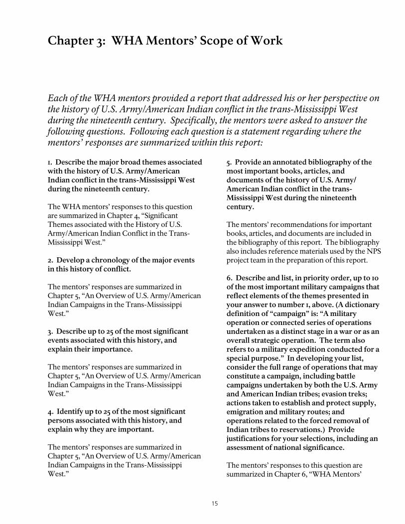
Chapter 3: WHA Mentors’ Scope of Work 15
Chapter 4: Significant Themes associated with the History of U.S. Army/American Indian Conflict in the Trans-Mississippi West 17
Chapter 5: An Overview of U.S. Army/ American Indian Campaigns in the Trans-Mississippi West, 1848-1886 24
Chapter 6: WHA Mentors’ Recommendations for the Most Significant Military Campaigns 35
Chapter 7: WHA Mentors’ Recommendations for the Most Significant Military Trails 37
Chapter 8: The Bozeman Trail 39
Associated Military Campaigns 39 Period of Significance 39 Location 39 Length of Trail 39 History 39 Map 40 Does the Bozeman Trail meet the definition of a military campaign trail? 41 Does the Bozeman Trail meet criteria for national significance? 42 Does the Bozeman Trail meet the criterion of significance through historic usage, as defined by the National Trails System Act? 42 Does the Bozeman Trail merit further study as a potential candidate for designation as a National Historic Trail? 42

ii
Places Associated with the Bozeman Trail that are Significant as Trail Resources and/or Provide Recreational and Interpretive Opportunities 43 Potential National Historic Landmarks associated with the Bozeman Trail 46
Chapter 9: The Long Walk 47
Associated Military Campaign 47 Period of Significance 47 Location 47 Length of Trail 47 History 47 Map 48 Does the Long Walk meet the definition of a military campaign trail? 50 Does the Long Walk meet criteria for national significance? 50 Does the Long Walk meet the criterion of significance through historic usage, as defined by the National Trails System Act? 51 Does the Long Walk merit further study as a potential candidate for designation as a National Historic Trail? 51 Places Associated with the Long Walk that are Significant as Trail Resources and/or Provide Recreational and Interpretive Opportunities 51 Potential National Historic Landmarks associated with the Long Walk 54
Chapter 10: The Northern Cheyenne Exodus Trail 56
Associated Military Campaign 56 Period of Significance 56 Location 56 Length of Trail 56 History 56 Map 57 Does the Northern Cheyenne Exodus Trail meet the definition of a military campaign trail? 59 Does the Northern Cheyenne Exodus Trail meet criteria for national significance? 59 Does the Northern Cheyenne Exodus Trail meet the criterion of significance through historic usage, as defined by the National Trails System Act? 60 Does the Northern Cheyenne Exodus Trail merit further study as a potential candidate for designation as a National Historic Trail? 60 Places Associated with the Northern Cheyenne Exodus Trail that are Significant as Trail Resources and/or Provide Recreational and Interpretive Opportunities 60 Potential National Historic Landmarks associated with the Northern Cheyenne Exodus Trail 64
Chapter 11: The Smoky Hill Trail 65
Associated Military Campaign 65 Period of Significance 65 Location 65 Length of Trail 65 History 65 Map 66 Does the Smoky Hill Trail meet the definition of a military campaign trail? 69 Does the Smoky Hill Trail meet criteria for national significance? 69 Does the Smoky Hill Trail meet the criterion of significance through historic usage, as defined by the National Trails System Act? 69 Does the Smoky Hill Trail merit further study as a potential candidate for designation as a National Historic Trail? 69 Places Associated with the Smoky Hill Trail that are Significant as Trail Resources and/or Provide Recreational and Interpretive Opportunities 69 Potential National Historic Landmarks associated with the Smoky Hill Trail 72

iii
Chapter 12: Trails of the Great Sioux War 73
Associated Military Campaigns 73 Period of Significance 73 Location and Length of Trails 73 History 73 Map 74 Do the Trails of the Great Sioux War meet the definition of a military campaign trail? 77 Do the Trails of the Great Sioux War meet the criterion of significance through historic usage, as defined by the National Trails System Act? 77 Do the Trails of the Great Sioux War meet criteria for national significance? 77 Do the Trails of the Great Sioux War merit further study as a potential candidate for designation as a National Historic Trail? 77 Trails and Sites Associated with the Great Sioux War that are Significant as Trail Resources and/or Provide Recreational and Interpretive Opportunities. 78 Potential National Historic Landmarks associated with the Great Sioux War 82
Conclusion 83
Bibliography 88


1
Introduction In recent years, the National Park Service has increasingly turned to the academic community for assistance in the preparation of its history studies. The Clash of Cultures trails project, a cooperative effort by the National Park Service (NPS) and the Western History Association (WHA), exemplifies this partnership of academic and public history. For the Clash of Cultures trails project, the National Park Service asked WHA historians for their assistance in identifying nationally significant trails associated with the history of U.S. Army/American Indian campaigns in the trans-Mississippi West during the nineteenth century. Secondly, the NPS asked the WHA historians for their recommendations as to whether any of these trails might warrant further study as potential National Historic Trails. As such, through the Clash of Cultures trails project, the WHA could provide scholarly guidance to NPS researchers and planners as they chart the course for future studies of trails associated with the history of the Indian Wars in the West. Founded in 1961 and currently located on the campus of the University of New Mexico, the Western History Association is a diverse group of western writers, academic historians, public historians, and enthusiasts whose purpose is to “promote the study of the North American West in its varied aspects and broadest sense.” To accomplish these tasks, the Western History Association assembled a group of eminent western historians and, in coordination with the National Park Service, asked each of them to prepare a report that addressed his or her perspective on the national significance of the trails associated with the Indians Wars in the West. Specifically, the WHA historians were asked to provide the following: • A description of the major broad themes,
events, and persons associated with the history of U.S. Army/American Indian conflict in the trans-Mississippi West during the nineteenth century;
• A list, in priority order, of the most important military campaigns associated with this history;
• A prioritized list of the most important
military campaign trails associated with this history;
• Recommendations as to whether any of these
trails are of outstanding national significance; and
• Recommendations as to whether any of these
trails may warrant further study as potential National Historic Trails.
Upon receiving the mentors’ reports, the NPS project team members also evaluated the recommended nationally significant trails according to the designation criteria of both the National Historic Landmarks program and the National Trails System Act. The mentors’ recommendations, as well as the NPS evaluations, are the main subjects of this report. The report also includes information on places along the trails that are of particular significance and/or offer recreational and/or interpretive opportunities. In addition, the report has information on places along the trails that may be potential National Historic Landmarks, pending further assessments of integrity. All of these recommendations will be used by the National Park Service to assess the need for future history and/or planning studies. It is important to note what this project did NOT do. It is not the purpose of the Clash of Cultures trails project to evaluate military campaign

2
The Clash of Cultures trails project is a “model” project in that it is the first time that trails are being evaluated in terms of their national significance using the criteria of the National Trails System Act and the criteria and methodology of the National Historic Landmarks program.
trails in terms of their physical integrity. Although an assessment of physical integrity is a standard component of a National Historic Landmark study, it was not included as part of the Clash of Cultures trails project because the National Trails System Act does not emphasize physical integrity of National Historic Trails. While the report includes general information on physical integrity, the project team did not undertake an intensive-level survey of the trails. Future surveys, beyond the scope of this project, may uncover segments of these trails that retain visible ruts and/or exceptional trail features. In the same way, the project team did not gather complete information on all the interpretive and educational opportunities along the trail. The places identified in this report should only be viewed as a sampling of the types of interpretive resources located along each trail. In addition, it is important to note that the Clash of Cultures trails project is not a study of all military trails. In due course, the National Park Service intends to study military campaign trails from colonial days through the twentieth century. This initial investigation is limited to one discrete historic theme: trails associated with U.S. Army/American Indian Wars in the trans-Mississippi West, an area that experienced its greatest period of conflict during the nineteenth century. It is anticipated that future studies will evaluate other military actions, such as intertribal wars, the Mexican War, and military explorations. The current investigation also excludes the War of 1812 and the Civil War because on-going studies by the NPS American Battlefield Protection Program will provide the necessary information to evaluate the relative significance of those campaign or battle routes.
Background The Clash of Cultures trails project is a “model” project in that it is the first time that trails are being evaluated in terms of their national significance using the criteria of the National Trails System Act and the criteria and methodology of the National Historic Landmarks program. This concept grew out of a National Historic Trails symposium held on August 18-20, 1999, in Santa Fe, New Mexico. Jerry Rogers, a former Keeper of the National Register, organized the event, entitled “Symposium of National Significance of Historic Trails.” Rogers, who had been instrumental in the inception and development of numerous preservation programs throughout his long career in the National Park Service, described the purpose of the symposium as follows: In 30 years of identifying and conferring official designation upon natural and cultural resources in the United States, I have recognized a pattern. In the beginning stages of a program, there are few guidelines or benchmarks by which to measure decisions. These come with experience. Also, in the beginning stages, programs tend to focus upon the designations that are most obvious and least difficult. As easy designations are exhausted, decisions become more difficult and more controversial for the cadre of professionals involved and also for the body politic and the government itself. If program leaders are wise and fortunate, they can bring to bear the experience they have gained at just the right time to keep the increasingly difficult decisions from becoming impossible. This has been the case with National Historic Landmarks, National Natural Landmarks, and the National Register of Historic Places. I believe we are now at the point in which those who study and recommend National Historic Trails need to consolidate their experience and that of others to enable the program to continue its record of quality in an increasingly complex future.1
1 Jerry Rogers to Lysa Wegman-French, invitation to attend the “Symposium of National Significance of Historic Trails,” letter dated June 24, 1999. Everyone invited to the symposium received identical letters.

3
The symposium attendees – which included representatives of the NPS National Trails System and National Historic Landmarks program, the Bureau of Land Management, state historical societies, and universities – discussed numerous issues regarding National Historic Trails. One of the major recommendations of the symposium, and the one that is the focus of this report, was to use the criteria and methodology of the National Historic Landmarks program to identify nationally significant trails associated with a particular theme, in this case the history of U.S. Army/American Indian conflict in the trans-Mississippi West. As discussed in more detail below, the application of National Historic Landmark criteria and methodology – used in conjunction with National Trails System Act criteria – results in the identification of trails that could warrant further study as potential candidates for National Historic Trail designation. Designation Criteria and Methodology of the National Trails System Act and the National Historic Landmarks Program The National Trails System was established by the National Trails System Act of 1968. Initially, the National Trails System only encompassed National Scenic Trails and National Recreation Trails. National Historic Trails were added when the Act was amended in 1978, with such trails defined as “extended trails which follow as closely as possible and practicable the original trails or routes of travel of national historic significance.”2 As defined in the Act, the purpose of the National Trails System is to “provide for the ever-increasing outdoor recreation needs of an expanding population and . . . to promote the preservation of, public access to, travel within, and enjoyment and appreciation of the open-air, outdoor areas and historic resources of the Nation . . .”
2 The National Trails System Act (P.L. 90-543) (U.S.C. 1241 et. seq.), as amended through P.L. 104-333, November 12, 1996, Section 3(a)(3).
Generally, potential National Historic Trails are assessed on an individual, case-by-case basis. . . . By contrast, the National Historic Landmarks program will only evaluate a potential landmark in terms of its relative significance to a larger group of properties. This task is typically accomplished through the completion of a “theme study.”
As Jerry Rogers observed during the Symposium of National Significance of Historic Trails, most of the “easy” choices for National Historic Trail designation, such as the Santa Fe and Oregon Trails, had been identified and designated early in the program’s history. As less obvious candidates for trail designation were put forward, it was often difficult to definitively answer the basic questions of national significance: Is this trail truly so important in the history of the United States that it warrants designation as a National Historic Trail? What other trails reflect the same historic theme and/or event, and how does this trail compare to those trails? And how can we be sure that this trail is the best representation of its type? These questions are the same asked of potential National Historic Landmarks. The National Historic Landmarks program, which was established by the Historic Sites Act of 1935, has several decades of experience in the application of criteria and processes for evaluation of national significance. As detailed later in this report, both the National Trails System and the National Historic Landmarks program have specific criteria for their respective designations. The two programs, however, take very different approaches in evaluating national significance. Generally – and this is a very broad generalization – potential National Historic Trails are traditionally assessed on an individual, case-by-case basis. This assessment is often made in response to a constituency group’s desire to see a particular trail designated as a National Historic

4
Trail. A constituency group, such as a local community or trails organization, often will approach Congress with a request that a particular trail be designated a National Historic Trail. Congress, in turn, will then direct the National Park Service or another federal agency to prepare a National Trails System study to evaluate whether or not that particular trail warrants such designation, including an assessment of national significance. By contrast, the National Historic Landmarks program will only evaluate a potential landmark in terms of its relative significance to a larger group of properties. This task is typically accomplished through the completion of a “theme study.” A theme study focuses on a specific historic context within an established time frame, such as U.S. Army/American Indian campaigns in the trans-Mississippi West in the nineteenth century. The theme study identifies the primary people and events associated with the historic theme. It also identifies a list of the primary historic buildings, structures, and sites that are associated with that theme. The theme study then goes a step further and, by comparing the relative significance of these properties, lists properties that are nationally significant and the best representations of that particular theme of American history. The list is further refined to include only those properties that have a high degree of physical integrity. And it is this “short list” of properties – those that have both national
significance and a high degree of integrity – that are considered candidates for National Historic Landmark designation. A primary goal of the Clash of Cultures trails project was to apply the methodology of the National Historic Landmarks program to potential National Historic Trails, specifically as it applies to an evaluation of national significance. Rather than assessing trails on an individual basis, the Clash of Cultures team evaluated all trails associated with a particular historic context – in this case, U.S. Army/ American Indian campaigns in the trans-Mississippi West – and made recommendations as to which of those trails have national significance and would be potential candidates for National Historic Trail designation. Project Schedule In late 2000, several members of the National Trails System program believed there was a need for a comprehensive look at historic trails in the Southwest. By March 2001, this concept had evolved into the idea for the Clash of Cultures study, which was funded by the Office of Park Planning. The Clash of Cultures trails project began with a kickoff meeting of the NPS and WHA project team members in Denver on June 13, 2001. The WHA mentors’ final reports were completed by January 1, 2002. The draft project report was prepared in April 2002; and the final report was completed in June 2002.

5
Chapter 1: Project Participants The National Park Service utilized an existing cooperative agreement with the Western History Association to secure access to the academic community for their recommendations regarding the national significance of trails associated with U.S. Army/American Indian campaigns in the trans-Mississippi West. Paul Andrew Hutton is the executive director of the Western History Association and served as the WHA coordinator for the project. Patricia Nelson Limerick served as a WHA project reviewer. The Western History Association obtained the services of six additional historians knowledgeable in various aspects of western history to serve as “mentors” for the project. These historians represented diverse aspects of historical scholarship – such as military history, social history, ethnic history, and American Indian history – and provided a variety of perspectives on the history of U.S. Army/ American Indian conflict. As part of the project agreement, each mentor was to provide a report that answered the questions outlined in the “Mentors’ Scope of Work” and was also to be available on an “as needed” basis for consultation during the project. The WHA historians participated in the project team meeting in Denver on June 13, 2001. In addition, the WHA historians participated in the WHA conference in San Diego, October 4-7, 2001, for a panel discussion on this project. Western History Association Participants R. David Edmunds (Mentor) Edmunds is Watson Professor of American History at the University of Texas at Dallas and a member of the Western History Association council. In 1990-91, he served as acting director of the McNickle Center for American Indian History at the Newberry Library in Chicago. Edmunds has written and/or edited seven books and over 90 articles or essays, including The Potawatomis: Keepers of the Fire (1978), which was awarded the 1978 Francis Parkman Prize; The Shawnee Prophet (1984), which was awarded the
1984 Ohiana Prize of Biography; and The Fox Wars: The Mesquakie Challenge to New France (1993), which was awarded the 1994 Heggoy Prize by the French Historical Society. Edmunds has been recipient of a Minority Dissertation Fellowship from the Ford Foundation; a post-doctoral fellowship from the Newberry Library; a summer stipend from the National Endowment for the Humanities; and a John Simon Guggenheim Fellowship. At the time of the Clash of Cultures trails project, he was editing two books of essays, co-authoring a textbook on Native American history, and writing a volume about businessmen on the Great Plains in the mid-nineteenth century. Paul Fees (Mentor) Fees received his doctorate from Brown University and is former senior curator at the Buffalo Bill Historical Center, past president of the Wyoming Council for the Humanities, and has served on the Wyoming State Records Advisory Board. He has organized numerous exhibits on various subjects, including “Bits and Spurs in the Vaquero Tradition,” "Cody or Bust,” “A Century of Plains Indians’ Portraits,” and “The Custer Mystique.” He has also authored or co-authored several books. His titles include Buffalo Bill: A Treatise, Wyoming Territorial Imprints, Interior West, Myth of the West, and Frontier America: Art and Treasures of the Old West from the Buffalo Bill Historical Center. Donald Fixico (Mentor) Fixico is director of the Indigenous Studies Program and a professor of history at the

6
As part of the project agreement, each Western History Association mentor provided a report that answered the questions outlined in the “Mentors’ Scope of Work” and also was available on an “as needed” basis for consultation during the project.
University of Kansas. A leading figure in the field of American Indian history, he has been a lecturer and/or professor at the University of California at Berkeley, the University of California at Los Angeles, San Diego State, and the University of Michigan. He also served as exchange professor at the University of Nottingham, England, and was visiting professor at the John F. Kennedy Institute at Freie University in Berlin. He is the author of Termination and Relocation: Federal Indian Policy, 1945-1960 and Urban Indians, and is the editor of two books, An Anthology of Western Great Lakes Indian History and Rethinking American Indian History. His latest book is The Urban Indian Experience in America (2000). Paul Andrew Hutton (WHA Coordinator for the Clash of Cultures Trails Project) Hutton is currently the executive director of the Western History Association and a professor of history at the University of New Mexico. He has published widely in the field of western history on topics ranging from the military and the West in the nineteenth century to film and popular culture. Hutton’s scholarship has been recognized with numerous awards including the Billington Prize, the Evans Biography Award, and the Spur Award for his book Phil Sheridan and His Army (1985). Hutton has twice won the Western Heritage Award (Wrangler) for “Showdown at Hollywood Corral: Wyatt Earp in the Movies” (1993) and “Theodore Roosevelt’s Rough Riders” (1999). His edited works include Frontier and Region, Soldiers West, and The Custer Reader. He has appeared in, written, or narrated over 100 television documentaries and is
currently writing a new biography of David Crockett. Alvin M. Josephy Jr. (Mentor) Josephy is one of America’s most distinguished historians. He served for many years as vice president and editor of American Heritage. He was founding chairman of the board of the Smithsonian Institution’s National Museum of the American Indian and is past president of the Western History Association. He is author of numerous prize-winning books, including The Patriot Chiefs, The Indian Heritage of America, The Nez Perce Indians and the Opening of the Northwest, Red Power, Now That the Buffalo’s Gone, The Civil War in the American West, and 500 Nations: A History of North American Indians. His latest book is his memoir, A Walk Toward Oregon, published in 2000. Patricia Nelson Limerick (Reviewer) Limerick received her doctorate from Yale University and is a professor of history at the University of Colorado at Boulder and a former president of the Western History Association. The author of a wide variety of books and articles, she is best known for her work The Legacy of Conquest (1987), which had a major impact on the field of Western American History. She has received a number of awards, including State Humanist of the Year (Colorado, 1992), and a MacArthur Fellowship (1995-2000). In addition to numerous scholarly articles and reviews, she has written frequent columns for the New York Times, The Denver Post, USA Today, The Chronicle of Higher Education and other newspapers. Most recently, she is a contributor to The Atlas of the New West and author of Something in the Soil: Field-Testing the New Western History. Sherry L. Smith (Mentor) Smith is a professor of history at Southern Methodist University where she teaches Western, Indian, and Public History. Her major works include Reimagining Indians, The View from Officers’ Row: Army Perceptions of Western Indians, and Sagebrush Soldier: Private

7
William Earl Smith’s View of the Sioux War of 1876. She has published numerous articles including “Lost Soldiers: Re-Searching the Army in the West” (1998) and “Single Women Homesteaders: The Perplexing Case of Elinore Pruitt Stewart” (1991), both in the Western Historical Quarterly, and “A Woman’s Life in the Teton Country,” Montana: The Magazine of Western History (1996). She is currently a WHA council member. Elliott West (Mentor) West is distinguished professor of history at the University of Arkansas and president of the Western History Association. A former member of the editorial board of the Western Historical Quarterly and currently on the editorial board of Montana: The Magazine of Western History, he is general editor of the Histories of Arkansas Series and served on the board of directors of the Arkansas Humanities Council. He is two-time winner of the Western Heritage (Wrangler) Award and the George Perkins Marsh Prize. His most recent book, The Contested Plains: Indians, Gold Seekers and the Rush to Colorado has been recognized with the Francis Parkman Prize, the Ray Allen Billington Award (co-winner), the WWA Spur Award, the PEN Center Award, the Caroline Bancroft Award, and the Caughey WHA Prize. He is also the author of The Way to the West: Essays on the Central Plains, Growing up in Twentieth Century America, and more than 50 articles and essays. National Park Service and Bureau of Land Management Project Team Members In addition to outside expertise gained through the Western History Association, the National Park Service called upon its staff to assist in the administrative and technical aspects of the project. Christine Whitacre, historian with the NPS-Intermountain Support Office in Denver served as project coordinator. Historian Jerome Greene (NPS-Harpers Ferry Center assigned to Denver) served as principal investigator. Historians Lysa Wegman-French and William Patrick O’Brien, of the NPS-Intermountain
Support Office in Denver, and who work in the National Historic Landmarks program, also served as project team members. (Although O’Brien, who was the program manager of the Cultural Resources and National Register Program Services of the Intermountain Support Office in Denver, accepted a new position with the NPS Cooperative Extension Services Unit office in Tucson before the completion of Clash of Cultures, he continued to consult on the project.) Dave Ruppert, an ethnographer with the Intermountain Support Office, served as a project reviewer. John Sprinkle of the National Historic Landmarks program in Washington D.C., and John Haubert of the National Park Service planning office were very instrumental in the development of the Clash of Cultures trails project and worked closely with the project team. Several National Historic Trails program staff also participated in the project. These included David Gaines, Aaron Mahr, and John Conoboy of the Long Distance Trails Office in Santa Fe; Jere Krakow of the Long Distance Trails Office in Salt Lake City; and Steve Elkinton of the National Trails System program office in Washington D.C. Carl Barna of the Bureau of Land Management, which shares responsibility with the National Park Service for the administration of National Historic Trails, also participated in the Clash of Cultures trails project.
NPS project team members Jerry Greene and Lysa Wegman-French reading interpretive signs at the Crazy Woman Fight Site, vicinity of Buffalo, Wyoming. Photo by Christine Whitacre.

8
Chapter 2: Methodology As has been discussed in the Introduction, the Clash of Cultures trails project was to be a model project in which the methodology of the National Historic Landmarks evaluation process was applied to National Historic Trails. To accomplish this, a methodology had to be designed that would accommodate the relevant requirements of both the National Historic Landmarks program and the National Trails System Act. As specified in Section 5(b) of the National Trails System Act (16 USC 1244), Congress may authorize the Secretary of the Interior to conduct a study "for the purpose of determining the feasibility and desirability of designating . . . trails as . . . national historic trails." Such studies are required to include at least 11 specific items of discussion. The Clash of Cultures study is not such a Congressionally authorized study, and is not addressing those 11 topics. Instead, this preliminary report focuses on only one of those topics: the criteria for National Historic Trails. As specified in the Section 5(b) (11), a proposed National Historic Trail must meet three specific criteria, briefly: (A) It must be a trail or route established by historic use and must be historically significant as a result of that use; (B) It must be of national significance with respect to any of several broad facets of American history; C) It must have significant potential for public recreational use or historical interest based on historic interpretation and appreciation. After determining the National Historic Trail criteria within the National Trails System Act, the project team then turned to the National Historic Landmarks process of evaluation, and found that the process related quite well with the National Trails System Act process. Therefore, the NPS project team designed a methodology that addressed the three criteria specified for designation of a National Historic Trail – historic
use, national significance, and interpretation/ appreciation. Evaluating National Significance of a Potential National Historic Trail The project team first addressed National Historic Trail Criterion B, requiring national significance: It must be of national significance with respect to any of several broad facets of American history, such as trade and commerce, exploration, migration and settlement, or military campaigns. To qualify as nationally significant, historic use of the trail must have had a far-reaching effect on broad patterns of American culture. Trails significant in the history of native Americans may be included. To accomplish the task of identifying and evaluating potential National Historic Trails in terms of national significance, the project team used the model of a National Historic Landmark theme study. Indeed, the Clash of Cultures trails project was the first time that potential National Historic Trails were evaluated through the use of a theme study – which are a standard methodology of the National Historic Landmarks program. The National Historic Landmarks program believes that a theme study (as discussed in the Introduction) is a very effective method of identifying and evaluating properties because it provides a comparative analysis of properties associated with a specific topic in history. This enables us to understand the entire story of a topic, and by seeing the larger

9
picture, the relative importance of specific properties can be understood. Within the theme study methodology, the first step is to determine the historic context, or theme, that will be examined. By placing a property within its proper historic context, we can understand or measure the importance of that property. The context is, therefore, the basis for judging a property's significance. Contexts are typically limited by geographic area and by date. National Historic Trails Criterion B addresses context. Although the National Trails System Act does not mention the term "context," it does state that the trails have to be "nationally significant with respect to any of several broad facets of American history, such as trade and commerce, exploration, migration and settlement, or military campaigns." Thus, within the text of the National Trails System Act, Congress provided guidance regarding areas to study. It identified several broad facets of American history as examples: trade and commerce, exploration, migration and settlement, and military campaigns. Congress has designated a number of National Historic Trails that cover some of those topics. For instance, the Santa Fe Trail represents trade and commerce, the Lewis and Clark Trail represents exploration, and the Oregon Trail and the Mormon Pioneer Trail represent migration and settlement. However, the Long Distance Trails staff of the National Park Service perceived a gap in representation of military campaigns, particularly those related to the western United States. After several discussions among the NPS trails, landmarks and planning staffs regarding which military campaign(s) should be studied as part of the Clash of Cultures trails project, the group selected the wars between the U.S. military and the various American Indian tribes. Thus the context was defined as the U.S. Army/American Indian campaigns in the trans-Mississippi West during the nineteenth century. National Historic Landmark Criteria for National Significance After selecting the historic context, the second step in evaluating a property is determining whether the property may be nationally
A theme study is a very effective method of identifying and evaluating properties because it provides a comparative analysis of properties associated with a specific topic in history. This enables us to understand the entire story of a topic, and by seeing the larger picture, the relative importance of specific properties can be understood.
significant under the “Specific Criteria of National Significance” (36 CFR 65.4(a)), which are also known as the National Historic Landmark criteria. They are: National Historic Landmark Criterion 1: Properties that are associated with events that have made a significant contribution to, and are identified with, or that outstandingly represent, the broad national patterns of United States history and from which an understanding and appreciation of those patterns may be gained. National Historic Landmark Criterion 2: Properties that are associated importantly with the lives of persons nationally significant in the history of the United States. National Historic Landmark Criterion 3: Properties that represent some great idea or ideal of the American people. National Historic Landmark Criterion 4: Properties that embody the distinguishing characteristics of an architectural type specimen exceptionally valuable for a study of a period, style, or method of construction, or that represent a significant, distinctive and exceptional entity whose components may lack individual distinction. National Historic Landmark Criterion 5: Properties that are composed of integral parts of the environment not sufficiently significant by reason of historical association or artistic merit to warrant individual recognition but collectively compose an entity of exceptional historical or artistic significance, or outstandingly commemorate or illustrate a way of life or culture.

10
Why are the trails being evaluated by National Historic Landmark criteria? Because these criteria are the NPS-wide standard for national significance, and are those used by the Secretary of the Interior’s National Park System Advisory Board in its evaluation of both National Historic Landmarks and National Historic Trails.
National Historic Landmark Criterion 6: Properties that have yielded or may be likely to yield information of major scientific importance by revealing new cultures, or by shedding light upon periods of occupation over large areas of the United States. Such sites are those which have yielded, or which may reasonably be expected to yield, data affecting theories, concepts and ideas to a major degree. Why are the trails being evaluated by National Historic Landmark criteria? Because these criteria are the NPS-wide standard for national significance, and are those used by the Secretary of the Interior’s National Park System Advisory Board in its evaluation of both National Historic Landmarks and National Historic Trails. The National Trails System Act, Section 5(b)(3), specifies that Congressionally funded studies of potential National Historic Trail shall include the recommendation of the National Park System Advisory Board regarding national significance “based on the criteria developed under the Historic Sites Act of 1935 (40 Stat. 666; 16 U.S.C. 461).” It is noteworthy, particularly for the purposes of this study, to summarize how the “criteria developed under the Historic Sites Act of 1935” have evolved over time to become what is today known as the National Historic Landmark criteria. The National Park Service first developed criteria for national significance in the 1930s. In 1933, Verne Chatelain, NPS chief historian, developed general criteria by which to evaluate historical additions to the NPS system. According to Chatelain, potential NPS historical
units should possess “uniqueness,” which he defined as follows: (a) In such sites as are naturally the points or bases from which the broad aspects of prehistoric and historic American life can best be presented, and from which the student of history of the United States can sketch the large patterns of the American story; which areas are significant because of their relationship to other areas, each contributing its part of the complete story of American history; (b) In such sites as are associated with the life of some great American, and which may not necessarily have any outstanding qualities other than that association; and (c) In such sites as are associated with some sudden or dramatic incident in American history, which though possessing not great intrinsic qualities are unique, and are symbolic of some great idea or ideal.3 Two years later, the Historic Sites Act of 1935 declared it national policy "to preserve for public use historic sites, buildings, and objects of national significance for the inspiration and benefit of the United States." The act further authorized the Secretary of the Interior to operate and manage historic properties, and to survey the nation’s sites, buildings, and objects, for the purpose of determining which possess exceptional value as commemorating or illustrating the history of the United States." The Historic Sites Act also established the creation of the National Park System Advisory Board. As stated above, the Historic Sites Act of 1935 identified nationally significant properties as those that “possess exceptional value as commemorating or illustrating the history of the United States.” Over time, however, the National Park System Advisory Board began using more detailed criteria for national significance, very similar to those developed by Chatelain. These criteria appear in 36 CFR 65.4 (a), entitled
3 Letter, Arno B. Cammerer to Gist Blair, December 18, 1933, drafted by Verne Chatelain, as cited in Barry Mackintosh, The Historic Sites Survey and National Historic Landmarks Program: A History (Washington, D.C.: National Park Service, History Division, 1985), p. 9.

11
"Specific Criteria of National Significance." Although 36 CFR Part 65 deals specifically with National Historic Landmarks, the criteria in section 4(a) do not apply only to National Historic Landmarks – but to all cultural resources. This broad use of the criteria for national significance is supported by at least two other NPS documents. The 2001 NPS Management Policies state that: “National significance for cultural resources will be evaluated by applying the National Historic Landmarks process contained in 36 CFR Part 65." These same criteria also appear in the NPS Criteria for Parklands, under the category of “Cultural Resource Evaluation." Thus the National Historic Landmark criteria have evolved into the criteria for the national significance of cultural resources, at least for the National Park Service. The NPS staff recognized that identifying and evaluating resources within the context of a theme study, as well as applying the criteria of national significance, would require professional expertise and a thorough familiarity of the best current scholarship. The National Park Service therefore approached the Western History Association with a proposal to work cooperatively on the project. As has been discussed in the Introduction, the WHA assembled a blue-ribbon panel of scholars who have recognized knowledge of that era of Western history. A set of questions was written to elicit information regarding the context and criteria, as well as comparing the relative significance of the trails. (The questions are included in this report under the chapter entitled “Mentors’ Scope of Work.") For instance, the criteria (as well as the questions) discuss topics such as broad patterns or themes in history, major events, and important persons. In addition, the scholars were asked to rank the most important campaign trails. The scholars met with the NPS staff in June 2001 to discuss the topics related to the U.S. Army/American Indian campaigns, along with the criteria and the process of identification and evaluation. In this meeting, the National Park Service members of the project team posed the prepared questions to the WHA scholars, and an invigorating discussion ensued. Several
The NPS staff recognized that identifying and evaluating resources within the context and utilizing the criteria would require professional expertise and a thorough familiarity of the best current scholarship.
months later, in October 2001, the Western History Association and the National Park Service jointly presented a panel discussion at the Western History Association conference. The scholars presented their thoughts on the topic, as they had developed them up to that point. The audience provided additional stimulating comments and suggestions. Subsequently, the WHA team members submitted their written responses to the set of questions. In both the discussions and in subsequent written submittals, the scholars’ responses provided valuable information and analysis regarding the topic. Utilizing the information provided by the subject matter experts, NPS historian Jerry Greene prepared a summary history of U.S. Army/American Indian campaigns in the nineteenth-century trans-Mississippi West, included herein as the chapter entitled “An Overview of Army-Indian Campaigns in the Trans-Mississippi West, 1848-1886.” The goal of this text is to provide sufficient background and depth to "support the relevance, the relationships, and the national importance of the properties to be considered."4 The scholars had also submitted discussions on what they perceived to be the major broad themes of the U.S. Army/American Indian campaigns. The three-person NPS team of Jerry 4 U.S., Department of the Interior, National Park Service, National Register, History and Education-National Historic Landmarks Survey, How to Prepare National Historic Landmark Nominations, National Register Bulletin ([Washington, D.C.: Government Printing Office], 1999), 19.

12
The WHA scholars were also asked to give recommendations on the most important military campaigns and military campaign trails associated with the history of the Indian Wars in the West.
Greene, Lysa Wegman-French, and Christine Whitacre compiled their comments, and upon analysis, realized that the themes could be organized within the NPS Thematic Framework. This framework, comprised of eight themes, represents the past as an “integrated, diverse, complex, human experience.”5 NPS historian Jerry Greene then crafted an essay synthesizing the major themes of the U.S. Army/American Indian campaigns – as proposed by the scholars – and organized within the NPS Thematic Framework. This essay is included in this report as the chapter entitled “Significant Themes Associated with the History of U.S. Army/ American Indian Conflict in the Trans-Mississippi West.” The WHA scholars were also asked to give recommendations on the most important military campaigns and military campaign trails associated with the history of the Indian Wars in the West. By compiling the scholars' lists of most important trails, six trails stood out quite clearly from all other suggestions. These trails were: the Long Walk, the Northern Cheyenne Exodus Trail, the Smoky Hill Trail, the Bozeman Trail, the Nez Perce Trail, and trails associated with the Great Sioux War. After the scholars had proposed these trails to be nationally significant, the NPS team then assessed them according to the National Trails System Act and the National Historic Landmark criteria. As noted earlier, the National Trails System Act specifies that a Congressionally authorized study on the suitability and feasibility of a potential National Historic Trail shall include the
5 [U.S., Department of the Interior, National Park Service], Revision of the National Park Service's Thematic Framework ([Washington, D.C.: Government Printing Office], 1996), 2.
recommendation of the National Park System Advisory Board regarding national historic significance. Note that the recommendations regarding national significance in this report are made jointly by the Western History Association's panel of subject matter experts and the National Park Service staff. The National Park System Advisory Board has not yet reviewed the recommendations. Evaluating Significance as a result of Historic Use as a Military Campaign Trail The next step was to apply the two additional criteria for National Historic Trails. National Historic Trail Criterion A specifies: It must be a trail or route established by historic use and must be historically significant as a result of that use [emphasis added]. The route need not currently exist as a discernible trail to qualify, but its location must be sufficiently known to permit evaluation of public recreation and historical interest potential. A designated trail should generally accurately follow the historic route, but may deviate somewhat on occasion of necessity to avoid difficult routing through subsequent development, or to provide some route variation offering a more pleasurable recreational experience. . . . This criterion contains three aspects. The requirement that the significance be derived “as a result of that [historic] use” was the focus of much discussion among the WHA scholars and the NPS staff. The group understood that the significance had to be derived from the use of the trail itself, separate from anything significant that occurred at either end of the trail. If the trail was simply the route that someone took to get to an important place, that importance did not automatically transfer to the trail. For instance, a trail connects point A and point B; even though something important happened at either point A or point B, the trail itself was not necessarily important. Likewise, if an important person used a trail, that importance did not necessarily transfer to the trail. The trail would have to have a strong association with that person’s importance through his/her use of the trail. For the trail itself to meet this National Historic Trail criterion, it had to be significant for the use of the

13
trail itself. This requirement eliminated a number of potential trails, which were associated with important battles or other events or people, but did not derive significance from the use of the trail itself. For instance, the many routes taken in Arizona, New Mexico, and Mexico by both the Apache people and the army typified the conflict between that tribe and the military. However, the project team determined that none of the trails in this important campaign met the requirement that significance be derived from the use of the trail itself. The next aspect of Criterion A relates to the physical nature and location of the trail. An additional step in the National Historic Landmark evaluation process is to determine if the property has physical integrity. The National Trails System Act legislation does not emphasize physical integrity of National Historic Trails, and this criterion states, "the route need not currently exist as a discernible trail to qualify but its location must be sufficiently known . . ." As a result, this study does not address physical integrity. For this reason, the trails themselves have not been considered as potential National Historic Landmarks. The NPS staff conducted research to determine the historic route(s) of each of the trails, and maps of those routes are included in this report. However, these maps are not intended to be precise maps, and should not be taken literally. Instead, they are intended to generally represent the locations of the trails. If subsequent studies are conducted on any of these trails to determine their suitability and feasibility as National Historic Trails, more specific maps should be prepared. Evaluating Potential for Public Recreational Use or Historical Interest The last part of Criterion A discusses “historical interest” and a “pleasurable recreational experience.” This topic segues into the third National Historic Trail criterion, Criterion C: It must have significant potential for public recreational use or historical interest based on historic interpretation and appreciation. The potential for such use is generally greater along roadless segments developed as historic trails, and at historic sites associated with the trail. The
For the trail itself to meet National Historic Trail criterion, it had to be significant for the use of the trail itself. This requirement eliminated a number of potential trails, which were associated with important battles or other events or people, but did not derive significance from the use of the trail itself.
presence of recreation potential not related to historic appreciation is not sufficient justification for designation under this category. The National Trails System Act also specifies (in Section 5(e)(1)) that after legislation has been enacted designating a trail, the Secretary is required to identify "all significant natural, historical, and cultural resources to be preserved (along with high potential historic sites. . . )." Section 12 of the act defines high potential historic sites as "those historic sites related to the route, or sites in close proximity thereto, which provide opportunity to interpret the historic significance of the trail during the period of its major use. Criteria for consideration as high potential sites include historic significance, presence of visible historic remnants, scenic quality, and relative freedom from intrusion." Using the legislative guidance, the NPS staff then pursued a next level of research on these proposed trails, to evaluate if the y did in fact meet this criterion for National Historic Trails. The research focused on three aspects: 1) what sites were in existence at the time of the historic use of the trail (especially sites important relative to trail use); 2) which of those sites are extant today; and 3) what non-historic sites along the routes interpret the trail. Also, the NPS staff located trail-related published material that is easily available to the public, which would help public enjoyment of the routes. In addition to library research, three NPS staff members (Jerry Greene, Lysa Wegman-French, and Christine Whitacre) conducted site visits along much of the trails. They drove selected routes of the Long Walk, and drove the majority of the routes of the

14
Northern Cheyenne Exodus, the Smoky Hill Trail, and the Bozeman Trail. This report identifies sites that appeared (either visually or through research) to be of the same era as the period of significance of the proposed trails, describes if there are visible historic remnants, and discusses scenic quality and whether the setting is free from modern intrusions. However, as noted in the text, additional research would be required to verify if certain resources are in fact of the same time period, and whether they have historic integrity. The lists in this report should not be considered comprehensive. Finally, this report was prepared to present information on the findings. The format is arranged within chapters, many of which focus on particular trails. Within those trail chapters, the discussion is organized in sections. The first
main section is the discussion of the trail’s historical significance. The next section is an assessment of the trail in terms of whether or not it meets the definition of a military campaign trail. The remaining sections assess national significance and the trail’s potential as a National Historic Trail. Categories within these sections correspond to the three National Historic Trail criteria and include an evaluation of whether the trail meets the criteria for national significance; a discussion of whether it is significant due to its historic use; and whether the trail merits further study as a potential candidate for designation as a National Historic Trail. Next is an annotated list of associated places along the trail that are trail resources or could provide recreational and interpretive opportunities. Finally, the NPS project team members recommend sites associated with the trails that should be evaluated (and nominated as appropriate) as National Historic Landmarks.
15
Chapter 3: WHA Mentors’ Scope of Work Each of the WHA mentors provided a report that addressed his or her perspective on the history of U.S. Army/American Indian conflict in the trans-Mississippi West during the nineteenth century. Specifically, the mentors were asked to answer the following questions. Following each question is a statement regarding where the mentors’ responses are summarized within this report: 1. Describe the major broad themes associated with the history of U.S. Army/American Indian conflict in the trans-Mississippi West during the nineteenth century. The WHA mentors’ responses to this question are summarized in Chapter 4, “Significant Themes associated with the History of U.S. Army/American Indian Conflict in the Trans-Mississippi West.” 2. Develop a chronology of the major events in this history of conflict. The mentors’ responses are summarized in Chapter 5, “An Overview of U.S. Army/American Indian Campaigns in the Trans-Mississippi West.” 3. Describe up to 25 of the most significant events associated with this history, and explain their importance. The mentors’ responses are summarized in Chapter 5, “An Overview of U.S. Army/American Indian Campaigns in the Trans-Mississippi West.” 4. Identify up to 25 of the most significant persons associated with this history, and explain why they are important. The mentors’ responses are summarized in Chapter 5, “An Overview of U.S. Army/American Indian Campaigns in the Trans-Mississippi West.”
5. Provide an annotated bibliography of the most important books, articles, and documents of the history of U.S. Army/ American Indian conflict in the trans-Mississippi West during the nineteenth century. The mentors’ recommendations for important books, articles, and documents are included in the bibliography of this report. The bibliography also includes reference materials used by the NPS project team in the preparation of this report. 6. Describe and list, in priority order, up to 10 of the most important military campaigns that reflect elements of the themes presented in your answer to number 1, above. (A dictionary definition of “campaign” is: “A military operation or connected series of operations undertaken as a distinct stage in a war or as an overall strategic operation. The term also refers to a military expedition conducted for a special purpose.” In developing your list, consider the full range of operations that may constitute a campaign, including battle campaigns undertaken by both the U.S. Army and American Indian tribes; evasion treks; actions taken to establish and protect supply, emigration and military routes; and operations related to the forced removal of Indian tribes to reservations.) Provide justifications for your selections, including an assessment of national significance. The mentors’ responses to this question are summarized in Chapter 6, “WHA Mentors’

16
Recommendations for the Most Significant Military Campaigns.” 7. Describe and list, in priority order, the most important military campaign trails that reflect elements of the themes presented in your answer to number 1 above. When answering this question, specifically address the significance of the trails of the military campaigns, not the campaigns themselves. The National Trails System Act, Section 5(b)(11), defines a “historic trail” as a “trail or route established by historic use and must be historically significant as a result of that use.” It is the use of the trail itself – not just the sites connected by the trail – that must be historically significant. Also, although the most important trails are likely to be associated with the campaigns identified in number 6 above, please consider ALL campaign trails associated with the history of U.S. Army/American Indian conflict in the trans-Mississippi West. It is possible that an individual trail may have a significance that is greater than that of the larger campaign with which it was associated. Provide justifications for your selections, including an assessment of national significance. The mentors’ responses to this question are summarized in Chapter 7, “WHA Mentors’ Recommendations for the Most Significant Military Trails.” These recommendations – as evaluated against the criteria for national
significance and the criteria of the National Trails System Act – also appear in the chapters on the Bozeman Trail, the Long Walk, the Northern Cheyenne Exodus Trail, the Smoky Hill Trail, and the Trails of the Great Sioux War. 8. If you have first-hand knowledge of the location and condition of the trails listed in number 7 above, please elaborate. Also, please identify any places along the trails that you believe may be particularly significant as trail resources and/or are outstanding locations for interpretation of the trail. The WHA mentors’ responses are summarized in the chapters on the Bozeman Trail, the Long Walk, the Northern Cheyenne Exodus Trail, the Smoky Hill Trail, and the Trails of the Great Sioux War. 9. Do you believe that any of the identified trails are of such outstanding national significance that they should be studied further as possible additions to the National Trails System? Provide justification for your selections. The mentors’ recommendations – as evaluated against the criteria for national significance and the criteria of the National Trails System Act – are included within the chapters on the Bozeman Trail, the Long Walk, the Northern Cheyenne Exodus Trail, the Smoky Hill Trail, and the Trails of the Great Sioux War.

17
Chapter 4: Significant Themes associated with the History of U.S. Army/American Indian Conflict in the Trans-Mississippi West Historic themes afford topical conceptualization of subjects to help provide context and significance, thus giving them broader relevance, meaning, expression, and understanding. The trails associated with U.S. Army-American Indian campaigns in the trans-Mississippi West evoke numerous recurring themes and subthemes that reflect elements contained in the 1996 “Revision of the National Park Service’s Thematic Framework.” The themes identified in the NPS thematic framework are: (I) Peopling Places, (II) Creating Social Institutions and Movements, (III) Expressing Cultural Values; (IV) Shaping the Political Landscape; (V) Developing the American Economy; (VI) Expanding Science and Technology; (VII) Transforming the Environment; and (VIII) Changing Role of the United States in the World Economy. All of the thematic framework’s eight interactive elements are represented in various degrees. The following presentation, based largely on the recommendations of the WHA mentors, discusses the predominant themes and subthemes affecting military campaigns in the trans-Mississippi West in relation to the integrated components defined in the thematic framework. The themes are presented in general order of significance to the topic of military campaign trails associated with U.S. Army/American Indian conflict in the trans-Mississippi West.
(V) Developing the American Economy. The economic theme is paramount because it conveys the essence of the national purpose for advancing continuously onto Indian lands in the region, while recognizing the impact of such activity, in terms of its concomitant policy, technical, and social aspects, on tribal cultures and economies.
Broadly speaking, all campaigns were intended to promote economic/political objectives, no matter their immediate purpose. In the long-term sense, campaigns were motivated by, and grounded in, prospects for commercial gain for white Americans. But there were economic ramifications among the tribes, too, affecting goods, trade, land, and lifeways. “Historians now understand,” wrote Sherry L. Smith, “that the complicated interactions among and between Indian occupants, as well as between Indians and Anglo-American migrants, miners, and agricultural users/settlers, add up to a frenzy of activity during which different groups, of various sizes and military strengths, vied for access to ‘the West.’” During the mid-nineteenth century, the West afforded a place where white people might migrate to improve their livelihoods, and federal policy encouraged such action. Such inroads by whites introduced competition for economic hegemony over Indian lands and their resources, ultimately forcing dispossession of tribal lands. The federally established “Permanent Indian Frontier” and its later evolutions were all successive expedients in the process of economic dispossession. Mining, with its rapid influx of white Americans, impacted tribal communities and caused wholesale displacement and cultural disruption – including that to native economies – precipitating conflict between Indians and civilian trespassers and subsequently the army, as well as among the tribes themselves. Mining and settlement evinced white Americans’ need to command a region’s resources, including game,

18
“Although Americans may not be accustomed to conceptualizing the United States as a nation that engaged in military conquest, expansion, and occupation of others’ homelands, such an interpretation is difficult to evade when one turns the spotlight on the Indian Wars of the nineteenth century West.”
often with cataclysmic results to tribal populations. For the tribes, their own command of resources, particularly of game, was fundamental to their subsistence and survival, and the eventual commercial exploitation of the buffalo by whites thus further threatened lifeways and provoked discord. Invariably, behind the wars, wrote Elliott West, “was a brooding understanding by Indians that the material basis for their way of life was being taken away, often rapidly.” Mining, followed quickly by white farming ranching activities, conflicted with tribal beliefs regarding the uses of land, nonetheless prompting modification of earlier removal programs affecting American Indians to embrace the reservation system as the absolute form of that policy. Mining and settlement temporarily coincided with, then succeeded, the enterprise of the fur trade in the West. During the post-Civil War period, the government sanctioned railroad construction throughout the region, insuring the expansion and enhanced mobility of the military presence while promoting economic growth via commerce and the continuation of western migration. As West noted, “Given the extent of the outside invasion of the far West and that invasion’s rapid redeployment of the West’s rich resources to new uses, the ways of life of native peoples were bound to be undermined, whether they fought back or not.” (IV) Shaping the Political Landscape. This theme vies for importance with the economic theme. All of the mentors saw it as a dominating topic, both in its reflecting the supreme nationalism of the United States throughout the period of the campaigns, as well as in regard to the parallel
impacts that the campaigns wrought upon and within American Indian cultures and societies.
As Sherry Smith stated, “the key story of the nineteenth century . . . is the emergence of [the United States as] an industrialized nation with sufficient power (demographic, military, etc.) to prevail over all others and establish control. . . . Although Americans may not be accustomed to conceptualizing the United States as a nation that engaged in military conquest, expansion, and occupation of others’ homelands, such an interpretation is difficult to evade when one turns the spotlight on the Indian Wars of the nineteenth century West.” Couched in the notion of Manifest Destiny – the belief that it was divinely ordained for the country to fulfill its territorial limits – national expansion, in effect, embraced colonization, necessitating the conquest, control, subordination, consolidation, and relocation of tribes whose presence barred the way. This was an elementary part of nationhood and the country’s attempt to advance and control its boundaries and internal resources. Preemption, noted Paul Fees, was the view that white Americans had a right to the land – that because the tribes kept it in a relatively “useless” condition “it was a right and a duty to take it and make it productive. It was the army’s duty to protect Americans exercising their right of preemption.” The latter constituted an application of police power and punishment often connected to the military enforcement of treaty provisions regarding tribal hunting lands. Imposition of the treaty system brought changes to tribal sovereignty and territoriality, removing Indian peoples from the major white overland routes and settlement zones to land areas deemed less desirable and potentially less usable, while exacerbating turmoil within their societies as tribal domains and game lands became increasingly constricted. Forced removal, Alvin Josephy suggested, amounted to what today might be termed “ethnic cleansing.” Further, stated Josephy, “as the government involved itself in tribal matters, the Indians lost control of their lives and affairs.” Loss of sovereignty caused some tribal groups to fight with each other over restricted hunting grounds or over the allegiance of some tribesmen in supporting the army (service as scouts, for example), actions that were

19
condoned by the government as a means of further breaking down Indian resistance. Other tribes – often smaller groups (some of which had been previously decimated by white men’s diseases) – aligned with the government against traditional foes as a means of survival, while elements of certain tribes saw warfare or flight to other locales as catalysts for bettering their circumstances. In sum, the independent nature of the tribes precluded their ability to marshal a sustained united front against the federal government. Often the outbreak of violence reflected the variant interpretations of treaties by Indians and whites that led the government to enforce its view, especially as it applied to the protection of American citizens. R. David Edmunds observed that “when tribal people left reservations without their agent’s permission, or when they committed depredations upon neighboring non-Indians, federal troops were dispatched to apprehend and sometimes punish the ‘hostiles.’” Indeed, it is likely that much Indian-white warfare of the mid-to-late nineteenth century resulted from American Indians’ resistance to going on reservations and, despite their strong instincts for survival, facing the cultural asphyxiation that awaited them there. All of the mentors agreed that violence, whether between the army and the Indians, among the tribes themselves, or between and among factions within tribes, characterized most aspects of Indian-white relations during the period in question. In the post-Civil War West, where comparatively small military forces operated following demobilization, it is possible that too much latitude rested on the judgment of individual army commanders who were not necessarily politically fit to exercise appropriate discretion in carrying out their duties. Finally, as Eliott West has indicated, the inevitability of white domination over the Indians and the loss of their independence points out the relative insignificance of the army-Indian conflicts in the larger sense. “The wars and campaigns . . . affected the particulars of Indian peoples’ loss of autonomy and their forced integration into a national economy, political system, and culture. The larger question of whether that integration would take place had already been answered.”
Forced removal, Alvin Josephy suggested, amounted to what today might be termed “ethnic cleansing.”
(I) Peopling Places. Movements and changes affecting human populations, including the composition of ethnic populations and communities and their patterns of living over time, along with the concept of homeland, profoundly impacted the course of Indian-white contact in the trans-Mississippi West and bore significantly on arising conflicts and the major army campaigns to overpower tribal groups.
As Donald L. Fixico and Alvin Josephy demonstrated, a traditional tribal homeland registered a people’s bonds with the earth that permeated their culture. It reflected a spiritual relationship with the land that white Americans could not comprehend. Economically motivated inroads by whites into Indian-occupied lands precipitated disruption of native societies by pushing tribes together on diminishing land bases and generating intertribal and intratribal rivalry and conflict. Introduction of the treaty process and its confusing interpretations among the tribes (or among parts of them) spelled further loss of control over their lives and affairs. Preemption and colonization by whites of Indian lands, with or without regard to the legal sanction of treaties, provoked tribal resistance to conquest and territorial incorporation. Despite efforts of either side to achieve understanding of each other’s cultures in the disputes that arose, as represented in the views of particular army officers and Indian leaders, accommodation seldom occurred and warfare was seldom averted. “Many officers observed Indian ways in an effort to understand and explain them,” noted Paul Fees, “[but] they also believed they were recording ways of life they assumed would soon disappear.” With the decline of Indian existence seemingly institutionally ordained, warfare evinced itself in various ways: the male-dominant campaigns of federal forces applying strategies and resources

20
Preemption was the view that white Americans had a right to the land . . . it was a right and duty to make it productive. It was the army’s duty to protect Americans exercising their right of preemption.
grounded in Euramerican tradition and technology, versus male-oriented tribal systems that fostered raiding, sought to protect noncombatants against army aggression, and initiated contact with troops rarely and usually only when superior numbers justified. Internal conflict often marked either side in the struggles. “Politics, jealousy, differences of strategy and overall policy all affected the white prosecution of campaigns,” stated Elliott West. “Division, often bitter, within the Indian leadership was at least as significant in how and how well they fought.” The army capitalized on such disputes, employing scouts from tribes that were enemies of those being prosecuted (or even from within those tribes), a technique that promoted tribal discord leading to the Indians’ fragmentation and defeat. In such manner the army exploited tribal independence and the inability of the diverse peoples to substantially unify their opposition. Warfare brought devastating consequences for Indian people. Beyond the human losses from fighting the soldiers were the destruction of material resources in homes and property. More severe was the trauma imposed on tribal infrastructure that reached deep into band and family units, ripping at cultural fabric to threaten tribal existence and accompanying militarily defeated people onto the reservation. Some resisted by fleeing their homelands to reach sanctuary in Canada; others fled reservations to return to their homelands. Facing overwhelming crises, still others found solace in spiritual and revivalist movements that were generally misinterpreted by government officials and led to further military confrontation. As Indians were ushered aside by the army campaigns, emigrants arrived to occupy areas where forts now guarded the hinterland, and former expeditionary routes became highways in the pattern of Euramerican
commerce and settlement. Again, in the larger view elaborated by Elliott West, the manner in which all of this transpired was subordinate to the inevitability of its occurrence. (VII) Transforming the Environment. The army-Indian campaigns of the trans-Mississippi West, along with associated precursor activities, produced wide-ranging ramifications on the environment, effects that were apparent in a host of changes to the cultural landscape. This theme considers the relationship between people and their environment while examining the results of the campaigns in terms of the environmental consequences that accompanied them.
Traditional Native American belief systems embodied their spiritual bond with the earth and its resources, and a conviction among many societies that members be born and die on the same soil. This view was contrary to Euramerican thought regarding land and land ownership and was one that most white men could not understand. Perceived geography among whites of the boundless plains and mountains encouraged the taking of largely uninhabited land from Indian peoples and promoted westward migration. As a result, explained Paul Fees, “the Indians were brought into proximity and conflict with each other in new ways as they were displaced by American settlement. The essentially migratory patterns of most plains tribes contributed to the belief that their place in the land was temporary and ultimately indefensible.” In the West, the bottom line became command of resources, and Indians found that the resources they needed to sustain themselves were diminishing rapidly as the outside invasion proceeded. Mining rushes became progenitors of conflict because they introduced massive numbers of people quickly into a region and resulted in abrupt landscape deterioration. “By their nature,” specified Elliott West, “isolated rushes led to an instant sprouting of institutions and, more important, economic supports such as agriculture and ranching, which in turn had their own impact on the region and brought more people. Nothing had a more wrenching environmental impact than mining frontiers.” As the tribes watched helplessly, their land bases

21
receded while game, timber, grass, and water resources declined. Not only was the destruction of the earth by mining inimical to the spiritual beliefs of tribesmen, it wrought physical destruction of the landscape as well. The invasion of tribal hunting territory by migrants bound for the gold fields or to find productive farm land, with their accompanying destruction of – and competition over – resources, made some tribes resort to fighting to stem their losses. The direct impacts of a mining strike, once focused, subsequently diffused to wreak broad consequences among neighboring lands and populations. The despoliation continued even in the aftermath of the army campaigns of the 1850s through 1880s. According to Sherry Smith, “once military campaigns ended and treaties, executive orders, and agreements shepherded Native Americans out of the way, enormous change followed, . . . not only for people but for the flora and fauna of the West. Nowhere are the changes more dramatic than the Great Plains. The decimation of wildlife – entire species in some cases – is a story most Americans know little about. The wholesale ‘agricultural assault’ . . . on the Southern Plains has stripped that region of its ecological vitality, not to mention its former considerable aesthetic appeal.”
Aside from the environmental effects introduced by white conquest, immediate climatic conditions played an important role in the government campaigns. Military movements against villages immobilized by winter weather increased significantly as a strategy, especially in the 1860s and 1870s, and factored in finally removing the tribes from the principal arteries of white travel and settlement. These campaigns, along with those that took place during other seasons, often laid down roads and trails or resulted in the establishment of army posts that affected regional patterns of white and Indian occupation, presaging further environmental change in the West.
(VIII) Changing Role of the United States in the World Community. The Indian campaigns with their related economic and political aspects affected changes in the status of the United States within the world community, while significantly changing the interaction between the tribes and the
. . . a traditional tribal homeland registered a people’s bonds with the earth that permeated their culture. It reflected a spiritual relationship with the land that white Americans could not comprehend.
federal government as well as the tribes’ interrelationships with each other.
Clearly, the United States government, in its impetus to expand politically and economically, at various times saw Indian populations as both facilitators and deterrents to that objective. During the fur trade era, the tribes played a major role in assuring the success of the trade, thus factoring in the nation’s commercial relations with its European competitors. By the time of the overland migrations, however, the tribes were generally viewed as obstacles, deeming their removal necessary. Indeed, relocated tribes, as part of what became an impermanent “Permanent Indian Frontier,” served as buffers between the United States and its European adversaries in the West. The treaty system, in which the tribes were viewed as domestic rather than sovereign nations within the boundaries of the United States, afforded means of removing Indians from lands that whites wanted to use, while the Indian campaigns with their punitive elements, supported the treaties to complete the process of conquest, intimidation, and control. David Edmunds noted that “tribal flight to escape oppression also created conflict.” Some campaigns were aided by accords with Great Britain respecting Indians seeking refuge in Canada, and reciprocity agreements with Mexico, permitting troops of either country to cross into the other in “hot pursuit” of Indians. Further, there was an international element in the composition of the troops that campaigned against the Indians, as many were immigrants from Europe. Other foreign born accompanied the overland movements of the 1840s, 1850s, and 1860s, participating in interactive cultural exchanges with other white emigrants, as well as with Indians, during and after the migrations.

22
The ability to move people and material over distances and difficult terrain was crucial to the course of every Indian war.
As a result of the campaigns, many Indian tribes were changed forever, both from physical loss in numbers and internal political and social realignments. Donald Fixico pointed up the different views of war held by whites and certain tribes, as well as the results of conquest on the people. Native leaders were killed or imprisoned and tribal infrastructures were threatened. The tribes lost control of their affairs, and with dispossession came removal, sometimes to reservations far from native homelands. Intertribal and intratribal relationships suffered. The army often employed scouts of one or more tribes to seek out (and often to fight) their ancestral enemies (a practice that led to the experimental assimilation of Indian men into the army as full-fledged soldiers). Some whole tribes aligned with the federal government against former enemy tribes, and those that did not resist the white advance generally fared better in the wake of the army campaigns. Sometimes, parts of tribes were encouraged by whites to fight against their kin, causing longstanding internal disruption within groups so affected. Occasionally, tribal members pressed by the military forces found sanctuary in Canada or Mexico. Overall, however, the inability of the people to mount any effective united opposition, together with their lack of renewable resources, assured their submission. (II) Creating Social Institutions and Movements. The Army-Indian campaigns of the trans-Mississippi West and their aftermaths significantly encouraged the burgeoning of social reform movements that influenced institutions within white and Native American societies. At the same time, the traumatic results of the campaigns – particularly in the removal of the tribes onto reservations – promoted social and spiritual responses within native communities that had immediate and long-range implications for the people.
As Paul Fees noted, the military campaigns against the tribes were conducted under “the scrutiny of a liberal press and a humanitarian public.” Church-oriented administration of Indian affairs during the 1870s influenced and coincided with the establishment of privately funded philanthropic organizations grounded in principles of equality and education whose primary objective was the integration of American Indians into the dominant society. Even as the campaigns occurred, these groups, which often included former high-ranking army officers in their memberships, aided by a liberal eastern press, sought to protect Indian people from concepts that forecasted the decline and inevitable disappearance of their cultures. Government attempts at Indian assimilation included ending traditional ceremonial practices, establishment of off-reservation schools for Indian children, and creation of judgeships and police forces modeled after those in white society, with the intention of replacing tribal institutions and promoting integration into the dominant order. The attack on native conventions that followed the army campaigns nurtured spiritual revivalist movements on many western reservations that resisted acculturation and sought to revert the people to their pre-reservation status and condition. The widely heralded Ghost Dance Movement was one example of this, and it fairly swept the tribes during the 1880s and 1890s, affording them hope during a period of great cultural stress. Among the recently subdued Lakotas its militaristic overtones distressed government agents and led to the tragic massacre at Wounded Knee. Among other groups it played out more subtly in the rise of new religions that helped transition the people to the new conditions. (VI) Expanding Science and Technology. As with other realms of human endeavor, science and technology had direct application to the army-Indian campaigns through processes of invention, experimentation, and application, ranging from advancements in material goods to evolving ideas of military strategy and tactical theory that directed profound change on factors of existence for Indian peoples and their communities.

23
Elliott West correctly observed that “the ability to move people and material over distances and difficult terrain was crucial to the course of every Indian war.” Mounted tribesmen generally conducted offensive operations during the summer when their mobility was at peak and they could move their homes and persons to keep one step ahead of pursuing troops. But this advantage was mostly seasonal; in the winter, as they occupied isolated villages and their ponies could not travel, they became vulnerable. Striking the tribes at this time of year became an army priority, and grand strategies were devised to this end. Later, a revolution in mobility occurred with expansion of railroads throughout the West, and this advantage permitted the rapid deployment of troops and supplies to practically every venue, assuring the final conquest of the tribes in a relatively short time span. American technological superiority was further seen in advancements in small arms and artillery and their ammunition, as well as in equipage components, all of which was brought to bear against designated “hostile” tribes in the West. Some of these improvements brought short-term benefits to the Indians, too, with rifles and other guns often replacing traditional weaponry; however, such dependence on this new technology became a problem because of the limited availability of ammunition and replacement parts to the people. Finally, technology brought changing patterns of land use, first with the development and use of mining apparatus, and later with inventions of barbed wire and farming equipment that, augmented by the railroads, transformed forever the use and appearance of the trans-Mississippi West. (III) Expressing Cultural Values. The Indian campaigns illustrated the extreme manifestation of culture conflict between American Indians and Euramericans. They also signified decisively the different values of the societies involved, exposing
For at least a century now, the Indian Wars have provided fodder for Americans’ identity.
the beliefs and lifeways that each embraced to support their existence, elements that to a large degree became diffused in American popular culture. In many respects, while the expression of traditional Indian cultural values endures today in art, literature, and the mass media, so does the history of the clash of arms between Indians and whites. All manner of media point up the cultural dichotomy and raise questions about the morality represented in the history of the campaigns, registering an interest that is strong and widespread. “Even as military conflicts were still playing themselves out in the West,” explains Sherry Smith, “artists, writers, and actors were transforming these events into cultural objects: Wild West Show performances, dime novels, lithographs which hung in taverns across America, paintings, sculptures, movies, and eventually television shows. For at least a century now, the Indian Wars have provided fodder for Americans’ identity. Of course, the nature of the tales has changed over time and the role of villains and heroes switched (with Indians, currently, holding the heroic roles more often than soldiers). What remains constant, however, is the usefulness of this history as vehicle to say something about who Americans were, and are.” And although much of this expression of popular culture encourages certain stereotyping of Indians, as Donald Fixico indicated, it additionally provides means for highlighting their ethnological distinctions, promoting their legitimacy as culturally diverse peoples.

24
Chapter 5: An Overview of U.S. Army/American Indian Campaigns in the Trans-Mississippi West, 1848-1886 Utilizing information provided by the WHA mentors, NPS historian and project team member Jerome Greene prepared the following summary history of U.S. Army/ American Indian campaigns in the trans-Mississippi West. The principal Indian campaigns of the trans-Mississippi West began during the period following the Treaty of Guadalupe-Hidalgo in 1848 that ended the war between the United States and Mexico. It was then that the expansive nation first confronted many of the native peoples who inhabited that region stretching north-to-south between the modern Canadian and Mexican borders and east-to-west from the Mississippi to the Pacific Coast. For many of the tribes, it marked the beginning of sustained contact with Euramericans, one that would carry deadly implications for them through the next several decades. Although some of the tribes and their people had previously encountered Americans – along with British, Spanish, Russians, and French – in earlier various nationalistic and commercial ventures, no previous associations had presented the portentous future that ultimately would challenge their existence and change their destinies forever as subjects of American military conquest. For as the War with Mexico yielded new territorial gains for the United States, it inspired an almost immediate influx of thousands of Euramericans through migration west via the emigrant trails seeking California’s gold and Oregon’s abundant land. The lands leading west from the Missouri borderlands composed the Great Plains, Great Basin, and intermountain regions, vast tracts historically occupied by tribes of these indigenous peoples who had traditionally competed among themselves for area game and land resources. During the decade following the War with Mexico, columns of emigrants bound westward for settlement or commercial venture increasingly contested the
native occupants for use of the land and its produce. The primary arteries of travel consisted of the Oregon Trail, the Mormon Trail, the California Trail, and the Santa Fe Trail, and all their collateral routes. The tribesmen, facing ever constricting hunting territory in their normal seasonal peregrations, confronted the additional complications of seeing their land exploited by whites, a factor that aggravated existing intertribal schisms and generated new ones. In an effort to assuage the Indians and to protect its citizens, the federal government in the 1850s and 1860s negotiated a number of treaties with the tribes, most of which attempted to remove the natives beyond the major lines of travel and settlement and to establish for them boundaries within which they might practice their age-old lifeways. The treaties promised rich benefits in goods and training, but in reality many of the agreements went unfulfilled. Moreover, the accords often created confusion and strife among people unfamiliar with written language and the legal concepts specified in the documents. The cultural misunderstandings inherent in many of the treaties ultimately produced conflict in the West. As Alvin Josephy noted, “the Indians did not want to give up their land, could not give up their land without pulling apart their relationship with the spiritual world, and the whites never understood that.” Further, some tribesmen did not comprehend the contents of agreements negotiated by their kin and refused to acknowledge any strictures. Just as troubling, whites often used the conventions as means to cheat the Indians and enrich themselves, to the detriment of both the tribesmen and citizens.

25
Whereas some peoples conformed to the agreements out of perceived needs for government protection against tribal enemies, others spurned altogether their relationship with federal representatives and continued to resist the emigrants’ encroachment onto their hunting lands. The tide of emigration west, slowed or halted during the Civil War, renewed following that conflict and brought a resumption of Indian resistance to white inroads on the plains and in the mountains. The years between 1865 and 1886 represented the period of major Indian-white contention in the trans-Mississippi West, an era that ended only with the forced removal to reservations of the Indians and the imprisonment or deaths of their leaders. Among the various tribes inhabiting the region before and following the Civil War, those with whom the United States variously treated and fought included the Lakotas (Teton Sioux), Dakotas (Santee Sioux), Northern Cheyennes, Southern Cheyennes, Northern Arapahos, Southern Arapahos, Blackfeet, Crows, Comanches, Kiowas, and Kiowa-Apaches, all of whom inhabited the prairies and plains; the Shoshonis, Nez Perces, Bannocks, and Paiutes, of the intermountain plateau; and the Chiricahua Apaches, Mescalero Apaches, and Navajos of the Southwest. Of these tribes, several dominated the warfare with the army over decades, notably the Lakotas, Northern Cheyennes, Southern Cheyennes, Comanches, and Kiowas whose relatively large populations and longstanding resistance in the area of the principal emigrant arteries through the plains made them frequent adversaries of the federal government. Some of these peoples had pursued their own expansionistic designs that were eventually superseded by those of white Americans. Intertribal warfare was rampant, and the presence of whites often aggravated age-old belligerencies. In the Southwest, Apache groups assumed a similar stance, while groups like the Modocs and Nez Perces occupied more remote localities, and their resistance to white domination, while vigorous, was of shorter duration and sometimes did not involve entire tribes. Further complicating matters, members of some of the tribes targeted by the army occasionally and variously served as scouts for the troops in pursuit of their own kin.
The years between 1865 and 1886 represented the period of major Indian-white contention in the trans-Mississippi West, an era that ended only with the forced removal to reservations of the Indians and the imprisonment or deaths of their leaders.
During the latter half of the nineteenth century – the period when most of the trans-Mississippi Indian campaigns occurred – the plains and mountain regions were administered by various geographically designated army divisions, departments, and districts. For example, during the 1870s a major component consisted of the Military Division of the Missouri, headquartered in Chicago, and included most of the Great Plains region. This vast jurisdiction, which stretched from the Great Lakes to the Rocky Mountains, was divided into several departments, including the Department of Dakota, headquartered in St. Paul, Minnesota; the Department of the Platte, headquartered in Omaha, Nebraska; and the Department of the Missouri, headquartered in St. Louis, Missouri. Subsidiary elements, for example within the Department of the Dakota, included the District of Western Montana, headquartered at Fort Shaw, Montana Territory, and the District of the Yellowstone, headquartered at Fort Keogh, Montana. Other departments had similar administrative subdivisions, as required. Generally, a major general (or rarely a lieutenant general) commanded a division, a brigadier general a department, and a colonel a district. Prominent officers who commanded military divisions at peak periods of the Indian campaigns included Lieutenant General Philip H. Sheridan (Division of the Missouri) and Major General Irvin McDowell (Division of the Pacific, headquartered at San Francisco). Those commanding departments included Brigadier General Alfred H. Terry (Department of Dakota), Brigadier General George Crook (Department of the Platte), Brigadier General John Pope (Department of the Missouri) – all within Sheridan’s division; and Brigadier General
26
Campaigns were the army’s means of prosecuting the Indians for their perceived wrongs or for eliminating them as obstructions.
Oliver O. Howard (Department of the Columbia within the Division of the Pacific). Colonel John Gibbon, for example, commanded the District of Western Montana within the Department of Dakota. While other officers commanded like jurisdictional components in other parts of the country, those cited above, or their predecessors and successors in similar positions, were administratively (and sometimes actively) involved in the campaigns that dominated the trans-Mississippi scene during the immediate pre- and post-Civil War periods.
Campaigns were the army’s means of prosecuting the Indians for their perceived wrongs or for eliminating them as obstructions. An 1880s definition described war generally as a contest “carried on by force, either for defense or for revenging insults and redressing wrongs, for the extension of commerce or acquisition of territory, or for obtaining and establishing the superiority and dominion of one [nation] over the other.” Within that context, a campaign represented “a connected series of military operations, forming a distinct stage or step in a war.” The term “campaign” is sometimes used interchangeably with “expedition,” which normally references a rapid, sudden movement of land forces for surprise assault purposes.6 The campaigns were usually managed by field rank commanders, generally officers graded as majors, lieutenant colonels, and colonels, although sometimes one or more departmental commanders took the field to direct large, multi- 6Thomas Wilhelm, A Military Dictionary and Gazetteer (Philadelphia: L.R. Hamersly and Company, 1881), pp. 84, 153, 626; Edward S. Farrow, Farrow’s Military Encyclopedia: A Dictionary of Military Knowledge (3 vols; New York: Military-Naval Publishing Company, 1895), I, 594; John Quick, Dictionary of Weapons and Military Terms (New York: McGraw-Hill Book Company, 1973), p. 88.
force undertakings against one or more large tribes of Indians. Occasionally, operations against small bodies of tribesmen were led by company-level officers of the rank of lieutenant or captain. On the other hand, the Indians generally viewed warfare in a different way. Operating within their particular cultural spheres, the tribesmen fought more or less individually in combat, presenting a guerilla style of surprise, ambush, and decoy that was anomalous to what the soldiers had been trained to expect. In open fighting far from village communities, warriors sometimes launched aggressive assaults much in the nature of intertribal warfare patterns, with individuals seeking war honors through effective use of terrain and speed to inflict sizable casualties on their enemies. Army campaigns normally departed from stations located on the periphery of an area inhabited by the targeted tribesmen, or from garrisons previously established within that area. Generally, the former place was where the campaigning force assembled and logistical matters were settled prior to taking the field. Campaigning forces comprised the companies of cavalry, infantry, and artillery (often acting as infantry) soldiers and their officers, a complement of Indian scouts, usually recruited from tribes that were enemies of those targeted, plus a selection of civilian guides, trailers, scouts, and drovers, together with the requisite number of contracted ox- or mule-drawn wagons carrying supplies for both men and beasts and driven by civilian teamsters. Beyond these animals, the military columns going afield included mules for pack trains, the hundreds of horses of the cavalry and Indian scouts, and often a herd of cattle for butchering en route. In sum, they proved sizable enterprises that were slow and cumbersome as they managed their courses, and were thus often in large measure crippled in effectiveness by their very composition. Sometimes portions of an expedition usually composed of cavalry functioned independently of the main column, affording some speed and mobility to compensate for the otherwise sluggardly advance; cavalry troops thus usually constituted the primary attacking force when the army engaged the Indians. The Indian groups

27
sought by the army during the campaigns generally avoided large-scale confrontations with the troops if at all possible. They occupied small villages or camps that were generally loosely segregated from each other for purposes of insuring sufficient game resources, but that often came together for security with knowledge of troops operating in the region. Nonetheless, they followed age-old traditions in their movements along well-worn trails to accustomed hunting and camping grounds. River and creek valleys provided known routes of travel while offering grass for the pony herds and game, water, and shelter for the people, especially during the cold winter months. More often than not, it was these traditional encampments that the soldiers sought out for attack. Although sometimes warriors far removed from their villages boldly initiated surprise attacks on the troops if their own superior numbers warranted, army-Indian engagements most commonly occurred following the soldiers’ discovery and surprise of a village, and usually in the morning when the occupants slept. These attacks, in which troops swept through on horseback driving out the villagers and capturing their homes and supplies, typified the Indian Wars. While today such tactics by the army are often condemned as immoral, resulting as they often did in death and injury to noncombatants, the army at the time justified them as practical and expedient because of the tribesmen’s elusiveness, and thereby necessary to the protection of white citizens. The trails that the various army columns employed in their prosecution of the Indians represented a diversity of characteristics that reflected existing geography as well as proximity of the commands to settled and unsettled areas of the country. As mentioned, major campaigns involving large numbers of troops usually originated from larger and more centralized installations located on the periphery of the region in which existed the tribes or villages that were to be the objectives of the movement. The trails leading from these posts into the hinterland often consisted of available wagon roads and/or long-used exploration or emigrant routes, themselves likely superimposed atop early Indian trails and even earlier game trails. Such routes were often used time and again for successive campaigns. Only when the troops gained the
. . . tribesmen fought more or less individually in combat, presenting a guerilla style of surprise, ambush, and decoy that was anomalous to what the soldiers had been trained to expect.
heart of the Indian country did departures from the main trail occur, as when scouting parties moved afield to locate the villages. For lengthy operations lasting many months, camps or cantonments were raised within zones of ongoing conflict from which smaller bodies of troops marched out after the tribesmen as events and conditions dictated. These campaigns often followed rivers and streams through the country, again often tracing age-old Indian and game trails. Thus, in most instances, the trails used by the soldiers on their campaigns at least partly conformed with paths and trails previously established through long-time use. Because of their continuous and successive use, the army’s campaign trails, as well as the known trails of Indian groups involved in the campaigns, represent historic routes of travel of varying significance based upon a given campaign’s national significance and the survival of historic remnants of its particular trails. Such routes also contain important potential for interpretation based upon their historical interest and significance, as well as upon public appreciation. By way of chronology, the government campaigns proceeded against the backdrop of much of the land acquisition following the War with Mexico and the impetus for American movement into the newly acquired territory. With the Mexican Cession came rapidly expanding American military authority, new to the many tribes occupying the region. Moreover, the Oregon Trail with its large numbers of emigrants brought western tribes into greater contact with Euramericans, engendering trade along with misunderstanding and violence. In response, government authorities negotiated treaties that defined areas of Indian habitation and that prescribed a tribe’s behavior towards white emigrants and settlers. On the Northern

28
The trails leading from the military posts often consisted of available wagon roads and/or long-used exploration or emigrant routes, themselves likely superimposed atop early Indian trails and even earlier game trails. Such routes were often used time and again for successive campaigns.
Plains, treaties concluded with the Teton Lakotas, Northern Cheyennes, Northern Arapahos, Crows, and other groups in the 1850s and 1860s attempted to segregate them from each other and to remove them from the principal avenues of white migration – notably the Oregon Trail – and areas of potential government economic interest. Conventions negotiated on the Southern Plains with the Southern Cheyennes, Southern Arapahos, Kiowas, and Comanches in 1861, 1863, and 1867, and with the tribes of the Southwest and Northwest had similar aims. A major flaw in the treaty process, evident in the Fort Laramie treaties of 1851 and 1868, was the government’s failure to comprehend that Indian leaders who signed the treaties often lacked authority to represent kinsmen in other bands who rejected the instruments. Eventually, when government efforts failed to enforce compliance from tribesmen who were not parties to the accords, the army was called in to force their acquiescence. By and large, it was the establishment of reservations by the treaties, and the Indian’s resistance to settlement on them, that proved the paramount reason for the conflict with the army and for the military campaigns that followed. Ironically, the “Peace Policy” fostered during the administration of Ulysses S. Grant, wherein the government promoted involvement in Indian administration by religious organizations, clashed starkly with the brutality of the army’s forceful prosecution of the tribes, ensuring altogether vague prospects for peace on the frontier. The first serious confrontations on the Northern Plains occurred in the 1850s following a dispute near Fort Laramie in 1854 over some Lakotas'
killing of an emigrant’s livestock. An ill-planned retaliation by a small body of soldiers from the post resulted in the Indians’ virtual destruction of the army detachment. In response, the government mounted a punitive campaign that resulted in Brigadier General William S. Harney with 600 dragoons, infantry, and artillery destroying a Lakota village on Blue Water Creek, Nebraska, near the Oregon Trail, on September 3, 1855. Harney not only dealt the tribesmen severe human and material losses, but his attack set a tone of mutual enmity and distrust that came to characterize government-Lakota-Cheyenne relations for the balance of the nineteenth century.
Following Harney’s campaign, relations with the Cheyennes worsened. On the Southern Plains, troops responding to reported attacks on emigrants struck a camp along the Platte River in Nebraska and killed ten people. And in July 1857, soldiers under Colonel Edwin V. Sumner encountered 300 Cheyenne warriors along the Solomon River in Kansas and opened a cavalry attack that scattered them, inflicting few casualties but encouraging retaliatory strikes in the future. The repercussions of the Harney and Sumner campaigns spread throughout the plains and foretold years of conflict between the army and the Lakotas and Cheyennes. While many troops headed east to fight in the Civil War, others – many of them of state or volunteer regiments – remained to garrison the posts in the West. As Union and Confederate armies contested fields through Virginia, Pennsylvania, Tennessee, and Georgia, two signal events took place in the West that presaged a continuation of volatile Indian-white affairs in that region. In Minnesota, white encroachment on Indian lands, together with the defrauding of the Santee, or Eastern, Sioux of their annuities, brought on an uprising against settlers in August 1862. More than 800 whites died in attacks led by Little Crow that lasted more than a month before state troops under Colonel Henry H. Sibley managed to defeat the tribesmen. Meantime, Santees escaping west forced new expeditions to curb retaliation and protect citizens. One led by Sibley succeeded in finding and defeating bands of those people and Yanktonais in the summer of

29
1863, while another headed by Brigadier General Alfred Sully moved to attack a large assembly of Santees at Whitestone Hill, Dakota, killing as many as 300 warriors and capturing 250 noncombatants while sustaining but minimal casualties. Both campaigns succeeded in punishing and further antagonizing the Indians; Sully’s had the effect of carrying the warfare westward to the region of the Yellowstone River and inflaming the tribesmen in that region. The Minnesota-Dakota Sioux war fueled the fears of whites throughout the trans-Mississippi frontier and helped foster another momentous incident, the Sand Creek Massacre of 1864, perpetuated by U.S. volunteer troops from Colorado against a village of Southern Cheyennes and Arapahos under the Cheyenne peace chief, Black Kettle. Responding to the demands of settlers, these troops, operating under Colonel John M. Chivington, assaulted a supposedly protected encampment and killed at least 160 people, then defiled their remains and destroyed their property. Although Sand Creek was quickly recognized as a national disgrace, it nonetheless mobilized the plains tribes and sent Sioux and Cheyenne warriors on an avenging rampage in Colorado, Wyoming, Kansas, and Nebraska that further exacerbated the tone of intolerance between Indians and whites. The Sand Creek massacre, noted Paul Fees, “became a central story to modern Cheyenne culture as well as a symbol of American injustice and brutality toward Indian people.” Intent on punishing the tribes, Brigadier General Patrick E. Connor headed a multi-columned movement into northern Wyoming and southern Montana in 1865. While Connor’s command found and destroyed a large Arapaho village under Chief Black Bear on Tongue River, and another column battled Sioux along the Powder River, the campaign in large measure failed because of deteriorating weather and logistical problems. According to Fees, Connor’s “feckless campaign left an impression of impotence which emboldened the Indians . . . in subsequent years.” Treaties negotiated with the Lakotas during the fall of 1865 supposedly assured the tribesmen’s withdrawal from the overland routes, but that provision eventually went unheeded. Correspondingly, the emigrant presence on the Northern Plains increased in the 1860s with
The Bozeman Trail conflict, reasoned Elliott West, “grew directly out of changes brought by a mining discovery . . . [and] resonates with the lessons Indians had learned about environmental changes brought by overland migration.”
establishment of the Bozeman Trail leading from the Oregon Trail northwest to the gold fields of southwestern Montana Territory. When Lakotas and Cheyennes again resisted the influx of travelers through their hunting grounds, the government raised and occupied army posts along the Bozeman in Wyoming (then part of Dakota Territory) and Montana, inciting major conflict with the tribes. Following several well-publicized engagements – including the annihilation by Sioux and Cheyennes of Captain William J. Fetterman and his command near Fort Phil Kearny, Wyoming – the government abandoned the region altogether, ending the so-called Red Cloud War and conceding, at least momentarily, native suzerainty there. (Coincidentally, access to the gold fields had by that time shifted west with expansion of the Union Pacific Railroad.) The treaty of 1868 designated hunting territory and established for the Lakotas and their allies the Great Sioux Reservation in western Dakota Territory, on which some – though not all – tribesmen settled, thereby laying the seeds for future confrontations with the army. The Bozeman Trail conflict, reasoned Elliott West, “grew directly out of changes brought by a mining discovery . . . [and] resonates with the lessons Indians had learned about environmental changes brought by overland migration.” Scattered incidents affecting several tribes took place in the early 1870s. None was more damaging to the Piegan tribe than the attack of Major Eugene Baker on a village along the Marias River in 1870, in which more than 170 Indians died. The assault delivered on the Piegans for purported wrongs against white settlers in northwestern Montana proved, in fact, to be a massacre. It inflamed public opinion among

30
The Great Sioux War did much to define the image of Indian-white warfare in American popular culture.
humanitarians and provoked considerable debate in its evident contrast to the “Peace Policy.” But the major eruption of fighting took place with the Lakotas and Northern Cheyennes following the 1874 discovery of gold on part of the Great Sioux Reservation. When the nontreaty Indians spurned government directions to move onto the new reservation and others refused to yield the gold-rich Black Hills to federal negotiators, warfare erupted. Over the course of 20 months in 1876 and 1877, the so-called Great Sioux War triggered 13 major contests and several smaller ones as troops and Indians ranged over a tract encompassing some 120,000 square miles in what is now Montana, Wyoming, South Dakota, and Nebraska. Principal fighting occurred at Powder River (March 1876), Rosebud Creek (June 1876), Little Big Horn River (June 1876), Slim Buttes (September 1876), Cedar Creek (October 1876), Red Fork of Powder River (November 1876) and at Wolf Mountains (January 1877). That at the Little Big Horn, in which Lieutenant Colonel George A. Custer’s Seventh Cavalry command fell before a Sioux-Cheyenne coalition under Sitting Bull, Crazy Horse, Gall, and Two Moon, climaxed the fighting and influenced vigorous government efforts to subjugate the tribes and end the warfare. Subsequent campaigning by Colonel Nelson A. Miles in the Yellowstone-Missouri country of Montana and by Brigadier General George Crook in the Powder River region of Wyoming promoted surrenders at Indian agencies in Dakota and Nebraska of the non-reservation Lakotas and the Northern Cheyennes, thereby concluding the country’s largest Indian war. This conflict, and particularly the epic Little Big Horn engagement, captured public attention as most previous army-Indian campaigns had not, with most of its actions occurring during the centennial year of American independence. As R. David Edmunds observed, the Great Sioux War “did much to define the
image of Indian-white warfare in American popular culture.” Near the end of the fighting in 1877, Sitting Bull and his followers took refuge in Canada; when Sitting Bull returned four years later his surrender effectually symbolized the end of non-reservation life for the Plains Indians. With the Lakotas and Northern Cheyennes removed from the Yellowstone and upper Missouri country, subsequent army campaigning focused on clean-up activities, on isolated incidents involving the tribes remaining on reservations in the region, and on the effects of the revivalist movements that pervaded some tribal societies as they sought to return to their old way of life. (Some events were related to occurrences in the Southern and Central Plains regions, as discussed below.) One of the latter consisted of an incident among the Crows in 1887 in which troops from nearby Fort Custer put down a perceived disturbance headed by a collaborator named Wraps-Up-His-Tail (Sword Bearer), who died in the affray. But the primary cultural renewal activity manifested itself among the Lakotas on the remaining tracts of the now-divided Sioux reservation. Misunderstood by government agents who regarded it as a hostile demonstration, the ghost dance practiced by the desperate tribesmen promised spiritual and cultural renewal. Its promulgation, and the government’s reaction against it, led directly to the massacre at Wounded Knee Creek, South Dakota, on December 29, 1890, perpetrated by troops sent to restore order. More than 250 Lakota men, women, and children died in the carnage that largely ended the Indian Wars and helped symbolize the closing of the American frontier. But compared to the campaigns of the preceding years, this event, along with similar operations against Indians now confined within established reservations, more properly comprised a civil disturbance. In many respects, events on the Southern Plains mirrored those happening in the north between the 1860s and 1890s. For decades, Indians in that region had been exposed to soldiers escorting trade caravans along the Santa Fe Trail. During the 1830s and 1840s, they had further endured the forced juxtopositioning among or near them of tribes removed there from the East by the government. In addition, the annexation of

31
Texas in 1845 along with the Mexican Cession three years later broadened the federal presence in the region, promoting disputes with many tribes that carried well into the Civil War years. In Texas, where warfare between settlers and Comanches had existed for decades, by the late 1850s federal troops joined Texas rangers and militia units in neutralizing the raiding proclivities of those people. Much as in the north, on the Southern Plains a treaty (Fort Atkinson, Kansas, 1853) sought to keep the Kiowas, Comanches, and Kiowa-Apaches from marauding along the overland trails. Yet following the Sand Creek Massacre of 1864, combustible conditions existed from Texas to Kansas and from Missouri to Colorado, many of them previously fueled by gold fever among whites en route to California and Colorado Territory, as well as by social and environmental disruptions among the tribes posed by the later construction of transcontinental railroads through the region. Already troubled relations with the Southern Cheyennes, Southern Arapahos, Kiowas, and Comanches further deteriorated in the violent aftermath of Sand Creek. Treaties in 1865 and 1867, at the Little Arkansas, Kansas, and at Medicine Lodge, Kansas, respectively, along with a congressional inquiry on the condition of the tribes did little to stem the hostilities, and in the latter year the presence of troops in that state during Major General Winfield S. Hancock’s summer campaign inflamed passions on both sides. In 1868, government attempts to protect white settlers following attacks by the Cheyennes presaged a winter campaign devised by General Sheridan that resulted in Custer’s attack on Black Kettle’s Cheyennes along the Washita River in the Indian Territory during which that chief was killed. This was followed by prosecution and destruction of the Cheyenne Dog Soldiers at Summit Springs, Colorado Territory, and by federal intimidation of camps of Arapahos, Kiowas, and Comanches in the Indian Territory and Texas, including the arrest of Kiowa leaders like Satanta and Big Tree following uncontrolled raiding and killing of settlers that ended with the placement of the tribes on reservations. Within several years, however, facing starvation from inadequate government provisions while witnessing the decimation of the buffalo herds by
Influenced by public opinion, the government eventually allowed Morning Star’s people to join Little Wolf’s followers on a reservation established for them in Montana. The attempt of Morning Star’s people to escape from Fort Robinson, together with other events, signified the failure of the government’s forced removal policy, as well as the leadership under desperate conditions of men like Morning Star and Little Wolf.
white hide hunters, the tribesmen generally retaliated against reservation life in the Red River War of 1874-75. Columns under Colonels Miles and Ranald S. Mackenzie assaulted several key villages in the Texas panhandle, notably at McClellan Creek and Palo Duro Canyon, killing tribesmen and destroying their property before the Kiowas, Comanches, Cheyennes, and Arapahos succumbed once more to reservation existence. In 1878, following their own incarceration in the Indian Territory in the aftermath of the Great Sioux War, many of the Northern Cheyennes, beset with disease and starvation, started for their Montana homeland under Chiefs Morning Star (Dull Knife) and Little Wolf. En route through Kansas, the Indians combatted troops and raided white settlements. In Nebraska, the soldiers forced the surrender of the group under Morning Star, while those with Little Wolf managed to elude the pursuit and eventually continued north. Finally incarcerated without food in a heatless barrack at Fort Robinson pending their return south, Morning Star’s people broke out of their prison in January 1879and were pursued over two weeks by soldiers. Many died in the conflict, while those who survived turned themselves in at the post. Influenced by public opinion, the government eventually allowed these people to join Little Wolf’s followers on a reservation established for them in Montana. This event, with others, signified the failure of the government’s forced removal policy, as well as the leadership under

32
Some of the most rigorous campaigning for troops and Indians in the trans-Mississippi West took place in the Southwest from the 1850s into the 1880s . . .
desperate conditions of men like Morning Star and Little Wolf. During the 1850s-70s, army campaigning occurred in the Pacific Northwest as the government sought to isolate the tribes sufficiently to permit the exploitation of regional resources. Previously, extended missionary efforts had met sharp rebuke following the Cayuse murders at Marcus Whitman’s mission on the Walla Walla River, an event that precipitated lengthy campaigns by territorial and federal forces. Ultimately, proposed treaties concluded in 1855 proved distasteful, and the Yakimas, Cayuses, Walla Wallas, and other groups arose against the Americans, bringing regular and militia troops into protracted frays in 1856 and 1858. Farther south, mounting government antagonism toward the Southern Shoshonis resulted in the attack on, and massacre of, one of their villages at Bear River, Idaho Territory, in January 1863, by state forces under command of then-Colonel Patrick E. Connor. During the 1860s and 1870s, continued settlement, gold rushes, and further treaties ultimately affected the Nez Perces of eastern Oregon and central Idaho Territory. Efforts to remove nontreaty elements of that tribe brought their resistance, and between June and October 1877, a consortium of Nez Perce bands headed by Looking Glass, Joseph, and others led a pursuing column under Brigadier General Oliver O. Howard through Idaho, Wyoming, and Montana territories in a movement punctuated by multiple battles and skirmishes. Attempting to reach sanctuary in Canada, most of the Nez Perces instead fought and surrendered to Colonel Miles’s Yellowstone Command near northern Montana’s Bear’s Paw Mountains. “In many ways,” observed Edmunds, “the flight of Chief Joseph and the Nez Perces toward Canada reinforced the image of the ‘vanishing red man,’ a
people staging a last-gasp effort to avoid being controlled by the federal government at the end of the Northern Plains Indian Wars.” Facing pressures similar to those that confronted the Nez Perces, groups of Bannock Indians in 1878 killed several whites and instigated a war that ultimately ranged through parts of Idaho, Washington, Oregon, and Wyoming, while a more localized contest involving a band of displaced Paiutes occurred the following year. And in 1879 bands of Ute Indians in Colorado Territory who detested their agency conditions forced deadly encounters in the so-called “Meeker Massacre” and the siege of cavalry soldiers at Milk River, an engagement resolved only with the arrival of reinforcement troops from Wyoming. Conditions regarding the Indians in most of California during the last half of the nineteenth century were such as to require little attention of the regular army. There, the concentrated population that numbered as many as 260,000 in 1800 had, under Spanish rule, been reduced to less than half that figure by mid-century. Most of these people existed in tiny, loosely organized enclaves that subsisted on small game and gathered seeds and roots. Gold-hungry Euramericans who swarmed into California following the Mexican War quickly advantaged themselves of these people, conducting mass killings with impunity as they seized control of the land and resources. Thousands more natives succumbed to introduced diseases in what amounted to a state-sponsored campaign of extermination; between 1850 and 1880 the number of Indians in California declined from 100,000 to 16,000. Only in northern California and southern Oregon were the people of sufficient numbers to offer resistance, and during the late 1850s a body of tribesmen collectively known as the Rogue River Indians, who inhabited the mountains of southern Oregon, staged a nine-month-long resistance to the whites’ spoliation of their country. Volunteer troops and regulars combined to finally force the Indians’ surrender in July 1856, following which most of the tribesmen removed to reservations. Similar operations in 1867-68 headed by Lieutenant Colonel George Crook ended resistance by the

33
Paiutes in southern Oregon and California, but defiance over treaty agreements persisted among the small but tough Modoc tribe, leading to a full-fledged military operation against them. The Modoc War of 1873-74 took place mostly in the rugged lava country of northern California, affording the army a necessity of northern maneuvering over some of the roughest terrain imaginable. The Indians killed numerous settlers, and several encounters proceeded before the command hierarchy attempted to negotiate with the tribesmen, an attempt that resulted in the death of Major General Edward S. Canby by Captain Jack, one of the Indian leaders. The war dragged on as the Modocs withdrew time and again into the fastness of the lava beds, emerging time and again to visit casualties upon the troops. Finally, pressured by their own factionalism as well as by cavalry reinforcements, some of the tribesmen yielded and joined in the army pursuit of their kinsmen under Captain Jack, who likewise ran out of hiding places. Under sentence of a military commission, several of the leaders were hanged, while surviving Modocs were removed to the Indian Territory. Some of the most rigorous campaigning for troops and Indians in the trans-Mississippi West took place in the Southwest from the 1850s into the 1880s where the principal native groups meeting the Euramerican advance composed Navajos and several tribes of Apaches. Campaigns against the Jicarillas were conducted by Lieutenant Colonel Philip St. George Cooke in the 1850s that virtually subordinated those people. During the Civil War, columns of state troops commanded by Colonels James H. Carleton and Kit Carson confronted Mescalero Apaches and Navajos with a “scorched earth” campaign, capturing their livestock, destroying their crops, and incarcerating many at Bosque Redondo in eastern New Mexico, precipitating for most of the Navajos their tragic “Long Walk” to that place in 1864. “Carson’s campaign,” suggested Sherry L. Smith, “deserves less attention than its aftermath, particularly the Long Walk to Bosque Redondo Reservation in eastern New Mexico, an early experiment in reservation policy.” Meanwhile, incidents like the Bascom Affair of 1861, in which an army lieutenant hanged relatives
In sum, the warfare accommodated the expansionist designs of white Americans at the expense of American Indians, finally restricting them on reservations where they labored, with great persistence, to live and to preserve their cultures.
of the Chiricahua leader, Cochise, brought a souring of Apache-government relations that persisted for decades. And the Camp Grant Massacre, wherein mostly white citizens murdered Aravaipa and Pinal Apaches in 1871, inspired further distrust between settlers and Indians in the Southwest. Subsequent military campaigns in the corrugated scapes of Texas, New Mexico, and Arizona during the 1870s and 1880s subjugated Apache groups intent on raiding settlements in both the United States and Mexico. Led by men like Victorio, Cochise, and Mangas Coloradas, the tribesmen resisted the affront to their homes and lifeways until they, too, dwindled away in numbers and intensity before the inexorable resources of the army. Principal drives against the Apaches included the Tonto Basin campaign of 1872-73 and the expedition into Mexico’s Sierra Madre in 1883. The last major campaigns involved the army’s prosecution of the Chiricahua leader, Geronimo, in 1885-86. Movements under Generals Crook and Miles, in which Apache scouts helped locate and fight their kinsmen, presently succeeded in isolating the tribesmen and ending the warfare. Many of the Apaches – including the scouts – were sent to Florida and Alabama as prisoners of war, insurance for the maintenance of white supremacy in the Southwest. Elliott West termed the Apache Wars “a grinding quarter-century of intermittent warfare that degenerated at times into something like a race war. . . . The basic conflict here was ongoing and nasty and . . . ultimately Indians lost their independence because they lost control of the wherewithal of living.” The immediate result of the army campaigns against the tribes in the trans-Mississippi West was the opening of their homelands and hunting

34
Many Indian people today view their encounters with the army as turning points in their respective tribal histories and cultures . . .
grounds to mining, white settlement, and other forms of commercial exploitation beneficial to the United States government and its citizens. In sum, the warfare accommodated the expansionist designs of white Americans at the expense of American Indians, finally restricting them on reservations where they labored, with great persistence, to live and to preserve their cultures. The sites where many Indians and
soldiers gave up their lives during the 1850s, 1860s, 1870s, and 1880s must be viewed as pockets of the same forces of Manifest Destiny that imbued white Americans throughout most of the nineteenth century. Many Indian people today view their encounters with the army as turning points in their respective tribal histories and cultures, and acknowledge the sites of those encounters as places that while signifying their people’s courage and sacrifices nonetheless denote the forcible confiscation of their freedoms and lifeways. As such, the sites of that warfare, as well as of the trails that ushered armed forces to and from them, warrant identification and preservation as part of United States history and the histories of the affected tribal societies. Taken together, these resources exemplify the ultimate form of culture conflict, an appreciation for which must never be lost.

35
Chapter 6: WHA Mentors’ Recommendations for the Most Significant Military Campaigns As outlined in the Scope of Work, the WHA mentors were asked to identify the most significant military campaigns associated with the history of the Indian Wars in the West. Following is a summary of their recommendations. All of the military campaigns involving soldiers and American Indians in the trans-Mississippi West were significant, and especially so for the tribes who were targeted by the various army commands. For the Indians, the campaigns usually resulted in the loss of lives, relocation, and disruption of traditional lifeways. For the federal government, the campaigns provided means to an end – punitive exercises directed against native peoples to protect white citizens while destroying Indian resistance and/or to effect the removal of the tribes from lands that whites wanted to possess, often regardless of treaty agreements. The mentors of the Western History Association were invited to recommend the military campaigns that they believed to be significant, and beyond their almost universal endorsement of the Great Sioux War of 1876-1877, there appeared to be no clear consensus as to other campaigns. (In the discussions, the term “war” and “campaign” were often used interchangeably, although formally “war” encompasses the multitude of operations and activities involved in a total conflict, while “campaign” or “expedition” generally represents an aspect of the procedures and maneuvers, including battles, through which a “war” is prosecuted.)
Besides the Great Sioux War, which in fact incorporated a number of wide-ranging campaigns (including, e.g., the Big Horn Campaign, the Big Horn and Yellowstone Expedition, the Powder River Expedition) throughout the Northern Plains over a 20-month period, and which resulted in the removal to the reservation of the large Lakota population as well as of the Northern Cheyennes, the mentors
designated three other conflicts or “wars” that they believed preeminently significant as representing the tenor of Indian-white conflict in the trans-Mississippi West. Two of these represented clustering of several conflicts, i.e., the Apache wars of the 1860s through the 1880s (including, for example, the Tonto Basin Campaign of 1872-1873 and the Geronimo Campaign of 1885-1886), and the warfare of the Central Plains that spanned 1864 through 1869 (and included the Sand Creek Massacre, Hancock’s Expedition of 1867, the Washita Campaign of 1868, the Republican River Campaign of 1869, and all relevant military-Indian encounters in between) as it pertained to such tribes as the Lakotas, Cheyennes, Kiowas, and Comanches. Finally, the Red River War of 1874-75, affecting several large tribes on the Southern Plains (but which also included a number of campaign-style military maneuvers) was considered significant by the mentors. All of these wars, which involved numerous military exercises and clashes between soldiers and tribesmen, typified the activities involved in other Indian-white conflicts, as well. In addition, these four broad conflicts affected large numbers of Indians from the Northern Plains to the Southern Plains to the desert Southwest, thereby symbolically representing what happened to these and other tribes during the course of the western Indian Wars. Several other Indian-white conflicts were variously cited as contenders for consideration of significance, but they represented more individual than the united recommendations of the mentors. For the record, these were the Nez Perce War of 1877, the Red Cloud War of 1866-

36
1868 (which might also be considered as part of a broader conflict involving the Lakotas beginning in the 1850s and including the Great Sioux War of 1876-1877 and the Wounded Knee Massacre of 1890), the Modoc War of 1872-1873, the Navajo War of 1863-1864 (especially the Long Walk phase of the campaigning), the Santee Sioux Uprising of 1862-1864 in Minnesota and Dakota (including the extended western campaigns of Generals Sibley and Sully in 1863 and 1864), the Atkinson/O’Fallon Upper Missouri River Campaign of 1825, and the Powder River Campaign of 1865. Of these, the Nez Perce War possessed considerable consensus in its significance; however, the linear route of the Indians as they fled their homeland ultimately seeking sanctuary in Canada, and along which they were pursued by several army commands, is presently designated as a National Historic Trail, and the sites of their historic encounters with U.S. troops form part of the interpretive program of Nez Perce National Historical Park and its collateral units in Oregon, Idaho, and Montana. Similarly, the events of the Modoc War comprise
an interpretive element of Lava Beds National Monument in California. To recapitulate, the campaigns associated with army-Indian combat in the trans-Mississippi region, as recommended for NPS consideration by the WHA mentors and ranked in order of preference, are as follows:
1. Great Sioux War, 1876-1877
2. Apache Wars, 1861-1886
3. Central Plains Warfare, 1864-1869
4. Red River War, 1874-1875
5. Nez Perce War, 1877
6. Minnesota Sioux War, 1862-1865
7. Navajo Campaign and Long Walk, 1863-68
8. Red Cloud War, 1866-1868
9. Modoc War, 1872-1873
10. Atkinson/O’Fallon Upper Missouri River Campaign, 1825
11. Powder River Campaign, 1865

37
Chapter 7: WHA Mentors’ Recommendations for the Most Significant Military Trails After identifying the most important themes and military campaigns associated with the Indian Wars in the West, the WHA mentors were then asked to list, in priority order, the most important military campaign trails. Summarized below, these recommendations are also discussed in the following chapters, including a discussion as to whether or not these trails meet specific criteria of the National Historic Landmarks program and the National Trails System Act. For many of the mentors, the question of which trails associated with the Indian Wars were the most significant proved to be the most challenging part of the Clash of Cultures trails project. Specifically, the mentors were asked to address the significance of the trails of the campaigns, not the campaigns themselves. As discussed earlier, the National Trails System Act defines a “historic trail” as a “trail or route established by historic use and must be historically significant as a result of that use.” National Historic Trails are defined as “extended trails which follow as closely as possible and practicable the original trails or routes of travel of national historic significance.” Hence, in this phase of the project, the WHA mentors were asked to evaluate whether the historic use of the trail was nationally significant, not the significance of the sites connected by the trail. As noted in the WHA mentors’ scope of work for the “Clash of Cultures” project, while the most important trails are likely to be associated with the most important campaigns, that may not always be the case. As the National Park Service and Western History Association project team discussed in the early phases of the project, it was possible that an individual trail might have a significance that is greater than that of the larger campaign with which it was associated. The significance of the trails, as well as their overall importance of use in a campaign, was generally more difficult to determine than the relative significance of the campaigns that they
represent. The trails that the mentors discussed in their evaluation, included (in no particular order): the Bozeman Trail, the Red River War Trails (including the campaign trails of Davidson, Miles, Mackenzie, the Palo Duro campaign trail, and the routes taken by the Comanches); the Nez Perce Trail; the Tonto Basin campaign trails; Carr’s Republican River campaign trail; the trails associated with Sheridan’s southern plains winter campaign (including the trail to Washita); the Navajo Long Walk; Crook’s trail to Fort Apache; the Old Spanish Trail; the South Platte Trail; Big Foot’s Trail to Wounded Knee; Mullan Road (Walla Walla to Fort Benton); the trail from Santa Fe to El Paso; the trail from Fort Smith to Santa Fe; the trail from El Paso to Los Angeles; the Butterfield Mail Route; the Montana to Salt Lake trail; the trail from Salt Lake City to Los Angeles; the Whoop-Up Trail; the Gila River Trail; Fisk’s Gold Seeker Routes; the Smoky Hill Trail; the Hopi, Zuni, and Pueblo Trails; the Comanche Trail to Mexico; Custer’s Trail through the Black Hills (1874); the trail of Crazy Horse from Little Big Horn to surrender; all of the primary campaign trails associated with the Great Sioux War; the Clearwater River Trail to Spokane; the Apache Trail from Arizona to Mexico; the Northern Cheyenne Exodus Trail; and the Chisholm Trail. Adding to the difficulty of evaluating the trails is that, with the exception of previously designated trails like that for the route of the army and Indians during the Nez Perce War, many of their

38
precise locations and routes have not yet been concluded with certainty. Nonetheless, a number of trails or portions of trails that conform to parts of several campaigns were recognized and recommended by the mentors as likely possessing significant on-ground remnant features of possible interpretive value in conveying the history of the Indian Wars to the American public. These represent elements of the Navajo War of 1863-1864; the Central Plains warfare of the 1860s involving the Southern Cheyennes, Southern Arapahos, Kiowas, and Comanches; the Sioux wars of the 1860s and 1870s, involving the Lakotas and Northern Cheyennes; the Nez Perce War; and the Northern Cheyenne campaign of 1878-79. Thus, after evaluating all of the trails, the WHA mentors overwhelmingly concurred that six of them are nationally significant and reflect the major themes associated with the history of U.S. Army/American Indian conflict in the West. These are: The Bozeman Trail
The Long Walk
The Nez Perce Trail
The Northern Cheyenne Exodus Trail
The Smoky Hill Trail
The Trails of the Great Sioux War
In terms of ranking, the Bozeman Trail ranked at the top of the list. However, the difference in the rankings of these six trails was very slight, and the mentors essentially found them to be of equal significance.
Each of these trails, except for the Nez Perce Trail, is discussed in the following chapters. In terms of the Nez Perce Trail, when the Western History Association mentors were asked to assess trails for national significance, they were instructed to look at the entire group of trails associated with the Indian Wars, and to not take into account the current designation status of those trails. Appropriately, within the context of the trails associated with the history of U.S. Army/American Indian conflict in the West, the Nez Perce Trail was identified as nationally significant. However, since that trail is already designated as a National Historic Trail, there is no need within this report to assess its potential for such designation.

39
Chapter 8: The Bozeman Trail
Bozeman Trail sign near Kaycee, Wyoming. Photo by Christine Whitacre.
Associated Military Campaigns Powder River Expedition (1865) and the Red Cloud War (1866-68). From the Indian perspective, the campaign to close the Bozeman Trail began with the trail’s establishment in 1863 and continued through the Red Cloud War. (For a discussion of the Bozeman Trail’s association with the Great Sioux War, see Chapter 12.) Period of Significance 1863-1868. The period of significance begins with the trail’s establishment by white emigrants in 1863. That same year, a war party of Cheyennes and Lakotas forced the first wagon train on the new trail to turn back, initiating Indian resistance to the trail. The period of significance ends with the 1868 Fort Laramie Treaty, which called for the closure of the military forts protecting the trail. Location The Bozeman Trail begins in the vicinity of Glenrock and Douglas, Wyoming (where several
routes of the Bozeman Trail leave the Oregon Trail) and runs northwest to Virginia City, Montana. Length of Trail The Bozeman Trail is approximately 535 miles long. History
The Bozeman Trail was established in 1863 as a civilian enterprise looking to provide a shortcut between the gold fields around Virginia City, Montana Territory, and the overland trails along the North Platte River in Wyoming. As established, the trail covered some 535 miles, part of it through the heart of hunting lands claimed variously by the Lakota, Northern Cheyenne, Northern Arapaho, and Crow tribes in Montana and Wyoming (only the Crow claims were then sanctioned by treaty). The Bozeman Trail originated from three points along the Oregon Trail adjoining the North Platte River – Bridger’s Ferry, below modern Douglas, Wyoming; the Deer Creek Station and Ferry, near present Glenrock; and Richard’s Bridge and Trading Post, near modern Evansville. These three routes eventually converged into one trail tracing diagonally northwest, passing over Powder River, Crazy Woman Fork, Tongue River, Big Horn River, Clark’s Fork River, before paralleling the Yellowstone and fording the Gallatin and Madison rivers in reaching Virginia City. Increased usage of the Bozeman Trail between 1863 and 1866 by white citizens prompted a campaign by Lakotas, Northern Cheyennes, and Arapahos to resist the intrusions, which in turn necessitated a federal military response. These large tribes, and especially the Lakotas, had come to dominate native use of the Powder River country bordering the Big Horn Mountains on the east and north and continuing north beyond

40

41
the Yellowstone and Missouri river basins of Montana. As the Indian threat to emigrants worsened following the Sand Creek Massacre in Colorado Territory in 1864, the government launched the Powder River campaign, which was composed of volunteer troops who marched over parts of the Bozeman Trail in 1865 in an unsuccessful attempt to intimidate the tribesmen. In one major contest near modern Ranchester, Wyoming, Brigadier General Patrick E. Connor attacked the Arapaho village of Chief Black Bear along Tongue River, killing 63 Indians and burning the lodges before withdrawing from the area. In retaliation, the Arapahos then assailed James Sawyers’s nearby civilian train then traversing the Bozeman Trail, laying siege to the party for two weeks. Connor’s Powder River Expedition thus accomplished little more than further inflaming the dominant Sioux, Cheyenne, and Arapaho coalition against any presence of whites along the trail. As attacks on emigrant trains mounted, the government settled on a permanent military presence with the construction and garrisoning of three stockaded outposts along the Bozeman: Fort Reno (a post left over from Connor’s expedition) at the junction of Powder River with the trail in east-central Wyoming; Fort Phil Kearny, 70 miles north of Reno; and Fort C.F. Smith, 90 miles beyond Fort Phil Kearny in Montana. The presence of the forts antagonized Chief Red Cloud of the Lakotas, whose warriors, as well as those of the Cheyennes and Arapahos, struck fatigue parties near the forts, ran off livestock, and continued their harrassment of army and civilian trains negotiating the Bozeman. This intermittent warfare climaxed on December 21, 1866, when Red Cloud’s warriors enticed a column of 80 men from Fort Phil Kearny, then surrounded and killed them all. The “Fort Phil Kearny Massacre,” as it was called, shocked the nation. Lieutenant General William T. Sherman’s planned retaliatory campaign against the tribesmen never took place as Congress decreed a peace commission to resolve differences with the tribes. Meantime, the Indians, bolstered with confidence from their victory and infuriated by the government’s construction of Fort Fetterman near the junction of the Bozeman and Oregon
trails, continued levying attacks on the Bozeman Trail garrisons, notably striking fatigue parties near Forts C.F. Smith and Phil Kearny in early August 1867, in a calculated and coordinated campaign against these northernmost garrisons. Finally, spiraling costs of the continued military occupation, together with its impracticality following construction of the Union Pacific Railroad that provided alternate routes to the Montana gold country, forced Washington to acquiesce. In the Fort Laramie Treaty of 1868, the federal government formalized the closure of the three posts.7 Does the Bozeman Trail meet the definition of a military campaign trail? Yes. The Bozeman Trail is a military campaign trail from the perspectives of both the Indians and the U.S. Army. Blazed by whites in 1863, the Bozeman Trail was targeted by Lakotas, Northern Cheyennes, and Northern Arapahos who resisted the intrusion through what they considered to be their hunting grounds, and waged a campaign to close down the trail. In
7The Bozeman Trail is chronicled in several important works, among them Susan Badger Doyle (ed.), Journeys to the Land of Gold: Emigrant Diaries from the Bozeman Trail (2 vols.; Helena: Montana Historical Society Press, 2000) (see, too, in this work, Elliott West, “Afterword: American Pathways”); Grace Raymond Hebard and E. A. Brininstool, The Bozeman Trail (2 vols.; Cleveland: The Arthur H. Clark Company, 1922); Dorothy M. Johnson, The Bloody Bozeman: The Perilous Trail to Montana’s Gold (New York: McGraw-Hill Book Company, 1971); and Robert A. Murray, The Bozeman Trail: Highway of History (Boulder, Colo.: Pruett Publishing Company, 1988). For early Indian occupation of the Powder River region of Wyoming, see, Sherry L. Smith, “The Bozeman – Trail to Death and Glory,” Annals of Wyoming, 55 (Spring, 1983), pp. 32-36. Overviews of military aspects relating to the trail appear in Jerome A. Greene, “Warbonnets and Longknives: Military Use of the Bozeman Trail in the 1860s” (unpublished paper presented at the Bozeman Trail Symposium, Bozeman, Montana, July, 1998), but see also, Sherry L. Smith, “The Bozeman Trail” (unpublished, undated report submitted to the Wyoming Department of Environmental Quality), pp. 28-36, 37-40. Other works that contributed to this overview of the Bozeman Trail are Wyoming: A Guide to Its History, Highways, and People (New York: Oxford University Press, 1941), pp. 270-72, 277, 282-83, 377-78; Wyoming Recreation Commission, Wyoming: A Guide to Historic Sites (Basin, Wyo.: Big Horn Publishers, 1976), pp. 30, 118, 120, 232; Thomas Schmidt and Winifred Blevins, History from the Highways: Wyoming (Boulder, Colo.: Pruett Publishing Company, 1993), 29-30, 79-83, 85-89.

42
response, the U.S. Army launched the 1865 Powder River campaign. In 1866, when the federal government began building three forts along the Bozeman Trail to defend it and protect emigrants, Lakota Chief Red Cloud’s warriors, as well as those of the Cheyennes and Arapahos, orchestrated a series of surprise military attacks to force their removal. During the Red Cloud War (1866-68), several army-Indian engagements were initiated by the tribesmen along the Bozeman Trail, including the so-called Fetterman Massacre, resonating the determination of their cause. The Indians’ objective was temporarily realized in the treaty of 1868, which called for the closure of the three military forts along the trail. In addition to the military engagements that took place along the trail, U.S. Army troops routinely used the road for communication, transportation, and supply purposes during the relatively short existence of the Bozeman Trail forts (1866-68). The Bozeman Trail also factored as a significant route for General Crook’s commands operating against Lakotas and Northern Cheyennes in the Great Sioux War. Does the Bozeman Trail meet criteria for national significance? Yes. The Bozeman Trail is nationally significant for its associations with the Powder River campaign and the Red Cloud War; indeed it was the establishment and use of the trail that was the cause of those conflicts. From the perspective of the Lakotas, Northern Cheyennes, and Northern Arapahos, the presence of the trail cutting directly through what they perceived to be their hunting grounds affronted them and mobilized them to a high degree to resist its continued use by civilians and soldiers. The tribes’ combined efforts to stop traffic over the Bozeman Trail equated to a campaign of resistance that, in turn, was met in force by a U.S. Army military campaign. As such, the Bozeman Trail looms large as a means for understanding both the evolution of federal policy affecting tribal lands during the mid-to-late-nineteenth century, the tribes’ response to the invasion of white settlers onto their traditional lands, as well as the military means through which the government sought to resolve issues of native resistance with decisive campaigns of punitive intent.
As WHA mentor Elliot West noted, the Bozeman Trail illustrates nearly all the major themes of the Indian Wars as discussed in Chapter 4 of this report and which fall within the National Park Service’s Thematic Framework (1996). Under the theme of Peopling Places, the Bozeman Trail represents the desire of Euramericans to move into traditional Indian lands, and the efforts of Indians to protect their lands from invasion. The trail also falls under the theme of Developing the American Economy, as it was the discovery of gold in Montana that prompted the construction of the Bozeman Trail through Indian lands. At the same time, the Indians fought to maintain the use of their traditional lands for subsistence hunting. Under the theme of Shaping the Political Landscape, the Bozeman Trail reflects the diplomatic and military efforts of Indians to protect their ethnic homelands, and is also a reflection of the U.S. government’s nationalism and its policies towards Indian tribes during the nineteenth century. Does the Bozeman Trail meet the criterion of significance through historic usage, as defined by the National Trails System Act?
Yes. The National Trails Systems Act states that a National Historic Trail “must be a trail or route established by historic use and must be historically significant as a result of that use.” The Bozeman Trail meets this definition since it was the actual establishment and use of the trail itself that precipitated the Powder River Campaign and Red Cloud’s War. Furthermore, the trail was used as a military campaign trail by both the U.S. Army and American Indians – Lakotas, Arapahos and Cheyennes – during those conflicts. Does the Bozeman Trail merit further study as a potential candidate for designation as a National Historic Trail? Yes. According to the National Trails System Act, a National Historic Trail must: (A) be significant as a result of its use as a trail; (B) must meet criteria for national significance; and (C) must have potential for public recreation or historical interpretation. As discussed above, the Bozeman Trail appears to meet the criteria for national significance based on its use as a historic

43
trail during the time leading up to and during the Red Cloud War and, as outlined below, has the potential to provide recreational and interpretive opportunities to the public. Places Associated with the Bozeman Trail that are Significant as Trail Resources and/or Provide Recreational and Interpretive Opportunities A reconnaissance-level survey of the Bozeman Trail indicates a high level of physical integrity. The Wyoming State Historic Preservation Office has prepared a National Register multiple property documentation form on the Bozeman Trail, and several segments of the trail that have high integrity, i.e., visible trail ruts, have been listed on the National Register of Historic Places. The Montana State Historic Preservation Office has surveyed much of the trail between Springdale and Virginia City, sections of which have also been found to have physical integrity. Western History Association mentor Sherry Smith has noted the Bozeman Trail remains in a portion of the West that has seen relatively little disruption of surface landscapes. As such, Smith believes that the trail is “posed to educate and even transport people back to the nineteenth century, in a way that is unique in the 21st century West.” The Bozeman Trail also provides recreational and interpretive opportunities. Among the activities that occur along the trail are the annual “Bozeman Trail Days,” which take place at a number of sites along the trail and include a symposium, exhibits, and tours. Other local organizations offer special activities and tours along the trail. In addition, several local museums house artifacts and exhibits associated with the Bozeman Trail. An excellent interpretive map of the Bozeman Trail, prepared by Susan Badger Doyle and W.S. Neal, lists numerous historic sites and interpretive and recreational opportunities along the trail, many of which have scenic qualities and most of which (outside of the major metropolitan areas) are free from modern intrusions.8 These include:
8 Susan Badger Doyle and W.S. Neal, Map, The Bozeman Trail: Gold Rush Road to Montana, 1863-1868 (Helena, MT: Doyle Neal Associates, 2001).
Top to bottom: Fort Laramie Cavalry Barracks, Fort Laramie National Historic Site, vicinity of Torrington, Wyoming; Wyoming Pioneer Museum in Douglas, Wyoming; Townsend Wagon Train Fight Site, Johnson County, Wyoming; Fort Fetterman, vicinity of Douglas, Wyoming. Photos by Christine Whitacre.

44
Fort Laramie National Historic Site (administered by the National Park Service), Vicinity of Torrington, Wyoming. Built in 1834 as a fur trading post and purchased by the U.S. Army in 1849, Fort Laramie protected the California, Pony Express, Mormon, and Bozeman trails. Connor’s Powder River campaign of 1865 was based at Fort Laramie. The fort was also the site of several treaty negotiations, including the 1868 treaty that called for the abandonment of the Bozeman Trail forts. Wyoming Pioneer Memorial Museum, Douglas, Wyoming. Located on the state fairgrounds, the Pioneer Museum exhibits a wide collection of artifacts associated with Wyoming history, including several associated with the history of the Bozeman Trail. Fort Caspar Museum, Casper, Wyoming. The Fort Caspar Museum interprets the history of Fort Caspar, which was adjacent to the Guinnard Bridge, later known as the Richard’s Bridge crossing of the Platte River. When Fort Caspar was abandoned in 1867, portions of it were salvaged to built Fort Fetterman. Fort Fetterman Historic Site, Vicinity of Douglas, Wyoming. Named for Captain William J. Fetterman (see “Fetterman Fight Site”), Fort Fetterman is at the junction of La Prele Creek and the North Platte River north of Douglas. Established in 1867, Fort Fetterman was the last post constructed on the Bozeman Trail. Following the abandonment of Forts Reno, Phil Kearny, and C. F. Smith in 1868, Fort Fetterman was the only post along the Bozeman Trail. Fort Fetterman is a historic site administered by the state of Wyoming. Hoofprints of the Past Museum, Kaycee, Wyoming. The Hoofprints of the Past Museum houses exhibits on regional history and organizes tours of area sites, including a 2002 tour of the Morning Star (Dull Knife) village site. Site of Fort Reno (Cantonment Reno), Johnson County, Wyoming. Established in 1866 at the Powder River crossing of the Bozeman Trail, Fort Reno (erected and abandoned as Fort Connor in 1865) was the southernmost of the three forts
Top to bottom: Fort Reno (Cantonment Reno) wayside, Johnson County, Wyoming; Fort Phil Kearney, vicinity of Story, Wyoming; Bozeman Trail Museum, Big Horn, Wyoming; Connor Battlefield State Park, Ranchester, Wyoming. Photos by Christine Whitacre.

45
built by the U.S. Army to protect the Bozeman Trail. The site, which is on Bureau of Land Management, is interpreted through markers placed by the state of Wyoming in cooperation with the Fort Phil Kearny/Bozeman Trail Association. Interpretive signs also mark the Bozeman Trail route north of the Fort Reno site. Townsend Wagon Train Fight Site, Johnson County, Wyoming. In July 1864, a Sioux and Cheyenne war party attacked a large wagon train of nearly 500 people a few miles west of the Powder River crossing of the Bozeman Trail. The site of that fight is identified with interpretive markers. Crazy Woman Fight Site, Vicinity of Buffalo, Wyoming. Interpretive markers indicate the site of the Crazy Woman Fight site, where a military train was attacked by a group of Red Cloud’s Lakota warriors in July 1866. The interpretive signs were placed by the state of Wyoming, in cooperation with the Fort Phil Kearny/Bozeman Trail Association.
Jim Gatchell Museum, Buffalo, Wyoming. The Gatchell Museum displays exhibits of artifacts associated with the Bozeman Trail, as well as of the forts associated with the trail. Also on display is a diorama of the Wagon Box Fight, and an extensive collection of American Indian artifacts. Fort Phil Kearny State Historic Site, Vicinity of Story, Wyoming. Established in 1866, Fort Phil Kearny was the largest of the three forts established to protect the Bozeman Trail. Following the Fort Laramie Treaty of 1868, the fort was abandoned and burned by the Indians. The site, which is administered by the Fort Phil Kearny/Bozeman Trail Association under the auspices of the Wyoming Division of State Parks and Historic Sites, includes a visitor center/museum. A portion of the fort stockade has been rebuilt, as have guard towers that mark the corners of the fort. Interpretive markers indicate the location of the fort buildings. Fort Phil Kearny, together with the Wagon Box Fight Site and the Fetterman Fight Site, are included within the “Fort Phil Kearny and Associated Sites” National Historic Landmark. Fetterman Fight Site, Vicinity of Story, Wyoming. On December 21, 1866, a small number of Indians decoyed Captain William J. Fetterman and 80 men over Lodge Trail Ridge where over 1,000 Sioux, Cheyenne, and Arapaho warriors were waiting. Fetterman’s entire command was killed in the ambush. An interpretive trail at the site interprets the event from the perspectives of both the soldiers and the Indians. The Fetterman Fight Site is managed by the Fort Phil Kearny/Bozeman Trail Association. Wagon Box Fight Site, Vicinity of Story, Wyoming. In August 1867, following the success of their ambush on the Fetterman party, an estimated 1,000 Indians attacked a detail of 26 soldiers and 6 civilians on a wood-cutting detail who were camped about five miles from Fort Phil Kearny. The soldiers and civilians took cover inside an oval of wagon boxes used as a stock corral and, armed with breech-loading rifles, held off the warriors until a relief force arrived from Fort Phil Kearny. The Wagon Box Fight Site, which is managed by the Fort Phil Kearny/ Bozeman Trail Association, is marked by interpretive markers.
Top to bottom: Site of Fort C.F. Smith Fort Smith, Montana; Virginia City, Montana. Top photo by Christine Whitacre; bottom photo from National Park Service files.

46
Bozeman Trail Museum, Big Horn, Wyoming. Main Street in Big Horn, Wyoming, follows a segment of the Bozeman Trail. The Bozeman Trail Museum is housed in a historic stage station along the route of the trail. King's Cowboy Museum, Sheridan, Wyoming. The King’s Cowboy Museum, located in the rear of King’s Saddlery and Ropes, includes a Bozeman Trail collection. Connor Battlefield State Park, Ranchester, Wyoming. On August 29, 1865, Brigadier General Patrick E. Connor attacked Chief Black Bear's Arapaho Indian camp along the Tongue River. The site of the Indian camp, marked by a monument and interpretive signage, is now a park within the town of Ranchester. The site is a Wyoming State Historic Site administered by the Fort Phil Kearny/Bozeman Trail Association in cooperation with the town of Ranchester. Sawyers Expedition Site, Vicinity of Ranchester, Wyoming. A few miles outside of Ranchester, Wyoming, a monument marks the site where Indians attacked a road expedition survey under the leadership of James A. Sawyers of Sioux City, Iowa City, on September 1, 1865. Site of Fort C.F. Smith, Fort Smith, Montana. Established in August 1866, Fort C.F. Smith was
the northernmost of the three forts built in 1866 specifically to protect the Bozeman Trail. The fort was located near the ferry across the Bighorn River, below the mouth of Bighorn Canyon. The site of Fort Smith, which was evacuated in 1868, is on private land, marked with a monument. Virginia City, Montana. It was the discovery of gold in Alder Gulch in 1863 that prompted the establishment of Virginia City – and the construction of the Bozeman Trail. Virginia City, the territorial capital of Montana and one of the West’s most famous mining towns, was the terminus of the Bozeman Trail. The town, which is a National Historic Landmark, is a popular tourist destination with several interpretive and recreational opportunities. Roadside markers. A number of roadside historical markers, as well as several interpretive signs, identify events associated with the Bozeman Trail. Potential National Historic Landmarks associated with the Bozeman Trail None were identified as part of this reconnaissance-level effort. As noted above, Fort Phil Kearny and Associated Sites and Virginia City are already designated as National Historic Landmarks.

47
Chapter 9: The Long Walk
Canyon de Chelly National Monument. The canyon was the last stronghold of the Navajos during the Navajo War of 1863-1865. Photo by Christine Whitacre.
Associated Military Campaign Navajo War of 1863-1865
Period of Significance 1863-1868. The period of significance begins with the Navajo War of 1863 and ends with the Navajos’ return to their homeland following the Treaty of 1868. Location The route of the Long Walk extends from the site of Fort Canby (now the town of Fort Defiance) in northeastern Arizona, the westernmost staging point for the march to Bosque Redondo, to Fort Sumner in east-central New Mexico, which was the center of the Bosque Redondo reservation. Length of Trail Between Fort Canby (now Fort Defiance) and Bosque Redondo, the Long Walk extends approximately 375 to 500 miles, depending on the route taken. The Long Walk followed four
primary routes: the Fort Union Route (498 miles); the Santa Fe Route (436 miles); the Mountain Route (424 miles), and the Canon Blanco Route (375 miles). History Conflict with the large Navajo tribe of some 12,000 people in the Department of New Mexico (including what is today western New Mexico and northeastern Arizona) began during the War with Mexico and its aftermath, particularly with the movement of American settlers into the region of the upper Rio Grande River, which touched off a long period of intermittent conflict. By the early 1860s, with the withdrawal east of federal troops for the Civil War, the army hierarchy in the area in the person of Brigadier General James H. Carleton, commander of the Department of New Mexico, decreed a policy of protecting citizens by removing the Indians from their potentially mineral-rich homelands and concentrating them under guard at an isolated location. Acting on Carleton’s orders for a strong prosecution, in late 1862 and early 1863 Colonel Christopher (“Kit”) Carson with territorial troops rounded up and removed several hundred Mescalero Apaches to a site known as Bosque Redondo (“Round Grove of Trees”), along the east bank of the Pecos River on the plains near Fort Sumner in eastern New Mexico. At Carleton’s direction, Carson next turned his attention to the Navajos. Beginning in June 1863, Carson’s thousand-man command ranged throughout the Navajo country capturing the Indians’ livestock and destroying their crops to force their submission. In a thus-weakened condition, the Navajos were likewise set upon by native enemies who plundered their homes and property, as well as by winter elements that further crippled them. In January 1864, Colonel Carson’s forces converged on the Navajo stronghold at Canyon de Chelly, killing 23 of the

48

49
people while destroying their sanctuary and forcing them to choose between the likelihood of death by starvation or surrender and removal. In all, the various troop movements resulted in the killing and wounding of several hundred Navajos and the capture of more than 700 others. Within weeks of the Canyon de Chelly expedition, the numbers of Navajos yielding at Forts Canby and Wingate swelled to several thousand, and the army began the process of exiling them to Bosque Redondo, a central component of Carleton’s strategy. The trek to the reserve, known among the Navajos as the Long Walk, began during the late summer of 1863 and lasted intermittently until 1867, with at least 53 separate journeys, and doubtless many more, incrementally constituting the removal. Groups of several hundred people – occasionally thousands – along with their surviving flocks of sheep and goats and herds of horses, accompanied by soldiers throughout, made their way to the reserve. By the end of 1864, more than 8,000 of the people – three-quarters of the tribe – with such leaders as Delgadito, Barboncito, Ganado Blanco, and Herrera Grande, had been ushered east from their homeland to languish in the remote and arid reserve on the Pecos. (Another 4,000 Navajos, including the chief, Manuelito, managed to flee into the rugged lands bordering the Colorado River but eventually surrendered; many of them ended up at Bosque Redondo.) More than 200 Navajos – many without proper clothing – perished during the oft-freezing transit, and rationing of such a large assembly en route and after became a major problem for the army command. The arrival of the Navajos, traditional enemies of the much smaller Mescalero population, aroused intertribal feuding at Bosque Redondo, with the Mescaleros finally stealing away altogether from the reserve to their former mountain haunts.
During the Long Walk, the Navajos followed several routes of varying distances, most of them utilizing existing military and wagon roads in the territory. Most of the tribesmen assembled at Fort Canby (near modern Fort Defiance) and were marched to Old Fort Wingate (near present San Rafael) to begin the journey to Bosque Redondo. Leaving Fort Wingate, they passed
Rock monument at Fort Sumner State Historic Site. These rocks were carried to Fort Sumner from different parts of the Navajo reservation in February 1971 in commemoration of the Navajos who were exiled and died at Bosque Redondo. Photo by Christine Whitacre.
east along a trail that ultimately branched, with one road leading to Albuquerque and another to Los Pinos, south of Albuquerque. From that point, several alternative routes led (1) to Santa Fe and Fort Union, then southeast to Fort Sumner and Bosque Redondo – the “Santa Fe Route”; (2) east from Albuquerque, then north along the Sandia Mountains to Fort Union and on to Fort Sumner – the “Mountain Route”; (3) directly east from Albuquerque through Canon Blanco to Fort Sumner – the “Canon Blanco Route”; and (4) east from Albuquerque or Los Pinos, respectively, along separate roads to Ojo de Cibolo, then through Piedra Pintada Canon to Fort Sumner – the “Piedra Pintada Route.” Of these, the most commonly used Mountain Route ran 424 miles from Fort Canby to Bosque Redondo, while those going via Santa Fe and Fort Union traversed as many as 498 miles; the comparatively little-used Canon Blanco route covered the distance in 375 miles. Some of the routes combined parts of the others. By November 1864, the relocation of the people was mostly complete. Over the next four years, the Bosque Redondo experiment with the Navajos failed drastically. The lands of the Pecos could not sustain such large numbers of people, while alternating blight, floods, droughts, and insect infestations ruined any hope of crop production. Many Navajos died from disease and malnourishment, and government rations were

50
perpetually insufficient for the great body of people. Some fled the reserve to avoid starvation. Compounding all, the tribesmen became targeted by Comanche and Kiowa foes who repeatedly attacked and stole their property. By 1867, with stockmen now coveting the Fort Sumner tract, the government acknowledged the failure of Bosque Redondo, and in treaty provisions with the Navajos the following year the people were allowed to return to their homeland (although to a much smaller reservation). In mid-June 1868, a caravan ten miles long filed out of the Pecos bottom escorted by four companies of soldiers. Their trauma and subjugation at Bosque Redondo weighed heavily on the tribesmen ever after, and they never again challenged Euramerican settlement in the Southwest.9
9For the Navajos’ ordeal in 1864-68, see, Lawrence D. Kelly, Navajo Roundup: Selected Correspondence of Kit Carson’s Expedition Against the Navajo, 1863-1865 (Boulder, Colo.: Pruett Publishing Company, 1970), passim; Robert A. Roessel, Jr., “Navajo History, 1850-1923,” in Handbook of North American Indians (Washington, D.C.: Smithsonian Institution, 1983), X (Southwest), 506-23; Robert M. Utley, Frontiersmen in Blue: The United States Army and the Indian, 1848-1868 (New York: The Macmillan Company, 1967), p. 237-48; Lynn R. Bailey, The Long Walk: A History of the Navajo Wars, 1846-68 (Tucson, Ariz.: Westerlore Press, 1988), pp. 149-237; Lynn R. Bailey, Bosque Redondo: The Navajo Internment at Fort Sumner, New Mexico, 1868-68 (Tucson: Westerlore Press, 1998); Harvey L. Carter, ‘Dear Old Kit’: The Historical Christopher Carson (Norman: University of Oklahoma Press, 1968), pp. 159-62; Neil C. Mangum, “Old Fort Wingate in the Navajo War,” New Mexico Historical Review, 66 (October, 1991), pp. 393-411; Darlis A. Miller, “Los Pinos, New Mexico: Civil War Post on the Rio Grande,” New Mexico Historical Review, 62 (January, 1987), pp. 1-31; Leo E. Oliva, Fort Union and the Frontier Army in the Southwest (Santa Fe: National Park Service, 1993), pp. 119, 297-98, 301-02, 351, 362-63, 549; Ruth Underhill, Here Come the Navaho! (Lawrence, Kansas: Haskell Institute, 1953); and Richard White, “It’s Your Misfortune and None of My Own”: A New History of the American West (Norman: University of Oklahoma Press, 1991), p. 100. Navajo views are presented in Broderick H. Johnson (ed.), Navajo Stories of the Long Walk Period (Tsaile, Ariz.: Navajo Community College Press, 1973), passim; and Crawford R. Buell, “The Navajo ‘Long Walk’: Recollections by Navajos,” in Schroeder, Changing Ways of Southwestern Indians, pp. 171-87. A detailed treatment of the Long Walk appears in Frank McNitt, “The Long March: 1863-1867,” in Albert H. Schroeder (ed.), The Changing Ways of Southwestern Indians: A Historic Perspective (Glorieta, New Mex.: The Rio Grande Press, Inc., 1973), pp. 145-69, but a most precise delineation of routes appears in Neal W. Ackerly, “A Navajo Diaspora: The Long Walk to Hweeldi” hhttp://members.tripod. com/
Does the Long Walk meet the definition of a military campaign trail? Yes. A major element in Brigadier General James H. Carleton’s military strategy for protecting American citizens and freeing up potentially mineral-rich lands in present Arizona and New Mexico specified the forced removal of indigenous populations to remote and isolated locations. The concentration and removal of the large Navajo tribe, as articulated by Carleton in correspondence in 1862 and 1863, became the major objectives of Colonel Christopher (“Kit”) Carson in his 1863-64 movements to implement Carleton’s policy. Thus, what became known as the Long Walk to the Navajos comprised an important component of the military operations to remove that tribe, culminating in the people’s incarceration at Bosque Redondo. As such, the military escort of the Indians to Bosque Redondo was an integral and planned part of the military campaign as conceived by Carleton. Simply put, the Long Walk did not take place after the military campaign, but was part of the military campaign, as conceived by Carleton. It was also the major focus of the campaign. Although there were other campaigns against the Navajos in 1863, the major thrust – thus the major campaign – came in January 1864 when Carson's forces converged on points within Canyon de Chelly. Does the Long Walk meet criteria for national significance? Yes. The military significance of the 1860s Navajo wars lay in the tandem of strategy conceived by General Carleton and vigorous campaigning of Colonel Carson, the latter in particular in securing the tactical destruction of the people’s livestock and food resources in a scorched-earth campaign that effected the large surrenders and incarceration at Bosque
~bloodhound/longwalk.htm). See also, “Four Primary Routes of The Long Walk” (http://reta.nmsu.edu/echshare/modules/ longwalk/lesson/part1/resource.htm#. For historical roads contemporary with, and utilized during, the Long Walk, see “Map of the Military Department of New Mexico, 1864,” reprint copy in Kelly, Navajo Roundup. For places, see also, New Mexico: A Guide to the Colorful State (New York: Hastings House, Publishers, 1940), pp. 355-56, and passim.

51
Redondo. Because Carleton’s initial goal lay in removing the Navajos from their lands, an objective realized through Carson’s expeditions, the Long Walk comprises a major campaign element of U.S. Army strategy. And as the immediate by-product of the forced removal, the Navajos’ exile at Fort Sumner and Bosque Redondo by extension possesses campaign implications through the termination of their incarceration and subsequent return to their homes in 1868. The human significance of the warfare and its aftermath lay in the physical and emotional impacts that the federal prosecution, including the Long Walk and Bosque Redondo experiences, held for the Navajos. Anguished over leaving behind the sacred sites and familiar landmarks of their homeland, they were escorted to a country that their religion rejected and that brought them untold heartache and physical suffering. The exile en masse and the deaths en route, together with the starvation, disease, misery, and homesickness that greeted the families at Fort Sumner – prolonged with the repeated failure of their efforts at agriculture and husbandry in this foreign land – comprised a tragedy that pierced the soul of the people and forever left in them perceptions of the ruthlessness of the federal government. But for their cultural fortitude and spirit, the people likely would not have survived the internment at Bosque Redondo; it represented a disheartening human calamity for the Navajos, one sustained ever since in their memory. The Long Walk and Bosque Redondo thus exemplified some of the worst aspects of the U.S. government’s removal policy regarding American Indians. The Long Walk is associated with several themes identified in the National Park Service’s Thematic Framework (1996). Under the theme of Peopling Places, the Long Walk represents the efforts to remove Indians from their ethnic homelands in order to promote white settlement – and the powerful desire of those native people to return. Under the theme of Expressing Cultural Values, the Long Walk represents a seminal event in Navajo history, strongly affecting the Navajos’ beliefs about themselves and the world they inhabit, and reflecting their strong desire to maintain their traditional culture and homelands
in the face of powerful forces that sought to destroy them. The Long Walk also represents the themes of Developing the American Economy as a government-supported effort to promote Euramerican economic activities in the Southwest, and the resulting economic ramifications on the tribes. As a reflection of the U.S. government’s nationalism and its policies towards American Indians during the nineteenth century, the Long Walk also is associated with the theme of Shaping the Political Landscape. Does the Long Walk meet the criterion of significance through historic usage, as defined by the National Trails System Act? Yes. The National Trails Systems Act states that a National Historic Trail “must be a trail or route established by historic use and must be historically significant as a result of that use.” The Long Walk meets this definition. The journey of the Long Walk – to and from Bosque Redondo – is of enormous significance to the Navajos and a nationally significant example of Indian removal and relocation. Indeed, the journey along the Long Walk has taken on a historical and cultural importance that is more powerful than any individual location along the route. Does the Long Walk merit further study as a potential candidate for designation as a National Historic Trail? Yes. According to the National Trails System Act, a National Historic Trail must: (A) be significant as a result of its use as a trail; (B) must meet criteria for national significance; and (C) must have potential for public recreation or historical interpretation. As discussed above, the Long Walk appears to meet the criteria for national significance based on its use as a historic trail and, as outlined below, has the potential to provide recreational and interpretive opportunities. Places Associated with the Long Walk that are Significant as Trail Resources and/or Provide Recreational and Interpretive Opportunities.

52
Based on a reconnaissance-level survey of the Long Walk route, the trail appears to have a high degree of integrity, at least outside of the major metropolitan areas. The various routes of the Long Walk pass through and/or near several towns, pueblos, and other sites that were in existence during the time of the Long Walk and, again based on a reconnaissance-level survey, many of these locations appear to have a high degree of historic integrity and reflect the historic era of the Long Walk. These include: Albuquerque, Algodones, Anton Chico, Apache Springs, Bernal (Bernal Springs), Cubero, El Rito, Fort Defiance, Fort Wingate, Galisteo, Golden (Real de San Francisco), Hatch’s Ranch, Isleta, Kozlowski’s Ranch, Las Vegas, Los Lunas, McCartys, Peralta (Los Pinos), Pigeon’s Ranch, Pueblo Laguna, Rio Puerco, Romeroville, San Antonito, San Jose, San Pedro, Santa Fe, Tecolate, Tecolotito, Tijeras, Tijeras Canyon, and Whittmore’s Ranch. In addition, the following list presents some places associated with the Long Walk that would provide recreational and interpretive opportunities. Many of them have scenic qualities, and most lie beyond the major metropolitan areas and are thus free from modern intrusions. Canyon de Chelly National Monument (administered by the National Park Service), Chinle, Arizona. Canyon de Chelly National Monument is an integral component of the Long Walk. When the first boundary lines for the current Navajo Reservation were drawn, Canyon de Chelly was intentionally placed in the center, and the current Navajo population is comprised of descendents of the survivors of Bosque Redondo and the Long Walk. Canyon de Chelly was the last stronghold of resistance during the army’s campaign against the Navajos, and some residents eluded capture by escaping to the top of Fortress Rock, a geologic formation within the monument. Other landscape features within the monument, such as cottonwood trees, also date to the time of the Long Walk. However, as noted in the monument’s informational handout, the most important legacy of the Long Walk in Canyon de Chelly is its impact on the hearts and minds of the Navajos who live within the monument. Canyon de Chelly interprets the Long Walk through exhibits in its visitor center and through printed materials.
Top to bottom: Canyon de Chelly National Monument Visitor Center, Chinle, Arizona; General view of Tecolate, New Mexico; Hubbell Trading Post National Historic Site, Ganado,Arizona; Fort Union National Monument, Watrous, New Mexico. Photos by Christine Whitacre.

53
Hubbell Trading Post National Historic Site (administered by the National Park Service), Ganado, Arizona. Purchased by John Lorenzo Hubbell in 1878, Hubbell Trading Post is the oldest continuously operating trading post on the Navajo reservation. Although the post was not established until after the Long Walk, several members of the Hubbell family are associated with that historic event. At least one Hubbell family member served with the U.S. Army during the military campaign against the Navajos and Mescalero Apaches, and other members of the family provided supplies and transportation services to the military during the time of the Long Walk and Bosque Redondo. Hubbell Trading Post also was important to the Navajos following their return to the Four Corners area. Hubbell Trading Post National Historic Site interprets the Long Walk in their printed materials and through special interpretive programs. Fort Union National Monument (administered by the National Park Service) Watrous, New Mexico. Fort Union was established in 1851 to provide protection for the Santa Fe Trail. As a military supply depot, the fort supplied the region’s army posts and forts and was involved with providing supplies to the U.S. Army during the period of the Long Walk. One of the Long Walk routes traveled to Fort Union, where the army distributed provisions for the remainder of the journey. On at least one occasion, the Navajos camped at Fort Union during their march to Bosque Redondo. Navajo Nation Museum, Window Rock, Arizona. The Navajo Nation Museum is located in Window Rock, the administrative center of the Navajo Nation. The museum includes exhibits on Navajo history, including the Long Walk and Bosque Redondo. Fort Sumner State Monument (administered by the State of New Mexico), Fort Sumner, New Mexico. Fort Sumner State Monument preserves the site of Fort Sumner, which was established in 1862 by General James H. Carleton, and stood at the center of the Bosque Redondo reservation. Although no fort buildings are extant, the foundations of some of the structures are marked by reconstructed walls. The monument includes
Top to bottom: Fort Sumner State Monument Visitor Center, Fort Sumner, New Mexico; Fort Sumner Entrance Sign; New Fort Wingate near Gallup, New Mexico; New Fort Wingate Wayside, vicinity of Gallup, New Mexico. Photos by Christine Whitacre.
54
a museum that interprets the Long Walk and Bosque Redondo. Also located within the site are two monuments placed by Navajos to commemorate the Long Walk and their internment at Bosque Redondo. Fort Sumner State Monument offers guided tours for organized groups. It also offers living history demonstrations every weekend throughout the summer or by reservation year-round. Fort Stanton, Capitan, New Mexico. Fort Stanton, established in 1855, was commanded by Colonel Christopher (“Kit”) Carson in 1862, when he began his campaign against the Mescalero Apaches. The site has great significance to the Mescalero Apaches as it was the staging point for their march to Bosque Redondo. Fort Stanton is owned by the State of New Mexico which, in recent years, has attempted to sell the property. A preservation group, Fort Stanton Inc., administers a museum at the fort and is working towards the long-term preservation of the site. Many of the fort’s buildings date to the era of Bosque Redondo. Fort Canby (Fort Defiance), Town of Fort Defiance, New Mexico. Fort Canby, which was the westernmost staging point for the Long Walk to Bosque Redondo, was established in 1863 on the former site of Fort Defiance. Fort Defiance had been established in 1851 as the first U.S. Army post in Navajo Country. In 1861, Fort Defiance (as well as nearby Fort Lyon) were closed, as the U.S. Army pulled troops away from these posts for use in repelling the Confederate invasion on the Rio Grande. In 1863, Colonel Christopher (“Kit”) Carson determined that he needed a fort in the heart of Navajo County as he began his assault against the Navajos, and established Fort Canby atop the ruins of Fort Defiance. Fort Canby, like Old Fort Wingate, later served as a temporary detention center for Navajos awaiting their Long Walk removal to Fort Sumner. There are no extant structures associated with the fort, although there may be archeological remains. New Fort Wingate, Fort Wingate (near Gallup), New Mexico. “New” Fort Wingate was originally established in 1860 as Fort Fauntleroy, which was soon renamed Fort Lyon. In 1861, however, Fort Lyon was abandoned and the materials were salvaged to build Fort Wingate –
later referred to as “Old Fort Wingate” – approximately 40 miles away, near the present-day town of San Rafael. In 1868, as treaty negotiations proceeded to allow the Navajos to return to their homeland, the U.S. Army decided to abandon Old Fort Wingate and build a new fort closer to Navajo country. The military selected the former site of Fort Lyon as the location for the new fort, naming it Fort Wingate. “New” Fort Wingate opened just in time to assist with the return of the Navajos to the homelands. Most, if not all, of the original Fort Wingate buildings have been destroyed, many of them by a fire in 1896. The site of the original fort is within the now-closed Fort Wingate Military Reservation. Old Fort Wingate, San Rafael, New Mexico. “Old” Fort Wingate was established in 1862. Together with Fort Canby, Fort Wingate served as a temporary detention center for processing Navajos for their relocation to Bosque Redondo. The first group of Navajos to surrender arrived at Fort Wingate in November 1863 to begin their “long walk.” Following the government’s decision to allow the return of the Navajos to their homeland in 1868, Old Fort Wingate was abandoned in favor of New Fort Wingate, which was closer to the heart of Navajo Country. Old Fort Wingate closed on July 22, 1868, the same day that the returning Navajos passed through its walls on their long journey home. Following its closure, Old Fort Wingate was scavenged by the settlers who built the adjacent town of San Rafael. The site of Old Fort Wingate lies approximately one mile east and slightly south of San Rafael. Roadside markers. The New Mexico State Monument office has placed several roadside markers along the route of the Long Walk, including the identification of old and new Fort Wingate. Potential National Historic Landmarks associated with the Long Walk Fort Sumner, New Mexico. The National Park Service (Intermountain Support Office, Santa Fe) is currently preparing a National Historic Landmark nomination of Fort Sumner.

55
Canyon de Chelly, Arizona. Canyon de Chelly National Monument was authorized in 1931, primarily to preserve the ruins of Indian villages within the canyon that were built between AD 350 and 1300. The designation did not specifically address Canyon de Chelly’s associations with the
Long Walk. As such, a National Historic Landmark nomination of Canyon de Chelly that focuses on the canyon’s association with the Long Walk –and which identifies places within the monument that are associated with that historic event – would be appropriate.

56
Chapter 10: The Northern Cheyenne Exodus Trail
Fort Reno, Oklahoma. Fort Reno provided protection to the nearby Cheyenne and Arapaho Agency at Darlington, from which the Northern Cheyenne escaped in September 1878.
Associated Military Campaign Cheyenne Campaign of 1878 Period of Significance 1878-1879. The period of significance begins with the Northern Cheyenne’s escape from their reservation in Oklahoma and ends with the surrender of Little Wolf's people in Montana. Location The Northern Cheyenne Exodus Trail extends from Darlington, Oklahoma, to Fort Keogh, Montana. Length of Trail The approximate length of the trail is 1,200 miles. History Following the Great Sioux War of 1876-77 on the Northern Plains, the bands of Lakota Indians
yielded at agencies in Dakota Territory and Nebraska or variously took refuge in Canada. In May 1877, even while the Sioux surrenders were underway, the Northern Cheyennes, who had fought alongside the Lakotas in the Powder River country of Wyoming and Montana and who had surrendered the previous month, found themselves escorted by army troops to join their southern kinsmen at the Cheyenne and Arapaho Agency, Indian Territory (present Oklahoma). (In November 1876, the Northern Cheyennes had been subdued by the army in a major assault on a village under Morning Star [Dull Knife] and Little Wolf in the Big Horn Mountains.) These people had lived on the Northern Plains for decades, and the exile of 937 of them to what in many respects was a foreign environment in the Indian Territory affected them profoundly. Over the next year, under guard of agents at Darlington and soldiers at nearby Fort Reno, they languished from starvation, disease, and homesickness in the hot, dry climes. The winter of 1877-78 was especially brutal for them, and dozens perished. On the night of September 7, 1878, 300 Northern Cheyennes led by Chiefs Little Wolf and Morning Star started north from Darlington in a desperate gambit to reach Montana. The movement brought a rapid military response as troops converged from several administrative departments to stop the Indians and turn them back. Army and Indian maneuvers over the next several weeks took on campaign appearances, with the principal route delineated by the tribesmen as they wended their way generally north through Kansas and Nebraska, and with secondary routes forged by the pursuing commands coming from various directions. Several times the comparatively few Cheyenne warriors skirmished en route with the soldiers, losing but few of their number in casualties while delivering significant losses among the troops. In major actions occurring at Turkey Springs, Indian Territory, and Punished Woman’s Fork,

57

58
Kansas, as well as in a number of smaller skirmishes, the tribesmen carried out carefully prescribed offensive combats at pre-selected positions that stymied the army forces, enabling them to continue on their course. They also raged against white citizens at several places in their flight, particularly after the encounter at Punished Woman’s Fork, helping themselves to livestock and food and sometimes killing settlers, despite reproval of their leaders for such actions. (These attacks on settlers, principally in Decatur and Rawlins counties, Kansas, helped neutralize public opinion that had previously largely favored the Cheyennes, and some of the leaders later faced legal charges for the depredations.) As they plied the country north of the Platte River in Nebraska, differences arose between the chiefs over immediate objectives, with Morning Star desiring to join relatives among the Sioux while Little Wolf wanted to proceed to the Powder River lands. In mid-October, the body of Indians divided; and mostly 149 women, children, and elderly followed Morning Star toward the old Red Cloud Agency in northwestern Nebraska. The remainder stayed with Little Wolf, passing much of the winter hidden away in valleys of the Nebraska Sand Hills, then trudging on to skirt the east and north sides of the Black Hills and on to their home country. On March 25, 1879, Little Wolf’s people surrendered to a contingent of troops from Fort Keogh on the Yellowstone River. They were eventually permitted to remain at the post. Meantime, the people under Morning Star fared much worse. Soon after their separation from Little Wolf’s followers, these people encountered a cavalry patrol from Fort Robinson in northwest Nebraska. On October 25, after several days of negotiations, desperately hungry and surrounded by artillery hurried forward from the post, the Indians gave up their weapons without a fight and went under escort to Fort Robinson. The government anticipated returning Morning Star’s people to Darlington, but the tribesmen were adamant in their refusal to go back. The dispute lasted for weeks. Finally, post commander Captain Henry W. Wessells, Jr., restricted them to an empty barrack without food and heat to force their compliance; later he cut off water. The onset of freezing weather compounded their
ordeal, and during the night of January 9, the Indians staged a sudden outbreak from their barracks prison armed with guns they had secreted beneath the floorboards. The garrison responded quickly, but many of the 149 tribesmen succeeded in breaking away and scattering among the hills and ravines around Fort Robinson. For almost two weeks, patrols of cavalrymen scoured the Nebraska countryside intermittently skirmishing with the escapees. The final engagement occurred northwest of the post on January 22, when 150 soldiers surrounded 33 tribesmen along Antelope Creek, killing most of them (including eight women and children). Taken together, Cheyenne casualties totaled 64 killed and 78 captured of those who fled Fort Robinson. For Morning Star’s followers, the bloody result ended their exodus from the Indian Territory. News of the events evoked considerable sympathy from white Americans, and the surviving tribesmen were permitted to stay with the Lakotas at Pine Ridge Agency in Dakota. Eventually, the government allowed the Pine Ridge Cheyennes to join Little Wolf and the others in Montana.10
10For the campaign involving the Northern Cheyenne’s flight from the Indian Territory and its resulting conflicts, see John H. Monnett, Tell Them We Are Going Home: The Odyssey of the Northern Cheyennes (Norman: University of Oklahoma Press, 2001), 48 and 128 (maps), and passim; Thomas R. Buecker, Fort Robinson and the American West, 1874-1899 (Lincoln: Nebraska State Historical Society, 1999), pp. 129-35, 141-46; Robert M. Utley, Frontier Regulars: The United States Army and the Indian, 1866-1890 (New York: The Macmillan Company, 1973), pp. 283-84; the somewhat novelized book by Mari Sandoz, Cheyenne Autumn (New York: McGraw-Hill, 1953), pp. vii-viii (maps), and passim; The Army Almanac: A Book of Facts Concerning the Army of the United States (Washington, D.C.: Government Printing Office, 1950), pp. 410, 678; Socolofsky and Self, Historical Atlas of Kansas, maps 20 and 29; Kansas Historical Markers, p. 26; “Major Trails of Kansas,” map provided by the Kansas State Historical Society, Topeka; Kansas: A Guide to the Sunflower State (New York: Hastings House, Publishers, 1949), pp. 32-33; and Nebraska: A Guide to the Cornhuster State (New York: Viking Press, 1939), p. 381. Accounts based largely on Cheyenne reminiscenses appear in George Bird Grinnell, The Fighting Cheyennes (Norman: University of Oklahoma Press, 1956), pp. 400-27; and especially, Peter J. Powell, People of the Sacred Mountain: A History of the Northern Cheyenne Chiefs and Warrior Societies, 1830-1879 (2 vols.; San Francisco: Harper and Row, Publishers, 1981), II, 1153-1262. Site specific information, including that for trails, is in Ramon Powers, “The Northern Cheyenne Trek Through Western Kansas in 1878: Frontiersmen, Indians and Cultural Conflict,” The Trail Guide, 17 (September, December,

59
Does the Northern Cheyenne Exodus Trail meet the definition of a military campaign trail? Yes. The Northern Cheyenne Exodus Trail is an excellent example of a military campaign trail, from the perspectives of both the Northern Cheyennes and the U.S. Army. When Little Wolf and Morning Star departed Indian Territory with 300 people in September 1878, it was with full realization that their flight would be countered by U.S. Army troops. The Northern Cheyennes’ movement became a military operation with the objective to enable them to reach their Montana homeland, and they repeatedly waged offensive and defensive warfare of tactical substance against soldiers and civilians to effect that goal. Conversely, the army reacted by deploying numerous units to prosecute the Indians in a series of field maneuvers. In 1907, the War Department sanctioned the collective army movements as the campaign against the Northern Cheyennes, 1878-1879.
Does the Northern Cheyenne Exodus Trail meet criteria for national significance? Yes. The Northern Cheyenne ordeal of their escape from the Indian Territory and pursuit by troops is fraught with significance for several reasons. It continued the face-to-face conflict with the army as in previous years. The forced relocation of the people from the Northern Plains to a country so physically ill-suited for them typified the government’s punitive policy of moving tribal peoples to the Indian Territory for
1972), pp. 1-35; Bob Rea, “Turkey Springs & Red Hills, September 13-14, 1878" (unpublished manuscript provided by the author); “The Great Cheyenne Chase: A Truthful Account by a Dragoon Who Participated in It” (typescript copy in the Decatur County Historical Society Last Indian Raid in Kansas Museum, Oberlin, Kansas); “Plan of Battle Ground between Troops and Cheyenne Indians September 27, 1878" (map by Captain William G. Wedemeyer of Punished Woman’s Fork site from court-martial proceedings of Captain Joseph H. Rendlebrock in the National Archives. Copy provided by Bob Rea, Fort Supply Historic Site, Oklahoma); Rendlebrock to Lieutenant Colonel John P. Hatch, Fourth Cavalry, December 12, 1878 (transcription of National Archives document provided by Bob Rea, Fort Supply Historic Site); and Terry L. Steinacher and Gayle F. Carlson, The Cheyenne Outbreak Barracks (Lincoln: Nebraska State Historical Society, 1999).
deeds considered inimical to the nation’s interests (in actuality, the government had projected the removal south of the Northern Cheyennes several years earlier); in other words, the Northern Cheyennes were punished thusly for their involvement in the Great Sioux War. While their flight from the Indian Territory in 1878 directly responded to existing conditions there as well as to the nostalgia of the people for their Powder River lands, it perhaps represented a deeper expression of outrage over the cultural dilemmas that had confronted them over the past two decades. This manifested itself time and again in their striking out against aspects of white society wherever encountered on the route north, and while the Indians needed food and animals to prolong their movement, it also explains in large measure the deaths and destruction, against the will of their leaders, directed against settlers along their course. Moreover, in the soldier-like manner of their execution, the stands of the Cheyenne warriors at Turkey Springs and Punished Woman’s Fork, as well as at other sites, represented important variants from former army-Indian encounters on the plains, signifying by their planning and armed readiness the determination of the people in their course. What followed for Morning Star’s people after their surrender to military authorities at Fort Robinson, including their subsequent escape from the unbearable conditions imposed on them in their barrack prison, exemplified the reaction of desperate people confronted with intolerable circumstances. The trek of Little Wolf and Morning Star in 1878 today constitutes a sad yet enduring legacy within Northern Cheyenne society. The Northern Cheyenne Exodus Trail is associated with several themes identified in the National Park Service’s Thematic Framework (1996). Under the theme of Peopling Places, the Northern Cheyenne Exodus – similar to the Long Walk – represents efforts by the U.S. government to remove Indians from their ethnic homelands, and the desire of those native people to return. Under the theme of Expressing Cultural Values, the Northern Cheyenne Exodus is a seminal event in Cheyenne history and culture. As a reflection of the U.S. government’s policies towards Indians, and the ability of the Cheyennes

60
to persuade the U.S. government to establish a reservation in Montana, the Northern Cheyenne Exodus also is associated with the theme of Shaping the Political Landscape. Does the Northern Cheyenne Exodus Trail meet the criterion of significance through historic usage, as defined by the National Trails System Act? Yes. The National Trails Systems Act states that a National Historic Trail “must be a trail or route established by historic use and must be historically significant as a result of that use.” Although the trail was most likely known and used before, the significance of the Northern Cheyenne Exodus Trail is directly tied to its one-time use as the route of the Northern Cheyennes during their flight from the reservation in Oklahoma. It is the use of the trail itself, and the events that took place during that journey that define the Northern Cheyenne Exodus, a seminal event in Northern Cheyenne history and culture. Does the Northern Cheyenne Exodus Trail merit further study as a potential candidate for designation as a National Historic Trail? Yes. According to the National Trails System Act, a National Historic Trail must: (A) be significant as a result of its use as a trail; (B) must meet criteria for national significance; and (C) must have potential for public recreation or historical interpretation. As discussed above, the Northern Cheyenne Exodus Trail appears to meet the criteria for national significance based on its use as historic trail and, as outlined below, has the potential to provide recreational and interpretive opportunities. It should be noted that any future study of the Northern Cheyenne Exodus Trail may want to consider a re-evaluation of the name for this trail. Steve Brady of the Northern Cheyenne Tribe stated that the word “exodus” seemed an inappropriate word choice, in that the Northern Cheyennes viewed the journey as coming to their homeland, rather than departing from Oklahoma.
Places Associated with the Northern Cheyenne Exodus Trail that are Significant as Trail Resources and/or Provide Recreational and Interpretive Opportunities Based on a reconnaissance-level survey of portions of the trail, the Northern Cheyenne Exodus Trail has a very high degree of integrity, and it is relatively easy for modern-day travelers to recreate the route of the trail. The Northern Cheyenne Exodus Trail also provides several recreational and interpretive opportunities, many of which have scenic qualities and most of which (outside of the major metropolitan areas) are free from modern intrusions. In addition, the story of the Northern Cheyenne Exodus was chronologically dramatic; as such, this trail especially offers an exciting experience for the traveler who begins the route in Oklahoma and follows the unfolding drama northward. Places associated with the Northern Cheyenne Exodus Trail include: Morning Star (Dull Knife) Village Site, Vicinity of Kaycee, Wyoming. The November 25, 1876, destruction of Morning Star’s village by Colonel Ranald S. Mackenzie devastated the Northern Cheyennes, forcing their surrender to the U.S. Army at Camp Robinson, Nebraska, in April 1877. The village site is on private property, approximately 15 miles west of Kaycee and approximately five miles north of the Barnum post office. Darlington Agency, Darlington, Oklahoma. Following their surrender, the Northern Cheyennes were marched nearly 1,000 miles to the Darlington Agency in Indian Territory. Nine hundred thirty-seven Northern Cheyennes enrolled at the Darlington Agency, reporting to John D. Miles, the agent for the Cheyennes and Arapahos in August 1877. One year later, only 353 Northern Cheyennes had survived the harsh living conditions at the agency. In a desperate attempt to return home, most of them deserted the reservation on September 9, 1878. The Darlington Agency is now the Darlington Game Bird Hatchery, and is open for wildlife viewing. The site does retain some historic buildings related to agency operation.

61
Fort Reno, Oklahoma. One of the primary missions of Fort Reno, which was established in 1874, was to provide protection for the nearby Cheyenne and Arapaho reservation at Darlington. Troops from Fort Reno pursued the Cheyennes after their breakout, encountering them at Turkey Springs, Punished Women’s Fork, and other skirmish areas. Fort Reno, now operated by the Agricultural Research Service of the U.S. Department of Agriculture, has a visitor center that interprets the history of the fort. A number of fort buildings date to the time of the Northern Cheyenne Exodus. Reno Cantonment, Canton, Oklahoma. Northwest of the town of Canton is the only remaining structure of a cantonment that was constructed on the North Canadian River in 1879. The cantonment, which is now used by the Cheyenne and Arapaho Head Start program, was built by the army to prevent additional Cheyennes from also trying to return to their Montana homelands. Fort Supply Historic Site, Town of Fort Supply, Oklahoma. Originally established as a base of operations for General Philip H. Sheridan’s 1868 campaign against the Cheyennes and Arapahos, Fort Supply also played a role in the Northern Cheyenne Exodus. Following their defeat at Turkey Springs, Captain Joseph Rendlebrock’s troops retired to the fort, then known as Camp Supply. Troops from Camp Supply were also involved in the skirmish at Sand Creek, Kansas (not to be confused with the Sand Creek Massacre in Colorado). The fort closed in 1893, and has since housed several governmental agencies, including the Western State Mental Hospital. The Fort Supply Historic Site preserves the fort’s historic buildings, including several that date to the time of the Northern Cheyenne Exodus, and has a visitor center and museum. Turkey Springs Battle Site, vicinity of Camp Houston, Oklahoma. The battle at Turkey Springs took place on September 13, 1878, and was the first encounter between the military and the Cheyennes during the Northern Cheyenne Exodus. A wayside marker along Oklahoma State Highway 64, between the towns of Tegarden and Camp Houston, marks the vicinity of the battle.
Top to bottom: Darlington Agency, Darlington, Oklahoma; Officers’ Barracks at Fort Reno, Oklahoma; vicinity of Turkey Springs Battle Site, vicinity of Camp Houston, Oklahoma; Salt Haulers’ Graves, vicinity of Camp Houston, Oklahoma. Photos by Christine Whitacre.
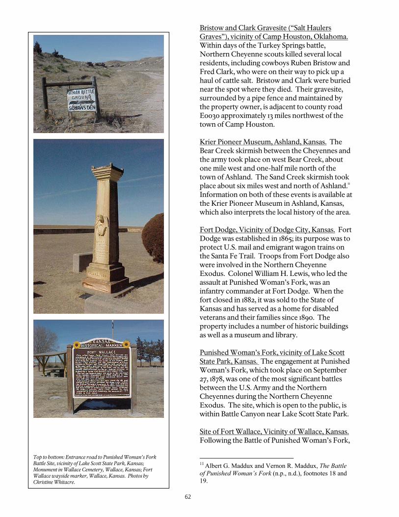
62
Bristow and Clark Gravesite (“Salt Haulers Graves”), vicinity of Camp Houston, Oklahoma. Within days of the Turkey Springs battle, Northern Cheyenne scouts killed several local residents, including cowboys Ruben Bristow and Fred Clark, who were on their way to pick up a haul of cattle salt. Bristow and Clark were buried near the spot where they died. Their gravesite, surrounded by a pipe fence and maintained by the property owner, is adjacent to county road E0030 approximately 13 miles northwest of the town of Camp Houston. Krier Pioneer Museum, Ashland, Kansas. The Bear Creek skirmish between the Cheyennes and the army took place on west Bear Creek, about one mile west and one-half mile north of the town of Ashland. The Sand Creek skirmish took place about six miles west and north of Ashland.11 Information on both of these events is available at the Krier Pioneer Museum in Ashland, Kansas, which also interprets the local history of the area. Fort Dodge, Vicinity of Dodge City, Kansas. Fort Dodge was established in 1865; its purpose was to protect U.S. mail and emigrant wagon trains on the Santa Fe Trail. Troops from Fort Dodge also were involved in the Northern Cheyenne Exodus. Colonel William H. Lewis, who led the assault at Punished Woman’s Fork, was an infantry commander at Fort Dodge. When the fort closed in 1882, it was sold to the State of Kansas and has served as a home for disabled veterans and their families since 1890. The property includes a number of historic buildings as well as a museum and library. Punished Woman’s Fork, vicinity of Lake Scott State Park, Kansas. The engagement at Punished Woman’s Fork, which took place on September 27, 1878, was one of the most significant battles between the U.S. Army and the Northern Cheyennes during the Northern Cheyenne Exodus. The site, which is open to the public, is within Battle Canyon near Lake Scott State Park. Site of Fort Wallace, Vicinity of Wallace, Kansas. Following the Battle of Punished Woman’s Fork,
11 Albert G. Maddux and Vernon R. Maddux, The Battle of Punished Woman’s Fork (n.p., n.d.), footnotes 18 and 19.
Top to bottom: Entrance road to Punished Woman’s Fork Battle Site, vicinity of Lake Scott State Park, Kansas; Monument in Wallace Cemetery, Wallace, Kansas; Fort Wallace wayside marker, Wallace, Kansas. Photos by Christine Whitacre.

63
the troops retired to Fort Wallace, Kansas. Colonel Lewis, who was wounded at Punished Woman’s Fork, died en route to the fort. Fort Wallace was originally established in 1865 to protect emigrant traffic along the adjacent Smoky Hill Trail; troops from the fort were engaged in numerous encounters with Indians, including those during the Northern Cheyenne Exodus. All that remains of the fort is its cemetery, which is within the Wallace Township cemetery. Fort Wallace stood directly south of the cemetery on land that is now private property. Fort Wallace Memorial Association Museum, Wallace, Kansas. The Fort Wallace Memorial Association Museum interprets the history of Fort Wallace and has exhibits of artifacts from the fort. Last Indian Raid Museum (Decatur County Museum), Oberlin, Kansas. Between September 30-October 3, 1878, Cheyenne warriors killed 31 settlers in the vicinity of Prairie Dog Creek, Beaver Creek, and the forks of the Sappa River in northern Kansas. The Last Indian Raid Museum interprets the history of those attacks, locally referred to as the “last Indian raid in Kansas.” The museum displays on the raid include artifacts and a video on the Northern Cheyenne Exodus. Last Indian Raid Monument, Oberlin Cemetery, Oberlin, Kansas. In 1911, a “Last Indian Raid” monument was placed within the Oberlin Cemetery, in memory of those local settlers who were killed during the raid and are buried near the monument. Among those buried in the cemetery are members of the Laing family, which lost four members (a father and three sons) during the raid. Fort Robinson, Vicinity of Crawford, Nebraska. In 1873, the U.S. government relocated Chief Red Cloud and approximately 13,000 Sioux, Cheyennes, and Arapahos to the White River area. The following year, Fort Robinson was established adjacent to the reservation to protect government employees and property and to oversee these Indians. The fort also served as a base for numerous army campaigns, including the 1876 Powder River campaign and the Northern Cheyenne Exodus. On October 23,
1878, troops from Fort Robinson encountered Morning Star’s band, leading to their surrender and imprisonment at Fort Robinson. The restored fort, which is within the Fort Robinson and Red Cloud Agency National Historic Landmark, is operated as a state park by the Nebraska Game and Parks Commission. Located within one of the fort’s historic buildings is the Fort Robinson Museum, which is operated by the Nebraska State Historical Society and interprets the history of the fort, including the Northern Cheyenne Exodus. The Nebraska State Historical Society also is currently reconstructing the Cheyenne Outbreak Barracks at Fort Robinson, from which the Northern Cheyennes escaped on January 9, 1879. Bear Butte, Bear Butte State Park, Sturgis, South Dakota. On their journey back to Montana, Little Wolf stopped to worship at Bear Butte. Sacred to Native Americans, Bear Butte is the place where Maheo, the creator, imparted to
Top to bottom: Exhibit on the Northern Cheyenne Exodus at the Last Indian Raid Museum, Oberlin, Kansas; Laing Family Cemetery Marker, Oberlin Cemetery, Oberlin, Kansas. Photos by Christine Whitacre.

64
Sweet Medicine the knowledge from which the Cheyennes derive their religious, political, social, and economic customs. The site, which is a National Historic Landmark, is within Bear Butte State Park. Site of Fort Keogh, Montana. Little Wolf’s band of 114 people surrendered to the U.S. Army at Fort Keogh on April 1, 1879. Established in 1877, Fort Keogh was at one time the largest army post in Montana. The site is now part of the Fort Keogh Livestock and Range Research Laboratory, operated by the U.S. Department of Agriculture. Remnants of the old parade ground, and one wagon shed, are all that remain of the original fort. Range Riders Museum, Miles City. The Range Riders Museum in Miles City, Montana, includes one of the officer’s quarters from Fort Keogh, which was relocated to this site from the Fort Keogh Livestock and Range Research Laboratory. The museum is on the site of the 1876 Tongue River Cantonment established by General Nelson A. Miles. Roadside markers. Several roadside historical markers identify events associated with the Northern Cheyenne Exodus.
Potential National Historic Landmarks associated with the Northern Cheyenne Exodus Trail As noted above, Bear Butte and Fort Robinson and the Red Cloud Agency already are National Historic Landmarks. Potential National Historic Landmarks associated with the Northern Cheyenne Exodus Trail include: Morning Star (Dull Knife) Village Site, Wyoming. The destruction of this village was a pivotal event in Northern Cheyenne history, and a deciding factor in forcing the surrender of the Northern Cheyennes and their removal to Oklahoma. Punished Woman’s Fork, Kansas. The Battle of Punished Woman’s Fork is the most significant engagement between the Northern Cheyenne and the U.S. Army along the route of the Northern Cheyenne Exodus. In addition, Punished Woman’s Fork is particularly significant for the military tactics employed by the Northern Cheyennes. The carefully planned and staged ambush by the Northern Cheyennes at Punished Woman’s Fork represented an important variant from earlier army-Indian encounters on the plains.

65
Chapter 11: The Smoky Hill Trail
Smoky Hill/Butterfield Overland Dispatch Trail Marker, Kansas. Photo by Christine Whitacre.
Associated Military Campaign Central Plains Warfare of the 1860s involving the Southern Cheyennes, Southern Arapahos, and other tribes. Period of Significance 1859-1870. The period of significance begins with the Colorado Gold Rush of 1859, which precipitated the creation of the Smoky Hill Trail, and ends with the 1870 arrival of the Kansas Pacific Railroad in Denver.
Location Although segments of the Smoky Hill Trail were based on earlier routes, the Smoky Hill, as a distinct continuous trail, is generally defined as extending from Atchison, Kansas, to Denver, Colorado. Trunk lines also connected to the trail from Fort Leavenworth and Kansas City. It is also important to note that the construction of the Kansas Pacific Railroad redefined the eastern beginning point of the Smoky Hill Trail; as the railroad moved westward, so did the eastern terminus of the trail. Length of Trail The length of the trail between Atchison, Kansas, and Denver, Colorado, is approximately 600 miles. History The Smoky Hill Trail was an overland passage followed by emigrants headed for the Colorado gold country during the late 1850s and 1860s. Named for the hilly clay ridge that divided the drainages of the Smoky Hill and Republican rivers, the course evolved as a middle route leading west between the Oregon Trail, paralleling the Platte River through Nebraska, and the Santa Fe Trail, following the Arkansas River in southern Kansas. The eastern parts of the Smoky Hill Trail, extending west from Fort Leavenworth and Kansas City, traced segments of old Indian trails in their course. In 1844, Major John C. Fremont’s expedition to the Rockies passed through the country bordering the Smoky Hill River. In little more than a decade, the migrant segment of the Smoky Hill Trail branched from the Santa Fe Trail near Council

66

67
Grove, Kansas, and carried west along the stream, providing a shorter but hazardous route to the goldfields, and during the rush of 1859 thousands of prospectors followed it in their wagons, pulling handcarts, or walking. From the head of the stream in what is today eastern Colorado, the Smoky Hill Trail veered northwest, following Sand Creek, before heading west and north to Denver. Part of the trail later served as a route for stagecoaches running between the Missouri River and Denver, as well as briefly for the overland mail. Military operations along the Smoky Hill Trail during the Indian Wars stemmed from the route’s use by citizens and commercial enterprise and the consequential establishment of army posts along it for their protection. It was not a campaign route in a formal sense, i.e., its use in that regard was secondary to the reason for its existence and came about largely because of the interplay of the various forts during unfolding events of the 1850s, 1860s, and 1870s vis-a-vis the Indians who inhabited its environs. As emigration proceeded, and as plans for a railroad materialized, the government erected several army posts east-to-west along the Smoky Hill Trail, namely Fort Harker (1864), Fort Hays (1865), and Fort Wallace (1865). All straddled the Smoky Hill Trail in interspersed fashion, and were anchored in the east, as were other Kansas posts, by Fort Riley (1853), near the junction of the Kansas and Republican rivers, and Fort Leavenworth (1827) on the Missouri River. The Smoky Hill posts, as well as four others raised along the Santa Fe Trail in the Arkansas Valley to the south, played significant roles in government-Indian relations affecting the entire Central Plains region. Beyond the routine military use of the Smoky Hill Trail as a wagon road connecting the forts, reflecting more or less of a daily interaction among them as they carried out their prescribed missions on the Kansas frontier, elements of the trail figured in several distinct operations against the Southern Cheyennes, Southern Arapahos, Lakotas, Kiowas, Comanches, and Kiowa-Apache Indians. In early September 1864, Major Edward W. Wynkoop and a command from Fort Lyon, Colorado Territory, marched to a point on the Smoky Hill to meet with the Cheyenne and
Arapahos. There the Cheyenne chief Black Kettle and the Arapaho leaders turned over several white captives and agreed to meet with Colorado Governor John Evans in an effort to maintain peace. But any peace was illusory; in late November Colonel John M. Chivington and a column of volunteer cavalry fell on Black Kettle’s village at Sand Creek, killing more than 150 of the people. Those who managed to flee the massacre found refuge with kinsmen in the Smoky Hill country. In retaliation, the Indians attacked whites along the overland trails throughout Wyoming, Nebraska, and Kansas, targeting emigrant parties, stage stations, and military outposts. Attempting to close the Smoky Hill Trail, which penetrated the Indians’ prime buffalo country, Cheyenne Dog Soldiers and other warriors conducted at least a dozen raids between 1865 and 1869 over the 200-plus mile expanse between Fort Wallace in the west and Fort Harker in the east. In 1867, the trail factored in Major General Winfield Scott Hancock’s campaign against the Cheyennes and Lakotas when the tribesmen killed citizens, stole livestock, burned stage stations along it, even attacking the garrison at Fort Wallace. Hancock sent Lieutenant Colonel George A. Custer in pursuit, and he followed the Smoky Hill Trail east for 40 miles from Downer’s Creek Station. At Fort Hays, the two officers counciled and determined that Custer should proceed northwest on a chase through the Platte, Republican, and Smoky Hill country. But there occurred no decisive engagements, and Custer’s weary column limped back to Fort Wallace. Later, troops of the Tenth Cavalry and Eighteenth Kansas Cavalry joined to fight several hundred Cheyennes and Lakotas at Beaver Creek, some 80 miles north of Fort Wallace on the Smoky Hill Trail. In September 1868, responding to Major General Philip H. Sheridan’s concern over increased depredations by Cheyennes and Lakotas along the railroads, Major George A. Forsyth led a command of 50 scouts out of Fort Hays, ultimately to engage Chief Roman Nose’s Cheyenne warriors in a storied fight of eight days on the Arickaree Fork of the Republican in eastern Colorado Territory. Forsyth’s besieged command, which included five dead and 16 wounded, was relieved by Tenth Cavalry

68
“Buffalo Soldiers” marching rapidly from Fort Wallace. Following Sheridan’s winter campaign against the Southern Plains tribes, Cheyenne prisoners taken at the Washita River encounter in November 1868, were incarcerated at Fort Hays. Again, in April 1875, cavalry operating out of Fort Wallace struck a village of Cheyennes about 70 miles northeast of the post and killed most of the occupants in an episode since plagued with controversy. And in September 1878, troops from Forts Wallace and Hays ranged east and west along the Smoky Hill Trail paralleling the Kansas Pacific Railroad, alert for the Cheyennes under Little Wolf and Morning Star who had broken away from their exile in the Indian Territory in a desperate attempt to return to their Montana homes. These people engaged soldiers at Punished Woman’s Fork on September 27, and the army casualties from that encounter were brought to Fort Wallace. Over the next several weeks, troops from Forts Wallace and Hays continued their maneuvers through the country along the Solomon, Beaver, and their tributaries, but were unsuccessful in their search for the elusive Cheyennes. Throughout the period of construction of the Kansas Pacific Railroad through Kansas near the Smoky Hill, troops from the different posts regularly conducted patrols along the trail to protect its stage and railroad stations from Indians. This routine procedure constituted principal army use of the Smoky Hill Trail, rather than any strict use of it by troops or Indians in the formal government campaigns. As an overland route, the Smoky Hill Trail provided access for emigrants and prospectors bound for the Rocky Mountains, and its presence eventually brought transportation and commerce, which promoted placement along its length of military posts to protect citizens as well as these interests. As did all the overland trails, it impacted Indians who lived in the region by introducing further competition into an ever-constricting land base. Whites vied for game in the coveted buffalo grounds between the Platte and Arkansas rivers granted the Cheyennes and Arapahos by treaty in 1861 and 1865. Compounding this, parties of emigrants who passed over the Smoky Hill Trail joined with those on the Oregon and Santa Fe trails to create a river of humanity cutting broad swaths through tribal lands, stripping grass and timber, while
droughts and disease additionally limited game availability, particularly that of buffalo. Moreover, the military stations along the Smoky Hill – as well as elsewhere in the region – contributed to the despoliation by cutting wood, taking game, and instituting haying to feed their horses, besides promoting the arrival of ranchers to graze the country with cattle to market to the troops. The mounting stress on resources produced trauma and resentment among the tribes, drawing them more and more centrifugally into the Smoky Hill country and creating combustible conditions that erupted randomly over the years of trail use. Underlying all, the Sand Creek Massacre had visited devastation upon the Cheyennes, ripping their societal fabric with the loss of so many leaders and families killed; the catastrophe further promoted longstanding schisms among the assorted bands over matters of war and peace that further manifested themselves in relations
with the army along the Smoky Hill Trail over the next decade.12
12This description of the Smoky Hill Trail and events that occurred along it as well as throughout the Central Plains, is drawn from the following publications: Elliott West, The Contested Plains: Indians, Goldseekers, and the Rush to Colorado (Lawrence: University Press of Kansas, 1998), pp. 198-99, 234-35, 273, 275, and passim; Calvin W. Gower, “The Pike’s Peak Gold Rush and the Smoky Hill Route, 1859-1860,” Kansas Historical Quarterly, 25 (Summer, 1959), pp. 158-71; Utley, Frontiersmen in Blue, pp. 292-97; Robert M. Utley, Frontier Regulars: The United States Army and the Indian, 1866-1890 (New York: The Macmillan Company, 1973), pp. 111-39, George Bent, Life of George Bent written from His Letters. Ed. by Savoie Lottinville (Norman: University of Oklahoma Press, 1968), passim; Lawrence A. Frost, The Court-Martial of General George Armstrong Custer (Norman: University of Oklahoma Press, 1968), map on pp. 114-15; and Margaret Long, The Smoky Hill Trail (Denver: Privately published, 1953), pp. 19-39, and maps opposite pp. xvi and 19. See also, Homer E. Socolofsky and Huber Self, Historical Atlas of Kansas (Norman: University of Oklahoma Press, 1972), maps 20 and 23; “Major Trails of Kansas,” map provided by the Kansas State Historical Society, Topeka; Kansas Historical Markers (Topeka: Kansas State Historical Society, n.d.), pp. 9, 26, 27, 39; Kansas: A Guide to the Sunflower State (New York: Hastings House, Publishers, 1949), p. 449; and Colorado: A Guide to the Highest State (New York: Hastings House, Publishers, 1941), p. 70-71, 271-72. For several of the military outposts along the trail, see, William McKale and William D. Young, Fort Riley, Citadel of the Frontier West (Topeka: Kansas State Historical Society, 2000); Leo E. Oliva, Fort Harker, Defending the Journey West (Topeka: Kansas State Historical Society, 2000); Leo E. Oliva, Fort Hays, Keeping Peace on the Plains (Topeka: Kansas State Historical Society, 1980); and Leo

69
Does the Smoky Hill Trail meet the definition of a military campaign trail? No. Although segments of the Smoky Hill Trail were used in various military campaigns, the trail was primarily an overland route and not a campaign route in a formal sense, in that it was not a primary route used by either Indians or army commands in a direct expeditionary sense. The trail’s military use was secondary to the reason for its existence and came about largely because of the interplay of various forts during unfolding events of the 1850s, 1860s, and 1870s vis-à-vis the Indians who inhabited its environs. Does the Smoky Hill Trail meet criteria for national significance? No, at least not within the context of military campaign trails. Although the Smoky Hill may be nationally significant as an overland trail, that assessment is beyond the scope of the Clash of Cultures trail project. The Smoky Hill Trail is significant in several respects, but its importance in the Indian campaigns derives more from its incidental presence and use, as well as from causative associative features that contributed to the existence of the campaigns, and not as a primary route used by either Indians or army commands in an expeditionary manner. Does the Smoky Hill Trail meet the criterion of significance through historic usage, as defined by the National Trails System Act? No, at least not within the context of military campaign trails. The National Trails Systems Act states that a National Historic Trail “must be a trail or route established by historic use and must be historically significant as a result of that use.” The Smoky Hill Trail may meet the definition of a nationally significant historic trail in terms of its use as an overland trail, but that is beyond the scope of this project.
E. Oliva, Fort Wallace, Sentinel on the Smoky Hill Trail (Topeka: Kansas State Historical Society, 1998).
Does the Smoky Hill Trail merit further study as a potential candidate for designation as a National Historic Trail? Pending further study, the Smoky Hill Trail may merit designation as a National Historic Trail designation for its use as an overland trail, but not for its use solely as a military trail. Places Associated with the Smoky Hill Trail that are Significant as Trail Resources and/or Provide Recreational and Interpretive Opportunities Based on a reconnaissance-level survey, the Smoky Hill Trail appears to have a high level of integrity, with vast open stretches of land similar to that encountered by historical travelers. Much of the trail parallels Interstate 70. The Smoky Hill Trail also provides several recreational and interpretive opportunities, many of which have scenic qualities and most of which (outside of the major metropolitan areas) are free from modern intrusions. From east to west, the following represents a partial list: Fort Leavenworth, Kansas. Fort Leavenworth, the oldest U.S. Army fort in continual use west of the Mississippi River, was established in 1827 to protect the Santa Fe Trail. The fort, which is a National Historic Landmark, was one of several forts that marked the line of the Permanent Indian Frontier, the purported purpose of which was to separate white settlement areas and Indian lands. Fort Leavenworth’s location on the Missouri River made it an important staging area for the military protection of all overland routes, including the Smoky Hill. Frontier Army Museum, Fort Leavenworth, Kansas. The Frontier Army Museum at Fort Leavenworth interprets the history of the frontier army from 1817 to 1917 and Fort Leavenworth from 1827 to the present. The museum offers a variety of interpretive displays and living history programs. Fort Riley, Kansas. Fort Riley, which is still an active base, was established in 1853 at the junction of the Smoky Hill and Republican rivers; its purpose was to provide protection to emigrant and commercial traffic along the adjacent Santa

70
Fe and Oregon Trails. A military road linked Forts Larned, Leavenworth, Riley, and Zarah. Following the discovery of gold in Colorado in 1858, wagons often gathered at or near Fort Riley to begin their westward journey along the Smoky Hill Trail. The fort also served as a stagecoach station stop. U.S. Cavalry Museum, Fort Riley, Kansas. Located within an historic building at Fort Riley, the U.S. Cavalry Museum interprets the history of the cavalry from the Revolutionary War to World War II. Fort Hays State Historic Site (administered by the State of Kansas), Hays, Kansas. Because it was believed that the Indian tribes, especially the Cheyennes and Arapahos, posed a significant threat to emigrant and commercial traffic along the Smoky Hill, Fort Hays (originally known as Fort Fletcher) was established in 1865 to provide protection for the trail. The first Fort Hays was approximately 14 miles to the south; in 1867, it was moved to its current location. Fort Hays also helped guard the mails and Union Pacific Railway construction crews, served as a stagecoach station stop, and was a supply depot for army posts throughout Kansas. Closed by the military in 1889, Fort Hays is now managed as a historic site by the Kansas State Historical Society. Four original structures still stand: the blockhouse, guardhouse, and two officers' quarters. The site has a visitor center and holds living history demonstrations on weekends during the summer. Fort Harker, Kanopolis, Kansas. Like Fort Hays and Fort Wallace, Fort Harker also was built in response to the increased emigrant and commercial traffic along the Smoky Hill Trail. First established as Fort Ellsworth in 1864, Fort Harker also helped guard the stagecoach line and military traffic along the Fort Riley Road. In 1866, the fort was the site of a failed attempt to negotiate a peace settlement with the Cheyennes, following the eruption of warfare that resulted from the 1864 Sand Creek Massacre. Today most of Fort Harker is private property, and several fort properties have been adaptively reused as residences.
Top to bottom: Smoky Hill Trail marker, eastern Colorado; Barracks buildings, Fort Hays State Historic Site, Hays, Kansas; Fort Wallace Memorial Association Museum, Wallace, Kansas. Photos by Christine Whitacre.

71
Fort Harker Guardhouse Museum, Kanopolis, Kansas. The Ellsworth County Historical Society owns two of the original Fort Harker buildings and operates one of them – the guardhouse – as a museum that interprets the history of the fort.
Geographic Landmarks along the Smoky Hill Trail. Most of the route of the Smoky Hill Trail traverses flat, open prairie. However, several geographic landmarks punctuate that landscape, and were points of interest to travelers along the Smoky Hill Trail. These landmarks, some of which have been designated as National Natural Landmarks, include the geographic formations within Mushroom Rock State Park near Ellsworth, Castle Rock near Quinter, and Monument Rocks near Oakley. Site of Fort Wallace, Vicinity of Wallace, Kansas. First called Camp Pond Creek, Fort Wallace was the westernmost military post along the Smoky Hill Trail. Established in 1865 to protect emigrant traffic, as well as stagecoaches and railroad crews, the fort was 150 miles west of Fort Hays and 200 miles east of Denver, within prime buffalo country coveted by several Indian tribes. As historian Leo Oliva has noted, the troops stationed at Fort Wallace, given their location and missions, engaged in more battles than those at any other post in Kansas. All that remains of the original fort is its cemetery, which is within the Wallace Township cemetery. The fort stood directly south of the cemetery on land that is now private property. Fort Wallace Memorial Association Museum, Wallace, Kansas. Fort Wallace Memorial Association Museum interprets the history of Fort Wallace and has displays exhibiting artifacts from the fort. Butterfield Trail Museum, Russell Springs, Kansas. Located in the historic county courthouse building, the Butterfield Trail Museum interprets the history of the Butterfield Overland Dispatch stage line, which followed the route of the Smoky Hill Trail. Twenty-Mile House, Parker, Colorado. The twenty-mile house was so-named because it was a stage stop along the Smoky Hill Trail 20 miles south of Denver. (In this area, the Smoky Hill
Trail paralleled the historic Cherokee Trail.) Later converted to a post office, the building is now preserved in the Twenty-Mile Historical Park in the town of Parker. The Twenty-Mile House was one of six “mile” houses on the Smoky Hill Trail along Cherry Creek south of Denver. Of these, only the Twenty-Mile House, the Seventeen-Mile House, and the Four-Mile House are extant. Seventeen-Mile House, Arapaho County, Colorado. In an effort to protect it from encroaching suburban development, Arapaho County has purchased the Seventeen-Mile House and surrounding land as open space. A nonprofit organization, the “Friends of the Seventeen-Mile House” is now working to restore and interpret the history of the site. Four-Mile House, Denver, Colorado. Constructed in 1859, the Four-Mile House is the oldest building in Denver. The building is within a 12-acre Denver park that is operated by a nonprofit organization, Four Mile Historic Park, Inc., which offers guided tours of the house, as well as other programs that interpret the early history of the region. Pioneer Monument, Denver, Colorado. The Pioneer monument, which is across from the State Capitol within the Civic Center plaza of downtown Denver, was designed by American sculptor Frederick MacMonnies to mark the end of the Smoky Hill Trail to Denver. The
Butterfield Trail Museum, Russell Springs, Kansas. Photo by Christine Whitacre.

72
dedication ceremony for the monument took place in 1911. Roadside markers. Several roadside markers have been placed along the route of the Smoky Hill Trail by the Colorado and Kansas state historical societies, as well as local communities and organizations. These include 138 stone markers placed by Howard Raynesford in 1963, which mark the route of the Butterfield Overland Dispatch in Kansas at those points where it crossed major highways. (One of these markers is shown on the first page of this chapter.) The Smoky Hill Trail passes through several towns and sites that were in existence during the time that the trail was historically used. More
intensive studies of the Smoky Hill Trail route, some of which have already been undertaken by volunteers and trail associations, will yield additional information on extant trail-related resources, such as trail ruts, camping sites, and stage stations. Potential National Historic Landmarks associated with the Smoky Hill Trail Fort Leavenworth is a designated National Historic Landmark. No new potential National Historic Landmarks were identified as part of this reconnaissance-level effort. Further research may yield potential National Historic Landmarks associated with the Smoky Hill Trail.

73
Chapter 12: Trails of the Great Sioux War
Little Bighorn Battlefield National Monument. National Park Service Photo.
Associated Military Campaigns Campaigns of the Great Sioux War Period of Significance 1876-1877. The period of significance encompasses all of the major military actions associated with the Great Sioux War, beginning with Brigadier General George Crook’s movements north in February 1876, and ending with the final campaigns of the war in July, August, and September 1877. Location and Length of Trails Varied. See accompanying map. History The WHA mentors concurred that the trails associated with the Great Sioux War of 1876-77, which was the nation’s largest Indian conflict, merited special attention because they carried troops, Indians, scouts, and large amounts of war materiel into the zone of active operations embracing parts of present Wyoming, Montana, North Dakota, South Dakota, and Nebraska. (In
1907, the War Department recognized the overall army movements as the “Campaign against the Northern Cheyennes and Sioux in Montana [Territory], Wyoming Territory, Dakota Territory, and Indian Territory” between February 22, 1876, and September 10, 1877.) The mentors did not identify one single trail as being the most significant, but instead identified a number of trails, as described below. In particular, the WHA mentors noted that there is considerable public interest in the routes of the army and Indians between the winter of 1875-1876 and the late summer of 1877, largely because of the defeat of Custer and his command at the Little Big Horn by Sioux and Cheyennes and all ancillary features associated with that engagement. Among campaign trails, that tracing the route of the army command under Brigadier General Alfred H. Terry (which included Custer and the Seventh Cavalry) west from Fort Abraham Lincoln, Dakota (near present Bismarck, North Dakota) into the Powder-Tongue-Big Horn river country south of the Yellowstone River evokes perhaps the widest interest because of the Custer connection. The entire length of this trail is known with great certainty, and especially that part leading south from the Yellowstone along Rosebud Creek and eventually west into Little Big Horn Valley. The trails of Custer and his subordinate officers in the direct vicinity of the climactic encounter are likewise well known, with the possible exception of that of Captain Frederick W. Benteen, whose battalion’s location immediately preceding the action at the Sioux-Cheyenne encampment remains at best murky. These are, of course, presently interpreted along with coinciding Indian movements at Little Bighorn Battlefield National Monument. While the climactic event of the Great Sioux War was the Indians’ defeat and destruction of Lieutenant Colonel George A. Custer’s command

74

75
at the Little Big Horn River in Montana, the conflict consisted of several other notable campaigns, including several whose routes corresponded with segments of the old Bozeman Trail route through Wyoming. All of these, each under the command of Brigadier General George Crook, embarked from Fort Fetterman, near present Douglas, Wyoming, and followed the trail generally northwest into the war zone. In February 1876, the Big Horn Expedition headed into the Powder River country along the Bozeman, but departed north along Prairie Dog Creek east of modern Sheridan, Wyoming, seeking Indians along the Tongue and Powder rivers in Montana. Following an engagement with Northern Cheyennes on the Powder on March 17 that portended grim implications for subsequent army operations, Crook’s force trudged over part of the Bozeman Trail in returning to Fort Fetterman. The route of the army command in this campaign is generally known, while parts are precisely known. Again in May, as part of the grand offensive known as the Sioux Campaign that involved army columns from Fetterman, Forts Shaw and Ellis, Montana Territory, and Fort Abraham Lincoln, Dakota Territory (including the ill-fated Custer command) closing on the Yellowstone-Powder river country, Crook started north again, once more following the Bozeman and, as in February, striking north from it a few miles southeast of present Sheridan, Wyoming. His column entered Montana and met the Indians in a major clash along upper Rosebud Creek that again forced his withdrawal back into Wyoming. Scarcely one week after Rosebud, the Sioux and Cheyennes annihilated Custer’s command at the Little Big Horn. Following the army setbacks, Crook awaited reinforcements along Little Goose Creek (near modern Sheridan, Wyoming), then once more struck north on the newly designated Big Horn and Yellowstone Expedition. On that campaign, Crook’s command labored through southeastern Montana into Dakota on a “Horsemeat March,” in which the starving soldiers consumed many of their animals. En route, the troops attacked a village of Sioux and Northern Cheyennes at Slim Buttes, South Dakota, before passing south through the Black Hills mining
districts and closing their operation at Camp Robinson, Nebraska. The route of Crook’s summer campaigning is more or less precisely known. The former Bozeman Trail factored once more in the Great Sioux War. In mid-November 1876, Crook led forth the Powder River Expedition – more than 2,500 soldiers and scouts and 150 wagons bearing provisions constituting the largest of Crook’s successive campaigns – again following the trail northwest out of Fort Fetterman bound for the Tongue River haunts of Crazy Horse’s Lakotas and tarrying briefly at Cantonment Reno, a rude outpost raised as a supply link to Fetterman. Near the road’s crossing of Crazy Woman Fork of Powder River, Crook advanced a large cavalry command under Colonel Ranald S. Mackenzie to attack a village of Northern Cheyennes of chiefs Morning Star (Dull Knife) and Little Wolf. Mackenzie struck the camp on November 25, and in one of the largest encounters of the Great Sioux War routed the tribesmen and destroyed their homes. Rather than continuing into Montana, Crook now backtracked over the Bozeman and from Pumpkin Buttes descended the Belle Fourche River in a northeasterly direction to overtake Crazy Horse’s Lakotas. Frigid weather conditions and scanty provisions, however, combined to turn him back to Fort Fetterman, and his command marched south over part of the Bozeman Trail on its way into the post. Three successive campaigns from Fort Fetterman thus moved northwest over parts of the Bozeman Trail before diverging toward Montana, the overall pertinent stretch containing segments utilized in Crook’s various campaigns measuring approximately 165 miles. While these movements constituted legitimate campaign routes of Crook’s armies, each traced the old Bozeman Trail over part of its course before passing northward. Subordinate routes of consequence tied closely to the Bozeman appear to have included that of Mackenzie leading to and from his attack on Morning Star’s village in the Big Horns, together with that of Crook’s push down and back along the Belle Fourche River before returning to Fort Fetterman in late December. Likewise, the general route north of the Cheyennes from their destroyed village into

76
Montana where they sought refuge with Crazy Horse’s people, while presently but approximately known, must be considered an associated route of this campaign. In all instances, the Bozeman Trail in 1876 likely resembled a broad, dusty, multi-laned dirt road intermittently scored by thousands of soldiers’ shoes, horses’ hooves, and wagon wheels, all moving forward, and the latter constantly passing back and forth with supplies, some bearing the wounded from the Rosebud and Morning Star engagements to the hospital at Fort Fetterman. Other Great Sioux War campaign trails whose courses are generally well known include the route of Colonel John Gibbon’s command from Fort Shaw to Fort Ellis and from the latter post down the Yellowstone to meet the Terry/Custer contingent from the east, as well as the route of march of the forces of Terry and Gibbon west from the mouth of Rosebud Creek to the Big Horn River and the ascent of that stream to the Little Big Horn and up that tributary to the scene of Custer’s engagement. The route of General Crook’s marches along the Bozeman trail, as previously explained, is also generally known. Less is known of the exact movements of Terry and Gibbon on the north side of the Yellowstone in August and September 1876, as they scouted the country before abandoning the summer operations and returning to their respective home stations. Following the summer campaign, the army erected cantonments at Tongue River and Glendive Creek on the Yellowstone, thereby permanently occupying the disputed lands. From these posts through the winter of 1876 and spring of 1877, Colonel Nelson A. Miles fielded campaigns in several directions designed to compel the tribesmen’s surrender and removal to the Dakota and Nebraska agencies. While the sites of Miles’s engagements north and south of the Yellowstone (Spring Creek, Cedar Creek, Bark Creek, Ash Creek, and Muddy Creek) have been established with certainty, the exact routes of his soldiers to and from those places are but vaguely known. The lone exception is Miles’s route south up Tongue River toward his rendezvous and battle with Crazy Horse’s Sioux and accompanying Northern Cheyennes in the Wolf Mountains on January 8, 1877. Similarly, the
trails of the Indians as they addressed army movements throughout 1876 and 1877 are presently known but generally. The least known routes of all of the army operations are those embracing the final campaigning of the Great Sioux War conducted by Miles and his subordinates north of the Yellowstone in the late summer and early fall of 1877, and those occurring simultaneously in eastern Montana, western Dakota, and northern Wyoming, as the troops tried to overtake refugees from the previous encounters and force them into the agencies. 13
13Facets of the Great Sioux War of 1876-77 are considered in several of the works cited in the preceding footnote relating to the Bozeman Trail, but see also, Utley, Frontier Regulars, pp. 247-84; Charles B. Robinson III, A Good Year to Die: The Story of the Great Sioux War (New York: Random House, 1995); John S. Gray, Centennial Campaign: The Sioux War of 1876 (Fort Collins, Colo.: Old Army Press, 1976). Site-specific data, including that relating to army and Indian trails, appears variously in Laudie J. Chorne, Following the Custer Trail of 1876 (Bismarck, No. Dak.: Printing Plus, 1997); ohn S. Gray, Custer’s Last Campaign: Mitch Boyer & the Little Bighorn Reconstructed (Lincoln: University of Nebraska Press, 1991); Paul L. Hedren, Traveler’s Guide to the Great Sioux War (Helena: Montana Historical Society Press, 1996); Jerome A. Greene, Slim Buttes, 1876: An Episode of the Great Sioux War (Norman: University of Oklahoma Press, 1982); and Jerome A. Greene, Yellowstone Command: Colonel Nelson A. Miles and the Great Sioux War, 1876-1877 (Lincoln: University of Nebraska Press, 1991). For 1876 use of the Bozeman Trail, see Paul L. Hedren, “Beyond Red Cloud’s War: The Bozeman Trail in the 1870s” (unpublished paper presented at the Bozeman Trail Symposium, Bozeman, Montana, July, 1998), while information specific to Crook’s operations in 1876, and particularly as they relate to movements in the area of the Bozeman Trail, is in John D. McDermott, “Gen. George Crook’s 1876 Campaigns: A Report Prepared for the American Battlefield Protection Program” (unpublished manuscript dated June, 2000), passim; Robert J. Legoski (comp.), General George Crook’s Campaign of 1876, June 5 through August 3: Newspaper Accounts of the Day (Sheridan, Wyo.: Privately published, 2000), pp. 6-20, 65-73; Jesse W. Vaughn, The Reynolds Campaign on Powder River (Norman: University of Oklahoma Press, 1961), pp. 43-52; and Neil C. Mangum, Battle of the Rosebud: Prelude to the Little Bighorn (El Segundo, Calif.: Upton and Sons, 1987), pp. 29-36, 89-91. Federal campaign designation encompassing the various army movements appears in The Army Almanac: A Book of Facts Concerning the Army of the United States (Washington, D.C.: Government Printing Office, 1950), pp. 410, 678.

77
Do the Trails of the Great Sioux War meet the definition of a military campaign trail? Yes. Taken as a whole, the trails of the Great Sioux War represent all of the army movements in 1876-77 to subdue elements of the Lakota and Northern Cheyenne Indians who refused to be confined on the Great Sioux Reservation. Together they comprise not only the routes of the large multi-columned expeditions to strategically target those tribes fielded by the government in the summer of 1876 in Dakota, Montana, and Wyoming territories, but also those of the smaller maneuvers from established cantonments through the winter of 1876 and the following spring and summer to force the Indians’ removal from the Yellowstone-Powder-Missouri rivers region. As well, the stalwart resistance of the tribes to the pervasive military force represented a defensive campaign against increasingly overwhelming odds, although the routes of Indian movement are but broadly known. The War Department later acknowledged the army operations against the Lakotas and Northern Cheyennes in 1876-1877 as a formal campaign. Do the Trails of the Great Sioux War meet the criterion of significance through historic usage, as defined by the National Trails System Act? No. The National Trails Systems Act states that a National Historic Trail “must be a trail or route established by historic use and must be historically significant as a result of that use.” A trail cannot be determined nationally significant because it provides a route, even if it is a historic route, from one famous site to the next. Indeed, National Trails System staff often use the analogy that it is not the purpose of trail designation to “string beads on a necklace.” In the case of the trails of the Great Sioux War, it is the engagement sites associated with the war – such as Little Bighorn – that are the most significant features. Do the Trails of the Great Sioux War meet criteria for national significance? No, at least not in terms of their possible designation as National Historic Trails.
According to National Trails System Act criteria, the trails themselves – not the points along the trails – have to be of national significance. The trails associated with the Great Sioux War are an excellent example of this distinction. The mentors of the Western History Association overwhelmingly identified the Great Sioux War of 1876-1877 as a nationally significant military campaign. However, the trails associated with this conflict are not significant as stand-alone resources, but rather for their associations with the major engagements of the Great Sioux War. As mentor R. David Edmunds noted, “Although the trails associated with the Custer campaign are important in that they are the routes that the army used during the campaigns, the trails themselves are only incidental to the events of the campaign, and therefore not the focal points.” However, the WHA mentors suggested designating the sites and trails associated with the Great Sioux War as a state or national heritage area, as a scenic/historic byway, or as an auto tour route. These concepts would encompass all of the major trails and sites associated with the Great Sioux War, and would provide an opportunity to interpret all of the major resources of the Great Sioux War – including its military campaign trails – within a broader and more comprehensive context. Do the Trails of the Great Sioux War merit further study as a potential candidate for designation as a National Historic Trail? No. According to the National Trails System Act, a National Historic Trail must: (A) be significant as a result of its use as a trail; (B) must meet criteria for national significance; and (C) must have potential for public recreation or historical interpretation. As discussed above, the trails of the Great Sioux War are important only in terms of their relationship to the engagements of the Great Sioux Wars. As stand-alone resources, they do not meet the criteria for national significance in terms of their use as historic trails.

78
Trails and Sites Associated with the Great Sioux War that are Significant as Trail Resources and/or Provide Recreational and Interpretive Opportunities. Based on a reconnaissance-level survey, many of the trails and sites associated with the Great Sioux War have retained a high degree of integrity. These trails and sites provide a range of educational and recreational opportunities, many of which have scenic qualities and most of which (outside of the major metropolitan areas) are free from modern intrusions. These include: Custer Trail, North Dakota and Montana. This route was used by the Terry-Custer column in its advance west from Fort Abraham Lincoln, Dakota, in the spring of 1876. From the mouth of Rosebud Creek on the Yellowstone, Custer marched with the Seventh Cavalry component to the Little Bighorn. The locations of historic army campsites have been established along its course. The trail approximates Interstate 94 in North Dakota and Montana in its route to Rosebud Creek, and Montana Highway 39 and U.S. Highway 212 in its course to Little Bighorn battlefield. Occasional markers and monuments interpret sites along the route up Rosebud Creek to the Little Bighorn. Crook’s Routes along the Bozeman Trail, Wyoming. Military use of the Bozeman Trail in 1876 consisted of passing north and back again from Fort Fetterman to the scenes of the Powder River, Rosebud, and Morning Star (Dull Knife) encounters. Parts of the trail were used repeatedly for the transportation of provisions for Crook’s commands. While parts of the trail can be accessed using county roads north of modern Douglas, other segments approximate the route of modern Interstate 25 and its parallel routes through northern Wyoming. Crook’s Route to the Black Hills, 1876. In the late summer of 1876, General Crook moved southeast from the Yellowstone River in pursuit of Lakotas and Cheyennes headed both toward the Great Sioux Reservation agencies and the Black Hills mining communities. Today, the route of his command can be approximated with reasonable accuracy along Interstate 94 in Montana and North Dakota, North Dakota State Highway 22,
and South Dakota State Highway 79 to Slim Buttes and the Black Hills, various local roads in the Black Hills from Whitewood to Deadwood to Custer, then south toward Camp Robinson, Nebraska, via U.S. Highway 385. Crook’s Trail on the Belle Fourche River, Wyoming. Following the destruction by Mackenzie’s cavalry of the Northern Cheyenne village under Morning Star and Little Wolf, Crook led his command down the Belle Fourche seeking Crazy Horse before returning to Fort Fetterman. The route of a small part of his trail approximates part of Wyoming Highway 387 through Campbell County east of modern Pine Tree, but most of the route has not been defined. Powder River Encounter Site, Montana. Located in Powder River County, Montana, 36 miles southwest of Broadus, this site commemorates Colonel Joseph J. Reynolds’s attack on a village of Northern Cheyennes on March 17, 1876, the first engagement of the Great Sioux War. The site, marked in 1934, is on private land. Fort Abraham Lincoln, North Dakota (1872-1891). Currently a North Dakota state historical park, this partly reconstructed post located near Bismarck represents the home of the Seventh Cavalry as it existed prior to its departure west on the Sioux Campaign in May, 1876. Fort Fetterman, Wyoming (1867-1882). This post, located near modern Douglas, Wyoming, stood at the periphery of the Powder River drainage and anchored three movements of Crook’s army in 1876. The site is currently administered as a state historical property. Fort Ellis, Montana (1867-1886). In the spring of 1876, cavalry and infantry troops under Colonel John Gibbon descended the Yellowstone River from Fort Ellis to join Terry’s column coming from the east. The site of the post, devoid of all structural features, is located on the east side of Bozeman, Montana, where a single marker interprets its history. Fort Laramie, Wyoming (1849-1890). This venerated post, with its fur trade antecedents, played major logistical – as well as strategizing – roles in the Great Sioux War. The 1868 treaty

79
establishing the Sioux Reservation was negotiated at Fort Laramie. As point of organization for the various campaigns under Crook, as well as a “jumping off” spot for some troops bound for the war, it served as an important army staging area throughout the conflict. It also hosted a major war progress conference with General Sheridan in attendance. Today a national historic site, Fort Laramie preserves nearly two dozen army buildings and interprets the role of the post in American frontier history. Tongue River Heights Skirmish Site, Wyoming-Montana. On June 9, 1876, Crook’s command, en route into Montana Territory, camped at the junction of Prairie Dog Creek with Tongue River, in modern Sheridan County, Wyoming. That evening, his bivouac briefly came under fire of Northern Cheyenne warriors before cavalry troops drove the Indians away. The site, which spans the border of the two states, is unmarked. Rosebud Battlefield, Montana. Here on June 17, 1876, Lakota and Cheyenne warriors instigated an attack on Crook’s column as it moved north to meet Terry, Gibbon, and Custer. The all-day battle netted significant casualties on either side, but importantly forced Crook to withdraw his command back into Wyoming, effectually removing him from the principal war zone a week before the Little Bighorn encounter. The site of this wide-ranging action is a Montana state park. Little Bighorn Battlefield National Monument (administered by the National Park Service) Crow Agency, Montana. This national monument, administered by the National Park Service, commemorates the Indian Wars through interpretation of the June 25-26, 1876, victory of the Lakotas and Northern Cheyennes over Custer’s Seventh Cavalry – the climactic engagement of the Great Sioux War and a strategic setback for the federal command. The site has come to symbolize not only the Great Sioux War, but the entire spectrum of the Indian Wars of the trans-Mississippi West, as well. Sibley Fight Site, Wyoming. This generally defined location where on July 7, 1876, a scouting detachment from Crook’s command engaged
Top to bottom: Fort Fetterman, vicinity of Douglas, Wyoming; Fort Robinson Museum (former post headquarters), Fort Robinson, vicinity of Crawford, Nebraska; Bozeman Trail ruts, Wyoming; Morning Star (Dull Knife) Village Site wayside marker, Johnson County, Wyoming. Photo of Fort Robinson by Roger Whitacre; all others by Christine Whitacre.

80
Northern Cheyenne warriors is in Bighorn National Forest, about ten miles from modern Dayton. The 25 soldiers and two scouts with Second Lieutenant Frederick W. Sibley, fought a two-hour exchange before managing to escape over the mountains and rejoin the troops without casualty. The approximate site is in Sheridan County and is accessible on Forest Service roads. The skirmish is commemorated by a monument erected along U.S. Highway 14 near Sibley Lake. Warbonnet Creek Skirmish, Nebraska. On July 17, 1876, Colonel Wesley Merritt’s Fifth Cavalry engaged Northern Cheyennes en route to the Powder River country from Red Cloud Agency, near Camp Robinson. The encounter disrupted the Indians’ journey, instead forcing most of them to return to the reservation. During the skirmish, the army scout, William F. Cody, shot and killed a young Cheyenne named Yellow Hair, an event later reenacted in Cody’s Wild West show. The site is interpreted through a monument and markers on Department of Agriculture property in Sioux County and is accessible via local gravel roads. Slim Buttes Encounter Site, South Dakota. At dawn on September 9, 1876, troops from Crook’s command under Captain Anson Mills stormed into a mixed village of Lakotas and Northern Cheyennes along Gap Creek, capturing a number of noncombatants, but also the chief, American Horse, who was mortally wounded. In the afternoon, Crook’s men skirmished with followers of Crazy Horse until nightfall. It was the first major army victory in the Great Sioux War. Most of the site in modern Harding County is on private land adjoining national forest land about 22 miles east of Buffalo along South Dakota Highway 20. Besides a state road marker, a single monument erected in 1920 interprets the site. Glendive Cantonment (1876-1877). Erected on the north bank of the Yellowstone River, Glendive Cantonment stood at the seasonal head of navigation of that stream. During 1876 and 1877, steamers unloaded equipment and provisions at Glendive for delivery upriver to the Tongue River Cantonment. Late in the Great Sioux War, Miles ordered campaigns from Glendive to seek out the refugees of Lame Deer’s village who had not yet surrendered. While the
Glendive Cantonment is long gone, its history is interpreted at local Glendive museum facilities. The site is on private property adjoining Montana State Highway 16. Tongue River Cantonment (1876-1877) and Fort Keogh (1877-1900), Montana. Raised in the fall of 1876, Tongue River Cantonment stood west of modern Miles City. From the cantonment, Colonel Nelson A. Miles fielded six campaigns in 1876-77, demonstrating to the tribes the government’s determination to permanently occupy the Sioux country and force the Indians’ capitulation or destruction. Tongue River Cantonment was replaced in the summer of 1877 by the more substantial Fort Keogh, erected a short distance up the Yellowstone to effect a continued military presence in the region. Today the Range Riders Museum approximates the location of the temporary post. Spring Creek Skirmishes, Montana. On October 11, 1876, a command escorting a provision train from Glendive Creek to Tongue River Cantonment under Captain Charles W. Miner, came under attack along Spring Creek (present Sand Creek) by Lakotas distressed over the army presence in the buffalo country. The train returned to Glendive, but started out again several days later under Lieutenant Colonel Elwell S. Otis. On October 15, Indians struck again, and an intermittent running fight ensued over many miles before troops from Tongue River arrived on the 18th and the warriors withdrew, allowing the train to proceed to the cantonment. The area of the extended skirmishing, mostly today on private land, is in modern Dawson and Prairie counties. Cedar Creek Conference and Skirmish, Montana. On October 20 and 21, 1876, Colonel Nelson A. Miles approached Sitting Bull’s camp in the divide country between the Yellowstone and Missouri rivers and there conferred at length with the Hunkpapa leader. At the meeting – the first between a federal agent and a leader of the Indian coalition since the warfare began – the chief demanded that the soldiers leave the region, while Miles resolved to remain. The contentious parley precipitated an encounter between Miles’s command and the Indians, following which many of the tribesmen (minus Sitting Bull’s people,

81
who escaped) agreed to surrender. The site, in Prairie County, approximately 21 miles northwest of Terry, is partly on Bureau of Land Management property and partly on privately owned land. Fort Robinson, Nebraska (1874-1948). During the Great Sioux War, Fort Robinson – then known as Camp Robinson – stood guard over nearby Red Cloud and Spotted Tail agencies of the Great Sioux Reservation to insure that warriors did not leave to reinforce their kinsmen fighting the soldiers to the northwest. Camp Robinson hosted soldiers of Crook’s various expeditions while overseeing the agencies and the Military District of the Black Hills, thus playing an important role in the conflict. In September 1877, the surrendered Oglala leader, Crazy Horse, was killed there by a sentry while resisting arrest, an action symbolizing the conclusion of the war. The “camp” designation was changed to “fort” in 1878. A museum operated by the Nebraska State Historical Society today interprets the post’s history. Cantonment Reno, Johnson County, Wyoming (1876-1878). Built along the Dry Fork of Powder River in what is now Johnson County, this cantonment served as a subpost supporting the operations of General Crook during that officer’s third and final thrust north from Fort Fetterman in 1876. The site, on Bureau of Land Management property, is interpreted through markers placed by the State of Wyoming. Morning Star (Dull Knife) Village Site, Wyoming. On November 25, 1876, cavalry from Crook’s command under Colonel Ranald Mackenzie attacked and destroyed the Northern Cheyenne village of Morning Star and Little Wolf in one of the largest engagements of the Great Sioux War. The army success demoralized the people, promoting their surrender at the Sioux agencies the following spring. The site is in Johnson County, mostly on private property, and is accessible by fee at the pleasure of the landowners. A small monument raised in 1948 by the Daughters of the American Revolution marks the site. Fort Peck Expedition Trail. In late November 1876, Colonel Miles led a command north from
Tongue River Cantonment seeking the winter haunts of the Lakotas. The troops followed down the Big Dry River to the Missouri and the Fort Peck Indian Agency (site now beneath the Fort Peck Reservoir), then moved west to the vicinity of Carroll, Montana, before returning southeast to the cantonment in late December. The route of the campaign is only broadly known. Part of the command under First Lieutenant Frank D. Baldwin moved east from Fort Peck and encountered Sitting Bull’s people at Bark Creek and Ash Creek. Bark Creek Skirmish, Montana. On December 7, 1876, a part of Colonel Miles’s command under First Lieutenant Frank D. Baldwin came upon Sitting Bull’s people near Bark Creek, about 18 miles below Fort Peck Indian Agency, and in process of crossing the ice of the Missouri River to its south bank. Baldwin’s infantry soldiers fired on the rearguard of the assemblage, but there were apparently no casualties on either side. The site of the Bark Creek action was inundated by reclamation projects in the 1930s and presently lies beneath Fort Peck Lake. Ash Creek Encounter Site, Montana. On December 18, 1876, First Lieutenant Frank D. Baldwin surprised and attacked at midday Sitting Bull’s village, forcing the occupants to scatter and destroying their homes and provisions. The attack motivated Sitting Bull to lead his people into Canada in the spring of 1877. This site, marked with a monument in 1932, is located on private land in Prairie County. Wolf Mountains Campaign Trail. This route led south from Tongue River Cantonment, passing upstream for approximately 100 miles. In January 1877, Miles’s infantry command moved out of the cantonment searching for Crazy Horse’s winter camp. The modern paved Tongue River Road closely approximates the course of the troops’ march to the scene of the January 8, 1877, engagement near present Birney, and then back to the Tongue River Cantonment near Miles City. Wolf Mountains Battlefield. At this site south of modern Birney, Lakotas and Northern Cheyennes led by Crazy Horse, Two Moon, and others attacked Miles’s bivouac on the morning

82
of January 8, 1877. The troops, armed with two artillery pieces and protected from the cold in buffalo overcoats, established a perimeter in the Tongue River bottom and confronted warriors entrenched on ridges to the southeast until the death of a prominent medicine man, Big Crow, coupled with the onset of a blizzard, forced the Indians’ withdrawal. The engagement was significant in convincing most of the Lakotas and Cheyennes to yield to the government the following spring. The site is on private land in Rosebud County approximately three miles southwest of Birney on Country Road 314. A privately raised sign marks the battlefield.
Lame Deer Encounter Site, Montana. Here at dawn on May 7, 1877, Miles and his cavalry attacked the village of Chief Lame Deer’s Minneconjou Sioux, who had repeatedly defied army presence in the region and had refused to surrender at the Dakota/Nebraska agencies. The chief was killed in the ensuing combat. The unmarked site, owned by the Northern Cheyenne Tribe and now compromised by the incursions of modern development, lies in Rosebud County on the southwestern edge of Lame Deer. Fort Custer, Montana (1877-1898). This post was raised in 1877, during the closing months of the Great Sioux War, to provide with its sister post, Fort Keogh, a permanent military occupation of the disputed Yellowstone-Big Horn region. The site of Fort Custer is on private land and admittance is prohibited. It is marginally interpreted at the Big Horn County Historical Society Museum in nearby Hardin. Potential National Historic Landmarks associated with the Great Sioux War Fort Robinson is part of the Fort Robinson and Red Cloud Agency National Historic Landmark. Little Bighorn Battlefield National Monument
recently received funding to prepare a thematic study of all the sites and trails associated with the Great Sioux War, an effort that may identify other potential National Historic Landmarks. Based on preliminary study prepared for this funding request, potential National Historic Landmarks associated with the Great Sioux War may include: Rosebud Battlefield, Montana. As noted above, this all-day battle forced Crook to withdraw his command back into Wyoming, effectually removing him from the principal war zone a week before the Little Bighorn encounter. Wolf Mountains Battlefield, Montana. This engagement was significant in convincing most of the Lakotas and Cheyennes to yield to the government the following spring. Powder River Encounter Site, Montana. The site of Colonel Joseph J. Reynolds’s attack on a village of Northern Cheyennes on March 17, 1876, this was the first engagement of the Great Sioux War. Morning Star (Dull Knife) Village Site, Wyoming. The destruction of this village was one of the largest engagements of the Great Sioux War, and prompted the surrender of the Northern Cheyennes in the spring of 1877. Slim Buttes Encounter Site, South Dakota. The Slim Buttes encounter was the first major army victory in the Great Sioux War. Cedar Creek Conference and Skirmish, Montana. In 1876, Colonel Nelson A. Miles approached Sitting Bull’s camp at this site, and conferred at length with the Hunkpapa leader in the first meeting between a federal agent and a leader of the Indian coalition since the Great Sioux War begin. The engagement that followed signified the government's determination to remain permanently in the region.

83
Conclusion The Clash of Cultures trails project had two primary goals. The first was to identify and assess the national significance of trails associated with the history of U.S. Army/American Indian campaigns in the trans-Mississippi West during the nineteenth century. To accomplish this goal, the National Park Service asked a blue-ribbon panel of Western History Association historians to evaluate the trails within the framework of a National Historic Landmark theme study. As such, the mentors were asked to evaluate the use of the military campaign trails associated with the Indian Wars in terms of their relative significance – requiring the WHA mentors to not only identify the most significant military campaign trails, but to also prioritize them in terms of their significance. This was a difficult task, and one that the mentors took very seriously. Sherry Smith reflected the views of many of the WHA historians as she noted that while she understood the National Park Service’s need for prioritization, she also found it frustrating. As she stated in her report: “Assigning levels of significance, ranking events (or people or places) is antithetical to what we historians do. We’re trying to understand the past by making connections; explaining relationships among groups, events, and individuals for the purpose of understanding the complexity of human activities.” At the same time, however, Smith and the other mentors also recognized that the National Park Service works with finite resources, and needs to make choices about which are the most important resources to preserve and interpret. While recognizing that all the trails of the Indian Wars are significant at some level, and all have some story to tell, the mentors agreed to identify those trails that were clearly nationally significant, and which were the best representations of the broader themes of the history of U.S. Army/American Indian conflict in the trans-Mississippi West. By compiling the mentors' lists of the most important trails, six trails stood out very clearly from all other suggestions. These were: the Bozeman Trail, the
Long Walk, the Nez Perce Trail, the Northern Cheyenne Exodus Trail, the Smoky Hill Trail, and the trails associated with the Great Sioux War. The second major goal of the Clash of Cultures trails project was to determine if any of these trails might warrant further study as potential National Historic Trails. Since the Nez Perce Trail is already designated as a National Historic Trail, there was no need for further evaluation. As described in the methodology section, the assessment of the remaining five trails had to be based on criteria established by both the National Trails System Act and the National Historic Landmarks program. These criteria are exacting. In particular, the National Trails System Act states any potential National Historic Trail “must be a trail or route established by historic use and must be historically significant as a result of that use.” As has been noted several times throughout this report, it must be the trails themselves – not just the points along the trails – that have to be of national significance. Examples are the Santa Fe and Oregon Trails. Both of these National Historic Trails are adjoined by places that are also significant for their association with those trails. But even if those associated places along the trails did not exist, the trails themselves would still have national significance. This standard of identifying trails that are nationally significant for their historic usage is particularly important in the case of military campaign trails. Most military trails are only considered significant in terms of their relationship with the engagement sites to which

84
. . . it must be the trails themselves – not just the points along the trails – that have to be of national significance.
they lead. Simply put, what happens on the trail is rarely as important as what happens on the battlefield. Overwhelmingly, it is the engagement sites themselves that are the primary resource in the history of military conflict. WHA historian Paul Fees noted that this distinction is graphically illustrated by various atlases and published maps of the Indian Wars. With few exceptions, Fees noted, these maps and atlases “show (marked by crossed sabers and a date) the places where actions and engagements took place, and the locations of forts and depots. But, significantly, they do not show how the army or the Indians got from one place to another, apparently because the trail is not as essential to the story.” Within the scope of the Clash of Cultures trails project, the evaluated trails also had to meet the definition of a military campaign trail – since that was the intent of this project. The Clash of Cultures trails project was specifically created to evaluate military trails, which are an under-represented resource type within the National Trails System, but one in which there is a substantial amount of public interest. Other categories of trails – such as trails of exploration, trails of trade and commerce, and trails of migration and settlement – have been, or will be, evaluated as separate studies. Based on these criteria, there were, not surprisingly, only a relatively small number of trails that the WHA mentors identified as nationally significant for their historic use as military campaign trails. Of those, only three trails were found to warrant further study as potential National Historic Trails. These were the Bozeman Trail, the Long Walk, and the Northern Cheyenne Exodus Trail. The Bozeman Trail ranked at the top of the WHA mentors’ list of nationally significant trails associated with the Indian Wars in the West, although only by a slight margin. Of the trails
studied, the Bozeman Trail was one of the clearest examples of how the historic usage of the trail was nationally significant, as it was the establishment and use of the trail itself that was the primary cause of the Powder River Campaign and the Red Cloud War. Interestingly, the Bozeman Trail points out that the most significant military campaign trails are not always associated with the most significant military campaigns, a situation that had been predicted by some project team members at the onset of the project. While the Red Cloud War and Powder River Campaign ranked, respectively, eighth and eleventh in the WHA mentors’ list of most significant campaigns, the Bozeman Trail was at the top of their list of most significant trails. The historic usage of the trail as both the precipitator and focal point of conflict – as well as its representation of several broad themes of the history of the Indian Wars – make the Bozeman Trail an excellent candidate for further evaluation as a National Historic Trail. The WHA also identified the Long Walk and the Northern Cheyenne Exodus Trail as nationally significant, and these two trails also appear to be excellent candidates for further evaluation as potential National Historic Trails. The Long Walk and the Northern Cheyenne Exodus Trail are both noteworthy as epic routes taken by Indian people in extraordinary campaigns. In both cases, it is the actual usage of the trails that are not only nationally significant, but which have also become seminal events in the history and culture of the tribes. Also, as Paul Fees noted, “these routes captured the imagination and the sympathy of the nineteenth-century American public in a way that the army’s treks could not, especially in the wake of the Civil War and its many epic marches and battles.” It is very important that any further studies of Indian Wars military campaign trails, specifically in terms of their possible designation as National Historic Trails, include tribal consultation. This is particularly true for the Northern Cheyenne Exodus Trail and the Long Walk. Tribal consultation would be absolutely necessary to learn whether or not the tribes would support such designation. The tribes also can identify any sites along these trails that are of particular significance to the tribes. As part of the Clash of

85
Cultures trails project, NPS project team members contacted the Navajo and Mescalero Apache tribal offices regarding the Long Walk, as well as individual members of the Northern Cheyenne tribe regarding the Northern Cheyenne Exodus Trail; however, there was no formal tribal consultation. The WHA mentors also identified the Smoky Hill Trail as being nationally significant. However, within the scope of the Clash of Cultures trails project, the Smoky Hill Trail did not meet the criteria for further study as a potential National Historic Trail, at least not within the context of military campaign trails, since it did not meet the definition of a military campaign trail. As discussed in the report, the Smoky Hill Trail’s importance in the Indian campaigns derives more from its incidental presence and use, and not as a primary route used by either Indians or army commands in a direct expeditionary sense. The Smoky Hill Trail’s primary significance is as a trail of migration and settlement – an overland route – albeit one that was militarily supported and protected. It is recommended that the Smoky Hill be evaluated as a National Historic Trail within the context of trails of migration and settlement, which is beyond the scope of this project. Indeed, new scholarship – such as The Contested Plains: Indians, Goldseekers, and the Rush to Colorado by WHA mentor Elliott West – has substantially broadened our understanding of the environmental and cultural impacts of the overland routes, warranting a re-evaluation of the significance and interpretation of those trails. The final recommendation for national significance by the WHA mentors encompassed the trails associated with the Great Sioux War. The WHA mentors overwhelmingly identified the Great Sioux War as the most important military campaign of the Indian Wars. However, there was no agreement as to which, if any, of the several campaign trails associated with the Great Sioux War are nationally significant as individual resources. Presumably, this reflects the secondary importance of the trails to the war. As has been discussed throughout this report, a trail is not nationally significant because it connects nationally significant sites; i.e., the “beads on the necklace” analogy. The trail itself must have
It is very important that any further studies of Indian Wars military campaign trails, specifically in terms of their possible designation as National Historic Trails, include tribal consultation.
national significance for its historic usage. The trails associated with the Great Sioux War provide an excellent example of this distinction. Although significant for their associations with the major engagements of the Great Sioux War, the trails are not nationally significant as stand-alone resources. Little Bighorn is nationally significant for the events that occurred on June 25-26, 1876. The route that Custer took to that nationally significant event is an associated, but secondary, element of that story. In terms of the trails associated with the Great Sioux War, many of the mentors suggested a more appropriate designation may be the creation of a multi-state heritage area or corridor, an auto tour, and/or scenic/historic byway that interpretively links some of the major campaign trails used by American Indians and soldiers together with certain of the encounter sites. Such an approach could enhance understanding of the country’s largest Indian war in a broad context, while helping to satisfy public interest in the specific events of the conflict and promoting the protection and interpretation of its sites. It is, of course, up to Congress to initiate the process for officially evaluating any potential national heritage area and/or National Historic Trail. In the case of a potential National Historic Trail, Congress directs either the National Park Service or another federal agency to complete a National Trails System study. As noted earlier, a Congressionally authorized National Trails System study must include the recommendation of the National Park System Advisory Board regarding the national significance of that trail. (Although the evaluation of national significance has been a major focus of this report, it is the responsibility of the National Park System Advisory Board to make that final

86
In terms of the trails associated with the Great Sioux War, many of the mentors suggested a more appropriate designation may be the creation of a multi-state heritage area or corridor, an auto tour, and/or scenic/historic byway . . .
recommendation.) In addition, the study must also evaluate both the feasibility and desirability of a potential National Historic Trail. National Trails System studies, which generally take about two years to complete, include extensive public involvement. As outlined in Section 5(b) of the NTSA, congressionally authorized studies are “made in consultation with the heads of other Federal agencies administering lands through which such additional proposed trails would pass and in cooperation with interested interstate, State, and local governmental agencies, public and private organization, and landowners and land users concerned.” Such studies also have to address the physical possibility and costs of developing and maintaining the trail, whether the development of a trail would be financially feasible, and the impact of public use on the preservation of the trail and its associated features. These studies, when completed, are printed as House or Senate documents. A National Trails System study of the trails identified in the Clash of Cultures trails project would offer an opportunity to more fully evaluate several issues raised in this preliminary report. This would include detailed routes of the trails, and the identification of important associated sites. In their scope of work for the Clash of Cultures trails project, the WHA mentors were asked if they had first-hand knowledge of the location and condition of recommended trails, or if they were aware of any sites along the trails that were of particular significance. In general, the mentors offered few such recommendations. As such, the project report includes only general information on such resources, primarily based on “windshield surveys” of portions of the trails that were done by NPS project team members. While the general impression of the NPS team
was that at least segments of the trails have a high level of integrity, any future trails studies should identify those trail resources that, according to National Historic Trail Criterion C, also “have significant potential for public recreational use or historical interest based on historic interpretation and appreciation” (NTSA (Section 5(b)(11)C)). This would include a close examination of both the trail route and significant associated sites. For example, most historians define the Long Walk as extending from Fort Canby (Fort Defiance) to Bosque Redondo. However, the route could also be defined as beginning in Canyon de Chelly. This could be further evaluated in the National Trails System study. Also, all the various routes of the Bozeman Trail should be evaluated in terms of their historic usage and which routes, therefore, should be potentially designated. And, although portions of the Northern Cheyenne Exodus are well known, other portions are lesser known, including the exact location of the camp established by Little Wolf in the valleys of the Nebraska Sand Hills, the identification of which may only be possible through tribal oral history and consultation. Project team members also recommend that any future surveys of these trails as potential National Historic Trails include a special effort to identify Indian-related sites associated with these trails. The very reconnaissance-level survey of the trails that was conducted as part of the Clash of Cultures trails project identified a predominance of U.S. Army-related sites, such as forts, largely because those are the sites that have been preserved and interpreted. Traditional Indian campsites, sites of special significance to the tribes, as well as areas where Indians traditionally lived, hunted, gathered, etc., are also an integral part of the story of these trails. Western History Association mentor Don Fixico also emphasized the importance of obtaining ethnographic information in any future trail studies, including the cultural background of Indian warfare and the use of war materials, and properly presenting that information to the public. Fixico also underscored the importance of representing the Indian point of view in the interpretation of the trails, a point that weighs heavily in trying to correct past stereotypes about

87
plains Indians that still plague the American public. National Park Service ethnographer Dave Ruppert, who reviewed the draft project report, echoed Fixico’s comments regarding an Indian perspective in the interpretation of the trails. “One of the major complaints I often hear from tribal members,” noted Ruppert, “ is that the American public is not really aware that Indian people – and important aspects of their culture – are still here.” The trails associated with the Indian Wars provide an opportunity to educate the public on the broad spectrum of the “clash of cultures.” The themes outlined in Chapter 4, which can be more fully developed in future trails studies, reflect how these resources characterize broad patterns of American history and culture, including Indian cultures – representing not only military clashes but also clashes of cultural views of land use, resources, lifeways, and ideas. It is also recommended that future trail studies take into consideration other historic contexts with which these trails are associated. As has been noted numerous times throughout this report, the focus of the Clash of Cultures trails project was on military campaign trails associated with the Indian Wars. But it is important to note that many of these trails had uses that extended beyond those of military campaigns – and which may also be historically important. Many of these trails originated as tribal and/or inter-tribal trails (which, in many cases, were also a “clash of cultures”). Some were also trails of exploration, overland travel, and trade and commerce. For example, in the case of the Smoky Hill Trail, the project team did not believe that it met the definition of a military campaign trail, and instead recommended that it be evaluated for its national significance as an overland trail. And, while the Bozeman Trail meets the definition of a military campaign trail, it was also used for commerce, migration, and overland travel. (Indeed, it was those activities that triggered the Bozeman Trail’s use as a military campaign trail.) Evaluated
A congressionally authorized study of a potential National Historic Trail must include the recommendation of the National Park System Advisory Board regarding the national significance of that trail . . . In addition, a National Trails System Study must also evaluate the feasibility and desirability of any potential National Historic Trail.
within those other contexts, the Bozeman Trail, as well as others, may be found to have nationally significant associations beyond their military use. In other words, some of these trails may “fit” into additional historic contexts other than “military campaign trails.” Those additional associations may be of equal or even greater significance – but, again, that was beyond the scope of the Clash of Cultures trails project. Indeed, the themes outlined in Chapter 4 illustrate how – even within just the context of military campaigns – these trails represent extremely broad patterns of American history and culture, and had far-reaching environmental, political, and social implications. The Clash of Cultures was a model project in that it was the first time that the methodology of the National Historic Landmarks program – specifically the use of a theme study – was applied to the identification and evaluation of potential National Historic Trails. Overall, the project team members believe that the methodology was successful in its application and may well serve as a useful means by which to evaluate additional thematic groups of trails in terms of their national significance. Future studies of trails could even more completely follow the model of a National Historic Landmark theme study by also assessing the physical integrity of the trails.

88
Bibliography Most of the following citations were provided by the Western History Association mentors as being the most important works on the history of U.S. Army/American Indian conflict in the trans-Mississippi West during the nineteenth century. In addition, citations are included for works that were used by the NPS project team to research specific trails; most of those resources are also cited in the footnotes in the text of the report. Documents: Heitman, Francis B. comp. Historical Register and Dictionary of the U.S. Army. 2 vols. Washington, D.C.,
1903. Kappler. Charles J. comp. Indian Affairs: Laws and Treaties. 2 vols. Washington, D.C., 1904. Oliva, Leo E. Fort Union and the Frontier Army in the Southwest. Santa Fe: National Park Service, 1993. Rendlebrock, Joseph to Lieutenant Colonel John P. Hatch, Fourth Cavalry, December 12, 1878.
Transcription of National Archives document provided by Bob Rea, Fort Supply Historic Site. U.S. Adjutant General’s Office, 1780s-1917, Record Group 94, National Archives, Washington, D.C. U.S. Army. “Map of the Military Department of New Mexico” by Captain Allen Anderson, 5th U.S.
Infantry, under the direction of Brigadier General James H. Carleton. 1864. Reprint copy in Navajo Roundup, Lawrence D. Kelly, Boulder, Colo.: Pruett Publishing Company, 1970.
U.S. Commissioner of Indian Affairs. Annual Reports, 1848-1890. U.S. Dept of Defense. Armed Forces Information School. The Army Almanac: A Book of Facts Concerning
the Army of the United States (Washington, D.C.: Government Printing Office, 1950). U.S. Secretary of War, Annual Reports, 1848-1891. Wedemeyer, William G. “Plan of Battle Ground between Troops and Cheyenne Indians September 27,
1878." Map of Punished Woman’s Fork site from court-martial proceedings of Captain Joseph H. Rendlebrock in the National Archives. Copy provided by Bob Rea, Fort Supply Historic Site, Oklahoma.
Articles: Anderson, Gary Clayton. “Early Dakota Migration and Intertribal Warfare.” Western Historical Quarterly,
11: 1 (January 1980): 17-36. Bischoff, W.N., S.J. “Yakima Campaign of 1856.” Mid-America 31 (1949): 162-208.

89
Calloway, Colin G. “Sword Bearer and the ‘Crow Outbreak,’ 1887." Montana, the Magazine of Western History XVI (April 1982): 38-51.
Doyle, Susan Badger. “The Bozeman Trail, 1863-1868.” Annals of Wyoming 70:2 (Spring 1998): 3-11. ________. “Indian Perspectives of the Bozeman Trail.” Montana, the Magazine of Western History 40:1
(Winter 1990): 56-67. Ellis, Richard. “The Humanitarian Generals.” Western Historical Quarterly 3 (April 1972): 169-78. Ewers, John C. “Intertribal Warfare as the Precursor of Indian-White Warfare on the Northern Great
Plains.” Western Historical Quarterly 6 (October 1975): 397-410. Flores, Dan. “Bison Ecology and Bison Diplomacy: The Southern Plains from 1800 to 1850.” Journal of
American History 78:2 (September 1991): 465-85. ________. “The Great Contraction: Bison and Indians in Northern Plains Environmental History.” In
Legacy: New Perspectives on the Battle of the Little Bighorn, ed. Charles E. Rankin, 3-22. Helena: Montana Historical Society Press, 1996.
Gower, Calvin W. “The Pike’s Peak Gold Rush and the Smoky Hill Route, 1859-1860.” Kansas Historical
Quarterly 25 (Summer 1959): 158-71. Gray, John S. “Blazing the Bridger and Bozeman Trails.” Annals of Wyoming 49: 1 (Spring 1977): 23-51. Horsman, Reginald, “Scientific Racism and the American Indian in the Mid-Nineteenth Century.”
American Quarterly 27 (May 1975): 152-68. Leonard, Thomas C. “Red, White and the Army Blue: Empathy and Anger in the American West.”
American Quarterly 26 (May 1974): 176-90. Mangum, Neil C. “Old Fort Wingate in the Navajo War.” New Mexico Historical Review 66 (October 1991):
393-411. McGinnis, Anthony. “Economic Warfare on the Northern Plains, 1804-1877.” Annals of Wyoming 44
(Spring 1972): 57-71. Miller, Darlis A. “Los Pinos, New Mexico: Civil War Post on the Rio Grande.” New Mexico Historical
Review 62 (January 1987): 1-31. Porter, Joseph C. “Crazy Horse, Lakota Leadership, and the Fort Laramie Treaty.” In Legacy: New
Perspectives on the Battle of the Little Bighorn, ed. Charles E. Rankin, 41-62. Helena, Mont.: Montana Historical Society Press, 1996.
Powers, Ramon. “The Northern Cheyenne Trek Through Western Kansas in 1878: Frontiersmen, Indians
and Cultural Conflict.” The Trail Guide 17 (September, December, 1972): 1-35. Smith, Sherry L. “The Bozeman Trail.” Annals of Wyoming (Spring 1983): 32-50. ________. “Lost Soldiers: Re-Searching the Military in the West.” Western Historical Quarterly (Summer
1998): 149-63.

90
Utley, Robert M. “The Frontier and the American Military Tradition.” In The American Military on the Frontier: Proceedings of the 7th Military History Symposium, ed. James P. Tate. Washington: Office of Air Force History, 1978.
White, Richard. “The Winning of the West: The Expansion of the Western Sioux in the Eighteenth and
Nineteenth Centuries.” Journal of American History 65:2 (September 1978): 319-43. Books: Anderson, Gary Clayton. Kinsmen of Another Kind: Dakota-White Relations in the Upper Mississippi Valley,
1650-1862. Lincoln: University of Nebraska Press, 1984. Andrist, Ralph K. The Long Death: The Last Days of the Plains Indians. New York: Macmillan Co., 1964. Athearn, Robert. William Tecumseh Sherman and the Settlement of the West. Norman: University of
Oklahoma Press, 1956. Bailey, Lynn R. Bosque Redondo: The Navajo Internment at Fort Sumner, New Mexico, 1868-68. Tucson:
Westerlore Press, 1998. ________. The Long Walk: A History of the Navajo Wars, 1846-68. Tucson, Ariz.: Westerlore Press, 1988. Ball, Eve. Indeh, An Apache Odyssey. Provo: Brigham Young University Press, 1980. Bent, George. Life of George Bent Written from His Letters. Ed. by Savoie Lottinville. Norman: University of
Oklahoma Press, 1968. Berthrong, Donald J. The Southern Cheyennes. Norman: University of Oklahoma Press, 1963. Bourke, John G. An Apache Campaign in the Sierra Madre. New York: Charles Scribner, 1958. ________. On the Border with Crook. Chicago: Rio Grande Press, 1962. Originally published 1891. Brimlow, George F. The Bannock Indian War of 1878. Caldwell: Caxton Printers, 1938. Brown, Dee. Bury My Heart at Wounded Knee: An Indian History of the American West. New York: Holt,
Rinehart and Winston, 1971. Brown, Mark H. The Flight of the Nez Perce: A History of the Nez Perce War. New York: G.P. Putnam, 1967. Buecker, Thomas R. Fort Robinson and the American West, 1874-1899. Lincoln: Nebraska State Historical
Society, 1999. Buell, Crawford R. “The Navajo ‘Long Walk’: Recollections by Navajos.” In The Changing Ways of
Southwestern Indians: A Historic Perspective, ed. Albert H. Schroeder, 171-87. El Corral de Santa Fe Westerners Brand Book. Glorieta, New Mexico: The Rio Grande Press, Inc., 1973.
Carpenter, John A. Sword and Olive Branch: Oliver Otis Howard. Pittsburgh: University of Pittsburgh
Press, 1964. Carter, Harvey L. ‘Dear Old Kit’: The Historical Christopher Carson. Norman: University of Oklahoma
Press, 1968.
91
Chorne, Laudie J. Following the Custer Trail of 1876. Bismarck, North Dakota: Printing Plus, 1997. Craig, R.S. The Fighting Parson: The Biography of Colonel John M. Chivington. Los Angeles: Westernlore
Press, 1959. Doyle, Susan Badger. Journeys to the Land of Gold: Emigrant Diaries From the Bozeman Trail, 1863-1866. 2
Vols. Helena: Montana Historical Society, 2000. Dunlay, Thomas W. Wolves for the Blue Soldiers: Indian Scouts and Auxiliaries with the United States Army,
1860-90. Lincoln: University of Nebraska Press, 1982. Emmit, Roger. The Last War Trail: The Utes and the Settlement of Colorado. Norman: University of
Oklahoma Press, 1965. Ewers, John. Indian Life on the Upper Missouri. Norman: University of Oklahoma Press, 1968. Frost, Lawrence A. The Court-Martial of General George Armstrong Custer. Norman: University of
Oklahoma Press, 1968. Gray, John S. Custer’s Last Campaign: Mitch Boyer & the Little Bighorn Reconstructed. Lincoln: University
of Nebraska Press, 1991. Gray, John. Centennial Campaign: The Sioux War of 1876. Fort Collins, Colorado: Old Army Press, 1976. Greene, Jerome A. Battles and Skirmishes of the Great Sioux War, 1876-1877: The Military View. Norman:
University of Oklahoma Press, 1993. ________. Lakota and Cheyenne: Indians Views of the Great Sioux War, 1876-77. Norman: University of
Oklahoma Press, 1994. ________. Nez Perce Summer, 1877: The U.S. Army and the Nee-Me-Poo Crisis. Helena: Montana Historical
Society, 2000. ________. Slim Buttes, 1876: An Episode of the Great Sioux War. Norman: University of Oklahoma Press,
1982. ________. Yellowstone Command: Colonel Nelson A. Miles, and the Great Sioux War, 1876-1877. Norman:
University of Oklahoma Press, 1991. Grinnell, George Bird. The Fighting Cheyennes. Norman: University of Oklahoma Press, 1915. Haley, James. The Buffalo War: The History of the Red River Indian Uprising of 1874. New York:
Doubleday, 1976. ________. Apaches: A History and Culture Portrait. Garden City, NY: Doubleday, 1981. Hampton, Bruce. Children of Grace: The Nez Perce War of 1877. New York: H. Holt, 1994. Hebard, Grace Raymond and E. A. Brininstool. The Bozeman Trail. 2 vols. Cleveland: The Arthur H. Clark
Company, 1922.

92
Hedren, Paul. Fort Laramie in 1876: Chronicle of a Frontier Post at War. Lincoln: University of Nebraska Press, 1988.
________. Traveler’s Guide to the Great Sioux War. Helena: Montana Historical Society Press, 1996. Hoig, Stan. The Battle of the Washita. Lincoln: University of Nebraska Press, 1976. ________. Tribal Wars on the Southern Plains. Norman: University of Oklahoma Press, 1993. ________. The Sand Creek Massacre. Norman: University of Oklahoma Press, 1963. Hutton, Paul. Phil Sheridan and his Army. Lincoln: University of Nebraska Press, 1985. Reprint, University
of Oklahoma Press, 1999. ________. Soldiers West: Biographies from the Military Frontier. Lincoln: University of Nebraska Press, 1987. Hyde, George E. Life of George Bent. Edited by Savoie Lottinville. Norman: University of Oklahoma Press,
1968 ________. Red Cloud’s Folk: A History of the Oglala Sioux Indians. Norman: University of Oklahoma Press,
1937. Reprint 1975. ________. Spotted Tail’s Folk: A History of the Brule Sioux. Norman: University of Oklahoma Press, 1961. Johnson, Broderick H., ed. Navajo Stories of the Long Walk Period. Tsaile, Ariz.: Navajo Community
College Press, 1973. Johnson, Dorothy M. The Bloody Bozeman: The Perilous Trail to Montana’s Gold. New York: McGraw-Hill
Book Company, 1971. Josephy, Alvin M. The Nez Perces Indians and the Opening of the Northwest. New Haven: Yale University
Press, 1965. Kansas State Historical Society. Kansas Historical Markers. Topeka: Kansas State Historical Society, 2001. Kavanaugh, Thomas W. Comanche Political History: An Ethnohistorical Perspective, 1706-1875. Lincoln:
University of Nebraska Press, 1996. Keim, DeB. Randolph. Sheridan’s Troopers on the Border: A Winter Campaign on the Plains. Lincoln:
University of Nebraska Press, 1985. Kelly, Lawrence D. Navajo Roundup: Selected Correspondence of Kit Carson’s Expedition Against the
Navajo, 1863-1865. Boulder, Colo.: Pruett Publishing Company, 1970. Knight, Oliver. Following the Indian Wars: The Story of Newspaper Correspondents among the Indian
Campaigners. Norman: University of Oklahoma Press, 1960. Larson, Robert W. Red Cloud: Warrior-Statesman of the Lakota Sioux. Norman: University of Oklahoma
Press, 1997. LaVere, David. Contrary Neighbors: Southern Plains and Removed Neighbors in Indian Territory. Norman:
University of Oklahoma Press, 2000.

93
Leckie, William H. The Military Conquest of the Southern Plains. Norman: University of Oklahoma Press,
1963. Legoski, Robert J., comp. General George Crook’s Campaign of 1876, June 5 through August 3: Newspaper
Accounts of the Day. Sheridan, Wyo.: Privately published, 2000. Limerick, Patricia Nelson. Legacy of Conquest. New York: W.W. Norton, 1987. ________ et. al. Trails: Toward a New Western History. Lawrence: University Press of Kansas, 1991. Long, Margaret. The Smoky Hill Trail. Denver: Privately published, 1953. Maddux, Albert G. and Vernon R. Maddux. The Battle of Punished Woman’s Fork. n.p., n.d. Madsen, Brigham D. The Shoshoni Frontier and the Bear River Massacre. Salt Lake City: University of Utah
Press, 1985. Mackintosh, Barry. The Historic Sites Survey and National Historic Landmarks Program: A History.
Washington, D.C.: National Park Service, History Division, 1985. Mangum, Neil C. Battle of the Rosebud: Prelude to the Little Bighorn. El Segundo, Calif.: Upton and Sons,
1987. Mattes, Merrill. Platte River Road Narratives: A Descriptive Bibliography of Travel over the Great Central
Overland Route to Oregon, California, Utah, Colorado, Montana, and Other Western States and Territories. Urbana: University of Illinois Press, 1988.
McDermott, John D. Forlorn Hope: The Battle of White Bird Canyon and the Beginning of the Nez Perce War.
Boise: State Historical Society, 1978. McGinnis, Anthony. Counting Coup and Cutting Horses: Intertribal Warfare of the Northern Plains, 1738-
1889. Evergreen, Colorado: Cordillera Press, Inc., 1990. McHugh, Thomas. The Time of the Buffalo. New York: Alfred A, Knopf, 1972. McKale, William and William D. Young. Fort Riley: Citadel of the Frontier West. Topeka: Kansas State
Historical Society, 2000. McNitt, Frank. Navajo Wars: Military Campaigns, Slave Raids, Reprisals. Albuquerque: University of New
Mexico Press, 1972. _________. “The Long March: 1863-1867.” In The Changing Ways of Southwestern Indians: A Historic
Perspective, ed. Albert H. Schroeder, 145-69. El Corral de Santa Fe Westerners Brand Book. Glorieta, New Mexico: The Rio Grande Press, Inc., 1973.
_________. Navajo Wars: Military Campaigns, Slave Raids, and Reprisals. Albuquerque: University of New
Mexico Press, 1992. Michino, Gregory F. Lakota Noon: The Indian Narrative of Custer’s Defeat. Missoula, Montana: Mountain
Press Publishing Co., 1997.

94
Monnett, John H. Tell Them We Are Going Home: The Odyssey of the Northern Cheyennes. Norman: University of Oklahoma Press, 2001.
_________. The Battle of Beecher Island and the Indian War of 1867-1869. Niwot: University Press of
Colorado, 1992. Mooney, James. The Ghost Dance Religion and the Sioux Outbreak of 1890. Lincoln: University of Nebraska
Press, 1991. Morris, Roy. Sheridan: The Life and Wars of General Phil Sheridan. Dayton, OH: Morningside Books, 1993. Murray, Robert A. The Bozeman Trail: Highway of History. Boulder, Colo.: Pruett Publishing Company,
1988. Oliva, Leo E. Fort Harker: Defending the Journey West. Topeka: Kansas State Historical Society, 2000. _________. Fort Hays: Keeping Peace on the Plains. Topeka: Kansas State Historical Society, 1980. _________. Fort Wallace: Sentinel on the Smoky Hill Trail. Topeka: Kansas State Historical Society, 1998. Powell, Peter John. People of the Sacred Mountains: A History of the Northern Cheyenne Chiefs and Warrior
Societies. 2 vols. San Francisco: Harper and Row, 1981. ________. Sweet Medicine: The Continuing Role of the Sacred Arrows, the Sun Dance, and the Sacred Buffalo
Hat in Northern Cheyenne History. Norman : University of Oklahoma Press, 1969. Prucha, Francis Paul. American Indian Policy in Crisis: Christian Reformers and the Indian, 1865-1900.
Norman : University of Oklahoma Press, 1976 ________. American Indian Treaties: The History of a Political Anomaly. Berkeley: University of California
Press, 1994. ________. The Great Father: The United States Government and the American Indians. 2 vols. Lincoln:
University of Nebraska Press, 1984. Quinn, Arthur. Hell With The Fire Out: A History Of The Modoc War. Boston: Faber and Faber Inc., 1997. Rickey, Don. Forty Miles a Day on Beans and Hay. Norman : University of Oklahoma Press, 1963. Roberts, David. Once They Moved Like the Wind: Cochise, Geronimo, and the Apache Wars. New York:
Simon and Schuster, 1993. Robinson, Charles B. III. A Good Year to Die: The Story of the Great Sioux War. New York: Random House,
1995. Robinson, Sherry, ed. Apache Voices: Their Stories of Survival as Told to Eve Ball. Albuquerque: University
of New Mexico Press, 2000. Roessel, Robert A., Jr. “Navajo History, 1850-1923.” In Handbook of North American Indians, ed. Alfonso
Ortiz. Vol. 10, Southwest. Washington, D.C.: Smithsonian Institution, 1983. Sandoz, Mari. Cheyenne Autumn. New York: McGraw-Hill, 1953.

95
Schmidt, Thomas and Winifred Blevins. History from the Highways: Wyoming. Boulder, Colo.: Pruett
Publishing Company, 1993. Smith, Sherry L. Sagebrush Soldier: Private William Earl Smith’s View of the Sioux War of 1876. Norman:
University of Oklahoma Press, 1989. ________. The View From Officers’ Row: Army Perceptions of Western Indians, 1848-1890. Tucson: University
of Arizona Press, 1990. Socolofsky, Homer E. and Huber Self. Historical Atlas of Kansas. Norman: University of Oklahoma Press,
[1972]. Spicer, Edward. Cycles of Conquest. Tucson: University of Arizona Press, 1962. Stands in Timber, John and Margot Liberty. Cheyenne Memories. 2nd ed. New Haven : Yale University
Press, 1998. Steinacher, Terry L. and Gayle F. Carlson. The Cheyenne Outbreak Barracks. Lincoln: Nebraska State
Historical Society, 1999. Stewart, Edgar I. Custer’s Luck. Norman, University of Oklahoma Press, 1955. Sweeney, Edwin R. Mangas Coloradas: Chief of the Chiricahua Apaches. Norman : University of Oklahoma
Press, 1998. Thompson, Gerald. The Army and the Navajo. Tucson: University of Arizona Press, 1976. Thrapp, Don. The Conquest of Apacheria. Norman: University of Oklahoma Press, 1967. ________. Victorio and the Mimbres Apaches. Norman: University of Oklahoma Press, 1973. Underhill, Ruth. Here Come the Navaho! Lawrence, Kansas: Haskell Institute, 1953. Unruh, Jr., John D. The Plains Across: The Overland Emigrants and the Trans-Mississippi West, 1840-1860.
Urbana: University of Illinois Press, 1979. Utley, Robert M. Cavalier in Buckskin: George Armstrong Custer and the Western Military Frontier.
Norman: University of Oklahoma Press, 1988. ________. Frontier Regulars: The United States Army and the Indian, 1866-1890. New York: Macmillan Co.,
1973. ________. Frontiersmen in Blue: The United States Army and the Indian, 1848-1865. New York: Macmillan
Co., 1967. ________. The Indian Frontier of the American West, 1840-1890. Albuquerque: University of New Mexico
Press, 1984. ________. The Lance and the Shield: The Life and Times of Sitting Bull. New York: Henry Holt, 1993. ________. The Last Days of the Sioux Nation. New Haven: Yale University Press, 1963.

96
Vaughn, Jesse W. The Reynolds Campaign on Powder River. Norman: University of Oklahoma Press, 1961. West, Elliott. The Contested Plains: Indians, Goldseekers, and the Rush to Colorado. Lawrence: University
Press of Kansas, 1998. ________. The Way to the West: Essays on the Central Plains. Albuquerque: University of New Mexico Press,
1995. White, Richard. “It’s Your Misfortune and None of My Own”: A New History of the American West. Norman:
University of Oklahoma Press, 1991. Wilfong, Cheryl. Following the Nez Perce Trail: A Guide to the Nee-Me-Poo National Historic Trail with
Eyewitness Accounts. Corvallis: Oregon State University Press, 1990. Wooster, Robert. The Military and United States Indian Policy, 1865-1903. New Haven: Yale University
Press, 1988. Works Project Administration. Writers' Program. Colorado: A Guide to the Highest State. New York:
Hastings House Publishers, 1941. ________. Kansas: A Guide to the Sunflower State. New York: Hastings House Publishers, 1949. ________. Nebraska: A Guide to the Cornhusker State. New York: Hastings House Publishers, 1939. ________. New Mexico: A Guide to the Colorful State. New York: Hastings House Publishers, 1940. ________. Wyoming: A Guide to Its History, Highways, and People. New York: Oxford University Press, 1941. Wyoming Recreation Commission. Wyoming: A Guide to Historic Sites. Basin, Wyo.: Big Horn Publishers,
1976. Other Media: Ackerly, Neal W., Dos Rios Consultants, Inc. “A Navajo Diaspora: The Long Walk to Hwéeldi.”
<http://members.tripod.com/~bloodhound/longwalk.htm >, 1998, accessed May 9, 2002. Doyle, Susan Badger and W.S. Neal. "The Bozeman Trail: Gold Rush Road to Montana, 1863-1868" [map].
1"= approximately 13 miles. Helena, MT: Doyle Neal Associates, 2001. “The Great Cheyenne Chase: A Truthful Account by a Dragoon Who Participated in It.” Typescript copy.
Last Indian Raid in Kansas Museum, Decatur County Historical Society, Oberlin, Kansas. Greene, Jerome A. “Warbonnets and Longknives: Military Use of the Bozeman Trail in the 1860s.”
Unpublished paper presented at the Bozeman Trail Symposium, Bozeman, Montana, July, 1998. Hedren, Paul L. “Beyond Red Cloud’s War: The Bozeman Trail in the 1870s.” Unpublished paper
presented at the Bozeman Trail Symposium, Bozeman, Montana, July, 1998. “Major Trails of Kansas.” Map provided by the Kansas State Historical Society, Topeka.

97
McDermott, John D. “Gen. George Crook’s 1876 Campaigns: A Report Prepared for the American Battlefield Protection Program.” Unpublished manuscript, June 2000.
Rea, Bob. “Turkey Springs & Red Hills, September 13-14, 1878." Unpublished manuscript provided by the
author. Regional Educational Technology Assistance. “Four Primary Routes of The Long Walk.”
<http://reta.nmsu.edu/modules/longwalk/lesson/maps/lw_map.htm>, accessed May 9, 2002. Smith, Sherry L. “The Bozeman Trail.” Unpublished report submitted to the Wyoming Department of
Environmental Quality, no date.