Embed Size (px)
Citation preview

Supported by
WORLD HERITAGE SITE
THE CITY OF
Management Plan 2016-2022
• WO
RLD
HERITAGE • PATRIMOIN
E M
ON
DIA
L •
PATR
IMONIO MUNDIAL

Members of the City of Bath World Heritage Site Steering Group have played an active role in producing this document and are committed to the vision and the ongoing implementation of this plan.
Government
National Conservation
Education
Local Bodies
City of Bath Charter Trustees
Preface 5
Vision 6
Executive Summary 7
Chapter 1: Introduction
1.1 The City of Bath World Heritage Site 81.2 What is World Heritage? 81.3 The need for a Management Plan 81.4 Scope and status of the plan 91.5 Preparation and structure of the plan 91.6 Aims 9 Map I WHS boundary and setting 10
Chapter 2: Description of the site
2.1 Introduction 122.2 Location 122.3 Boundary 122.4 Setting 122.5 Summary history of the site 122.6 A living city – Bath today 142.7 Condition of the site 152.8 Key facts 15
Chapter 3: Significance of the Site
3.1 Introduction 163.2 Statement of Outstanding
Universal Value 163.3 Attributes of Outstanding
Universal Value 183.4 Other Cultural Value 213.5 Natural Value 21
Chapter 4: Management of the Site
4.1 Introduction 224.2 Bath World Heritage Site:
The story so far; achievements under the previous plan 22
4.3 Ownership 244.4 Other key stakeholders 254.5 Management systems 254.6 International management 264.7 National and local management 264.8 Planning, policy and
legislative framework 264.9 National Planning Policy 264.10 Environmental Impact Assessments 264.11 Design and Access Statements 264.12 Heritage Statements/
Heritage Impact Assessments 264.13 Local Planning Policy 264.14 The Development Plan 274.15 Protection of the Hot Springs 274.16 Other management mechanisms 274.17 Funding Incentives 274.18 Analysis of current management 274.19 Risk management 284.20 Monitoring 28
Chapter 5: Issues, challenges & opportunities
5.1 Introduction 305.2 How the issues were gathered 305.3 How the issues are used 305.4 Priorities 305.5 Managing development 315.6 Transport 325.7 Public realm 325.8 Interpretation 325.9 Education 345.10 Environmental resilience 345.11 Conservation 345.12 Funding 365.13 Research 365.14 Accessibility and inclusivity 365.15 Visitor management 365.16 Administrative management 375.17 Objectives 38
Chapter 6: Implementation & action plan
6.1 Introduction 406.2 About the actions 406.3 Implementation 406.4 Action Plan 41
Appendices
1 Maps 48 II. Bath Conservation Area 49 III. Green Belt 50 IV. Cotswolds Area of Outstanding
Natural Beauty 51 V. Historic Parks and Gardens 52 VI. Scheduled Ancient Monuments 532 History of the site 543 Justification for inscription 584 Inventory of selected key elements
of the site 625 Membership and terms of reference
of the World Heritage Site Steering Group 68
6 Selected bibliography 70
Contents
4
Man
agem
ent P
lan
2016
-202
2

5
Man
agem
ent P
lan
2016
-202
2
Preface from the Chair of the City of Bath World Heritage SiteThe Bath World Heritage Site (WHS) is truly a centre of international significance, inscribed by UNESCO in 1987 as a living city set within a beautiful and dramatic landscape. The Outstanding Universal Value cited by the UNESCO inscription draws upon centuries of historical interplay fashioned within the natural and built environments set in a landmass site of just over 29 square kilometres.
Today’s citizens whether they are living and/or working in the WHS continue to not only influence the on-going maintenance of the site, but also to build upon the attributes bestowed through centuries of historical governance to retain ownership, security and civic pride.
The 2010-2016 Plan sees a WHS gain a rising population, the development of high quality visitor attractions of real benefit to both local people and businesses captured within a platform of cultural diversity. Employers regularly allude to the attractions of the Bath WHS for job creation and retention. Conservation is also recognised to be in good hands and backed by tested methods of caring for WHS heritage.
During 2014 the Bath WHS Steering Group determined to concentrate on identifying the building action blocks to deliver the coming six year plan period. The well attended 2015 Stakeholder Workshop further aided deliberations to finally agree the core priorities for the WHS; namely Managing Development, Transportation, the Public Realm, Interpretation, Education and Environmental Resilience. These priorities have been tested and validated through a full and robust public consultation exercise and we will now embark on delivering and monitoring the adopted actions.
UNESCO’s guidance for the preparation of this third Bath WHS Management Plan, 2016 to 2022 posed the question of ‘Sustainable Use’. The Steering Group does naturally recognise the importance of monitoring all positive and adverse impacts upon the Outstanding Universal Value of the Bath WHS. These with quality of life benefits for living communities, businesses and visitors alike does imply a unifying matrix for monitoring UNESCO’s expectations in the coming six year period.
I would like to take this opportunity to thank all my colleagues on the Steering Group for the time, patience and effort they have given to the creation of this third WHS Management Plan and on whose behalf I have pleasure of signing off the document.
Peter Metcalfe Chair of the City of Bath World Heritage Site Steering Group

6
Man
agem
ent P
lan
2016
-202
2
The Outstanding Universal Value of the City of Bath World Heritage Site will be conserved and enhanced for this and future generations.
Bath will be an exemplar of sustainable urban management, striving to balance the needs of an inventive and entrepreneurial 21st century place with the conservation and enhancement of the unique heritage which is of world-wide significance.
It will be a centre of excellence for urban heritage management and conservation, founded on strong and effective partnerships of local, national and international communities and organisations.
The impact upon the Outstanding Universal Value will be a key consideration in all proposals for change, recognising that small-scale incremental change can be as influential as major interventions. There will be a strong presumption against development that would harm the Outstanding Universal Value of the World Heritage Site itself, or its setting.
Bath will be accessible and enjoyable to all; a Site that understands and celebrates its Outstanding Universal Value, beauty and character.
World Heritage status will continue to be used to support and further the vitality and wellbeing of the local community.
Vision

7
Man
agem
ent P
lan
2016
-202
2
The City of Bath World Heritage Site was inscribed in 1987. The reasons for inscription, or key attributes of Outstanding Universal Value, can be summarised as:
1. Roman archaeology2. The hot springs3. Georgian town planning4. Georgian architecture5. The green setting of the City in a hollow in the hills6. Georgian architecture reflecting 18th century
social ambitions
Bath World Heritage Site is exceptional in that the inscription covers the entire city, not just the central suburb or individual monuments. This is a situation paralleled in very few other sites world-wide and means that all of the needs of a thriving modern city must be balanced with conservation of the outstanding heritage.
The current state of conservation in Bath is very good. The city can be described as prosperous, with few examples of derelict or abandoned buildings. It has a long tradition of caring for its heritage and has management systems, both locally and nationally, in place to ensure this continues. It also has a strong and experienced network of stakeholders committed to delivering the aims of the plan.
The first Bath World Heritage Site Management Plan (2003 – 2009) concentrated on establishing systems of management and ensuring appropriate policies and guidelines were in place. The second plan (2010-2016) applied these systems in the face of significant development pressure and sought to apply the lessons learnt from the UNESCO/ICOMOS Mission of 2008. Much was achieved during both plan periods.
The principal challenge in this plan is to deliver a further phase of considerable growth and change whilst sustaining the Outstanding Universal Value for which the site was inscribed. This is reflected in the plan priorities.
The economy of the city is changing, with former traditional employers moving out, and new industry moving in. A significant swathe of the valley floor which formally housed heavy industry is undergoing re-development, and this ‘Bath City Riverside’ enterprise area will represent the most significant physical change that the city has seen for a generation. Delivering this sensitively is a priority.
Moving people about within the historic settlement is an on-going challenge. An ambitious transport strategy has recently been adopted to address this and delivery will be within this plan period.
The public realm of the city, both historic and modern, is often in a poorer condition than the buildings. Addressing and financing a response to this, in the face of diminishing public funds, remains a priority issue.
Interpretation and education surrounding the site is another priority carried forward. Much work has been done to address this, including the prospect of a World Heritage Interpretation Centre, which now needs to be delivered.
Finally, environmental issues such as protection of the green setting of Bath, flooding and mineral extraction potentially impacting on the hot springs needs to be carefully monitored and handled.
The priorities of this plan are therefore:
• Managing Development• Transport• Public Realm• Interpretation and Education• Environmental Resilience
This is an optimistic and ambitious plan. The World Heritage property is already in good condition. This plan seeks to ‘raise the bar’ and ensure that the City of Bath World Heritage Site is an exemplar of urban heritage management.
Executive Summary

8
Man
agem
ent P
lan
2016
-202
2
1.1 The City of Bath World Heritage Site
The City of Bath has been a World Heritage Site (WHS) since 1987, recognised as a place of Outstanding Universal Value (OUV) for its architecture, town-planning, landscape, archaeological remains and its role as a setting for social history. The history of the city extends over 6 millennia, from its earliest days when the Hot Springs were a place of worship for the Britons to the modern day when Bath is an international icon of architecture and archaeology within a thriving local community.
The City of Bath is an exceptional WHS. The inscription covers the entire urban area, which is situation rarely seen anywhere else in the world. All urban conservation requires a balance between the need to preserve monuments and meeting the needs of a living community, but nowhere is this more apparent than here. 88,859 people live within the site boundary, and many of the 5,000 listed buildings continue in their original function providing homes for people living modern lives within the historic buildings for which the site was inscribed. Achieving a balance between conservation and change, and adopting a participatory approach to management are essential.
1.2 What is World Heritage?
WHS are designated and administered by the United Nations Educational Scientific and Cultural Organization (UNESCO). They are defined, in the UNESCO Operational Guidelines1, as being places which contain OUV which is ‘so exceptional as to transcend national boundaries and to be of common importance for present and future generations of all humanity’. Cultural, natural or mixed sites may be inscribed and Bath is a cultural site. The UNESCO World Heritage list2 includes places as unique and diverse as the Great Wall of China, Pyramids of Giza, the Australian Great Barrier Reef and the Taj Mahal in India. Despite there now being over 1,000 World Heritage ‘properties’, World Heritage inscription remains the most prestigious and highly respected heritage accreditation.
The focus of this plan will be on the City of Bath, but the wider mission of UNESCO and the place of Bath amongst a world-wide community of heritage sites should be recognised. UNESCO encourages participation of the local population in the preservation of their cultural and natural heritage and encourages international cooperation in the conservation of our world’s cultural and natural heritage. Bath is an international city and is proud to play a leading role in this mission.
1.3 The need for a management plan
WHS are recognised under the terms of the 1972 UNESCO Convention concerning the Protection of the World Cultural and Natural Heritage (the ‘World Heritage Convention’). By signing the Convention, the United Kingdom Government has undertaken to ‘identify, protect, conserve, present and transmit’ WHS to future generations (UNESCO 1972, Article 4). It is for each government to decide how best to fulfil these commitments. In England, this is done primarily through the statutory spatial planning system, designation of specific assets and the development of WHS Management Plans.
UNESCO’s Operational Guidelines (2013) for the implementation of the convention state that ‘each property should have an appropriate management plan or other documented management system which must specify how the OUV of a property should be preserved, preferably through participatory means’ (section 108). Since 1994 it has been UK Government policy that all UK WHS should have Management Plans. The purpose of the management plan is therefore to set out how the commitments of the World Heritage Convention, with regard to the City of Bath, will be applied, and to ensure that they are delivered.
Introduction
1

9
Man
agem
ent P
lan
2016
-202
2
The Great Bath, Roman Baths
1.4 Scope and status of the plan
The geographical scope of the plan relates to the site itself and its setting. This is clarified in section 2.3 (boundary).
In terms of content the primary focus of this plan is the protection, conservation and transmission of those attributes which bear OUV. However, the plan must take a holistic and strategic approach to provide a framework for management as it is neither practical or sensible to concentrate on certain periods of history whilst ignoring others. There will therefore be reference to items which are not directly covered by the OUV. Having said this, this is not a generic city management plan and there will be many city management issues which do not directly relate to the OUV and which are more appropriately addressed by other strategies. Chapter 3 clarifies this.
In terms of status, the Plan is a partnership document. It represents the consensus view of the members of the City of Bath World Heritage Site Steering Group. The successful implementation of the Plan and achievement of its objectives will depend to a large extent upon participation and partnership. This plan was adopted by Bath and North East Somerset Council on 15 September 2016.
1 http://whc.unesco.org/en/guidelines/
2 http://whc.unesco.org/en/list/
1.6 Aims
The aims of the Plan are to:
I. promote sustainable management of the Site;
II. ensure that the Outstanding Universal Value of the Site and its setting is understood, protected and sustained
III. maintain and promote Bath as a living and working city which benefits from World Heritage Site status;
IV. improve physical access and interpretation, encouraging all people to enjoy and understand the Site;
V. improve public awareness of, and interest and involvement in, Bath’s heritage, achieving a common local, national and international ownership of the Site’s management.
Stakeholder workshop event at the Assembly Rooms, 21 April 2016
The Plan works within the Council’s Development Plan (or Local Plan) for the area, which sets out planning policies to guide development. The Management Plan is a material consideration in the planning process (see section 3 for further details). It is not a statutory document and it does not diminish the responsibility of any agency or individual. The Plan will continue to inform and respond to other policies and management proposals relating to the area.
1.5 Preparation and structure of the Plan
This is the third management plan for the site. The issues and objectives of the previous (2010) plan have been reviewed to respond to current risks and opportunities. The Council, as the principal steward of the site, has taken the lead role in preparing the Plan through its World Heritage Site Manager. This work has been overseen by the WHS Steering Group.
This plan is divided down into 6 chapters. These cover an introduction, a description of what the property consists of, why it is of OUV, the management system and how stakeholders relate to each other, challenges to be addressed and actions to achieve this.
As outlined in 1.3, UNESCO encourages participation through participatory means. This plan was compiled from material gathered at a ‘stakeholder event’ in April 2015 and was then subject to full public consultation in 2016. As a result of both exercises, a total of 231 responses were made and changes were made accordingly. Full details of consultation are given in the Statement of Public Involvement made available alongside this plan.

10
Man
agem
ent P
lan
2016
-202
2
Map I – World Heritage Site Boundary and Setting
11
Man
agem
ent P
lan
2016
-202
2
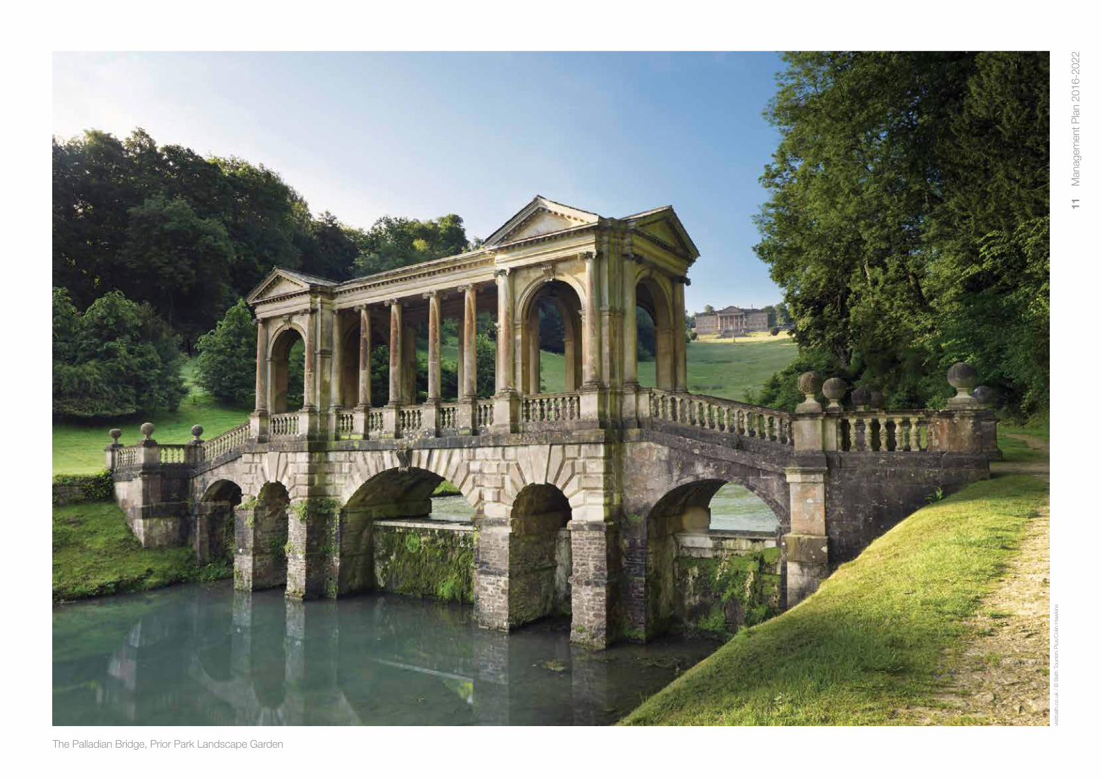
The Palladian Bridge, Prior Park Landscape Garden
visi
tbat
h.co
.uk
/ ©
Bat
h To
uris
m P
lus/
Col
in H
awki
ns

12
Man
agem
ent P
lan
2016
-202
2
Description of the site2
2.1 Introduction
In order to manage the Site, it is essential to understand how it has evolved and what it comprises today. This chapter describes where the site is, provides a summary history, and briefly describes the current city. Chapter 3 follows on to clarify why the property has OUV and present a clear understanding of the aspects that this plan seeks to address.
2.2 Location
The City of Bath is located in the South West of England, within the Bath and North East Somerset administrative region and the (ceremonial) county of Somerset. Maps and location details are shown in Appendix 1. The City lies approximately 100 miles (160 km) west of London, and 13 miles (21 km) south-east of Bristol. It is located on the southern edge of the Cotswold Hills, in a bend in the river valley created by the River Avon cutting through the plateau of surrounding limestone uplands.
2.3 Boundary
The site boundary is the municipal boundary of the city. This covers an area of approximately 29 square km. As noted in chapter 1, Bath is exceptional in this respect as the World Heritage inscription in almost every other city worldwide covers only a part of the urban area and not the entire settlement. Venice and its lagoon is the closest European comparator.
The property was inscribed in 1987 without a boundary map, which was not uncommon at that time. The description of the ‘City of Bath’ was taken to mean that the boundary encompassed the entire city and it was managed accordingly. This boundary was subsequently confirmed by letter (dated 17 October 2005) from the UNESCO World Heritage Centre.
2.4 Setting
The wider landscape setting lies beyond the Site boundary. The City of Bath WHS Setting Supplementary Planning Document1 (hereafter the ‘Setting SPD’ see Appendix 1, Map I) delineates this area. Bath World Heritage Site has a generous boundary, plus an area beyond this protected through planning policy as informed by the Setting SPD. These elements provide effective protection and are therefore considered to negate the need for the designation of a formal buffer zone.
2.5 Summary history of the Site
Bath’s history is well documented and a selected bibliography is shown at Appendix 7. A description of the Site’s history is given in Appendix 2, but a summary version is included below in order to show how the site has evolved.
The topography surrounding Bath provided an ideal location for a human settlement. Narrow, flat land in a curve of the valley provides a south facing site above the flood plain and an opportunity to cross the river where it is wide and slow.
Situated in this flat valley floor are three hot springs, the only springs to be classified as hot in the UK. Rain falling on the Mendip Hills to the south (up to 10,000 years ago) percolates 2 to 3km through the porous rock deep into the earth, heats, and is forced back to the surface at Bath through the Pennyquick Fault. The springs constantly produce over a million litres of water every day, with the volume issuing from the King’s Spring sufficient to fill a domestic bath tub every 8 seconds. The three main springs are the King’s Spring (46˚C), the Hetling Spring (48˚C) and the Cross Bath Spring (41˚C). The hot springs have played a central role in every stage of the city’s development, creating a unique social history and continuing culture. The city has regularly used the springs as a regeneration tool, rebuilding the structures and culture of bathing and drinking the waters for health and recreation.
The Nave, Bath Abbey

13
Man
agem
ent P
lan
2016
-202
2
Following the successful Roman invasion of Britain in 43 AD, the army pushed west, initially holding Bath as a frontier garrison town. As conquest and subsequent security increased, the Romans built a bathing complex and temple dedicated to Sulis Minerva in 65-75 AD. This complex and temple were developed over the next 300 years to become an international destination for pilgrims, with a settlement named Aquae Sulis growing up alongside.
After the battle of Dyrham in 577 AD, the Saxons took the city. The Roman complex fell into disuse and the ruins became buried. Bath continued however as an important religious centre, with a Saxon monastery built on the site of the current Abbey Church. King Edgar was crowned here as first king of all England in 973 AD. Following the 11th century Norman invasion the Saxon church was replaced first by a great Norman cathedral, and then by the present Abbey Church in the 16th century. Today, the street patterns around Abbey Green are the only visible evidence of the formal cathedral and the monastic quarter, although the monastic history is symbolised by the Abbey Church (1499-1611), an iconic and important piece of architecture in its own right.
Medieval Bath was an important regional trading centre for the wool and cloth trades. During that time the Roman complex remained undiscovered, although the hot springs still flowed and remained important, attracting the sick and convalescing due to beliefs in their healing properties. At the end of the 17th century Bath remained a compact city within defensive walls.
In the 18th century the city underwent dramatic change. Royal patronage of the baths and a rise in the wealth of the middle classes gave more citizens the means to enjoy leisure time and to socialise. The city was re-invented as a fashionable health resort, no longer just a destination for the sick but a ‘valley of pleasure’ for the healthy and fashionable. Physically it expanded dramatically beyond the medieval walls, largely through speculative development. The old town was remodelled in the contemporary Palladian style, with very few early buildings and urban arrangements remaining unaltered and almost all examples of early timber framed buildings lost. Cramped, jumbled medieval streets were transformed into a spacious and beautiful classical city, where architecture and natural landscape complemented each other. The Georgian city, renowned for its
architecture and curing waters, became patronised by the highest society, including royalty from across Europe.
Three men led this re-invention: the architect John Wood the Elder; the patron and entrepreneur Ralph Allen who quarried the Bath stone; and the social animateur Richard ‘Beau’ Nash. Their vision, ambition and innovation created a unique atmosphere and the conditions for some of the most inspirational and influential Palladian architecture and town planning in Britain.
The Bath Oolite limestone of the surrounding hills was mined and quarried (in many places in open-cast pits) and provided an excellent building material for both the Georgians and the Romans. It is an easily cut and durable ‘free-stone’ which can be intricately carved, and as such it proved eminently suitable for neo-classical buildings. Ralph Allen added to his considerable fortune by working extensive mines to the south of the city, including those at Odd Down and Combe Down. His activities as entrepreneur and patron fuelled much of the rebuilding, particularly through his association with the architect John Wood the Elder. Allen’s town-house in Lilliput Alley is notable, and Prior Park is outstanding, built specifically to showcase the quality of Bath Oolite.
Grand public buildings, such as the Assembly Rooms (John Wood the Younger, 1769-1771) and the Pump Room (John Palmer, 1790-1795), were provided as meeting places for the transient upper classes who flocked to the city. These buildings were complemented by outdoor entertainment in pleasure gardens, such as Sydney Gardens, or by ‘parading’ on broad streets laid out for the purpose. Housing was designed in monumental ensembles, such as Queen Square (1728-1736), the King’s Circus (1754) and the Royal Crescent (1767-1775). Many buildings were extremely innovative in their design and construction, making Bath one of the most architecturally exciting cities in 18th century Britain. Appendix 4 gives details of these and other buildings and gardens.
Despite a shift in emphasis from being a healing spa to a place of leisure, medical use of the hot springs continued in Georgian Bath. The Hot Bath and Cross Bath provided facilities and treatment for bathers from all classes of society. St John’s Hospital, a medieval foundation (see Appendix 4) which had been using
J Barratt’s map of 1818John Wood’s map of 1735
John Speed’s map of 1610J Hodgson’s depiction of 4th century AD Aquae Sulis
© B
ath
Rec
ord
Offi
ce, B
ath
& N
orth
Eas
t Som
erse
t Cou
ncil
© B
ath
Rec
ord
Offi
ce, B
ath
& N
orth
Eas
t Som
erse
t Cou
ncil

14
Man
agem
ent P
lan
2016
-202
2
the hot water to treat the sick since the 12th century, had its city centre complex partially remodelled by John Wood the Elder in 1726-8. The medieval King’s Bath attached to the Pump Room was also remodelled in a classical style. The Mineral Water Hospital, the first hospital in the country to offer treatment to patients from outside the local area, attracted scientists and doctors of renown because of the research opportunities the hospital offered.
New building included an extensive stock of smaller housing and other development, such as Pulteney Bridge (Robert Adam, 1764-1774), a range of later villas extending well beyond the city centre and Cleveland Pools (1815) the oldest surviving lido in the country.
Many of the streets, walkways and open spaces date from the 18th century in fabric and plan form, as well as historical association, and are integral to a comprehensive understanding of the city’s social history. Bridges, alleyways, parks, gardens, cemeteries and stone mines all combine to reveal the numerous interdependencies of city life and reflect the values, beliefs and ambitions of Georgian society. The vast majority of these cultural assets remain in active use today, many fulfilling original functions and demonstrating the authenticity of the WHS.
The Georgian town planning of Bath is innovative and spectacular. Individual developments respect the context of the next, serpentine crescents follow the contours to create dramatic effect and town and countryside are married together to form the deliberate creation of a beautiful city. This co-ordination however belies the way in which the city developed. Much of 18th century Bath evolved through speculative development of individual buildings, streets or squares. There was no city wide plan, and the new settlement grew incrementally upon its success in attracting wealthy visitors. Developments started from the old city, breaking out of the medieval walls and stretching uphill to Lansdown. The City Corporation facilitated the expansion of the city by providing wider streets and open spaces.
In the late eighteenth century Bath’s Georgian golden age began to fade. The Royal Court favoured sea bathing over the spa town and thus new fashions were set. The railways, which were set to bring to visitors flocking to European spa towns, did not herald an age of prosperity for Bath and the city entered a period of gentle decline. Victorian developments generally extended the city without rebuilding it and the canal and railway, although major developments, were themselves high quality architectural interventions. The 19th and 20th century suburbs largely filled in the landscape between the city and its satellite villages, but stayed within the river valley. The use of the Palladian style continued after 1825, but new Victorian styles increasingly influenced the city’s architecture.
A major historical landmark of the Victorian era was the rediscovery of the Roman Baths. Archaeological evidence had been found in 1727, 1755 and 1790, but no thorough investigation had been undertaken until a major excavation uncovered the remains of the thermal spa complex. The Victorians presented these for the first time since they had fallen into disuse in the Saxon period. The Baths became famous once more as a social centre, a bathing facility and a tourist attraction.
World War II bombing raids (April 1942) caused extensive destruction, with around 19,000 buildings sustaining some degree of bomb damage, and the 1942 City Engineer’s records identifying 115 Georgian buildings destroyed. Post war, during the 1950s and 60s the City Council demolished historic buildings for housing improvements. The successful conservation movement formed to resist the so-called ‘Sack of Bath’ helped to influence national attitudes to the conservation of historic buildings.
Bath’s suburbs continued to expand in the 20th century, with new housing estates being built on the south western valley sides. The decline of manufacturing industry in the late 20th century (principally the Stothert and Pitt crane works adjacent to the river) also changed the city’s landscape and economy. The factories and adjoining gas works were largely demolished, creating space for new development.
2.6 A Living City – Bath today
Bath today is a thriving 21st century community, home to approximately 88,859 residents2.
Bath remains a compact city, contained largely within the hollow in the hills as previously described. The city does not have significant ‘urban sprawl’ and high quality built development directly adjoins high quality landscape at the urban edge. The skyline is predominantly characterised by trees or open pasture. The green hillsides provide a backdrop to the urban area and are visible from most of the city centre. Bath is well provided for in terms of parks and open spaces, with the River Avon cutting through the city centre providing natural beauty and sense of calm. All of the above contribute to an impression that the city is smaller than it actually is.
It is a beautiful city. Almost all of the buildings are constructed of the locally quarried light yellow oolitic limestone, with slate or clay tiled roofs, giving a strong visual homogeneity unusual amongst British cities. There is very little sign of heavy industry, and the city is often described as being elegant. Residential properties form most of the building stock, with building height relatively consistent and low-rise.
In terms of transport, Bath is served by air from Bristol Airport (18.6 miles away) or from the M4 London-Cardiff motorway (11miles to the north). A mainline railway runs through the city giving journey times to central London of an hour and a half. Local transport is predominantly provided by buses, with ‘park and ride’ facilities to the north, south and west of Bath. The compact nature of the city affords opportunity for walking or cycling, with vehicle ownership in the city centre lower than the England/Wales average. However the compact historic city also proves difficult for modern vehicular traffic, resulting in some congestion and resultant air-pollution.
Bath continues to be a major tourist centre, attracting approximately 5.8m visitors per year (to the district)and adding an estimated £405m to the local economy. The culture of the spa town continues, with the historic Roman Baths attracting over 1 million visitors per year3 from all over the world and the modern Thermae Bath Spa very popular with short break domestic visitors. There are over 300 places of accommodation, including 80 hotels and 180 bed
and breakfasts. The main tourist season is summertime, with high day time tourist numbers in the city centre and in November/December with a popular Christmas Market. This gives a colourful and vibrant international flavour in comparison to cities with predominantly commercial centres.
Despite high visitor numbers, Bath remains a living city. It is not over-dominated by tourism to the extent that some international attractions have become. The resident population continue their everyday life alongside the influx of visitors.
Bath is a university town, with the population swollen during academic term times by students attending the University of Bath and Bath Spa University. A 2015 study commissioned by Bath Spa University4 estimates that 19.7% of the resident population of the city centre are full-time students. The academic summer break ensures student levels fall when tourist numbers are at their highest. Levels of education generally across Bath are good. The city is divided into 16 electoral wards, with all but four ward areas showing higher levels of students with undergraduate degree level qualifications than the England/Wales average.
In terms of employment, the public sector has recently provided an above average number of jobs in the city. Public administration and defence, local authority, education and health workers accounted for 36% of jobs in 2011. This figure is falling with the departure of the Ministry of Defence offices, and information and communications, publishing, finance and professional business services and the health and well-being sectors becoming more prominent employers. Levels of employment are high in comparison to national averages. 27% of those in employment are classed as professional workers, in comparison to a UK average of 19%5.
9 of the 16 wards have a population of older people (65 and over) above the England/Wales average, but not significantly so. Crime levels are low, with drug related crime being very low.
Despite the image of Bath as an affluent city with a skilled and educated workforce, high employment and low crime rates, there are pockets of real deprivation. Five neighbourhoods (Twerton, Twerton West, Whiteway, Whiteway West and Fox Hill North) are within the 20% of most deprived in England.6

15
Man
agem
ent P
lan
2016
-202
2
2.7 Condition of the Site
The current condition of the Site is considered to be good. There are many elements to be assessed in arriving at this conclusion, for example the condition of the Georgian building stock, of the archaeology, parts of the landscape setting, some of the key views and of the character of the site and intangible elements.
The range of monitoring mechanisms employed are discussed in section 4.20. The current assessment of ‘good’ is based on all of these, especially key elements such as the local and national ‘Buildings at Risk’ registers. There are approximately 5,000 listed structures in the Site. The national register7, which focuses on grade l and ll* structures only and is compiled by Historic England, contains only 4 entries for Bath. Three of the structures included are currently under repair and the fourth has a current planning permission for re-use. The local register, which includes all grades, currently contains 26 entries (2015). Of these only 9 are potentially habitable properties, with the remainder including a tower, bridges, a retaining wall, mortuary chapel and historic public toilets.
The condition assessment was validated in 2008 by the joint UNESCO/ICOMOS Reactive Monitoring Mission. The Mission Report8 stated:
‘All major buildings and components of the inscription of the property on the World Heritage List (e.g. Roman Baths, Royal Crescent, Circus, Lansdown Crescent, gardens, parks, and public spaces) are in a very good state of conservation and are being closely monitored, as is the landscape surrounding the City of Bath’.
There are however challenges to be addressed in the setting of the World Heritage Site. In places the landscape would benefit from better management of woodland, addressing issues resulting from the proximity of housing at the city edge and protection of areas of calcareous grassland. Some key views are obstructed by inappropriate vegetation and by inappropriate development within the focus of view. The Bathscape project (see section 5.11) is designed to address such issues.
Key FactsWhat is World Heritage?
World Heritage Sites are ‘places of Outstanding Universal Value to the whole of humanity’. ‘Outstanding Universal Value’ means cultural and/or natural significance which is so exceptional as to transcend national boundaries. There are currently (Nov 2016) 1052 WHS world-wide, and UNESCO adds a few new sites each year. Famous sites include the Taj Mahal, Pyramids of Giza, Great Wall of China and the Grand Canyon. The UK signed the 1972 UNESCO World Heritage Convention in 1984 and in doing so committed to identify, protect, conserve and interpret its sites and pass them on to future generations.
There are 30 (2016) WHS in the UK (and its overseas territories).
The City of Bath World Heritage Site
The Site was inscribed on 12 December 1987.
The Site is exceptional in that the entire urban area (approximately 29 square km) is inscribed. Only Venice provides a comparable example throughout Europe.
The 3 springs at the heart of the Site are the only ones classified as ‘hot’ in the UK.
The hottest spring is the Hetling at 48°C and there are 43 minerals in the water.
The most voluminous is the King’s Spring, with a continuous flow of 13 litres per second or 1,106,400 litres per day. This flow will fill a domestic bath tub every 8 seconds.
88,859 people live within the Site.
There are approximately 5,000 listed buildings in the Site, with the highest concentration of grade l and ll* listings outside of central London.
The Site generates approx. 1,500 applications for Planning Permission and Listed Building Consent per year – undoubtedly the highest of any UK World Heritage Site.
A single conservation area of 1,486 hectares covers two thirds of the Site.
There are 5 scheduled monuments covering 1.4ha (approx. 13% of the central area).
The surrounding landscape is covered by the Bath & Bristol Green Belt, plus the Cotswolds Area of Outstanding Natural Beauty (AONB), surrounding the city on its north, east and south sides.
There are 9 registered historic parks and gardens within the site, with 23 Parks and Gardens of local Historic Interest and 2 Sites of Special Scientific Interest.
Approximately 4.5m people visit Bath each year, adding an estimated £380m to the local economy and accounting for an estimated 10,000 jobs.
There are 21 primary schools in or adjacent to the WHS, plus two universities with over 20,000 students.
1 http://www.bathnes.gov.uk/sites/default/files/sitedocuments/Planning-and-Building-Control/Planning-Policy/Evidence-Base/Urban-Design-Landscape-and-Heritage/WHSSettingStudyInformationPaper.pdf
2 ‘usual resident population’: anyone who, on census day, had stayed or intended to stay in the area for a period of 12 months or more, or had a permanent address in the area and was outside it, but intended to be outside for less than 12 months. School children and students in full-time education studying away from their family home are treated as usually resident at their term-time address. Data from Office of National Statistics, 2011 census.
3 1,046,416 visitors during financial year 2015/16. Source: Heritage Services Annual Review 2014/15.
4 The Impact of Bath Spa University’s 2015/16 Expansion. Oxford Economics. November 2015
5 Office for National Statistics figures: https://www.nomisweb.co.uk/reports/lmp/wpca/1929379858/report.aspx
6 Further Bath statistics can be found on the Council’s website at: http://www.bathnes.gov.uk/services/your-council-and-democracy/local-research-and-statistics/wiki/bath-forum-area
7 http://www.historicengland.org.uk/advice/heritage-at-risk/
8 UNESCO Decision 33 COM 7B.131

16
Man
agem
ent P
lan
2016
-202
2
3.1 Introduction
Having described in the previous chapter what the site consists of, this chapter goes on to describe why this is of Outstanding Universal Value (OUV). It does this firstly by introducing the Statement of OUV, which is a concise description endorsed by the UNESCO World Heritage Committee. Each site has such a statement. It then describes the ‘attributes’ which are aspects which convey or express the OUV of the Site and which contribute to and enhance understanding of the OUV.
The Statement of OUV and the attributes are key documents for effective site management. The National Planning Policy Framework (NPPF) confirms that ‘not all elements of a World Heritage Site …will necessarily contribute to its significance’ and this is especially true in such an extensive site as the City of Bath. These documents therefore confirm what it is that makes Bath special in World Heritage terms and where the focus of World Heritage management should be.
3.2 Statement of Outstanding Universal Value
The current statement of OUV was adopted by the UNESCO World Heritage Committee at their 37th session in Phnom Penh, Cambodia, June 2013 (Decision reference: WHC-13/37.COM/8E). It was updated in that year to add sections on authenticity and integrity, and bring it into line with current UNESCO practice. It is therefore officially titled as the ‘Adopted Retrospective Statement of Outstanding Universal Value’.
Property City of Bath
State Party United Kingdom of Great Britain and Northern Ireland
Id. N° 428.
Date of inscription 1987
Brief synthesis
The City of Bath in South West England was founded in the 1st century AD by the Romans who used the natural hot springs as a thermal spa. It became an important centre for the wool industry in the Middle Ages but in the 18th century under the reigns of George l, ll and III it developed into an elegant spa city, famed in literature and art.
The City of Bath is of Outstanding Universal Value for the following cultural attributes:
The Roman remains, especially the Temple of Sulis Minerva and the baths complex (based around the hot springs at the heart of the Roman town of Aquae Sulis, which have remained at the heart of the City’s development ever since) are amongst the most famous and important Roman remains north of the Alps, and marked the beginning of Bath’s history as a spa town.
The Georgian city reflects the ambitions of John Wood Senior (1704-1754), Ralph Allen (1693-1764) and Richard “Beau” Nash (1674-1761) to make Bath into one of the most beautiful cities in Europe, with architecture and landscape combined harmoniously for the enjoyment of the spa town’s cure takers.
The Neo-classical style of the public buildings (such as the Assembly Rooms and the Pump Room) harmonises with the grandiose proportions of the monumental ensembles (such as Queen Square, Circus and Royal Crescent) and collectively reflects the ambitions, particularly social, of the spa city in the 18th century.
The individual Georgian buildings reflect the profound influence of Palladio (1508-1580) and their collective scale, style and the organisation of the spaces between buildings epitomises the success of architects such as the John Woods (elder 1704-1754, younger 1728-1782), Robert Adam (1728-1792), Thomas Baldwin (1750-1820) and John
Significance of the Site3

17
Man
agem
ent P
lan
2016
-202
2
Palmer (1738-1817) in transposing Palladio’s ideas to the scale of a complete city, situated in a hollow in the hills and built to a picturesque landscape aestheticism creating a strong garden city feel, more akin to the 19th century garden cities than the 17th century Renaissance cities.
Criterion (i): Bath’s grandiose Neo-classical Palladian crescents, terraces and squares spread out over the surrounding hills and set in its green valley, are a demonstration par excellence of the integration of architecture, urban design and landscape setting, and the deliberate creation of a beautiful city. Not only are individual buildings such as the Assembly Rooms and Pump Room of great distinction, they are part of the larger overall city landscape that evolved over a century in a harmonious and logical way, drawing together public and private buildings and spaces in a way that reflects the precepts of Palladio tempered with picturesque aestheticism. Bath’s quality of architecture and urban design, its visual homogeneity and its beauty is largely testament to the skill and creativity of the architects and visionaries of the 18th and 19th centuries who applied and developed Palladianism in response to the specific opportunities offered by the spa town and its physical environment and natural resources (in particular the hot springs and the local Bath Oolitic limestone). Three men – architect John Wood Senior, entrepreneur and quarry owner Ralph Allen and celebrated social shaper and Master of Ceremonies Richard “Beau” Nash – together provided the impetus to start this social, economic and physical rebirth, resulting in a city that played host to the social, political and cultural leaders of the day. That the architects who followed were working over the course of a century, with no master plan or single patron, did not prevent them from contriving to relate each individual development to those around it and to the wider landscape, creating a city that is harmonious and logical, in concord with its natural environment and extremely beautiful.
Criterion (ii): Bath exemplifies the 18th century move away from the inward-looking uniform street layouts of Renaissance cities that dominated through the 15th–17th centuries, towards the idea of planting buildings and cities in the landscape to achieve picturesque views and forms, which could be seen echoed around Europe particularly in the 19th century. This unifying of nature and city, seen throughout Bath, is perhaps best demonstrated in
the Royal Crescent (John Wood the Younger) and Lansdown Crescent (John Palmer). Bath’s urban and landscape spaces are created by the buildings that enclose them, providing a series of interlinked spaces that flow organically, and that visually (and at times physically) draw in the green surrounding countryside to create a distinctive garden city feel, looking forward to the principles of garden cities developed by the 19th century town planners.
Criterion (iv): Bath reflects two great eras in human history: Roman and Georgian. The Roman Baths and temple complex, together with the remains of the city of Aquae Sulis that grew up around them, make a significant contribution to the understanding and appreciation of Roman social and religious society. The 18th century redevelopment is a unique combination of outstanding urban architecture, spatial arrangement and social history. Bath exemplifies the main themes of the 18th century neoclassical city; the monumentalisation of ordinary houses, the integration of landscape and town, and the creation and interlinking of urban spaces, designed and developed as a response to the growing popularity of Bath as a society and spa destination and to provide an appropriate picturesque setting and facilities for the cure takers and social visitors. Although Bath gained greatest importance in Roman and Georgian times, the city nevertheless reflects continuous development over two millennia with the spectacular medieval Abbey Church sat beside the Roman temple and baths, in the heart of the 18th century and modern day city.
Integrity
Remains of the known Roman Baths, the Temple of Sulis Minerva and the below ground Roman archaeology are well preserved and within the property boundary as are the areas of Georgian town planning and architecture, and large elements of the landscape within which the city is set. Despite some loss of Georgian buildings prior to inscription, the Georgian City remains largely intact both in terms of buildings and plan form. An extensive range of interlinked spaces formed by crescents, terraces and squares set in a harmonious relationship with the surrounding green landscape survive. The relationship of the Georgian City to its setting of the surrounding hills remains clearly visible. As a modern city, Bath remains vulnerable to large-scale
development and to transport pressures, both within the site and in its setting that could impact adversely on its garden city feel and on views across the property and to its green setting.
Authenticity
The hot springs, which are the reason for the City’s original development, are of undoubted authenticity. The key Roman remains are preserved, protected and displayed within a museum environment, and the Roman Baths can still be appreciated for their original use. The majority of the large stock of Georgian buildings have been continuously inhabited since their construction, and retain a high degree of original fabric. Repairs have largely been sympathetic, informed by an extensive body of documentation, and aided by a programme of restoration in the late twentieth century. More vulnerable is the overall interaction between groups of buildings in terraces, crescents and squares and views to the surrounding landscape that contributed to the City’s visual harmony. There is a need for new developments to respect the planning of the Georgian terraces, to respect the scale and rhythm of its structures, and to contribute to picturesque views.
Protection and Management Requirements
The UK Government protects World Heritage properties in England in two ways. Firstly, individual buildings, monuments and landscapes are designated under the Planning (Listed Buildings and Conservation Areas) Act 1990 and the 1979 Ancient Monuments and Archaeological Areas Act, and secondly through the UK Spatial Planning system under the provisions of the Town and Country Planning Acts.
Government guidance on protecting the Historic Environment and World Heritage is set out in National Planning Policy Framework and Circular 07/09. Policies to protect, promote, conserve and enhance World Heritage properties, their settings and buffer zones are also found in statutory planning documents. The Bath and North East Somerset Local Plan contains a core policy according to which the development which would harm the qualities justifying the inscription of the World Heritage property, or its setting, will not be permitted. The protection of the surrounding landscape of the
property has been strengthened by adoption of a Supplementary Planning Document, and negotiations are progressing with regard to transferring the management of key areas of land from the Bath and North East Somerset Council to the National Trust.
The City of Bath World Heritage Site Steering Group was established as a non-executive committee consisting of representatives from 14 organisations with interest in the site. It has an independent chairperson. Members represent national government, Bath and North East Somerset Council elected members and officers, surrounding Parish Councils, heritage bodies, and the city business group, residents associations, both universities and the tourism company.
The Steering Group oversees the production and implementation of the World Heritage Site Management Plan. This plan aims to address the key tensions between development and conservation of the city-wide property. The main pressures currently facing the site are large-scale development and the need for improved transport.
The need for development to be based on an understanding of the distinctiveness and Outstanding Universal Value of the Georgian City continues to be guided by the policy framework listed above. A UNESCO/ICOMOS Mission assessed the development at Bath Western Riverside in 2008 and concluded that the Outstanding Universal Value and Integrity would not be adversely impacted by the phase one development. Subsequent phases are planned but not yet timetabled.
Transport improvements are based principally around a bus-based network and pedestrianisation, as outlined in the Management Plan.
Tourism is managed by Bath Tourism Plus, an independent company. The Destination Management Plan has been updated by a ‘Destination Marketing Strategy’ for Bath, which aims to promote growth in value of tourism rather than in volume.

18
Man
agem
ent P
lan
2016
-202
2
3.3 Attributes of OUV
As explained in 3.1, attributes are aspects which convey or express the OUV of the World Heritage Site and which contribute to and enhance understanding of the OUV. The attributes have been endorsed by Bath & North East Somerset Council (cabinet 14 May 2014) and the City Of Bath World Heritage Site Steering Group.
The key purpose for identifying attributes1 is so that they can be protected, managed and monitored and they are needed when assessing planning applications, when considering planning allocations and when planning projects or other interventions. Attributes are greater than individual components and include the characteristics which convey the values identified in the Statement of OUV.
Six headline attributes (below) were agreed in the 2010-2016 WHS Management Plan:
1. Roman archaeology
2. The hot springs
3. Georgian town planning
4. Georgian architecture
5. The green setting of the city in a hollow in the hills
6. Georgian architecture reflecting 18th century social ambitions
These were carried forward, little altered, from the 2003-2009 WHS Management Plan and have provided a sound and consistent basis for site management for over ten years. They do not however provide sufficient detail to provide an understanding of what it is that the management plan is seeking to protect. The table below therefore expands in greater detail these attributes.
Attributes of OUV
Roman Archaeology
1. The archaeological remains of the Roman temple of Goddess Sulis Minerva and baths complex built around the Form & Design Iron Age Sacred Spring, including the Great Bath, East Baths, Circular Bath and West Baths, with the Roman Baths still capable of being used for their original function
2. Roman archaeological remains within the city wall (itself thought to be of Roman origin) beyond the temple and baths Form & Design complex, demonstrating the extent of the city
3. Roman and Iron Age archaeological remains beyond the city wall including hill forts, field systems, villas and funerary Form & Design monuments, demonstrating the context of the Roman city
4. The surrounding road system and street plan of the Roman city, overlain by the medieval layout and influencing the Location & Setting form of the Georgian city, such as London Road
5. The culture and traditions associated with bathing and healing (recovered fragments, including Roman pewter, coins Language & other forms and inscribed curses, are artefacts and not themselves of OUV, but help demonstrate the function of the Baths and of intangible heritage Temple Complex)
The Hot Springs
6. Bath as a centre of healing, the medical research and learning associated with the ‘cure’ of the hot waters and medical Traditions, techniques & establishments developed around them including almshouses and hospitals management systems
7. The spiritual importance of the hot springs, the cultural use of the waters and the continuous flow of hot water from Spirit & feeling antiquity to present day
Georgian Town Planning
8. The introduction of innovative forms of town planning including squares, crescents and circus Form & Design
9. Visual homogeneity of the city due to widespread use of local Oolitic (Bath) limestone, a limited palette of colour tones Form & Design and the uniform scale and height of buildings
10. The deliberate creation of a beautiful city Form & Design
11. Views and vistas, within the Georgian city deliberately created by awareness of context, and beyond, including such Form & Design components as Prior Park and Sham Castle, designed to view, and be viewed from, the city centre
12. The positioning, orientation and layout of Georgian buildings, for example in serpentine terraces, to use slopes and Form & Design contours to create dramatic forms
13. The design of the Georgian city to facilitate outdoor social interaction and activity, including walks, promenades, Form & Design colonnades to afford weather protection, and pleasure gardens
14. The Kennet & Avon Canal, Somerset Coal Canal and associated features Form & Design

19
Man
agem
ent P
lan
2016
-202
2
15. The influence of Georgian town planning in Bath on subsequent developments in the UK and beyond Form & Design
16. The creation of wide, flat pavements to encourage promenading Form & Design
17. The harmonious and logical integration of individual Georgian developments, with residential terraces interspersed with Form & Design public buildings such as Assembly Rooms and Pump Room, and multiple architects building to a common ethos rather than to an overall master-plan
18. The principal historic road routes into the city, marking the arrival points for visitors who almost universally came by road Use & Function
19. The design of the Georgian city as a theatre set, with visual surprises and open spaces linked with one another Use & Function
20. 18th Century picturesque principles including the relationship of buildings to landscape, the concept of blending countryside Location & Setting and town, and historic parks and gardens
Georgian Architecture
21. Transposition of Palladio’s ideas to the scale of a complete city in a British setting, and employed in a wide range of Form & Design building forms including houses, public buildings, Pulteney Bridge and churches
22. Key visual landmarks within views, such as the Royal Crescent and Beckford’s Tower Form & Design
23. The contrast between polite, controlled, formal façades and the informal rear of Georgian buildings Form & Design
24. The Abbey Church as a key part of the urban form of the Georgian city Form & Design
25. The works of noted architects including the John Woods, Robert Adam, Thomas Baldwin, John Palmer, John Eveleigh Form & Design and John Pinch
26. The design of terraced houses to appear as though they were a single country house or palace, demonstrating the Form & Design social aspiration of occupiers to emulate the aristocracy
27. The Georgian monumental ensembles of crescents, squares, circus and terraces forming iconic, internationally Form & Design recognisable structures, where the whole is greater than the sum of the individual parts
28. The extent of Georgian redevelopment, almost totally obscuring previous medieval buildings and the widespread Form & Design survival of this fabric leaving a unique complete example of a Georgian city
29. Detached villas, largely in the suburbs of the city, showing the transformation of Bath toward a genteel retirement Form & Design settlement at the end of the Georgian period
30. The universal use of natural building materials in the Georgian city Materials & Substance
31. Widespread creation of basements and vaults to level the land below the Georgian city Materials & Substance
32. The widespread use of timber vertically sliding sash windows in the Georgian city, with scale and detailing that evolved Materials & Substance over time and often closing directly onto a stone cill
33. The use of wrought iron work to provide external features such as railings, overthrows for lanterns, etc. Materials & Substance
34. Components of Georgian street furniture, including coal holes, basement winches, foot scrapers, lamp brackets, Materials & Substance watchman’s boxes, and similar items
20
Man
agem
ent P
lan
2016
-202
2
Georgian Architecture continued
35. The high quality of craftsmanship in Georgian building construction and ornamentation Materials & Substance
36. The expressed hierarchy in both the exterior design of Georgian buildings, and the use of spaces within, and the Use & Function subsequent difference in their scale, ornamentation and decoration
37. Shop units, coffee and ale houses, demonstrating the evolution of the retail industry in the Georgian period Use & Function
38. The ubiquitous use of chimneys and fireplaces within Georgian buildings reflecting the use of coal as a fuel source Use & Function
39. Building design adaptions such as semi-circular stair walls and ramps for the use of sedan chairs, reflecting the Use & Function adaptation of architecture to cater for the needs of a spa town
40. Many of the Georgian buildings remain in, or are capable of being used for, their original purpose Use & Function
41. Individual internal fitting out of Georgian houses behind a uniform façade, and incomplete, truncated terraces, Traditions, techniques & demonstrating the speculative nature of Georgian development finance management systems
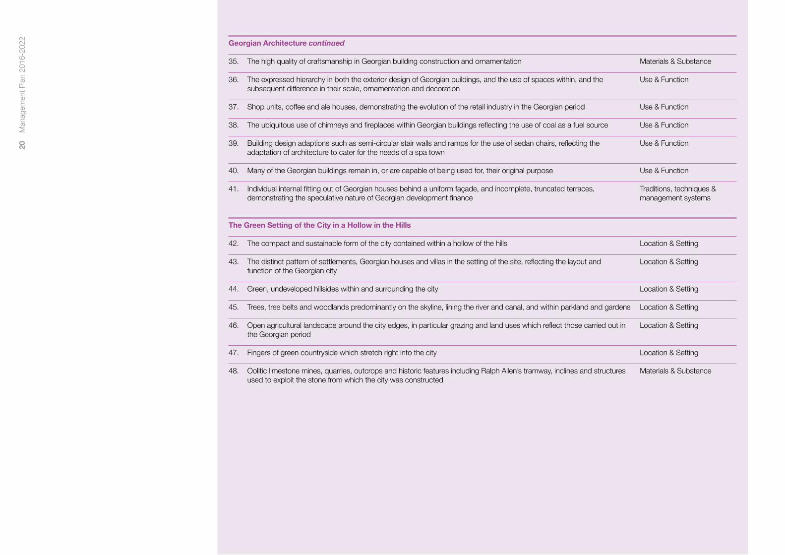
The Green Setting of the City in a Hollow in the Hills
42. The compact and sustainable form of the city contained within a hollow of the hills Location & Setting
43. The distinct pattern of settlements, Georgian houses and villas in the setting of the site, reflecting the layout and Location & Setting function of the Georgian city
44. Green, undeveloped hillsides within and surrounding the city Location & Setting
45. Trees, tree belts and woodlands predominantly on the skyline, lining the river and canal, and within parkland and gardens Location & Setting
46. Open agricultural landscape around the city edges, in particular grazing and land uses which reflect those carried out in Location & Setting the Georgian period
47. Fingers of green countryside which stretch right into the city Location & Setting
48. Oolitic limestone mines, quarries, outcrops and historic features including Ralph Allen’s tramway, inclines and structures Materials & Substance used to exploit the stone from which the city was constructed

21
Man
agem
ent P
lan
2016
-202
2
Georgian architecture reflecting 18th century social ambitions
49. The patronage and vision of John Wood Senior, Ralph Allen and Beau Nash in leading the social, economic and physical Traditions, techniques & re-birth of the city from a small provincial English town into an internationally famous resort management systems
50. Bath as a place of resort, attracting visitors from a wide geographical area, and the historical associations with the Use & Function extensive list of famous and influential people who visited
51. Custom and practices associated with ‘taking the waters’, including promenading Use & Function
52. Rules and etiquette developed in the polite society, largely intangible but embodied in buildings such as the Assembly Language & other forms of and Pump Rooms intangible heritage
53. The reflection of mythological, folkloric and antiquarian influences on the decorative motifs, alignments and dimensions Spirit & feeling on buildings such as the Circus
3.4 Other cultural value
In addition to the attributes of OUV outlined above, which give the WHS its international significance, there are other national and local values which have to be taken into account in holistic site management.
Moveable heritage is not included under the World Heritage inscription, but nevertheless some museum and archive collections are essential in providing interpretation as to how previous civilisations lived. The collections of the Roman Baths Museum, Fashion Museum and Bath Record Office all hold ‘designated’ status under the Arts Council England scheme. In 2014 the Roman Curse tablets, which are the personal and private prayers of 130 individuals inscribed on small sheets of lead or pewter and cast into the hot springs at Bath, were inscribed on the UK UNESCO ‘Memory of the World’ register2. One tablet is made up of Celtic words written in the Latin alphabet and is the only known surviving text in British Celtic, whilst another contains what is currently the earliest known reference to Christianity in Britain.
World Heritage designation can also highlight certain periods of history to the exclusion of others. The medieval and Victorian industrial past of Bath are of particular note and should not be overlooked in managing the city.
There are also intangible associations and traditions which contribute to Bath’s significance. The culture of worship, bathing and healing associated with the hot springs is a living tradition which is several thousand years old. This culture has inspired the development of the outstanding physical elements of the Site. Bath also has rich associations with prominent people (reflected in the plaques of Bath Abbey and Walcot St. Swithens Church Walls) from all periods, particularly during the 18th and 19th centuries. Royalty, politicians, aristocracy, artists, writers, and musicians were amongst the many prestigious spa visitors. It has played a long-term role as a national and international place for large-scale social interaction and the shaping of social values.
3.5 Natural value
The City of Bath is inscribed as a World Heritage Site for its cultural attributes. Its significance however is dependent upon the natural hot springs, the surrounding landscape of incised plateau hills and the Avon Valley. Its distinctiveness to a large degree results from the harmonious relationship of the built form and the natural landscape of the city including its green spaces, the river and canal corridors and the surrounding countryside which enfolds and extends right into the heart of the city. This natural landscape is appreciated today much as it was
historically for its health, visual and environmental benefits. However in these different social times more could be done to protect aspects of the landscape quality and to develop appreciation and enjoyment by disadvantaged communities. Effective governance and appropriate landscape management of the natural environment and its accessibility is essential to maintain biodiversity and the health of the natural environment and its value for people as well as contributing to protecting the authenticity, integrity and significance of the WHS.
In terms of ecology and biodiversity, the predominant and iconic natural habitats in the Site are broadleaved woodland, unimproved calcareous grasslands and lowland meadows. These are UK priority habitat types, but are all vulnerable and under threat to some degree. Many of the woodlands are at threat from long term neglect and from inadequate management, together with the impacts of climate change. Similarly, many grasslands are at threat from under grazing and the pressures of their topography and urban edge location. These habitat types are important and iconic to the setting of Bath and need strategic management objectives and support.
The River Avon, together with associated water meadows, is also an important wildlife corridor cutting through the heart of the city, supporting otters, dragonflies and damselflies, and providing
important flight lines and foraging habitat for many notable bat species. Parks, gardens and cemeteries also provide important habitats. Trees and woodlands, some ancient, provide a significant contribution to the landscape character and the local distinctiveness of the city and skyline.
Protected species include both Lesser and Greater Horseshoe Bats. These are key species which breed and hibernate in the disused stone mines of Combe Down and Bathampton Down. Bath Asparagus, or Spiked Star of Bethlehem (Ornithogalum Pyrenacium), is a nationally scarce plant found in its greatest numbers around the Bath area (one theory is that it was a Roman food crop). Another significant species is the Peregrine Falcon, which successfully breeds in the heart of the city on St John’s Church Tower, South Parade.
1 See UNESCO Operational Guidelines for the Implementation of the World Heritage Convention, Sections 88 and 89, and Annex 5
2 http://www.unesco.org.uk/2014-uk-memory-of-the-world-register/

22
Man
agem
ent P
lan
2016
-202
2
4.1 Introduction
This section explains the management of the world heritage property. It describes the story so far in terms of management, who owns the land, who the main stakeholders are, the control mechanisms in place, the systems of governance and how the various bodies involved relate to one another.
Bath is a large urban WHS in a sophisticated western society. The number of partners involved in management and the relationships between them are complex. The need to explain these fully, especially for the benefit of the reader not familiar with the site, was commented upon in the ICOMOS response to the 2010 Management Plan (August 2011). For this reason, this section is significantly longer than that of the preceding plan.
4.2 Bath World Heritage Site: The story so far
In order to better understand how we have arrived at our current position, the following short history of Bath as a WHS is provided.
The City of Bath was inscribed by the UNESCO World Heritage Committee at its 11th session in Paris on 11 December 19871. It was an early UK nomination following the first UK inscriptions in 1986.
The process of inscription in 1987 was less onerous than it is today. A 36 page report by the then Historic Buildings and Monuments Commission for England2 provided most of the documentation.
Initially, little impact of the inscription was apparent. Management was taken on by the local authority (Bath City Council) and appropriate policies were added into the local plan, supplemented by a guidance note.
In the 1996 local government re-organisation, Bath City Council was succeeded by Bath and North East Somerset (B&NES) Council, which encompassed a wider geographical area beyond the city. This Council took over the role as principal site steward.
On 14 June 2001 a WHS Steering Group was convened and an early task was the appointment of a ‘World Heritage Co-ordinator’. The post was hosted by B&NES Council and financially supported
by ‘start-up’ funding (reducing over a three year period) from English Heritage (now Historic England). The Co-ordinator and Steering Group (chaired by English Heritage) produced the first management plan in 2003. This was a pioneering document given the lack of published guidance and other examples to draw upon, and was subsequently used as a model by many other sites across the world.
The property was inscribed without a boundary map, which was not uncommon at the time. The description of the ‘City of Bath’ was taken to mean that the boundary encompassed the entire city and it was managed accordingly. This boundary was subsequently confirmed by letter (dated 17 October 2005) from the UNESCO World Heritage Centre. This confirmation of the boundary is a good example of one of the achievements of the first management plan, which put in place the systems needed for effective management.
As mentioned in section 3.4, it is worth noting here that the Great Western Railway (GWR) line was included in the UK tentative list of WHS in 1999. The GWR line passes through Bath. When the revised tentative list was published in 2014 this proposal was not carried forward, but it does demonstrate that the site encompasses other elements of world class heritage.
The first decade of the twenty first century saw multiple large development proposals in the city. These included re-development of Southgate Shopping Centre, Bath Western Riverside (at the time the largest housing development in SW England), the Thermae Bath Spa, the Dyson Academy3, the new bus station and an extension to the grade 1 listed Holburne Museum in a contemporary architectural style. This significant development pressure together with the proposal of new architectural styles caused significant debate.
This pressure emerged at the end of the 2003 - 2009 Management Plan period, when that document was due for renewal. The World Heritage Co-ordinator had left the post, the role was unfilled and the Steering Group did not meet during 2008. In hindsight, it was unfortunate that World Heritage Management was weak at a time when it was strongly required.
Management of the site4
Housing at Bath Western Riverside, constructed 2015

23
Man
agem
ent P
lan
2016
-202
2
UNESCO received concern from some commentators that the OUV of the property was threatened by these new developments. At its World Heritage Committee (32nd Session) in Quebec (July 2008), UNESCO requested that:
‘the State Party invite a joint World Heritage Centre / ICOMOS reactive monitoring mission to the property to consider its overall state of conservation and particularly the possible impact of the Bath Western Riverside development and the Dyson Academy on the Outstanding Universal Value and integrity of the property4.
The mission visited in November 2008.
In response to the proposed mission, B&NES Council reviewed and strengthened world heritage management. A new position of World Heritage Manager was created in 2008, at a higher level than the previous co-ordinator role and better placed to influence key policy decisions across (and beyond) the organisation. An independent Steering Group chairperson (Mr David Beeton CBE) was appointed, taking office in February 2009.
An early action of the Steering Group chairman (in 2009) was to establish the World Heritage Enhancement Fund. This grant scheme is funded by B&NES Council and the Bath Preservation Trust, and levers in further funding where possible (See 5.12).
The mission report5 was considered by the 2009 UNESCO World Heritage Committee. The report noted that the state of conservation was good and the site was well managed. The decision6 expressed satisfaction that the Dyson Academy Project had been withdrawn, strongly recommended that a revised plan showing inclusion of social facilities in Bath Western Riverside be submitted, urged that density and volume of buildings at Bath Western Riverside be reviewed, recommended that protection of the surrounding landscape be enhanced, invited reinforced interpretation for the site and called for a revised management plan including a tourism plan, public realm strategy and traffic plan.
The 2010-2016 Bath WHS Management Plan7 was produced as a response to the committee decision and addressed the points raised by the mission. The six plan priorities were funding and management, transport, the setting, planning policy, public realm and interpretation.
World Heritage Day was first celebrated in April 2009 and has become an annual fixture ever since.
In 2010 a conference was held in Baden-Baden bringing together the leading European spas with a view to potentially pursuing a trans-national bid for World Heritage inscription, based on the impact of spa towns to European culture. This was the start of the ‘Great Spas of Europe’ project outlined in section 5.11.
2012 saw the 25th anniversary of the inscription, with a range of activities across the year and a celebratory civic function on 11 December – exactly 25 years after the decision was made.
Strengthened policy protection during this plan period included the adoption of a Setting Study (October 2009 – see bibliography). The ‘statement of values’ was revised and adopted by UNESCO8 in 2013. Also, a list of ‘attributes’ was compiled and adopted9. The Core Strategy10 for the district was adopted on 10 July 2014, providing a high level strategic planning policy framework.
In 2013, Mr Peter Metcalfe took over the role of Steering Group Chairperson. As this was mid-way through the plan period, a full monitoring exercise was undertaken and a report on this, together with an update on current and forthcoming developments, was submitted to Department for Culture, Media and Sport (subsequently forwarded to UNESCO in 2014).
In 2014 the Roman Curse tablets, recovered from the Sacred Spring, were added to the UK national UNESCO ‘Memory of the World’ register (see 3.4). An award ceremony took place on 31 October 2014, attended by Mr Getachew Engida, Deputy Director General of UNESCO.
Key achievements of the previous WHS Management Plan (2010-2016) are shown below.
As this plan is compiled, Bath is at a point where the state of conservation is very good. The local economy is buoyant, with record visitor numbers, low shop vacancy rates, high property values and high levels of employment, plus very few ‘buildings at risk’. Looking forward, the key challenges to be faced are maintaining this good state of conservation whilst delivering a further phase of substantial growth and maintaining a strong economy. There will be a need to draw upon experience gained in previous plan periods, and provide the homes, employment and
transport infrastructure required without detrimentally impacting upon the OUV of the property.
2016 has seen some political uncertainty, with the referendum vote for the UK to leave the European Union, and with Bath and North East Somerset Council taking the first steps towards a possible West of England devolution deal. The implications of both of these decisions are likely to be long term and are as yet unknown.
Headline achievements during the previous plan period 2010-2016
2011
The Heritage Lottery Fund supported over 160 Bath projects from 2010-2015.
The £11.2m extension to the grade 1 listed Holburne Museum opens, winning RIBA SW Building of the Year Award and a Civic Trust design award.
A consolidated freight delivery system is implemented as part of a ‘CIVITAS’ funded initiative and hybrid Park and Ride buses are introduced following successful trials.
A Historic Environment Record Officer is first employed by the Council, paving the way for the on-line Historic Environment Record.
Bath Business Improvement District is established and launched.
2012
The ‘protection of setting’ is addressed by the adoption of the Bath World Heritage Site Setting Study Supplementary Planning Document.
Bath Transport Package is awarded £10.9m.
The register of listed buildings in Bath, containing over 5,000 buildings, is revised and published by English Heritage.
A civic event was held on 11 December 2012, marking 25 years since inscription. A large World Heritage symbol was placed in the Roman Baths’ entrance hall to mark the occasion.
2013
Extensive flood risk preventative work is undertaken including a Compensatory Storage Study, Flood Risk Management Study, Sequence and Exception tests and a West of England Partnership grant of £11m for Bath Quays Waterside Scheme in 2013.
The ‘Warmer Bath’ historic building adaptation guidance was launched in 2011, and a Sustainable Construction and Retro-fitting SPD followed in 2013.
New city information way-marking, incorporating the world heritage symbol was rolled out.
The £5m revamp and extension of No.1 Royal Crescent Museum opens.
A new independent WHS Steering Group Chairman took office.
Britain’s longest cycle tunnel, the £4.3m Two Tunnels route, opened.
Brunel Square and a revamped Bath Spa Railway Station opened, completing the link with Southgate Shopping Centre and restoring industrial heritage.
2014
Major new lottery funding bids for Bath Abbey and Cleveland Pools achieved round 1 Heritage Lottery funding.
Round 1 Heritage Lottery funding is secured for the ‘Archway Project’ to create a World Heritage Centre and Roman Baths Learning Centre.
World Heritage management moves to sit within the Heritage Services business unit with access to its education, marketing and support staff.
A DVD on the ‘City of Bath’ WHS is produced by the Museums Trading arm of Heritage Services.
‘Attributes of Outstanding Universal Value’ are adopted on the 14 May 2014.
The Great Spas of Europe bid is added to the UK Tentative List.
The ‘Getting Around Bath’ Transport Strategy is adopted.
The 25,000th Discovery Card, allowing free access to key local museums for residents, is issued.
Adoption of Council Cultural & Creative Strategy
24
Man
agem
ent P
lan
2016
-202
2
The Core Strategy is adopted, providing up-to-date planning policy protection for the site.
The Roman curse tablets are added to the UNESCO UK ‘Memory of the World’ register, with the UNESCO Deputy Director-General guest of honour at the awards ceremony in Bath.
High quality public realm improvement schemes in Northumberland Passage, High Street, Stall Street and Lower Borough Walls were delivered, with partial pedestrianisation of Stall Street.
2015
World Heritage Day was celebrated by a public event every year from 2009 onward during the plan period. The event helped Prior Park Landscape Garden achieve record visitor numbers on Sunday 19 April 2015.
A ‘face-lift’ restoration of Queen Square opens, restoring historic features.
Production of character appraisals for Bath Conservation Area begins in 2015.
A new mobile-enabled WHS website is launched, with key documents and Steering Group minutes all available on-line.
Bath Western Riverside construction proceeds well, with 300 dwellings built and occupied by 2015, including over 100 affordable units. Sales and occupancy levels are high.
The ‘Next Bike’ cycle hire scheme becomes financially self-sufficient, after being launched in 2014. Rentals topped 1,000 per month.
A new inclined bore hole to the hot springs, drilled in 2011, enables the opening of the 5* Gainsborough Hotel in 2015.
Work on the electrification of the Great Western Railway starts, promising quicker and cleaner rail travel.
The World Heritage Enhancement Fund undertakes its 50th project, delivering total on-site expenditure in excess of £1m.
The grade ll* Victoria Bridge re-opens after a £3.4m major restoration.
The Widcombe Parade scheme is completed in June 2015, reducing traffic harm and volume through the centre of Widcombe.
4.3 Ownership
In terms of how the site is managed, property ownership is an extremely important element as owners have significant control over how their land is used. This section includes a brief description of principal land/property owners and then in 4.4 of other significant stakeholders.
Much of the land within the site and many historic buildings are in the ownership of private citizens. These citizens are included in the site management in various ways. As property owners they are principally represented on the WHS Steering Group through membership of the Federation of Bath Residents’ Associations (FoBRA). FoBRA is an umbrella organisation representing 26 local resident’s associations plus associate members including the Bath Independent Guest Houses Association.
Aside from residents, there are a number of organisations which hold large property portfolios. Ownership by conservation minded organisations has historically been (and continues to be) highly influential in the good management of the site. Notable here are owners including the Local Authority, Housing Associations, the National Trust, the two universities and St John’s Hospital charity.
Bath & North East Somerset Council is a unitary authority with the powers and functions of a non-metropolitan county and district council combined. The whole of the WHS lies within the B&NES district. The Council owns around 60% of city centre property, much of it historic. Many properties are leased out and the level of direct Council control therefore varies. In cases such as the Roman Baths, Pump Room complex and Guildhall, the Council owns, occupies and manages (through its Heritage Services) important heritage assets. This gives significant control over these buildings and good opportunity for public access and interpretation. The Council owns and has responsibility for protection of the hot springs.
Council owned properties are generally managed as commercial ventures. The Council currently leases the Assembly Rooms from the National Trust. In this case, the Council has full responsibility for the management and conservation of the property, which also houses the Fashion Museum. B&NES Council also has a role in maintaining and improving the public realm of the City.
Curo is a not-for-profit housing organisation based in Bath. In 1999 B&NES Council passed its role as social housing provider to Somer Housing Community Trust, and this role has now passed to Curo. Around 10,000 of Curo’s stock of 12,500 homes are within B&NES, with around 530 in the city centre. Many properties are listed buildings, some grade 1. In some areas a fifth of the local population will be Curo customers. Curo is therefore a significant property owner, plus another conduit for resident representation on the Steering Group.
The National Trust (NT) owns and manages over 500 acres of land to the east of Bath, between the A36 Warminster Road and Claverton Down Road. The land includes Bathwick Wood, Smallcombe Wood, Rainbow Wood Farm and Fields and (since 1993) Prior Park Landscape Garden. Prior Park mansion itself remains in the ownership of Prior Park College. As noted above, the NT have owned (since 1931) the Assembly Rooms. By Act of Parliament, the Trust has the power to declare land inalienable which gives it very strong protection against sale or development. Land ownership by a body such as the NT therefore provides a highly effective management mechanism.
Bath Preservation Trust (BPT) is an independent charity, founded in 1934 as a pressure group. The Trust has restored historic properties, successfully campaigned on many proposals including new road schemes or demolition of structures and it routinely comments on planning and listed building applications and policy initiatives.
The BPT has approximately 1,400 subscribing members (UK and overseas). It draws upon expert advice from its membership and has significant influence, with for example his Royal Highness the Prince of Wales in the role as Patron. It is financially self-sufficient and independent of any controlling agency, a unique position for a heritage organisation to hold within the UK. In the management of the WHS the BPT provides scrutiny of major decisions, pushes for high standards, provides advice and assistance, mobilises volunteers and (through its museums) provides interpretation. The BPT is a long-standing and active member of the Steering Group.
BPT owns and manages No.1 Royal Crescent (operated as a museum and Trust headquarters) and the Countess of Huntingdon’s Chapel (housing the
Museum of Bath Architecture). The Trust is sole trustee of Beckford’s Tower, and is a trustee of the Herschel Museum of Astronomy.
The University of Bath is sited at Claverton Down, on a large site at the edge of the Green Belt. The complex is self-contained with accommodation, shops and entertainment in addition to the educational facilities and the National Institute of Sport. The University also has city centre property, with for example small accommodation sites such as at Pulteney Street, Bathwick Hill and a site at Carpenter House, Southgate Street. The University has approximately 15,155 students11, 25% of them coming from outside of the UK.
Bath Spa University has two campuses, one situated around Sion Hill, on the northern slopes of the city, and the other at Newton Park, just to the west of the city. Several of the buildings occupied by the University are listed and Newton Park is on English Heritage’s Register of Historic Parks and Gardens. The University has approximately 5,500 students (2009).
St John’s Hospital (founded 1174) and the Trustees of the Bath Municipal Charities own and manage a number of historic properties in and around the city, including the St John’s Hospital complex and Abbey Church House between Westgate Buildings and Bath Street, St Catherine’s and Bellot’s hospitals on Beau Street and the historic Beauford Square.
Also worthy of mention are the rail, river and canal owners. Network Rail owns Britain’s railway infrastructure, including the rail network that passes through the Site. The Canal and River Trust (formerly British Waterways) owns and manages the Kennet & Avon Canal, which enters on the eastern side and joins with the River Avon in the centre of the Site. The Environment Agency is responsible for the river and its floodplains. Above Pulteney Weir, the Avon is subject to the ownership of the riparian owners whose properties border the river.
Finally, the role of legal covenants on land, which may be separate from current ownership is important. For example, the green spaces fronting Georgian crescents such as Royal Crescent and Lansdown Crescent are integral to those architectural ensembles. Responsibility and ownership of these often lies with residents associations and the land is likely to be covenanted against development.

25
Man
agem
ent P
lan
2016
-202
2
4.4 Other key stakeholders.
‘Stakeholders’ is the umbrella term used to describe those who have a stake in the management of the WHS. There is obvious overlap here with the land owners described above who are also stakeholders, but there are bodies such as government agencies who do not own land but who are influential and directly involved in management.
The Department for Culture, Media and Sport (DCMS) is the government department with responsibility for World Heritage in England. All formal communication between Bath WHS and the UNESCO World Heritage Centre must pass via DCMS acting as the ‘state party’. DCMS are named members of the Steering Group but do not attend in person.
Historic England (formerly English Heritage) is an executive non-departmental public body of the government sponsored by DCMS. It is tasked with protecting the historical environment of England by preserving and listing historic buildings, ancient monuments and advising central and local government. Historic England plays an active role in site management by engaging with B&NES as planning authority on planning policy and development applications. A representative from the regional office (Bristol) sits on the Steering Group as does the Head of International Advice, who works closely with DCMS at national level.
ICOMOS UK is an advisory body on matters of cultural heritage. This organisation is described below in section 4.6 and it is important to make a distinction between ICOMOS UK and the wider international body.
Bath Tourism Plus (BTP) is the destination marketing organisation for Bath. It is a private company (limited by guarantee), partially funded by public money from B&NES Council, and by income generated through the Visitor Information Centre and a membership scheme for over 500 local tourism businesses. Bath Visitor Information Centre receives over 500,000 visitors per annum and as such is one of the busiest centres in the country. BTP are active Steering Group members and key partners on domestic and overseas tourism matters.
The Bath Business Improvement District (Bath BID) is an independent, not-for-profit, business led initiative voted for by the businesses of Bath and introduced in 2011. More than 700 businesses pay into the BID, which covers the central area of the WHS. The BID employs a ranger team to provide enhanced levels of street cleanliness; it introduced initiatives such as special bins for cigarette stubs and chewing gum, it promotes and manages events in open spaces, promotes events such as ‘Bath in Fashion’ and the ‘Great Bath Feast’, operates trade waste services and runs a ‘Nightwatch’ service to manage the evening economy.
There are around 21 primary schools in or adjacent to the site. The pupils will be future custodians of the Site and as such are important stakeholders. The schools are currently represented on the Steering Group by the Head Teacher at Weston All Saints Primary who is the Chair of Bath Primary Teachers’ Group. Secondary schools are not currently represented.
Avon Local Councils Association (ALCA) is a member organisation run by and for the local councils and parish meetings within B&NES and adjoining areas. ALCA represents the parishes in the setting of the WHS and is a member of the Steering Group.
The role of volunteer citizen participation is essential in the governance, conservation and interpretation the site, and as such they are key stakeholders. In terms of governance, a position such as the Steering Group Chair is an unpaid role, as are the positions of most councillors in and surrounding the site. With regard to conservation, bodies such as the National Trust and Canal and River Trust are heavily dependent upon volunteer labour. Many of the museums within the Site, providing interpretation, are reliant upon volunteers. An example is provided by the Holburne Museum, which retains approximately 300 volunteers under the supervision of a Volunteer Co-ordinator post. A third of these volunteers are young people, who receive formal training as part of their role and collectively provide work to the value of £243,00012 per annum to the museum.
4.5 Management Systems
Having described the principal land/property ownerships and key stakeholders, this section goes on to explain how they interact with each other to manage the site and the systems that are in place. The flow chart below shows a simplified management structure of the site, from the international level, through to national and local.
UNESCO
WH Committee
UNESCO
WH Centre (Paris)
Department for Culture, Media and Sport
(London)
Bath WHS Steering Group
(World Heritage Manager – B&NES Council)
Historic England
Historic England
(South West Region)
ICOMOS
International
ICOMOS
(UK)

26
Man
agem
ent P
lan
2016
-202
2
4.6 International Management
The UNESCO World Heritage Committee meets once a year and consists of representatives from 21 States Parties to the Convention elected by their General Assembly. The UNESCO World Heritage Centre (Paris) provides the committee administration. The UNESCO website13 gives a full explanation of the workings of that organisation.
The World Heritage Committee is advised by several expert bodies. Of principal relevance to Bath (as a cultural WHS) is the International Council on Monuments and Sites (ICOMOS). ICOMOS is a non-governmental international organisation which works for the conservation and protection of the world’s cultural heritage places. It promotes application of theory, methodology, and scientific technique to the conservation of architectural and archaeological heritage. ICOMOS comprises of a network of interdisciplinary experts including historians, archaeologists, art historians, geographers, anthropologists, engineers and town planners. There are 27 International Scientific Committees plus 95 National Committees (including ICOMOS UK). ICOMOS works largely on a voluntary basis, with (in the case of ICOMOS UK) only a secretary and skeleton staff of administration receiving payment14.
Any correspondence between ‘the property’ (City of Bath) and UNESCO must go via the ‘state party’. As described above DCMS are the government department responsible for World Heritage matters and are advised by Historic England.
4.7 National and Local Management
The UK is experienced in dealing with WH matters, with the earliest UK sites celebrating 30 years since inscription in 2016. Historic England are shown twice on the management chart, as they advise central government (principally from their London offices) and individual sites. An officer from the South West region sits on the Bath Steering Group. Historic England provide a link between national and local management. Also involved at this national/local level are ICOMOS UK, the UK National Commission for UNESCO and World Heritage UK (WH:UK), a charitable body which provides representation for all UK sites.15
Locally, the City of Bath WHS Steering Group is responsible for overseeing the production and implementation of this Management Plan. Current members of the group and terms of reference are shown in Appendix 5 and all principal stakeholders and major landowners are included.
The Steering Group is a non-executive advisory body which typically meets two or three times per year. The Steering Group has an independent Chairperson. As noted above this group has been established since 2001 and is an effective partnership, as the quote below from The sustainable growth of cathedral cities and historic towns (2014)16 demonstrates:
B&NES Council is a supporter of economic growth both as an authority and as major landowner, while the Bath Preservation Trust leads a formidable array of conservation bodies in the city. This could be a recipe for a war of attrition between development and heritage, but the WHS provides a focus around which the parties can largely agree. All parties increasingly understand how the Outstanding Universal Value of the city plays out in relation to development proposals, and the WHS Management Plan explains the approach that is needed. With UNESCO taking a keen interest in how one of its few global city-scale Sites fares, there is a feeling of local shared responsibility for heritage often lacking elsewhere. All this has been a valuable context for managing growth.
There are currently no permanent sub-groups under the Steering Group, although a sub-group has guided development of this plan and the formation of sub-groups to address education and the enhancement fund are currently (2016) under discussion.
B&NES Council are the principal steward of the WHS. Co-ordination of the Steering Group and the liaison role with stakeholders is provided by the World Heritage Manager, a full-time employee of B&NES Council.
4.8 UK Planning, Policy and Legislative Framework
The UK planning system is a principal method of protecting the OUV of the property. This system is one of the oldest and most robust systems in the world, originating as early as the nineteenth century with the emergence of public health acts.
4.9 National Planning Policy
The 2012 National Planning Policy Framework (NPPF) is the corner stone of Government Planning Policy. It gives a commitment that areas with national and international designations should receive the highest levels of protection.
The NPPF sets out national planning policy on the historic environment, including WHS, and is consistent with the UK Government’s obligations under the 1972 World Heritage Convention. The NPPF is a material consideration which must be taken into account in local development management decisions. The NPPF clarifies that WHS are designated Heritage. It states that:
‘‘Substantial harm to or loss of designated heritage assets of the highest significance, notably scheduled monuments, protected wreck sites, battlefields, grade I and II* listed buildings, grade I and II* registered parks and gardens, and World Heritage Sites, should be wholly exceptional.’
The National Planning Practice Guidance17 also provides an overview of national planning policy as it relates to World Heritage. This includes plain English answers to ‘Frequently Asked Questions’ about the UNESCO system, how it operates and interacts with UK planning law.
4.10 Environmental Impact Assessments
WHS’s are classed as sensitive areas for the purposes of the Environmental Impact Assessment (EIA) Regulations 201118. EIAs for development in WHS should consider the cultural impact of the proposal on the WHS and its OUV. For further details on EIAs, see the Government ‘Planning Portal’19.
4.11 Design and Access Statements
Design and Access Statements (DAS) are required for all planning applications under the Town and Country Planning (Development Management Procedure) Order 2010. A DAS is required with planning applications for major development – both full and outline. Lower thresholds apply in conservation areas and WHS’s, where some smaller applications must also be accompanied by a DAS. Listed building consent (LBC) applications must also include a DAS. See again the Planning Portal for details.
4.12 Heritage Statements/Heritage Impact Assessments
The NPPF states that in determining applications, local planning authorities should require an applicant to describe the significance of any heritage assets affected, including any contribution made by their setting. The level of detail should be proportionate to the assets’ importance and an assessment made of potential harm or other impacts caused by the development proposal. Heritage Statements are required for all works requiring LBC or Planning Permission in Bath WHS. ICOMOS have also produced useful guidance about this.20
4.13 Local Planning Policy
B&NES Council are the local planning authority. They are responsible for setting local planning policy within the framework of the NPPF and assessing development applications. Both activities include processes allowing public comment, ensuring that citizens can both help shape policy and comment on development proposals. This right to comment is enshrined in UK culture and heavily used in Bath. Local amenity societies will also regularly comment on development and policy proposals, and can be very influential. This process cannot always achieve consensus, but it does ensure that protection and management of the site through the planning system is participatory. Decisions on individual applications will either be ‘delegated’ decisions made by planning officers, or in the case of more complex cases they will be heard by the Development Management Committee. This committee comprises of democratically elected local councillors, ensuring that

27
Man
agem
ent P
lan
2016
-202
2
the planning process is again both participatory, democratic and open.
The planning system can only work effectively, and hold credibility with citizens, if breaches of control are investigated and acted upon. In this respect, effective and robust enforcement of planning regulations by the Local Planning Authority is essential.
4.14 The Development Plan
The Development Plan for B&NES currently comprises the Core Strategy (adopted July 2014), ‘saved’ policies from the Bath & North East Somerset Local Plan (2007) and the West of England Joint Waste Core Strategy (2011).
The Development Plan taken as a whole contains a raft of planning policies for the protection of the historic and natural environments, covering issues such as listed buildings and conservation areas, development within sensitive areas, archaeological remains and ancient monuments, ancient woodland, wildlife and geological sites, historic parks and gardens and many others. In addition to this, there is a range of other policies relating to the control and management of development and sustainability, and it also covers local community facilities, transportation, tourism, housing and employment.
Just as the NPPF is the corner stone of national policy, the Core Strategy is the corner stone of local policy and forms Part 1 of the new emerging Local Plan. The Core Strategy contains the following policy which seeks to protect the WHS and its Setting from development which would harm its Outstanding Universal Value:
Policy B4 The World Heritage Site and its Setting
There is a strong presumption against development that would result in harm to the Outstanding Universal Value of the World Heritage Site, its authenticity or integrity. This presumption applies equally to development within the setting of the World Heritage Site. Where development has a demonstrable public benefit, including mitigating and adapting to climate change, this benefit will be weighed against the level of harm to the Outstanding Universal Value of the World Heritage Site.
This policy is supported by The City of Bath WHS Setting Supplementary Planning Document (August 2013)21 which provides a detailed background and guidance for developers regarding the required assessment of the impact of development on the setting of the WHS.
B&NES Council is progressing a Placemaking Plan which will form Part 2 of the emerging Local Plan. The Placemaking Plan allocates specific sites for development and outlines a district-wide suite of planning policies. It complements and seeks to deliver the strategic framework set out in the Core Strategy by setting out a robust and positive planning policy framework to promote and deliver high quality, sustainable, well located development supported by the provision of necessary infrastructure.
This is a key document in terms of WHS management. The Action Plan (chapter 6) contains multiple examples for which the Placemaking Plan provides the policy guidance to address issues. Examples include guidance over the height of new buildings and design values to guide sensitive development proposals within the City.
The Placemaking Plan (as of 2016) is in the early stages in the statutory plan preparation process and little weight can be attributed to it at this stage. When adopted, the majority of the remaining saved Local Plan policies will be replaced through this Plan.
4.15 Protection of the Hot Springs
The Council in Bath (through its various organisational evolutions) has been charged with the protection of the hot springs since the Royal Charter of 1591. The County of Avon Act (1982) is an Act of Parliament giving B&NES Council powers to take reasonable measures to protect the water supply of the springs. This Act identifies three concentric zones within the city where excavation deeper than prescribed limits requires prior consent from the Council. In the central area close to the springs the limit below which consent is required is 5m, the critical depth extends to 15m in a zone along the River Avon’s flood plain, on the valley slopes and beyond the city to Batheaston the depth limit increases to 50m. The Council employs a trained officer to deal with these matters, and retains a consultant geologist to assess prior consent applications. Applications are also
submitted to a hydro-geologist at the Environment Agency.
The hot spring water is monitored at source for flow and content by the Council, on an automated fifteen minute basis. As a precautionary measure, deep quarrying in the surrounding region is also monitored, with Whatley Quarry, some 15 miles south of Bath, entering into legal agreements through the planning process to monitor potential impacts.
4.16 Other Management Mechanisms
As stated in the introduction to this chapter there are a wealth of interacting management mechanisms and legislation affecting the WHS. The main mechanisms impacting on the OUV are outlined above, but there are many others in place. For example building regulations apply standards to new building construction, traffic Acts and regulations control vehicle movement and parking, the 5 main Christian denominations are exempt from the need for listed building consent (under ‘ecclesiastical exemption’) as they have their have their own control systems in place, and the railway, river and canal have their own managing bodies. The depth and complexity of control is demonstrated by an enquiry that Bath WHS received from the tentative UNESCO WHS of Bagan, Myanmar, where hot air ballooning is popular but a potential risk to the fabric of the site. It was asked if this was a problem in Bath, but because of the regulations imposed by the UK Civil Aviation Authority, the requirement for all balloon pilots to be trained, licensed, medically assessed and insured and for the balloons themselves to be safety checked, accidents are very rare and this activity does not even register as a risk to OUV in Bath.
4.17 Funding Incentives
The management systems and mechanisms outlined in this chapter are predominantly based on control. Also of relevance is the incentive provided by grant funding. Bath benefitted greatly from a forty year historic building repair grants programme, funded jointly by central and local government. However, this ended in 1995/6 and it is now almost impossible for private householders to obtain financial grant assistance toward building maintenance or repair.
Funding does exist for not-for-profit groups and charities, and the conditions that come with this funding generally insist on high standards of workmanship. An example of this is the community group the Friends of St. Mary’s Churchyards, who obtained a grant of £46,800 in December 2014 for works to Smallcombe Cemetery, and have subsequently embarked on extensive conservation work including training volunteers in walling and lime pointing techniques.
The World Heritage Enhancement Fund has also promoted and enabled conservation projects to a high standard.
4.18 Analysis of current management
This chapter demonstrates that the management systems in place are extensive and to a large part well established, tried and tested. The good state of conservation within the WHS demonstrates that systems are working well.
Mechanisms do need to be kept under review. Local elections take place every four years and can result (as they did in 2015) in a widespread change of local politicians. These key decision makers may benefit from training, and management of such measures is therefore only efficient if repeated as necessary. Changes will also take place amongst Steering Group members and a review (the last one being in 2013) is built into the programme.
There are other potential gaps which can be recognised. Internationally, the WH system can struggle to keep pace with urban change. Under section 172 of the UNESCO Operating Guidelines the State Party is requested to inform UNESCO of ‘major restorations or new constructions which may affect the OUV of the property’. With the constant change experienced in a contemporary western city such as Bath it can be a difficult judgement call as to what to report to UNESCO and when. In the case of the Bath Western Riverside development, by the time a joint UNESCO/ICOMOS reactive monitoring mission had visited the city, legally binding planning permissions had already been issued. Reactive monitoring missions to UK World Heritage Sites are usually triggered by major development proposals. The statutory timescales within which planning applications in England have to be determined can

28
Man
agem
ent P
lan
2016
-202
2
make it difficult for the advice provided by missions and the World Heritage Committee to be taken into account in planning decisions. Via DCMS, B&NES will continue to liaise closely with the World Heritage Centre and ICOMOS in order to address this difficulty.
The Site is vulnerable to small scale detrimental cumulative change. For example, minor alterations to private buildings may not appear a problem, but enough of these can impact on the OUV. The planning system outlined above does not always address these small changes as well as it could. There is also a continuing need to train, educate and influence decision makers which, as previously described, have a very short life compared to the historic buildings which they are stewards of, and each new decision maker needs to understand the importance of the WHS.
Whilst this chapter outlines tight environmental management across the WHS, an area where systems need to be clarified is in river management. There are multiple agencies involved in the management of natural water courses in the WHS and some gaps in management responsibility. The best example of this is the stretch of the River Avon between the Widcombe junction of the river and Kennet and Avon Canal, and Pulteney Bridge. There is currently (2016) no recognised navigation authority for this stretch of river and, if there are problems with undesirable activities of boaters here, legal action is complicated and costly. This plan supports action to address this through the formation of a partnership and production of a management strategy.
Finally, as identified in the risk assessment outlined below there are a few key people involved in WH management in the site and a risk that the loss of key personnel would result in a loss of knowledge and momentum.
4.19 Risk management
Risk assessment and response is a key tool in site management and UNESCO Operating Guidelines (July 2015) recommend that it is addressed:
118. The Committee recommends that State Parties include risk preparedness as an element in their World Heritage Site management plans and training strategies.22
Risk assessment over the extensive site of Bath differs from a site where an individual complex or monument is inscribed. Generic emergency response for the city is provided by the fire, police and health services, plus the Council’s Emergency Planning Team. Through the Avon and Somerset Local Resilience Forum these bodies work together and produce guidance such as the Community Resilience Manual (2012)23 and planned co-ordinated responses to a range of possible emergencies such as a city centre evacuation plan.
Each individual building or attraction, especially those open to the public will have their own strategies and insurance in place.
The lead body on flood risk is the Environment Agency and again a range of assessment and mitigation measures are in place, including a Flood Emergency Plan, guidance for householders and food businesses, plus emergency advice telephone lines and internet advice24.
In terms of specific WH management, a risk assessment table is kept and used primarily as gap-analysis tool to ensure all necessary measures are in place to protect the OUV. At the time of writing this is a background working document and has not been published.
4.20 Monitoring
Monitoring falls into two categories. Firstly there is monitoring of the condition of the Site and secondly monitoring of the implementation of the Plan actions.
UNESCO monitors the condition of all sites through Periodic Reporting. This took place in 2005 and 2013. This is a high level exercise enabling trends to be spotted.
Locally, there are many different monitoring indicators available to assess the Site condition. These range from tourism statistics (collected by Bath Tourism Plus), listed buildings at risk (collected by Historic England and the Council’s Planning and Conservation Team), shop vacancy and city centre footfall (collected by Bath Business Improvement District), traffic counts (Council Highways) through to detailed monitoring of water flow of the Hot Springs (Council Building Control) and conservation monitoring of individual monuments (for example, the Roman Baths). Given the size and complexity of the site, the benefit of regularly collating these from individual sources is currently outweighed by the time taken to do so. Therefore no local regular WH monitoring report is compiled or considered necessary. The existence of individual information sources ensures mechanisms are in place to flag up any problem and provide the necessary data to assess it.
With regard to the monitoring of management plan actions, this has been undertaken on a two year basis. There were 71 actions in the 2010 plan and biennial progress reporting to the Steering Group proved an efficient and effective method of monitoring. It is planned to continue with this cycle and there is an action to confirm this in the Action Plan.
1 Without any conditions: Ref SC-97/CONF.005/9 Paris, 20 January 1988.
2 On behalf of the Department of the Environment (1986). See http://www.bathworldheritage.org.uk/
3 This educational establishment was never constructed despite gaining planning consent from B&NES Council.
4 Decision ref: 32 Com/7B.116
5 Reference: WHC-09/33.Com/7B. http://whc.unesco.org/en/sessions/33COM
6 Decision ref: 33 Com/7B.13. http://whc.unesco.org/en/sessions/33COM
7 www.bathworldheritage.org.uk
8 Decision ref: WHC-13/37.COM/8E
9 http://www.bathworldheritage.org.uk/documents
10 http://www.bathnes.gov.uk/services/planning-and-building-control/planning-policy/core-strategy-examination
11 2013/14 Higher Education Statistics Agency figures.
12 Calculation based on payment at the UK statutory minimum wage.
13 http://whc.unesco.org/en/about/
14 http://www.icomos.org/en/
15 http://worldheritageuk.org/
16 The sustainable growth of cathedral cities and historic towns. 2014. Green Balance, with David Burton-Pye. Commissioned by English Heritage
17 http://planningguidance.communities.gov.uk/blog/guidance/ conserving-and-enhancing-the-historic-environment/
18 Interpretation section, para ref 2 (1) “sensitive areas” (d)) and PPG Environmental Impact Assessment para 32).
19 http://planningguidance.planningportal.gov.uk
20 http://www.icomos-uk.org/world-heritage/
21 The City of Bath WHS Setting Supplementary Planning Document http://www.bathworldheritage.org.uk/sites/world_heritage_site/files/heritage/World%20Heritage%20Site%20Setting%20Supplementary%20Planning%20Document.pdf
22 http://whc.unesco.org/en/guidelines/
23 http://www.bathnes.gov.uk/services/your-council-and-democracy/emergencies
24 http://www.bathnes.gov.uk/services/your-council-and-democracy/emergencies/flooding

29
Man
agem
ent P
lan
2016
-202
2
Images from the annual World Heritage Day celebrations

30
Man
agem
ent P
lan
2016
-202
2
Issues to be addressed5
5.1 Introduction
To achieve effective management, it is essential to have a thorough understanding of the Site, its vulnerabilities and threats, and the opportunities arising from WHS status. This chapter sets out the issues, challenges and opportunities facing the City of Bath WHS, and the objectives and actions identified to address them.
Many issues identified result from change and growth. Change is inevitable in a modern city and if uncontrolled, this can be a threat to the OUV. Managed change is healthy in ensuring the city remains fit for the needs of its citizens and economically productive. The aims of this plan seek to ensure that the OUV and authenticity of the site are not harmed by this change.
5.2 How the issues were gathered
The issues were gathered from a number of sources. Firstly, there are items rolled forward from the 2010 plan. Issues may remain relevant as being ever -present (for example running an efficient Steering Group), long term projects (for example the re–development of the Bath rugby ground) or as yet unmet ambitions (relocation of Bath Record Office). Secondly, issues have arisen through risk assessment during the life of the previous plan (for example ‘fracking’ which was not under consideration when the 2010 plan was compiled). Thirdly, a major stakeholder consultation event (21 April 2015) had an invited audience of 154 representatives and resulted in a wide range of suggested issues. Finally, but of no lesser importance, issues have emerged through full public consultation.
Full details of consultation are given in the Statement of Consultation document accompanying this plan.
5.3 How the issues are used
The issues were gathered, tabulated and subsequently checked for validity. Chapter 3 explains that this is not a generic city management plan, and there will inevitably be issues raised which are indirectly related to the OUV of the site and best addressed by other strategies.
Valid issues are subsequently linked to objectives. This objective is then picked up under an action, or it may be that the objective is being delivered by another strategy and there is no need for an action in this plan.
5.4 Priorities
Of the issues raised, the Steering Group have identified 5 priority subject areas for this plan. These are deemed to be of equal importance and are shown below:
• Managing Development
• Transport
• Public Realm
• Interpretation and Education
• Environmental Resilience
Other issue headings covered are:
• Conservation
• Funding
• Research
• Accessibility and Inclusivity
• Visitor Management
• Administrative Management
The following sections concentrate on explaining the issues and the objectives and actions designed to address them.
No. 1 Royal Crescent

31
Man
agem
ent P
lan
2016
-202
2
5.5 Managing Development
During the forthcoming plan period Bath will witness another significant phase of development. Most notable elements of this include re-development of the Bath City Riverside area for employment and housing uses, housing sites guided by the Core Strategy and some major individual projects, many of which are already underway.
Bath City Riverside is the generic name for redevelopment of a 98ha stretch of land running alongside the River Avon in the heart of the Site. This development area extends from the Cornmarket and Cattlemarket sites in Walcot Street right along the river to Locksbrook and Brassmill Trading Estate at the western edge of the WHS. This major redevelopment opportunity potentially offers the creation of 9,000 new jobs, 3,400 new homes with new public open space, a new bridge across the river and new and improved cycle routes. Work started on site in early 2016. A Masterplan Vision Report (20141) sets out how this development will be delivered.
An ‘Urban Regeneration Panel’ of eminent design experts was convened to advise on previous development at Bath Western Riverside, but this initiative has lapsed. There is an action concerning the re-establishment of a design advisory panel in this plan. The current proposal is to use the Commission for Architecture and the Built Environment (CABE) design review process. The Council is expected to lead the way on this and encourage private sector developers to use this process. The National Planning Policy Framework encourages this approach2.
Objective 1: Ensure that new buildings and other developments do not harm the OUV of the Site.
Action 1: Re-establish a design advisory panel for major development applications.
Building design and contemporary architecture was identified as an issue in previous plans. The strong visual uniformity of the site due to the widespread use of local stone and predominance of neo-classical architecture caused concern about new buildings which deviated from this material or style. The emerging Placemaking Plan3 for the first time sets out design values. In doing so it references World Heritage, stating that ‘The WHS is not a constraint, but an invitation to excel’. This plan relies upon the
Placemaking Plan to guide issues of new building design and a specific action in this plan is not considered necessary.
The height of new buildings and the consequent impact upon views and the general character of the WHS is an acknowledged issue and potential risk to the OUV. In response to this, Bath Building Height Strategy (September 2010)4 was commissioned by the Council and forms part of the evidence base informing the Local Development Framework. An action is included to ensure that building height is properly addressed in all relevant cases.
Action 2: Ensure that the issue of building height is effectively managed through the application of the Placemaking Plan & by the adoption of a Building Heights Strategy as a SPD.
New development within the WHS is guided by a wide range of planning policy, strategies and evidence. The selected bibliography in Appendix 7 shows the extent and range of these documents. Chief amongst local planning documents is the Core Strategy, which will be used in the determination of all planning applications. The Core Strategy for B&NES was formally adopted by the Council on 10th July 2014 and as such gives an up to date basis for key decision making. The issue here is that it is essential for the Core Strategy and other documents to take full account of the WHS in order that the provisions of policy accord with the aims of this plan. An action is therefore included to promote engagement with all relevant emerging policy work, plus other major plans and strategies affecting the site.
Objective 2: Ensure that all relevant new policy documents take full account of the WHS and do not propose actions which would harm the OUV.
Action 3: Engage with all emerging planning policy, major plans & strategies affecting the site to ensure that the significance of the WHS’s OUV is safeguarded.
Section 4.13 outlines the high number of planning and listed buildings applications originating from the WHS each year. Most will not have a major impact on the OUV, although incremental impact upon the OUV is important and should not be under estimated. There are likely to be a number of major proposals which have the potential to directly impact upon the
OUV and which may potentially trigger referrals to UNESCO. In addition to the housing development proposed through the core strategy and the Bath City Riverside development, five developments are specifically named in action 4 to be carefully monitored.
Bath Rugby play at the Recreation Ground (‘The Rec’) which is situated alongside the River Avon in close proximity to Pulteney Bridge. The club first played here in 1894 and wish to remain in the city and develop this ground to modern standards. Proposals are likely to see the capacity of the ground rise from 12,000 to around 16,500 spectators. Plans have been delayed by Charity Commission rulings over the land and discussion has been on-going for many years. This proposed development represents both opportunity and risk, as Rugby brings both economic gain and civic pride, but there is also the potential to negatively impact upon key views. This development was flagged up in the 2009 UNESCO Mission Report, the 2013 UNESCO Periodic Report submission and the 2014 update report to UNESCO.
The Cleveland Pools project seeks to restore the UK’s only surviving Georgian open air swimming pool and re-open it for community use. The pools (opened in 1815) were built with private money for public use, and survived in use until 1984 when public funds were re-directed to the new Sports Centre. The project is being managed by the Cleveland Pools Trust and has received (stage 1) Heritage Lottery funding. As a grade ll* listed building within the WHS, the complex is of high heritage significance and an attribute of the OUV. It is consequently identified as warranting the support of this plan.
The Bath Abbey Footprint Project5 is another scheme which is both a conservation and enhancement project. The grade 1 listed Abbey welcomes nearly 500,000 people a year. Voids beneath the Abbey6, many as a result of burials, are a potential threat to the structural stability of the building and especially the historic stone floor. The building also lacks many of the facilities necessary to sustain it as a modern congregational venue, and has for example no toilet facilities to serve the 1,000 people who can fill the building. 200sq.m of new space to provide a contemporary Abbey interpretation centre is proposed, along with a new song school in the vaults to be used by local primary and secondary schools amongst others. The Victorian heating system will be
replaced, with investigations underway to see if thermal water from the Roman Baths Great Drain can be used to supplement heating. The total scheme value is £19.3m and it is included in action 4 due to scale of the works, the sensitivity of the building and archaeology and the opportunities that the scheme presents.
Pulteney Radial Gate, constructed in 1972 as part of the Bath Flood Defence scheme, is located on the river adjacent to Pulteney Weir and immediately downstream of Pulteney Bridge. Its original purpose was to automatically control water flow to prevent flooding, but upon review it is no longer required. There is no timescale for removal or firm design proposals, and any scheme is likely to tie-in with development of the adjoining Bath Rugby Club. The scheme is included as an issue due to the high sensitivity of the location and opportunity for enhancement.
The railway through Bath opened in stages from 1838-1841 and as an early Victorian insertion could therefore be viewed as being tangential to the OUV. However, the railway is closely integrated with the cultural landscape and passes though areas directly connected with attributes of OUV such as Sydney Gardens. The railway is currently being converted to power electric rather than diesel trains, using overhead wiring. This will have significant visual impact and require considerable modification, including works to 21 bridges, Bath Spa Station and other structures in the Site itself. The manner in which these works are carried out is therefore considered to be an issue for this plan. A report on the project was included in the 2014 UNESCO7 update report.
Action 4: Engage with proposals for major development which may impact upon the OUV of the Site, including the following:
a. The development of a sporting, cultural & leisure stadium at the Recreation Ground
b Cleveland Pools project as a listed building at risk & an attribute conveying OUV
c. Conservation & enhancement works as part of the Bath Abbey Footprint Project
d. Replacement of the radial gate at Pulteney Weir
e. The rail electrification project

32
Man
agem
ent P
lan
2016
-202
2
5.6 Transport
Transport and moving around the WHS is a major issue. Being contained within a hollow in the hills with protected landscape beyond, both topography and planning restrictions rule out a ring road or by-pass. North-south (A36/A46) and east-west (A4) principal road routes pass through the city. Roads can therefore be congested, with resulting air pollution and other detrimental impact on residents and businesses. Car ownership levels are also high and parking of private vehicles is problematic.
The ‘Integrity’ section of the statement of OUV recognises that Bath remains vulnerable to transport pressures, both within the site and in its setting. The previous management plan listed transport as a priority and contained an action to ‘bring forward a Comprehensive Traffic Management Plan for the Site’ (17a). The ‘Getting Around Bath’ transport strategy was adopted on 13th November 2014 by B&NES Council and contains a range of measures including expansion of existing park and ride facilities and exploration of the need for a potential new site to the east of the city. An action is included to ensure that proposals take full account of the impact on the WHS.
Objective 3: Work to control traffic growth and harm, and encourage and promote less car use, especially in the city centre.
Action 5: Engage with and monitor the delivery of the Transport Strategy (2014) objectives & seek to ensure that they deliver maximum benefit & no unacceptable impact to the OUV of the WHS & its setting.
The Getting Around Bath strategy also recognises the detrimental impact of through traffic passing through the site (and the impact this has on air quality - see Action 26). Heavy goods vehicles in particular may be making long journeys (typically from ferry ports on the south coast) and re-routing this traffic will involve discussions about the road network in neighbouring local authority areas, especially Wiltshire. There are also issues concerning access to the motorway network to the north which will involve South Gloucestershire Council. An action recognises the need for this engagement and clarifies that that it is an important WH consideration.
Objective 4: Ensure that other national and regional bodies take full account of the WHS in their strategic planning.
Action 6: Engage with central government & neighbouring authorities as necessary to reduce the impact of major road traffic routes passing through the WHS.
Despite the steep hillsides, cycling provides a sustainable means of transport in and around the site. Significant improvements to cycle infrastructure and the cycle hire scheme were achieved during the previous plan, and further works are planned. Main cycle routes in the site follow historic transport routes of the former Somerset and Dorset railway and the canal, so investment in these routes also helps to maintain the historic environment. B&NES Council has recently made a successful bid for £3.8 million of City Cycle Ambition Funding, which will be used for improvements from 2015-2018. Given that this investment will benefit and impact on attributes of OUV, and action is included to engage with and support this work.
Action 7: Engage with & support the current programme of cycling improvements & ensure that they deliver sustainable travel option whilst protecting the OUV.
5.7 Public Realm
The public realm refers predominantly to the streets and spaces between buildings. Much of the public realm in the historic city has direct connection to the attributes of OUV, as planned spaces such as broad pavements and public squares were integral to the use of the Georgian city and significant authentic fabric survives.
The conservation of buildings in the city progressed steadily through the last quarter of the twentieth century, so that today it is rare to find a dilapidated historic building in the Site. One issue here is that the improvement of street surfaces has not kept pace with this and it is far easier to find paving surfaces in need of repair. Significant progress was made during the last plan period, with the production of a Public Realm and Movement Strategy9 and from this a Pattern Book (to be published 2016) which forms a manual for public realm works and promotes a high quality and consistent approach. A related issue for
this plan will be to ensure that the Pattern Book is used to full effect.
Objective 5: Ensure that new street works and other developments are completed to high and consistent design standards allowing good accessibility to all.
Action 8: Continue to implement public realm improvements, especially with regard to poor pavement surfaces.
Action 9: Ensure that the Bath Pattern Book is adhered to & updated as necessary to guide street works in the WHS.
The ‘Getting around Bath’ Transport Strategy (see 5.6) includes an ambition to make Bath the UK’s most walkable city. As part of this, the prioritisation of pedestrians over vehicular traffic in key (predominantly city centre) streets is important and is supported by this plan. Works in 2014/5 to Seven Dials, and to partially close Stall Street and Lower Borough Walls are the latest schemes in this on-going work, with a shared space scheme for Saw Close programmed for completion in 2017.
Action 10: Continue to reduce the impact of vehicular traffic & continue the closure of key streets within the site to vehicles where there is a valid case for doing so.
5.8 Interpretation
Interpretation is primarily concerned with explaining the meaning of something, in this case the OUV of Bath.
Interpreting the OUV of Bath must overcome the barriers of the size and complexity of the Site. The attributes of OUV are spread across a wide geographical area and are in multiple ownerships, resulting in many partners being actively involved in interpretation. A significant amount of work has been undertaken on interpretation since site inscription but there remains more to do and this is one issue. Another issue is the changing methods and expectations around interpretation. Widespread use of the internet and increasing ownership of ‘smartphones’ brings new opportunities for interpretation, but also means that existing methods may quickly become out-dated.
Objective 6: Work to increase interpretation of the OUV, especially intangible values and continue to encourage co-ordination amongst providers and promote citizen involvement.
The current situation with regard to interpretation methods is shown in Appendix 6. Levels of interpretation over the previous plan period have increased significantly. This improvement ranges from major interventions, such as extension and improvement of major museums including Number 1 Royal Crescent, the Roman Baths and the Holburne Museum, through to small scale initiatives such as the production of self-guided trail leaflets, use of the UNESCO logo on way-finding street furniture and a new WHS website. The take up of ‘Discovery Cards’, which allow free access for local people to some museums has also been promising, with 25,000 cards now in circulation.
Studies of interpretation methods were carried out as an action of the previous plan, predominantly resulting in an Interpretation Study (Lynne May 2011) and a subsequent discussion paper (Tony Crouch September 2011). As a result of these studies (and other work), and the gap analysis contained within them, priorities for interpretation in the forthcoming plan period have been set.
Provision of interpretation and the refreshing of current offers is a continual process. There is therefore an element of ‘business as usual’ and the WHS Steering Group will continue to support existing and new initiatives as appropriate. There is an action in this plan to support further funding bids (where appropriate) for museums and other attractions. Continued support is also sought for groups such as the Mayor of Bath’s Corp of Honorary Guides, a proud Bath tradition of free walking tours led by a corp of 85 expert volunteer local guides which has been established for 80 years10. The guides led approximately 37,000 people around in 2015, and in the same year were awarded the Queen’s Award for Voluntary Service. Their modern relevance is evidenced by the award of their fifth Certificate of Excellence from TripAdvisor (2015) where they are currently (2016) listed as the top attraction in Bath.
A primary objective for interpretation is to be able to tell the whole story of Bath as a WHS. Interpretation is currently dispersed, with different attributes of OUV being explained at different places, but lacking a central ‘hub’ to show the overall picture and to direct

33
Man
agem
ent P
lan
2016
-202
2
people to these provisions. A World Heritage Interpretation Centre to achieve this has been a long held ambition.
The 2003-2009 WHS Management Plan contained an action relating to investigating the need for a centre. The 2010-2016 plan developed this ambition, and this plan period saw a major submission to the Heritage Lottery Fund under the working title of ‘Archway’ project. The need for a centre was also validated by the report of the 2008 joint UNESCO/ICOMOS reactive monitoring mission to Bath, which stated:
With regards to interpretation of the property, the World Heritage Centre and ICOMOS invite the State Party to embark on a reinforced, integrated and homogenous interpretation for all the attributes bearing the Outstanding Universal Value (e.g. Roman Baths, Circus, Royal Crescent). The World Heritage Centre and ICOMOS also strongly feel that an interpretation centre for this very rich and complex World Heritage property is very much needed.
There is therefore long-term and widely held consensus around the need for a WH interpretation centre. During this management plan period the Steering Group will seek to realise the delivery of this centre at premises in York Street.
Action 11: Deliver a WH Interpretation Centre as part of the Archway project.
There is also an action to support the continued improvement of the WH website. A new site bathworldheritage.org.uk was launched in 2015 and now carries items such as minutes from Steering Group meetings, helping to make management more open and accessible and accountable to all.
Action 12: Maintain & improve the WHS website.
There is a specific action to support WH Day events, which have been staged every April since 2009 and which play a significant role in increasing awareness and aiding interpretation. The event has been staged at Kingston Parade, Sydney Gardens and Prior Park Landscape Garden with a different theme each year to tie in with an attribute of OUV. Attendance figures and participant feedback demonstrate and monitor the success of this.
Action 13: Continue to support World Heritage Day.
A high level of awareness around WH management helps to increase interest and ownership in delivering the aims of this plan. The use of social media is seen as a potential means of achieving this increased awareness. Individual attractions (such as the Roman Baths) currently use Facebook and Twitter accounts, but World Heritage does not. An action is included to investigate this.
Action 14: Investigate a greater role for social media in the management of the WHS.
Co-ordination and increased awareness levels of WH can also be achieved through consistent branding. At present, the WHS documents use a design style which was developed for printed documentation. This style does not lend itself to other products and has not been adopted by other partners, whereas other WHS such as Blaenavon (South Wales) have shown that this is possible. The development of the WH Interpretation Centre provides an opportunity to investigate this and an action is included.
Action 15: Work toward the production of a new brand for the WHS.
The City has a wealth of historic records and runs an Archives Record Office with a full time Archivist and 3 part time staff. In other areas, a County Council might take on this task. The existence of these records is an important factor in preserving the authenticity of the site, by for example guiding accurate replacement of lost architectural features. The Record Office is housed in the basement of the Guildhall and the issue here is that this building lacks the facilities required to keep this expanding collection in appropriate conditions. An action is included to support the on-going ambition to find (and fund) better facilities.
Action 16: Continue to seek suitable premises for a one-stop-shop History Centre to house the Council’s ‘designated’ archives collection.
The UNESCO Mission report (2009) noted that ‘the World Heritage emblem was rarely promoted’. Over the course of the 2010 plan period the emblem has been incorporated in many places including the entrance hall of the Roman Baths, street way-finding, maps at car parks, on a Council Heritage Services vehicle, at new road entrance signs and on printed maps and leaflets. There are however still opportunities to do more, especially with regard to entrance signage. The road entrances are only partially addressed and there is an opportunity to look at the main entrance points for those taking other forms of transport.
Action 17: Install welcome signs on road, rail, river, canal & walking entrance points & seek to improve way marking for heritage walking routes.
‘Outreach’ work is providing services to any populations who might not otherwise have access to them and often involves physically taking lectures, demonstrations, etc. out into the community. It has proved a popular and effective form of interpretation. For example the Beau Street Hoard project run by the Council’s Heritage Services and backed by Heritage Lottery Funding (HLF), delivered 15 talks and exhibitions in 2015 as part of roadshow events. Bath Record Office also undertook a HLF funded project ‘Our Heritage, Your Story’ project in 2015, to be followed by work with the Black Families Educational Support Group in 2016.
Action 18: Support outreach work to help people (especially the young), engage in heritage issues, working with local societies & interest groups.
The intangible heritage of the WHS can be difficult to interpret and risks being overlooked. The Hot Springs provide a good example of this, as it is not the water itself which is an attribute of OUV but the cultural use of that water. The culture of worship, bathing and healing associated with the hot springs is several thousand years old and continues today. This culture has inspired the development of the outstanding physical elements of the Site. Bath also has rich associations with prominent people from all periods, particularly the 18th and 19th centuries: royalty, politicians, aristocracy, artists, writers, and musicians. It has played a long-term role as a national and international place for large-scale social interaction. These stories, traditions, beliefs and people need to be recognised if interpretation is to be effective.
Measures to address this within the plan period will include development of the ‘Great Spas’ project, the World Heritage Site Interpretation Centre, the Abbey Footprint Project and a spa interpretation smartphone ‘app’.
Action 19: Support measures which increase the understanding of the spiritual & intangible elements of the WHS
Given the dispersed nature of the interpretation there is a need for greater co-ordination of current provision. There are 13 main museums in or near the site. In 2013, the Holburne, American Museum in Britain and Bath Preservation Trust (No.1 Royal Crescent, the Building of Bath Collection, Beckford’s Tower, Herschel Museum) received an Arts Council England grant for a project called ‘Developing Audiences for Bath Museums’, which aimed to develop a collaborative approach to marketing, interpretation, and community engagement. This sort of collaborative working is encouraged by an action which also supports continuation of funding.
Action 20: Support the on-going co-ordination of the Bath cultural offer & the identification of funding to facilitate this.
As described above in relation to ‘welcome signs’, greater use of the UNESCO logo is considered desirable. Surveys over the previous plan period show that awareness of Bath’s WHS status is now high, but also that there is more to do. In a 2013 Council survey11 94% of respondents knew of Bath’s WH status, and 83% expressed a desire to know more. An action to reinforce this awareness through greater use of the UNESCO logo in promotion & civic signage (within brand guidelines) is rolled forward from the previous two plans.
Action 21: Continue to explore opportunities to use the UNESCO logo in promotion & civic signage within brand guidelines.

34
Man
agem
ent P
lan
2016
-202
2
5.9 Education
Education, the process of facilitating learning, is a commitment enshrined in the WH convention12. Bath WHS has enormous potential as resource for learning in all sectors of education and training, locally, nationally and internationally. Much is being done, with the leading museums and National Trust offering educational initiatives and on-line resources. The Roman Baths provide one of the most popular destinations outside London for educational visits, and the city attracts many foreign students to its two universities and to private English language schools.
Specific education regarding the WH inscription could be improved. A WH education pack, with the aim of promoting and supporting learning about WH within the curriculum was provided to all schools within the Site in 2009 and a new revised pack was produced by Bath Preservation Trust and B&NES Council in 2016. This is now widely available online as a resource for primary and secondary school teachers. However, in the face of rapidly changing curriculums and school staff it is difficult to maintain a sustained programme needed to reach successive years of students. To address this, in March 2014 the Head Teacher at Weston All Saints Primary School and Chair of the Bath Primary Teacher’s Group joined the WHS Steering Group to represent the primary school sector. Discussions are planned with regard to potentially establishing an education sub-group to widen representation. The proposed new Roman Baths learning centre (as part of the Archway Project) also promises to be a significant advancement in the provision heritage education.
Objective 7: Ensure that the Site is used widely and effectively as a resource for learning in all sectors and phases of education and training
Action 22: Work toward increasing the current Bath WHS education content in primary & secondary school curriculum & in associated local projects.
5.10 Environmental Resilience
Environmental resilience refers to issues relating to natural or man-made environmental factors affecting the Site, often as risks to the OUV. Climate change is an issue which will cut across many areas of this plan, potentially requiring actions which for example may include adaptation of buildings, increased measures to prevent flooding and further afield (and beyond the horizon of this six year plan) possibly more drastic measures.
Objective 8: Ensure that all environmental risks to the OUV are identified, managed and mitigated, as far as this is possible.
Flooding is a risk to the Site, predominantly from the River Avon with many grade I and grade II listed buildings in the historic centre at risk. Streams and surface water run-off must also be managed. Much of the Georgian city was built above the River Avon flood plain, but there are still many historic buildings adjacent to the river. Extreme weather events, which are likely to intensify with climate change, may threaten further historic buildings and archaeology. Flood risk through Bath from the River Avon is the responsibility of the Environment Agency. Although there is already an action to engage with plans and strategies affecting the site, a separate action is considered necessary to address engagement with flood prevention plans.
Action 23: Engage with all relevant authorities to mitigate flood risk from the River Avon with regard to impact upon people, historic buildings and archeology, and for parts of the site where groundwater and drainage pose a flood risk engage with the emerging Local Flood Risk Management Strategy & other relevant documents.
Hydraulic fracturing or fracking is an issue which has arisen over the lifetime of the previous plan. Fracking is a process whereby deep boreholes are drilled into a shale rock bed and water, sand and chemicals are injected at high pressure to induce rock fractures allowing trapped methane gas to escape. This gas is then collected at the surface and eventually fed into the mains gas supply. Coal bed methane extraction is a similar process.
The risk (and issue) is that fracking could pose a threat to the Hot Springs. To this end the Council, concerned about the issuing of exploration licenses
within the catchment area, commissioned independent expert advice from the British Geological Survey (BGS) who produced a report (2012) entitled ‘Potential problems in the Bath and North East Somerset Council and surrounding area with respect to hydrocarbon and other exploration and production’13. The exact course of the underground water flow is not fully understood and the BGS report confirms that full blown fracking in the zone of influence of the springs may cause harm. Any disruption to the water flow may not become apparent until sometime after any diversion had occurred and is likely to be irreversible. Measures to guard against harmful actions may include planning policy restrictions (through the emerging Placemaking Plan) and lobbying central government (Department of Energy and Climate Change) who are responsible for issuing licences.
As well as the risk from fracking, the hot springs may also be at risk from deep quarrying (of road stone) in the Mendip Hills and from any excavation in or near to the Site itself. To this end the County of Avon Act (see Chapter 4.16) will continue to be enforced, development proposals at the quarries scrutinised and the water flows monitored.
Action 24: Continue to monitor the hot springs & seek to protect them (especially from hydrocarbon extraction, geothermal exploitation, or any other mineral extraction operation) through inclusion in appropriate policy or by other means.
The Kennet and Avon Canal opened in 1810 and together with the navigable River Avon formed a through route from London to Bristol. Its elegant structures, including bridges and neo-classical aqueducts, are exceptionally fine examples of canal architecture. Management of the river and canal is the responsibility of multiple bodies including the Canal and Rivers Trust, the Environment Agency, B&NES Council plus involvement from the Kennet and Avon Canal Trust and riparian owners. A ‘Water Strategy’ bringing these bodies together in a management partnership is currently being planned and is supported by an action in this plan. The need for this was demonstrated by consultation responses looking to this plan to deliver management actions on the canal, whereas this would be far more effectively delivered by a separate strategy covering the waterways themselves.
Action 25: Support the establishment of an effective holistic management structure for the River Avon & Kennet & Avon Canal.
Air quality is important for human health with particular impacts on respiration-related illnesses. Much of this can be attributed to vehicle emissions but also emissions from railway engines and other sources. The ‘Getting Around Bath’ transport strategy identifies a number of city locations which currently exceed legal nitrogen dioxide levels. Particulates and other pollutants also affect the Bath stone used to construct almost all historic buildings in the site. An Air Quality Management Area has been declared for the city centre and its approaches. The transport strategy proposes a range of options to address this issue, including a potential Low Emission Zone, encouragement of alternatives to car use and removal of vehicular traffic from more parts of the city centre.
Achieving the ambitions of the transport strategy will require working with Government to secure appropriate powers and to secure the necessary funding. An action is included to support these steps.
Action 26: Support actions to reduce air pollution, primarily caused by petrol/diesel powered vehicles, which is a direct risk to people & historic fabric within the WHS.
5.11 Conservation
Conservation is an on-going issue and accordingly much of the focus of this plan and its actions is on conservation. It is not deemed necessary to identify it as a priority issue as the state of conservation is currently good and mechanisms are in place to ensure the OUV is conserved.
One of the key monitoring indicators of the state of conservation is the number of historic assets which are recorded as being at risk. The national Heritage At Risk Register includes the condition of Conservation Areas, Registered Parks and Gardens, Battlefields, Scheduled Monuments and Listed Buildings (grade I & II*). As this national register is maintained and regularly updated it provides a useful means to monitor the condition of most heritage asset types within the WHS14. A local register of all grades of listed structures at risk is held by the Council. Given that the site contains over 5,000 listed

35
Man
agem
ent P
lan
2016
-202
2
buildings, only three buildings are included on the national ‘buildings at risk’ register (2015) and numbers on the local list (which includes all listing categories) are also very low. Despite the good overall condition of the building stock, the issue of cumulative harm must not be overlooked. Incremental changes from poorly executed or informed repair, or the use of inappropriate materials, such as cement pointing or plastic windows, can erode the authenticity, character and appearance of historic buildings. The action below aims to ensure that the practice of keeping the historic building stock in good repair continues.
Objective 9: Ensure that damaged and disused historic structures within the Site are monitored, repaired, maintained and where appropriate re-used.
Action 27: Act to remove properties (& other attributes carrying OUV) from the National and Local Heritage at Risk registers.
Street lighting has been a contentious issue during the previous plan period. The introduction of LED lighting has provoked debate about conservation of old lamp columns and the style of new. Although this issue is tangential to conservation of the OUV it does affect how the city is presented and new guidance is deemed necessary.
There is also an issue around light pollution and ‘dark skies’. The NPPF states that ‘By encouraging good design, planning policies and decisions should limit the impact of light pollution from artificial light on local amenity, intrinsically dark landscapes and nature conservation.’ Light pollution impacts upon the character of the Site and upon bats, one of the key endangered species in the site. For this reason it is included in the action.
Action 28: Work toward a framework which provides clear & consistent guidance for street & other lighting across the WHS, including the issue of light pollution.
As noted in chapter 4, two thirds of the WHS is designated as a Conservation Area. Legislation15 requires that local planning authorities pay special attention in the exercise of planning functions to the desirability of preserving or enhancing the character or appearance of a conservation area. It follows therefore that this character should be identified and set out. This is the role of conservation area
appraisals and although it is best practice to have such appraisals in place they are currently lacking in Bath conservation area which relies upon a city wide character appraisal (August 2005)16. The physical size of the conservation area (1,486ha or two thirds of the City) and subsequent size of the task to appraise it has proved a barrier to bring these forward, and the absence of detailed appraisals is a weakness in policy protection acknowledged in the 2010 WHS Management Plan and by external commentators17. A programme to address key areas is underway as of 2016.
Action 29: Bring forward Conservation Area appraisals for areas within Bath Conservation Area.
A project is also under consideration to compile a list of locally important buildings. The large number of listed buildings can overshadow buildings (generally of later eras) which are also worthy of protection. Action 29 adds support to identify and protect these buildings.
The availability of craft skills and building materials to maintain the Site are essential and this is therefore a legitimate issue for this plan. Skills include ornamental plastering, stonemasonry, metal working and joinery, but this is specialist work offered by a small number of companies. An action encouraging and supporting such skills has been included in both previous plans but in practice it has been difficult for the Steering Group to influence this. The establishment of the Enhancement Fund (see 5.12) has helped, as stonemasonry and ironwork craftsmen have been commissioned in project works, notably in projects such as the restoration of the Corridor statues (May 2014) and Rebecca Fountain (2013) by City of Bath College masonry students, and the restoration of George Street railings by local metal workers.
Objective 10: Ensure that craft skills necessary to conserve the attributes of OUV are in place and are of sufficient quality
Action 30: Support initiatives which deliver the retention of craft skills and building materials which are necessary to maintain the fabric of the WHS.
Much of the conservation focus in the city has been on the built environment, with the result that the fabric of the city is on the whole in good condition. However the green landscape setting is vulnerable.
Chapter 4 describes how land ownership, principally by the National Trust, has conserved key areas of meadow and pasture land close to the city which are an attribute of OUV. No other English city has such a unique combination of landscape and built environment as Bath, and suburbs of high quality historic housing which back directly onto open grazing land.
Objective 11: Ensure that the natural setting of Bath, as a key attribute of OUV, is afforded equal importance to the built element and is protected, conserved and interpreted.
Risk to the setting comes from many sources including development pressure, lack of management of woodlands and grasslands leading to loss of wildlife habitats, poor stewardship of farmed land, decline in recognition and care for some heritage features (such as the ‘Wansdyke’ - an early medieval linear defence earthwork) and overgrown views and vistas. The opportunity and aim is to halt the decline in landscape quality and reconnect the people of Bath with their landscape.
A partnership of over 20 supporting organisations has formed the ‘Bathscape’ partnership and proposes to launch a bid for approximately £2.85m to the Heritage lottery Fund as part of an overall £4.1m project18.
Action 31: Support the ‘Bathscape’ partnership as a mechanism for delivering projects aimed at conserving the landscape of the WHS and of opening up and maintaining historically important views and vistas.
An issue which has caused past difficulties is the allocation of new housing numbers, with targets set at central government level and cascaded down through regional assemblies to individual local authority areas. If these allocations are not made on the ability of each particular location to absorb the required numbers, then areas such as Bath can be faced with an expectation to deliver housing which cannot be accommodated without harm to the OUV. The limited capacity of Bath to accommodate new housing needs to be fully recognised in advance of allocation decisions being made.
Action 32: Engage with regional/national/local government to ensure that sub-regional growth &
new housing numbers allocated to the city respects the special characteristics of the WHS.
Despite the fact that the hot springs of Bath are the only of their kind to be classified as ‘hot’ within the UK, their natural and/or geological significance is not recognised through a designation such as being a Site of Special Scientific Interest. An action is included to investigate this matter and ascertain whether such recognition would be warranted and useful.
Action 33: Investigate SSSI (or similar) status for the hot springs.
The Roman Baths, as a nationally important museum and archaeological site, is constantly undertaking conservation works and improving interpretation and access. The next phase of development will take place in the East Baths, with a £750k project planned across the years of 2016/17 to conserve the monument, upgrade interpretation and improve the visitor experience. Given the importance of the museum as the principal point of interpretation for the Roman attributes of the site’s OUV, a separate action is included to support this.
Objective 12: Ensure that there are measures in place to provide on-going conservation of the attributes of OUV.
Action 34: Progress a further phase of conservation work at the East Baths.
Bath is engaged in a trans-national serial WH nomination relating to European spa culture. This project started with the Czech Republic presenting a proposition to UNESCO to inscribe the historic spa of Luhacovice on the WH list. In 2008, the WH Committee19 deferred the application to allow the State Party ‘to conduct a more thorough study of the nominated property, particularly in the framework of a global thematic study of thermalism.’ Following this, a conference was staged in Baden Baden (Germany)20 in 2010 bringing together the leading historic spas of Europe including Bath. From this conference a working group of 16 spas formed and each was subsequently placed on the tentative list of the relevant state. The working group was reduced in number to 11 in 2016 on the basis of a comparative analysis to strengthen the nomination, which is currently programmed for 2018.

36
Man
agem
ent P
lan
2016
-202
2
The current WH inscription for Bath predominantly recognises architecture, archaeology and landscape. The OUV of the Great Spas nomination adds to this with recognition of Bath as one of the earliest and most famous European Spas, with an urban centre shaped by the function of the city as a spa and a centre of recreation to a nascent tourist industry and as an early centre of diagnostic medicine. The ‘amusements’ available to the spa curists extend beyond the city centre to include parks, gardens, a horse racecourse, and rides and walks into the hills beyond. Recognition of these aspects through a second over-laying nomination would aid conservation (for example as a further argument against fracking (see 5.10)) and promote ‘well-being’ tourism for the city.
Action 35: Continue to progress & support the Great Spas of Europe trans-national World Heritage bid.
5.12 Funding
Heritage both generates and requires funding. Whilst in management terms the focus is often on the need for funding, the income derived from heritage warrants mention in this plan. As an example, B&NES Council’s Heritage Services is run as an independent business unit within the Council and generates external income for the Authority of over £15 million p.a. This is planned to increase to £19 million p.a. by 2020. This income is a strategic resource for the Authority, and represents a direct contribution to its finances from the local tourism economy. There are also indirect contributions via parking fees and the impact on rental values of Commercial Estate shops. The economic impact survey undertaken by the University of Bath in 2012 indicated that the Roman Baths alone levers £107 million per annum into the local economy.
Protection of the OUV is heavily dependent upon financial resources available to all stakeholders. Public sector finance will continue to be under pressure during this plan period. B&NES Council is currently managing a £38m funding shortfall due to central government grant reduction, inflation on existing contracts, pay, pension and national insurance increases and an ageing population requiring more care. As a consequence there is an increased expectation for all Council service areas to maximise efficiency and explore new funding mechanisms. An example of new mechanisms is provided by planning application fees. Before 1981
there were no fees and the Council covered the cost. The introduction of fees transferred cost to the applicant and fees have steadily risen across the period of successive WHS management plans. In 2013/14 the planning income was £1,200,000, enabling a key management mechanism of sustaining the OUV to be provided to a high standard.
Significant funding in the previous plan period has come from the Heritage Lottery Fund (HLF). The HLF website21 lists a total of 161 heritage projects grant aided in Bath and environs from 2009-2014. These include the Holburne Museum, 1a Royal Crescent, Kennet and Avon Canal, Beckford’s Tower and the Beau Street Hoard (of Roman coins). Significant HLF projects underway include Bath Abbey ‘Footprint’ project, the Roman Baths ‘Archway’ learning and World Heritage Centre and the Cleveland Pools project.
Actions during the current plan period will aim to maintain and increase levels of funding, and to co-ordinate funding bids originating within the WHS where possible.
Objective 13: Ensure that management systems are appropriate for the effective implementation of the Plan, encourage community involvement, enable partnership working and secure the required funding.
Action 36: Support appropriate conservation funding bids relating to the OUV of the site and seek to ensure that these are made in a co-ordinated manner.
The World Heritage Enhancement Fund22 was established in 2009. This grant fund is operated by a partnership comprising of the World Heritage Site Steering Group, B&NES Council and Bath Preservation Trust. It has 3 aims, which are to initiate and organise minor enhancements to Bath’s heritage, to assist and encourage others to undertake such work and to organise volunteers for the same purpose. Funding comes from an annual allocation from B&NES Council of £25,000, a Bath Preservation Trust allocation of £5,000 plus annual contributions from successive WHS Steering Group Chairmen, both of whom have chosen to donate the (£5,000) annual stipend attached to their role to the Fund. This gives an annual budget of approximately £35,000.
Since 2009 the Fund has supported over 40 projects, plus the Fund’s volunteers have cleaned and repaired
over 50 items of historic street furniture. Projects include supporting community initiatives, addressing historic ‘buildings at risk’, restoring historic canal features and interpretation initiatives including maps, walking trails and a smartphone ‘app’. In most cases the Fund provides a contribution toward total project costs, and will look to draw in match funding. The multiplier effect of the funding is therefore significant and in times where budgets within individual organisations for discretionary works are reducing, this partnership approach has proved very successful. As noted in chapter 4, management of the site largely operates through control, and the Enhancement Fund is one of the few mechanisms of incentive.
Action 37: Continue to progress conservation, enhancement & interpretation works through the WH Enhancement Fund, seek to maintain & increase funding & produce an annual newsletter.
5.13 Research
Research is needed to provide information to underpin good site management. The City of Bath has a wealth of historic information available but is hampered by the fact that these records are held in a range of different places. These places include Bath Record Office, Bath Central Library Local Studies Collection, the two universities, the online Historic Environment Record and the Bath Royal Literary and Scientific Institution. No overall index makes finding and using research, and undertaking gap analysis to produce a research agenda, problematic. A current project is underway to look at the possibility of producing an on-line index as a first step toward encouraging and targeting further research.
Objective 14: Ensure that research and information about the Site is produced, collected, archived and analysed, and made available to partners in ways that assist implementation of the Plan.
Action 38: Pursue the establishment of a research group & an index of current research.
5.14 Accessibility and Inclusivity
Providing access to all, especially those with impaired mobility, is an on-going challenge in the historic environment. However, despite the abundance of protected historic buildings and uneven street
surfaces, significant improvements have been made in relation to this.
Leading museums in the city have used refurbishment opportunities to increase accessibility. For example, at No.1 Royal Crescent the integration with adjoining building 1A has been undertaken with largely step free floors, accessible toilets and lift, induction hearing loops, wheelchair loan, baby changing facilities and seating. Full information about accessibility, including floor plans, is given on the website enabling people to plan their visit. A similar approach can be found at the Roman Baths, where despite this being a below ground ancient monument, 90% of the site has been made accessible to wheelchair users. Audio guides at the baths are available in 12 languages (with printed guides in 23 more), and bespoke guides for children plus a sign language guide. These measures to increase inclusivity of interpretation have led to the Roman Baths being winners of the VisitEngland Access and Inclusivity Excellence Awards for two years in succession (2014/15).
Accessibility and inclusivity is a cross-cutting theme and also impacts on issues such as the public realm (5.7). New street surfaces (as guided by the Pattern Book) include best practice such as continuous ‘tapping strips’ for visually impaired people using canes and access groups are consulted in the design phase.
Action 39: Continue to identify & implement opportunities to make the historic environment more accessible for those with limited mobility and disabilities.
5.15 Visitor Management
Tourism is a leading industry for Bath. 2013 statistics show 5.8m visitors to the Bath and North East Somerset district, with the City of Bath being the principal attractor23. The industry accounts for approximately 9,300 jobs and generates an estimated £405 million of visitor spend in the local economy. This represents approximately 10% of all employment in Bath & NE Somerset. In 2014/15 there were 1,023,969 visitors to the Roman Baths, and Heritage Services will return a surplus of £5.6m in 2016/17. There is a direct link between tourism income and finance available to conserve the site.

37
Man
agem
ent P
lan
2016
-202
2
Bath is a very sustainable tourist centre. The attributes of OUV include over 5,000 listed buildings, with the vast majority of these buildings still in full use. Many city hotels are housed in these buildings. Therefore when visitors stay in any of the many listed hotels and guest houses, they are financially contributing toward the upkeep of those buildings and the wider Site. Bath Abbey received £552,283 in visitor donations in 2013, which significantly contributes to the upkeep of that building.
Bath is also a very walkable city. The ‘Getting Around Bath’ transport strategy states an ambition to make Bath the UK’s most walkable city. Although transport to the Site is often by coach or private car and can be less than desirable in sustainable terms, the Council is responding to this by, for example, granting planning permission for several new hotels (The Gainsborough (2015), Premier Inn James St. West (2014)) with no car parking provided, thus dissuading visitors from car use.
Objective 15: Ensure that visitor management is sustainable in that it benefits the Site and does not harm OUV.
In 2014 the concept of a visitor tax, of the kind commonly found in European cities, was explored by the Council. This was however not progressed due to restrictions under UK tax regulations. Such a tax or voluntary contribution remains an ambition and is included as an action in the hope that national legislation changes or regional devolution may bring new opportunity.
Action 40: Continue to explore options for a ‘visitor contribution’ & use proceeds to safeguard & interpret the fabric & economy of the WHS.
Tourism in Bath is principally managed by Bath Tourism Plus (BTP), a ‘destination management organisation’ who are currently responsible for marketing, operation of the Visitor Information Centre and the website visitbath.co.uk24. BTP are long-term members of the WH Steering Group. The Council and other Steering Group members also have a role. Although there is a Destination Marketing Strategy25 in place there is perceived need to produce a Sustainable Tourism Strategy to look at the future of tourism in the City, how the negative points can be mitigated and the benefits maximised. An action to produce such a document following the guidance produced by UNESCO26 is included as an action.
Action 41: Encourage & support the production & adoption of a Sustainable Tourism Strategy for the WHS.
The welcome and facilities offered by the city are good. The interpretation described in 5.8 relies on a wide range of volunteers (for example Bath Abbey has over 200 volunteers) who enrich the visitor experience. This presents an opportunity to ensure these ‘ambassadors’ have accurate and consistent information which they can spread amongst visitors. An action to support training for visitor ambassadors is included in action 46 alongside training for key decision makers.
Bath is a popular destination for visitors travelling by coach, often on day trips out of London. Coach traffic can be problematic, especially in terms of parking. As of Summer 2016 new options are being explored to address this, including drop-off and pick-up points. An action on this is included in order to ensure these studies lead to an acceptable conclusion.
Action 42: Engage with proposals to address coach parking within the WHS, and seek to ensure that sustainable solutions are delivered which maximise the benefit and minimise any harm to the WHS.
5.16 Administrative Management
Administrative management of the WH function is an on-going issue, with the objective of continuing to provide an effective (and excellent) service. The WHS Steering Group (established 2001) provides a tried and tested mechanism for bringing together the main partners concerned with the management of the Site. The action resulting from this is to sustain that group.
Action 43: Continue to maintain & resource an effective WHS Steering Group.
This management plan is (by necessity) a comprehensive and lengthy document. The need to engage more people, especially local people, in the process is an objective. In the first Bath management plan (2003-2009) a summary version was published, designed to be more accessible, easier to read and understand and more cost effective to distribute. It is the intention to repeat that approach with this plan.
Action 44: Produce a summary version of the WHS Management Plan & investigate if it should become an SPD.
It is the intention that all actions can be monitored and progress reports can then be made to the Steering Group and potentially shared more widely. Past practice has shown that biennial reporting is an efficient and effective time span for doing this.
Action 45: Produce monitoring reports on Management Plan progress on a biennial basis.
WHS’s are comparatively rare and there is an issue regarding management of the site in isolation from other sites. WHS’s are part of a wider family, both nationally and internationally. Sites can be very different, with, for example, Bath’s nearest WHS Stonehenge and Avebury being very different entities from an entire city. However, all sites share common management practices and requirements and the objective is to share best practice and jointly promote the message of UNESCO. Bath WHS is a member of World Heritage UK (WH:UK), the charitable body representing all UK sites. It also has international networks provided through the Great Spas of Europe project, European Historic Thermal Towns Association and the Organisation of World Heritage Cities.
Objective 16: Ensure that there is continued liaison with other sites for the purpose of learning from and helping others.
Action 46: Maintain links with appropriate local, national & international bodies which support WH management & funding.
Responsibility for the management of the Site rests in the hands of many key decision makers. These may be elected members, council officers, visitor ambassadors or others and there is an issue that these decision makers need to be properly informed about the Site and the aims of the plan if they are to deliver them. The objective therefore is to ensure that these key decision makers are identified and provided with training as necessary.
Objective 17: Ensure that key decision makers have a good understanding of the OUV of the Site and their role in the management of the WHS.
Action 47: Provide training as required to elected members, officers, visitor ambassadors & others on WH issues.
1 http://www.bathnes.gov.uk/sites/default/files/masterplan_vision_report_141030_low_res_0.pdf
2 NPPF para.62. Local planning authorities should have local design review arrangements in place to provide assessment and support to ensure high standards of design. They should also when appropriate refer major projects for a national design review.In general, early engagement on design produces the greatest benefits. In assessing applications, local planning authorities should have regard to the recommendations from the design review panel.
3 http://www.bathnes.gov.uk/sites/default/files/sitedocuments/Planning-and-Building-Control/Planning-Policy/Placemaking-Plan/pmp_options.pdf
4 See http://www.bathnes.gov.uk/services/planning-and-building-control/planning-policy
5 http://www.bathabbey.org/footprint
6 A 2013 trial repair of 5 per cent of the floor revealed that 30 per cent of the under-floor volume between the current floor and floor of the former Norman cathedral is air.
7 http://www.bathworldheritage.org.uk/documents
8 Information from East of Bath Park & Ride proposals – supporting information for consultation (2015)
9 http://www.bathnes.gov.uk/sites/default/files/sitedocuments/Planning-and-Building-Control/Planning-Policy/Evidence-Base/Urban-Design-Landscape-and-Heritage/PublicRealmandMovementStrategy.pdf
10 http://www.bathguides.org.uk/
11 http://www.bathnes.gov.uk/services/your-council-and-democracy/local-research-and-statistics/wiki/cultural-activities
12 UNESCO Convention Concerning the Protection of the World Cultural and Natural Heritage –Paris, 16 November 1972 “The States Parties to this Convention shall endeavour by all appropriate means, and in particular by educational and information programmes, to strengthen appreciation and respect by their peoples of the cultural and natural heritage defined in Articles 1 and 2 of the Convention.”
13 http://www.bathnes.gov.uk/services/environment/bath-hot-springs/hydraulic-fracturing-fracking
14 https://historicengland.org.uk/advice/heritage-at-risk/
15 Section 72 of the Planning (Listed Building and Conservation Areas) Act 1990
16 http://www.bathnes.gov.uk/sites/default/files/sitedocuments/Planning-and-Building-Control/Planning-Policy/Evidence-Base/Urban-Design-Landscape-and-Heritage/BathCity-wideCharacterAppraisalComplete.pdf
17 https://historicengland.org.uk/images-books/publications/sustainable-growth-of-cathedral-cities-and-historic-towns
18 www.bathnes.gov.uk/bathscape
19 Decisions report of the 32nd session (Quebec City, 2008) WHC-08/32.COM/24, p. 173. http://whc.unesco.org/archive/2008/whc08-32com-24reve.pdf
20 European Health Resorts and Fashionable Spas of the 19th Century. International Congress November 25 to 27, 2010.German National Committee of Icomos.
21 www.hlf.org.uk
22 http://www.bathworldheritage.org.uk/enhancement-fund
23 Source: Value of Tourism Survey 2013, South West Research Company. (sources UKTS - United Kingdom Tourism Survey, GBDVS – Day Visitor Survey, IPS – International Passenger Survey. ‘Cambridge Model’ applied)
24 Visitbath.co.uk attracted 3.1m visits in 2014 (google analytics).
25 http://channels.visitbath.co.uk/dbimgs/Destination%20Marketing%20Strategy%20for%20Bath%20%26%20NES_2012-14_FINAL.pdf
26 http://whc.unesco.org/sustainabletourismtoolkit/

38
Man
agem
ent P
lan
2016
-202
2 Table of Objectives
1 Ensure that new buildings and other development do not harm the OUV of the Site.
2 Ensure that all relevant new policy documents take full account of the WHS and do not propose actions which would harm the OUV.
3 Work to control traffic growth and harm, and encourage and promote less car use, especially in the city centre.
4 Ensure that other national and regional bodies take full account of the WHS in their strategic planning.
5 Ensure that new street works and other developments are completed to high and consistent design standards allowing good accessibility to all.
6 Work to increase interpretation of the OUV, especially intangible values and continue to encourage co-ordination amongst providers and promote citizen involvement.
7 Ensure that the Site is used widely and effectively as a resource for learning in all sectors and phases of education and training.
8 Ensure that all environmental risks to the OUV are identified, managed and mitigated, as far as this is possible.
9 Ensure that damaged and disused historic structures within the Site are monitored, repaired, maintained and where appropriate re-used.
10 Ensure that craft skills necessary to conserve the attributes of OUV are in place and are of sufficient quality.
11 Ensure that the natural setting of Bath, as a key attribute of OUV, is afforded equal importance to the built element and is protected, conserved and interpreted.
12 Ensure that there are measures in place to provide on-going conservation of the attributes of OUV.
13 Ensure that management systems are appropriate for the effective implementation of the Plan, encourage community involvement, enable partnership working and secure the required funding.
14 Ensure that research and information about the Site is produced, collected, archived and analysed, and made available to partners in ways that assist implementation of the Plan.
15 Ensure that visitor management is sustainable in that it benefits the site and does not harm OUV.
16 Ensure that there is continued liaison with other Sites for the purpose of learning from and helping others.
17 Ensure that key decision makers have a good understanding of the OUV of the Site and their role in the management of the WHS.
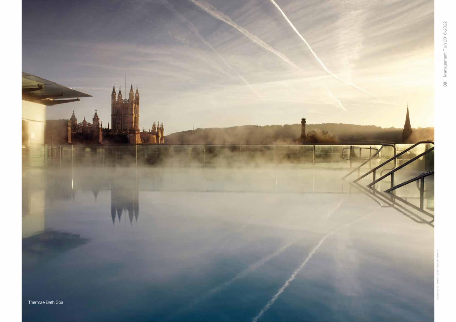
39
Man
agem
ent P
lan
2016
-202
2
visi
tbat
h.co
.uk
/ ©
Bat
h To
uris
m P
lus/
Col
in H
awki
ns
Thermae Bath Spa

40
Man
agem
ent P
lan
2016
-202
2
Implementation and Action Plan6
6.1 Introduction
This section of the Plan sets out recommended actions to address the issues and objectives outlined in Chapter 5. Actions are grouped under headings which reflect the key priorities as well as other topics.
6.2 About the actions
Actions range from minor acts and quick wins through to major projects and long-term aspirations. It is intended that every action will be as ‘smart’ as possible, and include information on who is responsible for delivery, with what resources, by when and with what indicator of success.
It is not possible however that all actions will be ‘smart’ and there is legitimate inclusion of some aspirations. An example of this Action 16 which contains an aspiration to create a one-stop-shop history centre, bringing together the Council’s Designated archives collection. At the time of writing, there is no firm project plan in place to achieve this but including this in an action indicates the support of the Steering Group to progress this, which can be important in gaining both funding and political support.
Conservation and protection of the WHS is heavily reliant on the planning system. This Management Plan does not form part of the Development Plan (see section 4.14) and as such it cannot set planning policy. It therefore recognises certain issues and looks to other documents which do form part of the Development Plan (such as the Placemaking Plan) to address these, again with the support of the Steering Group. This process extends to other strategies beyond planning, so where, for example, there is a recognised risk from flooding, the Management Plan will link to the relevant strategy to address it.
Although this Plan (through its actions) cannot set policy, it has strengths that other strategies do not. The plan is not constrained to land-use issues as planning documents largely are, and can cover a wide spectrum of subject areas. In doing so, it provides useful gap-analysis and the Steering Group can for example call for a sustainable tourism strategy (Action 41). The influence exerted by this should not be underestimated.
There are 46 actions included in this plan. The previous plan (2010-2016) contained 71 actions. Despite a good record of achievement on actions in the previous plan, the approach here is to concentrate on a smaller number of projects which can realistically be delivered.
6.3 Implementation
Actions will be delivered by a wide range of partners, both Steering Group members themselves and others. The action plan is designed as a separate table so it may be updated as necessary during the plan period. Monitoring of achievement against plan actions, as discussed in 4.20, will be undertaken on a biennial basis with reports presented to the Steering Group.
The Roman Baths Museum

41
Man
agem
ent P
lan
2016
-202
2
6.4 Action Plan
Action Delivery Resources Timescale Monitoring Partners Indicators
Managing Development
1. Re-establish a design advisory panel B&NES Regeneration Within existing budgets 2016 onwards Panel convened & meetings held for major development applications B&NES Environment and Design Evidence that panel advice is considered & followed in implementation of schemes
2. Ensure that the issue of building B&NES Planning Policy & Within existing budgets On-going Monitoring of incidences of tall building proposals height is effectively managed through Development Management & corresponding planning decisions the application of the Placemaking Plan & by the adoption of a Building Adoption of a Building Heights Strategy Heights Strategy as a SPD
3. Engage with all emerging planning B&NES Planning Policy and, Within existing budgets On-going Evidence that full account of WH has been taken policy, major plans & strategies Environment, Development into account in the plan/strategy affecting the site to ensure that the Management, Historic England & significance of the WHS’s OUV other authors of strategies Evidence that the OUV has been considered is safeguarded. in corresponding actions
4. Engage with proposals for major Bath Rugby, Cleveland Pools Trust, Within existing budgets Dependent upon progress of the Evidence that full account of WH has been taken development which may impact upon Bath Abbey, Environment Agency, scheme in question into account in the preparation & final design of the OUV of the Site, including the Network Rail, B&NES Planning & these projects following: Economic Development, Historic a. The development of a sporting, England Delivery of the projects without harm to the OUV cultural & leisure stadium at the Recreation Ground b. Cleveland Pools project as a listed building at risk & an attribute conveying OUV c. Conservation & enhancement works as part of the Bath Abbey Footprint Project d. Replacement of the radial gate at Pulteney Weir e. The rail electrification project
Transport
5. Engage with and monitor the B&NES, Historic England Key elements of the Transport See individual projects of the strategy Biennial reports to the Bath Transport Commission delivery of the Transport Strategy Strategy already have provisional for timetable, including actions on Transport Strategy delivery. Expected dates (2014) objectives & seek to ensure approval within B&NES budgets 6,7 & 10 of this plan March 2016, 2018, 2020, 2022 that they deliver maximum benefit & no unacceptable impact to Evidence that full account of WH has been the OUV of the WHS & its setting. taken into account in the preparation & final design of projects Delivery of the proposals without unacceptable impact to the OUV

42
Man
agem
ent P
lan
2016
-202
2
Action Delivery Resources Timescale Monitoring Partners Indicators
6. Engage with central government & B&NES Council, Wiltshire Council, An objective of improving the Dates for discussions not yet known Evidence of discussions neighbouring authorities as necessary Highways England, Dept. for national trunk road network for to reduce the impact of major road Transport inclusion in Highway England’s Inclusion of provisions within the 2015-2020 traffic routes passing through the WHS funding programme was confirmed Road Investment Strategy funding programme in B&NES cabinet budget proposal 2016/17
7. Engage with & support the current B&NES Council, Canal & River Trust Dept. of Transport Cycle Ambition 2.2km stretch of Batheaston K&A Delivery of the schemes within the programme programme of cycling improvements Fund (CAF) award of £3m will be Canal towpath re-surfacing & ensure that they deliver sustainable allocated to the provision of Bath commenced March 2016 Successful take up of the schemes as evidenced travel options whilst protecting the OUV Quays Bridge & linking infrastructure by scheme specific monitoring indicators Bath Quays Bridge has received final Local Growth Fund (potential £500k spend approval for CAF funding (2016). per year for 5 years) currently (2016) Anticipated construction in or after sought from Central Government year 2017/18
Public Realm
8. Continue to implement public realm B&NES Regeneration £100k given provisional approval in Saw Close Public realm Improvement schemes implemented improvements, especially with regard & Highways B&NES budget 2016/17 for a improvements 2017/18 to poor pavement surfaces review of wayfinding Bath Quays North and South Local Enterprise Partnership Bath Quays Bridge Developer contributions
9. Ensure that the Bath Pattern Book B&NES Regeneration Largely within existing budgets. On-going Incidences of street works not undertaken in is adhered to & updated as & Highways Further budget may be required if accordance with the Pattern Book necessary to guide street works updates to the book are required in the WHS
10. Continue to reduce the impact of B&NES Council, plus developer Saw Close gained provisional Saw Close Public realm Schemes implemented vehicular traffic & continue the contributions approval of £2.05m in B&NES improvements 2017/18 closure of key streets within the Site Council budget 2016/17 Transport Strategy action GABP10 calls for travel to vehicles where there is a valid case As developments come forward plans for all main activities. Monitoring will include for doing so Production of travel plans to be the number of plans produced & their impact funded as developments take place As yet unknown Discussions underway (2016) with regard to use of Weston Island as a coach park Local Enterprise Partnership Developer contributions

43
Man
agem
ent P
lan
2016
-202
2
Action Delivery Resources Timescale Monitoring Partners Indicators
Interpretation
11. Deliver a WH Interpretation Centre B&NES Heritage Services plus Total project cost £4.9m Submit HLF round 2 funding WH Centre & Learning Centre open & Learning Centre as part of the project partners bid June 2016 Archway project £1m B&NES contribution Visitor numbers & feedback Start construction Sep 2017. Heritage Lottery Funding Completion Oct 2018 £3,376,700 sought
12. Maintain & improve the WHS World Heritage Team Within existing budgets On-going Number of website hits website Evidence of more material being posted to the website Bi-annual inspection to ensure all material is current
13. Continue to support Heritage Services Learning & Heritage Services plus Annually in April Event staged World Heritage Day Programmes, plus other partners WH budget Participant numbers & feedback Other contributions from host site or partners
14. Investigate a greater role for World Heritage Team Within existing budgets 2016 Facebook & Twitter accounts established social media in the management of the WHS Evidence of use, audience reached Number of hits and tweets
15. Work toward the production of a new World Heritage Team plus Budget required 2017 New brand commissioned & in place brand for the WHS Steering Group
16. Continue to seek suitable premises B&NES Heritage Services with No budget currently identified On-going Evidence that possible solutions have been for a one-stop-shop History Centre support from other services considered to house the council’s ‘Designated’ including property & libraries archives collection Solution found
17. Install welcome signs on road, rail, World Heritage Team, with partners No budget currently identified 2016-2022 Signage in place river, canal & walking entrance points including Cotswold Way National Trail & seek to improve way marking for and Bathscape Partnership WH Enhancement Fund heritage walking routes Bathscape bid
18. Support outreach work to help people Steering Group members Anticipated as being within existing On-going Record of outreach work undertaken (especially the young), engage in budgets heritage issues, working with local societies & interest groups Bathscape bid
19. Support interpretation measures Steering Group members. No extra budget requirement On-going Record of measures undertaken which increase the understanding WH Enhancement Fund anticipated of the spiritual & intangible elements of the WHS

44
Man
agem
ent P
lan
2016
-202
2
Action Delivery Resources Timescale Monitoring Partners Indicators
20. Support the on-going co-ordination Steering Group members, especially No budgets identified for this On-going Record of co-ordination undertaken & funding of the Bath cultural offer & the as museum owners secured identification of funding to facilitate this
21. Continue to explore opportunities to WH Team plus Steering Group Largely within existing budgets On-going Evidence of instances where the logo is used use the UNESCO logo in promotion members & civic signage within brand guidelines Surveys of citizen awareness of World Heritage
Education
22. Work toward increasing the current Steering Group members plus Extra budget may be required & is 2017-2019 Production of WH content to fit the current Bath WHS education content in schools representatives not currently identified curriculum primary & secondary school curriculum & in associated local Figures on take up of the resource projects User feedback
Environmental Resilience
23. Engage with all relevant authorities to B&NES Environment and Design Team, No extra budget requirement 2016 onwards Evidence of strategies acknowledging & making mitigate flood risk from the River Environment Agency, FoBRA & anticipated provision for protection of OUV Avon with regard to impact upon others as appropriate people, historic buildings and Evidence of engagement in flood risk planning archaeology & for parts of the site Waterspace Partnership where groundwater & drainage pose a flood risk engage with the emerging Local Flood Risk Management Strategy & other relevant documents
24. Continue to monitor the hot springs B&NES Building Control, Within existing budgets On-going Evidence of on-going monitoring & seek to protect them (especially Heritage Services, Planning Services from hydrocarbon extraction plus others as required Evidence of intervention on issues such as geothermal exploitation or any influencing of new policy or issuing of licences other mineral extraction operation) through inclusion in appropriate policy or by other means
25. Support the establishment of an B&NES Environment Team plus Provisional approval of £150k in Appointment of co-ordinator Delivery of a Waterspace Strategy effective holistic management partners on the Strategic River Group B&NES 2016/17 budget early 2016 structure for the River Avon & Kennet & Avon Canal
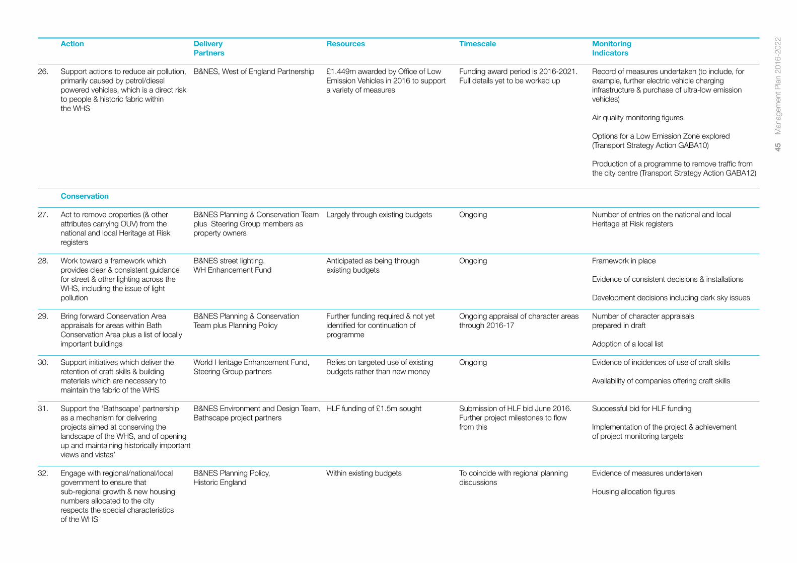
45
Man
agem
ent P
lan
2016
-202
2
Action Delivery Resources Timescale Monitoring Partners Indicators
26. Support actions to reduce air pollution, B&NES, West of England Partnership £1.449m awarded by Office of Low Funding award period is 2016-2021. Record of measures undertaken (to include, for primarily caused by petrol/diesel Emission Vehicles in 2016 to support Full details yet to be worked up example, further electric vehicle charging powered vehicles, which is a direct risk a variety of measures infrastructure & purchase of ultra-low emission to people & historic fabric within vehicles) the WHS Air quality monitoring figures Options for a Low Emission Zone explored (Transport Strategy Action GABA10) Production of a programme to remove traffic from the city centre (Transport Strategy Action GABA12)
Conservation
27. Act to remove properties (& other B&NES Planning & Conservation Team Largely through existing budgets Ongoing Number of entries on the national and local attributes carrying OUV) from the plus Steering Group members as Heritage at Risk registers national and local Heritage at Risk property owners registers
28. Work toward a framework which B&NES street lighting. Anticipated as being through Ongoing Framework in place provides clear & consistent guidance WH Enhancement Fund existing budgets for street & other lighting across the Evidence of consistent decisions & installations WHS, including the issue of light pollution Development decisions including dark sky issues
29. Bring forward Conservation Area B&NES Planning & Conservation Further funding required & not yet Ongoing appraisal of character areas Number of character appraisals appraisals for areas within Bath Team plus Planning Policy identified for continuation of through 2016-17 prepared in draft Conservation Area plus a list of locally programme important buildings Adoption of a local list
30. Support initiatives which deliver the World Heritage Enhancement Fund, Relies on targeted use of existing Ongoing Evidence of incidences of use of craft skills retention of craft skills & building Steering Group partners budgets rather than new money materials which are necessary to Availability of companies offering craft skills maintain the fabric of the WHS
31. Support the ‘Bathscape’ partnership B&NES Environment and Design Team, HLF funding of £1.5m sought Submission of HLF bid June 2016. Successful bid for HLF funding as a mechanism for delivering Bathscape project partners Further project milestones to flow projects aimed at conserving the from this Implementation of the project & achievement landscape of the WHS, and of opening of project monitoring targets up and maintaining historically important views and vistas’
32. Engage with regional/national/local B&NES Planning Policy, Within existing budgets To coincide with regional planning Evidence of measures undertaken government to ensure that Historic England discussions sub-regional growth & new housing Housing allocation figures numbers allocated to the city respects the special characteristics of the WHS

46
Man
agem
ent P
lan
2016
-202
2
Action Delivery Resources Timescale Monitoring Partners Indicators
33. Investigate SSSI (or similar) status for World Heritage Manager, B&NES No budget requirement anticipated 2017 Evidence of consideration of the matter the hot springs Heritage Services, B&NES Environment Team Accreditation as an SSSI or geological site as appropriate
34. Progress a further phase of B&NES Heritage Services £750k included in the Council’s capital Conservation works to be completed Consolidation works completed, ancient monument conservation work at the East Baths programme 2016-17. (This figure by March 2017 cleaned & stable environment established includes funding for interpretation)
35. Continue to progress & support the B&NES Council, Historic England, Budget is in place Target date for submission of bid to Production and submission of bid Great Spas of Europe trans-national DCMS and other project partners UNESCO in January 2018 World Heritage bid Successful nomination
Funding
36. Support appropriate conservation World Heritage Team, plus No budget requirement anticipated On-going Records of support given funding bids relating to the OUV Steering Group members as of the Site & seek to ensure that appropriate Evidence of co-ordination of bids these are made in a co-ordinated manner
37. Continue to progress conservation, Steering Group as members of the Budget in place & needs to be On-going with annual newsletter Annual newsletter produced enhancement & interpretation works Enhancement Fund Committee retained. Further opportunities for through the WH Enhancement Fund, or Working Group funding should be sought Funding levels generated seek to maintain & increase funding & produce an annual newsletter Projects undertaken
Research
38. Pursue the establishment of a research Bath University plus Steering Group Potential funding bid required Under active consideration in 2016 Funding secured group & an index of current research members as holders of historic records Research Group established Index on-line & maintained
Accessibility and Inclusivity
39. Continue to identify & implement B&NES Council, Steering Group Funding anticipated for delivery of Commissioning of a city centre City centre audit undertaken opportunities to make the historic members as historic property owners Transport Strategy actions access & inclusion audit is an action environment more accessible for (GABA6) in the Transport Strategy. Evidence of further measures undertaken those with limited mobility and Anticipated completion and disabilities publication date 2017 Accessibility awards achieved Other measures ongoing

47
Man
agem
ent P
lan
2016
-202
2
Action Delivery Resources Timescale Monitoring Partners Indicators
Visitor Management
40. Continue to explore options for a B&NES Council No project budget currently allocated As opportunity arises Evidence of active measures taken to pursue this visitor contribution & use proceeds to this to safeguard & interpret the fabric & economy of the WHS
41. Encourage & support the production Bath Tourism Operator (currently under Budgets allocated within 2016-17, most likely as part of a Strategy developed & adopted & adoption of a Sustainable Tourism review). B&NES Council Economic Bath Tourism Plus contract destination management plan Strategy for the WHS Development Team Evidence of implementation of strategy
Administrative Management
42. Engage with proposals to address Bath Tourism Operator (currently under Current review is resourced Ongoing Successful delivery of coach strategy coach parking within the WHS, and review). B&NES Council Economic seek to ensure that sustainable Development Team solutions are delivered which maximise the benefit and minimise any harm to the WHS.
43. Continue to maintain & resource B&NES Council (who provide the Within existing budgets Ongoing Steering Group meetings held, an effective WHS Steering Group secretariat) & Steering Group meetings well attended & productive members Mid-term review anticipated for 2019 Steering Group Chairperson recruited & in place Mid-term review undertaken
44. Produce a summary version of the WH Manager Largely within existing budgets, 2016 Summary produced & distributed WHS Management Plan & investigate although extra funding may be if it should become a SPD required for printing Discussions on SPD undertaken
45. Produce monitoring reports on WH Manager Within existing budgets Biennially. Timing to allow Reports produced & presented to Steering Group Management Plan progress on presentation to Steering Group a biennial basis
46. Maintain links with appropriate local, WH Manager, Steering Group Largely within existing budgets On-going Evidence of liaison with other bodies national & international bodies which members support WH management & funding Evaluation of benefits
47. Provide training as required to WH Manager, Head of Heritage Largely within existing budgets Repeated periodically Dates of training sessions elected members, officers, visitor Services plus other partners ambassadors & others on WH issues Feedback on training Evidence of training being used

48
Man
agem
ent P
lan
2016
-202
2
Appendix 1 Maps

49
Man
agem
ent P
lan
2016
-202
2
Map II – Bath Conservation Area

50
Man
agem
ent P
lan
2016
-202
2
Map III – Green Belt

51
Man
agem
ent P
lan
2016
-202
2
Map IV – Cotswold Area of Outstanding Natural Beauty

52
Man
agem
ent P
lan
2016
-202
2
Map V – Historic Parks and Gardens

53
Man
agem
ent P
lan
2016
-202
2
Map VI – Scheduled Ancient Monuments

54
Man
agem
ent P
lan
2016
-202
2
The Foundation of Bath
The exact date of Bath’s foundation as a settlement is not known. There has been human activity in the area since c.5000 BC but it is difficult to establish what, if any, actual settlement there was. There are Bronze Age burial mounds (tumuli) on Bathampton Down, to the east of the city, and an enclosure that dates from the Late Iron Age. This may have been used for seasonal pasture activities, rather than regular or continual inhabitancy.
There is evidence that the role of the Hot Springs was sacred before the arrival of the Romans. During excavations of the Roman reservoir in 1979/80, a gravel and boulder causeway was discovered leading to the spring head, dating to the Late Iron Age. Around the causeway were found a number of Celtic coins. It is believed the native goddess Sulis was worshipped here, with offerings cast into the spring. It is known that the Romans tended to build on sites of native power or religious significance in order to establish their dominance as rulers.
Roman Bath
When they invaded Britain in 43 AD, the Romans moved rapidly through the country and are thought to have established a military encampment in the Bath area, traditionally supposed to be at Bathwick, although substantial evidence has yet to be found. Cleveland Bridge (linking London Road to Bathwick) is the location of a natural river crossing with existing routes travelling north and south and this became the junction of four major Roman roads showing the strategic importance of the crossing.
The Temple of Sulis Minerva (see below) has previously been thought of as the stimulus for the development of the town of Aquae Sulis. However, the archaeological evidence from the two main areas of continued Roman occupation – the central area, and the Walcot Street / London Street area – is very different and seems to relate the largely separate development of the town and the temple area.
In the 1960s and 70s AD, the great Temple of Sulis Minerva was built. The temple precinct, including thermal healing baths, used the Hot Springs for worship, health and social interaction. The engineering feat the Romans achieved is astonishing
for until the Temple was built the Springs bubbled up out of open marshes. A lead lined reservoir was built where the Springs rose and a sluice gate arrangement was put in place to cope with the amount of sand brought to the surface by the water. The spring overflow can still be seen today in the Roman Baths Museum, stained bright orange by the oxidised iron salts. The reservoir formed the sacred pool of the temple, near to the sacrificial altar which was in the courtyard of the great classical temple building.
The area appears to have consisted solely of the temple and baths precinct until the 2nd century when other large public buildings were built. Development continued into the 4th and possibly 5th centuries. In the 2nd century the area, about 24 acres, may have been enclosed by an earthen bank. The stone walls, which are believed to have followed the line of the bank, were built in the 3rd or 4th centuries. It is only in the 4th century that evidence for domestic or industrial activity is found and the change seems to have been on a large scale, with buildings being erected over part of the temple precinct itself.
Prior to the building of the temple, there was already enough activity in the Walcot Street / London Street area to suggest a settlement was developing. Finds from the area around Cleveland Bridge date from 48-63 AD, before the temple was constructed. This location would have been supported by good communications and passing trade and the presence of a military establishment would have required goods and services. The settlement included river and street frontage and contained a mixture of timber and small masonry buildings, later to be replaced by more substantial masonry structures. Activity was both domestic and industrial. There was a cemetery unusually close to the area occupied by the living (these were by law kept completely separate).
Saxon Bath
The Romans left Britain in the early 5th century and after a battle at Dyrham in 577 AD Bath was taken over by the Saxons. The Roman buildings decayed and were gradually demolished, providing building material for the Saxon town that grew. Strategically, Bath held an important location: the city sat on the political boundary between Mercia (north) and Wessex (south), two strong Saxon powers. Originally
Appendix 2 History of the Site

55
Man
agem
ent P
lan
2016
-202
2
held by Mercia, the town was transferred to Wessex in the late 9th century, in the time of King Alfred.
The Wessex kings set about improving the defences of Bath and repaired the Roman walls that were still standing, though probably in a poor condition. In 901 AD the Witan (Saxon parliament) was held in Bath and later a mint was established. The highlight of the Saxon era was undoubtedly on 11 May, 973 AD, when Edgar was crowned first king of all England at the monastery in Bath.
The monastery of St. Peter was an ancient foundation, established by the mid-8th century. From the fragments of Saxon Bath that still survive, it seems that the Saxons built their religious buildings both inside and around the Roman Temple of Sulis Minerva.
One cemetery, believed to belong to the monastery, has been located in the precinct of the Roman Temple where the East Baths project out beneath Kingston Parade. A second has been found to the north of the King’s Spring, which may have belonged to either the monastery or the nearby Saxon church replaced by the medieval church of St Mary de Stalles. The exact location of the monastery is not known but these cemeteries suggest it was close to the existing Abbey church. Though the physical remains are elusive, the reputation of the monastery was well established in the Saxon era and in 973 AD it was considered a fitting place for the crowning of Edgar.
Norman Bath
Saxons stayed in the West Country until 1013, when the area surrendered to the Danish King Swein at Bath. Though the town is thought to have been largely unaffected by the arrival of the Normans in 1066, in the unsettled period that followed the death of William the Conqueror in 1088 Bath was at the centre of a plot to displace the new king William II with his brother, Robert of Normandy. The revolt was supported by the Norman bishops, whose base was at Bristol, and because Bath was largely owned by King William the town was sacked. The disruption caused by this event marked a new era in Bath’s history.
The Medieval Town
In 1090, John of Tours (also called de Villula) was appointed as Bishop of Wells. The new bishop decided to move his seat to the monastery church of Bath and a new era in building began. The religious complex that John of Tours planned and started to build (it was finished by Bishop Robert of Lewes who died in 1166) took up an entire quarter of the Medieval walled town.
The new cathedral was one of the largest of its kind in England and far larger than the 16th century abbey church that exists today. At this time the walled town covered about 24 acres, much the same as the Roman complex, of which only 3 acres belonged to the bishop, with most of the rest belonging to the king. John of Tours paid 500 pounds for all of the king’s property in Bath and the church became the largest power in the city, a power that would last for 450 years.
King’s Bath
John of Tours was probably also responsible for the renovation of the King’s Bath, largely demolished and then forgotten in Saxon times. A new bath was built over the Roman reservoir (though they may not have known it was there under the surface) and it was developed into quite an extensive complex with additional baths at the two other main springs, the Cross and Hot Springs. From later drawings it is apparent that there were distinct baths for healthy and diseased bathers, with areas for undressing, sheltered alcoves around the edge of the bath for resting and privacy (the baths were open to the sky) and refreshment facilities.
Though it is not clear how much attention was paid to the Hot Springs during Saxon times, by the 12th century the baths were well known throughout Europe for their healing properties and, as in Roman times, travellers came from far away to use them.
St John’s Hospital
In 1174, the Hospital of St John the Baptist was founded by Bishop Reginald to benefit the poor of Bath and was placed under the control of the monastery. Land was given to the hospital between the Cross and Hot Baths and the city walls for the hospital buildings, and parcels of land over a wider area were granted to them for income. It seems to have been a fairly standard medieval hospital with an infirmary building and a chapel at the east end. Other buildings would have included a kitchen and barn and there would have been a courtyard and garden. The hospital has had a varied history, with periods of diminished prosperity, but it has always been active since its foundation.
Late Medieval
With the removal of the bishopric back to Wells in 1218, the abbey church in Bath ceased to be a cathedral and returned to being a priory church for the monastery. While the town developed into a thriving wool market, the religious buildings and baths gently declined, until the town’s regional market was of greater importance than either. In 1499, Bishop King decided to replace the almost ruined Norman cathedral with a new church, but by the time of the Dissolution in 1536 the church was not finished: it was gutted and left as a ruin.
The Rise of the City Corporation
In the 16th century, the power balance in the city changed completely. The church, which had been influential for over 400 years, was going through the unsettled period of the Dissolution and the civic authorities, in the form of the City Corporation, were gaining strength. The Letters Patent of 1552 gave the mayor and citizens of Bath all the property owned by the priory. In 1590, Queen Elizabeth compounded this when she authorised a new charter of incorporation and finally gave all the powers of the bishop and prior to the Corporation.
One of the most important aspects of the charter was that it extended the boundaries of the city beyond the medieval walls, to include Barton Farm and Walcot, and gave the city the potential to expand. Also as a result of the charter the abbey
church, still unfinished, was re-consecrated as the parish church of St Peter and St Paul, which it remains to this day. The new status of the church meant it was the principal place of worship for the city and as such it was gradually renovated by the city authorities.
The baths, traditionally Crown property, had been given to the Corporation in 1552. The 16th century saw a number of publications extolling the virtues of bathing and the Corporation, realising the potential of the baths, set about renovating them. Mostly still the medieval structure, the Corporation added the Queen’s Bath (originally known as the New Bath) in 1576. There were also two other baths: the Cross Bath, mainly used by diseased bathers, and the Hot Bath. The Hot Bath in particular was improved in the 16th century to ‘gentrify’ it. The growing number of visitors, attracted by the improved facilities, led to a greater number (and higher quality) of lodging houses. This was the start of the mass tourist trade in Bath.
The 17th century saw attempts to clean up the city. Bath was still small, largely confined within its walls, but had a steadily growing population. In 1643, during the Civil War (1642-9), Parliamentary forces occupying Bath were defeated by the Royalists in a battle on Lansdown Hill, just north of the city. Though the city did not expand out into the countryside during this century, it changed greatly within the walls. The two storey thatched houses were replaced with four storey tiled buildings, filling in empty spaces and defining more than ever the differences between the poor and the wealthy. Outside the walls, the city was surrounded on most sides by orchards and market gardens.
The Beginning of Georgian Bath
Bath increased in popularity throughout the 1600s and in the later decades of the 17th century was established as a fashionable resort. The visits of Queen Anne in 1692 (as Princess) and then in 1702 and 1703 were seen as confirmation of the good society that was to be had in Bath and its popularity grew further. In 1700 the population was c.2000, but with the growth and popularity that followed, by 1800 this had risen to c. 30,000.

56
Man
agem
ent P
lan
2016
-202
2
In response to the increasing numbers of visitors, the first Pump Room was built 1704 -1706 between the Abbey Yard and the King’s Bath. As more visitors came, the city’s facilities were improved which in turn brought more visitors. Pressure for land grew sharply and those who held land outside the city walls grasped the opportunity now presented to them. Trim Street (1707) was the first speculative development to breach the city walls, and areas such as Barton Farm to the north and Kingsmead to the south soon became available for expansion.
The arrival in Bath of Richard (Beau) Nash, Ralph Allen and John Wood hailed the city’s golden era as the toast of society flocked there every year to see and be seen. Beau Nash arrived in Bath in 1705 and quickly established himself as Master of Ceremonies, imposing on society a set of rules that carved out new standards of behaviour. Ralph Allen made his fortune in developing the Postal Service and foresaw the need for building material, buying up most of the stone mines that surrounded Bath in the 1720s. John Wood was an architect whose extraordinary vision for a new city influenced development in Bath for a hundred years.
Building the New City
The building of Georgian Bath took roughly 125 years, starting at the beginning of the 18th century and finishing around 1825. Initially it was a response to the increasing numbers of visitors, with the first Pump Room built in 1706 on the site of the existing building and the lower Assembly Rooms in 1708 on Terrace Walk. These modest buildings were later replaced with the current examples, much grander in both style and scale, reflecting the growth during the 18th century in numbers of visitors and expectations of facilities and status.
The medieval town, as Bath essentially still was in 1700, was small, confined by its walls, and the buildings were almost all in the later medieval tradition with narrow streets and overhanging façades. It is very difficult now to trace this town except in the street pattern, since the Georgian rebuilding was so comprehensive and in such a different style.
John Wood
John Wood’s plans changed the face of the city forever. Though he met mixed enthusiasm and his plans were not completed, his achievements were immense, with some of the earliest and most accomplished Georgian buildings and a town planning tradition that can be seen in virtually every development in Bath until the Victorian era. Wood’s example was followed by many different architects, both during his lifetime and after his death, with the result that the town expanded very rapidly.
Bath Stone
Despite so many different architects working independently, Bath has a rare visual homogeneity. This is due partly to John Wood’s influence but largely to the almost wholesale use of Bath stone, from the mines around the city. This oolitic limestone has been used at least since Roman times for building in Bath and the quarries and mines grew up close to the city at Combe Down and Odd Down and other places such as Box.
Ralph Allen’s reasons for buying the stone mines in the 1720s were not so much to supply the city with building material but to promote its use in London, where he hoped to rival the pre-eminence of Portland. Allen was not successful in this plan, but after his death stone from Combe Down was used at Windsor Castle and Buckingham Palace. The availability of the stone locally has given a harmony to Bath’s buildings that spans two thousand years of changing styles and techniques.
Georgian Architecture
The highlights of architecture in Bath must be the crescents and terraces, particularly where they were built on the hills above the old city to make use of the views and countryside setting. John Wood did not work in isolation; there were many architects active in the 18th century, the majority of them local to Bath. The topography of the city was a challenge and it dictated much of the method of building and affected the continuous line of the terraces as they climbed up the steep hills.
For the bigger projects such as Queen Square and the Circus, huge amounts of earth were moved in attempts to level the sites. At Camden Crescent, the instability of Beacon Hill resulted in the collapse of the western end of the crescent and only the houses built on solid rock could be completed. Terrace design became more sophisticated throughout the century, particularly in dealing with the slopes. John Pinch’s work of the 1820s, the last of the great terraces to be built, cleverly incorporated the inclines into the decorative finish of the design.
The impact of the 18th century on the city, both physical and visual, was enormous. The scale of the rebuild spared very few of the medieval buildings, though more material may survive behind the façades. Visually the city was transformed. The expansion of the city was rapid, climbing the slopes of Lansdown and stretching out east and west into the countryside.
The design of the town houses had a significant physical impact on the city. The 18th century roads are built on vaults, connected to the basements of the houses on either side of the street: the excavation of these basements and vaults has compromised much of the medieval archaeology of Bath. New roads such as Union and Bath Streets (c.1790) were cut through existing rows of buildings, altering parts of the medieval street pattern and others were widened and refronted.
Bath’s position as a society favourite was in part due to its gambling establishments, of which Beau Nash was both a great supporter and regulator. The waters were still used for drinking and bathing but Bath’s main attraction was self-perpetuating: society gathered there to be part of fashionable society. The season lengthened from a few weeks to six months and was an essential part of high society’s calendar. The city became dependent on the tourists for its wealth: the number of visitors increased ten times during the 18th century.
The Decline in Popularity
Towards the end of the century, Bath’s popularity with the aristocracy dwindled and the nature of the visitors changed from high society to the emerging middle classes. More people began to retire to Bath and it became safe rather than exciting. New anti-gambling
laws and the death of Beau Nash added to the decline.
Physical expansion came to an abrupt halt in 1793 with the financial crisis brought on by the war with France. This led directly to several schemes going unfinished, most notably perhaps Great Pulteney Street, the suburbs of which were never built, leaving the main street in relative isolation. When stability returned in the 1820s, building energy was channelled into the newly popular semi-detached villas. The population continued to grow quickly and Bath’s reputation became that of a quiet refined resort, in architecturally excellent surroundings.
Victorian Changes
One of the greatest changes the Victorians wrought on Bath was the introduction of the railway and its grandiose architecture. Isambard Kingdom Brunel constructed the Great Western Railway Paddington to Bristol line with fine viaducts, bridges and stations and southern Bath in particular was affected, though the style of these structures was carefully designed to relate to the style and grandeur of the architecture of Bath. There were many architects who, whilst adopting Victorian architectural advances and stylistic preferences, also continued to work in harmony with the buildings of Georgian Bath, thus adding greatly to the visual homogeneity of the present city. Several architects, such as Henry Goodridge (1797-1864), were prolific and were influential in the development of the city in the mid-later 19th century. The Victorians also made many smaller alterations to the Georgian city as technology progressed, particularly with the introduction of plate glass in windows.
The highlight of the Victorian era was the rediscovery of the Roman Baths complex, with the remains of the Great Bath found in 1880, most of which was achieved through the determination of Major Charles Davis, City Surveyor of Work and architect. New baths were built at the western end of this complex allowing visits to the remains which the city saw as an opportunity to prop up their flagging tourist trade. The Pump Room extension, the Concert Hall, was completed by 1897 and the same architect was then employed to extend the Guildhall and add to it the Victoria Art Gallery.

57
Man
agem
ent P
lan
2016
-202
2
The last large Victorian addition to the city was the Empire Hotel. Bath’s popularity as a tourist destination did improve in the first decades of the 20th century, but it was not to recover the social status it had enjoyed throughout the 1700s.
20th Century
In 1930, before similar Government legislation was prepared, Bath developed a prototype Green Belt based on a Regional Plan written by Patrick Abercrombie and BF Brueton. The plan highlighted the special quality of the landscape around Bath and the need to conserve its character and prevent ‘straggling development’. These restrictions were incorporated into a Bath and District Planning Scheme in 1933.
Bomb Damage
On 25 and 26 April 1942, Bath was hit by bombs as part of the World War II Baedeker raids. The suburbs felt most of the damage, with a few notable exceptions such as the gutted Assembly Rooms (newly refurbished by Bath City Council as lessee in 1938) and the destroyed south side of Queen Square. Large swathes of artisan buildings in the west and south of the city were lost, in highly residential areas such as Oldfield Park and Kingsmead. The higher status Georgian buildings were largely restored but the artisan suburbs were generally cleared and redeveloped.
Town Planning
In 1945, Sir Patrick Abercrombie wrote his Plan for Bath, a proposal for city-wide development to replace the war damage and move into a new era of town planning. This document, in parts far sighted though largely unrealised, furthered the Green Belt concept and planned for residential developments inside the existing city boundary. It recognised the desirability of retaining Bath’s visual link to surrounding countryside and promoted better standards for residential housing and the incorporation of green open spaces and community facilities.
Further to the early Green Belt provision, Bath saw the first jointly funded grant scheme in the country between central government and the city council, to grant aid to historic building conservation. In 1955/6 the Bath Town Scheme offered grants for the cleaning of the stone façades of the Circus.
Planning controls, however, were altering and the emphasis on incorporating landscape design into new developments was lost. Despite its early protection of Green Belt and participation in the post-war designed landscapes, Bath fell victim to the country-wide blight of wholesale historic building destruction. 18th and 19th century suburbs were cleared in their entireties resulting in the huge loss of fine architecture. The replacement developments no longer considered landscape design as a necessary or even desirable feature.
Many smaller Georgian artisan dwellings, and in some cases entire suburbs, were lost in the World War II bombing raids (April 1942) and also during the 1950s and 60s when the City Council demolished historic buildings for housing improvements. The successful conservation movement formed to resist the so-called ‘Sack of Bath’ also helped to influence national attitudes to the conservation of historic buildings.
By the later 1960s, changes in attitude were emerging. Studies were undertaken into the management of traffic and development specifically in historic towns. Gradually an improvement took place, and more thought was put into redevelopment showing a growing awareness of the issues involved in modern life in a historic town.
Bath’s suburbs continued to expand in the 20th century and the decline of manufacturing industry in the late 20th century also changed the city’s landscape and economy. However, the city’s extensive remains form a unique and outstanding ensemble that continues to support a thriving 21st century community.
WWll bomb damage at the Assembly Rooms
© R
oman
Bat
hs M
useu
m, B
ath
& N
orth
Eas
t Som
erse
t Cou
ncil

58
Man
agem
ent P
lan
2016
-202
2
Appendix 3 Justification for Inscription
Inscription onto the list of World Heritage Sites is based upon the Site meeting one or more of six criteria measuring outstanding universal value, and fulfilling additional tests of authenticity and integrity, and the provision of adequate legislative protection. These criteria are set out in the UNESCO World Heritage Committee’s Operational Guidelines for the Implementation of the World Heritage Convention.
Criteria for outstanding universal value
The site must:
i. represent a masterpiece of human creative genius; or
ii. exhibit an important interchange of human values, over a span of time or within a cultural area of the world, on developments in architecture or technology, monumental arts, town-planning or landscape design; or
iii. bear a unique or at least exceptional testimony to a cultural tradition or to a civilisation which is living or which has disappeared; or
iv. be an outstanding example of a type of building or architectural or technological ensemble or landscape which illustrates (a) significant stage(s) in human history; or
v. be an outstanding example of a traditional human settlement or land-use which is representative of a culture, especially when it has become vulnerable under the impact of irreversible change; or
vi. be directly or tangibly associated with events or living traditions, with ideas, or beliefs, with artistic and literary works of outstanding universal significance.
Further tests
The Operational Guidelines in force at the time of inscription required that the site must:
i. meet the test of authenticity in design, material, workmanship or setting
ii. have adequate legal and/or traditional protection and management mechanisms to ensure the conservation of the nominated cultural properties
Bath was inscribed as a World Heritage Site in 1987 for criteria i, ii and iv. The city also meets the further tests of authenticity, integrity and adequate legislative protection.
Meeting criteria i, ii and iv
Criterion i. represent a masterpiece of human creative genius
In the 18th century, Bath prospered and expanded rapidly, changing its character from medieval to classical in the period of one hundred years, and providing the city with much of its outstanding universal value. Several driving forces created the conditions for this expansion, including the city’s popularity as a spa, the demand for housing, and the absence of local, ruling autocrats. But it was the presence of several ambitious personalities that drove this change.
Richard ‘Beau’ Nash (1674-1761) was a gambler who came to Bath in 1705. He saw an opportunity to build on its popularity as a spa and to create a social centre unrivalled outside London. He was largely responsible for the city’s incredible popularity throughout the 18th century, and contributed significantly to defining behaviour for the upper classes with the ‘rules’ he devised for Bath society. Bath’s position as a society city, second only to London, prompted the physical expansion of the city and enabled architects such as John Wood to attract patrons and builders to their schemes.
Ralph Allen (1693-1764) was an entrepreneur with exceptional foresight who bought extensive areas for mining stone. He built up that industry to the point where not only was he able to supply all of Bath’s stone needs at a time when the city was expanding exponentially, but he was also targeting markets in

59
Man
agem
ent P
lan
2016
-202
2
London. It is through his efforts to build up the stone mines, particularly at Combe Down and Odd Down, and to release money for speculative development, that much of the 18th century building was possible.
The best known and most influential architects at work in Bath in the 18th century were John Wood the Elder (1704-1754) and his son, John Wood the Younger (1728-1781). Their combined contribution to developments in architecture, landscape design and town planning is outstanding, and paved the way for many other architects in Bath and Britain.
John Wood the Elder returned to his native Bath in 1727 with the extraordinary vision to transform the small medieval walled city into a monumental, classical city. His vision included grand public buildings and formal open social spaces, including a Forum, Circus and Imperial Gymnasium for the exhibition of sports. The plans were radical and widely rejected by the city corporation, forcing Wood to continue independently to produce speculative individual developments. The architecture that he created in pursuit of his vision was highly innovative and influential, and changed forever the character of Bath and the art of town planning in Britain.
Wood’s main works were Queen Square (1729-36), Prior Park (begun by Wood c.1733, and completed by Richard Jones c.1750), North and South Parade, with Pierrepont Street and Duke Street (1740-43), the General Hospital (1738-42, now the Royal National Hospital for Rheumatic Diseases), the Circus (begun 1754) and Gay Street (c.1750). In addition to remodelling commissions for patrons such as the Duke of Chandos, including St John’s Hospital (1727-30), Wood also worked extensively around England and Wales, including Bristol’s Exchange and Market (1741-3) and Liverpool’s Exchange (now Town Hall, 1749-54).
Wood’s vision for Bath was heavily influenced by ancient Roman remains, the classical architecture of the previous century and particularly the work of Andrea Palladio. Wood was something of an eccentric, producing architectural writings based heavily on the mythology and architecture of ancient Britain. He found inspiration in stone circles, particularly Stonehenge and Stanton Drew, and myths such as that of Prince Bladud, who is supposed to have discovered the Hot Springs and their curative powers whilst wandering as a swineherd and suffering from leprosy.
John Wood the Younger completed the Circus after the death of his father, but was also an extraordinary architect in his own right. He was involved in all aspects of Bath society, and was instrumental in gaining the funding for the New Assembly Rooms (1769-71), constructing the building to his own design. The interior was unlike anything seen in Bath at that time, and was famed for its beauty and opulence. Other examples of Wood’s work in Bath include Rivers Street (c.1770), Catherine Place (c.1780) and the Hot Bath (1773-7).
The Woods’ greatest achievement, however, is undoubtedly the Royal Crescent (1767-75) which is approached from the Circus along Brock Street (c.1767). This massive endeavour, built like Queen Square and the Circus on green fields on the edge of the expanding city with speculative funding, became one of the most iconic and influential pieces of architecture and street design of the 18th century.
While the Woods undoubtedly produced much of the finest Palladian architecture of Bath, there were many other architects who were active in the 18th and 19th century and who also produced work of outstanding quality and innovation. The following is a selection.
Robert Adam (1728-92) was responsible for Pulteney Bridge (1769-74), another iconic structure. Highly original, save for Palladio’s un-built proposal for the Rialto Bridge in Venice, it introduced a freer Palladian style than that used by the Woods. Adam’s work in Bath particularly influenced architects such as Baldwin.
The work of Thomas Baldwin (1750-1820) can be seen all over Bath, in some of the key buildings such as the Guildhall (1775-78), the Bathwick estate (including Great Pulteney Street, c.1788-95) and the Pump Room colonnades (1791-92), as well as many smaller terraces. The Guildhall contains some of the finest 18th century civic building interiors in Britain. In his role as city surveyor, Baldwin also coordinated improvements to the bathing facilities, including the rebuilding of the Cross Bath (c.1786) and the creation of Bath Street (1791).
John Palmer (1738-1817) is best known for Lansdown Crescent (1789-93), which followed the achievements of Wood’s Royal Crescent and took it much further with its sinuous curves and harmony with the landscape.
John Pinch (1770-1827) produced a series of elegant terraces throughout the city, such as New Sydney Place (1807-8) and Sion Hill Place (1817-20). Pinch’s successful application of single monumental façades to several terraces is particularly notable for its careful treatment of sloping terraces, ensuring that Bath’s steep hills did not interfere with the flow of the façade.
That Bath is acknowledged as a place of outstanding universal value is testament to the skill and creativity of the architects and visionaries of the 18th and 19th centuries who applied and developed Palladianism in response to the opportunities offered by the spa town and its physical characteristics. That these architects were working over the course of a century, with no master plan, shared vision or single patron, did not prevent them from contriving to relate each individual development to those around it and to the wider landscape, creating a city that is harmonious and logical, in concord with its natural environment and extremely beautiful.
Criterion ii. exhibit an important interchange of human values, over a span of time or within a cultural area of the world, on developments in architecture or technology, monumental arts, town-planning or landscape design
Bath exemplifies the 18th century European move away from the uniform street layouts of Renaissance cities which dominated the 15th, 16th and 17th centuries. European cities were largely characterised by their medieval layouts and fortifications, and by the rule of state and Church. Where they were extended into Classical form, they tended to follow grand axial plans centred on palaces and other key buildings. In Bath, the confluence of Society and the growing wealth and aspirations of the middle class, the increasing opportunities available to the individual, and the absence of the threat of warfare allowed for the rules of Palladianism and the ideas of the French Enlightenment to be interpreted freely and creatively without the constraining power of a single patron or vision. Bath is where the middle class accessed the architecture of the ruling elite.
The Woods’ Royal Crescent (1767-75) combined Palladian architecture with the emerging Romantic movement and created a dialogue between building and landscape. This followed on from the tradition established at Versailles (1620s-70s) of placing buildings in direct contact with nature. The principle
of nature brought into the city and integrated into the architecture can also be seen at Place de la Concorde in Paris (Jacques-Ange Gabriel, 1763) and the Piazza del Popolo in Rome (Guiseppe Valadier, 1816-20).
In Britain, the Royal Crescent marks the introduction of the Picturesque into the urban environment, where the green landscape creates the illusion of country within the town. The Picturesque movement became one of the dominant aesthetic movements of 19th century Britain. The confluence of the Romantic and Picturesque movements with Palladian architecture is most fully developed in John Palmer’s Lansdown Crescent. Here the sinuous curves of the buildings mimic the contours of the land, and the immediate and distant rural settings create the impression that the building is an integral part of the landscape.
Bath’s contribution to British town planning is two-fold. The tools of Crescent and Circus, first demonstrated in Bath by the Woods, became, with the square, the mainstay of town planning until the mid-19th century. More important than these was the principle of a flexible and informal relationship between street, open space and building, so far removed from the grand axial town planning of continental Europe.
The extent of the spread of these tools and principles can be seen as far afield as Charles Bulfinch’s Tontine Crescent (1793, demolished 1858) in Boston, Massachusetts. Within Britain, the architecture and spatial arrangements of Bath were echoed in towns and cities from London to Edinburgh, Exeter to Buxton, and in coastal resorts such as Brighton and Weymouth.
The combination of crescent, circus and square, and their interrelation with one another through connecting streets, was immediately taken up by the leading architects of the day. The ideas and principles developed in Bath were first exported by George Dance with London’s America Square and its adjoining Crescent and Circus. From the 1790s to the 1810s many of the architect John Nash’s unexecuted plans for London show this combination, and the elements can be seen in his work at Regents Park. Here, unified monumental, classical terraces are sited in free contact with nature, continuing the development of architectural Romanticism. In Edinburgh, plans for extending the New Town after 1800 made extensive use of crescent and circus,

60
Man
agem
ent P
lan
2016
-202
2
though without the degree of informality of spatial arrangements shown in Bath.
Nash’s development of the circus idea at Oxford Circus and Piccadilly Circus, London, marks the point at which the circus moves from being a residential arrangement to a method of traffic management. The early imitations of the Circus were not continued, and relatively few examples survive today.
Conversely, the crescent was translated into all classes of architecture from the grand Royal Crescents at Buxton and Brighton to the softer curves of crescents at Exeter and Shrewsbury. In addition to its use in combination with other elements, it was also widely used as an individual element, increasingly in smaller developments. The crescent, terrace and the square entered the vernacular, and were dominant until the focus on the individual dictated the popularity of villas and private space. However, Bath’s Royal Crescent remains unique in that it is a semi-ellipse. The sophistication of its shape either went unnoticed, or was too difficult for later architects to reproduce. All subsequent ‘crescents’ were laid out as parts of circles.
Criterion iv. be an outstanding example of a type of building or architectural or technological ensemble or landscape which illustrates (a) significant stage(s) in human history
Bath is a reflection of the societies that created it and which, in turn, were influenced by the city. The two most significant eras – Roman and Georgian – are made richer by the survival of so much of their historical context. The development of this extraordinary city can be traced in physical remains and documentation from its earliest origins as a late prehistoric shrine to its current position as a 21st century heritage city.
The Roman Baths and Temple complex, together with the archaeological artefacts and remains of the Roman settlement, provide an opportunity to study a unique part of the Roman Empire. The importance of the Temple and Baths was recognised across the Empire by the pilgrims who travelled to worship here. Of all the spas in Europe, surviving or lost, Bath was one of the most renowned. The remains in Bath make a significant contribution to an understanding and appreciation of the social and religious character of Roman society in the 1st to 4th centuries AD.
With Hadrian’s Wall, they are the best surviving Roman remains in the UK, and some of the best spa remains north of the Alps.
There is considerable potential for further archaeological discovery, particularly from the Roman era. This is an exciting prospect since knowledge of the Roman settlement is still uneven.
Individually, the buildings and ensembles of 18th century Bath are of outstanding value. Taken as a whole, the city is a unique example of outstanding architecture, spatial arrangement and social history. Bath exemplifies the main themes of the 18th century neoclassical city – the monumentalisation of ordinary houses, the integration of landscape and town, and the creation and interlinking of urban spaces.
The extent of the surviving 18th century city – streets, footways, social and public buildings, domestic buildings from high status to artisan, parks, gardens, open spaces, landscape settings, stone mines and industrial remains – represents a unique survival of outstanding value for its contribution to developments in architecture and town planning, and for its role in the society of the time.
There are many individual buildings and structures that, in addition to their contribution to the wider cityscape, are notable for their individual merits. Buildings such as John Wood the Elder’s Prior Park (1733-50) and Robert Adam’s Pulteney Bridge (1769-74) particularly demonstrate the application of neoclassical architecture to suit the particular scale and topography of Bath. The great civic and social buildings, such as John Wood the Younger’s New Assembly Rooms (1769-71) and Thomas Baldwin’s Guildhall (1775-8) and Pump Room (begun 1790, and finished by John Palmer 1795), are harmoniously integrated with residential streets, open public spaces, parks and gardens. They respond to Bath’s prime role as a pleasure resort and health spa, and reflect the social ambitions of the age.
The role of Bath as a Spa is can be seen in the many buildings dedicated to the taking of (drinking), and bathing in, the hot water. The Grand Pump Room, Hot Bath, Cross Bath, King’s Bath and Hetling Pump Room are the main examples. However, much more important than this is the central role that the Hot Springs have played in the dynamics of Bath throughout its history. They are Bath’s ‘raison d’etre’, and a source of continued revitalisation and purpose.
Queen Square (John Wood the Elder, 1728-36) is the first successful treatment in Britain of a block of individual houses as a monumental façade, following earlier attempts in London. It demonstrated to architects across the country the possibilities of composing streets in a completely unified style, at a time when streets were largely constructed house by house. This allowed for the creation of urban spaces that directly related to the buildings around them – a device which can also be seen in Wood’s North and South Parades, where public promenading against a suitably grand backdrop was the main purpose of the development.
The Circus (John Wood the Elder and Younger, 1754-66) is quite unlike anything to be found across Europe and it has never been repeated to the same degree. Its roots can be seen in Roman coliseums, developments such as Place des Victoires, Paris (Jules Hardouin-Mansart, 1685), and garden designs such as ‘rond-points’. The Circus also reflects Wood’s interest in antiquities and, in this case, Celtic mythology, Druids and stone circles, such as Stonehenge. This combination produced a highly individual composition that blends fine architecture with dramatic, enclosed, urban space. This drama is greatly increased when viewed as intended after approaching up Gay Street (also by the Woods, 1733-55), where the incline of the hill conceals the Circus until the last moment.
Of all the developments in Bath it is perhaps the Royal Crescent (possibly both Wood the Elder and Younger, 1767-75) that has had the greatest impact. It harmoniously blends architecture and landscape, and was a forerunner of the Picturesque movement that became so dominant in the later 18th and 19th centuries. The Royal Crescent makes the best of its situation in the landscape to increase the drama of the building and to provide a monumental backdrop for those who paraded up and down in front of it. It is the first and only use of the ellipse (excluding some Roman amphitheatres, such as Chester) in British architecture, and possibly symbolises the Crescent Moon. It introduced the idea of a single sided street with a vista out over open countryside. The simple style of Brock Street (c.1767, connecting the Circus to the Royal Crescent) and the subtle angling of the Royal Crescent, conceal the sweep of the buildings, providing heightened drama and surprise when they are finally viewed.
Lansdown Crescent represents the apogee of the Picturesque movement in urban architecture. It continues the themes of the Royal Crescent, and echoes the undulating architecture of Francesco Borromini (1599-1667) in Rome. One of the most beautiful terraces in the country, its buildings are so contiguous with the topography that they appear to be an integral part of the landscape. Through buildings such as Lansdown Crescent, Bath exemplifies the English terrace tradition, which is quite unlike the apartment blocks and tenements of continental Europe and Scotland.
The building of the Georgian city is intimately bound to the development of society during that period. Through the survival of so much of the city’s fabric it is possible to trace the character of Georgian society. Bath represents the entrepreneurship and social ambitions of the age, as opportunity grew for ordinary men to make their fortunes and the rules of society were defined. Bath also captures society on the cusp of major industrialisation, after which the planning of towns was irrevocably altered, particularly by the transport revolution.
The development of increasingly grand architectural treatment for ordinary houses, and the growth in size and grandeur of social facilities, clearly illustrate the growing expectations of society – improved living conditions, higher quality urban environments and better facilities for entertainment and social interaction. All of this is illustrated in Bath. Much was done throughout the 18th century, in terms of streets, footpaths and open spaces, to improve the amenability and appearance of the city. This followed the growing integration of the themes of the French Enlightenment into the planning and architecture of cities.

61
Man
agem
ent P
lan
2016
-202
2
Meeting the further tests
i. meet the test of authenticity in design, material, workmanship or setting
The evolution of Bath is exceptionally clear in the buildings and streets, parks and gardens that survive and it is possible to observe evidence of the city’s character from its earliest origins right through to the 21st century.
The materials used to create this Site, the workmanship of both architects and craftsmen, the adaptation of architecture and town planning to the extreme topography of the area, and the opportunities of the geology and Hot Springs, are evident throughout the city, which is generally in a good state of preservation. The landscape setting is still an integral aspect and retains its historical, visual links with the architecture.
Despite the scale of the Site, particularly the number of historic buildings, there is a large body of information about the origins and alterations to the buildings, townscape and landscape that supports the authenticity of Bath.
ii. have adequate legal and/or traditional protection and management mechanisms to ensure the conservation of the nominated cultural properties
Legal protection
The UK national planning system provides adequate protection for most of the individual elements of Sites through statutory designations such as conservation areas, listed buildings and scheduled monuments. The protection for Sites as a whole is achieved through local development plans as advised in the NPPF, which states that World Heritage Site status should be a key material consideration for planning applications.
Pulteney Bridge and riverside colonnades
62
Man
agem
ent P
lan
2016
-202
2
Appendix 4 Inventory of selected key elements of the site
Archaeology: Historic Environment Record
The Bath & North East Somerset Historic Environment Record (HER) contains over 1200 archaeological records for the city of Bath of which 700 relate to the post-medieval and modern periods. Of the rest, over half relate to the period 1st to 4th century AD. The high number of later entries is the result of a recent study to record post-medieval monuments such as chapels, industrial buildings and other non-domestic structures. The prehistoric period was until recently confined to a few stray finds, two Iron Age occupation sites at Lower Common Allotments and Sion Hill and the timber lining of the Sacred Spring. However, large scale archaeological excavations carried out during the Southgate Centre redevelopment have revealed evidence of significant Mesolithic (Middle Stone Age) hunter-gatherer occupation in the form of flint tool scatters found within alluvial deposits on the River Avon flood plain.
In addition to the archaeological records, the HER also contains details of the City’s Listed Buildings, Conservation Areas and Registered Parks and Gardens, which are vital to the management of the city’s Georgian landscape and built heritage. The stabilisation of the Combe Down stone mines was accompanied by a detailed programme of archaeological recording, which explored Ralph Allen’s mine, where much of the stone was quarried to build the Georgian City.
Existing Remains
Characterising the archaeology of the Roman settlement of Aquae Sulis is challenging, not least because the nature of Roman Bath and its status within the region between the 1st and 4th century is ambiguous. It is not readily identifiable as an administrative centre nor yet a commercial and industrial one. There is no clear market site found and the core settlement area appears to be dominated by the baths, temple and associated high status town houses.
Discoveries of complex urban deposits along Walcot Street and London Road north of the city walls, however, suggests that there were in fact two distinct settlement foci, the latter being more of a commercial and industrial area. A third focus lies across the river on the gravel terrace of Bathwick where discoveries over the past two hundred years indicate the presence of a number of substantial buildings.
Circumstantial evidence also points to the existence of a military fort in this location. In many locations in and around Bath, Roman cemeteries and individual burials indicate the locations of main roads, many of which appear to by-pass the core area. The original river crossing appears to have been around the present Cleveland Bridge further strengthening the possibility of a fort at Bathwick.
Whilst settlement at Bath clearly continued beyond the traditional end of the Roman period and became regionally very important in Saxon England, material evidence is sparse. Recent investigations in the basement of Bellott’s Hospital on Beau Street revealed well preserved ‘black earth’ of post-Roman date above substantial Roman deposits and it is this enigmatic material that may well provide the key to this early period. Survival is, however, very patchy.
In many ways the medieval archaeology is even more challenging as so much of it has been severely truncated by more recent development particularly during the late 18th and early 19th centuries. The rebuilding of the Abbey church in the 16th century has left little visible reminder of the dominance of the Saxon monastery and apart from the east gate, two sections of city wall and the present street pattern, very little appears to survive. Having said that, recent work on existing buildings indicates that at least some of the 18th and 19th century town houses in the centre and along Broad Street, a medieval suburb, may contain remains of earlier medieval and early post medieval structures. Work in the basement of the then Clarks shoe shop in Union Street also indicated that some at least of the 18th and 19th vaults do not extend as deep as others and medieval survival may be better in these locations. Generally it is only the bottoms of medieval rubbish pits that survive.

63
Man
agem
ent P
lan
2016
-202
2
Later archaeology survives well and work at 4, Royal Crescent and at Circus Mews has produced excellent evidence for original garden layouts and stables. Recent investigations of an early 19th century row of back-to-back houses off the Lower Bristol Road, demolished in the 1960’s, has also made a substantial contribution to an understanding of the lives of the working population of Bath, previously overlooked by archaeology.
For the Roman period the majority of archaeological deposits have been classified as potentially nationally significant, indeed major areas of the core medieval and Roman urban area benefit from being designated as scheduled ancient monuments. The significance of the medieval remains, however, is less clear though potentially high, depending on the conditions. For the prehistoric period, the alluviated gravel terraces of the River Avon presents a significant but as yet unrealised potential. It is highly likely that these river valley deposits close to the Hot Springs will have been a focus for the ritual deposition of tools and weapons for a significant period of time.
Research Questions
There are many major research questions relating to Bath, some of which are: the nature of pre-Roman Bath; the relationship between the temple and baths complex and the rest of the Roman settlement, and with later post-Roman and early Saxon settlements; the nature and extent of the early monastic site; the exact boundaries of the medieval abbey; the extent, nature and origins of the medieval suburbs; the location of major routeways in the Roman and medieval periods; evidence for a Roman fort; evidence for Roman wharves; the nature of working class housing of the 18th and 19th centuries; and the impact of industrialisation.
Other elements
Roman Baths and Pump Room
This is a fascinating site with a history that began over 7000 years ago in the Mesolithic period. It includes the Roman temple and bath complex and museum, the Pump Room and the Concert Hall.
Before any baths were built, a temple was erected by the King’s Spring dedicated to Sulis Minerva, a combination of Roman and British goddesses. This was constructed in 65-75 AD and the spring was contained in a lead-lined reservoir, probably built of Bath Stone. This reservoir was used for worship, much as the Springs had been used for several thousands of years, with offerings to the Gods being thrown in to the water. The temple was a classical building and stood in a large precinct with other monumental buildings. In the middle of this precinct was a sacrificial altar. Many remains have been found of this precinct, including the pediment and steps of the temple and the altar, found in situ.
Gradually the complex grew and baths were added onto the religious site. At their height the baths included: the central swimming pool, the Great Bath; two suites of rooms (East and West Baths) with plunge and immersion baths; cold, warm and hot rooms; and a smaller warm pool. Curative rooms were a part of the complex, indicating the early understanding of the potential of the waters for improving health.
The baths have been modified on several occasions, including the 12th century when John of Tours built a curative bath over the King’s Spring reservoir, and the 16th century when the city corporation built a new bath (Queen’s Bath) to the south of the Spring. The existence of the Great Bath was not known at this time, as the Roman buildings covering it had long since collapsed and been buried. Discoveries were made throughout the 18th century, beginning with the highly important find in 1727 of the head of the statue of Sulis Minerva herself, near to where the Pump Room now stands. Further discoveries were made during the building of the Pump Room in the 1790s, and in the 19th century the major discoveries of the Great Bath, Roman reservoir and West Baths brought about a new dimension to the city – that of museum of antiquity. The 1897 extension to the Pump Room, the Concert Hall (now the main visitor
entrance) and Terrace, displayed the discoveries to the public, and they now represent a chapter of history themselves as the Victorian interpretation of Bath’s Roman past.
The Pump Room is a very special building, both architecturally and conceptually. It remains the only place in Britain where it is possible to drink hot spring waters, and from the time of its construction to the present day it has been used for its intended purpose of social interaction and entertainment and the drinking of the spa waters.
The first Pump Room, opened in 1706 in the form of an orangery by John Harvey, was a much simpler, single storey, stone building. There was the pump, supplying the spa waters, and provision for musical entertainment. In 1751 the building was extended to cater for the crowds who came to drink the waters and socialise, and in 1784 Thomas Baldwin added the north colonnade. The New Baths were built in 1788-89 (Queen’s Baths) mirroring the north colonnade in its façade, also designed by Baldwin. The original impact of this southern colonnade is now slightly lost with the alterations to the Baths behind it.
The main block was started in 1789 by Baldwin, but it was John Palmer who finished the scheme (1799). The interior, attributed to Palmer, is not considered to be as rich as either Wood’s Assembly Rooms or Baldwin’s Guildhall Banqueting Hall, but it is nevertheless appreciated by the thousands of visitors who come each year to eat in the restaurant and drink the spa waters. The building, with its two colonnades, dominates the approach to the Abbey Church Yard and creates an atmospheric link between the Abbey Church and Bath Street area.
The Pump Room is one of the main expressions of Georgian social ambitions, and stands as a reflection of the physical and social improvements taking place throughout the city. Socially, it stands at the centre of all that Georgian Bath was about.
The Roman remains are considered, along with Hadrian’s Wall, to be the finest architectural Roman remains in Britain, and some of the best Spa remains north of the Alps. They have huge potential for education and research, as well as being a popular amenity for local residents and visitors. The Pump Room has both architectural and historical importance. It has been at the centre of Bath social
activity for nearly three hundred years and is still used for its original functions.
The Pump Room (without the Concert Hall extension) is Grade I listed, and forms a group with 6 to 14 (consecutive) Abbey Church Yard, 13 & 14 Cheap Street, 3 Stall Street, and the Abbey Church. The Roman Baths are a Scheduled Ancient Monument. They are owned by Bath & North East Somerset Council and are operated by the Council’s Heritage Services.
Abbey Church
The church occupies a key site adjacent to the Baths complex and Pump Room. Externally its appearance owes a great deal to 19th century restoration, including the polygonal turrets of the tower, the pinnacles added to the turrets and the hollow flying buttresses erected on both sides of the nave. Nonetheless, it remains remarkably true to its Perpendicular style both within and without.
The church, begun in 1499, is cruciform in plan and occupies no more than the nave area of the Norman church which preceded it. The east end corresponds to the west arch that supported the Norman tower at the crossing. Little of the earlier church survives, but there are mutilated remains and a Norman arch high up on what is now the east wall of the south aisle choir. One of the most notable architectural features, the stone vaulted nave, was constructed between 1650 – 1872. Before this, the nave was roofed in timber. The church was damaged in the air raids of 1942 and all the 17th century heraldic glass that survives is now displayed in two windows in the north aisle.
The Abbey Church was built to replace the great Norman cathedral which fell into disrepair. The building survived the Reformation, though in an unfinished condition, and is now one of the grandest parish churches in the country. Finally finished in the 19th century the church is one of the most famous images of Bath and is a focal point for both local worship and tourist visits.
The Abbey Church is a Grade I listed building and forms a group with 6 to 14 (consecutive) Abbey Church Yard, 13 & 14 Cheap Street, 3 Stall Street and the Pump Room. It is owned by the Parochial Church Council of St Peter and St Paul.
64
Man
agem
ent P
lan
2016
-202
2
Chapel Court
St John’s Hospital is an ancient foundation and its site has evolved over many centuries. Much of what is now visible dates from the early 18th century, when the Duke of Chandos engaged the architect John Wood the Elder to redevelop the site. Chandos had stayed near St John’s when he visited Bath in 1726 and had not found the lodgings to his liking. Seeing an opportunity to make some money, he acquired several of the leases in and around the hospital and John Wood set to work.
The main hospital range had almshouses below and private lodgings above. Wood was asked to redevelop the upper storey without demolishing the lower floor, an arrangement that did not suit his taste for large scale developments with wide open spaces. John Wood House was the result, with its rubble-stone rear elevation facing Bath Street, which previously would have been rendered, and ashlar classical front overlooking the courtyard of the hospital. Wood was also commissioned to build several lodging houses for the Duke, including Chandos House and Chandos Buildings (now demolished). Chapel Court House was another reworking of a medieval building and, again, not to Wood’s taste.
The complex of Chapel Court is important, both as a significant element of Bath’s history – the medieval hospital – and for containing some of the first examples of John Wood the Elder’s use of classicism in the city.
The buildings that make up Chapel Court are a mix of Grade I and Grade II. They are owned by St.John’s Hospital.
Queen Square
Queen Square is a prime example of John Wood the Elder’s high ambitions for remodelling Bath, revealing his architectural talents and innovative town planning.
The land was leased to Wood by Robert Gay, with each plot in turn sub-let by Wood to local builders, working to his designs. The scheme for Queen Square was grand: three sides of the square were to be built giving the impression of a palace forecourt, with the main façade on the north, and a formal garden between. The south side was to be a separate building, from which to view the palace arrangement, with a broad promenade fronting it. Building started in 1728 on the east side and was completed in 1736.
During the course of building, the plans were altered and while the east and north sides were built to Wood’s original palace forecourt plan, the west was not. The north side was the first successful use in Britain of a single monumental façade on a row of individual, domestic houses and is impressive in its execution. The east side, which was intended as a complementary wing, is therefore somewhat simpler. The west side was built further back from the square, with a mansion façade and enclosed forecourt, and was flanked by two buildings of two houses each. The south side was built much as Wood intended, though without the formal promenade. The central area was enclosed by a low balustrade (now railings) and laid out as a formal garden. An obelisk was erected in the centre on the occasion of the visit of the Prince of Wales.
The main north façade is largely untouched, though some window proportions have been altered. The west side was altered by John Pinch the Younger in 1830 when he in-filled the two flanking buildings to create one long façade, in a different style. The south side was heavily damaged in the bombing raids of 1942. Half of it was completely destroyed, and has since been rebuilt.
Queen Square is a highly important development. It is considered to be the most successful early application of a single monumental façade to a group of individual houses and created an urban space that directly related to the domestic buildings around it.
The impact of Queen Square was heightened by its early construction, at a time when there were few Georgian buildings in Bath, on previously undeveloped land outside the city walls.
The buildings of Queen Square are Grade I listed. They are individually owned, and are mostly used as business premises.
Prior Park
The mansion of Prior Park was designed by John Wood the Elder for Ralph Allen in 1733-50, famously as an advertisement for the local Bath stone. The design was grand and extensive, but described by Wood as simple classicism. Wood had built the west wing, pavilion and mansion house before he argued with Allen in 1748 and was removed from the project. Allen’s clerk of works, Richard Jones, took over and is said to have ruined Wood’s classical symmetry by altering the east wing.
The situation of the mansion house, close to Allen’s stone mines, at the head of a combe overlooking the city gave the building the advantage of a tremendous view, with natural terraces sloping gently away. The building and park is a prominent feature of the Bath skyline. The grounds were landscaped by Allen, with advice first from Alexander Pope and later from Capability Brown, and they take advantage of the natural topography. The Palladian Bridge, a copy of the one at Wilton, was built in 1756 as a dam for the two lakes.
Prior Park is a lesson in both architecture and history. It is one of John Wood’s earliest works, and demonstrates the application of Palladianism to the scale and topography of Bath. The mansion is also a principal element of the story of Ralph Allen and Bath stone.
Prior Park is a Grade I listed building, as is the Palladian Bridge, and the gardens are registered Grade I on the English Heritage Register of Historic Parks & Gardens. The mansion is owned by Prior Park College and the Prior Park Landscape Garden (including Palladian Bridge) are owned by the National Trust.
North Parade and South Parade
Part of John Wood the Elder’s overall scheme for Bath was a Royal Forum, to provide a new social focus for the city. The open area would be lined by parades of buildings, each with large terraces overlooking the Royal Forum and built in a grand style similar to the palace façade of Queen Square. The area chosen, Abbey Orchard, was naturally very boggy and a large drainage system had to be in place before building could begin in 1740. Though the site is bordered on the east side by the River Avon, it never seems to have been intended as a visual element of the site.
The Grand, or North, Parade was the first to be constructed, with South Parade, overlooking the Royal Forum, started in 1743. As usual, Wood designed the façades and each individual builder undertook to comply with those designs, whilst given a freehand with the internal layout and rear elevations. East and west were Pierrepont and Duke Streets, with facing blocks of houses. St James’ Portico, on the west side of Pierrepont Street was constructed to give access to Orchard Street without breaking the uniformity of the street façade.
The scheme for the Royal Forum was abandoned and so the buildings on the eastern side were never constructed. Alterations to the Parades began even in construction when some tenants began to change proportions, particularly to the raised terraces, and this has continued into the 19th and 20th century with alterations to windows and the insertion of shop fronts. The grandiose scheme was never completed, but serves to illustrate again the ambition of Wood’s town planning.
As physical manifestations of John Wood’s huge architectural ambitions for Bath, the Parades are very special and unusual buildings despite the fabric alterations that have taken place since their construction.
The buildings of North and South Parade, with Duke Street and Pierrepont Street, North Parade Bridge and North Parade wall and balustrade, are a mix of Grade I, II* and II. The buildings are in mixed ownership and are used as homes, hotels and business premises.

65
Man
agem
ent P
lan
2016
-202
2
Circus
Many believe that the Circus is the pinnacle of John Wood the Elder’s work, combining his talent for town planning, understanding of classical architecture and the drama of façades, with his interests in Roman and native British architecture and beliefs. There appears to be much symbolism in the details of the Circus, which have been the focus for discussion for many years. Wood may have been directly influenced by the form of Stonehenge, as there are similarities in dimensions. Wood died soon after the first stone was laid in 1754, and the Circus was completed by his son, also named John Wood.
The Circus consists of three equal segments of buildings around an open area. There are three entrance roads, none of which give vistas of anything other than the buildings of the Circus, thereby creating an enclosed space that relates only to the buildings surrounding it. The approach up Gay Street was designed so that nothing was revealed of the form of the Circus until arrival at the top of the hill. The segments contain different numbers of buildings, varying in size, but all have three principal storeys and a uniform frontage height. Three different classical orders are used, and crowned by a parapet for stone acorns (linking the Circus to the legend of Prince Bladud and the pigs discovering the Hot Springs in ancient times). The unity of the façades is accentuated by the disparity of the rear elevations where, in the usual practice, each builder was allowed to cater to their client’s personal requirements.
The central area was originally paved and left open, intended to contain a statue of King George that was never erected. Each house was given a walled garden behind, as a part of Wood’s overall design. Wood specified the distance beyond which the rear elevations of the house were not permitted to stretch, in order to maintain some harmony of design and the retention of the garden space.
The Circus holds a unique place in both British architecture and town planning. It was central to Wood’s designs for Bath and reflects directly his ideas on the relationship between public and private space and the importance of providing outdoor social spaces within the city. The Circus is Grade I listed and is in mixed ownership. The buildings are mostly private homes.
Royal Crescent
In the great tradition of his father, John Wood the Younger contrived one of the most outstanding pieces of Georgian architecture. However, whilst construction began thirteen years after Wood the Elder’s death, the idea for Royal Crescent may be his. The approach along Brock Street is deliberately subdued architecturally, and the magnificence of the Crescent is only apparent as the end is approached. The situation of the Crescent, the formality of the buildings, the huge front lawn and the views across the city to the rural hills beyond, combine to match any of John Wood the Elder’s plans.
In contrast to the Circus, the Royal Crescent is severe in its restraint, relying on scale and proportions for its elegance. The thirty houses differ in size and plan but form a uniform, semielliptical façade. The first house, number 1 on the eastern end, was started in 1767, with the last completed in 1775.
As with so many of the Georgian buildings, the sash windows have been altered. But other than this, little has changed. Two of the houses, numbers 2 and 17, were gutted during the bombing raids of 1942, but the remaining interiors are largely original. The retention of green open space in front of the lawn of the Royal Crescent, now part of Royal Victoria Park, is of crucial importance for its setting and views.
There are few other crescents that have had such impact on architecture or held such an iconic reputation for so long. The Royal Crescent directly influenced architecture both in Bath and on a national and international scale. It marks the introduction in Britain of the Picturesque to urban architecture, and is equal to any composition in Europe.
The Royal Crescent is Grade I listed. The buildings are in mixed ownership and are mostly used as private homes.
Pulteney Bridge
Built by Robert Adam in 1769-74 for Sir William Pulteney to allow development across the river in Bathwick, Pulteney Bridge is another enduring image of Bath.
Originally the bridge was part of Adam’s extensive development for the Bathwick estate, but his plans were rejected and the bridge is the sole survivor of his grand scheme. The structure of the bridge is very much as built, with some alterations made in 1804 due to subsidence. The buildings, however, have been much altered, and on the north side are quite different to the original plans. The south side, more visually accessible, has been restored and the overhanging projections removed.
Architecturally the bridge is a rare example of classical Palladianism in this form. It resembles a proposed design by Andrea Palladio for the Rialto Bridge across the Grand Canal in Venice, depicted by Canaletto in1743/4. Historically, the bridge represents the grandeur of 18th century Bath society and the spatial needs of the expanding town, requiring the development of Bathwick as a residential area.
Pulteney Bridge is Grade I listed. It is owned by Bath & North East Somerset and let out on a long-term lease. The individual units are used for mixed retail.
Assembly Rooms
The first assembly rooms were built in 1708 by Thomas Harrison, situated on Terrace Walk by Harrison’s Walks. They were extensively remodelled throughout the century, but by the 1760s, with the growth of the upper town as a residential area, a need grew for additional assembly rooms to serve this area. The New or Upper Assembly Rooms, between Bennett Street and Alfred Street, were designed by John Wood the Younger and paid for by tontine subscription. They were begun in 1769 and opened in 1771.
The Rooms originally contained a Ball Room, octagonal Card Room and Tea Room, and quickly became the focus for social life in the upper town. The magnificence of the interiors overshadowed every other public building in Bath. An early alteration was the addition of another card room, a large rectangular apartment on the east front.
The Rooms are still used today for their original function of public entertainments. The chandeliers are acknowledged as the finest in-situ 18th century examples of their kind in the world.
The Assembly Rooms were hit by incendiary bombs in 1942 and consequently gutted, having just been refurbished by Bath City Council. Restoration was completed in 1963 and the building was reopened. The extensive fire damage is still visible in the colour of the stonework in the Tea Room.
The Assembly Rooms were central to Georgian society and are a physical reminder of the growing aspirations and status of the town throughout the 18th century. Architecturally, they have one of the finest interiors in the city, though sadly no longer original.
The Assembly Rooms are Grade I listed. They are owned by the National Trust and let on a lease to Bath & North East Somerset Council, who open the Rooms to the public and operate the Fashion Museum which is located in the basement.
Lansdown Crescent
Built between 1789 and 1793, Lansdown Crescent was designed by John Palmer for Charles Spackman, a wealthy coachbuilder and developer. It is one of the last crescents to be built before the financial crash of 1793. Several of the speculating builders involved with it were ruined that year.
Situated in one of the most striking positions in the city, the sinuous lines of the buildings following the slopes of Lansdown Hill sit comfortably in the landscape. Palmer’s designs took the example of Royal Crescent and its landscape setting to another level. The high setting gives the houses a panoramic view of the surrounding hills and their immediate rural context is secured by the rural field sloping down the hill in front of the Crescent. This rough pasture field is protected from development, recognised as central to a full appreciation of this important episode in Bath’s architectural history.
The classical design skilfully incorporates both the contours and slopes of the hill, with a concave central crescent and convex stepped up flanking wings. The ironwork is particularly fine on these buildings and is

66
Man
agem
ent P
lan
2016
-202
2
original. The archway between 20 Lansdown Crescent and 1 Lansdown Place West was built by William Beckford to house his library. The buildings have suffered little alteration and only some small damage during the bombing raids.
This development represents the height of landscape design and the terrace crescent in British architecture. Lansdown Crescent is Grade I listed. The buildings are in mixed ownership and are mostly private homes.
Sydney Gardens
These pleasure grounds were opened in 1795, and represent a focus for the society of Bath towards the end of its high popularity. Originally designed in conjunction with the Tavern (known as Sydney House), as a focal point for Baldwin’s Bathwick estate, Sydney Gardens are now somewhat stranded at the edge of Georgian Bath. The gardens, opened before the hotel construction was started, were a profit making enterprise built to rival the reputation of Vauxhall Gardens in London, then the height of fashion for polite society entertainment venues.
Laid out with winding paths, pavilions for private al fresco dining, lawns, groves, and water features, the gardens were the scene of some of the best social encounters of the period. The arrival of the Kennet and Avon canal in 1800-1, cutting the gardens at the east end, did not diminish the popularity of the gardens but rather enhanced it, with the two beautiful wrought iron bridges becoming another attraction.
The railway was another matter. In 1840, the Great Western Railway cut through the centre of the gardens, destroying the labyrinth, perimeter walk and isolating a large section of the northern gardens from their connecting paths. By this time, Bath society had altered and the popularity of the gardens was already waning.
Further encroachments took place for building purposes, and in the 1860s the gardens were laid out with bandstand, croquet, archery and lawn tennis, reflecting the changing tastes of the public. The transfer to municipal park was completed by 1912 when Bath City Council bought the whole site, selling the Tavern building (used by the Bath Proprietary College from 1853-1880) and a small area of gardens to the Trustees of Sir William Holburne’s art collection.
The Holburne of Menstrie Museum (now the Holburne Museum of Art), opened in 1916. In 1995 Bath City Council began a restoration programme to remove some of the modern developments within the park and restore some of the original layout and twenty years later a more comprehensive lottery funded project is under discussion.
The historical importance of Sydney Gardens relates to the development of public entertainments and the sociability of the Georgians. It is an integral part of the story of Georgian Bath towards the end of the 18th century.
Sydney Gardens are registered Grade II on the English Heritage Register of Historic Parks & Gardens. They are owned and operated as a public park by Bath & North East Somerset Council.
The Holburne Museum, Sydney Gardens
Brunel’s Great Western Railway, Sydney Gardens

67
Man
agem
ent P
lan
2016
-202
2

68
Man
agem
ent P
lan
2016
-202
2
Appendix 5 Membership and terms of reference of the World Heritage Site Steering Group
Membership
The Steering Group, which first met in 2001, is a non-executive committee consisting of representatives of local and national organisations with management interests and responsibilities for the Site, and others from various sectors in the city. The membership includes:
• Bath & North East Somerset Council
• Department for Culture, Media and Sport (receive papers but do not attend)
• Historic England
• ICOMOS UK
• The National Trust
• Bath Federation of Residents’ Associations
• Bath Chamber of Commerce
• Bath Preservation Trust
• Bath Business District
• Bath Primary Schools
• University of Bath
• Bath Spa University
• Bath Tourism Plus
• Bath Charter Trustees
• Avon Local Councils Association
• CURO Housing Association
Terms of Reference (adopted 2009)
The Steering Group is the principal body to guide implementation of the City of Bath World Heritage Site Management Plan. It will oversee progress on the implementation of the Management Plan and keep informed of World Heritage matters.
The composition of the Steering Group reflects the fields of work within the Management Plan. The Steering Group is intended to represent the wide range of key bodies interested in the future well-being of the World Heritage Site.
All Steering Group members should support the principles, objectives and actions of the Management Plan.
Members attend meetings to represent particular fields of work. They are not there to lobby for the organisations that have nominated them or to represent their personal interests. Some members may be co-opted for particular skills, knowledge or experience. Where a conflict of interest arises, members must declare it.
The main functions of the Steering Group are to:
• Agree the three-year work programmes and review their progress annually
• Make strategic decisions about the direction of implementation
• Support and advise the WH Manager
• Promote the Management Plan and the World Heritage Site in the community
• Maintain open dialogue between members
• Oversee the six-yearly review of the Management Plan
• Act as a forum for the exchange of information on World Heritage issues
The business of Steering Group meetings will focus on delivering the World Heritage Site Management Plan. Meetings will not be used as a forum for discussing matters beyond the remit of the Group and which are better dealt with in other fora.
The World Heritage Manager will provide the channel of communication between the Steering Group and other groups involved in implementation.
The Group will meet every six months, or more frequently if required. The Group will have an independent Chair.

69
Man
agem
ent P
lan
2016
-202
2
Supporting Statements
In preparing this management plan, Steering Group members were asked to supply supporting statements explaining their role and contribution with regard to Steering Group membership:
Bath & North East Somerset Council
Bath and North East Somerset (B&NES) Council is a unitary authority with the powers and functions of a non-metropolitan county and district council combined. The whole of the World Heritage Site lies within the B&NES district. The authority is a major landowner, owning around 60% of city centre property, much of it historic, plus nationally important museums including the Roman Baths and Fashion Museum.
Given the responsibilities of the Council with regard to planning, highways and transport, museums and interpretation, historic records, public open spaces, property and a wide range of other functions, it follows that the Council is the natural lead steward for the site. It therefore employs the full-time WHS Manager, provides the secretariat for the WHS Steering Group and funds the production of the plan as well as a series of events including World Heritage Day. The Council facilitates the selection and appointment of the Steering Group Chairperson, although this is an independent role. The Council is also the main financial supporter of the World Heritage Enhancement Fund.
Given the range of responsibilities the Council has a number of representatives on the Steering Group. These include the Cabinet Member for Economic Development, the Member Champion for the Historic Environment, the Divisional Director for Community Regeneration, the Divisional Director for Development, the Head of Heritage Services and the World Heritage Manager.
University of Bath
Dr Marion Harney is a Senior Lecturer and Director of Studies at the University of Bath, Visiting Professor at the University of Westminster and Fellow of the Higher Education Academy. Writer, architectural, landscape and cultural historian. I specialise in conservation research and multi-disciplinary conservation education.
Active member of the Bath World Heritage Site Steering Group and Chair of the WHS Research Committee, I am also a member of the National Trust Council and appointed member of their Historic Environment Advisory Group. Director of the Gardens Trust and Chair of their Conservation Committee, I have developed a keen awareness of the key issues and organisations involved with the historic environment. Member of ICOMOS-UK Cultural Landscapes and Historic Gardens Committee, this Committee takes a particular interest in the cultural landscape dimension of World Heritage Sites. Its members meet regularly to: review and comment on development proposals or guidance relating to cultural landscapes; promote the implementation of the European Landscape Convention with the ICOMOS-UK/IUCN-UK Landscape Working Group; raise awareness through research, projects or events and develop good practice.
Chair of Bathscape, a project board of partner organisations collaborating in a bid to the Heritage Lottery Fund to obtain grant funding for the Bathscape Landscape Partnership Scheme. Bathscape aims to reconnect people and communities with Bath’s unique landscape setting. The landscape has become undervalued, neglected and under used leading to a decline in environmental quality. The Bathscape partnership is working to ensure the landscape is better understood, valued, managed and accessed.
Federation of Bath Residents’ Associations
Nick Tobin is Vice-Chairman of the Federation of Bath Residents’ Associations (FoBRA) which aims to promote the interests of the residents of the City of Bath by representing their interests to the Local Authority and other relevant organisations including the World Heritage Site Steering Group (WHSSG). As a member of the WHSSG and on behalf of FoBRA he seeks to protect and enhance the environment and amenities of the City as a World Heritage Site by exchanging opinions and mutual help between the 26 Residents Associations and six Affiliate members, communicating information about developments in Bath which may affect residents, fostering community spirit and encouraging the development of a strong and effective residents’ movement throughout the City.
Historic England
As a member of its Steering Group, Historic England has welcomed the opportunity to offer on-going advice, and a national perspective, to the preparation of the Bath WHS Management Plan.
Sustaining Bath’s Outstanding Universal Value and reputation as an international tourist destination, requires a commitment from all key partners to ensure effective planning and management. As the Government’s adviser for the historic environment, including world heritage, Historic England recognises a meaningful Management Plan has an important role to play.
As a consequence we look forward to continuing to work with the Steering Group, in the development and delivery of an ambitious Management Plan that provides a sound framework for the positive management of the WHS. We will help ensure that the Management Plan complements the B&NES Core Strategy and Placemaking Plan, guides further heritage regeneration, constructive conservation and sustained improvements to the condition of the city and its surroundings.
Curo
Curo is a not-for-profit housing association which owns and manages 13,000 homes across the West of England. They are the principle provider of affordable housing in Bath, and own nearly 600 Georgian homes in the city centre. Curo’s programme of regeneration delivers physical, social and economic benefits to the local community. This includes significant investment to bring disused Georgian basements into use as new homes, as well as major development schemes including Mulberry Park at Foxhill, which will create 700 new homes, a new school and community facilities.
Bath Preservation Trust
Bath Preservation Trust (BPT) is a local amenity society. Set up in 1934, it aims to:
• Promote high standards of planning and architecture and to secure the preservation, protection, development and improvement of the character, amenities and buildings of historical, architectural or public interest in and around the City of Bath;
• Protect and preserve public rights of way and the beauty of the countryside around the City of Bath (and to promote its fullest enjoyment by the public);
• Provide educational resources, for, in particular museums, relating to the history and architectural heritage of Bath.
There is therefore a strong fit between its charitable objects and the aims of the WHS management plan.
As well as engaging in the planning process as a local (non-statutory) consultee and providing a series of events and study days for its members and the general public, BPT runs 4 museums in the City, welcoming around 75,000 visitors through its doors as well as over 1000 local school and university students on its educational programme. BPT also manages, in partnership with the Steering Group and the Council, an Enhancement Fund for small projects within the World Heritage Site.
Caroline, Kay, who sits on the Steering Group, is BPT’s Chief Executive. As well as her role with BPT she is a volunteer member of the Bath City Forum, the Bath Bridge and the South West Regional Advisory Board of the National Trust.

70
Man
agem
ent P
lan
2016
-202
2
Appendix 6 Selected Bibliography
A substantial number of sources are relevant to the World Heritage Site. The following list does not attempt to be comprehensive or hierarchical, but should rather be considered as a taster of what is available.
Architecture, Archaeology & History
Ayres, J. (1998) Building the Georgian City. New Haven: Yale University Press.
Bird, S. and Cunliffe, B. (2006) The Essential Roman Baths. London: Scala Publications Ltd.
Brown, D. and Spence, C. (2010) Bath: City on Show. Stroud: The History Press Ltd.
Buchanan, B. J. et al, (2005) Bath History Volume X. Bath: Millstream Books
Cruikshank, D. & Burton, N. (1990) Life in the Georgian City. London: Viking.
Cunliffe, B. (1986) The City of Bath. Gloucester: Sutton
Cunliffe, B. (1995) English Heritage Book of Roman Bath, London: Batsford / English Heritage
Curl, J. S. (2002) Georgian Architecture. Newton Abbot: David and Charles.
Davenport, P. (2000) ‘Aquae Sulis: The Origins and Development of a Roman town’. Bath History, 8 (1): 7-26.
Davis, G. (2007) Bath Exposed. Bath: Sulis Press.
Davis, G. (2008) Bath History 2008: v. 11. Bath: Bath Preservation Trust.
Davis, G. Bonsall, P. (2006) A History of Bath: Image and Reality. Lancaster: Carnegie Publishing Ltd.
Elliott, K. (2004) Bath. London: Frances Lincoln.
Eglin, J. (2005) The Imaginary Autocrat: Beau Nash and the Invention of Bath. London: Profile Books.
Fergusson, A. and Mowl, T. (1989) The Sack of Bath – And After: A Record And Indictment. Salisbury: Michael Russell
Forsyth, M. (2003) Bath: Pevsner Architectural Guides. New Haven: Yale University Press
Harding, S. and Lambert, D. eds. (1994) Parks and Gardens of Avon. Bristol: Avon Gardens Trust.
Ison, W. (1980) The Georgian Buildings of Bath from 1700-1830. Bath: Kingsmead.
Jackson, N. (1998) Nineteenth Century Bath Architects and Architecture. Bath: Ashgrove Press.
Lambert, R. (2000) ‘Patrick Abercrombie and Planning in Bath’. Bath History, 8 (1): 172-194.
Meehan, J. F. (2010) Famous Houses of Bath & District. Charleston: BiblioBazaar, LLC.
Miller, F. P., Vandome, A. F. and McBrewster, J. (2009) Buildings & Architecture of Bath. Alphascript Publishing.
Morriss, R. and Hoverd, K. (1993) The Buildings of Bath Stroud. Stroud: Alan Sutton Publishing Ltd.
Mowbray A. Green (1904) The Eighteenth Century Architecture of Bath. George Gregory.
Mowl, T. & Earnshaw, B. (1988) John Wood: Architect of Obsession Bath: Millstream Books.
Muthesius, S. (1982) The English Terraced House. New Haven: Yale University Press.
Perkins, J. W. (1979) Bath Stone: A Quarry History. Bath: University College Cardiff
Snaddon, B. (2000) The Last Promenade: Sydney Gardens, Bath. Bath: Millstream Books.
Toogood, M. (2010) Bath’s Old Orchard Street Theatre. Chippenham: CepenPark Publishing.
White, G. (2003) Hot Bath: The Story of the Spa. Bath: Nutbourne Publishing.
Wood, J. (1742-3) An Essay Towards a Description of the City of Bath. London.
71
Man
agem
ent P
lan
2016
-202
2
Historic Environment
Bath City Council. (1996) Recovering Quality Urban Spaces in Bath.
Bath & North East Somerset Council. (1998) Bath Streetscape History.
Bath & North East Somerset Council. (2000) Roman Baths & Pump Room Conservation Statement.
Department for Culture, Media and Sport. (2000) Centres for Social Change: Museums, Galleries and Archives for All.
Department for Culture, Media and Sport. (2002) People & Places: Social Inclusion Policy for the Built & Historic Environment.
English Heritage. (2002) Easy Access to Historic Properties.
English Heritage. (2002) Power of Place.
The National Trust. (2002) Prior Park Landscape Garden Conservation Plan.
Planning Policy
Bath and North East Somerset Council (2010) Bath Building Height Strategy [Online] Available from: http://www.bathnes.gov.uk/services/planning-and-building-control/planning-policy/evidence-base/urban-design-landscape-and-heri
Bath and North East Somerset Council (2005) Bath City Wide Character Appraisal SPD [Online] Available from: http://www.bathnes.gov.uk/sites/default/files/ sitedocuments/Planning-and-Building-Control/Planning-Policy/Evidence-Base/Urban-Design-Landscape-and-Heritage/BathCity-wideCharacterAppraisalComplete.pdf
Bath and North East Somerset Council (2014) Bath Morphological Study [Online] Available from: http://www.bathnes.gov.uk/services/planning-and-building-control/planning-policy/evidence-base/urban-design-landscape-and-heri
Bath & North East Somerset (2014) Core Strategy [Online] Available from: http://www.bathnes.gov.uk/services/planning-and-building-control/planning-policy/core-strategy-examination
Bath and North East Somerset Council (2014) Historic Environmental Research Studies by Mike Chapman [Online] Available from: http://www.bathnes.gov.uk/services/ planning-and-building-control/planning-policy/evidence-base/urban-design-landscape-and-heri
Bath and North East Somerset Council (2010) Public Realm and Movement Strategy: Creating the Canvas for Public Life in Bath [Online] Available from: http://www.bathnes.gov.uk/sites/default/files/sitedocuments/Planning-and-Building-Control/Planning-Policy/Evidence-Base/Urban-Design-Landscape-and-Heritage/PublicRealmandMovementStrategy.pdf
Bath and North East Somerset Council (2003) Rural Landscapes of Bath and North East Somerset: A Landscape Character Assessment SPD [Online] Available from: http://www.bathnes.gov.uk/sites/default/files/sitedocuments/Planning-and-Building-Control/Planning-Policy/Evidence-Base/Urban-Design-Landscape-and-Heritage/RuralLanscapesComplete.pdf
Bath and North East Somerset Council (2009) World Heritage Site Setting Study [Online] Available from: http://www.bathnes.gov.uk/sites/default/files/sitedocuments/ Planning-and-Building-Control/Planning-Policy/Evidence-Base/Urban-Design-Landscape-and-Heritage/WHSSettingStudyInformationPaper.pdf
Bath World Heritage (2014) Mid-Term Update to the City of Bath WHS Management Plan [Online] Available from: http://www.bathworldheritage.org.uk/documents
World Heritage
Feilden, B. and Jokilehto, J. (1998) Management Guidelines for World Cultural Heritage Sites. Rome: ICCROM / UNESCO / ICOMOS
ICOMOS. (1987) Conservation of Historic Towns (The Washington Charter).
ICOMOS. (1966) International Charter for the Conservation and Restoration of Monuments and Sites.
ICOMOS. (1999) International Cultural Tourism Charter.
ICOMOS Australia. (1999) The Australia ICOMOS Charter for the Conservation of Places of Cultural Significance revised (The Burra Charter).
ICOMOS-IFLA. (1982). Historic Gardens (The Florence Charter).
ICOMOS-UK. (2000) Guidelines for the Definition of Boundaries for Candidate World Heritage Sites.
ICOMOS-UK. (1995) The English World Heritage Sites Monitoring Reports.
ICOMOS-UK. (2000). The Oxford Declaration on Landscape.
Larsen, K. ed. (1995) Nara Conference on Authenticity. Paris: UNESCO /ICCROM / ICOMOS.
Prott, L. V. (1991) The Genesis and Philosophy of the World Heritage Convention (paper presented to the U.K World Heritage Site Seminar, York).
Stovel, H. (1998) Risk Preparedness: A Management Manual for World Cultural Heritage. Rome: UNESCO / ICCROM / ICOMOS.
UNESCO. (2002) Budapest Declaration on World Heritage.
UNESCO. (1972) Convention Concerning the Protection of the World Cultural and Natural Heritage.
UNESCO. (1998) Guidelines and Principles for the Use of the World Heritage Emblem.
UNESCO. (1995) The Nara Declaration on Authenticity.
UNESCO. (2002) Operational Guidelines for the Implementation of the World Heritage Convention (revised).
Bath and North East Somerset Council (2014) Bath City Riverside Enterprise Area Master Plan 2014-2029 [Online] Available from: http://www.bathnes.gov.uk/sites/ default/files/masterplan_vision_report_141030_low_res_0.pdf
Bath and North East Somerset Council (2014) Getting Around Bath: A Transport Strategy for Bath [Online] Available from: http://www.bathnes.gov.uk/sites/default/ files/sitedocuments/getting_around_bath_transport_strategy_-_final_issue_web_version.pdf
Department for Communities and Local Government (2012) National Planning Policy Framework [Online] Available from: https://www.gov.uk/government/uploads/system/uploads/attachment_data/file/6077/2116950.pdf
Smith, N. J. P. and Darling, W. G. (2012) Potential Problems Within the Bath and North East Somerset Council and Surrounding Area with Respect to Hydrocarbon and Other Exploration and Production. Nottingham: British Geological Survey. (CR/12/055)
Visit Bath (2012) A Destination Marketing Strategy for Bath and North East Somerset 2012-2014 [Online] Available from: http://channels.visitbath.co.uk/dbimgs/Destination%20Marketing%20Strategy%20for%20Bath%20%26%20NES_2012-14_FINAL.pdf

Copies of this plan may be downloaded from www.bathworldheritage.org.uk
The World Heritage Manager The Pump Room Stall Street Bath BA1 1LZ
Tel: 01225 477584
bathworldheritagesite
@bathwhs
Email: [email protected]