1
Just before Lord’s Bridge 27 the Triassic Hawksmoor Sandstone is exposed. These include red cross-bedded sandstones and conglomerates deposited by rivers. From the cross-bedding it is possible to work out which way the Triassic rivers were flowing. How does this compare with the Carboniferous river deposits at 13 and the modern Churnet? Cross Lord’s Bridge towards the Rambler’s Retreat. Continue south to a sharp left turn and follow the path to the bottom of Star Wood. Turn left up the valley to a point where it meets a path from the right 17. The fine grained, dark red/brown Ipstones Sandstone exposed here is the oldest rock on the trail. As the dip of the beds is steeper than the gradient of the valley, the rocks get progressively younger downstream towards Oakamoor. In the stream bed 18 is a red/buff iron-rich limestone. This unit, and the mudstones above, contain the marine goniatite Reticuloceras gracile; those below, have the land plant fossil Calamites. Here is fossil evidence of global sea-level change in Carboniferous times. Further south 19 mudstones contain more goniatites and a thin ironstone band. Return past the bridge 20, through the poorly exposed Roaches Grit. Mudstone blocks containing fossils occur in the river 21. Further downstream, the Chatsworth Grit forms a large cliff in the opposite side of the valley 22. This grit is accessible across the bridge 23 whilst down in the stream purple siltstones occur at the base of the unit. The trail now descends into historic Oakamoor 24. Here, an excellent industrial archaeological trail can be followed around the village. Our trail continues along the Oakamoor-Denstone ‘Greenway’ following the track bed of the former Churnet Valley Railway and line of the Uttoxeter Canal. South of Oakamoor Station 25 the Chatsworth Grit outcrops again. Beyond is a fault where Carboniferous rocks are replaced by Triassic sandstones. Close by, the River Churnet 26 is a classic example of a misfit river meandering across its wide sediment-filled valley floor. Here the trail crosses a fault, the same as that seen at locality 5, passing from the Woodhead Hill Sandstone to the Kingsley Sandstone. The valley now becomes gorge-like again with the resistant Kingsley Sandstone in the steep valley sides and softer mudstones in the valley floor. At Ochre Wood 47, probably a reference to the manufacture of ochre from local ironstones, re-cross the railway (beware of trains). Cross the Churnet via Whiston Bridge and continue to Froghall 48. Turn right along the A52 past Bolton’s copper and brass works and then left along the B5053 Ipstones road. Turn right onto the canal path back to Froghall Wharf to finish the trail. Return to the nature reserve and continue along the ‘Blue Trail’ descending into the Churnet Valley. Turn left onto the track to East Wall Farm 41. The footpath passes to the left, above the farm. A short detour left above the pond leads to springs where the porous Hawksmoor Sandstone rests on the impermeable Westphalian mudstones. This contact is an unconformity. Return to the farm, the site of a mediaeval iron bloomery, turn left and descend to the Churnet Valley floor 42. Look out for the tramway from the Woodhead Colliery coming in from the left. Here the valley opens out with gentler slopes as it is flanked by soft Westphalian mudstones. Note the hummocky terrain at the base of the valley slopes caused by landslides. Below a small footbridge 43 the fine grained, yellow/orange Kingsley Sandstone is exposed. The trail stays close to the Churnet, crossing the river, the Uttoxeter Canal and Churnet Valley Railway at Ross Bridge 44 where soft grey Westphalian mudstones occur. The trail rises to a fork 45 where a modern day crescentic landslip scar can be seen exposing grey mudstone. Fork left and look for a gully between the two paths which marks the position of the worked-out Crabtree Coal, and continue to a gate 46. Take the track on the northern side of the valley up Ousal Dale past the site of the smelting mill 33 and fork right along the upper path. Before a bend is an exposure 34 of the Hawksmoor Sandstone. Note the thin conglomerate, a small fault and honeycomb weathering here. Further exposures with thicker conglomerates occur along this path 35, 36. At the meeting of several tracks take the path upwards on the right to a road at the crest of the hill. A fault runs along the near side of the pond 37 and a pink mudstone unit visible on the far bank is the youngest rock seen on the trail. Follow the road to the T-junction. An alternative route back to Oakamoor can be made by taking the road to the right. The trail turns left at the junction and follows the road to Old Furnace 38. Here, another alternative route returns to the Rambler’s Retreat via Dimmings Dale. Turn right up Greendale Lane, past the copper and brass workers’ cottages 39, noting the date of construction, to the main road (take care in crossing). Enter Hawksmoor Nature Reserve through the stone entrance. Turn immediately left onto the ‘Blue Trail’ path to Highshutt along the edge of the reserve. Alternatively continue straight on, down the ‘Orange Trail’ for a short- cut to East Wall Farm. The path to Highshutt emerges from the reserve at a lay-by on a sharp bend in the road. The main entrance to Highshutt Quarry 40 is just downhill along the road on the left. Here the Freehay Conglomerate is exposed, a deposit formerly used for aggregate. WHISTON RAMBLER’S RETREAT 13 – 27 Return to the footpath crossing the golf course eastwards to the prominent block of Rough Rock 13 showing large scale cross-bedding formed by a Namurian river. Which way do you think the river was flowing? Try to find contortions of the bedding due to water escape as the sediment compacted and solidified. The trail follows a wall of local rock to a view 14 over Moneystone Quarry (do not enter). Rock Cottage 15 is built into the Rough Rock at one end. Follow the road to the right and then immediately take the first footpath on the left, next to a wall. After 300m turn right across a field. Continue down to a farm track and turn right along a terrace. In this area (Cotton Dell), steeper slopes relate to the outcrop of resistant sandstones and grits whilst gentler slopes occur on softer mudstones. The terrace here 16 is associated with a mudstone within the Chatsworth Grit. Lower down is another terrace in mudstone on top of the Roaches Grit. River erosion has cut down through more mudstone to the Ipstones Sandstone at the valley bottom. A fault along the valley then repeats the sequence with Roaches Grit forming the ridge at Cotton College. The Ipstones Sandstone forms the ridge on the horizon with the Carboniferous Limestone outcrops at Ribden and Caldon Low lying beyond. From the back of the car park follow the wide path to the left. Beyond a left fork is another exposure of the Hawksmoor Sandstone 28, a red/brown cross-bedded sandstone with occasional pebbles. On reaching the main road turn right. Follow the road and bear left onto a path up Rakes Dale 29, a dry valley. 100 metres after joining a road towards the top of the dale, take a sharp left turn back towards Toot Hill 30 for a panoramic view over the Churnet Valley (keep away from the edge). The Hollington Sandstone here is buff/red and contains cross-bedding with small barytes crystals weathering proud. Its greater resistance to erosion than the underlying Hawksmoor Sandstone is responsible for the valley’s steep sides. Take the path downhill westwards. In an exposure on the left 31, look for the transition from the lower, pebble-rich, Hawksmoor Sandstone to the upper, paler, pebble-free Hollington Sandstone. Continue downhill to the main road where, on the corner 32, is another exposure of the Hawksmoor Sandstone. Here the cross-bedding can be seen in three dimensions. Return to the Rambler’s Retreat via the path past locality 28. INTRODUCTION Welcome to the Churnet Valley Geotrail. This geotrail is designed to give the visitor a glimpse of the rocks, minerals, fossils and industrial heritage of the area which is intimately linked to the local geology. The whole trail is 25km long, which is probably too long to be tackled all in one go. We strongly recommend that it should be completed in sections from the access points at Froghall Wharf, Oakamoor, Rambler’s Retreat, Hawksmoor Nature Reserve and Highshutt. Alternative routes to make shorter circular walks are indicated in this guide in italics. The trail mainly follows public footpaths and other marked trails, including part of the Staffordshire Way, but visitors should note that some of these have steep sections and muddy, uneven terrain and the use of suitable footwear is advised. There are also some sections along minor roads where particular care should be taken of the traffic. Visitors are encouraged to view all features of interest from the geotrail itself unless a permitted access route away from the trail is indicated. To fully appreciate the trail, visitors will find it useful to read the background information overleaf. The age of rock units can be found in the column at the top right of this page. FROGHALL WHARF – WHISTON 1 – 12 From the historic Froghall Wharf 1 follow the Froghall ‘Green Walk’ towards Foxt. The path follows the outcrop of the Froghall Ironstone. Look out for several old mineshafts and a stream which dissects red mine spoil 2. If the bridge is closed, return down the trail to a path on the left across a stream. Take the left fork after 100m to stops 3 and 4 and then rejoin the trail. In Whieldon’s Wood 3 the Woodhead Hill Sandstone is exposed in the stream. Upstream, look out for an ochre layer from the processing of ironstone for coloured dye. The trail passes an outfall 4 draining a mine in the overlying Crabtree Coal and then climbs out of the valley past more coal workings. Continuing towards Foxt, a break in slope 5 marks the line of a fault, separating the Rough Rock sandstones of Namurian age from the younger Westphalian mudstones down in the valley. From this point onwards notice the use of different sandstones in buildings and walls. From Foxt, follow the road downhill and take a footpath on the left to an exposure 6 of red/orange Chatsworth Grit. Beyond the stile, head down to Shirley Brook. A short detour left leads to a tramway bridge and an exposure of the Roaches Grit 7. In the next valley 8 , Namurian mudstones are exposed providing a rare glimpse of this dominant Carboniferous rock type. The trail climbs back up to the tramway cutting 9 in Chatsworth Grit. Look out for the bleaching of the sandstone next to minor faults. An alternative route back to Froghall Wharf follows this tramway downhill. Return uphill and take the right fork 10. Cross Whiston Common and turn right, over the A52 and take Black Lane into Whiston village 11, 12. Try to locate buildings made of blocks of copper slag, waste from the Whiston smelter, now demolished. From Whiston, an alternative route back to Froghall Wharf continues along the lane to the A52, before following a footpath along a former tramway back to the start of the trail. RAMBLER’S RETREAT – TOOT HILL LOOP 28 – 32 HIGHSHUTT – FROGHALL WHARF 41 – 48 RAMBLER’S RETREAT – HIGHSHUTT 33– 40 Moneystone Quarry R ive r C hurnet S h ir ley B rook B5417 B5417 Ri v e r C h u r n et T unnel Moneystone Quarry G r e e n d a l e L a n e S to n e y D a l e D i m m i n g s D al e N WE S 40 39 38 37 36 35 34 33 27 26 25 24 23 22 21 20 19 18 16 15 14 13 11 9 10 8 7 6 1 5 4 3 2 48 47 45 44 46 43 42 41 P P 28 32 31 30 29 17 + P P L o c k woo d R o ad Red R o ad B l a k e l e y L a n e FOXT PH T WHISTON PH T T OAKAMOOR WC i S PH T FROGHALL WHARF WC i S PH T FROGHALL BRIDGE PH T Whiston Bridge Ross Bridge Whi ston E aves Lane RAMBLER’S RETREAT To Alton To Farley To Cotton To Ashbourne A52 To Winkhill To Kingsley To Kingsley Holt To Cheadle To Hollington A52 FROGHALL B5053 S Ross Lane 12 HIGHSHUTT HAWKSMOOR NATURE RESERVE P Star Wood Rakes Dale Toot Hill Lord’s Bridge Ou s a l D a l e Earl’s Rock A52 FI CC FI CC RR CG CG CG CG RR RG KS KS KS WHS WHS WC WC KS KS WC HKS FC FC M HLS HLS HKS HKS HLS CG CG RR CG WHS RG CG CG CG RG RG Cotton Dell East Wall Farm Gibridding Wood Ochre Wood Ca l d o n C a n a l Whieldon’s Wood C o tto n B r o o k Ri v er C h u r n e t ToCaldon quarries To Ipstones HB CG IS WHS KEY GEOTRAIL GEOTRAIL / road shared River Canal Railway Disused railway Disused tramway View point Fault with direction of downthrow S PH T i P WC 1 Major road Minor road Interest Point Car Park Toilets Information Telephone Public House Shop Café 0 1 km 42 6 13 1 15 14 16 31 39 40 41 T h e C h u r n e t V a l l e y G e o t r a i l LOWER TRIASSIC Approximate age in millions of years UPPER CARBONIFEROUS SCYTHIAN WESTPHALIAN NAMURIAN Quat. Alluvium Unconformity Unconformity M HLS FC HKS HB KS CC FI WHS RR CG IS WC RG C C M M M Hollington Sandstone (HLS) and mudstone (M) - meandering river deposits Hawksmoor Sandstone (HKS) and Freehay Conglomerate (FC) - fast flowing braided river deposits Huntley Breccia (HB) - alluvial fan deposits Cyclic succession of deltaic distributary channel sandstones and grits (Kingsley Sandstone - KS, Woodhead Hill Sandstone - WHS, Rough Rock - RR, Chatsworth Grit - CG, Roaches Grit - RG, Ipstones Sandstone - IS) with interdistributary mudstones (M), coals (C, Woodhead Coal - WC, Crabtree Coal - CC), ironstones (Froghall Ironstone - FI) occasional marine bands Recent alluvium and Pleistocene (Ice Age) deposits 0 2 245 250 313 318 Not to scale Reproduced from Ordnance Survey Mapping with the permission of Her Majesty's Stationery Office, © Crown Copyright 2008, Staffordshire Wildlife Trust License. AL 100032203. Geological Information based upon BGS Geological Map Sheet 124 (Ashbourne & Cheadle, S & D) at 1:50 000 scale with permission IPR/97-19C British Geological Survey c NERC. All rights reserved.

The ChurnetValley Geotrail

  • Upload
    others

  • View
    2

  • Download
    0

Embed Size (px)

Citation preview

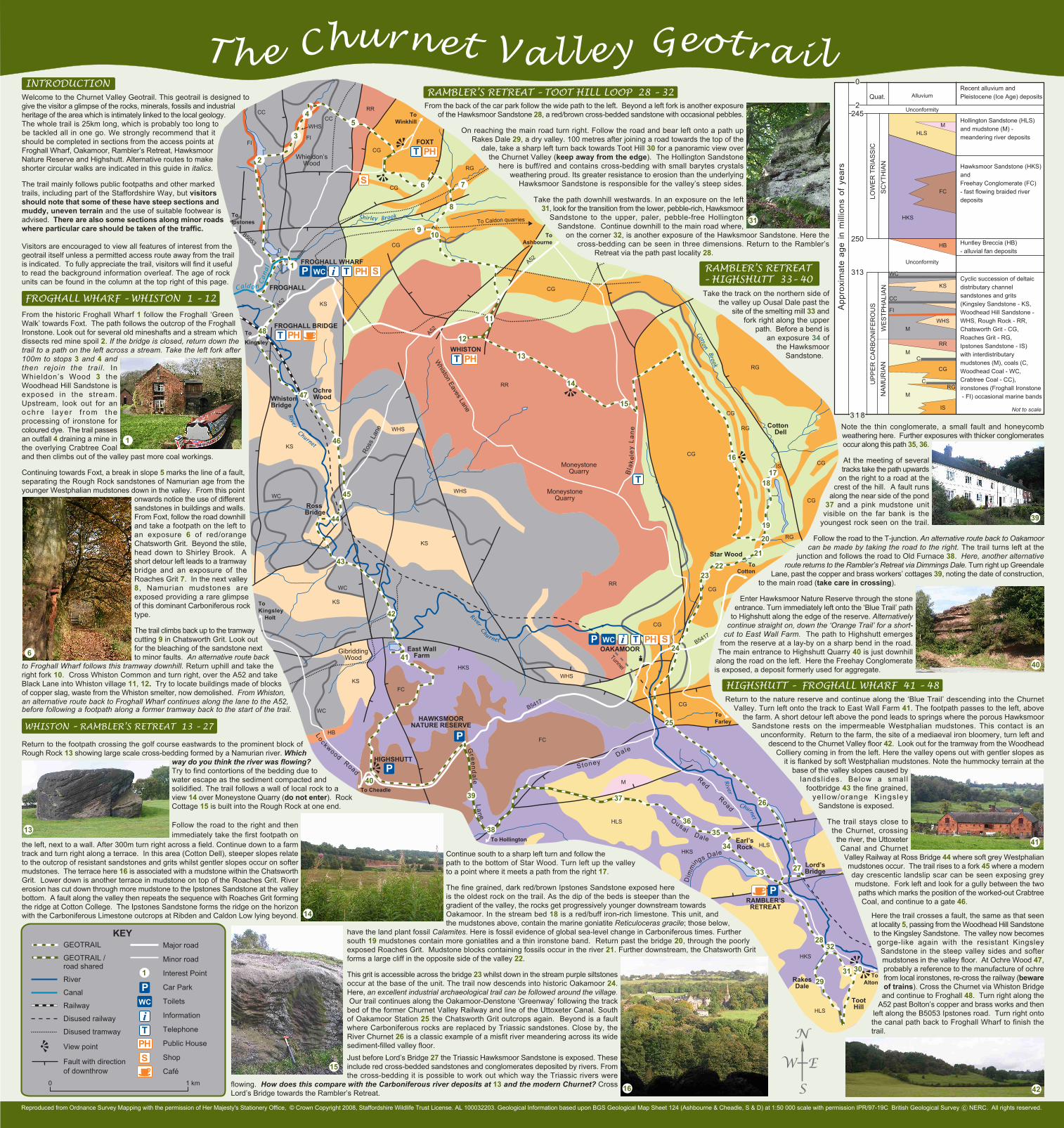
Just before Lord’s Bridge 27 the Triassic Hawksmoor Sandstone is exposed. Theseinclude red cross-bedded sandstones and conglomerates deposited by rivers. Fromthe cross-bedding it is possible to work out which way the Triassic rivers were

flowing. How does this compare with the Carboniferous river deposits at 13 and the modern Churnet? CrossLord’s Bridge towards the Rambler’s Retreat.

Continue south to a sharp left turn and follow thepath to the bottom of Star Wood. Turn left up the valleyto a point where it meets a path from the right 17.

The fine grained, dark red/brown Ipstones Sandstone exposed hereis the oldest rock on the trail. As the dip of the beds is steeper than thegradient of the valley, the rocks get progressively younger downstream towardsOakamoor. In the stream bed 18 is a red/buff iron-rich limestone. This unit, andthe mudstones above, contain the marine goniatite Reticuloceras gracile; those below,

have the land plant fossil Calamites. Here is fossil evidence of global sea-level change in Carboniferous times. Furthersouth 19 mudstones contain more goniatites and a thin ironstone band. Return past the bridge 20, through the poorlyexposed Roaches Grit. Mudstone blocks containing fossils occur in the river 21. Further downstream, the Chatsworth Gritforms a large cliff in the opposite side of the valley 22.

This grit is accessible across the bridge 23 whilst down in the stream purple siltstonesoccur at the base of the unit. The trail now descends into historic Oakamoor 24.Here, an excellent industrial archaeological trail can be followed around the village. Our trail continues along the Oakamoor-Denstone ‘Greenway’ following the trackbed of the former Churnet Valley Railway and line of the Uttoxeter Canal. Southof Oakamoor Station 25 the Chatsworth Grit outcrops again. Beyond is a faultwhere Carboniferous rocks are replaced by Triassic sandstones. Close by, theRiver Churnet 26 is a classic example of a misfit river meandering across its widesediment-filled valley floor.

Here the trail crosses a fault, the same as that seenat locality 5, passing from the Woodhead Hill Sandstoneto the Kingsley Sandstone. The valley now becomesgorge-like again with the resistant KingsleySandstone in the steep valley sides and softermudstones in the valley floor. At Ochre Wood 47,probably a reference to the manufacture of ochrefrom local ironstones, re-cross the railway (bewareof trains). Cross the Churnet via Whiston Bridgeand continue to Froghall 48. Turn right along the

A52 past Bolton’s copper and brass works and thenleft along the B5053 Ipstones road. Turn right ontothe canal path back to Froghall Wharf to finish thetrail.

Return to the nature reserve and continue along the ‘Blue Trail’ descending into the ChurnetValley. Turn left onto the track to East Wall Farm 41. The footpath passes to the left, above

the farm. A short detour left above the pond leads to springs where the porous HawksmoorSandstone rests on the impermeable Westphalian mudstones. This contact is an

unconformity. Return to the farm, the site of a mediaeval iron bloomery, turn left anddescend to the Churnet Valley floor 42. Look out for the tramway from the Woodhead

Colliery coming in from the left. Here the valley opens out with gentler slopes asit is flanked by soft Westphalian mudstones. Note the hummocky terrain at the

base of the valley slopes caused bylandsl ides. Below a small

footbridge 43 the fine grained,yel low/orange Kingsley

Sandstone is exposed.

The trail stays close tothe Churnet, crossing

the river, the UttoxeterCanal and ChurnetValley Railway at Ross Bridge 44 where soft grey Westphalianmudstones occur. The trail rises to a fork 45 where a modernday crescentic landslip scar can be seen exposing greymudstone. Fork left and look for a gully between the twopaths which marks the position of the worked-out CrabtreeCoal, and continue to a gate 46.

Take the track on the northern side ofthe valley up Ousal Dale past the

site of the smelting mill 33 andfork right along the upper

path. Before a bend isan exposure 34 of

the HawksmoorSandstone.

Note the thin conglomerate, a small fault and honeycombweathering here. Further exposures with thicker conglomeratesoccur along this path 35, 36.

At the meeting of severaltracks take the path upwards

on the right to a road at thecrest of the hill. A fault runs

along the near side of the pond37 and a pink mudstone unit

visible on the far bank is theyoungest rock seen on the trail.

Follow the road to the T-junction. An alternative route back to Oakamoorcan be made by taking the road to the right. The trail turns left at the

junction and follows the road to Old Furnace 38. Here, another alternativeroute returns to the Rambler’s Retreat via Dimmings Dale. Turn right up Greendale

Lane, past the copper and brass workers’ cottages 39, noting the date of construction,to the main road (take care in crossing).

Enter Hawksmoor Nature Reserve through the stoneentrance. Turn immediately left onto the ‘Blue Trail’ path

to Highshutt along the edge of the reserve. Alternativelycontinue straight on, down the ‘Orange Trail’ for a short-

cut to East Wall Farm. The path to Highshutt emergesfrom the reserve at a lay-by on a sharp bend in the road.

The main entrance to Highshutt Quarry 40 is just downhillalong the road on the left. Here the Freehay Conglomerateis exposed, a deposit formerly used for aggregate.

WHISTON – RAMBLER’S RETREAT 13 – 27

Return to the footpath crossing the golf course eastwards to the prominent block ofRough Rock 13 showing large scale cross-bedding formed by a Namurian river. Which

way do you think the river was flowing?Try to find contortions of the bedding due towater escape as the sediment compacted andsolidified. The trail follows a wall of local rock to aview 14 over Moneystone Quarry (do not enter). RockCottage 15 is built into the Rough Rock at one end.

Follow the road to the right and thenimmediately take the first footpath on

the left, next to a wall. After 300m turn right across a field. Continue down to a farmtrack and turn right along a terrace. In this area (Cotton Dell), steeper slopes relateto the outcrop of resistant sandstones and grits whilst gentler slopes occur on softermudstones. The terrace here 16 is associated with a mudstone within the ChatsworthGrit. Lower down is another terrace in mudstone on top of the Roaches Grit. Rivererosion has cut down through more mudstone to the Ipstones Sandstone at the valleybottom. A fault along the valley then repeats the sequence with Roaches Grit formingthe ridge at Cotton College. The Ipstones Sandstone forms the ridge on the horizonwith the Carboniferous Limestone outcrops at Ribden and Caldon Low lying beyond.

From the back of the car park follow the wide path to the left. Beyond a left fork is another exposureof the Hawksmoor Sandstone 28, a red/brown cross-bedded sandstone with occasional pebbles.

On reaching the main road turn right. Follow the road and bear left onto a path upRakes Dale 29, a dry valley. 100 metres after joining a road towards the top of the

dale, take a sharp left turn back towards Toot Hill 30 for a panoramic view overthe Churnet Valley (keep away from the edge). The Hollington Sandstone

here is buff/red and contains cross-bedding with small barytes crystalsweathering proud. Its greater resistance to erosion than the underlying

Hawksmoor Sandstone is responsible for the valley’s steep sides.

Take the path downhill westwards. In an exposure on the left31, look for the transition from the lower, pebble-rich, Hawksmoor

Sandstone to the upper, paler, pebble-free HollingtonSandstone. Continue downhill to the main road where,

on the corner 32, is another exposure of the Hawksmoor Sandstone. Here thecross-bedding can be seen in three dimensions. Return to the Rambler’s

Retreat via the path past locality 28.

INTRODUCTIONWelcome to the Churnet Valley Geotrail. This geotrail is designed togive the visitor a glimpse of the rocks, minerals, fossils and industrialheritage of the area which is intimately linked to the local geology.The whole trail is 25km long, which is probably too long tobe tackled all in one go. We strongly recommend that itshould be completed in sections from the access points atFroghall Wharf, Oakamoor, Rambler’s Retreat, HawksmoorNature Reserve and Highshutt. Alternative routes to makeshorter circular walks are indicated in this guide in italics.

The trail mainly follows public footpaths and other markedtrails, including part of the Staffordshire Way, but visitorsshould note that some of these have steep sections andmuddy, uneven terrain and the use of suitable footwear isadvised. There are also some sections along minor roadswhere particular care should be taken of the traffic.

Visitors are encouraged to view all features of interest from thegeotrail itself unless a permitted access route away from the trailis indicated. To fully appreciate the trail, visitors will find it usefulto read the background information overleaf. The age of rockunits can be found in the column at the top right of this page.

FROGHALL WHARF – WHISTON 1 – 12

From the historic Froghall Wharf 1 follow the Froghall ‘GreenWalk’ towards Foxt. The path follows the outcrop of the FroghallIronstone. Look out for several old mineshafts and a stream whichdissects red mine spoil 2. If the bridge is closed, return down thetrail to a path on the left across a stream. Take the left fork after100m to stops 3 and 4 andthen rejoin the trail. InWhieldon’s Wood 3 theWoodhead Hill Sandstone isexposed in the stream.Upstream, look out for anochre layer f rom theprocessing of ironstone forcoloured dye. The trail passesan outfall 4 draining a mine inthe overlying Crabtree Coaland then climbs out of the valley past more coal workings.

Continuing towards Foxt, a break in slope 5 marks the line of a fault,separating the Rough Rock sandstones of Namurian age from theyounger Westphalian mudstones down in the valley. From this point

onwards notice the use of differentsandstones in buildings and walls.From Foxt, follow the road downhilland take a footpath on the left toan exposure 6 of red/orangeChatsworth Grit. Beyond the stile,head down to Shirley Brook. Ashort detour left leads to a tramwaybridge and an exposure of theRoaches Grit 7. In the next valley8, Namurian mudstones areexposed providing a rare glimpseof this dominant Carboniferous rocktype.

The trail climbs back up to the tramwaycutting 9 in Chatsworth Grit. Look outfor the bleaching of the sandstone nextto minor faults. An alternative route back

to Froghall Wharf follows this tramway downhill. Return uphill and take theright fork 10. Cross Whiston Common and turn right, over the A52 and takeBlack Lane into Whiston village 11, 12. Try to locate buildings made of blocksof copper slag, waste from the Whiston smelter, now demolished. From Whiston,an alternative route back to Froghall Wharf continues along the lane to the A52,before following a footpath along a former tramway back to the start of the trail.

RAMBLER’S RETREAT – TOOT HILL LOOP 28 – 32

HIGHSHUTT – FROGHALL WHARF 41 – 48

RAMBLER’S RETREAT– HIGHSHUTT 33– 40

MoneystoneQuarry

River

Churnet

Shirley Brook

B5417

B5417

RiverChurnet

Tunnel

MoneystoneQuarry

Gr e endale

Lane

StoneyDale

Dim

mings Dale

N

W E

S

40

39

38

37

3635

34

33 27

26

25

24

2322

21

20

19

18

16

15

14

13

11

910

8

76

1

54

3

2

48

47

45

44

46

43

42

41

P

P

2832

31 3029

17

+

P

P

LockwoodRoad

Red

Road

Bla

kele

yLa

ne

FOXTPHT

WHISTONPHT

T

OAKAMOORWC i SPHT

FROGHALL WHARFWC i SPHT

FROGHALL BRIDGEPHT

WhistonBridge

Ross Bridge

Whiston

Eaves Lane

RAMBLER’SRETREAT

ToAlton

ToFarley

ToCotton

ToAshbourne

A52

ToWinkhill

ToKingsley

ToKingsley Holt

To Cheadle

To Hollington

A52

FROGHALL

B5053

S

Ross

Lan

e

12

HIGHSHUTT

HAWKSMOORNATURE RESERVE

P

Star Wood

RakesDale

TootHill

Lord’sBridge

Ousal Dale Earl’sRock

A52

FI

CC

FI

CC

RR

CG

CG

CG

CG

RR

RG

KS

KS

KS

WHS

WHSWC

WC

KS

KS

WC

HKS

FC

FC

M

HLS

HLSHKS

HKS

HLS

CG

CG

RRCG

WHS

RG

CG

CG

CG

RG

RG

Cotton Dell

East WallFarmGibridding

Wood

OchreWood

Cald on

Canal

Whieldon’sWood

Cotton

Brook

River

Churnet

To Caldon quarriesToIpstones

HB

CGIS

WHS

KEYGEOTRAIL

GEOTRAIL /road shared

River

Canal

Railway

Disused railway

Disused tramway

View point

Fault with directionof downthrow

SPHTi

PWC

1

Major road

Minor road

Interest Point

Car Park

Toilets

Information

Telephone

Public House

Shop

Café0 1 km

42

6

13

1

15

14

16

31

39

40

41

Th e Churnet Valley Geotrai l

LOW

ER

TR

IAS

SIC

App

roxi

mat

e ag

e in

mill

ions

of

year

s

UP

PE

R C

AR

BO

NIF

ER

OU

SS

CY

THIA

NW

ES

TPH

ALI

AN

NA

MU

RIA

N

Quat. Alluvium

Unconformity

Unconformity

MHLS

FC

HKS

HB

KS

CC

FI

WHS

RR

CG

IS

WC

RG

C

C

M

M

M

Hollington Sandstone (HLS)and mudstone (M) -meandering river deposits

Hawksmoor Sandstone (HKS)andFreehay Conglomerate (FC)- fast flowing braided riverdeposits

Huntley Breccia (HB)- alluvial fan deposits

Cyclic succession of deltaicdistributary channelsandstones and grits(Kingsley Sandstone - KS,Woodhead Hill Sandstone -WHS, Rough Rock - RR,Chatsworth Grit - CG,Roaches Grit - RG,Ipstones Sandstone - IS)with interdistributarymudstones (M), coals (C,Woodhead Coal - WC,Crabtree Coal - CC),ironstones (Froghall Ironstone - FI) occasional marine bands

Recent alluvium andPleistocene (Ice Age) deposits

0

2245

250

313

3 1 8Not to scale

Reproduced from Ordnance Survey Mapping with the permission of Her Majesty's Stationery Office, © Crown Copyright 2008, Staffordshire Wildlife Trust License. AL 100032203. Geological Information based upon BGS Geological Map Sheet 124 (Ashbourne & Cheadle, S & D) at 1:50 000 scale with permission IPR/97-19C British Geological Survey c NERC. All rights reserved.