Embed Size (px)
Citation preview
THE BURREN WALKING
TRAILSThe Shannon Region International Trails Programme is an initiative by Shannon Development to develop and promote the Shannon Region as a world-class trails destination. Check out www.ShannonRegionTrails.ie where you can find an abundance of information including GPS data, directions and detailed maps for lots of great trails, including walking, cycling, mountain biking, driving, equestrian, canoeing, surfing, scuba diving and more, in Ireland’s Shannon Region - which covers counties Limerick, Clare, North Tipperary and South West Offaly. We would also like to acknowledge the work of the National Parks and Wildlife Service (NPWS) on their work in developing the Dromore Wood Loop and Mullaghmore Way.
Leave No Trace on the Loops
1 Be Prepared Ensure you have the fitness, equipment and time needed for the loop you choose. Check the weather forecast and be prepared for changing weather conditions.
2 Be Considerate of Other PeoplePark appropriately -do not block entrance to other cars.Respect people you meet and keep noise to a minimum. Do not damage property.
3 Respect Farm Animals and WildlifeKeep dogs under close control.Avoid disturbing wild animals and birds and do not feed them. Remain at a safe distance from farm animals.
4 Protect the Trail from ErosionTravel in small groups and walk in single file on wet or eroded sectlons.
5 Leave What You FindLeave gates as you find them.Do not damage structures, artifacts or monu-ments.Leave rocks, plants, animals and habitats as you find them.
6 Dispose of Waste PropertyTake home ALL litter and leftover food - If You Bring It In, Take It Out!
7 Minimise the Effects of FireDo not light fires and if you smoke, take used matches and cigarette butts home with you.
Useful Linkswww.ShannonRegionTrails.iewww.shannondevelopment.iewww.discoverireland.ie/things-to-dowww.clare.iewww.irishtrails.iewww.Ballyvaghanfanorewalkingclub.comwww.burrenpeakswalkingfestival.comwww.cldc.ie/ruralwww.npws.ie
Notes: Linar routes are a point-to-point walk, which may require a car pick up to be organised at the finish point. Detailed sectional maps of all routes are available to download from www.ShannonRegionTrails.ie Routes are subject to change.
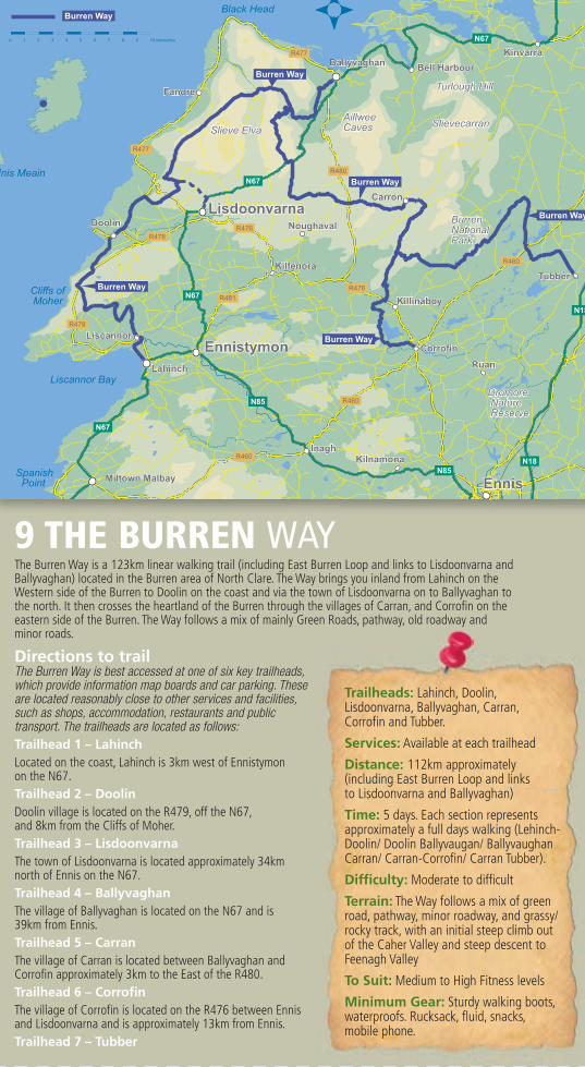
9 THE BURREN WAY
11 MULLAGHMORE BLUE LOOP WALK
The Burren Way is a 123km linear walking trail (including East Burren Loop and links to Lisdoonvarna and Ballyvaghan) located in the Burren area of North Clare. The Way brings you inland from Lahinch on the Western side of the Burren to Doolin on the coast and via the town of Lisdoonvarna on to Ballyvaghan to the north. It then crosses the heartland of the Burren through the villages of Carran, and Corrofin on the eastern side of the Burren. The Way follows a mix of mainly Green Roads, pathway, old roadway and minor roads.
Directions to trailThe Burren Way is best accessed at one of six key trailheads, which provide information map boards and car parking. These are located reasonably close to other services and facilities, such as shops, accommodation, restaurants and public transport. The trailheads are located as follows:Trailhead 1 – Lahinch Located on the coast, Lahinch is 3km west of Ennistymon on the N67.Trailhead 2 – Doolin Doolin village is located on the R479, off the N67, and 8km from the Cliffs of Moher.Trailhead 3 – Lisdoonvarna The town of Lisdoonvarna is located approximately 34km north of Ennis on the N67. Trailhead 4 – BallyvaghanThe village of Ballyvaghan is located on the N67 and is 39km from Ennis.Trailhead 5 – CarranThe village of Carran is located between Ballyvaghan and Corrofin approximately 3km to the East of the R480.Trailhead 6 – CorrofinThe village of Corrofin is located on the R476 between Ennis and Lisdoonvarna and is approximately 13km from Ennis.Trailhead 7 – Tubber
The Burren National Park is located in the southeastern corner of the Burren and is approximately 1500 hectares in size and is one of Ireland’s most outstanding landscapes: a place of great beauty and fascination, steeped in history, teeming with wildlife and blessed with a rich culture and strong sense of community. Lough Gealain is the lake at the base of Mullaghmore. The Burren National Park is managed by the National Parks and Wildlife Service.
Directions to trailheadFrom Corofin, travel north on the R476 out of Corofin in direction of Lisdoonvarna (4.6km to trailhead), at Kilinaboy, take right turn onto the L1112 (1.8km to trailhead). The Trailhead is located at the lay-by on the right at Gortlecka Crossroads near Mullaghmore in the Burren National Park, Co. Clare. GR:R 304 945From the trailhead, follow the Blue arrows which take you right from the trailhead, and then left across the Crag road, through a stile and to the shores of a little lake and around the mountain.
10 CARRAN TURLOUGH LOOP WALKCarran village lies in the centre of the Burren overlooking the region’s largest turlough (seasonal lake). It is the only village in the high Burren and features the bare necessities of Irish country life - a church, school, pub and restaurant (Cassidy’s). The area is the birthplace to Michael Cusack, founder of the GAA, whose original homestead has been fully restored and a contemporary visitor centre developed. Carran is a walker’s paradise boasting three marked walking trails, and a choice of accommodation (B&B, self catering and hostel). Slieve Carran Nature Reserve is just north of the village and contains a rich array of flora and fauna as well as historical features such as an old oratory, holy well and a fulacht fia. The Carran Turlough Loop, all on tarred road, is a relaxing buggy-friendly route that circles the turlough which gives the loop its name.
Directions to trailheadStarting from the town of Ennis, follow the N85 towards Lahinch and turn off onto the R476 for Corofin. Continue on the R476 for 7km before turning onto the R480 near Leamanagh Castle. After 1km turn right for Carran.A-B: With Cassidy’s pub at your back, travel left passing Clare’s Rock Hostel on your right. The loops turns left, along a windy road to a junction, where you turn left again. This straight flat road takes you along the shores of the Turlough on your left, with mountainous farmland on your right.B-C: At the next junction, turn left and follow this road to the cross signposted Burren Perfumery. Keep left, and you will pass the National University of Ireland Galway field research station on your right.C-D: At the t junction, with Carran National School on your left, take the left turn for a short climb on a pedestrian footpath back to the trailhead opposite Cassidy’s pub.
Trailheads: Lahinch, Doolin, Lisdoonvarna, Ballyvaghan, Carran, Corrofin and Tubber.
Services: Available at each trailhead
Distance: 112km approximately (including East Burren Loop and links to Lisdoonvarna and Ballyvaghan)
Time: 5 days. Each section represents approximately a full days walking (Lehinch-Doolin/ Doolin Ballyvaugan/ Ballyvaughan Carran/ Carran-Corrofin/ Carran Tubber).
Difficulty: Moderate to difficult
Terrain: The Way follows a mix of green road, pathway, minor roadway, and grassy/rocky track, with an initial steep climb out of the Caher Valley and steep descent to Feenagh Valley
To Suit: Medium to High Fitness levels
Minimum Gear: Sturdy walking boots, waterproofs. Rucksack, fluid, snacks, mobile phone.
At the next junction, turn left and follow this road to the cross signposted Burren Perfumery. Keep left, and you will pass the National
a rich culture and strong sense of community. Lough Gealain is the lake
the L1112 (1.8km to trailhead). The Trailhead is located at the lay-by on the right at Gortlecka Crossroads near Mullaghmore in the Burren
Trailhead: Opposite
Cassidy’s Pub, Carran
Services: Services available
seasonally at Carran, year
round at Corrofin
Distance: 5Km
Time: 1-1.5hrs
Difficulty: Easy
Terrain: Short section of
regional road, mostly minor
country roads
To Suit: Medium levels
of fitness, buggy friendly.
The Burren, an area of limestone rock covering imposing majestic mountains, one of the world’s most stunningly unique natural heritage regions...
Developing the Shannon Region as a world-class trails destinationA SHANNON DEVELOPMENT INITIATIVE
THE BURREN WALKING
TRAILS
The Barony of the Burren forms the northern part of Clare, overlooking Galway Bay and the Atlantic Ocean. The word Burren comes from Boireann, or stony district, and refers to the 130 square kilometres of spectacular terraced carboniferous limestone hills and valleys that characterise the area. The highest hill, Slieve Elva is a mere 344 metres above sea level, but the southwestern end of the Burren bedrock drops into the sea at the Cliffs of Moher which rise more than 200 metres vertically out of the sea.
Added to these surroundings are hundreds of miles of rambling stone field walls and a unique density of well preserved monuments and buildings from the Neolithic to the early Christian period, and a rich treasury of rare wild flowers. The Burren Way is a 123km walking
route that takes in the best of what the Burren area has to offer. From the coast at Doolin to majestic wild-flower-
decorated limestone terraces to the remains left by the Neolithic inhabitants of the Burren to the rich heritage of early Christian churches and sites.
The long views from the top of Mullaghmore, one of the easternmost Burren hills, are particularly spectacular in good weather. Terrain consists mainly of quiet tarmac, old green and ancient cattle droving roads, paths and
forestry tracks. When walking the entire route, there are also some short stretches on busy
roads. There are a few short steep climbs involved. Overnight accommodation and eating options are
very good in the North Clare and Burren area. There are public transport links to some of the main centres on the route.
For further information visit www.shannonregiontrails.ie
Trailhead: The Trailhead is located at lay by on the right at Gortlecka Crossroads, near Mullaghmore, in the Burren National Park, Co. Clare. GR: R 304 945Services: Services available seasonally at Carran, year round at Corofin
Distance/Time: 5.5Km/2 hrs 30 minsDifficulty: Very difficult Terrain: Remote/uplandTo Suit: High fitness levels.
GALWAY
Tralee
Cork
Galway DublinHolyheadDun Laoghaire
Larne
Rosslare
Cairnryan
Douglas Stranraer
BelfastSligo
FishguardPembroke
Holyhead
Swansea
LimerickLimerickLimerick
Burren