Embed Size (px)
Citation preview

1
The Bridestones –A Neolithic Chambered Long Cairn
The Bridestones as they are today looking west towards the entrance

2
The Bridestones are located on the border between Staffordshire and Cheshire
(SJ908622), three miles from Congleton and seven miles from Leek on a hill called the
‘Cloud’ at a height of 820 feet. The earliest account of the Bridestones comes from the
Reverend T. Malbon of Congleton: an account written before thousands of tons of stone
were removed from the site to make a nearby road in about 1764. Later even more stones
were removed to build a house and farm buildings.
The early description of the Bridestones in the Mona Antiqua Restaurata by Henry
Rowlands published in 1766, was based on information provided by the Rev. T. Malbon..
The ground plan produced by Malbon depicts a circle of stones on what appears to be a
courtyard area in front of a chambered tomb with a clearly defined porthole in stone d
below (Rowlands 1766, 319).
Figure 1. The forecourt area to the east of the entrance (Rowlands, 1766, 319).

3
In front of the chamber’s entrance, the upright stones are arranged in semicircles facing
east. Stone d is described as a separation stone standing across the chamber, five and a
half feet high with a circular hole of about nineteen and a half inches in diameter. Two
smaller chambers (“artificial caves”) are described at some fifty five yards distance (but
no mention of the direction and are not mentioned in later reports). Malbon records a
large heap of stones that covered the whole site, extending for some one hundred and
twenty yards long and twelve yards broad (Rowlands 1766, 320).
Ten years later in 1776, Dr J. D. Saiter in his “Scientific Rambles around Macclesfield”
gave an account of the Bridestones. His account confirms much of Malbon’s physical
description, but also mentions an area of oak charcoal at the base of two stones and again
states that the whole structure was covered with stone.
The layout of the chamber was first mapped out in detail by Mr J. Ward in 1843.
Figure 2: Ward’s 1843 ground plan of the Bridestones (Ward 1843, 4)
4
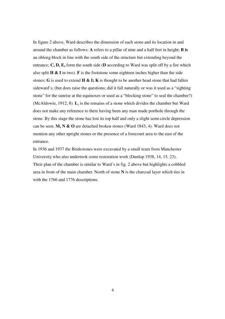
In figure 2 above, Ward describes the dimension of each stone and its location in and
around the chamber as follows: A refers to a pillar of nine and a half feet in height; B is
an oblong block in line with the south side of the structure but extending beyond the
entrance; C, D, E, form the south side (D according to Ward was split off by a fire which
also split H & I in two). F is the footstone some eighteen inches higher than the side
stones; G is used to extend H & I; K is thought to be another head stone that had fallen
sideward’s; (but does raise the questions; did it fall naturally or was it used as a “sighting
stone” for the sunrise at the equinoxes or used as a “blocking stone” to seal the chamber?)
(McAldowie, 1912, 8). L, is the remains of a stone which divides the chamber but Ward
does not make any reference to there having been any man made porthole through the
stone. By this stage the stone has lost its top half and only a slight semi-circle depression
can be seen. M, N & O are detached broken stones (Ward 1843, 4). Ward does not
mention any other upright stones or the presence of a forecourt area to the east of the
entrance.
In 1936 and 1937 the Bridestones were excavated by a small team from Manchester
University who also undertook some restoration work (Dunlop 1938, 14, 15, 23).
Their plan of the chamber is similar to Ward’s in fig. 2 above but highlights a cobbled
area in front of the main chamber. North of stone N is the charcoal layer which ties in
with the 1766 and 1776 descriptions.
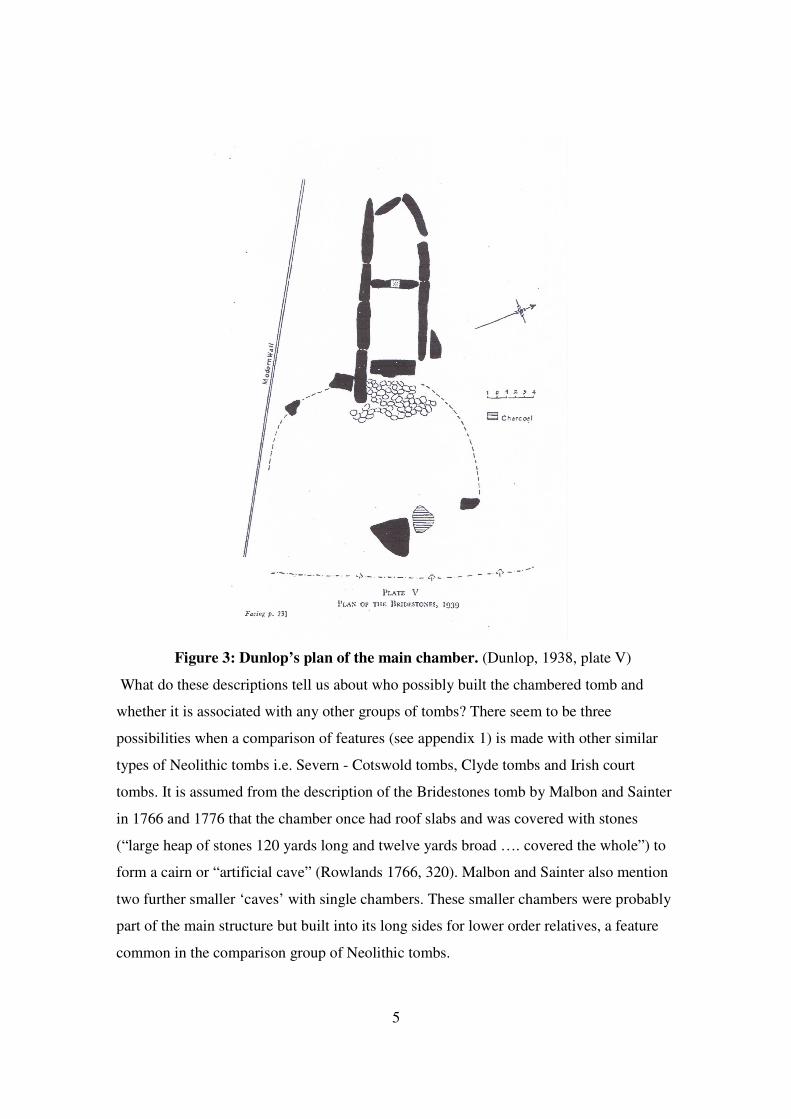
5
Figure 3: Dunlop’s plan of the main chamber. (Dunlop, 1938, plate V)
What do these descriptions tell us about who possibly built the chambered tomb and
whether it is associated with any other groups of tombs? There seem to be three
possibilities when a comparison of features (see appendix 1) is made with other similar
types of Neolithic tombs i.e. Severn - Cotswold tombs, Clyde tombs and Irish court
tombs. It is assumed from the description of the Bridestones tomb by Malbon and Sainter
in 1766 and 1776 that the chamber once had roof slabs and was covered with stones
(“large heap of stones 120 yards long and twelve yards broad …. covered the whole”) to
form a cairn or “artificial cave” (Rowlands 1766, 320). Malbon and Sainter also mention
two further smaller ‘caves’ with single chambers. These smaller chambers were probably
part of the main structure but built into its long sides for lower order relatives, a feature
common in the comparison group of Neolithic tombs.
6
Appendix 1
A comparison of Neolithic tombs with similar features to the Bridestones.
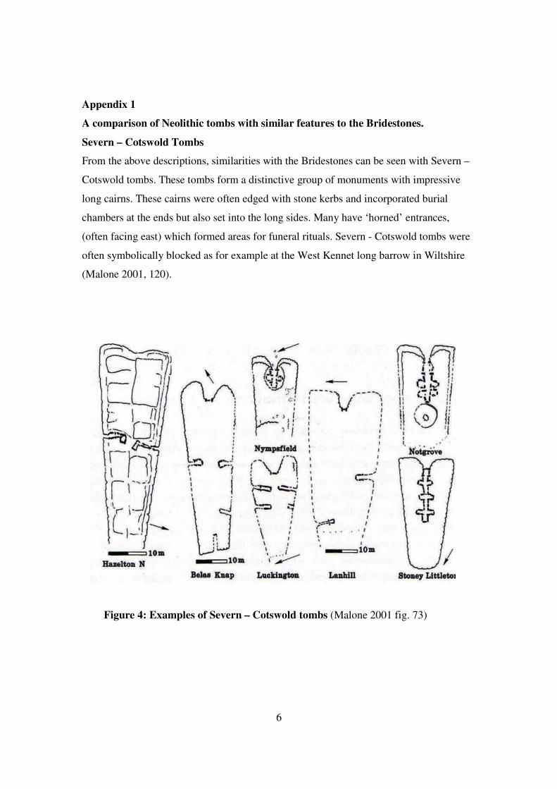
Severn – Cotswold Tombs
From the above descriptions, similarities with the Bridestones can be seen with Severn –
Cotswold tombs. These tombs form a distinctive group of monuments with impressive
long cairns. These cairns were often edged with stone kerbs and incorporated burial
chambers at the ends but also set into the long sides. Many have ‘horned’ entrances,
(often facing east) which formed areas for funeral rituals. Severn - Cotswold tombs were
often symbolically blocked as for example at the West Kennet long barrow in Wiltshire
(Malone 2001, 120).
Figure 4: Examples of Severn – Cotswold tombs (Malone 2001 fig. 73)
7
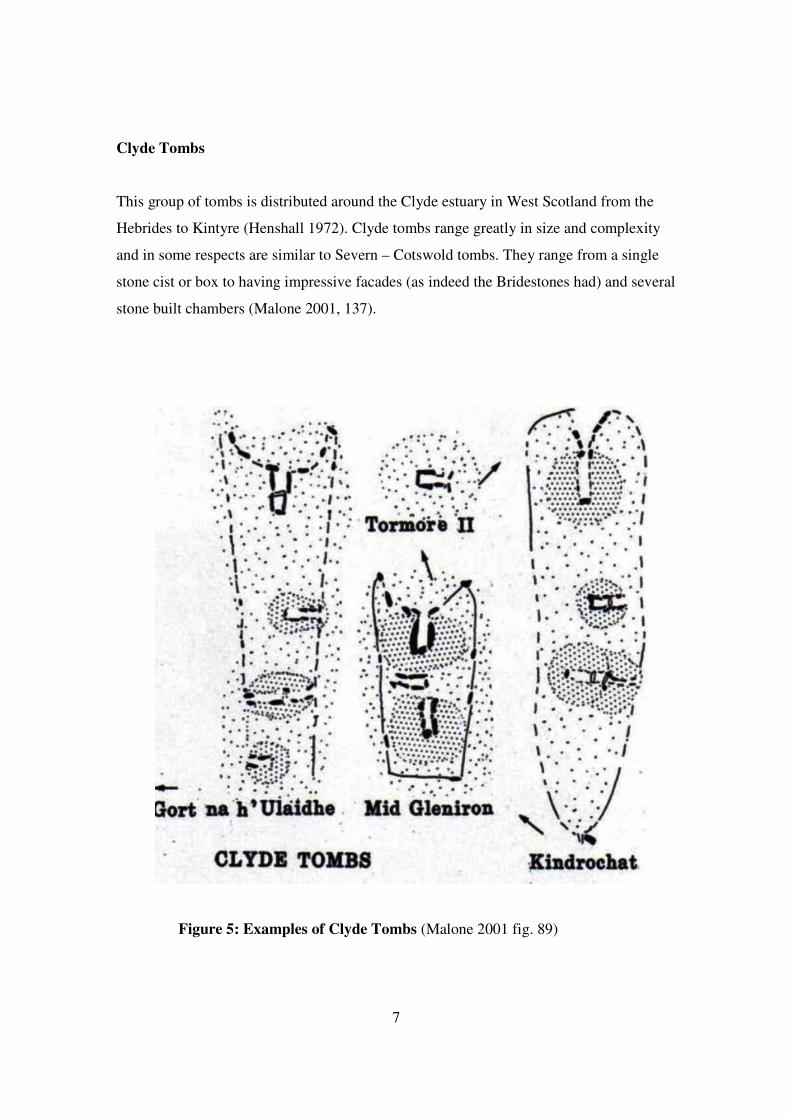
Clyde Tombs
This group of tombs is distributed around the Clyde estuary in West Scotland from the
Hebrides to Kintyre (Henshall 1972). Clyde tombs range greatly in size and complexity
and in some respects are similar to Severn – Cotswold tombs. They range from a single
stone cist or box to having impressive facades (as indeed the Bridestones had) and several
stone built chambers (Malone 2001, 137).
Figure 5: Examples of Clyde Tombs (Malone 2001 fig. 89)
8
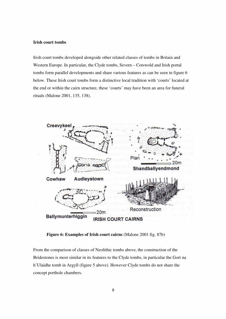
Irish court tombs
Irish court tombs developed alongside other related classes of tombs in Britain and
Western Europe. In particular, the Clyde tombs, Severn – Cotswold and Irish portal
tombs form parallel developments and share various features as can be seen in figure 6
below. These Irish court tombs form a distinctive local tradition with ‘courts’ located at
the end or within the cairn structure, these ‘courts’ may have been an area for funeral
rituals (Malone 2001, 135, 138).
Figure 6: Examples of Irish court cairns (Malone 2001 fig. 87b)
From the comparison of classes of Neolithic tombs above, the construction of the
Bridestones is most similar in its features to the Clyde tombs, in particular the Gort na
h’Ulaidhe tomb in Argyll (figure 5 above). However Clyde tombs do not share the
concept porthole chambers.
9
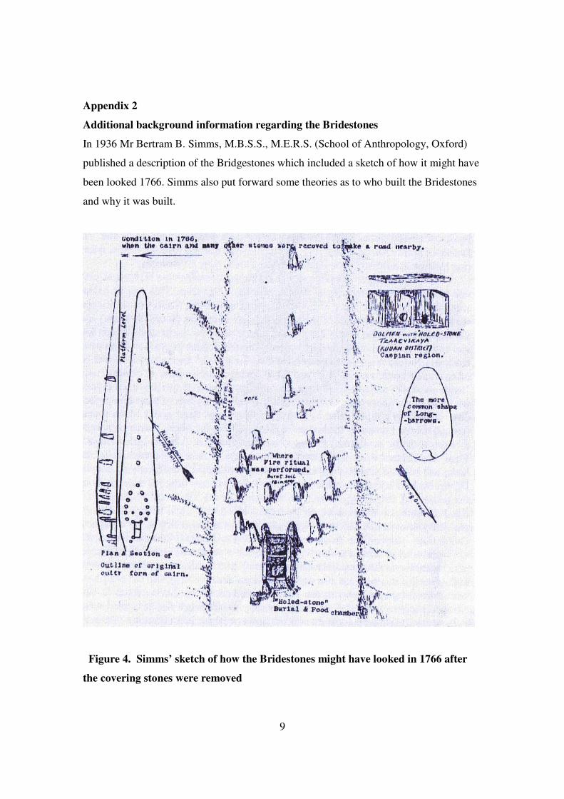
Appendix 2
Additional background information regarding the Bridestones
In 1936 Mr Bertram B. Simms, M.B.S.S., M.E.R.S. (School of Anthropology, Oxford)
published a description of the Bridgestones which included a sketch of how it might have
been looked 1766. Simms also put forward some theories as to who built the Bridestones
and why it was built.
Figure 4. Simms’ sketch of how the Bridestones might have looked in 1766 after
the covering stones were removed

10
In the top right hand corner of Simms’ sketch, figure 4 above, is a drawing of the only
other known porthole chamber of this description. This chamber is almost identical to the
Bridestones chamber except for slight variations in size. This chamber is in Tzarevskaya,
South Russia, near the Volga River. A more detailed drawing and account of the
Tzarevskaya chamber can be found in V. G. Childe’s book: The Dawn of European
Civilisation, 1950, 142, fig. 63. It is interesting to note Simms’ interpretation of the
cairn’s shape: long and pear shaped rather than the more common egg shape.
In an attempt to find out who constructed the Bridestones and what beliefs they might
have held, it is necessary to analyse and compare the Bridestones with other Neolithic
monuments. The first comparison to be made is the stone with its man-made porthole.
Such stones are rare in England although they are common in burial chambers of the
Paris basin (Antiquity 1927, 230) and their ultimate concept may come from as far south
as the Western Mediterranean (Dunlop 1938, 28). A similar stone does exist just twenty
five miles away in the parish of Mucklestone in Staffordshire.
Figure 5. The Devil’s Ring and Finger (Wells Bladen, 1912).
The Devil’s Ring and Finger are two standing stones re-set into a post-medieval field
boundary. One of the stones is perforated and the other is grooved; it is presumed that

11
they both originated from a megalithic chambered tomb, the site of which is now lost
(Newman & Pevsner 2006, 215)
The grooves on the finger are interesting and in the past have been subject to debate as to
their origin. Some have suggested that they are a natural result of rain channelling strata
of unequal hardness (Antiquity 1927, 230). Others (Simms, WSL, Sept. 1) suggest that
they were formed by sharpening stone celts (a prehistoric axe-like tool or weapon)
although this would probably relate to a later period than the tomb. In 1838 the field
adjacent to the monument’s current location was called ‘Whetstone Field’ (SRO
D3433/3/1) which suggests the stones’ use as large whetstones (Fradley, per. com.).
Similar grooves appear on the Queen Stone near Symonds Yat in the Cotswolds and the
Devil’s Arrows near Boroughbridge in Yorkshire (Antiquity 1927, 230).
The diameter of the hole in the Bridestones stone is recorded as being nineteen and a half
inches (Rowlands 1766, 320). The hole in the Devil’s Ring is twenty inches. These stones
were very similar and suggest contact or an affiliation between the tribes of a similar cult
with similar beliefs. So why go to the effort of cutting these holes and placing them at the
entrance to a chambered tomb or using them to divide a chamber as in the Bridestones?
The size of the holes suggests admittance. Stones with smaller holes where admittance
has been prevented are thought to have had magical significance as a ‘thoroughfare for
souls’ of the departed, or for the insertion of offerings (Antiquity 1927, 230). Simms has
suggested (Simms, WSL, Sept. 1) that the Devil’s Ring and Finger belonged to a
collective grave whereas the Bridestones was an individual’s grave because of the main
chambers division. Simms has suggested that the Bridestones relate to an ancient people
known as the “battle-axe folk” who arrived in the North West around 2300 BC. The
“battle-axe folk” are thought to be of Nordic extraction having migrated through Europe
to the Black Sea.
It has been suggested that in one half of the chamber an individual was buried. Malbon’s
commentary records finds within the chamber as being only an urn with burnt bones and
some flint. In the other section of the chamber his private possessions and food were
placed. The theory is that the spirit passed through the porthole stone to collect his
possessions when it passed on to the “other world.” Failure to satisfy the spirit in this way

12
could result in the spirit seeking revenge on his mortal relatives, it is suggested (Simms,
WSL, Sept. 1).
There is no doubt that the Bridestones chambered tomb was built to impress and
dominate the local landscape. Early reports on the Bridestones from Ward (1843) and
Rowland (1766) suggest a place of Druid ritual. The Druids were priests who carried out
religious rituals in the Iron Age Britain and France. Little is known of the Druids. The
Romans when they visited and later conquered Britain and France wrote (Strabo,
Diodorus Siculas, and notably Caesar) about their ritual practices (Green 1986, 26). The
Druids were important and powerful people in the Iron Age but the evidence suggests the
Bridestones was constructed at least 2000 years before the rise of the Druid culture.
If, as has been suggested by Simms, the tomb was built for a single person, a person who
had the support of and control over a significantly large tribe, the tribe must have had the
organizational capabilities of a ‘chiefdom society’ with resources and time beyond
subsistence provisioning and have had the skills necessary to build the monument. The
façade in front of the tomb’s entrance and the splitting of the burial chamber with a stone
with a porthole are possible features which are unique in Britain.
Colin Sparkes
Bibliography
Antiquity 1927, Vol. 1. The Devils Ring and Finger. (By the editor)
Fradley M. Unpublished desk research paper on the ancient parish of Mucklestone
Green M.1986, The Gods of the Celts, Sutton Publishing Limited, Gloucestershire
Henshall A. 1972, The chambered tombs of Scotland, Edinburgh, Edinburgh University
Press
Malone C. 2001, Neolithic Britain and Ireland, Tempus Publishing, Gloucestershire.
McAldowie A, M, 1912. Prehistoric time measurement in Britain: An astronomical study
of some ancient monuments, In North Staffordshire Field Club, Annual Report
and Transactions 1911-1912.
Rowland H, 1766, Mona Antiqua Restaurata.

13
Simms B, B. Published articles can be found at the William Salt Library (Stafford) ref.
323/38/1/2/80 and 323/38/1/1/80
Newman J, & Pevsner N, 2006, The Buildings of England: Shropshire, London
Ward J. 1843, The Borough of Stoke-on-Trent in commencement of the rein of Queen
Victoria, comprising it’s history, statistic, civil polity and traffic.
Wells Bladen W, 1912, North Staffordshire Field Club, Annual Report and Transactions
1911-1912.