Embed Size (px)
Citation preview

THE BLACK FOREST STORM OF THE BLACK FOREST STORM OF 15 JULY 2007: NUMERICAL 15 JULY 2007: NUMERICAL
SIMULATION AND SENSITIVITY SIMULATION AND SENSITIVITY STUDIESSTUDIES
THE BLACK FOREST STORM OF THE BLACK FOREST STORM OF 15 JULY 2007: NUMERICAL 15 JULY 2007: NUMERICAL
SIMULATION AND SENSITIVITY SIMULATION AND SENSITIVITY STUDIESSTUDIES
Evelyne RichardEvelyne Richard11, Jean-Pierre , Jean-Pierre ChaboureauChaboureau11
Cyrille FlamantCyrille Flamant22 and Cédric and Cédric ChampollionChampollion33
1. Laboratoire d’Aérologie, CNRS/UPS Toulouse, 1. Laboratoire d’Aérologie, CNRS/UPS Toulouse, FranceFrance
2. LATMOS/IPSL, CRNS/UPMC, Paris, France2. LATMOS/IPSL, CRNS/UPMC, Paris, France3. Géosciences, Montpellier, France3. Géosciences, Montpellier, France

COPS IOP8b – 15 July 2007
(Courtesy of DLR)
> 60 dBz
12
km

Radar reflectivity : Time evolution of Radar reflectivity : Time evolution of the the
10 dBZ contour10 dBZ contour
Radar reflectivity : Time evolution of Radar reflectivity : Time evolution of the the
10 dBZ contour10 dBZ contour
Montancy radarMontancy radar Simulation (ECMWF)Simulation (ECMWF)
12:15 –13:0012:15 –13:0013:15 – 14:0013:15 – 14:0014:15 – 15:0014:15 – 15:0015:15 – 16:0015:15 – 16:00

Radar reflectivity : Time evolution of Radar reflectivity : Time evolution of the the
10 dBZ contour10 dBZ contour
Radar reflectivity : Time evolution of Radar reflectivity : Time evolution of the the
10 dBZ contour10 dBZ contour
Montancy radarMontancy radar Simulation (ARPEGE)Simulation (ARPEGE)
12:15 –13:0012:15 –13:0013:15 – 14:0013:15 – 14:0014:15 – 15:0014:15 – 15:0015:15 – 16:0015:15 – 16:00

Motivations and Motivations and outlinesoutlines
Motivations and Motivations and outlinesoutlines
The real time Meso-NH forecast of this event was The real time Meso-NH forecast of this event was surprisingly good … but surprisingly good … but
■ Is this good forecast obtained for the good reasons?Is this good forecast obtained for the good reasons?■ What makes the ARPEGE based forecast different? What makes the ARPEGE based forecast different?
CAPE / CIN
Surface conditions
Sensitivity tests

CAPECAPE MESO-NH / ECMWF
MESO-NH ARPEGE
11:00 UTC
14:00 UTC

CINCIN MESO-NH / ECMWF
MESO-NH / ARPEGE
11:00 UTC
14:00 UTC

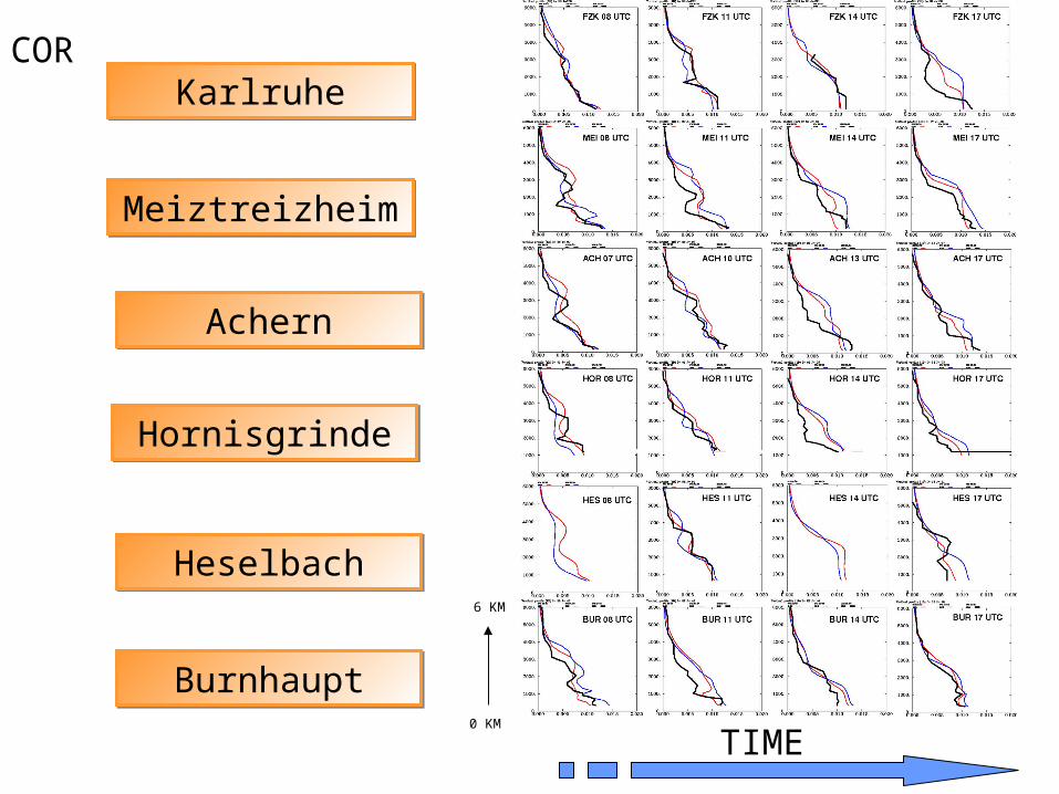
KarlruheKarlruhe
MeiztreizheimMeiztreizheim
AchernAchern
HornisgrindeHornisgrinde
HeselbachHeselbach
BurnhauptBurnhaupt
TIME
6 KM
0 KM
Water vapor mixing ratio (g/kg)
OBS. ECMWF ARPEGE

KarlruheKarlruhe
MeiztreizheimMeiztreizheim
AchernAchern
HornisgrindeHornisgrinde
HeselbachHeselbach
BurnhauptBurnhaupt
TIME
6 KM
0 KM
OBS. ECMWF ARPEGE
Potential temperature (K)

Surface moisture analysis : 00UTCSurface moisture analysis : 00UTCSurface moisture analysis : 00UTCSurface moisture analysis : 00UTC
ECMWFECMWF ARPEGEARPEGE

Sensitivity testsSensitivity testsSensitivity testsSensitivity tests
■ ECMWF surface moisture reduced by 20% ECMWF surface moisture reduced by 20% ■ ECMWF surface moisture reduced by 50% ECMWF surface moisture reduced by 50%
Thermodynamical conditions
Convection

KarlruheKarlruhe
MeiztreizheimMeiztreizheim
AchernAchern
HornisgrindeHornisgrinde
HeselbachHeselbach
BurnhauptBurnhaupt
TIME
6 KM
0 KM
OBS. ECMWF ARPEGE
Potential temperature (K)

Water vapor mixing ratio @ 13 Water vapor mixing ratio @ 13 UTCUTC
Water vapor mixing ratio @ 13 Water vapor mixing ratio @ 13 UTCUTC
ControlControl ObservationObservation 20% reduction20% reduction

Water vapor mixing ratio @ 13 Water vapor mixing ratio @ 13 UTCUTC
Water vapor mixing ratio @ 13 Water vapor mixing ratio @ 13 UTCUTC
ObservationObservation 20% reduction20% reduction50% reduction50% reduction

Cloud top height (color) + Instant Cloud top height (color) + Instant precipitation (contour) @ 15 UTCprecipitation (contour) @ 15 UTCCloud top height (color) + Instant Cloud top height (color) + Instant precipitation (contour) @ 15 UTCprecipitation (contour) @ 15 UTC
ControlControl 20% reduction20% reduction 50% reduction50% reduction
Convection is strongly controlled by initial moisture conditions

Summary / Summary / ConclusionConclusionSummary / Summary / ConclusionConclusion
■ Convection is well captured by the ECMWF- based Meso-NH forecast although the PBL is too cold and too moist.
■ The PBL structure is more correct in the ARPEGE-based MESO-NH forecast but convection is over predicted.
■ There is a large discrepancy between ECMWF and ARPEGE surface moisture analysis
■ The sensitivity tests shows that the convection triggering is strongly controlled by the surface moisture conditions
■ Do we have enough data to validate the surface moisture conditions?


MESO-NH ForecastsMESO-NH ForecastsMESO-NH ForecastsMESO-NH Forecasts
3 domains (32, 8, and 2 km) with 2-way interaction. 30h forecast starting at 00 UTC from ECMWF analysis Mixed phase microphysics (including hail particles) No convection parameterization in the 2km-mesh model
16/07 06UTC16/07 06UTC
MNH-MNH-ECMECM
12UTC12UTC15/07 00UTC
MNH-MNH-ARPARP
MNH-ECMMNH-ECM Run starting from the ECMWF analysis and forced with ECMWF forecasts
MNH-ARPMNH-ARP: Run starting from the ARPEGE analysis and forced with ARPEGE forecasts
16UTC16UTC
Convection over the
Black-Forest
KarlruheKarlruhe
MeiztreizheimMeiztreizheim
AchernAchern
HornisgrindeHornisgrinde
HeselbachHeselbach
BurnhauptBurnhaupt
TIME
6 KM
0 KM
COR
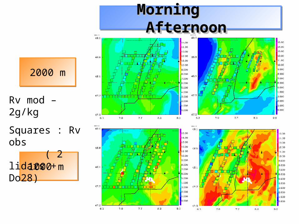
Morning Morning Afternoon Afternoon Morning Morning Afternoon Afternoon
1000 m 1000 m
2000 m2000 m
Rv mod – 2g/kg
Squares : Rv obs ( 2 lidars + Do28)

Water vapor mixing ratio : 13:00 – 13:30 UTCWater vapor mixing ratio : 13:00 – 13:30 UTC
Lidar observationsLidar observations

Water vapor mixing ratio : 13:00 – 13:30 UTCWater vapor mixing ratio : 13:00 – 13:30 UTC
Meso-NH Forecast Lidar observationsMeso-NH Forecast Lidar observations
Upward motionUpward motionUpward motionUpward motion

Convergence > 0.5 10 -3 s-1 + streamlines
@1000m

Convergence > 0.5 10 -3 s-1 + streamlines
@1000m 11 UTC 12 UTC
13 UTC 14 UTC

Convergence > 0.5 10 -3 s-1 + streamlines @ the surface

Moisture supplyMoisture supplyMoisture supplyMoisture supply
Soundings (3 hourly)
Airborne lidar (Leandre II + DLR Dial)
In situ aircraft data (Dornier 28)
Soundings (3 hourly)
Airborne lidar (Leandre II + DLR Dial)
In situ aircraft data (Dornier 28)

Convergence line in the lee of the Feldberg:
Feldberg Radar 13:08 UTCFeldberg Radar 13:08 UTC
Doppler velocityDoppler velocityWind @ 900hPa Wind @ 900hPa Moisture @750hPa > 7g/kgMoisture @750hPa > 7g/kg
Meso-NH Forecast 13:00 UTCMeso-NH Forecast 13:00 UTC

Water vapor mixing ratio : 13:00 – 13:30 UTCWater vapor mixing ratio : 13:00 – 13:30 UTC
Meso-NH Forecast Meso-NH Forecast
Lidar observationsLidar observations

Observation / Observation / SimulationSimulation
Observation / Observation / SimulationSimulation
METEOSAT TB = 280 KMETEOSAT TB = 280 K

Observation / Observation / SimulationSimulation
Observation / Observation / SimulationSimulation
MONTANCY R = 1dBZ
MONTANCY R = 1dBZ
METEOSAT TB = 280 KMETEOSAT TB = 280 K
![Evelyne Bouix - data.bnf.fr · Images (2) Recueil. Photographies. Soirée au Théâtre de la Gaité-Montparnasse. Paris. 1986 (1988) [Recueil. Portraits de Evelyne Bouix] Documents](https://img.pdfslide.us/doc/110x75/5fd8f32e3014a66eb51e62cf/evelyne-bouix-databnffr-images-2-recueil-photographies-soire-au-thtre.jpg)