Embed Size (px)
Citation preview

The Benefits of Consolidating Spatial Data Using Oracle Technology
Hull City Council’s Experience
EMMA WARWICKE Services Manager at Hull City Council
BRYAN HUGHES & DAVID MILLERSenior Consultant at eSpatial Solutions Ltd
DAVID MILLERCOO eSpatial
3rd December 2007
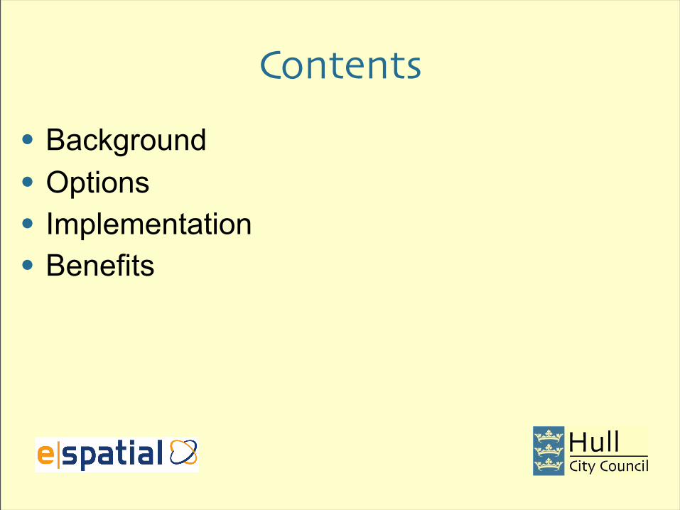
Contents
• Background
• Options
• Implementation
• Benefits

Background

General Background• Saving money – reduced duplication, easier
access
• Improving customer service• Evidence-based resource targeting• Modernisation
• Seamless data sharing• Data quality

Drivers• Remove data duplication
• At least 50 datasets, separately maintained
• Reduce licence costs• ~ 60 pro GIS licences = £1.5k each + maint + training
• Make access easy• < 6 GIS/spatial data technicians in 14,000 staff
• Improve visibility, decision making, accountability• Areas with devolved budgets but not line mngt
• Specifics• Priority Service Transformation Outcomes G14, G5

Spatial Data Store (SDS)
INTERNALMAPPINGDATA
INTERNAL SYSTEMS D’BASES
PARTNERSDATA
BROWSER TEXT RESULTS
BROWSERMAPPING
INTERNALGIS USERS
INTERNALSYSTEMS
Data Sources Data Storage &Distribution
Management
Data Destination
Spatial Data Store
(SDS)
BASE ‘SPATIAL’ DATA - LABELS
BASE SPATIAL DATA, SUPPLEMENTARY SPATIAL DATA
SUPPLEMENTARY DATA THAT CAN BE SHOWN SPATIALLY
DATABASE-SOURCED OR MAP-SOURCED FROM EXTERNAL
ENRICHED / RE-PROFILED DATA
MULTI-SOURCE DATA
MULTI-SOURCE DATA, INC NOT FROM MAPS
ADDRESS & SERVICE SEARCH, REPORTS
ADDRESS & SERVICE LOCATOR, REPORT VISUALISER
CORE INTERNAL D’BASES
PARTNERS

Spatial Data Store (SDS)
CRMAPPOINTMENTS
GMS HULLGMS OOT
CRM
IN HOUSEMAPPINGDATA
IN HOUSESYSTEMS
PARTNERSDATA
BROWSER TEXT RESULTS
BROWSERMAPPING
IN HOUSEGIS USERS
IN HOUSESYSTEMS
PARTNERS
Data Sources Data Storage &Distribution
Management
Data Destination
Spatial Data Store
(SDS)
LLPG ,NSGHULL AND EXTERNAL
GRAFFITI INCIDENTS, MISSED BINS, FLYTIPPING INCIDENTS
POLITICAL AREASSCHOOLS,ENVIRONMENTALOPERATIONALMAPS
EXOR, FLARE,SLITS, HITS,I-WORLD, IBS,COMMIT, EMS
POLICE,DTZ
LLPG, NSG, WARDS, AREAS
GRAFFITI INCIDENTS, WARDENS
WARDS, AREAS, POLICE HOTSPOTS, MISSED BINS
LLPG, NSG, BIN DAY, CTAX BAND, CATCHMENT AREA
ADDRESS & SERVICE SEARCH, REPORTS (EG GRAFITTI VS TRUANCY)
ADDRESS & SERVICE LOCATOR, REPORT VISUALISER (EG GRAFFITI VS TRUANCY)

Options

Network File StorageAdvantages
• Cheap• Easy to provide
Disadvantages
• Relies on manual enforcement of procedures to operate effectively
• Data sharing is more difficult especially across organisations
• Few of the advantages of a database approach
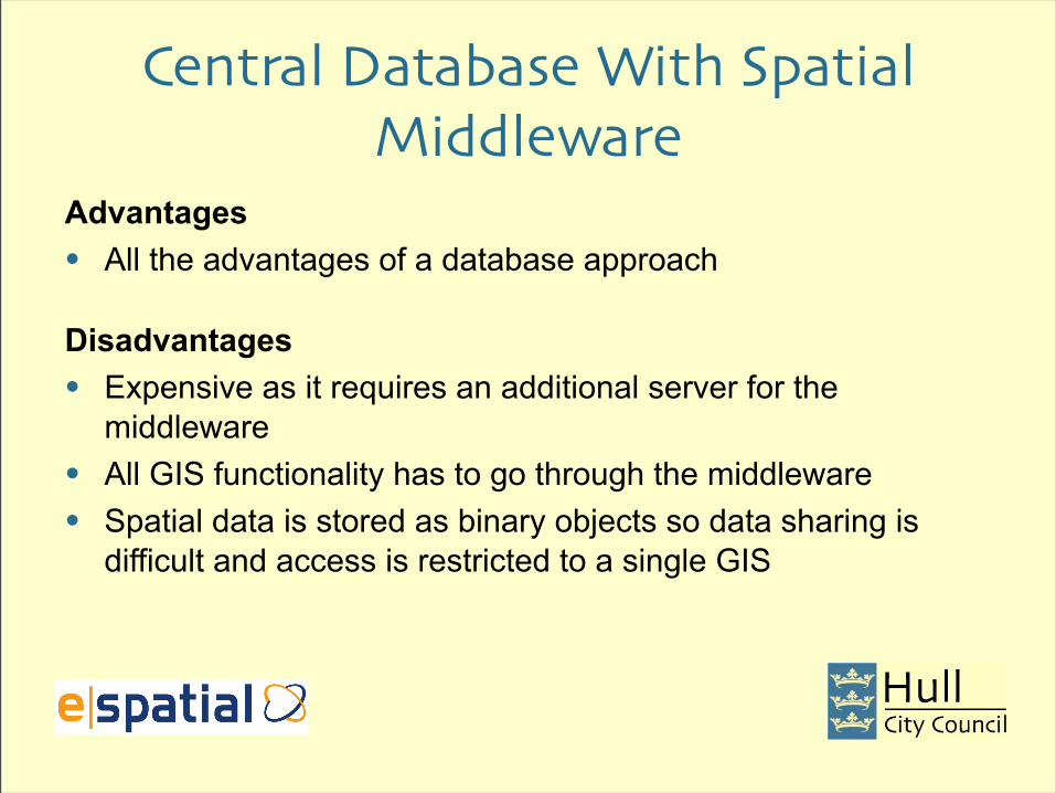
Central Database With Spatial Middleware
Advantages
• All the advantages of a database approach
Disadvantages
• Expensive as it requires an additional server for the middleware
• All GIS functionality has to go through the middleware
• Spatial data is stored as binary objects so data sharing is difficult and access is restricted to a single GIS

Oracle Spatial DatabaseAdvantages
• All the advantages of a database approach
• Spatial component is inside the database and not middleware
• Oracle Spatial is a mature, reliable and functionality-rich product
• Few data modelling restrictions
• Oracle’s open-standards approach makes data sharing easier
• Seamless integration with other Oracle products
Disadvantages
• Expensive (if a license doesn’t already exist) – but can use Locator for many functions

What About Data Dissemination?• Thick-client (desktop) GIS has traditionally been used for the map data
• Desktop GIS is functionality rich but often requires customisation as a result
• Licenses are expensive
• Performance can be poor when accessing network or database data
• You have to install it
• Not easy to serve data to the public using Desktop GIS
• But now it is treated like any other data which makes it easy to disseminate in other ways e.g. via a browser, web services etc

Implementation

The Solution Spatial Data Store + MyMaps (browser-based mapping)
• The SDS is about effective data management• Browser-based mapping is about consuming (viewing)
the data easily

Chosen Architecture
Oracle Database (SDS)
Oracle Application Server
J2SDK
Web Server
Firewall
OC4J
Administration App
OC4JIntranet App
OC4JInternet App
Administration Client
Intranet Client
Internet Client

Data Centralisation – How Was It Done?
• Oracle database was installed
• The data was loaded which included metadata and index creation
• The Address-point data was partitioned
• The data was validated, any errors rectified and re-loaded
• Materialised views were used to create daily snapshots of the LLPG and LSG data
• ISO-19115 compliant metadata was created for the spatial data

Data Delivery – How Was It Done?• Oracle Application Server was installed
• A custom application was developed using HTML, JSP, AJAX, Java and iSMART for the mapping engine
• Permissions were implemented using JAZN
• Access to spatial layers and functionality controlled by permissions that provided for two flavours of the application, one for the Internet and for the Intranet
• Internet flavour enabled the public to locate to their address and view road works (and other useful) information
• Intranet flavour provided staff with improved access to more, better quality information and the means to query it online thus improving decision-making

The Internet Version

The Intranet Version

Where we have got to

Spatial Data Store (SDS)
INTERNALMAPPINGDATA
INTERNAL SYSTEMS D’BASES
PARTNERSDATA
BROWSER TEXT RESULTS
BROWSERMAPPING
INTERNALGIS USERS
INTERNALSYSTEMS
Data Sources Data Storage &Distribution
Management
Data Destination
Spatial Data Store
(SDS)
CORE INTERNAL D’BASES
PARTNERS

Spatial Data Store (SDS)
CRMAPPOINTMENTS
GMS HULLGMS OOT
CRM
IN HOUSEMAPPINGDATA
IN HOUSESYSTEMS
PARTNERSDATA
BROWSER TEXT RESULTS
BROWSERMAPPING
IN HOUSEGIS USERS
IN HOUSESYSTEMS
Data Sources Data Storage &Distribution
Management
Data Destination
Spatial Data Store
(SDS)
PARTNERS

Benefits

The SolutionSDS (Spatial Data Store) – Oracle SpatialThe SDS is about effectively managing the spatial data we have
• reduce duplication
• minimise manual updating
• standardise formats to make it possible to share
• utilise open formats
• de-specialise for use by non-GIS experts
• pool in one place for ease of access, inc. partners

The SolutionMyMaps Internet&Intranet (browser-based mapping)eSpatial’s iSmart productbrowser-based mapping is about consuming (viewing) the data
easily
• reduce licence costs and need for GIS specialists
• simple look-ups
• proliferate (area) management information
• show pooled in one place for ease of access

General Benefits• Saving money
• Evidence-based resource targeting• Seamless data sharing• Data quality
• Potential for advanced functionality• Responsiveness

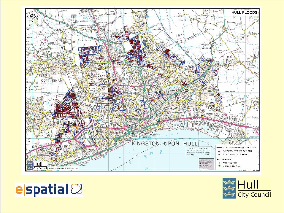
Kingston upon Hull

Flood Response
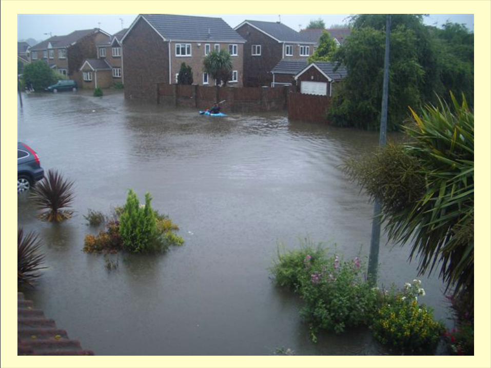

Hull Floods
• Almost 9,000 homes with water ingress
• Over 90% schools closed• 100s of streets affected• Around 2,000 calls taken to 300300
(1.5 x avg Mon, 2 x avg Fri)
Flood Response

Flood Response

Flood Response

Flood Response

Flood Response

Summary• Spatially enabling data enriches it
• Oracle Spatial is a good choice for an open system that can handle big volumes
• Browser-based mapping makes spatial data easily accessible and understandable
• This might save your business money – what % of your transactions have a spatial element?

Questions?


![Spatial Databases - Semantic Scholar · Spatial Databases 1.1 Introduction 1.1.1 Spatial Database Spatial database management systems [43, 58, 120, 119, 97, 74] aim at the effective](https://img.pdfslide.us/doc/110x75/5edc6310ad6a402d666706d6/spatial-databases-semantic-scholar-spatial-databases-11-introduction-111-spatial.jpg)