Embed Size (px)
Citation preview

The Behavior of 3.11 Tsunamis in the Sendai Plain
and the Damage of the Disaster Prevention System
Akira Mano Disaster Control Research Center
Tohoku University
2nd Kobe U. Brussels EC Symposium September 19, 2011 Vrije Universiteit Brussel

Background Damage by 3.11 tsunamis
20,000 people killed or missing 100,000 houses totally destroyed Coastal disaster mitigation system destroyed
Governmental policy of the disaster mitigation For L1 class hazards (RP of 100 to 150 y), to rebuilt coastal levees to secure
lives and assets For L2 class hazards ( >150 y), to secure lives and mitigate the asset
damage by multiple mitigation countermeasures Issues for L2 class hazards
How to secure lives? How to rebuilt the levees not seriously destructed?
Objectives To show the causes of the damage occurrence To find the possible solutions for the issues
Background and objectives
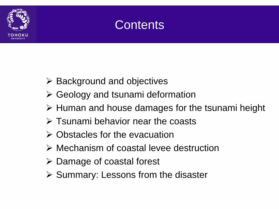
Background and objectives Geology and tsunami deformation Human and house damages for the tsunami height Tsunami behavior near the coasts Obstacles for the evacuation Mechanism of coastal levee destruction Damage of coastal forest Summary: Lessons from the disaster
Contents

Sanriku Coast
Sendai Bay Coast
Joban Coast
100 km
Geology and tsunami deformation in the three coasts
•Sariku Coast •Crustal uplifting in the north
•Cliff coast •Tsunami collision
•Crustal subsiding in the south •Submerged valleys •Energy concentration •Bay water resonance
•Frequent tsunami attacks •Sendai Bay Coast
•Alluvial plain • Sandy beach and shallow water • Propagation delay and energy dissipation
• Low frequency in large tsunamis •Joban Coast
• Crustal uplifting • Cliff coast and pocket beach • Tsunami collision
• Low frequency in large tsunamis

Tsunami height in 4 major events after Shigihara (2011)
Recent study finds Jogan Tsunami in 869 is similar to the 2011 tsunamis in the Sendai Plain through the sedimentological analysis, Sugawara (2011). This estimates RP of the tsunamis as a1000y.

Human damage
*** Fudai V. was secured by the 15.5m-high levee **** Kamaishi C. was mitigated by the tsunami breakwater ***** Ofunato C. was mitigated by the tsunami breakwater ****** A part of Toni-Hongo in Kamaishi C. was secured by mass movement to highland after 1933 Showa Sanriku Tsunamis.
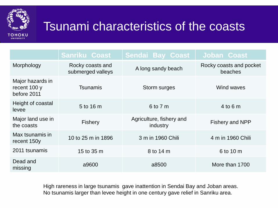
Tsunami characteristics of the coasts
Sanriku Coast Sendai Bay Coast Joban Coast Morphology Rocky coasts and
submerged valleys A long sandy beach Rocky coasts and pocket beaches
Major hazards in recent 100 y before 2011
Tsunamis Storm surges Wind waves
Height of coastal levee 5 to 16 m 6 to 7 m 4 to 6 m
Major land use in the coasts Fishery Agriculture, fishery and
industry Fishery and NPP
Max tsunamis in recent 150y 10 to 25 m in 1896 3 m in 1960 Chili 4 m in 1960 Chili
2011 tsunamis 15 to 35 m 8 to 14 m 6 to 10 m
Dead and missing a9600 a8500 More than 1700
High rareness in large tsunamis gave inattention in Sendai Bay and Joban areas. No tsunamis larger than levee height in one century gave relief in Sanriku area.

West House damage in Ishinomaki C. West
Koshimura(2011)
Tsunami inundation depth varies from 3m to 10m. More than 80% of houses were washed away for the tsunami inundation height > 5m.
Inundation area house washed away house survived

West House damage in Onagawa T.
Koshimura(2011)
Tsunami inundation depth reaches 18 m. More than 70% of the houses in this town were washed away by the tsunamis.
Inundation area house washed away house survived
Sanriku Coast Sendai Bay Coast
Oshika Peninsula
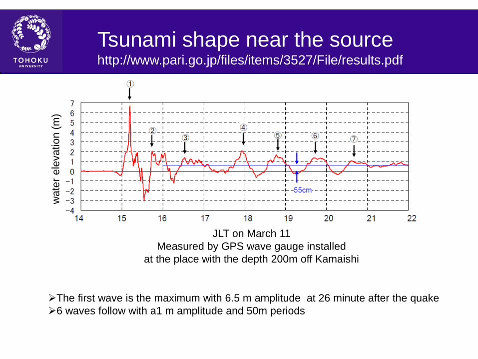
JLT on March 11 Measured by GPS wave gauge installed
at the place with the depth 200m off Kamaishi
Tsunami shape near the source http://www.pari.go.jp/files/items/3527/File/results.pdf
The first wave is the maximum with 6.5 m amplitude at 26 minute after the quake 6 waves follow with a1 m amplitude and 50m periods
wat
er e
leva
tion
(m)

West Tsunami shape along Sendai Bay Coast
The Abukuma River, 10km upstream from the Sendai Bay Coast
The Naruse River, 0.5 km upstream from the Sendai Bay Coast
The first wave is bore like and has the maximum at 16:20 which estimates the peak time 15:55 at the coast, 69 minutes after the quake.
The first wave is bore like and has the maximum at 15:50 which estimates the peak time 15:49 at the coast, 63 minutes after the quake.

240m
Tsunamis intruding into the residential area at Yuriage, Natori C, photo by Mainichi News

Modified tsunami warning transmission
High underestimate in the Initial tsunami warning gave relief to prevent evacuation. Modified warning did not reach residents in many places by blackout .

Multiple damage chains caused by blackout

The other obstacles for the evacuation
Returning back to the home to see the family or to bring something.
Being in the line of duty, such as firemen, community leaders, truck drivers, etc.
Nursing homes near the coasts. Inappropriately specified asylums and shelters lower than
the tsunami inundation height. Fire caused by floating cars, ships, and oils.

Disaster mitigation system along Sendai Bay Coast
Coastal disaster mitigation system Sandy beach:Natural wave energy dissipation function Coastal channels:Construction started in 1601 by Masamune Date and was
continued by Meiji government. The functions of conveyance and drainage. Coastal forests:Black pine trees have been planted to prevent sea water spray
and aeolian sand after Masamune. Coastal levees:6 to 7m high levees have been constructed to prevent storm
surges. Present vulnerability for huge hazards
New town developed by cutting coastal forests Important buildings such as airport, oil factory, sewage plant, industrial complex
built near coasts Disappearance of beaches

Coastal levee destruction at Ido, Wakabayashi, Sendai C.
The first flood tsunami scattered armor blocks on the mild slope levee landward. Concentration of the return flow eroded the back of the steep slope levee up to 3m, and changed the lands to sea.
Satellite image on 20110314
240m 3m erosion
Mild slope levee Steep slope levee
200m

Concentration of the return flow to the channels at Kabasaki, Iwanuma C.
Before, 20090814 After, 20110314
The return flow was collected to the coastal channel and then to the crossing channel to return back to the sea. These channels could be used to control the return flow.
500m

Aerial photo on March 14 by GSI Japan Erosion channel at the back of riverine and coastal levees by the return flow.
Breach of the coastal levee at the right bank of the Abukuma River mouth
The Abukuma River mouth at JLT 16:33, March 11 Turbid water flowing out from the breach and big vortices indicate steadiness and strong erodibity of the return flow.

Levee destruction at the right bank of the Abukuma River mouth
The backland of the coastal levee was eroded to form a channel. The concrete block with wave returning was broken at some place. The boundary of the riverine and coastal levees was breached. Undamaged fore-slope and eroded back-slope
of the riverine levee. The vertical concrete blocks at the top called parapet were flushed away.

2km
2km
Catastrophic destruction of coastal levees in the Yamamoto Coast, Sendai Bay area
Before the tsunamis After the tsunamis
T-jettys were constructed to prevent beach erosion. Thin beaches raise the levee destruction here and there by the flood tsunamis. The return flow concentrated to the destructed points to erode the land and levees.
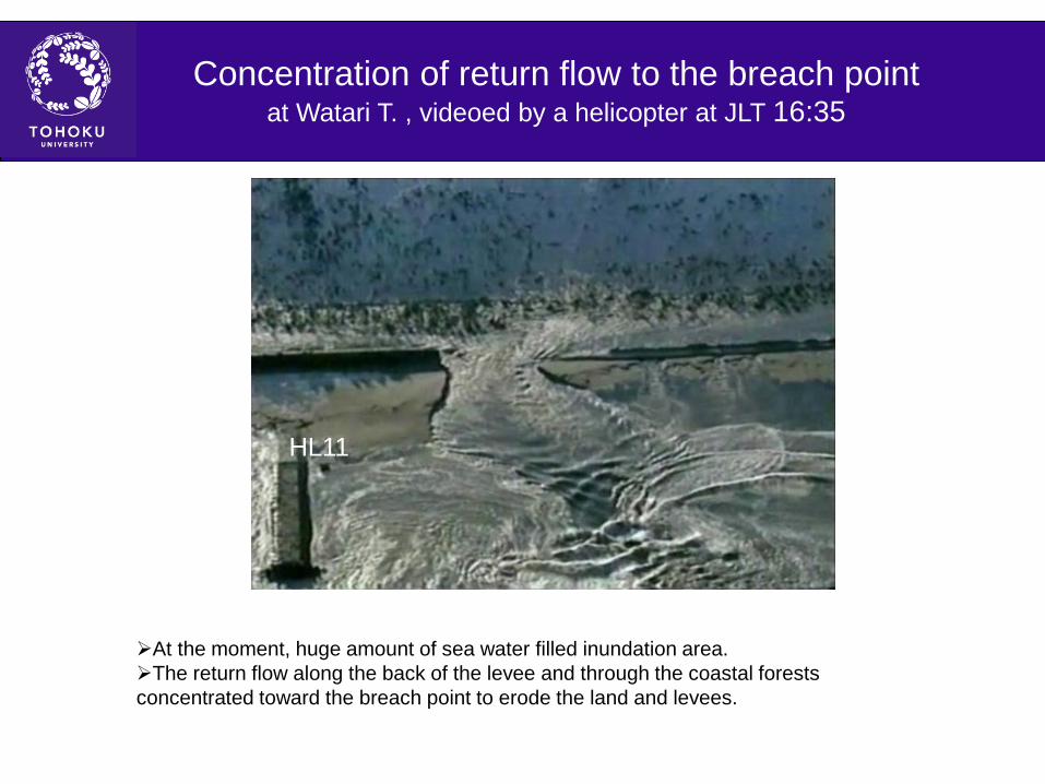
Concentration of return flow to the breach point at Watari T. , videoed by a helicopter at JLT 16:35
HL11
At the moment, huge amount of sea water filled inundation area. The return flow along the back of the levee and through the coastal forests concentrated toward the breach point to erode the land and levees.

Mitigation by the coastal forests Bird eye view of the fallen woods, Miyagino Bor., Sendai C.
20110406 The tsunamis fell coastal forests to washout the houses behind. The houses behind non-fallen forests were secured.

There would be feedback effects that fallen trees promote flow concentration which again promotes tree falling. High pine trees could caused domino topping.
Fallen woods by domino topping? Miyagino Bor., Sendai C.

Decrease of the human damage requires disaster mitigation education and evacuation training improvement of the tsunami warning to have mobile radio to avoid the residence in high hazard areas
Reconstruction of robust levees requires restoration of broad beaches control of the return flow concentration through the development of coastal channels and forests anti-erosion armoring at the flow concentration
Summary: Lessons from the disaster

最後に
Thank you for the attention