Embed Size (px)
Citation preview
The Argo Program
NOAA Climate Observation Division8th Annual PI Meeting and Workshop
The U.S. Argo Float Consortium
D. Roemmich (SIO), S. Riser (UW), G. Johnson (PMEL), B. Owens (WHOI), S. Garzoli and C. Schmid (AOML)
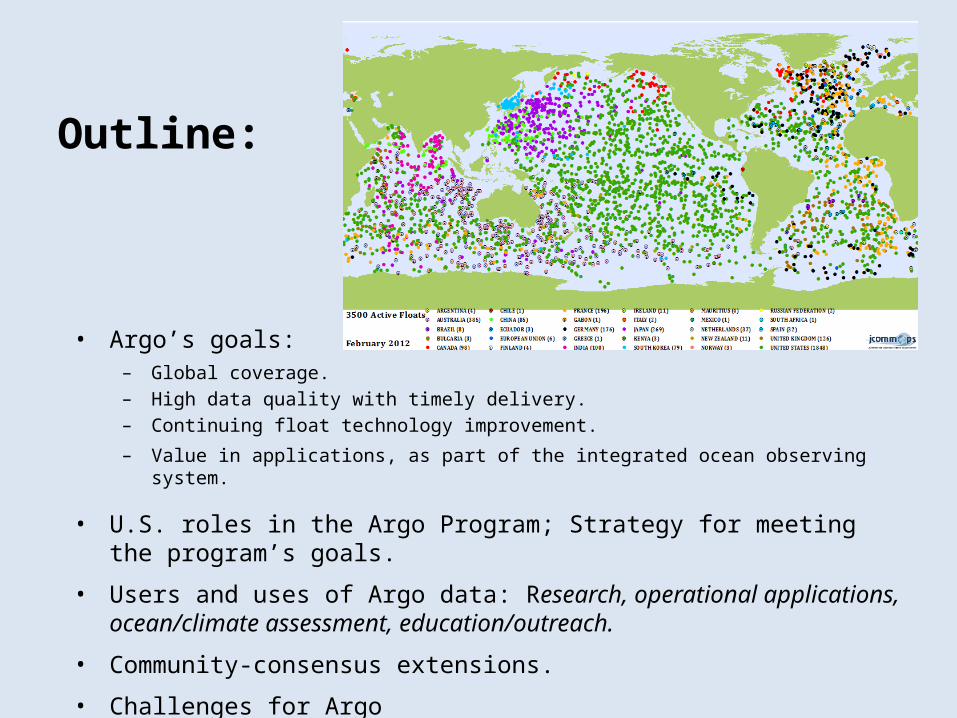
Outline:
• Argo’s goals: – Global coverage.– High data quality with timely delivery. – Continuing float technology improvement.
– Value in applications, as part of the integrated ocean observing system.
• U.S. roles in the Argo Program; Strategy for meeting the program’s goals.
• Users and uses of Argo data: Research, operational applications, ocean/climate assessment, education/outreach.
• Community-consensus extensions.
• Challenges for Argo

A randomly spaced array of 3300 locations. From:“On the Design and Implementation of Argo” (1999)
The Argo array in February 2012 is not very different in coverage from the program design.
Goal: Global coverage at 3° spacing.
0-25% 25-50% 50-75% 75-100% 100-200% 200-500% > 500%
Float coverage in 6° boxes. Source: JCOMMOPS
Room for improvement:• High southern latitudes• South Atlantic (Lady Amber
will deploy 40 floats)• Central and NE Pacific

Goal: High data quality/ On-time delivery (RT and DM)Argo provides a near real-time dataset (86% < 24 hours in 2011) for operational applications, and a delayed-mode dataset (presently 82% of > 1 year-old profiles), with corrections applied for salinity drift and surface pressure drift, for research applications including climate.
Data quality efforts focus on correction of drift in pressure and salinity. Overall quality is far beyond early-Argo expectation.
Pressure drift problem in 2007-2009 floats (oil “microleak”), documented in Barker et al. (2011, JAOT).
In 2011, Argo obtained 127,000 profiles, and themillionth Argo profile will be obtained in 2012.
Float salinity is stable in most floats, and slowly varying.
of DM eligible
Number of adjusted floats/Number of total floats
Average amplitude of adjustment
Cycle number
Delayed-mode salinity adjustment
Number of –ve drifting/Number of adjusted floats

U.S. floats deployed in 2006 have completed an average of 160 cycles, with 47% still active.
New generation floats (SOLO-II, Navis, ARVOR) are 30% smaller and lighter. Lifetimes and capabilities have been improved in these new models as well as in conventional (APEX) floats.
Goal: Float technology improvement
2005
20062007
2008
2011
2009
2010
SOLO-II ARVORNAVIS
APEXIridium communications:• Greatly shortened surface time
Less grounding Less array divergence Less bio-fouling
• High resolution• Energy savings• 2-way for mission control and
improved diagnostics
Survival rate: % reaching 40 or 100 cycles

Argo transformed global-scale oceanography into global oceanography.
20th Century: 781,272 T/S profiles > 500 m
Argo: 906,501 T/S profiles.
5 years of August Argo T,S profiles (2007-2011).
All August T/S profiles (> 1000 m, 1951 - 2000).
WOCE was a global survey of 8,000 T/S profiles in 7 yearsArgo is a global survey of 10,000 T/S profiles every month

Research: Over 1000 papers have been published using Argo data; Argo is a major resource in ocean science, and is prominent in national and international assessments of the state of the oceans.
Goal: High value for research, operational, and education applications
Operational centers use Argo data in ocean state estimation, short-term forecasting and seasonal to decadal prediction.
Education programs using Argo data are being developed in many nations.
Education/outreach tools: The Global Marine Atlas was created for easy interactive display of data.http://www.argo.ucsd.edu/Marine_Atlas.html
Argo in Google Earth. ftp://ftp.jcommops.org/Argo/TMP/Google/kmz_ocean_data.kmz
Research papers using Argo data
Global Marine Atlas

The Argo array by nation.
The U.S. roles in Argo
As the largest program in the international partnership, U.S. Argo’s role is to ensure that Argo is a single international program rather than a consortium of national contributions. To that end, U.S. functions include:
• Deploying floats in all oceans, including the remotest regions, filling gaps to provide global coverage. All Argo partners agree that “global” is the highest priority for coverage.
• Providing leadership in advancing profiling float technologies, in data management and data quality, and in demonstrating Argo’s value.
• International coordination and program integration through the Argo Steering Team, Argo Data Management Team, and Argo technical workshops.
International partners contribute about 50% of the total effort in Argo including roles in leadership and coordination.
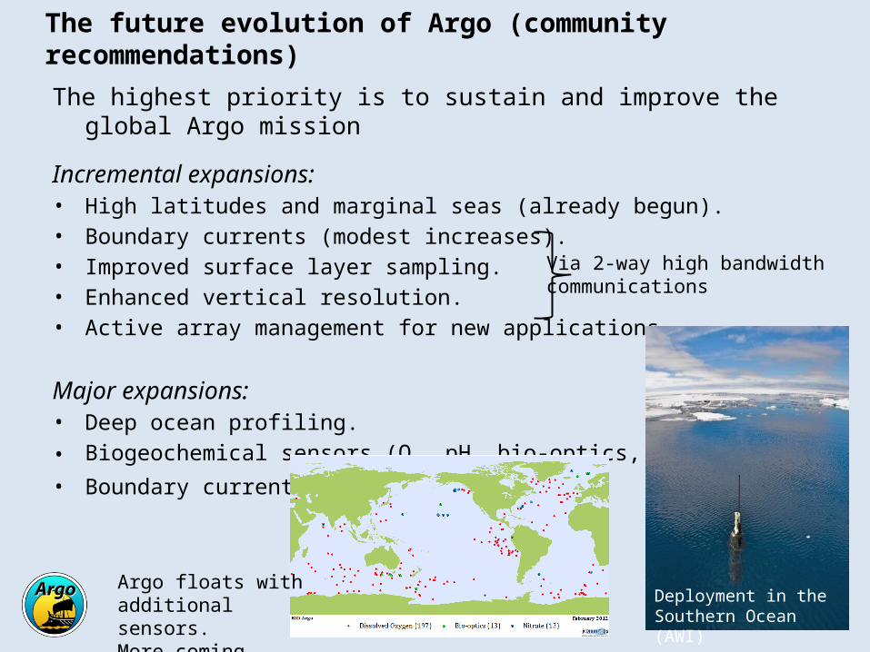
The future evolution of Argo (community recommendations)
The highest priority is to sustain and improve the global Argo mission
Incremental expansions:• High latitudes and marginal seas (already begun).• Boundary currents (modest increases).• Improved surface layer sampling.• Enhanced vertical resolution.• Active array management for new applications.
Major expansions:• Deep ocean profiling.
• Biogeochemical sensors (O2, pH, bio-optics, nitrate, …)
• Boundary currents.
Via 2-way high bandwidthcommunications
Deployment in the Southern Ocean (AWI)
Argo floats with additional sensors.More coming soon.

• Resources: U.S. Argo flat-funded since 2004 (except for Deep Argo development). Mission creep – expectations on Argo have increased with respect to data quality and coverage. Extension of float lifetimes has partially mitigated these problems.
• Spatial Coverage: Deployment opportunities are limited, and becoming more so (e.g. Ka decommissioning, other RV, VOS). The solution is (i) extended float lifetime and (ii) dedicated deployment cruises in the remotest regions (Kaharoa, Lady Amber, …).
• Technical failures (e.g. pressure sensor microleak): Quick detection and correction is essential.
• Law of the sea issues are compromising coverage in some regions. Most of the progress has been nation-to-nation.
• System Integration: Boundary current sampling goals and the interface of float and glider programs needs definition.
Challenges (global mission)
1/3 of Argo floats are in a Declared Maritime ZoneNearly 1000 floats deployed by RV Kaharoa since 2004.The future of this collaboration is questionable.
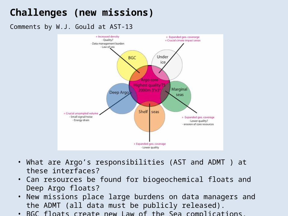
• What are Argo’s responsibilities (AST and ADMT ) at these interfaces?• Can resources be found for biogeochemical floats and Deep Argo floats?• New missions place large burdens on data managers and the ADMT (all
data must be publicly released).• BGC floats create new Law of the Sea complications.
Challenges (new missions)Comments by W.J. Gould at AST-13
Summary
• The Argo Program provides a global dataset of ~120,000 high-quality CTD profiles per year, 0 – 2000 m.
• Argo has achieved near-global coverage, and timely delivery of real-time and research-quality delayed-mode data, while advancing the technologies of profiling floats.
• An extraordinary variety and quantity of basic research is being done, integrating Argo and other ocean observations to investigate mesoscale to global variability, while operational applications and educational uses are also growing.
• Argo is a key dataset for global change studies, providing for the first time a fixed-era climatology for the upper ocean.
• The coming decade will see Argo extended into the deep ocean, marginal and coastal seas, and seasonal ice zones, and including new biogeochemical sensors.

Extra Slides
Argo Research Examples
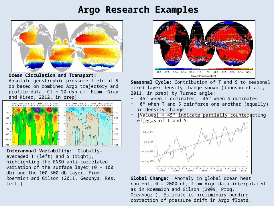
Ocean Circulation and Transport: Absolute geostrophic pressure field at 5 db based on combined Argo trajectory and profile data. CI = 10 dyn cm. From: Gray and Riser, 2012, in prep)
Interannual Variability: Globally-averaged T (left) and S (right), highlighting the ENSO anti-correlated variation of the surface layer (0 – 100 db) and the 100-500 db layer. From: Roemmich and Gilson (2011, Geophys. Res. Lett.)
Global Change: Anomaly in global ocean heat content, 0 – 2000 db; from Argo data interpolated as in Roemmich and Gilson (2009, Prog. Oceanogr.). Estimate is preliminary pending correction of pressure drift in Argo floats.
Seasonal Cycle: Contribution of T and S to seasonal mixed layer density change shown (Johnson et al., 2011, in prep) by Turner angle:• 45° when T dominates, -45° when S dominates • 0° when T and S reinforce one another (equally) in density change.• |Values| > 45° indicate partially counteracting effects of T and S.

Argo Under Ice: 3-year time-series of T and S, 0 to 500 db, from an Argo float (WMO 290001) under seasonal ice off of Wilkes Land, East Antarctica. From: Wong and Riser (2011, J. Phys. Oceanogr.)
Mean subsurface flow: Spreading of the water in 800 to 1100 dbar (includes Antarctic Intermediate Water) in the South Atlantic (Schmid and Garzoli, 2009 J. Mar. Res 67(6))
Variability of the subsurface flow: Seasonal variability of the flow at 800 to 1100 dbar (Antarctic Intermediate Water) in the Brazil-Malvinas Confluence (Schmid and Garzoli, 2009 J. Mar. Res 67(6))
Argo Research Examples