Embed Size (px)
Citation preview

Produced in collaboration with
April
2016
The Arctic Ahead Conservation and Management
in Arctic Alaska
Milo
Bur
cham

Ocean Conservancy The Arctic Ahead: Conservation and Management in Arctic Alaska | 2
Ocean Conservancy works with people around the world to protect the ocean from today’s greatest global challenges. Working together, we create science- based solutions for a healthy ocean and the wildlife and communities that depend on it.

Ocean Conservancy The Arctic Ahead: Conservation and Management in Arctic Alaska | 3
Suggested citation:
Hartsig, A. 2016. The Arctic Ahead: Conservation and Management in Arctic Alaska. Ocean Conservancy, Washington, D.C., 94 p.

Introduction
Ocean Conservancy The Arctic Ahead: Conservation and Management in Arctic Alaska | 4
IntroductionIn recent years, Arctic wildlife and Arctic peoples have faced rapid and dramatic environmental changes related to global climate change. While the region has always experienced fluctuations, the changes taking place now are happening at an unprecedented pace and scale. The Arctic is recognized as one of the fastest-warming regions on the globe. Air and sea temperatures are rising, tundra fires are occurring more frequently, ocean waters are becoming more acidic, seasonal sea ice cover is diminishing, permafrost is thawing and coastal erosion is increasing. These changes are already being felt in the U.S. Arctic and are predicted to continue far into the future.
Beyond these environmental changes, commercial and industrial operators are increasingly interested in Arctic Alaska¹. Energy companies have produced oil and gas at Prudhoe Bay since 1969², and have recently pushed operations toward new areas
such as Point Thomson near the border of the Arctic National Wildlife Refuge. In 2015, oil and gas companies proposed development plans for prospects in federal waters in the Beaufort Sea³ and announced the first production from leases in the federal National Petroleum Reserve-Alaska (NPR-A).⁴ Hundreds of oil and gas leases in the Chukchi Sea⁵ remain on the books, even if oil companies have no immediate plans to explore in that region. In addition to oil and gas activities, vessel traffic in the Arctic is increasing⁶ as ships take advantage of increasingly ice-free waters to travel the Northern Sea Route from Europe to Asia via the Arctic waters north of Russia, and the Northwest Passage through the archipelagic waters north of mainland Canada. While commercial fishing is currently prohibited in the U.S. Chukchi and Beaufort seas, new information could become available that may lead to changes in the management regime.⁷
Bob
Wic
k (B
LM)

Introduction
Ocean Conservancy The Arctic Ahead: Conservation and Management in Arctic Alaska | 5The Arctic Ahead: Conservation and Management in Arctic Alaska | 5
This combination of rapid environmental change and increasing industrialization has the potential to transform the Arctic. Of course, not all changes taking place in the region will have negative effects. But as climate change and industrial activities continue to intersect, the pace and scale of change will accelerate in ways that could cause irreversible adverse impacts to Arctic ecosystems, including important habitat areas that support both communities and wildlife. These adverse impacts could affect the ability of Arctic peoples to continue subsistence practices that are central to their culture and livelihood.
Some drivers of change – such as the concentration of atmospheric carbon dioxide and increasing ocean acidification – are already “locked in.”¹⁸ Impacts from these drivers cannot be avoided, but they can be anticipated. Other drivers of change – such as infrastructure to support industrial developments – can be managed and directed in ways to reduce negative impacts and maximize positive impacts. To do this successfully will require careful thought and long-term, integrated planning at a regional scale.
To date, however, most management decisions in the Arctic have been made on a piecemeal basis. Responsibility for the management of terrestrial and
marine environments is divided among federal and state government agencies and departments with widely varying missions, operating under an array of statutory mandates. Different industrial sectors and activities fall under a range of regulatory jurisdictions. Efforts to bridge these jurisdictional divides, and to understand and minimize the synergistic or cumulative effects of individual and multiple development projects, have been relatively modest. Even co-management agreements, which provide a way for Alaska Native organizations to engage more fully in some decision-making processes, are limited in scope and do not address all aspects of management.
More broadly, management decisions in Arctic Alaska are not guided by an overall, landscape level vision of what the region should look like in the future. In the absence of an overall vision, planners and managers may inadvertently allow the impacts of individual industrial activities to accumulate in ways that severely diminish ecosystem functioning or community access to resources.
Fortunately, there is growing interest in implementing integrated and long term decision-making in the Arctic, as evidenced by the current administration’s commitment to Integrated Arctic Management.⁹
The combination of rapid environmental change and increasing industrialization has the potential to transform the Arctic. Successful management will require careful thought and long-term, integrated planning at a regional scale.

Introduction
Ocean Conservancy The Arctic Ahead: Conservation and Management in Arctic Alaska | 6
Integrated Arctic Management requires a solid understanding of the ways in which individual management decisions may interact. The use of scenarios can facilitate this understanding.14 Scenarios are “plausible, alternative hypotheses about how the world might unfold, specifically designed to highlight risks and opportunities…” 15 This report uses three different scenarios to explore the potential effects associated with differing levels of industrial development. Maps depict medium- and high-development scenarios relative to selected natural, cultural, and industry-related values and attributes in the region, underscoring areas of potential conflict and risk.
These spatial depictions make clear that continued industrial infrastructure and activity in Arctic Alaska – if not managed carefully – could jeopardize important ecosystem values and/or interfere with subsistence
use and culturally important areas. While there are alternative ways to confront this management challenge, Integrated Arctic Management offers a promising approach that is pragmatic, inclusive and grounded by science-based decision-making that is “focused on ensuring the sustainability and continuity of ecosystem functions and services.”16
Section 01 reviews this report’s scope and methodology. Section 03 provides background and context, including general information on the region’s boroughs and communities, ecosystem values and the status and trends of key industrial sectors. Section 04 presents scenario maps and accompanying discussion. Section 05 proposes alternative management strategies for the region, and Section 06 suggests a path toward implementation of Integrated Arctic Management in one key portion of the project area.
Bob
Wic
k (B
LM)

Introduction
Ocean Conservancy The Arctic Ahead: Conservation and Management in Arctic Alaska | 7
The concept of Integrated Arctic Management is articulated and explained in a 2013 report to the President by the Interagency Working Group on Coordination of Domestic Energy Development and Permitting in Alaska.¹⁰ The report defines Integrated Arctic Management as:
Integrated Arctic Management is characterized by a set of guiding principles, including the following: 12
! A “whole-of-government” approach designed to improve efficiency, assess cumulative impacts, streamline decision-making, reduce uncertainty and facilitate participation.
! Direct and meaningful partnerships among stakeholders including Alaska Natives, communities, the State of Alaska, industry, non-governmental organizations and federal agencies.
! Science-based decision-making focused on ensuring sustainable ecosystems and continuity of ecosystem functions and services by
• identifying and protecting areas of significant ecological or cultural importance;
• using the best available science to understand ecological processes, to identify and measure indicators of change, and to make policy and management decisions;
• utilizing and integrating traditional knowledge into decision-making;
• investing in research and coordinating data collection and analysis; and
! Transparent, respectful, and consistent consultation and engagement with tribal governments.
! Adaptive management that uses baseline information and monitoring data to detect trends and make adjustments.
! Region-wide planning that crosses jurisdictional boundaries to identify areas that merit protection, areas vulnerable to change, and areas that can support development and infrastructure goals.
! Assessment of cumulative impacts associated with development activities throughout the Arctic.
The 2013 report to the President recommends that the U.S. government adopt and apply the principles of Integrated Arctic Management when making stewardship and development decisions in the U.S. Arctic.13
INTEGRATED ARCTIC MANAGEMENT
“a science-based, whole-of-government approach to stewardship and planning in the U.S. Arctic that integrates and balances environmental, economic, and cultural needs and objectives. It is an adaptive,stakeholder -informed means for looking holistically at impacts and sensitivities across the U.S. Arctic and generating sustainable solutions.” ¹¹
• using precaution in decision-making, especially where the health, productivity, and resilience of ecosystems may be compromised.

Table of ContentsGlossary
Section 01 Scope and methodology
Section 02
Background and context
Section 03
Narrative descriptions of maps
Section 04
Alternative paths toward conservation & management in Arctic Alaska
Section 05 Alaska’s Beaufort Sea coast: a test case for Integrated Arctic Management?
Section 06
Conclusion
Original maps: sources and processing
Endnotes
Thank you
9
20
11
31
78
page
page
page
page
page
85
9188
95105
page
page
page
page
page

A method of surveying subsurface geology using a sound source and sound detectors that are arrayed along a straight line.159
A method of surveying subsurface geology using a sound source and sound detectors that are spread out over an area; relative to 2-D seismic surveys, this method may produce improved resolution of subsurface features.160
Ships specifically designed for bulk carriage of ore with additional faculties for alternative, but not simultaneous, carriage of oil or loose or dry cargo.161
The shared decision-making process, formal or informal, between a government authority and an indigenous user group for managing a species of fish, wildlife, or other resource.162
An area with high relative density of a given species or set of species. In this report, a marine mammal core area refers to an area that contains 50% of all observations of a given species.
A port that can accommodate deep-draft vessels.163
When a vessel sails to the Arctic, performs some activity or task, in the Arctic, then returns south. Contrast with trans-Arctic shipping. See Arctic Council, Arctic Marine Shipping Assessment 2009 Report 12 (2009), available at http://www.pame.is/images/03_Projects/AMSA/AMSA_2009_report/AMSA_2009_Report_2nd_print.pdf.
Activities that take place following discovery of minerals in paying quantities and which are for the purpose of producing the minerals discovered; these may include geophysical activity, drilling, maintenance, platform construction, and operation of support facilities.164
The commercial search for oil or gas, including activities such as geophysical and geological surveys and drilling for the purpose of searching for commercial quantities of oil or gas.165
Liquid hydrocarbons existing as vapor in natural gas reservoirs that condense to liquids as their temperature and pressure decrease.166
“[A] science-based, whole of government approach to stewardship and planning…that integrates and balances environmental, economic, and cultural needs and objectives. It is an adaptive, stakeholder-informed means for looking holistically at impacts and sensitivities across the US Arctic and generating sustainable solutions.”167
An organism that causes ecological or economic harm in a new environment where it is not native.
Sea ice that is anchored to the shore or sea floor, typically over shallow ocean shelves at continental margins; landfast ice does not move with the winds or currents.
2-D seismic survey
3-D seismic survey
Bulk carriers
Co-management
Core area
Deep-draft port
Destinational shipping (in the Arctic)
Development (phase of oil and gas activity)
Exploration (phase of oil and gas activity)
Gas condensate
Integrated Arctic Management
Invasive species Landfast sea ice
B
E
C
G
D
I
L
Glossary
Ocean Conservancy The Arctic Ahead: Conservation and Management in Arctic Alaska | 9

A spatially defined area, onshore or offshore, in which commercial oil and gas exploration, development or production may be authorized pursuant to state or federal law.
A set of marine routes from Kara Gate (south of Novaya Zemlya) in the west to the Bering Strait in the east.168
The name given to the various marine routes between the Atlantic and Pacific oceans along the northern coast of North America that span the Canadian Arctic Archipelago.169
A legally defined oil and gas activity area consisting of one or more oil fields.170
A general area underlain by one or more underground reservoirs containing a common accumulation of oil.171
Activities that take place after exploration, including removal of oil from a field, transportation of oil, field operations, operation monitoring, maintenance, and similar activities.172
Different “futures” that result from the interaction of critical, selected uncertainties; plausible, alternative hypotheses about how the world might unfold, specifically designed to highlight risks and opportunities.173
A port that is relatively shallow and therefore can only accommodate ships that draw relatively little water.
Defined geographic areas within the NPR-A for which the Bureau of Land Management has adopted additional management measures designed to protect significant values.
Defined by the Bureau of Ocean Energy Management as “the customary and traditional uses by rural residents of wild, renewable resources for direct personal or family consumption as food, shelter, fuel, clothing, tools, or transportation; for making and selling of handcraft articles out of nonedible byproducts of fish and wildlife resources taken for personal or family consumption; for barter, or sharing for personal or family consumption; and for customary trade.”174
A roughly 800-mile-long pipeline system that begins in Prudhoe Bay on Alaska’s North Slope and terminates at the Valdez Marine Terminal in Prince William Sound.175
Voyages between the Atlantic and Pacific oceans that use the Arctic Ocean as a marine link.176
The hierarchy of organisms from photosynthetic plants to carnivores in which organisms at one level are fed upon by those at the next higher level (e.g., phytoplankton eaten by zooplankton eaten by fish).177
An executive action, undertaken pursuant to the Outer Continental Shelf Lands Act, that prevents consideration of certain areas for future oil or gas leasing for purposes of exploration, development, or production.178
Lease block (or lease tract) Northern Sea Route
Northwest Passage
Oil unit
Oil field
Production (phase of oil and gas activity)
Scenarios
Shallow-draft port
Special Area (in NPR-A)
Subsistence uses
Trans-Alaska Pipeline System (TAPS)
Trans-Arctic shipping route Trophic levels
Withdrawal (of federal waters)
N
O
T
P
S
W
Ocean Conservancy The Arctic Ahead: Conservation and Management in Arctic Alaska | 10

The Arctic Ahead: Conservation and Management in Arctic Alaska | 11
Section 01
Scope and methodology
Geographic and temporal scope of the report
Key industrial and non- industrial values considered in the report
Concept and use of scenarios in the report
USF
WS,
Mar
c Ro
man
o

Ocean Conservancy The Arctic Ahead: Conservation and Management in Arctic Alaska | 12
Scope and Methodology
This report combines future development scenarios with map-based analyses to illustrate potential risks associated with proposed industrial infrastructure and activity in Arctic Alaska. This approach helps readers identify areas that may have particular importance for conservation, subsistence, and/or cultural reasons. It also illustrates areas where proposed industrial activities may conflict with important non-industrial resource values, such as wildlife habitat, subsistence-use areas, culturally important areas, and designated conservation lands.
The degree and pace of future industrial development and activity in the project area is highly uncertain. To account for this uncertainty, this report makes use of low-, medium-, and high-development scenarios, which are based on draft scenarios developed in a separate, multi-year, multi-stakeholder process led by the North Slope Science Initiative (NSSI).17

Scope and methodology
Ocean Conservancy The Arctic Ahead: Conservation and Management in Arctic Alaska | 13
The NSSI project was undertaken to help identify future research and monitoring needs on the North Slope and adjacent seas.18 Although the NSSI project’s draft scenarios were developed in a separate process with a different goal in mind, this report employs them to help identify potential conflicts among competing uses or values in the region. More information about the NSSI scenarios can be found on the NSSI project website at www.northslope.org/scenarios.
The sections below describe in more detail the geographic scope of this report, key industrial and non-industrial values considered, and development of future scenarios for the Alaskan Arctic and their use in this report.

Scope and methodology
Ocean Conservancy The Arctic Ahead: Conservation and Management in Arctic Alaska | 14
The geographic scope of this report (i.e., the “project area”) focuses on a subsection of the U.S. Arctic.19 Onshore, it covers Alaska’s North Slope as well as the coastal lands of northwest Alaska from the Chukchi Sea to the southern portion of the Seward Peninsula. Offshore, it includes the U.S. portions of the Beaufort and Chukchi seas, the Bering Strait and the northern Bering Sea, including St. Lawrence Island. Within this project area, most lands are owned and managed by the federal government, the State of Alaska, Alaska Native corporations or municipalities. In some cases, jurisdiction is shared among multiple owners. Offshore, the State of Alaska has jurisdiction over ocean waters and subsurface lands from the
coastline out to three nautical miles (except for certain areas offshore of the NPR-A and the Arctic National Wildlife Refuge). The federal government asserts varying degrees of jurisdiction over marine waters and subsurface lands between three miles and the outer limit of the Exclusive Economic Zone (200 nautical miles beyond the coast).
The development scenarios in this report cover a 25-year time horizon, extending from the present to approximately 2040.20 This timeframe is far enough into the future such that the scenarios are not confined to short-term projects and plans, but not so far that they are dominated by uncertainty.
Geographic and temporal scope of the report
P r o j e c t S t u d y A r e a
B r o o k s R a ng
e
Fairbanks
Anchorage
Juneau

Scope and methodology
Ocean Conservancy The Arctic Ahead: Conservation and Management in Arctic Alaska | 15
Key industrial and non-industrial values considered in the report Maps in this report are not intended to show all possible resource values or industrial impacts. Instead, they focus on key categories that are particularly important in the region, such as subsistence use areas and habitat for caribou and bowhead whales.
With respect to industrial impacts, the maps depict infrastructure associated with the oil and gas industry, including specific drilling pads and platforms, wells, pipelines, roads and related facilities. In addition, the report includes specific maps that help visualize vessel traffic and low-altitude aircraft overflights. These activities may not leave a permanent footprint on the ground, but nonetheless may affect people, subsistence activities or wildlife.
With respect to non-industrial values and attributes, maps depict community subsistence use areas, Alaska Native allotments and historic use areas, lands designated or set aside for conservation purposes, caribou distribution, Important Bird Areas, marine mammal distribution and rates of coastal erosion in Arctic Alaska.
Information on data sources and analyses for the original maps created for this report can be found at the end of this report under the heading “Sources and Processing.”
Concept and use of scenarios in the reportThe 2013 report to the President on Integrated Arctic Management, described above, recognized that “[p]lanning in the face of uncertainty can be enhanced by recognizing a set of plausible futures, or ‘scenarios’ for the systems under consideration.”21 Scenarios are not forecasts; they are “alternative hypotheses about how the world might unfold.” 22 Scenario planning is considered “particularly useful in situations where uncertainty and change are high.” 23 The report to the President advised federal agencies to “assemble and assess the results” of various scenario efforts “to guide priority setting” for Integrated Arctic Management.
As noted above, this report uses low-, medium-, and high-development scenarios to account for uncertainty related to the degree and pace of industrial development in the project area. The particular scenarios used in this report – including the locations of proposed infrastructure such as drilling pads and platforms, pipelines and roads – are based on draft scenarios developed in the separate NSSI scenarios project described above.24 The scenarios developed by the NSSI project address only the North Slope of Alaska and adjoining waters. For the purposes of this report, we apply those scenarios to a slightly broader project area that also includes coastal lands of northwest Alaska from the Chukchi Sea to the southern portion of the Seward Peninsula and adjoining waters.
Some of the key characteristics of NSSI’s draft low-, medium-, and high-development scenarios are summarized in the paragraphs below. More detailed information on the characteristics of the draft NSSI scenarios is available on the NSSI project website.25

Scope and methodology
Ocean Conservancy The Arctic Ahead: Conservation and Management in Arctic Alaska | 16
Characteristics of NSSI’s draft low-development scenarioUnder this scenario, an environmental disaster combines with strict regulations and low oil prices to cause oil companies to shut down exploration and production on the North Slope. There is no offshore oil and gas activity, and the Trans-Alaska Pipeline System (TAPS) is closed. Lack of economic opportunity causes an outmigration of people and resources, causing adverse economic impacts in the region.
As noted above, this report’s map-based analysis is concerned with identifying where proposed industrial infrastructure and activities may conflict with important non-industrial resource values. Under the low-development scenario there would be no expansion of oil and gas infrastructure and activity and – as a result – no additional oil and gas conflicts beyond those that already exist. For this reason, the maps used in this report do not include a depiction of the low-development scenario.
B r o o k s R a ng
e
Closure of TAPS

Scope and methodology
Ocean Conservancy The Arctic Ahead: Conservation and Management in Arctic Alaska | 17
Characteristics of NSSI’s draft medium-development scenario Under this scenario, oil and gas development on the North Slope is moderately profitable, oil prices are high, and there is a relatively strict regulatory environment. Demand for energy is stable or low, with a business-as-usual approach to climate policy. Incremental infrastructure development takes place in NPR-A and the Beaufort Sea, but no development or production occurs in the Chukchi Sea. Revenue sharing brings some benefits to the State of Alaska and the North Slope Borough, and provides some support for local economy and jobs.
B r o o k s R a ng
e
TAPS
/Dal
ton
Hig
hway

Scope and methodology
Ocean Conservancy The Arctic Ahead: Conservation and Management in Arctic Alaska | 18
Characteristics of NSSI’s draft high-development scenario Under this scenario, global political instability, decreased fracking in the Lower 48 and decreased production overseas stimulate development in Alaska and make oil and gas development on the North Slope highly profitable. The regulatory environment is relatively permissive and climate change policies focus on limiting coal use. Significant new infrastructure development occurs both onshore and offshore, including development and production in the Chukchi Sea.
B r o o k s R a ng
e
TAPS
/Dal
ton
Hig
hway

Scope and methodology
Ocean Conservancy The Arctic Ahead: Conservation and Management in Arctic Alaska | 19

The Arctic Ahead: Conservation and Management in Arctic Alaska | 20
Section 02
Background and context
Political organization and communities
Industrial trends in Arctic Alaska
Alaska Native organizations and co-management organizations
Wildlife and habitat

Ocean Conservancy The Arctic Ahead: Conservation and Management in Arctic Alaska | 21
Background and Context
The following sections provide brief context on the project area’s political organization, communities and Alaska Native organizations. This background also touches on some of the important wildlife and habitat values, and discusses the status and trends related to four key industrial sectors in the project area: oil and gas, maritime shipping, commercial fishing and mining. The information in this section is not intended to be comprehensive in scope, but it may help some readers as they consider the maps, discussion and alternatives that appear later in the report.
NO
AA
Nat
iona
l Oce
an S
ervi
ce

Background and context
Ocean Conservancy The Arctic Ahead: Conservation and Management in Arctic Alaska | 22
The U.S. Arctic is home to indigenous peoples living in robust and resilient communities throughout the region. Some Alaska Native villages are among the oldest continually inhabited communities in North America.26 These communities have adapted – and continue to adapt – to profound changes to their environment. At the same time, they carry on traditional cultural practices, including a subsistence way of life that stretches back untold generations.
The northern portion of the project area falls within the North Slope Borough, an administrative subdivision of the State of Alaska that is nearly 90,000 square miles in size27 – an area larger than the State of Minnesota. The North Slope Borough plays a key role in the region, and has its own planning and wildlife departments (among other departments).28 Fewer than 10,000 people live in the North Slope Borough,29 and most residents live in one of eight communities: Anaktuvuk Pass, Atqasuk, Barrow, Kaktovik, Nuiqsut, Point Hope, Point Lay
or Wainwright.30 Roughly three-quarters of North Slope Borough residents are Iñupiat.31 Almost all Iñupiat households use subsistence foods, and in the majority of those households, subsistence foods account for at least half of the diet.32
The community of Kaktovik sits on the Beaufort Sea coast and is surrounded on three sides by the Arctic National Wildlife Refuge. Kaktovik Iñupiat Corporation owns roughly 92,000 acres in and around Kaktovik. To the west of the Arctic National Wildlife Refuge, the State of Alaska is the predominant landowner; the federal government and Alaska Native entities own smaller holdings. This region includes the Prudhoe Bay oil and gas complex, the northern section of the TAPS, and the unincorporated community of Deadhorse, which provides housing and facilities for oil and gas industry personnel who work on the North Slope. Most North Slope oil units lie within this portion of the project area or in adjacent state or federal
B r o o k sR a n
ge
B e a u f o r t
S e a
B e r i n g
S e a
C o l v i l l e R i v e r
C h u k c h i
S e a
Herald Shoal
Hanna Shoal
Barrow
WainwrightAtqasuk
NuiqsutDeadhorse
Anaktuvuk Pass
Point Lay
Point Hope
Kivalina
Kotzebue
Deering
Shishmaref
Teller
Nome
WalesDiomede
Savoonga
Gambell
Kaktovik
Red Dog MineDeLong Mountain Terminal
St. Lawrence Island
S e w a r dP e n i n s u l a
KasegalukLagoon
KingIsland
Little DiomedeIsland
BeringStrait
PortClarence
PeardBay
Barrow Canyon
HarrisonBay Camden Bay
Ut ukok RiverUp land s
1002 Area
A r c t i c N a t i o n a lW i l d l i f e R e f u g e
N a t i o n a l P e t r o l e u mR e s e r v e - A l a s k a
N o r t h w e s t A r c t i cB o r o u g h
N o r t h S l o p eB o r o u g h
0 40 80 120Miles
0 75 150 225Kilometers
TeshekpukLake
M a p E x t e n t
PrudhoeBay
KotzebueSound
LedyardBay
SmithBay
Red DogMine
Political organization and communities

Background and context
Ocean Conservancy The Arctic Ahead: Conservation and Management in Arctic Alaska | 23
waters. One oil unit – Point Thomson – is located on the border of the Arctic National Wildlife Refuge. Other oil units in the region include Prudhoe Bay, Kuparuk, Milne Point, Duck Island, Badami, Colville River and Oooguruk. Offshore oil units in the Beaufort Sea include the Northstar Unit, which straddles the state/federal boundary line, and the Liberty Unit, which is located wholly within federal waters.
Farther to the west, the communities of Nuiqsut, Barrow, Atqasuk and Wainwright are located on Native lands within or adjacent to the boundary of the NPR-A, and there are small private inholdings scattered throughout the area. Two oil units are located within the NPR-A near its eastern boundary: the Bear Tooth Unit and the Greater Moose’s Tooth Unit. The western NPR-A is a mixture of state, Native, and federal lands. The communities of Point Lay and Point Hope sit on the Chukchi Sea coast.
To the southwest, the project area includes a portion of the Northwest Arctic Borough. While smaller than the North Slope Borough, the Northwest Arctic Borough is the second-largest borough in Alaska33 at over 35,000 square miles.34 Like the North Slope Borough, the Northwest Arctic Borough plays an important role in management and has several departments, including planning and science.35 Approximately 7,500 people live in the Northwest Arctic Borough, roughly 85 percent of whom are of Alaska Native heritage.36 Most Alaska Natives in the Northwest Arctic Borough are Iñupiat, and subsistence hunting and fishing are important parts of their way of life.37 Northwest Arctic Borough villages in the project area include Deering, Kivalina and Kotzebue. The world’s largest zinc mine, Red Dog, is located roughly 90 miles north of Kotzebue and 45 miles inland, on land owned by an Alaska Native corporation. Minerals produced from the mine are hauled out via the DeLong Mountain Transportation System, which ends at a seasonal shallow-draft port on the Chukchi Sea coast called the DeLong Mountain Terminal.
The Bering Strait portion of the project area is not contained within any organized borough. This region includes the western section of the Seward Peninsula, Little Diomede Island, King Island, and St. Lawrence Island, and encompasses communities such as Nome, Teller, Port Clarence, Shishmaref, Diomede, Wales, Gambell and Savoonga, among others. Roughly 75 percent of Bering Strait region residents are Alaska Native,38 including Iñupiat on the Seward Peninsula, King Island, and Little Diomede, as well as Siberian Yupik on St. Lawrence Island.39
Gre
gory
Sm
ith

Background and context
Ocean Conservancy The Arctic Ahead: Conservation and Management in Arctic Alaska | 24
Alaska Native organizations & co-management organizationsIn addition to the boroughs, numerous and varied Alaska Native organizations are active in the project area.40 These include many village corporations, as well as regional corporations, such as Arctic Slope Regional Corporation, NANA Regional Corporation, and Bering Straits Native Corporation. Both village and regional corporations were established under the Alaska Native Claims Settlement Act.41 Other Alaska Native organizations include federally recognized tribal governments42 and regional nonprofit organizations such as the Iñupiat Community of the Arctic Slope, Kawerak, Inc., and Maniilaq Association.
A range of wildlife advisory and co-management organizations bring together representatives from Alaska Native organizations, federal agencies, and/or other organizations to facilitate management of particular resources in this geography. These advisory and co-management organizations include the Western Arctic Caribou Herd Working Group, Alaska Beluga Whale Committee, Alaska Eskimo Whaling Commission, Alaska Migratory Bird Co-management Council, Alaska Nanuuq Commission, Eskimo Walrus Commission, the Ice Seal Committee and the Alaska Marine Mammal Coalition – a coalition of the five Arctic marine mammal hunter/co-management organizations.43 While not an Alaska Native organization, the Arctic Waterways Safety Committee is a multi-stakeholder organization that includes Alaska Native organizations and is focused on creating best practices for the users of Arctic waterways.44
Wildlife and habitatThe land, ice and ocean of the U.S. Arctic support a delicate food web that spans terrestrial and marine habitats and supports an array of interconnected plants and animals. The food web encompasses and links together everything from algae and lichen, to voles and
polar cod, to bowhead whales, caribou and grizzly bears. People who reside in Arctic communities hunt, fish and gather wild foods, and are an integral part of the food web.
Arctic lands and waters are famous for their charismatic wildlife species. Caribou breed, feed and migrate on the North Slope in four major herds: the Porcupine, Teshekpuk, Central Arctic and Western Arctic herds.45 Arctic lands are also home to wolves, wolverines and grizzly bears.46 The ebb and flow of seasonal sea ice connects – and blurs the line between – the land and sea. Sea ice provides a resting platform for seals, scavenging grounds for Arctic foxes and hunting grounds for polar bears, among other animals.47 Arctic waters provide habitat for bowhead, beluga and gray whales; Pacific walruses and ice-dependent seals like bearded and ringed seals.48 At lower trophic levels, fish and invertebrates are vital to the marine food web.49 This region also hosts an impressive abundance of birds. BirdLife International and the National Audubon Society recognize a series of Important Bird Areas in Arctic Alaska which, in combination, cover much of the Chukchi and Beaufort coastlines, as well as other portions of the project area.50 These Important Bird Areas are used seasonally by a variety of seabirds, loons, waterfowl and shorebirds. For example, the Teshekpuk Lake area – located on the North Slope between Barrow and Nuiqsut – provides seasonal habitat for tens of thousands of molting geese, other waterfowl and nesting shorebirds.51 Each year more than one million birds travel to Teshekpuk Lake.52
Key coastal and marine habitat in the project area include St. Lawrence Island and surrounding waters, the coastal corridor along the entire Chukchi Sea coast, including Kasegaluk Lagoon and Peard Bay, the shallow waters of Herald and Hanna shoals, Barrow Canyon and adjacent areas, Harrison Bay, Camden Bay, the central Beaufort Sea coast northeast of Deadhorse, and the eastern Beaufort Sea coast near Kaktovik.53 The Bering Strait is another important marine and coastal area. At just 55 miles wide, it is the only marine passage between the North Pacific and Arctic oceans, and, as such, is a vital migratory corridor for many species of fish, birds and marine mammals.54 Onshore, key habitat areas include the Utukok River uplands, the Teshekpuk Lake region, and the Colville River corridor in the NPR-A,55 as well as the coastal plain of the Arctic National Wildlife Refuge, among other places.
Background and context
Ocean Conservancy The Arctic Ahead: Conservation and Management in Arctic Alaska | 25
Oil and gasThe first hydrocarbon studies on the North Slope began in the early 1900s.56 Discovery of commercial oil deposits in Prudhoe Bay occurred in 1968, which led to additional exploration and development in the area.57 Production began in 1977 with completion of TAPS.58 As of the end of 2013, oil companies had leased some 5.5 million acres, conducted roughly 60,000 linear miles of 2-D seismic surveys and 9,000 square miles of 3-D seismic surveys and drilled more than 6,800 wells on state lands on the North Slope and in state waters in the Beaufort Sea.59
According to the 2014 Annual Report of the Alaska Division of Oil and Gas, the North Slope now “hosts an extensive network of petroleum production, development and support facilities, all leading to the TAPS gathering facility, into the pipeline and ultimately the TAPS terminal in Valdez.”60 Prudhoe Bay is a hub for “existing fields and associated satellite developments on the North Slope and in the Beaufort Sea, extending outward via roads, pipelines, production and processing facilities, gravel mines and docks.”61 In addition to this long-term infrastructure, oil and gas work on the North Slope generates significant activity including year-round overflights and seasonal vessel traffic.
At present, nearly all commercially producing oil fields are located on state or Alaska Native lands.62 Most fields are located onshore, but six are located offshore on submerged lands in the Beaufort Sea, with two of those six accessed using directional drilling from onshore facilities.63 The Northstar Unit extends over submerged lands, both state and federal, in the Beaufort Sea.64
North Slope oil production peaked in the late 1980s.65 In general, production has been declining since then, although the addition of oil production from new units has helped slow the pace of the decline.66 Declining production has resulted in less oil moving through TAPS, which slows the rate at which oil travels in the pipeline, reduces oil temperatures, and can lead to more water and wax buildup – all of which can make it more challenging to manage and maintain the pipeline.67
For this and other reasons, many people in Alaska – including Alaska’s political leaders – are interested in coaxing more production from existing fields and in opening new fields for production.68 To that end, several projects are underway in new locations farther away from the central Prudhoe Bay field, including:
! Liberty: In September 2015, Hilcorp Alaska LLC submitted to the federal Bureau of Ocean Energy Management a development and production plan for its Liberty prospect.75 “This proposed facility to develop oil, which is to be built on a “manmade gravel island” about five miles offshore in the Beaufort Sea, is located beneath federal waters.76 Environmental analysis will likely take several years77 but if the project proceeds, it would be the first oil production facility located entirely in federal waters off Alaska.78
! CD-5: In October 2015, ConocoPhillips announced production from its CD-5 drill site, situated west of the Colville River adjacent to the existing Alpine field (Colville River Unit).69 Located on Native lands, it is the first producing well inside the boundaries of the NPR-A, and is expected to produce about 16,000 barrels per day at peak production.70
! Greater Mooses Tooth 1: Also in October 2015, the federal Bureau of Land Management approved a drilling permit and right-of-way grant for ConocoPhillips’ proposed Greater Mooses Tooth Unit development project, also in the NPR-A.71 If the project proceeds, it would result in the first production of oil from federal lands in the NPR-A.72
! Point Thomson: ExxonMobil is working to develop the Point Thomson gas condensate field, located to the east of Prudhoe Bay near the border of the Arctic National Wildlife Refuge.73 Exxon expects initial condensate production to occur in early 2016 at roughly 10,000 barrels per day.74
Industrial trends in Arctic Alaska

Background and context
Ocean Conservancy The Arctic Ahead: Conservation and Management in Arctic Alaska | 26
There has also been considerable recent interest in exploring for oil in the federal waters of the Chukchi Sea, far from existing oilfield infrastructure in the Prudhoe Bay region. In 2008, oil companies including Shell, ConocoPhillips, Statoil and Repsol purchased hundreds of Chukchi Sea lease blocks.79 Together, the companies submitted bids in the amount of nearly $3.4 billion, with a total of $2.6 billion in high bids.80 In the years after 2008, most leasees have expressed reluctance to proceed with exploratory drilling in the Chukchi Sea: in March 2013 industry media reported that Statoil was considering abandoning its Chukchi Sea prospects,81 and in April of the same year ConocoPhillips announced
it would put Chukchi Sea drilling plans on hold.82 Since that time, neither company has proposed an exploration plan to federal regulators. In contrast, oil giant Shell conducted exploration drilling operations in the Chukchi Sea in both 2012 and 2015. Shell’s 2012 exploration effort was plagued by errors and mishaps, including the grounding of the Kulluk drilling unit after the conclusion of the season.83 Shell’s 2015 drilling season also ended with disappointment when the company announced that while it had found “indications of oil and gas” in its exploration well, those indications were “not sufficient to warrant further exploration” at the prospect.84 As a result, Shell announced that it would “cease further exploration activity in offshore Alaska for the foreseeable future.”85 In the wake of Shell’s decision, Statoil announced that it, too, would exit Alaska and close its Anchorage office.86
TeshekpukLake
Arctic National Wildlife Refuge
1002 Area
Arctic National Wildlife Refuge
National Petroleum Reserve - Alaska
Placer
Tofkat
Bear Tooth
Greater MoosesTooth
Qugruk Pikka
Oooguruk
Nikaitchuq
Milne Point
Beechey Point
Northstar
Dewline
Duck Island
Liberty
PointThomson
Badami
PrudhoeBay
ColvilleRiver
0 10 20 30Miles
Kilometers0 20 40 60
SouthernMiluveach
KuparukRiver
North Slope Oil and Gas Units
Pipelines and Roads
Federal
Unit Type
Joint Federal / State
State
TAPS
/Dal
ton
Hig
hway

Background and context
Ocean Conservancy The Arctic Ahead: Conservation and Management in Arctic Alaska | 27
The decisions from Statoil, ConocoPhillips and Shell to retreat from offshore drilling in the Chukchi Sea likely preclude petroleum development and production from that region for some time to come. Over the longer term, however, the Chukchi Sea may continue to be of interest to oil companies, and the federal government may opt to sell new leases in the Chukchi Sea under a future nationwide offshore leasing program.
In addition, Shell and ConocoPhillips continue to pursue “suspension” of their Arctic leases, which would effectively extend the lifetime of the leases beyond their current expiration dates (generally 2017 in the Beaufort Sea and 2020 in the Chukchi Sea).88
Vessel trafficWhile not on the same scale as oil and gas development, vessel traffic is another key industrial sector in Arctic Alaska. Existing vessel traffic in the project area is largely destinational in nature, “centered on the transport of natural resources from the Arctic, and the delivery of general cargo and supplies to communities and natural resource extraction facilities, e.g. periodic barge sealift to Prudhoe Bay.”89 Much of the shipping in the region “is done with tugs and barges due to the absence of deep-water ports in the U.S. Arctic.”90 Transport of minerals from Red Dog mine, for example, requires shallow-draft barges to transfer ore from the shore to larger, deeper-draft vessels.91
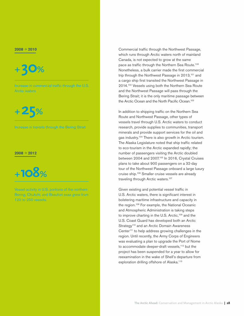
Despite the relatively low numbers of vessels traveling in the Bering Strait region and through the Chukchi and Beaufort seas, traffic in the region is growing. In the two years between 2008 and 2010, commercial traffic through the U.S. Arctic waters increased 30 percent and transits through the Bering Strait increased 25 percent.92 In the span between 2008 and 2012, vessel activity in U.S. portions of the northern Bering, Chukchi, and Beaufort seas grew from 120 to 250 vessels, an increase of 108 percent.93
Growth is expected to persist as the thinning and retreat of sea ice continues to make trans-Arctic shipping routes increasingly commercially viable. Shipping companies are already making greater use of the Northern Sea Route, which runs between northern Europe and the Bering Strait in the waters north of Russia and is substantially shorter in distance than routes through the Suez or Panama Canal.94 In 2009, two German vessels became the first foreign-flagged ships to transit the Northern Sea Route from east to west.95 In 2010, a total of four vessels transited the route;96 by 2013, a total of 71 vessels transited the route, including 25 trips by foreign vessels from 11 nations.97 In October 2015, China’s largest shipping company announced that it planned to schedule regular vessel traffic through the Northern Sea Route.98 Russia anticipates that cargo transport along the Northern Sea Route will increase from 1.8 million tons in 2010 to 64 million tons by 2020.99
Even as it announced its retreat from the Chukchi Sea, Shell observed that it “continues to see important exploration potential in the basin, and the area is likely to ultimately be of strategic importance to Alaska and the [United States].”87
Background and context
Ocean Conservancy The Arctic Ahead: Conservation and Management in Arctic Alaska | 28
Commercial traffic through the Northwest Passage, which runs through Arctic waters north of mainland Canada, is not expected to grow at the same pace as traffic through the Northern Sea Route.100 Nonetheless, a bulk carrier made the first commercial trip through the Northwest Passage in 2013,101 and a cargo ship first transited the Northwest Passage in 2014.102 Vessels using both the Northern Sea Route and the Northwest Passage will pass through the Bering Strait; it is the only maritime passage between the Arctic Ocean and the North Pacific Ocean.103
In addition to shipping traffic on the Northern Sea Route and Northwest Passage, other types of vessels travel through U.S. Arctic waters to conduct research, provide supplies to communities, transport minerals and provide support services for the oil and gas industry.104 There is also growth in Arctic tourism. The Alaska Legislature noted that ship traffic related to eco-tourism in the Arctic expanded rapidly; the number of passengers visiting the Arctic doubled between 2004 and 2007.105 In 2016, Crystal Cruises plans to take about 900 passengers on a 32-day tour of the Northwest Passage onboard a large luxury cruise ship.106 Smaller cruise vessels are already traveling through Arctic waters.107
Given existing and potential vessel traffic in U.S. Arctic waters, there is significant interest in bolstering maritime infrastructure and capacity in the region.108 For example, the National Oceanic and Atmospheric Administration is taking steps to improve charting in the U.S. Arctic,109 and the U.S. Coast Guard has developed both an Arctic Strategy110 and an Arctic Domain Awareness Center111 to help address growing challenges in the region. Until recently, the Army Corps of Engineers was evaluating a plan to upgrade the Port of Nome to accommodate deeper-draft vessels,112 but the project has been suspended for a year to allow for reexamination in the wake of Shell’s departure from exploration drilling offshore of Alaska.113
2008 ! 2010
2008 ! 2012
Increase in commercial traffic through the U.S. Arctic waters
Increase in transits through the Bering Strait
Vessel activity in U.S. portions of the northern Bering, Chukchi, and Beaufort seas grew from 120 to 250 vessels.
+30%
+25%
+108%

Background and context
Ocean Conservancy The Arctic Ahead: Conservation and Management in Arctic Alaska | 29
FishingIn the geographic area covered by this report, commercial fishing is prohibited in U.S. waters north of the Bering Strait until there is enough information to support “sustainable management of a commercial fishery.”114 There is support for exporting this precautionary approach to the high seas of the Arctic, which lie beyond the management authority of any single nation.
In July 2015, the United States, Russia, Canada, Norway and Denmark/Greenland signed a declaration agreeing to refrain from fishing in high- seas waters until there is more scientific information about fishery resources and until a regulatory regime is implemented.115 To ensure the effectiveness of the ban, other nations will need to agree to adhere to the same policy.
Waters south of the Bering Strait are also subject to restrictions on commercial fishing. In 2008, the
National Marine Fisheries Service implemented the Northern Bering Sea Research Area. This management area, recommended by the North Pacific Fishery Management Council in anticipation of commercially important fish stocks moving northward, prohibits bottom trawling in much of the northern Bering Sea unless conducted on an experimental basis under a comprehensive research plan for the area.116 Any fishing is required to be conducted under the research plan before an adaptively managed commercial fishery can occur, but since no research plan currently exists, bottom trawling is currently prohibited.117 Bering Sea fisheries farther south are tremendously important, but fall outside the geographic scope of this project. Although commercial fishing is not a significant driver in the project area at this time, subsistence fishing provides an important source of food for residents of the region. Targeted species include crab, salmon and other fish species.118

Background and context
Ocean Conservancy The Arctic Ahead: Conservation and Management in Arctic Alaska | 30
Mining The Red Dog mine, located roughly 82 miles north of Kotzebue, is the most significant mining operation that affects the project area. For example, in 2010, Red Dog was responsible for nearly 50 percent of Alaska’s non-fuel mineral production and produced ore worth more than $1.5 billion.119 Ore from the mine is stored at the DeLong Mountain Terminal port facility, located on the Chukchi Sea coast between Cape Krusenstern and the community of Kivalina. Stored ore is shipped by sea from the DeLong Mountain Terminal to customers in Canada, Asia and Europe during a 100-day season that occurs from July to October.120 Vessels servicing Red Dog include large bulk carriers up to 65,000 tons.121
There are small-scale mining operations near Nome, but they have limited impacts within the project area. There are also significant undeveloped mineral deposits in the U.S. Arctic, including coal resources on the North Slope (e.g., within the boundaries of the NPR-A) and a variety of mineral resources in the Ambler mining district. For now, however, there are no concrete plans to develop these resources.122
UncertaintyThe industrial sectors discussed in the foregoing paragraphs share at least one common trait: uncertainty. The oil and gas industry in Arctic Alaska continues to expand from the core Prudhoe Bay area, but at present, prospects for oil development in the Chukchi Sea have diminished. Nonetheless, changing market conditions could spark renewed interest in the Chukchi Sea at some point in the future. Maritime shipping and tourism in Arctic waters are poised for continued growth, but the rate of growth and the ultimate magnitude of vessel traffic in the region are not clear. Commercial fishing is currently limited in the project area and – with the notable exception of the Red Dog mine – so is commercial mining. However, given changing environmental and economic conditions, that may not always be the case. As noted above, scenarios can be particularly helpful in situations of high uncertainty and change,123 and they can help “guide priority setting” for Integrated Arctic Management. To that end, the section that follows discusses impacts associated with low-, medium-, and high-development scenarios in Arctic Alaska, using a series of maps to help readers visualize the potential industrial impacts of the medium- and high-development scenarios.
In July 2015, the United States, Russia, Canada, Norway and Denmark/Greenland signed a declaration agreeing to refrain from fishing in high-seas waters until there is more scientific information about fishery resources and until a regulatory regime is implemented. To ensure the effectiveness of the ban, other nations will need to agree to adhere to the same policy.

The Arctic Ahead: Conservation and Management in Arctic Alaska | 31
Section 03
Narrative descriptions of maps
Kevi
n Ra
skof
f
Narrative descriptions of maps
Map A: Community subsistence use areas
Map B: Native allotments and historic use
Map C: Lands designated to protect conservation values and/or subsistence use areas
Map F: Polar bear distribution
Map I: Aircraft overflights
Analysis of impacts associated with the medium-development scenario
Analysis of impacts associated with the high-development scenario
Map D: Caribou distribution
Map G: Marine mammal distribution
Map J: Coastal erosion
Map E: Important Bird Areas
Map H: Vessel traffic
Analysis of impacts associated with the low-development scenario

Ocean Conservancy The Arctic Ahead: Conservation and Management in Arctic Alaska | 32
Map and discussion
The first part of this section presents a series of ten maps of the project area, as well as accompanying narrative descriptions. The maps and narrative depict and describe key resource values or attributes in relation to industrial infrastructure associated with the medium- and high-development scenarios described above. Later subsections discuss impacts associated with the low-, medium-, and high-development scenarios.
NO
AA

Maps and discussion
Ocean Conservancy The Arctic Ahead: Conservation and Management in Arctic Alaska | 33
The base layer of each map shows hypothetical future infrastructure as it would appear under both the medium- and high-development scenarios.
Future infrastructure associated with the medium-development scenario is shown in yellow.124 This infrastructure includes:
! drill pads and pipelines in the northeastern portion of the NPR-A;
! drill pads and pipelines in the greater Prudhoe Bay region;
! drill pads in the North Slope foothills;
! drill pads and pipelines at Point Thomson near the border of the Arctic National Wildlife Refuge; and
! drilling platforms and pipelines in Camden Bay in the nearshore portion of the Beaufort Sea.
While there is exploration activity on oil and gas leases in the Chukchi Sea, the leases are not developed under the medium development scenario.
The high-development scenario includes all infrastructure shown in the medium-development scenario, plus additional infrastructure, which is shown in orange on the base layer of each map.125 This additional infrastructure includes:
! drilling platforms in the Chukchi Sea;
! a subsea pipeline connecting the Chukchi Sea platforms to the coast near Wainwright;
! an onshore oil and gas processing facility near Wainwright;
! a pipeline linking Wainwright to the Prudhoe Bay pipeline complex near Nuiqsut;
! roads connecting Wainwright to Nuiqsut, Wainwright to Atqasuk, and Atqasuk to Barrow;
! a Coast Guard station in Barrow;
! gas field development in Barrow;
! platforms or pads in Smith Bay and at Kaktovik;
! a pipeline linking Smith Bay to the Prudhoe Bay pipeline complex near Nuiqsut;
! a pipeline linking Kaktovik to the Prudhoe Bay pipeline complex at Point Thomson;
! drill pads at Umiat and a pipeline linking Umiat to TAPS;
! a pipeline linking drill pads at the North Slope foothills to TAPS.
Narrative descriptions of mapsBase layer showing medium- and high-development scenario infrastructure
As noted above, the maps included in this section do not include a depiction of the low-development scenario. Under that scenario, there would be no expansion of oil and gas infrastructure or activity and therefore no additional oil and gas conflicts beyond those that already exist.
The base maps also show generalized vessel traffic routes in blue. The location of these routes is the same under both the medium- and high-development scenarios, although the volume of vessel traffic along the routes would likely increase under the high-development scenario.

Map A: Community subsistence use areas

Maps and discussion
Ocean Conservancy The Arctic Ahead: Conservation and Management in Arctic Alaska | 35
Map A shows information on documented subsistence use in the project area. While the maps reflect the best information from publicly available data sources, these data sources are not comprehensive and patterns of subsistence use may shift over time. As a result, the maps are an incomplete approximation of documented subsistence use in the project area.
The pie charts shown on the map indicate the overall magnitude and composition of subsistence harvest for particular communities in the region. The magnitude of a community’s subsistence harvest (estimated in pounds harvested) is represented by the size of the pie chart on the map: the larger the pie chart, the larger the community’s cumulative subsistence harvest. Colors within the pie chart show the composition of a community’s subsistence use. Dark blue represents harvest of fish, green represents harvest of land mammals, turquoise represents harvest of marine mammals, yellow represents harvest of birds and eggs, and gray represents harvest of other types of subsistence resources. Importantly, the pie charts do not represent the spatial extent of subsistence activities for their respective communities.
In the North Slope portion of the project area, pink shading indicates the spatial extent of documented subsistence areas. The data representing the spatial extent of documented subsistence activities are available only for the North Slope portion of the project area; analogous data are not available for areas outside the North Slope.126 Although this dataset is limited to the North Slope, it shows that a significant geographic area, both onshore and offshore, is used for subsistence hunting and/or fishing purposes.
Sources:
1) Stephen R. Braund & Associates 2010;
2) Pedersen et al. 1979;
3) ADF&G 2015.

Maps and discussion
Ocean Conservancy The Arctic Ahead: Conservation and Management in Arctic Alaska | 36
TAPS
/Dal
ton
Hig
hway
0 40 80 120Miles
Kilometers0 75 150 225
Subsistence Harvest3(most recent year)
North Slope SubsistenceUse Areas 1,2
MediumDevelopment
High Development
Drilling Platforms and Pads
Pipelines
OCS Lease Blocks
Oil and Gas Units
Shipping Routes (Same as medium)
Other Infrastructure
(None)Roads
(None)
Fish
Land Mammals
Marine Mammals
Birds and Eggs
Other (vegetation, invertebrates)
Wales
Elim
Koyuk
KianaKobuk
Teller
Ambler
DeeringDiomede
GambellGolovin
Nuiqsut
SelawikNoorvik
Savoonga
Kivalina
Stebbins
Buckland
Kaktovik
Kotzebue
Shungnak
Shaktoolik
Unalakleet
Wainwright
Shishmaref
Brevig Mission
White Mountain
Anaktuvuk Pass
Noatak
Point Lay
Nome
Barrow
B r o o k s R a ng
e
C o l v i l l e R i v e r
Hanna Shoal
TeshekpukLake
BeaufortSea
ChukchiSea
BeringSea

Maps and discussion
Ocean Conservancy The Arctic Ahead: Conservation and Management in Arctic Alaska | 37
TAPS
/Dal
ton
Hig
hway
0 40 80 120Miles
Kilometers0 75 150 225
Subsistence Harvest3(most recent year)
North Slope SubsistenceUse Areas 1,2
MediumDevelopment
High Development
Drilling Platforms and Pads
Pipelines
OCS Lease Blocks
Oil and Gas Units
Shipping Routes (Same as medium)
Other Infrastructure
(None)Roads
(None)
Fish
Land Mammals
Marine Mammals
Birds and Eggs
Other (vegetation, invertebrates)
Wales
Elim
Koyuk
KianaKobuk
Teller
Ambler
DeeringDiomede
GambellGolovin
Nuiqsut
SelawikNoorvik
Savoonga
Kivalina
Stebbins
Buckland
Kaktovik
Kotzebue
Shungnak
Shaktoolik
Unalakleet
Wainwright
Shishmaref
Brevig Mission
White Mountain
Anaktuvuk Pass
Noatak
Point Lay
Nome
Barrow
B r o o k s R a ng
e
C o l v i l l e R i v e r
Hanna Shoal
TeshekpukLake
BeaufortSea
ChukchiSea
BeringSea

Map B: Native allotments and historic use

Maps and discussion
Ocean Conservancy The Arctic Ahead: Conservation and Management in Arctic Alaska | 39
Map B shows portions of the project area that are owned or have been selected by Alaska Native village corporations or Alaska Native regional corporations under the Alaska Native Claims Settlement Act. Significant portions of the Northern Bering Sea coastline constitute Native land, including almost all of St. Lawrence Island and much of the southern Seward Peninsula in the Bering Strait region. Along the Chukchi and Beaufort coasts, there are significant Native holdings around the coastal communities, in Kotzebue Sound, and along Ledyard Bay and among other locations.
Map B also shows major archaeological sites, historic use sites and historic subsistence use routes for the northern portion of the project area (the dataset on historic use and archaeological sites does not cover areas to the south). Like subsistence use areas shown in the North Slope region in Map A, traditional use areas, historic subsistence routes and archaeological sites occur throughout the northern portion of the project area.
Sources:
1) DOI-BLM 1978
2) DOI-BLM 2015

Maps and discussion
Ocean Conservancy The Arctic Ahead: Conservation and Management in Arctic Alaska | 40
Kotzebue
Wainwright
Barrow
Deadhorse
Nome
BeaufortSea
ChukchiSea
BeringSea
Limit of Historic Use Mapping
Hanna Shoal
TeshekpukLake
0 40 80 120Miles
Kilometers0 75 150 225
B r o o k s R a ng
e
C o l v i l l e R i v e r
TAPS
/Dal
ton
Hig
hway
MediumDevelopment
Historic Use - North Slope
High Development
Drilling Platforms and Pads
Pipelines
OCS Lease Blocks
Oil and Gas Units
Shipping Routes (Same as medium)
Other Infrastructure
(None)Roads
(None)
Land Status
Native Selected
Native Ownership
21
All Communities
Historic Use Sites
Historic Subsistence Routes
Important Archaeological Sites
Maps and discussion
Ocean Conservancy The Arctic Ahead: Conservation and Management in Arctic Alaska | 41
Kotzebue
Wainwright
Barrow
Deadhorse
Nome
BeaufortSea
ChukchiSea
BeringSea
Limit of Historic Use Mapping
Hanna Shoal
TeshekpukLake
0 40 80 120Miles
Kilometers0 75 150 225
B r o o k s R a ng
e
C o l v i l l e R i v e r
TAPS
/Dal
ton
Hig
hway
MediumDevelopment
Historic Use - North Slope
High Development
Drilling Platforms and Pads
Pipelines
OCS Lease Blocks
Oil and Gas Units
Shipping Routes (Same as medium)
Other Infrastructure
(None)Roads
(None)
Land Status
Native Selected
Native Ownership
21
All Communities
Historic Use Sites
Historic Subsistence Routes
Important Archaeological Sites

Map C: Lands designated to protect conservation values and/or subsistence use areas

Maps and discussion
Ocean Conservancy The Arctic Ahead: Conservation and Management in Arctic Alaska | 43
Map C shows lands set aside to protect conservation values and/or subsistence use areas. The Arctic National Wildlife Refuge, located at the east of the project area, is administered by the U.S. Fish and Wildlife Service.127 The Refuge128 includes large tracts of designated Wilderness, as well as proposed Wilderness and proposed Wild and Scenic Rivers. Production of oil and gas from the Refuge is prohibited unless authorized by Congress. A portion of federal waters in the Beaufort Sea near Kaktovik is withdrawn from oil and gas leasing to protect areas used for subsistence whaling.130
The NPR-A, managed by the Bureau of Land Management, covers nearly 23 million acres of the North Slope, making it the largest unit of federally managed land in the United States.131 The management plan for the NPR-A includes five “Special Areas” that encompass key resource values such as raptor, waterbird and shorebird habitat; caribou calving and insect-relief areas; and marine mammal haulouts.132 These are the Colville River, Teshekpuk Lake, Utukok River Uplands, Peard Bay and Kasegaluk Lagoon Special Areas.133 Portions of these Special Areas are unavailable for oil and gas leasing or exploratory drilling; some areas are also closed to construction of new permanent infrastructure (except subsistence-related infrastructure).134
Sources:
1) USGS and Interagency Wild and Scenic River Coordinating Council
2) University of Montana 2015 3) BOEM 2015 4) Alaska DNR 2015
5) BLM 2013
Offshore of the NPR-A in the Beaufort Sea east of Barrow, certain federal waters are withdrawn from oil and gas leasing to protect areas used for subsistence whaling.135 West of Barrow in the federal waters of the Chukchi Sea, three additional withdrawals preclude oil and gas leasing to protect subsistence activities near Barrow, wildlife habitat on Hanna Shoal, and a 25-mile wide corridor of biological productivity that runs along the coast.136
Additional conservation lands are located inland and along the coast of the Chukchi Sea and the Northern Bering Sea. These include Cape Krusenstern National Monument, Noatak National Preserve, Kobuk Valley National Park and Bering Land Bridge National Preserve, all of which are administered by the National Park Service. Other lands along this portion of the coast are included in conservation units administered by the Fish and Wildlife Service, including Selawik National Wildlife Refuge and the Chukchi Sea and Bering Sea units of the Alaska Maritime National Wildlife Refuge.

Maps and discussion
Ocean Conservancy The Arctic Ahead: Conservation and Management in Arctic Alaska | 44
1002 Area
Kobuk ValleyNational Park
Selawik National Wildlife Refuge
Bering Land BridgeNational Preserve
Alaska MaritimeNational Wildlife
Refuge
Cape KrusensternNational Monument
Alaska MaritimeNational Wildlife Refuge
Noatak NationalPreserve
Gates of Arctic National Park
Teshekpuk LakeSpecial Area
Utukok River UplandsSpecial Area
Colville River Special Area
Kasegaluk Lagoon Special Area
Peard BaySpecial Area
Arctic National Wildlife Refuge
2
Kotzebue
Wainwright
Barrow
Deadhorse
Nome
BeaufortSea
ChukchiSea
BeringSea
Hanna Shoal
TeshekpukLake
0 40 80 120Miles
Kilometers0 75 150 225
B r o o k s R a ng
e
MediumDevelopment
High Development
Drilling Platforms and Pads
Pipelines
OCS Lease Blocks
Oil and Gas Units
Shipping Routes (Same as medium)
Other Infrastructure
(None)Roads
(None)
Wild and Scenic Rivers 1
Wilderness Areas
Unavailable for Leasing 3,4
NPRA Special Areas
2
5
Non-Wilderness Protected Areas
TAPS
/Dal
ton
Hig
hway

Maps and discussion
Ocean Conservancy The Arctic Ahead: Conservation and Management in Arctic Alaska | 45
1002 Area
Kobuk ValleyNational Park
Selawik National Wildlife Refuge
Bering Land BridgeNational Preserve
Alaska MaritimeNational Wildlife
Refuge
Cape KrusensternNational Monument
Alaska MaritimeNational Wildlife Refuge
Noatak NationalPreserve
Gates of Arctic National Park
Teshekpuk LakeSpecial Area
Utukok River UplandsSpecial Area
Colville River Special Area
Kasegaluk Lagoon Special Area
Peard BaySpecial Area
Arctic National Wildlife Refuge
2
Kotzebue
Wainwright
Barrow
Deadhorse
Nome
BeaufortSea
ChukchiSea
BeringSea
Hanna Shoal
TeshekpukLake
0 40 80 120Miles
Kilometers0 75 150 225
B r o o k s R a ng
e
MediumDevelopment
High Development
Drilling Platforms and Pads
Pipelines
OCS Lease Blocks
Oil and Gas Units
Shipping Routes (Same as medium)
Other Infrastructure
(None)Roads
(None)
Wild and Scenic Rivers 1
Wilderness Areas
Unavailable for Leasing 3,4
NPRA Special Areas
2
5
Non-Wilderness Protected Areas
TAPS
/Dal
ton
Hig
hway

Map D: Caribou distribution

Maps and discussion
Ocean Conservancy The Arctic Ahead: Conservation and Management in Arctic Alaska | 47
Map D shows areas used seasonally by the four Arctic caribou herds. Calving core ranges in the project area are shown in solid colors, and are located south of Wainwright (Western Arctic herd), around Teshekpuk Lake (Teshekpuk herd), east and west of Deadhorse (Central Arctic herd), and in the coastal plain of the Arctic National Wildlife Refuge and east into Canada (Porcupine herd). Summer range for the four herds overlaps to some extent, and covers nearly the entire North Slope. Caribou winter range in the project area includes significant portions of the North Slope and Seward Peninsula, as well as a smaller area north of Kotzebue. Caribou may travel hundreds or even thousands of miles during their annual migration.137
Sources:
1) ADF&G 2014, as reported in Gotthardt et al. 2014;
2) Griffith et al. 2002.

Maps and discussion
Ocean Conservancy The Arctic Ahead: Conservation and Management in Arctic Alaska | 48
A R C T I C O C E A N
BeaufortSea
ChukchiSea
BeringSea
Hanna Shoal
TeshekpukLake
0 40 80 120Miles
Kilometers0 75 150 225
B r o o k s R a ng
e
C o l v i l l e R i v e r
Sources: 1) ADF&G 2014, as reported in Gotthardt et al. 2014; 2) Griffith et al. 2002.
Kotzebue
Wainwright
Barrow
Deadhorse
Nome
TAPS
/Dal
ton
Hig
hway
MediumDevelopment
High Development
Drilling Platforms and Pads
Pipelines
OCS Lease Blocks
Oil and Gas Units
Shipping Routes (Same as medium)
Other Infrastructure
(None)Roads
(None)
Western Arctic Herd
Calving Range
Summer Range
Winter Range
1 Teshekpuk Herd
Calving Range
Summer Range
Winter Range
1 Central Arctic Herd
Calving Range
Summer Range
Winter Range
1 Porcupine Herd
Calving Range
Summer Range
Winter Range
2

Maps and discussion
Ocean Conservancy The Arctic Ahead: Conservation and Management in Arctic Alaska | 49
A R C T I C O C E A N
BeaufortSea
ChukchiSea
BeringSea
Hanna Shoal
TeshekpukLake
0 40 80 120Miles
Kilometers0 75 150 225
B r o o k s R a ng
e
C o l v i l l e R i v e r
Sources: 1) ADF&G 2014, as reported in Gotthardt et al. 2014; 2) Griffith et al. 2002.
Kotzebue
Wainwright
Barrow
Deadhorse
Nome
TAPS
/Dal
ton
Hig
hway
MediumDevelopment
High Development
Drilling Platforms and Pads
Pipelines
OCS Lease Blocks
Oil and Gas Units
Shipping Routes (Same as medium)
Other Infrastructure
(None)Roads
(None)
Western Arctic Herd
Calving Range
Summer Range
Winter Range
1 Teshekpuk Herd
Calving Range
Summer Range
Winter Range
1 Central Arctic Herd
Calving Range
Summer Range
Winter Range
1 Porcupine Herd
Calving Range
Summer Range
Winter Range
2

Map E: Important Bird Areas

Maps and discussion
Ocean Conservancy The Arctic Ahead: Conservation and Management in Arctic Alaska | 51
Map E focuses on Important Bird Areas and marine bird colonies located within the project area. The size and composition of bird colonies is indicated by pie charts; the larger the size of the pie chart, the larger the size of the bird colony. St. Lawrence Island, the Bering Strait region and the Lisburne Peninsula north of Point Hope are home to numerous colonies hosting millions of marine birds including various auklets, kittiwakes, murres, puffins and terns.
The project area contains several recognized Important Bird Areas – outlined in green – that are of global, continental and state-wide significance. The areas west and south of St. Lawrence Island and in the vicinity of the Diomede Islands are recognized Important Bird Areas. Much of the Chukchi Sea coastline on the northern Seward Peninsula and north of Point Hope is encompassed by one or more Important Bird Areas. Virtually the entire Beaufort Sea coast is part of at least one Important Bird Area. Inland, the Teshekpuk Lake region and Colville River corridor are among places recognized as Important Bird Areas. The area north of Teshekpuk Lake is used as a molting area by tens of thousands of geese.
Sources:
1) Audubon Alaska2015;
2) World Seabird Union 2011

Maps and discussion
Ocean Conservancy The Arctic Ahead: Conservation and Management in Arctic Alaska | 52
A R C T I C O C E A N
BeaufortSea
ChukchiSea
BeringSea
Kotzebue
Wainwright
Barrow
Deadhorse
Nome
Hanna Shoal
TeshekpukLake
0 40 80 120Miles
Kilometers0 75 150 225
B r o o k s R a ng
e
C o l v i l l e R i v e r
MediumDevelopment
High Development
Drilling Platforms and Pads
Pipelines
OCS Lease Blocks
Oil and Gas Units
Shipping Routes (Same as medium)
Other Infrastructure
(None)Roads
(None)
2Marine Bird Colonies(scaled by total number of birds)
Auklets: Least Auklet, Crested Auklet, Parakeet Auklet (10.9 million total)
Murres: Thick-billed Murre, Common Murre (1.4 million total)
1Important Bird Areas
Other: Horned Puffin, Tufted Puffin, Black-legged Kittiwake, Northern Fulmar, Black Guillemot, Pelagic Cormorant, Pigeon Guillemot, Glaucous Gull, Common Eider, Herring Gull, Arctic Tern, Aleutian Tern, Glaucous-winged Gull, Sabine's Gull, Dovekie (600,000 total)
TAPS
/Dal
ton
Hig
hway

Maps and discussion
Ocean Conservancy The Arctic Ahead: Conservation and Management in Arctic Alaska | 53
A R C T I C O C E A N
BeaufortSea
ChukchiSea
BeringSea
Kotzebue
Wainwright
Barrow
Deadhorse
Nome
Hanna Shoal
TeshekpukLake
0 40 80 120Miles
Kilometers0 75 150 225
B r o o k s R a ng
e
C o l v i l l e R i v e r
MediumDevelopment
High Development
Drilling Platforms and Pads
Pipelines
OCS Lease Blocks
Oil and Gas Units
Shipping Routes (Same as medium)
Other Infrastructure
(None)Roads
(None)
2Marine Bird Colonies(scaled by total number of birds)
Auklets: Least Auklet, Crested Auklet, Parakeet Auklet (10.9 million total)
Murres: Thick-billed Murre, Common Murre (1.4 million total)
1Important Bird Areas
Other: Horned Puffin, Tufted Puffin, Black-legged Kittiwake, Northern Fulmar, Black Guillemot, Pelagic Cormorant, Pigeon Guillemot, Glaucous Gull, Common Eider, Herring Gull, Arctic Tern, Aleutian Tern, Glaucous-winged Gull, Sabine's Gull, Dovekie (600,000 total)
TAPS
/Dal
ton
Hig
hway

Map F: Polar bear distribution

Maps and discussion
Ocean Conservancy The Arctic Ahead: Conservation and Management in Arctic Alaska | 55
Map F shows polar bear denning areas (November to April), as well as predicted polar bear habitat use in late summer and early fall (August through October). Data show that polar bears likely use the entire U.S. coastline north and east of Point Hope for denning, although major denning areas are concentrated east of Barrow along the Beaufort Sea coastline. Habitat use predictions indicate that in the late summer and early fall, polar bears are most likely to use areas along the Beaufort coast and relatively far offshore in the Beaufort Sea.
Sources:
1) NOAA 1988;
2) USFWS 1995;
3) Audubon Alaska 2014, based on data from Durner et al. 2009.

Maps and discussion
Ocean Conservancy The Arctic Ahead: Conservation and Management in Arctic Alaska | 56
Hanna Shoal
TeshekpukLake
0 40 80 120Miles
Kilometers0 75 150 225
Kotzebue
Wainwright
Barrow
Deadhorse
Nome
TAPS
/Dal
ton
Hig
hway
BeaufortSea
ChukchiSea
BeringSea
B r o o k s R a ng
e
C o l v i l l e R i v e r
MediumDevelopment
High Development
Drilling Platforms and Pads
Pipelines
OCS Lease Blocks
Oil and Gas Units
Shipping Routes (Same as medium)
Other Infrastructure
(None)Roads
(None)
1,2
1,2
Major Denning Area
Denning Area
Predicted Relative Probability of Habitat Use, Aug-Oct 3
Most Likely
Least Likely

Maps and discussion
Ocean Conservancy The Arctic Ahead: Conservation and Management in Arctic Alaska | 57
Hanna Shoal
TeshekpukLake
0 40 80 120Miles
Kilometers0 75 150 225
Kotzebue
Wainwright
Barrow
Deadhorse
Nome
TAPS
/Dal
ton
Hig
hway
BeaufortSea
ChukchiSea
BeringSea
B r o o k s R a ng
e
C o l v i l l e R i v e r
MediumDevelopment
High Development
Drilling Platforms and Pads
Pipelines
OCS Lease Blocks
Oil and Gas Units
Shipping Routes (Same as medium)
Other Infrastructure
(None)Roads
(None)
1,2
1,2
Major Denning Area
Denning Area
Predicted Relative Probability of Habitat Use, Aug-Oct 3
Most Likely
Least Likely

Map G: Marine mammal distribution

Maps and discussion
Ocean Conservancy The Arctic Ahead: Conservation and Management in Arctic Alaska | 59
Map G shows distribution of key marine mammal species. Core areas – areas containing more than 50 percent of sightings for particular species – are outlined in various colors.
! Gray whale core areas: outlined in dark gray, located offshore of Wainwright and west of Barrow;
! Bowhead whale core areas: outlined in white, stretch from the Chukchi Sea to the Beaufort Sea;
! Pinniped core area: outlined in orange, parallels much of the Beaufort Sea coast;
! Beluga whale core areas: outlined in blue, occur off the Beaufort coast;
! Walrus core areas: outlined in green, located in portions of the Chukchi Sea;
! Steller sea lion core areas: outlined in brown, located adjacent to St. Lawrence Island.
Sources:
1) Oceana and Audubon Alaska 2015, based on data
from NOAA Fisheries 2014;
2) Jay et al. 2012;
3) NOAA Fisheries 2014;
4) Robards et al. 2007;
5) NOAA 2014;
6) ADF&G 1997;
7) Huntington et al. 1999;
8) Lowry et al. 1998;
9) Rugh et al. 1997;
10) USFWS 2002;
11) Clarke et al. 2015.
Map G also shows other areas used by cetaceans. A migration corridor – shown in red stippling – stretches from St. Lawrence Island through the Bering Strait and along the Chukchi and Beaufort coasts. Feeding areas, shown in a blue pattern, occur near St. Lawrence Island and in Norton Sound, north and south of the Bering Strait and along the Chukchi and Beaufort coastlines. Areas used for breeding, indicated by red cross-hatching, occur along the Chukchi and Beaufort coastlines near Point Hope and north of Point Lay to the Canadian border.
Finally, Map G depicts other marine mammal hotspots. Green diamonds indicate major walrus haul-out areas. They are located in the northern Bering Sea and in the Chukchi Sea. A walrus breeding area – shown in green cross-hatch – is located south of St. Lawrence Island. Spotted seal haulout areas are shown as orange diamonds. These appear in several shoreline locations on the Seward Peninsula, Icy Cape, Smith Bay (northwest of Teshekpuk Lake) and north of Nuiqsut.

Maps and discussion
Ocean Conservancy The Arctic Ahead: Conservation and Management in Arctic Alaska | 60
A R C T I C O C E A N
Exte
nt o
f Mar
ine
Mam
mal
Ana
lysi
s
S e e I n s e t MediumDevelopment
High Development
Drilling Platforms and Pads
Pipelines
OCS Lease Blocks
Oil and Gas Units
Shipping Routes (Same as medium)
Other Infrastructure
(None)Roads
(None)
Wainwright
Barrow
Spotted Seal Haulouts
Deadhorse
Deadhorse
BeaufortSea
ChukchiSea
BeringSea
Hanna Shoal
TeshekpukLake
0 40 80 120Miles
Kilometers0 75 150 225
Reproduction
Major Walrus Haulouts
Spotted Seal Haulouts
Walrus Breeding Areas
Cetacean Biologically Important Areas 11
Gray Whale Core Areas 1
Bowhead Whale Core Areas 1
Pinniped Core Areas 1
Beluga Core Areas1
Walrus Core Areas2
Steller Sea Lion Core Areas 3
4,5
6,7,8,9
10
Feeding
MigrationKotzebue
Wainwright
Barrow
Nome
TAPS
/Dal
ton
Hig
hway

Maps and discussion
Ocean Conservancy The Arctic Ahead: Conservation and Management in Arctic Alaska | 61
A R C T I C O C E A N
Exte
nt o
f Mar
ine
Mam
mal
Ana
lysi
s
S e e I n s e t MediumDevelopment
High Development
Drilling Platforms and Pads
Pipelines
OCS Lease Blocks
Oil and Gas Units
Shipping Routes (Same as medium)
Other Infrastructure
(None)Roads
(None)
Wainwright
Barrow
Spotted Seal Haulouts
Deadhorse
Deadhorse
BeaufortSea
ChukchiSea
BeringSea
Hanna Shoal
TeshekpukLake
0 40 80 120Miles
Kilometers0 75 150 225
Reproduction
Major Walrus Haulouts
Spotted Seal Haulouts
Walrus Breeding Areas
Cetacean Biologically Important Areas 11
Gray Whale Core Areas 1
Bowhead Whale Core Areas 1
Pinniped Core Areas 1
Beluga Core Areas1
Walrus Core Areas2
Steller Sea Lion Core Areas 3
4,5
6,7,8,9
10
Feeding
MigrationKotzebue
Wainwright
Barrow
Nome
TAPS
/Dal
ton
Hig
hway

Map H: Vessel traffic

Maps and discussion
Ocean Conservancy The Arctic Ahead: Conservation and Management in Arctic Alaska | 63
Maps H shows industrial activities that do not leave a permanent footprint, but may nonetheless contribute to conflicts with other uses or values. Map H shows the density of vessel traffic off Alaska’s northern coastlines for the year 2013. Areas frequented by vessels appear in different shades of green or blue, with areas of particularly dense vessel traffic appearing in dark blue. Vessel traffic hotspots occur near major coastal communities (e.g., Nome, Kotzebue, Wainwright, and Barrow), near the DeLong Mountain Terminal and in the Bering Strait. Exact vessel traffic patterns and levels vary from year to year, but this map gives a good indication of locations within the project area that are likely to experience relatively higher densities of vessel traffic.
Sources:
1) Audubon Alaska 2015, based on data from NOAA 2013

Maps and discussion
Ocean Conservancy The Arctic Ahead: Conservation and Management in Arctic Alaska | 64
A R C T I C O C E A N
TAPS
/Dal
ton
Hig
hway
Red Dog MineDeLong Mountain Terminal
BeaufortSea
ChukchiSea
BeringSea
Hanna Shoal
TeshekpukLake
0 40 80 120Miles
Kilometers0 75 150 225
B r o o k s R a ng
e
C o l v i l l e R i v e r
MediumDevelopment
High Development
Drilling Platforms and Pads
Pipelines
OCS Lease Blocks
Oil and Gas Units
Other Infrastructure
(None)Roads
(None)
Vessel Traffic Density
Highest: 1400 vessel km / km 2
Lowest: 0.01 vessel km / km 2Kotzebue
Wainwright
Barrow
Deadhorse
Nome

Maps and discussion
Ocean Conservancy The Arctic Ahead: Conservation and Management in Arctic Alaska | 65
A R C T I C O C E A N
TAPS
/Dal
ton
Hig
hway
Red Dog MineDeLong Mountain Terminal
BeaufortSea
ChukchiSea
BeringSea
Hanna Shoal
TeshekpukLake
0 40 80 120Miles
Kilometers0 75 150 225
B r o o k s R a ng
e
C o l v i l l e R i v e r
MediumDevelopment
High Development
Drilling Platforms and Pads
Pipelines
OCS Lease Blocks
Oil and Gas Units
Other Infrastructure
(None)Roads
(None)
Vessel Traffic Density
Highest: 1400 vessel km / km 2
Lowest: 0.01 vessel km / km 2Kotzebue
Wainwright
Barrow
Deadhorse
Nome

Map I: Aircraft overflights

Maps and discussion
Ocean Conservancy The Arctic Ahead: Conservation and Management in Arctic Alaska | 67
Map I shows industrial activities that do not leave a permanent footprint, but may nonetheless contribute to conflicts with other uses or values.
Map I shows the density of low-altitude aircraft flights (i.e., under 2,000 feet in elevation) and medium-altitude flight paths (i.e., under 10,000 feet in elevation) in 2014 and 2015. Low-level overflights can cause conflicts with subsistence hunters138 and disturb terrestrial and marine wildlife.139 Some areas in Arctic Alaska have special management measures designed to minimize disturbance from overflights. For example, aircraft flying over the Teshekpuk Caribou Herd Habitat Area are restricted from flying below 2000 feet in the summer, and management measures require users to minimize overflights in the Teshekpuk Goose Molting Area in the summer.140
Sources:
1) Audubon Alaska 2015, based on data from
FlightAware 2015
Map I shows low altitude flight density in shades of red, with areas of greater density appearing in darker red. Medium altitude flight paths are shown in shades of blue, again with areas of greater traffic appearing darker. Areas unaffected by flight traffic are unshaded. As might be expected, medium-altitude flight paths tend to connect major communities. Low-altitude flight traffic tends to be dense near coastal communities as well. In addition, there are relatively high levels of low-altitude flights throughout the Prudhoe Bay region, including those to outlying oil and gas fields to the east and west. Exploration drilling in the Chukchi Sea in 2015 likely triggered flight traffic to the offshore well sites. As with vessel traffic, exact levels of flight traffic will vary from year to year, but the traffic patterns depicted in Map I should give a good indication of which areas – and which types of industrial activity – generate a relatively high concentration of low-level overflights.

Maps and discussion
Ocean Conservancy The Arctic Ahead: Conservation and Management in Arctic Alaska | 68
Kotzebue
Wainwright
Barrow
Deadhorse
Nome
Extent of Flight Data
BeaufortSea
ChukchiSea
BeringSea
Hanna Shoal
TeshekpukLake
0 40 80 120Miles
Kilometers0 75 150 225
B r o o k s R a ng
e
C o l v i l l e R i v e r
MediumDevelopment
High Development
Drilling Platforms and Pads
Pipelines
OCS Lease Blocks
Oil and Gas Units
Shipping Routes (Same as medium)
Other Infrastructure
(None)Roads
(None)
Sources: 1) Audubon Alaska 2015, based on data from FlightAware 2015.
Extent of Flight Data
Major Medium-Altitude Flight Paths (<10,000 feet)
Least traffic
Most traffic
Minutes of potential overflightdisturbance per km 2
Low-Altitude Aircraft Density (<2,000 feet)
High: 313
Low: 0.1
TAPS
/Dal
ton
Hig
hway

Maps and discussion
Ocean Conservancy The Arctic Ahead: Conservation and Management in Arctic Alaska | 69
Kotzebue
Wainwright
Barrow
Deadhorse
Nome
Extent of Flight Data
BeaufortSea
ChukchiSea
BeringSea
Hanna Shoal
TeshekpukLake
0 40 80 120Miles
Kilometers0 75 150 225
B r o o k s R a ng
e
C o l v i l l e R i v e r
MediumDevelopment
High Development
Drilling Platforms and Pads
Pipelines
OCS Lease Blocks
Oil and Gas Units
Shipping Routes (Same as medium)
Other Infrastructure
(None)Roads
(None)
Sources: 1) Audubon Alaska 2015, based on data from FlightAware 2015.
Extent of Flight Data
Major Medium-Altitude Flight Paths (<10,000 feet)
Least traffic
Most traffic
Minutes of potential overflightdisturbance per km 2
Low-Altitude Aircraft Density (<2,000 feet)
High: 313
Low: 0.1
TAPS
/Dal
ton
Hig
hway

Map J: Coastal erosion

Maps and discussion
Ocean Conservancy The Arctic Ahead: Conservation and Management in Arctic Alaska | 71
Map J shows the annual rate of coastal erosion for certain coastlines within the project area.141 There is not comprehensive coverage for the entire project area; erosion rates are estimated or unavailable for most of the coastline south and west of Wainwright. Nonetheless, the available data indicate that much of the Chukchi and Beaufort coastline are experiencing, or projected to experience, moderate to high rates of coastal erosion. In particular, some areas north of Teshekpuk Lake are experiencing erosion rates over 18 meters per year.142 Only certain areas of Mississippi and Louisiana have higher average rates of erosion.143 Unlike Mississippi and Louisiana (and the rest of the Lower 48), coastal erosion in Arctic Alaska takes place only during a relatively short summer season from July through September; the rest of the year, the coastline is protected from erosion by landfast sea ice.144 If sea ice continues to melt earlier in the summer and form later in the fall, Arctic coastlines, according to a 2015 report from the U.S. Geological Survey, “will be more vulnerable to storm surge and wave energy, potentially resulting in accelerated shoreline erosion and terrestrial habitat loss in the future.”145
High rates of erosion may also affect the ecology of the region. For example, erosion could result in more frequent breaching of barriers that separate inland freshwater lakes from saltwater, and the resulting saltwater incursion could affect the suitability of this habitat for certain migratory birds.146 Increasing coastal erosion could also affect existing infrastructure located close to the coast, including some low-lying oil and gas infrastructure.147 Rates and patterns of coastal erosion should inform whether, where and how to build new infrastructure along the coastline of Arctic Alaska.
Sources:
1) Gibbs et al. 2015;
2) Gitierrez et al 2014

Maps and discussion
Ocean Conservancy The Arctic Ahead: Conservation and Management in Arctic Alaska | 72
Kotzebue
Wainwright
Barrow
Deadhorse
Nome
Estimated Erosion Rates Only 2
orNo Data Available
No Data Available
BeaufortSea
ChukchiSea
BeringSea
Hanna Shoal
TeshekpukLake
0 40 80 120Miles
Kilometers0 75 150 225
B r o o k s R a ng
e
C o l v i l l e R i v e r
MediumDevelopment
High Development
Drilling Platforms and Pads
Pipelines
OCS Lease Blocks
Oil and Gas Units
Shipping Routes (Same as medium)
Other Infrastructure
(None)Roads
(None)
Sources: 1) Gibbs et al. 2015; 2) Gutierrez et al 2014.
Annual Erosion/Accretion Rate 1,2
Accretion Moderate Erosion
Severe ErosionStable
TAPS
/Dal
ton
Hig
hway

Maps and discussion
Ocean Conservancy The Arctic Ahead: Conservation and Management in Arctic Alaska | 73
Kotzebue
Wainwright
Barrow
Deadhorse
Nome
Estimated Erosion Rates Only 2
orNo Data Available
No Data Available
BeaufortSea
ChukchiSea
BeringSea
Hanna Shoal
TeshekpukLake
0 40 80 120Miles
Kilometers0 75 150 225
B r o o k s R a ng
e
C o l v i l l e R i v e r
MediumDevelopment
High Development
Drilling Platforms and Pads
Pipelines
OCS Lease Blocks
Oil and Gas Units
Shipping Routes (Same as medium)
Other Infrastructure
(None)Roads
(None)
Sources: 1) Gibbs et al. 2015; 2) Gutierrez et al 2014.
Annual Erosion/Accretion Rate 1,2
Accretion Moderate Erosion
Severe ErosionStable
TAPS
/Dal
ton
Hig
hway

Maps and discussion
Ocean Conservancy The Arctic Ahead: Conservation and Management in Arctic Alaska | 74
Although not depicted on the base-layer of the maps, the low-development scenario – as described by NSSI – includes no new development activity offshore, cessation of onshore oil and gas development and production, and retirement of TAPS. Industrial impacts to wildlife habitat, culturally important areas, Alaska Native allotments and subsistence use areas would be relatively low under this scenario. With no oil and gas exploration or development, there would be fewer overflights and less oil and gas-related vessel traffic, which would again result in lower overall industrial impact. However, even under the low development scenario, shipping traffic along the Northern Sea Route and – to a lesser degree – the Northwest Passage, would likely continue to increase over current levels. In addition, vessel traffic associated with eco-tourism would also likely increase in the region.
The low-development scenario would likely lead to significant adverse impacts to communities within the project area. By definition, NSSI’s draft low-development scenario anticipates that the collapse of oil and gas industry on the North Slope would cause adverse economic impacts and significant outmigration from Alaska as well as fiscal challenges for the State of Alaska as a whole.148 Changes to the North Slope’s economy and culture could have ripple effects, including adverse impacts on subsistence activities. As currently practiced, subsistence activities on the North Slope are intimately tied to the cash economy. Subsistence hunters in Arctic Alaska need to purchase and maintain boats, snowmachines, all-terrain vehicles and other tools and technologies, all of which require cash. The type of economic depression envisioned in NSSI’s draft low-development scenario could make it difficult for residents to pay the costs associated with modern subsistence activities. While communities may be able to adapt and overcome these negative effects over the long-term, the low-development scenario would likely create hardships and require adjustments in the short-term.
Analysis of impacts associated with the low-development scenario
Bob
Wic
k (B
LM)
U.S
. Geo
logi
cal S
urve
y

Maps and discussion
Ocean Conservancy The Arctic Ahead: Conservation and Management in Arctic Alaska | 75
Under a medium-development scenario, there would be piecemeal build-out of oil and gas infrastructure on the edges of the Prudhoe Bay region: essentially, east at Point Thomson, in the nearshore region of the Beaufort Sea and in the northeast NPR-A. Additional infrastructure would include new drilling pads and additional pipelines to connect new wells to the existing Prudhoe Bay complex. Based on the patterns evident in the vessel traffic and aircraft overflight maps, it is likely that additional oil and gas development in the region would generate at least some additional vessel traffic and could generate relatively high levels of low-altitude overflights in certain areas.
If not managed carefully, the medium-development scenario could generate significant risk to key habitat areas and potential conflict with communities. Onshore, the new infrastructure and overflights associated with additional oil and gas development could conflict with subsistence uses, caribou calving, nesting and molting birds in Important Bird Areas, and denning polar bears. Aircraft overflights are unwelcome by many Alaska Natives engaged in subsistence hunting activities.149 Offshore, new oil and gas infrastructure and associated overflights could create conflicts with subsistence users, adversely affect birds within Important Bird Areas, and conflict with cetacean and pinniped use of the area. Even if offshore oil and gas development occurs relatively close to shore and to existing onshore infrastructure at Prudhoe Bay, it presents a substantial risk to the marine and coastal environment.
Additional oil and gas development could also trigger at least some increased vessel traffic – not only in the immediate area, but also along the entire route from ports south of the project area through the Bering Strait and along the coast to the Beaufort Sea. Under the medium-development scenario, there could also be increased vessel traffic associated
with greater shipping along the Northern Sea Route and (to a lesser extent) the Northwest Passage, as well as higher levels of tourism-related vessel traffic. This increased level of vessel traffic could generate additional noise and pollution in the marine environment and elevate the risk of ship strikes on marine mammals or interference with subsistence hunting activities on the water. There may be at least some incremental risk of a significant accident that could result in a fuel spill. Vessel traffic-related risks and impacts could be especially high in hotspots such as the Bering Strait region.
If offshore activity – drilling or vessel traffic – generated a major oil spill, it would be extremely difficult to clean up. A recent analysis commissioned by the U.S. Bureau of Safety and Environmental Enforcement determined that oil spill response tactics would not be possible in the Arctic Ocean anywhere from 50 percent to 84 percent of the time, depending on the specific tactic.150 In addition, an oil spill could spread away from the area immediately surrounding the spill site and could persist in the environment for a long time. Such a spill could generate acute and long-term adverse impacts to a wide range of species in the marine and coastal environments, and could have significant negative impacts on subsistence activities.
Analysis of impacts associated with the medium-development scenario

Maps and discussion
Ocean Conservancy The Arctic Ahead: Conservation and Management in Arctic Alaska | 76
As described above, a high-development scenario contemplates all the infrastructure and activity associated with the medium development scenario, plus new oil platforms and subsea pipelines in the Chukchi Sea, construction of onshore facilities in Barrow and Wainwright, multiple pipelines and roads across the NPR-A, new drilling platforms or pads in Smith Bay and Kaktovik, and new pipelines from Kaktovik to Point Thomson and from Umiat to TAPS. Under this scenario, infrastructure and activity would not be limited to a build-out around Prudhoe Bay, but would affect a much broader portion of the project area. Based on the patterns evident in the vessel traffic and aircraft overflight maps, it is likely that this level of additional oil and gas development in the region would generate significant additional vessel traffic and high levels of
low-altitude overflights. As explained below, the high-development scenario would likely generate significant risk and widespread conflict.
New onshore infrastructure would lead to both direct and secondary impacts over a wide area of the North Slope. Roads and pipelines would almost certainly conflict with polar bear denning areas, bird habitat and caribou calving, summer and winter range. For example, construction and operation of a pipeline from Smith Bay to TAPS could jeopardize important habitat near Teshekpuk Lake. In addition, the existence of new oil pipelines could make possible additional development projects that would otherwise be uneconomic due to their remoteness from existing infrastructure. As an illustration, a new pipeline from Wainwright to Nuiqsut
Analysis of impacts associated with the high-development scenario
Bob
Wic
k (B
LM)

Maps and discussion
Ocean Conservancy The Arctic Ahead: Conservation and Management in Arctic Alaska | 77
may facilitate additional oil and gas development projects along much of the route of that pipeline through the NPR-A, just as new oil development has spread out from the Prudhoe Bay area ever since core infrastructure was established in the region. The new pipelines could expand significantly the territory available to industry, which could generate widespread secondary impacts, including impacts to caribou habitat and subsistence use areas. It could also generate additional pressure to develop oil and gas resources in NPR-A Special Areas that are currently off-limits to industry.
Construction of roads through the NPR-A could also have significant impacts on subsistence use in the area. On one hand, these roads could make it significantly easier to access certain hunting areas in all seasons. On the other hand, the presence of the roads and traffic could have negative impacts on species targeted by subsistence hunters and would change the character of the landscape.
Offshore, construction and operation of new platforms and pipelines in the Chukchi Sea and in Smith Bay would generate noise and could increase pollution in those areas. In addition, the offshore development would generate increased vessel traffic and low-altitude overflights in the region. This new offshore infrastructure and activity could have negative impacts on whale migration and breeding areas, core areas for walrus and subsistence hunting in affected areas.
There is also the possibility that an offshore well could result in a major oil spill. The Bureau of Ocean Energy Management has estimated that if full-field development of Chukchi Sea oil and gas leases proceeds, there is a 75 percent chance of one or more large spills of more than 1,000 barrels of oil over the lifespan of the field.151 As noted above, a major spill in the Arctic Ocean would be extremely difficult to clean up, could travel long distances and could persist for a long time. A major spill would likely have serious negative effects on a wide range of species and on subsistence activities.
Under the high-development scenario, onshore and offshore oil and gas development would likely trigger significant vessel traffic both in the Chukchi and Beaufort seas and along the entire route to ports in the south. As was the case under the medium-development scenario, there would also be increased vessel traffic associated with greater shipping along the Northern Sea Route and Northwest Passage and higher levels of tourism-related vessel traffic. In combination, the higher levels of vessel traffic would generate additional noise and pollution in the marine environment and would elevate the risk of ship strikes or interference with subsistence hunting activities on the water. Again, there would be additional risk of a significant accident that could result in an oil spill that could have serious adverse consequences. Vessel traffic-related risks and impacts could be especially high in hotspots such as the Bering Strait region.
Ram
Pap
ish

The Arctic Ahead: Conservation and Management in Arctic Alaska | 78
Section 04
Alternative paths toward conservation & management in Arctic Alaska
Cease new industrial activity in the project area
Protection of areas not targeted by industry
Protection of the Arctic ecosystem through Integrated Arctic Management
Hid
den
Oce
an 2
005
Expe
ditio
n: N
OA
A O
ffice
of
Oce
an E
xplo
ratio
n

Ocean Conservancy The Arctic Ahead: Conservation and Management in Arctic Alaska | 79
Alternative paths toward conservation and management in Arctic Alaska
Future industrial infrastructure and operations in Arctic Alaska could result in significant conflict and risk to non-industrial users, resources and values. The sections that follow present alternative approaches to managing this future development, each of which will achieve a different conservation and management outcome.

Alternative paths toward conservation and management in Arctic Alaska
Ocean Conservancy The Arctic Ahead: Conservation and Management in Arctic Alaska | 80
1The preceding maps make clear that important habitat for at least some Arctic species is found virtually everywhere within the project area – both onshore and offshore. Many parts of the project area are important subsistence use areas and/or have particular historic or archaeological value. In that sense, strictly from a wildlife conservation management standpoint, one alternative would be to cease new industrial infrastructure and activities throughout the public lands and waters of the region. Under this alternative, there would be no new oil and gas leasing, exploration, development, or production on public lands and waters and no new vessel traffic activity in the region.
Despite its simplicity and potential conservation benefits, prohibiting new oil and gas projects on public lands on the North Slope during the next 25 years is unlikely. Given the State of Alaska’s reliance on oil and gas revenues,152 it is all but certain that oil and gas projects will continue on state lands and in state waters at the very least. Shutting down new vessel traffic in the Arctic is similarly unlikely. At least some vessel traffic is related to community re-supply, which is vital to the region. Other vessels transiting the region are not subject to U.S. jurisdiction (i.e., vessels in innocent passage or in transit passage through the Bering Strait), and could not be prohibited absent a momentous shift of longstanding U.S. policy153 and a change in basic international law.154
Moreover, NSSI’s draft low-development scenario assumes that the departure of the oil and gas industry would cause significant adverse consequences for residents of Arctic communities, including high levels of outmigration and serious negative economic and social implications. Prohibition of new industrial infrastructure and activity on all public lands and waters could cause similar negative impacts. As noted above, these negative impacts may have ripple effects that jeopardize the ability of North Slope residents to engage in subsistence activities as they are currently practiced.
In short, a “prohibit all industrial use” alternative is neither practical nor plausible, and may generate undesirable economic and social impacts.
Cease new industrial activity in the project area
Alternative

Alternative paths toward conservation and management in Arctic Alaska
Ocean Conservancy The Arctic Ahead: Conservation and Management in Arctic Alaska | 81
2An alternative strategy would allow development to proceed in those portions of the project area where industry has expressed significant interest, focusing conservation efforts only on those areas where industry has expressed low or no interest.
Even under the high-development scenario, industrial infrastructure would not blanket the whole of Arctic Alaska. Instead, it would be concentrated in key areas, such as the Prudhoe Bay region (including adjacent portions of the nearshore Beaufort Sea), Smith Bay, clusters of lease tracts in the Chukchi Sea and along a subsea pipeline connecting those leases to the shoreline, and along the new roads and pipelines cutting through the NPR-A. Based on traffic patterns depicted in maps H and I, aircraft and vessel traffic would probably continue to concentrate in and along access routes to areas of proposed development.
With industrial infrastructure and activity concentrated in these areas, there would still be broad areas of Arctic Alaska that would not be directly affected by industrial activity. By ceding high-interest areas to industry, it may be possible to secure significant conservation protections for these areas of low industrial interest.
This alternative, however, has a significant drawback: the areas targeted for conservation would not necessarily be areas of greatest ecological importance. For example, under the high-development scenario, marine areas relatively far offshore are not targeted by industry. Those areas, however, do not encompass areas known to be highly important habitat areas for whales, pinnipeds, marine birds or other species. Allowing oil and gas development to proceed in lease tracts in the Chukchi Sea would lead to adverse impacts in areas that appear to provide extremely important habitat for a variety of species – areas like Hanna Shoal, Barrow Canyon and the Chukchi coastal corridor. Similarly, allowing development of Smith Bay and construction of a pipeline from Smith Bay to Nuiqsut could impact high-value bird and caribou habitat around Teshekpuk Lake.
In short, while this alternative would have the virtue of minimizing conflict with industry, it would likely fail to preserve marine and terrestrial habitat areas that are most critical to ecosystem functioning.
Protection of areas not targeted by industry
Alternative
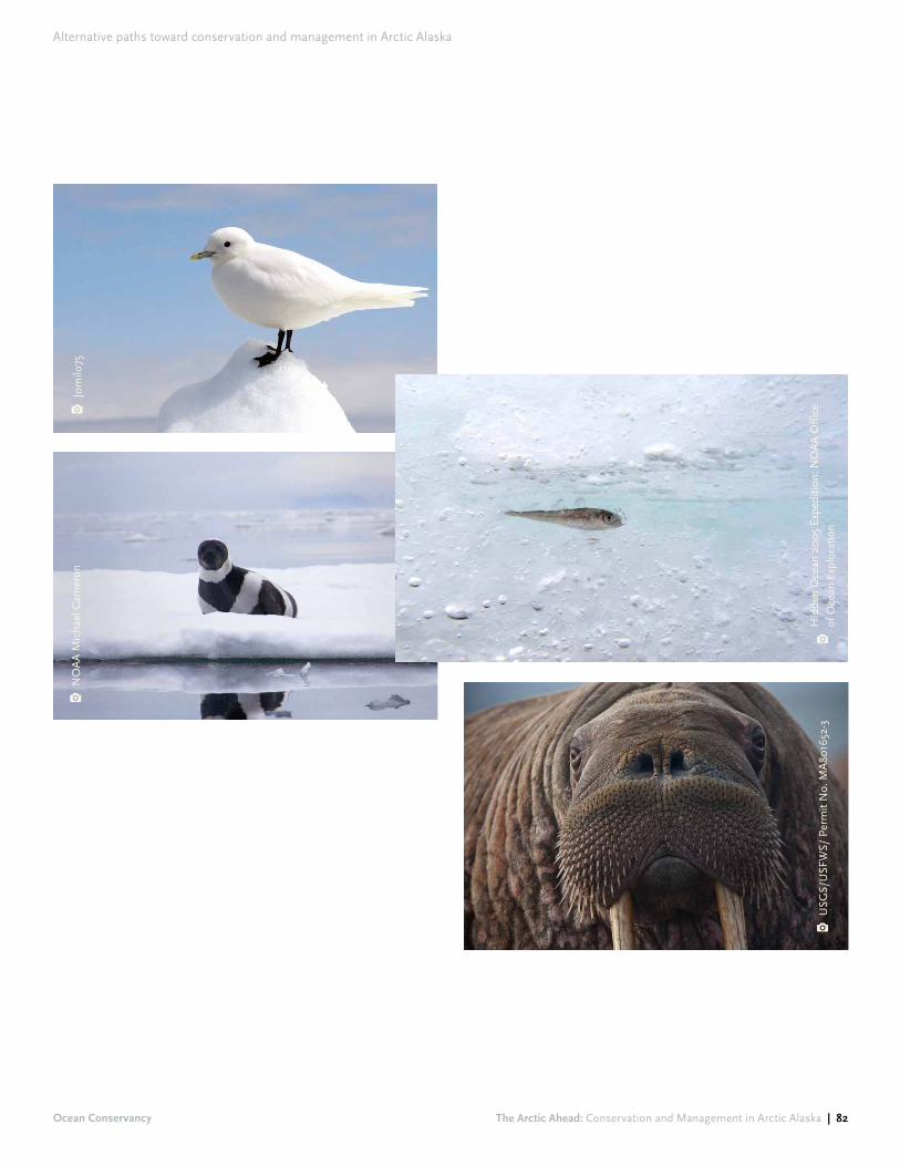
Alternative paths toward conservation and management in Arctic Alaska
Ocean Conservancy The Arctic Ahead: Conservation and Management in Arctic Alaska | 82
USG
S/U
SFW
S/ P
erm
it N
o. M
A80
1652
-3
Jom
ilo75
NO
AA
Mic
hael
Cam
eron
Hid
den
Oce
an 2
005
Expe
ditio
n: N
OA
A O
ffice
of
Oce
an E
xplo
ratio
n
Alternative paths toward conservation and management in Arctic Alaska
Ocean Conservancy The Arctic Ahead: Conservation and Management in Arctic Alaska | 83
3Another strategy would use the concept of Integrated Arctic Management to emphasize science-based management that prioritizes ecosystem functioning and resilience. Such an approach would identify and conserve high-value habitat and subsistence-use areas – both onshore and offshore – while allowing for carefully regulated industrial development and activity in limited areas.
Under such a strategy, there would be no new industrial activity in areas beyond the existing footprint of industrial infrastructure unless and until a regional plan is developed and implemented in accordance with the principles of Integrated Arctic Management.
As noted at the outset of this report, these principles include:155
! Planning on a regional-scale that is precautionary in outlook, engages all stakeholders, and crosses jurisdictional boundaries using a “whole of government” approach;
! Engaging in meaningful consultation with local communities, including consultation with respect to traditional knowledge and subsistence activities;
! Using the best available science to guide decision-making while also being mindful of data gaps and limitations of existing knowledge;
! Identifying and protecting areas of particular ecological or cultural importance;
! Analyzing rigorously the potential cumulative impacts of existing and reasonably foreseeable future development;
! Implementing and maintaining monitoring that is sufficiently rigorous to detect ongoing changes and impacts, both onshore and offshore;
! Committing to adaptive management that allows for management changes as conditions changes or new information becomes available.
Under an Integrated Arctic Management approach, existing conservation areas would continue to be protected. This would encompass all the various units administered by the National Park Service and U.S. Fish and Wildlife Service, including the Arctic National Wildlife Refuge and the 1002 Area within it. It would also encompass the five existing Special Areas in the NPR-A: Colville River, Teshekpuk Lake, Utukok River Uplands, Peard Bay and Kasegaluk Lagoon.
Offshore, certain areas of the Chukchi and Beaufort seas are already withdrawn from consideration for new leasing and exploration. Existing withdrawals, however, do not include many areas of high-value marine habitat and leave out substantial segments of important marine migratory corridors. To ensure protection of high-value habitat and subsistence use areas, significant additional offshore areas would need to be designated unavailable for leasing and exploration. Additional scientific research may be necessary to increase our understanding of the
Protection of the Arctic ecosystem through Integrated Arctic Management
Alternative

Alternative paths toward conservation and management in Arctic Alaska
Ocean Conservancy The Arctic Ahead: Conservation and Management in Arctic Alaska | 84
Arctic marine ecosystem, fill remaining data gaps and decrease uncertainties with respect to the identification of important marine areas.
Even if important marine areas were successfully identified and placed off-limits to oil and gas leasing and exploration, these areas would not necessarily be protected from the impacts of a spill originating from oil and gas activity in another offshore area. Oil from such a spill would be extremely difficult to clean effectively, could travel long distances, persist over a long time, and have devastating impacts to marine wildlife. An offshore oil spill could also have significant adverse effects on marine subsistence hunting activities. For all these reasons, protecting key habitat and subsistence areas would require significant advancement of offshore oil spill prevention and response before oil and gas activities could be allowed to proceed in the marine environment.
As noted above, it is unrealistic to ban vessel traffic throughout the project area. But under an Integrated Arctic Management approach, risks associated with increasing vessel traffic could be reduced substantially by regulating shipping carefully, especially in vessel traffic hotspots such as the Bering Strait region. For example, vessel traffic could be confined to specific traffic lanes and subject to targeted closures at critical times and/or in areas of high-value habitat or where there is high potential for conflict with subsistence users. These time/area closures could be combined with other measures to further reduce risks associated with increasing vessel traffic. For
example, vessel speed limits could be imposed to minimize the potential for ship strikes; emission and discharge could be more strictly regulated to limit pollution; communications systems could be built to increase maritime awareness; and emergency response assets could be built up in the region to prevent and respond to accidents.
Under an Integrated Arctic Management-based strategy, industrial development in the project area would not be foreclosed. Existing industrial infrastructure and activities could continue, and – if consistent with a regional integrated management plan – new development could proceed in areas outside of the spatial protections described above
However, to the extent that industrial activities proceed, they should be subject to rigorous regulations, stipulations and mitigation measures to ensure that negative impacts are minimized. Consistent with the principles of Integrated Arctic Management, ongoing monitoring should be used to determine whether mitigation measures are having their desired effects. If mitigation measures are ineffective, adaptive management should lead to appropriate modifications. If a regional plan allows for the possibility of offshore drilling, operators who seek to undertake such activities should be required to demonstrate the ability to effectively contain and clean up a worst-case oil spill before planners and managers decide whether to allow the project to proceed.
As noted above, it is unrealistic to ban vessel traffic throughout the project area. But under an Integrated Arctic Management approach, risks associated with increasing vessel traffic could be reduced substantially by regulating shipping carefully, especially in vessel traffic hotspots such as the Bering Strait region.
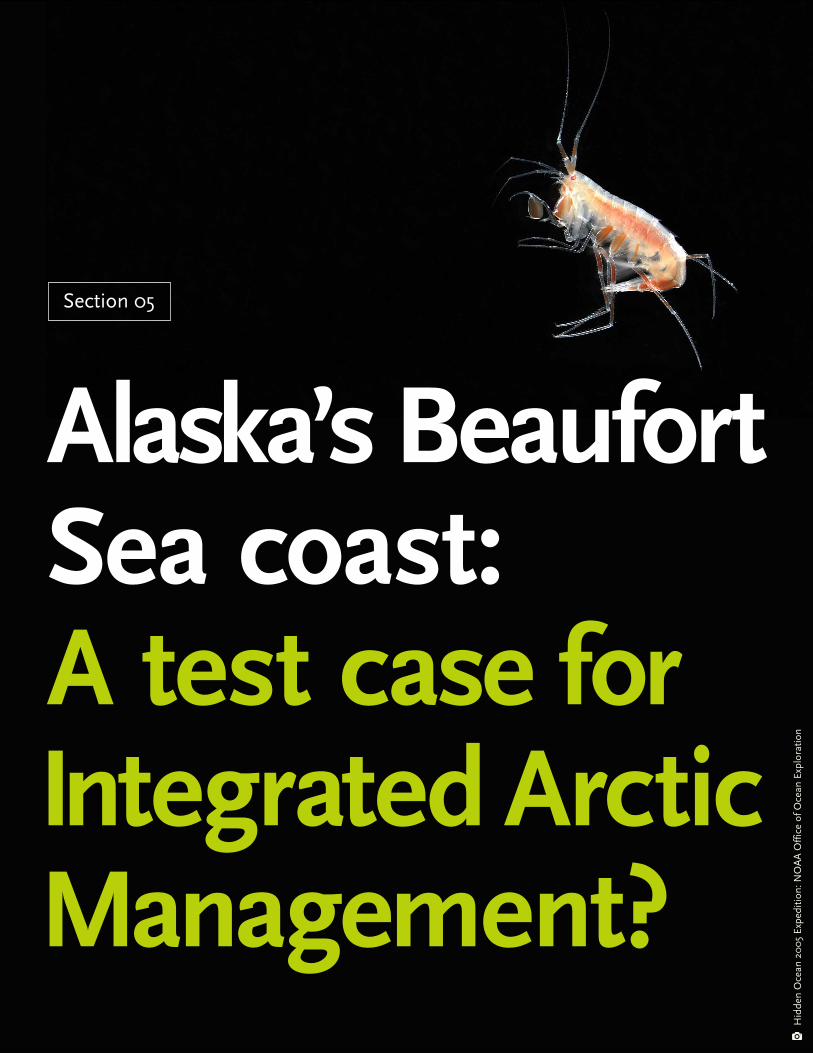
Section 05
Alaska’s Beaufort Sea coast: A test case for Integrated Arctic Management?
Hid
den
Oce
an 2
005
Expe
ditio
n: N
OA
A O
ffice
of O
cean
Exp
lora
tion

Alaska’s Beaufort Sea coast: A test case for Integrated Arctic Management?
Ocean Conservancy The Arctic Ahead: Conservation and Management in Arctic Alaska | 86
In the wake of decisions by Shell and Statoil to retreat from Chukchi Sea oil and gas operations, development of Chukchi Sea oil leases now seems less likely, at least in the relatively short term. Nonetheless, other aspects of the medium- and high-development scenarios are moving forward, especially in the coastal lands and nearshore waters from Barrow to Kaktovik. As noted above, oil and gas projects continue at Point Thomson, Liberty, CD-5, and Greater Mooses Tooth 1. In addition, Caelus Energy has applied for a permit to explore for oil in state waters in Smith Bay.156 In the near-term future, this area – the Beaufort coast region – appears to be the focal point for industrial infrastructure and associated activity in Arctic Alaska.
Development of oil and gas resources in the Beaufort coast region could bring economic and social benefits to the North Slope and to the State of Alaska. But it could also pose significant risks for important wildlife habitat, both onshore and offshore. Similarly, it could adversely affect the availability of some subsistence resources, or the ability of residents to pursue subsistence practices in affected areas.
This complex management challenge is an ideal test case for Integrated Arctic Management, an approach that by definition “balances environmental, economic, and cultural needs and objectives.”157
Effective evaluation of ongoing and potential industrial development on the Beaufort coast would bring into play many of the key principles of Integrated Arctic Management, including:
! Regional-scale planning: Piecemeal evaluation of the various Beaufort coast infrastructure projects will not result in the most appropriate management solution for the region. Instead, achieving an optimal balance of these competing concerns demands a coordinated plan for the region as a whole.
! “Whole of government” approach: A wide variety of federal agencies has jurisdiction over lands and activities on the Beaufort Sea coast. Effective planning and management will require these government agencies to closely coordinate their planning and decision-making.
! Stakeholder engagement and meaningful consultation: A wide range of stakeholders has interests in the Beaufort coast region. Effective and transparent engagement with all types of constituencies will help decision-makers elicit information, identify concerns and balance competing interests.
In the wake of decisions by Shell and Statoil to retreat from Chukchi Sea oil and gas operations, development of Chukchi Sea oil leases now seems less likely, at least in the relatively short term. Nonetheless, other aspects of the medium- and high-development scenarios are moving forward, especially in the coastal lands and nearshore waters from Barrow to Kaktovik.

Ocean Conservancy The Arctic Ahead: Conservation and Management in Arctic Alaska | 87
Alaska’s Beaufort Sea coast: A test case for Integrated Arctic Management?
! Identification and protection of important areas: The Beaufort coast contains a variety of important areas, including subsistence use areas and key habitat for important marine and terrestrial mammals and birds. To ensure “continuity of ecosystem functions and services,”158 these areas must be identified and protected.
! Rigorous analysis of cumulative impacts: A number of industrial projects has been proposed along the Beaufort coast, both onshore and offshore. Although these projects may fall under different regulatory regimes, their impacts will combine in various ways. Meaningful analysis of the cumulative effects is necessary to ensure that the impacts of these projects do not combine in ways that would jeopardize the sustainability of the ecosystem.
Proper implementation of Integrated Arctic Management on the Beaufort coast would also involve using the best available science and integration of traditional knowledge to guide decision-making, establishing baseline information and carrying out ongoing monitoring, and applying an adaptive management approach that adjusts to changing conditions and new information.
While it is easy to list the benefits of Integrated Arctic Management and its associated principles, implementation of this approach to the Beaufort coast will be a significant challenge. Among other things, it will require strong federal leadership to coordinate multiple management agencies with differing oversight and regulatory mandates. It will also require collaboration among non-federal entities with widely varying priorities, including the State of Alaska, local and tribal governments, Alaska Native organizations, non-governmental organizations and industry groups. Despite these and other challenges, Integrated Arctic Management provides a strong and flexible framework for future Beaufort coast planning efforts to build upon.
CHUKCHI SEA DEVELOPMENT While interest in developing the oil and gas resources of the Chukchi Sea seems to have ebbed for now, changes in the energy market could rekindle interest in the region in the future. If development and production of the oil and gas resources of the Chukchi Sea does proceed, it would be enormously risky. Bringing Chukchi Sea hydrocarbons to market would likely require construction of offshore platforms, subsea pipelines to connect the platforms to the Chukchi coast, onshore processing facilities and a new pipeline system across the NPR-A from Wainwright to TAPS. This growth would bring industrial infrastructure and operations to vast new areas of the U.S. Arctic and would likely facilitate additional projects that would generate their own infrastructure and operations (e.g., a pipeline across the NPR-A would likely trigger oil and gas development along its path). Chukchi Sea development and production would almost certainly lead to enormous and long-lasting impacts to wildlife habitat and subsistence use areas both onshore and offshore. In short, development and production of oil and gas resources in the Chukchi Sea – including a pipeline across the NPR-A – has the potential to significantly transform the region.
BERING STRAIT SHIPPING Applying Integrated Arctic Management to the Beaufort coast will help guide future development in that region, but it will not address all the challenges facing the region. For example, a planning effort focused on the oil and gas sector on the Beaufort coast would not be the optimal vehicle to address vessel traffic-related challenges hundreds of miles away in the Bering Strait region. Vessel traffic in the U.S. Arctic brings into play additional stakeholders and raises additional issues that are less relevant to the Beaufort coast region. For these reasons – in addition to applying Integrated Arctic Management to the Beaufort coast – efforts to address the impacts associated with increasing vessel traffic in Arctic waters should be prioritized. Key issues include increasing maritime safety, reducing environmental impacts, and minimizing conflicts with other users, including subsistence hunters and commercial fishing operators. These efforts may be especially important in the Bering Strait region, where the density of vessel traffic is higher relative to other portions of the project area.

The Arctic Ahead: Conservation and Management in Arctic Alaska | 88
Section 06
ConclusionN
ASA

The scenarios and map-based approach presented in this report represents one way to move toward more integrated planning and management in the Arctic Alaska region. Future development scenarios are useful tools to address the uncertainties associated with a rapidly changing Arctic. Because scenarios tell stories about how the future might unfold, they provide a convenient framework for thinking about the entire Arctic region and the multiple industrial sectors that are active in that region in a more comprehensive manner than is currently employed. Combining scenarios with map-based analyses helps to visualize relationships between and among industrial infrastructure and activities, conservation values, and subsistence and cultural values, and helps to highlight potential risks and areas of conflict.
Conclusion
Ocean Conservancy The Arctic Ahead: Conservation and Management in Arctic Alaska | 89

The maps and analysis in this report show that future infrastructure (e.g., additional wells, roads and pipelines) and activities (e.g., increasing low-altitude overflights and vessel traffic) could pose significant risks to wildlife habitat, subsistence use areas and culturally important areas in the region. In the near term, it appears that the Beaufort Sea coastal area between Barrow and Kaktovik will be a focal point for future industrial infrastructure and activity. Balancing economic, social and environmental factors in this portion of Arctic Alaska presents a significant challenge. At the same time, it is an excellent opportunity to put into practice the concept and principles of Integrated Arctic Management. Implemented correctly, Integrated Arctic Management offers an inclusive and pragmatic approach that focuses on maintaining ecosystem functioning and services while at the same time allowing for careful and thoughtful industrial development.
Conclusion
Ocean Conservancy The Arctic Ahead: Conservation and Management in Arctic Alaska | 90

Original maps: Sources and processing
Map A: Community Subsistence Use AreasSources: (1) Stephen R. Braund & Associates. 2010. Subsistence Mapping of Nuiqsut, Kaktovik, and Barrow. MMS OCS Study Number 2009-003.
(2) Pedersen, S. 1979. Regional Subsistence Land Use, North Slope Borough, Alaska. Occasional Paper No. 21. Anthropology and Historic Preservation, Cooperative Park Studies Unit, University of Alaska, Fairbanks, and the North Slope Borough, Barrow, Alaska.
(3) Alaska Department of Fish and Game. 2015. Community Subsistence Information System: Harvest Information. Accessed online at http://www.adfg.alaska.gov/sb/CSIS/.
Processing:! Manually digitized extent of usage polygon from source
(1) and dissolved with usage polygons from source (2).
! Downloaded and aggregated all data from source (3). For each community and each resource (birds and eggs, fish, land mammals, marine invertebrates, marine mammals, and vegetation), selected most recent study. Joined Estimated Pounds Harvested to community location shapefile and created pie chart for each community showing resource-by-resource harvest.
Map B: Native Allotments and Historic UseSources: (1) DOI-BLM. 1978. National Petroleum Reserve – Alaska Values and Resource Analysis 105 (c) Land Use Study. Bureau of Land Management, Department of the Interior.
(2) DOI-BLM. 2015. Generalized Land Status of Alaska. Alaska State Office, Bureau of Land Management, Department of the Interior, Anchorage, Alaska. Accessed online at: http://sdms.ak.blm.gov/download/landstatus/genstat.zip.
Processing:! Selected all features from source (2) with STATUS_
TYP = “Native Select” or “Native Patent or IC”.
Original Maps: sources and processing
Ocean Conservancy The Arctic Ahead: Conservation and Management in Arctic Alaska | 91

Map C: Conservation Areas Sources: (1) USGS and Interagency Wild and Scenic River Coordinating Council. 2015. National Wild and Scenic River System for Alaska. US Fish and Wildlife Service, Burbank, Washington. (2) University of Montana. 2015. National Wilderness Preservation System. Wilderness Institute, University of Montana, Missoula, Montana.
(3) BOEM. 2015. 2017-2022 Draft Proposed Program and January 27, 2015, Presidential Withdrawals GIS Files. Bureau of Ocean Energy Management. Accessed online at http://www.boem.gov/2017-2022-Map-Layer-Files/.
(4) Alaska DNR. 2015. Competitive Oil and Gas Lease Sale Regional Tract Map. Division of Oil and Gas, State of Alaska Department of Natural Resources. Accessed online at: http://dog.dnr.alaska.gov/leasing/Documents/SaleDocuments/BeaufortSea/LatestSale/BeaufortSea_LeaseSaleTractMap_201510.pdf.
(5) BLM. 2013. National Petroleum Reserve-Alaska Integrated Activity Plan Record of Decision. Bureau of Land Management, US Department of the Interior, Anchorage, AK. Accessed online at: https://eplanning.blm.gov/epl-front-office/projects/nepa/5251/42462/45213/NPR-A_FINAL_ROD_2-21-13.pdf.
Processing:! Selected relevant features from sources (1), (2), and
(3). Manually digitized features from sources (4) and (5).
Map D: Caribou Distribution Sources: (1) Gotthardt, T., T. Nawrocki, and N. Fresco. 2014. Terrestrial fine-filter conservation elements. North Slope Rapid Ecoregional Assessment. Alaska Natural Heritage Program, University of Alaska Anchorage, Anchorage, AK. (2) Griffith, B., D. Douglas, N. Walsh, D. Young, T. McCabe, D. Russell, R. White, R. Cameron, and K. Whitten. 2002. Section 3: The Porcupine Caribou Herd. In: Douglas, D., P. Reynolds, and E. Rhode (eds.). 2002. Arctic Refuge Coastal Plain Terrestrial Wildlife Research Summaries. Biological Science Report USGS/BRD 2002-0001. U.S. Geological Survey, U.S. Department of the Interior, Reston, Virginia.
Processing:! Merged, split, and dissolved layers from sources (1)
and (2) as needed to separate by season.
Original maps: Sources and processing
Ocean Conservancy The Arctic Ahead: Conservation and Management in Arctic Alaska | 92

Map E: Important Bird AreasSources: (1) Audubon Alaska. 2015. Important Bird Areas of Alaska, v3. Audubon Alaska, Anchorage, AK. Accessed online at http://databasin.org/datasets/f9e442345fb54ae28cf72f249d2c23a9.
(2) World Seabird Union. 2011. Seabird Information Network: North Pacific Seabird Data Portal. World Seabird Union. Accessed online at http://axiom.seabirds.net/portal.php.
Processing:! From source (2), aggregated number of auklets,
puffins, and other birds by colony and created pie chart for each colony showing group-by-group population.
Map F: Polar Bear DistributionSources: (1) NOAA. 1988. Bering, Chukchi, and Beaufort Seas Coastal and Ocean Zones Strategic Assessment: Data Atlas. Rockville, MD.
(2) USFWS. 1995. Habitat conservation strategy for polar bears in Alaska. US Fish and Wildlife Service, Anchorage, AK.
(3) Audubon Alaska. 2014. Predicted polar bear habitat use, by season. Audubon Alaska, Anchorage, AK.
Based on data from: Durner, G. M., D. C. Douglas, R. M. Nielson, S. C. Amstrup, T. L. McDonald, I. Stirling, M. Mauritzen, E. W. Born, O. Wiig, E. DeWeaver, M. C. Serreze, S. E. Belikov, M. M. Holland, J. Maslanik, J. Aars, D. C. Bailey and A. E. Derocher. 2009. Predicting 21st century polar bear habitat distribution from global climate models. Ecological Monographs 79:107-120.
Processing:! Overlaid major maternal denning area from 1) on
denning areas from 2).
! Selected only predicted probability of habitat use for months of highest activity from 3), using all available years. For August and September, data from 2009
to 2013 were used. For October, data from 2008 to 2012 were used. These data were summed using a conditional statement to suppress null values in cells that had at least one month of data coverage. Land was masked from the resulting raster, and the output was smoothed using bilinear interpolation.
Map G: Marine Mammal DistributionSource: (1) Oceana and Audubon Alaska. 2015. Marine Mammal Species Core Area Analysis. Juneau and Anchorage, AK.
Based on data from:NOAA Fisheries. 2014. Aerial Surveys of Arctic Marine Mammals (ASAMM). National Marine Mammal Laboratory, National Oceanic and Atmospheric Administration.
(2) NOAA Fisheries. 2014. Steller Sea Lion Critical Habitat Part 226: Designated Critical Habitat. National Oceanic and Atmospheric Administration.
(3) Robards, M., A. Kochnev, and S. Deming. 2007. Sharing Knowledge About Pacific Walrus (published map).
(4) ADF&G. 1997. Most Environmentally Sensitive Area (MESA) Data. Habitat and Restoration Division, Alaska Department of Fish & Game, Anchorage, AK.
(5) Huntington, H. P. and the communities of Buckland, Koyuk, Point Lay, and Shaktoolik. 1999. Traditional Knowledge of the Ecology of Beluga Whales (Delphinapterus leucas) in the Eastern Chukchi and Northern Bering seas, Alaska. Arctic 52:49-61.
(6) Lowry, L. F., K. J. Frost, R. Davis, D P. DeMaster and R. S. Suydam. 1998. Movements and Behavior of Satellite-Tagged Spotted Seals (Phoca largha) in the Bering and Chukchi Seas. Polar Biology 19:221-230.
(7) Rugh, D. J., K. E. W. Shelden and D. E.Withrow. 1997. Spotted seals, Phoca largha, in Alaska. Marine Fisheries Review 59:1-18.
(8) USFWS. 2002. Stock Assessment of the Pacific Walrus (Odobenus rosmarus divergens). US Fish and
Original maps: Sources and processing
Ocean Conservancy The Arctic Ahead: Conservation and Management in Arctic Alaska | 93

Wildlife Service, Anchorage, AK.
(9) Clarke, J. T., M. C. Ferguson, C. Curtice and J. Harrison. 2015. 8. Biologically Important Areas for Cetaceans Within U.S. Waters – Arctic Region. Aquatic Mammals 41:94-103.
Processing:! For data source (1), selected 50% isopleth for each
species. For details of isopleth analysis, see source (1).
! For data source (3), selected only haulouts with more than 100 individuals.
Map H: Vessel TrafficSource:(1) NOAA. 2013. Marine Cadastre Vessel Traffic Data. Accessed online at: http://marinecadastre.gov/ais/.
Processing:! Downloaded Automatic Identification System (AIS)
data for all UTM zones and all months for 2013. Aggregated each feature class into a merged shapefile. Sorted features by Maritime Mobile Service Identity (MMSI), by date, and time. Compared each feature to previous feature and removed all features with an identical MMSI and with time stamp within one hour of last kept feature. Created line shapefile from remaining records using concatenated MMSI and date as line ID. Removed lines that overlapping a 7-km internal buffer of AK coastline. Computed line density with a cell size of 1 km and a search radius of 1 km.
Map I: Flight DensitySource:(1) FlightAware. 2015. FlightAware Alaska North Slope Traffic (GIS Dataset). FlightAware, Houston, Texas.
Processing:! To identify low-altitude flight density, selected all
records with altitude below 2,000 feet. Calculated kernel density of aircraft overflight using a search radius of 4.8 km (per disturbance distance for staging brant calculated by Ward et al. 1999) and a cell size of 100 m.
! To identify major flight corridors, selected all records with altitude below 10,000 feet. Calculated kernel density of aircraft overflight using a search radius of 10 km and a cell size of 100m. Reclassified based on 10 quantiles, converted to polygons, and dissolved output to represent density in increments of 10%.
Map J: Coastal ErosionSources:(1) Gibbs, A.E., K.A. Ohman, and B.M. Richmond. 2015. National assessment of shoreline change – A GIS compilation of vector shorelines and associated shoreline change data for the north coast of Alaska, U.S.-Canadian border to Icy Cape. U.S. Geological Survey Open-File Report 2015-1030. U.S. Geological Survey, U.S. Department of the Interior, Reston, Virginia.
(2) Gutierrez, B.T., N.G. Plant, E.A. Pendleton, and E.R. Thieler. 2014. Using a Bayesian Network to predict shore-line change vulnerability to sea-level rise for the coasts of the United States. U.S. Geological Survey Open-File Report 2014–1083. U.S. Geological Survey, U.S. Department of the Interior, Reston, Virginia.
Processing:! Grouped features from (1) based on four break points:
all shoreline changes greater than + 1.4 meters per year were classified as Accretion, all changes between - 0.8 and + 1.39 m/y were classified as Stable, all changes between - 3.9 and - 0.8 m/y were classified as Moderate Erosion, and all changes less than - 4 m/y were classified as Severe Erosion.
! For source (2), all features with <40% probability of any type of change were masked. Features with >40% probability of one type of shoreline change were classified based on four break points: all changes greater than + 1 m/y were classified as Accretion, all changes between - 1 and + 1 m/y were classified as Stable, all changes between - 1 and - 2 m/yr were classified as Moderate Erosion, and all changes less than - 2 m/y were classified as Severe Erosion.
Original maps: Sources and processing
Ocean Conservancy The Arctic Ahead: Conservation and Management in Arctic Alaska | 94

1 See, e.g., KEVIN HILLMER-PEGRAM, A Synthesis of Existing, Planned, and Proposed Infrastructure and Operations Supporting Oil and Gas Activities and Commercial Transportation in Arctic Alaska (2014), https://www.iarc.uaf.edu/sites/default/files/node/4216/final_arcticalaskaoil_gasinfrastructuresynthesis_2_19975.pdf (compiling information about existing and future development projects and activity in Arctic Alaska).
2 ALASKA OIL AND GAS CONSERVATION COMMISSION, AOGCC Pool Statistics, Prudhoe Bay Unit, Prudhoe Oil Pool, http://doa.alaska.gov/ogc/annual/current/18_Oil_Pools/Prudhoe%20Bay%20-%20Oil/Prudhoe%20Bay,%20Prudhoe%20Bay/1_Oil_1.htm.
3 BUREAU OF OCEAN ENERGY MANAGEMENT, Liberty Development and Production Plan: Notice of Intent to Prepare an Environmental Impact Statement (Sept. 25, 2015), https://www.federalregister.gov/articles/2015/09/25/2015-24391/outer-continental-shelf-alaska-region-beaufort-sea-planning-area-liberty-development-and-production (announcing intent to prepare an EIS for a new development prospect in federal waters of the Beaufort Sea).
4 OIL AND GAS JOURNAL, Oil production begins from CD5 drill site in NPR-A (Oct. 28, 2015), http://www.ogj.com/articles/2015/10/oil-production-begins-from-cd5-drill-site-in-npr-a.html (noting that the CD5 site is the first commercial oil development on Alaska Native lands within the National Petroleum Reserve-Alaska).
5 BUREAU OF OCEAN ENERGY MANAGEMENT, Alaska Region, “Detailed Listing of Active Leases, updated December 1, 2015, p. 193, http://www.boem.gov/Alaska-Detailed-Listing-of-Active-Leases/ [hereinafter Active Leases] (listing hundreds of active Chukchi Sea oil and gas leases sold in lease sale).
6 See generally, U.S. COMMITTEE ON THE MARTINE TRANSPORTATION SYSTEM, U.S. Arctic Marine Transportation System: Overview and Priorities for Action (2013), http://www.cmts.gov/downloads/CMTS%20U%20
S%20%20Arctic%20MTS%20Report%20%2007-30-13.pdf [hereinafter Arctic Marine Transportation].
7 NORTH PACIFIC FISHERY MANAGEMENT COUNCIL, Fishery Management Plan for Fish Resources of the Arctic Management Area ES-1, pp. 3-4 (Aug. 2009), http://www.npfmc.org/wp-content/PDFdocuments/fmp/Arctic/ArcticFMP.pdf [hereinafter NPFMC Fishery Management Plan] (“For Arctic fish resources, the policy is to prohibit all commercial harvests of fish until sufficient information is available to support the sustainable management of a commercial fishery”).
8 See, e.g., INTERNATIONAL CRYOSPHERE CLIMATE INITIATIVE, Thresholds and Closing Windows: Risks of Irreversible Cryosphere Climate Change, p. 2 (2015) (noting that even if countries follow through on commitments to reduce carbon emissions, peak global carbon emissions “almost certainly will trigger permanent” and irreversible changes including complete loss of most mountain glaciers, complete loss of summer Arctic sea ice, and higher acidification), http://iccinet.org/wp-content/uploads/2015/11/ICCI_thresholds_v6b_151203_high_res.pdf; see also, Id. at 20 (noting that current carbon dioxide concentrations already represent a significant threat, and that acidification takes “many thousands of years” to reverse after carbon dioxide emissions stop).
9 See generally, CLEMENT, J. P., J. L. BENGTSON, AND B. P. KELLY, Managing for the Future in a Rapidly Changing Arctic: A report to the President. INTERAGENCY WORKING GROUP ON COORDINATION OF DOMESTIC ENERGY DEVELOPMENT AND PERMITTING IN ALASKA, (2013), https://www.doi.gov/sites/doi.gov/files/migrated/news/upload/ArcticReport-03April2013PMsm.pdf [hereinafter Clement].
10 Id.
11 Id.
12 Id. at 45-46.
Endnotes
Ocean Conservancy The Arctic Ahead: Conservation and Management in Arctic Alaska | 95

13 Id. at 46.
14 Id. at 47.
15 DAVID A. GARVIN AND LYNNE C. LEVESQUE, A Note on Scenario Planning, HARVARD BUSINESS SCHOOL, p. 3 (July 31, 2006), http://www.northslope.org/media/doc/2014/Feb/HBR_A_note_on_scenario_planning.pdf [hereinafter Garvin].
16 CLEMENT, supra note 9, at 45.
17 See generally, NORTH SLOPE SCIENCE INITIATIVE, Scenarios for North Slope Development and Related Science Needs (undated), http://northslope.org/scenarios/ [hereinafter NSSI Scenarios].
18 Id.
19 The “Arctic” does not have a single definition. Many consider the Arctic to be the region bounded by the Arctic Circle (66° 33’ north latitude) while others describe the Arctic as the area in the northern hemisphere in which the average temperature does not rise above 10°C (50°F) for any month. Under U.S. law, the Arctic includes all lands north of the Arctic Circle, plus land along the northwest coast of Alaska south to the mouth of the Kuskokwim River, plus the Arctic Ocean, the Beaufort, Bering and Chukchi seas, and the Aleutian Islands. See, e.g., Arctic Research and Policy Act, 15 U.S.C. § 4111(2010).
20 NSSI SCENARIOS, supra note 17.
21 CLEMENT, supra note 9, at 47.
22 GARVIN, supra note 15, at 3.
23 Id.
24 NSSI SCENARIOS, supra note 17.
25 See, NORTH SLOPE SCIENCE INITIATIVE, UNIVERSITY OF ALASKA FAIRBANKS, AND
GEOADAPTIVE LLC, Scenarios for Energy and Resource Development on the North Slope and Adjacent Seas: Scenarios Implications Workshop, pp. 18-19 (June 2-3, 2015), http://northslope.org/event/scenarios2015june/ [hereinafter Scenarios Implication Workshop].
26 See, e.g., TIKIGAQ HOME PAGE, Point Hope, http://www.tikigaq.com/category/shareholder/point-hope/ (noting that Point Hope, Alaska is “reportedly the oldest continuously inhabited village on the North American continent with over 2,500 years of recorded history”).
27 See, U.S. CENSUS BUREAU, State and County Quick Facts: North Slope Borough, Alaska, http://quickfacts.census.gov/qfd/states/02/02185.html [hereinafter Quick Facts].
28 See generally, NORTH SLOPE BOROUGH, Official Website of the North Slope Borough, http://www.north-slope.org.
29 NORTH SLOPE BOROUGH, North Slope Borough: Economic Profile and Census Report 2010, p. 1, http://www.north-slope.org/assets/images/uploads/North_Slope_Borough.pdf [hereinafter Economic Profile].
30 NORTH SLOPE BOROUGH, Our Communities, http://www.north-slope.org/our-communities.
31 ECONOMIC PROFILE, supra note 29.
32 Id.
33 See generally, NORTHWEST ARCTIC BOROUGH, The Northwest Arctic Borough, http://www.nwabor.org/about.html [hereinafter Northwest Arctic Borough].
34 QUICK FACTS, supra note 27.
35 See generally, NORTHWEST ARCTIC BOROUGH, Home Page of the Northwest Arctic Borough, http://www.nwabor.org/#.
Ocean Conservancy The Arctic Ahead: Conservation and Management in Arctic Alaska | 96The Arctic Ahead: Conservation and Management in Arctic Alaska | 96
Endnotes

36 NORTHWEST ARCTIC BOROUGH, supra note 33.
37 Id.
38 KAWERAK, INC., About Us, http://www.kawerak.org/weare.html.
39 KAWERAK, INC., Communities, http://www.kawerak.org/tribalpages.html.
40 See, e.g., DAVID S. CASE AND DAVID A. VOLUCK, Alaska Natives and American Laws, 3rd Ed., p. 325 (2012) [hereinafter Case & Voluck] (noting that observers “will be impressed by the number of both unrelated and interrelated Native governments, corporations, and associations representing modern Alaska Native interests”).
41 Alaska Native Claims Settlement Act of Dec. 18, 1971, Pub. L. No. 93-2-3, codified as amended at 43 U.S.C. § 1601 et seq. There are many village corporations in the project area; some examples include: Kuukpik Corp., Inc. (Nuiqsut); Olgoonik Corp., Inc. (Wainwright); King Island Native Corp. (King Island).
42 Examples of federally recognized tribal governments in the project area include but are not limited to: Native Village of Barrow Inupiat Traditional Government, Native Village of Diomede (aka Inalik), and Native Village of Kotzebue. There are more than 200 federally recognized tribal governments in the State of Alaska. See e.g., Indian Entities Recognized and Eligible to Receive Services from the United States Bureau of Indian Affairs, 75 Fed. Reg. 60,810, 60,813-14 (Oct. 1, 2010) (listing Native Entities within the State of Alaska Recognized and Eligible to Receive Services from the United States Bureau of Indian Affairs).
43 See, e.g., DIANA HAECKER, Maritime Symposium Addresses Increased Bering Strait Ship Traffic, NOME NUGGET p. 4 (Feb. 14, 2013), http://www.nomenugget.net/archives/2013/02.14.13%20NN.pdf (noting Arctic Marine Mammal Coalition was formed to address increasing ship traffic and is composed of five Alaska Native organizations that co-manage marine mammals).
44 ARCTIC WATERWAYS SAFETY COMMITTEE, Our Work, http://www.arcticwaterways.org/attorneys-1.html.
45 BUREAU OF LAND MANAGEMENT, Final Integrated Activity Plan/Environmental Impact Statement, p. 282 (Nov. 2012), https://eplanning.blm.gov/epl-front-office/projects/nepa/5251/41003/43153/Vol1_NPR-A_Final_IAP_FEIS.pdf [hereinafter BLM Final EIS].
46 Id. at 281.
47 NATIONAL SNOW AND ICE DATA CENTER, All about Sea Ice, Wildlife: Mammals, http://nsidc.org/cryosphere/seaice/environment/mammals.html.
48 See, e.g., BUREAU OF OCEAN ENERGY MANAGEMENT, Chukchi Sea Planning Area Oil and Gas Lease Sale 193, p. ES-4 (Feb. 2015), http://www.boem.gov/uploadedFiles/BOEM/About_BOEM/BOEM_Regions/Alaska_Region/Leasing_and_Plans/Leasing/Lease_Sales/Sale_193/2015_0127_LS193_Final_2nd_SEIS_Vol1.pdf [hereinafter BOEM Chukchi Sea Planning].
49 Id. at 75.
50 BIRDLIFE INTERNATIONAL, Interactive map of Important Bird Areas, http://www.birdlife.org/datazone/site; see also, NATIONAL AUDUBON SOCIETY, Important Bird Areas Interactive Map, http://netapp.audubon.org/iba.
51 See, e.g., AUDUBON ALASKA, OCEANA, OCEAN CONSERVANCY, THE PEW CHARITABLE TRUSTS, AND WWF, Arctic-specific Comments on the Preparation of the 2017-2022 Outer Continental Shelf (OCS) oil and gas leasing program, pp. 9-22 & Fig. 1, http://www.regulations.gov/#!documentDetail;D=BOEM-2014-0096-14343.
52 AUDUBON ALASKA, Teshekpuk Lake: Arctic Nursery, video, http://ak.audubon.org/videos/teshekpuk-lake-arctic-nursery-1.
53 See, e.g., AUDUBON ALASKA, OCEANA, OCEAN CONSERVANCY, THE PEW CHARITABLE TRUSTS, AND WWF, Arctic-specific Comments on the Preparation of the 2017-2022 Outer Continental Shelf (OCS) oil and gas leasing program, pp. 9-22 & Fig. 1, http://www.regulations.gov/#!documentDetail;D=BOEM-2014-0096-14343.
Endnotes
Ocean Conservancy The Arctic Ahead: Conservation and Management in Arctic Alaska | 97

54 ARCTIC COUNCIL, Arctic Marine Shipping Assessment 2009 Report, p. 106 (2009), http://www.pame.is/images/03_Projects/AMSA/AMSA_2009_report/AMSA_2009_Report_2nd_print.pdf [hereinafter 2009 Shipping Assessment].
55 See, e.g., BUREAU OF LAND MANAGEMENT, NPR-A Integrated Activity Plan: Record of Decision, pp. 2-5 (Feb. 2013), https://eplanning.blm.gov/epl-front-office/projects/nepa/5251/42462/45213/NPR-A_FINAL_ROD_2-21-13.pdf [hereinafter NPR-A Record of Decision].
56 ALASKA DIVISION OF OIL AND GAS, 2014 Annual Report, p. 6 (2014), http://dog.dnr.alaska.gov/Publications/Documents/AnnualReports/2014_Annual_Report.pdf.
57 Id.
58 Id.
59 Id.
60 Id. at 7.
61 Id.
62 Id. at 6.
63 Id. at 7.
64 Id.
65 Id. at 25.
66 Id.
67 ALEYSKA PIPELINE SERVICE COMPANY, Pipeline Operations: Declining Throughput, http://www.alyeska-pipe.com/TAPS/PipelineOperations/LowFlowOperations.
68 See, e.g., Sen. Lisa Murkowski, Annual Address to Alaska State Legislature (Feb. 19, 2015) http://www.murkowski.senate.gov/public/index.cfm/speeches?ContentRecord_id=15467E8F-3EDD-43CE-B4AF-0374B97FDD86 (noting concern about declining TAPS throughput and proposing new oil development in the Arctic National
Wildlife Refuge and NPR-A); see also, Gov. Bill Walker, My Turn: My high-level talks on Air Force One, JUNEAU EMPIRE (Sept. 5, 2015) http://juneauempire.com/opinion/2015-09-06/my-turn-my-high-level-talks-air-force-one (noting that “increased flow through the Trans-Alaska Pipeline System would mitigate much of the state’s fiscal challenges”).
69 TIM BRADNER, Good news from the Slope: More Oil, Drilling, 1 ALASKA JOURNAL OF COMMERCE (Nov. 2015), http://www.alaskajournal.com/2015-10-28/good-news-slope-more-oil-drilling.
70 Id.
71 Press Release, Bureau of Land Management, BLM Approves First Federal Production Well in the National Petroleum Reserve (Oct. 22, 2015), available at http://www.blm.gov/wo/st/en/info/newsroom/2015/october/nr_10_22_2015.html.
72 Id.
73 ALAN BAILEY, Taking a Next Step: ExxonMobil Applies for AOGCC Gas Injection Order for Point Thomson Field, 20 PETROLEUM NEWS 28 (July 12, 2015), http://www.petroleumnews.com/pntruncate/949694816.shtml.
74 Id.
75 OIL AND GAS JOURNAL EDITORS, BOEM moves forward in review of Hilcorp’s Liberty prospect, OIL & GAS JOURNAL (Sept. 22, 2015), http://www.ogj.com/articles/2015/09/boem-moves-forward-in-review-of-hilcorp-s-liberty-prospect.html.
76 Id.
77 Id.
78 JENNIFER A. DLOUHY, Feds to review Hilcorp’s plan for manmade island in Arctic, FUELFIX (Sept. 21, 2015), http://fuelfix.com/blog/2015/09/21/feds-to-review-hilcorps-plan-for-manmade-island-in-arctic/.
79 ACTIVE LEASES, supra note 5 at 193.
Ocean Conservancy The Arctic Ahead: Conservation and Management in Arctic Alaska | 98The Arctic Ahead: Conservation and Management in Arctic Alaska | 98
Endnotes

80 Press Release, Minerals Management Service, MMS Chukchi Sea Lease Sale 193 Breaks Energy Records with $2.6 Billion in High Bids; Record Number of Bids on Record Number of Tracts (Feb. 6, 2008), available at http://www.boem.gov/boem-newsroom/press-releases/2008/press0206.aspx.
81 JENNIFER A. DLOUGHY, Statoil may Abandon U.S. Arctic Drilling Leases, FUELFIX (March 5, 2013), http://fuelfix.com/blog/2013/03/05/statoil-may-abandon-us-arctic-drilling-leases/.
82 Press Release, ConocoPhillips, Regulatory Uncertainty Leads ConocoPhillips to Put 2014 Chukchi Sea Exploration Drilling Plans on Hold (April 10, 2013), available at http://alaska.conocophillips.com/Documents/NR-AK-Chukchi%20Sea-FINAL%204-9-2013.pdf.
83 See, e.g., MCKENZIE FUNK, The Wreck of the Kulluk, NEW YORK TIMES (Dec. 30, 2014), http://www.nytimes.com/2015/01/04/magazine/the-wreck-of-the-kulluk.html.
84 Press Release, Shell United States, Shell Updates of Alaska Exploration (Sept. 28, 2015), available at http://www.shell.com/media/news-and-media-releases/2015/shell-updates-on-alaska-exploration.html [hereinafter Shell’s Alaska Update].
85 Id.
86 STATOIL, Statoil exits Alaska, (Nov. 17, 2015), http://www.statoil.com/en/NewsAndMedia/News/2015/Pages/17Nov_Alaska.aspx.
87 SHELL’S ALASKA UPDATE, supra note 84.
88 JENNIFER DLOUHY, Shell Seeks to Preserve U.S. Drilling Rights in Arctic Ocean, BLOOMBERG POLITICS (Dec. 15, 2015), http://www.bloomberg.com/politics/articles/2015-12-15/shell-bid-aims-to-preserve-u-s-drilling-rights-in-arctic-ocean.
89 ARCTIC MARINE TRANSPORTATION, supra note 6, at 18.
90 CLEMENT, supra note 9, at 7.
91 ARCTIC MARINE TRANSPORTATION, supra note 6, at 21.
92 CLEMENT, supra note 9, at 17.
93 U.S. COMMITTEE ON THE MARTINERANSPORTATION SYSTEM, A 10-Year Projection of Maritime Activity in the U.S. Arctic Region, p. 7 (Jan. 2015), http://www.cmts.gov/downloads/CMTS_10-Year_Arctic_Vessel_Projection_Report_1.1.15.pdf [hereinafter 10 year projection].
94 2009 SHIPPING ASSESSMENT, supra note 54, at 44.
95 ROYAL BELGIAN INSTITUTE OF MARINE ENGINEERS, Arctic Transit: Northern Sea Route (2012), http://www.gallois.be/ggmagazine_2013/gg_02_03_2013_90.pdf.
96 ARCTIC MARINE TRANSPORTATION, supra note 6, at 44.
97 NORTHERN SEA ROUTE INFORMATION OFFICE, Final Statistics Figures for Transit Navigation on the NSR in 2013, http://arctic-lio.com/docs/nsr/transits/Transits_2013_final.pdf.
98 DAVID THURTON, Arctic Shipping Route through Russia Planned by Chinese Company: 1st Company to Plan Regularly Scheduled Container-Ship Traffic through Arctic Ocean, CBC NEWS (Oct. 30, 2015), http://www.cbc.ca/news/canada/north/arctic-shipping-route-through-russia-planned-by-chinese-company-1.3296334.
99 ARCTIC MARINE TRANSPORTATION, supra note 6, at 19.
100 ALASKA STATE LEGISLATURE, Alaska Northern Waters Task Force Findings and Recommendations, p. 15 (2012), available at http://housemajority.org/joule/pdfs/27/hjr0034_anwtf_recommendations.pdf [hereinafter Alaska Northern Waters].
101 JOHN MCGARRITY & HENNING GLOYSTEIN, Northwest Passage Crossed by First Cargo Ship, Nordic Orion, Heralding New Era of Arctic Commercial Activity, NATIONAL POST (Sept. 27, 2013), http://news.nationalpost.com/news/canada/northwest-passage-crossed-by-first-cargo-ship-the-nordic-orion-heralding-new-
Endnotes
Ocean Conservancy The Arctic Ahead: Conservation and Management in Arctic Alaska | 99

era-of-arctic-commercial-activity.
102 BECKY OSKIN, Cargo Ship Makes 1st-Ever Solo Trip through Northwest Passage, LIVESCIENCE (Oct. 1, 2014), http://www.livescience.com/48105-cargo-ship-solos-northwest-passage.html.
103 ALASKA NORTHERN WATERS, supra note 100.
104 ARCTIC MARINE TRANSPORTATION, supra note 6, at 14-23; see also, 10 YEAR PROJECTION, supra note 93, at 25-26 (noting that oil and gas facilities in the Beaufort Coast generate vessel traffic).
105 ALASKA NORTHERN WATERS, supra note 100.
106 See, e.g., EMILY PAYNE, Race to the ends of the earth! Luxury Cruise Liner to become the First to Traverse Arctic’s Notorious Northwest Passage (but it will cost passengers up to £93,000), DAILY MAIL (Sept, 9, 2014), http://www.dailymail.co.uk/travel/travel_news/article-2748999/Race-ends-earth-Luxury-cruise-liner-Crystal-Serenity-traverse-notorious-Northwest-Passage.html (noting that the 132-passenger Silver Explorer had already transited the Northwest Passage).
107 Id.
108 ARCTIC MARINE TRANSPORTATION, supra note 6.
109 Press Release, National Oceanic Atmospheric Administration, NOAA plans increased 2015 Arctic nautical charting operations; coordinating with Coast Guard for safe shipping route from Unimak Pass through Bering Strait (March 17, 2015), available at http://www.noaanews.noaa.gov/stories2015/20150317-noaa-plans-increased-2015-arctic-nautical-charting-operations.html.
110 See generally, UNITED STATES COAST GUARD, The U.S. Coast Guard’s Vision for Operating in the Arctic Region (May 2013), http://www.uscg.mil/seniorleadership/DOCS/CG_Arctic_Strategy.pdf.
111 ASAF SHALEV, Coast Guard Anticipates High-tech Future with New Arctic R&D Center, ALASKA DISPATCH NEWS (Nov. 1, 2015), http://www.adn.com/
article/20151101/coast-guard-anticipates-high-tech-future-new-arctic-rd-center.
112 FRANCESCA FENZI, Nome Could Have Deep-Draft Arctic Port by 2020, ALASKA DISPATCH NEWS (March 24, 2015), http://www.adn.com/article/20150324/nome-could-have-deep-draft-arctic-port-2020.
113 ALEX DEMARBAN, Work Toward Deep-Water Port in Alaska Arctic on Hold, Army Corps says, ALASKA DISPATCH NEWS (Oct. 26, 2015), http://www.adn.com/article/20151026/work-toward-deep-water-port-alaska-arctic-hold-army-corps-says.
114 NPFMC FISHERY MANAGEMENT PLAN, supra note 7.
115 YERETH ROSEN, 5 Nations Sign Declaration to Protect Arctic ‘donut hole’ from Unregulated Fishing, ALASKA DISPATCH NEWS (July 16, 2015), http://www.adn.com/article/20150716/5-nations-sign-declaration-protect-arctic-donut-hole-unregulated-fishing.
116 NOAA NMFS ALASKA FISHERIES SCIENCE CENTER, Discussion Paper: Considerations for Research Planning in the Northern Bering Sea Research Area, p. 1 (Sept. 2012), http://www.npfmc.org/wp-content/PDFdocuments/rural_outreach/NBSRA_DiscPap_912.pdf [hereinafter Alaska Fisheries Science Center].
117 See generally, Groundfish Fisheries of the Bering Sea and Aleutian Islands Management Area, 73 Fed. Reg. 43,362, 43,362–73 (July 25, 2008), available at https://alaskafisheries.noaa.gov/sites/default/files/finalrules/73fr43362.pdf; see also, NORTH PACIFIC FISHERIES MANAGEMENT COUNCIL, Agenda Item D-3, Bering Sea Habitat Conservation, Council Motion (June 10, 2007), http://www.npfmc.org/wp-content/PDFdocuments/conservation_issues/BSHC/BSHC607motion.pdf.
118 ALASKA FISHERIES SCIENCE CENTER, supra note 116, at 6.
119 CLEMENT, supra note 9, at 17.
120 RED DOG ALASKA, Red Dog Operations Fact
Endnotes
Ocean Conservancy The Arctic Ahead: Conservation and Management in Arctic Alaska | 100The Arctic Ahead: Conservation and Management in Arctic Alaska | 100

Sheet (2009), http://www.reddogalaska.com/Generic.aspx?PAGE=Red+Dog+Site
121 2009 SHIPPING ASSESSMENT, supra note 54, at 76.
122 10 YEAR PROJECTION, supra note 93.
123 GARVIN, supra note 15, at 1.
124 SCENARIOS IMPLICATION WORKSHOP, supra note 25, at 14.
125 Id. at 15.
126 For more information and maps about ecological and subsistence patterns in marine waters of the Bering Strait region, see generally, KAWERAK, INC. AND OCEANA, Bering Strait: Marine Life and Subsistence Use Data Synthesis (July 2014) http://oceana.org/sites/default/files/final_pdf_bering_strait_synthesis_july_30_2014_0.pdf.
127 U.S. FISH AND WILDLIFE SERVICE, Arctic National Wildlife Refuge, Alaska: Facts and Figures, http://www.fws.gov/refuge/arctic/facts_and_features.html.
128 U.S. FISH AND WILDLIFE SERVICE, Management of the 1002 Area within the Arctic Refuge Coastal Plain, http://www.fws.gov/refuge/arctic/1002man.html.
129 16 U.S.C. § 3143; see also, Id. at § 3142(i) (withdrawing public lands within the coastal plain from entry or appropriation under the mining laws and from operation of mineral leasing until Congress provided otherwise).
130 Memorandum on Withdrawal of Certain Areas of the United States Outer Continental Shelf Offshore Alaska from Leasing Disposition (Jan. 27, 2015), available at https://www.whitehouse.gov/the-press-office/2015/01/27/presidential-memorandum-withdrawal-certain-areas-united-states-outer-con [hereinafter Memo on Withdrawal]; see also, MIKE BOOTS & DAN UTECH, President Obama Protects Untouched Marine Wilderness in Alaska (Jan. 27, 2015), https://www.whitehouse.gov/blog/2015/01/27/president-obama-protects-untouched-marine-wilderness-alaska [hereinafter Boots & Utech].
131 BUREAU OF LAND MANAGEMENT, National Petroleum Reserve – Alaska (NPR-A) Planning Area, http://www.blm.gov/ak/st/en/prog/planning/npra_general.html.
132 NPR-A RECORD OF DECISION, supra note 55, at 2-4.
133 Id. at 112.
134 Id.
135 MEMO ON WITHDRAWAL, supra note 130; see also, BOOTS & UTECH, supra note 130; and see, WHITE HOUSE, Map: Beaufort Sea Planning Area, available at https://www.whitehouse.gov/sites/default/files/docs/tab_d_-_v_map.pdf.
136 MEMO ON WITHDRAWAL, supra note 130; BOOTS & UTECH, supra note 130; WHITE HOUSE, Map: Chukchi Sea Planning Area, available at https://www.whitehouse.gov/sites/default/files/docs/tab_c_-_chukchi_map.pdf.
137 See, e.g., U.S. FISH AND WILDLIFE SERVICE, Frequently Asked Questions about Caribou: Caribou Migration, http://www.fws.gov/refuge/arctic/carcon.html (noting that individuals in the Porcupine herd have been observed to travel over 3,000 miles per year).
138 See, GABRIELA HALAS, Caribou Migration, Subsistence Hunting, and User Group Conflicts in Northwest Alaska: A Traditional Knowledge Perspective, p. 60 (2015) (unpublished Master’s Thesis, Univ. of Alaska Fairbanks) available at https://scholarworks.alaska.edu/handle/11122/6090?show=full [hereinafter Caribou Migration] (finding that subsistence hunters near Noatak, Alaska reported that aircraft overflights had the highest negative impact to local subsistence caribou hunting); see also, BLM FINAL EIS, supra note 45, at 439 (noting that concerns expressed during scoping process included reducing the number of overflights, especially during hunting season).
139 BLM FINAL EIS, supra note 45, at 166, 174, 211, 257 (citing studies indicating that low-altitude overflights disturbed birds including brant flocks and geese, as well as marine mammals such as spotted seals and polar bears).
Ocean Conservancy The Arctic Ahead: Conservation and Management in Arctic Alaska | 101
Endnotes

The Arctic Ahead: Conservation and Management in Arctic Alaska | 102
140 NPR-A RECORD OF DECISION, supra note 55, at 66.
141 For purposes of this report, the term “erosion” indicates any type of retreat of the shoreline—whether from actual erosion or sea level rise. See, ANN E. GIBBS AND BRUCE M. RICHMOND, National Assessment of Shoreline Change—Historical Shoreline Change Along the North Coast of Alaska, U.S.–Canadian Border to Icy Cape, U.S. GEOLOGICAL SURVEY OPEN-FILE REPORT, 2015–1048, p.1 (2015), available at http://pubs.usgs.gov/of/2015/1048/pdf/ofr2015-1048.pdf [hereinafter Gibbs & Richmond] (“no distinction is made between physical erosion and land loss or shoreline retreat as a result of breaching of coastal lake shorelines or flooding of the coast due to sea-level rise or land subsidence; in this context erosion and retreat are interchangeable”).
142 GIBBS AND RICHMOND at 2.
143 YERETH ROSEN, North Slope Coastal Erosion Rates are among Worst in Nation, USGS reports, ALASKA DISPATCH NEWS (July 1, 2015), http://www.adn.com/article/20150701/north-slope-coastal-erosion-rates-are-among-worst-nation-usgs-reports [hereinafter Coastal Erosion].
144 GIBBS & RICHMOND, supra note141, at 2.
145 Id.
146 COASTAL EROSION, supra note 143.
147 Id.
148 SCENARIOS IMPLICATION WORKSHOP, supra note 25, at 18-19.
149 CARIBOU MIGRATION, supra note 138, at 60; see also, BLM FINAL EIS, supra note 45, at 439.
150 NUKA RESEARCH AND PLANNING GROUP, Estimating an Oil Spill Response Gap for the Arctic Ocean, p. 32 (Sept. 2014), http://www.nukaresearch.com/files/140910_Arctic_RGA_Report_FNL.pdf.
151 BOEM CHUKCHI SEA PLANNING, supra note 48, at 156.
152 GUNNAR KNAPP, An Introduction to Alaska Fiscal Facts and Choices, presentation given at ‘Building a Sustainable Future: Conversation with Alaskans,’ p. 5 (June 5, 2015) http://gov.alaska.gov/Walker_media/documents/20150605_an-introduction-to-alaska-fiscal-facts-and-choices.pdf (noting that from 2005 to 2014, taxes oil revenues generated roughly 90% of Alaska’s general fund revenues).
153 See, e.g., U.S. DEPARTMENT OF DEFENSE, Fact Sheet: Freedom of Navigation Program, (March 2015) (http://policy.defense.gov/Portals/11/Documents/gsa/cwmd/DoD%20FON%20Program%20--%20Fact%20Sheet%20(March%202015).pdf (noting that U.S. interests and policies for “preserving freedom of the seas are long-standing in nature and global in scope”).
154 See, e.g., U.N. Convention on the Law of the Sea, December 10, 1982, Part II, Sec. 3, Arts. 17–25 (describing right of innocent passage) and Part VII, Sec. 1, Arts. 87–90, U.N.T.S. 3 (describing right of freedom of navigation).
155 CLEMENT, supra note 9, at 45-46.
156 ALASKA DEPARTMENT OF NATURAL RESOURCES, Public Notice Caelus Smith Bay Tulimaniq CT-2 Plan of Operations 2015-2016 North Slope Exploratory Drilling (Nov. 2015), https://aws.state.ak.us/OnlinePublicNotices/Notices/View.aspx?id=179079.
157 CLEMENT, supra note 9, at 46.
158 Id. at 45.
159 See, U.S. ENERGY INFORMATION ADMINISTRATION, Glossary: 2-D Seismic Survey, http://www.eia.gov/tools/glossary/.
160 Id. at 3-D Seismic Survey.
161 2009 SHIPPING ASSESSMENT, supra note 54 at 72.
162 CASE & VOLUCK, supra note 40, at 321.
163 The U.S. Army Corps of Engineers tentatively selected
The Arctic Ahead: Conservation and Management in Arctic Alaska | 102Ocean Conservancy
Endnotes

a deep-water port plan that would deepen Nome’s port to 28 feet below mean lower low water. See, U.S. ARMY CORPS OF ENGINEERS, Alaska District: FAQ [for Arctic deep-draft port], http://www.poa.usace.army.mil/Portals/34/docs/civilworks/arcticdeepdraft/FAQsforDeep.pdf. Existing ice-breakers typically require water depths of at least 35 feet below mean lower low water level. Id. One U.S. law defines a deep-water harbor as one which is authorized to be constructed to a depth of more than 45 feet. 33 U.S.C. § 2241(1).
164 See, 30 C.F.R. § 250.105.
Id.
165 See, EXXONMOBIL, About Point Thomson, http://corporate.exxonmobil.com/en/company/worldwide-operations/locations/united-states/alaska/point-thomson?parentId=d372df1b-de85-4609-9e9d-37f08b9fefe6.
166 CLEMENT, supra note 9, at 46.
167 2009 SHIPPING ASSESSMENT, supra note 54, at 20.
168 Id. at 23.
169 See, ALASKA DEPARTMENT OF NATURAL RESOURCES, Oil & Gas Definitions, http://dog.dnr.alaska.gov/AboutUs/Documents/OG_Definitions.pdf.
170 Id.
171 See, 30 C.F.R. § 250.105 (2011).
172 GARVIN, supra note 15, at 3.
173 BUREAU OF OCEAN ENERGY MANAGEMENT, 2012-2017 OCS Oil and Gas Leasing Program Final Programmatic EIS Glossary, p. A-13 (July 2012), http://www.boem.gov/uploadedFiles/BOEM/Oil_and_Gas_Energy_Program/Leasing/
Five_Year_Program/2012-2017_Five_Year_Program/A_Glossary.pdf [hereinafter BOEM Glossary].
174 See, ALYESKA PIPELINE SERVICE CO., Overview of TAPS, http://www.alyeska-pipe.com/TAPS.
175 2009 SHIPPING ASSESSMENT, supra note 54, at 12.
176 BOEM GLOSSARY, supra note 174, at A-13.
177 MEMO ON WITHDRAWAL, supra note 130.
Endnotes
Ocean Conservancy The Arctic Ahead: Conservation and Management in Arctic Alaska | 103

The Arctic Ahead: Conservation and Management in Arctic Alaska | 104

Ocean Conservancy The Arctic Ahead: Conservation and Management in Arctic Alaska | 105
Support for this work was provided through the generous contributions of the Oak Foundation, Wilburforce Foundation, and 444S Foundation. Special thanks to: Jim Ayers, Alaska Strategies; Kevin Hillmer-Pegram, University of Alaska Fairbanks; Michael LeVine, Oceana; and Stanley Senner, National Audubon Society.
All original maps in this report were created at Audubon Alaska by Benjamin Sullender, with support from Melanie Smith, Nathan Walker, and Elefint Designs.
Cover photo by Milo Burcham
Thank you

The Arctic Ahead: Conservation and Management in Arctic Alaska | 106Designed by Elefint