Embed Size (px)
Citation preview
EARTHECHOWAT E R B Y D E S I G N
THE ANATOMYOF AN
AQUIFER
W W W . E A R T H E C H O . O R G / E X P E D I T I O N S
PRESENTED in PARTNERSHIP with
THIS LESSON WAS DEVELOPED IN COLLABORATION WITH THE FOLLOWING
EARTHECHO EXPEDITION FELLOWS:
This activity has been adapted from: Hands-on Activity: Do as the Romans: Construct an Aqueduct! © 2013 by Regents of the University of Colorado; original © 2004 Worcester Polytechnic Institute. Contributed by the Center for Engineering Educational Outreach, Tufts University. Accessed 2017, https://www.teachengineering.org/activities/view/construct_an_aqueduct
Erika Magdalena CoronadoSouth Gate Middle School STEM Magnet
Heather HendricksThe Palmdale Aerospace Academy
Kim JonesThomas Starr King Middle School–Environmental STEAM Magnet
Daryth MorrisseyVista View Middle School
Marianna O’BrienLincoln Middle School
Lawrence RamosEmerson Community Charter Middle School
TABLE OF CONTENTS
INTRODUCTION
TEACHER BACKGROUND
STUDENT HANDOUTS
EDUCATIONAL STANDARDS
ASSESSMENTS
Page 14
Page 12
Page 9
Page 5
Page 2
Page 1
5E LESSON PLAN
W W W . E A R T H E C H O . O R G / E X P E D I T I O N S
p a g e
1W W W . E A R T H E C H O . O R G / E X P E D I T I O N S
This design challenge is in support of launching your students from passive to active learners through a cross-curricular, hands-on team challenge in direct correlation to real world issues of water conservation. This lesson will allow students to understand the structure of aquifers and how they impact our freshwater supply. Your students will also understand groundwater in regards to the water cycle. The hands-on design challenge will have your students creating a model of an aquifer.
SUMMARY
1. Subject(s): Science, Technology, Engineering, and Math2. Topic or Unit of Study: Water, Conservation, Engineering, Ear th Science3. Grade/Level: 6-84. Objective: As a result of these activities, students will be able to:
a) Understand the role of aquifers on our drinking water supply.b) Explore and analyze how aquifers work in different areas.c) Comprehend the effects of excessive pumping in the US and in other countries.d) Identify the different types of rocks found in aquifers (sandstone, clay, shale, granite, etc.), recognize their water-bearing capacity and apply this knowledge to the creation of an aquifer model with an infrastructure design that promotes a more efficient recharging system. e) Build a model of an aquifer that must demonstrate the following:
i. Confined, unconfined, and perched aquifersii. Recharge and discharge areasiii. Interaction between groundwater, runoff, and streamflow, subsidence
f) Demonstrate permeability.g) Explain the water cycle in groundwater discharge and recharge.
INTRODUCTION
EARTHECHOW AT E R B Y D E S I G NTHE ANATOMY OF AN AQUIFER
p a g e
2W W W . E A R T H E C H O . O R G / E X P E D I T I O N S
TEACHER BACKGROUND
Groundwater accounts for from about 30% of California’s drinking water sources during regular periods to about 60% during a drought period. It is the largest source of usable water in the entire United States. While its importance is huge, groundwater is less appreciated as it is found beneath the ear th and “invisible” to the public eye. Groundwater is stored in aquifers. Many people are not aware that water needs to be restored or recharged into the aquifers to keep it from getting polluted.
What is an aquifer?
An aquifer is formed when spaces develop within rock fragments and soil par ticles that can become filled with water (storage) and through which water can easily move (transmission). Aquifers are both permeable and porous because they are made mostly of sandstone, conglomerate, fractured limestone, and unconsolidated sand and gravel. Fractured volcanic rocks such as columnar basalts also make good aquifers. The rubble zones between volcanic flows are generally both porous and permeable and make excellent aquifers. Rocks such as granite and schist are generally poor aquifers because they have a very low porosity.
Groundwater percolates or flows rapidly over large distances in aquifers whose pore spaces are large or where porosity arises from interconnected fractures. It would take more effor t to force water through tiny pores, . thus larger pore spaces tend to have higher permeability, produce less energy loss, and allow water to move more rapidly. However, a downside of this is that the rate of the spread of contaminants can be difficult or impossible to prevent. On average, the porosity and permeability of rocks decreases as their depth below land surface increases; the pores and cracks in rocks at great depths are closed or greatly reduced in size because of the weight of overlying rocks.
What does an aquifer look like?
Confined aquifers are formed when porous rock layers become tilted in the ear th. A confining layer of less porous rock both above and below the porous layer is formed. Wells drilled into this type of aquifer are pushed up to the surface without the aid of a pump as pressure gets confined in the porous rock and its water. This type of well is called ar tesian.
p a g e
3W W W . E A R T H E C H O . O R G / E X P E D I T I O N S
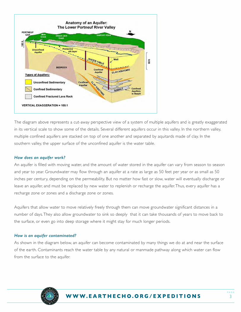
The diagram above represents a cut-away perspective view of a system of multiple aquifers and is greatly exaggerated in its ver tical scale to show some of the details. Several different aquifers occur in this valley. In the northern valley, multiple confined aquifers are stacked on top of one another and separated by aquitards made of clay. In the southern valley, the upper surface of the unconfined aquifer is the water table.
How does an aquifer work?
An aquifer is filled with moving water, and the amount of water stored in the aquifer can vary from season to season and year to year. Groundwater may flow through an aquifer at a rate as large as 50 feet per year or as small as 50 inches per century, depending on the permeability. But no matter how fast or slow, water will eventually discharge or leave an aquifer, and must be replaced by new water to replenish or recharge the aquifer. Thus, every aquifer has a recharge zone or zones and a discharge zone or zones.
Aquifers that allow water to move relatively freely through them can move groundwater significant distances in a number of days. They also allow groundwater to sink so deeply that it can take thousands of years to move back to the surface, or even go into deep storage where it might stay for much longer periods.
How is an aquifer contaminated?
As shown in the diagram below, an aquifer can become contaminated by many things we do at and near the surface of the ear th. Contaminants reach the water table by any natural or manmade pathway along which water can flow from the surface to the aquifer.

p a g e
4W W W . E A R T H E C H O . O R G / E X P E D I T I O N S
To deal with the issue of contaminants, Change the Course, a first-of-its-kind national water initiative, has star ted projects to help reduce groundwater pumping rates or replenish groundwater tables by facilitating natural recharge. The Change the Course movement is creating par tnerships with farmers and irrigators to install new technology to more precisely manage water applications or to provide infrastructure that allows natural flows to refill depleted groundwater tables.
VOCABULARY:
Aquifer - Underground layer of water-bearing permeable rockAquitard - Zone that restricts groundwater flow from one aquifer to anotherWater table - Zone of saturation - area in which soil or sand are permanently saturated with waterBedrock - Solid, unweathered rock deep below the ground surfaceUnconfined aquifer - Water from the ground surface seeps directly into this type of aquiferConfined aquifer - Deeper in the ground then unconfined aquifer, has a layer of rock that blocks ground surface water from seeping inPerched aquifer - A small water body above the water table which lies in an unsaturated zoneRecharge zones - Area around an aquifer which is replenished by precipitation or surface waterDischarge zones - Area where groundwater flows to the land surfaceRunoff - Flow of water from excess stormwater or meltwaterStreamflow - Volume of water that moves through a specific point in a given timeframe
Cite: Perlman, USGS Howard. “Aquifers and Groundwater.” Aquifers and Groundwater, from USGS Water-Science School, water.usgs.gov/edu/earthgwaquifer.html.
p a g e
5W W W . E A R T H E C H O . O R G / E X P E D I T I O N S
III. LESSON
Task:
In this design challenge, students will work with specified materials to create a model of an aquifer. Then, the students will engage in a design project that will challenge them to engineer the most efficient and practical way to recharge groundwater.
Estimated Timeline:
1. Multiple sessions (5 days)2. 250 minutes (50 minutes/session)
Before the Activity
• Prepare materials• Make copies of the challenge write-up and rubric. • Prepare the videos
Engage1. Ask students if they have ever dug a hole in the sand at the beach. What happens as they dig deeper into the
sand? Does the sand get wetter as they dig deeper? Does the hole star t to fill up with water?2. Have students do a Think-Pair-Share for the following prompt: Last year California had a wet winter, yet this
winter the state is rapidly approaching drought status again. Where did all the water go?3. Watch the video Recharging Aquifers. Students should take guided notes. Use the following questions to begin a
discussion to assess student understanding:1. What is an aquifer? What are they composed of, and why are they important to us?2. How does the amount of water in aquifers compare to the amount of water in lakes and other surface reservoirs?3. How long can it take for water to seep down into aquifers (‘recharge’)? Why is this a concern?4. How can we measure groundwater levels using technology?5. What impacts could overpumping groundwater have on people, ecosystems, and the environment?6. What are some potential solutions to the issue of groundwater depletion?
4. Point out that, luckily, aquifers store a large amount of water that we may not see, but definitely drink during drought years. All the snow and rain from last year drained into the ground. As snow melts, water moves downward, through the top layers of an aquifer, which is a natural storage tank for groundwater. What if we could access this water when there is not a lot of rainfall?
5E LESSON PLAN
p a g e
6W W W . E A R T H E C H O . O R G / E X P E D I T I O N S
5. Remind students how digging a hole at the beach is a great way of illustrating the concept of how at a cer tain depth, the ground is saturated with water. The upper surface of this zone of saturation is called the water table and the zone beneath it is the aquifer. At the beach, the level of the water table is always at the same level as the ocean, which is just below the surface of the beach, while everywhere else we have to dig deeper.
6. Introduce the idea of drilling wells. “Wells drilled into aquifers provide water for drinking, agriculture, and industrial uses. However, aquifers can dry up when people drain them faster than nature can refill them.” (https://www.nationalgeographic.org/encyclopedia/aquifer/)
7. Student activity: Visualizing ar tesian pressure1. Fill a plastic sandwich bag with water2. Place a straw through the opening, 3. Tape the opening around the straw closed, DO NOT point the straw toward anyone4. Squeeze the baggie. Artesian water is pushed out through the straw.
8. Distribute one blank poster board to each group. Students will use this paper to create an engineering storyboard. An engineering storyboard is a record of how an engineering design team researches, explores, tests, and improves designs they make to solve problems. The theme for this storyboard is How to Conserve Clean Water in an Aquifer System. Have groups develop a team name and write it at the top of their storyboard. Explain that each time students learn a new concept, do an experiment, create a design, or test a design, it should be recorded on the storyboard for teachers and students to see and comment on. Students should take a few minutes to record any notes or other information about aquifers that they think is important.
9. Introduce the idea that if we can pull water out of the ground, other things can get into the drinking supply by showing the video clip: Groundwater Aquifer Contamination
That’s where organizations like the West Basin Water District come in. The West Basin Water District saw the problem with diminishing fresh water sources and is working to create a solution. The Hydro Engineers and Environmentalists with West Basin Water District are not waiting around for the next rainfall or snowstorm to refill the aquifers, they are exploring desalination as a source of drinkable water which can recharge the aquifers. Desalination plants such as West Basin Water District are actively looking for ways to convert current sources of salt water, which is the largest source of all water on our planet, to fresh water by removing salt. These innovative ideas will help us conserve our freshwater supply.
p a g e
7W W W . E A R T H E C H O . O R G / E X P E D I T I O N S
Explore1. Assign 3-4 students to each team and give them Student Handout.2. Describe the challenge to the class and show them the materials they will use. 3. Clarify the project requirements and expectations.
Materials:
I. Aquifer Model (building supplies should be upcycled materials whenever possible)
• Fish tank (25 gallons, 24” x 12” x 20”)• Soil• Rocks, gravel, sand, pebbles• Clay• Liquid soap pumps/spray bottle• Straws, rubber tubing, glass tubing• Food coloring• Water in measuring cups or cylinders• 30cc syringes
Explain• Have student teams prepare a short presentation explaining how they approached their aquifer model and their
recharging system design.
Elaborate• After completion of the challenge, modify the course to make it a little harder. Ask students to suggest some
of the problems a community might face if the re-charging system is not efficient and the system has numerous ar tesian wells. Also, think about how aquifers may become contaminated and identify different sources of contamination.
• Have students draw a 3D picture of their model - sketch on graph paper or create in software such as SketchUp.• Have students write an essay on adjustments they would make to their model if money was not limited. What
kind of high quality materials would they use and why? What would be the benefit?
Differentiation• Par tner struggling students with higher scoring students.• For EL - par tner lower-level English Speaking students with students who only speak English, to encourage
conversation in English.• Provide models of what a successfully completed project looks like.• Provide an altered lesson with sentence stems, thinking maps, etc.

p a g e
8W W W . E A R T H E C H O . O R G / E X P E D I T I O N S
Evaluate• Have students reflect on what they learned while completing this project. They should consider the engineering
process and how this idea could be applied in the real world. • Use the Aquifer Model Design Assessment Rubric to assess student work on the engineering project. Criteria
include testing of knowledge and concepts, design and construction of the re-charging system, and operation of the system
p a g e
9W W W . E A R T H E C H O . O R G / E X P E D I T I O N S
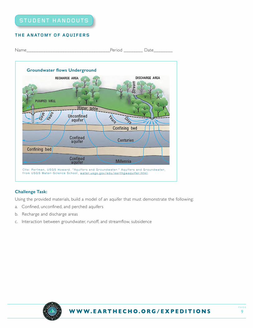
THE ANATOMY OF AQUIFERS
Name___________________________________Period ________ Date________
Challenge Task:
Using the provided materials, build a model of an aquifer that must demonstrate the following:a. Confined, unconfined, and perched aquifersb. Recharge and discharge areasc. Interaction between groundwater, runoff, and streamflow, subsidence
STUDENT HANDOUTS
Groundwater flows Underground
Cite: Perlman, USGS Howard. “Aquifers and Groundwater.” Aquifers and Groundwater, from USGS Water-Science School, water.usgs.gov/edu/earthgwaquifer.html.
p a g e
1 0W W W . E A R T H E C H O . O R G / E X P E D I T I O N S
Materials:
These materials have corresponding cost. Use the materials that you need for your aquifer model, but keep in mind that you have an initial budget of “$100” to spend. You can earn additional money with every written summary about a recommended resource you turn in. Each summary is worth $20.• Fish tank (25 gallons, 24” x 12” x 20”) - $20• Soil, $2/kg• Rocks, gravel, sand, pebbles, $2/kg• Clay $2/kg• Liquid soap pumps/spray bottle $1 each• Straws, rubber tubing, glass tubing $1 each• Food coloring $1each• Water in measuring cups or cylinders ($5/liter)• 30cc syringes $1 each
Procedures:
1. After thoroughly studying the anatomy of an aquifer, decide on different materials you can use to create a model of an aquifer. Show the different aquifer types and the recharge and discharge systems. Your team should be able to demonstrate the many elements of aquifers that exist in nature.
2. The aquifer model must demonstrate two main functions of aquifers: storage and transmission of water. Not only must your model show evidence of water storage, but it also must show water percolating through the system you are designing and building.
3. During the demonstration your team must recharge water into a pre-identified recharge area in two minutes. You may add as much water as you can without causing a runoff. You must demonstrate the most efficient way of recharging an aquifer, including collecting precipitation or recycled water (infiltration), introducing it into the system (recharging), preventing runoff and contamination.
4. Measure both the amount of water you poured, or recharged, into your aquifer, as well as the distance the water percolated, or flowed along, as evident in the presence of water in your interconnected aquifer.
p a g e
1 1W W W . E A R T H E C H O . O R G / E X P E D I T I O N S
Review and Reflection Questions
1. Where does the water in an aquifer come from?
2. How does an aquifer work?
3. Why are aquifers important to us?
4. Explain the human impact on aquifers - both negative and positive.
5. Determine three or more factors which would cause one aquifer to dry out quicker than another.
6. What additional suggestions would you give an agency, such as West Basin Water District, to aid in recharging aquifers?
p a g e
1 2W W W . E A R T H E C H O . O R G / E X P E D I T I O N S
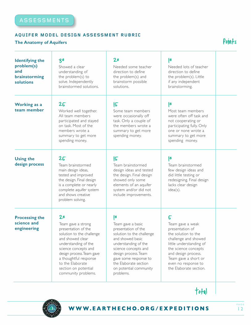
ASSESSMENTS
AQUIFER MODEL DESIGN ASSESSMENT RUBRIC
The Anatomy of Aquifers
Identifying the problem(s) and brainstorming solutions
Working as a team member
Using the design process
Processing the science and engineering
30Showed a clear understanding of the problem(s) to solve. Independently brainstormed solutions.
25Worked well together. All team members par ticipated and stayed on task. Most of the members wrote a summary to get more spending money.
25Team brainstormed main design ideas, tested and improved the design. Final design is a complete or nearly complete aquifer system and shows creative problem solving.
20Team gave a strong presentation of the solution to the challenge and showed clear understanding of the science concepts and design process. Team gave a thoughtful response to the Elaborate section on potential community problems.
Points
20Needed some teacher direction to define the problem(s) and brainstorm possible solutions.
10Needed lots of teacher direction to define the problem(s). Little if any independent brainstorming.
15Some team members were occasionally off task. Only a couple of the members wrote a summary to get more spending money.
10Most team members were often off task and not cooperating or par ticipating fully. Only one or none wrote a summary to get more spending money.
15Team brainstormed design ideas and tested the design. Final design showed only some elements of an aquifer system and/or did not include improvements.
10Team brainstormed few design ideas and did little testing or redesigning. Final design lacks clear design idea(s).
10Team gave a basic presentation of the solution to the challenge and showed basic understanding of the science concepts and design process. Team gave some response to the Elaborate section on potential community problems.
5Team gave a weak presentation of the solution to the challenge and showed little understanding of the science concepts and design process. Team gave a short or even no response to the Elaborate section.
Total
p a g e
1 3W W W . E A R T H E C H O . O R G / E X P E D I T I O N S
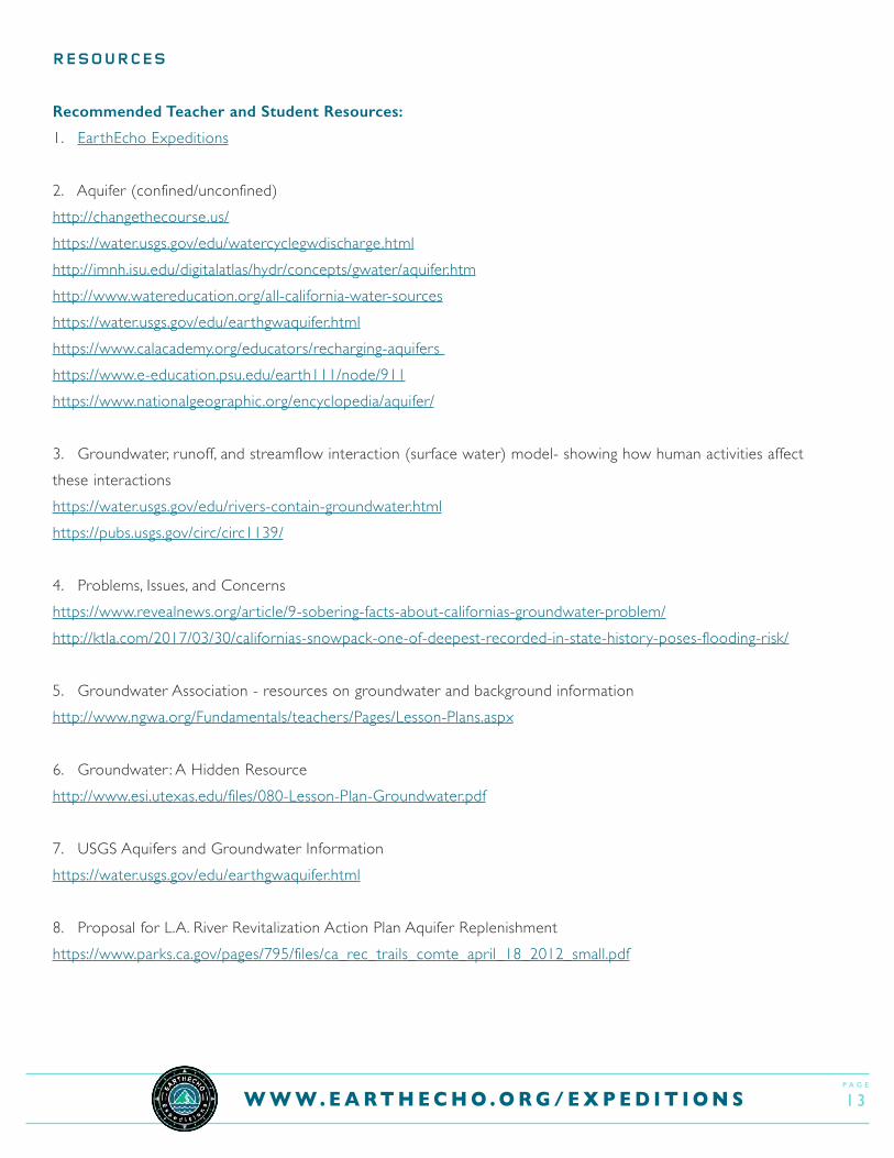
RESOURCES
Recommended Teacher and Student Resources:
1. Ear thEcho Expeditions
2. Aquifer (confined/unconfined)http://changethecourse.us/https://water.usgs.gov/edu/watercyclegwdischarge.htmlhttp://imnh.isu.edu/digitalatlas/hydr/concepts/gwater/aquifer.htmhttp://www.watereducation.org/all-california-water-sourceshttps://water.usgs.gov/edu/ear thgwaquifer.htmlhttps://www.calacademy.org/educators/recharging-aquifers https://www.e-education.psu.edu/ear th111/node/911https://www.nationalgeographic.org/encyclopedia/aquifer/
3. Groundwater, runoff, and streamflow interaction (surface water) model- showing how human activities affect these interactionshttps://water.usgs.gov/edu/rivers-contain-groundwater.htmlhttps://pubs.usgs.gov/circ/circ1139/
4. Problems, Issues, and Concernshttps://www.revealnews.org/ar ticle/9-sobering-facts-about-californias-groundwater-problem/http://ktla.com/2017/03/30/californias-snowpack-one-of-deepest-recorded-in-state-history-poses-flooding-risk/
5. Groundwater Association - resources on groundwater and background informationhttp://www.ngwa.org/Fundamentals/teachers/Pages/Lesson-Plans.aspx
6. Groundwater : A Hidden Resourcehttp://www.esi.utexas.edu/files/080-Lesson-Plan-Groundwater.pdf
7. USGS Aquifers and Groundwater Informationhttps://water.usgs.gov/edu/ear thgwaquifer.html
8. Proposal for L.A. River Revitalization Action Plan Aquifer Replenishmenthttps://www.parks.ca.gov/pages/795/files/ca_rec_trails_comte_april_18_2012_small.pdf

p a g e
1 4W W W . E A R T H E C H O . O R G / E X P E D I T I O N S
CITATIONS
• https://www.revealnews.org/ar ticle/9-sobering-facts-about-californias-groundwater-problem/• Perlman, USGS Howard. “Aquifers and Groundwater.” Aquifers and Groundwater, from USGS Water-Science
School, water.usgs.gov/edu/ear thgwaquifer.html• Halverson, Nathan. “9 sobering facts about California’s groundwater problem.” Reveal, 24 June 2015, www.
revealnews.org/ar ticle/9-sobering-facts-about-californias-groundwater-problem/• Community Water Center. “Groundwater Aquifer Contamination.” YouTube, YouTube, 17 Feb. 2017, www.youtube.
com/watch?v=f1ArRV9HmtI • Society, National Geographic. “Aquifer.” National Geographic Society, 9 Oct. 2012, www.nationalgeographic.org/
encyclopedia/aquifer/ • “Recharging Aquifers.” California Academy of Sciences, www.calacademy.org/educators/recharging-aquifers• What is an Aquifer?, imnh.isu.edu/digitalatlas/hydr/concepts/gwater/aquifer.htm
EDUCATIONAL STANDARDS
NGSS STANDARDS
Performance Expectations:
MS-EST1-1. - Define the criteria and constraints of a design problem with sufficient precision to ensure a
successful solution, taking into account relevant scientific principles and potential impacts on people and
the natural environment that may limit possible solutions. SEP – Constructing explanations and designing solutions
DCI - ETS1.C: Optimizing the Design Solution
• Although one design may not perform the best across all tests, identifying the characteristics of the
design that performed the best in each test can provide useful information for the redesign process—
that is, some of those characteristics may be incorporated into the new design.
• The iterative process of testing the most promising solutions and modifying what is proposed on the
basis of test results leads to greater refinement and ultimately a better solution.
DCI – ETS1.B: Developing Possible Solutions
A solution needs to be tested, and then modified on the basis of the test results, in order to improve it.
(MS-ETS1-4)
p a g e
1 5W W W . E A R T H E C H O . O R G / E X P E D I T I O N S
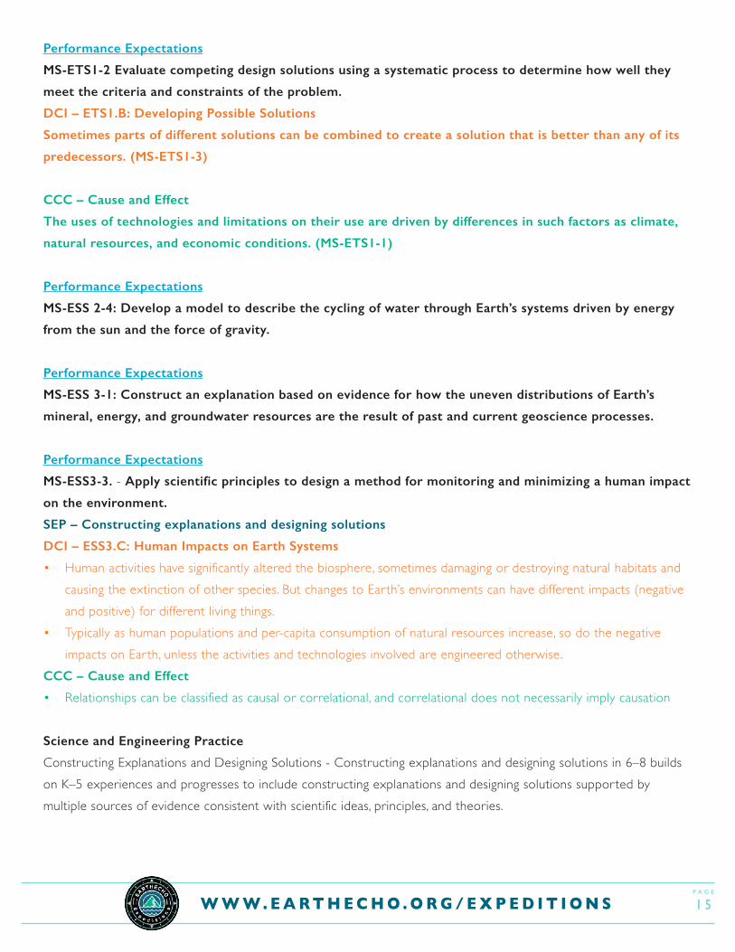
Performance Expectations
MS-ETS1-2 Evaluate competing design solutions using a systematic process to determine how well they
meet the criteria and constraints of the problem.
DCI – ETS1.B: Developing Possible Solutions
Sometimes parts of different solutions can be combined to create a solution that is better than any of its
predecessors. (MS-ETS1-3)
CCC – Cause and Effect
The uses of technologies and limitations on their use are driven by differences in such factors as climate,
natural resources, and economic conditions. (MS-ETS1-1)
Performance Expectations
MS-ESS 2-4: Develop a model to describe the cycling of water through Earth’s systems driven by energy
from the sun and the force of gravity.
Performance Expectations
MS-ESS 3-1: Construct an explanation based on evidence for how the uneven distributions of Earth’s
mineral, energy, and groundwater resources are the result of past and current geoscience processes.
Performance Expectations
MS-ESS3-3. - Apply scientific principles to design a method for monitoring and minimizing a human impact
on the environment.
SEP – Constructing explanations and designing solutions
DCI – ESS3.C: Human Impacts on Earth Systems
• Human activities have significantly altered the biosphere, sometimes damaging or destroying natural habitats and causing the extinction of other species. But changes to Ear th’s environments can have different impacts (negative and positive) for different living things.
• Typically as human populations and per-capita consumption of natural resources increase, so do the negative impacts on Ear th, unless the activities and technologies involved are engineered otherwise.
CCC – Cause and Effect
• Relationships can be classified as causal or correlational, and correlational does not necessarily imply causation
Science and Engineering Practice
Constructing Explanations and Designing Solutions - Constructing explanations and designing solutions in 6–8 builds on K–5 experiences and progresses to include constructing explanations and designing solutions supported by multiple sources of evidence consistent with scientific ideas, principles, and theories.
p a g e
1 6W W W . E A R T H E C H O . O R G / E X P E D I T I O N S
Common Core State Standards - Math
• 6.RP.A.1 Understand the concept of a ratio and use ratio language to describe a ratio relationship between two quantities. (MS-ESS3-3), (MS-ESS3-4)
• 7.RP.A.2 Recognize and represent proportional relationships between quantities. (MS-ESS3-3), (MS-ESS3-4)• 6.EE.B.6 Use variables to represent numbers and write expressions when solving a real-world or mathematical
problem; understand that a variable can represent an unknown number, or, depending on the purpose at hand, any number in a specified set. (MS-ESS3-2), (MS-ESS3-3), (MS-ESS3-4)
• 7.EE.B.4 Use variables to represent quantities in a real-world or mathematical problem, and construct simple equations and inequalities to solve problems by reasoning about the quantities.
Common Core State Standards - English Language Arts
• RST.6-8.1 Cite specific textual evidence to support analysis of science and technical texts.