Embed Size (px)
Citation preview

Oc
Fro
BySar
cean S
m Inc
(Map
rahSchum
Case
Universi
ThSpecia
ceptio
p: RI Coastal Re
mann,Tiffa
Studiesof
CoRhodeI
ityofRho
he Rhal Are2008
on thr
esources Mana
anySmythJanu
fMarineSJennifer
oastalResIslandSeadeIsland
ode Isea Ma8 – 20ough
agement Counc
he,NicoleAuary2016
SpatialPlMcCann,E
ourcesCeaGrantColGraduate
slandanage15: Imple
cil/University o
Andrescav6
lanningREditor
enterandllegeProgSchoolof
ment
emen
of Rhode Island
vageandC
ReportSeri
gramOceanogr
Plan,
ntation
d)
ChristianF
ies
raphy
,
n:
Fox

URI Coastal Resources Center/Rhode Island Sea Grant, January 2016
ii
Acknowledgements This report is one of three marine spatial planning (MSP) case study reports produced by the Coastal Resources Center/Rhode Island Sea Grant College Program (CRC) at the URI Graduate School of Oceanography. It is part of CRC’s broader ongoing research and capacity‐building initiative to strengthen the network of marine spatial planning and coastal management practitioners. The purpose of the case studies is to document and share lessons learned from examples of marine spatial planning in the U.S. in order to build the capacity of MSP and coastal management practitioners. Research was conducted in three locations: Rhode Island, Washington State and San Francisco. The Rhode Island case focused on implementation of the Rhode Island Ocean Special Area Management Plan; the Washington case focused on the ongoing development of the Washington Coast Marine Spatial Plan; and the San Francisco study became a two‐case analysis of two different Coast Guard‐led waterways management initiatives. CRC has produced three technical reports summarizing case study research as well as a series of shorter publications highlighting key findings. All documents were developed with support from the URI Coastal Resources Center’s Marine Spatial Planning Advisory Committee members (Geoff Coughlan, Memorial University; Tracey Dalton, University of Rhode Island Department of Marine Affairs; Grover Fugate, Rhode Island Coastal Resources Management Council; Jennifer Hennessey, Washington Department of Ecology; Edward G. LeBlanc, U.S. Coast Guard Sector Southeastern New England; Betsy Nicholson, National Oceanic and Atmospheric Administration; and Stephen Olsen, Professor in Residence at the URI Graduate School of Oceanography and Director Emeritus of the URI Coastal Resources Center). In particular, CRC’s project team (Jennifer McCann, Tiffany Smythe, Nicole Andrescavage, Christian Fox, Tom Pavitt and Danielle Turek) would like to recognize the expertise and thoughtful advice provided by Stephen Olsen on all of these products. For further information, please see ww.crc.uri.edu/initiatives_page/msp/. The authors wish to thank the RI Coastal Resources Management Council for their assistance in shaping this case study. The authors also thank case study reviewers Grover Fugate, Betsy Nicholson and Stephen Olsen, as well as Alan Desbonnet, Rhode Island Sea Grant, and longtime Rhode Island statesman Kenneth Payne for their time and thoughtful insights. Finally, the authors wish to thank the many Ocean SAMP practitioners and stakeholders who contributed to this case study as interview participants or through their participation and dedication to the Ocean SAMP development and implementation process. This report was funded by the Gordon and Betty Moore Foundation and the Rhode Island Sea Grant College Program. This document should be referenced as: Schumann, S., T. Smythe, N. Andrescavage and C. Fox. 2016. The Rhode Island Ocean Special Area Management Plan, 2008 – 2015: From Inception through Implementation. In McCann, J., Ed. 2016. Case Studies of Marine Spatial Planning Report Series. Coastal Resources Center and Rhode Island Sea Grant College Program, URI Graduate School of Oceanography. Narragansett, R.I. 80 pp.
URI Coastal Resources Center/Rhode Island Sea Grant, January 2016
iii
TABLE OF CONTENTS
ACKNOWLEDGEMENTS ............................................................................................................ ii
TABLE OF CONTENTS .............................................................................................................. iii
LIST OF TABLES ........................................................................................................................ v
LIST OF FIGURES ...................................................................................................................... v
LIST OF ACRONYMS ................................................................................................................ vi
I. INTRODUCTION .................................................................................................................... 1
A. Overview .................................................................................................................................................. 1
B. Rhode Island, The Ocean State .................................................................................................................. 1
C. The People of the Ocean SAMP ................................................................................................................. 3
II. DEVELOPING THE OCEAN SAMP .......................................................................................... 7
A. Background: Winds of Change off Rhode Island’s Coast ............................................................................. 7
B. The Helping Hand of History ...................................................................................................................... 9
C. From Concept to Action ............................................................................................................................ 12
III. OCEAN SAMP IMPLEMENTATION ..................................................................................... 19
A. Implementing the REZ: Permitting the Block Island Wind Farm ................................................................. 20
B. Exerting the Influence of the Ocean SAMP Outside of State Waters .......................................................... 26i. Expanding Rhode Island’s Influence in Federal Waters: Using the Ocean SAMP to Develop a GLD ............. 27ii. The Area of Mutual Interest (AMI): Interstate Coordination and Influence over Federal Decisions ............ 29iii. Use of the Ocean SAMP in Federal Decision‐Making: The RI/MA Wind Energy Area ................................... 31iv. The Interplay of State and Regional Planning ............................................................................................... 33
C. Fishermen’s Experience of Ocean SAMP Implementation ......................................................................... 34i. Formal participation ...................................................................................................................................... 35ii. Informal Participation: Leveraging the Ocean SAMP .................................................................................... 39iii. Nonparticipation: Tacit Approval or Strategic Rejection? ............................................................................. 44
D. Environmental Interests and Ocean SAMP Implementation ...................................................................... 45
E. Looking Over the Horizon: The Ocean SAMP in the Future ........................................................................ 47i. New Uses and Future Drivers ........................................................................................................................ 48

URI Coastal Resources Center/Rhode Island Sea Grant, January 2016
iv
ii. Updating Data and Adapting Policies ............................................................................................................ 50iii. Building on the Experience of the Ocean SAMP ............................................................................................ 55iv. Sustaining Leadership and Social Capital ...................................................................................................... 56
IV. LESSONS LEARNED FROM THE OCEAN SAMP .................................................................... 57
A. Lessons Learned from Ocean SAMP Development .................................................................................... 57
Lesson #1: Build a broad base of leadership. ...................................................................................................... 58
Lesson #2: Allow for time to build trust. ............................................................................................................ 59
B. Lessons Learned from Ocean SAMP Implementation ................................................................................ 60
Lesson #3: Keep the driver relevant to sustain stakeholder engagement through implementation. .................... 60
Lesson #4: Create clear policy tools in your plan to support streamlined decision‐making. ................................. 61
Lesson #5: Prepare yourself for working even harder during implementation. ................................................... 61
VI. CONCLUSION .................................................................................................................... 62
VII. WORKS CITED .................................................................................................................. 64
APPENDIX I. DEFINITION OF A SPECIAL AREA MANAGEMENT PLAN ...................................... 68
APPENDIX II. OCEAN SAMP GOALS AND PRINCIPLES ............................................................. 69
APPENDIX III. OCEAN SAMP PUBLIC REVIEW PROCESS .......................................................... 70
APPENDIX IV. CASE STUDY FINDINGS: OCEAN SAMP LEADERS .............................................. 71
END NOTES ............................................................................................................................ 73
URI Coastal Resources Center/Rhode Island Sea Grant, January 2016
v
List of Tables
Table 1. Interview Participants..............................................................................................................................5Table 2. History of Rhode Island Special Area Management Plans (SAMPs) and Coastal Management Accomplishments........................................................................................................................11Table 3. Timeline: Key Events in Ocean SAMP Development and Implementation.........................13Table 4. Agencies Issuing Permits or Approvals for the Block Island Wind Farm..............................22
List of Figures
Figure 1. Ocean SAMP Planning Area Boundary (Source: CRMC/URI) ........................................... 9 Figure 2. Lease blocks in the RI/MA AMI included in BOEM’s 2010 Call Area (Source: CRMC/URI)....................................................................................................................................................... 41 Figure 3. New fishing intensity data shown within BOEM lease blocks (Source: CRMC/URI) ..... 42 Figure 4. Final Lease Blocks included in BOEM’s RI‐MA Wind Energy Area (Source: BOEM) ...... 43
URI Coastal Resources Center/Rhode Island Sea Grant, January 2016
vi
List of Acronyms
ADP: Areas Designated for Protection AMI: Area of Mutual Interest APC: Areas of Particular Concern BOEM: Bureau of Ocean Energy Management CFCRI: Commercial Fisheries Center of Rhode Island CFRF: Commercial Fisheries Research Foundation CLF: Conservation Law Foundation COP: Construction and Operations Plan CRC: Coastal Resources Center CRMC: Rhode Island Coastal Resources Management Council CZMA: Coastal Zone Management Act DC: Direct Current DWW: Deepwater Wind EA: Environmental Assessment EIS: Environmental Impact Statement EMF: Electromagnetic field EPA: Environmental Protection Agency FAA: Federal Aviation Administration FAB: Fishermen’s Advisory Board FERC: Federal Energy Regulatory Commission GLD: Geographic Location Description HAB: Habitat Advisory Board LNG: Liquid Natural Gas MMS: Mineral Management Service MOU: Memorandum of Understanding MSP: Marine Spatial Planning NDI: Necessary Data and Information NEPA: National Environmental Policy Act NMFS: National Marine Fisheries Service NOAA: National Oceanic and Atmospheric Administration NOPP: National Oceanographic Partnership Program NROC: Northeast Regional Ocean Council NRDC: Natural Resources Defense Council OCM: Office for Coastal Management (within NOAA) OCS: Outer Continental Shelf OER: Rhode Island Office of Energy Resources RESP: Renewable Energy Siting Partnership REZ: Renewable Energy Zone RIDEM: Rhode Island Department of Environmental Management RPB: Regional Planning Body SAMP: Special Area Management Plan SHPO: State Historic Preservation Office
URI Coastal Resources Center/Rhode Island Sea Grant, January 2016 vii
TAC: Technical Advisory Committee TDI: Technology Development Index URI: University of Rhode Island USACE: United States Army Corps of Engineers USFWS: United States Fish and Wildlife Service WEA: Wind Energy Area
URI Coastal Resources Center/Rhode Island Sea Grant, January 2016
1
I. Introduction
A. Overview
The Rhode Island Ocean Special Area Management Plan (Ocean SAMP), a marine spatial
plan — and, one of the United States’ first such plans — laid the groundwork for the siting and
permitting of the nation’s first offshore wind farm. This document examines the Ocean SAMP
process from the time it was conceived, through its intensive plan development period (2008 –
2010) and its five years of implementation to date (2010‐2015). The focus, however, is on
examining the implementation phase, as this is the period that has yet to be studied. Drawing
on the field‐tested experience of planners, managers, and stakeholders interviewed for this
study, the case offers lessons learned through this intensive marine spatial planning (MSP)
process. These lessons emphasize the importance of: building a broad base of leadership;
allowing time to build trust; using the planning driver to maintain stakeholder engagement
through plan implementation; including clear policy tools in the plan to facilitate streamlined
decision‐making; and preparing to work even harder during implementation than in the design
and development phases.
This case study tells two stories. First is that of preparing a marine spatial plan for an
area shaped by numerous interests and resources important to Rhode Islanders: commercial
and recreational fishing, commercial shipping, recreational boating and sailing, marine
resources and habitats, and potentially offshore wind energy development. Second is that of
locating and permitting the United States’ first offshore wind energy project. The coast of the
northeastern United States has premier wind resources, and renewable energy development is
arguably a priority to both the nation and to the state of Rhode Island. The two stories are
interwoven, as that is how they have taken place. Yet, it is important to emphasize that the
Ocean SAMP was launched, prepared and adopted as a comprehensive ecosystem‐based
marine spatial plan, not as a renewable energy facility siting plan.
B. Rhode Island, The Ocean State
For this story to make sense, it is important to know a little about Rhode Island. Rhode
Island has a long‐standing, time‐honored connection to its marine waters. Known as the “Ocean
State,” it has over 400 miles of shoreline. This includes Narragansett Bay, New England’s largest
estuary, which extends 25 miles inland from the state’s south coast and comprises nearly 10
percent of Rhode Island’s 1,214 square miles. This shoreline also includes Rhode Island’s south

URI Coastal Resources Center/Rhode Island Sea Grant, January 2016
2
coast and the shoreline of Block Island, located 13 miles south of the mainland. The south coast
abuts Block Island and Rhode Island Sounds, whose open waters provide a direct connection to
the ocean. Whereas Rhode Island has a long and rich history of coastal and marine
management initiatives, the Ocean SAMP was the first time that the state focused on its
offshore waters – Block Island and Rhode Island Sounds and adjacent ocean waters.
Rhode Island’s offshore region is ecologically unique. It comprises shallow, nearshore
continental shelf waters that are dynamically connected to Narragansett Bay as well as
Buzzards Bay to the east, Long Island Sound to the west, and the Atlantic Ocean to the south.
This area is characterized by great biodiversity as it includes a mix of northern cold water
species and southern warm water species. These include diverse finfish, shellfish, and
crustaceans, marine mammals, birds, and sea turtles, which feed, reproduce, and migrate
through this region, thriving on its rich habitats and food sources. Marine mammals found in
this area include the endangered North Atlantic right whale and other whale species, gray seals,
and harbor seals. Commercially and recreationally important fish species found in this region
include, but are not limited to, cod, lobster, sea scallop, squid, striped bass, and multiple
flounder species. This region is also characterized by strong and steady winds, which make it a
desirable location for offshore wind development.
Rhode Island’s offshore waters have long been integral to human activities. People of
this region have used and depended upon these offshore waters and the resources they
contain for subsistence, transportation, commerce and recreation. Narragansett Indian tribal
history indicates that Narragansett peoples lived in parts of this offshore area, on dry land, over
15,000 years ago — before rising sea levels rendered the area uninhabitable.
Over the past 400 years, Rhode Island’s offshore waters have been actively used for
maritime activities including commercial and recreational fishing, maritime commerce, naval
operations, yacht racing, and other activities. Commercial fishing is a longstanding tradition and
part of Rhode Island’s economy and culture, and the port of Point Judith, on Rhode Island’s
south coast, is one of the largest remaining commercial fishing ports in the U.S. The U.S. Navy
was in part created in Rhode Island, and the Navy had a significant presence in Rhode Island’s
waters in the late‐19th through mid‐20th centuries. Although naval activities in these waters
have declined somewhat, maritime commerce continues to thrive in Rhode Island’s offshore
waters, with cargo vessels servicing Narragansett Bay ports, tug and barge units passing
through between the ports of Boston and New York, and ferries serving Block Island and other
coastal communities. Rhode Island’s offshore waters have a long and storied tradition of yacht
racing. In the late‐19th century, the city of Newport became a center of sailing and other
recreation and tourism activities, and during the 20th century, the international America’s Cup
URI Coastal Resources Center/Rhode Island Sea Grant, January 2016
3
yacht races were held 12 times in Rhode Island’s offshore waters. This earned Newport the
nickname “The Sailing Capital of the World.” Today, recreational activities including yacht
racing as well as recreational fishing are important contributors to Rhode Island’s tourism
economy.1
These offshore activities are critical to Rhode Island’s economy. In 2013, landings from
Rhode Island’s commercial fisheries generated $86 million in revenue. Excluding imports, the
state’s seafood industry supported over 5,400 jobs, over $304 million in sales, and over $111
million in income. That same year, Rhode Island’s recreational fisheries supported over 2,500
jobs, over $226 million in sales and over $102 million in income.1 In 2012, the Rhode Island
cluster of marine trades businesses that supports recreational boating and yacht racing in this
region supported 14,700 jobs, $2.6 billion in sales and $598 million in wages.2 Maritime
commerce and military activities are also critical to Rhode Island; in 2013, marine
transportation alone accounted for over 2,500 jobs and $180 million in wages in the Ocean
State.3
The natural beauty of Rhode Island’s offshore waters, along with its rich historic and
cultural heritage, has long been celebrated. Block Island and other Rhode Island south coast
communities are popular destinations for seasonal tourists and Rhode Islanders alike.
C. The People of the Ocean SAMP
The SAMP’s iterative, coupled research‐and‐stakeholder process was as much a social
process as a planning exercise, turning a diverse array of participants into MSP practitioners.
Ocean SAMP practitioners included not only the lead planning agency but other state and
federal agencies, commercial and recreational fishermen, boaters, divers, renewable energy
developers, environmental organizations, the Narragansett Indian Tribe, and private citizens,
including residents of Block Island and other adjacent coastal communities. Each made unique
contributions to the Ocean SAMP development, bringing their individual skills and expertise to
the process.
When the Ocean SAMP process shifted from plan development to implementation, the
roles of these diverse practitioners changed. The lead regulatory agency, the Rhode Island
Coastal Resources Management Council (CRMC), began formal application of the policies
included in the plan. Stakeholders, such as fishermen and environmental organizations, began
1 For further information on the background presented here, see the full text of the Rhode Island Ocean SAMP (CRMC 2010).

URI Coastal Resources Center/Rhode Island Sea Grant, January 2016
4
to leverage relationships and reputations developed through the SAMP process to accomplish
their own goals – a form of informal SAMP implementation. Although different entities have
applied the Ocean SAMP in different ways, all of these uses can be considered under a broad
umbrella of MSP implementation.
As noted earlier, this case study places particular emphasis on examining the formal and
informal implementation of the plan from 2010 to 2015. (For further discussion of Ocean SAMP
development, see McCann et al. (2013) and Olsen et al. (2014)). It is built on semi‐structured
interviews with 17 key participants who have been involved in Ocean SAMP development
and/or implementation (see Table 1). Ocean SAMP leaders assisted in identifying these
participants using a selection process that ensured each different sector, agency or organization
was represented. Invited participants included commercial fishermen, with a wide range of
viewpoints regarding the Ocean SAMP, although some were either unavailable within the
project timeframe or declined to participate.

URI Coastal Resources Center/Rhode Island Sea Grant, January 2016
5
Table 1. Interview Participants
Name Affiliation During Ocean SAMP Development/ Implementation
Role
Management Team Members
Grover Fugate
Rhode Island Coastal Resources Management Council (CRMC)
Executive Director of CRMC
Project manager for the RI Ocean SAMP
Jennifer McCann
Coastal Resources Center (CRC)/ Rhode Island Sea Grant, University of Rhode Island (URI) Graduate School of Oceanography (GSO)
Director of U.S. Coastal Programs at CRC and Director of Extension Programs for Rhode Island Sea Grant
Co‐Principal Investigator for the RI Ocean SAMP
State Team Members
David Beutel Rhode Island Sea Grant (up to 2009); CRMC (2009 ‐ present)
Fisheries and Aquaculture Coordinator with CRMC; formerly RI Sea Grant Fisheries Extension Agent
Member of core SAMP development team who led fisheries engagement; reviewed Block Island Wind Farm application; leads fisheries aspects of Ocean SAMP implementation
John King URI/GSO; Habitat Advisory Board(HAB)
Professor of Oceanography at URI and member of HAB
Conducted scientific research in support of Ocean SAMP development; oversees numerous related ongoing scientific research projects
Ken Payne URI (2008 ‐ 2009); Rhode Island Office of Energy Resources (OER) (2010 ‐ 2011)
Research Associate Professor at URI during early phase of SAMP development; Director of OER during latter SAMP development and initial implementation
Independent facilitator of Ocean SAMP stakeholder group
Federal Agency Participants
Robert DeSista
U.S. Army Corps of Engineers(USACE) New England District
Acting Chief of the Regulatory/Permitting Division of the USACE New England District
A USACE staff participant in Ocean SAMP process; involved in USACE review of Block Island Wind Farm project
David Kaiser National Oceanic and Atmospheric Administration (NOAA) Office for Coastal Management (OCM)
Senior Policy Analyst with NOAA OCM
Worked with CRMC on federal approval of Ocean SAMP and on development and approval of Geographic Location Description (GLD)
Robert LaBelle
Bureau of Ocean Energy Management (BOEM)
Science Advisor to BOEM Director/Acting Chief, Office of Environmental Programs
A BOEM staff participant in Ocean SAMP process
Edward LeBlanc
U.S. Coast Guard (USCG) Sector Southeastern New England
Waterways Management Chief
USCG staff participant in Ocean SAMP process; reviewed Block Island Wind Farm application

URI Coastal Resources Center/Rhode Island Sea Grant, January 2016
6
Name Affiliation During Ocean SAMP Development/ Implementation
Role
Chris Tompsett
U.S. Navy/Naval Undersea Warfare Center
Senior Environmental Planner at the Naval Undersea Warfare Center
Liaison for the U.S. Navy in Ocean SAMP process
Susan Tuxbury
National Oceanic and Atmospheric Administration ‐ National Marine Fisheries Service (NMFS)
Fisheries Biologist, NMFS Habitat Conservation Division
Primary NMFS participant in Ocean SAMP process
Stakeholders
Kim Gaffett Town of New Shoreham (Block Island) (through 2014)
Formerly First Warden (highest elected official) for Town of New Shoreham
Represented Block Island in Ocean SAMP process
Tricia Jedele Conservation Law Foundation(CLF) Rhode Island
Attorney; Vice President of CLF/Director of CLF RI
Represented CLF in Ocean SAMP process
Fred Mattera Independent/Commercial Fisheries Research Foundation (CFRF)
Former commercial fisherman, marine safety instructor, and Vice President of CFRF
Participated in parts of Ocean SAMP development
Bill McElroy Independent/Fisheries Advisory Board (FAB)
Lobsterman/FAB chair
Participated in Ocean SAMP development and implementation
Other Key Participants
Aileen Kenney
Deepwater Wind, LLC (DWW) Vice President of Permitting/Environmental Affairs
A DWW staff participant in SAMP process; oversaw DWW’s environmental assessment, permitting, and stakeholder outreach processes as part of Ocean SAMP implementation
Kate Mulvaney
Independent contractor Social scientist and marine governance professional
Conducted first biennial Ocean SAMP assessment (2013)
Through the interviews, case study authors probed the ways in which the Ocean SAMP
has marked people’s lives. What motivated them to get involved? How did they influence the
planning process? How did history, both political and personal, play into the process? How have
these individuals utilized Ocean SAMP data and policies since the plan’s approval? How has the
Ocean SAMP affected their ability to reach their goals? How have they made use of the Ocean
SAMP outside of formal implementation? How well do they think the Ocean SAMP will carry on
into the future? The findings, anecdotes and lessons learned reported in this case study are
based on these interviews as well as a review of the public record on the Ocean SAMP to date.
URI Coastal Resources Center/Rhode Island Sea Grant, January 2016
7
The Ocean SAMP story begins in 2006, the year Rhode Island first formally committed to
pursuing offshore wind energy. The text that follows describes the Ocean SAMP development
and implementation activities, lessons learned, and how those lessons were made evident
through the SAMP process.
II. Developing the Ocean SAMP
A. Background: Winds of Change off Rhode Island’s Coast
On January 12, 2006, Rhode Island Governor Donald Carcieri announced his aspiration
to tackle the state’s rising greenhouse gas emissions and energy costs. By 2011, he declared,
the state would aim to obtain 15 percent of its electrical supply from the wind.4 "I think this is
something we can achieve, and I'm going to pursue this aggressively," he asserted
enthusiastically at a news conference.5 The governor’s commitment to wind energy was clear,
and his timeline was ambitious.
A study funded by the then newly‐created Rhode Island Office of Energy Resources
(OER) revealed that the only way to meet the governor’s renewable energy goal would be to
take advantage of the Ocean State’s biggest asset: its offshore waters. That study, known as
RIWINDS, estimated that 95 percent of Rhode Island’s wind supply lay offshore.6 With support
and seed money from the governor, in 2007, the University of Rhode Island (URI) created a
Center for Excellence for Research in Offshore Renewable Energy at URI’s Graduate School of
Oceanography. This center was led by Rear Admiral Sam DeBow, retired from the National
Oceanic and Atmospheric Administration (NOAA) Commissioned Corps, who had served aboard
NOAA’s hydrographic survey ships during his seafaring career. The new center would take
charge of developing an environmental impact statement (EIS) for a proposed offshore wind
farm southeast of Block Island straddling state and federal waters. By early 2008, the state of
Rhode Island had issued a Request for Proposals to identify a preferred offshore wind energy
developer. Soon thereafter, Governor Carcieri was in conversations with Deepwater Wind, who
had been selected as the state’s “preferred developer.”2
The governor’s intention to develop offshore wind energy could have moved ahead
without a comprehensive planning process such as the Ocean SAMP. In fact, some interview
participants believe it probably would have moved ahead without such a process in place were
it not for the idea proposed by a longtime custodian of the state’s coastal resources, CRMC
Executive Director Grover Fugate. The idea of what became known as the Ocean SAMP, a
2 For a more detailed discussion of this history see Olsen et al. (2014).
URI Coastal Resources Center/Rhode Island Sea Grant, January 2016
8
marine spatial plan to guide the siting of offshore renewable energy, was ultimately supported
at the highest levels of Rhode Island state government and URI leadership.
Fugate knew from his 28 years at the helm of CRMC that big gaps in knowledge existed
about Rhode Island’s offshore environment. Biological and geological data were scarce,
centralized information about current users was limited, and the public had little in the way of a
shared vision about the area. Moreover, he had heard concerns about the governor’s wind
energy public input process, which consisted of four stakeholder meetings carried out by a
consultant for the OER, and wondered whether this would be enough to make the public
comfortable with this unprecedented use of the state’s marine waters. This question was
critical. In neighboring Massachusetts at the time, a prolonged battle over the proposed Cape
Wind offshore wind farm had underscored the importance of proactive planning and
stakeholder input for siting and permitting renewable energy and other permanent structures
in marine waters.
Fugate, together with URI ocean engineer Dr. Malcolm Spaulding, argued to the RI OER
that a proactive science‐based planning approach would be far more effective for ultimately
siting and permitting an offshore renewable energy project. These and other SAMP proponents
within state government and at the university argued that a SAMP could also streamline the
National Environmental Protection Act (NEPA) review process, reduce costs, and save time in
moving this project forward. OER staff encouraged Fugate and Spaulding to put together a
proposal and budget. Fugate and Spaulding meanwhile pulled together a broad range of URI
scientists and engaged URI’s Coastal Resources Center (CRC), which assists in the development
and implementation of coastal management programs in the U.S. and throughout the world.
Together, Fugate, Spaulding, Jennifer McCann of CRC and the Rhode Island Sea Grant
College Program, and URI scientists sketched out a vision for a comprehensive process that
could guide decisions about new uses in the waters off Rhode Island’s coast – including, but not
limited to, wind energy – and minimize conflict like that taking place in neighboring
Massachusetts. This process would ultimately bring URI scientists together to draft a research
agenda for a 1,467 square‐mile area covering both Rhode Island state waters from 500 feet to
three nautical miles offshore3 and federal waters extending offshore an additional 27 nautical
miles, with potentially promising conditions for wind energy development (see Figure 1).4 The
CRMC/URI team named this proposed research, planning, and stakeholder process the Ocean
Special Area Management Plan (SAMP).
3 The inshore Ocean SAMP boundary began 500 feet waterward of the mean high water line, and excluded all of Narragansett Bay. See Figure 1. 4 For a more detailed discussion of how this boundary was determined, see Olsen et al. (2014).

URI Coasta
Figure 1. O
B. T
T
The wind
moment
offices of
interest m
Island a r
critical fo
F
Ocean SA
Island did
al Resources Ce
Ocean SAMP P
he Helping H
he move to
d energy imp
um within a
f state gover
may not hav
rich setting f
or understan
ugate’s idea
AMP, Rhode
d not always
enter/Rhode Is
lanning Area B
Hand of Hist
pursue offsh
perative prov
tight timelin
rnment. Yet,
ve flourished
for an expan
nding Rhode
for a SAMP
Island was t
s use this int
sland Sea Gran
Boundary (Sou
tory
hore plannin
vided a stron
ne, and secu
, interview p
d as it did, w
nsive MSP ef
Island’s exp
was no surp
three decad
tegrated pla
t, January 201
urce: CRMC/UR
ng in Rhode
ng driver: it
ured politica
participants
ere it not fo
ffort. This ro
perience wit
prise in Rhod
es into its le
nning strate
16
RI)
Island was a
shepherded
l and financ
point out th
r contextua
le of contex
h the Ocean
de Island. At
earning curve
egy to manag
a seed that f
d resources,
ial support f
hat this seed
l factors tha
t and history
n SAMP.
t the time it
e with MSP.
ge its coasta
ell on fertile
assured forw
from the hig
of public
t made Rhod
y is arguably
undertook t
Yet, Rhode
al waters. Du
9
e soil.
ward
ghest
de
y
the
uring
URI Coastal Resources Center/Rhode Island Sea Grant, January 2016 10
the first decade after its 1971 creation, CRMC relied upon a piecemeal permitting system
characterized by inefficiencies, inconsistencies, and accusations of political interference.7
During these years, CRMC and CRC established a partnership that would grow and strengthen
over subsequent decades and through which CRC staff would help CRMC develop and refine its
coastal management plan. After the first decade of this CRMC‐CRC collaboration, and three
versions of a state coastal management plan, in the early 1980s, the two organizations
introduced two major new planning strategies in order to find a balance between issue‐driven
planning and policy consultation and public consultation. One strategy was a comprehensive
zoning plan assigning six different levels of usage and protection for Rhode Island’s coastal
waters. The second strategy was to develop SAMPs for areas where complex environments,
overlapping jurisdictions, and multiple human uses called for more focused analysis and
extensive public input processes. The conceptual framework for SAMPs is contained within the
federal Coastal Zone Management Act (CZMA), which recommends special area management
planning as a comprehensive tool for the protection of natural resources and promotion of
appropriate development within specific areas of a state’s coastal zone (see Appendix I). CRMC
and CRC took this conceptual framework and created a method of developing SAMPs that
featured this agency‐university partnership and an intensive and collaborative stakeholder
process.
CRMC completed its first SAMP, for the Providence Harbor, in 1983. By the time it
embarked on the Ocean SAMP, it had completed five other SAMPs and had one more in
progress (see Table 2). Throughout this time, CRMC’s Council, comprising appointed
representatives who oversee the agency and approve planning and regulatory decisions,
actively engaged in and supported the development and use of SAMPs. As a result, when CRMC
took on the Ocean SAMP, it brought with it a long history of institutional knowledge,
relationships with other agencies and stakeholders, and, according to interview participants, a
reputation of capability.
URI Coastal Resources Center/Rhode Island Sea Grant, January 2016 11
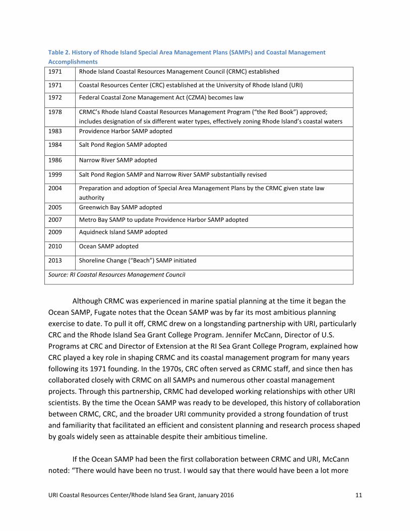
Table 2. History of Rhode Island Special Area Management Plans (SAMPs) and Coastal Management
Accomplishments
1971 Rhode Island Coastal Resources Management Council (CRMC) established
1971 Coastal Resources Center (CRC) established at the University of Rhode Island (URI)
1972 Federal Coastal Zone Management Act (CZMA) becomes law
1978 CRMC’s Rhode Island Coastal Resources Management Program (“the Red Book”) approved;
includes designation of six different water types, effectively zoning Rhode Island’s coastal waters
1983 Providence Harbor SAMP adopted
1984 Salt Pond Region SAMP adopted
1986 Narrow River SAMP adopted
1999 Salt Pond Region SAMP and Narrow River SAMP substantially revised
2004 Preparation and adoption of Special Area Management Plans by the CRMC given state law
authority
2005 Greenwich Bay SAMP adopted
2007 Metro Bay SAMP to update Providence Harbor SAMP adopted
2009 Aquidneck Island SAMP adopted
2010 Ocean SAMP adopted
2013 Shoreline Change (“Beach”) SAMP initiated
Source: RI Coastal Resources Management Council
Although CRMC was experienced in marine spatial planning at the time it began the
Ocean SAMP, Fugate notes that the Ocean SAMP was by far its most ambitious planning
exercise to date. To pull it off, CRMC drew on a longstanding partnership with URI, particularly
CRC and the Rhode Island Sea Grant College Program. Jennifer McCann, Director of U.S.
Programs at CRC and Director of Extension at the RI Sea Grant College Program, explained how
CRC played a key role in shaping CRMC and its coastal management program for many years
following its 1971 founding. In the 1970s, CRC often served as CRMC staff, and since then has
collaborated closely with CRMC on all SAMPs and numerous other coastal management
projects. Through this partnership, CRMC had developed working relationships with other URI
scientists. By the time the Ocean SAMP was ready to be developed, this history of collaboration
between CRMC, CRC, and the broader URI community provided a strong foundation of trust
and familiarity that facilitated an efficient and consistent planning and research process shaped
by goals widely seen as attainable despite their ambitious timeline.
If the Ocean SAMP had been the first collaboration between CRMC and URI, McCann
noted: “There would have been no trust. I would say that there would have been a lot more

URI Coastal Resources Center/Rhode Island Sea Grant, January 2016 12
miscommunication. We probably wouldn’t have been able to be so creative; it would have been
a much more rigid process. We always said we were building the plane as we were flying it. And
that’s really hard to do with a co‐pilot that you don’t know . . . I think it wouldn’t have been
such a comprehensive or responsive project. We would have had to learn each other’s
priorities. CRMC trusted our ability to do a public process [while CRMC controlled the policy
process] . . . we knew each other so well that we were able to show each other our
vulnerabilities. That made it a more impactful process, because of that history.”
C. From Concept to Action
It was strong support at the highest levels of state government combined with URI
leadership that moved the Ocean SAMP from idea to reality. When CRMC and the URI/CRC
team presented the initial Ocean SAMP proposal in May 2008, Governor Carcieri quickly
supported the project. Just three months later, the Rhode Island OER had supplied an initial
$3.2 million to start the project via the Rhode Island Renewable Energy Fund, with the
understanding that a plan would be completed in two years. While the team had requested $6
million, including funds to build a meteorological tower, this lesser amount of funding was
enough to jumpstart the SAMP process. And, less than a year later, the state provided an
additional $2.8 million to support SAMP development and research.8 With this critical top‐level
support, the Ocean SAMP became a foundation for the state’s offshore wind development
strategy.
URI Coastal Resources Center/Rhode Island Sea Grant, January 2016 13
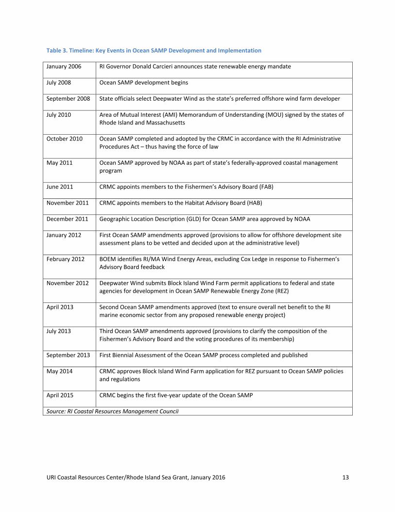
Table 3. Timeline: Key Events in Ocean SAMP Development and Implementation
January 2006 RI Governor Donald Carcieri announces state renewable energy mandate
July 2008 Ocean SAMP development begins
September 2008 State officials select Deepwater Wind as the state’s preferred offshore wind farm developer
July 2010 Area of Mutual Interest (AMI) Memorandum of Understanding (MOU) signed by the states of Rhode Island and Massachusetts
October 2010 Ocean SAMP completed and adopted by the CRMC in accordance with the RI Administrative Procedures Act – thus having the force of law
May 2011 Ocean SAMP approved by NOAA as part of state’s federally‐approved coastal management program
June 2011 CRMC appoints members to the Fishermen’s Advisory Board (FAB)
November 2011 CRMC appoints members to the Habitat Advisory Board (HAB)
December 2011 Geographic Location Description (GLD) for Ocean SAMP area approved by NOAA
January 2012 First Ocean SAMP amendments approved (provisions to allow for offshore development site assessment plans to be vetted and decided upon at the administrative level)
February 2012 BOEM identifies RI/MA Wind Energy Areas, excluding Cox Ledge in response to Fishermen’s Advisory Board feedback
November 2012 Deepwater Wind submits Block Island Wind Farm permit applications to federal and state agencies for development in Ocean SAMP Renewable Energy Zone (REZ)
April 2013 Second Ocean SAMP amendments approved (text to ensure overall net benefit to the RI marine economic sector from any proposed renewable energy project)
July 2013 Third Ocean SAMP amendments approved (provisions to clarify the composition of the Fishermen’s Advisory Board and the voting procedures of its membership)
September 2013 First Biennial Assessment of the Ocean SAMP process completed and published
May 2014 CRMC approves Block Island Wind Farm application for REZ pursuant to Ocean SAMP policies and regulations
April 2015 CRMC begins the first five‐year update of the Ocean SAMP
Source: RI Coastal Resources Management Council
URI Coastal Resources Center/Rhode Island Sea Grant, January 2016 14
An intensive planning process unfolded over the next two years. CRMC and CRC
assembled a project management team comprising CRMC, CRC, and URI administrators and
scientists. The management team’s purpose was to meet weekly and keep the entire research,
stakeholder and policy development process moving forward. Additionally, they convened five
advisory committees: a legal committee, scientific committee, stakeholder committee, state
agencies committee (including representatives from Connecticut, Massachusetts, and New
York), and a federal agency committee. They brought in an external volunteer facilitator, Ken
Payne, to chair the stakeholder committee, and recruited 50 organizations and the general
public to participate in the process. They formed Technical Advisory Committees (TACs) made
up of scientific and stakeholder experts in their fields to help write and advise on each chapter.
Over the course of the two‐year Ocean SAMP development process, the team held over 100
formal public meetings – including stakeholder meetings, TAC meetings, and CRMC Council
meetings and hearings. This figure does not include the countless informal meetings and
interactions between the Ocean SAMP team and stakeholders and experts.
The stakeholder process stands out as the central feature of the overall Ocean SAMP
process and one that, according to interview participants, has given it lasting relevance.
Interview participants explain how the stakeholder chair and management team designed the
process to emphasize consistency of message (most meetings began with restating the SAMP
goals, included in Appendix II); transparency (the leadership team let stakeholders see how
decisions were made); and responsiveness of the process to stakeholder demands (e.g., the
team granted a stakeholder organization’s request that each individual chapter, as well as the
document in its entirety, be given a full review and public hearing by the CRMC). Participants
also had their individual motivations for participating in the SAMP, and these varied widely (see
the following box). This diversity of perspectives and motivations knit the process together and
made for a stronger planning document in the end – one relevant to many different
stakeholders and, as such, likely to be actively used long into the future.
URI Coastal Resources Center/Rhode Island Sea Grant, January 2016 15
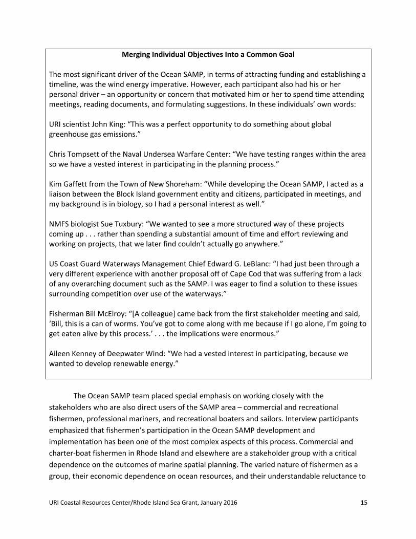
Merging Individual Objectives Into a Common Goal The most significant driver of the Ocean SAMP, in terms of attracting funding and establishing a timeline, was the wind energy imperative. However, each participant also had his or her personal driver – an opportunity or concern that motivated him or her to spend time attending meetings, reading documents, and formulating suggestions. In these individuals’ own words: URI scientist John King: “This was a perfect opportunity to do something about global greenhouse gas emissions.”
Chris Tompsett of the Naval Undersea Warfare Center: “We have testing ranges within the area so we have a vested interest in participating in the planning process.”
Kim Gaffett from the Town of New Shoreham: “While developing the Ocean SAMP, I acted as a liaison between the Block Island government entity and citizens, participated in meetings, and my background is in biology, so I had a personal interest as well.”
NMFS biologist Sue Tuxbury: “We wanted to see a more structured way of these projects coming up . . . rather than spending a substantial amount of time and effort reviewing and working on projects, that we later find couldn’t actually go anywhere.”
US Coast Guard Waterways Management Chief Edward G. LeBlanc: “I had just been through a very different experience with another proposal off of Cape Cod that was suffering from a lack of any overarching document such as the SAMP. I was eager to find a solution to these issues surrounding competition over use of the waterways.”
Fisherman Bill McElroy: “[A colleague] came back from the first stakeholder meeting and said, ‘Bill, this is a can of worms. You’ve got to come along with me because if I go alone, I’m going to get eaten alive by this process.’ . . . the implications were enormous.”
Aileen Kenney of Deepwater Wind: “We had a vested interest in participating, because we wanted to develop renewable energy.”
The Ocean SAMP team placed special emphasis on working closely with the
stakeholders who are also direct users of the SAMP area – commercial and recreational
fishermen, professional mariners, and recreational boaters and sailors. Interview participants
emphasized that fishermen’s participation in the Ocean SAMP development and
implementation has been one of the most complex aspects of this process. Commercial and
charter‐boat fishermen in Rhode Island and elsewhere are a stakeholder group with a critical
dependence on the outcomes of marine spatial planning. The varied nature of fishermen as a
group, their economic dependence on ocean resources, and their understandable reluctance to

URI Coastal Resources Center/Rhode Island Sea Grant, January 2016 16
share proprietary business information about the locations of their fishing activity have added a
great deal of complexity to their participation in the Ocean SAMP process from the start.
Interview participants described how, in the early months of the process, large numbers of
fishermen attended SAMP stakeholder meetings and were very vocal, expressing concerns
about the potential impacts of offshore wind on their livelihoods and the possibility that the
SAMP would add a new layer of regulations to already heavily‐regulated fisheries. Many
fishermen conveyed their distrust of government, particularly acute in this case given that
Rhode Island fishermen had not previously worked with CRMC, the state’s coastal management
agency (the state’s fisheries are managed by a separate agency, the Department of
Environmental Management). To respond to this, Ocean SAMP leaders sought to maximize
fishermen’s participation and access to information in every way possible. This included
convening numerous targeted stakeholder meetings solely for fishermen; providing them with
access to specialized maps, charts, studies, and offshore wind farm experts; and even
facilitating direct communication between fishermen and the state’s chosen offshore wind farm
developer.
While the stakeholder process was underway, URI researchers, coordinated by ocean
engineer Dr. Malcolm Spaulding, Sam DeBow and other URI leaders, identified and worked to
complete numerous research projects to fill data gaps concerning the SAMP area. Research
leaders selected priorities by considering existing CRMC SAMPs, the types of data used to
inform the Cape Wind EIS, and URI scientists’ knowledge base of the offshore environment.
Researchers investigated topics as wide‐ranging as geology, phytoplankton productivity, sea
birds, underwater archaeology, geographical spread of commercial and sports fishing activities,
location and timing of boating and other recreational uses, legal research on policies applicable
to the SAMP area, and models of meteorological, acoustic, and wave environments. Most of
this research was conducted or managed by university scientists and funded through public
funds allocated for SAMP development.
Several interview participants emphasized that one very important research project was
the Technology Development Index (TDI), developed by a team led by Dr. Malcolm Spaulding.9
The TDI was developed especially for the Ocean SAMP and applied to the Ocean SAMP area to
help identify sites for potential offshore renewable energy development, and was used to help
identify the Renewable Energy Zone (REZ) (see further discussion below). The TDI method
quantified the “Technical Challenge” of developing a facility at a given location, taking into
account construction challenges, expenses, and proximity to the energy grid, as well as the
potential benefits of development (determined by assessing “Power Production Potential”).
Sites with the lowest TDI (calculated by dividing the Technical Challenge by the Power
Production Potential), indicating the greatest return for the least investment, were considered
URI Coastal Resources Center/Rhode Island Sea Grant, January 2016 17
most desirable for development.10 Interview participants explained how the TDI, which
included numerous graphics and maps illustrating different datasets and different stages of the
analysis, was foundational to the SAMP – both the research findings themselves as well as the
graphics and the process. Some interview participants noted that the TDI enhanced stakeholder
communication and understanding of the MSP process. At the same time, others felt it caused
some stakeholders to see the Ocean SAMP as a narrowly‐focused renewable energy siting plan
– which was not planners’ intention. Ocean SAMP leaders sought to address such concerns
through the stakeholder process.
The process of writing the Ocean SAMP document involved extensive back‐and‐forth
between the TACs, the SAMP management team, and stakeholder groups. The integrated
writing process brought researchers and stakeholders into a collaborative, integrated
knowledge‐generation effort designed to produce more accurate and credible data than any
individual group could have produced alone. Through a series of public workshops and formal
CRMC public hearings, practitioners evaluated each chapter independently and then evaluated
the SAMP document in its entirety, in order to apply an ecosystem‐based management lens to
the whole plan (see Appendix III). This CRMC public comment process generated 2,000
individual comments, each of which CRC staff addressed or incorporated into the plan before it
was finalized.
The 1,027‐page planning document produced through this process includes a synthesis
of detailed data and information, findings of fact, general policies and enforceable regulations,
and is accompanied by 2,827 pages of technical documents (included in Ocean SAMP Volume
2). Some chapters provide an in‐depth examination of commercial fisheries, recreational uses,
and shipping while others summarize available knowledge of the ecology of the area, cultural
and historic resources, and the prospect of offshore renewable energy and other future uses. A
Narragansett Indian Tribe medicine woman and oral historian, Dr. Ella Wilcox‐Thomas Sekatau,
contributed a tribal oral history, which is included verbatim in the plan’s chapter on cultural and
historic resources. Interview participants explained that SAMP data and information included in
these chapters was viewed as high‐quality and legitimate because it was part of a state‐ and
university‐led MSP exercise, not part of a developer‐led exercise or a narrowly‐focused
renewable energy siting effort.
The Ocean SAMP document included numerous new policies and regulations. These
anticipate future development and new uses in the SAMP area and establish a number of
mechanisms to balance these new activities with existing uses and ecological protection. The
Ocean SAMP’s most innovative policies include:
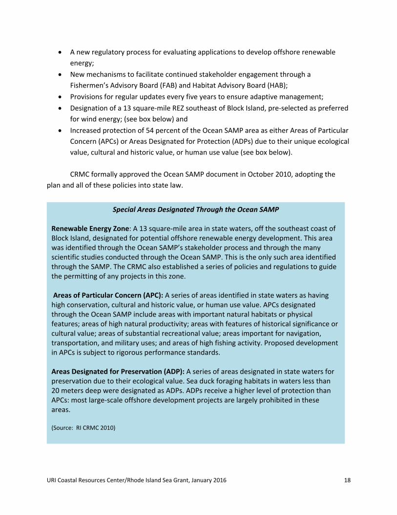
URI Coastal Resources Center/Rhode Island Sea Grant, January 2016 18
A new regulatory process for evaluating applications to develop offshore renewable
energy;
New mechanisms to facilitate continued stakeholder engagement through a
Fishermen’s Advisory Board (FAB) and Habitat Advisory Board (HAB);
Provisions for regular updates every five years to ensure adaptive management;
Designation of a 13 square‐mile REZ southeast of Block Island, pre‐selected as preferred
for wind energy; (see box below) and
Increased protection of 54 percent of the Ocean SAMP area as either Areas of Particular
Concern (APCs) or Areas Designated for Protection (ADPs) due to their unique ecological
value, cultural and historic value, or human use value (see box below).
CRMC formally approved the Ocean SAMP document in October 2010, adopting the
plan and all of these policies into state law.
Special Areas Designated Through the Ocean SAMP Renewable Energy Zone: A 13 square‐mile area in state waters, off the southeast coast of Block Island, designated for potential offshore renewable energy development. This area was identified through the Ocean SAMP’s stakeholder process and through the many scientific studies conducted through the Ocean SAMP. This is the only such area identified through the SAMP. The CRMC also established a series of policies and regulations to guide the permitting of any projects in this zone. Areas of Particular Concern (APC): A series of areas identified in state waters as having high conservation, cultural and historic value, or human use value. APCs designated through the Ocean SAMP include areas with important natural habitats or physical features; areas of high natural productivity; areas with features of historical significance or cultural value; areas of substantial recreational value; areas important for navigation, transportation, and military uses; and areas of high fishing activity. Proposed development in APCs is subject to rigorous performance standards. Areas Designated for Preservation (ADP): A series of areas designated in state waters for preservation due to their ecological value. Sea duck foraging habitats in waters less than 20 meters deep were designated as ADPs. ADPs receive a higher level of protection than APCs: most large‐scale offshore development projects are largely prohibited in these areas. (Source: RI CRMC 2010)

URI Coastal Resources Center/Rhode Island Sea Grant, January 2016 19
CRMC then took three different actions to institutionalize the plan in order to prepare
for successful implementation. The first was to forge a formal agreement with Massachusetts.
Near the end of the Ocean SAMP development process, the governors of Rhode Island and
Massachusetts signed an agreement identifying an area of mutual interest (AMI) in federal
waters adjacent to both states’ waters. A map of this area was added to the Ocean SAMP as a
finding. The agreement designated the Ocean SAMP as the governing document for the AMI
area for both states.
The second action was to work with NOAA to achieve two critical approvals. First,
NOAA’s Office for Coastal Management (OCM) approved the SAMP as part of Rhode Island’s
federally approved coastal zone management program in May 2011.11 Later that year, CRMC
also requested NOAA approval for a Geographic Location Description (GLD) in the federal
waters of the Ocean SAMP area. This ensures that Ocean SAMP information and policies are
applied through future CRMC federal consistency review of any federal activity or federally‐
approved project in this area. NOAA approved the GLD in December 2011.
The third action was to ensure formal recognition from the Federal Energy Regulatory
Commission (FERC). FERC officially recognized the Ocean SAMP in May 2012 as a
“comprehensive plan,” meaning the agency would consider the SAMP when reviewing and
permitting future renewable energy projects.5
Many lessons learned emerged through the SAMP development phase. These are
discussed in the final pages of this case study, as are the lessons learned during the
implementation phase – for as mentioned earlier, the two phases build from each other.
Considering what has been learned at the different stages of the overall process also helps in
understanding the “whole” of the Ocean SAMP and how what happened in the development
phase in many cases either shaped or influenced what happened in the implementation phase.
III. Ocean SAMP Implementation
After CRMC formally approved the Ocean SAMP document in 2010, participants’ level of
energy and direction of effort changed. The intensive two‐year process of developing the plan
had been a centralized effort, where all participants – CRMC, CRC, scientists, and stakeholders –
combined efforts towards a single shared goal: development of a marine spatial plan for the
waters off Rhode Island. After SAMP approval, that team effort entered a more decentralized
5 See Olsen et al. (2014) for more details on the formal adoption and approval process.
URI Coastal Resources Center/Rhode Island Sea Grant, January 2016 20
phase in which the various products of the Ocean SAMP – new knowledge, new relationships,
new policies and regulations – were filtered into many different decision‐making arenas.
This section presents initial observations, reflections, and analysis from the Ocean SAMP
implementation phase. At the time of this writing, the Ocean SAMP has been in
implementation (post‐plan approval) for five years. Observations and analysis of those five
years follow, while lessons learned are included in Section IV, which captures key lessons from
both the development and implementation phases of the Ocean SAMP process.
For the purposes of this analysis, Ocean SAMP implementation includes top‐down
implementation by CRMC, bottom‐up implementation by fishermen and environmental
stakeholders, and lateral implementation by other agencies involved in permitting decisions in
the SAMP area. Additionally, implementation encompasses both formal execution of
procedures laid out in the Ocean SAMP document as well as various forms of informal
implementation. Examples of informal implementation include usage of data produced in the
SAMP process, further strengthening of or tapping into relationships developed during the
process, or informal information‐sharing amongst participants – all for purposes other than
formal permitting activities. Interviews indicate that these informal aspects are, in fact, some of
the most important ways in which the Ocean SAMP has become a tool for achieving results.
A. Implementing the REZ: Permitting the Block Island Wind Farm
The first formal use of Ocean SAMP regulations took place in the context of Deepwater
Wind’s proposal to build a 30‐megwatt facility three miles southeast of Block Island, in the REZ.
Submitted in September 2012, the proposal included five turbines, a cable connecting the
turbines to Block Island, and a second bi‐directional cable connecting Block Island with the
mainland.12 Deepwater Wind worked with Ocean SAMP data and within Ocean SAMP policies in
its permit applications, its construction and operations plan, and its siting decisions, perhaps
most significantly in its use of the REZ. “The Renewable Energy Zone was a real positive for us in
terms of taking the issue of siting off the table,” said Aileen Kenney, Vice President of
Permitting for Deepwater Wind. “The process found the site, and then we have to be within it,
so it helped the permitting process to go smoother than it might have without the Renewable
Energy Zone.”
A total of four state agencies, seven federal agencies, two Indian tribes, and three
municipalities played a role in approving the wind farm and transmission cables. While CRMC
approval was the only part of the process that was formally governed by the Ocean SAMP,
many other decisions made by other agencies relied indirectly on the Ocean SAMP in some way

URI Coastal Resources Center/Rhode Island Sea Grant, January 2016 21
– for example, utilizing Ocean SAMP data or drawing on improved personal knowledge formed
during the Ocean SAMP development phase.
Wind farm permits and reviews were issued by multiple state and federal agencies (see
Table 4). These included a permit (called an “assent”) and submerged lands lease issued by
CRMC in November 2014. These also included an Individual Permit from the U.S. Army Corps of
Engineers under the federal Rivers and Harbors Act and Clean Water Act (September 2014), and
a Right of Way Grant from BOEM to lay the cable that would cross federal waters (November
2014).13 Other agencies, such as the U.S. Fish and Wildlife Service, the U.S. Coast Guard (USCG),
and the NOAA National Marine Fisheries Service (NMFS), played a role in reviewing the
proposal under the joint Environmental Assessment prepared by the lead agency, the U.S. Army
Corps (USACE), and the cooperating agency (BOEM) pursuant to NEPA.

URI Coastal Resources Center/Rhode Island Sea Grant, January 2016 22
Table 4. Agencies Issuing Permits or Approvals for the Block Island Wind Farm
Agency Permit, Approval or Consultation Required
Federal
Bureau of Ocean Energy Management (BOEM)
Right of Way Grant for Block Island Transmission System (Outer Continental Shelf Lands Act)
Environmental Protection Agency (EPA) Air Conformity Determination (Clean Air Act)
Federal Aviation Administration (FAA) Determination of No Hazard
Fish and Wildlife Service (USFWS) Consultation (Endangered Species Act, Migratory Bird Treaty Act)
National Oceanic and Atmospheric Administration National Marine Fisheries Service (NMFS)
Consultation and Incidental Take Authorization (Marine Mammal Protection Act); Essential Fish Habitat consultation (Magnuson‐Stevens Fishery Conservation and Management Act)
U.S. Army Corps of Engineers (USACE) Individual Permit (Rivers and Harbors Act, Clean Water Act)
U.S. Coast Guard (USCG) Approval for Private Aids to Navigation
Tribal
Narragansett Tribe Consultation (National Historic Preservation Act)
Wampanoag Tribe Consultation (National Historic Preservation Act)
State
R.I. Coastal Resources Management Council (CRMC)
Assent (Permit); Concurrence with Federal Consistency Certification; Submerged Lands Lease; Coastal and Freshwater Wetlands Permit
R.I. Department of Environmental Management (RIDEM)
Coastal and Freshwater Wetlands Permit; Endangered Species Consultation; R.I. Pollution Discharge Elimination System General Permit for Storm Water Discharge
R.I. Department of Transportation (RIDOT) Physical Alteration Permit; Easement for the cable and overhead electric lines
R.I. Historical Preservation and Heritage Commission State Historic Preservation Office (SHPO)
Consultation (National Historic Preservation Act and R.I. Historic Preservation Act)
Local
Town of Narragansett Special Use permit
Town of New Shoreham Zoning Board Special Use Permit
Town of New Shoreham Planning Board Development Plan Review
Source: Deepwater Wind. 2012. Block Island Wind Farm/Block Island Transmissions System Environmental Report/Construction and Operations Plan. Online at http://dwwind.com/wp‐content/uploads/2014/08/Environmental‐Report.pdf.

URI Coastal Resources Center/Rhode Island Sea Grant, January 2016 23
Representatives of some permitting agencies interviewed for this case study indicated
that the Ocean SAMP eased their respective permitting processes in several ways. The
proposed wind farm’s location within the REZ assured reviewers that the public had already
vetted the location and was unlikely to raise major objections during the public comment
process. Meanwhile, the wind farm location’s avoidance of APCs and ADPs designated through
the SAMP assured reviewers that it would not interfere with sea duck foraging habitat, shipping
lanes, or Navy testing ranges that would have been grounds to deny or challenge a permit.
Moreover, the abundance of data contained within the Ocean SAMP, which had been produced
by university scientists and scrutinized by a comprehensive group of stakeholders, provided a
valuable and trusted informational resource.
Marine spatial planning is sometimes touted as a way to simplify the mandated NEPA
environmental review process by generating enough up‐front information to eliminate the
need for a full‐blown EIS, and this was one of the arguments originally used in presenting the
idea of the Ocean SAMP to state leadership. In the case of the Block Island Wind Farm, USACE
reviewer Bob DeSista estimated that the Ocean SAMP saved his agency two to three years by
enabling the project to move ahead with the less time‐consuming and resource‐intensive
option of an EIS, which resulted in a Finding of No Significant Impact.
USACE drew on the Ocean SAMP when developing alternative siting scenarios, a
required step for NEPA analysis. It was not simply a coincidence that the Ocean SAMP
contained ample information useful for this analysis. By participating in the Ocean SAMP
development, USACE provided input that helped ensure that the plan generated the kind of
data they would eventually need for their NEPA review, including the alternatives analysis the
Corps would ultimately be required to perform. “They almost did some of the work for us
before we had to do it,” observed DeSista. “There was a lot of information in there that we and
other agencies who were commenting on it could utilize.”
Other agencies involved in the permitting process echoed DeSista’s observation, saying
that the Ocean SAMP enabled them to review the project more swiftly and confidently. For
example, Edward LeBlanc of the USCG noted that widespread references to Ocean SAMP data
within Deepwater Wind’s navigational risk assessment greatly informed his agency’s review and
evaluation of navigation risks. “We took that at face value,” said LeBlanc. “‘Oh, it’s in the
SAMP? Then fair enough, we’re moving on. We’re not questioning the methodology of how
that document was prepared because we know it. We were part of it.’”
Similarly, Sue Tuxbury of NOAA’s NMFS commented that having Ocean SAMP data at
her fingertips expedited the Essential Fish Habitat (EFH) review that her agency performed as

URI Coastal Resources Center/Rhode Island Sea Grant, January 2016 24
part of the NEPA process. “A lot of the information that we would have requested for our EFH
review was provided ahead of time through the Ocean SAMP process,” Tuxbury explained. “If
we had received this application without this early coordination, our review would have taken
substantially longer, and the application processes would likely have taken years longer as well.
Having the data from the Ocean SAMP available for our review helped ensure our comments
were provided within the requested timeline.”
In addition to facilitating agency decisions about whether to permit the wind farm,
interview participants explained how the Ocean SAMP helped some agencies determine what
conditions to place on the wind farm in their respective permits. For instance, CRMC worked
closely with USACE, according to Bob DeSista, as they prepared their own permit in order to
coordinate and create consistency between the two agencies’ monitoring requirements and
decommissioning plans. NMFS fisheries biologist Sue Tuxbury explained how NMFS also worked
with the state and USACE on overlapping monitoring requirements. For example, coordination
among the state and federal agencies, as well as the fishing community, ensured a robust trawl
survey was incorporated as a requirement in the federal permit.6
Interviews revealed the Block Island Wind Farm permitting process also benefited from
the Ocean SAMP’s intangible outcomes, such as social capital. Most notably, working
relationships, communication, and the trust established through the Ocean SAMP process
helped the wind energy developer and existing users of the SAMP area collaborate rather than
engage as adversaries. For example, Grover Fugate recounted how fishermen representing
three different commercial fishing organizations, environmental advocates, and members of
the Narragansett Indian Tribe all showed up to testify in favor of the Block Island Wind Farm
during a final permitting hearing. He explained that at this hearing, a member of the public kept
interrupting a Conservation Law Foundation (CLF) representative while she was delivering her
supportive testimony. A fisherman who would later become chair of the FAB intervened. “He
stood up and said something like ‘let the CLF have their say,’” Fugate explained. “It struck me as
ironic that the fishing industry representatives were vocally supporting CLF to have an
uninterrupted say – which was, in a manner of speaking, supporting development in the
ocean.”
The Ocean SAMP “brought a lot of stakeholders to the table,” observed Aileen Kenney
of Deepwater Wind: “So when we went to develop the project, with the key stakeholders
6 NMFS does not have direct permitting authority over development projects such as the Block Island Wind Farm. Instead, it has authority to review these projects for impacts on Essential Fish Habitat provisions as defined in the Magnuson Stevens Fishery Conservation and Management Act and to provide guidance to federal permitting agencies such as the Army Corps of Engineers.

URI Coastal Resources Center/Rhode Island Sea Grant, January 2016 25
there’s not a learning curve there really. They all obviously know what type of product we’re
trying to sell, which is offshore wind, but they all also know each other. For example, the
fishermen understand why the tribes are at the table, and they all understand why folks are
concerned about marine mammals.”
Permitting the Block Island Wind Farm in the REZ relied on the Ocean SAMP in many
ways – both the designated areas and regulations established by the SAMP, as well as the
relationships and communication the SAMP established between agencies, stakeholders, and
the developer. This stands in contrast to efforts to site another wind farm, Cape Wind,
discussed below.

URI Coastal Resources Center/Rhode Island Sea Grant, January 2016 26
Planning for Offshore Wind Development in New England:
Comparing Cape Wind and the Block Island Wind Farm
The Block Island Wind Farm permitting experience stands in stark contrast to the experience of
the nearby Cape Wind project, proposed in 2001 in federal waters of Nantucket Sound.14 The
Cape Wind project underwent 14 years of permitting battles and litigation, and at the time of
this writing, appears to be all but permanently defeated. There are many reasons that Cape
Wind faced a steeper battle than the Block Island Wind Farm. These include its much larger size
at 130 turbines, its location in federal rather than state waters, early and intense opposition
from a few influential and wealthy property owners, mid‐stream changes in the permitting
process due to the Energy Policy Act of 2005, and open opposition from two out of the three
governors who sat in office during the efforts to win approval and begin construction. However,
interview participants who observed both processes say that some of the Block Island Wind
Farm’s comparative success in obtaining necessary permits with minimal public opposition can
be traced to the Ocean SAMP’s broad and proactive public planning process.
Unlike the Block Island Wind Farm, the Cape Wind project did not stand on the shoulders of a
public MSP process, for no such process had been completed in the waters off Massachusetts
at the time. Instead, the developer chose what appeared to be a suitable location and applied
for a lease to use it – following the process that was required under existing federal
environmental regulations. As a result, Massachusetts lawyers Kenneth Kimmel and Dawn
Stalenhoef wrote that the project was beset from the beginning by a public perception that
“Cape Wind had simply located a site, staked a flag on it, as it were, and began permitting as if
it had the necessary property rights.”15
The fundamental difference is that the Block Island Wind Farm was sited through a broad,
state‐led, comprehensive planning process, whereas Cape Wind was sited through a narrowly‐
focused, developer‐driven permitting process. Whereas siting an offshore wind farm is neither
an assumed goal of marine spatial planning nor an indicator of success per se, these two cases
illustrate some of the potential benefits of undertaking a comprehensive, stakeholder‐driven
MSP process.
B. Exerting the Influence of the Ocean SAMP Outside of State Waters
Interview participants indicated that through a combination of data‐rich planning,
continuous relationship‐building, and innovative policy instruments, Rhode Island has leveraged
the Ocean SAMP to attain a level of influence over federal waters which, although based on

URI Coastal Resources Center/Rhode Island Sea Grant, January 2016 27
solid data and existing policy tools, is arguably beyond the norm for a state planning effort.
Through the Ocean SAMP, the state of Rhode Island:
Secured NOAA approval of a GLD for state waters, giving CRMC increased federal
consistency review authority over certain activities in federal waters;
Developed the AMI agreement with Massachusetts, collaborating rather than
competing with its neighbor over development in adjacent federal waters;
Drew on data and relationships formed through the Ocean SAMP to influence site
selection of a set of BOEM lease blocks in federal waters; and,
Is playing a role in the anticipated development of an approximately 200‐turbine wind
farm in the AMI area.
The influence that Rhode Island has achieved to date over federal waters through the Ocean
SAMP shows that marine spatial planning can be a way for a state to influence activities outside
its own waters, and in doing so achieve numerous environmental, economic and social benefits.
i. Expanding Rhode Island’s Influence in Federal Waters: Using the Ocean SAMP to
Develop a GLD
SAMP leaders interviewed for this study explained CRMC’s early recognition that the
Ocean SAMP would be a primary tool to address activities in federal waters, including energy
projects, through the federal consistency provision of the federal CZMA and that the Ocean
SAMP data and information would enhance the state’s ability to review these activities in
federal waters. In addition, SAMP leaders explained how they envisioned the Ocean SAMP
forming the basis for proposing to NOAA a GLD in federal waters for CRMC federal consistency
reviews. Under NOAA’s CZMA regulations, a state can establish a GLD for an area outside of its
coastal zone.7 In a GLD, a state lists the federal licenses or permits for activities that will be
automatically subject to state CZMA review. Otherwise, a state would have to request approval
from NOAA to review proposed projects in federal waters on a case‐by‐case basis. Listed
activities are those that have been found to have “reasonably foreseeable effects” on a state’s
coastal uses or resources.
For Rhode Island, a GLD for the Ocean SAMP area would ensure that CRMC and Rhode
Islanders would have a say in any new development proposed for the federal waters within the
SAMP area (out to 30 miles, well beyond the three‐mile state waters boundary). SAMP leaders
explained that by creating the GLD for review of projects in federal waters, CRMC ensured that
7A GLD can be proposed either inland to other parts of the state, or in another state, or seaward into federal waters.

URI Coastal Resources Center/Rhode Island Sea Grant, January 2016 28
the Ocean SAMP information and policies would be applied through future CRMC federal
consistency review of any federal agency activity or federally approved project proposed for
state waters and federal waters within the GLD, conducted through CRMC’s coastal zone
management authority. When a GLD is in place, the onus is on non‐federal applicants seeking a
listed federal permit to file a federal consistency certification with the state coastal
management agency. This gives states more influence over the leasing and
permitting/authorization processes for these activities. Additionally, for listed activities in a
GLD, the state does not need to track these activities off of its coast; rather, the burden is on
the applicant and the authorizing agency to notify the state.8
CRMC requested approval of a GLD from the NOAA OCM in 2011. CRMC’s proposed GLD
covered all federal waters within the SAMP area, and requested “listed” status for eight classes
of activities: offshore renewable (wind, wave, tidal) energy, offshore liquefied natural gas (LNG)
platforms, artificial reefs, underwater cables, mining activities, aquaculture, dredged material
disposal, and meteorological towers. NOAA approved the GLD for seven of the eight proposed
categories. It did not grant listed status for dredged material disposal because previous Army
Corps monitoring of an existing dredge spoil disposal site, Area 69B, showed no evidence of
adverse biological effects and, at the time of the GLD review process, CRMC was unable to
produce enough data to satisfy NOAA’s requirements on this topic.
Having a marine spatial plan is not a prerequisite for a GLD, but extensive, high‐quality
data is. A comprehensive, science‐based, and stakeholder‐driven MSP process is an effective
and efficient way to generate this data. Data and reliable studies are what enable states to
build persuasive “reasonably foreseeable effects” arguments necessary to convince federal
authorities that the state should have review authority of, and therefore, greater influence
over, listed activities in federal waters. To demonstrate that a class of federally permitted
activities (e.g., wind energy, dredging) will have effects on uses or resources of the state’s
coastal zone, states must use data about an area and its natural resources and human uses to
demonstrate a causal relationship between activities in the GLD area and effects to uses or
resources of a state’s coastal zone (even if the uses or resources occur or are affected in federal
waters). Given this, the scientifically sound and extensive research performed by URI scientists
was critical to CRMC in making successful coastal effects justification arguments for seven
classes of activity. Without the Ocean SAMP funding, research and stakeholder involvement, it
would arguably have been very difficult to develop the GLD.
8 A GLD is only needed for federal license or permit activities by non‐federal applicants. A GLD is not needed for activities proposed to be conducted by a federal agency; federal agencies determine whether their proposed activities will have coastal effects, regardless of the location of the activity.

URI Coastal Resources Center/Rhode Island Sea Grant, January 2016 29
Interviews revealed that the Ocean SAMP also supported Rhode Island’s GLD request in
intangible ways by cultivating close working relationships with many of the federal agencies
that would be affected by the GLD. By involving NOAA’s OCM (which approves changes to state
coastal management programs, including GLDs) and other federal agencies with a say in
approving listed uses (e.g., USCG, USACE, BOEM, the Navy) early and often in the Ocean SAMP
process, CRMC made sure these agencies not only fully absorbed the information generated
through the process, but were able to provide input at every stage. This also resulted in the
federal agencies signing off on the GLD in the end. Moreover, CRMC announced early on in the
Ocean SAMP process that it intended to pursue the GLD, so when it finally did, the agencies
with a say in its approval were not caught off guard. “As soon as we would draft a version [of
the Ocean SAMP], we’d send it to [the federal agencies] for comments,” recalls CRMC Director
Grover Fugate. “They’d send back the comments, we’d incorporate them, and send it back. It
went back and forth like that. So NOAA had participated in the drafting of each of the chapters,
and later with the GLD. They were intimately familiar with how everything was flowing.”
The GLD amplifies the impact of the Ocean SAMP in other ways as well. Fugate
explained how the GLD amplifies the power of the FAB and the HAB established through the
SAMP because these boards now “have standing with the federal agencies.” He explained how,
in this sense, the GLD has “given the state more control over its destiny” by expanding its
influence in federal waters. While there are few tangible effects of the GLD to date, Fugate
explained how the FAB has already wielded some influence by helping to determine the
fisheries monitoring studies the agencies have required Deepwater Wind to perform, as well as
the location of a proposed meteorological buoy. While other effects have not yet been
demonstrated in any measurable way, observers theorize that the benefits of the GLD have
already played out in more subtle ways. “The leverage that it creates is influential,” observed
CLF’s Tricia Jedele. “Just the fact that we have a GLD that’s been approved for a whole list of
activities gives CRMC leverage when talking with the federal government before a project is
proposed, when it’s just an idea.”
ii. The Area of Mutual Interest (AMI): Interstate Coordination and Influence over
Federal Decisions
A second mechanism through which Rhode Island extended the influence of the Ocean
SAMP was by signing a Memorandum of Understanding (MOU) with Massachusetts establishing
a 400 square‐mile AMI in federal waters, equidistant from the coasts of the two states. The AMI
agreement has played a dual role in shaping wind energy planning in Southern New England.
On one hand, it has reduced tensions between Rhode Island and Massachusetts over wind
energy siting and distribution of benefits. At the same time, it has given the two states an

URI Coastal Resources Center/Rhode Island Sea Grant, January 2016 30
innovative tool to influence the siting of federally permitted wind energy projects.
The MOU was signed in 2010 when initial results of the Ocean SAMP’s TDI began to
reveal prime territory for wind energy development in the easternmost portion of the SAMP
area — in federal waters near the boundary of Massachusetts state waters. The governors of
the two states realized the importance of this area, and also the potential for competition. As
Grover Fugate explains it, the states realized their ability to work together would be key to
influencing the selection of priority wind energy leasing areas by BOEM (known as the Minerals
Management Service/MMS at the time)9 as that agency prepared to open wide swaths of the
East Coast to wind energy development. BOEM indicated its general intent to defer to the
states when selecting areas. “They wanted the states to nominate the area,” explained Grover
Fugate. “We knew between Rhode Island and Massachusetts that we needed to work together
and reach an agreement in order to have offshore renewable energy.”
In the 10‐year MOU, signed just three months before final CRMC approval of the Ocean
SAMP in 2010, the two states pledged to coordinate when pursuing wind energy development
in the AMI. The MOU established several mechanisms to ensure coordination, thus formally
institutionalizing elements of the Ocean SAMP. Mechanisms included:
Granting official SAMP stakeholder status to the Massachusetts Office of Energy and
Environmental Affairs;
Requiring three Massachusetts fishermen to join the six Rhode Island fishermen in FAB
decisions regarding AMI waters; and
Designating the Ocean SAMP as the governing planning document for the AMI.
The MOU also set guidelines for how each state would go about pursuing wind energy
development both inside and outside the AMI. Inside the AMI, the two states agreed to share in
costs and benefits resulting from wind energy, including associated infrastructure development,
construction and operations jobs, payments to states associated with the federal lease,
payments in lieu of taxes, and other economic benefits such as interconnection to the electric
power grid or power purchase agreements. The MOU barred either state from working with a
developer to pursue a lease in the AMI without securing written approval from the other state.
The MOU also expressed a guarantee of support by Massachusetts for projects undertaken in
the AMI by Deepwater Wind, Rhode Island’s preferred developer. The MOU also included a
9 The federal agency Minerals Management Service was renamed the Bureau of Ocean Energy Management, Regulation and Enforcement (BOEMRE) in 2010 following the Deepwater Horizon oil spill. BOEMRE was subsequently divided into three different agencies in 2010‐2011, including the current Bureau of Ocean Energy Management (BOEM), which is responsible for managing development of the nation’s offshore energy resources.
URI Coastal Resources Center/Rhode Island Sea Grant, January 2016 31
provision through which Massachusetts fishermen would participate on Rhode Island’s FAB to
discuss future development projects or other issues related to this area. Outside the AMI, the
MOU recognized Rhode Island’s exclusive interest in pursuing renewable energy development
in state and federal waters north and west of the AMI and recognized Massachusetts’ exclusive
interest in waters east and south of the AMI.
One of the most concrete aspects of AMI implementation to date was an outreach
effort that CRMC conducted for Massachusetts stakeholders soon after the approval of the
Ocean SAMP. This outreach took place at Massachusetts’ request and was targeted at
fishermen and coastal communities. Since the MOU made the Ocean SAMP the governing
document for the AMI, SAMP leaders explained that it was important to ensure that Ocean
SAMP implementation took these stakeholders’ knowledge and concerns into account. Grover
Fugate and Dave Beutel of CRMC, as well as CRC staff and URI scientists, spent considerable
time traveling to locations in Southeastern Massachusetts to hold workshops with fishermen
and other stakeholders. These meetings helped build a mutual understanding between Rhode
Island and Massachusetts practitioners and stakeholders about the resources of the AMI.
In addition to affirming a cooperative spirit between Rhode Island and Massachusetts,
Fugate explained that the AMI agreement signaled to BOEM that both states were interested in
working collaboratively to develop wind energy in this area. This was important because the
Ocean SAMP could not formally designate areas for wind energy in federal waters, as it did in
state waters, through the REZ. But by highlighting the AMI through the MOU, the two
governors indicated to BOEM that there was regional interest and scientific backing for wind
energy development and that the area had already been through preliminary vetting by
scientists and stakeholders. The two states chose the boundary delineating the AMI based on
initial results of the TDI analysis, which indicated a high potential for wind energy production
there. Fugate explained how the AMI boundary was also developed with input from Rhode
Island fishermen, who wanted to ensure the area would be managed through the SAMP
document and process. Selection of the area was also influenced by an informal agreement
between BOEM and Massachusetts leaders to keep any development at least 12 nautical miles
off the Massachusetts shore. Although the AMI holds no formal meaning at the federal level, its
designation was arguably an important informal influence in the selection of BOEM’s wind
energy lease areas in federal waters, as discussed in the next section.
iii. Use of the Ocean SAMP in Federal Decision‐Making: The RI/MA Wind Energy Area
The Ocean SAMP’s influence in federal decision‐making can be seen through BOEM’s
designation and leasing of a Rhode Island/Massachusetts Wind Energy Area (RI/MA WEA) in

URI Coastal Resources Center/Rhode Island Sea Grant, January 2016 32
federal waters. This process, which began shortly after the completion of the Ocean SAMP, was
influenced by the Ocean SAMP in at least three ways.
First, BOEM’s selection in 2011 of the area that ultimately became the RI/MA WEA
fundamentally mimicked the location and boundaries of the agreed‐upon AMI set out in the
Rhode Island‐Massachusetts MOU. By including this AMI agreement as a finding within the
Ocean SAMP, Rhode Island signaled to BOEM that the two states favored this area for wind
energy. Fugate explains that, at that time, BOEM was soliciting guidance from states up and
down the East Coast to identify areas with the most promise for wind energy development.
Interview participants observed that since the AMI had already been vetted through the Ocean
SAMP process, this provided some assurance to BOEM that this area enjoyed public support as
a focus for wind energy development. By effectively pre‐designating the area, the states
arguably saved BOEM time and energy, facilitated harmonious working relationships between
the states and BOEM, and achieved informal influence over the federal leasing process.
Second, the Ocean SAMP influenced the geographic designation of the RI/MA WEA
through relationships and communication pathways created through the SAMP process,
principally between commercial fishermen and decision‐makers. CRMC’s Dave Beutel explained
how, during the first stage of BOEM’s public process (the Call for Nominations and Information),
fishermen raised concerns over the inclusion of important fishing grounds on Cox Ledge within
the proposed leasing area. With technical support from CRMC and URI, the FAB was able to
show BOEM data confirming that multiple fisheries, using different types of fishing gear, make
intensive use of this area. As a result, BOEM removed a swath of lease blocks from the
proposed area before finalizing it as the RI/MA WEA in February 2012 and opening a
competitive lease sale – the first in the nation for wind energy – in July 2013 for two clusters of
lease blocks.16 This story, discussed in greater detail below (see Section III. C. ii.), is a story of
informal, extra‐regulatory activity of a formal body, the FAB, established through the Ocean
SAMP. The data, relationships, and legitimacy that fishermen leveraged to push for the removal
of Cox Ledge from the Call Area all derive in some way from the Ocean SAMP.
A third way in which the Ocean SAMP played a role in decision‐making within the RI/MA
WEA was by supplying data for BOEM’s Environmental Assessment (EA) conducted prior to the
federal leasing process. According to BOEM’s Bob LaBelle, “The Ocean SAMP provided
information used during preparation of the Environmental Assessment that was used to assist
BOEM in determining which OCS [offshore continental shelf] areas offshore of Rhode Island and
Massachusetts should be the focus of the agency’s wind energy leasing efforts.” According to
LaBelle, BOEM viewed the Ocean SAMP as “the best available science to identify resource
conflict‐use areas and suitable placement of offshore energy facilities and input from well‐

URI Coastal Resources Center/Rhode Island Sea Grant, January 2016 33
informed and committed environmental and civic organizations; local, state, and federal
agencies; and resource users and researchers.” BOEM incorporated extensive Ocean SAMP data
on ecology, human uses, fish populations, and wildlife into the EA. This move expedited BOEM’s
EA process and drew on the high credibility of Ocean SAMP data to ensure what some interview
participants described as a relatively accurate and well‐respected outcome.
The BOEM leasing process that took place after the EA included auctions for two
sections of the RI/MA WEA. Both were leased to Rhode Island’s preferred developer,
Deepwater Wind, which is in the planning stages for a potential 200‐turbine wind farm called
Deepwater ONE to be sited in this area. Ultimately, proposed development in the RI/MA WEA
will be subject to Rhode Island’s recently‐expanded federal consistency authority through its
new GLD, illustrating how RI will continue to exert influence in federal waters through the
Ocean SAMP (discussed above; see Section III. B. i.).
iv. The Interplay of State and Regional Planning
In 2010, President Barack Obama signed Executive Order 13547 to adopt a National
Policy for the Stewardship of the Ocean, Our Coasts, and the Great Lakes.17 The policy was a
culmination of work by the Interagency Ocean Policy Task Force created by the President in
2009 to devise policies for better management and stewardship of U.S. oceans, coasts, and
Great Lakes. The Executive Order created the National Ocean Council, made up of senior‐level
representatives from federal executive departments including the Department of Commerce
and the Department of the Interior, the administrators of NOAA and the Environmental
Protection Agency, the chair of the Council on Environmental Quality, and others. It also
provided for coastal and MSP efforts at the regional or large marine ecosystem level, overseen
in each respective region by a Regional Planning Body (RPB). RPBs do not have regulatory
authority but instead, focus on improving science and information and coordinating effective
decision‐making among multiple agencies within existing authorities.18 Some interview
participants pointed out that National Ocean Policy and regional planning leaders often look to
the Ocean SAMP as a prime example of marine spatial planning. For further discussion, see
Olsen et al. (2014).
In New England, regional MSP efforts are coordinated by the Northeast Regional
Planning Body, established in 2012 pursuant to the National Ocean Policy, which works in close
collaboration with the Northeast Regional Ocean Council (NROC), a regional ocean partnership
first established in 2005. Together, the two entities are working toward the development of a
regional ocean plan (expected in 2016). Fugate, who has been the state co‐lead of the
Northeast RPB and a longtime NROC participant, explained how both entities are working to

URI Coastal Resources Center/Rhode Island Sea Grant, January 2016 34
foster greater coordination among permitting agencies, improve the scientific basis for
decision‐making, and create expanded pre‐application processes for new uses in New England
waters.
The Northeast’s ongoing data‐ and information‐gathering process will produce material
directly relevant to Ocean SAMP implementation, and vice versa. CRMC plans to integrate
much of this information into the Ocean SAMP’s five‐year update, which began in October
2015. For example, NROC is developing detailed maps of fisheries usage in the region based on
Vessel Monitoring System (VMS) data provided by NOAA. CRMC’s Dave Beutel explained how
these fine‐scale maps showing fishing activity by target species and location are far more
advanced than the fisheries maps CRMC was able to develop during the tight timeframe of
Ocean SAMP development. Federal commitments in the forthcoming regional ocean plan may
include regular updates of VMS and other such data, thus ensuring the plan remains updated
and useful. Additionally, the regional data collection process will also highlight regional science
and research priorities and, in doing so, elevate the prioritization of data gaps identified
through the Ocean SAMP.
As part of the ongoing regional process, NROC is also conducting a regional recreational
activity characterization and mapping project.19 This includes gathering input from recreational
stakeholders, through a survey and in‐person meetings, and mapping key areas for recreational
boating, diving, fishing, and sailing. Like the fisheries maps, these maps will feed into the 2015
Ocean SAMP update. CRMC and CRC staff interviewed for this study explained that they are
helping with the regional data collection process, by collecting data for Rhode Island and the
Ocean SAMP area, in order to ensure that it is accurate and comprehensive. “We’re benefiting
each other, making each other’s initiatives stronger,” said CRC’s Jennifer McCann.
C. Fishermen’s Experience of Ocean SAMP Implementation
In the five years since Ocean SAMP approval, fishermen have considered questions of
wind turbine siting, fisheries monitoring, and mitigation of wind turbine impacts on fisheries.
Interview participants indicated that to address these questions, some fishermen have used a
combination of formal consultation requirements as required through Ocean SAMP policies as
well as ad‐hoc, informal strategies that take advantage of relationships and communication
channels facilitated by the Ocean SAMP. As mentioned previously, while some fishermen have
been highly active and have sought creative ways of leveraging the Ocean SAMP to serve their
interests, others have remained on the sidelines, making it difficult to know whether or not
their interests are adequately represented in the outcomes of planning. All of these factors
make for a complex and evolving dynamic of engaging fishermen in the SAMP.

URI Coastal Resources Center/Rhode Island Sea Grant, January 2016 35
i. Formal participation
The Ocean SAMP lays out various policies to ensure continued representation of
fishermen’s interests in the SAMP area. Chief among these is the creation of the nine‐member
FAB to comment on potential fishery‐related impacts of proposed development projects. The
Ocean SAMP requires developers to consult with the FAB on matters such as project location,
construction schedules, impacts on fishing activity, and mitigation measures. For projects in
state waters, the Ocean SAMP requires project proponents to meet with the FAB as a
prerequisite to submitting an application to CRMC. For projects in federal waters, the Ocean
SAMP requires project proponents to meet with the FAB as “necessary data and information”
for federal consistency review.10
Other formal fisheries measures in the Ocean SAMP include a requirement that
developers negotiate a fisheries mitigation agreement (with input from the FAB), include
fisheries surveys in their Site Assessment Plan (SAP) and Construction and Operations Plan
(COP),11 and hire a third‐party “fisheries liaison” to facilitate direct communication with
fishermen during all phases of a project, from pre‐construction to operation to
decommissioning.
1. The Fishermen’s Advisory Board (FAB)
CRMC appointed the initial slate of nine FAB members (six from Rhode Island and three
from Massachusetts) in July 2011, 10 months after Ocean SAMP approval.20 Members
represent the range of fishing activities that take place in the SAMP area: lobster, bottom trawl,
gillnet, scallop, recreational, and charter. SAMP policies provide only a rough outline of FAB
operating procedures, largely leaving it up to appointees to decide how to run the advisory
body.
Interviews revealed that, to date, the FAB has used this leeway widely. Early on,
members realized their busy fishing schedules made it hard to attend meetings. At their
request, CRMC initiated a public process to amend the Ocean SAMP to allow for one alternate
member per fishery gear group. FAB members themselves appointed individuals to fill these
slots. Through a similar public process, the FAB also secured a change in the regulations to
recognize one FAB member as an official chairperson in charge of managing meetings. Despite
the designation of alternate representatives, FAB members continued to struggle with the
10 “Necessary data and information” is a requirement of the federal consistency review process as laid out in the federal Coastal Zone Management Act. 11 This requirement is waived if the developer has obtained a CRMC permit within the REZ within two years of approval of the Ocean SAMP.
URI Coastal Resources Center/Rhode Island Sea Grant, January 2016 36
complications of fitting meeting attendance into their busy fishing schedules, and so requested
and obtained approval from CRMC for a further accommodation – for the FAB to conduct its
business over e‐mail.
These regulatory changes – allowing alternate members and providing recognition for a
chair to run FAB meetings – are among very few official changes to have taken place so far to
Ocean SAMP policies. To Grover Fugate, these custom modifications of the functioning of the
FAB indicate a high level of investment among its members. “Fishermen took possession of the
FAB,” Fugate observed, “which is what it was set up to do. They really laid claim to it. And
they’re using it to their maximum advantage.”
FAB chair Bill McElroy concurred: “You have to have a formula, a process, by which you
can say, ‘There’s an issue that I need to talk to someone about.’” For McElroy, the formalized
legitimacy that CRMC granted the FAB through its creation in the Ocean SAMP is the only way
to give fishermen a voice that will be heard in development decisions. “If it wasn’t for the FAB,
and I didn’t have that line of communication with Deepwater Wind, I try to imagine how we’d
ever find out things and put input into things. Basically, I would be a lone individual fisherman
calling up the central switchboard at some giant company.” As the rest of this section
illustrates, the FAB has used its voice to exert influence in the development of the SAMP area.
2. Fisheries Monitoring
Interview participants recounted how fishermen emphasized serious concerns about the
unknown impacts of wind energy development during the Ocean SAMP development process
and have continued to reiterate this during the Ocean SAMP’s implementation phase. “I hope
we do enough science – continuously – so that we do see what impact this has,” commented
fisherman Fred Mattera. As a result of fishermen’s continued concerns, monitoring the impacts
of development on fisheries is a key priority of the Ocean SAMP.
Interviews revealed that through the FAB, fishermen have played an influential role in
expanding the baseline fisheries monitoring performed by Deepwater Wind at the Block Island
Wind Farm site.12 CRMC’s Dave Beutel reported that, initially, Deepwater Wind and CRMC had
agreed that the company would perform a pre‐ and post‐construction fish trawl survey as a
condition of its permit to develop the wind farm. But, members of the FAB felt that more was
needed, and made a request to Deepwater Wind to fund an additional study – a survey that
12 For the Block Island Wind Farm, such studies are not required because the Ocean SAMP waives its fisheries baseline and monitoring requirements for any project proposed in the Renewable Energy Zone within two years of Ocean SAMP approval.
URI Coastal Resources Center/Rhode Island Sea Grant, January 2016 37
could help assess lobster populations.
Interview participants indicated that the FAB had several motivations in requesting the
additional survey. Not only did they believe that it was necessary to track potential impacts of
wind turbines on lobster populations, but they saw an opportunity to fill gaps in coverage for
fisheries management data. Currently, the state collects lobster data inshore and in
Narragansett Bay, but the area around Block Island is underrepresented. According to FAB chair
Bill McElroy, FAB members hope to leverage the wind farm’s monitoring commitment to
generate information that could be useful in fisheries management decisions. Whether or not
the state will be able to use the data for this purpose is unclear, but the FAB is optimistic.
“The states are having to cut back because their budgets are shrinking, so this is the
perfect opportunity to expand the data gathered via a different mechanism,” explained FAB
Chair Bill McElroy. “When they were planning the fish and lobster surveys, I insisted that they
be done in a fashion that was compatible with the way that fisheries management research is
currently conducted. So the information that’s gathered can be used in the fishery
management realm.”
Several interview participants recounted a more recent instance in which the FAB
persuaded Deepwater Wind to extend the timeline of its pre‐construction monitoring program.
Bill McElroy reported that when fishermen realized that the two‐year pre‐construction and
two‐year post‐construction surveys would leave a gap in data collection, they met with
Deepwater Wind staff and asked them to voluntarily continue the fisheries surveys during
construction. Although Deepwater Wind had no legal obligation to honor this request, they
chose to do so, suggesting the strength of the relationship between the FAB and the developer.
This agreement was later formalized through its inclusion in a November 2013 letter from
Deepwater Wind to CRMC, documenting the company’s fisheries mitigation activities. All told,
Deepwater Wind’s monitoring commitment totals $1.3 million.21
3. Mitigation of Impacts on Fisheries
Ocean SAMP policies require any large‐scale developer to presume an impact on
fisheries and commit to mitigation mechanisms to “make whole those fisheries user groups
that are adversely affected by proposals to be undertaken, or undertaken projects, in the
Ocean SAMP area.” Possible mitigation measures outlined in the Ocean SAMP include direct
compensation, effort reduction, habitat preservation, restoration, marketing, and infrastructure
improvements.22
URI Coastal Resources Center/Rhode Island Sea Grant, January 2016 38
Fisheries mitigation requirements for the Block Island Wind Farm were determined
through negotiations involving CRMC, Deepwater Wind, the FAB, several fishermen’s
associations, and individual fishermen. All of these measures have been formally approved by
CRMC as part of Deepwater Wind’s official fisheries mitigation commitment. Mitigation
measures documented in a November 2013 letter from Deepwater Wind to CRMC include:
A ‘local hiring’ promise – Deepwater Wind is committed to hiring local fishermen to fill
appropriate positions during construction of the project. Interview participants explain
that this mitigation measure was not formally negotiated, but came about in response
to comments and ideas raised by fishermen and other participants at public meetings.
Funding an executive director for the Commercial Fisheries Center of Rhode Island
(CFCRI) – Deepwater Wind agreed to fund a full‐time position to represent the Rhode
Island fishing community – not only in conversations about offshore development, but
also on fisheries management issues. This position is funded for four years and housed
at the CFCRI, a previously unstaffed organization located at URI and governed by a
board of fishermen. This mitigation measure was negotiated between Deepwater Wind
and the CFCRI board.
A conceptual agreement to fund a charter fishing marketing campaign – Deepwater
Wind committed to supporting a nationwide advertising campaign raising awareness
about charter fishing opportunities in Rhode Island. This mitigation measure was
negotiated between Deepwater Wind and the Rhode Island Party and Charter Boat
Association.
A package to offset impacts of construction closures – fishermen who anticipate being
affected by the Block Island Wind Farm’s two‐ to three‐month construction closure will
be eligible for direct financial compensation for forfeited income.23
Interview participants reported that this last mitigation measure – Deepwater Wind’s
direct compensation to individual fishermen affected by construction – has required special
handling due to the need to assure fair and accurate selection of beneficiaries. Deepwater Wind
approached this task by forming a steering committee made up of representatives of the FAB,
CRMC, the Rhode Island Department of Environmental Management, and Deepwater Wind.
This team hammered out a process by which to solicit and evaluate applications for
compensation from affected fishermen. The FAB approved the application and review process
but opted not to participate in the selection process. Funds were to be awarded based on an
evaluation of vessel overhead costs, landings and fisheries monitoring data, and details about
areas fished during the months of July ‐ October. CRMC’s David Beutel confirmed that for the
2015 construction season, 27 fishermen applied for compensation funds; several were rejected
because of incomplete information or lack of qualifying criteria. Ultimately, 10 fishermen

URI Coastal Resources Center/Rhode Island Sea Grant, January 2016 39
accepted their compensation package outright, and three more accepted compensation
packages after legal intervention, for a total of 13 fishermen receiving compensation.
4. Fisheries Liaison
Ocean SAMP policies promote ongoing communication between developers and the
fishing industry by requiring a permanent fisheries liaison, which Deepwater hired for their
Block Island Wind Farm in April 2015. The job description was developed in collaboration with
CRMC and the FAB, and calls for an individual with strong communication skills and “intimate”
knowledge of Rhode Island fisheries gained through work experience in fisheries or fisheries
science. This part‐time position is funded by the developer, but answers to CRMC. According to
the job description, the liaison facilitates direct communication between both commercial and
recreational fishermen and the permit holders, which include both Deepwater Wind and
National Grid (which is responsible for the submarine cable).24
Deepwater Wind received 17 applications for the job. All were connected to Deepwater
Wind or the commercial fishing industry in some way, which forced CRMC to grapple with the
potential for conflicts of interest. In the end, CRMC hired a woman with a longtime connection
to the fishing industry who works as a fisheries observer, is a contract employee for NOAA and
is married to a commercial fisherman. At the time of this writing, it is too soon to evaluate the
outcome of this position as it has been filled for just a few months and communications have
only just begun as wind farm construction activities have gotten under way.
ii. Informal Participation: Leveraging the Ocean SAMP
Informal participation includes the ways in which fishermen have taken advantage of
status gains derived from the Ocean SAMP to accomplish goals both related and unrelated to
the Ocean SAMP’s regulatory requirements. The Ocean SAMP elevated fishermen as a key
stakeholder group by investing heavily in fisheries outreach, research, and policy development
to ensure representation of their interests — leaving little room for doubt that fisheries
represent a priority use of Rhode Island’s offshore area. Moreover, fishermen who participated
in the Ocean SAMP and were interviewed for this study say it has lifted their individual
standings, and even boosted their influence outside the MSP arena.
Other interview participants commented that the ways fishermen have used this
influence are creative and enterprising. For example, stakeholder chair Ken Payne observed, “I
think their interest is in how do we use the SAMP and the offshore wind effort to help secure
the future of fisheries . . . I think that the fishermen’s motives aren’t specifically SAMP – or
URI Coastal Resources Center/Rhode Island Sea Grant, January 2016 40
[wind] project‐related; rather, they’re saying ‘Let’s pull something from this that enables us to
be more effective in managing our own future.’”
The next two sections describe examples in which FAB members and other fishermen
have drawn on the Ocean SAMP to seemingly further the interests of their industry, both within
the realm of marine spatial planning and beyond.
1. Protecting Vital Fishing Grounds in Federal Waters
Cox Ledge, an area in federal waters to the southeast of Rhode Island, is heavily used by
both commercial and recreational fisheries. “Cox’s Ledge is the backbone of the ecosystem – of
the multitude of species that migrate through southern New England,” says fisherman Fred
Mattera.13 CRMC’s Dave Beutel explained how, throughout the Ocean SAMP development
process, fishermen emphasized the importance of this area to their activities and thus may
have assumed it was off the table for wind farm development. Hence, they were dismayed to
learn in December 2010 that BOEM’s newly‐released map of the Call Area (see Figure 2), which
would eventually become the RI/MA WEA, included this valuable fishing area.
13 This area is formally named and denoted on nautical charts as “Cox Ledge,” but many fishermen and others with local knowledge describe it as “Cox’s Ledge”.

URI Coasta
Figure 2. L
W
through t
influence
how, at t
individua
fishing in
developm
according
had know
surround
England.
al Resources Ce
ease blocks in
What happen
the Ocean S
e in the large
the urging of
al fishing hist
ntensity (see
ment becaus
g to number
wn all along:
ding areas, a
enter/Rhode Is
the RI/MA AM
ned next sug
SAMP proces
er landscape
f FAB memb
tories, which
Figure 3). S
se fishermen
r of fisheries
: Cox Ledge i
nd hence on
sland Sea Gran
MI included in
ggests that th
ss has, to som
e of offshore
bers, many fi
h CRMC then
uch maps w
n had not sh
s gear types
is used inten
ne of the mo
t, January 201
BOEM’s 2010
he trust dev
me extent, g
e decision‐m
shermen pr
n combined
were never cr
ared the nec
(e.g., lobste
nsively by a l
ost importan
16
Call Area (Sou
veloped betw
given the fish
aking. Interv
ovided CRM
to create m
reated throu
cessary data
ring, scallop
larger numb
nt fishing gro
urce: CRMC/UR
ween CRMC
hing commu
view particip
MC with their
maps showing
ugh Ocean S
a. The maps,
ping), proved
ber of gear ty
ounds in Sou
RI)
and fisherm
unity greater
pants explain
r proprietary
g areas of hi
AMP
, color‐coded
d what fishe
ypes than
uthern New
41
men
r
ned
y
gh
d
rmen

URI Coasta
Figure 3. N
N
a request
Fugate ex
agency c
about fav
early stag
S
formal pu
BOEM di
making t
4).25
al Resources Ce
New fishing int
Next, the fish
t to change
xplained tha
ould not sub
voring one b
ge in the pro
ince the FAB
ublic comme
d so, and in
he final RI/M
enter/Rhode Is
tensity data sh
hermen – act
the Call Area
at although C
bmit it direct
business inte
ocess.
B request for
ent period, B
February 20
MA WEA abo
sland Sea Gran
hown within BO
ting through
a by removin
CRMC had d
tly because t
erest (fisherm
r a change in
BOEM was u
012 removed
out 20 perce
t, January 201
OEM lease blo
h the FAB – s
ng Cox Ledg
eveloped th
the state of
men) over an
n the Call Are
under no leg
d about 205
ent smaller t
16
ocks (Source: C
submitted th
ge. CRMC Exe
he map, with
Rhode Islan
nother (wind
ea was not p
al obligation
square mile
han the orig
CRMC/URI)
his map to B
ecutive Dire
h URI technic
nd wished to
d energy de
presented as
n to conside
es of Cox Led
ginal Call Are
OEM, along
ctor Grover
cal support,
o be cautious
velopers) at
s part of a
r it. Howeve
dge from lea
ea (see Figur
42
with
the
s
t this
er
asing,
re

URI Coasta
Figure 4. F
T
The first
issues th
verifiable
that BOE
stakehold
decision
2. S
A
through
years of s
explained
al Resources Ce
inal Lease Bloc
here may be
is that the F
at surpassed
e data and in
EM itself reco
ders such as
that honore
Securing Lon
As mentioned
negotiation
salary for an
d that fisher
enter/Rhode Is
cks included in
e several rea
FAB had earn
d that of its f
nformation f
ognized the
s fishermen a
ed and reinfo
ng‐Term Fun
d above, par
with various
n executive d
rmen are see
sland Sea Gran
n BOEM’s RI‐M
asons for BO
ned a solid re
formal role o
from a numb
importance
and their rep
orced those
nding for a F
rt of the form
s fisheries re
director posi
eking perma
t, January 201
MA Wind Energ
OEM’s decisio
eputation as
outlined in t
ber of source
of maintain
presentative
relationship
Full‐Time Fish
mal mitigatio
epresentativ
ition at the C
nent suppor
16
gy Area (Sourc
on to honor
s the central
the SAMP. T
es backed u
ning relation
es in the FAB
ps.
hing Industr
on package o
ves was a co
CFCRI. Howe
rt for this po
ce: BOEM)
the fisherm
l voice for fis
he second is
p the reques
ships with im
B and ultima
ry Represen
offered by D
mmitment t
ever, intervie
osition, and t
en’s request
shermen on
s that detaile
st. The third
mportant ma
ately made a
tative
Deepwater W
to fund four
ew participa
the FAB and
43
t.
MSP
ed,
is
arine
a
Wind
ants
d

URI Coastal Resources Center/Rhode Island Sea Grant, January 2016 44
CFCRI have begun to do so through legislative means. Their efforts began with a 2014 lobbying
effort at the R.I. General Assembly. They worked with several assemblymen to put forth a bill to
redirect the lease fees collected by the state from the Block Island Wind Farm (about
$150,000/year) from the state’s general operating fund to fund the CFCRI executive director
position on a long‐term basis. That bill failed to gain approval at the last minute. In 2015, FAB
members again worked with assemblymen on similar legislation, this time seeking only $50,000
in support annually.26 In spite of broad support, the 2015 bill also failed to gain approval.
Despite the fact that this lobbying work is outside of the FAB’s formal activities, FAB
chair Bill McElroy says that these efforts – though unsuccessful – were important and were only
possible because of the SAMP. He observed, “If we’d just come through the door at the State
House asking for a handout, we’d never have been able to get it. The FAB gives us clout. It’s
because of the FAB that we’ve been able to go to the legislature and say, ‘The Fishermen’s
Advisory Board, set up under CRMC, thinks that this is necessary.’ So now up at the State
House, they’re saying ‘Oh, here’s CRMC’s Fishermen’s Advisory Board.’ They think it’s a big
deal.”
iii. Nonparticipation: Tacit Approval or Strategic Rejection?
Although certain FAB members have been extremely active in Ocean SAMP
implementation, interview participants and other observers confirm that most Rhode Island
fishermen — including members of the FAB — have not engaged actively in the process.
Moreover, most of those fishermen who have been active on the FAB or in Ocean SAMP‐related
activities are currently actively fishing. What is unclear are the reasons for the non‐
participation. Is it because nonparticipants are already satisfied with the way FAB leaders are
representing their interests? Is it lack of awareness about the Ocean SAMP? Is it the time
demands that participation would put on them? Or, is it a symbolic or strategic rejection of the
Ocean SAMP or even of government management more broadly?
This last conjectured reason – i.e., that fishermen may not see the Ocean SAMP as
legitimate – is an important one. Ken Payne, who has long worked with the fishing community
on legislative issues, noted the profound differences of opinion about the values which should
underlie fisheries regulation and management and observed that this underlying divide likely
explains some of this group’s non‐participation. Fishermen who fundamentally reject the
principles of marine spatial planning do not participate in the Ocean SAMP, effectively leaving
them out of the MSP process. This, in turn, makes it less likely that the process will effectively
represent them. Members of the FAB, the primary vehicle for ongoing fishermen’s
participation, are individuals who already believe in and support the MSP process and the

URI Coastal Resources Center/Rhode Island Sea Grant, January 2016 45
Ocean SAMP, although this is not a prerequisite for FAB membership. The bottom line is the
FAB has no formal involvement of those fishermen who view the Ocean SAMP as illegitimate or
not worth their time and effort, leaving this group unrepresented. Not surprisingly, invitations
to nonparticipating fishermen to be interviewed for this case study were mostly unsuccessful.
However, an interview with one skeptical fisherman, coupled with the perspectives of skeptical
fishermen interviewed for the 2013 Ocean SAMP Biennial Assessment,27 revealed several
criticisms of Ocean SAMP implementation. Some of these fishermen:
Are displeased the FAB is not elected by fishermen but rather appointed by CRMC
(initially) and by its own members (subsequently), arguing that its appointed nature
cushions it from accountability to the greater industry;
Argue that the HAB and FAB meetings are in practice not open to public, and so
stakeholders who would like to attend have no way of doing so; and
Argue that the process used to select HAB and FAB members is biased, and the people
chosen are not representative.
These criticisms, in contrast with other case study findings about fishermen’s trust of
and influence in the decision‐making process, highlight the complexity of fisheries issues and
engaging fisheries stakeholders in an MSP process. Arguably, no planning effort can include and
speak for each and every person. Nevertheless, watching how this reality continues to play out
in Ocean SAMP implementation, particularly as the wind farm is constructed, will be important
in better understanding this stakeholder group and their past and future involvement in MSP.
D. Environmental Interests and Ocean SAMP Implementation
Throughout Ocean SAMP development and implementation, many stakeholders with
environmental and conservation interests have advocated for a vision of ocean protection
coupled with environmentally responsible renewable energy promotion. Just as is the case with
fishermen, conservationists’ participation in the process has been both formal and informal.
Interviews revealed that some of these stakeholders have provided input into decisions through
the formally organized HAB while also effecting change informally by drawing on relationships
gained through participation in the Ocean SAMP.
The HAB was established through the Ocean SAMP as a forum for researchers and
environmental groups to discuss potential impacts and avoidance measures related to
development and wildlife habitat in the Ocean SAMP area. The HAB, which consists of five
marine research scientists and five representatives of environmental organizations, has not
been nearly as active as the FAB, and its meetings have been infrequent.28 Nonetheless, several

URI Coastal Resources Center/Rhode Island Sea Grant, January 2016 46
interview participants reported that HAB members closely follow development decisions in the
SAMP area and are regularly involved with science and/or advocacy relating to the impacts of
these decisions on wildlife.
According to HAB member and URI scientist John King, one of the HAB’s core functions
has been to flag data gaps in state and federal permitting processes. For instance, in a meeting
between the HAB and Deepwater Wind regarding electromagnetic fields (EMF) at the
company’s planned Deepwater ONE site in the RI/MA WEA, King realized that the developer
lacked sufficient data to predict impacts on wildlife. At present, relatively little is known about
the effects of EMF produced by submarine cables, especially the effects of direct current (DC).
Using his status as a HAB member and member of the Ocean SAMP’s core URI science team,
King and several colleagues urged BOEM to consider studying the impacts of EMF on wildlife.
He then assembled a team who successfully competed for BOEM funds to study this issue by
placing fish in cages near existing DC cables in Long Island Sound. This is one of several studies
being conducted by HAB members.
King added that a second important feature of HAB activity has been its symbiotic
relationship with the FAB. The HAB and FAB have held joint meetings about wind farms and
other issues, and many of the scientists working on pre‐construction research are working with
fishermen from the FAB to carry it out. Interview participants described how these interactions
provide opportunities for both formal and informal discussion between scientists and
fishermen, contributing to comfort and trust between the two groups and enabling them to
maximize their combined effectiveness in influencing the outcome of decision‐making about
the SAMP area. According to King, “We kind of work hand in hand with the FAB, because we’ll
alert the FAB. It’s like we’re writing the message and then taking it over to the megaphone.
Then it’s the FAB that will amplify and transmit the message . . .”
Meanwhile, some environmental groups appear to have leveraged the relationships that
they built with Deepwater Wind through the Ocean SAMP to exert influence outside of the
formal structure of the HAB. For example, in 2012, the CLF approached Deepwater Wind with a
concern about the impacts of wind farm cable construction on Atlantic right whales, an
endangered species with only 450 individuals remaining.29 Large numbers of mother‐and‐calf
pairs of right whales – a critical life stage of the species – migrate through Rhode Island Sound
annually each April. Initially, Deepwater Wind was planning to perform pile driving during the
month of April to secure its five turbines to the bottom and to lay the final stretch of cable
connecting its Block Island Wind Farm to the mainland.

URI Coastal Resources Center/Rhode Island Sea Grant, January 2016 47
CLF convinced Deepwater Wind to adjust their construction schedule to begin after the
first of May. According to CLF’s Tricia Jedele, “We used the relationship that we formed with
Deepwater Wind to approach them separately and say ‘Look, we don’t think this has to be a
problem for you, if we can talk through the technical and economic/business aspects of
changing your construction schedule, we can end up with a win/win. It took a lot of back and
forth and a lot of involvement from their technical and engineering staff, and eventually, they
were able to come to a place where they could agree to avoid . . . the month of April for pile
driving. It was more about using the relationship that we developed, and the trust, to solve a
problem that was not going to be specifically addressed through the implementation of the
SAMP.” The resulting agreement, formed in February 2013, became legally formalized when a
right whale avoidance clause, established based on this verbal agreement, was included in
Deepwater Wind’s 2014 assent (permit) from CRMC.
The agreement between CLF and Deepwater Wind for the company’s Block Island Wind
Farm took place at the same time that CLF was participating in negotiations for a larger
agreement among three East Coast wind energy developers (Deepwater Wind; Energy
Management, Inc./Cape Wind; and NRG Bluewater Wind) and environmental organizations
(CLF, Natural Resources Defense Council, and the National Wildlife Federation) for wind farms
in development in the Mid‐Atlantic region, from New Jersey to Virginia. That larger agreement
was signed in December 2012.30
Building on the success of the mid‐Atlantic agreement and the Block Island Wind Farm
agreement, CLF and the two other environmental groups approached Deepwater Wind a third
time with a proposal to minimize impacts on right whales in the Deepwater ONE site in the
RI/ME WEA. Their approach was successful. In a May 2014 agreement, Deepwater Wind
committed to supporting real‐time monitoring of whale activity in the site area, restricting pile
driving activities to daylight hours when whales can be spotted, using noise‐reducing tools and
technologies, and lowering vessel speed limits during periods in the spring when right whales
are abundant in the area.31
E. Looking Over the Horizon: The Ocean SAMP in the Future
The Ocean SAMP is a living document, and its first five years are presumably the
beginning of a much longer story – a story that will one day include new uses of the ocean, new
leaders and stakeholders, new knowledge, and new policies. As Ocean SAMP implementation
moves through its fifth year, some of these new applications and challenges are already
becoming evident. Nearly all interview participants agreed that addressing them in some way
URI Coastal Resources Center/Rhode Island Sea Grant, January 2016 48
will be an important part of ensuring the Ocean SAMP lives up to its promise of adaptive
management.
i. New Uses and Future Drivers
The Ocean SAMP was intended to apply to a much wider spectrum of decisions than just
wind energy permitting. For example, the core SAMP regulatory standards and data
requirements that apply to offshore wind projects also apply to all “Offshore Developments,”
which include other energy projects such as wave, in‐stream tidal, or ocean current devices,
offshore liquefied natural gas platforms, artificial reefs, underwater cables, mining and mineral
extraction activity, aquaculture, and dredging.
Some stakeholders view the Ocean SAMP as multi‐purpose. Block Island resident and
Ocean SAMP stakeholder Kim Gaffett commented, “Even though it was maybe catalyzed by
energy, if someone wants to do ocean dumping or know where the best travel lanes are for
ships, now they all have a single baseline to start from . . . If we’re developing some sort of
fishing industry, there’s the Ocean SAMP. If we decide we need more tourism, there’s the
Ocean SAMP.”
That said, most of the Ocean SAMP activity since its 2010 approval has been related to
wind energy development. This has led some interview participants to question whether the
Ocean SAMP’s data basis and policy framework are really up for the task of dealing with other
new uses of the marine environment. As CRMC’s Dave Beutel said, “The Ocean SAMP is
thorough. But it’s thorough for wind energy projects. I’m not sure that it’s thorough for other
kinds of development. For example, sand and gravel mining. Oil development. Other energy –
maybe not renewable energy. Dredge disposal. There are lots of other things that may well
occur in the Ocean SAMP area, but while we’re really clear about renewables, we’re not really
clear about those other pieces.”
Grover Fugate explains that much of the SAMP’s value was in developing a baseline of
understanding for the offshore area that will be foundational for offshore decision‐making
moving forward. “Sometimes it’s more important to know what you don’t know than what you
do,” he explained. This baseline provides a foundation for prioritizing future scientific research
investments. Additionally, as a regulatory document, the SAMP can be updated and amended
as demand increases for new uses of the offshore environment.
However, some interview participants see the SAMP as too narrowly focused on
offshore wind. The driver for the Ocean SAMP was the prospect of an offshore wind farm. It

URI Coastal Resources Center/Rhode Island Sea Grant, January 2016 49
was that driver that mobilized resources, pulled in stakeholders, provided a focus for analysis
and discussion, and appealed to the press – making for an intensive and focused plan
development process. Updating the Ocean SAMP to prepare for potential new uses may well
require a similarly intensive process. However, mustering the resources to carry out proactive
planning may be difficult until a new use becomes imminent.
This raises another question: how will the Ocean SAMP remain relevant if there are no
new uses on the horizon to propel planning and analysis? Without new, pressing questions
driving a plan update or amendment, some interview participants questioned whether the
knowledge, relationships, and credibility holding the plan and the community of practice
together could diminish. That being said, conversations about two new uses that are addressed
but not explored in detail in the SAMP – sand and gravel mining and dredge spoil disposal – are
already underway.
1. Sand and Gravel Mining
Several interview participants pointed out that interest in sand and gravel resources is
on the rise in Rhode Island and throughout the Northeast due to recent major storm events,
beach erosion, and sea level rise. Offshore sand and gravel mining are not yet being actively
considered in the Ocean SAMP area, but CRMC director Grover Fugate anticipates that they
soon will be. “If we don’t look at that issue ahead of time, and we get a major hurricane event
that destroys the barrier areas, and the Army Corps shows up the next week with a dredge,
sitting off our shore, and says ‘Where do you want us to go?’ that’s not the time to be planning
for this. If we don’t prepare for it beforehand, then we’re going to be reacting to it on the
backside, and reactionary is not a good way to be.”
The Ocean SAMP contains only one page on sand and gravel mining – a meager amount
of information compared to its 258‐page chapter on renewable energy uses. To address this
data gap, in 2014 URI scientists began mapping sand and gravel resources in the SAMP area and
analyzing the ecological value of these areas.32 In addition, the FAB and the HAB held a joint
meeting on this issue in September 2014. These events show that the Ocean SAMP document
provides a foundation – including a process and a network of relationships – that can be set in
motion to address new issues as the need arises. “You already have a good stakeholder base
established,” commented NMFS fisheries biologist Sue Tuxbury. “You already know the people
who have to be part of those discussions. They’ve been identified and have a role. You also
have data on the areas, and though more site‐specific data may be needed for a project
application, Rhode Island is ahead of the game as far as offshore data collection and potential
site identification. Since these types of activities can potentially impact sensitive fish habitats, I
would expect we’ll be using the information collected and continue to be part of the
URI Coastal Resources Center/Rhode Island Sea Grant, January 2016 50
stakeholder groups established in [the SAMP] process as other development proposals move
forward.”
2. Dredge Spoils Disposal
Disposal of dredge spoils is not a new use of the Ocean SAMP area. There is already a
USACE dredge disposal site in Rhode Island Sound. This site, the Rhode Island Sound Disposal
Site, or Area 69B, was used for the short‐term project of dredging the Providence River and
Harbor starting in 2001. In 2004, the EPA designated it a long‐term disposal site.33 Interview
participants report that more recently, USACE has been considering the site as a disposal
location for spoils from a Long Island Sound dredging project. Fugate shared his agency’s
concerns about this: Area 69B is a fixed capacity site, and once it is full, it will no longer be
available to receive additional materials should another Rhode Island dredging need arise.
Given this, Rhode Island is considering how to use spatial planning to attain greater influence
over future dredge spoils disposal in the Ocean SAMP area.
Dredge spoils disposal was the single use NOAA did not approve for inclusion in the GLD
— because, as noted earlier, CRMC could not produce enough data at the time to prove
“reasonably foreseeable effects” of use of Area 69B on Rhode Island’s coastal resources, such
as effects on commercial fishing in the vicinity of the site. If Rhode Island is to make another
attempt to include dredge spoils disposal in the GLD, it needs data to support that argument.
“Now our hurdle is higher,” said CRMC’s Grover Fugate. “Because now we have to show that
there is a problem, or that there is potential for a problem. Or, given our present level of
knowledge now, that dredge disposal might cause problems. We would have to generate some
additional scientific data to show, for instance, that sediments are moving off the site, or that
there are impacts that weren’t anticipated at the time of the disposal.” Because this would
require more funding, research to help answer these questions may have to wait.
ii. Updating Data and Adapting Policies
The emergence of new uses of the Ocean SAMP area is only one of the changes that
could cause the SAMP to become outdated. In addition, the underlying ecological and social
contexts of the Ocean SAMP area may change. Crafters of the Ocean SAMP anticipated these
changes by including several provisions for evaluating and updating the plan to ensure its
continued relevance. These include the establishment of a Science Research Agenda to identify
data gaps and ways to fill them; a biennial assessment that evaluates progress towards Ocean
URI Coastal Resources Center/Rhode Island Sea Grant, January 2016 51
SAMP goals; and a major review and update every five years with new stakeholder and data
inputs.
Some interview participants commented that implementing adaptive management can
feel like an extra step when implementation is going smoothly and the plan is serving its
purpose well. But, they add that it is important to think ahead and ensure the Ocean SAMP
does not become another document ‘sitting on the shelf.’ “We really need to live up to our
pledge to reevaluate the SAMP and its policies as we get new information,” affirmed CLF’s
Tricia Jedele, who has participated extensively in the Ocean SAMP as a stakeholder and HAB
member. “ . . . Because the data will change. And we know that in the face of climate change,
the environment will change, and what we thought was true in 2008 may no longer be true in
2015.”
1. Biennial Assessment, 2013
The Ocean SAMP’s first – and currently, only – biennial assessment was conducted in
2013. Because it was early in the implementation process, the assessment evaluated the
process used to create the plan as well as the first two years of implementation.34 The work of
completing the assessment and preparing a summary report was funded by the RI OER and
contracted to CRC, who hired an independent consultant, Dr. Kate Mulvaney, to perform it.
CRC’s Jennifer McCann explained that the advantage of hiring an outside person was to ensure
objectivity.
The consultant conducted semi‐structured interviews with 24 people from major
agencies and groups who had participated in Ocean SAMP development or were participating in
its implementation. This included representatives from state and federal agencies, and tribal
governments; local governments; environmental organizations; policy, legal, fisheries, and
biophysical researchers; and fishing, recreation, and marine trades stakeholders. Interview
participants included individuals who were critical of the process and plan, and all interviews
were conducted with a promise of confidentiality. Interviews were conducted in mid‐2013, just
two and a half years into plan implementation.35
Based on these interviews, the assessment concluded that the Ocean SAMP had made
significant progress and is considered a model for efforts in other states. Interviewees had high
praise for the Ocean SAMP development process. Even skeptical stakeholders stated the Ocean
SAMP team had made a valiant effort to reach out to them. With regard to implementation,
however, many interviewees said it was too early in the process to know if the plan would be
effective in the long term or if the energy required to sustain it would materialize.36
URI Coastal Resources Center/Rhode Island Sea Grant, January 2016 52
Many assessment interviewees stressed the importance of continuously updating the
Ocean SAMP but noted the challenges of doing so. Some expressed a view that insufficient
monitoring was taking place to update Ocean SAMP data and shared a frustration about the
continued existence of data gaps. Some felt that the Science Research Agenda should be more
comprehensive and better funded. Some were dismayed that current research was
overwhelmingly focused on biophysical aspects, and suggested adding more socioeconomic
research, for instance, to monitor the changing attitudes of stakeholders. Some focused on the
lack of a competitive bidding process for research contracts, noting that the majority of
research is conducted by URI scientists or research firms owned by URI faculty. Others
suggested a need for greater coordination in making existing data easily accessible to the public
through a comprehensive database and highlighted a need for funding to do this.37
In an interview conducted for this case study, assessment author Dr. Kate Mulvaney
shared some insights about adaptive management and the Ocean SAMP gained through the
process of conducting the assessment. Foremost among these was a realization of the
challenges associated with the Ocean SAMP’s broad, principle‐based goals. As Mulvaney
evaluated the Ocean SAMP, she was forced to ponder the question of how to measure progress
towards non‐quantifiable values. “How do we know if we’ve ever gotten to our goals?”
Mulvaney mused. “They’re so general that you can meet them and not meet them, and I think
that’s challenging. If we were able to say, ‘We’ve reached these three goals, but not these other
two, so let’s focus our time and effort on addressing those and encouraging those processes to
evolve,’ that would probably enable adaptive management to a much higher extent.’”38
Interview participants explained that when the Ocean SAMP leadership team worked
with stakeholders to draft the SAMP’s four overarching goals, they consciously bucked the
coastal management best practice39 that holds that planning goals must be time‐bound and
measurable. CRC’s Jennifer McCann explained that the Ocean SAMP team made this decision
because they felt that broad goals were more suited to the comfort level of Ocean SAMP
stakeholders and that affirming shared values was more important than setting benchmarks.
“If we had written time‐bound, measurable goals, from day one, our Ocean SAMP process
would have been delayed by people debating over appropriate percentages and dates as
opposed to have a more positive experience of learning about the impacts of a potentially new
industry, and building relationships and an understanding of where each stakeholder group was
coming from,” observed McCann, who wrote the Ocean SAMP’s four overarching goals with the
help of stakeholders. She continued, “Developing broad, non‐measurable goals is important for
fostering stakeholder buy‐in and building momentum for a planning process.” These points

URI Coastal Resources Center/Rhode Island Sea Grant, January 2016 53
illustrate how the practice of spatial planning may, in some cases, depart from the academic
guidance on plan development, implementation, and adaptive management.
2. Five Year Update, 2015
The Ocean SAMP’s five‐year update process is underway, but not yet completed, at the
time of this writing. Although it is too soon to tell a full story about Ocean SAMP adaptive
management, preliminary work to date in this area has yielded a few observations.
CRMC continues to work hand‐in‐hand with CRC on the five‐year update. Because
funding for the update is limited, the CRMC and CRC team are innovating. They are
piggybacking on a suite of data collection activities that NROC is spearheading as part of their
northeast regional ocean planning exercise described earlier. Interview participants noted that
the update is focusing in particular on the recreation, marine transportation, and commercial
fisheries chapters and will emphasize the connection between the Ocean SAMP and the
regional planning effort. They further explained that leveraging this opportunity for
collaboration with NROC is enabling CRMC to conduct a more data‐rich and efficient update
than would be otherwise possible while simultaneously contributing to the regional planning
process.
CRMC and CRC staff interviewed for this study view the update as both a mandate to
gather newer data about the Ocean SAMP area, and a chance to reinvigorate relationships with
stakeholders. “I see it as an opportunity to reengage,” said CRC’s Jennifer McCann. “It’s that
relationships thing. So it’s having a conversation, around, one, the maps. But when you start to
talk about the maps, you talk about other issues, other things. We need to know . . . what are
the issues of the stakeholders, what’s keeping them up at night? What’s stirring their blood?”
In addition to reconnecting with stakeholders, the CRMC and CRC team is taking
advantage of the five‐year update to generate data that could help CRMC update some
elements of the state’s federally approved Rhode Island Coastal Resources Management
Program, known locally as the “Red Book.” As issues facing marine and coastal waters have
become more complex, CRMC leaders explained, they have realized the Red Book could benefit
from new data and information. The process of developing the Ocean SAMP helped CRMC staff
generate ideas on how the Red Book could be updated to respond to 21st‐century issues and
trends. The CRMC and CRC team will also take advantage of the five‐year Ocean SAMP update
— focused on the offshore environment — to begin gathering data on nearshore marine and
coastal uses in Narragansett Bay and other areas covered by the Red Book.

URI Coastal Resources Center/Rhode Island Sea Grant, January 2016 54
3. Climate Change
Rhode Island leaders consider climate change a high‐priority policy issue. This is evident
through numerous CRMC initiatives, including the Ocean SAMP, and more recently through the
Resilient Rhode Island Act of 2014 (RIGL § 42‐6.2‐8), which called upon state agencies to
exercise their existing powers comprehensively to address established climate change goals.
“[Climate change] is going to be profound,” observed CRMC director Grover Fugate. “And it is
going to dwarf everything else. It may not be this decade, but it will be a couple of decades
out.” As climate change advances, it will affect not only the physical environment, biological
dynamics, and human uses of the Ocean SAMP area, but also the way that Rhode Island
manages the area. For example, if fish populations at the wind farm site change, did they
change because of the wind farm project or because of climate change?
Acknowledging the magnitude of this issue, the Ocean SAMP document dedicated an
entire chapter to climate change, summarizing scientific knowledge of observed and
anticipated changes in the ocean’s physical and biological characteristics and their observed
and anticipated impacts on current and future human uses of the area. It also required CRMC to
convene a biannual Climate Change Science Advisory Panel to advise CRMC on current climate
change science and its ecological and management implications for coastal and offshore areas.
However, through the Ocean SAMP implementation process, action has taken a
different form. While CRMC has not convened the Climate Change Advisory Panel, in 2013 it
initiated a different planning process – the Rhode Island Shoreline Change SAMP, or “Beach”
SAMP, which is explicitly climate‐focused, dealing with the impacts of sea level rise and erosion
on the nearshore environment and in particular on RI’s beaches and coastal communities.40
Hence, many climate change conversations that might otherwise have occurred in conjunction
with Ocean SAMP implementation are taking place instead within the context of the Beach
SAMP.
Some interview participants noted that the Ocean SAMP’s synthesis of climate science is
already out of date, and new policies are needed to respond to evolving a scientific
understanding of climate change and the way it affects the SAMP area. Given the rapid growth
and expansion of climate science in general, and understanding the implications of climate‐
related changes to SAMP area resources and human uses, climate change represents a
particularly critical adaptive management priority for Rhode Island’s offshore waters. Yet, as of
this writing, the agency is pursuing some of these questions through the nearshore‐focused
Beach SAMP, rather than updating these aspects of the offshore‐focused Ocean SAMP.

URI Coastal Resources Center/Rhode Island Sea Grant, January 2016 55
iii. Building on the Experience of the Ocean SAMP
Interviews with study participants, as well as a review of the literature, suggest the
Ocean SAMP has earned Rhode Island a reputation as a pioneer in marine spatial planning.
CRMC’s advice is now sought out worldwide, and evidence suggests URI and CRC are viewed as
world leaders in building the capacity of MSP practitioners. Interview participants explained
how practitioners elsewhere recognize that the Ocean SAMP approach can be applied in
tackling other spatial planning challenges in many places, on both land and water.
For example, soon after the Ocean SAMP was completed, Rhode Island policy makers
needed a process and document to help with renewable energy siting decisions onshore. This
developed into the Renewable Energy Siting Partnership (RESP), a collaborative effort of CRC,
the Rhode Island OER, and the Rhode Island Statewide Planning Program. The 2011‐2012 RESP
followed the Ocean SAMP process, coupling original research on wind speeds, wildlife impacts,
and impacts on local communities with extensive stakeholder interaction that gave voice to
people potentially impacted by renewable energy siting decisions.41 Then, in 2013, DEM asked
CRC to collaborate on a Shellfish Management Plan, also using the elements of the Ocean SAMP
process.42
CRC’s expertise in marine spatial planning reaches beyond Rhode Island. In late 2010,
the National Oceanographic Partnership Program (NOPP), an interagency federal program that
supports ocean‐related research through partnerships and funding, awarded URI and CRC
funding to develop environmental monitoring protocols for BOEM and other permitting
agencies to use as the basis for monitoring requirements associated with U.S. wind, wave, and
tidal energy projects. The two‐year project culminated in a publication, Developing
Environmental Protocols and Modeling Tools to Support Renewable Energy and Stewardship,
which included a review of the environmental impacts of offshore renewable energy, a
comparative review of monitoring techniques used in Europe, and a decision tree to help
regulators choose appropriate monitoring requirements. In addition to supporting renewable
energy decisions nationwide, this project fed directly back into RI’s regulatory process as CRMC
considered these protocols when determining monitoring requirements for the Block Island
Wind Farm.43
CRC has hosted a series of MSP trainings to share the lessons of the Ocean SAMP with a
broader audience. In 2011, CRC and Rhode Island Sea Grant convened a three‐day training of 40
MSP practitioners and academics from the U.S. and abroad and walked them through a series
of learning modules designed around elements of the Ocean SAMP process (e.g. “Organizing
the Process through Pre‐Planning”). CRC followed this with the publication of an MSP
URI Coastal Resources Center/Rhode Island Sea Grant, January 2016 56
practitioners’ guide.44 In 2012, the Moore Foundation funded the International Marine Spatial
Planning Symposium: Sharing Practical Solutions, held as that year’s annual Rhode Island Sea
Grant Ronald C. Baird Sea Grant Science Symposium.45 It convened in Rhode Island practitioners
from around the world for a series of presentations and interactive sessions on the practice of
marine spatial planning. This was so successful that CRC/Rhode Island Sea Grant convened a
second such event in 2015, also funded by the Moore Foundation. These are just a few
examples of the continued and expanding interest in marine spatial planning and the Ocean
SAMP and suggest there may be many new opportunities in the future to promote this marine
planning approach.
iv. Sustaining Leadership and Social Capital
The overarching importance of human elements such as relationships and distributed
leadership in developing and implementing the Ocean SAMP raises questions about what will
happen as participants move on. The social capital formed during the two‐year SAMP
development process, and the social learning that took place among SAMP participants, have
been vital to achieving effective implementation of the plan. However, the anticipated exit of
key players – for any number of reasons – may have implications for the future effectiveness of
the Ocean SAMP. As new participants join the community of practice, they will not benefit from
the connectivity established among initial participants. Establishing connectivity may be harder
during the more decentralized implementation stage than the SAMP’s meeting‐intensive
development stage.
This issue is particularly relevant when considering some of the key individuals who
have been involved in Ocean SAMP from its development to its current implementation.
Several individuals were identified by interview participants as playing important roles in
bringing about the Ocean SAMP, including CRMC’s Executive Director, the Ocean SAMP
independent stakeholder facilitator, CRMC’s liaison to the fishing industry, and many others.
Without these individuals, might the story of the Ocean SAMP have been a very different one?
When key individuals move on, it may be unrealistic to expect to replace each one’s
precise brand of leadership and influence. “I’m worried about leadership,” said CRC’s Jennifer
McCann. “Who’s going to lead the Ocean SAMP when Grover retires? And there’s really no
plan. There are a lot of people retiring in the next five years. It will be a different playing
ground. One thing I keep thinking about is how do we build the next generation? It’s going to
evolve; that’s healthy. But you need that next tier. We need to put some energy into that, for
Rhode Island.”
URI Coastal Resources Center/Rhode Island Sea Grant, January 2016 57
For Grover Fugate – described as an influential leader who is nearing retirement age –
the solution is to mentor new people to play leadership roles. Asked his thoughts on the most
important attributes of a leader, he responded, “Someone who understands the issues from a
technical standpoint. Someone who can listen, and assimilate things from a political, legal, and
technical standpoint. Somebody who has some vision.”
It is debatable whether future leadership must reside within a government authority or
whether the energy and expertise to carry out planning may come from stakeholders, a
university, or a nongovernmental organization. The Ocean SAMP process to date clearly
includes examples of leaders from outside government – notably, individual fishermen and
representatives from environmental organizations, as well as CRC. But it is not clear whether
any of these individuals or groups would have found a similar opportunity to help lead if the
entire Ocean SAMP effort had not received such resounding support from the highest offices of
state government. According to Bob DeSista of USACE: “It takes a strong state leadership to
endorse a plan like this. A state agency can’t do something like this on its own. It takes support
from above. The political team that was in place when the SAMP started was key. You need
support to keep it going and get the money. There needs to be a commitment.”
Finally, sustaining leadership depends on sustaining funding. As Ed LeBlanc of the USCG
pointed out, “The one challenge with the SAMP is having a designated caretaker that’s funded
properly to keep that thing updated. Because as valuable as it is right now, and as wonderful as
it is, if it should get outdated, and if it should get a reputation among constituents as outdated,
then it would lose its value very quickly.” CRC has no dedicated funding to work on keeping the
Ocean SAMP relevant and up to date. Meanwhile, CRMC is a taxpayer‐funded agency with
limitations on funding and staff. So, while both CRC and CRMC to date have been creative in
leveraging other opportunities to keep the Ocean SAMP alive, it is unclear if such efforts can
sustain the Ocean SAMP into the future.
IV. Lessons Learned from the Ocean SAMP
A. Lessons Learned from Ocean SAMP Development
The Ocean SAMP benefited from and was shaped by the unique experience,
professional backgrounds and skills and the different roles played by individuals from various
sectors and affiliations. In other words, it derived value from team and stakeholder members’
distributed leadership and expertise. Also, the Ocean SAMP development process not only
created a shared knowledge base but knit together a social fabric. It changed the way
URI Coastal Resources Center/Rhode Island Sea Grant, January 2016 58
participants interacted with each other and learned to operate within a new planning context
— the lesson being that SAMPs are as much about people, relationship building, and trust as
about sound science and appropriate policy instruments.
Lesson #1: Build a broad base of leadership.
Interview participants explained that Ocean SAMP development relied on the
individuals involved – a broad group of participants from both within and outside of
government, representing a diverse range of sectors, expertise, and perspectives. The high rate
of participation, the high number of participants, and diversity of roles led to a network
characterized by both distributed leadership and distributed expertise. This diverse leadership
base also brought with it the advantage of a network of existing working relationships that
could be tapped as needed in the SAMP process. All of this helped build the perceived value of
the Ocean SAMP, ensure a collaborative effort with accurate and credible results, and foster a
broad‐based constituency that was later leveraged during implementation.
Although the Ocean SAMP had a formal structure with a prescribed flow of tasks and
decisions, the process was also characterized by rich informal leadership dynamics that would
not be captured by a conventional organizational chart. When asked about Ocean SAMP
leaders, interview participants called attention to a number of individuals who played
particularly important leadership roles and encompassing the full range of participants in the
SAMP process — from government agencies to university researchers, nongovernmental
organizations, businesses, private citizens and the Narragansett Indian Tribe. For example,
interview participants highlighted the leadership roles played by Grover Fugate and the CRMC’s
appointed Council, as well as CRC/Rhode Island Sea Grant’s Jen McCann. For example,
participants explained that the overall commitment from CRMC council members to
understand the science and public opinion and to ensure that they were fairly and
appropriately incorporated into policy development contributed to the Ocean SAMP’s success.
“This strong commitment and leadership by the Council,” according to Jen McCann, “has been
just as strong during implementation and has ensured that the policies are being implemented
the way we thought they would.”
Interview participants also emphasized individuals with one‐of‐a‐kind leadership roles
including Ken Payne, the independent stakeholder chairperson, and David Beutel, the fisheries
liaison. Additionally, interviews emphasized the leadership of those without formal leadership
roles; examples included charter boat fisherman Rick Bellavance and commercial fisherman Bill
McElroy. Some even emphasized Deepwater Wind itself who, according to many interview
participants, earned a strong reputation as a leader for the restraint shown during the Ocean
URI Coastal Resources Center/Rhode Island Sea Grant, January 2016 59
SAMP process. Without exception, this collective leadership fostered open communication,
practiced transparency, generated trust, modeled neutrality, and promoted an ecosystem‐
based approach to decision‐making. These results show that leaders at all levels matter. For
more detail on Ocean SAMP leaders, see Appendix IV.
Lesson #2: Allow for time to build trust.
Interviews revealed that a baseline of familiarity and trust among many participants
helped Ocean SAMP development move forward swiftly, confidently, and collaboratively. For
example, many of the lead scientists had previously worked on research projects with each
other, the area’s fishermen, and the Narragansett Tribe. Meanwhile, federal agencies such as
the USACE and NOAA had a history of interacting with CRMC through permitting processes,
interagency task forces, and CZMA federal consistency stipulations.
At the same time, preexisting relationships can work both ways. For instance, Rhode
Island’s coastal zone management agency, the CRMC, and the state’s environmental
management agency, the DEM, have a history of occasional friction due to overlapping
missions. Some interview participants described how, early in the development process,
misunderstandings arose from these historical tensions. But, in the end – through hard work
and effective communications on the part of both the Ocean SAMP team and DEM staff – these
misunderstandings were resolved, and the two agencies collaborated effectively.
Similarly, relationships between commercial fishermen and CRMC were characterized by
a high degree of mistrust. Fishermen had not interacted extensively with the agency in the past,
and, in general, tend to be wary of government regulators. According to fishermen Bill McElroy,
he and his peers initially felt CRMC director Grover Fugate saw them as “ . . . a time bomb
waiting to explode, and . . . Based on the way the fishing industry had conducted itself to this
point, it was natural to see each side as a natural adversary.”
The shift from mutual mistrust to a productive, collaborative working relationship
between CRMC and many commercial fishermen can largely be credited to the positive
intervention of two individuals with longstanding credibility among fishermen – stakeholder
group chair Ken Payne and then‐Sea Grant extension agent Dave Beutel. Ken Payne “kept us
involved and earned our trust,” said McElroy. “He had always had an affinity for commercial
fisherman and had helped us on other issues in the past, had always given us unofficial
guidance. We knew we could trust him. Once Grover saw that relationship, he began to trust us
more.”
URI Coastal Resources Center/Rhode Island Sea Grant, January 2016 60
However, it is important to note that some fishermen did not share this feeling of trust
in the plan leaders and the process. Even in developing this case study, the authors were
unsuccessful in their attempts to interview some fishermen who had declined to participate in
SAMP development because of their distrust. One fisherman, Fred Mattera, did consent to an
interview and explained this dynamic: “I was disappointed that we, the [fisheries] stakeholders,
didn’t have a seat at the table.” He further observed that this problem persisted to the end of
the development process. “By the end,” he explained, “the final SAMP was presented only to a
handful of the [fisheries] stakeholders because most of us had realized we had no voice in this.
So we backed off and took another approach.” As the SAMP moved from development into
implementation, he continued, “Just a handful of players were making decisions. While I laud
their effort, they don’t represent the full scope of the industry – not all the commercial,
recreational, and charter boat members.” Other interview participants observed that some
fishermen continued to distrust the process because of concerns that decisions were being
made too fast, without sufficient regard for the environment and fisheries, or that the process
was simply about the university and the state seeking money and acclaim by racing to be the
first state to permit an offshore wind farm.
The Ocean SAMP case study illustrates how relationship‐building and trust is an organic
process. Social benefits cannot be engineered, only facilitated over a period of time. “There’s
no way to shape a format for trust,” said fisherman Bill McElroy. “The only way to build trust is
through time. It happens when you see that ‘Gee, the fellow followed through on what he said,
he didn’t tell me one thing and do the other.’ And it takes time to do that.”
B. Lessons Learned from Ocean SAMP Implementation
Ocean SAMP implementation to date has included a series of activities that, although
less centralized than the SAMP planning process, have actively and meaningfully engaged
stakeholders in offshore decision‐making. However, SAMP leaders have needed to be creative
and resourceful in order to continue implementation activities. Lessons learned from these
experiences have included the importance of the planning driver in sustaining stakeholder
engagement through plan implementation; the value of clear, tangible policy tools; and the
importance of working even harder through implementation.
Lesson #3: Keep the driver relevant to sustain stakeholder engagement through
implementation.
A successful planning effort requires a planning driver – a pressing issue that constantly
“stirs the blood” or is relevant and compelling to its stakeholders. In the case of Rhode Island,
this was the prospect of offshore wind development and the subsequent permitting of the

URI Coastal Resources Center/Rhode Island Sea Grant, January 2016 61
Block Island Wind Farm. Ocean SAMP leaders used offshore wind to engage stakeholders in the
planning process and to develop a more realistic plan. During plan implementation, this driver
has arguably been just as important as SAMP leaders have continued using the wind farm driver
to engage stakeholders. This has taken place formally, through policy tools established through
the SAMP, and informally, through ongoing dialogue and debate about the wind farm. This
powerful driver and the tangible success of the Ocean SAMP document has contributed to
helping the state’s coastal program to develop a strong and diverse constituency not just for
Ocean SAMP‐related activities, but for all of Rhode Island’s ocean and coastal waters,
resources, and uses.
Lesson #4: Create clear policy tools in your plan to support streamlined decision‐
making.
Implementing the Ocean SAMP has revealed the extent to which clear, tangible policy
tools can streamline decision‐making processes during implementation. The Ocean SAMP
resulted in numerous policy tools: the REZ and associated policies and regulations; the HAB and
the FAB; the MOU with Massachusetts establishing the AMI area; and the GLD in federal
waters. Not all marine spatial plans in the U.S. have included, or are anticipated to include, such
tangible tools. Yet together, these tools have laid out a process through which project
applicants, agencies, and stakeholders can efficiently and effectively make decisions regarding
offshore waters. Through the REZ and associated regulations, the Block Island Wind Farm was
permitted quickly and efficiently, with extensive input from stakeholders including highly‐
affected groups like fishermen, and with minimal conflict. In part through the MOU that
established the AMI, Massachusetts, and Rhode Island have coordinated with each other, with
BOEM, and with their respective stakeholders to influence future offshore wind development in
this area. Through the GLD, Rhode Island leaders anticipate that state interests in federal
waters will be considered in a more streamlined and effective manner. And through the FAB
and the HAB, key stakeholder groups have a well‐defined means of officially engaging in this
decision‐making process – giving them assurance of their involvement in and influence over the
process. Clear, tangible, well‐developed policy tools strengthen current and future decision‐
making and help to continue engaging stakeholders.
Lesson #5: Prepare yourself for working even harder during implementation.
Ocean SAMP implementation has revealed just how important, and how much work,
this phase of the process can be. Jen McCann noted, “. . . after the plan was developed, the
budget ran out, the stakeholders went home, everyone thought we were done.”
Implementation is when the rubber meets the road – when decisions based on the plan are
made, and when adaptive management takes place, keeping the plan alive and up‐to‐date. In

URI Coastal Resources Center/Rhode Island Sea Grant, January 2016 62
the Ocean SAMP’s case, this has meant activities such as permitting the Block Island Wind
Farm, organizing two new stakeholder bodies and developing new policy tools like the GLD. It
also meant actively seeking new funds to continue the research process, to coordinate with the
regional process, and to implement adaptive management through the biennial assessment and
the five‐year update. Funding for implementation, monitoring, and adaptive management is
often limited, and Ocean SAMP leaders have needed to work diligently and creatively to
address these needs.
McCann also points out that implementation has been an opportunity to test the plan –
including its policy tools and the diverse leaders the Ocean SAMP team sought to develop
during the plan development phase. Implementation has required CRMC and URI to rely on
leadership both within and outside of their own institutions. This includes relying on the FAB
and the HAB to bring their issues and concerns to the table, and to work through the process
laid out through the Ocean SAMP to resolve them. The team has also relied on leadership
within CRMC’s Council, whose members showed their commitment to implement the SAMP by
permitting the Block Island Wind Farm in accordance with its policies and regulations.
Fortunately, all of these leaders have risen to the challenge. Meanwhile, continuing to engage
them with few available resources has required Ocean SAMP leaders to work even harder and
smarter than ever.
VI. Conclusion
Each of the 17 Ocean SAMP participants interviewed for this case study was asked at the
conclusion of their interview: “Do you consider the Ocean SAMP an example of successful
marine spatial planning?” All answered “yes,” but offered a range of reasons. Many named
intangibles: the social capital, relationships, reputation‐building, and social learning that
emerged through the process. The social latticework that materialized through the Ocean
SAMP, several participants explained, is not only an end in itself but a prerequisite for effective
decision‐making in a context of multiple, competing uses and overlapping jurisdictions.
Many noted that the data and policies contained in the Ocean SAMP document are seen
as highly credible and meaningful precisely because of the social process that generated them –
a process that brought together a wide array of stakeholders, researchers, and government
agencies to jointly learn, ask questions, reflect, and see things from each other’s points of view.
These technical, planning, and social benefits are all tightly intertwined. As USCG Waterways
Management Chief Edward LeBlanc describes the Ocean SAMP:
URI Coastal Resources Center/Rhode Island Sea Grant, January 2016 63
“When people have a question or challenge an assumption that the Coast Guard has
made, we say, ‘We gathered this data from the SAMP,’ and then we get the head nod. . .
There’s no challenge there because they understand the foundation of the development
process and the purpose of the SAMP. . . . It’s really that touchstone document, where
we feel confident in it, and we feel that the stakeholders feel confident in it, so we can
all use it as sort of a common base from which we can make conclusions and
recommendations.”
As Ocean SAMP stakeholder chair Ken Payne summed it up, the Ocean SAMP “took a
situation that was potentially highly tense and converted what could have been a battleground
and contested space into a space of developing shared understanding. That’s huge. . . . Very
simply, it replaced a battle over impacts with a shared effort and social order. From battle to
learning. That’s what marine spatial planning can do.”

URI Coastal Resources Center/Rhode Island Sea Grant, January 2016 64
VII. Works Cited
Applied Technology and Management, Inc.; Loria Emerging Energy Consulting, LLC; Maguire
Group, Inc.; TRC Companies, Inc.; Birch Tree Capital, LLC. Final Report: RIWINDS Phase I:
Wind Energy Siting Study. Applied Technology and Management, Inc., 2007.
Barmann, Timothy C. "Rhode Island to produce 15% of energy by wind." The Providence
Journal, January 13, 2006.
Beutel, David. "RE: FAB." Personal Communication. Wakefield, RI: Rhode Island Coastal
Resources Management Council, August 24, 2011.
Deegan, David. "Site Designated in Rhode Island Sound for Safe Long‐Term Disposal of Dredged
Sediment." United States Environmental Protection Agency Newsroom: News Releases
By Date. December 16, 2004.
http://yosemite.epa.gov/opa/admpress.nsf/27166bca9a9490ee852570180055e350/3fd
fe5e0129d11b6852570cf0059c50d!OpenDocument (accessed December 1, 2015).
Ehler, Charles. A Guide to Evaluating Marine Spatial Plans. IOC Manuals and Guides No. 70,
ICAM Dossier No. 8, Intergovernmental Oceanographic Commission (IOC), Paris, France:
United Nations Educational, Scientific, and Cultural Organization (UNESCO), 2015.
Ehler, Charles, and Fanny Douvere. Marine Spatial Planning: A Step‐by‐Step Approach Toward
Ecosystem‐based Management. IOC Manuals and Guides No. 53, ICAM Dossier No. 6,
Intergovernmental Oceanographic Commission (IOC), Paris, France: United Nations
Educational, Scientific, and Cultural Organization (UNESCO), 2009.
Field, Emily. Offshore Wind Farm Gets OK For Underwater Cable. Law360. November 17, 2014.
http://www.law360.com/articles/596887/offshore‐wind‐farm‐gets‐ok‐for‐underwater‐
cable (accessed December 1, 2015).
Grace, Robert C., and Jason Gifford. "New England Wind Forum Volume 1, Issue 2‐ December
2006." The National Renewable Energy Laboratory. Edited by Robert C. Grace.
Sustainable Energy Advantage, LLC. December 2006.
http://www.nrel.gov/wind/pdfs/40855.pdf (accessed December 1, 2015).
Grybowski, Jeff, et al. "Mid‐Atlantic offshore wind and right whale agreement." NRDC Natural
Resources Defense Council Document Bank. Letter to Maureen Bornholdt, Bureau of
Ocean Energy Management. December 12, 2012.
http://docs.nrdc.org/oceans/files/oce_12121101a.pdf (accessed December 7, 2015).
URI Coastal Resources Center/Rhode Island Sea Grant, January 2016 65
Haas, Meredith. $200k to Find Sand. August 8, 2014.
http://seagrant.gso.uri.edu/blog/2014/08/08/200k‐to‐find‐sand/ (accessed December
1, 2015).
Henry, Ray. "Carcieri unlikely to reach goal; Said R.I. will get 15% of electricity from wind by
’11." The Boston Globe, December 1, 2007.
Kenney, Aileen. "Block Island Wind Farm and Transmission System CRMC Fishery Liaison Job
Posting." Providence, RI: Deepwater Wind, LLC., December 5, 2014.
Kenney, Aileen. Subject: Block Island Wind Farm and Block Island Transmission System ‐
Summary of Commercial and Recreational Fishing Outreach and Proposed Mitigation,
CRMC File No. 2012‐09‐065. Letter to the Rhode Island Coastal Resources Management
Council, Providence, RI: Deepwater Wind, LLC., 2013.
Kimmell, Kenneth, and Dawn Stolfi Stalenhoef. "The Cape Wind Offshore Wind Energy Project:
A Case Study of the Difficult Transition to Renewable Energy." Golden Gate University
Environmental Law Journal (Golden Gate University) 5, no. 1 (October 2011): 197‐225.
McCann, Jennifer. Developing Environmental Protocols and Modeling Tools to Support Ocean
Renewable Energy and Stewardship‐ National Oceanographic Partnership Program. OCS
Study BOEM 2012‐082, Herndon, VA: United States Department of the Interior, Bureau
of Ocean Energy Management, Office of Renewable Energy Programs, 2012.
McCann, Jennifer, Sarah Schumann, Grover Fugate, Sue Kennedy, and Chip Young. The Rhode
Island Ocean Special Area Management Plan: Managing Ocean Resources Through
Coastal and Marine Spatial Planning. Guide, Narragansett, RI: Monica Allard‐Cox, Editor,
2013.
McGee, Sandy. Block Island wind farm project wins key permit. WPRI Eyewitness News.
September 5, 2014. http://wpri.com/2014/09/05/block‐island‐wind‐farm‐project‐wins‐
key‐permit/ (accessed December 1, 2015).
Mulvaney, Kate. "First Biennial Assessment of the Rhode Island Ocean Special Area
Management Plan Process." Assessment prepared for the Rhode Island Coastal
Resources Management Council and the University of Rhode Island Coastal Resources
Center, 2013.
National Ocean and Atmospheric Administration. North Atlantic Right Whales (Eubalaena
glacialis). February 20, 2015.
http://www.fisheries.noaa.gov/pr/species/mammals/whales/north‐atlantic‐right‐
whale.html (accessed December 1, 2015).

URI Coastal Resources Center/Rhode Island Sea Grant, January 2016 66
NOAA National Marine Fisheries Service. 2013. Fisheries Economics of the United States. Available online at http://www.st.nmfs.noaa.gov/economics/publications/feus/FEUS‐2013/fisheries_economics_2013.
National Ocean Economics Program. 2015. Ocean Economy Data. Available online at
http://www.oceaneconomics.org/Market/ocean/oceanEcon.asp. Last accessed
February 18, 2016.
Obama, Barack. "Executive Order 13547 ‐‐Stewardship of the Ocean, Our Coasts, and the Great
Lakes." The White House Office of the Press Secretary. July 19, 2010.
https://www.whitehouse.gov/the‐press‐office/executive‐order‐stewardship‐ocean‐our‐
coasts‐and‐great‐lakes (accessed December 14, 2015).
Office of Senator Jack Reed. "RI Advances Commercial Offshore Wind Energy Development‐
Removal of Cox's Ledge from “Wind Energy Area” a victory for RI fishermen." Jack Reed,
United States Senator for Rhode Island. February 24, 2012.
http://www.reed.senate.gov/news/releases/ri‐advances‐commercial‐offshore‐wind‐
energy‐development (accessed December 1, 2015).
Olsen, Stephen, Jennifer McCann, and Grover Fugate. "The State of Rhode Island’s pioneering
marine spatial plan." Marine Policy (Elsevier Ltd.) 45 (March 2014): 26‐38.
Planning Decisions, Inc. 2014. Economic Impact & Skills Gap Analysis. Prepared for the Rhode Island Marine Trades Association. Available online at http://www.gwb.ri.gov/pdfs/RIMTAImpactRpt0914.pdf.
Point 97, Seaplan, and the Surfrider Foundation. Characterization of Coastal and Marine
Recreational Activity in the U.S. Northeast. Report, Northeast Regional Planning Body, 2015, 1‐
251.
Rhode Island Coastal Resources Management Council. Rhode Island Ocean Special Area
Management Plan (Ocean SAMP). Management Program Document, Providence, RI:
Rhode Island Coastal Resources Management Council, 2010.
Rhode Island Sea Grant. "International Marine Spatial Planning Symposium: Sharing Practical
Solutions/11th Annual Ronald C. Baird Sea Grant Science Symposium (IMSPS) Summary
Notes." Rhode Island Sea Grant‐ Baird Sea Grant Science Symposium. May 2012.
http://seagrant.gso.uri.edu/wp‐content/uploads/2014/05/Baird_summarynotes.pdf
(accessed December 2, 2015).
Ruggiero, Deborah, Arthur Handy, Daniel McKiernan, Kenneth Marshall, and Teresa Tanzi.
"2015 ‐‐ H 5641: AN ACT WATERS AND NAVIGATION ‐ COASTAL RESOURCES
URI Coastal Resources Center/Rhode Island Sea Grant, January 2016 67
MANAGEMENT COUNCIL ‐ THE RHODE ISLAND LOCAL AGRICULTURE AND SEAFOOD
ACT." Providence, RI: Rhode Island House of Representatives Bill, February 25, 2015.
Sosnowski, V. Susan. "2014 ‐‐ S 2792: AN ACT RELATING TO WATERS AND NAVIGATION ‐ THE
COASTAL RESOURCES MANAGEMENT COUNCIL ‐ FISHERIES ADMINISTRATIVE FUND FOR
RENEWABLE ENERGY PROJECTS." Providence, RI: Rhode Island Senate Bill, March 25,
2014.
Spaulding, M.L., A. Grilli, C. Damon, and G. Fugate. "Application of Technology Development
Index and Principle Component Analysis methods to ocean renewable energy facility
siting." Marine Technology Society Journal 44, no. 1 (2010): 8‐23.
Tanzi, Teresa, Donald Lally, Peter Martin, and Deborah Ruggiero. "2014 ‐‐ H 7992: AN ACT
RELATING TO WATERS AND NAVIGATION ‐ THE COASTAL RESOURCES MANAGEMENT
COUNCIL ‐ FISHERIES ADMINISTRATIVE FUND FOR RENEWABLE ENERGY PROJECTS."
Providence, RI: Rhode Island House of Representatives Bill, March 27, 2014.
United States Bureau of Ocean Energy Management. Commercial Wind Lease for the Wind
Energy Area Offshore Rhode Island and Massachusetts. n.d.
http://www.boem.gov/Commercial‐Wind‐Lease‐Rhode‐Island‐and‐Massachusetts/
(accessed December 1, 2015).
University of Rhode Island Coastal Resources Center. 2015 International Marine Spatial
Planning Symposium: Sharing Practical Solutions‐ 14th Annual Ronald C. Baird Sea Grant
Science Symposium | Oct. 6. 2015. December 2, 2015. http://rhody.crc.uri.edu/msp15/
(accessed December 2, 2015).
—. About The Rhode Island Shellfish Management Plan. December 2, 2015.
http://www.rismp.org/about/ (accessed December 2, 2015).
—. RESP: Rhode Island Renewable Energy Siting Partnership. December 2, 2015.
http://www.crc.uri.edu/projects_page/rhode‐island‐renewable‐energy‐siting‐
partnership‐resp/ (accessed December 2, 2015).
—. RI CRMC Shoreline Change Special Area Management Plan‐ About. December 1, 2015.
http://www.beachsamp.org/about/ (accessed December 1, 2015).
URI Coastal Resources Center/Rhode Island Sea Grant, January 2016 68
Appendix I. Definition of a Special Area Management Plan A Special Area Management Plan (SAMP) is a comprehensive plan for a discrete area of the
coastal zone that provides for both natural resource protection and reasonable economic
growth. SAMPs are identified in the federal Coastal Zone Management Act (CZMA) as one of
many tools available to coastal managers. According to the CZMA, a SAMP must include a
detailed and comprehensive list of coastal policies, criteria to guide public and private uses of
coastal lands and waters, and mechanisms for timely implementation in specific areas of the
coastal zone. The CZMA encourages states to develop SAMPs to provide for “increased
specificity” in managing their coastal zones (16 U.S.C. § 1453 (17)). When a SAMP is approved
by NOAA, it becomes enforceable as part of a state’s federally‐approved coastal management
program.
Source: Coastal Zone Management Act of 1972 (16 U.S.C. § 1451 et. seq.).
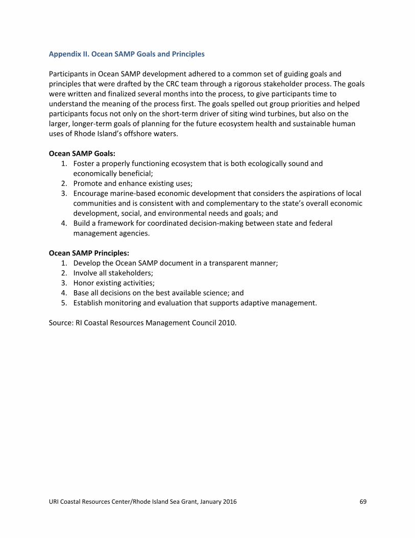
URI Coastal Resources Center/Rhode Island Sea Grant, January 2016 69
Appendix II. Ocean SAMP Goals and Principles Participants in Ocean SAMP development adhered to a common set of guiding goals and principles that were drafted by the CRC team through a rigorous stakeholder process. The goals were written and finalized several months into the process, to give participants time to understand the meaning of the process first. The goals spelled out group priorities and helped participants focus not only on the short‐term driver of siting wind turbines, but also on the larger, longer‐term goals of planning for the future ecosystem health and sustainable human uses of Rhode Island’s offshore waters. Ocean SAMP Goals:
1. Foster a properly functioning ecosystem that is both ecologically sound and economically beneficial;
2. Promote and enhance existing uses; 3. Encourage marine‐based economic development that considers the aspirations of local
communities and is consistent with and complementary to the state’s overall economic development, social, and environmental needs and goals; and
4. Build a framework for coordinated decision‐making between state and federal management agencies.
Ocean SAMP Principles: 1. Develop the Ocean SAMP document in a transparent manner; 2. Involve all stakeholders; 3. Honor existing activities; 4. Base all decisions on the best available science; and 5. Establish monitoring and evaluation that supports adaptive management.
Source: RI Coastal Resources Management Council 2010.
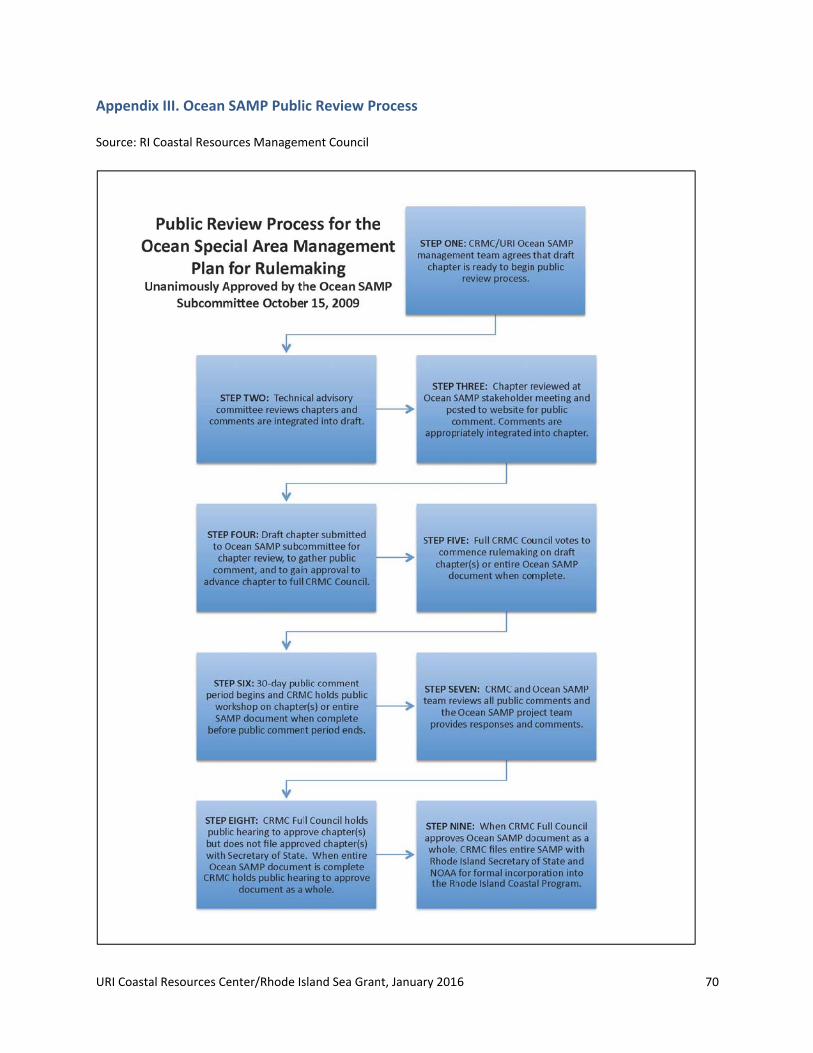
URI Coasta
AppendixSource: RI
al Resources Ce
x III. Ocean
Coastal Resou
enter/Rhode Is
SAMP Publi
rces Managem
sland Sea Gran
ic Review Pr
ment Council
t, January 201
rocess
16 70

URI Coastal Resources Center/Rhode Island Sea Grant, January 2016 71
Appendix IV. Case Study Findings: Ocean SAMP Leaders As Dave Beutel of CRMC commented, “The Ocean SAMP was successful because of the
individuals who were involved.” The Ocean SAMP participants whom we interviewed for this
case study called attention to a few key individuals who played particularly important
leadership roles. These included CRMC Executive Director Grover Fugate. Stakeholder
chairperson Ken Payne described Fugate as a “wonderfully capable agency director . . .
passionately committed to the Ocean SAMP” and “adroit at working the system to sustain
headway” — a combination that made him “a real force for having things happen.” Another
critical leader was Jennifer McCann and the CRC team; stakeholder Kim Gaffett described
McCann as the “orchestrator”; under McCann’s leadership, a team of CRC and Rhode Island Sea
Grant staff and graduate students pieced together the nuts and bolts of the process. McCann
noted that her strong connection with the Rhode Island Sea Grant College Program enabled her
to mobilize a broad diversity of experts, including those from the Rhode Island Sea Grant Legal
Program at Roger Williams University, which was critical to the success of the SAMP document
and the stakeholder process.
Many interview participants identified stakeholder chairperson Ken Payne as a leader in his role
as trusted communicator, mediating between various parties and assuring an objective,
transparent stakeholder process that earned and maintained the trust of parties involved.
Payne, a semi‐retired public servant with years of experience as a Senior Policy Advisor in the RI
State Senate Policy Office, filled this role as an unpaid volunteer, and thus was decidedly
outside of the institutional structure of the Ocean SAMP. Kim Gaffett described him as “as
neutral a person as could be found.” For his role as liaison between the process and the
fishermen, Dave Beutel, CRMC’s fisheries specialist, was identified as a critical leader. This is
because of the indispensable role he played in communicating between the formal Ocean
SAMP process and commercial fishermen, one of the most critical user groups involved in the
Ocean SAMP. “If it hadn’t been for Dave Beutel, the fishing industry would not have come
aboard as it did,” said fisherman Bill McElroy. “His credibility was crucial; he had built up an
enormous rapport with the industry.” Additionally, Dr. Malcolm Spaulding, a URI ocean
engineer, was identified as a key science leader because of his role formulating the initial
research plan for the Ocean SAMP, developing the TDI, and contributing greatly to the process
from the engineering perspective. Other URI scientists and impartial experts, including NOAA
Admiral Sam DeBow, were identified as important leaders for adding their skill, expertise and
contacts to the process.
Numerous other key leaders were identified in interviews; these include stakeholder leaders
from the charter boat and commercial fishing industries and from the environmental advocacy
URI Coastal Resources Center/Rhode Island Sea Grant, January 2016 72
community. For example, charter boat fisherman Rick Bellavance and commercial fisherman Bill
McElroy helped establish connectivity and trust between their respective communities of
fishermen and the Ocean SAMP stakeholder process. This type of bottom‐up leadership
depended on stakeholders themselves perceiving a gap in communication and taking the
initiative to fill it. “The situation required my skill set,” said McElroy of his decision to take on an
informal leadership role. “The fishermen could communicate with me, and I could
communicate with the process, and there weren’t a lot of people who could fill that role.”
Another example is the non‐profit Conservation Law Foundation (CLF), which had a big impact
on the success of the process by advocating for transparency, stakeholder input, and an
ecosystem‐based approach to decision‐making. These also include leaders from the
Narragansett Indian Tribe; Narragansett Tribal historian Doug Harris provided important
leadership during the Ocean SAMP development process by sharing tribal knowledge and
concerns publicly in stakeholder meetings, and engaging in direct dialogue with SAMP leaders
as well as with scientists like URI professor John King. Finally, these included Deepwater Wind
itself who, according to many interview participants, earned a strong reputation as a leader for
the restraint they showed during the Ocean SAMP process. “For a developer, they were
remarkably hands‐off,” said Ken Payne, “and that restraint was absolutely crucial. If they had
tried to capture the process and be dominating, it would not have worked.”

URI Coastal Resources Center/Rhode Island Sea Grant, January 2016 73
END NOTES 1 NOAA National Marine Fisheries Service, 2013. 2 Planning Decisions, Inc., 2014. 3 National Ocean Economics Program, 2015. 4 Grace and Gifford, 2006; Henry, 2007. 5 Barmann, 2006. 6 Applied Technology and Management, Inc. et al., 2007, 4.7 Olsen et al., 2014, 26‐38. 8 McCann et al., 2013. 9 Spaulding et al., 2010. 10 Spaulding et al., 2010. 11 McCann et al., 2013. 12 Tetra Tech EC, Inc., 2012.13 McGee, 2014; Field, 2014. 14 Kimmell and Stalenhoef, 2011.15 Kimmell and Stalenhoef, 2011. 16 United States Bureau of Ocean Energy Management, n.d. 17 Obama, 2010. 18 Obama, 2010. 19 Point 97 et al., 2015. 20 Beutel, 2011. 21 Kenney, “Subject,” 2013. 22 Rhode Island Coastal Resources Management Council, 2010, 29. 23 Kenney, “Subject,” 2013. 24 Kenney, “Block Island,” 2014. 25 Office of Senator Jack Reed, 2012. 26 Sosnowski, 2014; Tanzi et al., 2014; Ruggiero et al., 2015. 27 Mulvaney, 2013. 28 Mulvaney, 2013. 29 NOAA, 2015. 30 Grybowski et al., 2012. 31 Grybowski et al., 2012. 32 Haas, 2014. 33 Deegan, 2004. 34 Mulvaney, 2013. 35 Mulvaney, 2013. 36 Mulvaney, 2013. 37 Mulvaney, 2013. 38 Mulvaney, 2013. 39 Ehler and Douvere, 2009; Ehler, 2015. 40 University of Rhode Island Coastal Resources Center, “RI CRMC Shoreline,” 2015. 41 University of Rhode Island Coastal Resources Center, “RESP,” 2015. 42 University of Rhode Island Coastal Resources Center, “About,” 2015. 43 McCann, 2012. 44 McCann et al., 2013. 45 Rhode Island Sea Grant, 2012.