Embed Size (px)
Citation preview
TESTING AN INTEGRATED PDA-GPS
SYSTEM TO COLLECT STANDARDIZED
ANIMAL CARCASS REMOVAL DATA
ON VIRGINIA ROADWAYS
FINALCONTRACT REPORT
VTRC 08-CR10
http://www.virginiadot.org/vtrc/main/online_reports/pdf/08-cr10.pdf
BRIDGET M. DONALDSONResearch Scientist
Virginia Transportation Research Council
NELSON W. LAFONDeer Project Coordinator
Virginia Department of Game and Inland Fisheries
tandard Title Page - Report on Federally Funded Project 1. Report No. 2. Government Accession No. 3. Recipient’s Catalog No. FHWA/VTRC 08-CR10
4. Title and Subtitle 5. Report Date Testing an Integrated PDA-GPS System to Collect Standardized Animal Carcass Removal Data
February 2008
6. Performing Organization Code 7. Author(s) Bridget M. Donaldson and Nelson W. Lafon
8. Performing Organization Report No. VTRC 08-CR10
9. Performing Organization and Address 10. Work Unit No. (TRAIS) Virginia Transportation Research Council
530 Edgemont Road 11. Contract or Grant No. Charlottesville, VA 22903
82106
12. Sponsoring Agencies' Name and Address
13. Type of Report and Period Covered
Virginia Department of Transportation FHWA Final Contract 1401 E. Broad Street 400 North 8th Street, Room 750 14. Sponsoring Agency Code Richmond, VA 23219 Richmond, VA 23219-4825 15. Supplementary Notes 16. Abstract Animal-vehicle collisions (AVCs) have a growing impact in the United States in terms of safety, economic loss, and species conservation. According to estimates from insurance claims, Virginia has consistently ranked as one of the top seven states for deer-vehicle collisions (DVCs) since 2002. Of the state’s estimated 43,500 to 47,700 DVCs in 2006, less than 14% were reported to the police and stored in the Virginia Department of Transportation’s (VDOT) accident database. Virginia has no standardized method of sufficiently tracking AVC occurrences and locations, creating difficulty in researching and implementing mitigation efforts to reduce accidents.
Valuable AVC data can be obtained from documenting the instances and locations of animal carcasses from the roadway, but most transportation organizations do not systematically record these removals. This project entailed testing a personal data assistant (PDA) enabled with a global positioning system (GPS) receiver for the collection and analyses of animal carcass removals (CRs) from the roadway. Using GPS-enabled PDAs and software developed by Western Transportation Institute, maintenance personnel from a VDOT area headquarters in Rockbridge County collected 8 months of spatially accurate CR data. Rockbridge County DVC estimates derived from the CR data collected for this study were more than 9 times greater than the number of AVCs reported in police records. These spatial data can be easily used for density analyses to determine “hotspots” of AVCs. Implementing mitigation at these areas can ultimately lead to fewer AVCs and associated reductions of human deaths, injuries, and financial losses; improved traffic operations; a reduction in maintenance costs related to carcass removal and disposal; and wildlife conservation. VDOT is currently undergoing changes to its method of documenting roadway maintenance activities, including the deployment of GPS-enabled PDAs to all area headquarters. These PDAs provide a mechanism for collecting spatially accurate and standardized CR data, but collecting and reporting CRs are currently not requirements. Given the PDA’s ease of use and the benefits these data would provide, the study recommends that this procedure be integrated into regular practice by VDOT area headquarters. As VDOT is receiving added regulatory pressure to implement measures to reduce AVCs, improving CR data collection using the technology described in this report can help provide an objective method for deciding whether and where mitigation is needed. 17 Key Words 18. Distribution Statement Personal data assistant, global positioning system, animal-vehicle collisions, deer-vehicle collisions, carcass pick-up, carcass removal, roadkill, accident data, accident analysis, mitigation
No restrictions. This document is available to the public through NTIS, Springfield, VA 22161.
19. Security Classif. (of this report) 20. Security Classif. (of this page) 21. No. of Pages 22. Price Unclassified Unclassified 22
Form DOT F 1700.7 (8-72) Reproduction of completed page authorized
FINAL CONTRACT REPORT
TESTING AN INTEGRATED PDA-GPS SYSTEM TO COLLECT STANDARDIZED ANIMAL CARCASS REMOVAL DATA ON VIRGINIA ROADWAYS
Bridget M. Donaldson Research Scientist
Virginia Transportation Research Council
Nelson W. Lafon Deer Project Coordinator
Virginia Department of Game and Inland Fisheries
Project Manager Bridget M. Donaldson, Virginia Transportation Research Council
Contract Research Sponsored by the Virginia Transportation Research Council
Virginia Transportation Research Council (A partnership of the Virginia Department of Transportation
and the University of Virginia since 1948)
In Cooperation with the U.S. Department of Transportation Federal Highway Administration
Charlottesville, Virginia
February 2008
VTRC 08-CR10
ii
NOTICE
The project that is the subject of this report was done under contract for the Virginia Department of Transportation, Virginia Transportation Research Council. The contents of this report reflect the views of the authors, who are responsible for the facts and the accuracy of the data presented herein. The contents do not necessarily reflect the official views or policies of the Virginia Department of Transportation, the Commonwealth Transportation Board, or the Federal Highway Administration. This report does not constitute a standard, specification, or regulation. Each contract report is peer reviewed and accepted for publication by Research Council staff with expertise in related technical areas. Final editing and proofreading of the report are performed by the contractor.
Copyright 2008 by the Commonwealth of Virginia. All rights reserved.
iii
ABSTRACT
Animal-vehicle collisions (AVCs) have a growing impact in the United States in terms of safety, economic loss, and species conservation. According to estimates from insurance claims, Virginia has consistently ranked as one of the top seven states for deer-vehicle collisions (DVCs) since 2002. Of the state’s estimated 43,500 to 47,700 DVCs in 2006, less than 14% were reported to the police and stored in the Virginia Department of Transportation’s (VDOT) accident database. Virginia has no standardized method of sufficiently tracking AVC occurrences and locations, creating difficulty in researching and implementing mitigation efforts to reduce accidents.
Valuable AVC data can be obtained from documenting the instances and locations of animal carcasses from the roadway, but most transportation organizations do not systematically record these removals. This project entailed testing a personal data assistant (PDA) enabled with a global positioning system (GPS) receiver for the collection and analyses of animal carcass removals (CRs) from the roadway. Using GPS-enabled PDAs and software developed by Western Transportation Institute, maintenance personnel from a VDOT area headquarters in Rockbridge County collected 8 months of spatially accurate CR data. Rockbridge County DVC estimates derived from the CR data collected for this study were more than 9 times greater than the number of AVCs reported in police records. These spatial data can be easily used for density analyses to determine “hotspots” of AVCs. Implementing mitigation at these areas can ultimately lead to fewer AVCs and associated reductions of human deaths, injuries, and financial losses; improved traffic operations; a reduction in maintenance costs related to carcass removal and disposal; and wildlife conservation.
VDOT is currently undergoing changes to its method of documenting roadway maintenance activities, including the deployment of GPS-enabled PDAs to all area headquarters. These PDAs provide a mechanism for collecting spatially accurate and standardized CR data, but collecting and reporting CRs are currently not requirements. Given the PDA’s ease of use and the benefits these data would provide, the study recommends that this procedure be integrated into regular practice by VDOT area headquarters. As VDOT is receiving added regulatory pressure to implement measures to reduce AVCs, improving CR data collection using the technology described in this report can help provide an objective method for deciding whether and where mitigation is needed.
INTRODUCTION
Background Animal-vehicle collisions (AVCs) are an important issue across North America. The
number of ungulate (including deer)-vehicle crashes is estimated at 725,000 to 1,500,000 annually in the United States. These collisions are estimated to cause more than 200 human fatalities and more than $1 billion in property damage a year (cited in Huijser et al., 2007).
For certain species of wildlife, AVCs can reduce population viability (Huijser et al.,
2007). According to the Virginia Wildlife Action Plan, unintentional killing of animals on roadways is one of the top 10 stresses for terrestrial wildlife species, particularly reptiles, in Virginia (Virginia Department of Game and Inland Fisheries [VDGIF], 2005). Road mortality has significantly affected some black bear (Ursus americanus) populations in the southern Appalachians, coastal North Carolina, and Florida, although the impacts in most of Virginia are thought to be minimal (VDGIF, 2002).
AVCs are grossly underreported, including those involving large mammals that present
significant threats to human safety and property on roadways (Huijser et al., 2007). In Virginia, law enforcement officers are required to file a written accident report only if an accident exceeds $1,000 in damage. Of the state’s 43,500 to 47,700 deer-vehicle collisions (DVCs) estimated by State Farm Insurance in 2006 (M. Miles, unpublished data, 2007), only 6,054 (less than 14%) were reported to the police and stored in VDOT’s accident database.
According to State Farm Insurance claim estimates, Virginia has the sixth highest number
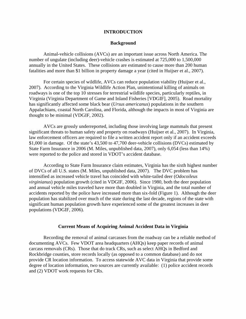
of DVCs of all U.S. states (M. Miles, unpublished data, 2007). The DVC problem has intensified as increased vehicle travel has coincided with white-tailed deer (Odocoileus virginianus) population growth (cited in VDGIF, 2006). Since 1980, both the deer population and annual vehicle miles traveled have more than doubled in Virginia, and the total number of accidents reported by the police have increased more than six-fold (Figure 1). Although the deer population has stabilized over much of the state during the last decade, regions of the state with significant human population growth have experienced some of the greatest increases in deer populations (VDGIF, 2006).
Current Means of Acquiring Animal Accident Data in Virginia
Recording the removal of animal carcasses from the roadway can be a reliable method of documenting AVCs. Few VDOT area headquarters (AHQs) keep paper records of animal carcass removals (CRs). Those that do track CRs, such as select AHQs in Bedford and Rockbridge counties, store records locally (as opposed to a common database) and do not provide CR location information. To access statewide AVC data in Virginia that provide some degree of location information, two sources are currently available: (1) police accident records and (2) VDOT work requests for CRs.
2
Figure 1. Trends in reported deer-vehicle accidents, vehicle miles driven, and the deer population index in Virginia, 1980-2006. Methodologies in calculating miles driven changed between 2001 and 2002. Interpolations were used for accidents during 1991-1997, rather than actual data, due to significant changes in methods for reporting accidents with property damage. Unpublished data provided by the Virginia Department of Transportation and the Virginia Department of Game and Inland Fisheries.
Police accident records are collected by state, local, and other enforcement officials and sent to the Virginia Department of Motor Vehicles (DMV). The DMV sends these crash reports to VDOT’s Transportation Engineering Division. Accidents are then plotted on a VDOT digital map service. During this process, errors of more than 0.1 mi (but generally estimated to be on the order of about ±85 ft) may be introduced. Although these police accident records (which include AVCs) are spatially represented, these locations are not precise and represent only a fraction of the actual AVCs that occur. As mentioned previously, of the 43,500 to 47,700 DVCs estimated by State Farm Insurance in 2006 (M. Miles, unpublished data, 2007), less than 14% were reported to police and stored in VDOT’s accident database.
AVC data can also be obtained through VDOT’s recently updated database named the Virginia Operational Information System (VOIS). VOIS, a component of VDOT’s Asset Management System, is a statewide operation system intended to track road maintenance activities and work requests, including telephone calls from the public requesting removals of carcasses from the roadway. Although tracking these requests provides valuable information on AVCs, the frequency with which work requests are entered into VOIS is not consistent across VDOT residencies. Even if reporting consistency were achieved, it would be difficult to gather meaningful CR data from VOIS. CRs listed in VOIS represent only a portion of the actual removals that VDOT performs. On the regular CR runs conducted by VDOT maintenance crews whereby roads are systematically scanned for roadkill, incidents of CRs are generally not recorded. VOIS documented 4,741 CR work requests in 2006, which represent 10% of the DVCs estimated by State Farm Insurance (M. Miles, unpublished data, 2007). Further, VOIS does not allow for large-scale queries of CRs and does not provide CR latitude and longitude coordinates that can be easily integrated and analyzed on mapping software.
3
The Need for Standardized Animal-Vehicle Collision Data
According to a Synthesis of Highway Practice on AVC data collection recently published by the National Cooperative Highway Research Program, standardized procedures are needed to improve collection and sharing of data on AVCs by transportation and natural resource agencies (Huijser et al., 2007). In Virginia, consistently reported and spatially accurate AVC data would benefit a variety of organizations in terms of safety, economics, and conservation.
In addition to VDOT’s concerns and responsibilities for driver safety and environmental stewardship, the financial impact of AVCs on traffic operations and CR and carcass disposal is a significant matter. Time and resources devoted to these issues escalate with increasing AVCs. Although VDOT does not maintain a statewide database that systematically tracks the number of CRs and associated disposal expenses, the disposal cost for the Reston AHQ in Fairfax County alone is $65 per trip. At more than 40,000 DVCs annually, carcass disposal could easily cost VDOT millions of dollars each year (Donaldson, 2006). Without a standardized method of recording AVCs or carcass removals, the efficiency of VDOT’s carcass disposal practices and potential economic benefits of alternative disposal methods are difficult to evaluate.
VDGIF bear and deer management plans also recognize the impact of AVCs. The
Virginia Bear Management Plan (2001-2010) directs VDGIF to examine the role of roads and other risk factors that may limit population viability of bears and manage for human safety and property damage associated with bear-vehicle collisions (VDGIF, 2002). The 2006-2015 Virginia Deer Management Plan contains objectives to quantify and manage DVCs, including strategies to work with VDOT on monitoring, abatement, and carcass disposal:
• Develop a program, in cooperation with the Virginia Department of Transportation (VDOT), to accurately monitor deer-vehicle collisions on a management unit basis annually.
• Support research on incidence and prevention of deer vehicle collisions in Virginia. • Assist VDOT with development of carcass disposal procedures that are environmentally safe,
socially acceptable, practical, and cost effective” (VDGIF, 2006).
During 2003 through 2006, VDOT, the Virginia Transportation Research Council (VTRC), VDGIF, and 10 other organizations were involved with the Metropolitan Washington Council of Governments (MWCOG) in the development of a report and an educational video on trends and prevention measures for DVCs in the Virginia, Maryland, and DC areas. The working group recommended the creation of a standard for collecting and analyzing deer collision information to be implemented throughout the region. In addition, the working group requested that local, state, and federal jurisdictions involved consider recommendations on mitigation, planning, and research as outlined in the September 2006 Deer Vehicle Collision Report (MWCOG, 2006).
GPS-Enabled Personal Data Assistants Although Virginia’s two primary methods for acquiring AVC data can be improved,
neither has the capability of fully characterizing the number and location of AVCs that occur
4
statewide or even in certain localities. The potential exists, however, for VDOT to implement a standardized method of CR data collection. VDOT’s Asset Management Division (AMD) is undergoing changes to its current method of tracking maintenance activities. Under AMD’s “Work Accomplishment Module,” personal digital assistants (PDAs) enabled by a global positioning system (GPS) are planned for distribution to each VDOT AHQ in 2008. These hand-held devices will be used by AHQ maintenance personnel to track maintenance work performed. The GPS-enabled PDAs (referred to hereinafter as simply “PDAs”) that will be available to maintenance crews may provide VDOT a standardized method of recording spatially accurate AVC data, enabling both researchers and management to prioritize efforts on mitigation opportunities to increase safety, reduce costs associated with carcass disposal and mobility management, and conserve wildlife populations.
PURPOSE AND SCOPE
This purpose of this project was to test a PDA-GPS tool for the collection and analyses of CR data.
The data were analyzed to achieve the following objectives: (1) quantify CRs in the test
area and correlate these data with police and VOIS records to estimate the underreporting rates for these crashes, (2) determine user burden and time associated with CR data collection using PDAs and the benefits of this procedure, and (3) determine whether the PDA-collected carcass data can be easily used to detect areas with high densities (”hotspots”) of AVCs.
METHODS Five tasks were conducted to achieve the study objectives over the course of a 1-year study:
1. Partner with Western Transportation Institute (WTI) to test their PDA and software specifically developed to collect CR data.
2. Train the maintenance personnel for a VDOT AHQ on PDA use for CR data
collection.
3. Analyze 8 months of CR data collected by the VDOT maintenance crew.
4. Determine the user burden and potential benefits associated with this data collection procedure.
5. Investigate the opportunity within VDOT to implement the practice of recording CRs
with PDAs.
5
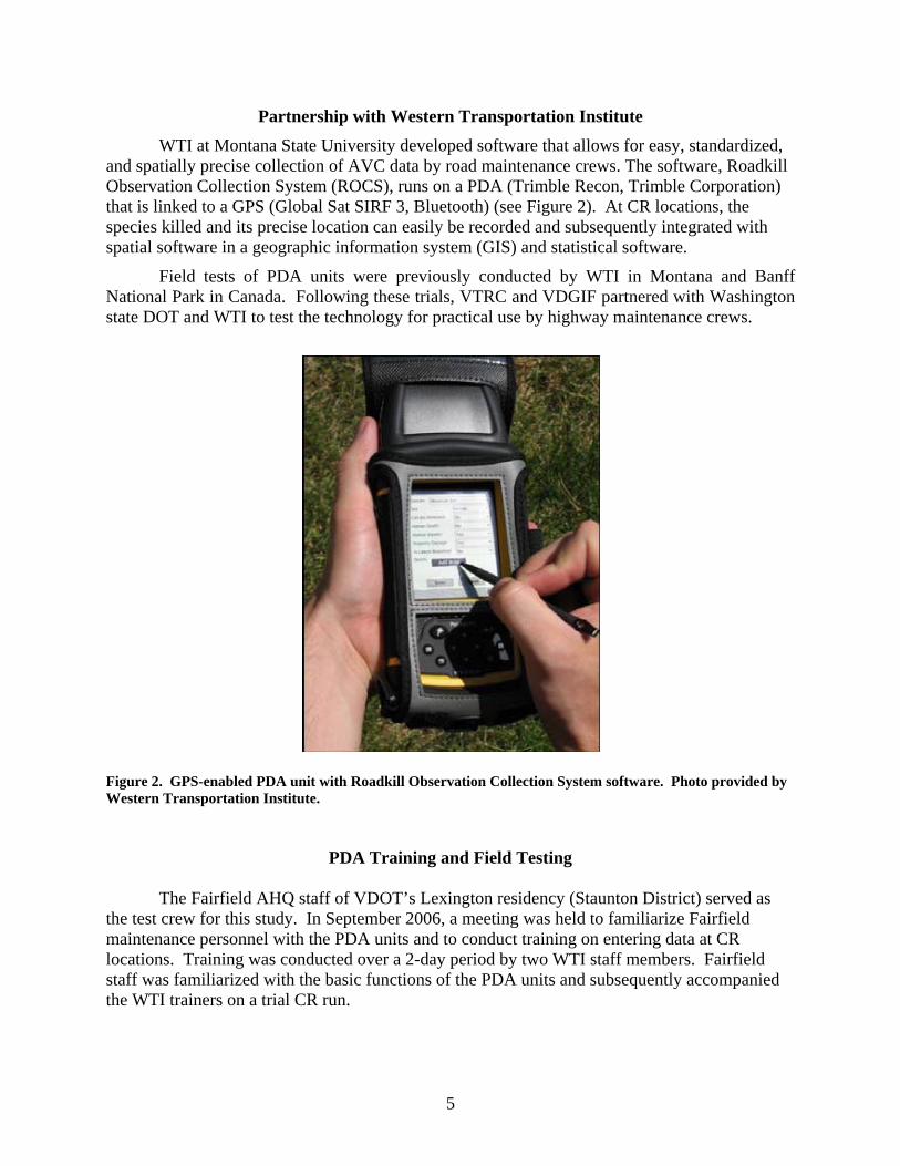
Partnership with Western Transportation Institute WTI at Montana State University developed software that allows for easy, standardized, and spatially precise collection of AVC data by road maintenance crews. The software, Roadkill Observation Collection System (ROCS), runs on a PDA (Trimble Recon, Trimble Corporation) that is linked to a GPS (Global Sat SIRF 3, Bluetooth) (see Figure 2). At CR locations, the species killed and its precise location can easily be recorded and subsequently integrated with spatial software in a geographic information system (GIS) and statistical software.
Field tests of PDA units were previously conducted by WTI in Montana and Banff National Park in Canada. Following these trials, VTRC and VDGIF partnered with Washington state DOT and WTI to test the technology for practical use by highway maintenance crews.
Figure 2. GPS-enabled PDA unit with Roadkill Observation Collection System software. Photo provided by Western Transportation Institute.
PDA Training and Field Testing
The Fairfield AHQ staff of VDOT’s Lexington residency (Staunton District) served as
the test crew for this study. In September 2006, a meeting was held to familiarize Fairfield maintenance personnel with the PDA units and to conduct training on entering data at CR locations. Training was conducted over a 2-day period by two WTI staff members. Fairfield staff was familiarized with the basic functions of the PDA units and subsequently accompanied the WTI trainers on a trial CR run.
6
WTI staff programmed PDAs with a list of 11 species or species groups from which to choose when recording CR information. Users may also use the stylus to write in species not listed in the PDA software. The list includes deer (which pose the highest risk to driver safety), black bear, red and gray fox, raccoon, opossum, coyote, bobcat, rattlesnake, turtle, turkey, and hawk/owl/eagle. VDGIF wildlife biologists provided assistance in selecting species that may benefit from the use of CR data for research, monitoring, or management decisions.
The Fairfield maintenance personnel were provided two PDA units for data collection.
Once the crew left for the carcass monitoring run, the crew member used a stylus to select “Start GPS” on the screen; the program subsequently logs GPS location information. While the driver followed the road route, the passenger could enter his or her initials on the screen and had the option to record any notes using an onscreen keypad. As the vehicle proceeded during the carcass monitoring session, latitude, longitude, elevation, and speed were recorded every 5 to 6 sec. At CR sites, the crew member selected “Record Observation,” prompting the list of 11 species or animal groups to appear as a drop-down list. Once the crew member chose the relevant animal from the list, the system would geo-locate the roadkill observation. At the end of a monitoring session, the user pressed the “Stop GPS” button.
Upon the maintenance crew’s return to the AHQ each week, the PDA data were
transferred to a desktop computer with Microsoft ActiveSync. Comma-separated-value (CSV) files are used to store data, and data were backed up on a secure digital (SD) memory card to provide redundant storage in the event of a device’s memory failure. The data can be readily imported into Excel, ArcGIS, and other analysis tools using ActiveSync and the CSV files recorded by the ROCS application.
Carcass Removal Data Collection and Analysis
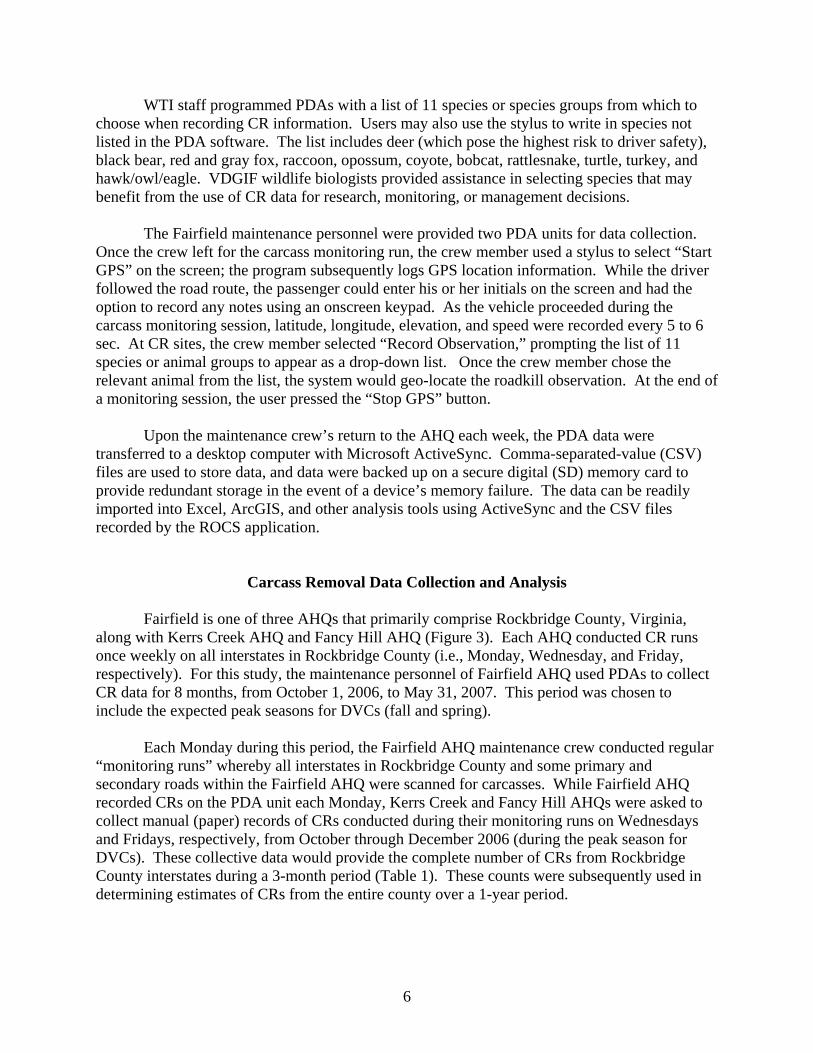
Fairfield is one of three AHQs that primarily comprise Rockbridge County, Virginia, along with Kerrs Creek AHQ and Fancy Hill AHQ (Figure 3). Each AHQ conducted CR runs once weekly on all interstates in Rockbridge County (i.e., Monday, Wednesday, and Friday, respectively). For this study, the maintenance personnel of Fairfield AHQ used PDAs to collect CR data for 8 months, from October 1, 2006, to May 31, 2007. This period was chosen to include the expected peak seasons for DVCs (fall and spring).
Each Monday during this period, the Fairfield AHQ maintenance crew conducted regular “monitoring runs” whereby all interstates in Rockbridge County and some primary and secondary roads within the Fairfield AHQ were scanned for carcasses. While Fairfield AHQ recorded CRs on the PDA unit each Monday, Kerrs Creek and Fancy Hill AHQs were asked to collect manual (paper) records of CRs conducted during their monitoring runs on Wednesdays and Fridays, respectively, from October through December 2006 (during the peak season for DVCs). These collective data would provide the complete number of CRs from Rockbridge County interstates during a 3-month period (Table 1). These counts were subsequently used in determining estimates of CRs from the entire county over a 1-year period.
7
Figure 3. Map illustrating VDOT’s Fairfield, Kerrs Creek, and Fancy Hill Area Headquarters in Rockbridge County, Virginia. Only these three area headquarters, which conduct maintenance work on all interstate miles in the county, were included in the study.
Table 1. Data Collection Among Three VDOT Area Headquarters in Rockbridge County
Data Collection Period (2006-2007) VDOT AHQ (Rockbridge County) O
ct
Nov
Dec
Jan
Feb
Mar
Apr
May
Road Type and Location
Data Collection Method/Day
Fairfield
X X X X X X X X All Interstates in Rockbridge County Some Primary and Secondary Roads in AHQ only
PDA, Mondays
Kerrs Creek X X X All Interstates in Rockbridge
County Paper, Wednesdays
Fancy Hill X X X All Interstates in Rockbridge
County Paper, Fridays
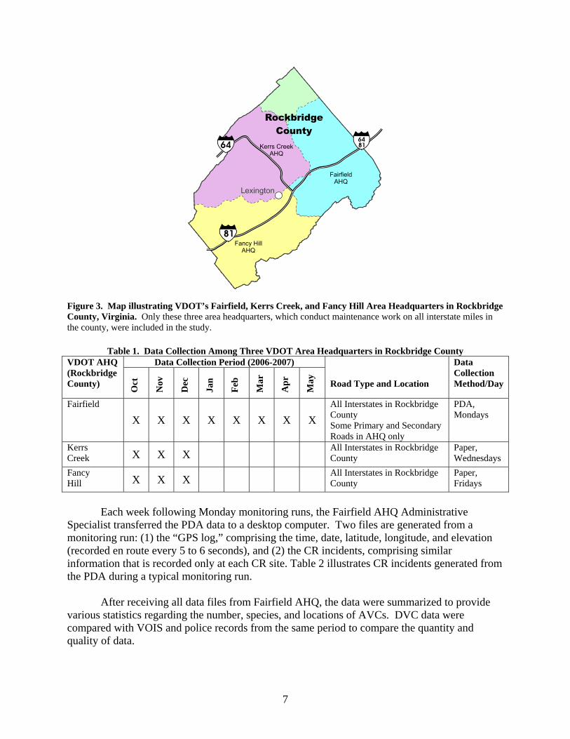
Each week following Monday monitoring runs, the Fairfield AHQ Administrative Specialist transferred the PDA data to a desktop computer. Two files are generated from a monitoring run: (1) the “GPS log,” comprising the time, date, latitude, longitude, and elevation (recorded en route every 5 to 6 seconds), and (2) the CR incidents, comprising similar information that is recorded only at each CR site. Table 2 illustrates CR incidents generated from the PDA during a typical monitoring run. After receiving all data files from Fairfield AHQ, the data were summarized to provide various statistics regarding the number, species, and locations of AVCs. DVC data were compared with VOIS and police records from the same period to compare the quantity and quality of data.
8
Table 2. Example of CR Information Obtained During a Monitoring Run in VDOT’s Fairfield Area Headquarters
Date Time Latitude Longitude Elevation (ft) Fix Species 5/29/2007 8:10:49 AM 37.93432 -79.2255 1841.535 3D Deer 5/29/2007 8:32:22 AM 37.89743 -79.2727 1853.018 3D Opossum 5/29/2007 8:33:46 AM 37.8949 -79.2746 1826.772 3D Deer 5/29/2007 11:01:59 AM 37.68357 -79.4896 1221.129 3D Deer 5/29/2007 11:57:14 AM 37.89557 -79.5792 2192.585 3D Deer 5/29/2007 1:27:16 PM 37.8201 -79.3791 1337.598 3D Turkey 5/29/2007 2:55:29 PM 37.8582 -79.3225 1722.769 3D Raccoon 5/29/2007 3:07:16 PM 37.89786 -79.2574 1740.814 3D Deer 5/29/2007 3:15:55 PM 37.90957 -79.2294 1708.661 3D Deer
The weekly GPS logs and the CR incidents files were uploaded to ArcGIS (Version 8.2)
to plot the route driven and the location of CRs. The latitude and longitude coordinates, which were continuously logged by the GPS attachment to the PDA, were used to plot the route driven during the carcass monitoring session. Using the Spatial Analyst extension of ArcGIS, cluster or density estimates were calculated for deer CRs recorded during Fairfield AHQ’s weekly monitoring runs along Interstates 81 and 64.
User Burden versus Potential Benefits Associated with PDA Carcass Removal Data Collection
Because the incidents and locations of CRs are currently not systematically collected throughout VDOT jurisdictions, collecting these data will likely be perceived as requiring increased time and effort by maintenance personnel. To help determine whether the benefits of this data collection procedure outweigh this additional effort, discussions were held with Fairfield AHQ PDA users to determine the additional time and burden associated with recording CR data using PDAs.
Conversely, the advantages of CR data were diagrammed according to the opportunities they might provide and the areas and disciplines that might be affected.
VDOT’s PDA Deployment
VDOT’s AMD was contacted throughout this study to discuss the current method of recording and tracking road maintenance activities (namely animal carcass removal) and upcoming changes to the system. AMD has been developing a Work Accomplishments Module, which will involve the distribution of PDAs to all AHQs for documenting road work activities. The details of this system and the feasibility of using PDAs to record spatially accurate CR data are discussed in subsequent sections.
9
RESULTS
Carcass Removal Results PDA Data
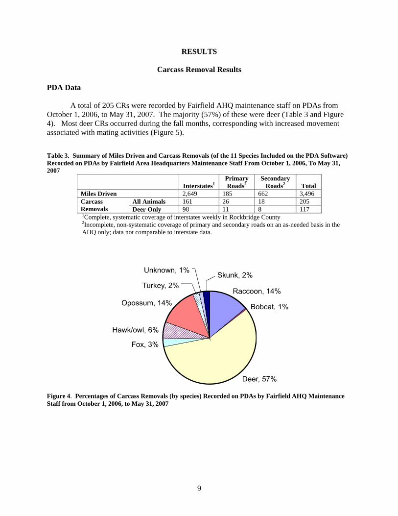
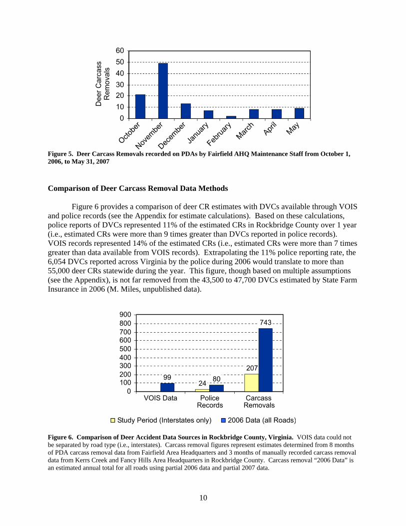
A total of 205 CRs were recorded by Fairfield AHQ maintenance staff on PDAs from October 1, 2006, to May 31, 2007. The majority (57%) of these were deer (Table 3 and Figure 4). Most deer CRs occurred during the fall months, corresponding with increased movement associated with mating activities (Figure 5). Table 3. Summary of Miles Driven and Carcass Removals (of the 11 Species Included on the PDA Software) Recorded on PDAs by Fairfield Area Headquarters Maintenance Staff From October 1, 2006, To May 31, 2007
Interstates1
Primary Roads2
Secondary Roads2
Total
Miles Driven 2,649 185 662 3,496 All Animals 161 26 18 205 Carcass
Removals Deer Only 98 11 8 117 1Complete, systematic coverage of interstates weekly in Rockbridge County 2Incomplete, non-systematic coverage of primary and secondary roads on an as-needed basis in the AHQ only; data not comparable to interstate data.
Figure 4. Percentages of Carcass Removals (by species) Recorded on PDAs by Fairfield AHQ Maintenance Staff from October 1, 2006, to May 31, 2007
10
Figure 5. Deer Carcass Removals recorded on PDAs by Fairfield AHQ Maintenance Staff from October 1, 2006, to May 31, 2007 Comparison of Deer Carcass Removal Data Methods
Figure 6 provides a comparison of deer CR estimates with DVCs available through VOIS and police records (see the Appendix for estimate calculations). Based on these calculations, police reports of DVCs represented 11% of the estimated CRs in Rockbridge County over 1 year (i.e., estimated CRs were more than 9 times greater than DVCs reported in police records). VOIS records represented 14% of the estimated CRs (i.e., estimated CRs were more than 7 times greater than data available from VOIS records). Extrapolating the 11% police reporting rate, the 6,054 DVCs reported across Virginia by the police during 2006 would translate to more than 55,000 deer CRs statewide during the year. This figure, though based on multiple assumptions (see the Appendix), is not far removed from the 43,500 to 47,700 DVCs estimated by State Farm Insurance in 2006 (M. Miles, unpublished data).
Figure 6. Comparison of Deer Accident Data Sources in Rockbridge County, Virginia. VOIS data could not be separated by road type (i.e., interstates). Carcass removal figures represent estimates determined from 8 months of PDA carcass removal data from Fairfield Area Headquarters and 3 months of manually recorded carcass removal data from Kerrs Creek and Fancy Hills Area Headquarters in Rockbridge County. Carcass removal “2006 Data” is an estimated annual total for all roads using partial 2006 data and partial 2007 data.
11
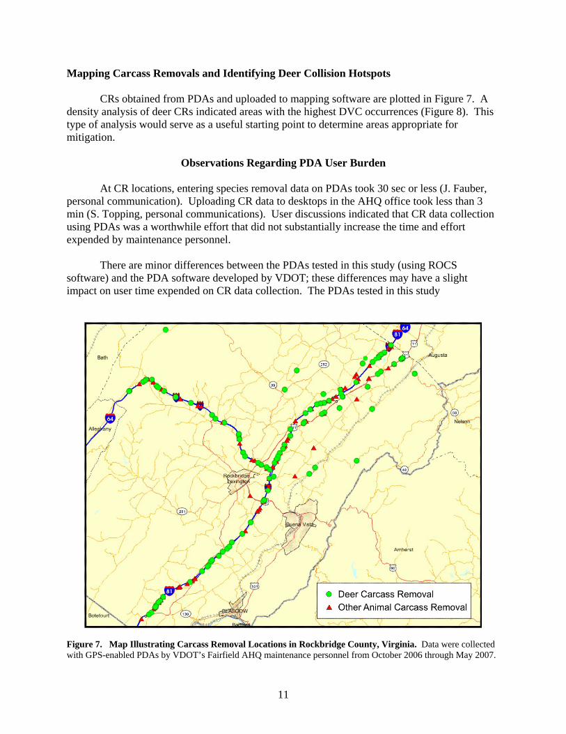
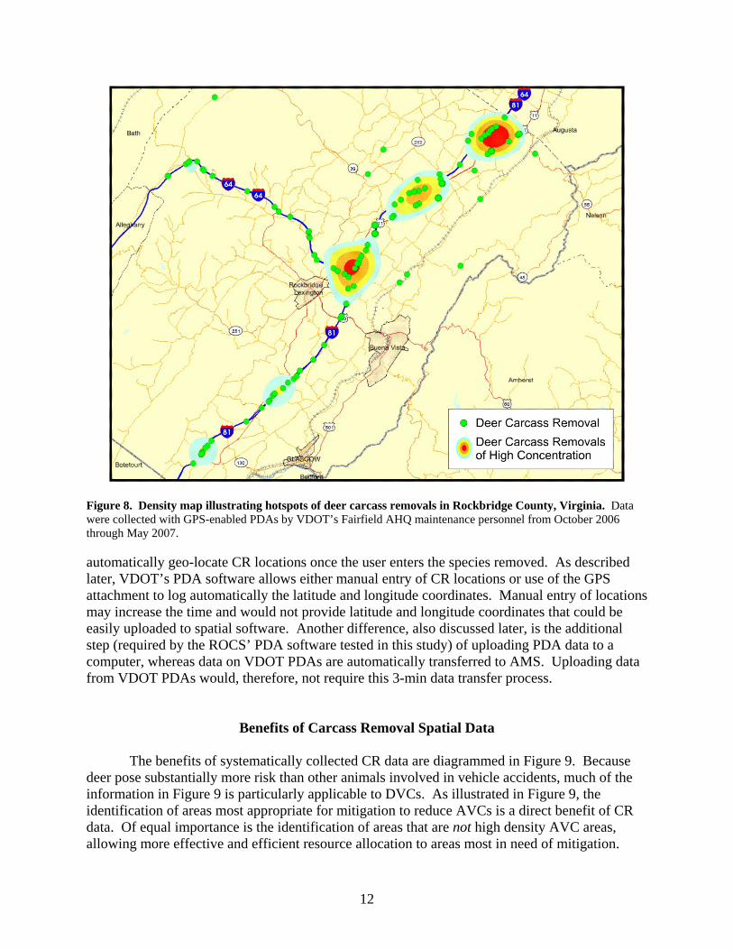
Mapping Carcass Removals and Identifying Deer Collision Hotspots CRs obtained from PDAs and uploaded to mapping software are plotted in Figure 7. A density analysis of deer CRs indicated areas with the highest DVC occurrences (Figure 8). This type of analysis would serve as a useful starting point to determine areas appropriate for mitigation.
Observations Regarding PDA User Burden
At CR locations, entering species removal data on PDAs took 30 sec or less (J. Fauber, personal communication). Uploading CR data to desktops in the AHQ office took less than 3 min (S. Topping, personal communications). User discussions indicated that CR data collection using PDAs was a worthwhile effort that did not substantially increase the time and effort expended by maintenance personnel.
There are minor differences between the PDAs tested in this study (using ROCS
software) and the PDA software developed by VDOT; these differences may have a slight impact on user time expended on CR data collection. The PDAs tested in this study
Figure 7. Map Illustrating Carcass Removal Locations in Rockbridge County, Virginia. Data were collected with GPS-enabled PDAs by VDOT’s Fairfield AHQ maintenance personnel from October 2006 through May 2007.
12
Figure 8. Density map illustrating hotspots of deer carcass removals in Rockbridge County, Virginia. Data were collected with GPS-enabled PDAs by VDOT’s Fairfield AHQ maintenance personnel from October 2006 through May 2007. automatically geo-locate CR locations once the user enters the species removed. As described later, VDOT’s PDA software allows either manual entry of CR locations or use of the GPS attachment to log automatically the latitude and longitude coordinates. Manual entry of locations may increase the time and would not provide latitude and longitude coordinates that could be easily uploaded to spatial software. Another difference, also discussed later, is the additional step (required by the ROCS’ PDA software tested in this study) of uploading PDA data to a computer, whereas data on VDOT PDAs are automatically transferred to AMS. Uploading data from VDOT PDAs would, therefore, not require this 3-min data transfer process.
Benefits of Carcass Removal Spatial Data
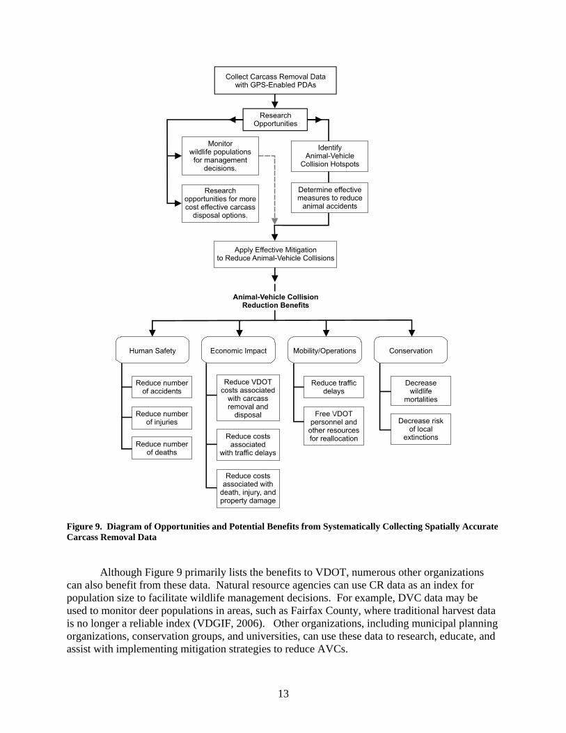
The benefits of systematically collected CR data are diagrammed in Figure 9. Because deer pose substantially more risk than other animals involved in vehicle accidents, much of the information in Figure 9 is particularly applicable to DVCs. As illustrated in Figure 9, the identification of areas most appropriate for mitigation to reduce AVCs is a direct benefit of CR data. Of equal importance is the identification of areas that are not high density AVC areas, allowing more effective and efficient resource allocation to areas most in need of mitigation.
13
Figure 9. Diagram of Opportunities and Potential Benefits from Systematically Collecting Spatially Accurate Carcass Removal Data
Although Figure 9 primarily lists the benefits to VDOT, numerous other organizations
can also benefit from these data. Natural resource agencies can use CR data as an index for population size to facilitate wildlife management decisions. For example, DVC data may be used to monitor deer populations in areas, such as Fairfax County, where traditional harvest data is no longer a reliable index (VDGIF, 2006). Other organizations, including municipal planning organizations, conservation groups, and universities, can use these data to research, educate, and assist with implementing mitigation strategies to reduce AVCs.
14
VDOT’s PDA Deployment
To determine the feasibility of implementing this method of data collection in Virginia, VDOT’s AMD was contacted throughout this study to discuss whether and how VDOT documents roadway maintenance work such as animal CR. VDOT’s current method of tracking road maintenance activities generally begins with paper documentation by maintenance personnel of work conducted in the field. Upon return to the office, information on the type, location, time spent on, and the cost of each activity is uploaded to two databases: VDOT’s Financial Management System (FMS) and the Asset Management System (AMS).
VDOT’s AMD’s Work Accomplishment module is under development to document and track road work activities more efficiently. A primary component of this module is the PDA, which is enabled with a GPS receiver and uploaded using ESRI’s ArcPad 6.0.3 software to AMS. These PDAs allow for on-site documentation of roadway asset maintenance work. Data recorded on PDAs are automatically entered to AMS upon uploading to the server through the VDOT network, replacing the redundancy of manually entering data on paper and then keying it into the AMS database. Similar to the PDA units tested as part of this study, the operator uses a stylus to select the work performed from a list of work activities. The location of each activity can be recorded by either marking the location on digital maps loaded into the software or using the integrated GPS receiver to log automatically the latitude and longitude coordinates. VDOT’s Ashland and Louisa residencies tested these PDA units over a 6-month period. Based in part on these tests, AMD personnel is currently reassessing PDA equipment and resolving software issues. Completion of the revisions to this system and deployment of PDAs to each AHQ is planned by the end of 2008. Upon PDA deployment to all AHQs, maintenance personnel will be trained on PDA use.
In September 2006, a meeting was held with the authors of this report and members of VDOT’s AMD and Information Technology Division to discuss the feasibility of integrating an animal CR element into VDOT’s PDA software. Including this element in VDOT’s PDA software would allow for a simple method to document CR data in a similar fashion to the PDAs tested in this study. Meeting attendees agreed that this would be a worthwhile addition to the software, and AMD staff requested that letters of support for this task be gathered from VDOT’s Environmental Division.
In the following weeks, members of VDOT’s Environmental Division provided letters of
support for the addition of a CR element, and with support from VDOT’s Chief of Technology, Research, and Innovation, this component was subsequently added to VDOT’s PDA software. Though numerous CR parameters (i.e., method of carcass disposal, sex of species, etc.) can be collected with PDAs, the CR element incorporated in VDOT’s PDAs is currently simplified so that only the available selections are deer and bear. These species pose the highest risk to driver safety. Additional species and parameters may be added at a later date.
Under the current system of tracking roadway asset maintenance work, each work activity is listed under one of two categories: “Work Activities” or Asset Maintenance Activity Codes (AMAC), which are required to be recorded as the work is performed, and “Cost Center” charges, which are not required to be recorded in AMS. “Dead Animal Pick-up” is currently
15
listed as a Cost Center (“Dead Animals CSC# 1116019”). Implementation of CR data collection will require either changing this Cost Center to a Work Activity (or AMAC) or requiring that VDOT AHQ record the Cost Center “Dead Animal Pick-up.”
DISCUSSION
Virginia does not currently have a method of systematically collecting animal accident data that sufficiently represents the quantity and location of these collisions. Rockbridge County DVC estimates derived from the CR data collected for this study were more than 9 times greater than the number of DVCs reported in police records and more than 7 times greater than CR data available from VOIS records.
A standardized method of collecting spatially accurate CR data can provide both researchers and management with a tool for prioritizing efforts to reduce AVCs. This type of data can demonstrate the magnitude of the AVC problem, the location of problem areas, seasonal variation in accidents, and potential changes over time. A primary application of consistently collected CR data is the identification of animal accident hotspots by conducting density analyses of CR locations. Because AVC locations are spatially aggregated and based on certain landscape elements (cited in Donaldson, 2007), CR data can be easily analyzed to determine these areas of higher density. Once hotspots are distinguished, researchers can identify road and landscape characteristics in those areas that may contribute to higher incidents of AVCs. This information would be useful in planning new roads, as well as implementing effective mitigation for existing roads (see Donaldson, 2007). Successful mitigation measures can ultimately lead to fewer AVCs and associated reductions of human deaths, injuries, and financial losses; improved traffic operations; wildlife conservation; and a reduction in maintenance costs related to carcass removal and disposal. Standardization of CR data collection also allows data integration across state or agency borders.
As part of a recent National Cooperative Highway Research Program Synthesis of
Highway Practice, surveys pertaining to AVC data collection were distributed to transportation organizations and natural resource agencies in the United States and Canada (Huijser et al., 2007). Survey responders specifically mentioned the use of more rigid and standardized procedures to collect AVC data in order to address problems, improve procedures, and improve the coordination between state agencies that share a vested interest in the data (Huijser et al., 2007). Survey responders also indicated that a need must be demonstrated before agencies will begin collecting AVC data (Huijser et al., 2007). The findings from this study demonstrate a need in Virginia for consistent PDA-collected CR data in terms of (1) the quantity of data that this method provides over the presently available AVC data; (2) the quality of the data in terms of its spatial precision; and (3) the numerous benefits these data offer numerous state and private organizations from safety, economic, operational, and ecological perspectives. With implementation of CR data collection, VDOT will be a national leader in standardization and reporting efforts to reduce the increasing AVC problem.
16
Under VDOT’s Work Accomplishments module, PDAs equipped with software to record road maintenance activities are planned for distribution to VDOT AHQs by the end of 2008, shortly followed by training on PDA use. Although the recent addition of the CR element to this software provides the mechanism for collecting spatially accurate and standardized CR data, CRs are currently categorized as a “Cost Center” rather than a “Work Activity” and are, therefore, not required to be recorded. The software modifications (currently in progress) for these PDAs, prior to PDA deployment by the end of 2008, provide a timely opportunity for the CR element to be reprioritized and required to be reported. This would substantially contribute to the currently available AVC data. By July 1, 2009, Virginia interstate maintenance will be conducted by contract companies. In the current language for these contracts (entitled Turnkey Asset Maintenance Service Contracts), contractors are not required to use PDAs to document work activities. Once PDAs are VDOT’s standard method of recording maintenance work, this issue may be revisited if VDOT determines that contractors should use the same method of work documentation.
CONCLUSIONS
• Rockbridge County DVC estimates derived from the CR data collected for this study were
more than 9 times greater than animal-vehicle accidents reported in police records and more than 7 times greater than CR data available from VOIS records.
• The CR data collected from GPS-enabled PDAs can be easily analyzed to identify high-
density DVCs areas that may be appropriate for mitigation. • VDOT maintenance personnel that tested the PDA units reported that minimal additional
time was associated with collecting CR data and felt that this data collection procedure was a worthwhile use of their time.
• The recent addition of the CR element to VDOT’s PDA software provides the mechanism for
collecting spatially accurate and standardized CR data, but collecting CR data is not currently a requirement.
• The current software modifications to the PDAs present a timely opportunity for the CR
element to be reprioritized and required to be recorded by VDOT AHQ. • These data could be used to illustrate the rationale for the implementation and location of
mitigation measures that can ultimately lead to fewer AVCs and associated reductions of human deaths, injuries, and financial losses; improved traffic operations; wildlife conservation; and a reduction in maintenance costs related to carcass removal and disposal.
17
RECOMMENDATIONS 1. Upon deployment of the GPS-enabled PDAs to all VDOT AHQs, VDOT’s AMD should
require AHQs to collect CR data along with the presently required collection of other roadway asset management work. This would entail (1) either continuing to list the carcass removal element as a Cost Center activity or recategorizing CRs as a Work Activity; (2) a commitment or a requirement that CRs be recorded by VDOT AHQ; and (3) incorporating the required CR data collection into the planned PDA training.
2. When collecting CR data, VDOT AHQ maintenance staff should collect the data in a
consistent manner and record carcass removals on site using the GPS attachment to log latitude and longitude coordinates. This will help ensure that the data is accurate and meaningful.
3. VDOT’s AMD should ensure that the PDA data uploaded to the AMS allow for integration
with spatial software for mapping and analyses capabilities. 4. Once VDOT AHQ maintenance staff routinely collects the incidents and GPS locations of
CRs, VDOT’s AMD should require interstate maintenance contractors to adopt a similar data collection and reporting system for this activity. This would require a revision to the current Turnkey Asset Maintenance Service Contracts.
5. Once sufficient CR data are available, VDOT residencies and other applicable VDOT
jurisdictions (with the help of the Virginia Transportation Research Council, if necessary), should analyze the data to consider whether and where mitigation measures are deemed necessary.
COSTS AND BENEFITS ASSESSMENT
Because the CR element is already a component of VDOT’s PDA software, implementation of a standardized CR data collection procedure would not affect the budget that has been allocated for equipment and software expenses for PDA deployment. The costs of routine use of PDAs to collect CR data are, therefore, associated with the time expended to record each CR and to upload it to the appropriate location on VDOT’s server. As discussed previously, maintenance personnel reported a time of 30 sec or less to record each CR on the PDAs tested as part of this study and data are automatically uploaded to VDOT’s AMS.
Benefits of CR data collection at the AHQ level cannot be monetized unless VDOT acts on the findings from the CR data. Long-term benefits of CR data are associated with the implementation of successful mitigation to reduce AVCs at identified accident hotspots. As illustrated in Figure 9, gains from the application of effective mitigation could be significant in terms of a reduction in mobility/operations and carcass disposal costs to VDOT; property damage savings for the public; and wildlife conservation. Property damage savings from effective AVC mitigation is described in Donaldson (2005), where a highway underpass used by deer to cross beneath the road was determined to be cost-effective in terms of property damage
18
savings if it prevented a minimum of 2.6 DVCs per year (Donaldson, 2005). Although wildlife crossings with fencing have been found to be among the most effective mitigation measure to reduce AVCs, many other promising technologies (such as dynamic message signs and animal-detection driver warning systems) are being tested (described in Donaldson, 2006).
ACKNOWLEDGMENTS
The authors extend their appreciation to Sean Graham, Amanda Hardy, and Rob Ament from Western Transportation Institute for PDA software development and training. The authors are very grateful to the Fairfield Area Headquarters maintenance staff, namely, Chris Fauber, Sam Topping, Phil Sheetz, and Roger Clark, for their dependable work with data collection, and to Jimmy White, who directed the authors to this group. John Strachan, Gary Allen, and Juanita Mack provided invaluable assistance with providing information and assistance with the carcass removal element of the software. Dave Steffen, Matt Knox, Bob Ellis, and Bob Duncan of VDGIF, and Mike Fitch, Jimmy White, and Amy O’Leary of VDOT supported this project and reviewed the report. Andrew Rosenberger of the Conservation Management Institute at Virginia Tech provided useful insights into the logistics and utility of PDA technology early in this project.
REFERENCES Donaldson, B.M. The Use of Highway Underpasses by Large Mammals and Other Wildlife in Virginia and Factors Influencing Their Effectiveness. In Transportation Research Record 2011. Transportation Research Board, Washington, DC, 2007. Donaldson, B.M. A Toolkit of Measures for Reducing Animal-Vehicle Collisions. VTRC 07-
R13. Virginia Transportation Research Council, Charlottesville, 2007. Huijser, M.P., Fuller, J., Wagner, M.E., Hardy, A., and Clevenger, A.P. Animal-vehicle
Collision Data Collection: A Synthesis of Highway Practice. National Cooperative Highway Research Board Program Synthesis 370. Transportation Research Board,
Washington, DC, 2007. Metropolitan Washington Council of Governments. Deer-vehicle Collision Report. Washington, DC, 2006. Virginia Department of Game and Inland Fisheries. Virginia Black Bear Management Plan (2001-2010). Richmond, 2002.
Virginia Department of Game and Inland Fisheries. Virginia’s Comprehensive Wildlife Conservation Strategy. Richmond, 2005. Virginia Department of Game and Inland Fisheries. Virginia Deer Management Plan, 2006- 2015. Wildlife Information Publication No. 07-1. Richmond, 2006.
19
APPENDIX
CALCULATING CARCASS REMOVAL (CR) ESTIMATES IN ROCKBRIDGE COUNTY
(Please refer to the “Methods” section for context)
The following calculations that derive CR estimates from police-reported data are based
on assumptions that introduce error. Although not an ideal method of calculation because of the difficulty in establishing the proportion of CRs to police-reported DVCs (due to the lack of adequate CR data), the goal of these calculations is to provide a rough comparison of an estimated 1 year of PDA-collected CR data to the actual available police report data. The calculations’ assumptions are noted in the relevant sections.
(1) CR estimate on interstates only during study period, October 1, 2006–May 31, 2007
a. Oct-Dec 2006 monitoring data = 116 deer = 55 deer (Monday runs by Fairfield AHQ) + 61 deer (Wednesday and Friday runs by Kerrs Creek and Fancy Hills AHQs combined) (NOTE: Runs by Fairfield AHQ = 47.4% of total)
b. Jan-May 2007 monitoring estimate = 91 deer = 43 deer (Monday runs by Fairfield AHQ, Jan-May)/47.4% (portion from Fairfield AHQ runs during Oct-Dec, part a)
c. Study period monitoring estimate = 207 deer (total from a and b) NOTE: This estimate assumes that Fairfield AHQ's percentage of total countywide CRs remains the same in Jan-May as it was in Oct-Dec).
(2) CR estimate on all roads during one calendar year (2006 or 2007)
a. Study period (Oct 2006-May 2007) total for all roads = 493 deer = 207 deer (monitoring estimate for interstates during study period, i.e., part c above)/42% (portion of police reports on interstates during study period; i.e., 24 interstate reports/57 total reports)
b. Portion during study period = 66.3% = 57 police reports (Oct 2006–May 2007)/86 police reports (Oct 2006 – Sept 2007)
c. Annual estimated total = 743 deer = 493 (part a)/66.3% (part b) NOTE: This estimate assumes that the proportions of CRs on interstates, primaries, and secondaries are equal to those proportions of DVCs reported by the police. Given that interstate DVCs are apt to result in more reported, but not necessarily actual, accidents than those on roads with lower speeds (and therefore with lower degrees of property damage), police reports of DVCs are likely biased toward interstate accidents. Using police reports of DVCs to estimate CRs on all roads would therefore result in a conservative estimate.


![ODOT- PDA intro.ppt [Read-Only] · PDA ConclusionsPDA Conclusions • PDA with CAPWAP evaluates capacity at low cost for driven piles, drilled shafts, & augercast piles • PDA gives](https://img.pdfslide.us/doc/110x75/5e80a08e0838cb51cc1301e3/odot-pda-introppt-read-only-pda-conclusionspda-conclusions-a-pda-with-capwap.jpg)