Embed Size (px)
Citation preview

TerraFlow
Flow Computation onMassive Grid Terrains
Helena Mitasova
Dept. of Marine, Earth & Atmospheric Sciences, NCSU,
USA
http://www.cs.duke.edu/geo*/terraflow
Lars Arge
Laura Toma
Dept. of Computer Science
Duke University,
USA

TerraFlow
Flow direction • The direction water flows at a cell
Flow Routing• Compute flow direction for all cells in the terrain, including flat
areas
Flow accumulation value• Total amount of water which flows through a cell per unit width of
contour• Flow is distributed according to the flow directions
Flow Accumulation• Compute flow accumulation values for all cells in the terrain
Modeling Flow on Grids

TerraFlow
Modeling Flow
Flow Direction Flow Accumulation
Sierra-Nevada DEM

TerraFlow
Applications
Automatic estimation of various terrain parameters• watershed basins
• stream network
• topographic indices
Surface saturation Soil water content Erosion Deposition Forest structure Sediment transport Solar radiation
TerraFlow
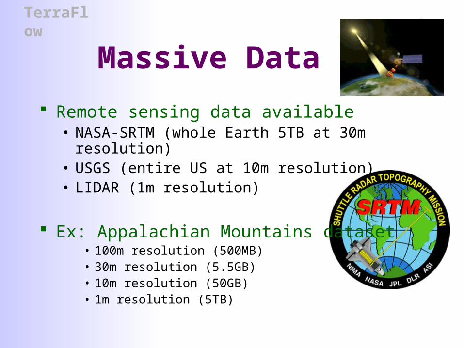
Massive Data
Remote sensing data available • NASA-SRTM (whole Earth 5TB at 30m resolution) • USGS (entire US at 10m resolution)• LIDAR (1m resolution)
Ex: Appalachian Mountains dataset• 100m resolution (500MB)• 30m resolution (5.5GB)• 10m resolution (50GB)• 1m resolution (5TB)

TerraFlow
Process Massive Data? GRASS
• r.watershed, ...• Killed after running for 17 days on a 6700 x 4300 grid (approx
50 MB dataset)
TARDEM• flood, d8, aread8• Killed after running for 20 days on a 12000 x 10000 grid
(appox 240 MB dataset)• CPU utilization 5%, 3GB swap file
ArcInfo • flowdirection, flowaccumulation• Can handle the 130MB dataset
• Doesn’t work for datasets bigger than 2GB
TerraFlow
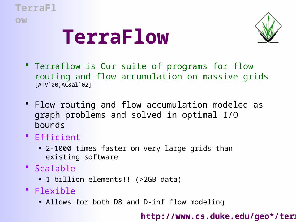
TerraFlow Terraflow is Our suite of programs for flow routing and
flow accumulation on massive grids [ATV`00,AC&al`02]
Flow routing and flow accumulation modeled as graph problems and solved in optimal I/O bounds
Efficient• 2-1000 times faster on very large grids than existing software
Scalable• 1 billion elements!! (>2GB data)
Flexible • Allows for both D8 and D-inf flow modeling
http://www.cs.duke.edu/geo*/terraflow

TerraFlow
r.terraflow
Port of Terraflow into GRASS Preliminary results on
• Augment with additional features • Output plateaus, depressions, tci, water outlet queries,
watershed basins
• Comparison with GRASS flow routines• r.watershed, r.flow, r.topidx, ...
• Performance results
TerraFlow
Outline
Scalability to large data• Why standard programs are not in general scalable
• One approach to improve scalability• I/O-efficient algorithms
r.terraflow • Algorithm outline
• Related work and programs
• Preliminary comparison and performance results
• Output illustration

TerraFlow
Scalability to Massive Data
Why? Most GIS programss assume data fits in memory and minimize only
CPU computation
But..Massive data does not fit in main memory! OS places data on disk and moves data in and out of memory
• Data is moved in blocks
• Accessing the disk is 1000 times slower than accessing main memory when processing massive data disk I/O is the bottleneck, rather than CPU time!
TerraFlow
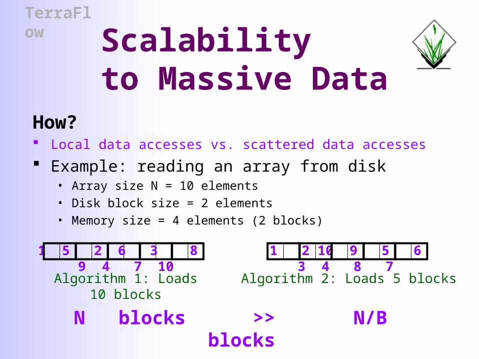
Scalability to Massive Data
How? Local data accesses vs. scattered data accesses
Example: reading an array from disk• Array size N = 10 elements
• Disk block size = 2 elements
• Memory size = 4 elements (2 blocks)
1 2 10 9 5 6 3 4 8 71 5 2 6 3 8 9 4 7 10
Algorithm 2: Loads 5 blocksAlgorithm 1: Loads 10 blocks
N blocks >> N/B blocks

TerraFlow
Example
r.watershed• r.watershed –m el=elev_grid dir=dir_grid ac=accu_grid
• Running on a 500MHz PIII, 1GB RAM, FreeBSD
• On Hawaii dataset we let it run for 17 days in which it completed 65%
Kaweah
1100 x 1400
1.6M elements
Puerto Rico
4400 x 1300
6M elements
Hawaii
6800 x 4300
28M elements
Capdem
12000 x 10000
122M elements
r.watershed 12 min 5 days 26 days ?
However good the OS, it cannot change the data access pattern of the program!!
TerraFlow
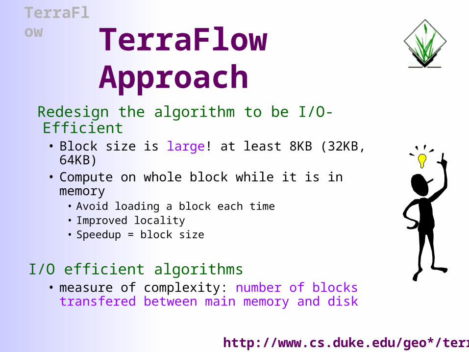
TerraFlow Approach
Redesign the algorithm to be I/O-Efficient • Block size is large! at least 8KB (32KB, 64KB)• Compute on whole block while it is in memory
• Avoid loading a block each time• Improved locality• Speedup = block size
I/O efficient algorithms• measure of complexity: number of blocks
transfered between main memory and disk
http://www.cs.duke.edu/geo*/terraflow

TerraFlow
r.terraflow outline
Step 1: Flow routingWater flows downhill: SFD, MFD
• Compute SFD/MFD flow directions by inspecting 8 neighbor points
• Identify flat areas: plateaus and sinks
http://www.cs.duke.edu/geo*/terraflow

TerraFlow
Flow Routing on Flat Areas
…no obvious flow direction Plateaus
• Assign flow directions such that each cell flows towards the nearest spill point of the plateau
Sinks• Either catch the water inside the sink
• Assign flow directions towards the center of the sink
• Or route the water outside the sink using uphill flow directions• Simulate flooding the terrain: sinks plateaus
• Assign uphill flow directions on the original terrain by assigning downhill flow directions on the flooded terrain

TerraFlow
r.terraflow outline
Step 2: Compute flow accumulation• Water flows following the flow directions
• Goal: Compute the total amount of water through each grid cell• Initially one unit of water in each grid cell
• Every cell distributes water to the neighbors pointed to by its flow direction(s)
All these steps can be solved I/O-efficiently• Flow routing: modeled as graph problems (breadth-first search,
connected components, graph contraction)
• Flow accumulation: sweeping using an I/O-efficient priority queue

TerraFlow
Related Work
TerraFlow’s emphasis • Computational aspects, not modeling
Flow modeling• [O’Callaghan and Mark 1984]
• D8 method for flow accumulation
• [Jenson and Domingue 1988]• General technique of flooding
• Software• GRASS, ArcInfo,Tardem, Topaz, Tapes-G, RiverTools

TerraFlow
GRASS Raster Flow Functions
r.watershed• Most commonly used. Uses A* algorithm to determine flow of water. Ehlschlaeger,
USACERL.
• Input: elevation, [..]
• Output: flow direction, flow accumulation, [waterhseds, stream segments, slope length, slope steepness]
• Flow direction grid equivalent to running r.drain for every cell on the grid
• Watershed grid equivalent to running r.water.outlet for multiple outlets
• r.drain• Traces the least-cost (steepest-downslope) flow path from a given cell. Stops in pits.
• Input: elevation, point coordinates
• Output: least-cost path
• r.water.outlet• Generates a watershed basin from a flow direction map. Ehlschlaeger, USACERL.
• Input: flow direction (from r.watershed), basin coordinates
• Output: watershed basin map
TerraFlow
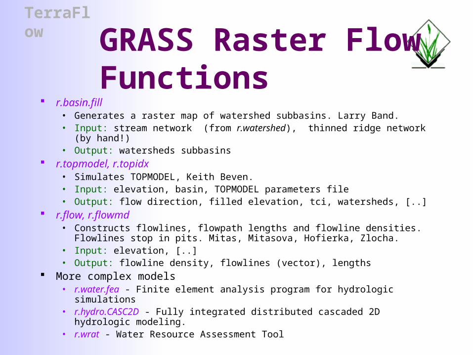
GRASS Raster Flow Functions
r.basin.fill• Generates a raster map of watershed subbasins. Larry Band.• Input: stream network (from r.watershed), thinned ridge network (by hand!)• Output: watersheds subbasins
r.topmodel, r.topidx• Simulates TOPMODEL, Keith Beven. • Input: elevation, basin, TOPMODEL parameters file• Output: flow direction, filled elevation, tci, watersheds, [..]
r.flow, r.flowmd• Constructs flowlines, flowpath lengths and flowline densities. Flowlines stop in
pits. Mitas, Mitasova, Hofierka, Zlocha.• Input: elevation, [..]• Output: flowline density, flowlines (vector), lengths
More complex models• r.water.fea - Finite element analysis program for hydrologic simulations• r.hydro.CASC2D - Fully integrated distributed cascaded 2D hydrologic modeling.• r.wrat - Water Resource Assessment Tool

TerraFlow
r.terraflow features
Input• elevation grid
Output• flow direction grid
• SFD (D8) single flow directions• MFD (Dinf) multiple flow directions
• flow accumulation grid• Option to switch to SFD when flow value exceeds an user-
defined threshold
• topographic convergence index (tci) grid• plateau and depressions grid
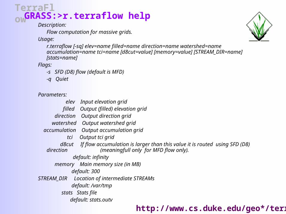
TerraFlowGRASS:>r.terraflow help
Description:Flow computation for massive grids.
Usage:r.terraflow [-sq] elev=name filled=name direction=name watershed=name accumulation=name tci=name [d8cut=value] [memory=value] [STREAM_DIR=name] [stats=name]
Flags:-s SFD (D8) flow (default is MFD)
-q Quiet
Parameters: elev Input elevation grid filled Output (filled) elevation grid direction Output direction grid watershed Output watershed grid accumulation Output accumulation grid tci Output tci grid d8cut If flow accumulation is larger than this value it is routed using SFD (D8) direction
(meaningfull only for MFD flow only). default: infinity
memory Main memory size (in MB) default: 300
STREAM_DIR Location of intermediate STREAMs default: /var/tmp
stats Stats file default: stats.outv
http://www.cs.duke.edu/geo*/terraflow

TerraFlow
Preliminary Experimental ResultsPIII dual 1GHz processor, 1GB RAM
DatasetGrid
dimensions
Grid size (million
elements)
Kaweah 1163 x 1424 1.6
Puerto Rico 4452 x 1378 5.9
Sierra Nevada 3750 x 2672 9.5
Hawaii 6784 x 4369 28.2
Lower New England
9148 x 8509 77.8
Panama11283 x 10862
122.5
r.terraflow
1.85 min
4.65 min
19.22 min
22.35 min
114 min
3.5 hr
r.watershed
9.2 min
93 min
18.2 hours
killed after 6 days
< 1% done

TerraFlow
Panama DEM
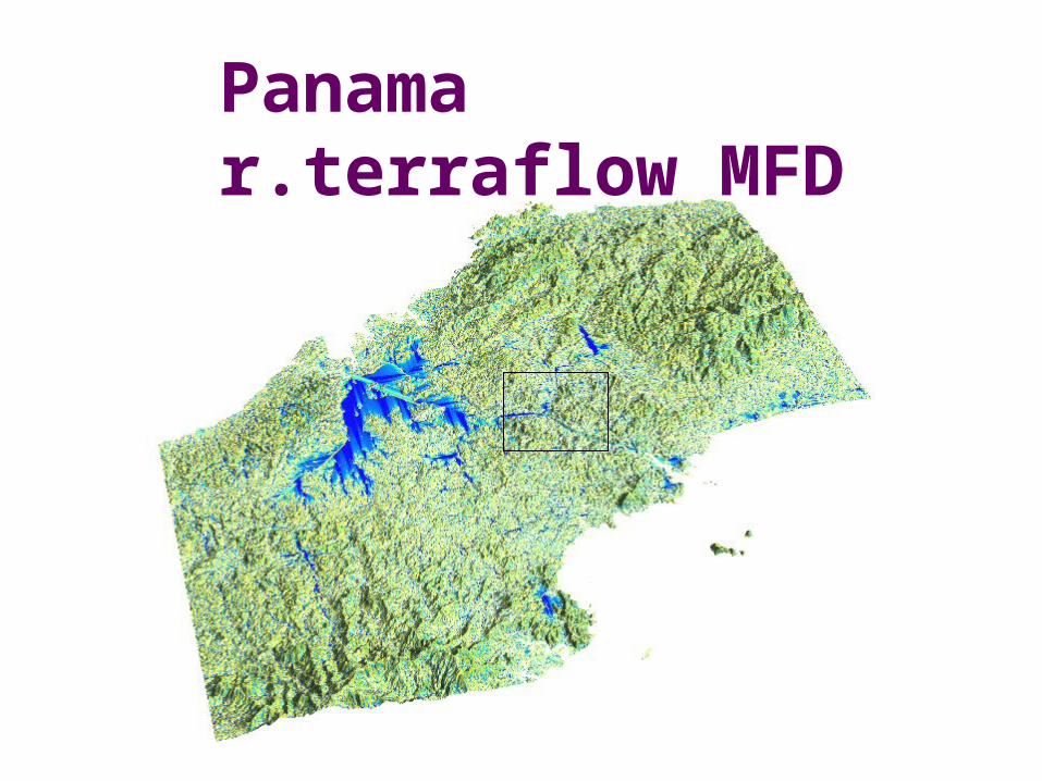
TerraFlow
Panama r.terraflow MFD

TerraFlow

TerraFlow
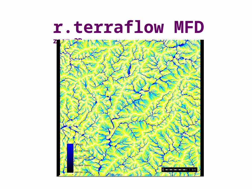
r.terraflow MFD zoom,3D

TerraFlow
r.terraflow SFD zoom,3D
TerraFlow
r.terraflow MFD zoom,2D

TerraFlow
r.terraflow SFD zoom,2D

TerraFlow
r.terraflow MFD TCI zoom,2D

TerraFlow
r.terraflow SFD TCI zoom,2D
TerraFlow
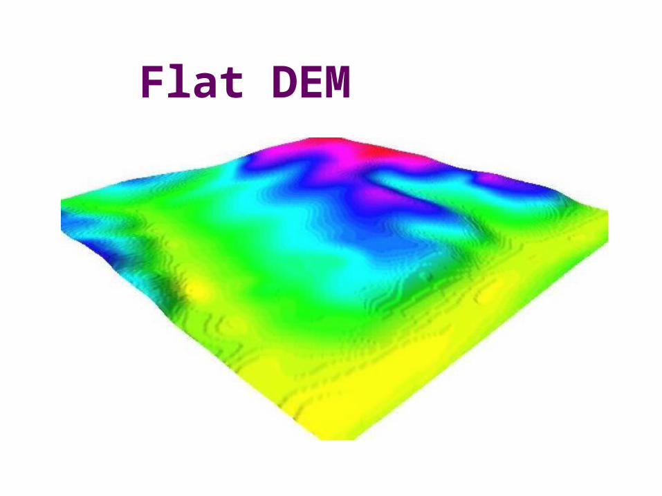
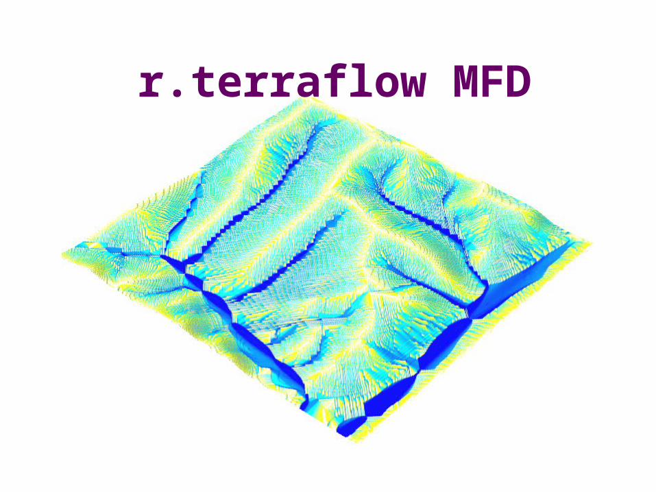
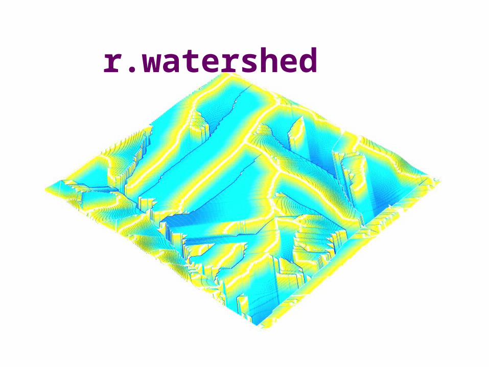
Flat DEM
TerraFlow
r.terraflow MFD

TerraFlow
r.terraflow SFD
TerraFlow
r.watershed

TerraFlow
Conclusions/Future Work
Work in progress• More features
• Water outlet queries
• Watershed delineation
• Experimental analysis
Other features? Modeling? Other (intensive computing, I/O-bound) applications?
http://www.cs.duke.edu/geo*/terraflowhttp://www.cs.duke.edu/geo*/terraflowhttp://www.cs.duke.edu/geo*/terraflow
![Fig. 3 Y[m] X[m] Time [year] space-time cube t1t1 t2t2 tntn 15 7 0 m interpolate z=f(x,y,t) (x,y,z) … reorder as (x,y,t,z) H. Mitasova, NCSU](https://img.pdfslide.us/doc/110x75/56649cb95503460f949810ad/fig-3-ym-xm-time-year-space-time-cube-t1t1-t2t2-tntn-15-7-0-m-interpolate.jpg)