Embed Size (px)
Citation preview
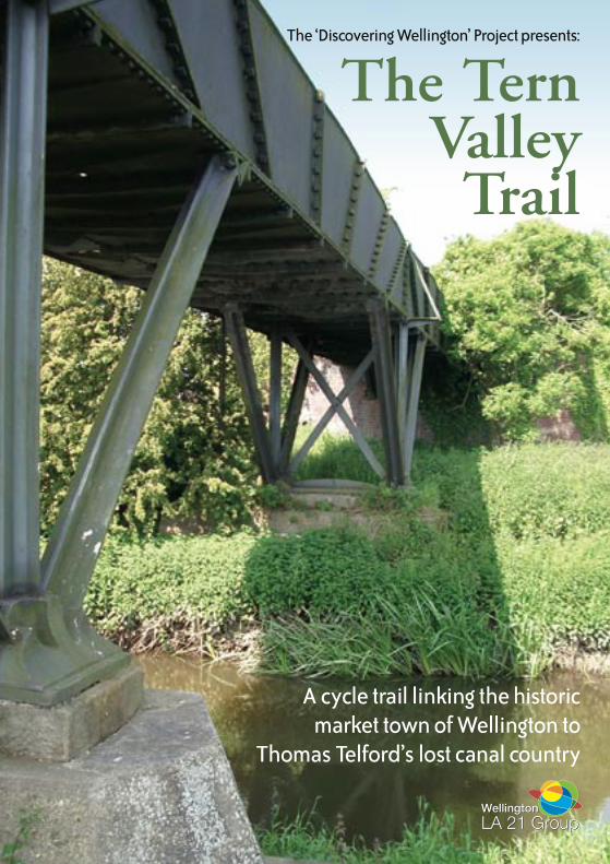
A cycle trail linking the historic market town of Wellington to
Thomas Telford’s lost canal country
The ‘Discovering Wellington’ Project presents:
The TernValleyTrail

The Tern Valley Trail
Between 1795 and 1796, Thomas Telford drove the Shrewsbury Canal through the lower Tern Valley near Wellington, rendering many changes to the local landscape that can still be viewed today. The year 2007 marks the 250th anniversary of the renowned Scottish civil engineer’s birth, so what better way to witness his impact in east Shropshire than to get out and see some of the changes he made first hand? Along the way you’ll uncover groundbreaking industrial heritage, medieval castle ruins, secret Second World War history and much more besides, so come with us now and discover the riparian wonders of the Tern Valley.
Wellington, then The Tern
The Tern Valley Trail is a 14-mile, circular cycle route on quiet country roads, traffic-free paths and existing sections of the National Cycle Network. The trail begins and ends in the ancient market town of Wellington, the historic capital of east Shropshire. Wellington’s long and illustrious history stretches back to at least Anglo-Saxon times, while the town received its first market charter in 1244 and became a prosperous centre for industry and agriculture in the Victorian era. Today, the market is still at the centre of town life, while its comprehensive range of specialist shops, cafes, restaurants and pubs make Wellington an excellent place to start and end your adventure.
Wellington Midsummer Fair, Market Square
Longdon Aqueduct

A River Runs Through It
The River Tern rises just over the Shropshire border at Maer in north Staffordshire, crossing the county boundary near Market Drayton and flowing southwards before converging with the River Severn some 30 miles downstream at Atcham, between Wellington and Shrewsbury. Although relatively short in length, the Tern plays a vital role in draining a large part of north and east Shropshire and has recently attracted major funding to support a groundbreaking intensive research scheme examining water management for the benefit of the local community. The LOCAR programme, which is sponsored by the National Environment Research Council, will examine the interaction between river water, surface water and groundwater in the Tern Valley, studying its effects on fish and other organisms in the area. Monitored sites, measuring the components of the water cycle (such as rainfall, evaporation and water flow), will be established and, as a result, the Tern should eventually become one of the best understood waterways in the country.
Following the Trail
To follow the Tern Valley Trail just refer to the route map in the centre of this booklet. There are also focus maps on alternate pages containing additional details of lost heritage features along the way and plenty of opportunities to take a break at family-friendly pubs en route. Just remember to bring your imagination and always follow the Highway Code.
The Tern Valley at Walcot
Traffic-free cycling on the Tern Valley Trail
Rodington
Rodington
Longdonon Tern
Withington
Isombridge
Walcot
Wrockwardine
Wellington
River Tern
River Roden
River Tern
River Tern
A5
A5
A442
M54
B5063
B5063
B4394
B4394
B5061 B5061
to Shrewsbury
to Atchamto Telford
to Telford
to Hodnetto High Ercall
J7
Short Cut

Mansion House LaneUntil the early 19th Century, Vineyard Road and the area of Springhill stretching to the junction of Admaston Road were known as Mansion House Lane. Many of Wellington’s wealthiest and most influential families lived in this area and a number of the fine properties they inhabited still stand as a reminder of the grandeur once associated with this exclusive Wellington address.
To The Vineyard
In its days as Mansion House Lane, Vineyard Road began at the north end of Church Street and was only extended to its present junction with King Street in the early 1970s. Although there are several large properties in the area, the mansion house from which the street took its name is probably the white Georgian building that stands above Springhill roundabout. ‘The Vineyard’ appears to have been finished in 1721, when the house was ‘painted-in’ for its first owner St John Charlton Chiverton Charlton, the naval officer and owner of the nearby Apley Castle estate, who was responsible for its construction. The house, which is now a private property, has been largely obscured from view by modern development within its grounds, which were formerly far grander than today. In 1841, The Vineyard and its extensive range of outbuildings, offices and gardens, covered over 5 acres and included a large ornamental pool to the rear of the property.
There were at least three driveways onto the estate, which also contained twelve acres of meadow and pasture to the north west of the house itself. The Charlton family appear to have sold the house sometime after 1840 and several prominent local figures have since occupied it. TC Eyton, who lived at The Vineyard in 1851 with his wife, children and a staff of 12 servants, was a well-known local businessman and naturalist. He produced a number of books on ornithology and it was his companies that were responsible for supplying Wellington with water and gas during the Victorian era. Eyton was also a local JP and held a commission in the Shropshire Yeomanry. During 1842, he played a prominent role in crushing miners riots in the east Shropshire coalfield. Yet, a century earlier, another Vineyard resident, local attorney Thomas Leeke, played a very different part in a similar situation...
Where Vineyard Road meets Church Street
The Vineyard
The Vineyard and Mansion House Lane in 1841
Geo
rge
Evan
s

The Bread Riots
The summer of 1756 was, even by British standards, unusually wet, wreaking havoc on harvests and creating severe food shortages. Locally, incidents of civil unrest became more commonplace as many people struggled to afford the vastly inflated prices food suppliers demanded. In east Shropshire, the situation had apparently become so bad that gangs of roving colliers had taken to visiting markets in the area, forcibly buying-up bread at a pre-arranged price they decided upon themselves. Somewhat inevitably, this situation seems to have led to widespread plundering of other goods and, in the second week of November, beleaguered traders in Much Wenlock, Shifnal and Broseley were all targeted before the gang appeared in Wellington at the town’s weekly Thursday market.
According to one contemporary account, local farmers were prepared for these unwelcome visitors who, on arrival, found little produce worthy of plunder. As a result, more widespread pillaging of local businesses and houses allegedly took place, during the course of which one of the looters was apprehended by townsfolk after helping himself to a leg of beef he had seized from a local butcher! Supposedly, the gang swore to return for vengeance the next morning but local tradesmen, with the help of an armed militia raised by members of the local gentry, dispersed the rioters, ten of whom were later sentenced to death at the local assizes the following spring.
The ‘Wise’ Mr Leeke
The presiding judge later recommended six of these men be reprieved but notice of his decision failed to reach Shropshire by the day of the executions. Without sanction, and against all advice, Thomas Leeke, in his role as Deputy Sheriff of the county, postponed the hangings and sent a letter to London requesting further instruction. Subsequently, eight men were saved from the gallows by his action and the Lord Chief Justice of England later commended Leeke for the ‘wise and humane part’ he had played in proceedings.
V I N E Y A R D R O A D
B R I D G E S T R E E T
S P R I N G H I L L
ADMASTON ROAD
ORLETON LANE
NO
RT
H R
OA
D
VINE
YARD DRI
VE
Q U E E N S T R E E T
C HU RCH
STREET
CR
ES C
E N T R O A D
PAR K
ST R
E ET
SpringhillHouse
TheVineyard Portico
HouseParville
Edinburgh House
Glenville
Wellington in the late 18th century
Parville
Springhill House

In Search of CynddylanBy the mid-10th Century, the Royal manor of Wrockwardine was an important local centre enjoying rights and privileges over a wide area of modern day east Shropshire. The settlement’s pre-eminence may have arisen when Viroconium Cornoviorum, the former western capital of Roman Britain and home of the Celtic Cornovii tribe, was abandoned at the end of the 6th or early 7th Century in exchange for a site nearer to the traditional tribal centre of The Wrekin Hill fort. However, other sources link Wrockwardine’s regal lineage to the legendary kingdom of Pengwern and the seat of its last leader, Cynddylan ap Cyndrwyn.
The Legend of Pengwern
To secure Britain from Anglo-Saxon incursions, the Romans appear to have appointed local chieftains to help defend some of the more vulnerable parts of their territory and a number of independent kingdoms may have emerged in these areas after their rule ended. Owing to the unstable climate in which these new states arose, many appear to have been short-lived and evidence supporting their existence is scarce.
The Hall of Cynddylan
Little of the conjectured kingdom of Pengwern is known until the Battle of Chester, which is thought to have occurred about 613. It seems likely that, if the fledgling state did exist, it, too, was based on former Roman settlements; in this case Caer Luit Coyt (Wall, South Staffordshire), Caer Magnis (Kenchester, Herefordshire) and Viroconium (Wroxeter, Shropshire). Pengwern’s leader at that time was, reputedly, Cyndrwyn Fawr (the ‘Great’) who may have fought at Chester with other British leaders against King Æthelfirth of Bernicia. Pengwern supposedly passed to his son Cynddylan around 620, who then ruled the kingdom from Llys Pengwern (the fabled ‘Hall of Cynddylan’). Viroconium had been abandoned by this time and, although the reasons for its demise are unclear, it may have been that it was exchanged for a more defendable site in the vicinity of The Wrekin Hill, the former tribal capital of the area from which Wrockwardine takes its name.
The Wrekin
St Peter’s parish church, Wrockwardine

The Laments of Heledd
The main source of evidence for Pengwern’s existence is contained in two 9th Century Welsh poems dealing with Cynddylan’s death and the destruction of his kingdom at the hands of King Oswiu of Northumberland, which may have taken place in the year 656. However, both Marwnad Cynddylan (The
Death Song of Cynddylan) and the Canu Heledd (The Laments of Heledd — in legend, Cynddylan’s sister) were probably passed by word of mouth for up to 200 years before being written down, which makes their validity as historical evidence problematical.
In the Canu Heledd, Cynddylan’s burial takes place at Baschurch (Eglwysseu Bassa) in north Shropshire, which is often assumed to have been the site of Llys Pengwern, his capital. However, the ancient texts make reference to Cynddylan’s home being much nearer to The Wrekin Hill and the former Roman town of Viroconium, while his kingdom is also described as occupying the lands between the Roden and Tern, from which Baschurch is some distance away. The literal translation of Pengwern, meaning ‘at the head of a swamp or marsh’, would certainly be more appropriate to Wrockwardine’s situation above the Weald Moors. Indeed, the royal manor held special privileges over the area, including unlimited cattle grazing rights, until the late 1500s, although quite how or why it came to have such generous rights remains uncertain.
The People of The Wrekin
To add to the air of mystery surrounding the area’s lineage, The Tribal Hidage, an Anglo-Saxon tax record that may have been compiled within 100 years of the supposed fall of Pengwern, records Wrockwardine as belonging to the Wreosensaete (‘the people of The Wrekin’) which was then a sub-kingdom of the larger Anglo-Saxon state of Mercia. Other evidence from the period suggests the word ‘saete’ may have been used to denote former British kingdoms, providing another tantalising clue to Wrockwardine’s regal past.
WrockwardineWE L L I N GT O N R O A D
St Peter’s ChurchThe Green
PlayingField
The Green, Wrockwardine
Come outside, maidens, and look at the land of Cynddylan.
The court of Pengwern is a raging fire: woe to the young who long for their brothers
Excerpt from Cynddylan in the Canu Heledd
“
”The Weald Moors

From A Jack To A KingAfter leaving Wrockwardine, the cycle trail descends towards the Tern Valley via the ancient settlement of Charlton, a village that takes its name from a family of local nobles who once enjoyed the favour of the English monarchy. Yet, just a mile or so before reaching their former home, our journey takes us past the site of another house with a very different history…
Tiddicross Workhouse
Tiddicross Field, situated to the west of Wrockwardine on the road to Charlton, was purchased for charitable purposes in 1657, when the rents of the property, upon which a house and barn were later built, were divided annually between the poor of the parish. The cost of relieving local poverty rose rapidly during the 17th and 18th Centuries and in 1782 the parish authorities were forced to rent a cottage in which to house the local poor. However, most people requiring assistance received it outside the institution, through cash payments and goods in kind. At that time, the parish included the detached settlement of Wrockwardine Wood, where the need for aid proved to be particularly heavy and was often linked to downturns in local industry.
Self-Sufficiency
In 1801, a new workhouse was deemed necessary and a new institution was built on Tiddicross Field. The occupants of the facility were principally drawn from the ranks of the elderly and infirm and rarely numbered more than 20. Despite the seemingly frail condition of many of its inhabitants, some amenities, including a number of spinning wheels, were installed for the residents to work upon. The presence of a kitchen, cowhouse, pigsties and brewhouse on site was also intended, in theory at least, to give the institution a level of self-sufficiency, as well as providing the inhabitants with the bread, cheese and beer their hosts were charged with feeding them at least once a week. By 1814, a salaried workhouse master, who was paid £20 a year, was appointed to oversee the day-to-day running of the institution, while the services of a local doctor were also retained for residents at that time. In 1836, responsibility for providing assistance was transferred to the new Wellington Poor Law Union, although Tiddicross Workhouse, which is now a private property, continued to receive those seeking relief for some time after. When the institution finally closed, the house was divided into four cottages, the annual rents from which were still divided among the poor of the parish in 1907 when £35 was raised for the Tiddicross Charity.
On the road to the workhouse
The former Tiddicross Parish Workhouse

Charlton Castle
The tiny settlement of Charlton, situated halfway between Wrockwardine and Walcot, shows few obvious traces of the prominent position it once enjoyed locally. Yet, in a field on the edge of the village, standing within a large moated enclosure, the ruins of a fortified manor house built by a distinguished 14th Century knight who served at the court of an English monarch provide enduring evidence of the former importance of this secluded site.
The House Sir John Built
Charlton Castle was once home to the ‘beloved valet’ of Edward II, Sir John Charlton, who was appointed Governor of Ireland in 1338 and also served as King’s Chamberlain. Records of a property on the site exist from at least 1174, when a house was apparently leased to the Charlton family by the abbot of Lilleshall Abbey. Sir John appears to have inherited the estate at the same time his younger brother Alan succeeded to the family seat of Apley Castle, situated to the north of Wellington. In 1316, Charlton was given license by the Crown to crenellate, or fortify, the house as part of a series of improvements that may have been instigated by his wife Hawys (the daughter of Owen ap Griffith - the last Prince of Powys) to whom Charlton was married in 1311. Sir John later received permission to celebrate mass in a chapel on the site in 1341 but, by the time of his death twelve years later, Charlton Castle was said to be worth next to nothing and it seems unlikely he spent much time there.
Enter The Lords of Powys
Sir John accumulated many properties during his lifetime and, through his court connections, was granted possession of numerous lands and castles across north and south Wales by royal charter. Through his marriage to Hawys, Charlton also acquired Powys Castle which he rebuilt with the distinctive red sandstone towers that still characterise the world-famous property today. If only in name, it seems Charlton Castle continued to be used as a residence of the Lords of Powys until the 16th Century but all that now remains of Sir John’s original Shropshire seat are some well-preserved foundations and fragmentary walling that only hint at its former grandeur. The remains of a large fishpond and rabbit warren that
once served his estate are also located nearby.
Glentworth, Mill Bank
Charlton village and The Wrekin
Charlton
Walcot
to Shrewsbury
to Wellington
B4394
WhitefieldsFarm
Charlton Castle
Tiddicross
The Grove Inn
Medieval Fish Pond
Charlton Castle ruins in 1857
Shro
pshi
re A
rchi
ves

The Bridge of the Servants
Although Isombridge now comprises little more than a farmstead and a few scattered houses, evidence suggests the ancient hamlet was once more prominent in the local community. Intriguingly, one interpretation of the settlement’s name, as the ‘bridge of the servants’, alludes to a possible connection with the royal manor at Wrockwardine, although how, when and why this link may have come about is unclear. Archaeological evidence north and south of the minor road to Walcot confirms agricultural activity may have gone on in the area since at least the Iron Age and, by the time of the Domesday Survey in 1086, Isombridge was important enough to have been considered a manor in its own right. However, it seems to have declined in importance from that point on and eventually became part of the manor of Great Bolas. Today, this remote part of the Tern Valley trail, with its dramatic backdrop of The Wrekin and south Shropshire hills, is an excellent spot for birdwatching. Close to the road, several old clay pits have been filled with water and form an excellent habitat for a variety of wading birds and other avian visitors to the area.
Bratton Gets Its Wings
The crossroads at Long Lane, between Longdon-on-Tern and Bratton, may not seem particularly noteworthy today yet, just over 60 years ago, the scene here was very different. On the south side of the road stood Longdon Halt which opened in 1934 and was the first station out of Wellington on the Great Western Railway line to Crewe. After the outbreak of the Second World War, the tiny halt was thrust into a more important role than could ever have been envisaged, when it became the principal station for a 190-acre grass airfield that sprang to life on the other side of the highway in the winter of 1940. RAF Bratton was intended as a relief landing strip for the nearby base at Shawbury, although it later served aircraft from Tern Hill and the naval air station at Hinstock before closing just after the end Isombridge and The Wrekin
Rodington
Longdon on TernLongdon on Tern
WithingtonWithington
RodingtonHeath
IsombridgeIsombridge
Rushmoor
Marsh Green
Allscott
Admaston
Leaton
Walcot Wrockwardine
WellingtonWellington
Dothill
Shawbirch
SleepfordSleepford
CharltonCharlton
Rodington
RodingtonHeath
Rushmoor
Marsh Green
Allscott
Admaston
BrattonBratton
Leaton
Walcot Wrockwardine
Dothill
Shawbirch
River Tern
River Roden
River Tern
River Tern
Aqueduct
A5
A5
A442
M54
A5223
B5063
B5063
B4394
B4394
B5061B5061
to Shrewsbury
to Atcham
to Telford
to Telford
to Hodnetto High Ercall
Junction 7
The Tern Valley TrailHere are some other places to look out for along the route
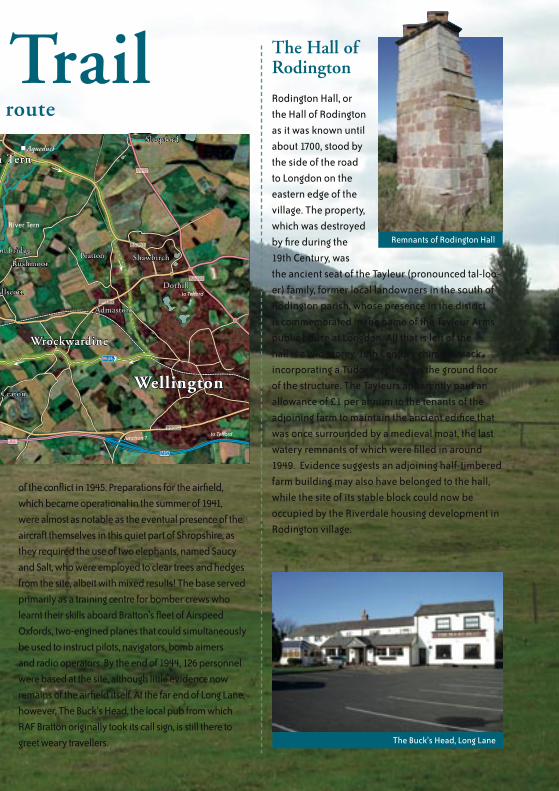
of the conflict in 1945. Preparations for the airfield, which became operational in the summer of 1941, were almost as notable as the eventual presence of the aircraft themselves in this quiet part of Shropshire, as they required the use of two elephants, named Saucy and Salt, who were employed to clear trees and hedges from the site, albeit with mixed results! The base served primarily as a training centre for bomber crews who learnt their skills aboard Bratton’s fleet of Airspeed Oxfords, two-engined planes that could simultaneously be used to instruct pilots, navigators, bomb aimers and radio operators. By the end of 1944, 126 personnel were based at the site, although little evidence now remains of the airfield itself. At the far end of Long Lane, however, The Buck’s Head, the local pub from which RAF Bratton originally took its call sign, is still there to greet weary travellers.
The Hall of Rodington
Rodington Hall, or the Hall of Rodington as it was known until about 1700, stood by the side of the road to Longdon on the eastern edge of the village. The property, which was destroyed by fire during the 19th Century, was the ancient seat of the Tayleur (pronounced tal-loo-er) family, former local landowners in the south of Rodington parish, whose presence in the district is commemorated in the name of the Tayleur Arms public house at Longdon. All that is left of the hall is a two-storey, 16th Century chimney stack, incorporating a Tudor fireplace on the ground floor of the structure. The Tayleurs apparently paid an allowance of £1 per annum to the tenants of the adjoining farm to maintain the ancient edifice that was once surrounded by a medieval moat, the last watery remnants of which were filled in around 1949. Evidence suggests an adjoining half-timbered farm building may also have belonged to the hall, while the site of its stable block could now be occupied by the Riverdale housing development in Rodington village.
Remnants of Rodington Hall
The Buck’s Head, Long Lane
Rodington
Longdon on TernLongdon on Tern
WithingtonWithington
RodingtonHeath
IsombridgeIsombridge
Rushmoor
Marsh Green
Allscott
Admaston
Leaton
Walcot Wrockwardine
WellingtonWellington
Dothill
Shawbirch
SleepfordSleepford
CharltonCharlton
Rodington
RodingtonHeath
Rushmoor
Marsh Green
Allscott
Admaston
BrattonBratton
Leaton
Walcot Wrockwardine
Dothill
Shawbirch
River Tern
River Roden
River Tern
River Tern
Aqueduct
A5
A5
A442
M54
A5223
B5063
B5063
B4394
B4394
B5061B5061
to Shrewsbury
to Atcham
to Telford
to Telford
to Hodnetto High Ercall
Junction 7
The Tern Valley TrailHere are some other places to look out for along the route

Where Roden Goes Into TernAmong the many poems that comprise the Canu
Heledd, Afonydd (River) speaks of an area on the border of Pengwern where ‘Roden goes into Tern’. The actual confluence of the two rivers is located near the ancient village of Walcot. Close by, at Withington, the Tern Valley Trail joins up with the course of another well-known local waterway, the Shrewsbury Canal.
Walcot
Possible Iron Age enclosures to the south of the River Tern suggest a long history of habitation in the area surrounding Walcot. Indeed, the village appears to have been a notable settlement since early Anglo-Saxon times and its name may denote status as a village where Welsh was still spoken at the time it belonged to Wreosensaete, the 8th Century sub-kingdom of Mercia. By Domesday, Walcot was reckoned to be an outlying farmstead of Wellington, where that manor’s mill may have been situated. Milling continued to a play an important role in village life until the early years of the 20th Century; the mill itself was demolished in 1961. However, near to the Tern, the mill race can still be seen, while the southern end of the bridge over the river is notable as the last edifice to be designed by William Hayward, architect of the Thames Bridge at Henley.
Withington
Approaching Withington from the east, your first site of the village is likely to be the distinctive broach spire and sandstone walls of the local parish church. A place of worship has existed here since at least 1150, although the current building, dedicated to St John the Baptist, dates from 1874. Withington church is noted for its 16th Century brasses, one of which commemorates the former village parson ‘Master Adam Grafton’. In a highly distinguished career, Grafton served as chaplain to King Edward V and Prince Albert and was buried at the church during 1530, after spending his final years living in the village. When Thomas Telford drove the Shrewsbury Canal through the area at the end of the 1700s, the church also became notable for its close proximity to Withington wharf, which stood between it and the road to Walcot. However, this is not the village’s only association with the famous civil engineer, as the local blacksmith (whose forge was located opposite the Hare and Hounds pub) is reputed to have cast some of the chain links for Telford’s Menai Suspension Bridge.Confluence of the Tern and Roden at Walcot
The Hare and Hounds, Withington
St John’s parish church, Withington

Rodington
The former canalside village of Rodington is an ancient rural community standing on the banks of the River Roden, the waterway from which the settlement probably took its name. Despite its tranquil appearance, Rodington has a surprisingly lively past and, when Telford drove the Shrewsbury Canal through the area in the late 1700s, the village Bull Ring was the site of a barbaric annual festival of blood and gore.
The Bull Ring
The Bull Ring was located on the side wall of the farm building that stands opposite the former village school. The local pound for stray animals was once located on the site, while the gruesome spectacle of bull-baiting with dogs is thought to have continued here until about 1840. The ring to which the unfortunate animals were tethered may have remained in place until 1904 and a blackened mark in the sandstone wall itself is said to indicate the site of the hearth where the bulls were roasted after being killed. An annual week of cockfighting is also known to have taken place on the bull ring until 1810, attracting colliers from the Shropshire coalfield at Ketley and Oakengates, who stayed next door at the Bull’s Head. The pub, supposedly the second oldest licensed house in Shropshire, was not the only source of ale for 19th Century locals; another hostelry, The Crown, was situated on Chapel Crossroads west of the village. A complaint lodged in the local parish overseer’s book
from 1839 also protests at the presence of a beerhouse in Drury Lane, where local servants were allegedly encouraged to ‘tipple all night’!
Ancient Origins
To avoid the need for the local curate to wait in the Bull’s Head before services began, a new vestry was added to St George’s parish church in 1823; it also functioned as a schoolroom. A church is first recorded in Rodington at the time of the Domesday survey in 1086 when a Saxon, Toret, was lord of a manor inhabited by only a handful of villagers and serfs. St George’s itself was founded by the 13th Century, although no trace of the original church, which was inadequately rebuilt in stone during 1751, survives. After a century of regular repairs to the crumbling edifice, extensive renovations were again carried out in 1851 that give the building its modern day appearance. By that time, the schoolroom in the vestry had been replaced by a building in the churchyard, near to the present jubilee gates, on a site more familiar to misbehaving adults — the village stocks!
RodingtonRodington Hall
Withington
WalcotRiver Tern
River Roden
B4394
Bulls Head
Hare & HoundsSt John
The Baptist Church
The Lees
Walcot Road Farm
The Parks Farm
The DaleThe OaklandsBarker’s Square
Grove Farm
New House Farm
St George’s Church
Bridge No.29
Bridge No.28
Wharf
WharfBull Ring
Lift Bridge No.27
Bridge No.26 Lift Bridge No.25
Aqueducts
Course of Canal
Co
urs
e o f
C
anal
Short Cut
The Bull Ring
St George’s Church and Roden Bridge

Telford’s CanalIn 1793, an Act of Parliament sanctioned a 17-mile canal linking Shrewsbury to the east Shropshire coalfield at Trench. The waterway, which opened four years later, was completed under the leadership of the renowned civil engineer Thomas Telford and included many groundbreaking engineering feats. Although the canal is no longer in use, some of these features can still be seen along the Tern Valley Trail.
Hail The Chief… Engineer!
By the late 18th Century, Shrewsbury was largely dependant on the many mines centred around the Oakengates area for its coal supplies. In fact, the sheer volume of traffic used for transporting raw materials to the county town had rendered the Holyhead Road all but impassable in places and an alternative was sought in 1792 when a potential route for a new canal was first surveyed.
The success of the existing tub-boat system servicing the coalfield itself meant finding capital to fund the scheme was not a problem and local industrialists, including the Duke of Sutherland, were among the principal users of the Shrewsbury Canal, which opened in several stages between 1794 and 1796. The civil engineer Josiah Clowes was charged with overseeing construction work but, after his death in 1795, Thomas Telford, who had already worked on the Ellesmere Canal, was appointed his successor.
Telford’s Path to Shropshire
Thomas Telford was born near the tiny settlement of Westerkirk, on the banks of the River Esk in Dumfries, to a local shepherd in August 1757. After being apprenticed as a stonemason, he left Eskdale for Edinburgh where he further refined his skills before leaving Scotland for London in 1782. Telford then worked on several major projects, including the construction of Portsmouth Docks, before being contracted in 1786 by William Pulteney, Member of Parliament for Shrewsbury, to carry out alterations to the town’s castle; Pulteney had inherited the historic building by virtue of marriage and intended to use it as his private residence. While carrying out the repairs Telford was appointed Surveyor of Public Works for Shropshire. In this capacity he oversaw a wide array of projects, including the construction of Shrewsbury Gaol, new churches at Bridgnorth and Madeley, several bridges and the improvement of numerous roads throughout the county. His undoubted skill was later recognised when he was appointed engineer of the Ellesmere Canal in 1793.
Lift Bridge near Rodington
Longdon Wharf
Rodlington Aqueduct

Although the Shrewsbury scheme was straightforward in comparison, Telford commented in a letter to a friend that ‘there are many important works in its course’. Indeed, it was these ‘works’ that provided him with the experience and knowledge to complete many of his later triumphs.
All Aboard the Tub-Boat
Building the Shrewsbury Canal presented few real challenges in the way of difficult terrain or severe gradients yet, owing to its connections with the canal network serving the east Shropshire coalfield, it retained a number of unusual features. The new waterway was designed to accommodate the same tub-boats that plied along that system, rendering it unusable to standard narrowboats until a widening program took place during the 1830s. At Trench, a 223 yard inclined plane drew vessels up and down from the existing canal 75 feet above via rail but the utilisation of unconventional engineering methods did not end there. The locks on the Shrewsbury Canal were, at just 6 feet and 7 inches, the narrowest in Britain and, at 81 feet long, could accommodate up to four boats at a time. ‘This is accomplished’, wrote Telford, ‘by having gates that are drawn up and let down perpendicularly’; it was this feature that gave
these unusual devices the name ‘Guillotine Locks’.
Canal Dreams
Despite its excellent commercial prospects, the Shrewsbury Canal enjoyed a relatively short period of prosperity and entered a gradual decline from the mid-19th Century, when the railway network reached Shropshire. The closure of the canal basin in Shrewsbury itself, during 1922, signalled the beginning of the end for the doomed waterway and, after regular traffic had all but ceased in the 1930s, it was finally abandoned in 1944. Today, much of the canal bed has been filled in and many of its notable features, such as the movable, wooden drawbridges that carried several of the roads on the Tern Valley Trail over the waterway, have long since disappeared. At Rodington, however, the approach embankment to the vanished triple-arched aqueduct over the River Roden still survives, while nearby, at Longdon, a warehouse building belonging to the former wharf still stands as a reminder of the area’s proud canal heritage.
No. 26 Canal Bridge, Rodlington
Thomas Telford
C ourse of Shrewsbury Canal
RodingtonWide Waters
Withington
Rodington Heath
River Roden
River Tern
Bulls Head
Hare & Hounds
The Lees
Walcot Road Farm
The Parks Farm
The DaleThe OaklandsBarker’s Square
Grove Farm
New House Farm
St George’s Church
Bridge No.29
Bridge No.28
Wharf
WharfBull Ring
Lift Bridge No.27
Bridge No.26Lift Bridge No.25
Aqueducts
Short Cut
Shro
pshi
re A
rchi
ves

Over The Long HillWhen Thomas Telford became chief engineer of the Shrewsbury Canal project, one of his first tasks was to bridge the River Tern at Longdon. A masonry aqueduct begun by his predecessor had been swept away in the floods of February 1795 and Telford was persuaded by the canal company’s promoters to consider a new material for its replacement–iron.
The Oldest Surviving Iron Aqueduct in the World
Longdon Aqueduct is the oldest surviving cast iron structure of its kind in the world but was not the first to
be built. A few weeks before its completion, in February 1796, the much smaller Holmes Aqueduct, designed by the civil engineer Benjamin Outram, opened on the Derby Canal. Sadly, this historic structure was demolished in 1971.
All The Way From Ketley
Plans for a cast iron aqueduct at Longdon were approved just fourteen days after Telford’s appointment. The idea of using this revolutionary material is credited to Thomas Eyton, Chairman of the Shrewsbury Canal Company, although Telford would certainly have been aware of developments at Derby through his acquaintance with Outram’s business partner William Jessop. The two men had previously worked together on the Ellesmere Canal, where they had apparently already considered using iron. Another of the project’s promoters, the Ketley ironmaster William Reynolds, co-designed the aqueduct with Telford and supplied
the iron plates for the frame of the structure.Using the surviving ends of Josiah Clowes’ water ravaged edifice, a trough and separate towing path measuring 62 yards in length were slotted into place on knee-braced supports just 16 feet above the Tern Valley. Although Longdon Aqueduct is now a scheduled ancient monument, its principal value lies in the influence it had on Telford’s later work. The experience he gained from using iron at Longdon was to prove invaluable in the construction of the Pontcysylite Aqueduct on the Llangollen Canal, one of the great engineering triumphs of the canal age.
Original drawing of the aqueduct
The end of Clowes’ stone aqueduct (right)
The aqueduct in water (circa around 1950)
Iron
brid
ge G
orge
Mus
eum
Tru
st
Inside the iron trough

Geo
rge
Evan
s
The Abbot’s River
Although Longdon is probably best known today for its connections with Thomas Telford’s late 18th Century iron aqueduct over the Tern, the village’s situation on the river has made it a site to which great value has been attached for a much longer period. In earlier times, the abbot of Lilleshall Abbey, who held a grange and mill here, went to great lengths to ensure he had command of the local waterway.
Millers’ Tales
Evidence of a water mill at Longdon-on-Tern appears in the Domesday survey of 1086, when the enterprise, located at ‘Languedune’ (which, roughly translated, means the ‘long hill’), was deemed to be worth only 5s. However, the value of the mill appears to have risen considerably during the following century, when the local church and its lands, which had formerly belonged to St Alkmund’s in Shrewsbury, formed part of the endowment of Lilleshall Abbey, founded between 1145 and 1148.
Kicking Up A Stank
Lilleshall was plagued by regular financial crises throughout its existence and monastic officials appear to have been quick to recognise the value of the mill to the foundation. A number of documents from the 13th Century reveal evidence of grants of land along the banks of the Tern being made by local landowners to the abbot, in order that he could gain command of the river for his mill and establish a fishery for the canons nearby. Grants of this nature were not uncommon at the time, as it was often the practice for lay people to make gifts in return for the benefit of prayer. Indeed, Lilleshall appears to have acquired a number of properties in this way. Once established, the abbey’s rights to the waterway were jealously guarded, as in 1251 when a writ was issued against the abbot of Buildwas Abbey for unlawfully throwing down a stank at Longdon. Long Mill, as it seems to have been known, remained with Lilleshall until its dissolution in 1538, although nothing of the medieval structure survives, with the current mill building dating from the early 19th Century.
Longdon on Tern
Isombridge
Marsh Green
River Tern
River Tern
B5063
to High Ercall
to Wellington
Bridge No.23
Bridge No.22
Bridge No.20
Bridge No.19
Bridge No.21Longdon Wharf
Tayleur Arms
Long Mill
LongdonAqueduct
C o u r s e o f C a n a l
Long Mill St Bartholomew’s parish church

Taking The WatersThe final leg of the Tern Valley Trail follows the course of the former Wellington to Market Drayton railway, now a traffic-free path forming part of the National Cycle Network. At Admaston, there is the chance to break your journey and follow in the footsteps of local Victorian high society, when the village was a fashionable spa resort where wealthy visitors took to the healing spring waters for rest and relaxation.
A Single to Market Drayton
The Wellington and Drayton Railway was first incorporated in 1862 and a 16-mile line linking the two market towns was eventually completed, after several delays, in October 1867. Little fanfare appears to have accompanied the opening of the railway, although a celebratory dinner was organised by its contractors, Messrs Brassey and Field, at the Wrekin Hotel in Wellington’s Market Square where, according to the Wellington
Journal, ‘some good songs were sung
and an extremely pleasant evening was passed’.Despite its low-key opening, the Journal was in no doubt of the ‘ultimate usefulness’ of a venture that ‘must not on that account be slightly spoken of’. Indeed, the Great Western Railway was a prominent supporter of the scheme, which allowed the company access to the important rail centres of Stoke and Crewe via pre-existing lines already established at Market Drayton. For much of its history, the railway’s strategic importance was as a freight route and, by the 1920s, only six daily passenger trains traversed the line which eventually closed in 1963, with goods services surviving for another four years.
Admaston Spa
Locally, the coming of the railways also contributed to the flourishing reputation of Admaston as a fashionable centre for ‘genteel society’. A station, situated on the main line between Shrewsbury and Wellington, opened in 1851, by which time the Topographical Dictionary of England (1848) described the township as ‘a mineral spa of considerable celebrity, where a commodious hotel has been built for visitors’. This spacious facility, which included its own bath house, was rebuilt during the 1840s, although a commercial spa appears to have been in existence by at least 1750. The therapeutic qualities of the iron-and sulphur-bearing springs were thought helpful in the treatment of rheumatic complaints and it is possible people visited the site since medieval times, when a holy well may have existed here. Despite its appeal to late Victorian ideals on healthy living, the popularity of the spa was short-lived and, by the 1890s, it had closed. The spa house, which later became a chicken farm, was restored to private ownership in the 1970s.Admaston
Wellington
Dothill
Shawbirch
Bratton
A5223
A442
A442
B5063
B4394
to Telford
to Hodnet
to Longden on Tern
Site of RAF Bratton
Disused Railway
Silkin WayAdmaston Spa
The Gate Inn
Admaston Spa House
Wellington Station in the mid-19th century

Protecting Your HeritageAfter you’ve cycled around the Tern Valley, we’re sure you’ll agree it’s a place worth protecting for future generations to
enjoy. You can be part of helping to ensure this happens.
How You Can Help
Wellington Local Agenda 21 Group is a voluntary organisation that encourages local people to get involved in issues which impact all our everyday lives. Decisions made on the doorstep can make a real difference and the Local Agenda 21 process exists to help individuals and groups work together to find local solutions to global problems affecting the environment, from organising litter picking to developing sustainable transport projects.
The group maintains a long term commitment to helping support and protect the natural and historic environment around Wellington and this includes the Tern Valley. If you would like to learn more about our work and how you can get involved, visit us at:www.wellingtonla21.org.uk
Acknowledgments
Allan Frost, George and Naomi Evans, Steve Bean, John Powell, Shropshire Wildlife Trust, Shrewsbury and Newport Canal Trust, Shropshire Archives, Sustrans, Borough of Telford and Wrekin.
Written by: Marc Petty for Wellington LA21 GroupPhotography by: Marc PettyDesigned by: MA Creative (www.macreative.co.uk)Printed by: CLH Design and Print (01952 505032)Published by: Wellington Local Agenda 21 Group, 2 Arrow Road, Shawbirch, TF5 0LF.
© Wellington Local Agenda 21 Group 2007

Visit the Tern Valley
Broseley
Albrighton
Much Wenlock
Church Stretton
Leighton
Shawbury
AtchamSHREWSBURYSHREWSBURY
BRIDGNORTH
TELFORDTELFORD
WellingtonWellington
Ironbridge
to Wolverhampton
Shifnal
NewportA442
A458
A4169
A5223
A4169
A458
A458
A442
A518
A518
A442
A454
A458
7
3
54
6
to Birmingham(M6)
to Kidderminster to Stourbridgeto Ludlow & Hereford
to Oswestry& N. Wales
to Whitchurch
A5
A5A5
A5
to Stafford
A53
A41
A41
A49
A49
A49
A49
M54
M54
M54
On two wheels...
If you are cycling in the area for the first time, Wellington is an excellent place to begin your journey. The railway station is located in the centre of town with regular services to and from the West Midlands and Central Wales. Most local trains have capacity forup to two bikes (no tandems or tricycles) although a reservation may be required on some services. For more information, visit:
www.centraltrains.co.uk www.arrivatrainswales.co.uk
Secure cycle parking is available at a number of locations around Wellington town centre, while help with spares and repairs can be found at Perry’s Cycles, 33 Tan Bank. To find out more about the heritage of the area, you can pick up copies of other booklets in the Discovering Wellington series at the tourist information centre in the Wellington News shop, Crown Street.
Out and about…
To follow the Tern Valley Trail simply consult the route map in the centre of this booklet. Some of the trail utilises existing sections of the National Cycle Network (NCN) routes 45 and 81 and further details relating to the NCN can be acquired by visiting www.sustrans.org.uk. Take care at all times along the trail and always follow the Highway Code. Ride single file where the road is narrow, slow down for passing walkers, horse riders and vehicles and watch out for gravel and greasy roads after rain. The trail contains several gradients and busy junctions, so always ride positively and decisively. For more information about the Tern Valley and other local heritage attractions around Wellington, visit:
www.wellingtonla21.org.uk/discover