Embed Size (px)
Citation preview
February 2012
Terms of Reference for
Environmental Assessment of a
New Landfill Footprint at
Beechwood Road Environmental Centre
at Town of Greater Napanee
Terms of Reference for a New Landfill Footprint
February 2012
Terms of Reference
Approved by:
__________________________________
Tim Murphy
Waste Management of Canada Corporation
February 17, 2012
Date
Accepted by:
___________________________________
Don Wright
Waste Management of Canada Corporation
February 17, 2012
Date
Terms of Reference for a New Landfill Footprint
iii
February 2012
Table of Contents
1.0 INTRODUCTION ................................................................................................ 1
1.1 Purpose and Organization of Terms of Reference ................................ 1
1.2 Identification of Proponent ..................................................................... 3
1.3 Terms of Reference Submission Statement (How the Environmental Assessment Will be Prepared) .............................................................. 3
1.4 Justification for Submitting a Focused Terms of Reference .................. 4
1.5 Service Area .......................................................................................... 5
1.6 Statement of Environmental Values ...................................................... 6
1.7 Flexibility of Terms of Reference ........................................................... 6
2.0 HISTORICAL CONTEXT FOR THE CURRENT PROPOSAL ............................ 8
2.1 Developing a New Vision ....................................................................... 9
2.2 Developing a New Proposal .................................................................. 9
2.3 Addressing Concerns with Previous Proposal ..................................... 11
2.4 Overview of the Beechwood Road Environmental Centre (BREC) ..... 12
2.5 Proposed New Landfill Footprint ......................................................... 15
2.6 What’s Different This Time? ................................................................ 16
2.7 The Environmental Assessment Process ............................................ 18
2.7.1 Ontario Environmental Assessment Act ........................................ 19
2.7.2 Canadian Environmental Assessment Act ..................................... 20
3.0 PROPOSED UNDERTAKING AND RATIONALE ............................................. 21
3.1 Overview of WM’s Analysis to Determine the Proposed Undertaking . 21
3.1.1 Rationale ........................................................................................ 21
3.1.2 Purpose of the Undertaking ........................................................... 23
3.1.3 Consideration of Alternatives To .................................................... 23
3.2 Description of the Undertaking ............................................................ 24
3.2.1 "Do Nothing" Alternative ................................................................ 25
Terms of Reference for a New Landfill Footprint
iv
February 2012
3.3 Identification of Alternative Methods .................................................... 26
4.0 EXISTING ENVIRONMENTAL CONDITIONS .................................................. 29
4.1 Study Areas ......................................................................................... 29
4.2 Environmental Components ................................................................ 29
4.3 Overview of Existing Environmental Conditions .................................. 30
4.4 Additional Field Work and Studies ....................................................... 33
5.0 ASSESSMENT METHODOLOGY .................................................................... 34
6.0 CONSULTATION ............................................................................................. 36
6.1 Consultation Objectives during the Development of the Proposed Terms of Reference ............................................................................. 36
6.2 Summary of Issues and Concerns Raised During the Terms of Reference Development ...................................................................... 37
6.3 Proposed Consultation Plan During the Preparation of the Environmental Assessment ................................................................. 37
7.0 ENVIRONMENTAL ASSESSMENT SCHEDULE ............................................ 40
8.0 REFERENCES ................................................................................................. 41
TABLES Table 1 Summary of WM's Business Assessment to Identify Reasonable and Practicable Alternatives 24
FIGURES
Figure 1 BREC Location Plan
Figure 2 Existing Site Plan
Figure 3 Constraints Map
Figure 4 Study Area
APPENDICES
APPENDIX A Glossary of Terms
APPENDIX B Proposed Assessment Criteria
APPENDIX C Environmental Assessment Work Plan
APPENDIX D Other Approvals
Terms of Reference for a New Landfill Footprint
1
February 2012
1.0 INTRODUCTION 1.1 Purpose and Organization of Terms of
Reference This document is the proposed Terms of Reference for the Environmental Assessment of a New Landfill Footprint. The new landfill footprint is one component of the Beechwood Road Environmental Centre (BREC) that Waste Management of Canada Corporation (WM) is proposing to construct and operate at its Beechwood Road site (the Site) in the Town of Greater Napanee, Ontario (Figure 1).
The purpose of the Terms of Reference (TOR) is to set out in detail the requirements for conducting the Environmental Assessment (EA) studies of the undertaking. The TOR is hereby submitted to the Ontario Minister of the Environment (the Minister) for approval, and if approved will provide the framework for conducting and evaluating the required EA studies. The submission of documents to the Minister consists of three volumes as follows:
Volume 1: Terms of Reference (this document);
Volume 2: Consultation Record; and,
Volume 3: Supporting Documents.
Only Volume 1, the Terms of Reference is being submitted for the Minister’s approval.
This document, Volume 1, is organized into the following sections and appendices:
Section 1 provides an introduction to the TOR including the purpose and organization of the TOR, a roadmap to the documentation, the submission statement (i.e., how the TOR is being submitted for approval) and identification of the proponent;
Section 2 provides the historical context for the current proposal including an overview of the previous EA and the issues related to that undertaking. The consultation process, which was undertaken before this EA began and led to the development of the current proposal, is summarized;
Section 3 presents the proposed undertaking and an overview of the analysis WM undertook to determine if there was a need for the
Terms of Reference for a New Landfill Footprint
2
February 2012
undertaking, and identification of alternative methods of implementing the proposed undertaking;
Section 4 provides an overview of the environment that may be affected by the proposed undertaking and a description of study areas that will be used to characterize existing environmental conditions and to conduct the assessment of effects. The “environment” is defined as those components of the natural and human environment that may be affected by the proposed undertaking, which include: atmosphere, geology and hydrogeology, surface water, biology, cultural heritage resources, transportation, land use, agriculture, socio-economic and aboriginal interests;
Section 5 provides an overview of the proposed methods for conducting the EA, including the comparative evaluation of alternatives and a discussion of proposed mitigation measures;
Section 6 summarizes the consultation plan for developing this TOR and preparing the EA;
Section 7 discusses the proposed schedule for preparing the EA;
Appendices contain additional details of selected topics, including a glossary of terms and a listing of acronyms used in this TOR (Appendix A), proposed evaluation criteria, indicators and data sources that will be used in the EA (Appendix B), proposed work plan for conducting the EA and individual environment components (Appendix C) and a listing of other approvals that may be required for the new landfill footprint and other components of the BREC (Appendix D);
Consultation Record is contained in Volume 2, and presents the record of the consultation process, summary of events, inputs received, how input was used in the TOR or rationale for why it wasn't considered appropriate for inclusion in the TOR; and,
Supporting Documents are contained in Volume 3 and provide additional and/or background information that supports the TOR. The Supporting Documents (SD) include a description and discussion of how issues in the Minister’s refusal of the previous EA have been addressed (SD #1), a presentation of the rationale for WM’s proposed undertaking (SD #2), an evaluation of possible alternatives to the undertaking (SD #3), an overview of existing environmental and existing landfill operating conditions (SD #4), and a comparison of the previous and current proposals (SD #5).
Terms of Reference for a New Landfill Footprint
3
February 2012
1.2 Identification of Proponent Waste Management of Canada Corporation is the proponent for the proposed undertaking. WM is a provider of comprehensive waste management services, including advanced residential, commercial and industrial collection, recycling and disposal services throughout Canada. The WM contact for this project is as follows:
Mr. Tim Murphy, MCIP, RPP Director, Environmental Protection & Regulatory Affairs Waste Management of Canada Corporation 1271 Beechwood Road, Napanee, Ontario, L7R 3L1
1.3 Terms of Reference Submission Statement (How the Environmental Assessment Will be Prepared)
The TOR is submitted to the Minister for approval in accordance with the Ontario Environmental Assessment Act (EAA) Regulation 101/07, and specifically pursuant to subsections 6(2)(c) and 6.1(3) of the EAA, which enable proponents to “focus” the EA and alternatives to address their specific needs and circumstances. The generic aspects of the EA outlined in subsection 6.1(2) that will not be undertaken in this EA are:
Subsection 6.1(2)(b)(iii): A description of and statement of the rationale for alternatives to the undertaking. All of the other generic requirements stipulated in subsection 6.1(2) will be included in the EA.
Further to the above aspects, the following additional assessments, not normally part of the Ontario EA process, are proposed for this EA. These include:
Assessment of the effects of all components of the BREC facility;
Assessment of cumulative effects of the new landfill footprint with other non-BREC projects/activities existing, planned and approved, or reasonably foreseeable;
Consideration of valued ecosystem components (VEC); and,
Assessment of the effects of the environment on the project.
Terms of Reference for a New Landfill Footprint
4
February 2012
1.4 Justification for Submitting a Focused Terms of Reference
The justification for proceeding under subsection 6(2)(c) and 6.1(3) of the Ontario EAA and excluding the “needs” assessment and “alternatives to” assessment is as follows.
WM is a privately owned company conducting business in the Province of Ontario. As such, the question as to whether there is a need for the services that we provide is our business decision. Similarly, the question as to how we might provide these services is a WM business decision. For example, a broad search of alternative technologies, or sites for new landfill footprints within an EA process could result in decisions that would be economically unacceptable or present too great of a risk. Consequently, these assessments and business decisions have been taken by WM prior to carrying out the EA. The assessments that led to these business decisions are contained in SD #2 and SD #3, and were presented and discussed in the consultation process as a part of the development of the TOR.
WM’s decision to proceed with the proposed project is in the interest of the public. SD #2 describes the general lack of waste disposal capacity in Ontario, which is predicted to increase with time. WM’s proposed project will help to reduce this deficit. WM’s proposed Beechwood Road Environmental Centre, with its various diversion facilities, will help the Province achieve its goal of 60% diversion of waste from landfill. The project will be undertaken in accordance with all applicable regulations and operated in accordance with best management practices, and will ensure the protection of human health and the environment.
The justification for undertaking additional assessments is described below.
During the consultation process, we received comments that all aspects of the BREC should be considered in the EA, not just the new landfill footprint alternative. We have chosen to address this concern by adding an assessment of the predicted likely effects of the non-landfill components of the BREC facility, and also adding an assessment of the cumulative effects of a new landfill footprint with other current or planned projects in the study area. It is noted that sometimes it is also necessary to identify projects beyond the study area. The assessment of cumulative environmental effects is not an aspect normally considered in the Ontario EAA but is part of the federal EA
Terms of Reference for a New Landfill Footprint
5
February 2012
process under the Canadian Environmental Assessment Act (CEAA). The cumulative effects assessment is included to address concerns expressed by some during the consultation process. The additional assessment of effects of the non-landfill BREC components is not required under the Ontario EAA, as these components are subject to other approval processes, as described below. However, these additional assessments are included in order to address comments heard during the TOR preparation.
The consideration of Valued Ecosystem Components (VECs) and assessment of the effects of the environment on the project will also be included in the EA. These are additional aspects not normally part of the Ontario EAA process (but are part of the federal CEAA process). Their inclusion makes the EA broader and more comprehensive. VECs are specific components of the environment that are identified by the public and other stakeholders as being important for them. VECs will be determined early in the EA process in consultation with the public, GRT and aboriginal communities. We will also consult with the Canadian Environmental Assessment Agency for guidance in conducting aspects of the EA that are normally part of the federal EA process.
Finally, the proposed undertaking will also require approvals under the Environmental Protection Act (EPA) and the Ontario Water Resources Act (OWRA) as well as the Planning Act. WM is proposing to submit an application for the Ontario EAA approval prior to seeking these other approvals. Approvals required for the new landfill footprint are described further in Appendix D.
1.5 Service Area The service area for the proposed undertaking will be the Province of Ontario, which is the approved service area for the current Richmond Landfill. However, it is expected that the majority of the waste that will be received for disposal will originate from generators in eastern Ontario.
Terms of Reference for a New Landfill Footprint
6
February 2012
1.6 Statement of Environmental Values The EA will incorporate the principles of the Ministry of the Environment (the Ministry) “Statement of Environmental Values” (SEVs), which is a means for Ontario government ministries to record their commitments to the environment and be accountable for ensuring consideration of the environment in their decision making process. Although the Ministry’s SEVs were developed in regards to the Environmental Bill of Rights (EBR), which was proclaimed in 1994, many of the guiding principles of the SEV are relevant and inherent in the EA process. This TOR specifically incorporates the guiding principles of the SEVs as follows:
1) The ecosystem approach, including consideration of cumulative effects on the environment, the interdependence of air, land, water and living organisms, and the interrelations among the environment, the economy and society;
2) Environmental protection, which includes exercising the precautionary approach in decision-making; and,
3) Resource conservation, which includes seeking a safe, secure and reasonably priced supply of energy, promoting energy and water conservation, and encouraging the 3Rs – reduction, reuse and recycling – to divert materials from disposal.
1.7 Flexibility of Terms of Reference While the TOR is intended to set out in detail the requirements for preparing the EA, this document does not and cannot present the details of all aspect of the proposed EA. Furthermore, in carrying out the EA contemplated in the TOR, minor variations may be necessary or desirable. Such variations may include the following:
Minor changes in methodology or an alteration in the level of detail of the studies contemplated by this TOR. This may be in response to studies in the EA that show effects to be greater or less than anticipated or due to the content and quality of information available from data sources; and,
Modifications to the proposed public consultation program as required.
The foregoing examples of potential minor variations in methodology are not intended to be exhaustive; they set out the types of changes that will be considered minor, which could be accommodated within the framework of this
Terms of Reference for a New Landfill Footprint
7
February 2012
TOR without seeking approval for an amendment. WM will consult regularly with the Ministry and in any case where it may be unclear whether a proposed variation can be accommodated within this TOR.
Any changes to the EA process described in the TOR, which will be considered during the EA, will be undertaken in consultation with the public, Aboriginal communities, and the government review team (GRT), as appropriate.
Terms of Reference for a New Landfill Footprint
8
February 2012
2.0 HISTORICAL CONTEXT FOR THE CURRENT
PROPOSAL Waste Management of Canada Corporation is a provider of comprehensive waste management services, including advanced residential, commercial and industrial collection, recycling and disposal services throughout Canada. We employ about 3,400 people at 116 operating locations in 9 provinces in Canada, servicing over 4.5 million residential customers and 170,000 industrial and commercial customers. We own and/or operate 20 recycling recovery facilities and 18 landfills across Canada.
WM owns and operates the Richmond Landfill located in the Town of Greater Napanee, Ontario (Figure 2). The Richmond Landfill, which has been in operation since 1954, will reach its capacity and close at the end of June 2011. Between 1999 and 2006, WM sought approval, under the Ontario EAA, to expand the Richmond Landfill by increasing the licensed airspace by approximately 25 million cubic metres (m3). Our application was met with very significant opposition and criticism from the surrounding community, residents and First Nations peoples, including challenges in court. In 2006, the Minster refused our EA application. The reasons provided by the Ministry were mainly related to groundwater protection, leachate control, air emission impacts and other environmental impacts issues.
After the Minister’s refusal of our EA application, we reconsidered the need for the waste management services that are provided in the Town of Greater Napanee and eastern Ontario1. We talked with many people in the community, the Town of Greater Napanee, its Solid Waste Advisory Committee, residents, businesses and other stakeholders. The message was loud and clear – that comprehensive, sustainable waste management solutions should be sought. We have learned and understand that any new facility that is proposed at the Site would need to be aligned with the Town of Greater Napanee’s long-term waste management goals and the province’s environmental values and policy statements relating to zero waste, climate change and green energy creation.
Through our discussions with the communities we concluded that a new modern vision for waste management in eastern Ontario was needed.
1. Municipality of Durham and the municipalities to the Quebec border.
Terms of Reference for a New Landfill Footprint
9
February 2012
2.1 Developing a New Vision We understood that the new vision for our waste management services in eastern Ontario should meet the needs of the communities we serve in a sustainable manner that protects the environment, minimizes energy and raw material use, minimizes waste and builds sustainable economic, ecological and social relationships. We accept that our new vision for providing services in eastern Ontario should be compatible with our corporate efforts in sustainability, and that “lessons learned” in other jurisdictions in North America could be applied to the Site.
We recognized that any new facility that we proposed would need to include a number of industrial, commercial and residential waste diversion operations that would maximize the value of the resources we receive and minimize the amount of residual waste requiring disposal in a new landfill footprint.
We also recognized that any new landfill footprint developed at the Site as part of the proposal would require an EA approval. A new landfill footprint would need to be both engineered and operated to modern standards. We understood that opportunities for production of green energy, incorporation of community facilities and provision of economic benefits to the community should be included in our proposal.
2.2 Developing a New Proposal Within this context, WM considered the need for the future of the Richmond Landfill and waste disposal services in eastern Ontario. We undertook a business analysis to determine the need for the project and approximate size required for the landfill component of the project. Our business analysis is contained in SD #2 and summarized in Section 3.1.1.
As presented in Volume 2 of this TOR submission, we consulted with many people and groups and closely followed the meetings of the Napanee Solid Waste Advisory Committee, which was engaged in a process to develop a comprehensive plan to manage solid waste for the Town of Greater Napanee. This will enable the municipality to meet Ontario’s waste diversion target.
Terms of Reference for a New Landfill Footprint
10
February 2012
“…there will always be some quantity of waste requiring landfilling. Without a landfill, Napanee is required to export their waste for final disposal.” - Development of a Comprehensive Plan to Manage Solid Waste for Greater Napanee,” Community Meeting #1, July 15, 2008. p.9.
It was concluded that there continues to be a need for waste management services and that there is an opportunity for WM to meet these needs, in a manner consistent with the wishes of the Town of Greater Napanee, its residents and the Province of Ontario.
We considered a wide range of alternatives to meet the need and concluded that the best alternative would be to safely close and monitor the current landfill, and to establish a new integrated waste management facility with enhanced diversion activities (the BREC) to take its place. Our assessment of alternatives to a new landfill footprint is presented in SD #3 and summarized in Section 3.1.3 of the TOR.
As noted, in accordance with the new vision and established need for waste management services, we developed an exciting new concept or proposal, known as the BREC. This proposed facility would have its primary focus on waste diversion and would represent an entirely new approach to managing waste in eastern Ontario. The new facility would be focused on dividing materials into distinct streams that would allow WM to maximize re-use, recovery and recycling opportunities. This new vision would represent a significant step forward in how WM and the community could reduce dependence on disposal and help make the Site a leader in Ontario in responsible waste management.
The proposal is intended to address the concerns and issues raised by the Town of Greater Napanee, surrounding community residents, Mohawks of the Bay of Quinte (MBQ) and the Ministry during the previous EA process. One component of the facility would be a new landfill footprint to receive residual wastes. There would also be opportunities for community facilities and other benefits including a significant contribution to the local economy.
Terms of Reference for a New Landfill Footprint
11
February 2012
2.3 Addressing Concerns with Previous Proposal From the previous EA, WM recognizes that there were many outstanding concerns and technical questions relating to the safety and performance of the current Richmond Landfill. In order to move forward with the new proposal, it was recognized that outstanding concerns with the current landfill had to be addressed. We engaged in a lengthy, comprehensive investigation and analysis process to study and resolve the outstanding issues and concerns raised in the Minister’s refusal to approve the EA and the Town of Greater Napanee’s Peer Review of the EA. Our responses to the Minister’s 2006 EA decision and the Town of Greater Napanee Peer Review comments are presented in SD #1, which is contained in Volume 3 of the TOR submission, and summarized below. In addition, there were several important lessons learned in the previous EA that have been incorporated into the current TOR. These are summarized in Section 2.6.
WM’s first technical priority for the proposed undertaking was to demonstrate to the Ministry’s satisfaction that the existing Richmond Landfill can be monitored and that it is safe and not causing off-site impacts to groundwater or surface water. To achieve this, it was necessary for WM to address the Ministry’s concerns, regarding the Site physical hydrogeology (conceptual model), which were documented in the Minister’s refusal letter. A prerequisite to addressing these concerns was to further develop and describe a conceptual model of site geology and groundwater flow conditions that explained existing groundwater conditions and proved that it was possible and practicable to monitor groundwater flow and quality at the Site and in the Site-vicinity.
In the fall of 2009, WM submitted a report titled Site Conceptual Model Report, Richmond Landfill [1]. This report describes the site hydrogeologic conceptual model and specifically describes the two active flow zones beneath the Site, including groundwater flow directions. This report, now accepted by the Ministry [2], forms the basis for preparation of a revised environmental monitoring plan (EMP) for the Site. This revised EMP will provide the background and specific details regarding the evaluation of groundwater to meet regulatory requirements for Reasonable Use.
Terms of Reference for a New Landfill Footprint
12
February 2012
Air quality and odour issues had been a concern at the Site for some time. In 2003, WM was receiving numerous odour complaints mainly due to leaking above ground gas collection flex piping. This situation was rectified by WM by replacing and burying the above ground gas flex piping system. The landfill gas management system was also expanded by installing additional gas collection wells. Every year since the remediation took place, odour complaints have decreased. By 2007 they were down to a few dozen. In the past two years WM has installed dewatering pumps, which has lowered complaints even further. Several odour surveys have been conducted by consultants and in 2009 the Ministry participated in an odour survey and verified that there was little to no issue now. The Ministry also conducted their own Trace Atmospheric Gas Analyser (TAGA) survey and reported that there were no issues. Construction of landfill capping with one metre (m) of clay soil and leachate seep repairs over the past few years has also made a considerable improvement. Yearly gas scans over the landfill surface have shown a tremendous improvement in the number of ‘hot spots’, concluding with zero ‘hot spots’ identified in 2009.
2.4 Overview of the Beechwood Road Environmental Centre (BREC)
On March 3, 2010 WM announced the BREC proposal and initiated the EA process for a new landfill footprint by publishing a Notice of Commencement in local newspapers and distributing letters to local municipalities, neighbours, members of the public, Aboriginal communities, government agencies and interested parties. Copies of these notices and other consultation events are contained in Volume 2 of the TOR submission (Consultation Record).
However, EA approval is required only for the new landfill footprint, which is one component of the BREC proposal. It is the only component of the BREC proposal that requires EA approval.
The BREC will focus on waste diversion, diverting as much waste as possible away from disposal to reuse and recycling purposes. BREC will be aligned with the Town of Greater Napanee’s long-term waste management goals and the province’s environmental values and policy statements relating to zero waste and green energy generation. It will include additional lands set aside for community sports and recreational purposes; wildlife habitat areas; a modern, engineered landfill to provide secure long term environmental
Terms of Reference for a New Landfill Footprint
13
February 2012
containment for disposal of residual waste, and clean renewable energy generation. BREC will include a number of industrial, commercial and residential waste diversion operations that will maximize the value of the resources we receive. The proposed BREC facilities will be assessed by the EA. The BREC will include the following facilities:
Material Recycling Facility will house the latest technology to sort and process paper, glass, plastics, metals and electronics that can be processed into products. The facility will help divert thousands of tonnes of material from disposal, reducing the need for new resources to create products;
Construction and Demolition Material Facility will receive construction and demolition materials for re-use and recycling. There will be an expanded drop‐off facility for Habitat for Humanity to collect used building and renovation materials. Many of the materials are valuable and can be re-used, thereby avoiding disposal;
Residential Diversion Facility will allow local residents to drop off household hazardous waste and household recyclables including scrap wood, plastic, metal, paper, drywall, concrete, paints, and more. These recyclables will be transported to the material recycling or construction and demolition facilities for processing;
Organics Processing Facility will have the capacity to receive and process compostable waste from industrial, commercial and institutional sources; and,
Landfill Gas to Energy Facility will collect landfill gas and convert it into green, renewable energy. Further, this same technology will be used at the old, closed landfill site to create enough energy to power a greenhouse that will be constructed for community use.
Electronic Waste Handling Facility to receive and handle waste electronic products.
Terms of Reference for a New Landfill Footprint
14
February 2012
Other approval requirements for the new landfill footprint and BREC facility components are provided in Appendix D and are listed below:
• Ontario Environmental Protection Act (EPA); • Ontario Water Resources Act (OWRA); • Planning Act; • The Environmental Bill of Rights (EBR); • Conservation Authority Approvals; and, • Federal Approvals.
BREC will build on our long standing commitment of being an engaged and responsible corporate citizen to create significant community and economic benefits. Community and economic benefits from the BREC will include:
Economic Development - BREC will create up to 75 new green jobs in waste diversion, disposal and green energy generation. Economic benefits will also extend to the larger community through community host agreements, as well as funds to support local projects. In addition, revenue opportunities will be created from waste diversion activities for local processors and downstream activities related to recycling and re-use;
Wildlife Habitat - An On-Site wildlife habitat centre has been opened to the public and will continue to serve as an education centre for the community. Our current landfill facility has received international recognition for its contribution to wildlife habitat conservation in the form of a wildlife habitat council (WHC) certification in 2006;
Recreation - WM’s current landfill operation has extensive non-operational lands. Some space will be required to support the facility’s operation, but other lands will be dedicated for community uses that could include sports fields, biking and hiking trails and a leash-free dog park; and,
Community input - Input from the community will be an important part of determining the ultimate use of non-operational areas at the BREC facility. Residents and community leaders have told us that they value increasing the amount of available recreational and community lands. We are responding by setting aside space surrounding our operations for dedicated community use.
Finally, a new landfill footprint will be a required component of the BREC facility to receive residual wastes. An overview of the new landfill footprint, which will be assessed in the EA, is discussed in the next section.
Terms of Reference for a New Landfill Footprint
15
February 2012
2.5 Proposed New Landfill Footprint WM plans to develop a new secure engineered landfill on a new footprint located north or northeast of the current landfill. The new landfill is required for disposal of residual waste materials that can not be recyclyed, reused or recovered. The new landfill footprint is expected to have a total capacity of about 13 million m3 and an expected operating life of approximately 20 years for the disposal of up to 400,000 tonnes per year of residual material. The total volume was estimated by determining the total amount of waste received over 20 years (400,000 tonnes/yr x 20 years = 8 million tonnes). The volume of landfill air space was determined using an airspace utilization factor of 0.75 tonnes of waste per m3 (8 million tonnes/0.75 tonnes/m3 = 10.64 million m3). Finally, an allowance was made for a 4:1 daily cover material to waste ratio that resulted in a total air space requirement of 13 million m3. As concluded in SD#2, pprovision of an annual residual waste disposal capacity in the range of 350,000 to 450,000 tonnes per year would deliver a key service to the communities in eastern Ontario while encouraging the development of higher diversion rates and alternative technologies through the BREC vision for managing the residual waste stream.
The new landfill footprint will accept a significantly smaller amount of waste than was previously proposed (as discussed below in Section 2.6). The main characteristics of the new landfill footprint include:
The new landfill footprint will be constructed on a new area within the currently owned or optioned WM lands (the Site). The new landfill footprint will incorporate technology and processes as set out in Ontario Regulation (O. Reg.) 232/98 Landfill Standards to ensure safety and efficiency.
The new engineered landfill will include a liner system, leachate collection and monitoring system to ensure long-term protection of groundwater and surface water. Collected leachate is, and will continue to be removed for off-site treatment to meet standards approved by the Ministry; and,
Landfill gas, which is created naturally through the decomposition of waste in landfills, will be collected and used for energy production. Like wind and solar power, landfill gas is a natural resource that can be harnessed to produce clean energy. It is estimated that the facility will be able to generate six megawatts of electricity.
Terms of Reference for a New Landfill Footprint
16
February 2012
2.6 What’s Different This Time? There are many differences between the current proposal for a new landfill footprint and the previous proposal, which was the subject of the EA that was not approved by the Minister in 2006. These changes, which were the result of WM's ongoing discussions with the Town of Greater Napanee, the community and the Ministry, result in improvements that avoid or address concerns from the previous proposal. SD #5 provides a comparision of the previous and current proposals.
For example, the previous proposal included a 25 million m3 expansion of the landfill with no enhanced diversion, whereas the current proposal includes an intergrated waste management facility (the BREC) comprising diversion, composting, educational and other components, as well as a new 13 million m3 landfill footprint proposed for residual waste disposal. The rate of receiving waste has been reduced from 750,000 tonnes per year in the previous proposal to up to 400,000 tonnes per year in the new proposal. The previous proposal called for 870,200 tonnes of waste to be reclaimed from the south landfill and a liner system to be installed. The BREC alternative, however, proposes to close the existing landfill. There is also a considerable difference between the landfill footprint area of the previous and the current proposals; the previous proposal called for 109.5 hectares (ha) of landfill footprint area, while the current proposal calls for 51 to 55 ha.
Not only is the project different this time, but the EA process is also improved. Generic work plans for each technical discipline are contained in Appendix C. Following approval of the TOR and at the beginning of the EA studies, more detailed technical work plans will be developed in consultation with the Government Review Team members to ensure that appropriate and sufficiently detailed information and methods will be used. These work plans will build on baseline data collected since the last EA, such as the hydrogeology and air quality studies. Appropriate models and assessment methods will be used, according to the most recent regulatory requirements. All aspects of the environment are to be considered; no component of the environment is to be excluded from the assessment.
Terms of Reference for a New Landfill Footprint
17
February 2012
Although this will be a focused EA, the only two aspects of an unfocused individual EA that are not being considered are the needs assessment and alternatives to. In fact, the EA that WM is proposing is very broad and comprehensive in scope. The EA will also look at the effects of the individual components of BREC, not just the new landfill footprint. The cumulative effects of the new landfill footprint, in conjunction with other known existing and planned projects in the area will be assessed. A regional study area sufficiently large to consider potential socio-economic effects on the entire Town of Greater Napanee and Tyendinaga Mohawk Territory will be assessed.
A range of alternative methods will be assessed in the EA. These will consist of alternative BREC configurations. First the preferred location of the new landfill footprint will be determined and then the various components of BREC will be assessed.,
As described in Section 2.3, since 2006 WM has consulted extensively with the MOE on the site geology and hydrogeology and conducted extensive additional subsurface investigation programs to prepare a Site Conceptual Model that has been accepted by the MOE. This has greatly improved the understanding of the bedrock subsurface conditions associated with the existing disposal site, the effects of the landfill on groundwater quality within the bedrock fracture flow system and groundwater- surface water interaction. As part of the EA technical studies, investigations will be undertaken to characterize the geology and hydrogeology in the area of the potential new landfill footprints, and integrate this with existing information to prepare an overall site conceptual model. This will form the basis for evaluation of potential effects of the new landfill footprint alternatives on groundwater and surface water quality.
The approach to design of the new landfill footprint will follow the requirements of Ont. Reg. 232/98 Landfill Standards, including the approach to leachate management through the use of liner, leachate collection and final cover systems. Although it may become appropriate to make modifications during the EA technical studies, it is anticipated that the approach to liner design in this bedrock setting will follow the generic design #2 set out in Ont. Reg. 232/98, consisting of a double composite liner and both primary and secondary leachate collection systems. Only new footprint
Terms of Reference for a New Landfill Footprint
18
February 2012
alternatives that are predicted using the method of analysis set out in Ont. Reg. 232/98 will be carried forward to the comparative evaluation step in the methodology.
Potential downstream and downgradient effects on the Mohawks of the Bay of Quinte will be assessed. Aboriginal communities will be consulted on how they want to be engaged and how they want to participate in the EA program. The proposed consultation process is open and transparent and will be scheduled to occur at significant EA milestones, giving interested parties many opportunities to participate. As was the case during the preparation of the TOR, additional consultation events will be scheduled should the need arise.
To make the EA more compatible with the federal EA process under the Canadian Environmental Assessment Act, several additional EA components will be considered, including a consideration of valued ecosystem components and an assessment of the effects of the environment on the project.
Together, these additional components and WM’s commitment to a full, broadly scoped EA make this process much better than the previous one.
2.7 The Environmental Assessment Process This section describes the EA process that is known to apply to the project (i.e., the Ontario Environmental Assessment Act (EAA)), or potentially may apply (i.e., the Canadian Environmental Assessment Act (CEAA)).
Terms of Reference for a New Landfill Footprint
19
February 2012
“A terms of reference is not an environmental assessment and the proponent is not required to demonstrate the feasibility of its proposal at the terms of reference stage. That work is done at the environmental assessment stage using the framework set-out in the approved terms of reference” [3].
2.7.1 Ontario Environmental Assessment Act Under the Waste Management Projects Regulation (Reg. 101/07) made under the Ontario Environmental Assessment Act, some waste management projects, regardless of whether the proponent is public or private sector, are designated under the Act. Various projects are then exempted. According to Reg. 101/07 (Section 4), WM’s proposed new landfill footprint is subject to the EAA because it would add more than 100,000 m3 to the total waste disposal volume. Also according to the Regulations, the project is not subject to exemption and is not subject to fulfilling the requirements of the environmental screening process. Accordingly, WM’s project is subject to an individual environmental assessment.
The only component of the BREC that requires an EA under the Ontario EAA is the new landfill footprint. Other components, such as the composting, construction and demolition and material recycling facility require approvals under the Environmental Protection Act (EPA) (e.g., Certificate of Approval); they do not require Ontario EAA approval. However, WM has chosen to carry out an assessment of the effects of the BREC ancillary facilities (listed in Section 2.4).
An EA under the Ontario EAA is a planning study that assesses environmental effects and benefits of a project, termed an ‘undertaking’. The environment is considered in broad terms that include the natural, social, cultural and economic aspects of the environment.
This undertaking is subject to an individual EA under the Ontario EAA. In an individual EA, the first step in the EA process is to develop a TOR for the EA studies (summarized in this document). The TOR is submitted to the Ministry for review, and once approved it becomes the framework for preparation and review of the EA.
This TOR document has been prepared in accordance with the Ministry’s “Code of Practices for Preparing and Reviewing Terms of Reference for Environmental Assessments in Ontario” [3].
Terms of Reference for a New Landfill Footprint
20
February 2012
2.7.2 Canadian Environmental Assessment Act The Canadian Environmental Assessment Act is a federal statute that requires federal agencies to conduct an EA for prescribed projects and activities before providing federal approval or financial support [4].
An EA under CEAA was not triggered for the previous 2006 EA for the proposed Richmond Landfill expansion and, through discussions with the Canadian Environmental Assessment Agency [5], it is understood that an EA under the CEAA would also not be triggered for the current project.
However, it is possible that a screening EA could be triggered should there be a need to relocate a portion of the upper tributaries of Marysville Creek to accommodate the preferred alternative landfill footprint. In addition, concerns about potential adverse effects on groundwater and surface water and downstream ecological resources (terrestrial and aquatic) have been identified by the MBQ and concerned residents for the previous and current proposals.
It is also possible that potential trans-boundary issues could be raised by concerned stakeholders under section 48 of CEAA in regards to potential adverse effects of the undertaking on Tyendinaga Mohawk Territory. In view of these concerns and the potential for a federal EA for possible relocation of some drainage features in the headwater of Marysville Creek, this TOR addresses and considers the CEAA requirements, including for example the cumulative effects of this project in conjunction with other current and/or planned projects.
Terms of Reference for a New Landfill Footprint
21
February 2012
3.0 PROPOSED UNDERTAKING AND RATIONALE WM’s proposed undertaking, which will be the subject of an EA, is described in this section of the TOR. Supporting Document SD #2 (provided in Volume 3 of this TOR submission) presents WM’s analysis that led to the identification of the proposed undertaking. The final decision for the preferred alternative will be included in the EA once alternative methods have also been evaluated.
3.1 Overview of WM’s Analysis to Determine the Proposed Undertaking
Since the Minister refused WM’s previous EA in 2006, we have listened to the community and considered the need for the future of the Site and waste disposal services in the Town of Greater Napanee and eastern Ontario. We have concluded that there continues to be an opportunity for WM to meet these needs, in a manner consistent with the wishes of the Town of Greater Napanee, its residents and the Province of Ontario. The current landfill can be safely closed and monitored and a new integrated waste management facility established to take its place. As noted, the analysis that led WM to this conclusion is presented in SD #2, and is summarized below.
3.1.1 Rationale After the Minister's refusal of the previous EA, WM conducted a business analysis to determine the scope of our future services to be offered at the Site and eastern Ontario. Since the proposed Site is located in eastern Ontario, we limited the waste disposal needs assessment to eastern Ontario, which we defined as the municipality of Durham eastward to the Ontario - Quebec provincial boundary. Our assessment focused on estimating waste disposal generation and comparing it to estimated disposal capacity while taking into consideration current and future diversion rates. The assessment methodology is based on a similar analysis undertaken by the Ontario Waste Management Association in 2005 [6], which identified an increasing shortage of landfill disposal capacity in Ontario in the future.
Based on the available information, we estimated waste disposal needs under different scenarios for future waste disposal rates. We considered municipal disposal sites in eastern Ontario and identified those that will be reaching capacity and closing over the next several years. We considered major municipal waste disposal developments or expansions, which are known or planned.
Terms of Reference for a New Landfill Footprint
22
February 2012
WM's analysis showed that with all diversion rate scenarios that were considered, even an aggressive increase of 2 percent (%) per year for both municipal and industrial, commercial and institutional (IC&I) waste sectors, there is an expected disposal capacity deficit ranging from approximately 520,000 to 708,000 tonnes per year until 2015. Thereafter, the highly aggressive waste diversion assumptions, particularly those for IC&I waste in the City of Ottawa, lead to a disposal deficit which ranges from 310,000 to 510,000 tonnes per year through the year 2028.
From this analysis WM concluded that there would be a disposal capacity deficit and an ongoing need for residual waste disposal services in eastern Ontario for at least the next 20 years. Providing an annual residual waste disposal capacity in the range of 400,000 tonnes per year would not meet the entire need for the region, but it would provide a key service to the communities in eastern Ontario while encouraging the development of higher diversion rates and alternative technologies through the BREC for managing the residual waste stream.
Since the Site is favourably located in eastern Ontario, in terms of both haul distances and routes, and since the other private disposal sites are located a considerable distance away in the more eastern parts of the province, there is an opportunity to extend the historic waste management role at the WM Site as a significant component in the residual waste disposal infrastructure servicing generators in eastern Ontario.
Based on the above, we determined that a new landfill footprint would need to be approximately 13 million m3 in size for a 20 year operating period.
WM are also aware of the need to provide increased diversion facility capacity in Ontario, in particular to accommodate the desired and anticipated increase in diversion from the IC&I sector. The proposed capacity of the diversion components of the BREC facility will be determined during the EA process, and will form the basis for the proposed assessment of the predicted effects of the preferred new landfill footprint combined with the non-landfill components of the BREC facility. As described in Section 2.6, an assessment of the cumulative effects of a new landfill footprint with other known existing and planned projects in the area will then be completed.
Terms of Reference for a New Landfill Footprint
23
February 2012
3.1.2 Purpose of the Undertaking The purpose of the proposed new landfill footprint at WM’s Beechwood Road site in the Town of Greater Napanee is to enable WM to continue to provide environmentally safe waste management services for disposal of solid, non-hazardous residual wastes.
3.1.3 Consideration of Alternatives To After reaching the conclusion that there was a need for waste disposal services in eastern Ontario and that WM had an opportunity to provide those services, we looked at different ways of meeting the need. In EA terms this is the assessment of “alternatives to” the proposed undertaking.
WM identified a number of potential alternatives (as described further in SD #3) with respect to the opportunity noted above.
The alternatives identified and considered were:
1) Do nothing;
2) Use current landfill as a transfer and processing facility and haul wastes to a disposal facility elsewhere;
3) Construct a thermal destruction facility at the Site;
4) Establish a new landfill footprint elsewhere in Ontario;
5) Close the current landfill and establish a new landfill on-site; and,
6) Close the current landfill and establish a new landfill footprint for disposal of residual wastes on-site as part of a comprehensive, integrated waste management system (i.e. the proposed BREC facility).
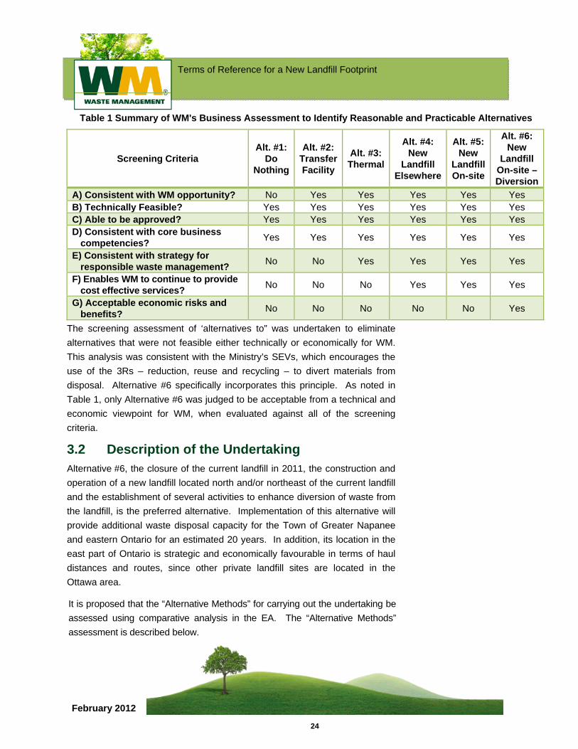
WM established seven screening criteria, collected data for each alternative and conducted a comparative evaluation of alternatives. The results are shown in the following table.
Terms of Reference for a New Landfill Footprint
24
February 2012
Table 1 Summary of WM's Business Assessment to Identify Reasonable and Practicable Alternatives
Screening Criteria Alt. #1:
Do Nothing
Alt. #2: Transfer Facility
Alt. #3: Thermal
Alt. #4: New
Landfill Elsewhere
Alt. #5: New
Landfill On-site
Alt. #6: New
Landfill On-site – Diversion
A) Consistent with WM opportunity? No Yes Yes Yes Yes Yes B) Technically Feasible? Yes Yes Yes Yes Yes Yes C) Able to be approved? Yes Yes Yes Yes Yes Yes D) Consistent with core business
competencies? Yes Yes Yes Yes Yes Yes
E) Consistent with strategy for responsible waste management? No No Yes Yes Yes Yes
F) Enables WM to continue to provide cost effective services? No No No Yes Yes Yes
G) Acceptable economic risks and benefits? No No No No No Yes
The screening assessment of ‘alternatives to” was undertaken to eliminate alternatives that were not feasible either technically or economically for WM. This analysis was consistent with the Ministry’s SEVs, which encourages the use of the 3Rs – reduction, reuse and recycling – to divert materials from disposal. Alternative #6 specifically incorporates this principle. As noted in Table 1, only Alternative #6 was judged to be acceptable from a technical and economic viewpoint for WM, when evaluated against all of the screening criteria.
3.2 Description of the Undertaking Alternative #6, the closure of the current landfill in 2011, the construction and operation of a new landfill located north and/or northeast of the current landfill and the establishment of several activities to enhance diversion of waste from the landfill, is the preferred alternative. Implementation of this alternative will provide additional waste disposal capacity for the Town of Greater Napanee and eastern Ontario for an estimated 20 years. In addition, its location in the east part of Ontario is strategic and economically favourable in terms of haul distances and routes, since other private landfill sites are located in the Ottawa area.
It is proposed that the “Alternative Methods” for carrying out the undertaking be assessed using comparative analysis in the EA. The “Alternative Methods” assessment is described below.
Terms of Reference for a New Landfill Footprint
25
February 2012
3.2.1 "Do Nothing" Alternative The "do nothing" alternative will be included for further consideration in the EA as a benchmark against which the advantages and disadvantages of Alternative #6 will be compared.
WM will evaluate the potential impacts of Alternative #6 and the 'do nothing' alternative against a full range of natural, social, economic, cultural and technical criteria, generally described in Appendix B of this Terms of Reference. The specific set of environmental criteria and a comparative evaluation methodology will be confirmed in consultation with the public, Aboriginal communities and government reviewers.
Terms of Reference for a New Landfill Footprint
26
February 2012
3.3 Identification of Alternative Methods Alternative methods are the different ways the BREC facility could be implemented. WM is proposing to assess and compare a reasonable number of different landfill footprint alternatives (e.g., four), within the preliminary development envelopes (or areas), on lands owned or optioned by WM. Once a preferred landfill footprint is identified, alternative configurations of the BREC facility will be considered.
An assessment of leachate treatment alternatives will be assessed in the EA. Other alternative methods, such as the assessment of liner systems, will not be assessed in the EA.
In regards to leachate management systems, WM is required to meet the design and performance standards of O. Reg 232/98 for liner, leachate collection and final cover system designs. Landfill gas management requirements for the new landfill footprint are also mandated by O. Reg. 232/98 and O. Reg. 216/08, i.e., use of an active gas collection system. Other system components, such as stormwater management, will be determined once preliminary conceptual design plans have been formulated.
The preliminary envelopes for potential development of landfill footprints were determined during the TOR development stage and include possible envelopes for siting the various non-landfill BREC components as well. During the EA, the preliminary landfill footprint envelopes will be refined and finalized in consultation with the public, government review team, Aboriginal communities and other interested parties. Alternative landfill footprints will be identified and refined. A detailed comparative evaluation of alternatives will be conducted and a preferred landfill footprint will be identified. As noted previously, the assessment process will include many opportunities for the municipalities, residents, First Nations communities, GRT members and interested persons to become involved in the process.
As a part of the exercise to determine the suitable preliminary land envelopes for the development of the proposed landfill at the TOR stage, it was necessary to determine the land area required for the proposed volume. As determined through the needs assessment, the required volume of the landfill is approximately 13 million m3, which requires an approximate land area of 51 to 55 ha. This approximate land area requirement for the
Terms of Reference for a New Landfill Footprint
27
February 2012
proposed footprint was identified assuming that the new landfill will be the same height as the existing landfill. Dependent on other factors such as the dimensions of the landfill, location, and required buffer zones, which will be determined during the EA, the exact area of the land required may vary. The alternative methods will be assessed by comparative evaluation using technical, environmental, and socio-economic criteria, and consideration of the advantages and disadvantages of each of the alternatives. The outcome of the assessment will be the identification of a preferred alternative method. The proposed evaluation criteria, indicators and data sources for the alternative methods assessment are presented in Appendix B.
During the TOR development process, constraint mapping was used to determine the preliminary land envelopes within the lands owned and optioned by WM for the possible location of the proposed alternative landfill footprints (Figure 3). The alternative methods that can be developed at the Site are a function of a number of site-specific factors that include existing streams, wetlands, electricity transmission facilities, transportation access, the provision of perimeter buffer zones, and landfill design and operations considerations.
WM owns or has optioned-to-purchase land within the area (Figure 2) bounded by Selby Road to the north, Beechwood Road to the south, Deseronto Road to the west, and Johnsons Side Road to the east. WM lands in the southeast portion of the property were excluded from the analysis because those lands are not contiguous with the rest of the lands owned by WM and were too small for development of the required facilities. Thus, the total area used for the preliminary constraint mapping is approximately 347 ha bounded as described above. The next step in the preliminary constraint mapping exercise was to identify areas that pose constraints for development of the new landfill footprint for various reasons. The following potential constrained areas were identified:
Existing landfill footprint and the surrounding diversion facilities in the southwestern portion of the property;
Wetland conservation area located on the northwestern portion of the property;
Hydro-easement located in the centre of the property immediately above the existing landfill; and,
Buffer lands around Marysville Creek.
Terms of Reference for a New Landfill Footprint
28
February 2012
There were two areas that were identified as being too small for development as a landfill footprint, but were suitable for potential development of infrastructure such as entrance, scales, maintenance facilities, community recreational areas and diversion facilities. One parcel is located immediately east of the existing landfill and the other is located along Johnsons Side Road about 1 km north of Beechwood Road.
For purposes of this preliminary screening, it was necessary to assume that the hydrogeological conditions beneath the area available for a new landfill footprint were similar, and that none of the available area posed a specific constraint. Whether or not this is a potential screening factor that has to be considered will be determined during the EA, since the required information will only be known after additional hydrogeological studies have been completed.
After considering the constraints posed by the above areas as related to locating the new landfill footprint, a large envelope was identified for the proposed development. The preliminary envelope for potential development can be divided in half (approximately) thus creating two areas for development of new landfill footprint alternatives – the western and eastern areas. It was determined that the 51 to 55 ha of land area required for the proposed new landfill footprint would occupy most of the land within each area of the envelope.
It is anticipated that two or more alternatives would be identified during the EA for both the western and eastern halves of the envelopes. The alternatives will comprise different landfill footprint dimensions (variation in height, width, length, etc.), location of entrance, infrastructure, waste diversion facilities and community facilities.
After a preferred alternative for a new landfill is determined, WM will then prepare conceptual level designs of the complete facility, showing locations of the site entrance, access roads, proposed landfill and other components of the BREC facility such as proposed community and recreation facilities.
Terms of Reference for a New Landfill Footprint
29
February 2012
4.0 EXISTING ENVIRONMENTAL CONDITIONS This section provides an overview of the study areas that will be used to assess the potential effects of the various alternatives on the environment, the components of the environment that will be assessed and an overview of existing environmental conditions On-Site and in the Site-vicinity. Supporting SD #4 (Volume 3) describes existing environmental conditions in further detail.
4.1 Study Areas The proposed On-Site and Site-vicinity study areas for the EA are shown in Figure 4 and are listed below:
On-Site - the lands owned or optioned by WM and required for the new landfill. The Site is bounded by Beechwood Road on the south, Deseronto Road on the west, County Road 11 on the north and Johnsons Side Road on the east;
Site-vicinity - the lands in the vicinity of the site extending about 500 m in all directions; and,
Regional - the lands within about 25 kilometres (km) of the Site for the Socio-economic environment (i.e., will include the municipalities of the Town of Greater Napanee and the Township of Tyendinaga).
It should be noted that these are generic study areas that may be modified during the EA to suit the requirements of each environmental component. Each technical discipline will modify the study area as required (e.g., surface water study area will extend along watershed boundaries).
4.2 Environmental Components It is proposed that the EA will address the following components of the environment that may be affected by the alternative methods of carrying out the undertaking:
Atmosphere;
Geology and Hydrogeology;
Surface Water;
Biology;
Cultural Heritage Resources;
Terms of Reference for a New Landfill Footprint
30
February 2012
Transportation;
Land Use;
Agriculture;
Socio-economic; and,
Aboriginal.
The criteria, indicators and data sources proposed for the assessment are set out in Appendix B.
4.3 Overview of Existing Environmental Conditions
The existing environmental and Site conditions are described in greater detail in SD #4. Following is a brief summary of the existing environmental conditions on the Site and in the Site-vicinity study area:
The Atmosphere environmental component comprises air quality, noise and odour sub-components. In the Site-vicinity, air quality is typical of eastern Ontario with transportation and agricultural activities contributing to baseline air quality/odour and noise levels. The existing landfill operations also represent a source of air and noise emissions. Landfill gas and leachate controls implemented at the existing landfill by WM in 2001 and subsequently have resulted in significantly lower gas and odour emissions form the existing landfill, as demonstrated by air quality and odour surveys conducted by WM’s consultants and the Ministry.
The Geology and Hydrogeology environmental component comprises groundwater quality and groundwater flow sub-components. Geology in the Site-vicinity is characterized by a thin mantle of glacial till generally having a thickness of 2 m or less, although much thicker within the local drumlin features such as Empey Hill in the southwestern portion of the Site. These soil deposits overlie limestone bedrock. The upper portion of the limestone consists of the Verulam Formation that is generally up to a few metres thick, underlain by about 11 to 15 m of the Bobcaygeon Formation, and followed by the limestone of the Gull River Formation. Hydrogeology in the Site-vicinity is characterized by two active groundwater flow zones, a shallow zone that includes the overburden and upper 1 to 2 m of the bedrock and an intermediate zone extending to 30 m below the bedrock surface. The regional groundwater flow direction is towards the south. However, directions of

Terms of Reference for a New Landfill Footprint
31
February 2012
groundwater flow in the shallow zone are locally influenced by ground surface topography and drainage features; Empey Hill creates a flow divide west of the existing landfill that directs shallow groundwater towards both the north and south. In the intermediate zone, groundwater generally flows towards the west, south, and southwest from beneath the existing landfill.
The Surface Water environmental component is composed of surface water quality and quantity. Surface water resources are influenced by the position of the WM property in relation to watershed drainage divides. Flow patterns are typically from northeast to southwest towards the Bay of Quinte. Lands throughout the study area are drained by the watersheds of Marysville Creek, Sucker Creek and the Salmon River, which all discharge into the Bay of Quinte. Almost the entire Site is located within the Marysville Creek watershed, which has its headwaters within the Site in the form of intermittent drainage channels. The southern portion of the Site is drained by the Beechwood Road ditch.
The Biology environmental component is composed of terrestrial and aquatic ecosystems. The Ecosystems include the Hempfly Swamp (a provincially significant wetland to the north of the Site), and a second unevaluated wetland that extends onto the northwest corner of the Site. A total of 20 distinct meso-ecosites have been delineated on the Site, with distinctive vegetation communities; on-Site vegetation is a mosaic of cultivated fields, hedgerows, abandoned fields, and woodlots. A total of 250 plant species have been historically recorded, including four species that are considered to be rare in the Lake Ontario lowlands portion of eastern Ontario [7]. Small patches of cattail marshes are found due to poor soil drainage. A total of 85 potential breeding bird species were recorded, including several forest interior species. Other wildlife including eleven mammal species, three species of reptiles, and seven species of amphibians were also reported. Thirty species of butterflies were also identified, one of provincial significance.
Terms of Reference for a New Landfill Footprint
32
February 2012
Cultural Heritage Resource environmental component is composed of cultural landscapes, built heritage, and archaeological resources sub-components. Cultural heritage resource surveys have not identified any known archaeological sites, but identified the potential for pre-contact archaeological resources because of the characteristics of the Site setting. Cultural heritage resources are generally situated to the south and southeast of the existing landfill and consist of cultural landscape units and built heritage features related to farm complexes and buildings that face Beechwood Road. Martin/Empey Hill Cemetery is designated as a property of historical value and is recognized and protected from demolition and unsympathetic alteration.
The Transportation environmental component is composed of both air and road traffic. The existing landfill is located just over 8 kilometres from the Tyendinaga Mohawk Airport, which is operated as a training facility. Traffic accessing the Site originates from Highway 401 and the Highway 401/County Road 10 interchange, limiting truck traffic to about 1.3 kilometres on County Road 10 and 0.65 kilometres on Beechwood Road to the Site entrance.
The Land Use environmental component considers the effects on current or planned future land uses. Adjacent to the Site, land use is predominantly for agriculture or rural purposes, and as natural areas. Interspersed are woodlots and non-farm related land uses, which include residential, community facility, and waste management uses and related activities. The Site and surrounding are traversed by a series of transportation and utility corridors.
The Agriculture environmental component considers the effects on the agricultural lands and agricultural operations. Agricultural capability is based on the Canada Land Inventory mapping, which shows that Class 3 soils, defined as having moderately severe limitations, are dominant on the Site, with some areas of Class 1 soils which have no significant limitations. In the Site-vicinity are areas of Class 1 and 3 to the north and west with mostly Classes 4 and 6 to the south and east. There are both active and retired/non-operational agricultural uses on the Site or in the Site-vicinity.
Terms of Reference for a New Landfill Footprint
33
February 2012
The Socio-economic environmental component is composed of the effects on cost of services to the communities, continued services to customers, economic effects to local municipalities, effects on recreational resources and visual impact sub-components. The Socio-economic environment in the Site-vicinity is largely rural agricultural, with some commercial activity. Many residents’ families have a history of having lived in the area for several generations. Residences are located along the road network in the area of the Site. Within 3 km of the Site, there are 20 businesses and institutional uses. Other than WM’s activities, there are no other non-farm business activities on the Site.
The Aboriginal environmental component considers the potential effects on aboriginal communities including the potential effects on use of lands for traditional purposes. The Mohawks of the Bay of Quinte (MBQ) are located on Tyendinaga Mohawk Territory, with its closest boundary located approximately 3.5 km south of the Site. Other Aboriginal communities identified in the eastern Ontario region include; Chippewas of Mnjikaning (Rama), Alderville First Nation, Algonquins of Pikwakanagan First Nation, Curve Lake First Nation, Hiawatha First Nation, Mississaugas of Scugog Island, Wendat-Huron First Nation and Métis peoples.
4.4 Additional Field Work and Studies Additional field studies and data collection have been ongoing since the Minister’s refusal of the previous EA in 2006. This includes hydrogeologic, air quality, terrestrial biology field surveys, water quality sampling and fisheries surveys. During the EA, and following approval of work plans by the GRT, the project team will collect further information and conduct studies (desktop and field) to describe components and sub-components of the environment identified in the TOR that may be affected by the undertaking. The environmental components, sub-components, rationale, indicators and data sources that will be used in the analysis of each component are presented in Appendix B and the assessment methodology that will be used for each environmental component is provided in Sections 5.0 to 15.0 of Appendix C.
Terms of Reference for a New Landfill Footprint
34
February 2012
5.0 ASSESSMENT METHODOLOGY As part of the EA, WM will consult with the Ministry of the Environment to develop detailed technical studies so that the proposed site, potential contaminant pathways in the subsurface environment, and all potential environmental impacts of the proposed undertaking are clearly understood. WM will fully evaluate the advantages and disadvantages of the proposed undertaking. WM will build on the work that has been completed for the existing Richmond landfill and demonstrate that the proposed site can be adequately characterized. This will include demonstrating that the proposed undertaking is capable of meeting the requirements under Ont. Reg. 232/98, including developing effective monitoring and contingency plans. The EA will demonstrate whether the undertaking will be consistent with the purpose of the Environmental Assessment Act, in particular the protection, conservation and wise management of the environment.
This Section summarizes the proposed methodology that will be used to conduct the EA. The outcome of the EA, which will be carried out in accordance with the approved TOR, will involve the identification of the preferred undertaking. The proposed methodology (work plan) to conduct the EA and assess the individual components of the environment is presented in Appendix C. The proposed work plans, which were provided to the GRT, are general and will be discussed and finalized during the EA with the GRT. In general, the EA will include:
A description of the alternative methods for carrying out the proposed undertaking;
An assessment of the effects of these alternatives (i.e., the new landfill footprint and BREC components) on the human and natural environments; and,
Identification of a preferred alternative.
The assessment and evaluation of alternatives will consist of the following steps:
Identify and describe alternative leachate treatment alternatives;
Identify and describe alternative footprints for a new landfill and BREC facility components based on the constraints and development envelopes identified in the TOR and further refined in the EA (i.e., conceptual designs that include proposed mitigation measures will be prepared in sufficient detail for assessment purposes);
Terms of Reference for a New Landfill Footprint
35
February 2012
Describe the environment potentially affected by each alternative in relation to the proposed criteria, indicators and data sources;
Conduct preliminary assessment of effects of the landfill and BREC facility components and determine mitigation measures for each alternative as necessary;
Predict environmental effects for each alternative, which involves taking into account mitigation measures, and indentify residual adverse effects and beneficial effects;
Conduct screening to eliminate or alter alternatives, if appropriate;
Conduct a comparative evaluation of alternatives, taking into account the relative importance of the evaluation criteria established with public input during the development of this TOR and identify the preferred alternative, which then becomes the proposed undertaking; and
Assess cumulative effects of the preferred undertaking considering other known existing and planned projects in the area.
Terms of Reference for a New Landfill Footprint
36
February 2012
6.0 CONSULTATION An overview of the results of the consultation program during the development of the TOR, in accordance with the Ministry’s Code of Practice [8], is provided below. The detailed consultation results are documented in Volume 2 (Consultation Record). The proposed Consultation Plan for conducting the EA is presented in the final section in this chapter.
6.1 Consultation Objectives during the Development of the Proposed Terms of Reference
The approach to consultation on development of the TOR was intended to be as open, inclusive and transparent as possible. Consultation activities were designed to accommodate the needs and characteristics of adjacent residents, the public and other stakeholders and First Nations to facilitate their full participation in the process.
The objectives of WM’s consultation plan for development of the TOR were:
To engage First Nations communities as early as possible in the development of the TOR for the EA and to facilitate their involvement in the process in ways that meet their needs;
To engage nearby residents of the proposed undertaking and other stakeholders from the beginning of the process through the use of a variety of consultation events and activities including open houses and to ensure that there were adequate opportunities to provide input, feedback and comments concerning the EA undertaking and process, and that these comments are considered by the EA team;
To engage local elected officials in the development of the TOR and to ensure that they were provided with regular and timely information concerning the TOR development process;
To ensure the consultation process was open, transparent and inclusive; and,
To document all issues and concerns identified by First Nations communities, the public, agencies and other stakeholders and to demonstrate how these concerns and issues have been considered in the final TOR.
Terms of Reference for a New Landfill Footprint
37
February 2012
A variety of consultation activities and events were used by WM to make the process accessible to as many people as possible. General information on the process, proposed project, schedule and information on how to become involved in the development of the TOR were provided through a number of ongoing activities including letter mailings, electronic mailings, media releases, a project website, an EA information line and newsletters.
Summary of Consultation Activities
Consultation with the public and agency stakeholders is a key component of the EA process. It enables stakeholders to participate in the planning process and enhance the quality of the undertaking. The key vehicles in the Consultation Plan that were used to engage the public and the other stakeholders and elicit feedback were the Open Houses, the Workshop and letter correspondence. Since the launch of the project on March 3, 2010, WM hosted four open houses and a workshop and distributed draft EA Work Plans to members of the GRT.
Consultation related to the development of the TOR is documented in the Consultation Record provided in Volume 2 of this TOR submission.
6.2 Summary of Issues and Concerns Raised During the Terms of Reference Development
The issues and concerns raised by the stakeholders are provided in Volume 2 (Section 5) of the TOR submission. The issues and concerns are summarized in Volume 2 in a table that provides the issue and the method in which it has been considered in the preparation of the TOR.
6.3 Proposed Consultation Plan During the Preparation of the Environmental Assessment
During preparation of the EA, a consultation plan similar to the one conducted for preparation of the TOR is proposed. Input during the EA study process will be obtained through a number of proposed consultation activities. The results of the consultation program conducted by WM during preparation of the EA process will be presented in the EA Study Report.
Terms of Reference for a New Landfill Footprint
38
February 2012
The following key consultation activities will be undertaken during the development of this EA. The consultation activities are numbered sequentially from the beginning of the TOR process to the conclusion of the EA. The proposed consultation activities are as follows:
Open House #5 to present the approved TOR and introduce the EA Study Work Plans. An overview of existing environmental conditions will be presented as well as work plans intended to characterize the environment for the EA. The consultation program and opportunities for the public to get involved in the process will be presented;
Workshop #2 will invite participants to identify and develop new landfill footprints and locations for the various BREC facility components within the envelope areas identified during the TOR.
Open House # 6 will present the results of the workshop and further work by WM to describe possible new landfill footprints and BREC facility component layouts. The new landfill footprints represent alternative methods of proceeding with the landfill component of the BREC facility. An overview of the assessment methodologies that will be used to predict and assess impacts of each alternative will be presented;
Workshop #3 will discuss the comparative evaluation methodology and invite participants to provide input on the relative importance of evaluation criteria;
Open House #7 will present a summary of studies to describe existing environmental conditions. The results of impact prediction assessments of the alternatives will be presented. The methodology to present the comparative evaluation of alternative methods and the identification of the preferred alternative will be presented;
Workshop #4 will invite participants to discuss and provide input to the comparative evaluation of alternative methods and identification of a preferred alternative;
Open House #8 will present the results of the comparative evaluation of alternatives and identification of a preferred alternative, and the findings of the overall assessment of the BREC facility and cumulative impact assessments of a new landfill footprint and other projects in the future in the area;
Open House #9 will present a summary of the EA Study Report;
Terms of Reference for a New Landfill Footprint
39
February 2012
Kitchen Table Meetings, with a small number of people, initiated by either the consulting team or the community and to provide an excellent vehicle to obtain further feedback on the study and community expectations for the landfill and the community;
Special Technical Sessions, if necessary, on specific topics, (e.g., hydrogeology, landfill engineering and leachate management, etc.) for an invited group, will provide more information than can be presented in an Open House forum;
Consultation Reports will be prepared following each Open House and workshop, outlining the consultation process, including the comments received at the events and via email;
The Project Website will be used as an effective way to inform the public on the EA process and public consultation activities;
The EA Contact Line and Contact Person will allow residents or interested parties to leave comments, ask questions and provide call-back information;
Email Blasts may provide timely and detailed information to interested stakeholders and can, through the use of electronic comment sheets, be used to obtain immediate feedback during the EA process;
An appropriate program to engage and consult with Aboriginal communities will be developed considering their specific needs. The Aboriginal communities will be consulted on how they would like to be involved in the EA process. The following Aboriginal communities will be contacted: Mohawks of the Bay of Quinte; Chippewas of Mnjikaning (Rama), Alderville First Nation, Algonquins of Pikwakanagan First Nation, Curve Lake First Nation, Hiawatha First Nation, Mississaugas of Scugog Island, Wendat-Huron First Nation and Métis peoples. Potential communication tools include meetings or presentations at Open Houses in Aboriginal communities, smaller discussion groups with interested persons by phone and/or in person on specific topics, site tours, copies of information and email correspondence; and,
If there is significant interest in particular issues, or need for more discussion, or if requested, WM may hold additional Open Houses or consultation events.
Terms of Reference for a New Landfill Footprint
40
February 2012
7.0 ENVIRONMENTAL ASSESSMENT SCHEDULE Submission of the TOR for the proposed undertaking will be in late spring 2010.
EA timelines are dependent on the Minister’s decision on the TOR and the EA can not proceed without an approved TOR.
A decision on the approval of the TOR is anticipated in the fall of 2010. Collection of some baseline data was initiated in 2008 and has continued during 2009 and 2010. The EA is expected to be completed and the application documents submitted in 2012.
It is proposed that submission of the EA application documents in final form will be for review by the regulatory agencies and public review by the project stakeholders. Any supplementary evaluations, responses and/or clarifications required by this review process will be documented as required, either by addendum to the EA or otherwise.
As noted above, the proposed undertaking will also require approvals for the new landfill footprint under the EPA and the OWRA as well as the Planning Act for the new landfill. Monitoring requirements for the proposed undertaking will be developed as part of EPA or OWRA approvals processes. WM is proposing to submit an application for the Ontario EAA approval prior to seeking these other approvals.
A listing and brief description of the other approvals that will likely be required are presented in Appendix D.
Terms of Reference for a New Landfill Footprint
41
February 2012
8.0 REFERENCES [1] Waste Management of Canada Corporation (WM). (2008). Site
Conceptual Model Report, Richmond Landfill.
[2] Ministry of the Environment (MOE). (2010). Richmond Landfill Conceptual Site Model Report. Letter from K. Stephenson (MOE) to C, Dobiech (MOE). April 28, 2010.
[3] Ministry of the Environment (MOE). (2009). Code of Practices for Preparing and Reviewing Terms of Reference for Environmental Assessments in Ontario. June 2007.
[4] Canadian Environmental Assessment Agency. 2010. Environmental Assessments. Accessed from website http://www.ceaa.gc.ca/default.asp?lang=En&n=4F451DCA-1.
[5] Canadian Environmental Assessment Agency. (2008). Meeting with Canadian Environmental Assessment Agency (Dave Bell). December 2008.
[6] Ontario Waste Management Association. (2005). The Private Sector IC&I Waste Management System in Ontario. Report Prepared by RIS International Ltd. January 2005.
[7] Ministry of Natural Resources (MNR). 2010. Natural Heritage Information Centre. Accessed from website http://nhic.mnr.gov.on.ca/MNR/nhic/queries/mapguide_download.cfm.
[8] Ministry of the Environment (MOE). (2009). Code of Practice: Consultation in Ontario’s Environmental Assessment Process. October 2009.
n:\active\2010\1126 - environmental & cultural sciences\10-1126-0011 wmcc tor development napanee\final draft tor\final word files for wm
approval\1 - tor main document jun7 .docx
Terms of Reference for a New Landfill Footprint
February 2012
Terms of Reference for
Environmental Assessment of a
New Landfill Footprint
Figures
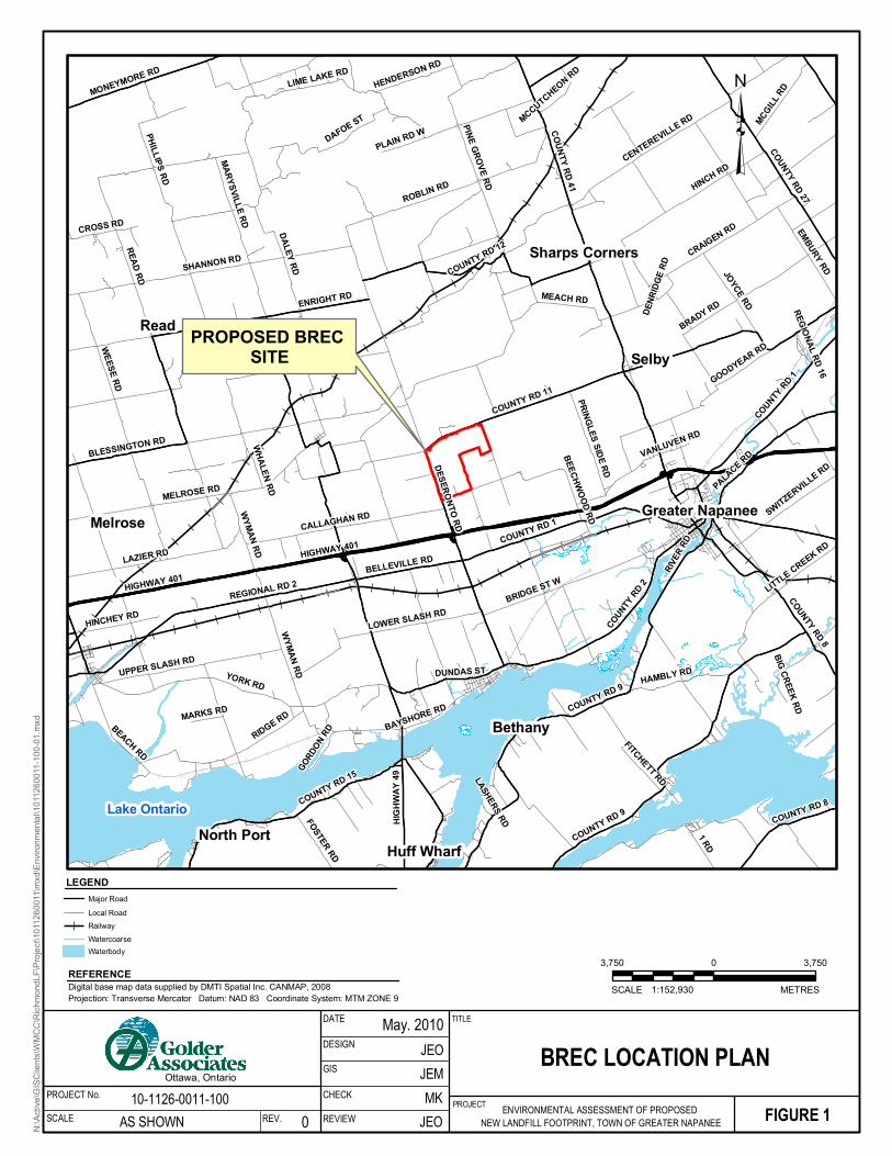
(
(
(
(
(
(
(
(
(
((
(
(
(
(
(
(
(
(
(
(
(
(
(
(
(
(
(
(
(
(
(
(
(
(
(
(
(
(
(
(
(
(
(
(
(
(
(
(
PROPOSED BREC SITE
Greater Napanee
HIGHWAY 401
READ RD
YORK RD
COUNTY RD 41
COUNTY RD 11
DESERONTO RD
DALEY RD
WEESE RD
COUNTY RD 9
ENRIGHT RD
SHANNON RD
MEACH RD
ROBLIN RD
REGIONAL RD 2
BLESSINGTON RD
MARYSVILLE RD
MELROSE RD
HINCH RD
PHILLIPS RD
BRIDGE ST W
RIDGE RD
LAZIER RD
COUNTY RD 15
COUNTY RD 12
COUNTY RD 27
COUNTY RD 1
HIGHW
AY 49
CRAIGEN RD
PINE GROVE RD
CALLAGHAN RD
COUNTY RD 2
LOWER SLASH RD
DAFOE ST
RIVER
RDUPPER SLASH RD
CENTEREVILLE RD
LIME LAKE RDMONEYMORE RD
WYMAN RD
GOODYEAR RD
1 RD
LITTLE CREEK RD
JOYCE RD
EMBURY RD
BEACH RD
BEECHWOOD RD
HAMBLY RD
MCGILL RD
BRADY RD
FITCHETT RD
PALACE RD
COUNTY RD 8
SWITZERVILLE RD
BELLEVILLE RD
HINCHEY RD
CROSS RD
BIG CREEK RD
PRINGLES SIDE RD
FOSTER RD
HENDERSON RD
DENR
IDGE R
DDUNDAS ST
WHALEN RD
BAYSHORE RD
PLAIN RD W
GORDON R
D
MARKS RD
MCCUTCHEON RD
VANLUVEN RD
REGIONAL RD 16
LASHERS RD COUNTY RD 8
HIGHWAY 401
WYMAN RD
COUNTY RD 9
COUNTY RD 1
ReadSelby
Melrose
Bethany
Huff WharfNorth Port
Sharps Corners
Lake Ontario
FIGURE 1PROJECT ENVIRONMENTAL ASSESSMENT OF PROPOSED NEW LANDFILL FOOTPRINT, TOWN OF GREATER NAPANEE
³
3,750 0 3,750
1:152,930SCALE METRES
BREC LOCATION PLANTITLE
10-1126-0011-100AS SHOWN 0
DATE
REV.
DESIGN
Ottawa, OntarioPROJECT No.SCALE
GIS
REVIEW
JEMJEO
May. 2010
CHECK
N:\Ac
tive\G
ISClie
nts\W
MCC\
Richm
ondL
F\Proj
ect\1
0112
6001
1\mxd
\Envir
onme
ntal\1
0112
6001
1-100
-01.m
xd
Digital base map data supplied by DMTI Spatial Inc. CANMAP, 2008Projection: Transverse Mercator Datum: NAD 83 Coordinate System: MTM ZONE 9
REFERENCE
LEGENDMajor RoadLocal RoadRailwayWatercoarseWaterbody
JEOMK
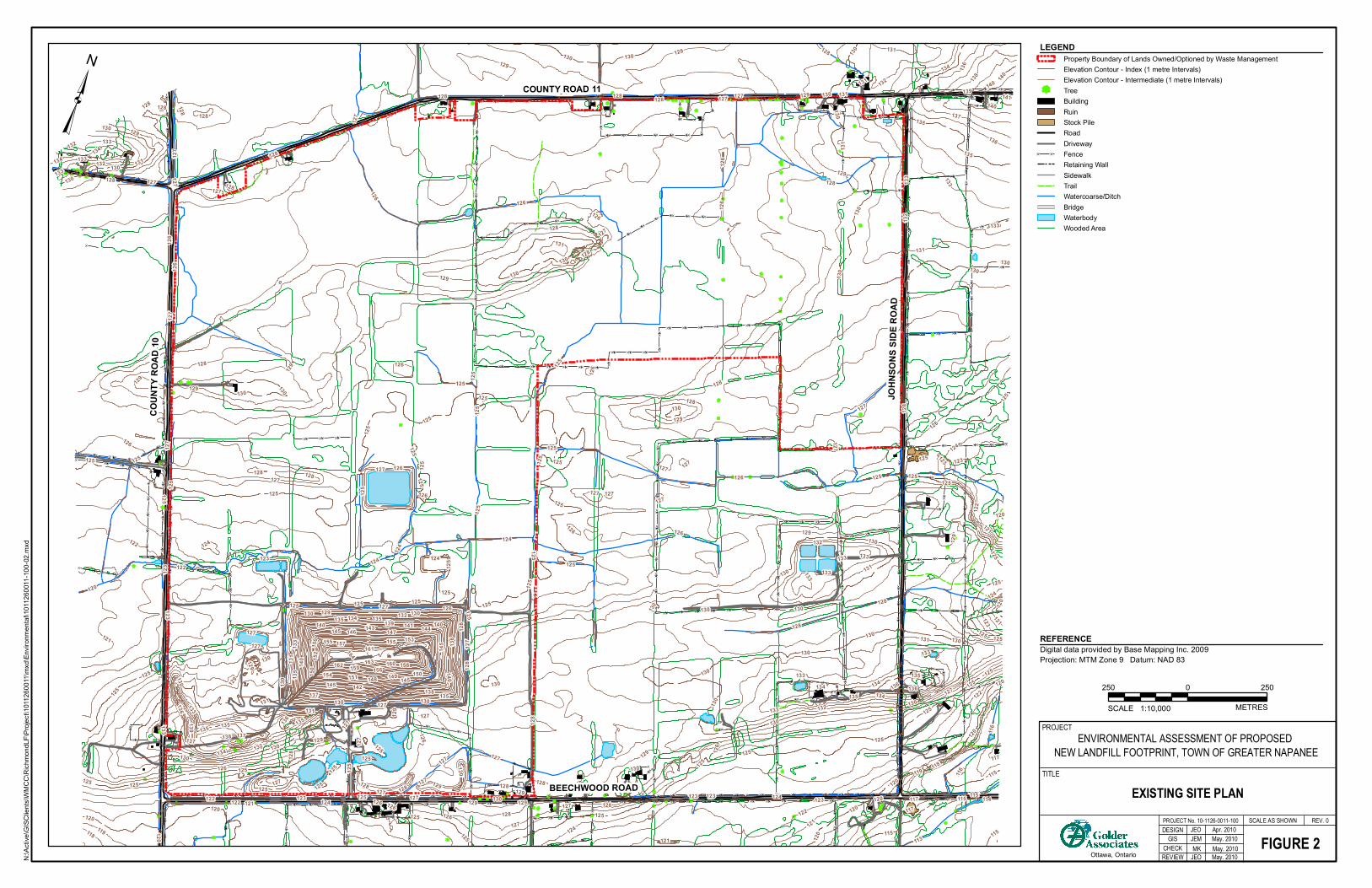
}}}}
}}}
}}}
}}}
}}}
}
}}}
}}}}}}}}}}}}
}}}}}
}}}
}
}} } }} } }} } }}
}}}
}
}}}
}}}
}}
} } }} } }} } }}
}}}
}
}}
} }}}
}}}}
}}}
}}}
}}}
}}}
}}}
}}}}
}}}
}}}
}}}
}}}
}}}
}}}
}
}}
} } }} } }} } }} } }} } }} } }} } }} } }} } }}
}}}
}}}
}}}
}}}
}}}
}}}
}}}}}}}}}
}}}}
}}
}}
}}
} }}} }}
} }}}
}}
}}
} } }} } }}
}}}
}}}
}}}}}}
}}}
}}}}
}}}
}}}
}}}
}}}
}}}}}}
}}}}
}}
}}}
} }}
}}
}}}
}}}
}}
}}}}}}}}}
}}
}
}}}}
}
} } }}
}
} }
}
}}}
}}}}
}
}}}}
} }}} }
}}}}}}}}
} } }}}}} } }}
}
}}}
}
}}}
}}}
}} } }}
} } }} } }} } }} } }} } }} } }} } }}
}}}
}
}}}
}}}
}}
}}}}}}
}}}}}}
}
}}}}
}
}}}
}}}}}}}}}}}
} } }} } }} } }} } } }} } }} } }} } }
}
}
}
}}
}
} } } }} } }} } }} } }} } }}
}
}
}
}
}}
}}}}}}} }}
}}
}
}}}
}
}}
}}}}}
}}}
}}}
}
}}
}}}}}}}}}}}}}}}}}}}
}}}
}}}
}
}}}}}}}}}}}}}}}}}}}}
}}}
}
}}}}}}
}}
}}}} }
}}
}}
}}
}}}
}}}
}}}}}
}
}}
}}}}
}
}}}
}}}
}}}}}
}}}
}}} } }} } }} } }} }
}} }
}}}}}}}}}}}}}
}}}
}}}
}}
}
}}
}
}
}}}
}}}
}}}
}}}
}}}
}}}
}}}
} }
}
}
}}}
}}}
}}}
}}
}
}}
}}
} } }}
}}}}
}}} } }} } }} } }}
}}}
}}}}}}
}
}}
}}}}}}}}}}}}}}}}}}}}}}
}}}
}}}
}}}
}}}
}}}
}}}
}}}
}}}
}}}
}
}}}}}
} }} } }} } }} } }} } }} } }} } }} } }}
}}}
}
}}}}}
}}}
}}}
} }} } }} } }} }
}}}}
}
}
} }} } }
}}}}}
}}}
}}}
}}}
}}}
}}}
}}}
}}}
}}}
}}}}}}}}}}}}}
}
}
} } }} } }} } }} } }} }
}
}} }}
}
}
}
} } }}
}}
}}}
}}}
}}}}}
}}}
}
}} } }}
}}}}
}}}
}}}
}}}
}}}
}
}}}
}}}
}}
}}} }}
}}}
}
}}}
}}}}}
}
}}}
}}}}}
}
} } }
}}
}}}
}}}}}
}}}
}}}
}}}
}}}
} }} } }} } }} } }} } }
}
}
}}
}}}
}}}
}
}}}
}}}
}
}}
}}
}
}
}
}
}
}
}}
} }} } }}
}}}
} }}}
} }}
}}}}
} }
}
}
} } }} } }}
}}
}
}
}}}}}}}
}}}}
}
}
}
} }
}
}}}
}
} }}
} } }} } }} } }} } }}
}
}
} } }} }}}
}}}
} }} } }} } }} } }}
}
}}}
}}}
}}}
}}}
}}}
}}
}
} } }} } }} } }} } }}
} } }} } }}}}}}
}}}
} }}} }}
}}}}}}}}}}}}}}}}}}}
}
}}}}}
}}}
}}}
}}}
}}}
}}}
}}}
}}}
}}}
}}}
}}}
}}}
}}}
}}}
}}}
}
}}
} }} } }} } }}
}}}
}}}
}}}
}}}
}}}
}} }}
} }}
}} }}
} } }} } }} } }} } }} } }} } }} } }} } }} } }} } }} } }}
}}}
}}}
}}}
}}}
}}}
}}}}
}}}
}
}}}
}}}
}}}}}}}}}}}}
}}}
}}}
}}}}
}}}}}}}}}}
}}}
}}}
}}}
}}}
}}}
}
}}}
}}}
}}}
}}
}}}}}
}}}
} }}
}
}}
}}}}}
}}}}
}} }}
}}}}}}}
} } }} } }} } }} } }} }}}
}
}}}}}
}}}
}}}
}}}
} }}
}}}
}}}
}}}
}}}
}
}}
}}
}}}
}
}}}}}}}}}}}}}}}}}}}}}}}}}}}}}}}}}}}}}}
}}
}}}
}}}
}}}
}}}
}}}
}}}
}}}
}}}
}}}
}}}
}}}
}}}
}}}
}
}
}}}
}}}}}}}}}}}}
}} }
}}}}}}
}
}
} } }} } }} } }}
}}}
} }} } }} } }} }}}
}}}
} }} } }} } }} } }} } }} } }} } }} }}}
}}}
}
}}}
}}}}}
}}}
}}}
}}}
}
}} } }} } }} } }} } }} } }} } }} } }}
}}}
}}}
}
}}}
}}}}}
}}}
}}}
}}}
}}}
}}}
}}}
}}}
}}}
}
}}}}}
}}}
}}}}}}}}}}
}}
}
}}}
}}}}}
}}}
}
}}}}}
}}
}
}}
BEECHWOOD ROAD
COUNTY ROAD 11
COUN
TY R
OAD
10
JOHN
SONS
SID
E ROA
D
12612
7
128
124
123
129
122
119
131
118
121 117
132
116
133
134
136
125
142
141143 144
148
130
149
147146
151
152
120
137 138
139
114
135
163
140
157
145
115
153
150154 156 158159
155161
162 160
164
113
131
131
127
130
141
135
125
128
125
127
125
126
126
130
125
133
125
125
128
129
131
128 127
129
135
127
125
127
130
132
124
129
126
125
133
126
129
125
130
120
128
118
125
130
128
126
139
130
127
126
132
128
127
120
130
127
137
128120
125
145
128
124125
115
130
117
127
125
129
130
127
127
128
130
121
129
125
145
135
122
125
155
135
115
135
127
128
130
125
140
125
130
126
125
128
130
125
137
133
125
125
130
129
121
130
136
123
133
125
130
140
130
127
129
128
127
120
125
115
125
130
130
131
134
125
127
120
129
129
125
140
125
123
133133
124
128125
126
130
126
120
124
128
135
121
121
122
129
124
124
125
125
145
125
125
125
134
128
126
140
133
126
127
120
127
127
124
130
123
125
122
126
126
150
127
135
121
130
130
126
130
130
132
127
128
130
133
134
129
131
128
132
125
128
123
133
122
135
134133
123
132
128
130
125
127
119
125
124
125
127
127
133
130
125
125
134
124
128
127
125
133
130
131
116
131
126
125
127
120
127
127
130
127
136
125
130
134
128
129
128
132
125
136
130
128
126
137
123
131
136
127
131
126
126
135
125
126
136
140
115
135
128
122130
120
129
125
125123
125
125
130
126
129
133
125
128
125
125
133
133
128
130
130
127
126
127
129
120
123
125
129
130
129
128
130
131
125
132
140
139
125
122
150
125
120
128
136
125
130
128
138
128
129
125
127
127
129
125
130
126
127
129
117
130
128
134
123
131
125
127
138
³LEGEND
Digital data provided by Base Mapping Inc. 2009Projection: MTM Zone 9 Datum: NAD 83
REFERENCE
Property Boundary of Lands Owned/Optioned by Waste ManagementElevation Contour - Index (1 metre Intervals)Elevation Contour - Intermediate (1 metre Intervals)TreeBuildingRuinStock PileRoadDriveway
} } FenceRetaining WallSidewalkTrailWatercoarse/DitchBridgeWaterbodyWooded Area
REV. 0
Ottawa, Ontario
DESIGN
EXISTING SITE PLAN
FIGURE 2PROJECT No. 10-1126-0011-100 SCALE AS SHOWN
PROJECT
TITLE
GIS
REVIEWCHECK
ENVIRONMENTAL ASSESSMENT OF PROPOSED NEW LANDFILL FOOTPRINT, TOWN OF GREATER NAPANEE
JEM May. 2010
METRES
250 2500
1:10,000SCALE
N:\Ac
tive\G
ISClie
nts\W
MCC\
Richm
ondL
F\Proj
ect\1
0112
6001
1\mxd
\Envir
onme
ntal\1
0112
6001
1-100
-02.m
xd
JEO Apr. 2010
nm
MK May. 2010JEO May. 2010
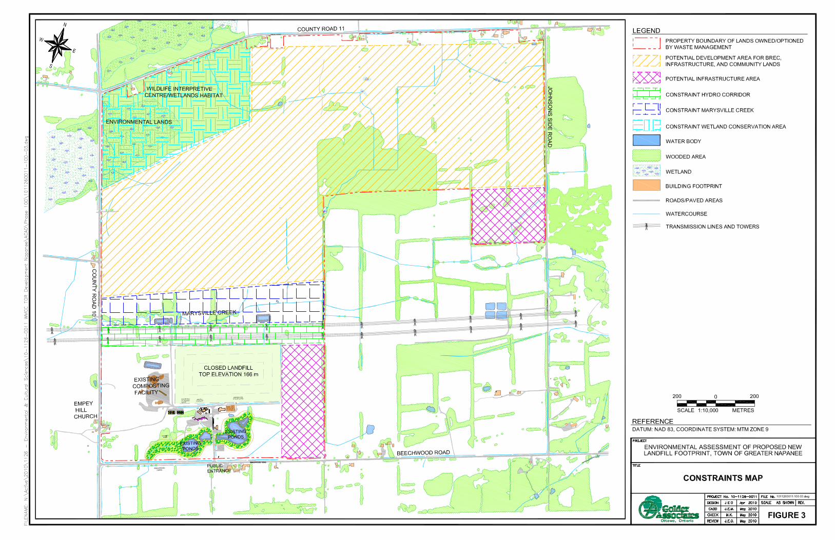
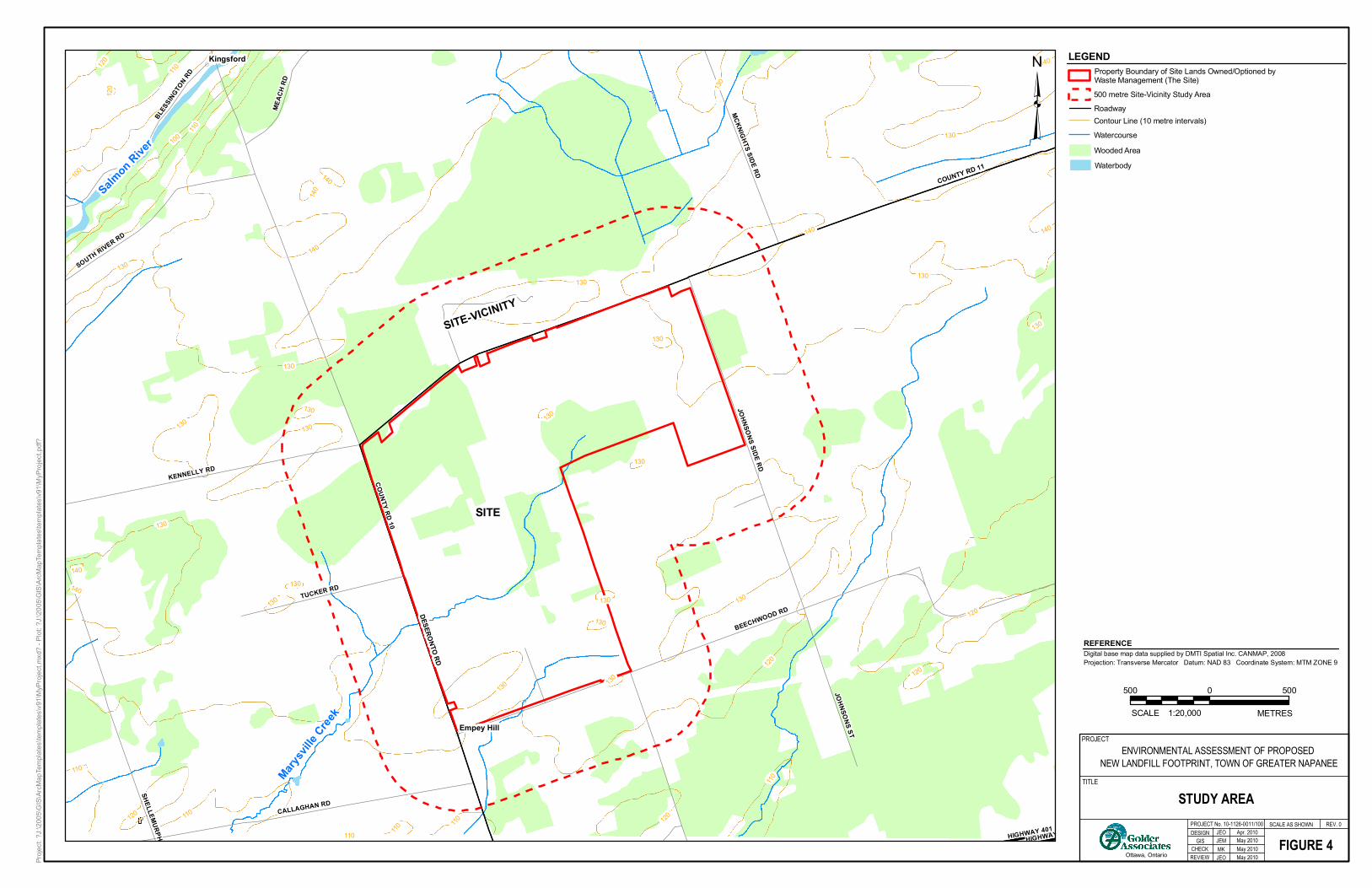
(
(
Marysvi
lle Cree
k
SITE
SITE-VICINITY
Salmon Rive
r
COUNTY RD 10
BEECHWOOD RD
CALLAGHAN RD
KENNELLY RD
JOHNSONS SIDE RD
TUCKER RD
SOUTH RIVER RD
BLESS
INGTON RD
JOHNSONS ST
MEAC
H RD
MCKNIGHTS SIDE RD
SHELLEY RD
HIGHWAY 401HIGHWAY 401
MURPHY RD
120
130
110
100
140
110
120
140
120
140
140
120
130
130
130
130
120
130
140
130
110
120
130130
110
110
140
130
130
140
130130 130
130
130
130
100
120
130
110
130
130
110
130
110
140 COUNTY RD 11
DESERONTO RD
Kingsford
Empey Hill
Proje
ct: ?J
:\200
5\GIS\
ArcM
apTe
mplat
es\te
mplat
es\v9
1\MyP
rojec
t.mxd
? - Pl
ot: ?J
:\200
5\GIS\
ArcM
apTe
mplat
es\te
mplat
es\v9
1\MyP
rojec
t.pdf?
³
METRES
500 5000
1:20,000SCALE
REV. 0
Ottawa, Ontario
DESIGN
STUDY AREA
FIGURE 4PROJECT No. 10-1126-0011/100 SCALE AS SHOWN
PROJECT
TITLE
GIS
REVIEW
JEO Apr. 2010
CHECK
ENVIRONMENTAL ASSESSMENT OF PROPOSED NEW LANDFILL FOOTPRINT, TOWN OF GREATER NAPANEE
JEM May 2010
Digital base map data supplied by DMTI Spatial Inc. CANMAP, 2008Projection: Transverse Mercator Datum: NAD 83 Coordinate System: MTM ZONE 9
REFERENCE
LEGEND
500 metre Site-Vicinity Study AreaRoadwayContour Line (10 metre intervals)WatercourseWooded AreaWaterbody
Property Boundary of Site Lands Owned/Optioned by Waste Management (The Site)
MK May 2010JEO May 2010

Terms of Reference for a New Landfill Footprint
February 2012
APPENDIX A Glossary of Terms
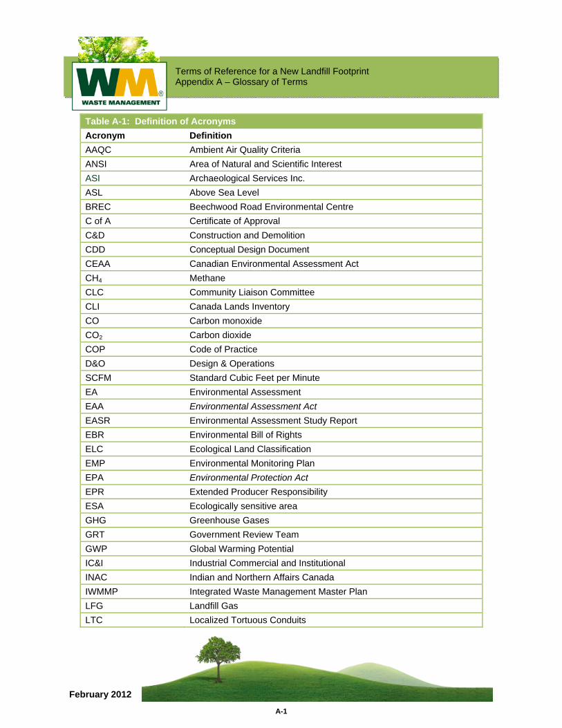
Terms of Reference for a New Landfill Footprint Appendix A – Glossary of Terms
A-1
February 2012
Table A-1: Definition of Acronyms Acronym Definition AAQC Ambient Air Quality Criteria ANSI Area of Natural and Scientific Interest ASI Archaeological Services Inc. ASL Above Sea Level BREC Beechwood Road Environmental Centre C of A Certificate of Approval C&D Construction and Demolition CDD Conceptual Design Document CEAA Canadian Environmental Assessment Act CH4 Methane CLC Community Liaison Committee CLI Canada Lands Inventory CO Carbon monoxide CO2 Carbon dioxide COP Code of Practice D&O Design & Operations SCFM Standard Cubic Feet per Minute EA Environmental Assessment EAA Environmental Assessment Act EASR Environmental Assessment Study Report EBR Environmental Bill of Rights ELC Ecological Land Classification EMP Environmental Monitoring Plan EPA Environmental Protection Act EPR Extended Producer Responsibility ESA Ecologically sensitive area GHG Greenhouse Gases GRT Government Review Team GWP Global Warming Potential IC&I Industrial Commercial and Institutional INAC Indian and Northern Affairs Canada IWMMP Integrated Waste Management Master Plan LFG Landfill Gas LTC Localized Tortuous Conduits
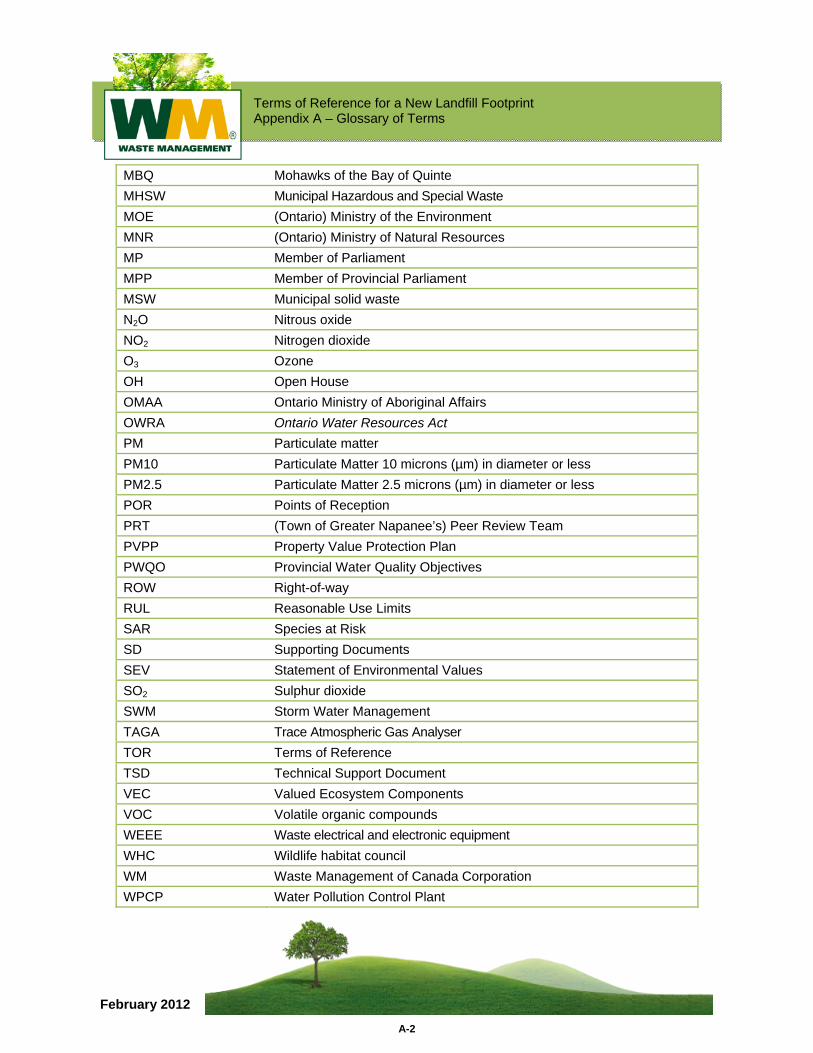
Terms of Reference for a New Landfill Footprint Appendix A – Glossary of Terms
A-2
February 2012
MBQ Mohawks of the Bay of Quinte MHSW Municipal Hazardous and Special Waste MOE (Ontario) Ministry of the Environment MNR (Ontario) Ministry of Natural Resources MP Member of Parliament MPP Member of Provincial Parliament MSW Municipal solid waste N2O Nitrous oxide NO2 Nitrogen dioxide O3 Ozone OH Open House OMAA Ontario Ministry of Aboriginal Affairs OWRA Ontario Water Resources Act PM Particulate matter PM10 Particulate Matter 10 microns (µm) in diameter or less PM2.5 Particulate Matter 2.5 microns (µm) in diameter or less POR Points of Reception PRT (Town of Greater Napanee’s) Peer Review Team PVPP Property Value Protection Plan PWQO Provincial Water Quality Objectives ROW Right-of-way RUL Reasonable Use Limits SAR Species at Risk SD Supporting Documents SEV Statement of Environmental Values SO2 Sulphur dioxide SWM Storm Water Management TAGA Trace Atmospheric Gas Analyser TOR Terms of Reference TSD Technical Support Document VEC Valued Ecosystem Components VOC Volatile organic compounds WEEE Waste electrical and electronic equipment WHC Wildlife habitat council WM Waste Management of Canada Corporation WPCP Water Pollution Control Plant
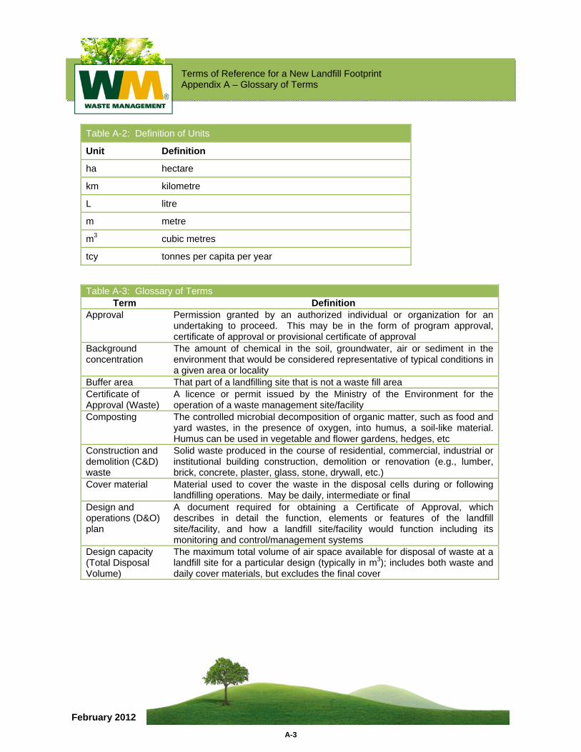
Terms of Reference for a New Landfill Footprint Appendix A – Glossary of Terms
A-3
February 2012
Table A-2: Definition of Units
Unit Definition
ha hectare
km kilometre
L litre
m metre
m3 cubic metres
tcy tonnes per capita per year
Table A-3: Glossary of Terms Term Definition
Approval Permission granted by an authorized individual or organization for an undertaking to proceed. This may be in the form of program approval, certificate of approval or provisional certificate of approval
Background concentration
The amount of chemical in the soil, groundwater, air or sediment in the environment that would be considered representative of typical conditions in a given area or locality
Buffer area That part of a landfilling site that is not a waste fill area Certificate of Approval (Waste)
A licence or permit issued by the Ministry of the Environment for the operation of a waste management site/facility
Composting The controlled microbial decomposition of organic matter, such as food and yard wastes, in the presence of oxygen, into humus, a soil-like material. Humus can be used in vegetable and flower gardens, hedges, etc
Construction and demolition (C&D) waste
Solid waste produced in the course of residential, commercial, industrial or institutional building construction, demolition or renovation (e.g., lumber, brick, concrete, plaster, glass, stone, drywall, etc.)
Cover material Material used to cover the waste in the disposal cells during or following landfilling operations. May be daily, intermediate or final
Design and operations (D&O) plan
A document required for obtaining a Certificate of Approval, which describes in detail the function, elements or features of the landfill site/facility, and how a landfill site/facility would function including its monitoring and control/management systems
Design capacity (Total Disposal Volume)
The maximum total volume of air space available for disposal of waste at a landfill site for a particular design (typically in m3); includes both waste and daily cover materials, but excludes the final cover
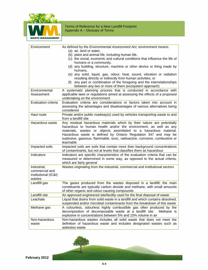
Terms of Reference for a New Landfill Footprint Appendix A – Glossary of Terms
A-4
February 2012
Environment As defined by the Environmental Assessment Act, environment means: (a) air, land or water, (b) plant and animal life, including human life, (c) the social, economic and cultural conditions that influence the life of
humans or a community, (d) any building, structure, machine or other device or thing made by
humans, (e) any solid, liquid, gas, odour, heat, sound, vibration or radiation
resulting directly or indirectly from human activities, or (f) any part or combination of the foregoing and the interrelationships
between any two or more of them (ecosystem approach) Environmental Assessment
A systematic planning process that is conducted in accordance with applicable laws or regulations aimed at assessing the effects of a proposed undertaking on the environment
Evaluation criteria Evaluation criteria are considerations or factors taken into account in assessing the advantages and disadvantages of various alternatives being considered
Haul route Private and/or public roadway(s) used by vehicles transporting waste to and from a landfill site
Hazardous waste Any residual hazardous materials which by their nature are potentially hazardous to human health and/or the environment, as well as any materials, wastes or objects assimilated to a hazardous material. Hazardous waste is defined by Ontario Regulation 347 and may be explosive, gaseous, flammable, toxic, radioactive, corrosive, combustive or leachable
Impacted soils Impacted soils are soils that contain more than background concentrations of contaminants, but not at levels that classifies them as hazardous
Indicators Indicators are specific characteristics of the evaluation criteria that can be measured or determined in some way, as opposed to the actual criteria, which are fairly general
Industrial, commercial and institutional (IC&I) wastes
Wastes originating from the industrial, commercial and institutional sectors
Landfill gas The gases produced from the wastes disposed in a landfill; the main constituents are typically carbon dioxide and methane, with small amounts of other organic and odour-causing compounds
Landfill site An approved engineered site/facility used for the final disposal of waste Leachate Liquid that drains from solid waste in a landfill and which contains dissolved,
suspended and/or microbial contaminants from the breakdown of this waste Methane gas A colourless, odourless highly combustible gas often produced by the
decomposition of decomposable waste at a landfill site. Methane is explosive in concentrations between 5% and 15% volume in air
Non-hazardous waste
Non-hazardous wastes includes all solid waste that does not meet the definition of hazardous waste and includes designated wastes such as asbestos waste
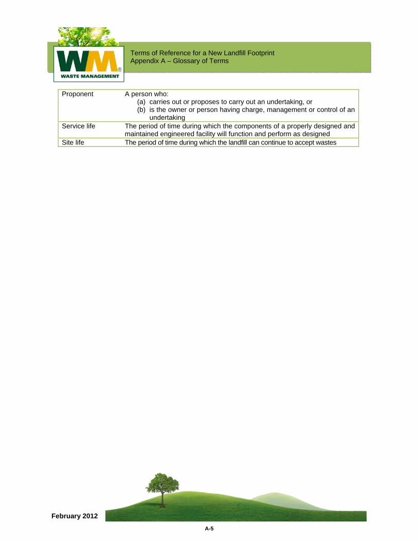
Terms of Reference for a New Landfill Footprint Appendix A – Glossary of Terms
A-5
February 2012
Proponent A person who: (a) carries out or proposes to carry out an undertaking, or (b) is the owner or person having charge, management or control of an
undertaking Service life The period of time during which the components of a properly designed and
maintained engineered facility will function and perform as designed Site life The period of time during which the landfill can continue to accept wastes

Terms of Reference for a New Landfill Footprint
February 2012
APPENDIX B Proposed Assessment Criteria
Terms of Reference for a New Landfill Footprint Appendix B – Proposed Assessment Criteria
B-1
February 2012
INTRODUCTION This appendix to the TOR describes the assessment criteria, indicators and data sources that are proposed to evaluate the different alternative methods of carrying out the project. The outcome of the EA, which will be carried out in accordance with the approved TOR, will include the identification of a preferred alternative method of carrying out the project.
Table B-1 presents the set of assessment criteria proposed for the EA. The assessment criteria are grouped into three categories: environmental, socio-economic and technical (site operation and design). Each criterion includes a statement of rationale, indicators that will be used for measurement and data sources.
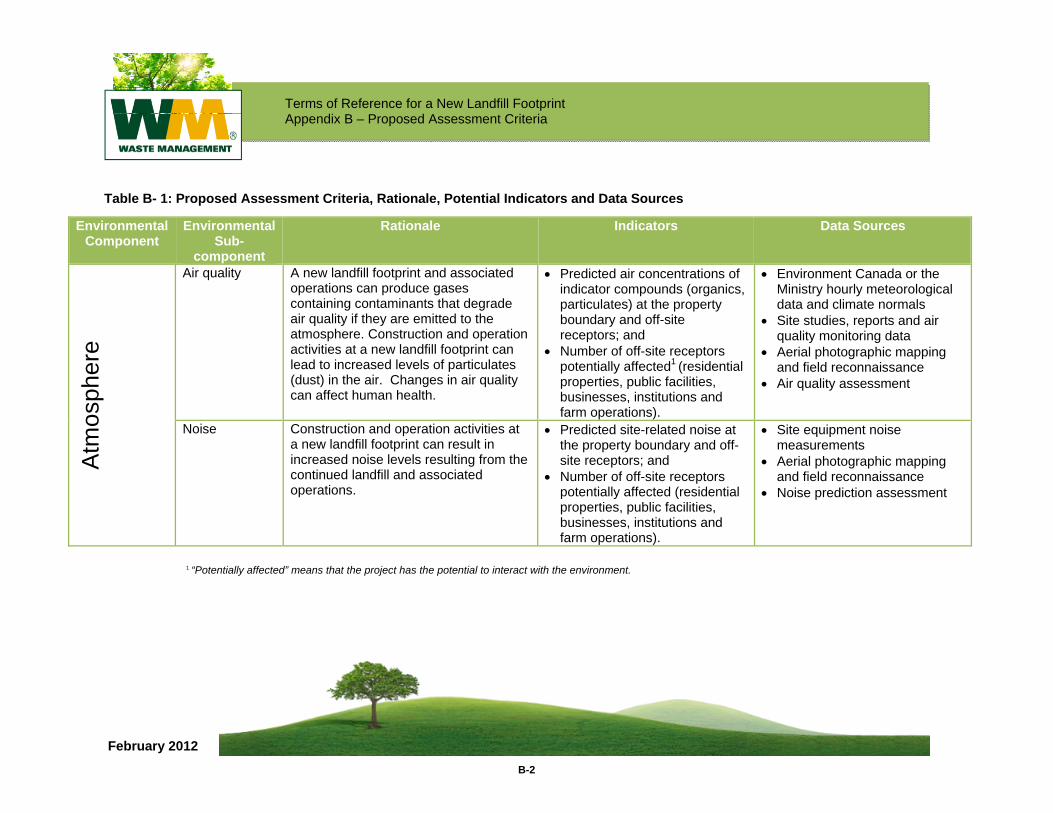
Terms of Reference for a New Landfill Footprint Appendix B – Proposed Assessment Criteria
B-2
February 2012
Table B- 1: Proposed Assessment Criteria, Rationale, Potential Indicators and Data Sources
Environmental Component
Environmental Sub-
component
Rationale Indicators Data Sources
Atm
osph
ere
Air quality A new landfill footprint and associated operations can produce gases containing contaminants that degrade air quality if they are emitted to the atmosphere. Construction and operation activities at a new landfill footprint can lead to increased levels of particulates (dust) in the air. Changes in air quality can affect human health.
• Predicted air concentrations of indicator compounds (organics, particulates) at the property boundary and off-site receptors; and
• Number of off-site receptors potentially affected1 (residential properties, public facilities, businesses, institutions and farm operations).
• Environment Canada or the Ministry hourly meteorological data and climate normals
• Site studies, reports and air quality monitoring data
• Aerial photographic mapping and field reconnaissance
• Air quality assessment
Noise Construction and operation activities at a new landfill footprint can result in increased noise levels resulting from the continued landfill and associated operations.
• Predicted site-related noise at the property boundary and off-site receptors; and
• Number of off-site receptors potentially affected (residential properties, public facilities, businesses, institutions and farm operations).
• Site equipment noise measurements
• Aerial photographic mapping and field reconnaissance
• Noise prediction assessment
1 “Potentially affected” means that the project has the potential to interact with the environment.
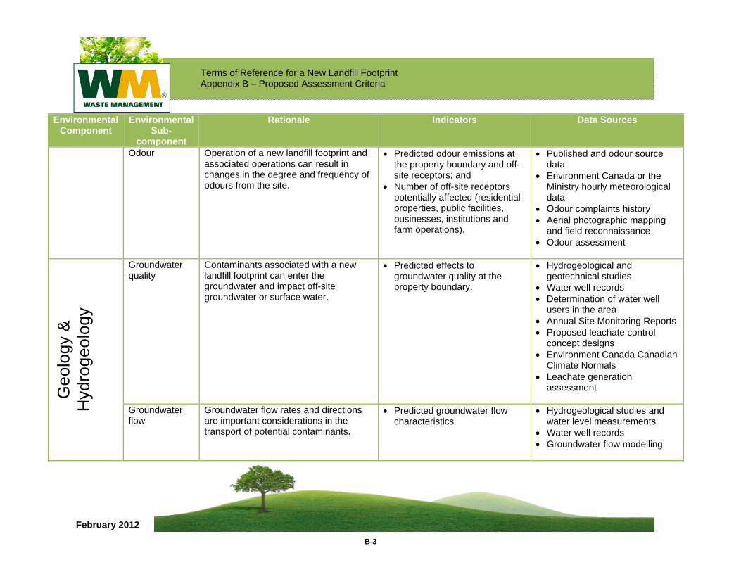
Terms of Reference for a New Landfill Footprint Appendix B – Proposed Assessment Criteria
B-3
February 2012
Environmental Component
Environmental Sub-
component
Rationale Indicators Data Sources
Odour Operation of a new landfill footprint and associated operations can result in changes in the degree and frequency of odours from the site.
• Predicted odour emissions at the property boundary and off-site receptors; and
• Number of off-site receptors potentially affected (residential properties, public facilities, businesses, institutions and farm operations).
• Published and odour source data
• Environment Canada or the Ministry hourly meteorological data
• Odour complaints history • Aerial photographic mapping
and field reconnaissance • Odour assessment
Geo
logy
&
Hyd
roge
olog
y
Groundwater quality
Contaminants associated with a new landfill footprint can enter the groundwater and impact off-site groundwater or surface water.
• Predicted effects to groundwater quality at the property boundary.
• Hydrogeological and geotechnical studies
• Water well records • Determination of water well
users in the area • Annual Site Monitoring Reports • Proposed leachate control
concept designs • Environment Canada Canadian
Climate Normals • Leachate generation
assessment
Groundwater flow
Groundwater flow rates and directions are important considerations in the transport of potential contaminants.
• Predicted groundwater flow characteristics.
• Hydrogeological studies and water level measurements
• Water well records • Groundwater flow modelling
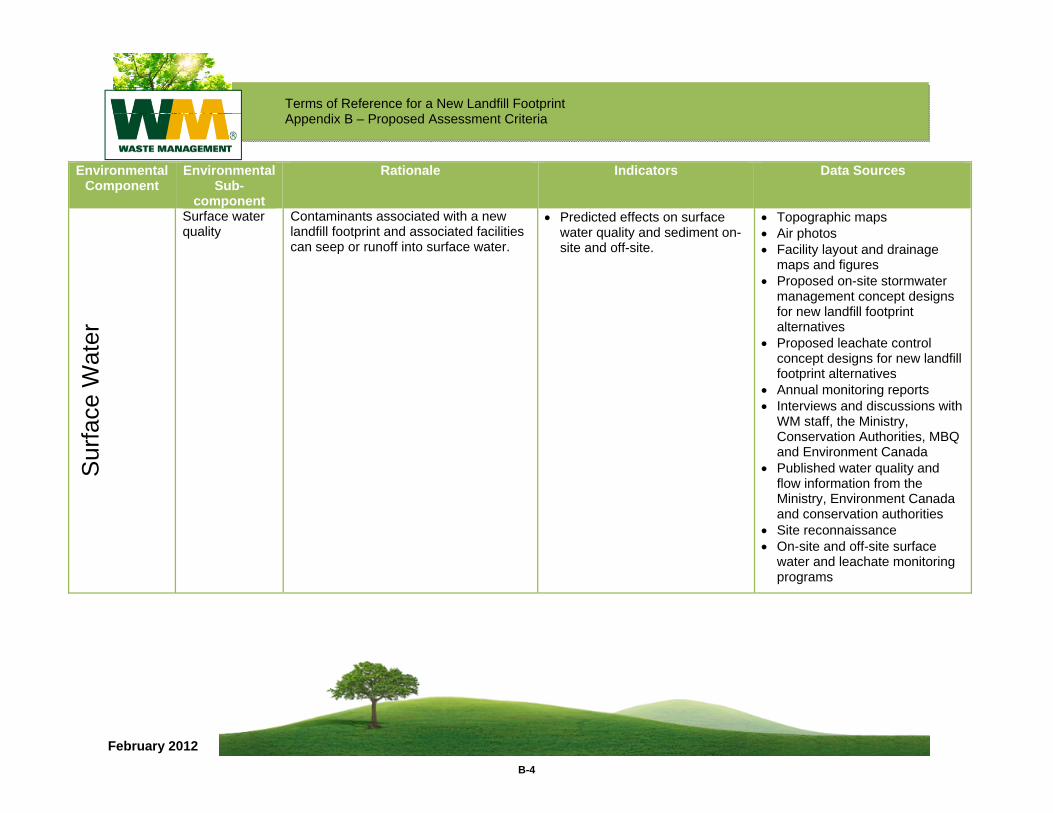
Terms of Reference for a New Landfill Footprint Appendix B – Proposed Assessment Criteria
B-4
February 2012
Environmental Component
Environmental Sub-
component
Rationale Indicators Data Sources
Sur
face
Wat
er
Surface water quality
Contaminants associated with a new landfill footprint and associated facilities can seep or runoff into surface water.
• Predicted effects on surface water quality and sediment on-site and off-site.
• Topographic maps • Air photos • Facility layout and drainage
maps and figures • Proposed on-site stormwater
management concept designs for new landfill footprint alternatives
• Proposed leachate control concept designs for new landfill footprint alternatives
• Annual monitoring reports • Interviews and discussions with
WM staff, the Ministry, Conservation Authorities, MBQ and Environment Canada
• Published water quality and flow information from the Ministry, Environment Canada and conservation authorities
• Site reconnaissance • On-site and off-site surface
water and leachate monitoring programs
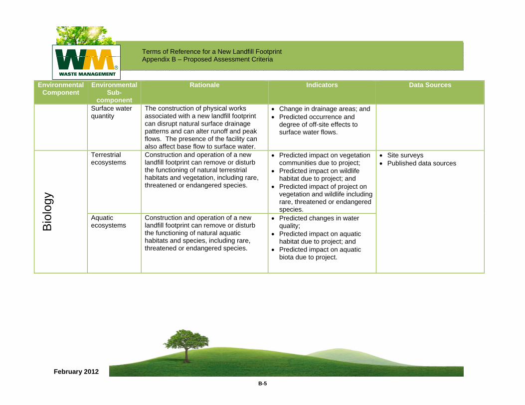
Terms of Reference for a New Landfill Footprint Appendix B – Proposed Assessment Criteria
B-5
February 2012
Environmental Component
Environmental Sub-
component
Rationale Indicators Data Sources
Surface water quantity
The construction of physical works associated with a new landfill footprint can disrupt natural surface drainage patterns and can alter runoff and peak flows. The presence of the facility can also affect base flow to surface water.
• Change in drainage areas; and • Predicted occurrence and
degree of off-site effects to surface water flows.
Bio
logy
Terrestrial ecosystems
Construction and operation of a new landfill footprint can remove or disturb the functioning of natural terrestrial habitats and vegetation, including rare, threatened or endangered species.
• Predicted impact on vegetation communities due to project;
• Predicted impact on wildlife habitat due to project; and
• Predicted impact of project on vegetation and wildlife including rare, threatened or endangered species.
• Site surveys • Published data sources
Aquatic ecosystems
Construction and operation of a new landfill footprint can remove or disturb the functioning of natural aquatic habitats and species, including rare, threatened or endangered species.
• Predicted changes in water quality;
• Predicted impact on aquatic habitat due to project; and
• Predicted impact on aquatic biota due to project.
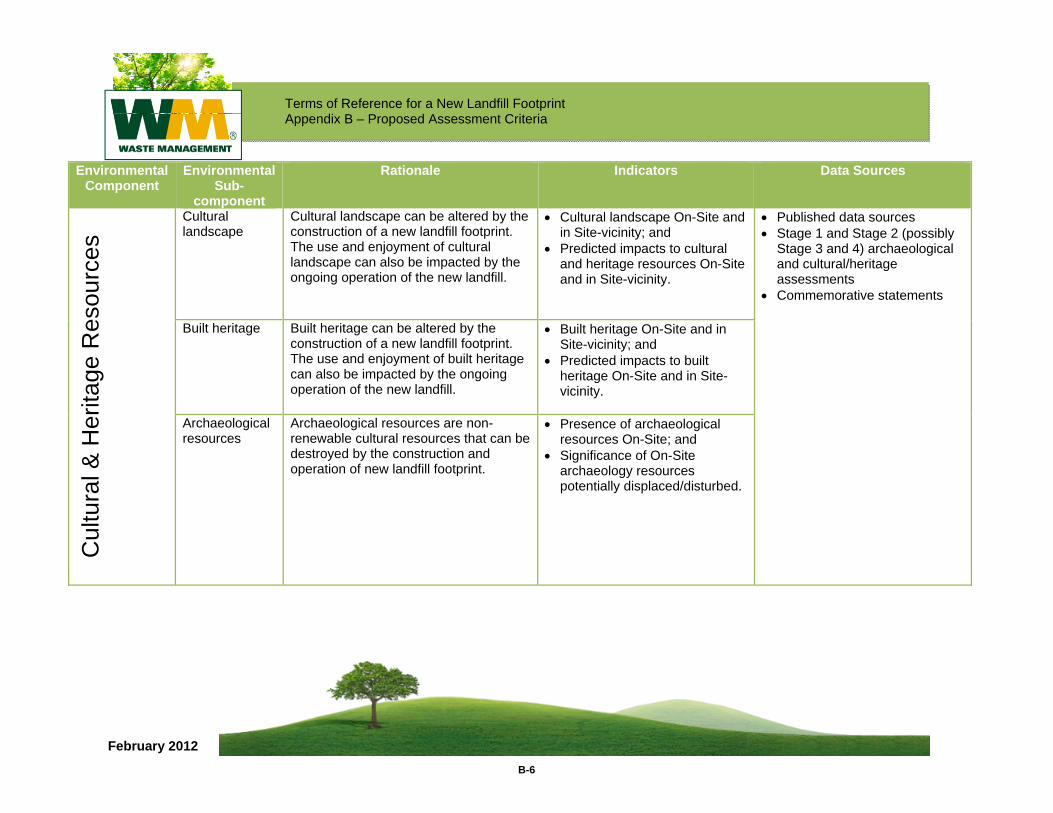
Terms of Reference for a New Landfill Footprint Appendix B – Proposed Assessment Criteria
B-6
February 2012
Environmental Component
Environmental Sub-
component
Rationale Indicators Data Sources
Cul
tura
l & H
erita
ge R
esou
rces
Cultural landscape
Cultural landscape can be altered by the construction of a new landfill footprint. The use and enjoyment of cultural landscape can also be impacted by the ongoing operation of the new landfill.
• Cultural landscape On-Site and in Site-vicinity; and
• Predicted impacts to cultural and heritage resources On-Site and in Site-vicinity.
• Published data sources • Stage 1 and Stage 2 (possibly
Stage 3 and 4) archaeological and cultural/heritage assessments
• Commemorative statements
Built heritage Built heritage can be altered by the construction of a new landfill footprint. The use and enjoyment of built heritage can also be impacted by the ongoing operation of the new landfill.
• Built heritage On-Site and in Site-vicinity; and
• Predicted impacts to built heritage On-Site and in Site-vicinity.
Archaeological resources
Archaeological resources are non-renewable cultural resources that can be destroyed by the construction and operation of new landfill footprint.
• Presence of archaeological resources On-Site; and
• Significance of On-Site archaeology resources potentially displaced/disturbed.
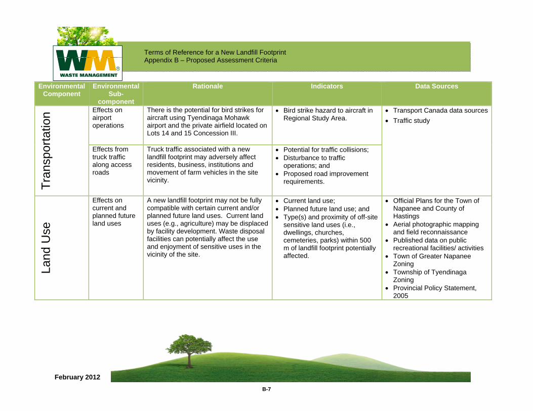
Terms of Reference for a New Landfill Footprint Appendix B – Proposed Assessment Criteria
B-7
February 2012
Environmental Component
Environmental Sub-
component
Rationale Indicators Data Sources
Tran
spor
tatio
n Effects on airport operations
There is the potential for bird strikes for aircraft using Tyendinaga Mohawk airport and the private airfield located on Lots 14 and 15 Concession III.
• Bird strike hazard to aircraft in Regional Study Area.
• Transport Canada data sources• Traffic study
Effects from truck traffic along access roads
Truck traffic associated with a new landfill footprint may adversely affect residents, business, institutions and movement of farm vehicles in the site vicinity.
• Potential for traffic collisions; • Disturbance to traffic
operations; and • Proposed road improvement
requirements.
Land
Use
Effects on current and planned future land uses
A new landfill footprint may not be fully compatible with certain current and/or planned future land uses. Current land uses (e.g., agriculture) may be displaced by facility development. Waste disposal facilities can potentially affect the use and enjoyment of sensitive uses in the vicinity of the site.
• Current land use; • Planned future land use; and • Type(s) and proximity of off-site
sensitive land uses (i.e., dwellings, churches, cemeteries, parks) within 500 m of landfill footprint potentially affected.
• Official Plans for the Town of Napanee and County of Hastings
• Aerial photographic mapping and field reconnaissance
• Published data on public recreational facilities/ activities
• Town of Greater Napanee Zoning
• Township of Tyendinaga Zoning
• Provincial Policy Statement, 2005
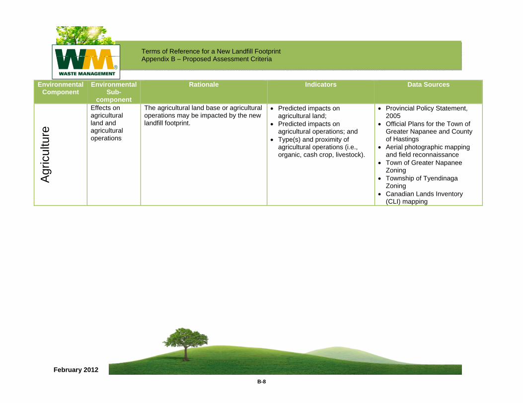
Terms of Reference for a New Landfill Footprint Appendix B – Proposed Assessment Criteria
B-8
February 2012
Environmental Component
Environmental Sub-
component
Rationale Indicators Data Sources
Agr
icul
ture
Effects on agricultural land and agricultural operations
The agricultural land base or agricultural operations may be impacted by the new landfill footprint.
• Predicted impacts on agricultural land;
• Predicted impacts on agricultural operations; and
• Type(s) and proximity of agricultural operations (i.e., organic, cash crop, livestock).
• Provincial Policy Statement, 2005
• Official Plans for the Town of Greater Napanee and County of Hastings
• Aerial photographic mapping and field reconnaissance
• Town of Greater Napanee Zoning
• Township of Tyendinaga Zoning
• Canadian Lands Inventory (CLI) mapping
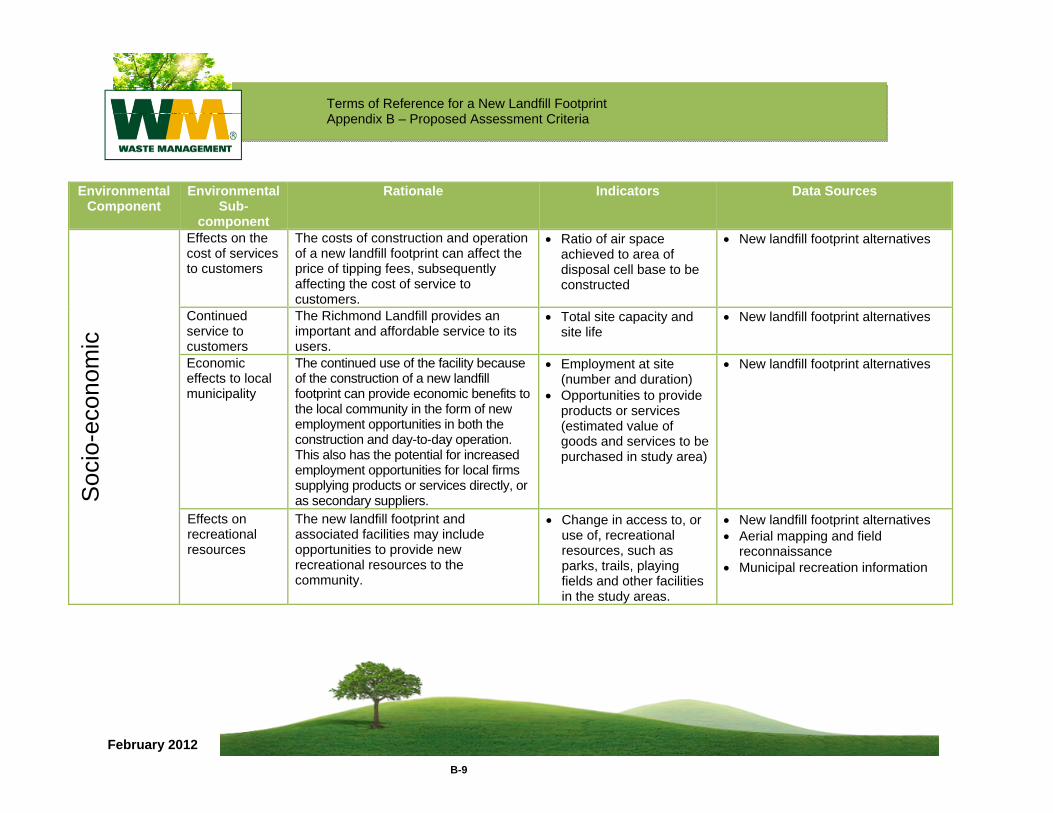
Terms of Reference for a New Landfill Footprint Appendix B – Proposed Assessment Criteria
B-9
February 2012
Environmental Component
Environmental Sub-
component
Rationale Indicators Data Sources
Soc
io-e
cono
mic
Effects on the cost of services to customers
The costs of construction and operation of a new landfill footprint can affect the price of tipping fees, subsequently affecting the cost of service to customers.
• Ratio of air space achieved to area of disposal cell base to be constructed
• New landfill footprint alternatives
Continued service to customers
The Richmond Landfill provides an important and affordable service to its users.
• Total site capacity and site life
• New landfill footprint alternatives
Economic effects to local municipality
The continued use of the facility because of the construction of a new landfill footprint can provide economic benefits to the local community in the form of new employment opportunities in both the construction and day-to-day operation. This also has the potential for increased employment opportunities for local firms supplying products or services directly, or as secondary suppliers.
• Employment at site (number and duration)
• Opportunities to provide products or services (estimated value of goods and services to be purchased in study area)
• New landfill footprint alternatives
Effects on recreational resources
The new landfill footprint and associated facilities may include opportunities to provide new recreational resources to the community.
• Change in access to, or use of, recreational resources, such as parks, trails, playing fields and other facilities in the study areas.
• New landfill footprint alternatives • Aerial mapping and field
reconnaissance • Municipal recreation information
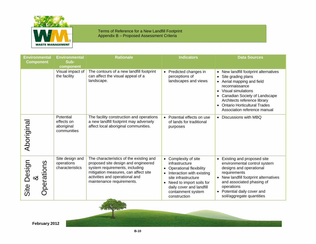
Terms of Reference for a New Landfill Footprint Appendix B – Proposed Assessment Criteria
B-10
February 2012
Environmental Component
Environmental Sub-
component
Rationale Indicators Data Sources
Visual impact of the facility
The contours of a new landfill footprint can affect the visual appeal of a landscape.
• Predicted changes in perceptions of landscapes and views
• New landfill footprint alternatives • Site grading plans • Aerial mapping and field
reconnaissance • Visual simulations • Canadian Society of Landscape
Architects reference library • Ontario Horticultural Trades
Association reference manual
Abo
rigin
al Potential
effects on aboriginal communities
The facility construction and operations a new landfill footprint may adversely affect local aboriginal communities.
• Potential effects on use of lands for traditional purposes
• Discussions with MBQ
Site
Des
ign
&
Ope
ratio
ns Site design and
operations characteristics
The characteristics of the existing and proposed site design and engineered system requirements, including mitigation measures, can affect site activities and operational and maintenance requirements.
• Complexity of site infrastructure
• Operational flexibility • Interaction with existing
site infrastructure • Need to import soils for
daily cover and landfill containment system construction
• Existing and proposed site environmental control system designs and operational requirements
• New landfill footprint alternatives and associated phasing of operations
• Potential daily cover and soil/aggregate quantities
Terms of Reference for a New Landfill Footprint
February 2012
APPENDIX C Environmental Assessment Work Plans
February 2012
WORK PLAN FOR ENVIRONMENTAL ASSESSMENT
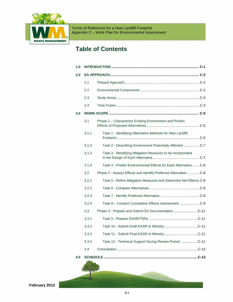
Terms of Reference for a New Landfill Footprint Appendix C – Work Plan for Environmental Assessment
C-i
February 2012
Table of Contents
1.0 INTRODUCTION ........................................................................................... C-1
2.0 EA APPROACH ............................................................................................ C-2
2.1 Phased Approach ............................................................................. C-2
2.2 Environmental Components ............................................................. C-2
2.3 Study Areas ...................................................................................... C-3
2.4 Time Frame ...................................................................................... C-3
3.0 WORK SCOPE .............................................................................................. C-5
3.1 Phase 1 – Characterize Existing Environment and Predict Effects of Proposed Alternatives ...................................................... C-5
3.1.1 Task 1 - Identifying Alternative Methods for New Landfill Footprint ...................................................................................... C-5
3.1.2 Task 2 - Describing Environment Potentially Affected ................ C-7
3.1.3 Task 3 - Identifying Mitigation Measures to be Incorporated in the Design of Each Alternative ................................................ C-7
3.1.4 Task 4 - Predict Environmental Effects for Each Alternative ....... C-8
3.2 Phase 2 - Assess Effects and Identify Preferred Alternative ............ C-8
3.2.1 Task 5 - Refine Mitigation Measures and Determine Net Effects C-8
3.2.2 Task 6 - Compare Alternatives ................................................... C-9
3.2.3 Task 7 - Identify Preferred Alternative ........................................ C-9
3.2.4 Task 8 – Conduct Cumulative Effects Assessment .................... C-9
3.3 Phase 3 - Prepare and Submit EA Documentation .........................C-11
3.3.1 Task 9 - Prepare EASR/TSDs ...................................................C-11
3.3.2 Task 10 - Submit Draft EASR to Ministry ...................................C-11
3.3.3 Task 11 - Submit Final EASR to Ministry ...................................C-11
3.3.4 Task 12 - Technical Support During Review Period ..................C-11
3.4 Consultation ....................................................................................C-12
4.0 SCHEDULE ..................................................................................................C-13
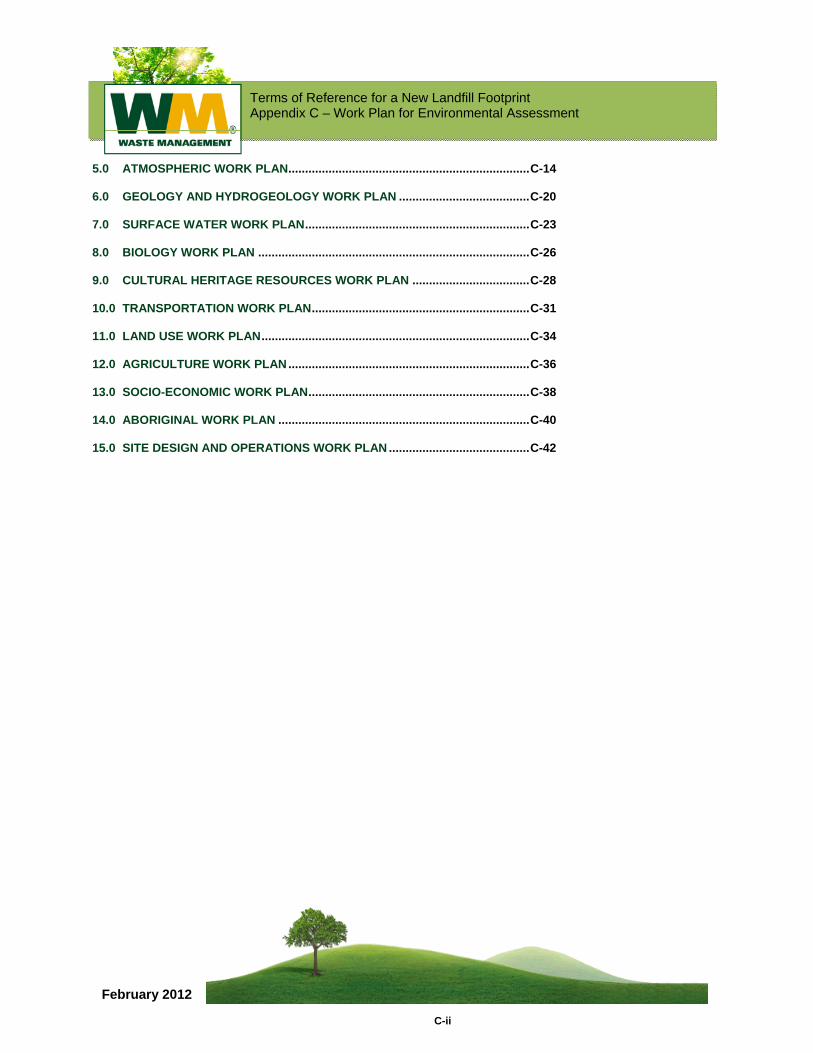
Terms of Reference for a New Landfill Footprint Appendix C – Work Plan for Environmental Assessment
C-ii
February 2012
5.0 ATMOSPHERIC WORK PLAN ........................................................................ C-14
6.0 GEOLOGY AND HYDROGEOLOGY WORK PLAN ....................................... C-20
7.0 SURFACE WATER WORK PLAN ................................................................... C-23
8.0 BIOLOGY WORK PLAN ................................................................................. C-26
9.0 CULTURAL HERITAGE RESOURCES WORK PLAN ................................... C-28
10.0 TRANSPORTATION WORK PLAN ................................................................. C-31
11.0 LAND USE WORK PLAN ................................................................................ C-34
12.0 AGRICULTURE WORK PLAN ........................................................................ C-36
13.0 SOCIO-ECONOMIC WORK PLAN .................................................................. C-38
14.0 ABORIGINAL WORK PLAN ........................................................................... C-40
15.0 SITE DESIGN AND OPERATIONS WORK PLAN .......................................... C-42
Terms of Reference for a New Landfill Footprint Appendix C – Work Plan for Environmental Assessment
C-1
February 2012
1.0 INTRODUCTION The purpose of this document is to present the proposed work plan for the environmental assessment (EA) of Waste Management of Canada Corporation’s (WM) new landfill footprint at the site. Comments were invited from the Government Review Team (GRT) during the preparation of the Terms of Reference (TOR).
This proposed work plan, which is part of the TOR, presents the scope of work required to complete the EA, including the scope of technical studies for each of the environmental components, public consultation, effects prediction/assessment, mitigation, EA documentation and submission. Work plans for the individual technical disciplines are included in Sections 5.0 to 16.0 of this document. The work plan for design and operation is provided in Section 15.0.
The Work Plan for Stakeholder Consultation is provided in Section 16.0.
Terms of Reference for a New Landfill Footprint Appendix C – Work Plan for Environmental Assessment
C-2
February 2012
2.0 EA APPROACH 2.1 Phased Approach It is proposed that the EA work will be undertaken in three phases as follows:
Phase 1 – Characterize Existing Environment and Predict Effects of the Proposed Alternatives;
Phase 2 – Identify Preferred Alternative; and,
Phase 3 – Prepare and Submit EA Documentation.
Consultation with the public, agencies and other stakeholders will be ongoing throughout the EA process.
2.2 Environmental Components The environmental components that will be evaluated in the EA, sub-components, rationale, indicators and data sources for the comparative evaluation criteria are provided in Appendix B of the TOR.
Environmental Components
Atmosphere (Section 5.0);
Geology and Hydrogeology (Section 6.0);
Surface Water (Section 7.0);
Biology (Section 8.0);
Cultural Heritage Resources (Section 9.0);
Transportation (Section 10.0);
Land Use (Section 11.0);
Agriculture (Section 12.0)
Socio-economic (Section 13.0); and,
Aboriginal (Section 14.0).
Terms of Reference for a New Landfill Footprint Appendix C – Work Plan for Environmental Assessment
C-3
February 2012
Technical Criteria
Site Design and Operations (Section 15.0).
2.3 Study Areas Data for the EA will be collected and analyzed for three generic study areas that will be presented in the TOR, as follows:
On-Site – the lands owned and/or optioned by WM for the proposed new landfill footprint and ancillary facilities;
Site vicinity – the lands in the vicinity of the Site (within 500 m of the Site, and modified as appropriate for specific technical disciplines as will be determined during the EA); and
Regional – the lands within about 25 km of the Site for socio-economic environment.
2.4 Time Frame The EA will consider potential effects on the environment associated within three timeframes as follows:
Construction;
Operations (20 years); and
Post-closure.
Terms of Reference for a New Landfill Footprint Appendix C – Work Plan for Environmental Assessment
C-4
February 2012
Terms of Reference for a New Landfill Footprint Appendix C – Work Plan for Environmental Assessment
C-5
February 2012
3.0 WORK SCOPE 3.1 Phase 1 – Characterize Existing Environment
and Predict Effects of Proposed Alternatives This initial phase of the EA studies comprises four tasks, which involve identifying alternative methods, characterizing existing environmental conditions, determining mitigation measures that will be incorporated into the design of alternatives, and predicting the effects of the alternatives on the environment.
WM will undertake EA studies to adequately describe baseline conditions and demonstrate that it can clearly understand the proposed site and potential environmental impacts of the proposed undertaking.
The project team will consult with the Ministry of the Environment, other appropriate government reviewers, members of the public, and Aboriginal communities during Phase 1 of the EA studies regarding the nature and scope of the proposed EA studies, including early consultation on the development of the Geology and Hydrogeology Work Plan, summarized in Section 6.0. This early consultation will provide an opportunity for WM to receive input from regulators and interested parties on how potential impacts may be identified, which will inform the development of measures to mitigate potential environmental impacts.
3.1.1 Task 1 - Identifying Alternative Methods for New Landfill Footprint
Preliminary land envelopes or areas where new landfill footprints could be constructed have been identified during the preparation of the TOR. Early in the EA studies the land envelopes will be refined and confirmed and approximately four reasonable landfill footprints will be proposed by the project team in consultation with the public and GRT. The new landfill footprints will provide approximately 13 million m3 of air space and will be required to meet all applicable requirements of the Ministry of the Environment (the Ministry). The proposed alternatives will include development options on both the western and eastern portions of the lands owned or optioned by WM (see Figure 3 in the TOR). WM is proposing that the height of the new landfill footprint alternatives will be no greater than the current landfill height but this could be changed through the consultation process.
Terms of Reference for a New Landfill Footprint Appendix C – Work Plan for Environmental Assessment
C-6
February 2012
The alternative new landfill footprints that will be developed will comprise a range of features and variables, including for example, footprint configuration, location of entrance, and access roads; the position of the landfill footprint will determine the location of the non-landfill BREC components such as materials recycling facility, construction and demolition facility, organics facility, landfill gas to energy facility, greenhouses, community features, etc.
Terms of Reference for a New Landfill Footprint Appendix C – Work Plan for Environmental Assessment
C-7
February 2012
During the EA, the project team will describe the alternative new landfill footprints and associated facilities in sufficient level of detail (i.e., conceptual designs) for assessment by individual environmental component leads. A draft Conceptual Design Document (CDD) will be prepared and distributed to each of the environmental component leads for further analysis. The characteristics of the existing and proposed site design and engineering system requirements, including in-design mitigation measures, can affect the environment and site activities such as operational and maintenance requirements. These potential effects will be assessed in the EA.
3.1.2 Task 2 - Describing Environment Potentially Affected
The project team will collect information and conduct studies (desktop and field) to describe components and sub-components of the environment identified in the TOR that may be affected by the undertaking and BREC facility components. This will be done for each of the alternative methods identified in the previous task. The environmental components, sub-components, rationale, indicators and data sources that will be used in the analysis of each component are presented in Appendix B and methodology is provided in Sections 5.0 to 15.0 of this document.
3.1.3 Task 3 - Identifying Mitigation Measures to be Incorporated in the Design of Each Alternative
Following identification of a reasonable number of alternatives (Task 1) and the characterization of existing environmental conditions (Task 2), the project team will conduct a preliminary assessment of potential effects of the landfill and BREC facility components. Potential mitigation measures to be incorporated into the conceptual design of the alternatives will also be developed. The project team will then finalize the CDD, updating the conceptual designs, including in-design mitigation measures. The CDD will serve as the common basis for conducting the assessment of alternatives.
Terms of Reference for a New Landfill Footprint Appendix C – Work Plan for Environmental Assessment
C-8
February 2012
3.1.4 Task 4 - Predict Environmental Effects for Each Alternative
In this final task for phase 1, the project team will predict the effects of each alternative (i.e., including in-design mitigation measures) on the environment. The potential effects of BREC facility components will also be predicted. The assessment will be done for each component of the environment based on the existing environmental conditions (determined in Task 2) and the conceptual designs for each alternative including mitigation (determined in Task 3).
3.2 Phase 2 - Assess Effects and Identify Preferred Alternative
3.2.1 Task 5 - Refine Mitigation Measures and Determine Net Effects
The EA project team will identify linkages (i.e., direct or indirect effects of the undertaking on an environmental component via another component, such as groundwater discharge to surface water). Linkage diagrams will be prepared by the environmental component leads. These diagrams will serve as the basis for conducting an integrated assessment of effects.
Prediction of future environmental conditions associated with each alternative landfill footprint and BREC facility components will be provided by each discipline lead using modelling and other methods. Assessment of potential effects will be done using appropriate objectives, standards, policies and legislation. The MOE and the GRT members will be consulted on methodologies that will be used. Further mitigation measures, if required, will be identified and refined as necessary. The project team will update and revise the conceptual design plans for the alternative footprints. The final conceptual designs will be documented in the EA Study Report (EASR).
Finally, the EA project team will repeat prediction of future environmental effects, assuming all mitigation measures are in place. The remaining effects or “net effects”, if any, will be documented.
Terms of Reference for a New Landfill Footprint Appendix C – Work Plan for Environmental Assessment
C-9
February 2012
3.2.2 Task 6 - Compare Alternatives
In this task, the net effects of each alternative method (landfill footprint and associated facilities) will be examined to determine if each would ultimately be approvable under the Ontario Environmental Protection Act (EPA). Should an alternative be found to not be approvable due to unacceptable net effects (i.e., no further refinement of mitigation is possible) or technical reasons, then the alternative would be eliminated from further consideration. At this point, the project team may also consider additional alternative landfill footprints that may have been identified by the public or other parties during the EA process. Should an additional alternative(s) be developed, it (they) would also be subjected to the analysis described in Task 3.
When the alternatives have been finalized, a comparative evaluation of alternative landfill footprints will be conducted to identify a preferred alternative. Each alternative will be compared using the criteria, indicators, and data sources presented in the TOR. This analysis will be undertaken by the EA project team.
3.2.3 Task 7 - Identify Preferred Alternative
In this task, the advantages and disadvantages of the alternative landfill footprints will be described based on the comparative evaluation. Preliminary feedback on the relative importance of the criteria was received during preparation of the TOR and further input will be obtained during the initial stages of the EA. The outcome of this ranking exercise will be the identification of a preferred alternative.
3.2.4 Task 8 – Conduct Additional Assessments
WM is proposing to conduct assessments that are not normally part of the Ontario EAA process. The assessment of cumulative effects, effects of the environment on the project and consideration of valued ecosystem components (VECs) are components of the federal Canadian Environmental Assessment Act process. WM is proposing to conduct these additional analyses in order to provide a more fulsome assessment of the project and the environment. The cumulative effects assessment will consider the combined or cumulative effects on the environment of “net effects” of the new landfill footprint identified previously, with the effects of other BREC facility components and other projects that occur during the same timeframe
Terms of Reference for a New Landfill Footprint Appendix C – Work Plan for Environmental Assessment
C-10
February 2012
and geographic area. For example, the cumulative effects assessment will consider the combined effects of the new landfill footprint with other BREC components such as the materials recycling facility, construction and demolition facility, etc.
In addition, the EA will consider the potential effects of the environment on the project, such as severe weather. VECs will also be considered as part of the EA. VECs are specific components of the environment that are identified by the public and other stakeholders as being important for them. VECs will be determined early in the EA process in consultation with the public, GRT and aboriginal communities; and the Canadian Environmental Assessment Agency.
Terms of Reference for a New Landfill Footprint Appendix C – Work Plan for Environmental Assessment
C-11
February 2012
3.3 Phase 3 - Prepare and Submit EA Documentation
The third and final phase of the EA will be the preparation and submission of the EA documentation. The EASR will be based on the results of the individual technical studies and the consultation program, which will be documented in Technical Support Documents (TSDs) and a series of consultation reports, respectively.
3.3.1 Task 9 - Prepare EASR/TSDs
Key information and findings from the TSDs and consultation reports will be compiled into the EASR by the EA Team.
During the preparation of the TSDs and EASR, the project team will conduct meetings or telephone calls with the Ministry, Ministry of Natural Resources (MNR), Environment Canada, Conservation Authorities and other government staff to discuss the EA studies and findings. Input and comments received from the public, aboriginal groups, government agencies and other stakeholders will be considered in the preparation of the final reports.
3.3.2 Task 10 - Submit Draft EASR to Ministry
This task is the submission of the EASR in draft form to the Ministry and includes tracking and follow-up to ensure all reports are received by the GRT.
3.3.3 Task 11 - Submit Final EASR to Ministry
This task is the formal submission of the revised EASR, based on comments received from the GRT and the Ministry in Task 10.
3.3.4 Task 12 - Technical Support During Review Period
Golder and sub-consultant staff will be available for technical support during the review period. This will include answering questions/comments received and documenting responses. It is anticipated that comments and responses will be presented in a separate report.
Terms of Reference for a New Landfill Footprint Appendix C – Work Plan for Environmental Assessment
C-12
February 2012
3.4 Consultation Consultation will be ongoing throughout the EA. The proposed EA Consultation Plan is provided in Section 6.3 of the TOR.
To ensure that agency contacts are coordinated and documented fully, Mr. Ted O’Neill of Golder Associates, the environmental consultant, will serve as the coordinator to be a one-window point of contact with agencies. It is anticipated that meetings will be required between members of the project team and various regulatory agencies during the preparation of the EA.
Terms of Reference for a New Landfill Footprint Appendix C – Work Plan for Environmental Assessment
C-13
February 2012
4.0 SCHEDULE The TOR will be submitted to the Ministry in late spring 2010 and it is expected that it will be posted on the EBR website for public comment during the month of June 2010. A decision by the Minister on the TOR is expected in the fall of 2010. Assuming that the Minister approves the TOR, the EA is expected to begin in the fall of 2010.
As noted previously, the EA will be undertaken in three phases. Phase 1 is initiation of the EA process, Phase 2 is assessment of effects and identification of a preferred alternative and Phase 3 is preparation and submission of the EA documentation.
At the completion of Phase 1 of the EA studies, existing environmental conditions will be characterized and conceptual designs for the landfill footprint development alternatives will be completed, including mitigation measures, as required. The bulk of the work in this phase will be the development of predictions for the various environmental components.
At the completion of Phase 2 of the EA, a preferred alternative will be identified. The analysis methods and tools for undertaking the comparative evaluation have been developed, and the detailed comparative evaluation task will be completed after the effects prediction analysis is completed during the EA.
In the third and final phase of the EA, the necessary EA documentation will be prepared, reviewed by the WM team and formally submitted to the Ministry.
Terms of Reference for a New Landfill Footprint Appendix C – Work Plan for Environmental Assessment
C-14
February 2012
5.0 ATMOSPHERIC WORK PLAN The atmosphere environmental component is comprised of three sub-components for the purposes of the EA: air quality, noise and odour. The following tasks will be undertaken to characterize existing environmental conditions, predict and assess potential environmental effects, determine mitigation measures (if required) and compare alternative methods of carrying out the undertaking:
Compile and interpret information from existing data sources, including information available from the following resources:
Atmospheric studies from the previous EA;
Ongoing monitoring assessments for the current landfill;
Environment Canada and Ministry air quality monitoring data from local stations; and,
Review site records related to air emission (odour) and noise complaints;
Conduct site reconnaissance to confirm site information compiled from existing documentation and finalize location and nature of potential off-site receptors.
Determine "linkages" with other components and data generation/transfer requirements (e.g., link with natural environment, link with transportation component).
Consult with the Ministry and other members of the GRT to decide on air dispersion/noise modelling approach and protocols to be used in the assessment.
Based on consultation with the Ministry, the review of existing information and the project description, identify information gaps and data needs.
Conduct on-site air quality/odour sampling (if required) to characterize sources of odour and provide data for input to the air quality and odour assessments.
Terms of Reference for a New Landfill Footprint Appendix C – Work Plan for Environmental Assessment
C-15
February 2012
Conduct noise measurement surveys to determine baseline noise levels at potential sensitive points of reception, and along haul routes, and to determine noise levels from on-site sources, i.e., landfill equipment operations.
Terms of Reference for a New Landfill Footprint Appendix C – Work Plan for Environmental Assessment
C-16
February 2012
Define baseline conditions for the project, based on available monitoring data.
Upon collection of data required for the assessment of air quality and odour emissions, embark on the following studies:
Assessment of Alternatives: This study will focus on the subject of the EA (i.e., the landfill) and assess emissions from the various alternatives. Emissions from each alternative (including landfill gas [LFG] collection system, haul roads, excavation operations etc.) will be estimated. This will be followed by the execution of an atmospheric dispersion model for each alternative. The results of this study will be predicted maximum air quality and odour effects associated with each of the alternatives. This study will focus on property line and sensitive receptors. Results will be used to assist in ranking of project alternatives.
Ontario Regulatory Permitting Assessment: This study will focus on the final selected alternative based on input from the various technical components, and specifically on the sources at the larger integrated waste management site that require regulatory permitting in Ontario under O.Reg.419/05. These sources include the proposed landfill gas collection system, the material recycling facility, and the organics composting operation. Emission estimates will be generated for each of the sources that will require regulatory permitting. These estimates will be input to an atmospheric dispersion model for the site to predict the maximum off-property effects of operations, and to determine the ability of the site to comply with the Ministry’s air quality criteria and odour guidelines. This study will be based on the Ontario regulatory receptor grid, and discrete sensitive receptors.
Cumulative Assessment: This study will assess the combined impact of the larger integrated waste management site and other sources of air emissions within the local area. One option for achieving this will be combining model predictions of the proposed waste management site with available ambient monitoring data. This study will focus on receptors that represent the locations of monitoring stations, or areas of interest identified by the study team.
Terms of Reference for a New Landfill Footprint Appendix C – Work Plan for Environmental Assessment
C-17
February 2012
In support of the air quality and odour studies listed above the following will be completed:
The development of an AERMOD atmospheric dispersion model for the site, which will be used to predict effects of the proposed operations. Based on the complexity (or simplicity) of local conditions, changes to the selected atmospheric dispersion model may be made. Changes to the dispersion model will be done in consultation with the Ministry.
Development of a site-specific meteorological dataset will be compiled, based on available well established datasets. The sources of the data will be reviewed with the Ministry prior to finalization of the modelling dataset.
Assessment of mitigation measures inherent in the project design and those that may be necessary to improve operations.
Upon collection of data required for the assessment of noise emissions, embark on the following studies:
Assessment of Alternatives: This study will focus on the subject of the EA (i.e., the landfill) and assess emissions from the various alternatives. Emissions from equipment operating within each alternative (including LFG collection system, haul roads, excavation operations etc.) will be based on measurements from the existing landfill or emissions data from Golder’s database of similar noise sources. This will be followed by the execution of a noise prediction model for each alternative. The results of this study will be predicted worst-case hour operation associated with each of the alternatives. This study will focus on off-site sensitive points of reception. Results will be used to assist in ranking of project alternatives.
Ontario Regulatory Permitting Assessment: This study will focus on the final selected alternative based on input from the various technical components, and specifically on the sources at the larger integrated waste management site that require regulatory permitting in Ontario in accordance with Ministry noise guidelines. These sources include the proposed landfill gas collection system, the material recycling facility and the organics composting operation. Source noise emissions will be based on data from Golder’s database of similar noise sources and/or manufacturer’s

Terms of Reference for a New Landfill Footprint Appendix C – Work Plan for Environmental Assessment
C-18
February 2012
specifications. This data will be input to a noise prediction model for the site to predict the off-site noise emissions associated with the worst-case hour operations, and to determine the ability of the site to comply with the Ministry’s noise guidelines.
Terms of Reference for a New Landfill Footprint Appendix C – Work Plan for Environmental Assessment
C-19
February 2012
In support of the noise study listed above, the following will be completed:
The development of an ISO 9613 prediction model for the site, which will be used to predict effects of the proposed operations.
Haul route noise assessment, using STAMSON or other approved prediction models, to predict the effects of the proposed haul route on sensitive points of reception.
Provide acoustic specifications for mitigation measures inherent in the project design and those that may be necessary to improve operations and ensure compliance with Ministry noise guidelines.
Generate predictions (air quality, odour and noise) for use in non-atmospheric EA components (e.g., terrestrial component).
Compile and document climate normals for the project site, and document the existing climatic conditions;
Prepare a monitoring program appropriate for the preferred alternative, and conceptual contingency plan approaches;
Document the assessments listed above, data sources and assessment results in an Atmosphere TSD that will form an appendix to the EA;
Participate in meetings with the government review agencies including upfront consultations with the MOE during the EA to obtain pre-approval of tasks in the work plan as required; and,
Provide technical support during the review of the draft EA by the regulatory agencies and public.
Terms of Reference for a New Landfill Footprint Appendix C – Work Plan for Environmental Assessment
C-20
February 2012
6.0 GEOLOGY AND HYDROGEOLOGY WORK PLAN The geology and hydrogeology environmental component includes the sub-components groundwater quality and groundwater flow. The following tasks will be undertaken to characterize existing environmental conditions, predict and assess potential environmental effects, determine mitigation measures and compare alternative methods of carrying out the undertaking.
Compile and interpret information from defined background sources;
Compile and review published geological and hydrogeological maps and reports, water well data, regional groundwater and wellhead protection studies, regional and local topographic and drainage mapping, previous subsurface investigation findings, properties and interpretation;
Compile and review current conceptual geological and hydrogeological model of site and existing landfill; and
Develop groundwater flow model for new landfill footprint alternatives.
On the basis of the current models, prepare preliminary conceptual model of geological and hydrogeological conditions in the area of proposed new landfill development envelopes;
Conduct additional subsurface investigations to characterize the overburden and bedrock geology and physical properties in the area of the proposed new landfill development envelopes to an EA level of detail (i.e., cored boreholes with down-hole geophysical logging; rotary/percussion drilled holes with down-hole geophysical logging);
Install an array of nested groundwater monitors completed at different elevations in order to characterize both the horizontal and vertical groundwater flow regime;
Characterize the hydraulic conductivity of the bedrock formations and zones, (i.e., possibly using packer testing, hydro-geophysical logging, pumping tests, rising or falling head tests in monitoring wells);
Determine seasonal variation in

Terms of Reference for a New Landfill Footprint Appendix C – Work Plan for Environmental Assessment
C-21
February 2012
groundwater levels and flow orientations;
Terms of Reference for a New Landfill Footprint Appendix C – Work Plan for Environmental Assessment
C-22
February 2012
Collect groundwater samples to characterize background groundwater quality;
Determine soil characteristics and distribution of soil thickness across area of proposed new landfill alternatives;
Develop final conceptual model of geological and hydrogeological conditions in the area of proposed new landfill footprint alternatives, including groundwater and surface water interaction;
Develop calibrated groundwater flow model for use in simulation of potential effects of proposed new landfill footprint;
Based on the CDD, conduct predictive modelling of landfill performance ( flow and transport modelling) and contaminating lifespan as per O. Reg. 232/98 for each of the alternatives;
Based on the proposed conceptual design alternatives, in-design mitigation measures and the results of predictive modelling, complete an evaluation of potential effects of each alternative on the hydrogeological environment;
Compare the degree of potential effects using the criteria and indicators for the geological and hydrogeological component, rank the alternatives, and identify the preferred alternative from the geological and hydrogeological perspective;
Prepare groundwater monitoring program for the preferred alternative, and conceptual contingency plan approaches;
Document the factual information, analysis and comparative assessment in a Geology and Hydrogeology TSD that will form an appendix to the EA;
Participate in meetings with the government review agencies as required; and,
Provide technical support during the review of the draft EA by the regulatory agencies and public.
Terms of Reference for a New Landfill Footprint Appendix C – Work Plan for Environmental Assessment
C-23
February 2012
7.0 SURFACE WATER WORK PLAN The surface water environmental component has the sub-components surface water quantity and surface water quality. The following tasks will be undertaken to characterize existing environmental conditions, predict and assess potential environmental effects, determine mitigation measures and compare alternative methods of carrying out the undertaking.
Compile and interpret information from defined background sources including:
Surface water reports from previous EA and annual monitoring reports;
Topographic mapping and aerial photography to define drainage network and drainage watersheds/sub-watersheds, discharge locations; and
Published sources (annual reports, Ministry, Environment Canada, Conservation Authority) to characterize water quality and stream flow.
Conduct site reconnaissance to confirm the information from available sources;
Establish surface water flow and water quality monitoring station locations and monitoring program to obtain representative information;
Summarize existing surface water flow and quality representative of conditions upstream and downstream of proposed new landfill footprint alternatives;
Using a hydrological model, calculate surface water runoff and peak flows in the area of the proposed new landfill footprint under existing conditions, using designs storms as set out in O. Reg. 232/98;
Based on the CDD, predict and assess future surface water runoff and peak flows and quality conditions associated with each of the proposed new landfill footprint alternatives;
Compare these predictions to the existing conditions; determine changes and potential adverse effects on downstream water courses. Determine if mitigation measures are
Terms of Reference for a New Landfill Footprint Appendix C – Work Plan for Environmental Assessment
C-24
February 2012
required, and if so develop conceptual mitigation, i.e., engineered stormwater management measures/facilities;
Terms of Reference for a New Landfill Footprint Appendix C – Work Plan for Environmental Assessment
C-25
February 2012
Based on the proposed conceptual design alternatives, in-design mitigation measures and the results of predictive modelling, complete an evaluation of potential effects of each alternative on the surface water environment;
Compare the degree of potential effects using the criteria and indicators for the surface water component, rank the alternatives, and identify the preferred alternative from a surface water perspective;
Prepare a stormwater monitoring program appropriate for the preferred alternative, and conceptual contingency plan approaches;
Document the factual information, analysis and comparative assessment in a Surface Water TSD that will form an appendix to the EA;
Participate in meetings with the government review agencies as required; and,
Provide technical support during the review of the draft EA by the regulatory agencies and public.
Terms of Reference for a New Landfill Footprint Appendix C – Work Plan for Environmental Assessment
C-26
February 2012
8.0 BIOLOGY WORK PLAN The Biology environmental component has the sub-components terrestrial ecosystems and aquatic ecosystems. The following tasks will be undertaken to characterize existing environmental conditions, predict and assess potential environmental effects, determine mitigation measures and compare alternative methods of carrying out the undertaking.
Compile and interpret information from defined background sources including:
Biology reports from previous EA and ongoing terrestrial and aquatic surveys;
Published information from MNR, Canadian Wildlife Service, Fisheries and Oceans Canada and Conservation Authority, including potential Species at Risk (SAR); and
Aerial photos and topographic and drainage mapping.
Characterize terrestrial environment baseline conditions in the area of the proposed new landfill footprint and site vicinity including occurrence and distribution of wetlands, vegetation communities and wildlife (e.g., birds, mammals, reptiles, amphibians by means of breeding bird surveys, amphibian surveys, rare plant and insect assessment, snake/turtle surveys, mammal surveys, specific surveys for any identified SAR); natural areas such as significant wetlands, woodlands, valley lands and wildlife habitat, and habitat for endangered and threatened species;
Characterize existing aquatic ecosystems, including drainage ditches and natural watercourses by fish community surveys, aquatic habitat assessment, benthic invertebrate sampling programs, water quality and flow information;
Based on the CDD, and considering in-design mitigation measures, assess potential impacts of the proposed new landfill alternatives on the natural environment;
Determine if mitigation and/or habitat compensation measures are required to avoid or reduce potential adverse impacts and, if so, develop conceptual mitigation;
Terms of Reference for a New Landfill Footprint Appendix C – Work Plan for Environmental Assessment
C-27
February 2012
Prepare natural environment monitoring program for the preferred alternative that is integrated with the proposed surface water monitoring program, and develop conceptual contingency measure approaches;
Document the factual information, analysis and comparative assessment in a Biology TSD that will form an appendix to the EA;
Participate in meetings with the government review agencies as required; and,
Provide technical support to the regulatory agencies and public during the review of the draft EA.
Terms of Reference for a New Landfill Footprint Appendix C – Work Plan for Environmental Assessment
C-28
February 2012
9.0 CULTURAL HERITAGE RESOURCES WORK PLAN
The Cultural Heritage Resources environmental component has the sub-components of archaeological resources, built heritage, and cultural landscape. The following tasks will be undertaken to characterize existing environmental conditions, predict and assess potential environmental effects, determine mitigation measures and compare alternative methods of carrying out the undertaking.
Compile and interpret information from defined background sources including:
Archaeology reports from the previous EA and available from the Ministry of Culture;
Ministry of Tourism and Culture has indicated that site area has high archaeological potential; and
Site reconnaissance to confirm the information from available sources and plan field work programs.
Complete Built Heritage Resources and Cultural Heritage Landscapes Checklist and submit to the Ministry of Culture to determine if a qualified heritage consultant needs to be retained to carry out a Heritage Impact Assessment;
Complete Stage 1 and Stage 2 archaeological and cultural heritage assessments in areas that may be disturbed by the proposed new landfill alternatives and associated facilities;
If necessary due to the presence and significance of resources identified, complete Stage 3 and 4 assessments;
Provide mitigation measures, as required, to manage potential impacts and/or preserve/protect significant features;
Based on the CDD, predict and assess potential impacts on archaeological and cultural heritage resources associated with each of the proposed new landfill footprint alternatives;
Compare the degree of potential effects using the criteria and indicators for the archaeological and cultural

Terms of Reference for a New Landfill Footprint Appendix C – Work Plan for Environmental Assessment
C-29
February 2012
heritage components, rank the alternatives, and identify the preferred alternative from a cultural heritage perspective;
Terms of Reference for a New Landfill Footprint Appendix C – Work Plan for Environmental Assessment
C-30
February 2012
Document the factual information, analysis and comparative assessment in a Cultural Heritage Resources TSD that will form an appendix to the EA;
Complete submissions to the Ministry of Culture to obtain the required approvals and clearances;
Participate in meetings with the government review agencies as required; and,
Provide technical support during the review of the draft EA by the regulatory agencies and public.
Terms of Reference for a New Landfill Footprint Appendix C – Work Plan for Environmental Assessment
C-31
February 2012
10.0 TRANSPORTATION WORK PLAN The transportation environmental component has the sub-components of airport and access roads. The following tasks will be undertaken to characterize existing environmental conditions, predict and assess potential environmental effects, determine mitigation measures and compare alternative methods of carrying out the undertaking.
Compile information from background sources including:
Traffic volumes and mix;
Vehicular operating speeds;
Roadway and intersection geometrics (including horizontal and vertical curves; passing zones; turning radii, etc.);
Traffic controls as well as regulatory signage and pavement markings;
Historical collision records;
Trip generation information from other comparable landfill sites operated by WM; and,
Active and passive methods successfully used by WM and other landfill operators for bird control at sites within close proximity to airports.
Refine the study area for each sub-component based on the expected influence area. In the case of the road network, impacts on the road geometrics and operations will be assessed for an area that includes roads (independent of classification or jurisdiction) that directly link the site to the nearest interchange on the provincial highway system. In the case of airport operations, the study area will extend eight kilometres from the Site.
Undertake necessary liaison with members of the GRT to achieve early consensus on study area; extent of impact (e.g., trip generation rate, collision frequency/severity); and expected effectiveness of potential mitigation measures (e.g., bird control strategies).
Provide input to the assessment of alternative landfill footprints, site accesses and haul routes, placement of weight stations
Terms of Reference for a New Landfill Footprint Appendix C – Work Plan for Environmental Assessment
C-32
February 2012
or control gates; as well as site development sequencing/phasing.
Compare the alternatives using the criteria and indicators for the Transportation environmental component, rank the alternatives, and identify the preferred alternative from a Transportation perspective;
Terms of Reference for a New Landfill Footprint Appendix C – Work Plan for Environmental Assessment
C-33
February 2012
Predict the expected change in traffic volumes; traffic mix; and collision frequency/severity.
Identify road improvements (e.g., addition of auxiliary lanes or extension in the length of existing auxiliary lanes; intersection improvements (e.g., modification to lane configuration and turning radius); introduction/upgrading of traffic controls; and changes to passing zones.
Document the analysis assumptions, findings and mitigation measures in a Transportation TSD will form an appendix to the EA.
Participate in meetings with the government review agencies as required; and,
Provide technical support during the review of the draft EA by the regulatory agencies and public.
Terms of Reference for a New Landfill Footprint Appendix C – Work Plan for Environmental Assessment
C-34
February 2012
11.0 LAND USE WORK PLAN The land use environmental component has the sub-component of effects on current and planned future land uses. The following tasks will be undertaken to characterize existing environmental conditions, predict and assess potential environmental effects, determine mitigation measures and compare alternative methods of carrying out the undertaking.
Compile and interpret information from defined background sources including:
Provincial Policy Statement 2005;
Official Plans for Town of Greater Napanee and Hastings County;
Zoning By-laws for Town of Greater Napanee and Township of Tyendinaga;
Aerial photographic mapping and field reconnaissance;
Published information on public recreational facilities and activities;
Reconnaissance to confirm data from information sources;
Former proposed landfill footprint EA for the Richmond landfill site
Meet with municipal officials to determine planned development and land use, including any applications for approval currently submitted;
Based on the CDD, and considering in-design mitigation measures, identify potential adverse effects on current and planned future land use;
Compare these predictions to the existing conditions. Determine if mitigation measures are required, and if so develop conceptual mitigation;
Compare the degree of potential effects using the criteria and indicators for the land use component, rank the alternatives, and identify the preferred alternative from a land use
Terms of Reference for a New Landfill Footprint Appendix C – Work Plan for Environmental Assessment
C-35
February 2012
perspective;
Document the factual information, analysis and comparative assessment in a Land Use TSD that will form an appendix to the EA;
Participate in meetings with the government review agencies as required; and,
Provide technical support during the review of the draft EA by the regulatory agencies and public.
Terms of Reference for a New Landfill Footprint Appendix C – Work Plan for Environmental Assessment
C-36
February 2012
12.0 AGRICULTURE WORK PLAN
The agriculture environmental component has the sub-component of effects on agricultural land and agricultural operations. The following tasks will be undertaken to characterize existing environmental conditions, predict and assess potential environmental effects, determine mitigation measures and compare alternative methods of carrying out the undertaking.
Compile and interpret information from defined background sources including:
Provincial Policy Statement 2005;
Official Plans for Town of Greater Napanee and Hastings County;
Zoning By-laws for Town of Greater Napanee and Township of Tyendinaga;
Aerial photographic mapping and field reconnaissance;
Published information on public recreational facilities and activities;
Published information on agricultural land classification and agricultural or agricultural-related uses in the area;
Reconnaissance to confirm data from information sources; and,
Former proposed landfill footprint EA for the Richmond Landfill site.
Meet with municipal officials to determine planned agricultural operations, including any applications for approval currently submitted;
Based on the CDD, and considering in-design mitigation measures, identify potential adverse effects on agricultural land and agricultural operations;
Compare these predictions to the existing conditions. Determine if mitigation measures are required, and if so develop conceptual mitigation;
Compare the degree of potential effects using the criteria and indicators for the agriculture component, rank the alternatives, and identify the preferred alternative from an agricultural perspective;
Document the factual information, analysis and comparative assessment in a Agriculture TSD that will form an appendix to the EA;
Participate in meetings with the government review agencies as required;
Terms of Reference for a New Landfill Footprint Appendix C – Work Plan for Environmental Assessment
C-37
February 2012
and,
Provide technical support during the review of the draft EA by the regulatory agencies and public.
Terms of Reference for a New Landfill Footprint Appendix C – Work Plan for Environmental Assessment
C-38
February 2012
13.0 SOCIO-ECONOMIC WORK PLAN The socio-economic environmental component has the sub-components of effects on the cost of services to customers, continued service to customers, economic effects on the local municipality, effects on recreational resources and visual impact. The following tasks will be undertaken to characterize existing environmental conditions, predict and assess potential environmental effects, determine mitigation measures and compare alternative methods of carrying out the undertaking.
The indicators associated with the first three sub-components listed above utilize information that comes directly from or is calculated from the CDD. As such, there are no work plan tasks specific to these sub-components.
Recreational Resources
Define existing recreational resources in the study areas, including parks, trails, playing fields and other facilities;
Define opportunities to provide new recreational resources as part of the project;
Assess the effects of the alternatives on existing resources and opportunities to provide new resources; and,
Develop strategies to mitigate adverse effects and maximize benefits to recreational resources.
Visual Impact Assessment
Define the existing visual conditions of the site from off-site viewpoints, and document through written and photographic record;
Determine the viewpoints (directions, distances) from which the proposed landfill footprint alternatives will be visible and take photographs from those viewpoints;
Using Visual Software integrated with photographs, a digital terrain model of the site and surrounding area, and site grading plans from the CDD, superimpose each of the landforms associated with each of the proposed new landfill footprint alternatives to establish the appearance of the site from off-site viewpoints, both during operations and post-closure;
Terms of Reference for a New Landfill Footprint Appendix C – Work Plan for Environmental Assessment
C-39
February 2012
Using the Visual Software, assess the effects of vegetation growth over time, during both operational and post-closure periods; and,
Develop strategies to mitigate visual impacts and improve the appearance of the site, as required.
Comparison of Alternatives
Compare the degree of potential effects using the criteria and indicators for the socio-economic component (including quantitative assessment of visual impact for off-site receptors), rank the alternatives, and identify the preferred alternative from a socio-economic perspective;
Document the factual information, analysis and comparative assessment in a Socio-economic TSD that will form an appendix to the EA;
Participate in meetings with the government review agencies as required; and,
Provide technical support during the review of the draft EA by the regulatory agencies and public.
Terms of Reference for a New Landfill Footprint Appendix C – Work Plan for Environmental Assessment
C-40
February 2012
14.0 ABORIGINAL WORK PLAN The Aboriginal environmental component has the sub-component of potential effects on Aboriginal communities. The following tasks are proposed to be undertaken to characterize the existing environmental conditions, predict and assess potential environmental effects, determine mitigation measures and compare alternative methods of carrying out the undertaking. The work plan will be finalized in discussion with Aboriginal communities.
Compile and interpret information from defined background sources including but not limited to:
Potentially affected First Nations communities;
Ontario Ministry of Aboriginal Affairs (OMAA);
Assembly of First Nations;
Chiefs of Ontario;
Métis Nation of Ontario; and,
Indian and Northern Affairs Canada (INAC).
Existing conditions with respect to treaty rights, land claims and litigation involving the Site and Site-vicinity will be examined. The traditional use of lands and resources, as well as the existing culture, way-of-life and socio-economics of the MBQ, and other Aboriginal communities that may be affected by the undertaking, will be described.
Provide mitigation measures, as required, to manage potential impacts and/or preserve/protect significant features;
Predict and assess potential impacts on the Aboriginal environmental component associated with each of the proposed new landfill footprint alternatives;
Compare degree of potential effects using the criteria and indicators for the Aboriginal communities sub-component;
Document the factual information, analysis and comparative assessment in an Aboriginal TSD that will form an appendix of the EA;
Terms of Reference for a New Landfill Footprint Appendix C – Work Plan for Environmental Assessment
C-41
February 2012
Participate in meetings with the government review agencies and First Nations as required; and,
Provide technical support during the review of the draft EA by the regulatory agencies and Aboriginal communities.
Terms of Reference for a New Landfill Footprint Appendix C – Work Plan for Environmental Assessment
C-42
February 2012
15.0 SITE DESIGN AND OPERATIONS WORK PLAN
The site Design & Operations (D&O) environmental component has the sub-component of site design & operations characteristics. The following tasks will be undertaken to characterize existing environmental conditions, predict and assess potential environmental effects, determine mitigation measures and compare alternative methods of carrying out the undertaking.
Compile information from background sources including:
Digital topographic mapping, drainage features, ground cover;
Aerial photography;
Existing site infrastructure and facilities; and,
Requirements for site design specified in Ont. Reg. 232/98 Landfill Standards.
Develop alternative landfill footprints and grading plans to reasonably represent the characteristics of the possible range of alternatives within the land envelope identified for the new landfill footprint. This includes landfill base elevations, height, side slope geometry and top area contours;
Calculate total footprint area, total airspace, corresponding estimated waste tonnage capacity and site operational period;
Integrate alternative footprints with overall site development concept (i.e., BREC waste diversion components, site roads, screening berms, buffer zones, etc.) and develop landfill site sequencing/phasing plans;
Estimate excavation and fill quantities and construction and operations materials requirements, and prepare overall soil balance for each alternative;
Complete geotechnical assessment (static and seismic stability and settlement analysis) of alternatives;
Prepare conceptual design of leachate containment and management system (liner and leachate collection system), following the requirements on Ont. Reg. 232/98;
Prepare conceptual design of final cover system;
Terms of Reference for a New Landfill Footprint Appendix C – Work Plan for Environmental Assessment
C-43
February 2012
Prepare estimate of landfill gas generation and prepare conceptual design of landfill gas management system;
Prepare Draft CDD and circulate to other EA component disciplines to serve as common basis for their individual assessments;
Based on the findings and requirements as a result of the EA component disciplines, make necessary modifications and update the Draft Conceptual Design Document to Final status, which will form a Technical Support Document (TSD) to the EA;
Compare the alternatives using the criteria and indicators for the D&O component, rank the alternatives, and identify the preferred alternative from a D&O perspective;
Participate in meetings with the government review agencies as required; and,
Provide technical support during the review of the draft EA by the regulatory agencies and public.
n:\active\2010\1126 - environmental & cultural sciences\10-1126-0011 wmcc tor development napanee\final draft tor\final
word files for wm approval\appendices a to d\4 - appendix c ea work plan jun2.docx

Terms of Reference for a New Landfill Footprint
February 2012
APPENDIX D Other Approvals
Terms of Reference for a New Landfill Footprint Appendix D – Other Approvals
D-1
February 2012
OTHER APPROVALS Other Approvals Required
The construction and use of a new landfill footprint for residual wastes will require approval under the Ontario Environmental Protection Act (EPA) and the Ontario Water Resources Act (OWRA), as well as under the Planning Act. WM proposes to seek Ontario Environmental Assessment Act (EAA) approval prior to proceeding with the EPA approval process. The following sections provide an overview of the approvals that may be required in addition to the Ontario EAA approval process.
Environmental Protection Act
The EPA, Section 27 stipulates that “…no person shall use, operate, establish, alter, enlarge or extend a waste management system, or a waste management site unless a certificate of approval or provisional certificate of approval has been issued…” The application for the Certificate of Approval must be supported by a detailed report that complies with Ontario Regulation (O. Reg.) 232/98 Landfilling Sites and describes the proposed design and operations of the landfill site.
Ontario Water Resources Act
The OWRA, Section 53 states “…no person shall establish, alter, extend or replace new or existing sewage works except under and in accordance with an approval granted by the Director”. Sewage works in this context refer to collecting, transmitting, treating and/or disposing of storm water. A Certificate of Approval from the Ministry of the Environment for “sewage works” will be required for stormwater works associated with the preferred new landfill footprint alternative. The application must be supported by a document assessing potential impacts to the environment and relevant environmental standards that must be met.
Terms of Reference for a New Landfill Footprint Appendix D – Other Approvals
D-2
February 2012
The Planning Act
WM’s proposed new landfill footprint on the Site would also require approvals under the Planning Act for construction and operation of the landfill for residual wastes. The Planning Act applications are separate from the EA, but may share impact assessment studies and other common elements.
The Environmental Bill of Rights Act
The Environmental Bill of Rights (EBR) requires that public notices be posted on the Environmental Registry for applications that will be submitted for this undertaking under the EPA, the OWRA, the Planning Act, as well as the EAA. The Environmental Registry is accessible by the internet (www.ene.gov.on.ca/envision/env_reg/ebr) and provides a means of disseminating information to the public in regards to environmental matters. Members of the public may request leave to appeal government decisions to issue some of these approvals in certain circumstances.
Conservation Authority Approvals
Conservation Authorities are responsible for issuing permits for placing or removing fill on properties located within designated Cut and Fill Construction Limits. Additionally, Conservation Authority approval is required for any construction in or alteration of watercourses. The Site is located within the jurisdiction of Quinte Conservation Authority. At this time, it is expected that Conservation Authority approvals may be required in relation to the potential alterations to the intermittent tributary drainage courses in the headwaters of Marysville Creek to accommodate a new landfill footprint. The process will also make provision for any other approval requirements as the assessment proceeds.
Federal Approvals
At this time, it is not expected that any federal approvals will be required; however, the process will make provision for such approval requirements as the assessment proceeds.
n:\active\2010\1126 - environmental & cultural sciences\10-1126-0011 wmcc tor development napanee\final draft tor\final word files for wm approval\appendices a to d\5 - appendix d other