Embed Size (px)
Citation preview

Terms of Reference and Review of Activities
WMO / OBS / Space Programme www.wmo.int/sat
COORDINATION GROUP ON SATELLITE DATA REQUIREMENTS FOR REGION III AND IV
FIRST SESSION
GREENBELT, MD, USA, 27-28 APRIL 2015
Stephan Bojinski, WMO

Defining Regional Requirements forSatellite Data Access and Exchange
Regional approach to defining / maintaining requirements for satellite data access and exchange
In support of all WMO programmes
Builds on positive experience:RA I (Africa): Dissemination Expert GroupRA II (Asia): WIGOS Project on SatellitesRA III/IV (Americas): RA-3-4-SDR RA V (SW Pacific): Task Team on Sat Utilization
Operational users, Training centres(VLab CoEs), Science, others
Regional Events (User Conferences, Training Events, Regional Group Mtgs)
WMO Congress
CBS
OPAG‐IOS
IPET‐SUP
RA I Dissemination Expert Group
RA‐III/IV Regional Satellite Data Requirements
RA‐V TT Satellite User
Requirements

RA‐3‐4‐SDR in the WMO Regional Associations
• WMO Regional Associations are a coordination mechanism for meteorological, hydrological and related activities by Members of WMO
• RA III (2014): Recognized Group as technical advisory body of the Working Group on Infrastructure and Technology Development– President of RA III: Julián Báez, Paraguay
• RA IV (2013): Recognized Group as advisory group of the Task Team in charge of the WMO Integrated Global Observing System (WIGOS) and the WMO Information System (WIS) implementation– President of RA IV: Juan Carlos Fallas Sojo, Costa Rica

8 Terms of Reference of the RA III‐RA IV Coordination Group on Satellite Data Requirements
The Group:1. Consists of a representative number of members from the satellite data user
community in the Region, satellite data providers and WMO. The Group is chaired by one or two representatives from key satellite data user organizations of the Region.
Status:Name Institution Country
Estela Collini Servicio de Hidrografía Naval (SHN) and Servicio Meteorológico Nacional (SMN)
Argentina
Luiz Augusto Machado
Center for Weather Forecasting and Climate Studies (CPTEC), National Institute for Space Research (INPE)
Brazil
Wagner de Aragão Bezerra
National Institute of Meteorology (INMET) Brazil
David Bradley Meteorological Service of Canada Canada
Miguel Egaña Dirección Meteorológica de Chile Chile
Olga Gonzalez Institute of Hydrology, Meteorology and Environmental Studies (IDEAM)
Colombia
Luis Fernández National Meteorological and Hydrological Institute (INAMEH)
Venezuela
Bryan Thomas Meteorological Office Trinidad and Tobago
Satellite operators Paul Seymour NOAA NESDIS USA
Kelly Sponberg NOAA NWS and UCAR USA
Sally Wannop EUMETSAT International
RA‐3‐4‐SDR‐1 2015
Name State / Territory
VenantiusDescartes
Saint Lucia
Fitzroy Pascal Dominica
Egbert Westby Belize
Homero Jacome Ecuador
Mark Oduber Aruba
Glendell de Souza
BCT
Total: 13 countries

8 Terms of Reference of the RA III‐RA IV Coordination Group on Satellite Data Requirements
2. Maintains an updated list of satellite data and products available to the Region through existing dissemination services. Data and products shall be classified by categories of variables and derived products.
Status: OK, ongoing.

8 Terms of Reference of the RA III‐RA IV Coordination Group on Satellite Data Requirements
3. Regularly reviews sources of regional needs and undertakes, as needed, further information gathering, such as surveys, to ensure that views of WMO Members in the Region are adequately represented.
Status: OK, ongoing.

8 Terms of Reference of the RA III‐RA IV Coordination Group on Satellite Data Requirements
4. Analyzes the requirements for each relevant category of product, and identifies which requirements are not adequately met by existing services. The unmet requirements are prioritized, taking into account:1. The applications supported and their impact2. The number and representativeness of the users3. The status of the required data or products4. The quality and suitability of the required data or products.
Status: Initial analysis; needs more work
5. Formulates recommendations pertaining to:1. Existing satellite data/products (with detailed references) to be
included in existing distribution services, or moving a product from one service to another, or assigning lower priority to an existing product (or removing it if obsolete)
2. Amendments of existing products or development of new products3. Evolution (upgrade, or consolidating) of data dissemination means,
or other (e.g. training, tools, user equipment)4. Short‐term action to implement these recommendations
8 Terms of Reference of the RA III‐RA IV Coordination Group on Satellite Data Requirements
Status: Initial analysis; needs more work
6. The Group maintains a dialogue with satellite data providers of relevance to the Region, and other partners as needed, to ensure that its recommendations are implemented.
8 Terms of Reference of the RA III‐RA IV Coordination Group on Satellite Data Requirements
Status: OK, ongoing. Discussion needed on additional partners.

7. The Group uses the WMO Procedure for Documenting Regional Requirements for Satellite Data Access and Exchange, for guidance.
8 Terms of Reference of the RA III‐RA IV Coordination Group on Satellite Data Requirements
Status: OK, completed.

8. The Group meets in person at least every two years, and, to ensure continuity, works through collaborative tools during the intersessional period.
8 Terms of Reference of the RA III‐RA IV Coordination Group on Satellite Data Requirements
Status: OK, ongoing.

• Identify and synthetize user needs for satellite data, products and associated training
• Effective user‐provider dialogue towards meeting these requirements
• Find user‐friendly and affordable cost‐sharing arrangements for data access and distribution
• Prepare for the next generation of meteorological satellites
• Support operational services, application development, and capacity building in meteorology (weather and climate) in the Region
• Exploit synergy through links with other users, applications and GEO SBAs
Expected BenefitsCoordination Group on Satellite Data Requirements
in Region III and IV
Backup slides

Transition from GOES‐N,O,P to GOES‐R,S (1)
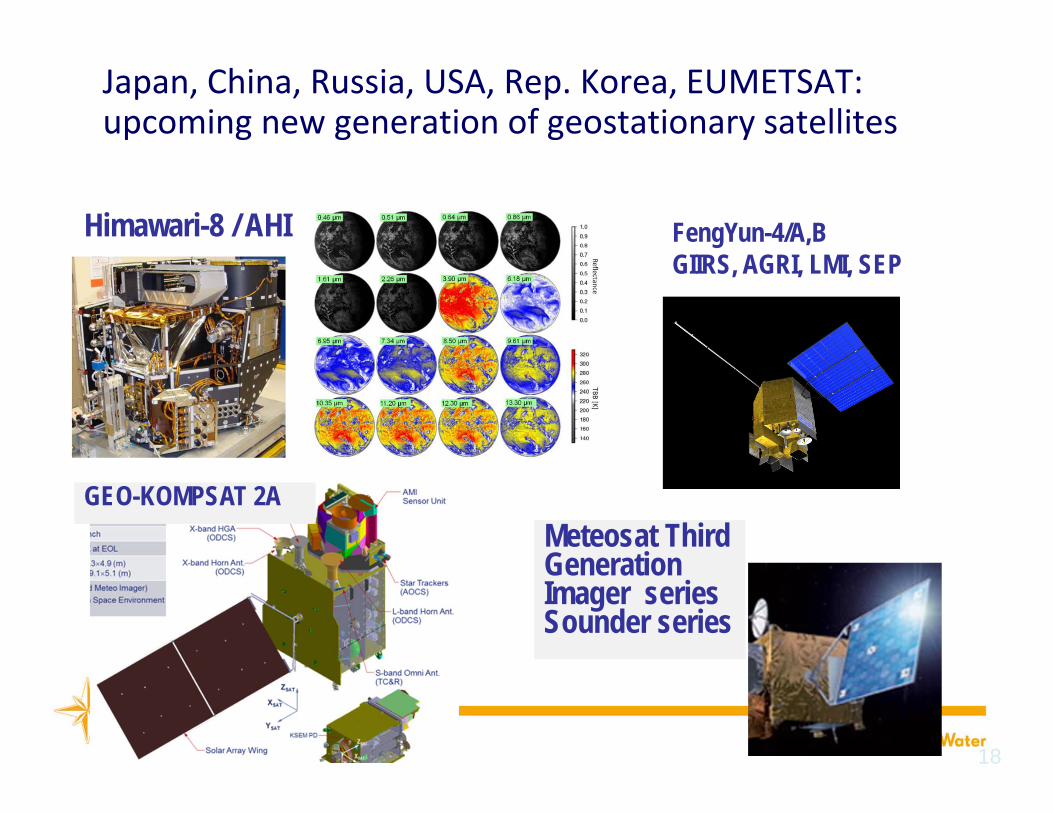
• Most geostationary systems start a new generation in the next 8 years: Himawari-8 (Oct. 2014), FY-4A, GOES-R, GEO-KOMPSAT-2A , MTG-I1, Electro-M1
• Guideline for Ensuring User Readiness for New Generation Satellites adopted by CBS-15 :– NMHSs should set up preparation projects– Satellite operators to provide technical information and tools– SATURN portal provides a single access to this information
• For RA III: GOES (East) is essential• Considerable improvement with GOES-R• Transition requires special attention

Transition from GOES‐N,O,P to GOES‐R,S (2)• Date of start of GOES-R/S operations over RA III cannot be predicted• No overlap period with current GOES series Difficulty for NMHSs to plan GOES-R receiving equipment and
increased risk of not being ready in due time To reduce this risk and facilitate user uptake, WMO ET-SUP
recommended to disseminate proxy data (during commissioning) thenpre-operational datasets (during storage and early operations) via Geonetcast-A
Infrastructure is in place The SDR Group would propose priority datasets Proposal: NOAA to investigate this possibility

Reference User Readiness Project: Background• Frame user readiness planning
– Generic timeline with respect to launch date– (‐5/‐4/‐3 years etc.)– Deliverables for users and satellite operators
• The detailed timeline of activities and deliverables is available in the SATURN portal
4/5/2015 17IPET‐SUP‐1 March 2015
Users (e.g. NMS) Satellite operators
Budget planning, R&D Operation plans & schedules
Data reception & handling Instrument characterization
Data processing & visualization
Data access specifications
Training and capacity building Test data and tools; Software
Contributions to cal/val User dialogue channels
18
18
FengYun-4/A,B GIIRS, AGRI, LMI, SEP
Himawari-8 / AHI
Japan, China, Russia, USA, Rep. Korea, EUMETSAT: upcoming new generation of geostationary satellites
GEO-KOMPSAT 2AMeteosat ThirdGenerationImager seriesSounder series

Summary of User issues in the Americas• Transition from GOES to GOES-R• GOES-R data reception (Direct readout: GRB; PDA; GNC-A): changes
from GOES• Access to data, to products• Training material• User feedback mechanisms• NPP• Data reception, direct readout, pre-processing, DBNet

WMO RecommendationsIPET‐SUP‐1 (2015)• Recommendation : in regional requirements tables, a
distinction should be made between products needed for routine operations, and those needed in emergency situations.
• Recommendation: NOAA to continue delivering basic imagery in GeoTIFF format from GOES‐R on GNC‐A.

WMO Recommendations
ET‐SUP‐8 (2014)• RECOMMENDATION 8.19: NOAA NESDIS to consider using
an extended check‐out period to make GOES‐R data available on a pre‐operational basis.
• RECOMMENDATION 8.21: NOAA NESDIS, in collaboration with international partners, to develop a GOES‐R preparation project for users in RA III and RA IV (outside the US).
• RECOMMENDATION 8.22: T. Mostek and CIRA to facilitate organization of GOES‐R related events through the VLab and dedicated user conferences, such as the 2015 NOAA Satellite Conference.

17th World Meteorological CongressSide event
"Ensuring User Readiness to New‐Generation Meteorological Satellites"
• held on Wed 27 May 2015 between 12.15 and 13.15 at the CICG conference centre in Geneva, Switzerland
• Focus is on preparation of users for Himawari‐8 and the upcoming GOES‐R and JPSS systems
• 191 WMO Member states and territories represented at Congress

Capacity building• Two Centres of Excellence of the Virtual Laboratory :
Brasil (INPE), Argentina (SMN, CONAE, UBA) supported by NOAA• Weather briefings (with CoE in Costa Rica and Barbados)• Webinars (Geonetcast-Americas: Remote sensing tools for decision
making on environmental phenomena and disasters, 07/2014)
• NOAA 2015 conference : 27 April-1 May 2015, Greenbelt, MD, USA

Space Weather• Effects of solar events on the Sun-Earth environment, including
radiation burst, particle fluxes, ionospheric and geomagneticdisturbances
• Impacts on aviation, radio HF communications, GNSS signal, electricpower grids (induced current)….
• Increasing attentiuon by ICAO• Inter-Programme Coordination Team on Space Weather (ICTSW)
currently includes 23 WMO Members (Brasil from RA III)• Members are encouraged to identify partner organizations with
experience in this area to participate in ICTSW.

Terms of Reference of the RA III‐ RA IV Coordination Group on Satellite Data Requirements (Summary)
• Need standing expert group to regularly review the satellite data needs, and dialogue with satellite operators, along EC-65 Res.12
• RA III and RA IV would benefit of a common expert group• Initial ad-hoc group: Argentina, Brazil, Canada, Colombia, Chile,
Trinidad &Tobago, Venezuela, + CONAE, INPE, EUMETSAT, NOAA• Maintains a database of required data and products• Has reviewed the contents of GEONetCast-A, EUMETCast• Fruitful dialogue with NOAA on GOES-East scanning optimization• Terms of Reference (in Annex) were endorsed by RA IV• Would support WG-ITD, SG-OBS (To be discussed under item 5.3)