Embed Size (px)
Citation preview

Templer WayA scenic and historic waymarked routefor walkers linking Dartmoor and thesouth coast of Devon
devon.gov.uk/walking
2
Templer WayA route for walkers linking Haytor on Dartmoor with the seaport of Teignmouth
History of the Templer WayThe Templer Way is a route for walkerslinking Haytor on Dartmoor with the seaportof Teignmouth. It has a length of 18 miles(29 km) and covers a wide range of scenery -open moorland, woodland, meadow,historical tracks, urban land and estuaryforeshore.
The story of the route begins in 1722 whenJames Templer was born in Exeter.Orphaned at the age of six, he was educatedlocally and then apprenticed to an Exetercarpenter. In 1745 he married Mary Parlby ofRotherhithe, and set up business there as aHouse Carpenter. Over time, he made afortune, working on government contracts inmost of the Royal Dockyards, especially atPortsmouth and Plymouth. In 1765, hepurchased the run-down Stover estate, nearNewton Abbot, built the new Stover Houseand set about renovating his estate.
In 1792, his son, James II, built a canalbetween Teigngrace and the tidal River Teignat Newton Abbot. This, the Stover Canal,was built to carry clay for export fromworkings on his land via Teignmouth Docks.
In 1820 James II’s son, George, built agranite tramway from Haytor to link with thecanal in order to export the granite beingextracted from his Dartmoor quarries.
Once the granite quarries becameuneconomic during the 1850’s the tramwaywas no longer used. The branch line toMoretonhampstead later followed the lowerpart of its route. Clay continued to beexported along the lower end of the canaluntil the mid 20th century. It ceased to bemaintained in 1942.
OS Maps which cover the Templer Way:Explorer No. 110Majority of the route (1:25,000)Explorer No. OL28Dartmoor end (1:25,000)
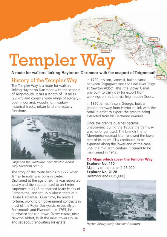
Barges on the Whitelake, near Newton Abbot,early twentieth century
Haytor Quarry, early nineteenth century

3
Templer WayWaymarkers
Introductionto the WalkUsing a mixture of rights of way,permissive routes and minor roads, theTempler Way follows as closely as possiblethe route of the Templers’ ventures - theHaytor Granite Tramway and the StoverCanal - between Haytor and Newton Abbot.It then follows the old exporting route downthe Teign Estuary to the Templers’ New Quayat Teignmouth.
Except on the open moorland at HaytorDown, where the granite rails of thetramway can be followed, the route iswaymarked in both directions, and may betackled in short stretches or in one go.Circular walks have been developed for mostsections, including the Heritage Trail, a circuitaround the Templer Estate at Stover. Pleasenote that the return loops are notwaymarked.
The waymarks are made up of the TemplerWay logo which is composed of a tramwaywheel and the tiller and rudder of a barge,
Sustainable Travel LinksFrequent and regular bus services operatenear to the route between Stages 1 and 6providing an opportunity to plan ‘Ride andStride’ options. Newton Abbot is veryaccessible with a main line train station.
For up to date bus times call Traveline on0871 200 22 33 or visit www.traveline.org.uk
representing the tramway and the canal.There is also a series of information boardslocated along the route. Anyone wishing tocomplete the Templer Way in one day shouldallow up to 10 hours and should check tidetables before setting out.
Much of this route follows permissive pathswhere landowners have given permission foruse by walkers only. It cannot, therefore, berecommended for cyclists.
Walk North, or South - instages….Stage 1 4 miles/6.4kmHaytor to Edgemoor Hotel
Stage 2 2 miles/3.2kmEdgemoor Hotel to Great Plantation
Stage 3 4 miles/6.5kmGreat Plantation to Locks Bridge, Teigngrace
Stage 4 2 miles/3.2kmLocks Bridge, Teigngrace to Newton AbbotTown Quay
Stage 5 2.5 miles/3.8kmNewton Abbot Town Quay to Coombe Cellars
Stage 6 3 miles/4.5kmCoombe Cellars to Teignmouth
R
i
P
WC
Key to Map
Templer Way
Return Loop
Car Park
Refreshments
Information Board
Bus Stop
Bus Stop (limited services)
Toilets
Start/end of Stage
© Crown Copyright and database right 2013. Ordnance Survey 100019783
At A Glance• 18 miles (29km) in total
• Divided into 6 easy stages
• Easy to follow, waymarked trail
• Largely flat and level surface
• Stages 5 and 6 are tide dependant

4
Stage 1
Haytor to EdgemoorHotelDistance: 4 miles (6.3km)
The route starts from outside the Haytor VisitorCentre and heads across the road bearing rightaround the bottom of Haytor Rocks to the carvedmarker stone at the junction of the tramway.This section of the route passes over the openmoorland of Haytor Down before windingdownhill through enclosed farmland to YarnerWood which is part of the East Dartmoor Woodsand Heaths National Nature Reserve. Here thebeautiful beech avenue lining the tramway wasprobably planted when the rails were laid down inabout 1820. The granite rails are still visible inmany places both here and higher up the route,look out also for the milestones which show thenumber of miles to the Stover Canal. On leavingthe woodland the route continues onwards alonga permissive path through fields and appleorchards which opened in 2007 as part of aNatural England Environmental Stewardshipagreement. It joins the main road close to theEdgemoor Hotel. The orchards were planted inthe 1950s and contain local Devon apple varieties.As part of the Stewardship scheme the trees areundergoing careful restorative pruning to enhancetheir productivity and increase wildlife.
From the open moorland section there arestunning views out over the whole route to thecoast at Teignmouth. The area also supports a richdiversity of wildlife – look out for buzzards, ravensand a range of mosses and ferns as you dropdown into Yarner Wood and for lichens in theorchards below. To explore Yarner Wood further,follow the nature trail signs.
FacilitiesThere is a Dartmoor National Park Visitor Centreand toilets close to the start of the route, a pubin nearby Haytor Vale and a hotel at the lowerend of this section. A leaflet on the EastDartmoor Woods and Heaths nature trails isavailable in Yarner Wood car park. The seasonalHaytor Hoppa Saturday bus service links Haytorwith Bovey Tracey, Newton Abbot and beyond.
Route informationPlease be aware that paths in this area canbecome muddy in wet weather and wear suitablefootwear.
Yarner Wood Loop6.8 miles (11km)This loop includes quiet road and bridlewaysections as well as woodland tracks. It offersstunning views out across the East DartmoorWoods and Heaths National Nature Reserve aswell as a chance to explore a range of habitatsincluding western oak woodland and moorland.
DirectionsFrom Haytor Information Centre follow theTempler Way as far as the first road. Leave theTempler Way here, turning left along the roaduntil you come to the top of Yarner Wood onyour right. Turn right down into the wood justbefore the house and follow the track until thefirst side track comes in from your left. Turn sharpback left and follow this track as it contoursaround the top of the valley. Cross the streamand continue to follow the track downhill alongthe edge of the wood. When the nature trailcomes in from your right (look for the arrows andnumbered posts), turn right along it, bearing leftat the bottom of the first slope, and follow itdown to the main Yarner Wood car park. Walkthrough the car park and follow the drive out tothe road. Turn right and then right again up thebridleway leading to the Haytor Road. Look outfor the Templer Way where it crosses the trackand turn right uphill along it. Follow the TemplerWay through the top of Yarner Wood and outthrough a gate, across a drive and back up toHaytor.

Alternative Route
P
P
i
P
P
R
R
WC
5
© Crown Copyright and database right 2013. Ordnance Survey 100019783
R
i
P
WC
Key to Map
Templer Way
Return Loop
Car Park
Refreshments
Information Board
Bus Stop
Bus Stop (limited services)
Toilets
Carved Granite Marker Stone
Start/end of Stage
Haytor Marker Stone Haytor Quarry
6
Stage 2
Edgemoor Hotel toGreat Plantation2 miles (3.2km)
This section of the route starts along astretch of the original tramway through asmall deciduous woodland before followingminor roads and bridleways through Brimleyon the edge of Bovey Tracey. In some placesthe granite rails are still visible along withoriginal milestones which gives the distanceto the Stover Canal.
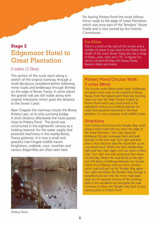
Near Chapple the tramway crosses the BoveyPottery Leat, at its only surviving bridge.A short distance afterwards the route passesclose to Pottery Pond. The pond wasconstructed in the eighteenth century as aholding reservoir for the water supply thatpowered machinery in the nearby BoveyTracey potteries. It is now a small andpeaceful tree-fringed wildlife haven.Kingfishers, mallards, coot, moorhen andvarious dragonflies are often seen here.
On leaving Pottery Pond the route followsminor roads to the edge of Great Plantationwhich was once part of the Templers’ StoverEstate and is now owned by the ForestryCommission.
FacilitiesThere is a hotel at the start of this section and anumber of places to eat close to the Pottery Roadlength of the route. Bovey Tracey also has a rangeof shops, pubs, cafes and a TIC. A regular busservice connects Brimley with Bovey Tracey,Newton Abbot and Exeter.
Pottery Pond Circular Walk5 miles (8km)This circular route follows quiet roads, bridlewaysand green lanes close to the outskirts of BoveyTracey. From the highest point there are stunningviews out over the Teign Estuary. It starts atPottery Pond which was constructed in theeighteenth century as a holding reservoir forwater that powered machinery in the localpotteries. It is now a popular small wildlife haven.
DirectionsFrom Pottery Pond follow the Templer Way southalong a minor road until you reach the edge ofthe Great Plantation. Turn right along thebridleway through Lookweep Farm and walkthrough to the next road. Turn right and thenafter a short distance take the second left up anunsurfaced track. Where the track divides keepright and then right again until you reach a minorroad. Turn right and walk along and then downinto Brimley. Where the road bends to the rightturn left along a bridleway between two houses.Follow this bridleway until you reach anotherminor road and pick up the Templer Way again.Turn right and follow the Templer Way through awoodland and out onto the minor road again.Look out for exposed sections of the tramwayboth in the woodland and alongside the road.Continue to follow the Templer Way back to yourstarting point at Pottery Pond.
Pottery Pond

R
R
i WC
EdgemoorHotel
Great Plantation
© Crown Copyright and database right 2013. Ordnance Survey 100019783
R
i
P
WC
Key to Map
Templer Way
Return Loop
Car Park
Refreshments
Information Board
Bus Stop
Bus Stop (limited services)
Toilets
Start/end of Stage
7Templer Way milestones along the route

8
Stage 3
Great Plantation to LocksBridge, Teigngrace4 miles (6.5km)
This section of the Templer Way passes by aconifer plantation, meadow, woodland, lakeand river and rejoins the tramway atVentiford Basin. This is where the Templers’Stover Canal and Haytor Granite Tramwaymet. Granite was transferred onto barges tobe taken down the Canal and on toTeignmouth.
Stover Country Park sits in the middle of thissection and formed part of James Templer’sStover Estate. The lake was constructed andgrounds landscaped in the late 1700’s.Historical features include the granitegatehouse situated on the north side of thepark, carriage drives and Teigngrace Church.There has been continued development ofclay extraction into the 21st century withmany clay pits in this area.
The ground is fairly flat and runs along off-road tracks (some unsurfaced), woodlandpaths and fields. There is a short road sectionalong quiet lanes at Ventiford. Care must be
Teigngrace Church, built by the Templers
taken when crossing the busy Drumbridgesroundabout which divides the GreatPlantation from Stover Country Park; followthe Templer Way signs along the pavementcircumnavigating the roundabout. Access onthis section is through gates.
There is much to tempt the wildlifeenthusiast with a variety of wildfowl andsummer dragonflies at Stover Lake, alongwith kingfishers, herons and sand martins onthe River Teign. Shy roe deer may be spottedin the Great Plantation and woodlandssurrounding Stover, along with woodlandbirds such as great-spotted woodpecker andnuthatch. Butterflies grace the woodlandglades and meadows during the summermonths.
FacilitiesThe petrol station and small shop at Heathfieldare open 7 days a week for drinks and snacks.At Liverton there is a small shop and post officealong with a pub which serves meals. Toilets canbe found at Stover Country Park. There areseveral caravan and camping sites close to thisstretch of the route. Two free car parking pointswith limited spaces accessing Great Plantationcan be found at Belle Vue, Liverton and on theA382 opposite the petrol station. A Pay andDisplay car park is situated at Stover Country Parkwith a small car park at Teign Bridge.Refreshments also available at Sampson’s Farm,Preston.
Heritage Trail Circular Walk4 miles (6.5km)The start of a 4-mile circular walk, the HeritageTrail, can be found in Stover Country Park.This circuit forms the middle part of the TemplerWay and through walkers can take either route toarrive at Locks Bridge, Teigngrace. Leaflets areavailable from the Country Park.No cycling along this section; the Newton Abbotto Bovey Tracey Cycle Route runs along quietlanes past Teigngrace and cuts through the northend of the Park. Many surfaced tracks suitable forwheelchairs and pushchairs can be found inStover, including the majority of the Ted HughesPoetry trail. Part of the Heritage Trail can also beaccessed with sturdier models.

iP
i
WC
i
Locksbridge
R
© Crown Copyright and database right 2013. Ordnance Survey 100019783
R
i
P
WC
Key to Map
Templer Way
Return Loop
Car Park
Refreshments
Information Board
Bus Stop
Bus Stop (limited services)
Toilets
Start/end of Stage
9
Stover Lake
Stover Country ParkThere is a Nature Interpretation Centre at StoverCountry Park. Set in over 114 acres of woodland,heathland, lake and marsh, the ‘green flag’award park also includes trails, interpretationboards, an aerial walkway, bird hides, picnic areasand a poetry trail celebrating the works of TedHughes.

10
Stage 4
Locks Bridge,Teigngrace to NewtonAbbot Town Quay2 miles (3.2km)
The top of this section of the Templer Wayfollows the Stover Canal past two old locks.Much of these upper stretches of the canalno longer hold water but form areas ofdamp woodland. Further downstream thecanal emerges into the Jetty Marsh CanalBasin - the end of the Canal. Barges thenfollowed the Whitelake Channel throughwhat is now Jetty Marsh Local NatureReserve, until the Channel merged with theRiver Lemon and then the River Teign justupstream of Newton Town Quay. Ball clayfrom Decoy mines and pits was loaded ontobarges there until the 1940s.
This stretch is great for spotting birds - akingfisher swooping under the railway intothe Canal Basin, a heron stealthily huntingnear the reeds, or the loud and cheerfulwhistle of the tiny Cetti’s warbler. Otters usethese waterways for night-time fishing,leaving footprints and spraint in secretplaces!
This section is fairly level and even, and thereis a safe crossing over the busy B3195 toWharf Road Sidings. However, there is then astepped bridge over the River Lemon, whichcan be avoided by following the cycle routealong the Avenue, turning left into TemplersRoad and quickly left again along a footpathto rejoin the main route. If you do cross thebridge, look down into the Lemon for apassing school of large grey mullet.
Please note that there is no cycling allowedthrough Jetty Marsh Local Nature Reserve.The reserve has a narrow section along thecanal basin, curving paths with blind bendsand is regularly used by wheelchair users.You are welcome to push your bike throughthe reserve and you can then follow the cycleroute along the Avenue, as above.
FacilitiesNewton Abbot has a wide range of eating andother facilities. Close to Newton Town Quay isTuckers Maltings, where, between Good Fridayand the end of October, you can see maltedbarley being prepared for local breweries - andbuy local beers, light refreshments andsandwiches. There is a public car park offOsborne Street, close to the Maltings.
Jetty MarshJetty Marsh is a County Wildlife Site and LocalNature Reserve containing varied wildlife habitats.It has great value as a wildlife corridor betweenthe Lower River Teign and the Bovey Basin. Thesite has large reedbeds which are a scarce habitatin Devon, together with blackthorn and bramblescrub, mature oak trees and herb-rich grassland.Jetty Marsh Lock was rebuilt in the 1820s. Lookout for the engraved stone to George Templer atthe end of the lock.
Stover Canal Circular Walk2 miles (3.2km)From the car park at Teign Bridge cross the roadand take the public footpath along the river.After the second pylon, turn left at a woodenpost to join the Templer Way. Cross fields andturn left signed ‘to Canal Bridge’.Walk alongside the Stover Canal following theTempler Way signs until you go under a railwayarch at Jetty Marsh Nature Reserve. Here, leavethe Templer Way by immediately turning right atthe Canal Lock.Turn right again after crossing a culvert bridge tojoin the cycleway. Continue along the cyclewayand turn right with care onto Exeter Road, overthe railway crossing and Canal Bridge. Bear leftoff the road immediately after the bridge, use thefield footpath back to the car park.

i
P
iLocksbridge
Newton AbbotTown Quay
© Crown Copyright and database right 2013. Ordnance Survey 100019783
11
R
i
P
WC
Key to Map
Templer Way
Stover Canal Circular Walk
Car Park
Refreshments
Information Board
Bus Stop
Bus Stop (limited services)
Toilets
Start/end of Stage
Newton AbbotAlthough a long-established market town,Newton Abbot really came to prominence withthe arrival of the railway. During the 1800’s itbecame an important railway town, withmarshalling yards and repair facilities. The areaaround the Whitelake and River Lemon was usedas railway sidings until the relatively recent past,difficult to imagine now!
George Templer memorial stone, Jetty Marsh Lock Kingfisher. © Neil Harris.

12
Stage 5
Newton Abbot TownQuay to CoombeCellars2.5 miles (3.8km)
This section follows the Teign Estuary shoreand should only be walked within 2 hourseither side of low tide. It is uneven and can beslippery after heavy rain or high tides - neverleave the path or you may get stuck in theestuary mud! It is not suitable for cycles. Tocheck tide times visit easytide.ukho.gov.uk
Have your binoculars ready for good views ofwaders, ducks and pure white Little Egrets asyou walk this route. Once a rare visitor to theUK, the Little Egret has become a residentbreeding species. At Netherton Point there isa heronry in the top of pine trees, and abeautiful, but fragile, salt marsh with seapinks and sea lavender.
Optional High Tide RoutesThe Netherton Coombe walks offer a variety ofwaymarked circular routes, passing through fieldsand along traditional Devon lanes with farms,orchards and lovely estuary views. Nethertononce had an on-farm cider factory and its ownspecial variety of cider apple. If the tide is high,you can follow the Buckland Circle pastHoneysuckle Farm. The South of the Teign EstuaryCircular walks leaflet shows a variety of walks inthis scenic area; for a copy, ask a local TIC.(Check tide times at easytide.ukho.gov.uk)
FacilitiesThere is a full range of facilities in Newton Abbot;refreshments can be bought at Coombe Cellarspub during opening hours.
Town Quay Bridge
The Teign Estuary is an important Shellfishproduction area, a Bass nursery, a goodsalmon and sea-trout river and the site of theBritish record for Flounder. What looks likemud flats to people are also a vast andproductive habitat area for marine wormsand crustaceans which drive the estuarinefoodchain.
Lower Netherton Circular Walk3 miles (5km)Leave the Templer Way by crossing the stile intothe field a little way upstream of the CoombeCellars. Cross the field diagonally to the far topcorner and continue alongside the hedge. At theend bear left and arrive at a surfaced lane.Go ahead to a cross roads and turn right, downthe hill and through the hamlet of LowerNetherton. Continue up the other side to anotherjunction and go left. Take the next right whichdescends and then climbs to arrive at a residentialarea. Go right at the next junction (Drake Road)and follow this almost to the main A380 road.Just before the A380, follow the footpath on theright next to the main road and on to descendsteps to rejoin the Templer Way adjacent to theroad bridge.

R
i
PR
Newton AbbotTown Quay
13
© Crown Copyright and database right 2013. Ordnance Survey 100019783
Fishing boat at the Teign Estuary
Little Egret on the Teign Estuary
Coombe Cellars on the Teign Estuary
R
i
P
WC
Key to Map
Templer Way
Return Loop
Car Park
Refreshments
Information Board
Bus Stop
Bus Stop (limited services)
Toilets
Carved Granite Marker Stone
Start/end of Stage

R
P
i
R
14
Stage 6
Coombe Cellars toTeignmouth3 miles (4.5km)
This section follows the Teign Estuary shoreand should only be walked within 2 hourseither side of low tide. It is uneven and can beslippery after heavy rain or high tides - neverleave the path or you may get stuck in theestuary mud! It is not suitable for cycles. Tocheck tide times visit easytide.ukho.gov.uk
The estuary shore is full of interest, with ashellfish farm, an old lime kiln and lots ofwatercraft to watch. You can imagine the old,square-sailed barges running before the wind,or, if it was calm, drifting down the estuarywith the tide, or even being poled by thebargees. In the late 1800s - early 1900s asteam tug, the Kestrel, was used to tow astring of barges up and down the estuary.Later still, a motor tug, the Heron, took over;it seems that the Heron was laid off in 1939,when the canal stopped being usedcommercially, but crossed the Channel toDunkirk in 1940, rescuing British soldiers -before being scrapped.
At Ringmore Strand the Templer Way leavesthe shore and passes through the village ofShaldon to the ferry crossing (frequentcrossings, ring 07896 711822 or visitteignmouthshaldonferry.co.uk for moreinformation). The ferry trip across the mouthof this busy estuary is a high point of thewalk! Continue northwards alongTeignmouth ‘back beach’, and you will findthe historic and picturesque ‘New’ Quay -built in 1821 by the Templer family. Here claywas transhipped to the potteries and graniteto London. The carved granite markersignifies the end of the Templer Way route.
FacilitiesRefreshments can be bought at Coombe Cellarspub. There is a small car park and picnic site atArch Brook. There are several cafes and pubs inboth Shaldon and Teignmouth. If you follow theStokeinteignhead loop, there are Inns atCombeinteignhead and at Stokeinteignhead,where there is also a village shop.
Stokeinteignhead Circular Walk5 miles (8km)Leave the Templer Way opposite RingmoreTowers, climbing Salty Lane. At the fork bearright and follow the lane ahead and down to theright. At a junction go ahead, steeply uphill, andkeep following the lane until it arrives atStokeinteignhead. Turn right, out of the villageand then turn left at the next junction (along alane, not the narrower track). Keep ahead as faras Rocombe House and Orchard Farm then turnright. Follow the track to the right and steeplyuphill and keep climbing to arrive at a lane.Turn right and follow this lane. Just beforereaching the Newton Abbot - Shaldon road turnleft along a track, then turn right at a junction toreach the road. Almost opposite is a publicfootpath across a field. Follow this and on past acottage to a lane. Turn right, up the hill, to ajunction and go left here. At the end follow thefootpath to the right alongside a hedge and atthe next field go diagonally left to the far bottomcorner. Cross the stile to arrive on the TemplerWay near the Coombe Cellars.
New Quay, Teignmouth1827, with a largecrane and blocks ofgranite ready fortranshipment

R
i
i
R
RR
P
WC
WC
i
Station
Teignmouth
© Crown Copyright and database right 2013. Ordnance Survey 100019783
15Teignmouth - the end of the Templer Way
R
i
P
WC
Key to Map
Templer Way
Return Loop
Car Park
Refreshments
Information Board
Bus Stop
Bus Stop (limited services)
Toilets
Carved Granite Marker Stone
Start/end of Stage

D E V O N
Engl
ish
Channel
Bristol Channel
This is printed on recycled paper
When you have finishedwith it please recycle andhelp the environment.
Devon County Council has made every effort to ensure that the contentsof this publication are accurate at the time of printing however walksand rides are undertaken at your own risk. July 2013.
For more information on walks which are accessible to all, visitdevon.gov.uk/accessforall
For visitor information including accommodation availability visitwww.visitdevon.co.uk
If you enjoy Devon'scoast and countryside . . .Why not visit devon.gov.uk
02552
If you need this in a different formatplease contact 01392 382104 oremail: [email protected]