Embed Size (px)
Citation preview

Accepted Manuscript
Tectono-Stratigraphic evolution of the upper jurassic-neocomian rift succession,Araripe Basin, Northeast Brazil
Claiton Marlon dos Santos Scherer, Emanuel Ferraz Jardim de Sá, Valéria CenturionCórdoba, Debora do Carmo Sousa, Mayara Martins Aquino, Fátima Maria CanelasCardoso
PII: S0895-9811(13)00151-X
DOI: 10.1016/j.jsames.2013.10.007
Reference: SAMES 1226
To appear in: Journal of South American Earth Sciences
Received Date: 21 May 2013
Accepted Date: 24 October 2013
Please cite this article as: Scherer, C.M.d.S., Jardim de Sá, E.F., Córdoba, V.C., Sousa, D.d.C., Aquino,M.M., Cardoso, F.M.C., Tectono-Stratigraphic evolution of the upper jurassic-neocomian rift succession,Araripe Basin, Northeast Brazil, Journal of South American Earth Sciences (2013), doi: 10.1016/j.jsames.2013.10.007.
This is a PDF file of an unedited manuscript that has been accepted for publication. As a service toour customers we are providing this early version of the manuscript. The manuscript will undergocopyediting, typesetting, and review of the resulting proof before it is published in its final form. Pleasenote that during the production process errors may be discovered which could affect the content, and alllegal disclaimers that apply to the journal pertain.
MANUSCRIP
T
ACCEPTED
ACCEPTED MANUSCRIPT
TECTONO-STRATIGRAPHIC EVOLUTION OF THE UPPER JURASSIC-1
NEOCOMIAN RIFT SUCCESSION, ARARIPE BASIN, NORTHEAST BRAZIL 2
3
Claiton Marlon dos Santos Scherer1, Emanuel Ferraz Jardim de Sá2, Valéria Centurion 4
Córdoba2, Debora do Carmo Sousa2, Mayara Martins Aquino3, Fátima Maria Canelas 5
Cardoso4 6
7
1 UFRGS, Instituto de Geociências, P.O. Box 15001, CEP 91501-970, Porto Alegre - 8
RS, Brazil. 9
2 UFRN, Centro de Ciências Exatas e da Terra, Departamento de Geologia, 10
Laboratório de Geologia e Geofísica de Petróleo, Programa de Pós-Graduação em 11
Geodinâmica e Geofísica, Natal-RN, Brazil 12
3 Petróleo Brasileiro S.A., E&P - EXP/IABS/PN, Rio de Janeiro, Brazil 13
4 Universidade de Coimbra, Centro de Geociências, Ciências da Terra FCTUC, 14
Coimbra, Portugal 15
16
E-mail addresses: [email protected] (C.M.S. Scherer), [email protected] 17
(E.F. Jardim de Sá), [email protected] (V.C.Córdoba), [email protected] 18
(D.C. Sousa), [email protected] (M.M. Aquino), 19
[email protected] (F.M.C. Cardoso).. 20
21
Abstract 22
The rift succession of the Araripe Basin can be subdivided into four depositional 23
sequences, bounded by regional unconformities, which record different 24
palaeogeographic and palaeoenvironmental contexts. Sequence I, equivalent to the 25
Brejo Santo Formation, is composed of fluvial sheetflood and floodplain facies 26
association, while Sequence II, correspondent to the lower portion of the Missão Velha 27
Formation, is characterised by braided fluvial channel belt deposits. The fluvial deposits 28
of Sequences I and II show palaeocurrents toward SE. The Sequence III, 29
correspondent to the upper portion of Missão Velha Formation, is composed of fluvial 30
sheetflood deposits, which are overlain by braided fluvial channel deposits displaying a 31
palaeocurrent pattern predominantly toward SW to NW. Sequence IV, equivalent to the 32
Abaiara Formation, is composed of fluvio-deltaic-lacustrine strata with polimodal 33
paleocurrent pattern. The type of depositional systems, the palaeocurrent pattern and 34
the comparison with general tectono-stratigraphic rift models led to the identification of 35
different evolutionary stages of the Araripe Basin. Sequences I, II and III represent the 36
record of a larger basin associated to an early rift stage. However, the difference of the 37
MANUSCRIP
T
ACCEPTED
ACCEPTED MANUSCRIPT
fluvial palaeocurrent between sequences II and III marks a regional rearrangement of 38
the drainage system related to tectonic activity that compartmentalised the large 39
endorheic basin, defining more localised drainage basins separated by internal highs. 40
Sequence IV is associated with the renewal of the landscape and implantation of half-41
graben systems. The high dispersion of palaeocurrents trends indicate that 42
sedimentary influx occurs from different sectors of the half-grabens. 43
44
Keywords 45
Araripe Basin, Rift Basin, Continental Sequence Stratigraphy, Continental Deposional 46
Systems 47
48
1. Introduction 49
50
In recent years, numerous studies have addressed the tectonic-stratigraphic 51
evolution of the rift basin, focusing on the influence of the tectonic on basin geometry 52
and on accommodation and sediment supply ratio (A/S ratio) during the different 53
stages of rifting (Prosser, 1993; Bosence, 1998; Galthorper and Leeder, 2000; Morley, 54
2002; Kuchle & Scherer, 2010). However, there are few studies detailing the facies 55
architecture and depositional dynamics associated with each of the evolutionary stages 56
of rifting, especially with regard to the initial stages of rifting, where depocenters are 57
difficult to identify and fill patterns are diverse and yet poorly understood (Kinabo et al., 58
2007; Morley, 2002; Kuchle et al., 2011). 59
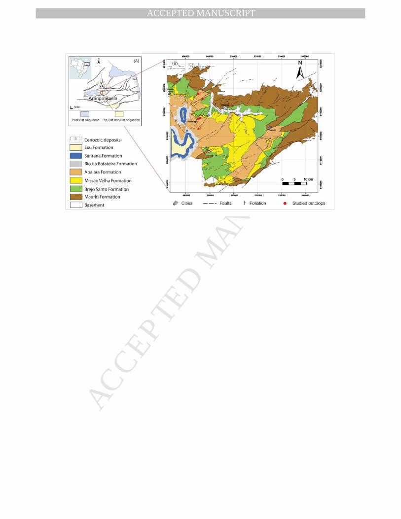
The sedimentary deposits of the Araripe Basin cover an area larger than 9,000 km2, 60
consisting of one of more extensive interior basins of the Brazilian Northeast (Figure 1). 61
As with the other interior basins, the origins of Araripe Basin are linked to the rifting and 62
opening processes of the South Atlantic (Ghignone et al., 1986; Assine, 2007). 63
Geometry and evolution of these basins are strongly conditioned by structures of the 64
Precambrian/Neopalaeozoic basement, whose reactivation controlled the arrangement 65
of depocenters over time. The Mesozoic stratigraphic record of the Araripe Basin 66
reflects different stages of subsidence related to three main phases (Ponte and Ponte 67
Filho, 1996): (a) the “Pre-Rift” phase, characterised by regional subsidence produced 68
by visco-elastic lithospheric stretching; b) the Rift phase, with accentuated mechanical 69
subsidence, forming graben and/or half-graben systems; and c) the Post-Rift phase, 70
characterised by the predominance of thermal subsidence. The main objective of this 71
paper is to detail the stratigraphic architecture of the section corresponding to "pre-rift” 72
and rift phases, aiming at understanding the depositional geometry, the fill patterns and 73
main controls on sedimentation and accumulation of different evolutionary stages of 74
MANUSCRIP
T
ACCEPTED
ACCEPTED MANUSCRIPT
rifting. Its specific goals include: (1) to identify and correlate unconformities that permit 75
the recognition of different depositional sequences; (2) to analyze the facies 76
architecture and the palaeocurrent pattern of each of the depositional sequences 77
proposed; and (3) to reconstruct the tectono-sedimentary evolution of the rift sucession 78
of the Araripe Basin. These results were obtained as part of a project intitled Interior 79
Basins of the Northeast (Bacias Interiores do Nordeste) (PETROBRAS/UFRN/PPGG), 80
whose preliminary results were presented in graduate MSc (Garcia, 2009, Aquino, 81
2009; Cardoso, 2010; Costa 2012) and at scientific meetings (Jardim de Sá et al., 82
2009, 2010, 2011, Cardoso et al., 2009, 2010). 83
To reach these objectives, 5 stratigraphic sections, each 5 to 90 m thick, were 84
measured and analysed in detail (Fig. 1). High-resolution sedimentary logs were 85
measured in order to define the main sedimentary elements of the studied interval. In 86
addition to detailed facies analysis of logged sections, architectural panels were made 87
to define the two-dimensional (2D) geometries of the deposits. Facies were defined 88
mainly on the basis of grain-size and sedimentary structures. Palaeocurrent 89
orientations were measured from cross-stratified beds. Paleocurrent readings were 90
corrected to the horizontal surface based on the S0 depositional surface (Tucker, 91
1996). Unconformities surfaces were identified within the main outcrops and correlated 92
between sedimentary logs (the sections), allowing the individualisation of different 93
depositional sequences. 94
95
2. Regional Stratigraphic Framework 96
The Araripe Basin, similar to other basins that occur in the interior of Northeast 97
Brazil, is associated with the Neocomian rift event that resulted in the separation of the 98
South American and African continents, specifically, in the opening of the East 99
Brazilian continental margin (Ghignone et al., 1986; Assine, 2007). Geometry and 100
evolution of these basins are strongly conditioned by structures of the 101
Precambrian/Neopalaeozoic basement, whose reactivation controlled the arrangement 102
of depocenters over time. As discussed by Ponte and Appi (1990), Chang et al. (1992), 103
Matos (1992,1999) and other authors, this event included a range of onshore aborted 104
rift basins, which extend from Recôncavo-Tucano-Jatobá grabens system to the 105
Potiguar graben, all of which were controlled by a principal NW extension. Alternative 106
models have been proposed by other authors (e.g., Françolin et al. 1994), though the 107
kinematics of the NW extension is supported by recent studies (Córdoba et al. 2008; 108
Aquino, 2009; Cardoso, 2010; Jardim de Sá et al. 2010, 2011). 109
MANUSCRIP
T
ACCEPTED
ACCEPTED MANUSCRIPT
In the case of the Araripe Basin, the tectonic rift affected the Precambrian 110
granite-gneiss and Paleozoic sedimentary basements. Studies by Matos (1992, 1999), 111
Aquino (2009) and Cardoso (2010) describe half-grabens controlled by normal faults in 112
the NE direction that are commonly tilted to the SE and associated with strike slip faults 113
that define a conjugate pair (E-W sinistral and NE dextral), which also agrees with the 114
NW distension. 115
According to the studies by Ponte and Appi (1990), Assine (1990, 1992) and 116
Ponte and Ponte Filho (1996), the Araripe Basin may be subdivided into sequences 117
bound by regional unconformities that reflect distinct tectonic stages in the basin. 118
Assine (2007) integrated these different proposals, identifying four large units limited by 119
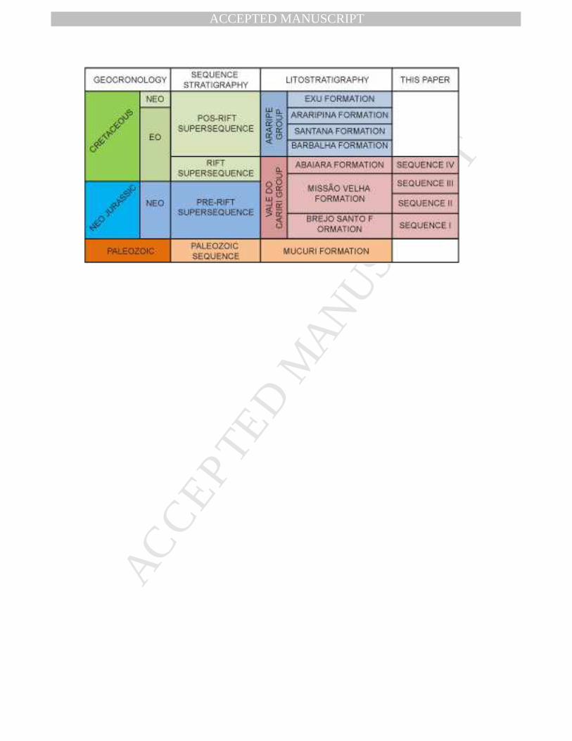
unconformities: (1) the Palaeozoic Sequence, represented by the alluvial sedimentation 120
of the Mauriti Formation and interpreted as the residual deposits of a large intracratonic 121
basin; (2) the Pre-Rift Supersequence (Neojurassic), corresponding to the Brejo Santo 122
and Missão Velha formations; (3) the Rift Supersequence (Neocomian), equivalent to 123
the Abaiara Formation; and (4) the Post-Rift Supersequence. The latter may be 124
subdivided into two higher-frequency sequences: (a) Post-Rift Sequence I (Aptian-125
Albian), corresponding to the Barbalha and Santana formations; and (b) Post-Rift 126
Sequence II, equivalent to the Araripina and Exu formations. 127
The interval analysed in the present study includes the pre-rift and rift 128
supersequences of the Araripe Basin, corresponding to the Brejo Santo, Missão Velha 129
and Abaiara formations, which are grouped in the Cariri Valley Group (Grupo Vale do 130
Cariri) (Ponte and Appi, 1990; Assine, 2007) (Table 1). The Brejo Santo Formation is 131
predominantly made up of red, or more rarely green mudstones, rich in ostracod 132
fossils. Sometimes, intercalated layers of fine grained sandstones are observed, mainly 133
toward the top of the unit (Assine, 1990). The Brejo Santo Formation is interpreted as 134
deposits of the shallow, broad and ephemeral lakes (Assine, 1990). The Missão Velha 135
Formation is compound by fine to very coarse-grained sandstones, sometimes 136
containing fossil trunks, intercalated with rare and discontinuous mudstones lenses. 137
The Missão Velha Formation has been interpreted as braided fluvial channels deposits 138
with a regional palaeoflow toward the SE (Assine, 1994). Finally, the Abaiara 139
Formation is characterized by different litological types with a predominance of fine to 140
medium-grained sandstones and mudstones. This unit has been interpreted as 141
deposits of fluvial, deltaic and lacustrine depositional systems. According to Assine 142
(1994), the fluvial and deltaic deposits of the Abaiara Formation show paleocurrents 143
toward the SE. 144
In the present study, the stratigraphic data are presented and interpreted 145
according to the commonly accepted hypothesis, in which the Brejo Santo Formation 146
MANUSCRIP
T
ACCEPTED
ACCEPTED MANUSCRIPT
was deposited during the Neojurassic (Dom João Stage) (Coimbra et al., 2002, Assine, 147
2007). Meanwhile, 100 miles north of Araripe Basin are described reddish mudstones 148
(Lavras da Mangabeira Formation) that are intruded by basic dikes aged of 185 Ma, as 149
discussed by Jardim de Sá et al. (2010, 2011). The mudstones of the Lavras da 150
Mangabeira Formation overly paleozoic sandstones, defining a stratigraphic context 151
very similar to Brejo Santo Formation. As a result, Jardim de Sá (2010, 2011) raise the 152
possibility that the lower part of the Brejo Santo Formation may be older than 153
Neojurassic. 154
155
3. Sequence Stratigraphy of the Jurassic-Neocomian Succession 156
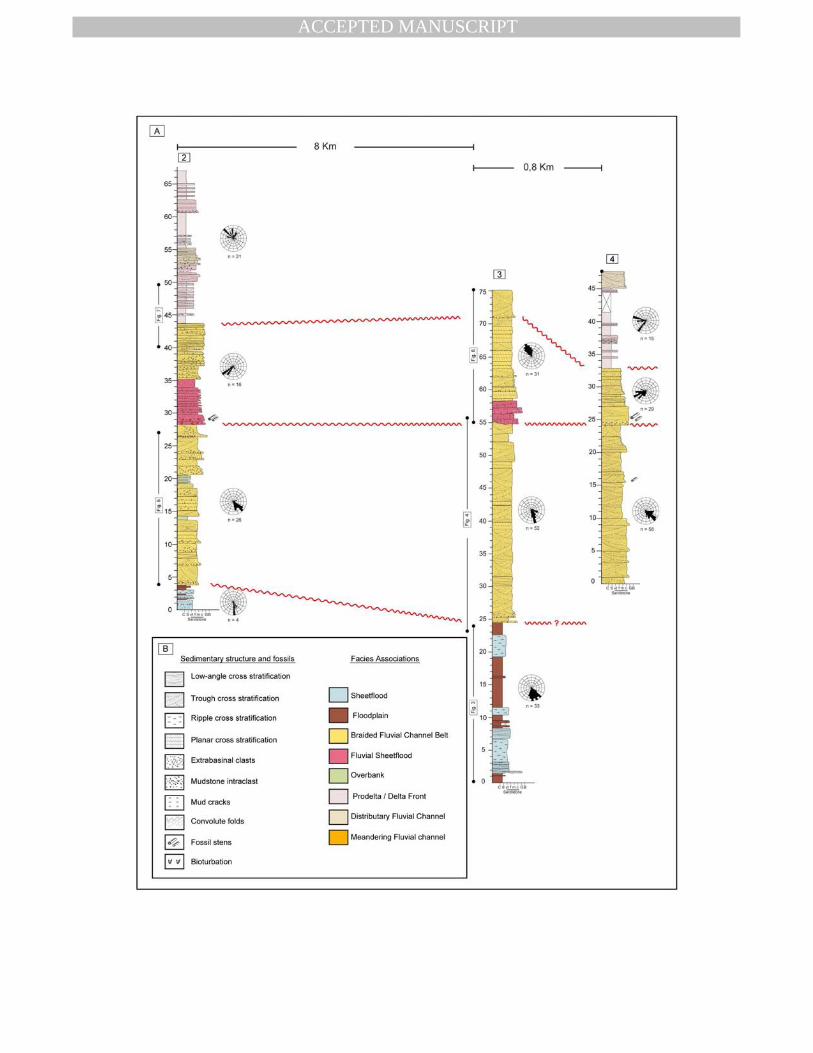
157
The UpperJurassic-Neocomian section of Araripe Basin can be subdivided into four 158
depositional sequences. These sequences are designated, from the base to the top, as 159
Sequences I, II, III and IV (Figure 2). The criteria used to identify unconformities in 160
outcrops include: (1) an abrupt facies change, which may involve both a change in the 161
depositional systems or modification of facies architecture within a specific depositional 162
system; (2) an abrupt change in the texture and grain size across the unconformity; 163
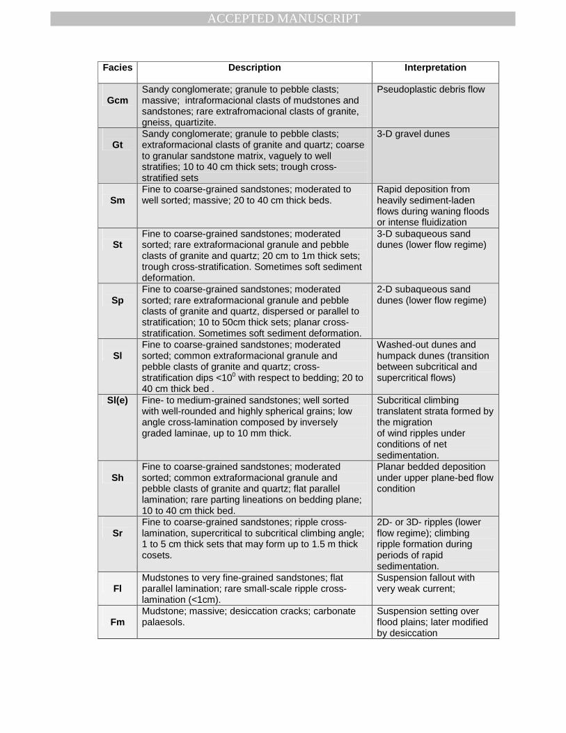
and (3) changes in the palaeocurrent patterns. The lithofacies description for each 164
depositional sequence is shows in Table 1 and is based on the original table from Miall 165
(1977). 166
167
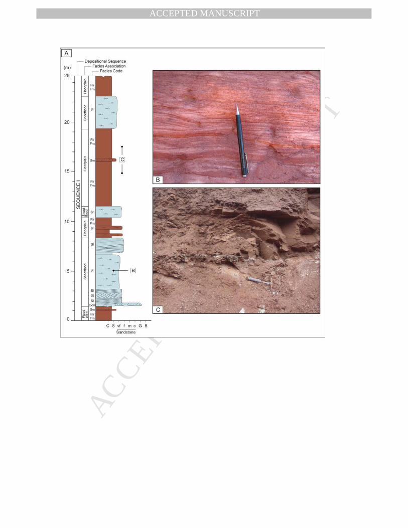
3.1 Sequence I 168
Sequence I corresponds entirely to the Brejo Santo Formation. This sequence displays 169
a thickness of approximately 400 m (Ponte and Appi, 1990; Assine, 1992). The lower 170
and the upper boundaries of Sequence I comprise regional scale unconformities with 171
the Mauriti and Missão Velha formations, respectively (Figure 2). Sequence I is 172
composed of two distinct facies associations (Figure 3): (1) Fluvial Sheetflood Facies 173
Association and (2) the Floodplain Facies Association. 174
175
3.1.1 Fluvial Sheetflood Facies Association 176
This facies association is characterised by fine to medium-grained sandstones, 177
arranged in 1-5 m thick tabular bodies, that can be traced laterally more than 80 m 178
(maximum outcrop extent). Fining-upward trends are common, with the tops of the 179
cycles grading to mudstones of the floodplain facies association. The tabular bodies 180
are bounded at the base by flat or slightly erosional surfaces that may eventually be 181
marked by < 10cm thick lags of mud and carbonate intraclasts (Figure 3). Internally, 182
MANUSCRIP
T
ACCEPTED
ACCEPTED MANUSCRIPT
sandstone bodies can be composed of a single lithofacies (Sm) or a sucession of the 183
different lithofacies. In the latter case, the sandbodies are characterized at the base by 184
massive (Sm), low-angle (Sl) and/or horizontal (Sh) laminated sandstones, which are 185
succeeded by ripple cross-laminated sandstones (Sr). Trough cross-bedding 186
sandstones (St) are isolated and rare (Figure 3). Measurements of the direction of the 187
dip of the cross-strata display a unimodal pattern with a mean vector toward the SE 188
(Figures 2 and 3). 189
The tabular bodies can be interpreted as the result of flash flood deposition in 190
laterally extensive, unconfined sheets or poorly confined fluvial channels. The 191
abundance of massive, low-angle or horizontally stratified sandstones suggests that 192
flow events were short lived and of high intensity (Tunbridge, 1984; Hampton and 193
Horton, 2007). The intercalation of these lithofacies within the same succession 194
indicates variations in the concentration of sediments and in the flow velocity. The 195
massive sandstones are the result of hyperconcentrated flows in which the 196
concentration of sandy sediment in suspension inhibits the turbulence and separation 197
of the flow, which are necessary for the embryonation of dunes (Allen and Leeder, 198
1980). The sediment is deposited en masse during the deceleration of the flow. In turn, 199
the low-angle and horizontal stratified sanstones indicate more diluted flow conditions 200
in which the sediments are predominantly transported by traction in high-flow regime 201
(Allen and Leeder, 1980). The occurrence of ripple cross stratified sandstone in the 202
upper portion of the tabular bodies is the result of waning flow velocity associated with 203
flow termination or channel abandonment (Miall, 1996). Intraformational lags at the 204
base of sheet sandstone bodies represent the reworking of deposits accumulated in 205
the floodplain areas. 206
207
3.1.2 Distal Floodplain Facies Association 208
This facies association is characterized by up to 5 m thickness reddish 209
mudstones intercalated occasionally with tabular sandstones (Figure 3). Mudstones are 210
massive, with ostracod fossils, sometimes exhibiting layers of calcareous concretions. 211
Sandstones are fine to medium-grained, well-sorted and deposited in tabular layers, 10 212
to 30 cm thickness, with planar and non-erosive basal contact. The sandstones 213
commonly display ripple cross-lamination (Sr). Sometimes, horizontal lamination (Sh) 214
can be observed. 215
This facies association is interpreted as floodplain deposits, which may 216
represent two distinct depositional contexts: (a) overbank flooding resulting from 217
unconfined flow originating from overtopped channels when they occur adjacent to 218
MANUSCRIP
T
ACCEPTED
ACCEPTED MANUSCRIPT
lenticular sandbodies; or (ii) downslope, unconfined sedimentation associated with 219
terminal flooding stages (Hampton and Horton, 2007; Spalletti and Piñol, 2005). 220
Tabular sandstone beds composed of horizontal lamination and ripples cross-221
laminated are interpreted as the products of poorly developed traction currents during 222
the waning stages of flood events (Hampton and Horton, 2007). Mudstones, in turn, 223
must have been deposited by the gravitational settling of the particles in suspension 224
during the final stages of flooding or in temporary lacustrine bodies that form on the 225
alluvial plain. The levels characterised by carbonate nodules are interpreted as 226
calcareous palaeosols (Ray and Chakraborty, 2002). 227
228
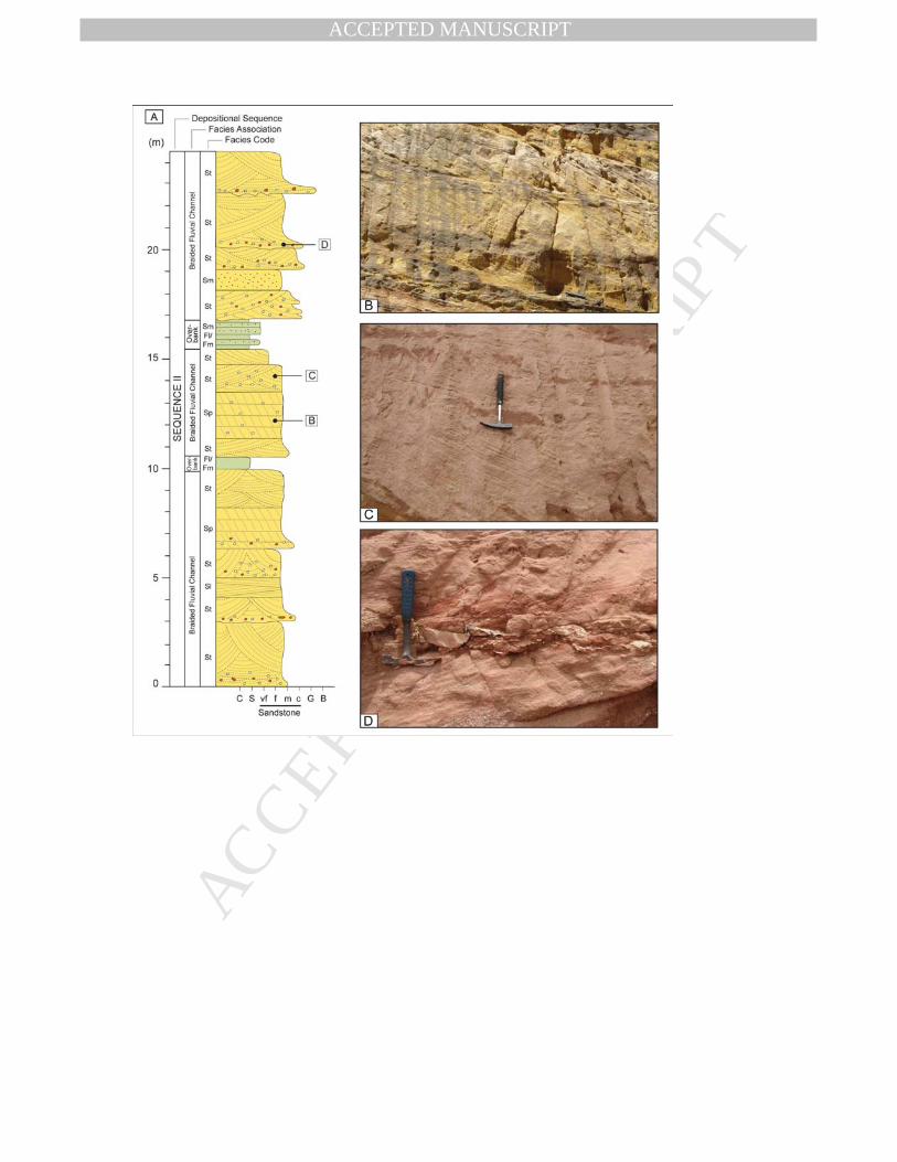
3.2 Sequence II 229
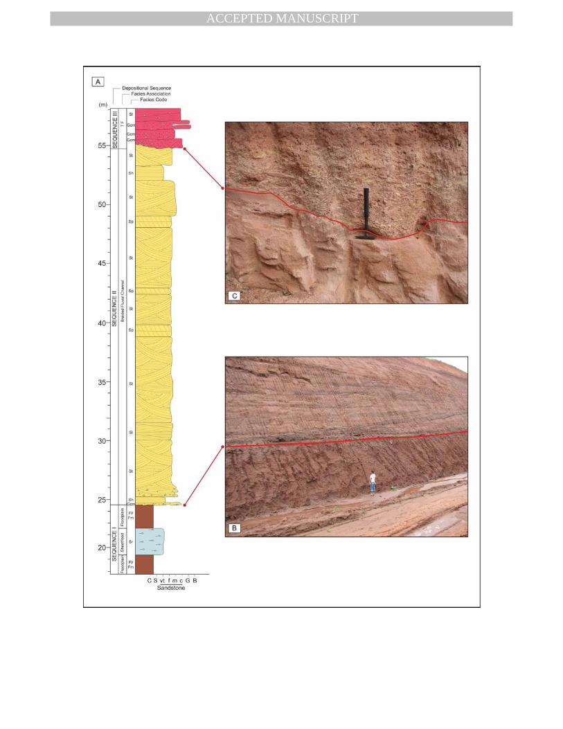
230
Sequence II is equivalent to the lower section of the Missão Velha Formation, bounded 231
at the top and the base by unconformities (Figure 2 and 4). This sequence displays a 232
thickness of between 20 and 30 m and it is composed of two distinct facies association 233
(Figures 4 and 5): (1) Braided Fluvial Channel Belt and (2 234
) Overbank Facies Association. 235
236
3.2.1 Braided Fluvial Channel Belt Facies Association 237
This facies association consists of fine to very coarse-grained sandstones, 238
moderately sorted, sometimes containing fossil trunks, arranged in sandstones bodies, 239
5 to 15 m thick, that extend laterally for more than 300 m (maximum outcrop extent). 240
The sandstone bodies are bounded at the base by erosive, slightly concave surfaces, 241
which in some cases are marked by concentrations of granules and pebbles. Internally, 242
the sandstone bodies exhibit a weakly developed fining upward pattern. The 243
sandstones exhibit planar (Sp) and trough (St) cross-bedding, arranged in 0.2 to 1 m 244
thick sets (Figures 4 and 5). Horizontal stratification (Sh) and low angle cross-245
stratification (Sl) sandstones are rare and normally restricted to isolated sets, 10 to 30 246
cm thick. Sometimes, it is possible to identify compound cross-strata, 2 and 3 m thick, 247
which internally display sets of planar and trough cross-bedding bounded by inclined 248
surfaces dipping in the same direction of the cross strata. The dipping of the bounding 249
surfaces varies from 30 to 100, and those with a lower angle (30 to 50) are only visible in 250
sections parallel to the dipping direction, where a smooth downlap of these surfaces 251
can be identified over the basal surface of the compound cross-strata. Measurements 252
of the direction of the dip of the cross-strata display a unimodal pattern with a mean 253
vector toward the SE (Figures 2, 4 and 5). 254
MANUSCRIP
T
ACCEPTED
ACCEPTED MANUSCRIPT
The occurrence of sandstone bodies bounded at the base by erosive surfaces 255
outlined by granules and pebbles lags and internally composed of sets of planar and 256
trough cross-strata with a unimodal direction of the palaeocurrents indicate that this 257
facies association represents fluvial channel deposits. The compound cross-strata can 258
be interpreted as macroforms migrating in-channel. The fact that the cross-strata 259
exhibit the same dip direction of the bounding surfaces allows for the conclusion that 260
the compound cross-strata represent downstream accretion macroforms with 261
superimposed, small-scale bedforms (Miall, 1996; Chakraborty, 1999; Jo and Choung, 262
2001). The sandstone bodies sheet geometry, prevailing coarse-grained nature of the 263
deposits, common presence of the downstream macroforms, the weak development of 264
the fining upward sucession and the low dispersion of the palaeocurrent data suggest 265
low sinuosity, braided channel belt deposits (Scherer and Lavina, 2006; Miall, 1996). 266
267
3.2.2 Overbank Facies Association 268
This facies association is rare and occurs intercalated with braided fluvial 269
channel-belt deposits, consisting mainly of red massive mudstone (Fm) (Figures 5). 270
Individual bodies are decimetres thick (< 50cm) and extend laterally for less than 30 m, 271
invariably truncated by the overlying sandstone bodies of the braided fluvial channel 272
belt facies association. 273
The fine-grained deposits are interpreted as overbank deposits accumulated 274
through gravitational settling of the suspended load within flooded areas surrounding 275
braided channel belts (Miall, 1996). 276
277
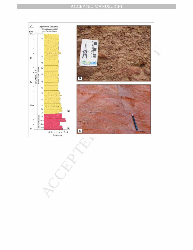
3.3 Sequence III 278
279
Sequence III, 20 to 30 m thick, corresponds lithostratigraphically to the upper 280
portion of the Missão Velha Formation (Fambrini et al., 2011). Due to similarity of the 281
facies association (both are fluvial deposits), it is difficult to identify the unconformity 282
surface between sequences II and III, defining a cryptic sequence boundary 283
(terminology of Miall and Arush, 2001). Among the main criteria used for this 284
identification, the following can be highlighted: (1) an increase in grain size through the 285
unconformity, marked by the abrupt occurrence of sandy conglomerate deposits over 286
medium to coarse-grained sandstones; (2) the presence of sandstone clasts and 287
reworked fossil trunks of the Sequence II in basal conglomerate of sequence III; (3) a 288
change in the direction of the fluvial palaeocurrents through the unconformity (Figure 289
2). The top of Sequence III is also marked by disconformity, marked by onlap of the 290
MANUSCRIP
T
ACCEPTED
ACCEPTED MANUSCRIPT
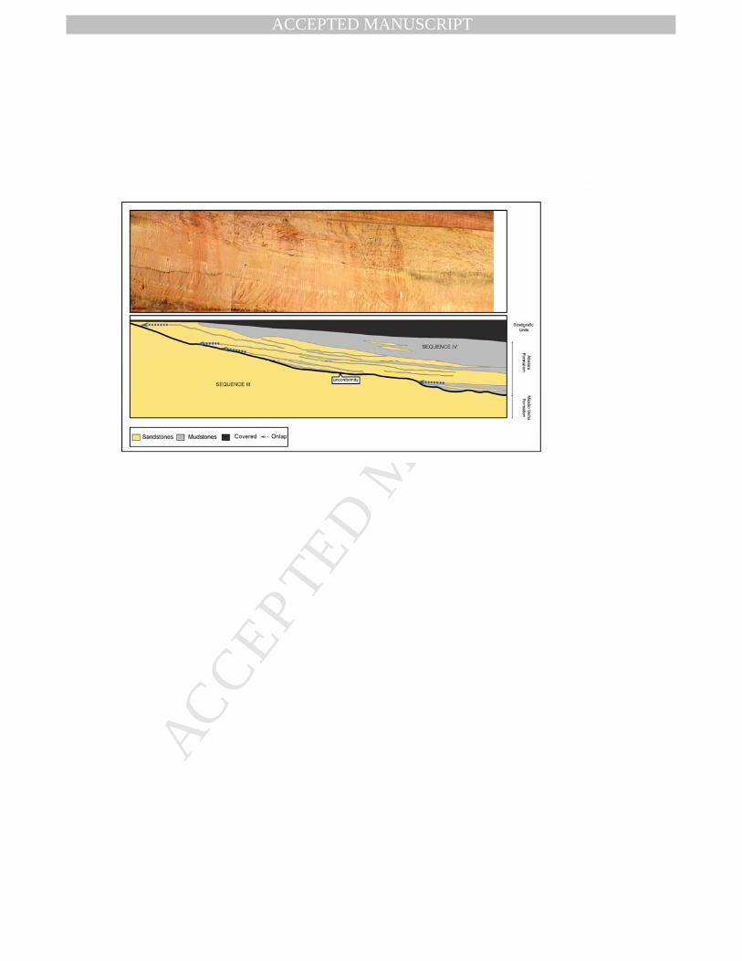
fluvial and deltaic deposits of Sequence IV (Abaiara Formation) (Figures 2 and 6). 291
Sequence III is composed of two distinct facies association (Figure 7): (1) Fluvial 292
Sheetflood Facies Association and (2) Braided Fluvial Channel Belt Facies Association. 293
294
3.3.1 Fluvial Sheetflood Facies Association 295
296
This facies association is composed of sandy conglomerate and medium to very 297
coarse-grained sandstones, moderately sorted, arranged in sheet-like sandstone 298
bodies, 0.5 and 1.2 m thick. The conglomerates are clast-supported, massive and 299
predominantly consist of granules and pebbles of quartz, granites, sandstones and 300
muddy intraclasts (Gm). The sandstones, in turn, are massive (Sm) or, less often, 301
display low-angle cross-stratifications (Sl). The sandstones commonly display granules 302
or pebbles of granite or mud intraclasts, dispersed or concentrated along the 303
stratification planes. 304
The dominance of massive conglomerates together with massive or horizontal 305
to low-angle stratified sandstones, displayed in sedimentary bodies with sheet 306
geometry, suggests that these deposits result from high-energy, sheetflood fluvial flows 307
(Nemec and Postma, 1993; Blair, 2000, 2001). The succession of amalgamated 308
sandstone and conglomerate beds may represent a series of flooding events that were 309
deposited in wide shallow channels. Massive, clast supported conglomerate suggests 310
deposition by high-density hyperconcentrated flows. Massive sandstone is interpreted 311
as rapid deposition from heavily sediment-laden flow during waning floods 312
hyperconcentrated flows. Low-angle cross-stratified sandstones are interpreted as 313
plane bedforms produced near the upper to lower flow regime transition by 314
unidirectional currents (Miall, 1996). 315
316
3.3.2 Braided Fluvial Channel Belt Facies Association 317
318
This facies association is made up of several sheet-like sandstone bodies, 2 to 319
7 m thick, bounded at the base by flat to concave-up erosional surfaces, sometimes 320
marked by massive, granule to pebbled clast-supported conglomerate (Gcm), 10 to 20 321
cm thick. These deposits are succeeded by 0.2 to 0.4 m thick, trough (St) and planar 322
(Sp) cross-stratified sandstones, and, rarely, by low-angle cross-stratified sandstones 323
(Sl) (Figure 7). Sometimes, it can be observed compound cross-strata, 2 and 4 m thick, 324
in which each set is bounded by inclined surfaces (5-8°) that dip in the same direction 325
of the cross-strata. Measurements of the direction of the dip of the cross-strata indicate 326
a paleocurrent toward the SW to NW (Figure 2). 327
MANUSCRIP
T
ACCEPTED
ACCEPTED MANUSCRIPT
These sandstone bodies are interpreted as deposits of fluvial channel, based on 328
the presence of concave-up erosional lower boundaries and dominance of 329
unidirectionally oriented decimetre-scale planar and trough cross-strata. The erosional 330
lower boundary of the sandstone bodies may be interpreted as limits of the fluvial 331
channels, equivalent to the 5th-order surface of Miall (1988, 1996). The downcurrent-332
dipping inclined strata represent downstream accretion of compound bars with 333
superimposed, small-scale bedforms (DA architectural element of Miall, 1988, 1996). 334
The sheet geometry of the sandstone bodies, dominantly coarse sand size of the 335
deposits, absence of mudstone, locally developed downstream accretion macrofoms 336
and low dispersion of the paleocurrent data collectively suggests that this facies 337
association represents braided fluvial channel belt deposits (Miall, 1996; Ray and 338
Chakraborty, 2002). 339
340
3.4 Sequence IV 341
Sequence IV is approximately 400 m thick and corresponds lithostratigraphically 342
to the Abaiara Formation (Figure 2). It is bounded at the base by an unconformity 343
marked by onlap of deltaic deposits over fluvial braided channel belt facies association 344
of Sequence III (upper section of the Missão Velha Formation) (Figure 7). The upper 345
contact of this sequence is marked by angular unconformity with the alluvial strata of 346
the Barbalha Formation (Assine, 1990) or the Rio da Batateira Formation (Ponte, 347
1990), which compose the base of the Post-Rift Supersequence (Assine, 2007). 348
Sequence IV is composed of four distinct facies association (Figures 2, 7 and 8): (1) 349
the Prodelta/Deltaic Front, (2) Distributary Fluvial Channels, (3) Overbank Deposits and 350
(4) Meandering Fluvial Channel Facies Association. 351
352
3.4.1 Prodelta / Delta Front Facies Association 353
354
This facies association is characterized by repetition of 2 to 10 m meter-scale 355
coarsening-upward cycles (Figure 8). The base of the cycles is characterised by 356
reddish to greenish color, massive (Fm) or laminated (Fl) mudstones, frequently 357
exhibiting ostracod fossils. These mudstones interlayer upward with fine to very fine 358
sandstones, 5 and 30 cm thick, which exhibit ripple cross-laminations (Sr) and, less 359
commonly, low-angle cross stratifications (Sl). The transition between mudstones and 360
sandstones beds is marked by soft-sediment deformations structures, including simple 361
load, pendulous features, pseudo-nodules and balls and pillow structures. Some 362
cycles can present at the top amalgamated layers of fine to medium sandstones with 363
MANUSCRIP
T
ACCEPTED
ACCEPTED MANUSCRIPT
trough (St) and planar (Sp) cross-stratifications. The sandstones may also show 364
indication of soft-sediment deformation, mainly oversteepened cross-stratification, 365
convoluted folds and plate and pillar structures. Measurements of the direction of the 366
dip of the cross-strata show a preferential direction within each cycles, though with high 367
dispersion if different cycles are compared (Figures 2 and 8). 368
The lithology, coarsening-upward cycles organization and dominance of 369
unidirectional current-generated structures suggest that these facies association 370
represents progradation of river-dominated delta, similar to those described by 371
Bhattacharya (1991) and Giosan and Battacharya (2005). The ostracod fossils present 372
in the fine-grained deposits indicate a lacustrine context (Coimbra et al., 2002). The 373
thickness of the cycles represents the minimum depth of the water level, which, in this 374
case, varied from 2 to 10 m. The massive and laminated mudstones at the base of the 375
cycles are interpreted as prodelta deposits. The lack of bioturbation in these deposits 376
indicates that the sediment was rapidly buried, thus preventing the reworking of the 377
substrate by organisms. The vertical increase in the frequency and thickness of the 378
sandstones layers indicate progradational tendency of the deltaic front. The 379
pronounced intercalation of sandstones and mudstones and the dominance of the 380
unidirectional current-generated structures in the sandstones suggest that the 381
sediments were supplied by intermittent unidirectional flows derived from fluvial 382
systems. The presence of different types of soft-sediment deformation in the contacts 383
between the sandstones and mudstones and within the sandstones layers must be 384
linked to a high rate of sedimentation, which increases the water pressure in the pores, 385
inducing the liquification of the sediment. The amalgamated sandstones that occur at 386
the top of the coarsening-upward cycles must represent the proximal portions to the 387
delta front, deposited by distributary mouth-bars (Battacharya, 2011). 388
389
3.4.2 Distributary Fluvial Channel Facies Association 390
391
This facies association is made up by fining-upward sucessions, 1.5 to 5 m 392
thick, normally overlaying Prodelta / Deltaic Front Facies association (Figure 8). The 393
base of the cycles is marked by an erosive surface, frequently capped by 394
intraformational conglomerates rich in mudstone intraclasts. Internally, the cycles are 395
characterised at the base by medium to coarse-grained sandstones, moderately 396
sorted, with trough cross-stratifications (St), planar cross-stratifications (Sp) and low-397
angle cross-stratifications (Sl), which sometimes give rise toward the top to fine to very 398
fine-grained sandstones with ripples cross-laminations (Sr). 399
MANUSCRIP
T
ACCEPTED
ACCEPTED MANUSCRIPT
The presence of fining upward cycles, bound by erosive surfaces capped by 400
intraclast lags suggests deposits of fluvial channels. The fact that this association 401
invariably covers prodelta/ deltaic front deposits indicates distributary fluvial channels 402
of the deltaic plain (Hampson et al., 1999). The trough and planar cross-stratifications 403
sandstones may be interpreted as deposits of 2D and 3D subaqueous dunes, 404
respectively, which migrate over the bottom of the channel in response to unidirectional 405
tractional flows. The fining-upward successions suggest a progressive decrease of the 406
flow velocity, culminating in the abandonment of the channel. The lack of lateral 407
accretion surfaces suggests fluvial channels with low sinuosity. 408
409
3.4.3 Overbank Facies Association 410
This facies association commonly occurs intercalated with distributary fluvial 411
channel or meandering fluvial channels deposits. It is characterised by red or greenish 412
(rare) mudstones occasionally interlayered with tabular sandstones, where deposits 413
commonly exhibit a tabular geometry, ranging from 3 to 15 m thick (Figure 8). The 414
mudstones are massive (Fm) or laminated (Fl), sometimes displaying calcareous 415
concretions. The nodules vary from 1 to 20 cm in diameter, exhibiting shapes that 416
range from highly irregular to vertically elongated and tabular. The sandstones are fine 417
to medium-grained, well-sorted, arranged in tabular layers, with planar and non-erosive 418
basal contact, internally compound by ripples cross-laminations (Sr). Sometimes, very 419
fine to coarse-grained, bimodal sandstones, with low-angle cross-stratifications (Sl(e)), 420
can be observed. Each lamina is inversely graded, 1 and 3 mm thick. 421
This facies association is interpreted as overbank deposits, which may have 422
been accumulated both in the inter-distributary bays present in the deltaic plain or in 423
the swampy regions of the fluvial floodplain. The mudstones have been deposited due 424
to the gravitational settling of particles in suspension, while the sandstones with ripples 425
cross-laminations represent the deposits of crevasse splays accumulated during river 426
channel overbank flooding. The carbonate nodules horizons are interpreted as 427
calcareous palaeosols (Ray and Chakraborty, 2002). The sandstones with low-angle 428
cross-stratification, with inversely gradated laminae, are interpreted as aeolian sand 429
sheet deposits formed by the migration and climbing of the aeolian ripples (Scherer & 430
Lavina, 2005; Scherer et al., 2007). The presence of frequent carbonaceous 431
palaeosols and aeolian deposits, indicates drier periods marked by a water table falling 432
and subaerial exposure of the depositional surface. 433
434
3.4.4 Meandering Fluvial Channel Facies Association 435
MANUSCRIP
T
ACCEPTED
ACCEPTED MANUSCRIPT
436
This facies association is composed of sandstone bodies, 2 to 7 m thick, 437
bounded at the base by erosive, concave upward surfaces, with reliefs varying from 1 438
to 3 m. Internally each sandstone body shows one large scale lateral accretion unit, 439
characterized by sets of fine to medium-grained sandstones with trough cross-440
stratification (St) and/or ripples cross-lamination which are bounded by inclined 441
surfaces (2 to 10°) that dip approximately perpendi cular to the direction of the cross-442
strata dip (Figure 9) 443
The presence of sandbodies with an erosive base and the predominance of 444
unidirectional tractive structures allow to interpret this facies association as fluvial 445
channel deposits. The occurrence of large-sized inclined strata indicates the presence 446
of macroforms filling the fluvial channels. The fact that the cross-strata show 447
palaeocurrents that are approximately transversal to the direction of the dip of the 448
bounding surfaces suggests lateral accretion macroforms (Miall, 1996). The dominance 449
of lateral accretion macroform suggests that this facies association represents high 450
sinuosity fluvial channel (Ghazi and Mountney, 2010). 451
452
3. Stratigraphic evolution 453
454
The Neo-Jurassic-Neocomian succession of the Araripe Basin consists of four 455
depositional sequences bound by unconformities (Figure 2). Sequence I corresponds 456
lithostratigraphically to the Brejo Santo Formation and can be interpreted as the distal 457
portion of an aluvial plain that developed in an arid to semi-arid climatic context. This 458
sequence is composed of floodplain and fluvial sheetflood facies associations that flow 459
toward the SSE (Figure 2 e Figure 11a). This depositional context suggests that the 460
basin extends toward the north, where the proximal sub-environments of Sequence I 461
would be positioned. Therefore, the entire depositional system can represent a 462
distributary fluvial or terminal fans systems that occupied an area much larger than the 463
one circumscribed within the current erosive limits of the Araripe Basin, as claimed by 464
Kuchle et al. (2011). 465
Sequence II, corresponding to the lower portion of the Missão Velha Formation, 466
is characterized by multi-storey and multi-lateral, amalgamated, sheet sandstone 467
bodies with rare preservation of fine-grained, overbank deposits, interpreted as the 468
deposits of braided fluvial channel-belt system, with palaeocurrents toward the SE 469
(Figure 2 e Figure 11b). The disconformity that separates Sequences I and II is easily 470
observed in outcropps, marked by grain-size increase and by abrupt change in 471
depositional style, from an ephemeral fluvial system of Sequence I to a braided fluvial 472
MANUSCRIP
T
ACCEPTED
ACCEPTED MANUSCRIPT
channel-belt system of Sequence II. The change in the depositional style reflects 473
change in the discharge regime of the fluvial systems, which is probably associated 474
with the more humid climatic conditions in Sequence II. Although there is a change in 475
the depositional systems of sequences I and II, both units have palaeocurrent to SE. 476
This suggests that the source area and proximal deposits of the sequences I and II 477
were northwest of the study area. 478
Sequence III, corresponding to the upper interval of the Missão Velha 479
Formation, is composed, at its base, of fluvial sheetflood facies association that passes 480
upward to braided fluvial channel belt facies association, the latter displaying facies 481
architecture similar to that of the fluvial deposits of Sequence II, though with 482
characteristically distinct palaeocurrents (Figure 11c). The fluvial strata of Sequence II 483
exhibit palaeocurrents toward the SE, while the fluvial deposits of Sequence III display 484
a palaeocurrent pattern predominantly toward the SW and NW (Figure 2). So, the 485
unconformity between Sequences II and III marks significant rearrangement in the 486
depocenters of the basin. The presence of sandstones clasts and reworked coniferous 487
trunks of the sequence II at the base of the Sequence III indicates uplift of the basin, 488
exposing the sequence II deposits to erosion. This fact, combined with the change in 489
the fluvial palaeocurrent vectors, must be associated with tectonic movements that 490
changed the morphology of the basin, causing a change in the drainage system. 491
Sequence IV, equivalent to the Abaiara Formation, is characterised by a thick 492
succession deposited by deltaic and fluvial systems, that display high dispersion in the 493
palaeocurrents (Figure 2 and 10), suggesting that the sedimentation occurred within a 494
restricted basin with sedimentary supply from different flanks of the basin (Figure 11d). 495
The onlap of the deltaic deposits of Sequence IV over the fluvial sandstones of 496
Sequence III (Figure 7) confirms the restructuring of the basin with consequent 497
reduction of the depositional area. 498
4. Tectonic-Stratigraphic Context 499
In recent years, different studies have discussed the tectonic-stratigraphic 500
evolution of rift basins, identifying different evolutionary stages (Morley, 2002). The first 501
stage is characterised by incipient extensional efforts that generate a basin that has a 502
broadly synclinal geometry. The thickening toward the basin center is achieved by 503
expansion of section across numerous rotational and nonrotational normal faults. 504
These faults are of similar displacement and no dominant fault trend is apparent. This 505
large basin was established before the development of the half graben system. Thus, 506
this stage is characterized by a wide synclinal depression, larger than the subsequent 507
MANUSCRIP
T
ACCEPTED
ACCEPTED MANUSCRIPT
rift trough, associated to the low rate, continuous and uniformly distributed tectonic 508
activity (Morley, 2002; Kinabo et al., 2007; Kuchle et al., 2011). Although different 509
authors (e.g., Prosser, 1993; Bosence,1998; Gawthorpe and Leeder, 2000) visualise 510
the beginning of the rift in the form of smaller-sized half graben basins bounded by 511
small normal faults, some actual and ancient examples corroborate the synformal basin 512
geometry to early rift stage (Morley, 2002; Kinabo et al., 2007; Kuchle et al., 2011). In 513
turn, the second stage would be marked by the formation of half-grabens. The 514
development of half-grabens would occur through the nucleation of the main border 515
fault by linkage of smaller faults. In the initial phase of the process, the mechanical 516
subsidence is still reduced, as a result of the small slip faults (Gawthorpe and Leeder, 517
2000). Accordingly, the fault scarps are underdeveloped, reducing the occurrence of 518
conglomerate wedges (Prosser, 1993; Bosence,1998; Gawthorpe and Leeder, 2000). 519
When the fault linkage occurs, forming a continuous border fault along the half-graben, 520
there is an increase in the subsidence favouring the development of large and deep 521
lakes, as now occurs in the rift system of East Africa. As the rate of accommodation 522
creation tends to be greater than the rate of sedimentary influx, the sedimentary 523
succession displays retrogradational stacking pattern (Prosser, 1993; Kuchle and 524
Scherer, 2010). Finally, there is the final filling stage of the half-graben, in which the 525
movement of the border fault is significantly reduced. Therefore, there is a decrease in 526
the ratio between the rate of accommodation creation and the rate of sedimentary 527
influx, resulting in a progradational stacking pattern (Prosser, 1993; Kuchle and 528
Scherer, 2010). 529
The Jurassic-Neocomian section of the Araripe Basin exhibits distinct 530
stratigraphic signatures, which allow for the identification of different evolutionary 531
stages. Sequences I, II e III, equivalent to Brejo Santo and Missão Velha formation, 532
show depositional systems distribution and palaeocurrent pattern indicating that this 533
units occupied a depositional area much larger than the one circumscribed within the 534
current erosive limits of the Araripe Basin. This suggests that sequences I, II and III 535
were deposited in a large sedimentary basin connected to the initial stage of the 536
Neocomian rifting (Kuchle et al., 2011). Previous studies (e.g. Estrela, 1972; Garcia et 537
al., 2005; Kuchle et al., 2011) have suggested that Brejo Santo and Missão Velha 538
formations were accumulated on the northern flank of the one large endorheic basin, 539
named of Afro-Brasilian Depression. However, the difference of the fluvial 540
palaeocurrent between sequences II and III marks a regional rearrangement of the 541
drainage system possibly related to tectonic activity. These tectonic movements may 542
have compartmentalised the large endorheic basin, defining more localised drainage 543
MANUSCRIP
T
ACCEPTED
ACCEPTED MANUSCRIPT
basins separated by internal highs, as observed in other basins of the Brazilian 544
Northeast (Kuchle et al., 2011). 545
Because the deposits of Sequences I, II and III are linked to the initial rifting 546
stages, it is inadvisable to use the term pre-rift to designate the tectonic stage in which 547
this entire sedimentary section is inserted, as has been employed in previous studies 548
(Ponte and Appi, 1990; Assine, 1990,1992; Ponte, 1992; Assine, 1994; Ponte and 549
Ponte Filho, 1996; Assine, 2007). The term pre-rift is used to designate rocks that are 550
completely unrelated to the rifting process, consisting of the sedimentary basement 551
upon which the taphrogenic processes will act (Prosser, 1993; Bosence, 1998). 552
Normally, the pre-rift strata are tens to hundreds of millions of years older than the 553
deposits accumulated during the rifting event (Bosence, 1998). The most appropriate 554
term for this initial phase of accumulation would be the Early Rift Stage (Morley, 2002) 555
or the Initial Rift Tectonic Systems Tract (Kuchle and Scherer, 2010). Sequence IV, in 556
turn, is characterised by a thick succession of fluvial-deltaic-lacustrine deposits, 557
indicative of a context with a high rate of accommodation generation. Beside, the high 558
variation in the palaeocurrent direction and the fact that Sequence IV strata onlap 559
deposits from Sequence III are consistent with the implantation of half-grabens 560
(Bosence, 1988; Prosser, 1993; Galthorpe and Leeder, 2000). According Prosser 561
(1993) the sedimentary influx of the half-grabens occurs from different regions (e.g., 562
flexural margin, faulted margin and axial influx), resulting in a high dispersion of 563
palaeocurrents trends when different sectors or stratigraphic intervals in the basin are 564
analyzed, similar to what can be observed in the deposits of Sequence IV. The 565
presence in outcrops of growth faults affecting deposits of Sequence IV corroborates 566
the idea of intense extensional tectonics concomitant with sedimentation (Aquino, 567
2009). Thus, Sequence IV may be considered the record of the Half-Graben Stage 568
(Morley, 2002) or of the Half Graben Develop to Rift Climax Tectonic SystemsTracts 569
(Kuchle and Scherer, 2010). 570
571
5. Conclusions 572
573
It was possible to individualise four depositional sequences in the Jurassic-574
Neocomian section of the Araripe Basin. Sequence I, equivalent to the Brejo Santo 575
Formation, is composed of deposits from sheet floods and of floodplains. Sequences II, 576
correspondent to the lower portion of Missão Velha Formation, is characterised by 577
braided fluvial channels belt amalgamated sandbodies intercalated with rare and 578
discontinuous floodplain deposits. Sequence III, correspondent to the upper portion of 579
Missão Velha Formation, is composed of fluvial sheetflood deposits, which are overlain 580
MANUSCRIP
T
ACCEPTED
ACCEPTED MANUSCRIPT
by braided fluvial channel belt deposits. Sequence IV, equivalent to the Abaiara 581
Formation, is composed of fluvial-deltaic-lacustrine deposits. 582
The sequences were accumulated during different rift tectonic stages. Sequences I 583
and II were deposited over a large basin, similar to a syneclise, though linked to the 584
initial stages of rifting. The change in the direction of the palaeocurrents of Sequence III 585
(toward the SW or NW) in relation to that of the palaeocurrents of Sequences I and II 586
(toward the SSE) is associated with tectonic movements related to the beginning of the 587
implantation of internal highs and grabens in an important structural reorganisation of 588
the basin. Sequence IV, in turn, was accumulated in well-defined half-graben systems 589
with the development of lacustrine environment, including fluvial and deltaic systems. 590
The sedimentary influx of the half-grabens occurs from different regions (e.g., flexural 591
margin, faulted margin and axial influx), as attested by high dispersion of 592
palaeocurrents trends of the Sequence IV. 593
From the results of this work it is possible to visualize the evolution of the different 594
stratigraphic stages of rifting. Corroborating propositions of Morley (2002), Kinabo et al. 595
(2007) and Kuchle et al. (2011), the first stage of rifting (sequences I and II) is 596
characterized by the development of a wide basin, unlike the model of Prosser (1993), 597
Bosence (1998), Gawthorpe and Leeder (2000) that suggest the existence of small 598
grabens isolated at the beginning of rifting. This large basin has a relatively low rate of 599
subsidence (low A / S ratio), and does not record extensive lacustrine facies. The 600
development of half-graben system occurs at a later stage. Firstly, there is the 601
subdivision of large basin into incipient graben (Sequence III), even with low rate of 602
subsidence. After, from the linkage of fault segments occurs an increase in the 603
subsidence (increase in A/S ratio) and full development of half graben systems, 604
allowing the development of deep and extensive lakes (Sequence IV). 605
606
Acknowledgements: 607
The authors acknowledges PETROBRAS for financing the research project. CMSS 608
acknowledge the Brazilian Research Council (CNPq) for research support. We are also 609
grateful for the constructive and thoughtful reviews by Reinhardt Fuck, Giorgio Basilici, 610
Michael Holz and an anonymous referee. 611
612
References: 613
614
Allen, J.R.L. and Leeder, M.R., 1980. Criteria for instability of upperstage plane beds. 615
Sedimentology , 27, 209–212. 616
617
MANUSCRIP
T
ACCEPTED
ACCEPTED MANUSCRIPT
Aquino, M.M., 2009. A Formação Abaiara e o Arcabouço Tectonoestratigráfico da 618
Região de Abaiara-Brejo Santo, Bacia do Araripe, NE do Brasil. MSc. thesis, Centro de 619
Ciências Exatas e da Terra, Universidade Federal do Rio Grande do Norte. 620
621
Assine, M.L., 1990. Sedimentação e tectônica da Bacia do Araripe (Nordeste do 622
Brasil). MSc. thesis, Universidade Estadual Paulista. 623
624
Assine, M. L., 1992. Análise estratigráfica da bacia do Araripe, Nordeste do Brasil. 625
Revista Brasileira de Geociências, 22(3), 289-300. 626
627
Assine, M.L. 1994. Paleocorrentes e paleogeografia na Bacia do Araripe, Nordeste do 628
Brasil. Revista Brasileira de Geociências, 24 (4), 1-10. 629
Assine, M.L. 2007. Bacia do Araripe. Boletim de Geociências da Petrobras, 15 (2), 630
371-389. 631
632
Bhattacharya, J. P. 1991. Regional to subregional facies architecture of river-633
dominated deltas in the Alberta sub-surface, Upper Cretaceous Dunvegan Fm. In: 634
Miall, A.D and Tyler (Eds.), The 3-D facies architecture of terrigenous clastic sediments 635
and its implications for hydrocarbon discovery and recovery. SEPM Concepts in 636
Sedimentology and Paleontology 3, 189-206. 637
638
Bhattacharya, J.P. 2011. Deltas. In: James, N.P. and Dalrymple, R.W. (Eds), Facies 639
Model 4. Geological Society of Canada, 233-264. 640
641
Blair, T.C. 2000. Sedimentology and progressive tectonic unconformities of the 642
sheetflood-dominated Hell.s Gate alluvial fan, Death Valley, California. Sedimentary 643
Geology, 132, 233-262. 644
645
Blair, T.C. 2001. Outburst flood sedimentation on the proglacial Tuttle Canyon alluvial 646
fan, Owens Valley, California, U.S.A. J. Sediment. Res., 71, 657-679. 647
648
Bosence, D.W.J., 1998. Stratigraphic and sedimentological models of rift basins. In: 649
Purser, B.H., Bosence, D.W.J. (Eds.), Sedimentation and Tectonics of Rift Basins: Red 650
Sea ‐ Gulf of Aden. Chapman & Hall, London, 9‐25. 651
MANUSCRIP
T
ACCEPTED
ACCEPTED MANUSCRIPT
652
Cardoso, F. M. C. 2010. O grabén da Palestina: contribuição à estratigrafia e estrutura 653
do estágio rifte na Bacia do Araripe, Nordeste do Brasil. MSc. thesis, Centro de 654
Ciências Exatas e da Terra, Universidade Federal do Rio Grande do Norte. 655
656
Cardoso, F. M. C., Jardim de Sá, E. F., Silva, F. C. A., Scherer . C. M. S. 2009. O 657
Graben do Serrote das Cacimbas-Palestina (Sub-bacia Cariri, Bacia do Araripe, NE, 658
Brasil). In: XXIII Simpósio de Geologia do Nordeste, Fortaleza, Resumos. 659
660
Cardoso, F.M.C., Jardim de Sá, E.F., Scherer, C.M.S., Córdoba, V.C., Antunes, A.F., 661
Silva, F.C.A., 2010. Tectono-stratigraphic relationships in the Palestina Graben, 662
Araripe Basin, NE Brazil. II Central and North Atlantic Conjugate Margins Conference, 663
Lisboa, Abstracts, v. 1. 664
665
Catuneanu, O., 2006. Principles of Sequence Stratigraphy. Elsevier, Amsterdam, 375 666
pp. 667
668
Chakraborty, T., 1999. Reconstruction of fluvial bars from the Proterozoic Mancheral 669
Quartzite, Pranhita-Godavari, India. In: Smith, N.D., Rogers, J.(Eds.), Fluvial 670
Sedimentology IV, IAS Spec. Pub., 28, 451–466. 671
672
Chang, H.K., Kowsmann, R.O., Figueiredo, A.M.F., Bender, A.A., 1992. Tectonics and 673
stratigraphy of the East Brazil Rift System: an overview. Tectonophysics, 213, 97-138. 674
675
Costa, A B.S., 2012. Diagênese e Proveniência dos Arenitos da Tectonossequência 676
Rifte nas bacias do Rio do Peixe e do Araripe, NE do Brasil. MSc. thesis, Centro de 677
Ciências Exatas e da Terra, Universidade Federal do Rio Grande do Norte. 678
679
Coimbra, J.C., Arai, M., Carreno, A.L., 2002. Biostratigraphy of Lower Cretaceous 680
microfossils from the Araripe basin, northeastern Brazil. Geobios, 35 (6), 687-698. 681
682
Cordoba, V.C., Jardim de Sá, E.F., Sousa, D.C., Antunes, A.F., Cruz, L.R., 2008. Bacia 683
Pernambuco-Paraíba. Boletim de Geociências da PETROBRAS, 15, 391-403. 684
685
Estrella, G.O., 1972. O estágio rift nas bacias marginais do leste brasileiro. 686
26 Congresso Brasileiro de Geologia, Belem,. Anais, v. 3, p. 29-34. 687
688
MANUSCRIP
T
ACCEPTED
ACCEPTED MANUSCRIPT
Fambrini, G.L., Lemos, D.R., Tesser, S., Araújo, J.T., Silva Filho, W.F., Souza, B.Y.C., 689
Neumann, V.H.M.L. 2011. Estratigrafia, arquitetura deposicional e faciologia da 690
Formação Missão Velha (Neojurássico-Eocretáceo) na área-tipo, Bacia do Araripe, 691
Nordeste do Brasil: exemplo de sedimentação de estágio de início de rifte a clímax de 692
rifte. Revista do Instituto de Geociências – USP, 11 (2), 55-8. 693
694
Françolin, J. B. L., Cobbold, P.R., Szatmari, P., 1994. Faulting in the Early Cretaceous 695
Rio do Peixe Basin (NE Brazil) and its significance for the opening of the Atlantic. 696
Journal of Structural Geology, Amsterdam, 16 (5), 647-661. 697
698
Gawthorpe, R.l., Leeder, M.R., 2000. Tectono-sedimentary evolution of active 699
extensional basins. Basin Research, 12 (2), 195-218. 700
701
Garcia, A.J.V., Rosa, A.A.S., Goldberg, K., 2005. Paleoenvironmental and 702
paleoclimatic control on early diagenetic processes and fossil record in Cretaceous 703
continental sandstones of Brazil. Journal of South American Earth Sciences, 19, 704
243-258. 705
706
Garcia, H. R. C. 2009. Arquitetura deposicional e evolução tectonoestratigráfica das 707
sequências Pré-Rifte e Rifte, na porção central do Vale do Cariri, Bacia do Araripe, NE 708
do Brasil. MSc. thesis, Centro de Ciências Exatas e da Terra, Universidade Federal do 709
Rio Grande do Norte. 710
711
Ghazi, S., Mountney, N.P., 2010. Facies and architectural element analysis of a 712
meandering fluvial succession: The Permian Warchha Sandstone, Salt Range, 713
Pakistan. Sedimentary Geology, 221, 99–126. 714
715
Giosan, L., Bhattacharya, J.P. 2005. River deltas: Concepts, models and examples. 716
SEPM Special Publications, 83. 717
718
Guignone, J.I., Couto, E.A., Assine, M.L., 1986. Estratigrafia e estrutura das bacias do 719
Araripe, Iguatu e Rio do Peixe. Anais do Congresso Brasileiro de Geologia, 34, 271-720
285. 721
722
Hampton, B.A., Horton, B.K., 2007. Sheetflow fluvial processes in a rapidly subsiding 723
basin, Altiplano plateau, Bolivia. Sedimentology, 1-27 724
725
MANUSCRIP
T
ACCEPTED
ACCEPTED MANUSCRIPT
Kinabo, B.D., Atekwana, E.A., Hogan, J.P., Modisi, M.P., Wheaton, D.D., Kampunzu, 726
A.B. 2007. Early structural development of the Okavango rift zone, NW Botswana. 727
Journal of African Earth Sciences, 48, 125‐136. 728
729
Kuchle, J., Scherer, C.M.S., Born, C.C., Alvarenga, R.S., Adegas, F. 2011. A 730
contribution to regional stratigraphic correlations of the Afro-Brazilian depression e The 731
Dom João Stage (Brotas Group and equivalent units e Late Jurassic) in Northeastern 732
Brazilian sedimentary basins. Journal of South American Earth Sciences, 31, 358-371. 733
734
Kuchle, J.; Scherer, C.M.S. 2010. Sismoestratigrafia de bacias rifte: técnicas, métodos 735
e sua aplicação na Bacia do Recôncavo. Boletim de Geociências da Petrobras, 18(2), 736
33-60. 737
738
Jardim de Sá, E.F., Antunes, A.F., Cordoba, V.C., Vasconcelos, P.M.P, Scherer, 739
C.M.S, Silva, F.C.A., Souza, D.C., Cruz, L.R., Nascimento, M.A., Almeida, C.B., 740
Aquino, M.M., Cardoso, F.C., Medeiros, W.E., Lins, F.A.P.L., 2011. Structural, 741
Stratigraphy and Geochronological Constraints of the Mesozoic Rifting in Northeast 742
Brazil, Bearing to the Opening of the South Atlantic. Gondwana 14, Búzios, v.1, p.224. 743
744
Jardim de Sá, E.F., Antunes, A.F., Cordoba, V.C., Alvez da Silva, F.C., Souza, D.C., 745
Cruz, L.R., Almeida, C.B., Medeiros, W.E. 2010. Evolução do rifte na Margem Leste-746
Setentrional Brasileira: contribuição dos projetos ANP/UFRN/PPGG. 45 Congresso 747
Brasileiro de Geologia, Belém, Resumos, p.224. 748
749
Jardim de Sá, E.F., Sousa, D.C., Aquino, M.M., Scherer, C.M.S.; Córdoba, V.C., 2009. 750
A Tectonossequencia Rifte na Bacia do Araripe. XXIII Simpósio de Geologia do 751
Nordeste, Fortaleza, Resumos, p.152. 752
753
Jo, H.R., Chough, S.K., 2001. Architectural analysis of fluvial sequences in the 754
northwestern part of Kyongsang Basin (Early Cretaceous), SE Korea. Sedimentary 755
Geology, 144, 307-334. 756
757
Matos, R.M.D., 1992. The Northeast Brazilian rift system. Tectonics, 11, 766-791. 758
MANUSCRIP
T
ACCEPTED
ACCEPTED MANUSCRIPT
759
Matos, R.M.D., 1999. History of the Northeast Brazilian rift system: kinematic 760
implications for the break-up between Brazil and West Africa. In: Cameron, N.R., Bate, 761
R.H., Clure, V.S. (Eds.), The oil and gas habitats of the South Atlantic. Special 762
Publications of Geological Society of London, 55-73. 763
764
Miall, A.D., 1977. A review of the braided river depositional environment. Earth-Sci. 765
Rev. 13, 1-62. 766
Miall, A.D., 1996. The Geology of Fluvial Deposits: Sedimentary Facies, Basin Analysis 767
and Petroleum Geology. Springer-Verlag, New York. 768
769
Miall, A.D., 1988. Facies Architecture in clastic sedimentary basins. In:Kleinspehn, 770
K.L. and Paola, C. (Eds.), New perspectives in basin analysis. Spriger-Verlag, Berlin, 771
67–81. 772
773
Miall, A.D., Arush, M., 2001. Crypitic sequence boundaries in braided fluvial 774
sucessions. Sedimentology, 46, 971-985. 775
776
Mitchum, R.M., Vail, P.R., Thompson III, S., 1977. Seismic stratigraphy and global 777
changes of sea level. Part 2: the depositional sequence as a basic unit for stratigraphic 778
analysis.In: Payton, C.E. (Ed.), Seismic Stratigraphy — Application to Hydrocarbon 779
Exploration. Am. Assoc. Pet. Geol. Mem., 26, 53–62. 780
781
Morley, C.K., 2002. Evolution of large normal faults: Evidence from sesmic refletion 782
data. American Association of Petroleum Geologists Bulletin, 86, 961‐978. 783
784
Nemec, W., Postma, G., 1993. Quaternary alluvial fans in southwestern Crete: 785
sedimentation processes and geomorphic evolution. In: Marzo, M., Puigdefabregas, C. 786
(Eds.), Alluvial sedimentation. IAS Spec.Pub., 17, 235-276. 787
788
Ponte, F.C. and Ponte Filho, F.C. 1996. Estrutura geológica e evolução tectônica da 789
Bacia do Araripe. DNPM, Recife, 68pp. 790
791
MANUSCRIP
T
ACCEPTED
ACCEPTED MANUSCRIPT
Ponte, F.C. and Appi, C.J. 1990. Proposta de revisão da coluna litoestratigráfica da 792
Bacia do Araripe. 36 Congresso Brasileiro de Geologia, Natal, Anais, v.1, p.211-226. 793
794
Prosser, S., 1993, Rift-related linked depositional systems and their seismic 795
expression. In: Williams, G.D., Dobb, A. (Eds), Tectonics and seismic sequence 796
stratigraphy. Geological Society Special Publication 71,117–144. 797
798
Ray, S.; Chakraborty, T., 2002. Lower Gondwana fluvial succession of the Pench–799
Kanhan valley, India: stratigraphic architecture and depositional controls. Sedimentary 800
Geology, 151, 243-271. 801
802
Scherer, C.M.S.; Lavina, L.E.C.; Dias Filho, D.C.; Oliveira, F.M.; Bongiolo, D.E.; Silva, 803
E., 2007. Stratigraphy and fácies architecture of the fluvial-aeolian-lacustrine Sergi 804
Formation (Upper Jurassic), Recôncavo Basin, Brazil. Sedimentary Geology, 194, 169-805
193. 806
807
Scherer, C.M.S. and Lavina, E.L.C., 2005. Sedimentary cycles and facies architecture 808
of aeolian–fluvial strata of the Upper Jurassic Guará Formation, Southern Brazil. 809
Sedimentology 52, 1323–1341. 810
811
Smith, N.D., Cross, T.A., Dufficy, J.P., Clough, S.R., 1989. Anatomy of an avulsion. 812
Sedimentology, 36, 1–23. 813
814
Spalletti, L.A., Piñol, F.F., 2005. From Alluvial Fan to Playa: An Upper Jurassic 815
Ephemeral Fluvial System, Neuquén Basin, Argentina. Gondwana Research, 8, 362-816
382. 817
818
Tucker, M.E., 1996. Sedimentary Rocks in the Field. John Wiley and Sons, 819
Chinchester, England. 820
821
Tunbridge, I.B., 1984. Facies models for a sandy ephemeral stream and clay playa 822
complex; the Middle Devonian Trentishoe Formation of North Devon, UK. 823
Sedimentology, 31, 697–716. 824
825
826
827
MANUSCRIP
T
ACCEPTED
ACCEPTED MANUSCRIPT
828
829
830
831
832
833
834
835
836
837
838
Figure Captions 839
Table 1: Stratigraphic nomenclature table of the Araripe Basin (according Assine, 840
2007) 841
842
Table 2: Summary of facies description and interpretation. 843
844
Figure 1: (A) Regional geological setting of the Araripe Basin. (B) Simplified geological 845
map of the studied area showing the location of eight logged sections, which represent 846
the study localities discussed in this paper. 847
848
Figure 2: (A) Stratigraphic cross-section based on log correlation, displaying the 849
depositional sequences, their bounding surfaces and facies association (datum: 850
regional flooding surface at the base of the Abaiara Formation). (B) Explanation of 851
symbols used in the sedimentological logs of this paper. 852
853
Figure 3: (A) Sedimentological log showing litofacies, facies association and facies 854
succession of the Sequence I. See Figure 2 for explanation of symbols and position of 855
the logs. See Table 1 for facies code. (B) Lithofacies Sr. Ripple cross-laminated, fine-856
grained sandstone. Pencil: 0.15m. (C) Lithofacies Fm. Massive mudstone. Coin: 857
20mm. 858
859
Figure 4: (A) Sedimentological log showing the basal and the top unconformities of the 860
Sequence II. See Figure 2 for explanation of symbols and position of the logs. See 861
Table 1 for facies code. (B) Low relief, basal unconformitie marked by abrupt contact 862
between floodplain (Sequence I) and braided fluvial channel (Sequence II) facies 863
associations. Person: 1.7 m. (C) Sandy conglomerate with sandstones clasts 864
MANUSCRIP
T
ACCEPTED
ACCEPTED MANUSCRIPT
(Lihofacies Gm) of the Sequence III covering braided fluvial channel sandstones of 865
Sequence II. Observe erosive nature of the contact. Hummer: 0.3 m. 866
867
Figure 5: (A) Sedimentological log showing litofacies, facies association and facies 868
sucession of the sequence II. See Figure 2 for explanation of symbols and position of 869
the logs. See Table 1 for facies code. (B) Lithofacies Sp. Planar cross-bedded 870
sandstones. Hummer: 0.3 m. (C) Lithofácies St. superimposed sets of trough cross-871
bedded sandstones. Hummer: 0.3 m. (D) Mud intraclasts concentrated at the base of 872
cross-bedded set (lithofacies St). Hummer: 0.3 m. 873
874
Figure 6: (A) Sedimentological log showing litofacies, facies association and facies 875
succession of the sequence III. See Figure 2 for explanation of symbols and position of 876
the logs. See Table 1 for facies code. (B) Lithofacies Gm. Massive conglomerate 877
composed of mudstones and sandstones intraformacional clasts held within a medium 878
to coarse sand matrix. (C) Lithofacies Sp. Planar cross-bedded sandstones. Pencil: 879
0.15 m. 880
881
Figure 7: Onlap of the prodelta to delta front deposits of the Sequence IV over braided 882
fluvial channel sandbodies of the Sequence III. See Figure 2 for position of the 883
sedimentological panel. 884
885
Figure 8: (A) Sedimentological log showing litofacies, facies association and facies 886
succession of the outcrop 5 (sequence IV). See Figure 2 for explanation of symbols 887
and position of the logs. See Table 1 for facies code. (B) Facies sucession of the 888
distributary channel and overbank facies association. (C) Heterolithic deposits of the 889
overbank facies association characterized by intercalation of the massive sandstones 890
(Sm) and massive mudstones with mud cracks (Fm). (D) and (E) Coarsening upward 891
facies succession of the prodelta and delta front facies association. Person: 1.6 m. 892
893
Figure 9: (A) Sedimentological log showing litofacies, facies association and facies 894
succession of the outcrop 1(sequence IV). See Figure 2 for explanation of symbols and 895
position of the logs. See Table 1 for facies code. (B) Outcrop panel showing lateral 896
accretion surface in meandering fluvial channel sandstone bodies. 897
898
Figure 10: Rose diagrams showing cross-bedding dip directions of the prodelta /delta 899
front and distributary channel facies association of the Sequence IV. n= 105. 900
901

MANUSCRIP
T
ACCEPTED
ACCEPTED MANUSCRIPT
Figure 11: Depositional models depicting the temporal evolution of the upper jurassic- 902
neocomian rift succession of the Araripe Basin, representing four distinct sequences 903
accumulated during different rift tectonic stages. See text for discussion. 904
905
Figure 11: Continued. 906
907
908
MANUSCRIP
T
ACCEPTED
ACCEPTED MANUSCRIPT
MANUSCRIP
T
ACCEPTED
ACCEPTED MANUSCRIPT
Facies Description Interpretation
Gcm
Sandy conglomerate; granule to pebble clasts; massive; intraformacional clasts of mudstones and sandstones; rare extrafromacional clasts of granite, gneiss, quartizite.
Pseudoplastic debris flow
Gt
Sandy conglomerate; granule to pebble clasts; extraformacional clasts of granite and quartz; coarse to granular sandstone matrix, vaguely to well stratifies; 10 to 40 cm thick sets; trough cross-stratified sets
3-D gravel dunes
Sm
Fine to coarse-grained sandstones; moderated to well sorted; massive; 20 to 40 cm thick beds.
Rapid deposition from heavily sediment-laden flows during waning floods or intense fluidization
St
Fine to coarse-grained sandstones; moderated sorted; rare extraformacional granule and pebble clasts of granite and quartz; 20 cm to 1m thick sets; trough cross-stratification. Sometimes soft sediment deformation.
3-D subaqueous sand dunes (lower flow regime)
Sp
Fine to coarse-grained sandstones; moderated sorted; rare extraformacional granule and pebble clasts of granite and quartz, dispersed or parallel to stratification; 10 to 50cm thick sets; planar cross-stratification. Sometimes soft sediment deformation.
2-D subaqueous sand dunes (lower flow regime)
Sl
Fine to coarse-grained sandstones; moderated sorted; common extraformacional granule and pebble clasts of granite and quartz; cross-stratification dips <100 with respect to bedding; 20 to 40 cm thick bed .
Washed-out dunes and humpack dunes (transition between subcritical and supercritical flows)
Sl(e) Fine- to medium-grained sandstones; well sorted with well-rounded and highly spherical grains; low angle cross-lamination composed by inversely graded laminae, up to 10 mm thick.
Subcritical climbing translatent strata formed by the migration of wind ripples under conditions of net sedimentation.
Sh
Fine to coarse-grained sandstones; moderated sorted; common extraformacional granule and pebble clasts of granite and quartz; flat parallel lamination; rare parting lineations on bedding plane; 10 to 40 cm thick bed.
Planar bedded deposition under upper plane-bed flow condition
Sr
Fine to coarse-grained sandstones; ripple cross-lamination, supercritical to subcritical climbing angle; 1 to 5 cm thick sets that may form up to 1.5 m thick cosets.
2D- or 3D- ripples (lower flow regime); climbing ripple formation during periods of rapid sedimentation.
Fl
Mudstones to very fine-grained sandstones; flat parallel lamination; rare small-scale ripple cross-lamination (<1cm).
Suspension fallout with very weak current;
Fm
Mudstone; massive; desiccation cracks; carbonate palaesols.
Suspension setting over flood plains; later modified by desiccation
MANUSCRIP
T
ACCEPTED
ACCEPTED MANUSCRIPT
MANUSCRIP
T
ACCEPTED
ACCEPTED MANUSCRIPT
MANUSCRIP
T
ACCEPTED
ACCEPTED MANUSCRIPT
MANUSCRIP
T
ACCEPTED
ACCEPTED MANUSCRIPT
MANUSCRIP
T
ACCEPTED
ACCEPTED MANUSCRIPT
MANUSCRIP
T
ACCEPTED
ACCEPTED MANUSCRIPT
MANUSCRIP
T
ACCEPTED
ACCEPTED MANUSCRIPT
MANUSCRIP
T
ACCEPTED
ACCEPTED MANUSCRIPT
MANUSCRIP
T
ACCEPTED
ACCEPTED MANUSCRIPT

MANUSCRIP
T
ACCEPTED
ACCEPTED MANUSCRIPT
MANUSCRIP
T
ACCEPTED
ACCEPTED MANUSCRIPT
MANUSCRIP
T
ACCEPTED
ACCEPTED MANUSCRIPT

MANUSCRIP
T
ACCEPTED
ACCEPTED MANUSCRIPT
• Rift section of the Araripe Basin can be subdivided into four depositional sequences.
• These sequences record different different evolutionary stages of Araripe Basin. • Sequences I, II and III represent a record of a larger basin associated to early
rift stage. • Sequence IVwas accumulated in well-defined half-graben systems.