Embed Size (px)
Citation preview
This is a repository copy of Tectonics, volcanism, landscape structure and human evolution in the African Rift.
White Rose Research Online URL for this paper:http://eprints.whiterose.ac.uk/1169/
Book Section:
Bailey, G. orcid.org/0000-0003-2656-830X, Manighetti, I. and King, G. (2000) Tectonics, volcanism, landscape structure and human evolution in the African Rift. In: Bailey, G., Charles, R. and Winder, N., (eds.) Human Ecodynamics. Symposia of the Association for Environmental Archaeology . Oxbow Books , pp. 31-46.
[email protected]://eprints.whiterose.ac.uk/
Reuse
Items deposited in White Rose Research Online are protected by copyright, with all rights reserved unless indicated otherwise. They may be downloaded and/or printed for private study, or other acts as permitted by national copyright laws. The publisher or other rights holders may allow further reproduction and re-use of the full text version. This is indicated by the licence information on the White Rose Research Online record for the item.
Takedown
If you consider content in White Rose Research Online to be in breach of UK law, please notify us by emailing [email protected] including the URL of the record and the reason for the withdrawal request.
5. Tectonics, Volcanism, Landscape Structure and Human Evolution in the African Rift
Geoff Bailey, Geoffrey King and Isabelle Manighetti
Tectonic movements and volcanism in the African Rift have usually been considered of relevance to human evolution only at very large geographical and chronological scales, principally in relation to long- term topographic and climatic variation at the continental scale. At the more loco1 scale of catchment basins and individual sites, tectonic features are generally considered to be at worst disruptive and at best incidental features enhancing the preservation and exposure of early sites. We demonstrate that recent lava flows and fault scarps in a tectonically active region create a distinctive landscape structure with a complex and highly differentiated topography of enclosures, barriers and fertile basins. This landscape structure has an important potential impact on the CO-evolution of prey-predator interactions and on interspecific relationships more generally. In particular, we suggest that it would have oflered unique opportunities for the development of a hominid niche characterised by bipedalism, meat-eating and stone tool use. These landscape features are best appreciated by looking at areas which today have rapid rates of tectonic movement and frequent volcanic activity, as in eastern Afar and Djibouti. These provide a better analogy fur the Plio-Pleistocene environments occupied by early hominids than the present-day landscapes where their fossil remains and artefacts have been discovered. The latter areas are now less active than was the case when the sites were fumed. l l e y have also been radically transfomed by ongoing geomorphological processes in the intervening millennia. Thus, previous attempts to reconstruct the local landscape setting adjacent to these early howinid sites necessarily rely on limited geological windows into the ancient land surface and thus tend to filter out small-scale topographic detail because it cannot be reliably identwed. It is precisely this local detail that we consider to be of importance in understanding the environmental contribution to CO-evolutionary d e ~ e ~ o ~ ~ e n ~ s .
Keywords: NORMAL FAULTING; LAVA FLOWS; AFAR; AFRICAN RIFT; HOMINIDS.
INTRODUCTION
Our aim in this paper is to bring together two bodies of knowledge that have, for the most part, been pursued in isolation from each other. On the one hand is the geological investigation of the dynamics of rift formation using the new techniques of tectonic geomorphology. Considerable advances have been made during the past decade in our understanding of African tectonics both in terms of large-scale dynamics and, of particular relevance to this paper, their influence on local and regional changes of the physical environment (Stein et al. 1991;Manighetti
1993: Manighetti et al. 1997, 1998). These studies have, however, been largeIy pursued without reference to their potential impact on the course of human development.
On the other hand the palaeoanthropological and archaeological investigation of human evolution has focused on such issues as changes in the biological and cultural potential of early horninids, their intra-specific social interactions, and their inter-specific ecological interactions with prey and predator organisms. Discussion ofthe physical environment in relation to early hominids has mainly emphasised large-scale changes of climate,
32 GeofS Bailey, GeofSrey K ring and Isabelle Manighetti
vegetation and tectonics, and interactions between them (e.g. Foley 1994, in press; Partridge et al. 1995a; Vrba 1996; Vrba et al. 1995), or small-scale reconstructions of sedimentary environments, food and raw materials available within the vicinity of archaeological sites (e.g. Blumenschine & Peters 1998; Brown & Feibel 1991; Harris & Herbich 1978; Rapp & Vondra I98 1). Tectonic factors have in general played very little role in interpre- tation except in indirect terms: as an ultimate cause of global climatic change (Ruddiman & Raymo 1988); as an indirect forcing agent on mammalian evolution through the impact on regional climatic variation (Partridge et al. 1995b); as a source of ecological diversity (Coppens 1994; Foky 1987: Gamble 1993); or simply as a mechanism for accelerating the protection and discovery of finds by rapid sedimentation and subsequent exposure by erosion.
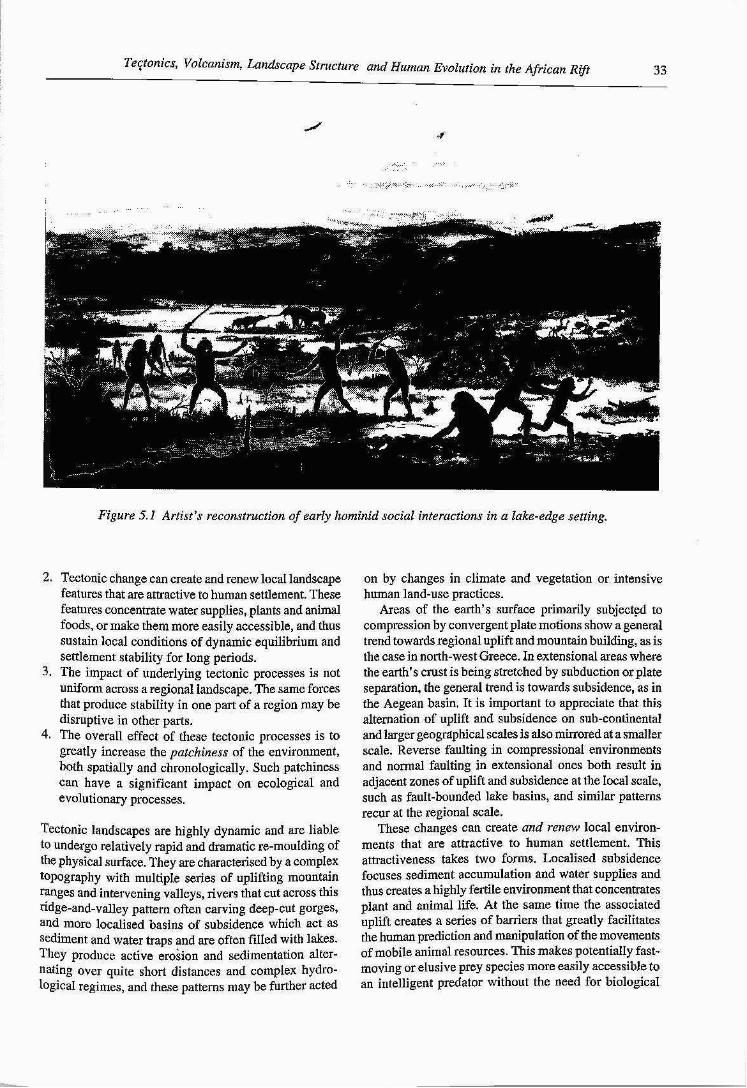
Thus, the landscapes studied by geomorphologists, geologists and geophysicists are typically dominated by physical dynamics, and the human occupants are essen- tially out of sight or at best passive spectators. Conversely, an archaeological or palaeoanthropological perspective is one dominated by a foreground of biological and cultural dynamics with hominids as the centre of focus and an essentially passive and distant, albeit variable and changing, physical environment. The artist's recon- struction of an early hominid scene (Fig. 5.1) offers a graphic if somewhat exaggerated ilIustration of this point, with a foreground of active and indeed violent socid interactions, and an environmental background composed, appropfiately enough, of a volcanic mountain largely obscured by cloud.
Here we focus on the dynamic interactions that occur at the interface between the physical environment and hliman behaviour at the local scale. In particular we aim to show that the tectonics of the African Rift create a distinctive and complex topographic structure character- ised by varying combinations of changing lake basins and river vaIleys, fauIt scarps and lava flows. We argue that a landscape structured in this way was highly attractive to early hominids, and may have exerted selective pressures favouring bipedalism, the exploitation of animaI foods, and evolutionary divergence.
Discussion of interactions between humans and the physical environment tends to veer towards one of two extremes. Either humans are seen as passive tools of environmental change, or the environment is treated as essentially inert until acted on by human agency. Both are equally deterministic in their own way and both imply an essentially one-way relationship - either the physical environment is seen as determining behaviour, or behaviour is seen as determining what is significant in the physical environment. Intermediate interactions of varying strength can, however, be envisaged. h the hypothesis that we advance below, we do not imply that the course of human evolution was determined by the structbre of tectonic landscapes. Our point is rather that
the interaction between hominids and tectonically active environments resulted in new configurations of hominid behaviour that wouId not otherwise have occuhed. Early hominids selected certain sorts of environments, and these in turn selected for certain sorts of hominFd behaviours in a process of reciprocal interaction that amplified some patterns of behaviour at the expense o& others. This process is simiIar in some respects to that of a co- evolutionary relationship, commonly defined in biology as a situation in which two or more taxa undergo evolutionary change as a result of reciprocal selective pressures that each imposes on the other through their mutual ecoIogica1 interaction (Pianka 1980). Recent examples of land use, where human activity is having a dramatic impact on the physical landscape and the changed physical landscape in its turn is further affecting human activity, could properly, in our view, be described as an example of a CO-evolutionary process invoIving reciprocal interactions between physical, biological and cultural variables. The example that we describe below is not strictly a case of CO-evolutionary development in that sense because the physical landscape was not (so far as we know) affected by the presence of hominid or other large-mammal activity. On the other hand, the distinctive landscapes that we describe below could have significantly altered or accelerated the pattern of co- evolutionary relationships between biological species, and cannot be treated as an essentially passive or uniform tabula rasa awaiting the imprint of ecologicaI and evolutionary processes. We suggest that concepts of co- evolutionary behaviour and environmental selection provide a fruitful framework for examining interactions between variations of the physical environment and its biotic occupants including humans, and one that avoids the charge of determinism and the consequent dismissal of relevant factors - environmental, behavioural or cultural as the case may be.
TECTONIC ENVIRONMENTS AND PALAEOLITHIC SUBSISTENCE
We begin with a brief example from the Middle and Upper Palaeolithic of north-west Greece, an area which is subject to very high rates of tectonic activity as a consequence of its position at the boundary between the African and European plates (BaiIey et al. 1993; King et al. 1994). It is also an area that has been the focus of detailed studies of Palaeolithic environment, economy and archaeology (Bailey 1997). We emphasise and elaborate on the following four points:
I. Tectonic activity accelerates processes of landscape change both directly by uplift and subsidence, and indirectly by amplifying or moderating the effect of climatic change and human land use, and it does so at a variety of chronological and geographical scales.
Tectonics, Volcanism, Landscape Structure and Human Evolution in the African R@ 33
/ d
Figure 5. I Artist's reconstruction of early hominid social interactions in a lake-edge setting.
2. Tectonic change can create and renew locaI landscape features that are attractive to human settlement. These features concentrate water supplies, plants and animal foods, or make them more easily accessible, and thus sustain local conditions of dynamic equilibrium and settlement stability for long periods.
3. The impact of underlying tectonic processes is not uniform across a regional landscape. The same forces that produce stabiIity in one part of a region may be disruptive in other parts.
4. The overall effect of these tectonic processes is to greatIy increase the patchiness of the environment, both spatially and chrono1ogically. Such patchiness can have a significant impact on ecological and evolutionary processes.
Tectonic landscapes are highIy dynamic and are liable to undergo relativeIy rapid and dramatic re-mouIding of the physical surface. They are characterised by a compIex topography with multiple series of uplifting mountain rages and intervening valleys, rivers that cut across this ridge-and-valley pattern often carving deep-cut gorges, and more localised basins of subsidence which act as sediment and water traps and are often fiIIed with lakes. They produce active erosion and sedimentation alter- nating over quite short distances and complex hydro- logicaI regimes, and these patterns may be further acted
on by changes in climate and vegetation or intensive human land-use practices.
Areas of the earth's surface primarily subjected to compression by convergent plate motions show a general trend towards regional uplift and mountain building, as is the case in north-west Greece. In extensional areas where the earth's crust is being stretched by subduction or plate separation, the general trend is towards subsidence, as in the Aegean basin, It is important to appreciate that this alternation of upIift and subsidence on sub-continental and larger geogaphical scales is also mirrored at a smaller scale. Reverse faulting in compressiona1 environments and normal faulting in extensional ones both result in adjacent zones of uplift and subsidence at the Iocal scale, such as fault-bounded lake basins, and similar patterns recur at the regionaI scale.
These changes can create and renew local environ- ments that are attractive to human settlement. This attractiveness takes two forms. Localised subsidence focuses sediment accumulation and water supplies and thus creates a highly fertile environment that concentrates plant and animal life. At the same time the associated uplift creates a series of barriers that greatly faciIitates the human prediction and manipulation of the movements of mobile animal resources. This makes potentialIy fast- moving or eIusive prey species more easily accessible to an intelligent predator without the need for biological
:g and Isabdle Manighetti 34 Gsoff Bailey, Geoffrey Kin
abiIities of rapid movement or elaborate technological means of killing at a distance such as spear throwers and guns. Repeated fault movements on the same axis continuously rejuvenate these features, sustaining a fertile environment and maintaining sharp topographic barriers, and can create a climatically insensitive Iocal area that sustains attractive conditions for human existence regardIess of external cIimatic changes.
The region of north-west Greece has been undergoing compression throughout the Tertiary and Quaternary periods, and continues to show rates of seismicity and tectonic activity which are amongst some of the highest in the world (King et al. 1993). The archaeological record extends back at least over the past 100,000 years, with long sequences of Middle and Upper PalaeoIithic material in open air sites or limestone rockshelters associated with a subsistence economy in which large game animals (red deer, horse, cattle and ibex) were a major resource (Bailey 19971,
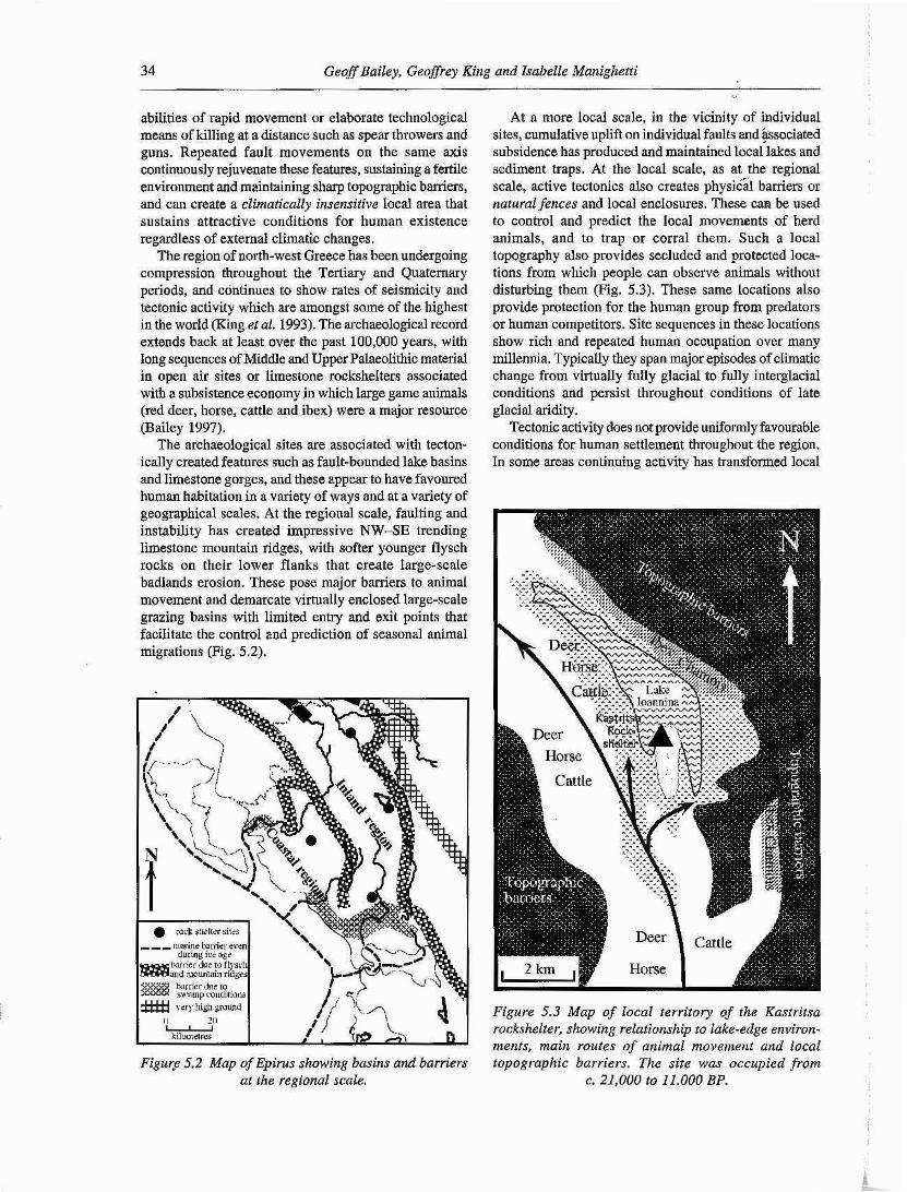
The archaeological sites are associated with tecton- ically created features such as fault-bounded lake basins and limestone gorges, and these appear to have favoured human habitation in a variety of ways and at a variety of geographical scales. At the regional scale, faulting and instability has created impressive NW-SE trending limestone mountain ridges, with softer younger flysch rocks on their lower flanks that create large-scaIe badlands erosion. These pose major barriers to animal movement and demarcate virtually enclosed large-scale grazing basins with limited entry and exit points that facilitate the control and prediction of seasonal animal migrations (Fig. 5.2).
Figuce 5.2 Map of Epirus showing basins and barriers at the regional scale,
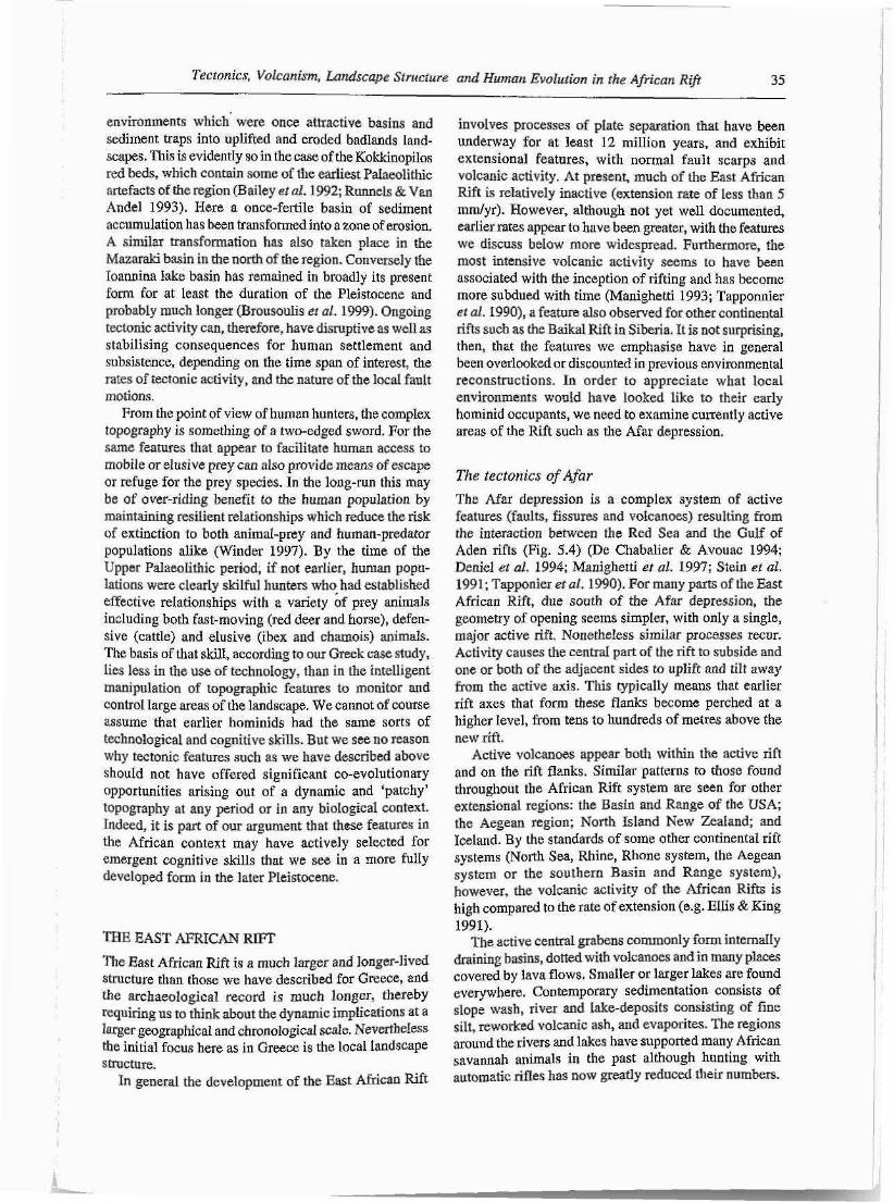
At a more local scale, in the vicinity of individual sites, cumulative uplift on individual faults and @sociated subsidence has produced and maintained local lakes and sediment traps. At the local scale, as at the regional scale, active tectonics also creates physicd barriers or natural fences and local enclosures. These can be used to control and predict the local movemnts of herd animals, and to trap or corral them. Such a local topography also provides secluded and protected loca- tions from which people can observe animals without disturbing them (Fig. 5.3). These same locations abo provide protection for the human group from predators or human competitors. Site sequences in these locations show rich and repeated human occupation over many millennia. Typically they span major episodes of climatic change from virtually fully glacial to fully interglacial conditions and persist throughout conditions of late glacial aridity.
Tectonic activity does not provide uniformly favourable conditions for human settlement throughout the region. In some areas continuing activity has transformed local
Figure 5.3 Map of local territory of the Kastritsa rockshelter, showing relationship to lake-edge environ- ments, main routes of animal movement and local dopographic barriers. The side was occupied frona
c. 21,000 to 11.000 BP.
Tectonics, Volcanism, Landscape Structure and Human Evolution in [he African Rift 35
environments which' were once attractive basins and sediment traps into uplifted and eroded badlands land- scapes. This is evidently so in the case of the Kokkinopilos red beds, which contain some of the earliest Palaeolithic artefacts of the region (Bailey et al. 1992; Runnels & Van Andel 1993). Hare a once-fertile basin of sediment accumulation has been transformed into a zone of erosion. A similar transformation has also taken place in the Mazaraki basin in the north of the region. Conversely the Ioannina lake basin has remained in broadly its present form for at least the duration of the Pleistocene and probably much longer (Brousoulis et al. 1999). Ongoing tectonic activity can, therefore, have disruptive as well as stabilising consequences for human settlement and subsistence, depending on the time span of interest, the rates of tectonic activity, and the nature of the locaI fault motions.
From the point of view of human hunters, the complex topography is something of a two-edged sword. For the same features that appear to facilitate human access to mobile or elusive prey can also provide means of escape or refuge for the prey species. In the long-run this may be of over-riding benefit to the human population by maintaining resilient relationships which reduce the risk of extinction to both animal-prey and human-predator populations alike (Winder 1997). By the time of the Upper Palaeolithic period, if not earlier, human popu- lation~ were clearly skilful hunters who had established effective relationships with a variety bf prey animals including both fast-moving (red deer and horse), defen- sive (cattle) and eIusive (ibex and chamois) animals. The basis of that skill, according to our Greek case study, lies less in the use of technology, than in the intelligent manipulation of topographic features to monitor and controI Iarge areas of the landscape. We cannot of course assume that earlier hominids had the same sorts of technological and cognitive skills. But we see no reason why tectonic features such as we have described above should not have offered significant CO-evolutionary opportunities arising out of a dynamic and 'patchy' topography at any period or in any biological context. Indeed, it is part of our argument that these features in the African context may have actively selected for emergent cognitive skills that we see in a more fully developed form in the later Pleistocene.
THE EAST AFRICAN RIFT
The East African Rift is a much larger and longer-lived structure than those we have described for Greece, and the archaeological record is much longer, thereby requiring us to think about the dynamic implications at a lager geographical and chronologica1 scale. NevertheIess the initial focus here as in Greece is the local Iandscnpe structure.
In general the development of the East African Rift
involves processes of plate separation that have been underway for at least 12 million years, and exhibit extensional features, with normal fault scarps and volcanic activity. At present, much of the East African Rift is relatively inactive (extension rate of less than 5 mmlyr). However, although not yet well documented, earIier rates appear to have been greater, with the features we discuss below more widespread. Furthermore, the most: intensive voIcanic activity seems to have been associated with the inception of rifting and has become more subdued with time (Manighetti 1993; Tapponnier et al. 19901, a feature also observed for other continental rifts such as the Baikal Rift in Siberia. It is not surprising, then, that the features we emphasise have in general been overlooked or discounted in previous environmental reconstructions. In order to appreciate what local environments would have looked like to their early hominid occupants, we need to examine currently active areas of the Rift such as the Afar depression.
The tectonics of Afar
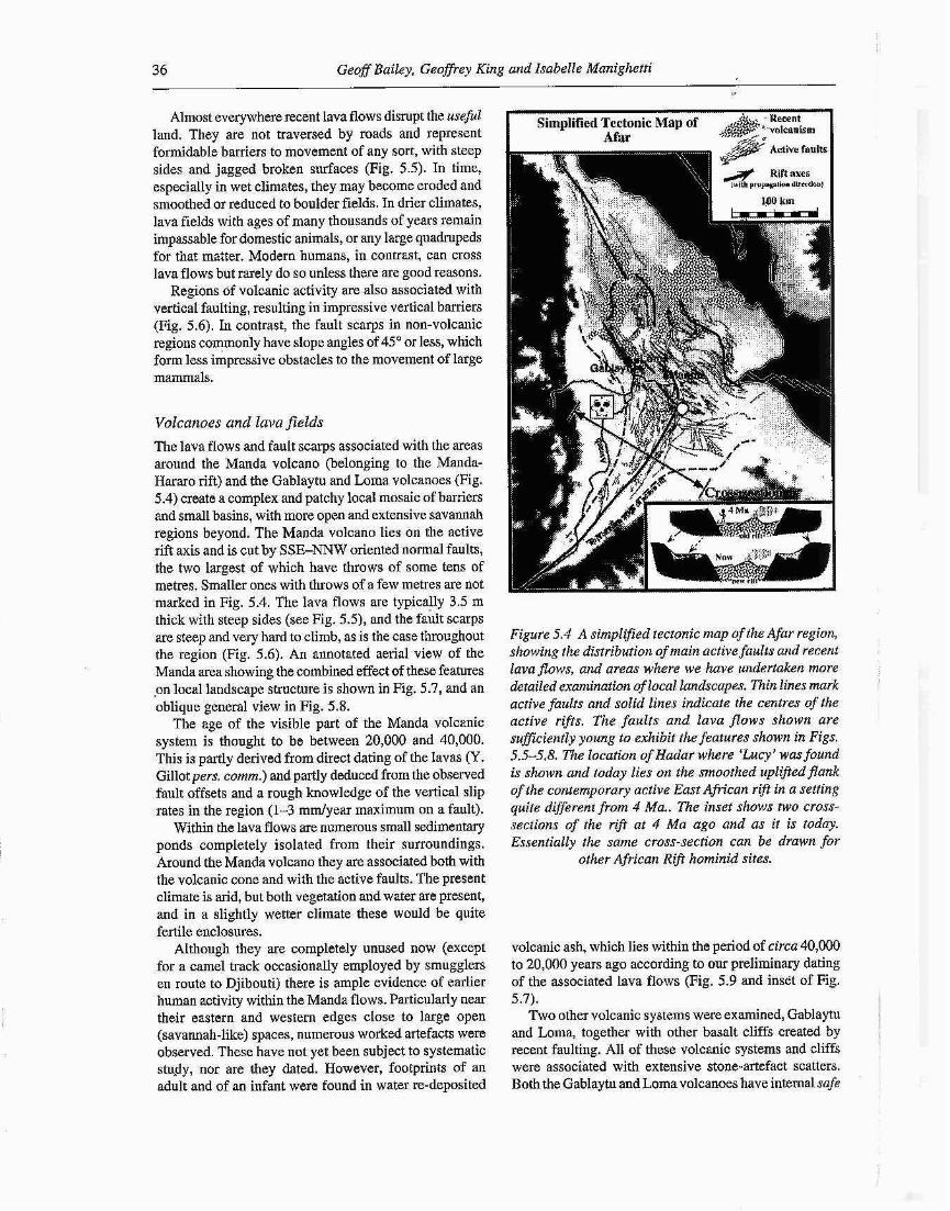
The Afar depression is a complex system of active features (faults, fissures and volcanoes) resulting from the interaction between the Red Sea and the Gulf of Aden rifts (Fig. 5.4) (De Chabalier & Avouac 1994; Deniel et al. 1994; Manighetti et al. 1997; Stein et al. 199 1 ; Tapponier et al. 1990). For many parts of the East African Rift, due south of the Afar depression, the geometry of opening seems simpler, with only a single, major active rift. Nonetheless similar processes recur. Activity causes the centraI part of the rift to subside and one or both of the adjacent sides to uplift and tilt away from the active axis. This typically means that earlier rift axes that form these flanks become perched at a higher Ievel, from tens to hundreds of metres above the new rift.
Active volcanoes appear both within the active rift and on the rift flanks. Similar patterns to those found throughout the African Rift system are seen for other extensional regions: the Basin and Range of the USA; the Aegean region; North Island New Zealand; and Iceland. By the standards of some other continental rift systems (North Sea, Rhine, Rhone system, the Aegean system or the southern Basin and Range system), however, the volcanic activity of the African Rifts is high compared to the rate of extension (e.g. Ellis & King 1991).
The active central grabens commonly form internaIIy draining basins, dotted with volcanoes and in many places covered by lava flows. Smaller or larger lakes are found everywhere. Contemporary sedimentation consists of slope wash, river and Iake-deposits consisting of fine silt, reworked volcanic ash, and evaporites. The regions around the rivers and lakes have supported many African savannah animals in the past although hunting with automatic riffes has now greatly reduced their numbers.
36 Geoff Bailey, GeofSrey Kii ~g and Isabelle Manighetti
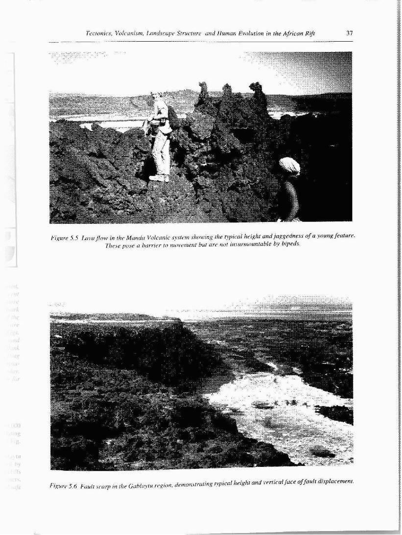
Almost everywhere recent lava flows disrupt the useful land. They are not traversed by roads and represent formidable barriers to movement of any sort, with steep sides and jagged broken surfaces (Fig. 5.5). In time, especially in wet climates, they may become eroded and smoothed or reduced to bouIder fields. In drier climates, lava fields with ages of many thousands of years remain impassable for domestic animals, or any large quadrupeds for that matter. Modern humans, in contrast, can cross lava flows but rarely do so unless there are good reasons.
Regions of volcanic activity are also associated with vertical faulting, resulting in impressive vertical barriers (Fig. 5.6). In contrast, the fault scarps in non-volcanic regions commonly have slope angles of 45" or less, which form less impressive obstacles to the movement of large mammals.
Volcanoes and lava fields
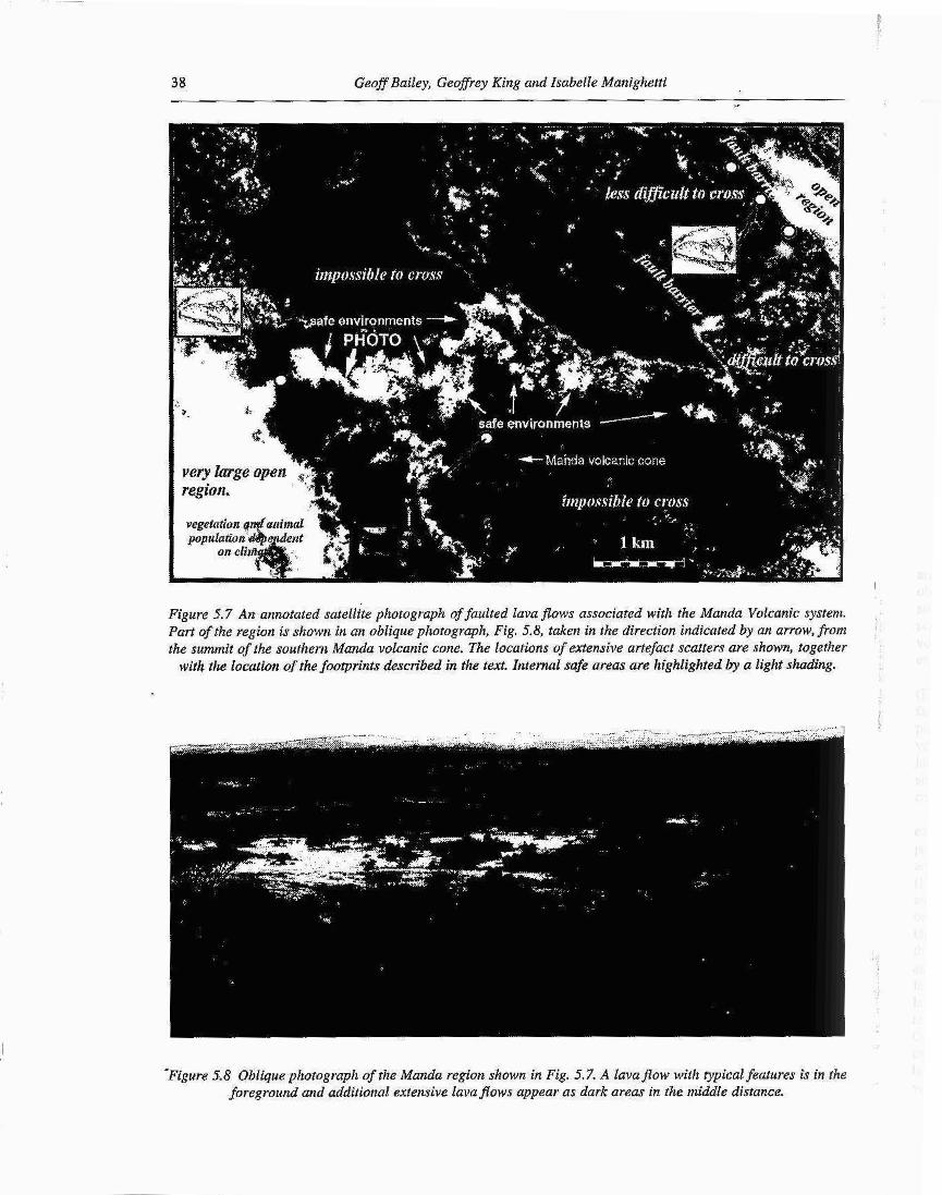
The lava fIows and fault scarps associated with the areas around the Manda volcano (belonging to the Manda- Hararo rift) and the Gablaytu and Loma volcanoes (Fig. 5.4) create a complex and patchy local mosaic of barriers and small basins, with more open and extensive savannah regions beyond. The Manda volcano lies on the active rift axis and is cut by SSE-NNW oriented normal faults, the two largest of which have throws of some tens of metres. SmaIler ones with throws of a few metres are not marked in Fig. 5.4. The lava flows are typically 3.5 m thick with steep sides (see Fig. 5.5), and the fault scarps are steep and very hard to climb, as is the case throughout the region (Fig. 5.6). An annotated aerial view of the Manda area showing the combined effect of these features "on local landscape structure is shown in Fig. 5.7, and an oblique general view in Fig. 5.8.
The age of the visible pare of the Manda voIcanic system is thought to be between 20,000 and 40,000. This is partly derived from direct dating of the Invas [Y. Gillot pers, comm.) and partly deduced from the observed fault offsets and a rough knowledge of the vertical slip rates in the region (1-3 mmlyear maximum on a fault).
Within the lava flows are numerous small sedimentary ponds completely isolated from their surroundings. Around the Manda volcano they are associated both with the volcanic cone and with the active faults. The present climate is arid, but both vegetation and water are present, and in a slightly wetter climate these would be quite fertile enclosures.
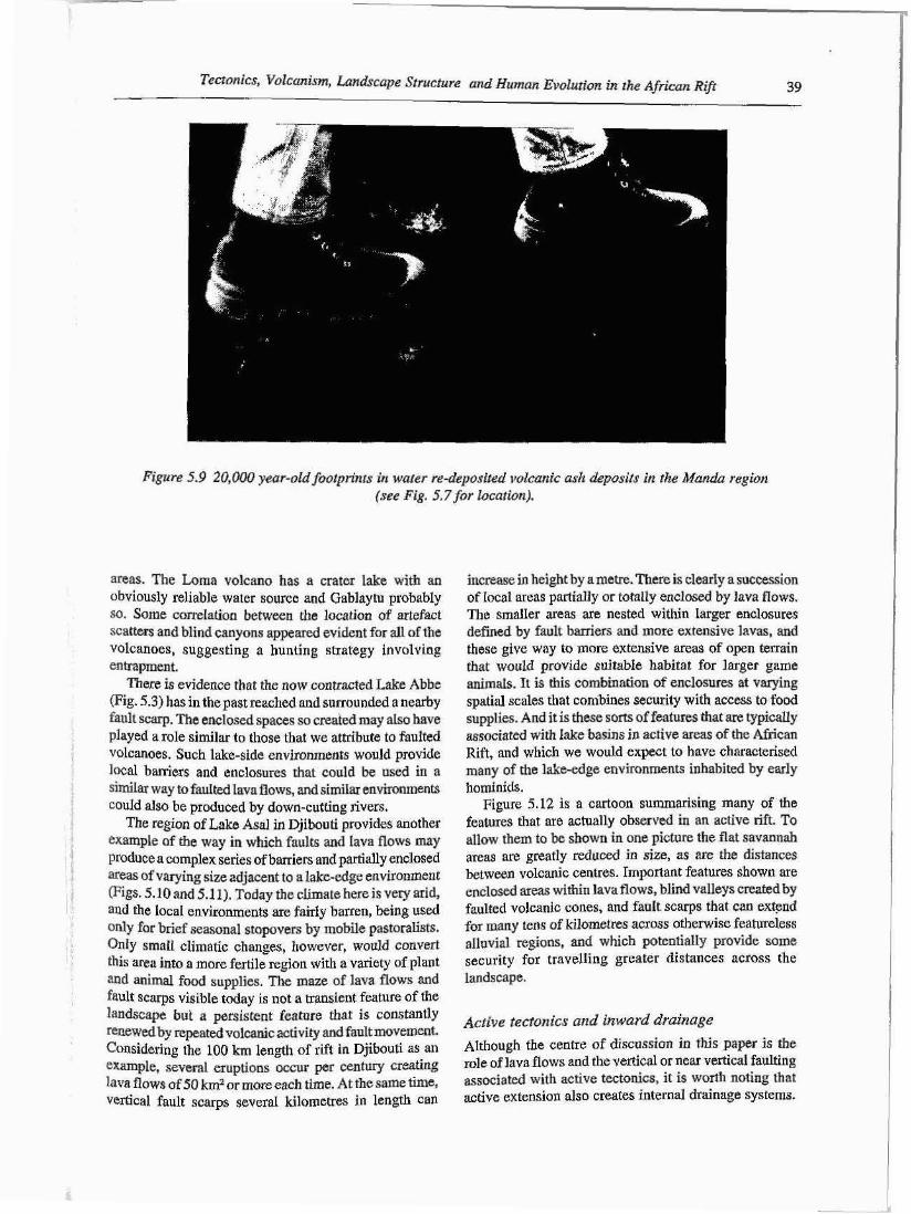
AIthough they are completely unused now (except for a camel track occasionally employed by smugglers en route to Djibouti) there is ample evidence of earlier human activity within the Manda flows. ParticularIy near their eastern and western edges dose to large open (savannah-like) spaces, numerous worked artefacts were observed. These have not yet been subject to systematic study, nor are they dated. However, footprints of an adult and of an infant were found in water re-deposited
I Simplified Tectonic Map of di8&@ :o~tkm 1 Afar >>..-*
Figure 5.4 A simpl$ed tectonic map of the Afar region, showing the distribution of main active faults and recent lava flows, and areas where we have undertaken more detailed examination of local landscapes. Thin lines murk ' active faults and solid lines indicate the centres of the active r#s. The faults and lava flows shown are suflciently young to exhibit the features shown in Figs. 5.5-5,8. The location of Hadar where 'hey' was found is shown and today lies oa the smoothed uplifted flank of the contemporary active East African rift in a setting quite different from 4 Ma.. The inset shows two cross- sections of the rift at 4 Ma ago and as it is today. Essentially the same cross-section can be drawn for
other African Rift hominid sites.
volcanic ash, which lies within the period of circa 40,000 to 20,000 years ago according to our preliminary dating of the associated lava flows (Fig. 5.9 and inset of Fig. 5.7).
Two other volcanic systems were examined, Gablaytu and Loma, together with other basalt cliffs created by recent faulting. A11 of these volcanic systems and cliffs were associated with extensive stone-artefact scatters. Both the GabIaytu and Loma volcanoes have internal safe
~ ' L ~ C I U I I ~ I ~ S , IJo/~~~~.utt i . lnl , I J ~ I T ~ ~ . Y C ~ I ~ ~ J S ~ ~ U I . I I I J L ' a ~ d Jlunacl~~ Emlurion b~ rhe Africun Riff 37 ................ P ................ .
I ' ' i # u ~ 5..5 ~ I V O ~ I O W in ilrr M(~nrlcr Volcntlio sysfrrrl ,sho\t.r.ing the tyj>ic:c11 hrigIti und jcrpgrdnesr c $ ~ y o u r ~ ~ fenlurr.. ?.l~rhc~ pri,sP rr hr~rrir,. I O t t ~ o v r ~ ~ ~ ~ ~ ~ a t hur (IT(, tioi ills-r~rmounruble bv brpeds.
38 Geoff Bailey, GeofSrey King and Isabelle Manighetti
Figure 5.7 An annotated satellhe photograph of faulted lava flows associated with the Manda Volcanic system. ,
Part offhe region is shown in an oblique photograph, Fig. 5.8, token in the direction indicated by an arrow, from ; the summit of the southern Mundu volcanic cone. The locations of extensive artefact scatters are shown, together
with the location of the footprints described in the text. Internul safe oreas are highlighfed by a light shading.
-Figure 5.8 Oblique phofograph of rhe Manda region shown in Fig. 5.7. A lovopow with ~ p i c a l features is in the foreground and additional extensive lava flows appear as dark areas in the middle distance.
Tectonics, Volcunism, Landscape Srructure and Human Evolution in the African Rift 39
Figure 5.9 20,000 year-old footprints in water re-deposited volcanic ask deposits in the Manda region (see Fig. 5.7 for location).
areas. The Loma volcano has a crater lake with an obviously reliable water source and Gablaytu probably SO. Some correlation between the location of artefact scatters and blind canyons appeared evident for all of the volcanoes, suggesting a hunting strategy involving entrapment.
There is evidence that the now contracted Lake Abbe (Fig. 5.3) has in the past reached and surrounded a nearby fault scarp. The enclosed spaces so created may aIso have played a role similar to those that we attribute to faulted volcanoes. Such lake-side environments would provide local barriers and enclosures that could be used in a simiIar way to fauIted Iavn flows, and similar environments could also be produced by down-cutting rivers.
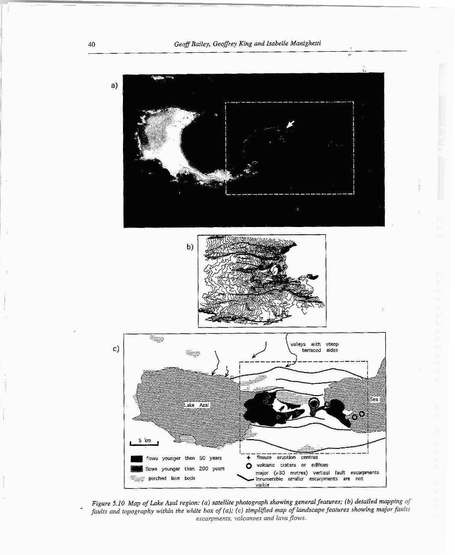
The region of Lake Asal in Djibouti provides another example of the way in which faults and Iava flows may produce a complex series of barriers and partially enclosed areas of varying size adjacent to alake-edge environment (Figs. 5.10 and 5.1 1). Today the climate here is very arid, and the IocaI environments are fairly barren, being used only for brief seasonal stopovers by mobile pastoralists. Only smaIl climatic changes, however, would C O ~ V . E I ~
this area into a more fertile region with a variety of plant and animal food supplies. The maze of lava flows and fault scarps visible today is not a transient feature of the landscape but a persistent feature that is constantly renewed by repeated vobanic activity and fault movement. Considering the 100 km length of nft in Djibouti as an example, several eruptions occur per century creating lava flows of 50 km2 or more each time. At the same time, vertical fault scarps severaI kilometres in length can
increase in height by a metre. There is clearly a succession of Iocal areas partially or totally enclosed by lava flows, The smaller areas are nested within Iarger enclosures defined by fault barriers and more extensive lavas, and these give way to more extensive areas of open terrain that would provide suitable habitat for larger game animals. It is this combination of enclosures at varying spatid scales that combines security with access to food supplies. And it is these sorts of features that are typically associated with Iake basins in active areas of the African Rift, and which we would expect to have characterised many of the l&e-edge environments inhabited by early hominids.
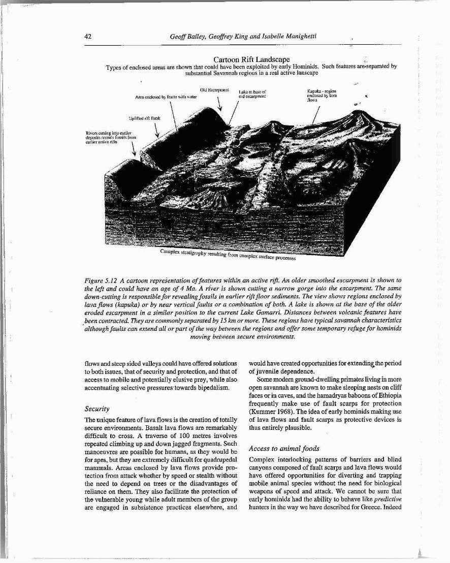
Figure 5.12 is a cartoon summarising many of the features that are actually observed in an active rift. To allow them to be shown in one picture the flat savannah areas are greatly reduced in size, as are the distances between volcanic centres. Important features shown are enclosed areas within lavaflows, blind valleys created by faulted volcanic cones, and fault scarps that can extend for many tens of k i lomet~s across otherwise featureless alluvial regions, and which potentialIy provide some security for travelling greater distances across the landscape.
Active tectonics and inward draiaage Although the centre of discussion in this paper is the role of lava flows and the vertical or near vertical faulting associated with active tectonics, it is worth noting that active extension also creates internal drainage systems.
40 GeoJSP Bailey, Geoflrey King and Isabelle Manighetti
1 ..A ......... ......... . * . - * ., ... l vallevs with steep
.... ......... ......... .....7 / 5 "terraced sides ll-d-dl-dl--l 1
-- -. flows younger than 50 years + fissure eruption centres
0 v ~ l c a n ~ c craters or edif~ces m flows younger than 200 years maior (>30 metres) vertical fault escarpments .... .......... ...... perched lake beds \ inkrneible smaller escarpments are not ......... I ....
visible 1
Figure 5.10 Map of Lake Asal region: (a) satellite photograph showing general features; (b ) detailed mapping of faults and topography within the white box of (a); (c) simpl8ed map of landscape features showing major faults
escarpments, volcanoes and lavaflows.
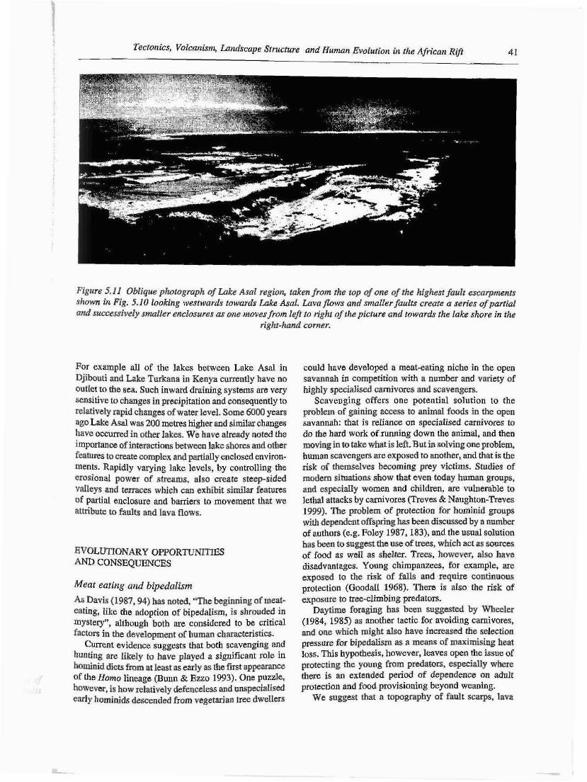
Tectonics, Volcanim, Landscape Sfructure and Human Evolution in the African Rij? 41
Figure 5.11 Oblique photograph of Lake Asal region, taken from the top of one ofthe highest fault escarpments shown in Fig. 5.10 looking westwards towards Lake Asal. L.uva j h w s and smaller faults create U series of partial and successively smaller enclosures as one moves from lefr to right of the picture and towards the lake shore in the
right-hand corner.
For example all of the lakes between Lake Asal in Djibouti and Lake Turkana in Kenya currently have no outlet to the sea. Such inward draining systems are very sensitive to changes in precipitation and consequently to relatively rapid changes of water level. Some 6000 years ago Lake Asal was 200 metres higher and similar changes have occurred in other lakes. We have already noted the importance of interactions between lake shores and other features to create complex and partially enclosed environ- ments. Rapidly varying lake levels, by controlling the erosional power of streams, also create steep-sided vaIleys and terraces which can exhibit similar features of partial enclosure and barriers to movement that we attribute to faults and lava flows.
EVOLUTIONARY OPPORTUNITIES AND CONSEQUENCES
Meat eating and bipedalisrn
As Davis (1987,94) has noted, "The beginning of meat- eating, like the adoption of bipedalism, is shrouded in mystery", although both are considered to be critical factors in the development of human characteristics.
Current evidence suggests that both scavenging and hunting are likely to have played a significant role in hominid diets from at least as early as the fist appearance of the Homo lineage (Bum & Ezzo 1993). One puzzle, however, is how relatively defenceless and unspecidised e d y horninids descended from vegetarian tree dweIIers
could have developed a meat-eating niche in the open savannah in competition with a number and variety of highly specialised carnivores and scavengers.
Scavenging offers one potential solution to the problem of gaining access to animaI foods in the open savannah: that is reliance on specialised carnivores to do the hard work of running down the animal, and then moving in to take what is left. But in solving one problem, human scavengers are exposed to another, and that is the risk of themselves becoming prey victims. Studies of modern situations show that even today human groups, and especidly women and children, are vulnerable to lethal attacks by carnivores (Treves & Naughton-Treves 1999). The problem of protection for hominid groups with dependent offspring has been discussed by a number of authors (e.g. Foley 1987, 183), and the usual solution has been to suggest the use of trees, which act as sources of food as we11 as shelter. Trees, however, also have disadvantages. Young chimpanzees, for example, are exposed to the risk of falls and require continuous protection (Goodall 1968). There is also the risk of exposure to tree-climbing predators.
Daytime foraging has been suggested by Wheeler (1984, 1985) as another tactic for avoiding carnivores, and one which might also have increased the selection pressure for bipedalism as a means of maximising heat loss. This hypothesis, however, leaves open the issue of protecting the young from predators, especially where there is an extended period of dependence on adult protection and food provisioning beyond weaning.
We suggest that a topography of fault scarps, lava
42 Geoff Bailey, Geoffrey King and Isabelle Manighetti
Cartoon Rift Landscape i- I
Types of enclosed w a s are shown that could have been exploited by early Elorninids. Such fentures rtre*sepslfilted by substantial Savnnnah redons in a reat active lanscnp
Old Fscnrpmcnl , ab at
Arcacnclowl bg faults nith unler old c s ~ r p m c l ~
Figure 5.12 A cartoon repreientation of features within an active r$t. An older smoothed escarpment is shown to the lefr and could have an age of 4 Mu. A river is shown cutting a narrow gorge into the escarpment. The same hwn-cutting is responsible for revealing fossils in earlier rift floor sediments. The view shows regions enclosed by lava flows (kupuka) or by near vertical faults or a combination of both. A lake is shown at the base of the older eroded escarpment in a similar position to the current Lake Gamarri. Distances between volcanic features have been contracted. Khey are commonly separated by 15 km or more. These regions have typical savannah characteristics although faults can extend all or part of the way between the regions and offer some temporary refuge for hominids
moving between secure environments.
flows and steep sided valleys could have offered solutions to both issues, that of security and protection, and that of access to mobile and potentially eIusive prey, while aIso accentuating selective pressures towards bipedalism.
The unique feature of lava flows is the creation of totally secure environments. Basalt lava flows are remarkably difficult to cross. A traverse of 100 metres involves repeated cIirnbing up and down jagged fragments. Such manoeuvres are possible for humans, as they would be for apes, but they are extremely difficult for quadruped$ mammals. Areas enclosed by Iava flows provide pro- tection from attack whether by speed or stealth without the need to depend on trees or the disadvantages of reliance on them. They aIso facilitate the protection of the vulnerable young while adult members of the group are engaged in subsistence practices elsewhere, and
would have created opportunities for extendin6the period of juvenile dependence.
Some modern ground-dwelling primates living in more open savannah are known to make sleeping nests on cliff faces or in caves, and the hamadryas baboons of Ethiopia frequently make use of fault scarps for protection (Kummer 1968). The idea of early hominids making use of lava flows and fault scarps as protective devices is thus entirely plausible.
Access to animal foods Complex interlocking patterns of barriers and blind canyons composed of fauIt scarps and lava flows would have offered opportunities for diverting and trapping mobile animal species without the need for biological weapons of speed and attack. We cannot be sure that early hominids had the ability to behave like predictive hunters in the way we have described for Greece. Indeed
Tectonics, Volcanism, Landscape Structure and Human Evolution in the African R@ 43
. there is considerabIe controversy over the extent to which : hunting was carried out at all in the earlier periods of
human evolution. But the presence of topographic opportunities would certainly have created selective pressures for the development of such abilities, by offering important competitive advantages to a vulrterable horninid in otherwise relatively open savannah environ- ments.
Food supplies Unlike trees, lava flows, or small areas isolated within them, provide little or no food, which must be brought in from elsewhere. Animals brought down by hunting might conceivably have been diverted into topographic traps formed by Iava flows before being killed, so as to minimise the distance over which the carcass had to be carried to a safe location. Even if hunting were not practised, meat acquired from scavenging would most probably have required transportation as would plant foods, if they were to be eaten at leisure in secure locations. As noted by numerous other authors bipedalism favours the transport of food by largely freeing the upper limbs {Lovejoy 198 1). Limited modification leaves the same animal with the ability to negotiate cliffs and lava flows. We emphasise that food transportation in such a situation does not presuppose food sharing or a division of labour as envisaged by Isaac's (1978b) original food- sharing hypothesis, though such behaviours may be an outcome. It presupposes only the need to remove food from the point of capture or collection to a safe location for consumption.
Tools
Lava flows provide simple stone tools, sharp rock fragments are to hand everywhere and are usable without modification. The materials to create more sophisticated tools such as obsidian are also available.
Fire
Very early evidence for the use of fire remains contro- versial, but the association of early hominid activity with volcanically active areas would certainly have enhanced the possibilities for observing and making use of the benefits and effects of fire and heat (Gowlett et al. 1981). Furnaroles might have encouraged experiments with cooking.
Pressure towards change Forested environments are essentially uniform in terms of the physical selection pressures they impose on species adapted to a forested habitat, except to the extent that areas of forest may expand or contract with climatic change. Such large-scale variations can alter
the patchiness of a landscape and thus the balance of predator-prey relationships, and the general contraction of forest in the late Tertiary is, of course, generally considered to be a key large-scale factor in opening up the hominid niche. At the smalIer scales that are our focus here, however, landscapes characterised by fault- ing and volcanic lava flows may show greater variability than forests in the degree to which they provide en- closure and protection. Lava flows are not all the same. Although numerous completely enclosed areas exist, many more are partially enclosed or are in Iava flows that are eroded sufficiently to be more readily traversed. Furthermore as climate changes, lava flows stay fixed. This offers a challenging environment to a species that inhabits them.
The existence of a range of niches that were similar in their general characteristics but different in detail would have provided an added incentive to evolutionary change, either through niche separation or by selecting for intra-species adaptability.
DISCUSSION
The modern equivalents of the sites of early hominid finds lie among the active faults and volcanoes of the currently active parts of the East African Rift. No reports of studies in these regions are to be found and they are generally regarded as inhospitable and inaccessible. Yet within then1 secure areas exist that could provide a refuge for an ape-like creature deprived of trees and an environment where bipedalism would confer advantages. Even a brief visit suggests that evidence for prehistoric occupation is strong, and that these seemingly inhospitable landscapes provided attractions for human settlement. Although not many sites have been identified, those that have are associated with the contemporaneous rift activity. Conversely, it is notable that scarceIy any trace of stone tools was observed in the more open terrain on theManda Hararo rift flank, despite the fact that more than 60 locations similar in many respects to those we refer to in the central rift were visited forpalaeomagnetic dating. By contrast, pastoral activity is now well developed on the rift flanks and rock paintings of domesticated camels suggest that this may have been so for some time. The implication is that, until the advent of animal domesti- cation, human habitation of such regions was not practical. Although this is the savannah in which early hominids have commonly been placed, i t appears that human occupation has only recently extended into it.
It also appears that at least some of the tribal people of the Kenyan Rift Valley were familiar with lava-flow environments. When deprived of firearms by the British in Kenya, the local people notoriously disappeared into a region of volcanoes and lava flows into which they could not be followed. Presumably they knew how to exploit the environment to survive. Thus it may be at

44 Geoff Bailey, Geoflrey King and Isabelle Manighetti
least as useful to examine how modem people have exploited the active regions of the East African Rift prior to the appearance of guns, as a source of insight and andogy for the sort of ecological niche that we have identified for early horninids, as to examine the behaviour of our nearest living relatives amongst the Great Apes, or the behaviour of carnivores with supposed functional similarities to hominid scavengers or hunters.
The environments that we have described for the present Manda Bararo rift are the exact conditions that will in due course create a future geological environment like that in which many early hominid remains have been found. Interbedded lacustrine and fine terrestrial sediments are associated with ash falls, water-reworked ash and basalt lava flows at Hadar (Taieb er al. 1976; Taieb & Tiercelin 1979), and at other classic Rift Valley sites such as Omo, Turkana and Olduvai (Feibel et al. 1989; Hay 1976; Rapp & Vondra 1981). Examining a contemporary example explains why geologists have such problems correlating strata between individual exposures in separate valleys. Lava flows and sediment traps simply do not correlate except over very short distances, and a layer cake stratigraphy misses an important insight into the nature of the original environment.
Indeed this geological issue is one of several factors that have obscured the role of tectonics at the local scale. Reconstructions of the landscape around early hominid sites tend to produce a picture-of relatively smooth landscapes lacking in physical barriers and topographical detail (e.g. at Olorgesailie (lsaac 1978a; Shackleton 1978), atche Bed I Olduvai sites (Isaac 1981) and at Koobi Fora (Bunn et al. 1980; Isaac & Behrensmeyer 1997). This is an almost inevitable consequence of attempting reconstructions from a Iimited number of geoiogical. 'windows' into a landscape that has undergone radical alteration through ongoing rifting, tectonic activity and erosion since the time of hominid occupation. Such reconstructions inevitably arrive at a lowest common denominator in which locd topographic detail is largely eliminated for the simple reason that it cannot be reconstructed with any confidence - or else has been smoothed away by erosion.
There are two other reasons, in our view, why the tectonic factors we have cited have been overlooked. Firstly, the role of the natural environment in evolutionary trends tends to be dedt with in very general terms, in relation to large-scale phenomena such as regional and global climaticand biotic changes (e.g.Vrba et al. 1995). Numerous studies of the more recent archaeological and pdaeoenvironmental record, however, demonstrate that broad climatic and environmental changes can be significantly modified or moderated by local topographic features (e.g. Bailey 1997). Landscape structure, especi- ally at the local scale, thus becomes a key focus for :mall-scale interactions between populations and environ- mental factors, and these small-scale interactions can have a significant if poorly understood impact on both
short-term ecological interactions and, longer-term evolutionary trajectories. v
Secondly, the African Rift where the best known early hominid sites occur was most probably more active tectonically and volcanically in the late Tertiary and early Quaternary than is the case today. The hithest rates of activity at the present day are to be foufld in eastern Afar and Djibouti, and highly active areas such as these are rarely visited by modern observers and usually regarded as arid, inhospitable and inaccessible areas of lava flows. I There is consequently a general lack of awareness about the physical structure of such active landscapes. However, as we have shown above, there is good evidence that these landscapes can be very attractive for human settlement under appropriate climatic conditions.
CONCLUSION
The hypothesis that we advance here is that lava flows and the young normal faults of tectonically active areas of the African Rift created a local landscape structure that was uniquely appropriate as an agent of environmental selec- tion in the early stages of hominid evolution. We suggest that this process operated both directly, in selecting for and amplifying specjfic feattires such as bipedalism, meat- eating and cognitive development, and indirectly by controlling the pattern of interactions between species and their CO-evolutionary deVelopment. In particular we empha- sise the following features of tectonics in the African Rift:
Unusually high rates of tectonic activity and volcan- ism, associated with a complex pattern of often impassable lava flows and vertical fault scarps. Complex patterns of enclosure at a variety of spatial scales that would have provided opportunities to hominids for the development of new niches as unspecialised predators, as well as protection to hominids as potential prey victims. The creation and maintenance of a rich and diverse mosaic of resources subject to varying degrees of patchiness. Topographic and environmental conditions that were locally variable in time as well as space, offering varying degrees of local isolation and/or regional mixing, and thus acting as an environmental pace- maker for evolutionary developments.
We suggest that this hypothesis has been overlooked both because of the difficulties of reconstructing Plio- ,
Pleistocene topography and locd environmentsin ahighly active tectonic region, and because the classic sites of early hominid discoveries are in areas of the East African Rift which are now probably Jess active than when the sites were formed. Existing reconstructions which show early hominid sites surrounded by smooth alluvial plains are highly misleading because they are uninformed by a knowledge of topography in modem active environments,
Tectonics, Volcaaisq, Landscape Structure and Haman Evolution in the African Rift 45
and because the complex small-scale patterning of local faults and lava barriers that is so critical to an under- standing of these environments cannot easily be recovered from the ancient landscape and has in consequence been erased from the reconstructions.
Finally, we acknowledge that the ideas presented above pose two sorts of challenges to future investigation, one practical, the other theoretical. On the practical side, systematic testing of our basic hypothesis will require two sorts of observations to be undertaken: the systematic archaeological investigation of those modern environ- ments which provide contemporary analogies for the landscapes occupied by early hominids; and the recon- struction of past landscape structure with an eye to barriers and 'sharp' topographic features especially at the local scale. The need for the former arises from precisely the same set of factors which makes the latter so difficult, namely the large-scale transformation of locd environ- mental features that has been effected by continued tectonic activity and environmentd processes of erosion and sedimentation over hundreds of thousands of rniIlen- nia. We do not underestimate the diff~culties posed by both approaches, the dangers of extrapolation from modem analogues in the former case, and the uncertainties of reconstruction in the latter. But we suggest that both need to be attempted, and that in combination they should lead to a better understanding of the environmental context in
to reproduce it, to Nick Winder for highlighting the co- evolutionary significance of tectonic landscapes, to John Price for comments on fumaroles, and to Rob Foley and two anonymous assessors for critical readings of an earlier draft. The fieldwork which stimulated the obser- vations and ideas reported here was undertaken during mapping and palaeomagnetic determination of defor- mation processes in Afar and Djibouti and field excur- sions and discussions associated with the Addis Ababa Conference of 1997 on Flood Basalts, Rifting and Palaeoclimates in the Ethiopian Rift and Afar depression. We thank C.N.R.S. and I.N.S.U., Paris, and the Uni- versity of Newcastle-upon-Tyne for financial support.
REFERENCES
Bailey, G. N. (ed). 1997. Klithi: Paiaeolithic Ssttlemer~r and Qlraremaly landscapes in Northwest Greece. Vol. 1: Excavation and Intra-Site Analysis at Klizhi. Vol. 2: Klithi in its Local and Regional Setting. Cambridge: McDonald Institute for Archaeo- logical Research.
Bailey, G. N., King, G. C. P. and Sturdy, D. A. 1993. Active tectonics and land use strategies: a Palaeolithic example from Northwest Greece. Antiqlrio 67, 292-3 12.
Bailey, G. N., Papaconstantinou, V, and Sturdy, D. A. 1992. Asprochaliko and Kokkinopilos: TL dating and reinterpretation of Middle Palaeolithic sites in Epirus, North-west Greece. Cambridge Archaeological Journal 2, 136-44.
which early hominid evolution took place, and a fuller Blumenschine, R.J. and Peters, C.R. 1998. Archaeological predictions for hominid land use in the paleo-Olduvai Basin, Tanzania, during integration of environmental factors into the understanding lowermost Bed II times. ofHu,ann Evolution 34, 565407.
of ~ ~ - e ~ ~ l ~ t i ~ n a r y processes. Brousoulis, J., Ioakim, C., Kolovos, G. and Papanikos, D. 1999. The On the theoretical side, we observe that differences of loannina basin: geologicaI and palaeoenvironmcntaI evolution in
scale continue to provide one of the most common sources Quaternaty and historical times, pp. ?? in G.N. Bailey, E. Adam,
of confusion and misunderstanding the field human E. PanagopouIou, C. Perlts & K. Zachos (eds.), The Paiaeolithic Archueology of Greece and Adjacent Areas. London: British
evolution and human history, especially between special- school at working in different disciplines or in different time B ~ ~ ~ ~ , F. H, and Feibel, C. S . 1991. Stratigraphy, depositional
periods. At the same time differences of scale also lie at environments and palaeogeography of the Koobi Fora formation,
the very heart of ecodynamic theory and present one of pp. 1-30 in Harris, J.M. (ed), Koobi Fora Research Project,
the most difficult challenges to theoretical understanding. Volume 3, The Fossil Ungulates: Geology, Fossil Artiodactyis, and Pdueoenvironmsnts. Oxford: Clarendon Press.
Not the least part of that is the forging of a Bun", H. T. and Ezzo, J. A. 1993. Hunting and scavenging by Plio- common language that will allow communication across Pleistocene hominids: nutritional constraints, archaeological disciplinary and sub-disciplinary boundaries. However, a common conceptual framework that accommodates differences of scale is unlikely to emerge without a degree of CO-evolutionary intellectual development, in which specialists emerge from behind barriers of isolation, old ideas are abandoned or modified, and new ones experi- mented with. That process of CO-evolutionary intellectual development is not an easy or comfoflable one, as anyone who has engaged in a large-scde multi-disciplinaty project will know. Without it, however, there can be no prospect of understanding the CO-evolutionary nature of the past.
ACKNOWLEDGEMENTS
We are grateful to John Coles for identifying the source of Fig. 5.1 and to Topham Picturepoint for permission
patterns, and behavioural irnplications.~~ournal of Archaeological Science 20, 365-98.
Bunn, H. T., Hams, J. W. K., Isaac, G. L., Kaufulu, Z., KroI1, E., Schick, K., Toth, N. and Behrensmeyer, A. K. 1980. FxJj 50: an early Pleistocene site in northern Kenya. World Archaeology 12, 109-36.
Coppens, Y, 1994. East side story: the origin of humankind. Scientific ,
American 270, 62-9. Davis, S. 1. M. 1987. TIte Archaeology of Animals. London: Batsford. Dc Chabalier, J.-B. and Avouac, LP. 1994. Kinematics of the AsaI
Rift Djibouti determined from the deformation of Fieale VoIcano. Science 265, 1677-81.
Deniel C., Vidal, Ph., Coulon. C., Vellutini, P. l. and Piguet, P. 1994. TempomI evolution of mantle sources during continentd rifting: the volcanism of Djibouti Afar. Journol of Geophysical Restarch 99(B2), 2853-69.
Ellis, M. and King, G. C. P. 1991. Structural control of flank volcanism in Continental Rifts. Science 254, 839-42.
Feibel, C. S.. Brown, F. H. and McDougall, I. 1989. Stratigraphic context of fossil hominids from the Orno group deposits: Northern
46 Geoff Bailey, Geoffrey King and lsubelle Manigketti
Turkana basin, Kenya and Ethiopia, American Journal of Physical Anthropology 78, 595-622.
Foley, R. A. 1987. Another Unique Species: Patterns in Human Evolutionaly Ecology. Harlow: Longman.
Foley, R. A. 1994. Speciation, extinction and climatic change in hominid evolution. Journal of Human Evohtion 26, 27-89.
Foley, R. A. in press. Evolutionary geography of Pliocene African hominids, in Bromage, T, and Schrenk, P. (eds.), African Biogeography, Climaric Change and Early Horninid Evolution. Oxford: Oxford trr~iversity Press.
Gamble, C. S. 1993. Timewalkers: the prshisroty of global colon- ization. Stroud Alan Sutton.
Goodall, J. 1968. The Bshaviour of Free-living Chimpanzees in the Gombe S!ream Reserve. (Animal behaviour Monographs; vol. 1(3)), London: Bailliere, Tindall and Cassell.
Gowlett, J. A. J., Harris, J. W. K., Walton, D. and Wood, B. A. 1981. Early archnenlogical sites, hominid remains and traces of fire from Chesowanja, Kenya. Nulure 294, 12.5-9.
Harris, J. K. and Berbich, 2. 1978. Aspects of early Pleistocenc hominid behaviour of east Lake Turkana, pp. 529-47 in Bishop, W.W. (ed.), Geological Background to Fossil Man. Edinburgh: Scottish Academic Press.
Hay, R. L. 1976. Geology ofthe Olduvai Gorge. Berkelcy: University of California Press.
Issac, G. L. 1978a. The Olorgesailie formation: stratigraphy, tectonics and thc palaeogeographic context of the Middle Pleistocene archaeological sites, pp. 173-206 in Bishop, W.W. (ed.), Geological Backgr~und to Fossil Man. Edinburgh: Scottish Academic Press.
Issac, G. L. 1978b. The food-sharing behavior of protohuman hominids. Scieniific American 238, 90-108.
Isaac, G. L. 1981. Stone Age visiting cards: approaches to the study of early land-usepattcms, pp. 131-55 in Bodder, I., Ismc, G. and Bammond, N. (eds.), Pattern of the Past. Cambridge: Cambridge University Press.
Isaac, G. L. and Behrensmeycr, A. K. 1997. Geological context and palaeoenvironments, pp. 12-19 in Isaac, G. L and Isaac, B. (eds.), Koobi Fora Research Project, Vol. S. Plio-Pleistocene Archae- ology. Oxford: Clarendon Press.
King, G. C. P., Sturdy, D. A. and Bailey, G. N. 1994. Active tectonics, complex topography and human survival strategics. Journal of Geophysical Research 99(310), 20063-78.
Kummcr, H . 1968. Social Organization of the HamQdryas Baboon. Chicago: University of Chicago Press.
Lovejoy, C. 0. 1981. The origin of man. Science 211, 341-50. Manighetti, I. 1993. Dynamigue des sysikmes extensifs en Afar.
Unpublished PhD thesis, Institut de Physique du Globe de Paris. Manighetti, L, Tapponnier, P,, Courtillot, V., Gruszow, S. and Gillot
P. Y. 1997. Propagation of rifting along the Arabia-Somalia plate boundary: the gulfs of Aden and Tadjoura Journal ofGeopirysico1 Research 102, 268 1-7 10.
Manigheni, L, Tapponnier, P-, Gillot, P. Y, Jacques, E., Courtiliot, V., Armijo, R., Ruegg, J. C. and King, G. 1998. hpagalion of rifting along the Arabia-Somalia plate boundary into Afar. Journal of Geophysicnl Research 103, 4947-74.
Partridge, T. C., Bond, G. C., flartnady, C. .l. H., deMenocal, P. B. and Ruddiman, W. F. 1995a. Climatic effects of late Neogene tectonisrn and volcanism, pp. 8-23 in Vrba, E. S., Denton, G. H., Partridge, T. C. and Burckle, L. H. (eds.), Paleoclimate and Evolution, with emphasis on Human Origins. New Haven, CT: Yale University Press.
Parhidge, T. C., Wood, B. A. and deMenoca1, P,',B. 1995b. The influence of global climatic change and regional uplift on large- mammalian evolution in east and southern Africa, pp. 331-55 in Vrba, E. S., Denton, G. H., Partridge, T. C. and Burckle, L. B. (eds.), Paleoclimata and Evoluiton, with*~mphasis on Human Origins. Near Haven, CT: Yale University Press.
Pianka, E. R. 1978. Evoluiionaty Ecology. 2nd ed$ion. New York: Harper & Row. ?3
Rapp, G. and Vondra, C. F., (eds.) 198 1. Hominid Siies: their geologic settings. American Association for the Advancement of Science, Selected symposium 63. Boulder, Colorado: Westview Press.
Ruddiman, W. F. and Raymo, M. E. 1988. Northern Hemisphere climate regimes during the past 3Ma: possible tectonic connec- tions, pp. 1-20 in Shackleton, N. J., West, R. W. and Bowen, D. Q. (eds.), The Past Three Million Years: evolution of climntic variability in the North Atlantic region. London: Royal Society.
Runnels, C. and Van Andel, Tj. H. 1893. A handue from Kok- kinopilos, Epirus, and its implications for the Paleolithic of Greece. Jortrnnl of Field Archaeology 20, 91-103.
Shackleton, R, S. 1978. in Isaac, G. L. The Olorgesailie formation: stratigraphy, tectonics and the palaeogeographic context of the Middie Pleistocene archaeological sites, pp. 173-206 in Bishop, W. W. (ed.), Geological Background to Fossil Man. Edinburgh: Scottish Academic Press.
Stein, R. S., Briole, P,, Ruegg, I. C., Tapponnier, P. and Gasse, F. 1991. Contemporary, Holocene and Quaternary deformation of the Asal Rift, Djibouti: implications for the mechanics of slow spreading ridges. JournaI of Geophysical Research 96, 21789- 806.
Taicb, M., Johanson, D. C., Coppcns, 5'. and Aronson, J. L. 1976. Geological md palaeontological background of the Hadar hominid site, Afar, Ethiopia. Natiire 260, 289-93.
Taieb, M. and Tierceiin, J.-J. 1979. Sddimentation Plioc&ne et PaltSaenvironments de Rift: exemple dc la F ormation BHorninidBs d'Hadar 5, Afar, Ethiopie. Bulletin de la Sociitk Gblogique dc Fmnce 21, 243-53.
Tapponnier P,, Armijo R., Manighetti I. and Courtillot, V. 1990. Bookshelf faulting and horizontal block rotation between overlapping rifts in southern Afar. Geophysical Research Letters 17(1), 1-4.
Treves, A. and L. Naughton-Treves, 1999, Risk and opportunity for humans coexisting with large carnivores. Journal of Human Evolution 36, 275-82,
Vrba. E. 1996. Paleoclimate and Neogene Evolution. New Haven, CT: Yale University Press.
Vrba, E. S., Denton, G. B., Partridge, T. C. and Burckle, L. H. (eds) 1995. Paleoclimate and Evolution, with emphasis on Human Origins. New Haven, C T Yaie University Press.
Wheeler, P .E. 1984. The evolution of bipedality and loss of functional body hair in hominids. Journal of Human Evolurion 13, 91-8.
Wheeler, P. E. 1985. The loss of functional body hair in man: the influence OF thermal environment, body form and bipedality. Journal of Human Evolulion 14, 23-8.
Winder, N. 1997. Dynamic modelling of an extinct ecosystem: refugia, resilience and the overkill hypothesis in Pnlacolithic Epirus, pp. 625-36 in Bailey, G. N. (d.), Klithi: Palaeoli!hic Settlernenr and Qwaiernary Landscapes in Northwest Greece. Vol. 2: KIithi in its Local and Regional Setting. Cambridge: McDonald Institute for Archaeological Research.


![Cenozoic volcanism and tectonics in the southern Tyrrhenian sea] … · 2014-11-22 · Cenozoic volcanism and tectonics in the southern Tyrrhenian sea] space!time distribution and](https://img.pdfslide.us/doc/110x75/5edbd346ad6a402d66663a97/cenozoic-volcanism-and-tectonics-in-the-southern-tyrrhenian-sea-2014-11-22-cenozoic.jpg)