Embed Size (px)
Citation preview
JHARKHAND RENEWABLE ENERGY DEVELOPMENT AGENCY TENDER SPECIFICATION FOR CARRYING OUT DETAILED SURVEY
AND INVESTIGATION OF THE IDENTIFIED SHP SITES
© 2006 MECON Limited. All rights reserved. SECII: Page 1 of 10
TECHNICAL SPECIFICATION
1.0 General This specification is for carrying out Detailed Survey & Investigation of the 25 nos. identified
SHP sites in the State of Jharkhand.
This specification is intended to familiarize the bidder with the scope of work and technical
requirements of the subject work. The tenderer shall study the specification and shall take full
responsibility for the completeness of work in all respects.
This technical specification (TS) is intended to provide general guidance to the tenderer. All such
items, even though not specifically mentioned in this TS, but considered necessary for carrying
out Detailed Survey and Investigation, shall be considered included in the offer.
The tenderer shall visit and carefully examine the site and surroundings to satisfy him about the
nature and condition of existing sites and all other matters affecting the Survey & Investigation
works. Claim and objection due to ignorance of site condition shall not be considered after
submission of offer.
Clearance/Sanction if any for carrying out the Survey and other investigations are to be arranged by the Tenderer.
2.0 Scope of Work The scope of work for DSI is as follows.
1. Planning
2. Reconnaissance Survey
3. Topographical survey
4. Geological investigations
5. Hydrological Investigations including discharge measurement for minimum 12 months
including one lean season.
6. Other relevant information/Data
Collection of information / data for the following items;
a) Right of land to be acquired for the SHP project
b) Electrical Load demand of nearby villages
JHARKHAND RENEWABLE ENERGY DEVELOPMENT AGENCY TENDER SPECIFICATION FOR CARRYING OUT DETAILED SURVEY
AND INVESTIGATION OF THE IDENTIFIED SHP SITES
© 2006 MECON Limited. All rights reserved. SECII: Page 2 of 10
c) Power evacuation
d) Construction material survey.
e) Communication facilities (Telephone, Fax, Mobile)
f) Approach of different modes of transport (road, rail, air)
g) Socio-economic condition of nearby villages
h) Hydro-Meteorological data
i) Photographs
7. Preparation of ‘Detailed Survey & Investigation Report’ and submit in 5 hard copies and a
soft copy in CD.
Detailed Survey & Investigation Report shall be compilation of all the information, data,
drawings, maps etc. of the above works (Sl No. 1 to 6) and shall also interalia contain the
following.
a) Filled up Check List as per enclosed Format.
b) Introduction and Index Map
c) Scheme finalisation: Main Scheme / Alternate Scheme
d) Identification/ Location of Structures and facilities with justification
e) Surveys: Reconnaissance Survey and Topographical survey
f) Geological Investigations
g) Hydrological Investigations (including discharge measurement and collection of
meteorological data and establishment relation between them)
h) Other relevant Information / data
- Right of land to be acquired for the SHP project
- Electrical Load demand of nearby villages
- Power evacuation
- Construction material survey
- Communication facilities (Telephone, Fax, Mobile)
- Approach of different modes of transport (road, rail, air)
- Socio-economic condition of nearby villages
- Meteorological data
i) Power Potential Study
JHARKHAND RENEWABLE ENERGY DEVELOPMENT AGENCY TENDER SPECIFICATION FOR CARRYING OUT DETAILED SURVEY
AND INVESTIGATION OF THE IDENTIFIED SHP SITES
© 2006 MECON Limited. All rights reserved. SECII: Page 3 of 10
j) Photographs
k) Conclusion
3. Technical Specification 3.1 Planning
The scheme shall be planned taking into consideration any development planned in upstream or
downstream of the proposed project. Further, consideration must also be given to the fact that
the project is to be connected to an interconnected grid or would be feeding an isolated area.
Forest Area, private land should be avoided to the extent possible.
3.2 Surveys
3.2.1 Reconnaissance Survey:
Reconnaissance survey shall be carried out based on the Pre-feasibility Report/ Identification
Report by a team comprising of experienced engineers, geologist and hydrologist for selecting
optimum location of hydroelectric scheme(s). One main and one alternative layout shall also be
identified. The main and alternative scheme/ layout should be arrived with a view to utilize the
best combination of head and discharge at minimum cost.
While selecting the layout the following shall be taken in to consideration.
¦� Availability of sufficient space to accommodate different facilities and structures including
Power House, Switchyard, transmission line take off, Residential colony for O & M staff
etc.
¦� Proximity to the existing load center and existing grid
¦� Topography and geology
3.2.2 Topographical Survey:
Topographical Surveys shall be conducted to fix the location of particular structures viz.
Diversion Structure, Water conductor system, desilting tank, forebay/balancing reservoir, power
house, tail race, cross drainage works and river training works if any.
Establishment of BM: – One no. of Standard BM and 5 nos. of Ordinary BM should be
constructed in the identified SHP site.
Carrying out Topographical survey and preparation of drawing – The extent of area to be
surveyed; scale, contour intervals and remarks are given in Table 1.
JHARKHAND RENEWABLE ENERGY DEVELOPMENT AGENCY TENDER SPECIFICATION FOR CARRYING OUT DETAILED SURVEY
AND INVESTIGATION OF THE IDENTIFIED SHP SITES
© 2006 MECON Limited. All rights reserved. SECII: Page 4 of 10
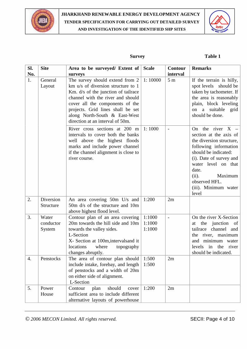
Survey Table 1
Sl. No.
Site Area to be surveyed/ Extent of surveys
Scale Contour interval
Remarks
The survey should extend from 2 km u/s of diversion structure to 1 Km. d/s of the junction of tailrace channel with the river and should cover all the components of the projects. Grid lines shall be set along North-South & East-West direction at an interval of 50m.
1: 10000 5 m If the terrain is hilly, spot levels should be taken by tachometer. If the area is reasonably plain, block leveling on a suitable grid should be done.
1. General Layout
River cross sections at 200 m intervals to cover both the banks well above the highest floods marks and include power channel if the channel alignment is close to river course.
1: 1000 - On the river X – section at the axis of the diversion structure, following information should be indicated: (i). Date of survey and water level on that date. (ii). Maximum observed HFL. (iii). Minimum water level
2. Diversion Structure
An area covering 50m U/s and 50m d/s of the structure and 10m above highest flood level.
1:200 2m
3. Water conductor System
Contour plan of an area covering 20m towards the hill side and 10m towards the valley sides. L-Section X- Section at 100m,intervalsand it locations where topography changes abruptly.
1:1000 1:1000 1:1000
- On the river X-Section at the junction of tailrace channel and the river, maximum and minimum water levels in the river should be indicated.
4. Penstocks The area of contour plan should include intake, forebay, and length of penstocks and a width of 20m on either side of alignment. L-Section
1:500 1:500
2m
5. Power House
Contour plan should cover sufficient area to include different alternative layouts of powerhouse
1:200 2m
JHARKHAND RENEWABLE ENERGY DEVELOPMENT AGENCY TENDER SPECIFICATION FOR CARRYING OUT DETAILED SURVEY
AND INVESTIGATION OF THE IDENTIFIED SHP SITES
© 2006 MECON Limited. All rights reserved. SECII: Page 5 of 10
and switchyard, tail race if its length is short.
6. Tailrace Channel
If the length of the tailrace channel is long the area to be surveyed should be governed by the norms described in (3)
7 Cross Drainage works, if any
L section of the Drain and at least four cross sections near the cross drainage work
1:200 2m Highest Flood Level should be marked. Nature and extant of catchments to be indicated.
.8 Colony Contour plan of the required area. 1:1000 2m
The use of proper instruments is an important factor in survey work. The Contractor shall arrange his own instruments, accessories, tools and tackles, camping equipment and transport necessary for conducting the survey as per precision required.
3.2.3 Instruments, Tools and Tackles: The survey team shall have at least the following survey instruments and accessories: • 20 second Theodolite (for general survey- contour and topographic details) • 1-second Theodolite with (a) supporting distance-measuring instruments (Invert tape,
measuring weights, target sets, measuring heads, and thermometers) or (b) Diplomat with all attachments.
• Precision automatic tilting levels with precision leveling staff (For setting of B.M. pillars) • Precision automatic tilting levels with parallel plate micrometer reading directly upto 4th
decimal place (for contour surveying) (least count 0.1 mm). • Calculators • Precision measuring tapes. • Target sets. • Leveling staff, ranging rods. • Drawing office instruments and accessories. • Other supporting tools and tackles.
3.2.4 Accuracy of work
For general survey (Contour and topographical details) • Linear Measurement: 1 in 10,000 • Leveling: +5 mm/km, (km = Distance in kilometer)
For High precision (Grid fixing) • Linear Measurement: 1 in 50,000 • Leveling: +2 mm/km
JHARKHAND RENEWABLE ENERGY DEVELOPMENT AGENCY TENDER SPECIFICATION FOR CARRYING OUT DETAILED SURVEY
AND INVESTIGATION OF THE IDENTIFIED SHP SITES
© 2006 MECON Limited. All rights reserved. SECII: Page 6 of 10
3.3 Geological Investigations:
A reconnaissance report, based on a geological traverse of the area shall be prepared. In addition,
the following minimum geological investigations shall be carried out:
(i). Diversion Structure:
Type of strata underlying the proposed structure by means of at least one bore-hole trial pit at a
suitable location as advised by the geologist, with geological logging. The report should include
the type of strata of the abutments.
(ii). Power Channel:
Geological mapping of the hill slope with alignment for assessing the stability of hill slope
particularly the reaches where falling of the loose material is apprehended, shall be identified in
order to enable the designer to consider the remedial measures, like providing covered conduit or
duct in these reaches.
(iii). Cross Drainage Works:
Geological assessment of the strata, particularly of the abutments and bed of the drain at the
proposed site structure to assist the designer to take care of the geological factors for the
foundation of the abutment of the structure shall be carried out.
(iv). Penstock Intake & Penstocks:
Geological mapping of the penstock slopes with particular attention for geological sections at
saddle and anchor block locations with indication of strata at the foundation level of the
structure. One test pit at the location of intake and two or more test pits on the penstocks slope
with geological logging.
(v).Power House:
Two test pits at powerhouse site with geological logging shall be carried out. In particular,
geological mapping of the slopes of the power house excavation shall be prepared, indicating the
JHARKHAND RENEWABLE ENERGY DEVELOPMENT AGENCY TENDER SPECIFICATION FOR CARRYING OUT DETAILED SURVEY
AND INVESTIGATION OF THE IDENTIFIED SHP SITES
© 2006 MECON Limited. All rights reserved. SECII: Page 7 of 10
stability of the construction slopes and any adverse geological feature, so that this could be taken
care of in the design for stability of slopes.
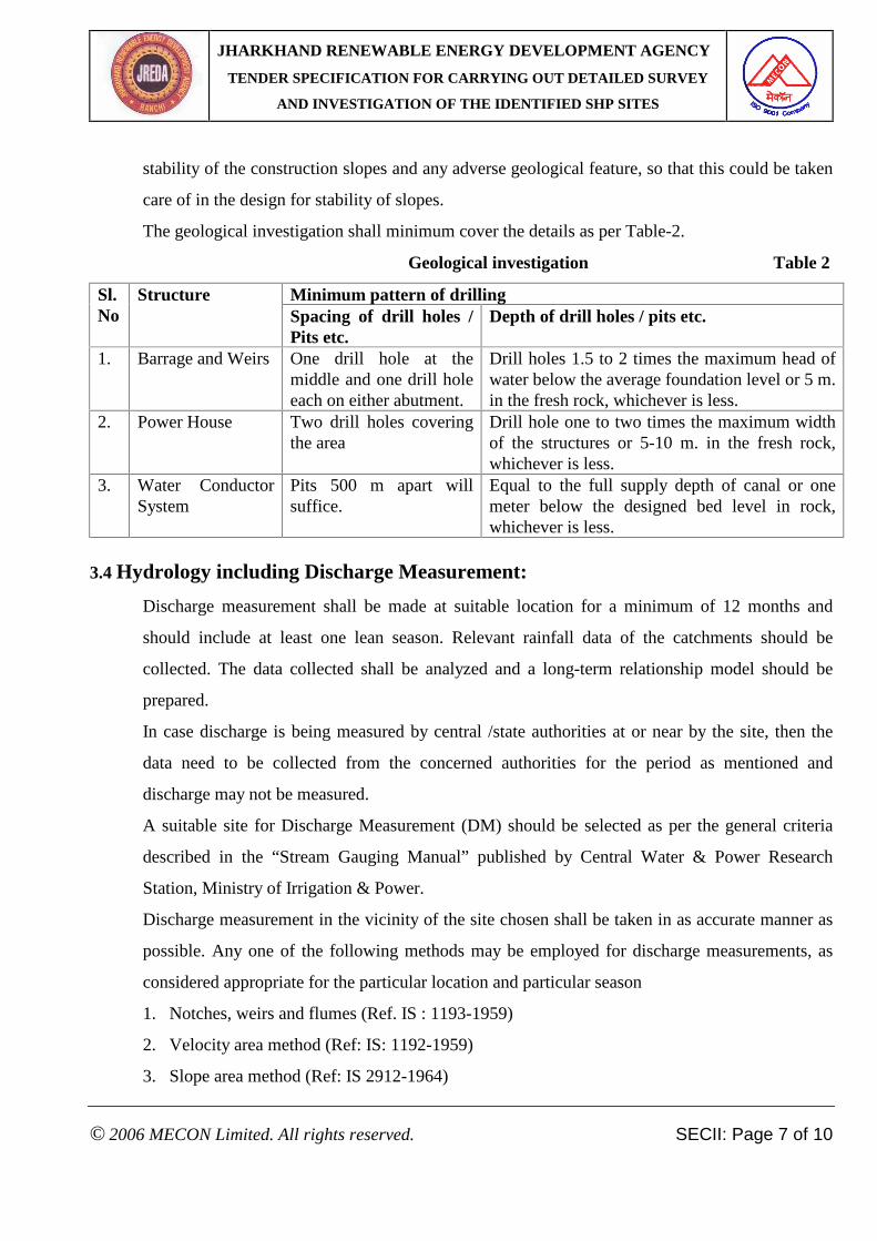
The geological investigation shall minimum cover the details as per Table-2.
Geological investigation Table 2
Minimum pattern of drilling Sl. No
Structure Spacing of drill holes / Pits etc.
Depth of drill holes / pits etc.
1. Barrage and Weirs One drill hole at the middle and one drill hole each on either abutment.
Drill holes 1.5 to 2 times the maximum head of water below the average foundation level or 5 m. in the fresh rock, whichever is less.
2. Power House Two drill holes covering the area
Drill hole one to two times the maximum width of the structures or 5-10 m. in the fresh rock, whichever is less.
3. Water Conductor System
Pits 500 m apart will suffice.
Equal to the full supply depth of canal or one meter below the designed bed level in rock, whichever is less.
3.4 Hydrology including Discharge Measurement:
Discharge measurement shall be made at suitable location for a minimum of 12 months and
should include at least one lean season. Relevant rainfall data of the catchments should be
collected. The data collected shall be analyzed and a long-term relationship model should be
prepared.
In case discharge is being measured by central /state authorities at or near by the site, then the
data need to be collected from the concerned authorities for the period as mentioned and
discharge may not be measured.
A suitable site for Discharge Measurement (DM) should be selected as per the general criteria
described in the “Stream Gauging Manual” published by Central Water & Power Research
Station, Ministry of Irrigation & Power.
Discharge measurement in the vicinity of the site chosen shall be taken in as accurate manner as
possible. Any one of the following methods may be employed for discharge measurements, as
considered appropriate for the particular location and particular season
1. Notches, weirs and flumes (Ref. IS : 1193-1959)
2. Velocity area method (Ref: IS: 1192-1959)
3. Slope area method (Ref: IS 2912-1964)
JHARKHAND RENEWABLE ENERGY DEVELOPMENT AGENCY TENDER SPECIFICATION FOR CARRYING OUT DETAILED SURVEY
AND INVESTIGATION OF THE IDENTIFIED SHP SITES
© 2006 MECON Limited. All rights reserved. SECII: Page 8 of 10
The method proposed for discharge measurement shall be indicated in the bid.
The Tenderer shall study changes in upstream land usage, changes in Upstream flow pattern, Flow extraction, flow discharges while calculating Design Energy.
3.5 Other relevant Information / data
3.5.1 Right of land to be acquired for the SHP project:
Extent of land required for the project along with right of land. Break up of extant for each
structure with rights of land to be provided.
3.5.2 Water quality
River/ Nala Water quality shall be tested through a sample taken during monsoon for pH value,
type, size specific gravity and quantity of silt content
3.5.3 Electrical Load demand of nearby villages
Detailed data may be collected for the possible number of users, type of load, i.e.
domestic/commercial/common community loads, industrial and irrigation loads, like water
pumps, furniture making, flour mills, etc. The demand pattern shall be worked out and the total
energy, which would be consumed on account of each load, should be worked out.
3.5.4 Power evacuation
Location of near by Switchyard with distance, Voltage level, /Basic Insulation Level, Space
availability for bay.
Approximate length of transmission line to switchyard/ load center(s) with details of possible
river/ Nala, Road crossings etc.
3.5.5 Construction material
Near by locations where following materials (possible quantity and type) available with
approximate distance from the proposed site and shall be indicated..
Cement, Coarse aggregate, fine aggregate, Steel (structural steel, Reinforcement steel, Plate steel
etc.), Stone, Bricks, tiles, POL, Explosives, CGI Sheets etc.
3.5.6 Communication facilities (Telephone, Fax, Mobile) from the SHP site shall be indicated.
3.5.7 Approach of different modes of transport (road, rail, air) shall be indicated
3.5.8 Hydro- Meteorological data
JHARKHAND RENEWABLE ENERGY DEVELOPMENT AGENCY TENDER SPECIFICATION FOR CARRYING OUT DETAILED SURVEY
AND INVESTIGATION OF THE IDENTIFIED SHP SITES
© 2006 MECON Limited. All rights reserved. SECII: Page 9 of 10
# The Hydrological aspect shall include collection of data with regard to rainfall, steam
flow, flow extraction and flood flows etc.
# Delineation of Catchment marking precisely the rain gauge station
# Rainfall data of last 12 years including years of Discharge measurement. The successful
Bidder shall collect the required data from concerned Block Headquarter.
Rainfall data from all the rain gauge stations in the catchments; Climatological parameters
including temperature, humidity, wind velocity, sunshine of the SHP site shall be collected.
3.6 Power Potential Study
Estimation of flow duration curve, head, power potential, water availability, estimation of design
flood level and assessment of possible installed capacity
3.7 Conclusion
Based on the Detailed Survey & Investigation it shall be concluded whether JREDA should go
ahead and prepare the DPR of the proposed site.
3.8 Photographs
Digital Photographs of
• Identified locations of weir, Diversion structure, Water conductor System, Cross drainage
works, Penstock intake and Penstock, Power House power, Tail race channel, etc.,
• During different activities of survey, investigation, discharge measurement etc.
Shall be included in the DSI Report.
4.0 Completion Time
4.1 Preliminary reconnaissance survey, Topographical Survey, Geological Investigation, Hydrological Study (All details excluding discharge measurement, which shall be as on date), collection of other Information/ data as per scope shall be completed within 10 months of placement of LoI.
4.2 Draft DSI report shall be submitted within 12 months of Placement of LoI.
4.3 JREDA officials will visit site and successful bidder shall satisfy JREDA regarding correctness of collected/surveyed data and methods of discharge measurement etc. after submission of Survey/Investigation details at convenient dates.

JHARKHAND RENEWABLE ENERGY DEVELOPMENT AGENCY TENDER SPECIFICATION FOR CARRYING OUT DETAILED SURVEY
AND INVESTIGATION OF THE IDENTIFIED SHP SITES
© 2006 MECON Limited. All rights reserved. SECII: Page 10 of 10
4.4 Submit Final DSI report after balance discharge measurement and incorporating all details as per scope and incorporation of all details as commented by JREDA by within 14 months of placement of LoI.
A detailed over all time schedule shall be enclosed as per enclosed Format – II .