Embed Size (px)
Citation preview

Network Rail Stafford Area Capacity Study Technical Report Black
ISSUE 3
Network Rail Stafford Area Capacity Study Technical Report
June 2007
This report takes into account the
particular instructions and requirements
of our client.
It is not intended for and should not be
relied upon by any third party and no
responsibility is undertaken to any third
party
Ove Arup & Partners Ltd
The Arup Campus, Blythe Gate, Blythe Valley Park, Solihull, West Midlands. B90 8AE
Tel +44 (0)121 213 3000 Fax +44 (0)121 213 3001 www.arup.com Job number 119075-20

J:\119000\119075-20\4 INTERNAL PROJECT DATA\4-08 PUBLIC AND STATUTORY CONSULTATION\4-08-01 TECHNICAL REPORT AND TAGS\TECHNICAL REPORT FOLLOWING 2007 06 21 MEETING V3.DOC
Ove Arup & Partners LtdIssue 3 26 June 2007
Document Verification
Page 1 of 1
Job number Job title Stafford Area Capacity Study
119075-20
File reference Document title Technical Report
Document ref
Revision Date Filename 0005 draft to network rail 2006 08 22.doc
Description First draft
Prepared by Checked by Approved by
Name Various Authors Richard Foster Phil Hall
Draft 1 22/08/06
Signature
Filename 0006 issue to network rail 2006 08 31.doc
Description Issue to Network Rail
Prepared by Checked by Approved by
Name Various Authors Richard Foster Phil Hall
Issue 1 12/06/07
Signature
Filename updated technical report following 2007 06 review.doc
Description Second issue to network rail on 2007 06 01
Prepared by Checked by Approved by
Name Various Authors Richard Foster Phil Hall
Issue 2 22/06/07
Signature
Filename technical report following 2007 06 21 meeting v3.doc
Description Revised following June 21 meeting
Prepared by Checked by Approved by
Name Various Authors Richard Foster Phil Hall
Issue 3 28/06/07
Signature
Issue Document Verification with Document �

Network Rail Stafford Area Capacity StudyTechnical Report
J:\119000\119075-20\4 INTERNAL PROJECT DATA\4-08 PUBLIC AND STATUTORY CONSULTATION\4-08-01 TECHNICAL REPORT AND TAGS\TECHNICAL REPORT FOLLOWING 2007 06 21 MEETING V3.DOC
Ove Arup & Partners LtdIssue 3 26 June 2007
Contents
Page
Executive Summary i
1 Introduction and Purpose of this Report 1
1.1 Historical Overview 1
1.2 Initial Arup Commission 1
1.3 The Purpose of this Report 1
1.4 Structure of this Report 1
2 Network Rail’s Requirements 3
2.1 Future Train Service Requirements 3
2.2 Infrastructure Requirements 3
3 Existing Engineering Conditions 5
3.1 The Trent Valley Four-Tracking Scheme and Colwich Junction 5
3.2 The Layout in the Stafford Area – Post TV4 5
3.3 Train Services 6
3.4 The Capacity Pinch-points 6
3.5 Signalling 6
3.6 Structures 7
3.7 Electrification 8
3.8 Utilities 8
3.9 Communications Systems 8
4 Environmental Setting 9
4.1 Noise and Vibration 9
4.2 Local Air Quality 9
4.3 Greenhouse Gases 9
4.4 Landscape and Townscape 9
4.5 The Heritage of Historic Resources 10
4.6 Biodiversity 11
4.7 The Water Environment 12
4.8 Planning Policy Context 14
4.9 Environmental Constraints Plans 16
5 Geotechnical Issues 17
5.1 Approach 17
5.2 Sources of Information 17
5.3 Identification and interpretation of BGS borehole data 17
5.4 Outline Geology 17
5.5 Interpretation of Landscape from a Geological Perspective 18

Network Rail Stafford Area Capacity StudyTechnical Report
J:\119000\119075-20\4 INTERNAL PROJECT DATA\4-08 PUBLIC AND STATUTORY CONSULTATION\4-08-01 TECHNICAL REPORT AND TAGS\TECHNICAL REPORT FOLLOWING 2007 06 21 MEETING V3.DOC
Ove Arup & Partners LtdIssue 3 26 June 2007
5.6 Identification of Geological Features from Envirocheck Mapping 20
5.7 General Observations 21
6 Traffic and Transportation Setting 23
6.1 Local Highway Network – Stafford Town Area 23
6.2 Role of Highway Routes – Stafford Town Area 23
6.3 Highway and Local Transport Proposals – Stafford Town Area 24
6.4 Traffic and Transportation Issues – Rural Staffordshire 25
6.5 Highway and Local Transport Proposals - Rural Staffordshire 27
7 Initial High-Level Study 29
7.1 Option Generation Workshop 29
7.2 The Options – Descriptive Title and Key Decision Factors 30
7.3 Options Carried Forward 38
8 Assessment Methodology 41
8.1 Environmental Appraisal Methodology 41
8.2 Tunnelling Issues 41
8.3 Costing Methodology 43
9 Development of the HS Options 48
9.1 The Bishton Junction 48
9.2 The Existing Railway – Hixon to Sandon / Stone 48
9.3 Junction Layout Sub-options at Each A to D Location 49
9.4 Speed Capability of the Existing Railway: Hixon to Stone 50
9.5 The N and S Route Variants 51
9.6 The HS Options’ Trent Viaduct 52
9.7 HS Options Carried Forward 53
10 Development of the ER Options 54
10.1 Option ER1 - Twin Track Underpass at Stafford 54
10.2 Option ER2 - Single Track Underpass at Stafford, Flyover at Great Bridgeford 56
10.3 Option ER3 - Four-Tracking Shugborough Tunnel 58
10.4 Option ER4 - Paired by Direction to Great Bridgeford 61
10.5 Option ER5 - Paired by Direction to Crewe 62
10.6 Option ER6 – Transposition: Stafford to Badnall Wharf 63
10.7 Option ER7 - Six-track Railway: Stafford to Newport Corridor 65
10.8 Option ER8 - Six-track Railway: Stafford to Creswell 66
10.9 Option ER8+ 66
10.10 The ER Options Carried Forward 71
11 Development of the GF Options 72
11.1 Option GF1 – Salt / North of Norton Bridge 72
11.2 Option GF2 – Ingestre/Hopton/South of Norton Bridge 74
Network Rail Stafford Area Capacity StudyTechnical Report
J:\119000\119075-20\4 INTERNAL PROJECT DATA\4-08 PUBLIC AND STATUTORY CONSULTATION\4-08-01 TECHNICAL REPORT AND TAGS\TECHNICAL REPORT FOLLOWING 2007 06 21 MEETING V3.DOC
Ove Arup & Partners LtdIssue 3 26 June 2007
11.3 Option GF3 – Ingestre/Hopton/North of Norton Bridge 76
11.4 Option GF4 – Four-Track Variant of Option GF3 77
11.5 GF Options Carried Forward 78
12 The Short-List 79
12.1 A Reminder of the Short-Listed Options 79
12.2 Engineering Design Requirements 79
13 Appraisal Methodology for the Short-Listed Options 81
13.1 The Government’s Five Criteria 81
13.2 The Environmental Objective - Appraisal Methodology 82
13.3 The Safety Objective – Appraisal Methodology 86
13.4 The Economy Objective - Appraisal Methodology 86
13.5 The Accessibility Objective - Appraisal Methodology 86
13.6 The Integration Objective - Appraisal Methodology 86
13.7 Environmental Reporting 86
14 Option HSAN 87
14.1 Description 87
14.2 Structures 90
14.3 Signalling 92
14.4 Electrification 93
14.5 Speeds 93
14.6 Environmental Overview 94
14.7 Traffic and Highways Impacts 95
14.8 Implementation Planning and Outline Possession Requirements 97
15 Option HSBN 100
15.1 Description 100
15.2 Structures, Signalling and Electrification 100
15.3 Speeds 101
15.4 Environmental Overview 101
15.5 Implementation Planning and Outline Possession Requirements 102
16 Option HSCN 103
16.1 Description 103
16.2 Speeds 103
16.3 Environmental Overview 104
16.4 Implementation Planning and Outline Possession Requirements 105
17 Option HSDN 106
17.1 Description 106
17.2 Speeds 106
17.3 Environmental Overview 107

Network Rail Stafford Area Capacity StudyTechnical Report
J:\119000\119075-20\4 INTERNAL PROJECT DATA\4-08 PUBLIC AND STATUTORY CONSULTATION\4-08-01 TECHNICAL REPORT AND TAGS\TECHNICAL REPORT FOLLOWING 2007 06 21 MEETING V3.DOC
Ove Arup & Partners LtdIssue 3 26 June 2007
17.4 Implementation Planning and Outline Possession Requirements 108
18 Option HSAS 109
18.1 Description 109
18.2 Speeds 109
18.3 Environmental Overview 110
19 Option HSBS 111
19.1 Description 111
19.2 Speeds 111
19.3 Environmental Overview 111
20 Option ER8+ 113
20.1 Description 113
20.2 Speeds 115
20.3 Environmental Overview 116
20.4 Geotechnical Overview 117
20.5 Implementation Planning and Outline Possession Requirements 118
21 Option GF2 120
21.1 Description 120
21.2 Speeds 121
21.3 Environmental Overview 121
21.4 Implementation Planning and Outline Possession Requirements 123
22 Transposition 125
22.1 The Concept 125
22.2 Schematic Layout 125
22.3 Untransposition – Restoring the Existing Pattern of Trains 125
22.4 The Options to which Transposition Could Apply 125
22.5 The Business Case for Transposition 126
23 Layouts at Norton Bridge - the “NB” Options 127
23.1 Introduction 127
23.2 Environmental Effects 127
23.3 Option NB1 127
23.4 Option NB2 128
23.5 Option NB3 128
23.6 Option NB4 129
23.7 Option NB5 130
23.8 Environmental Appraisal 130
23.9 Summary of Preferences 131
23.10 Further Work Requirements 131
24 Costing and Risk Assessment 132

Network Rail Stafford Area Capacity StudyTechnical Report
J:\119000\119075-20\4 INTERNAL PROJECT DATA\4-08 PUBLIC AND STATUTORY CONSULTATION\4-08-01 TECHNICAL REPORT AND TAGS\TECHNICAL REPORT FOLLOWING 2007 06 21 MEETING V3.DOC
Ove Arup & Partners LtdIssue 3 26 June 2007
24.1 Capital Costs 132
24.2 Risk Assessment Methodology 134
24.3 Cost and Risk Results 137
25 Planning Policy Assessment 139
25.1 National Planning Guidance 139
25.2 Regional Planning Policy 140
25.3 County Structure Plan 141
25.4 Local Plan 142
25.5 Conclusion 143
26 Operational Analysis Results – Summary 144
26.1 Basic Approach 144
26.2 Issues 144
26.3 Key Findings 144
27 Summary Tables 146
27.1 WebTAG – Environmental Effects 146
27.2 WebTAG - The Accessibility Objective 146
27.3 WebTAG - The Integration Objective 147
27.4 Property Effects 147
27.5 Route Lengths 147
27.6 Trent Viaduct Lengths and Heights 148
28 Discussion of the Options - The Decision Tree 149
28.1 Option ER8+ 149
28.2 HS Options - Locations A to D 149
28.3 Option GF2 150
28.4 “N” or “S” options north or south of Norton Bridge 150
28.5 Discussion – the NB Options 151
28.6 The Effect of Transposition 151
28.7 The Preferred Option 151
Appendices
Appendix A
Planning Policies

Network Rail Stafford Area Capacity StudyTechnical Report
J:\119000\119075-20\4 INTERNAL PROJECT DATA\4-08 PUBLIC AND STATUTORY CONSULTATION\4-08-01 TECHNICAL REPORT AND TAGS\TECHNICAL REPORT FOLLOWING 2007 06 21 MEETING V3.DOC
Page i Ove Arup & Partners LtdIssue 3 26 June 2007
Executive Summary
The report explains the process for generating and assessing options for solving a forecast capacity
problem at Stafford.
The West Coast Main Line (WCML) runs from London (Euston) to the West Midlands, the north-
west of England, and western Scotland. It was electrified in stages, reaching Glasgow in 1974.
The West Coast Route Modernisation, planned in the 1990’s, has been largely implemented with
completed works at Euston, Proof House Junction (Birmingham), Nuneaton, Stockport, and
Manchester Piccadilly. 125mph tilting trains have been introduced. On-going work is taking place at
Bletchley/Milton Keynes, Rugby, from Tamworth to Armitage in the Trent Valley, and between
Crewe and Weaver Junction.
The Stafford area remains as a problem. Network Rail therefore carried out a series of studies into
forecast capacity problems there, and concluded that the existing layout would not cater for the
forecast increases in train services. Network Rail therefore commissioned this engineering and
environmental study of route improvement options, while also undertaking business case analysis.
The report focuses on technical studies, principally on engineering, environmental appraisal and
costs.
Of the short-listed options, six would partially use the existing railway between Hixon and the
Sandon area:
• Option HSAN;
• Option HSBN;
• Option HSCN;
• Option HSDN
• Option HSAS;
• Option HSBS.
One would use the existing railway corridor;
• Option ER8+.
One would be a wholly green-field route:
• Option GF2.
These routes were appraised in line with Government’s Web-Based Transport Analysis Guidance
(WebTAG) methodology. In parallel with the engineering work, capacity studies were undertaken.
The conclusion was that, in terms of environmental impact, there were no overwhelming
“showstoppers”, but there are some significant areas of concern to be addressed.
The report does not make any recommendations on a preferred option, principally because there
are other deciding factors outside the scope of the above topics.

Network Rail Stafford Area Capacity StudyTechnical Report
J:\119000\119075-20\4 INTERNAL PROJECT DATA\4-08 PUBLIC AND STATUTORY CONSULTATION\4-08-01 TECHNICAL REPORT AND TAGS\TECHNICAL REPORT FOLLOWING 2007 06 21 MEETING V3.DOC
Page 1 Ove Arup & Partners LtdIssue 3 26 June 2007
1 Introduction and Purpose of this Report
1.1 Historical Overview
Prior to commissioning Arup, Network Rail had undertaken capacity modelling studies.
These demonstrated, although the existing layout at Stafford would have enough capacity
for the proposed 2008 passenger timetable, it would not have sufficient capacity to handle
the full passenger and freight demands of 2015.
Network Rail had also previously commissioned Scott Wilson to prepare a report entitled
“West Coast Route Modernisation, Stafford Underpass Option, Pre-Feasibility Summary
Report, Issue 01 Final, 05/12/03”. That Scott Wilson report of 2003 looked at underpass
options in the Stafford station area.
Network Rail and the Department for Transport had also considered, at a very high-level, an
alternative underpass at Stafford, and a bypass option around Stafford, hence relieving
capacity pressures in the station area.
There were, therefore, three options in concept before Arup was appointed:
• Scott Wilson underpass at Stafford;
• Network Rail underpass at Stafford;
• Network Rail / DfT bypass around Stafford.
1.2 Initial Arup Commission
In January 2006, Arup was appointed by Network Rail to study the above three options.
For the bypass, an indicative alignment was drawn, but only to determine whether it was a
feasible engineering concept, and to establish an understanding of the key cost and
environmental issues. In parallel with Arup’s work, the DfT had commissioned a Business
Case analysis, again to establish whether there was a plausible economic and financial
case. These studies came together in March 2006. It was concluded that a bypass was
worthy of consideration.
Arup’s commission was therefore extended to ensure that there was a fully structured
process for generating, assessing, sieving and carrying forward only those options worthy of
more detailed consideration. This report starts from that position.
1.3 The Purpose of this Report
This report describes the processes for generating a wide range of options, and the sieving
process which has taken place to result in a short-list of options which go towards meeting
Network Rail operational, performance, cost and environmental objectives.
The report is technical, describing how the need for the scheme was determined, and then
explaining how the route selection process was undertaken. It does not describe the
selection process for arriving at a definite single option.
1.4 Structure of this Report
This report is laid out as follows.
• Chapter 1, this chapter, is introductory;
• Chapter 2 describes Network Rail’s Requirements;
• Chapter 3 describes the Existing Engineering Conditions;
• Chapter 4 describes the Environmental Setting;
• Chapter 5 describes the Geotechnical Issues;

Network Rail Stafford Area Capacity StudyTechnical Report
J:\119000\119075-20\4 INTERNAL PROJECT DATA\4-08 PUBLIC AND STATUTORY CONSULTATION\4-08-01 TECHNICAL REPORT AND TAGS\TECHNICAL REPORT FOLLOWING 2007 06 21 MEETING V3.DOC
Page 2 Ove Arup & Partners LtdIssue 3 26 June 2007
• Chapter 6 sets out the Traffic and Transportation Setting;
• Chapter 7 concerns the results of an Initial High-Level Study;
• Chapter 8 describes the Assessment Methodology used for this study;
• Chapter 9 describes the Development of the HS Options;
• Chapter 10 describes the Development of the ER Options;
• Chapter 11 describes the Development of the GF Options;
• Chapter 12 is the process for determining the Short-List;
• Chapter 13 describes the Appraisal Methodology for the Short-Listed Options;
• Chapters 14 to 21 describe the options:
o Chapter 14 concerns Option HSAN;
o Chapter 15 concerns Option HSBN;
o Chapter 16 concerns Option HSCN;
o Chapter 17 concerns Option HSDN;
o Chapter 18 concerns Option HSAS;
o Chapter 19 concerns Option HSBS;
o Chapter 20 concerns Option ER8+;
o Chapter 21 concerns Option GF2.
• Chapter 22 describes the concept of Transposition;
• Chapter 23 describes Layouts at Norton Bridge - the “NB” Options;
• Chapter 24 sets out the Costing and Risk Assessment;
• Chapter 25 is the Planning Policy Assessment;
• Chapter 26 summarises the Operational Analysis Results;
• Chapter 27 presents Summary Tables;
• Chapter 28 is a Discussion of the Options.
The report has one Appendix.
• Appendix A gives a comprehensive list of planning policies.
Supporting Volumes.
The environmental appraisal was undertaken in accordance with a technique known as
“WebTag” - this is explained later. The results of the appraisal are presented in three
separate Volumes (appropriate to the particular NATA objectives they address):
• Environmental Appraisal of Options;
• Accessibility Objective; the Severance and Access Sub-Objectives;
• The Integration Objective; the Land Use Policy Sub-objective.
The summary information from these detailed tables is included in the option appraisal
chapters.

Network Rail Stafford Area Capacity StudyTechnical Report
J:\119000\119075-20\4 INTERNAL PROJECT DATA\4-08 PUBLIC AND STATUTORY CONSULTATION\4-08-01 TECHNICAL REPORT AND TAGS\TECHNICAL REPORT FOLLOWING 2007 06 21 MEETING V3.DOC
Page 3 Ove Arup & Partners LtdIssue 3 26 June 2007
2 Network Rail’s Requirements
2.1 Future Train Service Requirements
Initially, the key input for this study was the “Stafford Remodelling – Assumptions and
Specification Document (W169-155-EG-SPE-005000 A02, 3 February 2006) which gave
train services frequencies, types, routes and speeds in the study area for the year 2008.
Tests were also conducted using a 2015 train service specification, which was conceived
and instructed by the Department for Transport, and developed by Network Rail. It was
derived from a “one line represents one train per hour” plot showing the entering and leaving
points of services in the study area. This plot gave details of the type of train, the traction,
the route and stopping pattern for both passenger and freight services. This plot was
translated, by Network Rail, into a conventional timetable (and presented in spreadsheet
format) entitled:
• “Timetable for Stafford Modelling Exercise”, with a footer containing the text
“Version 5.0 dated 18/07/06. Jeff Hawken”, with a further annotation “Based on (and
an expansion of) Version Ea of “Stafford Flows” diagram, updated following Blue
Sky Workshop 12/07/06”.
The data was described in the notes on the sheet as being:
• “Evening Peak Period (1900 – 2030) assumed, with additional Down pm peak West
Coast services, and enhanced Up freight services”.
This timetable data was used as the basis of all the infrastructure tests. The timetabling
used Sectional Running Times (SRTs) from VISION modelling undertaken by Network Rail.
The timetable was also developed as conventional train service graph of paths.
2.2 Infrastructure Requirements
The key requirements in terms of design of the options developed in the study are
summarised from Network Rail’s Functional Specification entitled “Project W169 & W179,
Stafford Area Route Utilisation, Remodelling and Resignalling, Incl Colwich Junction –
Norton Bridge Junction Version 3.4, 17th January 2006”.
The requirements were as follows:
2.2.1 General
• line-speeds will aim at 125 mph EPS;
• Slow Line speeds shall aim at 100 mph PS otherwise stated;
• freight trains will be a maximum length of 775 metres inclusive of locomotive;
• Bi-directional working capability between Colwich Junction and Milford &
Whitehouse Junctions is required.
2.2.2 Stafford Station
• Four lines are required, each with a platform capable of accommodating a 10-car
Class 390, 10-car Class 221 or 12-car 20m EMU, and capable of extension to take
a 12-car Class 390;
• An independent platform to turn back local services from both the north and the
south shall be provided;
• Speeds are to be as high as possible (target 125 mph EPS/HST 110 mph PS) for
traffic to Bushbury and no lower than the braking/acceleration curve for Queensville
Curve for Trent Valley traffic;
• Slow line speeds are to be 75 mph PS, minimum 60 mph PS;

Network Rail Stafford Area Capacity StudyTechnical Report
J:\119000\119075-20\4 INTERNAL PROJECT DATA\4-08 PUBLIC AND STATUTORY CONSULTATION\4-08-01 TECHNICAL REPORT AND TAGS\TECHNICAL REPORT FOLLOWING 2007 06 21 MEETING V3.DOC
Page 4 Ove Arup & Partners LtdIssue 3 26 June 2007
• S&C should be capable of a minimum of 40 mph;
• Junctions to switch between Slow and Fast lines in both directions are required
north of Stafford station;
• Passive provision should be made for the existing Doxey junction to be re-laid at
higher speed (75 mph).
2.2.3 Norton Bridge Junction
• Fast lines target 125 mph EPS 90 mph PS;
• Slow lines target 100 mph PS;
• Stone lines 30 mph PS with an increased speed if possible;
• The station should be assumed to remain.
2.2.4 Between Whitehouse Junction and Queensville Curve:
• Trent Valley Fast line speeds to be targeted at 125 mph EPS and maximum
practicable PS;
• Trent Valley Slow lines are to be target 100 mph PS.
2.2.5 Queensville Curve
• Trent Valley Fast line speeds are to be as high as possible (target 90 mph EPS 75
mph PS).
• Trent Valley Slow lines are to be as high as possible (target 60 mph PS)
• Bushbury – Trent Valley Jn
• Up and Down Line speeds are 125 mph HST and maximum practicable PS, and
should be assumed to be retained as now.
2.2.6 Bypass Options
• Double track unless capacity calculations demonstrate additional track(s) to be
required;
• Aligned and configured for 125 mph Permissible Speed (140 mph EPS compatible);
• The incremental cost of 155 mph and 186 mph is to be assessed;
• To be freight compatible with gradients of no greater than 1 in 100 target and 1 in
75 maximum;
• To be to UIC GB gauge, any disproportionate costs compared with W12 gauge to
be assessed;
• Conventional (lineside) signalling is to be assumed to support a maximum line-
speed of 125 mph.
• S&C at junctions and the speed capability of any intermediate sections of existing
route shall be optimised for the new line, with a maximum (straight) speed to/ from
existing lines of 140 mph.
2.2.7 Implementation Strategy
• Construction and commissioning should minimise interaction with the delivery of the
2008 timetable on the existing routes.
• A weekday 4-track West Coast Main Line railway through Stafford and 2-track
Bushbury route to/ from Stafford must be provided at all times, except at times of
exceptional traffic reduction;
• A weeknight 2-track West Coast Main Line railway must be provided at all times.

Network Rail Stafford Area Capacity StudyTechnical Report
J:\119000\119075-20\4 INTERNAL PROJECT DATA\4-08 PUBLIC AND STATUTORY CONSULTATION\4-08-01 TECHNICAL REPORT AND TAGS\TECHNICAL REPORT FOLLOWING 2007 06 21 MEETING V3.DOC
Page 5 Ove Arup & Partners LtdIssue 3 26 June 2007
3 Existing Engineering Conditions
This section sets out the existing conditions around which a wide range of options was
developed.
3.1 The Trent Valley Four-Tracking Scheme and Colwich Junction
A scheme currently under construction involves 4-tracking the WCML in the Trent Valley
from Tamworth to Armitage. This scheme is known as “TV4”.
At present, north of Armitage, the disposition of the tracks, from west to east, is Down Fast,
Down Slow, Up Fast, Up Slow. Although loosely “paired by direction”, the arrangement of
Fast and Slow lines is unusual on the Down side. The existing Colwich Junction is
configured to match this unusual arrangement, with Manchester-bound trains turning from
the Down Fast to the Down Slow south of the junction, before crossing the Up Main (from
Milford Junction) at a switch diamond crossing with a speed limit of 45mph. The TV4
scheme will reverse the disposition of the Down lines, to form a rather more typical
arrangement, from west to east, of Down Slow, Down Fast, Up Fast, Up Slow (i.e. Fast lines
in the centre of the layouts).
There will be a consequential need to reconfigure Colwich Junction, seeking to provide a
50/65mph capability for Manchester-bound trains. Network Rail developed a number of
layouts for the reconfiguration of Colwich Junction. The favoured layout, entitled “Colwich
Option 2”, would have the primary benefit of removing the slip diamond, as well as achieving
faster speeds. Network Rail provided a single-line diagram as input to the study.
3.2 The Layout in the Stafford Area – Post TV4
After the completion of TV4, there will be a 4-track railway approaching the study area from
the south (via the Trent Valley route). The disposition of the lines, from west to east, will be
Down Slow, Down Fast, Up Fast, Up Slow (i.e. Fast lines in the centre of the layouts). The
layout at Colwich will allow parallel moves from the Down Slow to Stafford / Down Fast to
Stoke, and the corresponding Up moves.
Towards Stafford, the twin-track railway will assume its present configuration, which is as
follows. The Up Main and Down Main run from Colwich Junction (MP 127.08) to Milford
Junction (MP 129.31), where the Down Slow is created as a third, westerly, track. This 3-
track layout continues northwards to Whitehouse Junction (MP130.47), where the Up Slow
is created. North from Whitehouse Junction, therefore, there is a 4-track railway, paired by
speed, with the Slow lines to the east, and Fast lines to the west. This arrangement
continues to Stafford Trent Valley Junction (MP133.04) where the Down Slow Birmingham
and the Up Fast Birmingham form a flat, double junction with the Slow lines only.
At Stafford South Junction (MP133.24), there are connections between the Slow and Fast
sides. In general terms, the Fast lines continue through Stafford Station (MP133.43) with
platform loops on both Up (Platform 1) and Down (Platform 3) sides. Also, in general terms,
the Slow lines continue and pass the faces of Up Slow (Platform 4) and Down Slow
(Platform 5). An additional Up and Down Platform 6 line lies to the east, together with a
Royal Mail platform. North of the station, Uttoxeter Line Junction No 5 (MP133.60) and
Stafford North Junction / Doxey Junction (MP134.03) allow moves between all Fast and
Slow lines.
Northwards, the railway passes under the M6 at Cresswell viaduct (MP135.19), and pass
through the site of the former Great Bridgeford station at MP136.60. At Norton Bridge South
Junction, there is a Slow to Fast ladder, allowing trains from the Slow lines to access the
Norton Bridge Branch (Norton Bridge North Junction MP139.00 to Stone Junction (MP0.00).
The WCML continues northwards towards Crewe, and passes out of the study area at
Millmeece.

Network Rail Stafford Area Capacity StudyTechnical Report
J:\119000\119075-20\4 INTERNAL PROJECT DATA\4-08 PUBLIC AND STATUTORY CONSULTATION\4-08-01 TECHNICAL REPORT AND TAGS\TECHNICAL REPORT FOLLOWING 2007 06 21 MEETING V3.DOC
Page 6 Ove Arup & Partners LtdIssue 3 26 June 2007
Reverting back to Colwich Junction, the Down Main and Up Main form a twin-track railway
towards Stone, Stoke and ultimately, Manchester. Colwich Junction is MP38.58 measured
from the Macclesfield direction. The former Sandon Station is situated at MP31.53, followed
by Aston-by-Stone Level Crossing (CCTV) at MP28.63, the northern extremity of the study
area.
3.3 Train Services
The existing train services comprise a mix of high-speed, medium-speed, and stopping
passenger services, together with a number of freight services. A number of TOCs are
responsible for their operation. The main operator of higher-speed services is Virgin Trains,
who operate the West Coast Franchise, and the Cross-Country Franchise. The most recent
timetable change saw a major speed-up of the WCML services in the December 2005
timetable change. The next major timetable change is planned for implementation in
December 2008.
3.4 The Capacity Pinch-points
The major capacity problems identified by the capacity analysis were at:
• Milford Junction;
• Whitehouse Junction;
• Trent Valley junction;
• Stafford South junction;
• Doxey Junction;
• Norton Bridge Junction.
Other issues affecting capacity were;
• The twin-track section through Shugborough Tunnel;
• The mix of train speeds on the lines between Stafford and Norton Bridge;
• Platform utilisation at Stafford.
3.5 Signalling
The study area splits into three control areas:
• Stafford No 4;
• Stafford No 5;
• Stoke Signalling Centre (Stoke SC).
Stafford No 4 is a 105-lever frame electro-mechanical interlocking, dating from 1960. It
controls multiple-aspect signals, and turnouts with point machines. It essentially controls the
route from Colwich Junction (exclusive) to Stafford South Junction, and includes Milford
Junction, Whitehouse Junction, and Trent Valley Junction.
Stafford No 5 is a 150-lever frame electro-mechanical interlocking, dating from 1952. It
controls multiple-aspect signals, and turnouts with point machines. It controls Uttoxeter Line
Junction, Stafford North/Doxey Junction, and the WCML to a point near Great Bridgeford.
Stoke SCC controls the route from south of the study area, through Rugeley North Junction,
Colwich Junction, and the Colwich to Stoke route to a point beyond the study area. Colwich
interlocking, on the Stoke SC, controls Rugeley North Junction, Colwich Junction, and the
Colwich to Stoke route to a point at MP35.28 near Hixon.

Network Rail Stafford Area Capacity StudyTechnical Report
J:\119000\119075-20\4 INTERNAL PROJECT DATA\4-08 PUBLIC AND STATUTORY CONSULTATION\4-08-01 TECHNICAL REPORT AND TAGS\TECHNICAL REPORT FOLLOWING 2007 06 21 MEETING V3.DOC
Page 7 Ove Arup & Partners LtdIssue 3 26 June 2007
The existing signalling in the Stafford area mainly dates from the resignalling of the 1960s,
but has had extensive alterations carried out since, including the conversion of points from
mechanical to power operation and the renewal of the interlocking in the 1990s. Stafford 4
has also had some major alterations carried out since, including the conversion of points
from mechanical to power operation. Major changes were made in the 1970’s with the
abolition of Stafford 1, Stafford 2 and Queensville signal boxes in the 1970s. and
concentration of their functions on No. 4.
Some of the equipment will have been renewed as alterations were carried out or through
like-for-like replacement as the original equipment became worn out. It is known that there
are issues with some of the equipment at Stafford but spot renewals are being carried out to
maintain the safe operation of the railway.
The existing signalling system in the Stafford area lends itself particularly well to being
easily maintained and can be renewed almost indefinitely. The external equipment is of a
type which can, if required, be renewed with modern equivalents. On the whole, as
equipment becomes worn out or life expired, it can be renewed piecemeal. The main
exceptions to this are the signal box structures. Even the mechanical lever frames can be
renewed as parts wear.
3.6 Structures
Records drawings, inspection details and assessment reports relating to the structures that
are likely to be affected by the options were investigated.
3.6.1 Stafford Station Area
The existing routes are constrained by a number of structures that date from the original
construction of the various lines that converge at Stafford.
To the south at Rickerscote, the line to Wolverhampton is crossed by a two span structure
that may originally have been a masonry arch farm access bridge. The bridge has been
modified by the addition of a concrete slab deck and now carries a footway/cycleway linking
Rowley Grove to Exeter Street. It forms a constraint to widening.
The Trent Valley lines pass under a steel footbridge in the area of Siemens Road. This
structure is of relatively lightweight construction and should not be regarded as a constraint
to track slews etc. No information has been located as yet regarding the status of the
structure; its form may be regarded by some as worthy of preservation, however, it is not
thought to have been listed.
Where the Trent Valley and Wolverhampton lines converge, they are crossed by
Wolverhampton Road Bridge (Structure No B83). This structure carries the A449 into the
centre of Stafford and is a major commuter route into the city from the south and from M6
Junction 13. The A449 is also the main diversion route for the M6 when the motorway has
been closed. The bridge has had a varied history as the railway developed in the area
culminating with re-decking in the 1960’s associated with electrification of the route and
extension to the north by the addition of an extra span. This extension appears to have been
accomplished by demolition of the North Abutment to ground level and the construction of a
steel trestle on the remaining base and a new Northern Abutment. This bridge is a major
constraint to the horizontal alignment of the railway in this area.
The A518 Newport Road crosses the route just to the South of Stafford Station on B84
Station Bridge which is a skew 4 span multi-beam bridge. This is a major constraint on the
track layout in the southern station approach area.
In the northern station approach area, the track layout is constrained by Castle Street
Bridge, which is a narrow single span structure that may originally have been a masonry
arch, but which now has a concrete slab deck. The highway alignment over this structure is
very constrained both vertically and horizontally and sightlines are sub-standard.

Network Rail Stafford Area Capacity StudyTechnical Report
J:\119000\119075-20\4 INTERNAL PROJECT DATA\4-08 PUBLIC AND STATUTORY CONSULTATION\4-08-01 TECHNICAL REPORT AND TAGS\TECHNICAL REPORT FOLLOWING 2007 06 21 MEETING V3.DOC
Page 8 Ove Arup & Partners LtdIssue 3 26 June 2007
3.6.2 Great Bridgeford Area
The railway passes through a rural area, and under the M6 Cresswell viaduct. The other
structures in this area are primarily field access or farm accommodation structures. These
structures are of little of significance to the options under consideration.
3.6.3 Bishton Area
The main structure of significance in the Bishton area is at Bellamour Lane where the
existing railway crosses the lane on a single span structure. The superstructure of this
bridge appears to be a series of individual spans supporting the rails on longitudinal timber
bearers. It is assumed that this was done to maximise the headroom at this point. Bellamour
Lane itself crosses the railway with a sharp bend which is sub-standard from the point of
view of sightlines. It should be noted that if it was decided that a highway diversion was
necessary in this area, extensive work would be needed to achieve current highway design
standards.
3.6.4 Sandon
At Sandon, the B5066 crosses the route of the WCML via a bridge that is located adjacent
to the disused Station (now a residential property). The existing bridge is a masonry arch
structure and appears to be in reasonable condition. The alignment of the B5066 over the
bridge has substandard sightlines however. The B5066 continues toward Stafford, crossing
the Trent and Mersey Canal and the River Trent itself, on masonry bridges and it is
understood that at least one of these bridges is a listed structure. Both bridges are narrow
and alternating single line traffic is necessary at the canal bridge.
3.7 Electrification
The electrification system dates from the London – Manchester/Liverpool scheme of 1966.
The equipment through the Stafford station area is from the Mark 1 range with the structures
of portal, single and two track cantilever construction. There is a mixture of auto tensioned
and fixed termination equipment.
The system is fed in the area from Brereton Feeder Station with a return conductor and
booster transformers but this is currently being replaced by a new autotransformer system.
3.8 Utilities
Network Rail was in the process of collecting data on utilities for this study, but it was not
available in time to affect the recommendations. A Utilities Risk Analysis was therefore
undertaken, and the capital costings reported later made assumptions about utility
diversions and effects.
3.9 Communications Systems
It was assumed that, by the time the scheme is implemented, operational communications
will be based upon Network Rail’s GSM-R mobile network with lineside telephony as
backup. GSM-R itself is supported by lineside optical fibre and copper infrastructure
capable of integrating with the Fixed Transmission Network (FTN). Consequently,
communications infrastructure should already exist by the lineside on all existing routes in
the vicinity. A detailed survey of all existing infrastructure would be required to assess the
impact of any proposed modifications and associated communications requirements.
Currently, the IVRS project provides voice-grade GSM-R coverage on all existing routes. It
was understood that Network Rail envisages that GSM-R will be fully functional at the time
of implementation of the proposed options.

Network Rail Stafford Area Capacity StudyTechnical Report
J:\119000\119075-20\4 INTERNAL PROJECT DATA\4-08 PUBLIC AND STATUTORY CONSULTATION\4-08-01 TECHNICAL REPORT AND TAGS\TECHNICAL REPORT FOLLOWING 2007 06 21 MEETING V3.DOC
Page 9 Ove Arup & Partners LtdIssue 3 26 June 2007
4 Environmental Setting
This chapter describes the available data and the setting of environmental resources in the
study area.
4.1 Noise and Vibration
There was no factual data concerning noise levels in the study area.
In general terms, the operational phase would be of greater significance for options in the
rural areas, while those along the existing rail corridor would not result in a significant
change in noise levels. For both cases, it was expected that mitigation could be
incorporated into the design of the new railway.
The construction phase would be likely to give rise to significant, if sometimes localised,
noise nuisance for any option. There could be a requirement to provide significant quantities
of secondary glazing to residents as a consequence of the close and high-density
residential population. Whether the disruption would be a daytime or night-time issue would
be dependent on the option, and the degree of interference with the existing railway
infrastructure.
4.2 Local Air Quality
There was no factual data on air quality in the study area. A review of the Stafford Borough
Air Quality report 2005 showed that there are no anticipated breaches of air quality
objectives in the Stafford area, and there has been no designation of an Air Quality
Management Area (AQMA), or need to implement an action plan for criteria pollutants listed
in the Air Quality Regulations 2000.
4.3 Greenhouse Gases
There was no data on Greenhouse Gas emissions specific to the study area, although there
is considerable data at national and regional levels, against which options were assessed.
4.4 Landscape and Townscape
The study area lies at the junction of three Landscape Character Areas as defined by the
Countryside Agency; this is reflected in the variety of landscape types encountered within
the study area:
• The Shropshire, Cheshire and Staffordshire Plain covers parts of the west and
north-west of the study area. It is an extensive area typified by gently rolling
topography interrupted by sandstone ridges, with few woodlands but strong field
patterns and good hedgerows with many hedgerow trees;
• The Needwood and South Derbyshire Claylands Character Area includes the north-
eastern section of the study area, encompassing the River Trent corridor and the
land immediately adjacent to it, where the ground rises towards Cannock Chase;
• The Cannock Chase and Cank Wood Character Area covers the southern and
central parts of the study area. This is again very varied but is typified by the
Cannock Chase landscape itself, with large areas of plantation complemented by
broad tracts of heathland, with long views. The Chase is an Area of Outstanding
Natural Beauty, is heavily used for recreation due to its proximity to the West
Midlands conurbation and contains a Country Park.
North of the main woodland and heathland of the Chase there is a landscape of older
villages such as Milford which have now expanded to an almost suburban level. Here the
hedges are generally good but the landscape remains predominantly open and arable.

Network Rail Stafford Area Capacity StudyTechnical Report
J:\119000\119075-20\4 INTERNAL PROJECT DATA\4-08 PUBLIC AND STATUTORY CONSULTATION\4-08-01 TECHNICAL REPORT AND TAGS\TECHNICAL REPORT FOLLOWING 2007 06 21 MEETING V3.DOC
Page 10 Ove Arup & Partners LtdIssue 3 26 June 2007
Historic parks are a feature of the landscape lying around the edge of Cannock Chase.
Shugborough Park, in particular, is a fine example of an 18th century designed landscape.
The study area contains a number of sections with landscape designations;
• The Cannock Chase Area of Outstanding Natural Beauty (AONB) includes part of
the southern section of the study area and incorporates Shugborough Park. This
AONB is the smallest in mainland England but the Country Park within it is one of
the UK’s largest.
• An extensive Special Landscape Area (SLA), as defined in the Stafford Borough
Local Plan, lies towards the north of the study area. This SLA includes the mature
historic parkland of Sandon Park, as well as part of the River Trent corridor and the
nearby village of Salt.
The central rural sections of the study area typically have a landscape setting characterised
by small intermittent pockets of replanted ancient woodland, open naturalised grassland and
agricultural land; the topography is generally undulating.
The study area also contains areas of settlement and existing rail uses, and there are
isolated Conservation Areas and Sites of Special Scientific Interest. Water bodies include
two lakes and numerous smaller ponds. In addition, there is also a complex network of
water channels, many of which are highly significant features in the landscape, including the
River Trent and the Trent and Mersey Canal which run through the north-western section of
the study area, and the River Sow and the Staffordshire and Worcestershire Canal running
through the southern and south-western sections.
Stafford itself is an extensive urban area, and the urban rail options under consideration
have the potential to cause adverse visual impact on adjacent residential properties,
particularly during construction: this would be assessed in more detail at a later stage, and
mitigation proposed. Stafford has a network of important green spaces which would also
need to be considered during the assessment.
4.5 The Heritage of Historic Resources
There are a number of listed buildings and archaeological areas of interest focused on
Bishton, one of which, Bishton Hall is a nationally significant grade II* listed structure now
used as a school.
The Conservation Area for Colwich and Little Haywood is sandwiched between the A51 and
the River Trent. The Colwich area was known for its quarrying and brickworks, remains of
which are archaeologically significant.
The Conservation Area of Great Haywood and Shugborough is an area of strong canal
heritage, and is the junction point of the Trent and Mersey Canal and the Staffordshire and
Worcestershire Canal. There are a number of Grade II listed buildings in the village,
including the church and Post Office. The Conservation Area also covers the majority of the
grade I Registered Park of Shugborough, designated as having the highest level of
importance amongst similar features in Britain.
Shugborough Park contains a range of associated listed buildings of grades I, II* and II. The
Shugborough estate was purchased in 1624 by the Anson family, later Earls of Lichfield.
The original house was built in 1693 for William Anson, a prosperous Staffordshire lawyer.
In 1720, Shugborough was inherited by Thomas Anson. He was responsible for three
remarkable neo-Grecian monuments that stand in the park. The most imposing piece, the
Triumphal Arch begun in 1761, is a memorial to Admiral Anson and his wife. The Chinese
House by the River Sow also commemorates the Admiral. In 1790 Samuel Wyatt was
commissioned to carry out extensive remodelling. Shugborough has some 365 hectares of

Network Rail Stafford Area Capacity StudyTechnical Report
J:\119000\119075-20\4 INTERNAL PROJECT DATA\4-08 PUBLIC AND STATUTORY CONSULTATION\4-08-01 TECHNICAL REPORT AND TAGS\TECHNICAL REPORT FOLLOWING 2007 06 21 MEETING V3.DOC
Page 11 Ove Arup & Partners LtdIssue 3 26 June 2007
grounds. The formal terraces decorated with classical urns and cones of yellow yew
descend from the house to the River Sow.
There are likely to be features of archaeological interest located within the late Glacial River
terrace deposits. The Trent Valley is noted for intensive archaeological activity from a range
of archaeological periods, and includes both well preserved archaeological features and
waterlogged remains. Its landscape today is the result of 10,000 years of change and
development through natural and human actions.
The Pasturefields area on the west side of the River Trent is an internationally designated
Special Area of Conservation, as the last surviving natural inland salt marsh in Britain. The
localities salt fields are integral to the industrial history of Staffordshire, in particular the
production of salt glazed pottery in Stafford.
The hamlet of Ingestre is a designated Conservation Area and includes significant heritage
buildings including St Mary’s Church, grade I listed, Ingestre Hall, Grade II* listed, and
associated estate buildings listed at grade II.
The small Conservation Area of Tixall contains a number of significant heritage structures,
including Tixall Gatehouse, grade I listed. There are also a number of other listed buildings
associated with the estate of Tixall Hall – the hall of which is no longer extant.
Weston Hall is a nationally significant grade II* listed Jacobean house. The Weston area
was historically important in the production of salt, and was served by the Trent and Mersey
Canal of 1777. Few features of this history now survive, but Weston Lock, to the north of
the Hall, is of note. The canal as a whole is designated as a Conservation Area.
There is a registered battlefield at Hopton Heath, commemorating the battle in 1643. After a
period of relative inactivity over the winter, both sides in the Civil War sought to regain
momentum in the field by the spring of 1643 however, the battle of Hopton Heath was
indecisive in outcome.
The village of Salt contains a Grade II listed church.
To the north-eastern edge of the study area lies Sandon Park, a grade II registered park of
national importance. Sandon Hall is the ancestral home of the Earls of Harrowby. The
house was rebuilt by William Burn in imposing neo-Jacobean style in 1854. The Hall is set
in approximately 21 hectares (50 acres) of landscaped gardens, including an arboretum.
The Park includes a number of listed buildings within its limits.
The existing Sandon station house is a Listed Building, approached by an avenue of trees
from Sandon Park, and the Jacobean building reflects the style of the gate lodges. There is
a porte cochere provided for the convenience of the Earl. The adjacent overbridge, although
rebuilt for electrification, still carries the earl's arms.
To the west of Sandon Park, and to the north of Marston, are a series of archaeological
sites recorded on the County Sites and Monument Record.
There is a concentration of archaeological sites identified on the County Sites and
Monuments Record around Yarlet Hall, now a school.
Near the M6 motorway, a number of archaeological sites have been recorded broadly
between the motorway and Norton Bridge.
At Heamies Hill and Meece Brook contain alluvial material, and late glacial River Terrace
deposits will be present across the Meece Brook. It is likely that archaeological and geo-
archaeological material will be present within this area.
4.6 Biodiversity
There are a range of designated nature conservation sites within the study area that include:

Network Rail Stafford Area Capacity StudyTechnical Report
J:\119000\119075-20\4 INTERNAL PROJECT DATA\4-08 PUBLIC AND STATUTORY CONSULTATION\4-08-01 TECHNICAL REPORT AND TAGS\TECHNICAL REPORT FOLLOWING 2007 06 21 MEETING V3.DOC
Page 12 Ove Arup & Partners LtdIssue 3 26 June 2007
• Ancient Woodlands (AWs);
• Sites of Biological Interest (SBIs);
• Sites of Special Scientific Interest (SSSIs); and a,
• Special Area of Conservation (SAC).
There are also other SACs outside of the study area that may be indirectly affected. English
Nature is normally contacted with regard to proposed works within 10km of SACs. The
SACs that occur within 10km of the options are: Pasturefields Salt Marsh, Chartley Moss
(part of the West Midlands Mosses) and Cannock Chase. The requirement for an
Appropriate Assessment of the aforementioned sites of European importance will need to
be determined when a more detailed assessment is made of route options.
In order to determine what habitats and species are likely to be affected, a more detailed
desk-based study (involving consultation with English Nature, Staffordshire County Council,
Staffordshire Wildlife Trust and other organisations) and field surveys will need to be
conducted.
A generic issue is the risk posed by Great Crested Newts. The chances could be high on
the rural sections of some options, as a number of ponds could be adversely affected. The
process for overcoming this issue could take 1-2 years, with implications on the timescales
for the TWA process, and for mitigation after the TWA powers were granted. Additional land
for mitigation might be needed in the Order.
4.7 The Water Environment
The area in and around Stafford has a complex pattern of surface water drainage and fluvial
system. The main river in the study area is the River Trent, which flows in a south-easterly
direction and has a significant fluvial floodplain. This river will require particular
consideration for any future analysis of options within the extent of both the functional and
passive fluvial floodplain. The other primary watercourses in the area are the River Penk,
River Sow, Marston Brook, Cher Brook, Doxey Brook, Millian Brook and Rising Brook.
These could be either designated main river, critical ordinary watercourse (COW) or other
watercourses. However, the exact designation of the water bodies affected is unknown at
this time and will likely remain so until stakeholder consultation. The study area for the
options also contains the Trent and Mersey Canal.
In the vicinity of Stafford, both of these major rivers are fed by a large number of small
brooks, streams and drains. It is thought that the complex nature of the drainage is a result
of the very low gradient of the river systems at this point. This low gradient arises as the
rivers have superimposed themselves onto an accumulation of unconsolidated sediments,
washed into an incised gorge some time after the last glacial maximum. This created
conditions that could result in a braided channel network if the channels were left totally
natural.
Due to the low lying nature of the land in and around Stafford town centre, much of it has
been mapped to lie with the 1% floodplain of the River Sow. This includes the entire
alignment of the existing railway, including Stafford Station. However, flood defences have
been constructed on the western bank. These features reduce the risk of flooding in the
area around the existing station. As a result the risk of flooding is perceived by the EA to be
low. However, development within an area of existing floodplain is against current EA
policy, as the development may increase the risk of flooding to the immediate locality or
elsewhere.
There is a substantial fluvial floodplain throughout the whole length of the River Trent in the
study area, although much of it is contained within the Trent Valley. After the Autumn/Winter
2000 floods, the Environment Agency is reviewing their approach to flood management and

Network Rail Stafford Area Capacity StudyTechnical Report
J:\119000\119075-20\4 INTERNAL PROJECT DATA\4-08 PUBLIC AND STATUTORY CONSULTATION\4-08-01 TECHNICAL REPORT AND TAGS\TECHNICAL REPORT FOLLOWING 2007 06 21 MEETING V3.DOC
Page 13 Ove Arup & Partners LtdIssue 3 26 June 2007
flood defence on the River Trent. These floods were categorised as 2% (1 in 50 year
chance of a flooding) and they caused extensive damage to local communities.
Consequently, the EA’s River Trent Strategy is a review of fluvial flooding which looks at the
whole of the River Trent, rather than just focusing on individual towns and communities. The
Environment Agency have also produced the River Trent inception report, which is a
summary of readily available catchment data and issues that are relevant to flood risk
management in the catchment area. The report provides a catchment overview and will
assist to identify relevant issues in the catchment. It should be noted that impounded flood
water within the River Trent’s functional floodplain will have an adverse affect on the
tributary watercourses draining to it.
All watercourses impacted by the proposed works will have to be analysed in relation to the
proposed works. This analysis will be in the form of an investigation to determine the
existing 1-in-100 year floodplain, an assessment of whether the proposed works impacts
upon the floodplain and whether the proposed works changes the extent of the floodplain.
This is irrespective of whether previous analysis has been done to determine the floodplain
extent. If the proposed works impact the existing hydraulic conditions of the river, mitigation
measures would have to be proposed which would return the river to a state similar
encountered pre-development. This applies to all watercourses irrespective of their status.
In addition, any excavation within the existing floodplain will be at particular risk at times of
high rainfall from a number of sources of flooding including fluvial, overland flow and rising
groundwater.
The unconsolidated sediments underlying Stafford and the surrounding area are by their
very nature likely to be water bearing. In addition, the bed rock of the area, Mercia
Mudstone is fairly impermeable. For this reason the area underlain by the sub glacial layer
may be prone to high groundwater conditions, which may increase the risk of flooding
incurred by any excavations within the area. In addition, the local geology promotes a large
reaction between the surface and groundwater. The proposed alignments cross both minor
and major aquifers, and a ground water protection zone exists in the area of Shugborough
Park, which some of the alignments encroach upon.
Water quality data collected for the Doxey Brook, River Penk and River Sow all suggest that
the water is of a ‘good’ standard when compared to the EA’s General Quality Assessment
(GQA) with grades of B shown for the data period 2000 - 2002. However, the Marston
Brook, a watercourse which feeds into the River Sow from the north, suffers from depleted
dissolved oxygen and so records a GQA grade of E, which is interpreted as ‘poor’ water
quality. The marshy conditions are favoured by many aquatic species and this is reflected
by the existence of Doxey and Tillington Marshes SSSI located to the north west of the town
centre.
The Mercia Mudstone contains salt deposits at a depth of about 55m and is about 35m thick
(as a sequence of interbedded rock salt, saliferous mudstone and mudstone). The salt
deposits historically provided a source of Brine by interaction with groundwater. However
continued exploitation of this resource has lead to serious subsidence beneath Stafford
Town centre. The eastern edge of the salt deposits contains brine due to the interaction of
groundwater from the Sherwood Sandstone to the east, with the salt deposit. Within this
zone, the interaction between groundwater and the salt deposit continues at a very low rate.
Although the area in and around Stafford is shown to be a minor aquifer, there are no
source protection zones. This suggests that public water supply abstraction from this area
has been avoided due to the salt deposits.
There is little general information readily available on the water quality of groundwater within
the area. However, borehole investigation has detected some saline-rich water, due to the

Network Rail Stafford Area Capacity StudyTechnical Report
J:\119000\119075-20\4 INTERNAL PROJECT DATA\4-08 PUBLIC AND STATUTORY CONSULTATION\4-08-01 TECHNICAL REPORT AND TAGS\TECHNICAL REPORT FOLLOWING 2007 06 21 MEETING V3.DOC
Page 14 Ove Arup & Partners LtdIssue 3 26 June 2007
existence of salt deposits. It is important that there is no mixing of the good quality surface
water and the saline rich groundwater.
Network Rail advised that there would be a strong resistance to applying for discharge
consents, especially as they would consider run-off from a ‘new’ railway to be
uncontaminated surface water. Unless there was a sensitive receptor, or a high potential for
a pollution source, then discharge consents would be unlikely.
4.8 Planning Policy Context
4.8.1 National Planning Guidance
Planning Policy Statements (PPS) and Planning Policy Guidance (PPG) notes set out
policies on different aspects of land use planning and need to be taken into account by
Regional Planning Bodies.
• Planning Policy Statement 1: Delivering Sustainable Development. Sets out the
overarching framework for planning policies on the delivery of sustainable
development through the planning system.
• Planning Policy Guidance Note 2: Green Belts. Establishes a general
presumption against inappropriate development within a Green Belt, except where
there are very special circumstances to justify that development.
• Planning Policy Statement 7: Sustainable Development in Rural Areas. Sets
out the role of planning in facilitating and promoting sustainable patterns of
development and sustainable communities in rural areas. Where significant
development of agricultural land is unavoidable, any adverse effects on the
environment should be minimised.
• Planning Policy Statement 9: Biodiversity and Geological Conservation.
Promotes sustainable development through the enhancement of biodiversity and
geological resources as part of economic, social and environmental development.
The aim of planning decisions should be to prevent harm to biodiversity and
geological interest.
• Planning Policy Statement 10: Planning for Sustainable Waste Management.
Looks to achieve more sustainable waste management.
• Planning Policy Statement 11: Regional Spatial Strategies. Sets out the
processes and procedures to guide the preparation of Regional Spatial Strategies
(RSS) and Regional Transport Strategies (RTS).
• Planning Policy Guidance 13: Transport. Annex C (Para 8-10) deals with
Planning for New Railways, Tramways and Inland Waterways and notes that “The
RTS provides a strategic steer on the role and future development of new railways,
tramways and inland waterways.” It deals with mitigating the impact of new
transport infrastructure and notes that “Care must be taken to avoid or minimise the
environmental impact of any new transport infrastructure projects, or improvements
to existing infrastructure; this includes the impacts which may be caused during
construction (including the need to transport materials to and from the site, and
dispose of spoil).”
• Planning Policy Guidance 15: Planning and the Historic Environment. This
PPG sets out policies for the identification and protection of historic buildings,
conservation areas, and other elements of the historic environment. It highlights the
impact that “major new transport infrastructure developments can have on the
historic environment, not just visually and physically, but indirectly, for example by
altering patterns of movement or commerce and generating new development
pressures or opportunities in historic areas”.
Network Rail Stafford Area Capacity StudyTechnical Report
J:\119000\119075-20\4 INTERNAL PROJECT DATA\4-08 PUBLIC AND STATUTORY CONSULTATION\4-08-01 TECHNICAL REPORT AND TAGS\TECHNICAL REPORT FOLLOWING 2007 06 21 MEETING V3.DOC
Page 15 Ove Arup & Partners LtdIssue 3 26 June 2007
• Planning Policy Guidance 16: Archaeology and Planning. This sets out the
government’s policy on archaeological remains. It aims to ensure that the impact of
development on areas of archaeological interest is kept to a minimum and there is a
presumption in favour of preservation ‘in situ’.
• Planning Policy Statement 23: Planning and Pollution Control. This PPS
emphasises the need for Local Planning Authorities, when considering proposals for
development, to take into account the risks of, and from, pollution and land
contamination and how these can be managed or reduced.
• Planning Policy Guidance 24: Planning and Noise. This PPG provides advice
and guidance on matters to be taken into account when considering activities which
will generate noise, the impact on residential areas and planning conditions to
minimise the impact of noise. Local Planning Authorities are encouraged to locate
noise sensitive developments away from noise generators and vice versa. Where
this is not possible, mitigation measures should be considered.
• Planning Policy Guidance 25: Development and Flood Risk and recent
consultation on new PPS 25. This makes clear the importance of the
management and reduction of flood risk, acting on a precautionary basis and taking
account of climate change. It sets out a catchment-wide approach, and assuming
the use of flood plains for their natural purpose. The Environment Agency has the
lead role in providing advice on flood issues, and developers should fund flood
defences where required as a consequence of the development.
4.8.2 Other Relevant National Policy Issues
Future of Transport White Paper 2005
This identifies the need a transport network that can meet the challenges of a growing
economy and the increasing demand for travel, but can also achieve the government’s
environmental objectives. In terms of rail, this requires a network “providing a fast, reliable
and efficient service, particularly for interurban journeys and commuting into large urban
areas”.
Future of Rail White Paper 2005
This includes reference to encouraging more people to use rail rather than road in meeting
the government’s environmental objectives.
M6 Expressway – feasibility study 2005
Work is underway to consider the feasibility and impact of the proposed M6 Expressway as
an alternative to the planned widening of the M6 between Birmingham and Manchester
(which runs through the study area).
4.8.3 Regional Planning Policy
Regional Spatial Strategy for the West Midlands - RSS 11
The WCML is identified in the priority Trans-European Transport (TEN). Policy T12 identifies
the priorities for transport investment and includes the completion of works to the WCML.
Stafford is identified as a strategic town centre within the region, and as such a driver for the
economy. The RSS also contains a number of policies which seek to protect and conserve
the region’s natural and built heritage.
4.8.4 Structure Plan Policy
Staffordshire and Stoke-on-Trent Structure Plan 1996 – 2011
The Structure Plan for Staffordshire and Stoke-on-Trent was prepared jointly by
Staffordshire County Council and Stoke-on-Trent City Council and covers the period 1996-
2011. The Plan was formally adopted in 2001.

Network Rail Stafford Area Capacity StudyTechnical Report
J:\119000\119075-20\4 INTERNAL PROJECT DATA\4-08 PUBLIC AND STATUTORY CONSULTATION\4-08-01 TECHNICAL REPORT AND TAGS\TECHNICAL REPORT FOLLOWING 2007 06 21 MEETING V3.DOC
Page 16 Ove Arup & Partners LtdIssue 3 26 June 2007
• Policy T1B seeks an integrated and sustainable transport strategy.
• Policy T7 looks for the provision of a comprehensive and integrated public transport
network.
• Policy TA8 seeks improvements to the rail network, the development of services, the
upgrading of the WCML and the modernisation and enhancement of other lines.
• Policy T14 supports the free flow of traffic on routes of national and regional
significance, including the WCML.
• Policy T15A reserves land for the implementation of improvements to the WCML.
• Policy T10 gives priority to reducing the environmental impact of long distance freight
movements.
There are also a number of plan wide protection policies which need to be taken into
account relating to development, the environment, countryside, landscape, biodiversity,
habitats, nature conservation, water, flood, archaeology, Historic Parks and Gardens, Listed
Buildings, Conservation Areas, and the Trent Valley and Canal Facilities. There is also
Supplementary Planning Guidance ‘Planning for Landscape Change’.
4.8.5 Local Planning Policy
The relevant documents are:
• Lichfield Local Development Framework Submission Documents
• Stafford Borough Local Plan 2001
• Cannock Chase Local Plan March 1997
• Lichfield District Local Plan 1998
• Lichfield Local Development Framework - Core Strategy Submission
Document 2005
4.9 Environmental Constraints Plans
Based on the data assembled from the sources described above, Environmental
Constraints Plans were prepared.
It must be noted that there was no consultation with statutory bodies or consents authorities
to establish an understanding of the importance of the constraints derived from the above
process.
An internal workshop was held at which a range of environmental specialists presented their
interpretation of the severity of the mapped constraints, and described the rarity,
designation, importance and replaceability of those sites that could be spatially mapped.
Planning policy was also reviewed over the study area as this could not be “mapped” on a
spatial background.
This understanding of constraints was then used to derive the basic alignments of each of
the selected options, or to begin to understand the major issues which a route could involve.
Network Rail Stafford Area Capacity StudyTechnical Report
J:\119000\119075-20\4 INTERNAL PROJECT DATA\4-08 PUBLIC AND STATUTORY CONSULTATION\4-08-01 TECHNICAL REPORT AND TAGS\TECHNICAL REPORT FOLLOWING 2007 06 21 MEETING V3.DOC
Page 17 Ove Arup & Partners LtdIssue 3 26 June 2007
5 Geotechnical Issues
5.1 Approach
Landmark Envirocheck reports for the study area were defined by National Grid Reference
(NGR) SJ 9000, 3500 to the north; SK 0800, 1700 to the east; SK 0600, 1700 to the south;
and SJ 8200, 3500 to the west were obtained to facilitate constraints mapping. Geological
maps at a scale of 1:10 000 held by the BGS, and the Stafford Memoir (H.M.S.O. 1927)
were also consulted.
The work carried out was limited to:
• Interpretation of the landscape from a geological perspective;
• Identification and interpretation of BGS boreholes;
• Identification of geological features from historical and modern mapping;
• Provide recommendations on the mitigation of risks deriving from identified features.
5.2 Sources of Information
This assessment provided a summary of the key issues identified from the desk study
information, provided by the sources identified below and makes a qualitative assessment of
the potential impact on the project from geological ground conditions constraints identified in
the areas of each option.
The following list of sources was referred to:
• Geological Mapping, (BGS 1;50 000 sheet 139 [Stafford] and sheet 140 [Burton on
Trent])
• The Geological Memoirs for sheet 139 and 140 (see 6.4)
• BGS borehole records
• Landranger Series 1:50,000 maps (Ordnance Survey)
• Envirocheck Report
• Envirocheck Historical Mapping
The information presented is the result of a high level review and to be confirmed by more
detailed study and physical ground investigation.
5.3 Identification and interpretation of BGS borehole data
Available BGS borehole data was acquired, some of it from very old investigations. Only
limited interpretation of this data was made at this stage.
5.4 Outline Geology
The following observations are made based on the study of geological mapping and
memoirs for the study area.
5.4.1 Solid Geology
The solid geology of the study area comprises Triassic Strata belonging to the Mercia
Mudstone and Sherwood Sandstone Groups, with the majority of the study area being
underlain by the mudstone. A narrow upfaulted area of Sherwood Sandstone crosses the
eastern part of the study area.
The Sherwood Sandstone Group is divided into two formations: the Lower Cannock Chase
Formation (equivalent to the Kidderminster formation of the Birmingham Area), and the
Network Rail Stafford Area Capacity StudyTechnical Report
J:\119000\119075-20\4 INTERNAL PROJECT DATA\4-08 PUBLIC AND STATUTORY CONSULTATION\4-08-01 TECHNICAL REPORT AND TAGS\TECHNICAL REPORT FOLLOWING 2007 06 21 MEETING V3.DOC
Page 18 Ove Arup & Partners LtdIssue 3 26 June 2007
upper Bromsgrove Sandstone Formation, which extends across much of the West Midlands
region.
The sandstones are generally weakly cemented and the Cannock Chase Formation is
gravely/conglomeratic in the lower part. However, in places the Bromsgrove Sandstone is
better cemented, and has locally been quarried for building stone.
Beneath the Triassic Strata, Carboniferous Upper, Middle and Lower Coal Measures strata
occur at depth. Within the upfaulted area of Sherwood Sandstone to the east of Stafford,
the Middle and Lower Coal Measures have been prospected in the past as an extension to
the South Staffordshire/ Cannock Chase Coalfield. It is understood, in the current economic
climate there are no plans to revive this. This should be confirmed with the Coal Authority.
5.4.2 Drift Geology
The solid geology is overlain by superficial deposits across about 50% of the study area.
The following materials are present.
• Small isolated areas of Fluvio glacial sands and gravels.
• A thin and very discontinuous layer of Glacial Till.
• Extensive spreads of Glacial Sands and Gravels along the valleys of the Rivers Sow
and Trent.
• Extensive spreads of River Terrace deposits across the lower part of the River Trent
Valley
• Alluvial deposits across the lowest parts of the Valleys of the Rivers Sow and Trent, and
also minor tributary stream courses.
• Deposits of Peat in isolated hollows, occasionally as layers overlying River Terrace
Deposits and as often as layers within the Alluvial deposits.
• Deposits within Sub Glacial ‘Tunnel Valleys’ beneath parts of Stafford. These consist of
a variety of Sands Gravels Silts Clays and Peat.
5.5 Interpretation of Landscape from a Geological Perspective
5.5.1 Glaciation
The landscape of the study area was significantly impacted by the advance of glacial ice
across the whole area from the north-west during the later part of the Devensian glacial
period, approximately 15,000 to 20,000 years ago. During the glacial maximum, melt-water
escaped south and south-eastwards within and beneath the glacier, eroding sub-glacial
channels into the underlying strata. The present course of the River Sow through the study
area largely follows the alignment of one of these channels.
The landscape and the present valleys of the Sow and Trent were eroded by a flood of
glacial melt-water flowing south eastwards as the ice sheet melted and retreated north
westwards. This phase dissected the layer of lodgement till formed beneath the glacier into
discontinuous areas, and deposited spreads of gravel across the lower elevations.
The River Sow and probably the River Trent now occupy the valleys incised into the
landscape by glacial and subglacial meltwater. The valley sides are typically steep and the
valley bottoms broad and flat. Beyond the main valleys the Triassic Strata overlain by a
discontinuous covering of Glacial Till forms an undulating topography rising 20 to 50m
above the valley bottoms. To the south of the Rivers Sow and Trent, Cannock Chase forms
an area of more elevated topography, rising to 150 – 200m OD, 100m or more above the
base of the river valleys.
The valley gradient of the River Sow, following the line of a sub glacial channel is very slack,
resulting in very poorly drained and marshy conditions across the broad flat valley bottom

Network Rail Stafford Area Capacity StudyTechnical Report
J:\119000\119075-20\4 INTERNAL PROJECT DATA\4-08 PUBLIC AND STATUTORY CONSULTATION\4-08-01 TECHNICAL REPORT AND TAGS\TECHNICAL REPORT FOLLOWING 2007 06 21 MEETING V3.DOC
Page 19 Ove Arup & Partners LtdIssue 3 26 June 2007
and the development of extensive peat deposits. A consequence of the slack valley profile is
that the valley bottom is vulnerable to flooding,
The River Trent, which has a large catchment to the north, has continued to modify the
bottom of its valley after the influence of glacial meltwater ceased, and has left some
extensive spreads of River Terrace Deposits across the valley bottom. The current river
channel and associated alluvial deposits have very slightly incised and reworked the earlier
deposits so the current flood plain is some 1.2m below the level of the main (no. 1) river
terrace.
5.5.2 Glacial Channels
During the last (Devensian) ice age, meltwater escaping south eastwards from the glacier
covering the area, eroded channels into the underlying strata. These channels subsequently
became infilled by Fluvio-glacial sands and gravels and Glacio-lacustrine silts. Locally these
channels were not completely infilled and in post glacial times were occupied by lakes,
which in time became infilled with peat and clay. The courses of many of the glacial
channels were followed by the post glacial river systems as they superimposed themselves
on the glacial landscape immediately after the ice melted. This was due to the tendency for
the Glacial Channels to have formed linear hollows in places across the landscape and due
to the easily erodable infilling of unconsolidated deposits.
In the Stafford area, the course of the River Sow appears to follow the line of a glacial
channel which extends from beyond the M6 Creswell Viaduct to south of Stafford Station.
However there is insufficient data to define the exact course and margins of the feature
The glacial channels do not directly impact on the present landscape, however, just to the
south of the study area, the eastern margin of the channel at Walton on the Hill, remains as
an abrupt step in the topography.
5.5.3 Brine Extraction
The Mercia Mudstone contains salt deposits approximately equivalent to the Upper
(Wilkesley) Halite in Cheshire. The salt deposits occur at a depth of about 55m and are
approximately 35m thick, forming a sequence of interbedded rock salt, saliferous mudstone
and mudstone. The salt deposits historically provided a source of Brine by interaction with
groundwater. However continued exploitation of this resource lead to serious subsidence
problems as fresh water gained access to the salt deposits beneath Stafford Town centre.
As a result of this, brine pumping ceased in 1969 following court action, although minor
residual movement continues in places. The eastern edge of the salt deposit (including
Stafford Town centre) contains brine from the interaction of groundwater from the Sherwood
Sandstone to the east with the salt deposit. Within this zone, the interaction between
groundwater and the salt deposit continues at a very low rate (Review of Mining Instability
Stafford Brine Pumping Case Study Report).
5.5.4 Groundwater
The Mercia Mudstone is classified as a non-aquifer; however minor amounts of groundwater
can occur within the weathered zone. The Sherwood Sandstone is classified as a major
aquifer and the groundwater surface reflects the topography of the area with levels close to
the surface across the lower parts of valleys.
Groundwater will also be present within many of the superficial deposits. Levels are close to
the surface along the valley of the River Sow, within the Glacial Sands and Gravels and the
Alluvium. Substantial thicknesses of water bearing Sands, Gravels and Silts are present
within the Sub Glacial Channels.

Network Rail Stafford Area Capacity StudyTechnical Report
J:\119000\119075-20\4 INTERNAL PROJECT DATA\4-08 PUBLIC AND STATUTORY CONSULTATION\4-08-01 TECHNICAL REPORT AND TAGS\TECHNICAL REPORT FOLLOWING 2007 06 21 MEETING V3.DOC
Page 20 Ove Arup & Partners LtdIssue 3 26 June 2007
5.6 Identification of Geological Features from Envirocheck Mapping
Mapping dating from approximately 1890 to 2000 was examined for changes in geological
features which were then annotated onto 1:10,000 plans. The significant features identified
comprised:
• Water courses and water bodies
• Areas currently or previously identified as liable to flooding
• Areas currently or previously defined as marsh or reeds
• Extraction features (marl pits, sand pits, quarries etc.) that still have a physical presence
• Historic extraction features (marl pits, sand pits, quarries etc.) that have been infilled or
developed and are no longer visible in the landscape
• Sites of household and industrial land-fill
• Areas of potential archaeological significance
• Identification of pollution incidents of significance
5.6.1 Water Courses and water Bodies
Large sections of the study areas follow the paths of the River Trent, River Sow and the
Trent and Mersey Canal.
It was identified that certain areas (in particularly the study area north of Doxey) were
networks of field drains and areas that were marshy and liable to flood. The area also has a
large number of pits and small ponds that have been formed following marl extraction.
5.6.2 Extraction/ Marl Pits
Large numbers of pit features were identified from the historical mapping for the area of the
study. The majority dated from the 18th and 19
th centuries when following enclosure, the
Mercia Mudstone was extracted to improve the topsoil, as its slightly-calcareous aspect
(Marl) improved acid soils. Since then, they have either become infilled, remained as
features on the landscape or have filled with water to form ponds. There are also similar
features that have resulted from quarrying and gravel extraction.
5.6.3 Sites of Household and Industrial Landfill
There are a number of landfill sites within the study area. The majority of sites are classified
as small (less that 25,000m3 pa) and handle non-toxic, non-hazardous inert wastes such as
building rubble, soils and brick.
Several sites were identified within the Envirocheck Report as large (greater than 75,000m3
pa) and handle household, industrial and commercial wastes.
The largest of these sites were identified at RAF Swynnerton and Hopton Railway Cutting
(now closed).
5.6.4 Archaeology
There were few site of potential archaeological that were identified from the historical
mapping. These were:
• Tumuli near Beacon Hill
• Moat and fishponds at Gayton
• Moat at Little Haywood
• Site of church and burial ground, and site of battle near Hopton
An additional burial ground was identified within Stafford but its location is beneath factory
buildings.

Network Rail Stafford Area Capacity StudyTechnical Report
J:\119000\119075-20\4 INTERNAL PROJECT DATA\4-08 PUBLIC AND STATUTORY CONSULTATION\4-08-01 TECHNICAL REPORT AND TAGS\TECHNICAL REPORT FOLLOWING 2007 06 21 MEETING V3.DOC
Page 21 Ove Arup & Partners LtdIssue 3 26 June 2007
5.6.5 Pollution
A number of pollution incidents to controlled waters were identified in the Envirocheck
Report. The majority of incidents identified were Category 3 (minor) incidents, with a few
classed as significant incidents (Category 2). A single category 1 (major) incident was
recorded as a fuel tanker fire with a foam blanket used.
The Envirocheck data shows that these incidents were in surface waters and therefore it is
very unlikely that residual risks remain due to dissolution and attenuation of contaminants.
5.7 General Observations
Northwest from Stafford Station, the landscape is flat and lies at approximately 70mAOD.
Large numbers of drains are present in the area and there is evidence of large areas of
marshy ground. Historical mapping also shows that the River Sow and drain system are
liable to flooding in the area north of Doxey. The network of drains continues northwest to
southeast of Great Bridgeford where a small number of both infilled and open marl pits are
present.
Northwest from Great Bridgeford, the corridor follows the course of the River Sow. Within
the region of Chebsey the number of remaining marl-pit is approximately one per field, and
many of them form ponds. Southwest of Chebsey is the Smallwood Pit landfill site1
(household waste) and Chebsey landfill2 (household, commercial and inert waste).
South and southwest of the MoD Swynnerton Training Area there is another area of drain
networks and larger bodies of water. The area between the Meece Brook and railway has
been worked for sand gravel. A large area just to the northeast of the study area is the site
of RAF Swynnerton landfill3 (household waste).
North east of Rugeley, the River Trent, the Trent and Mersey Canal and a network of brooks
and drains is present. There are also a small number of pits that have subsequently infilled.
The River Trent and the Trent and Mersey Canal follow the perimeter of the study area
between Bishton and Hixon, and there are some areas of marshland between the two
watercourses. To the south of Hixon, the study area is dominated by a large number of
historic marl pits. Some have been subsequently infilled but the majority have formed small
ponds.
There are also a number of landfill sites in the area of Little Haywood and Great Haywood,
which handle household and inert, non-hazardous, non-toxic commercial wastes.
Between Great Haywood and Sandon, the study area follows the Trent Valley, with the
higher ground of Beacon Hill and Stafford to the south. Within this area, there are many
former extraction pits or which approximately one third are no longer present, one third
remain as surface features and the remaining third have formed ponds. These features are
generally more concentrated in the low lying fields close to the River Trent and the Trent
and Mersey Canal. North of the village of Hopton is a large landfill4 that holds residential,
commercial and industrial wastes.
Between Stafford and Ashton-By-Stone, the corridor moves to the west of the River Trent
and Trent and Mersey Canal. On the higher ground, surface water features are limited to
water filled extraction pits and field drainage. Lower lying ground lies close to Burston and
the River Trent and Trent and Mersey Canal. There are high numbers of former marl pits in
the area between Ashton-By-Stone and Stafford, of which more than half have formed water
filled ponds. The remaining half either have visible surface features or are infilled. There are
1 Envirocheck Map ID 37
2 Envirocheck Map ID 38
3 Envirocheck Map ID 34
4 Envirocheck Map ID 102

Network Rail Stafford Area Capacity StudyTechnical Report
J:\119000\119075-20\4 INTERNAL PROJECT DATA\4-08 PUBLIC AND STATUTORY CONSULTATION\4-08-01 TECHNICAL REPORT AND TAGS\TECHNICAL REPORT FOLLOWING 2007 06 21 MEETING V3.DOC
Page 22 Ove Arup & Partners LtdIssue 3 26 June 2007
several small landfill sites in this area, all of which handle construction materials such as
hardcore, soil and rubble.
From Shallowford to Swynnerton, the route corridor crosses the shallow valley formed by
the Meece Brook and its’ tributaries. There are large numbers of extraction pits in this area,
averaging more than one per field. Close to Norton Bridge and Swynnerton the size of the
pits is significantly greater than other parts of the route corridor.

Network Rail Stafford Area Capacity StudyTechnical Report
J:\119000\119075-20\4 INTERNAL PROJECT DATA\4-08 PUBLIC AND STATUTORY CONSULTATION\4-08-01 TECHNICAL REPORT AND TAGS\TECHNICAL REPORT FOLLOWING 2007 06 21 MEETING V3.DOC
Page 23 Ove Arup & Partners LtdIssue 3 26 June 2007
6 Traffic and Transportation Setting
6.1 Local Highway Network – Stafford Town Area
The highway network in Stafford consists of six main radial routes, connected by an inner
ring road. The radial routes comprise:
• A449 Wolverhampton Road;
• A518 Newport Road;
• A5013 Eccleshall Road;
• A34 Stone Road;
• A518 Weston Road; and
• A34 Lichfield Road.
The inner ring road on the east and north sides of the town centre (linking the A34 Lichfield
Road, the A518 Weston Road and A34 Stone Road) is constructed to dual 2-lane standard,
with additional queuing lanes on some sections). The remainder of the inner ring road on
the south and west halves of Stafford is a two-lane single carriageway.
The M6 forms a western bypass, with Junction 13 on the A449 and Junction 14 on the
A5013. From M6 Junction 14, a section of the A34 and the A513 Beacon Side forms the
northern section of an edge-of-town distributor road linking the motorway with the A34 and
the A518. The alignment for an Eastern Bypass is safeguarded in the Local Plan (see
below).
Emergency Service Routes
The Staffordshire General Hospital, situated on the A518 Weston Road, has an accident
and Emergency Department. Stafford Fire Station is located off the roundabout junction of
the A518 Weston Road and A518 Beacon Side. Direct access throughout Stafford and to
the M6 needs to be maintained from both emergency service sites.
6.2 Role of Highway Routes – Stafford Town Area
Within Stafford, the key roads are:
• The A449 Wolverhampton Road provides access onto the M6 at junction 13 and
thus provides the main radial route into Stafford from the M6 South. It also serves
as a local distributor for much of the south part of Stafford. The A449 carries a two-
way flow of 450 heavy commercial vehicles per 12-hour weekday period (source:
Staffordshire Provisional LTP 2005). The A449 was de-trunked and transferred to
Staffordshire County Council management in 2002. It remains a Primary Route on
the Strategic Road Network.
• The A518 Newport Road is classified as a ‘Primary Route on the Strategic Road
Network’. It serves a distributor function to the Stafford residential areas along its
south side and to the village of Gnosal and to Newport beyond. The A518 does not
provide access onto the M6. It carries a two-way flow of 210 heavy commercial
vehicles per 12-hour weekday period (source: Staffordshire Provisional LTP 2005).
Staffordshire County Council is the Highway Authority responsible for the A518.
• Castle Street is a narrow single carriageway, providing access to terraced houses
to the east of the railway and to light industrial premises west of the railway via a
hump-back bridge. Castle Street is closed to through motor traffic west of the
industrial access, but provides a through route for pedestrians and cyclists between

Network Rail Stafford Area Capacity StudyTechnical Report
J:\119000\119075-20\4 INTERNAL PROJECT DATA\4-08 PUBLIC AND STATUTORY CONSULTATION\4-08-01 TECHNICAL REPORT AND TAGS\TECHNICAL REPORT FOLLOWING 2007 06 21 MEETING V3.DOC
Page 24 Ove Arup & Partners LtdIssue 3 26 June 2007
Martin Drive/Kingsway and Doxey Road, as part of the Beaconside to Derrington
Cycle Route, linking the west and north parts of Stafford.
• The Rowley Grove bridge in the Rickerscote area carries cycle and pedestrian
traffic only.
Signing Strategy
The existing signing strategy to key destinations for vehicles entering the town on the A449
Wolverhampton Road and A518 Newport Road is shown on the drawings.
Vehicles approaching the town centre on the A449 are signed to follow the inner ring road
around the east and north sides of the town centre to reach all destinations. For vehicles
approaching the town centre on the A518 Newport Road, the signed route to the M6 North
and destinations along the A34 is via the ring road around the south and west sides of the
town centre (A518 Station Road, Victoria Road, Tenterbanks and Chell Road). For all other
destinations, traffic on the A518 is signed to follow the inner ring road around the east and
north sides of the town centre.
Congested locations
Loop occupancy data from the Stafford Urban Traffic Control (UTC) centre confirms that all
‘A’ Class radial routes in the town are subject to standing/slow moving traffic between 0815
and 0915. Average journey speeds during this period are estimated at between 6-10 kph. In
the evening peak, congestion is mainly confined to the central areas although queues do
occur at certain key outbound junctions.
Data from the UTC confirms that traffic diverts off the M6 through the Stafford around twice
a month, to avoid accidents and incidents between J13 and J14. This diversion results in
major gridlock problems within the town. At peak times, motorway flows can exceed 5,000
vehicles per hour in the peak direction of flow, whereas the capacity of local diversion roads
is around 800 vehicles per hour per direction.
The County’s UTC system is used to manage congestion caused by traffic diverting from the
M6, by altering timings at strategically located traffic signal installations. These incident
management facilities are introduced automatically by continually sensing the level of
congestion at strategically important locations. The incident control facilities operate on the
A449, but may not be available on alternative routes that would be utilised during bridge
works on the A449.
The drawings show the existing congestion on selected routes as observed during site visits
undertaken in mid February 2006, (on ‘typical’ days, not subject to motorway incidents).
The drawings also show junctions in Stafford that are forecast to suffer regular peak hour
congestion by 2011, if no improvements are implemented, taking into account all
programmed development.
6.3 Highway and Local Transport Proposals – Stafford Town Area
6.3.1 Data Sources
Published proposals for highway schemes and local transport improvements were reviewed,
to identify possible impacts on or synergy with the proposed railway remodelling. The
following documents were included in the review:
• The West Midlands Regional Transport Strategy, 2004;
• Staffordshire Provisional Local Transport Plan 2006-2011;
• The Stafford Borough Local Plan 2001; and
• The Highways Agency’s Targeted Programme of Improvements.
Network Rail Stafford Area Capacity StudyTechnical Report
J:\119000\119075-20\4 INTERNAL PROJECT DATA\4-08 PUBLIC AND STATUTORY CONSULTATION\4-08-01 TECHNICAL REPORT AND TAGS\TECHNICAL REPORT FOLLOWING 2007 06 21 MEETING V3.DOC
Page 25 Ove Arup & Partners LtdIssue 3 26 June 2007
6.3.2 Highways Agency Targeted Programme of Improvements
There are no schemes within the Highways Agency Targeted Programme of Improvements,
TPI (as published in February 2006), that would impact on the railway remodelling or be
affected by the remodelling. Similarly, none of the schemes in the TPI would affect the
sections of highway subject to proposed bridge works or proposed as diversion routes.
6.3.3 Stafford Eastern Bypass
The Stafford Borough Local Plan 2001 safeguards the route for the A513 Stafford Eastern
Bypass, which would provide an eastern extension of the A513 Beacon Side linking the
A518 Weston Road to the A34 Lichfield Road. The proposed bypass would cross the
railway at Baswich Lane.
The proposed by-pass would not provide a diversion route for traffic displaced from the
A449 Wolverhampton Road or A518 Newport Road.
The A513 Stafford Eastern Bypass is not included in the Targeted Road Improvements
listed in the Staffordshire Provisional Local Transport Plan, nor are there any other Targeted
Road Improvements in the LTP2 that would impact on or be affected by the railway
remodelling.
6.3.4 Stafford Western Access Improvements
The Staffordshire Provisional Local Transport Plan 2006-2011 refers to a possible major
scheme to improve access around the western side of Stafford Town Centre, in support of
regeneration proposals. The scheme would include the construction of a new link road and
improvements to Stafford Rail Station, including a significant expansion of car parking to
serve the station as well as improvements to bus, cycle and pedestrian links. A feasibility
study is currently being undertaken which will determine whether the scheme will need to be
brought forward as a major project or whether it will need to be funded out of the integrated
transport block allocation.
The alignment of the new Western Access Link Road is not defined in the Provisional LTP,
nor is a safeguarded corridor for the scheme shown on the Stafford Local Plan 2001
proposals map.
However, the high standard of the newly-constructed Kingsway and the roundabout at its
north end suggests that this may be designed to form part of such a highway improvement,
and it also appears from aerial photos that a corridor has been retained between new
developments north of the railway and south of Doxey Road. On the north side of the
railway, a new link road could connect back to the ring road (A518 Chell Road) on an
alignment parallel with Doxey Road.
6.3.5 Rickerscote Park & Ride
The Borough Local Plan 2001 housing proposal HP3 includes reservation of an area for a
potential Park & Ride at Rickerscote, off the A449. The site is not operational at present,
but if constructed, buses would route via the A449 to Stafford town centre. This proposal is
not mentioned in the Staffordshire Provisional Local Transport Plan 2006-2011.
6.3.6 Cycle Network Improvements
Staffordshire County Council is currently considering the development of a National Cycling
Demonstration Town Project for Stafford for incorporation in the Final LTP. The estimated
cost would be around £4 million. It is likely that Staffordshire County Council would require
any highway or footbridges removed as part of the Stafford remodelling to be replaced by
cycle and pedestrian bridges.
6.4 Traffic and Transportation Issues – Rural Staffordshire
6.4.1 Highway Network - Rural Staffordshire
Key routes are as follows:
Network Rail Stafford Area Capacity StudyTechnical Report
J:\119000\119075-20\4 INTERNAL PROJECT DATA\4-08 PUBLIC AND STATUTORY CONSULTATION\4-08-01 TECHNICAL REPORT AND TAGS\TECHNICAL REPORT FOLLOWING 2007 06 21 MEETING V3.DOC
Page 26 Ove Arup & Partners LtdIssue 3 26 June 2007
• The M6 Motorway;
• Other Primary Routes on the Strategic Network:
• the A34 Stafford-Stone-Stoke;
• the A51 Lichfield-Rugeley-Stone;
• the A513 Rugeley to Stafford;
• the A518 Stafford to Uttoxeter;
• The B5066 Stafford to Meir Heath
• The B5026 Stone to Eccleshall.
The rural area is also crossed by a fine network of minor rural roads and farm accesses.
6.4.2 Role of Highway Routes - Rural Staffordshire
The existing roads potentially affected are:
• Bellamour Lane is a narrow single carriageway road between the A51 at Bishton and
the B5013 near Colton. It currently provides a shortcut between the A51 and B5013,
avoiding Rugeley, although with opening of the Rugeley Eastern Bypass, this role
should diminish. The carriageway is wide enough for two cars to pass, but there is no
centre line. The existing railway bridge over the road imposes a 12.0 ft height restriction
for road traffic, and the carriageway narrows at a blind bend to pass under the railway.
• Bishton Lane is a narrow single track road with restricted forward visibility at bends. It
provides an access from the A51 at Bishton to Moreton Farm and a number of other
farms.
• Tolldish Lane & Moreton Lane are narrow single carriageway roads, which provide the
access from the A51 at Great Haywood to Tolldish and several farms situated to the
north and south of Moreton Lane. Moreton Lane also provides an access to Moreton
Farm from the west.
• Church Lane, Hixon is a single 2-lane carriageway, which provides access to Hixon
from the A51 and Rugeley. (New Road provides the access to Hixon from the A51 and
Stone). Church Lane forms the main north-south road through Hixon and continues
north as Stowe Lane to link to the A518 to Uttoxeter. Church Lane is subject to a
60mph speed limit from the A51 north as far as the access to Hixon Industrial Estate
(some 200m north of the junction with Pasturefields Lane), from where a 30mph limit
applies through the village.
• Pasturefields Lane is a single carriageway road between the A51 and Church Lane,
Hixon. Pasturefields Lane is closed to traffic at the existing Colwich to Stone railway.
Thus, the sole means of vehicular access to the factory units east of the railway is via
Church Lane and the east section of Pasturefields Lane. Some of the factory units are
currently unoccupied.
• The A51 runs along the Trent Valley from Stone to Rugeley and beyond to Lichfield. It
is a Primary Route on the Strategic Road Network and is the responsibility of
Staffordshire County Council. For most of its route, it is a single 2-lane carriageway with
local widening to provide right-turn ghost islands at junctions, but there is a 4km section
of dual 2-lane carriageway between Weston and Sandon.
• The B5066 is a single 2-lane carriageway road which provides a moderately direct route
from Stafford northwards to Sandon on the A51, and beyond to Meir Heath where it
joins the A520 to Leek. The B5066 links several hamlets. The A34 to the west provides
a north-south route of higher standard for longer distance traffic. A significant number of

Network Rail Stafford Area Capacity StudyTechnical Report
J:\119000\119075-20\4 INTERNAL PROJECT DATA\4-08 PUBLIC AND STATUTORY CONSULTATION\4-08-01 TECHNICAL REPORT AND TAGS\TECHNICAL REPORT FOLLOWING 2007 06 21 MEETING V3.DOC
Page 27 Ove Arup & Partners LtdIssue 3 26 June 2007
HGVs carrying quarry products were observed on the B5066 near Sandon, but the local
authority record of pre-operational, operational and non-operational mineral sites in
Staffordshire and Stoke-on-Trent does not list any sites along the B5066 and all mineral
sites nearby could use an alternative route.
• Enson Lane is a single track rural road, which serves farms and isolated properties
along the south edge of the Trent Valley flood plain. Although it forms a link between
the B5066 south of Sandon with the A34 south of Aston-By-Stone, traffic flows are low.
• The A34 is a dual 2-lane carriageway route from Stafford northwards to Stone and
Stoke-on-Trent, running parallel to and on the east side of the M6. It provides an
alternative route for traffic avoiding congestion on the M6 between junctions 14 and 15.
The A34 in Staffordshire was de-trunked and transferred to Staffordshire County
Council in 2002/2003. It remains a Primary Route on the Strategic Road Network. A
60mph speed limit applies between the junction with the A513 and the approach to the
junction with the A51.
• Green Lane and Pirehill Lane form a bridleway linking the minor farm access roads
that run north from Whitgreave and south from Stone. The section of Pirehill Lane
between Stone and North Pirehill Farm is a ‘byway open to all traffic’.
• The M6 is a strategic link to the North West and Scotland from all southern areas of the
country. The motorway in the Stafford area is a dual 3-lane carriageway carrying in
excess of 100,000 vehicles per day, of which approximately 30% are heavy vehicles.
The route carries the highest traffic volumes and percentage of HGVs in the Region.
The M6 is the responsibility of the Highways Agency.
• The B5026 is a single 2-lane carriageway road, which provides one of few east-west
routes to the north and west of Stafford. It is the main route between Stone and
Eccleshall, and is the most direct route from Stone to the A519 and Telford. It provides
the all-purpose highway access to Stafford M6 northbound services, but there is no
access from the B5026 to the M6.
6.5 Highway and Local Transport Proposals - Rural Staffordshire
6.5.1 Data Sources
Published proposals for highway schemes and local transport improvements were reviewed,
to identify possible impacts on or synergy with the proposed railway remodelling. The
following documents were included in the review:
• The West Midlands Regional Transport Strategy, 2004;
• Staffordshire Provisional Local Transport Plan 2006-2011;
• The Stafford Borough Local Plan 2001; and
• The Highways Agency’s Targeted Programme of Improvements.
6.5.2 Highways Agency Targeted Programme of Improvements
Widening of the M6 is proposed between Junctions 11A and 19, for implementation in the
period 2011-2015. Two possible schemes are under consideration:
• Widening the existing M6 to four lanes in each direction;
• A parallel expressway (toll road); comprising two lanes in each direction.
The Highways Agency is currently consulting on the two options. Staffordshire County
Council supports the widening proposal, but not the proposal for the parallel M6
Expressway. If the parallel M6 expressway (toll road) option is taken forward, it is likely that
the alignment of the M6 Expressway would be widely separated (more than 100m) from the

Network Rail Stafford Area Capacity StudyTechnical Report
J:\119000\119075-20\4 INTERNAL PROJECT DATA\4-08 PUBLIC AND STATUTORY CONSULTATION\4-08-01 TECHNICAL REPORT AND TAGS\TECHNICAL REPORT FOLLOWING 2007 06 21 MEETING V3.DOC
Page 28 Ove Arup & Partners LtdIssue 3 26 June 2007
existing M6, in order to avoid the M6 service areas on the northbound and southbound
carriageways. By the time that plans for rail remodelling would be being finalised, the
method and alignment of the M6 improvement scheme should be known, enabling the
widened or additional motorway crossing to be built into the railway design.
There are no other schemes within the Highways Agency Targeted Programme of
Improvements, TPI (as published in February 2006), that would impact on the railway
remodelling or be affected by the remodelling.
6.5.3 Rugeley Eastern Bypass
Work has commenced on construction of single carriageway Rugeley Eastern Bypass,
which is due to be open to traffic by the end of 2007. The bypass includes construction of
two new road-under-rail bridges, but it is not anticipated that these will affect the new
section of railway. When completed, the bypass would provide part of the diversion route via
the A51 and B5013 (skirting around the north side of Rugeley).

Network Rail Stafford Area Capacity StudyTechnical Report
J:\119000\119075-20\4 INTERNAL PROJECT DATA\4-08 PUBLIC AND STATUTORY CONSULTATION\4-08-01 TECHNICAL REPORT AND TAGS\TECHNICAL REPORT FOLLOWING 2007 06 21 MEETING V3.DOC
Page 29 Ove Arup & Partners LtdIssue 3 26 June 2007
7 Initial High-Level Study
This chapter describes how a very wide range of possible solutions were generated and
assessed. The chapter represents the start of the process for option assessment.
7.1 Option Generation Workshop
In order to begin the process of generating the widest possible range of options, a “Blue
Sky” Workshop was held on July 12th, 2006.
The Workshop was attended by a wide range of Network Rail, DfT and Arup specialists. The
Workshop was managed by a facilitator independent of the study team, and it took place at
Arup’s Campus office. The facilitator prepared a free-standing report of the Workshop; the
Workshop report is entitled “W169 Stafford Remodelling Output of Blue Sky Workshop
(W169-222-EG-REP-0050000)”. The report contains the list of attendees, and it was
circulated to ensure they agreed its contents.
Initially, the Workshop heard background information on the business drivers for a scheme.
The key constraints were then identified. The major environmental constraints that may
cause issues were identified as:
• Sites of Special Scientific Interest (SSSI) and an Area of Outstanding Natural
Beauty;
• Flood plains;
• Historic Parks and Gardens;
• Battlefields;
• Listed Buildings;
• The Trent and Mersey Canal Conservation Area;
• Residential areas with issues of noise, and air quality, especially during
construction.
Other issues identified that may constrain the final route included
• The potential for widening the M6 motorway, or creating a parallel Expressway;
• Topography, especially the higher lying land between the Trent and Sow valleys;
• The need to maintain the existing railway, and to retain its capacity;
• The business need to avoid blockades or four-line blocks;
• Major highways to be kept open at all times except for limited weekends and nights.
• The signalling at Stafford is inflexible and cannot be modified.
• The project will have a funding limit, and must have a satisfactory Business Case.
• The tunnel at Shugborough is a capacity constraint.
The Workshop then went on to draw up a totally unconstrained, judgement-free list of
options for addressing the capacity problem. In total, 34 options (33 infrastructure schemes
and 1 Do-Minimum) were suggested by attendees, and these were captured in descriptive
format by the facilitator.
The Workshop later reviewed each option, and discussed its primary advantages and
disadvantages. The attendees concentrated on the extent to which the option would
address the primary capacity issue at Stafford, rather than being merely “good ideas” which
could be developed independently if they had benefits beyond the immediate project remit.

Network Rail Stafford Area Capacity StudyTechnical Report
J:\119000\119075-20\4 INTERNAL PROJECT DATA\4-08 PUBLIC AND STATUTORY CONSULTATION\4-08-01 TECHNICAL REPORT AND TAGS\TECHNICAL REPORT FOLLOWING 2007 06 21 MEETING V3.DOC
Page 30 Ove Arup & Partners LtdIssue 3 26 June 2007
Following the workshop, Arup undertook some alignment, costing and assessment work to
amplify the attendees’ considerations.
7.2 The Options – Descriptive Title and Key Decision Factors
The full list of options, with their descriptive title and a summary of the key decision factors,
is described below. This report contains notes additional to those recorded as the workshop
to aid clarification and understanding.

Network Rail Stafford Area Capacity StudyTechnical Report
J:\119000\119075-20\4 INTERNAL PROJECT DATA\4-08 PUBLIC AND STATUTORY CONSULTATION\4-08-01 TECHNICAL REPORT AND TAGS\TECHNICAL REPORT FOLLOWING 2007 06 21 MEETING V3.DOC
Page 31 Ove Arup & Partners Ltd Draft 1 17 August 2006
TABLE 7.1: OPTIONS CONSIDERED AT OPTION GENERATION WORKSHOP
Option Title Description and Issues Outcome
0 (Base Case) Renew in Modern
Equivalent Form (MEF)
This is the base case scenario against which other proposals will be
measured. There is a projection of 125% capacity utilisation when the
2008 timetable comes into play.
SSI moved to Stoke Control
Normal possession requirements
TWA powers not required
Not carried forward.
1 Twin Track Underpass at
Stafford
Major disruption to highways (incl A449 road bridge)
Possession hungry (65 long possessions).
Large number of people would be affected
About 14 properties will need to be acquired
About 80 properties would lose gardens
Very low down in the NPV ranking in the previous study.
Does little for London to Crewe journey times and nothing for London to
Manchester journey times.
Does not deal with the problems at Norton Bridge or Colwich.
There would be groundwater issues.
TWA powers required.
Does not deliver the capacity
requirements in its current form, but
needs to be reviewed and carried
forward.
2 Single Track Underpass at
Stafford + flyover at Great
Bridgeford
Major disruption to the highways (incl A449 road bridge)
Possession hungry (75 long possessions).
Large number of people would be affected
About 14 properties will need to be acquired
Very low down in the NPV ranking in the previous study.
Does little for London to Crewe journey times and nothing for London to
Manchester journey times.
Does not deal with the problems at Norton Bridge or Colwich.
Does not deliver the capacity
requirements in its current form, but
needs to be reviewed and carried
forward.

Network Rail Stafford Area Capacity StudyTechnical Report
J:\119000\119075-20\4 INTERNAL PROJECT DATA\4-08 PUBLIC AND STATUTORY CONSULTATION\4-08-01 TECHNICAL REPORT AND TAGS\TECHNICAL REPORT FOLLOWING 2007 06 21 MEETING V3.DOC
Page 32 Ove Arup & Partners Ltd Draft 1 17 August 2006
There would be groundwater issues.
A TWO is required.
3 Colwich cut-off and
Northern Bypass
Was not optimised but met the needs of 125mph and 140mph EPS.
Delivers the capacity requirements at Stafford
Modest works to be undertaken to highways
Railway Disruption (28 long possessions, but limited in effect as spread
over a number of locations)
Limited number of people affected with a few properties to be purchased.
Rehanding of Fast and Slow Lines and the transposition of Fast and
Slows could be included in bypass options.
In terms of gradient, the 1:75 proposal does not cause a problem but
1:40 gradient may.
There is a different contracting option (Greenfield working).
There is the least amount of new railway for a green-field route.
There is an additional opportunity to reduce journey times on the
Manchester line.
There is a maintenance advantage of having an alternative route through
Stafford.
Highest NPV of the options that have been looked at to date.
Removes the Colwich junction, maintains the Norton Bridge one but
bypasses it
Would require a junction at Sandon,
Would be visually intrusive, with difficult landscaping issues on the
Colwich Cut-Off section
The railway between Colwich and Great Haywood could be closed.
Could not offer 300kph because of the curvature.
Would offer journey time savings to both Crewe and Manchester,
Would still need to be works at Stafford.
Carried forward to the high-level options
study.
4 “Open Country” routes There are a number of options in this area of Stafford between Stafford Carried forward .

Network Rail Stafford Area Capacity StudyTechnical Report
J:\119000\119075-20\4 INTERNAL PROJECT DATA\4-08 PUBLIC AND STATUTORY CONSULTATION\4-08-01 TECHNICAL REPORT AND TAGS\TECHNICAL REPORT FOLLOWING 2007 06 21 MEETING V3.DOC
Page 33 Ove Arup & Partners Ltd Draft 1 17 August 2006
between Stafford and the
Trent Valley corridor
and the Colwich/Stone railway,
There may be a potential issue with installation of a tunnel through the
area as a result of topographical issues.
Assumes it would minimise effects of the major environmental
constraints.
Has advantages for the maintenance of Stafford.
Potential for 300kph.
Would involve an M6 crossing.
5 Routes on the fringe of the
Stafford urban area.
As Option 4 but closer to the urban edge of Stafford. Not really different
in concept from Option 4.
Carried forward.
6 Western Bypass Takes out 1 train /hour and doesn't meet the capacity requirements.
Would be costly in terms of a Cost/Benefit analysis
Close, as it would only address issues on
the Birmingham corridor.
7 Alternative to Option 3, but
still using Route Section 12
Similar to Option 3.
Moved south to minimise the effect on Burston.
Could be a higher speed on RS12.
It may affect more properties.
More bridge works required.
Might enable a flat junction,
Longer than Option 3 so potentially more costly
Carry forward.
8 North East of Sandon Park Should be moved to pass east of Hixon,
It is longer than other routes,
There is no tunnel.
There is less of a gradient.
It could achieve 300kmph,
The route would be lengthier, more
costly and less effective than Route 3
above. Not carried forward.
9 4 tracking through
Shugborough, with
termination at Milford /
Whitehouse Junction.
Uses the existing transport corridor
Offers no speed improvements.
Would be disruptive to the railway.
Does not solve the capacity problem.
Stafford still needs doing.
Take forward, and consider extension
through Stafford to Great Bridgeford, or
to Crewe (see 23 below).

Network Rail Stafford Area Capacity StudyTechnical Report
J:\119000\119075-20\4 INTERNAL PROJECT DATA\4-08 PUBLIC AND STATUTORY CONSULTATION\4-08-01 TECHNICAL REPORT AND TAGS\TECHNICAL REPORT FOLLOWING 2007 06 21 MEETING V3.DOC
Page 34 Ove Arup & Partners Ltd Draft 1 17 August 2006
No Manchester or Crewe journey time benefits.
May solve some capacity issues at Norton Bridge / Great Bridgeford.
Could be paired by direction to match TV4
10 North of Rugeley to
Stafford (Link)
There are better journey times.
Would be a high cost.
Would go through Cannock Chase
Still requires works (Options 1 or 2) at Stafford.
Not carried forward in view of ineffective
performance and adverse environmental
impact. .
11 Move starting point of
Colwich Cut-off from
Bishton to Armitage.
Adds track mileage.
It would incorporate the junction at Armitage
Would add additional cost with no corresponding benefit
Not carried forward as it would simply
add cost with no corresponding benefit,
and with adverse environmental effects.
12 Move starting point of
Colwich cut-off towards
Rugeley.
There may be advantages to moving the junction from Bishton closer to
Rugeley in order to incorporate a revised Rugeley North Junction.
Take forward.
13 Elevated Structure through
Stafford (similar to Ashford,
Kent on CTRL)
Would be too high to go above the road crossings over the existing
railway in the station area.
The construction would be notably difficult whilst maintaining a running
railway.
It could be an expensive engineering option
It would be very environmentally intrusive
Not carried forward in view of the scale
of disruption to rail operations during
construction, the visual effects and the
disruption to road traffic. It would be very
costly.
14 Move Stafford Station to
the Great Bridgeford /
Creswell area and remove
the existing route through
the Shugborough area.
Would be politically very sensitive when people are being encouraged to
walk/use public transport rather than driving to an out of town station.
There would be increased road traffic
Not driven by any operational requirement
Probably still requires a local station
Not carried forward. There would be no
Stafford to Euston service, except via
Wolverhampton. There would be no rail
access from the Trent Valley stations
such as Lichfield, Rugeley etc to
Stafford.
15 Move the northern
termination of bypass north
from the Badnall Wharf
area.
Provides more of a route for no purpose.
Would be more costly for no benefit
Not carried forward as it would simply
add cost with no corresponding benefit,
and with adverse environmental effects.

Network Rail Stafford Area Capacity StudyTechnical Report
J:\119000\119075-20\4 INTERNAL PROJECT DATA\4-08 PUBLIC AND STATUTORY CONSULTATION\4-08-01 TECHNICAL REPORT AND TAGS\TECHNICAL REPORT FOLLOWING 2007 06 21 MEETING V3.DOC
Page 35 Ove Arup & Partners Ltd Draft 1 17 August 2006
16 Build a chord South of
Stone to Mill Meece
There are too many houses on this route.
The route is too slow.
The speeds would be below 125mph
Not carried forward as it would not solve
the defined problem.
17 Stone Bypass on the West
side (remove Stone)
including a Norton Bridge
link
Would speed up the Manchester Line.
Would eliminate the railway from Stone.
Would add to the core problem
Not carried forward as it would not solve
the defined problem.
18 Stone Eastern Bypass to
Whitmore
Would be very long.
The solution would be disproportionate to the problem.
Would be very costly.
There would be topographical issues.
Not carried forward as it would not solve
the defined problem.
19 Grade separation North of
Stone to Norton Bridge
Is not a solution to the core problem.
It is an extra over cost.
Not carried forward as it would not solve
the defined problem.
20 Realignment of Stone to
Norton Bridge
Is not a solution to the core problem.
It is an extra over cost.
Not carried forward as it would not solve
the defined problem.
21 From the “east of Hixon”
route to the north of Stone
and Whitmore as well as
plain lining Stone Junction
This would be very long.
The solution would be disproportionate to the problem.
It would be very costly,
There would be topographical issues
Not carried forward as it would not solve
the defined problem.
22 Divert freight from WCML
onto the Crewe –
Kidsgrove route and via
Stone to take it out of the
Stafford area.
May help capacity issues between 2008 and 2014.
There needs to be a link with the timetables to check if this solves the
problem at Stafford
Not carried forward into high-level
options report as such, but Network Rail
to address internally.
23 Remodel the existing
corridor from Colwich to
Norton Bridge to “paired by
speed”
This will be covered under Option 9. Covered by Option 9, which was carried
forward.
24 From Bishton to a location Is longer than other options Not carried forward for the reasons

Network Rail Stafford Area Capacity StudyTechnical Report
J:\119000\119075-20\4 INTERNAL PROJECT DATA\4-08 PUBLIC AND STATUTORY CONSULTATION\4-08-01 TECHNICAL REPORT AND TAGS\TECHNICAL REPORT FOLLOWING 2007 06 21 MEETING V3.DOC
Page 36 Ove Arup & Partners Ltd Draft 1 17 August 2006
near the M6 at Junction 13,
then follow the M6 corridor
north.
Probably offers no journey time benefits (or even slower)
It is notably more expensive than other options
It crosses Cannock Chase
Causes avoidable environmental effects.
identified.
25 Remove the Midlands
Metro between Bushbury
and Birmingham in order to
use the corridor.
Would be additional mileage between London and Stafford.
Would be increased timescales and costs.
Unlikely to be politically acceptable
Does not resolve the capacity issues at Stafford.
Not carried forward; the idea was
generated only to demonstrate radical
thinking. It would not solve the defined
problem.
26 Southern Stafford Bypass
from Hixon to Penkridge
Does not resolve the capacity issue at Stafford
Is similar to option 24
Not carried forward as it would not solve
the defined problem.
27 Improve the Cannock to
Rugeley route
Does not resolve the capacity issue at Stafford Not carried forward as it would not solve
the defined problem.
28 Use the corridor of the
disused Great Northern
railway from Stafford to
Uttoxeter towards Stone in
order to remove the Norton
Bridge Junction
Does not resolve the capacity issue at Stafford Not carried forward as it would not solve
the defined problem.
29 Use Disused route from
Stafford to Newport to
create 6-track route
No speed increase or saving in journey time but potential capacity
increase
Carried forward.
30 6 Tracking from Stafford to
Norton Bridge
No speed increase or saving in journey time but potential capacity
increase
Carried forward.
31 Parallel the M6 corridor
between Penkridge and the
Whitgreave area as a sub
option of Option 24
Takes out 1 train /hour and doesn't meet the capacity requirements.
Would also be costly in terms of cost/Benefit analysis
Not carried forward as it would be only a
very partial and costly solution.
32 Divert the freight out of the
Stafford Area through the
Could offer some capacity benefit Not carried forward into high-level
options report as such, but Network Rail

Network Rail Stafford Area Capacity StudyTechnical Report
J:\119000\119075-20\4 INTERNAL PROJECT DATA\4-08 PUBLIC AND STATUTORY CONSULTATION\4-08-01 TECHNICAL REPORT AND TAGS\TECHNICAL REPORT FOLLOWING 2007 06 21 MEETING V3.DOC
Page 37 Ove Arup & Partners Ltd Draft 1 17 August 2006
Stone and Stoke areas. to address internally.
33 Build Colwich Cut-Off and
Great Bridgeford Flyover
but not the Underpass at
Stafford.
Removes the Colwich conflict.
It does not resolve the capacity problem at Stafford.
These options would be component
elements of other options, and are
effectively being studied as incremental
additions.

Network Rail Stafford Area Capacity StudyTechnical Report
J:\119000\119075-20\4 INTERNAL PROJECT DATA\4-08 PUBLIC AND STATUTORY CONSULTATION\4-08-01 TECHNICAL REPORT AND TAGS\TECHNICAL REPORT FOLLOWING 2007 06 21 MEETING V3.DOC
Page 38 Ove Arup & Partners LtdIssue 3 26 June 2007
7.3 Options Carried Forward
The options carried forward are repeated below:
• Option 1 - Twin Track Underpass at Stafford;
• Option 2 - Single Track Underpass at Stafford + flyover at Great Bridgeford;
• Option 3 - Colwich Cut-off and Northern Bypass;
• Option 4 - “Open Country” routes between Stafford and Trent Valley;
• Option 5 – Routes close to the fringe of the Stafford urban area;
• Option 7 - Western Bypass, using Route Section 12 – like Option 3 moved south;
• Option 9 – 4-tracking through Shugborough to Milford / Whitehouse, or extended
north to Great Bridgeford or Crewe as in Option 23;
• Option 12 - Move starting point of Colwich cut-off towards Rugeley;
• Option 22 - Divert freight from WCML onto the Crewe – Kidsgrove route and via
Stone to take it out of the Stafford area (a Network Rail modelling exercise);
• Option 23 - As Option 9 but extended north to Great Bridgeford or Crewe;
• Option 29 - Use the corridor of the disused Stafford to Newport line to connect into
part of Option 6;
• Option 30 - 6-tracking from Stafford to Norton Bridge;
• Option 32 - Divert the freight out of the Stafford Area through the Stone and Stoke
areas.
Options 22 and 32 would not involve infrastructure work, and only required performance
modelling by Network Rail. This report does not therefore develop them further. Also, it was
agreed that the case for Option 12 (moving the starting point of the Colwich Cut-off towards
Rugeley) may be developed later. This left Option 1, Option 2, Option 3, Option 4, Option 5,
Option 7, Option 9 / 23, Option 29 and Option 30.
In general terms, the options fell into three broad groupings:
• Options partially using the existing railway between Hixon and Sandon (the Route
Section 12 section) and partially “green-field” situation – these options were re-
numbered into the “HS” series;
• Options in a wholly “green-field” situation – these options were re-numbered into the
“GF” series.
• Options concentrating on the existing rail corridor from Colwich, through
Shugborough, Stafford and to Norton Bridge – these options were re-numbered into
the “ER” series. In the “ER” series, the existing Stone lines north of Colwich
Junction would remain.
It transpired, during the engineering development of the alignments, particularly in the “”GF”
series, that there could be a “mix and match” between routes, with a route being part of an
initially-conceived route before changing location to adopt the alignment of another route.
During the study, Network Rail’s consideration of performance modelling also suggested
both 2-track and 4-track versions of the “green-field” routes. One bypass was selected for
development as a 4-track option as an incremental tests of costs and effects.

Network Rail Stafford Area Capacity StudyTechnical Report
J:\119000\119075-20\4 INTERNAL PROJECT DATA\4-08 PUBLIC AND STATUTORY CONSULTATION\4-08-01 TECHNICAL REPORT AND TAGS\TECHNICAL REPORT FOLLOWING 2007 06 21 MEETING V3.DOC
Page 39 Ove Arup & Partners LtdIssue 3 26 June 2007
The following chapters therefore make an attempt to describe the logical process for
identifying and naming routes, rather than adhering slavishly to the numbers indicated in
Table 7.1 above.
The map below shows the routes in diagrammatic form.
This section of the report therefore concerns:
• Option HS1. This would run from a junction with WCML near Bishton, include the
Colwich Cut-off, join RS12 at Hixon, leave RS12 at Sandon, and a cross-country
alignment, pass north of the M6 Stafford Services, pass just north of Norton Bridge,
joining the WCML at Badnall Wharf;
• Option HS2. This would run from a junction with WCML near Bishton, include the
Colwich Cut-off, join RS12 at Hixon, leave RS12 at Sandon Park (south of the HS1
junction), and a cross-country alignment, pass south of the M6 Stafford Services,
pass just north of Norton Bridge, joining the WCML at Badnall Wharf;
• Option GF1. This would run from a junction with WCML near Bishton, pass north of
Great Haywood, cross the Trent to the western side of the valley, pass south of
Salt, and south of the M6 Stafford Services (adopting the westerly elements of
HS2);
• Option GF2. This would run from a junction with WCML near Bishton, pass north of
Great Haywood, cross the Trent to pass south of Ingestre, pass south of Hopton,
cross the M6 south of Whitgreave, pass south of Norton Bridge, and join WCML at
Badnall Wharf;

Network Rail Stafford Area Capacity StudyTechnical Report
J:\119000\119075-20\4 INTERNAL PROJECT DATA\4-08 PUBLIC AND STATUTORY CONSULTATION\4-08-01 TECHNICAL REPORT AND TAGS\TECHNICAL REPORT FOLLOWING 2007 06 21 MEETING V3.DOC
Page 40 Ove Arup & Partners LtdIssue 3 26 June 2007
• Option GF3. This would follow the GF2 route as far as Hopton, but then adopt a
more northerly alignment to pass north of Norton Bridge, in an almost identical
position to Option HS1;
• Option GF4. This would be 4-track version of Option GF3. It was not considered at
the Workshop which led to Table 7.1, but emerged following route development and
performance modelling of “bypass” options generally;
• Option ER1 - Twin Track Underpass at Stafford;
• Option ER2 - Single Track Underpass at Stafford plus flyover at Great Bridgeford;
• Option ER3 - Four-tracking in the Shugborough area, adding a second twin-track
tunnel, paired by direction to match TV4. The paired by direction would “unwind” in
the Milford and Whitehouse Junction areas to retain the existing track configuration
between Whitehouse Junction and Stafford station;
• Option ER4 – As ER3 in the Shugborough area but not “unwound” at Whitehouse
Junction. This would extend the paired by direction concept through the Stafford
station area to Great Bridgeford, where a new twin-track grade-separation would
adopt the existing track configuration to Norton Bridge;
• Option ER5 - As ER3 and ER4 but not “unwound” at Great Bridgeford. This would
extend the paired by direction concept through to Crewe, where the existing layout
is so paired;
• Option ER6 – This would be any “GF” option, plus the transposition of Fast and
Slow lines north of Stafford. This would not involve infrastructure changes in the
Milford, Whitehouse or Stafford station areas, but would route the “slow” trains from
Shugborough/Queensville onto the eastern side of Stafford station, allowing the
Birmingham lines to be “fast” towards the western side of the layout. The “un-
transposition” would occur within the Bypass/Badnall Wharf junction, allowing the
Fast and Slow sides to adopt the present configuration north of Badnall Wharf.
• Option ER7 – Provide a six-track railway north of Stafford by placing two tracks on
the corridor of the disused Stafford to Newport line to rejoin the present route south
of Norton Bridge. There would be a grade-separated connection to the Fast lines,
thus providing a non-conflicting move from the Birmingham direction towards
Manchester;
• Option ER8 – Provide a six-track railway north of Stafford by placing two tracks to
the west of the existing four between Stafford station and the Great Bridgeford area,
then providing a grade-separated junction to provide a non-conflicting move from
the Birmingham direction towards Manchester.

Network Rail Stafford Area Capacity StudyTechnical Report
J:\119000\119075-20\4 INTERNAL PROJECT DATA\4-08 PUBLIC AND STATUTORY CONSULTATION\4-08-01 TECHNICAL REPORT AND TAGS\TECHNICAL REPORT FOLLOWING 2007 06 21 MEETING V3.DOC
Page 41 Ove Arup & Partners LtdIssue 3 26 June 2007
8 Assessment Methodology
8.1 Environmental Appraisal Methodology
A standard methodology was favoured for the appraisal of the environmental constraints.
While the Transport Analysis Guidance website (WebTAG) would provide a means for
consistency of appraisal, it would be a rather unwieldy tool for appraising very large
numbers of options. It was also necessary to ensure that the appraisal process would fit
seamlessly with Network Rail’s Guide to Rail Infrastructure Projects (GRIP), ensuring a fit
with the GRIP product steps from pre-feasibility through to option development. It was for
this reason that the Network Rail environmental appraisal/action plan checklist was used in
the initial stages of the study. It was also agreed that the appraisal would focus on high-level
issues, and, while still addressing the issues raised in the WebTAG guidance, it would focus
more on stating the significance and importance of the environmental constraints discovered
by the desk study and investigative work. This would make it easier to take the output of
appraisal through to option development and detailed design (GRIP 2 - 5), and would be in
line with the preferred Network Rail approach.
It was recognised that an appraisal methodology covering both railway and highway
interests would be required, as any rural options would involve “green-field” new
construction more typical of a road scheme than a rail scheme, and also recognising that,
while Network Rail’s GRIP Manuals describe the products to be prepared at each GRIP
stage, they do not provide any guidance on actual methodologies.
The Network Rail Environmental Appraisal/Action Plan provides a checklist to be completed
that is underpinned by the following key steps:
• Identify appropriate GRIP Stage;
• Review environmental constraints/risks from pervious GRIP stage where appropriate;
• Collect relevant environmental data (Marlin, Landmark, MAGIC, etc.);
• Appraise environmental constraints/risks for each option;
• Create action plan to progress issues to next stage;
• Evaluate probability of occurrence for construction/operation;
• Identify specific actions to control, prevent and/or mitigate risks;
• Review Appraisal/Action Plan through GRIP design stages.
In all cases, the appraisal was constrained by the timescale available, but it still followed the
spirit, if not the detailed letter, of the published advice. Some topics (such as journey
ambience) were omitted at this stage, principally because they would not be key, high-level
decision-making variables. Wherever possible, outputs from this study would follow GRIP
principles, and deliverables would seek to follow GRIP templates, despite the appraisal
being conducted at the most strategic level and not providing all the necessary products as
a function of pre-feasibility at GRIP stage 2.
8.2 Tunnelling Issues
8.2.1 Introduction
Some route options may involve tunnelling, so this section explores a few key issues in
relation to tunnel sizing and costs.
8.2.2 Issues Affecting Passengers
When a train enters a tunnel, it induces pressure waves in the air which travel up and down
the tunnel at the speed of sound. These waves pass over the trains causing the air pressure

Network Rail Stafford Area Capacity StudyTechnical Report
J:\119000\119075-20\4 INTERNAL PROJECT DATA\4-08 PUBLIC AND STATUTORY CONSULTATION\4-08-01 TECHNICAL REPORT AND TAGS\TECHNICAL REPORT FOLLOWING 2007 06 21 MEETING V3.DOC
Page 42 Ove Arup & Partners LtdIssue 3 26 June 2007
inside the carriages to fluctuate, potentially resulting in discomfort and even pain in the ears
of the passengers.
The magnitude of these fluctuations is dependent on many parameters, such as those
below, listed in approximate order of decreasing significance:
• Train speed;
• Presence of other trains, their speeds and relative times of entry;
• Blockage ratio (area of train/area of tunnel);
• Pressure relief features such as vent shafts and cross passages;
• Tunnel and train length;
• Ballast / slab tracked and wall roughness;
• Train nose geometry.
The pressure relationship with velocity is a square law. While on existing lines it is often
tunnel aerodynamics which impose limits on line speeds, new tunnels can be constructed
for the desired line speed, taking account of aerodynamic requirements, and issues such as
gauge and clearances. The economics of new tunnel construction though, are such that
very significant savings can be made on the construction cost by minimising the cross
sectional area of the tunnel. Significant reductions can also be made to the required tunnel
area by incorporating vent shafts or cross-passages at appropriate points.
Detailed design iterations would be needed to achieve the required aerodynamic
performance, focussing on:
• The effect of incorporating air shafts to ground level;
• Changing the existing tunnel areas by excavation and track lowering;
• The possibility of including cross-passages for twin-tunnel situations.
8.2.3 Aerodynamic Modelling
Traditional techniques for computing pressure changes experienced by passengers in
tunnels have used 1-Dimensional techniques. For the study of the Welwyn tunnels on the
East Coast Main Line, Arup developed new advanced 3-Dimensional Computational Fluid
Dynamics (CFD) software tools that enabled the extent of these pressure fluctuations to be
predicted and to characterise certain events as trains pass through tunnels. These new
techniques involve a greater depth of investigation, and involved a larger number of
iterations of train combinations and other scenarios. They were an advance on the
methodologies generally used to date. The models were validated by monitoring the
pressures inside the Welwyn South tunnel, and were shown to predict to a high degree of
accuracy the pressure transients induced in tunnels by trains. The results also compare
favourably with results obtained from established modelling methods.
Using these tools, aerodynamic studies were undertaken relating to aural passenger
comfort to establish the free cross-sectional area required. The design pressure change
criterion was adopted as a 4kPa (kilopascals) change in 4 seconds. This criterion in double-
track tunnels (and 2.5kPa in 4 seconds in single track tunnels) have historically been used
in the U.K. These levels are based on extensive pressure chamber tests performed by
British Rail Research in the 1970’s and 1980’s. The comfort level is lower for single track
tunnels as the maximum pressure change is experienced every time the train passes
through the tunnel rather than only when a combination of two trains pass in the tunnels at
one particular point. In practice, a double track tunnel which is compliant with the 4kPa
criterion for two trains will also comply with the 2.5kPa criterion for single trains. Indicative
cross-sections for the new tunnels were developed that satisfied that aerodynamic

Network Rail Stafford Area Capacity StudyTechnical Report
J:\119000\119075-20\4 INTERNAL PROJECT DATA\4-08 PUBLIC AND STATUTORY CONSULTATION\4-08-01 TECHNICAL REPORT AND TAGS\TECHNICAL REPORT FOLLOWING 2007 06 21 MEETING V3.DOC
Page 43 Ove Arup & Partners LtdIssue 3 26 June 2007
constraint, and the implications of these cross sections with regard to clearances, the
provision of safe access were considered.
Actual pressure changes experienced by passengers are very susceptible to speed, but
crucially also to the relative time of entry of two trains in a tunnel, and the exact location on
the train where the critical passenger is located. For many design combinations, only a few
passengers may experience pressure changes in excess of any chosen criterion, but the
majority will be under the threshold value. It is a probabilistic issue, not a “pass or fail” test.
8.2.4 Tunnel Cross-Section
Based on the Welwyn results, a 125mph tunnel for the Stafford scheme would need a “free”
area of about 60sq.m, or about 50sq.m if air-shafts or cross-passages were used. The exact
values would depend on the train types chosen as the “design case”. The larger areas
would accommodate the W18 loading gauge without compromising the potential provision of
emergency walkways etc. The area would meet HMRI dimensional requirements. It is not
likely that the optimum aerodynamic shape would be a circle, but it would more likely be a
flattened ellipse, with a width of about 10m. This was assumed for the Stafford situation,
together with a 10m separation between tunnels for a twin-tunnel scenario.
For 186mph (300kph) operation, data from the Channel Tunnel Rail Link was used, which
again used the computational techniques described above. Again, the optimum
aerodynamic shape would not be circular, but a flattened ellipse with a free area of about
100sq.m giving a 14m width.
Given the sensitivity of pressure changes to quite modest changes in cross-section, there is
considerable scope for optimisation of tunnel cross-sections and a consequential reduction
in capital cost.
8.2.5 Tunnelling Costs
It was assumed that tunnelling costs would be £500 per sq.m giving a cost of £30,000 per
metre run (£30m/km) for a 60sq.m/125mph tunnel, and £50,000 per metre run (£50m/km)
for a 100sq.m/186mph tunnel.
Cost savings could potentially be achieved by the inclusion of airshafts, the cost of each
shaft being approximately £250,000. Any air shafts would introduce some adverse
environmental impact (both visual and audible) especially if they were unavoidably situated
near residential property.
The engineering feasibility of such proposals and the environmental and cost implications
need to be assessed in detail. Fundamental to any decisions are confirmation of the train
types to be considered and the most likely combinations, and the probability of passing
through the tunnel coincidentally. Detailed value engineering and risk assessment would
need to be undertaken in order to enable significant reductions to be made on the
construction costs.
8.3 Costing Methodology
8.3.1 Introduction
For the very initial study (up to March 2006), some route options were developed, and were
costed, using unit rates and calculated quantities, to establish confidence in the magnitude
of cost for the initial conceptual analysis. For this stage of design, there was insufficient
route engineering detail to allow quantities to be derived at the same level of definition. The
detail would be appropriate only to a more “corridor” definition of the alignments.
Nevertheless, it was necessary to maintain consistency with the earlier work.
The unit rates discussed above were therefore used to derive more aggregated rates,
consistent with the quantities available from the current drawings. The costs used previously
were aggregated into fewer major headings, concentrating on the “civil engineering”

Network Rail Stafford Area Capacity StudyTechnical Report
J:\119000\119075-20\4 INTERNAL PROJECT DATA\4-08 PUBLIC AND STATUTORY CONSULTATION\4-08-01 TECHNICAL REPORT AND TAGS\TECHNICAL REPORT FOLLOWING 2007 06 21 MEETING V3.DOC
Page 44 Ove Arup & Partners LtdIssue 3 26 June 2007
elements (particularly earthworks, major structures and tunnels), and “railway” elements
such as track, signalling and OLE.
The rates used in the March 2006 study were largely green-field / Green Zone rates, as they
applied almost wholly to construction remote from the existing railway. For options in the
“ER” series, this would not apply, as these would have a significant amount of working in
difficult and less accessible areas.
8.3.1.1 Permanent Way
The March 2006 work contained a reasonably detailed breakdown on the length of new
track, and counted the numbers of turnouts of different speeds. Allowances were made for
the costs of cess walkways etc. For this work, the total costs from March 2006 were divided
by the number of track-km to give an inclusive rate of £928,885 per track-km.
8.3.1.2 Signalling
In March 2006, Signalled Single-Line Diagrams (SSLDs) were produced for the 3 options
under consideration at that time. The SSLDs allowed a detailed extraction of the total
number of Signalling Equivalent Units (SEU) for each option, which was then costed at an
SEU rate. Changes to interlockings were also included. For this work, it was not necessary
to produce SSLDs. It was therefore decided to divide the previous total costs by the number
of track-km (not route-km) to produce a signalling cost per track-km. The signalling cost
would be an inclusive total of all signalling elements. The quantity measure of track-km was
taken from the track layout drawings. The signalling rate per track-km was £465,818.
8.3.1.3 Electrification
The March 2006 estimates included a specific measure of new support structures (single
track cantilevers, portals etc), together with catenary and contact wire costs per track-km.
Additional costs were included for new feeder stations and AT sites. As with many issues,
electrification design was not undertaken in this high-level study, so the previous total
electrification cost was divided by track-km to derive a cost for this study. The derived rate
was £898,155.
8.3.1.4 Telecomms
The March 2006 estimate included provision for new base stations and trackside
infrastructure. This total was divided by the route kilometrage to derive an inclusive rate per
route-km of £74,885.
8.3.1.5 Utilities
In March 2006, a generalised estimate was made for utilities alterations, making
assumptions about the scale of utilities present in each side road location, or affected by the
main line. This March 2006 total was divided by the route kilometrage to derive a per route-
km cost of £185,166.
8.3.1.6 Civil Engineering
In the March 2006 work, about 75% of the totality of the civil engineering works element was
explained by earthworks operations. It was therefore decided to split the previous costs into
the earthworks elements and aggregate the remaining costs into an overall “per route-km”
basis.
Earthworks quantities were calculated from the drawings. Allowances were made for the
excavation and disposal of contaminated material, and for special ground improvement
measures such as stone columns or soil nailing by inclusion in the aggregated earthworks
rates. The rates used were:
• Cut to Fill: £7.50 / cu.m;
• Cut to dispose: £20.00 / cu.m;
• Imported fill: £25.00 / cu.m.
Network Rail Stafford Area Capacity StudyTechnical Report
J:\119000\119075-20\4 INTERNAL PROJECT DATA\4-08 PUBLIC AND STATUTORY CONSULTATION\4-08-01 TECHNICAL REPORT AND TAGS\TECHNICAL REPORT FOLLOWING 2007 06 21 MEETING V3.DOC
Page 45 Ove Arup & Partners LtdIssue 3 26 June 2007
The following were aggregated into the “route-km” measure:
• Site Clearance;
• Fencing;
• Drainage;
• Highways.
The inclusive rate was £1,130,025 per route-km.
8.3.1.7 Bridges
In the March 2006 work, the total structures cost was the summation of a few, high-cost,
individual structures, together with a modest sum for the host of minor structures such as
accommodation bridges, minor watercourse crossings, and side road bridges. It was
therefore decided, for this study, to undertake specific costings (per metre run) for the
following structures (where applicable on a particular option):
• The M6 Crossing (Jacked Box or Major Overbridge);
• Trent Viaduct;
• Eccleshall Road;
• Badnall Wharf (or similar Northern Junction);
• Meece Brook;
• Any “rail over rail” major structure;
• Colwich Underbridge;
• Retaining Walls.
For the more minor structures, the remaining cost was used to derive a cost of £988,235 per
route-km.
Tunnelling was specifically estimated using a cost figure related to the cross-sectional area
of the tunnel. This rate per square meter was then used to derive tunnel costs for tunnels of
differing diameters (to allow for single or double track, or to estimate the effects of larger
cross-sectional areas needed for higher-speed routes). The cost implication of a change
from 125mph to 186mph was also estimated.
8.3.1.8 Tunnelling
Tunnelling costs were as described above.
8.3.2 Net Construction Cost
The total of the above items was the “Net Construction Cost”:
• Permanent Way
• Signalling
• Electrification
• Telecomms
• Utilities
• Civil Engineering
• Bridges and Tunnels.

Network Rail Stafford Area Capacity StudyTechnical Report
J:\119000\119075-20\4 INTERNAL PROJECT DATA\4-08 PUBLIC AND STATUTORY CONSULTATION\4-08-01 TECHNICAL REPORT AND TAGS\TECHNICAL REPORT FOLLOWING 2007 06 21 MEETING V3.DOC
Page 46 Ove Arup & Partners LtdIssue 3 26 June 2007
8.3.3 Administration and Ancillary Costs
The March 2006 report included other allowances for scheme development costs. The
costing for this report therefore added these as percentage additions over the Net
construction Cost. This report’s costs therefore include:
• General Administration / Scheme Development (13% for design, 20% for signalling
design, 9% testing and commissioning);
• Environmental mitigation: 2%.
The following were not included:
• Possessions costs;
• Land Acquisition costs;
• Network Rail costs.
8.3.4 Total Construction Costs
The total construction cost was the sum of:
• Net Construction Cost;
• Administration and Ancillary Costs.
8.3.5 Risk Allowance
The March 2006 report undertook cost-risk analysis, and the resulting P (mean) figure was
fairly constant at 5.2% of the Total Construction Cost. The figure of 5.2% was then added to
the Total Construction Cost to give the Estimated Total Cost. It must be stressed, therefore,
that the costs as presented include a risk allowance.
8.3.6 Other Exclusions
The estimates did not include for the following, as these valuations were incorporated into
the Business Case model built by the DfT:
• “Optimism Bias”, in accordance with HM Treasury’s “Green Book”;
• Escalation costs for inflation adjustments;
• TOC/FOC compensation, which was valued as “genuine” values of time losses to
passengers, not Schedule 4 compensation values.
8.3.7 Validation of Estimating Procedure
The costs of Option HS1 were checked by taking quantities from the drawings for a
comparable option in the March 2006 report, and then multiplying them out by the
aggregated rates as described above. The total which emerged was within £3m (1%) of the
previous estimate, giving confidence in the estimating procedure.
8.3.8 Price Base
The costs were assumed to be at Q1, 2006. The costs were required at 2002 prices for
input to the Business Case, as this uses 2002 values of time etc in the benefit calculations.
Network Rail / DfT undertook this deflation calculation.
8.3.9 Comparison with Trent Valley 4-Tracking Estimates
The scheme now under construction to widen the railway between Tamworth and Armitage
(known colloquially as “TV4”) has had recent tendered costs for civil engineering elements.
Later tenders will provide data on track, signalling and electrification. This cost data was
used to provide a validation of the methodologies.
8.3.10 Accuracy of Alignments and Corresponding Cost Estimates
For the option development, alignments were prepared on the basis of spot heights in the
ground model at 10m centres, at an accuracy of about ±0.5m. While this accuracy gave a
reasonable ground profile in a gently-sloping field, it was problematic for a discrete

Network Rail Stafford Area Capacity StudyTechnical Report
J:\119000\119075-20\4 INTERNAL PROJECT DATA\4-08 PUBLIC AND STATUTORY CONSULTATION\4-08-01 TECHNICAL REPORT AND TAGS\TECHNICAL REPORT FOLLOWING 2007 06 21 MEETING V3.DOC
Page 47 Ove Arup & Partners LtdIssue 3 26 June 2007
obstruction such as a road, whose level could be identified with considerably less accuracy
than 0.5m. It should therefore be noted that a lateral movement of a centre-line could result
in a noticeable change in the ground profile, and hence the assumed cutting / embankment
heights. In some areas, visual inspection of the surrounding features was such that it could
be possible that taking the vertical profile over a road rather than under it, especially if a
road diversion were needed, might be a more cost-effective solution.
The lateral position of options in the more open country sections was not optimised; efforts
were concentrated in more sensitive areas such as Burston, Pea Hill and certain designated
sites. There remains some way to go on refining alignments in order to avoid individual
property constraints or to minimise impacts on designated environmental sites whose
boundaries are not known with accuracy.
No major attempts were made to optimise earthworks balance, and there remains some
scope for adjustment of those alignments which might emerge from the selection process.
Equally, earthworks quantities and bridging options suggest that costs could move.
It would not be wise to dismiss or retain routes simply because of the impact shown on the
drawings; moving an alignment by 50m could result in cost changes (either positive or
negative).
8.3.11 Network Rail Adjustments
Following Arup’s costing work, Network Rail undertook estimates of the items not included
in Arup’s costs. Also, it is understood that they took a view on risk magnitude. Other
adjustments were made to provide consistency with their Business Case analysis work, and
re-worked figures to fit in with their Control periods for accounting purposes.
It is therefore quite likely that, when comparing cost data from this report and from Network
Rail’s own work, the reader of this report will encounter differing costs, apparently for an
identical scheme. It must be remembered that all the costs in this report are essentially
capital construction costs only, but are consistent in undertaking relative comparisons of
options.

Network Rail Stafford Area Capacity StudyTechnical Report
J:\119000\119075-20\4 INTERNAL PROJECT DATA\4-08 PUBLIC AND STATUTORY CONSULTATION\4-08-01 TECHNICAL REPORT AND TAGS\TECHNICAL REPORT FOLLOWING 2007 06 21 MEETING V3.DOC
Page 48 Ove Arup & Partners LtdIssue 3 26 June 2007
9 Development of the HS Options
The HS1 and HS2 options described above were further developed, and it became clear
that there were more than two possible options within the general concept of the “HS”
series, i.e. those using the existing railway between Hixon and Sandon.
9.1 The Bishton Junction
The study began from a preliminary visual / landscape study of the area to the east of Little
Haywood and Great Haywood. An alignment close to the A51 would be challenging
topographically, probably involving tunnelling works to obtain satisfactory gradients. The
more easterly routes could follow the groundform more naturally, albeit that they would be
longer, though less costly by the avoidance of tunnelling.
The issues about the elongated length of a grade-separated junction were highly relevant in
this locality. It was also necessary to position the junction in relation to existing signal
positions where possible, and to avoid curvature towards the Colwich Junction area.
Vertically, consideration was given to the alignment of the cut-off. If it were to rise almost
immediately following its divergence from the WCML (in order to gain height for the
approaching topography), it would be about 1km northwards before there would be sufficient
vertical clearance to allow a ground-level route to pass under it. This would involve a very
significant diversion of the present WCML Up alignments to pass under the structure, and
their southerly extent would be problematic at Rugeley North Junction. It was therefore
decided to allow the bypass route to remain at ground level, with the Up WCML diverted to
pass over it.
9.2 The Existing Railway – Hixon to Sandon / Stone
There were a number of locations where the “northern bypass / cross-country” element of
the route would diverge from the length of existing railway between Hixon and the Aston-by-
Stone area. The issues influencing the decision on the preferred location are:
• North of the divergence, the bypass would cross the River Trent, its valley, and the
Trent and Mersey Canal, in a potentially difficult location in terms of environmental,
particularly visual, impact;
• In this valley the river meanders, and any structure could have an adverse impact
on water and flooding issues;
• As the existing railway proceeds north, it becomes generally more sinuous,
adversely impacting on the speed potential;
• There are isolated straight sections where a junction could be conveniently located;
• The valley bottom contains the A51, restricting lateral freedom;
• The villages of Salt and Burston are established communities, close to potential
locations;
• The vertical alignment of the bypass, in order to cross the river and canal, would
have to be elevated such that an intrusive structure could result. A corollary of this
is that this elevation would naturally create a grade-separated junction of the bypass
and through alignment towards Manchester.
In the light of these considerations, four junction locations were developed. The options
were:
• Location A - Option HSA – Weston;
• Location B - Option HSB – Sandon Park;

Network Rail Stafford Area Capacity StudyTechnical Report
J:\119000\119075-20\4 INTERNAL PROJECT DATA\4-08 PUBLIC AND STATUTORY CONSULTATION\4-08-01 TECHNICAL REPORT AND TAGS\TECHNICAL REPORT FOLLOWING 2007 06 21 MEETING V3.DOC
Page 49 Ove Arup & Partners LtdIssue 3 26 June 2007
• Location C - Option HSC – Sandon;
• Location D - Option HSD – near Aston-by-Stone.
In geographical order, these options would use increasing lengths of the existing railway
between Hixon and a point near Aston-by-Stone. It was necessary to explore the maximum
speed capability as an input to the route selection process, and to assist in determining
journey time savings for use in the Business Case assessments.
9.3 Junction Layout Sub-options at Each A to D Location
For each of the A to D locations, there were a number of layout configurations based on the
priority afforded to the bypass or Manchester route, and the speeds achievable through the
turnouts off the priority route. In general terms, the alternatives would offer:
• Sub-option 1: a compliant 100mph turnout to Manchester off a straight bypass;
• Sub-option 2: a split 125mph/125mph turnout giving 125mph on both routes;
• Sub-option 3: a 100mph or 125mph turnout to the bypass off a straight Manchester
route.
• Sub-option 4: a non-compliant 125mph turnout off a straight bypass
These options were developed in order to determine the spatial requirements, and also to
determine the vertical alignments needed to allow the bypass alignment to pass over the
Trent and Mersey Canal, the River Trent and its floodplain, and other side roads. In all
cases, the need to cross these obstacles led naturally to the provision of a grade-separated
junction, whereas providing a flat junction would require an artificial lifting of both bypass
and Manchester routes to a common, higher, level. Grade separation was, therefore, the
natural and most cost-effective solution.
Sub-options 1 and 4 were favoured over 2 and 3 as they offer an unrestricted “main line”
towards the bypass, within a compact land requirement, and with lesser interference with
the River Trent and the Trent and Mersey Canal. The distinction between 1 and 4 would be
in respect of the speed towards Manchester, with 1 having a compliant 100mph turnout, and
4 having a non-compliant 125mph capability. The land requirement would be very
comparable. The decision between a compliant 100mph turnout and a non-compliant
125mph turnout can be deferred. While there were slight variations in performance, land-
take and layout, none was such as to require development of all the 1 to 4 sub-options for
all of the locations A to D. It would be possible to future-proof either the 1 or 4 variants by a

Network Rail Stafford Area Capacity StudyTechnical Report
J:\119000\119075-20\4 INTERNAL PROJECT DATA\4-08 PUBLIC AND STATUTORY CONSULTATION\4-08-01 TECHNICAL REPORT AND TAGS\TECHNICAL REPORT FOLLOWING 2007 06 21 MEETING V3.DOC
Page 50 Ove Arup & Partners LtdIssue 3 26 June 2007
modest change in land requirement. At this level of costing, there would be no significant
difference between sub-options.
The remainder of the study therefore assumes a 100mph turnout towards Manchester off a
“straight” bypass alignment, but with that length of straight in the bypass being sufficient to
allow a 125mph turnout to be incorporated later, if and when approved.
9.4 Speed Capability of the Existing Railway: Hixon to Stone
The existing railway between Hixon and Stone is known as Route Section 12 (RS12), a
piece of terminology arising from the West Coast Route Modernisation.
The installed track geometry data from the RS12 upgrade (taken from W142-040-TR-RTE-
489026-A03) was used to establish the start and end of each horizontal element (curve,
straight or transition). The data was used to derive an appropriate maximum potential
design speed for each element. Speed increases were considered by means such as the
lengthening of transitions and slewing of the curved sections. No detailed gauging studies
were undertaken. No vertical curve data was available, but the gradient profiles were such
as to suggest that there would not be any vertical restraint on higher speeds.
This data translated into the following speed capabilities, in relation to the A to D junction
location options.
Table 9.1 presents the results in the Down direction.
TABLE 9.1: EXISTING AND POTENTIAL LINE SPEEDS ON SHARED SECTION OF
ROUTE – DOWN DIRECTION
Location Chainage Existing Speeds Potential Speeds
PS EPS PS EPS
Hixon Junction 210+320 95 125 186 -
211+374 95 125 160 -
Junction Point A 212+360 95 125 160 -
213+209 95 125 140 140
Junction Point B 213+500 95 125 140 140
214+657 95 125 115 140
Junction Point C 215+370 95 125 115 140
Junction Point D 216+860 95 125 115 140
216+904 95 125 115 130
217+049 95 125 105 130
Table 9.2 presents the results in the Up direction.
TABLE 9.2: EXISTING AND POTENTIAL LINE SPEEDS ON SHARED SECTION OF
ROUTE – UP DIRECTION
Location Chainage Existing Speeds Potential Speeds
PS EPS PS EPS
218+276 95 125 105 130
216+904 95 125 115 140

Network Rail Stafford Area Capacity StudyTechnical Report
J:\119000\119075-20\4 INTERNAL PROJECT DATA\4-08 PUBLIC AND STATUTORY CONSULTATION\4-08-01 TECHNICAL REPORT AND TAGS\TECHNICAL REPORT FOLLOWING 2007 06 21 MEETING V3.DOC
Page 51 Ove Arup & Partners LtdIssue 3 26 June 2007
Junction Point D 216+865 95 125 115 140
Junction Point C 215+370 95 125 115 140
214+656 95 125 140 140
Junction Point B 213+500 95 125 140 140
213+206 95 125 160 -
Junction Point A 212+360 95 125 160 -
211+371 95 125 186 -
Hixon Junction 210+320 95 125 186 -
NOTE: Potential speeds assume track realignment within existing railway corridor only. Route can be upgraded to
186mph from Hixon Junction to Junction Point B with works outside the existing railway boundaries.
The above tables demonstrate the gradually decreasing speed capability of RS12 as it
proceeds north.
9.5 The N and S Route Variants
For each of the A, B, C and D locations, the alignment to the north-west could run to the
north or south of Norton Bridge. The route options were therefore given a supplementary
letter (N or S) to denote that choice.
In total, therefore, there were 4 “N” combinations:
• Option HSAN - From Location A to north of Norton Bridge;
• Option HSBN - From Location B to north of Norton Bridge;
• Option HSCN - From Location C to north of Norton Bridge;
• Option HSDN – From Location D to north of Norton Bridge.
These are shown conceptually on the following diagram.
There were four “S” combinations. Preliminary studies were conducted on alignments,
achievable speeds, environmental effects and costs. This work demonstrated the tortuous
nature of Options HSCS and HSDS. These layouts would fail to meet the desired criteria,
and other HS options would always perform better on any or all criteria.
No further consideration was therefore given to Option HSCS and HSDS.
The remaining “S” options were:
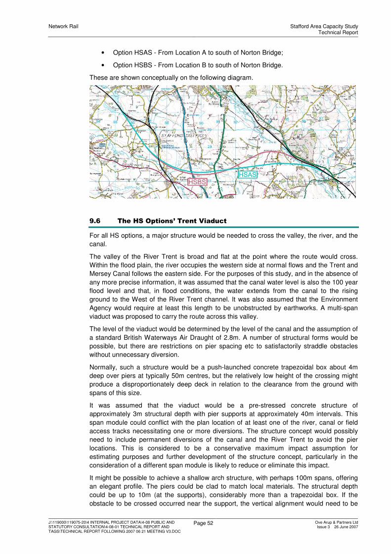
Network Rail Stafford Area Capacity StudyTechnical Report
J:\119000\119075-20\4 INTERNAL PROJECT DATA\4-08 PUBLIC AND STATUTORY CONSULTATION\4-08-01 TECHNICAL REPORT AND TAGS\TECHNICAL REPORT FOLLOWING 2007 06 21 MEETING V3.DOC
Page 52 Ove Arup & Partners LtdIssue 3 26 June 2007
• Option HSAS - From Location A to south of Norton Bridge;
• Option HSBS - From Location B to south of Norton Bridge.
These are shown conceptually on the following diagram.
9.6 The HS Options’ Trent Viaduct
For all HS options, a major structure would be needed to cross the valley, the river, and the
canal.
The valley of the River Trent is broad and flat at the point where the route would cross.
Within the flood plain, the river occupies the western side at normal flows and the Trent and
Mersey Canal follows the eastern side. For the purposes of this study, and in the absence of
any more precise information, it was assumed that the canal water level is also the 100 year
flood level and that, in flood conditions, the water extends from the canal to the rising
ground to the West of the River Trent channel. It was also assumed that the Environment
Agency would require at least this length to be unobstructed by earthworks. A multi-span
viaduct was proposed to carry the route across this valley.
The level of the viaduct would be determined by the level of the canal and the assumption of
a standard British Waterways Air Draught of 2.8m. A number of structural forms would be
possible, but there are restrictions on pier spacing etc to satisfactorily straddle obstacles
without unnecessary diversion.
Normally, such a structure would be a push-launched concrete trapezoidal box about 4m
deep over piers at typically 50m centres, but the relatively low height of the crossing might
produce a disproportionately deep deck in relation to the clearance from the ground with
spans of this size.
It was assumed that the viaduct would be a pre-stressed concrete structure of
approximately 3m structural depth with pier supports at approximately 40m intervals. This
span module could conflict with the plan location of at least one of the river, canal or field
access tracks necessitating one or more diversions. The structure concept would possibly
need to include permanent diversions of the canal and the River Trent to avoid the pier
locations. This is considered to be a conservative maximum impact assumption for
estimating purposes and further development of the structure concept, particularly in the
consideration of a different span module is likely to reduce or eliminate this impact.
It might be possible to achieve a shallow arch structure, with perhaps 100m spans, offering
an elegant profile. The piers could be clad to match local materials. The structural depth
could be up to 10m (at the supports), considerably more than a trapezoidal box. If the
obstacle to be crossed occurred near the support, the vertical alignment would need to be

Network Rail Stafford Area Capacity StudyTechnical Report
J:\119000\119075-20\4 INTERNAL PROJECT DATA\4-08 PUBLIC AND STATUTORY CONSULTATION\4-08-01 TECHNICAL REPORT AND TAGS\TECHNICAL REPORT FOLLOWING 2007 06 21 MEETING V3.DOC
Page 53 Ove Arup & Partners LtdIssue 3 26 June 2007
raised by up to 5-6m, somewhat contrary to the need to minimise the visual effects of the
structure. There would be severe knock-on effects on the vertical curvature approaching the
area. Also, if there were a 10m structural depth over an obstacle needing 10m clearance,
the visual impact would be oddly disproportioned; the “Golden Ratio” rule would be notably
broken.
Much more detailed study is needed of a range of structural types, span arrangements,
deck depths and vertical alignments. It is believed, however, that it will be possible to design
an aesthetically-pleasing structure in modern materials.
It was assumed that noise considerations will require of the provision of acoustic screening
close to the major source of noise and so a combined robust kerb and absorptive acoustic
barrier could be included. Additional noise barriers may however be required when more
detailed calculations of noise exposure are performed.
It was assumed that maintenance of a long structure of this form would require a permanent
maintenance access track both at high level and at the river valley level. Maintenance
requirements are likely to be for small tools and light plant at high level and for heavier plant
such as inspection platforms at ground level. The cross section allows for a 2m access track
to both sides of the running tracks on the viaduct and a single 3.6m wide track at the river
valley level. The shadow area of the viaduct would also be hardened using grasscrete or
similar to allow future maintenance plant to operate beneath all parts of the structure. It may
also be necessary to provide additional small bridges crossing the River Trent and the Trent
and Mersey Canal to permit full length access the lower maintenance track. It would also be
prudent to connect the lower track to the longitudinal maintenance access track that is
provided along the remainder of the route.
9.7 HS Options Carried Forward
The short-list of HS options was:
• Option HSAN;
• Option HSBN;
• Option HSCN;
• Option HSDN;
• Option HSAS;
• Option HSBS.

Network Rail Stafford Area Capacity StudyTechnical Report
J:\119000\119075-20\4 INTERNAL PROJECT DATA\4-08 PUBLIC AND STATUTORY CONSULTATION\4-08-01 TECHNICAL REPORT AND TAGS\TECHNICAL REPORT FOLLOWING 2007 06 21 MEETING V3.DOC
Page 54 Ove Arup & Partners LtdIssue 3 26 June 2007
10 Development of the ER Options
10.1 Option ER1 - Twin Track Underpass at Stafford
10.1.1 Layout
Option ER1 would provide a twin-track underpass to carry the Up and Down Birmingham
Fast lines below the Up and Down Trent Valley Slow, south of Stafford Station. This would
bring the Wolverhampton fast service onto the easterly “fast” side of the 4-track railway to
the north of Stafford, and would avoid Virgin Cross-country service from the Wolverhampton
direction towards Manchester having to cross at Doxey Junction.
The underpass would be south of the station, and would deepen to a maximum depth of
eight metres below existing levels, south of the existing A449 Wolverhampton Road bridge.
The underpass would rise to ground level about 300m south of Rickerscote bridge, merging
into the Birmingham Slow lines. The Slow lines would be diverted to the west, to join the
Trent Valley Slow lines at Stafford South Junction. Gradients of about 1:55 to 1:65 would be
required as a result of the need to have all tracks at ground level to the south of the
platforms.
The key structure would be the Wolverhampton Road bridge. It would be demolished to
allow the construction of the underpass, and to give the freedom to place tracks anywhere
below it on either temporary or permanent alignments. A new bridge would first be built
alongside the existing to the north. It would cross the railway corridor at zero skew relative
to the railway and in a single span to provide maximum flexibility for track position. A
realignment of Wolverhampton Road would be needed, involving a demolition of a garage
and petrol filling station, a Public House, and 14 residential properties on the north side of
the railway.
The existing signal boxes would be abolished, with control transferred to a new control
centre. This could be temporary or permanent; the decision would not affect the proposed
scheme. New SSI interlockings would be provided, with their boundaries to suit NR Territory
preferences. It was assumed that it would be necessary to implement bi-directional
signalling on both lines between Stafford and Colwich to provide flexibility for future
maintenance, given the absence of a diversion route under Option ER1.
The construction effects would be sufficiently disruptive as to necessitate the upgrading of
the Walsall to Rugeley route to carry diverted services.
10.1.2 Environmental Effects
10.1.2.1 Noise
There are approximately 2197 properties within 300m of the alignment, although many are
masked from the railway by intervening property.
Construction
With the assumed construction activities, there is likely to be considerable numbers of
receptors that may experience potential adverse noise impacts.
Construction activities would involve day-time, night-time and long-weekend activities with
possession of the WCML during which intensive and heavy engineering activities would be
undertaken. As a consequence, it was considered that these activities could give rise to
noise nuisance which in consequence could give rise to noise abatement action and
possible delays in programme and associated costs.
It was considered that noise mitigation could be provided during the construction period;
however, it was considered that the use of noise barriers was unlikely to mitigate noise
levels sufficiently for night-time possession activities.

Network Rail Stafford Area Capacity StudyTechnical Report
J:\119000\119075-20\4 INTERNAL PROJECT DATA\4-08 PUBLIC AND STATUTORY CONSULTATION\4-08-01 TECHNICAL REPORT AND TAGS\TECHNICAL REPORT FOLLOWING 2007 06 21 MEETING V3.DOC
Page 55 Ove Arup & Partners LtdIssue 3 26 June 2007
Other options that may mitigate noise impacts are provision of noise insulation, temporary
re-housing or compulsory purchase.
It is recommended that detailed noise analysis should be undertaken to identify appropriate
mitigation options to control construction noise prior to undertaking the works, which should
be supported by consultation and close liaison with local authority planning, environmental
health officers and the immediate community.
Operation
The change in train flows (as described in the Functional Specification for the 2008
timetable) was considered using the CRN prediction methodology and based upon the
assumption that no screening would exist between the railway and the nearest properties.
The preliminary assessment identified that an increase in noise levels of 1 dB may be
expected; this was not considered to be significant. There is a need to undertake more
detailed modelling of the effects of the underpass in shielding operational noise, or
potentially generating reflected noise from the underpass walls.
Detailed analysis taking into account screening, topography and any other mitigating
information should be undertaken upon selection of a preferred option.
10.1.2.2 Air Quality
There would be about 1441 properties within 200m. The effect on local air quality is thought
likely to be greatest through the construction phase, particularly dust and fugitive emissions
on residential property properties proximal to construction work.
10.1.2.3 Landscape and Townscape
Option ER1 would lead to increased visual impact within the urban environment; the
underpass would help to improve the situation by removing some trains from view, but large
scale OLE gantries would be a notable disfigurement of the visual scene. The railway
corridor is in close proximity to adjacent properties, both existing and under construction.
Construction activities would also require careful control, particularly night-time possessions.
10.1.2.4 The Heritage of Historic Resources
There would be potential effects on buried archaeological resources should they be present,
resulting from construction activities. The permanent works may give rise to visual effects
on the setting of listed buildings located in the vicinity. The works may also result in effects
on industrial archaeological features associated with the railway. The County SMR includes
a medieval settlement on this route. Details of these archaeological features, including their
extent, cannot be determined in more detail without consulting with the Local Authority.
Archaeological investigation could take a significant period which would need to be
accommodated within the project staging. If the site were identified to be of special
importance, protection of the site could preclude construction of a haul road through this
area.
Archaeological mitigation would include the careful design of construction to avoid (were
practicable) features of importance should they be identified and/or propose a suitable
investigative mitigation.
10.1.2.5 Biodiversity
There may be impacts to the following designated sites of European nature conservation
importance that are located within 10km of this route:
• Cannock Chase SAC 5km to the south-east;
• Chartley Moss (part of the West Midlands Mosses SAC) 10km to the north-east;
and,
• Pasturefields Salt Marsh Special Area of Conservation (SAC) 6km to the north-east.

Network Rail Stafford Area Capacity StudyTechnical Report
J:\119000\119075-20\4 INTERNAL PROJECT DATA\4-08 PUBLIC AND STATUTORY CONSULTATION\4-08-01 TECHNICAL REPORT AND TAGS\TECHNICAL REPORT FOLLOWING 2007 06 21 MEETING V3.DOC
Page 56 Ove Arup & Partners LtdIssue 3 26 June 2007
There may also be impacts to the following designated sites nature conservation importance
that are located within 1km of this route:
• Doxey and Tillington Marshes Site of Special Scientific Interest (SSSI);
• Rowley Grove Site of Biological Interest (SBI); and,
• Hough Drain SBI.
Habitats that may be impacted include:
• a UK BAP priority habitat (floodplain grazing marsh); and,
• seven UK BAP broad habitats (boundary and linear features, built up areas and
gardens, fen, marsh and swamp, neutral grassland, rivers and streams and
standing open water).
Protected or otherwise notable species that may be impacted include: Otter, Water Vole,
White-clawed Crayfish, birds, bats, reptiles, amphibians, fish, invertebrates and plants.
10.1.2.6 The Water Environment
For the water environment, the option may impact two watercourses at the southern end of
the underpass, requiring realignment or culverting that the Environment Agency does not
usually support.
10.1.3 Geotechnical Issues
There was very little information on the likely ground conditions for the underpass, which is
envisaged as a long structure excavated about 8m below existing ground level. Based on
the results of a few boreholes and the information depicted on the geological map, two
alternatives on the expected ground conditions were identified; in both, ground water is
indicated to be high, within 1.0m of surface level. Any cuttings in the superficial deposits are
likely to encountered groundwater, and Alluvial deposits may require 1 in 3 side slopes.
10.1.4 Construction Traffic
A key construction site would be triangle of land between the Queensville curves and the
Birmingham lines. The haul road to this site would need to cross an area of ‘Protected Open
Space’, pass close to a children’s playground and fringe a site listed in the “Sites and
Monuments Record”.
10.1.5 Capital Cost and Incremental Add-Ons
The basic capital cost of the scheme was estimated at £289m.
10.1.6 Option Summary
Environmentally, it would affect significantly more people than any HS or GF option, but
would have a reduced effect on ecological, landscape and heritage resources.
The option was not carried forward.
10.2 Option ER2 - Single Track Underpass at Stafford, Flyover at Great
Bridgeford
10.2.1 Layout
This option would provide a single-track underpass to carry the Up Birmingham Fast lines
below the Down Slow and Down Fast (Trent Valley) lines. The location of the underpass
would be almost identical to that of Option ER1. Down Birmingham services needing to
access the present Down Fast would cross by means of a new flyover near Great
Bridgeford.
The key structures would be the underpass (whose issues would be as in Option ER1), and
the flyover near Great Bridgeford. To minimise the vertical difference between alignments
for the two tracks that cross, a structure form that spans from side to side of the route was

Network Rail Stafford Area Capacity StudyTechnical Report
J:\119000\119075-20\4 INTERNAL PROJECT DATA\4-08 PUBLIC AND STATUTORY CONSULTATION\4-08-01 TECHNICAL REPORT AND TAGS\TECHNICAL REPORT FOLLOWING 2007 06 21 MEETING V3.DOC
Page 57 Ove Arup & Partners LtdIssue 3 26 June 2007
chosen. The structure approaches use reinforced earth type retaining walls either side of the
track to form ramps in the order of 1km long. The location chosen for the crossover structure
would be where an existing farm accommodation structure crosses the WCML, complicating
the structural provisions.
The signalling would include full bi-direction provision on the Up Trent Valley Slow line
between Whitehouse Junction and Stafford, on all lines in Stafford station except the Up
Trent Valley Fast, on all lines except the Up Fast between Stafford station and Doxey
Junction and on the Up and Down Birmingham lines between Stafford station and
Rickerscote Junction.
The OLE implications would be almost identical to Option ER1.
10.2.2 Environmental Effects
10.2.2.1 Noise
There are approximately 2290 properties in the vicinity of this option which may potentially
be affected by noise during construction works.
10.2.2.2 Air Quality
There would be about 1404 properties within 200m of the proposed route. The effect on
local air quality is thought likely to be greatest through the construction phase, particularly
dust and fugitive emissions on residential property properties proximal to construction work.
10.2.2.3 Landscape and Townscape
The effects of Option ER2 would be as for Option ER1, but with additional impact to the
north-west of Stafford, where communities at Great Bridgeford and Seighford may be
affected. The flyover would introduce hard urban elements into the rural setting. This would
need to be addressed during the assessment and scheme design; mitigation in the form of
landscape earthworks and planting could help to reduce the impact, but should be carefully
planned to avoid the mitigation measures themselves becoming visually intrusive.
10.2.2.4 The Heritage of Historic Resources
There would be potential effects on buried archaeological resources should they be present,
resulting from construction activities. The permanent works may give rise to visual effects
on the setting of listed buildings located in the vicinity. The works may also result in effects
on industrial archaeological features associated with the railway. The County SMR includes
a medieval settlement on this route. Details of these archaeological features, including their
extent, cannot be determined in more detail without consulting with the Local Authority.
Archaeological mitigation would include the careful design of construction to avoid (were
practicable) features of importance should they be identified and/or propose a suitable
investigative mitigation.
There is a listed chapel at Creswell. Other listed buildings are also present in the vicinity.
These may, as a result of the permanent works experience adverse impacts to their setting.
10.2.2.5 Biodiversity
There may be impacts to the following designated sites of European nature conservation
importance that are located within 10km of this route:
• Cannock Chase SAC 5km to the south-east;
• Chartley Moss (part of the West Midlands Mosses SAC) 10km to the north-east;
and,
• Pasturefields Salt Marsh Special Area of Conservation (SAC) 6km to the north-east.
There may also be impacts to the following designated sites nature conservation importance
that are located within 1km of this route:

Network Rail Stafford Area Capacity StudyTechnical Report
J:\119000\119075-20\4 INTERNAL PROJECT DATA\4-08 PUBLIC AND STATUTORY CONSULTATION\4-08-01 TECHNICAL REPORT AND TAGS\TECHNICAL REPORT FOLLOWING 2007 06 21 MEETING V3.DOC
Page 58 Ove Arup & Partners LtdIssue 3 26 June 2007
• Doxey and Tillington Marshes Site of Special Scientific Interest (SSSI);
• Rowley Grove Site of Biological Interest (SBI);
• Hough Drain SBI; and,
• Drakelow Covert SBI.
Habitats that may be impacted include:
• a UK BAP priority habitat (floodplain grazing marsh); and,
• seven UK BAP broad habitats (boundary and linear features, built up areas and
gardens, fen, marsh and swamp, neutral grassland, rivers and streams and
standing open water).
Protected or otherwise notable species that may be impacted include: Otter, Water Vole,
White-clawed Crayfish, birds, bats, reptiles, amphibians, fish, invertebrates and plants.
10.2.2.6 The Water Environment
In terms of the water environment, Option ER2 would be very similar to Option ER1, with the
added effects within the 1 in 100 floodplain of the River Sow and the Doxey and Millian
Brook.
10.2.3 Geotechnical Issues
The southern part of Option ER2 would be virtually identical to Option ER1 in the Stafford
station area. For the underpass, the observations made in respect of Option ER1 would
apply.
The Great Bridgeford flyover would be located within the central part of a cutting up to 6m
deep. There was little/no borehole data to indicate expected ground conditions. Any cuttings
into the superficial deposits are likely to encountered groundwater, and Alluvial deposits
may require 1 in 3 side slopes. The cuttings into the Mercia Mudstone Strata overlain by
gravels are likely to require 1 in 2 side slopes.
10.2.4 Construction Traffic
Construction of the Great Bridgeford Flyover would require a main construction access and
haul road to the A5013 between Great Bridgeford and Cresswell, and a secondary point of
access from the B5405 to the west side of the existing railway.
10.2.5 Capital Cost and Incremental Add-Ons
The basic capital cost of the scheme was estimated at £372m.
10.2.6 Option Summary
Environmentally, this option would affect significantly more people than any HS or GF
option, and would affect more people in the Rickerscote area than Option ER1. It would
have a reduced effect on ecological, landscape and heritage resources. There would be
additional effects at Great Bridgeford, and on the Doxey and Tillington Marshes Site of
Special Scientific Interest (SSSI).
The option was not carried forward.
10.3 Option ER3 - Four-Tracking Shugborough Tunnel
10.3.1 Layout
The option would extend the track arrangement from Bishton, through Colwich Junction and
on to Shugborough. Colwich Junction would have to be re-modelled to include a six-track
corridor from a new junction some distance to the south. The route towards Stoke and
Manchester would not be grade-separated, but would simply peel off to the north. It would
be preferable to construct the Colwich Cut-Off as a more cost-effective and journey time
saving alternative.

Network Rail Stafford Area Capacity StudyTechnical Report
J:\119000\119075-20\4 INTERNAL PROJECT DATA\4-08 PUBLIC AND STATUTORY CONSULTATION\4-08-01 TECHNICAL REPORT AND TAGS\TECHNICAL REPORT FOLLOWING 2007 06 21 MEETING V3.DOC
Page 59 Ove Arup & Partners LtdIssue 3 26 June 2007
To the west of Colwich Junction, two new tracks would be added to the north of the existing
two, passing over a new structure over the Trent and Mersey Canal. The new bridge would
be clear of the existing structure. West of Meadow Lane, the two new tracks would need to
lie to the south of existing, thereby necessitating a change of side for the widening. A new
bridge would be constructed over Meadow Lane.
The new southerly tracks would pass over the River Trent on a viaduct, clear of the flood
plain. The existing cutting in the Shugborough Park area would be widened to create the
space for the new tracks. A new aqueduct would be needed to carry Cher Brook over the
railway, together with a new bridge to carry the egress from Shugborough Park to the A513.
The route would then enter a new tunnel parallel to, and about 25m from, the existing
tunnel. A 125mph tunnel cross-section would be provided, as the potential for higher line
speeds is modest. The new tunnel would be approximately 700m in length, as is the
existing.
West of the tunnel, the new lines would pass the site of the former Milford Station, and
would remove Milford Junction. It was assumed that the new tracks could pass under the
structure carrying Holdford Road. Further west, the existing railway formation is sufficiently
wide as to accommodate all four running lines.
West of the village of Milford, it would be necessary to construct a new flyover structure to
allow the Up Slow to run over to be the northerly of the four tracks through Shugborough.
This new flyover would lie in open land between Milford and the easterly Stafford suburbs in
the Baswich area. There would be a temporary diversion of the Staffordshire and
Worcestershire Canal to the north. There would also need to be a temporary realignment of
the Slow lines to the south to create construction space. For environmental reasons, a site a
little further west may actually be preferable.
West and north of Whitehouse Junction, there would be no change to the existing railway.
The present layout at Stafford would remain.
10.3.2 Environmental Overview
10.3.2.1 Noise
There are approximately 713 properties located within 300 metres that may be potentially
affected by construction or operation of the route. The majority of these properties are
located within the villages of Walton-on-the-Hill and Milford.
10.3.2.2 Local Air Quality
There are 470 houses within a distance of 200m on either side of the proposed route. The
effect on local air quality is thought likely to be greatest through the construction phase,
particularly dust and fugitive emissions on residential properties proximal to construction
work.
10.3.2.3 Landscape and Townscape
Option ER3 would involve substantial new work within the AONB, in the Shugborough Park
area, leading to landscape/visual impacts from the new cutting and tunnel sections and a
length of new embankment. Near Milford, there would also be visual impact from the new
flyover structures and the associated approach ramps; this would be on the borders of the
AONB and occur in a sensitive location adjacent to the River Sow and the Staffordshire and
Worcestershire Canal.
10.3.2.4 The Heritage of Historic Resources
This option would cross the Trent Valley south of Little Haywood, passing through the
Conservation Area of Colwich and Little Haywood before crossing the Trent River. The route
would also pass close to a number of listed buildings within the village of Colwich.

Network Rail Stafford Area Capacity StudyTechnical Report
J:\119000\119075-20\4 INTERNAL PROJECT DATA\4-08 PUBLIC AND STATUTORY CONSULTATION\4-08-01 TECHNICAL REPORT AND TAGS\TECHNICAL REPORT FOLLOWING 2007 06 21 MEETING V3.DOC
Page 60 Ove Arup & Partners LtdIssue 3 26 June 2007
At the River Trent, the alignment would traverse alluvium and river terraces which have the
potential to contain archaeology and information on palaeo-environmental indicators. The
Trent and Mersey Canal to the west of Colwich is a designated conservation area.
The route would pass underneath Shugborough Park in a tunnel and surface on the
southern side of the River Sow valley where a flyover is proposed comprising a reinforced
earth ramp.
The alignment is within the Conservation Area of Great Haywood and Shugborough. The
Conservation Area also covers the majority of the Grade I Registered Park of Shugborough.
The Park contains a range of listed buildings whose setting would be affected.
Construction may affect archaeology located within the late Glacial River terrace deposits.
Tunnelling may have an impact on the variety of listed buildings and the setting of the
parkland landscape. The cutting required for the tunnel would also have an impact on the
setting for these features and would also increase the potential for the discovery of
archaeological remains.
10.3.2.5 Biodiversity
There may be impacts to the following designated sites of European nature conservation
importance that are located within 10km of this route:
• Cannock Chase Special Area of Conservation (SAC) 500m to the south-east;
• Chartley Moss (part of the West Midlands Mosses SAC) 7km to the north-east; and,
• Pasturefields Salt Marsh SAC 3km to the north.
There may also be impacts to the following designated sites of nature conservation
importance that are located within 1km of this route:
• Rawbones Meadow Site of Special Scientific Interest (SSSI).
• Baswich Meadows Site of Special Scientific Interest (SSSI).
Habitats that may be impacted include:
• a UK BAP priority habitat (floodplain grazing marsh); and,
• seven UK BAP broad habitats (boundary and linear features, built up areas and
gardens, fen, marsh and swamp, neutral grassland, rivers and streams and
standing open water).
Protected or otherwise notable species that may be impacted include: Otter, Water Vole,
White-clawed Crayfish, birds, bats, reptiles, amphibians, fish, invertebrates and plants.
10.3.2.6 The Water Environment
The route would affect the 1% year floodplain of the River Trent, which extends to the
western bank of the River Trent at this location. There would be a widened embankment
which would impinge on the existing floodplain both in terms of flood conveyance and flood
storage volume. Any loss would need to be compensated for.
The alignment would affect the 1 in 100 year floodplain of the Cher Brook at Shugborough
Park. The brook crosses the existing railway, which is within cutting, via an aqueduct. A
new aqueduct would be required, with potential flooding implications.
West of Shugborough tunnel, the alignment would enter the 1% floodplain of the River Sow.
The alignment would again be on embankment with conveyance and storage issues.
The Staffordshire and Worcestershire Canal delineates the edge of the 1% floodplain of the
River Sow but the route would fall predominantly outside the floodplain. The flyover
approach ramp would encroach onto the canal, which would need realigning to the north,

Network Rail Stafford Area Capacity StudyTechnical Report
J:\119000\119075-20\4 INTERNAL PROJECT DATA\4-08 PUBLIC AND STATUTORY CONSULTATION\4-08-01 TECHNICAL REPORT AND TAGS\TECHNICAL REPORT FOLLOWING 2007 06 21 MEETING V3.DOC
Page 61 Ove Arup & Partners LtdIssue 3 26 June 2007
impeding the River Sow floodplain; any lost volume would need to be compensated and
may require considerable mitigation works.
Part of the alignment would pass over a major aquifer, and care would need to be taken in
the construction of any foundations or tunnels, to ensure the aquifer was not affected. This
aquifer was identified at being at risk from diffuse pollution on the EA’s website. Surface
water disposal to ensure water quality is particularly relevant as part of the alignment would
pass through a groundwater protection zone.
10.3.3 Geotechnical Overview
The tunnel at Shugborough through Sherwood Sandstone Strata would most likely be
constructed using a Road Header with a temporary sprayed concrete lining followed with
cast in situ concrete lining; similar to the North Downs tunnel on the CTRL. Due to the short
length of the tunnel, the use of a TBM is unlikely to be cost-effective. The required
separation from the existing tunnel would depend on the details of the ground conditions.
The western section of this option would follow the southern side of the River Sow valley
between Baswich and Milford, where a flyover is proposed. Alluvial deposits and a late
glacial River Terrace deposit will be present overlying Sherwood Sandstone strata.
Any cutting required into the Sherwood Sandstone are likely to be accommodated by 1 in 2.
10.3.4 Capital Cost and Incremental Add-Ons
The basic capital cost of the scheme was estimated at £192m.
10.3.5 Option Summary
The layout would not achieve a capacity increase at Stafford Trent Valley Junction, and
would need to be supplemented. Although the basic cost would be £192m, there would
need to be the addition of the Colwich Cut-off (£135m), together with either option Er1 or
ER2 at Stafford Station (£289m or £372m).
There would be major landscape and townscape implications, with substantial work within
AONB, in Shugborough Park and near Milford, on River Sow and on the Staffordshire and
Worcestershire Canal. There would be major effects on the Conservation Area of Colwich
and Little Haywood, Shugborough Park, and the Conservation Area of Great Haywood and
Shugborough. There would be biodiversity impacts on Cannock Chase Special Area of
Conservation (SAC), Rawbones Meadow SSSI and Baswich Meadows SSSI. There would
be water impacts on floodplains and a groundwater protection zone. Environmentally, these
are major adverse issues.
The option was not carried forward.
10.4 Option ER4 - Paired by Direction to Great Bridgeford
10.4.1 Layout
Option ER4 would extend the track arrangement of the TV4 Scheme through Stafford, to
Great Bridgeford. The key issue is that this configuration will be a conventional paired-by-
direction scheme with the Fast lines in the centre of the layout. This paired by direction
arrangement would require all Birmingham-bound services to cross both TV Down lines.
The option would be identical to Option ER3 between Colwich Junction and Milford, but
would not require the flyover at Whitehouse Junction. West from Whitehouse Junction, the
existing four lines to Stafford would remain in exactly the same positions, but would be used
differently. At Stafford, this option would include the underpass element of Option ER2. At
Great Bridgeford, there would be a flyover as in Option ER2, but with different tracks being
carried on it.
Network Rail Stafford Area Capacity StudyTechnical Report
J:\119000\119075-20\4 INTERNAL PROJECT DATA\4-08 PUBLIC AND STATUTORY CONSULTATION\4-08-01 TECHNICAL REPORT AND TAGS\TECHNICAL REPORT FOLLOWING 2007 06 21 MEETING V3.DOC
Page 62 Ove Arup & Partners LtdIssue 3 26 June 2007
10.4.2 Environmental Overview
10.4.2.1 Noise
There are approximately 1075 properties within 300m that may be potentially affected by
construction or operation of the route. These figures do not count property in the Stafford
area where no infrastructure changes are proposed. The majority of the properties are in the
villages of Walton-on-the-Hill and Milford, with a small number near Great Bridgeford.
10.4.2.2 Local Air Quality
There are 678 houses within a distance of 200m on either side of the proposed route. The
effect on local air quality is likely to be greatest through the construction phase, particularly
dust and fugitive emissions on residential properties proximal to construction work.
10.4.2.3 Landscape and Townscape
The effects would be as for Option ER2 and ER3.
10.4.2.4 The Heritage of Historic Resources
The effects would be as for Option ER2 and ER3.
10.4.2.5 Biodiversity
The effects would be as for Option ER2 and ER3.
10.4.2.6 The Water Environment
The effects would be as for Option ER2 and ER3.
10.4.3 Geotechnical Overview
The implications would be as for Option ER2 and ER3.
10.4.4 Capital Cost and Incremental Add-Ons
The basic capital cost of the scheme was estimated at £515m.
10.4.5 Option Summary
This option would achieve a capacity increase at Stafford Trent Valley Junction, but in
environmental terms, it would be comparably poor as Option ER3, with a trade-off of the
Great Bridgeford effects against those at Milford.
This option was not carried further.
10.5 Option ER5 - Paired by Direction to Crewe
10.5.1 Layout
Option ER5 would extend the track arrangement of options ER3 and ER4. It would be
identical to Option ER4 between Colwich Junction and Great Bridgeford, but there would be
no flyover there. The track configuration would be maintained to Crewe, which is already
paired in this configuration. There would, therefore, be a paired-by-direction railway all the
way from Nuneaton to Winsford. There would be no flyovers at Whitehouse Junction or
Great Bridgeford. Between Stafford and Crewe there would be significant railway works to
adapt the present four tracks into their new running arrangements. At Basford Hall, it might
be necessary to construct a grade-separated facility to connect Basford Hall yards with the
Up Slow.
10.5.2 Environmental Overview
10.5.2.1 Noise
There are approximately 1242 properties within 300 metres that may be potentially affected
by construction or operation of the route.
10.5.2.2 Local Air Quality
There are 759 houses within a distance of 200m on either side of the proposed route. The
effect on local air quality is thought likely to be greatest through the construction phase,

Network Rail Stafford Area Capacity StudyTechnical Report
J:\119000\119075-20\4 INTERNAL PROJECT DATA\4-08 PUBLIC AND STATUTORY CONSULTATION\4-08-01 TECHNICAL REPORT AND TAGS\TECHNICAL REPORT FOLLOWING 2007 06 21 MEETING V3.DOC
Page 63 Ove Arup & Partners LtdIssue 3 26 June 2007
particularly dust and fugitive emissions on residential properties proximal to construction
work.
10.5.2.3 Landscape and Townscape
Option ER5 would involve substantial new work within the AONB, in the Shugborough Park
area, leading to landscape/visual impacts from the new cutting and tunnel sections and a
length of new embankment.
10.5.2.4 The Heritage of Historic Resources
The route would have all the effects of Option ER4, but would avoid those in the Great
Bridgeford area. Further data collection and consultation would be required in order to
ascertain the effects between Great Bridgeford and Crewe.
10.5.2.5 Biodiversity
The route would bring about all the effects associated with Option ER4, but would avoid
those in the Great Bridgeford area. Further data collection and consultation would be
required in order to ascertain the effects between Great Bridgeford and Crewe.
10.5.2.6 The Water Environment
The route would bring about all the effects associated with Option ER4, but would avoid
those in the Great Bridgeford area. Further data collection and consultation would be
required in order to ascertain the effects between Great Bridgeford and Crewe.
10.5.3 Geotechnical Overview
No physical works are required for this option over and beyond those described for Options
ER3 and ER4.
10.5.4 Capital Cost and Incremental Add-Ons
The basic capital cost of the scheme was estimated at £566m.
10.5.5 Option Summary
This option would appear to have negative performance aspects. It was of high cost, and
environmentally would have the disadvantages of Option ER3, offset by a lesser impact at
Great Bridgeford, but with unknown and possibly notable impacts resulting from the other
infrastructure changes which would be needed to make it a satisfactory operational option.
This option was not carried further.
10.6 Option ER6 – Transposition: Stafford to Badnall Wharf
10.6.1 Introduction to the Concept of Transposition
One of the factors thought likely to benefit performance was the concept of transposition.
If a bypass were constructed, the majority of the remaining trains approaching Stafford from
the Trent Valley direction would be freight or stopping passenger services. These could be
routed almost exclusively to the present Fast lines north of Stafford. Equally, trains from the
Birmingham direction could be routed to the present Slow lines. This would vastly reduce
conflicts at Trent Valley Junction, and would avoid the costly and disruptive impact of
providing grade-separation in this area. Effectively, the layout through Stafford would
become two parallel, two-track railways, with no conflicts.
The schematic below presents transposition in its most simplistic, stylised form.

Network Rail Stafford Area Capacity StudyTechnical Report
J:\119000\119075-20\4 INTERNAL PROJECT DATA\4-08 PUBLIC AND STATUTORY CONSULTATION\4-08-01 TECHNICAL REPORT AND TAGS\TECHNICAL REPORT FOLLOWING 2007 06 21 MEETING V3.DOC
Page 64 Ove Arup & Partners LtdIssue 3 26 June 2007
There would be no track or signalling changes at Stafford; transposition would simply be a
matter of routing. A further benefit would be that this reduction in conflicts could give the
opportunity to simplify the layout to something more appropriate to the residual movements,
possibly in conjunction with re-signalling.
10.6.2 Layout
Option ER6 would be the incremental addition of transposition. There would be no
infrastructure changes in the Milford, Whitehouse or Stafford areas, but these “slow” trains
would be routed onto the easterly lines at Stafford, allowing the Birmingham lines to be
“fast” towards the western side. There would have to be an arrangement of grade-
separation to restore the present track layout north of Badnall Wharf. A bypass junction at
Badnall Wharf would allow this at a marginal incremental cost.
10.6.3 Environmental Overview
There would be no more environmental effects over and above those described for
whichever bypass layout that Option ER6 was combined with.
10.6.4 Geotechnical Overview
There would be no more geotechnical implications over and above those described for
whichever bypass layout that Option ER6 was combined with.
10.6.5 Capital Cost and Incremental Add-Ons
The costs of ER6 are included in the estimates for previous options, except for the costs of
the Slow line upgrade. This was not fully costed.
10.6.6 Operational Performance of Transposition
The key findings (in relation to Option ER6) from operational modelling were that:
• the 2015 timetable would not perform satisfactorily on the existing infrastructure;
• transposition ending within the Badnall Wharf Junction would be ineffective – it
would have to be south of Norton Bridge to be effective;
• satisfactory performance could be achieved by routing Trent Valley freight via
Stafford;
• remodelling Norton Bridge would achieve time savings;
• decisions on the number of freight trains routed via the bypass, or remaining on the
existing route via Stafford, would adjust performance; there was no simple answer
to this conundrum;
• the Wolverhampton to Stafford corridor was not critical to performance.
10.6.7 Option Summary
This option would achieve a simplification of Stafford Trent Valley Junction with capacity
gains. It would be combined with any “bypass” option. Environmentally, there would be no

Network Rail Stafford Area Capacity StudyTechnical Report
J:\119000\119075-20\4 INTERNAL PROJECT DATA\4-08 PUBLIC AND STATUTORY CONSULTATION\4-08-01 TECHNICAL REPORT AND TAGS\TECHNICAL REPORT FOLLOWING 2007 06 21 MEETING V3.DOC
Page 65 Ove Arup & Partners LtdIssue 3 26 June 2007
effect over and above whichever HS or GF option it were combined with. It would, however,
not deliver the expected performance and capacity benefit, as the transposition would be
north of Norton Bridge.
This option was not carried further.
10.7 Option ER7 - Six-track Railway: Stafford to Newport Corridor
10.7.1 Layout
Option ER7 would provide a six-track railway north of Stafford by placing two tracks to the
west of the existing railway between Rickerscote and Stafford. There would be no Trent
Valley Junction. There would be a 40mph curve to take the route onto the Stafford to
Newport rail corridor. The route would require the re-location of “The Way for the
Millennium”, a cycle route network which runs along this corridor. The two new tracks would
then utilise the disused line as far as Burleyfields, at which point they would rise to pass
over the M6 and local rural roads. The route would then turn north to pass east of Seighford,
approaching the existing railway north of the M6, via a pair of 80mph curves. There would
be a flyover at Great Bridgeford to provide a grade-separated route from the Birmingham
direction to the easterly Fast Lines north of Cresswell.
10.7.2 Environmental Overview
10.7.2.1 Noise
There are approximately 2339 properties located within 300 metres that may be potentially
affected by construction or operation of the route. The majority of these properties are
located in Stafford and its outlying villages.
10.7.2.2 Local Air Quality
There are about 1533 houses within a distance of 200m but there was insufficient data to
calculate accurately. The effect on local air quality is thought likely to be greatest through
the construction phase, particularly dust and fugitive emissions on residential properties
proximal to construction work.
10.7.2.3 Landscape and Townscape
The urban section’s limited townscape impact would arise mainly from road realignments.
There would be a visually intrusive structure over the M6 Motorway and a flyover at Great
Bridgeford as in Option ER2.
10.7.2.4 The Heritage of Historic Resources
This route would have no known impact on designated features. Further data collection and
consultation would be required in order to ascertain the effect that this alignment would have
on undesignated and as yet unidentified heritage assets.
10.7.2.5 Biodiversity
There may be some effects along the disused rail corridor, but these are unknown. The
effects at Great Bridgeford would be as for Option Er2.
10.7.2.6 The Water Environment
Between Rickerscote and Stafford, any widening would impinge on the existing floodplains.
Near the M6, the route would cross the floodplain of the Doxey Brook. It would then cross
the Millian Brook, but if elevated should be satisfactory to the Environment Agency. The
route passes through a minor aquifer though to be ‘possibly at risk’ from diffuse pollution.
The route does not pass through any groundwater protection zones.
10.7.3 Geotechnical Overview
This option would require little or no earthworks either where the alignment would follow the
existing alignment north of Stafford Station or where it would follow the course of the former
Newport Railway railway. The flyover at Great Bridgeford would be as for Option Er2.

Network Rail Stafford Area Capacity StudyTechnical Report
J:\119000\119075-20\4 INTERNAL PROJECT DATA\4-08 PUBLIC AND STATUTORY CONSULTATION\4-08-01 TECHNICAL REPORT AND TAGS\TECHNICAL REPORT FOLLOWING 2007 06 21 MEETING V3.DOC
Page 66 Ove Arup & Partners LtdIssue 3 26 June 2007
10.7.4 Capital Cost and Incremental Add-Ons
The basic capital cost of the scheme was estimated at £152m.
10.7.5 Option Summary
This option would provide a major capacity gain and a grade-separated movement for trains
between the Birmingham and Manchester routes. It would however have a serious adverse
effect on journey times on that axis, and would not afford any benefit for the Euston to
Manchester services, unless it were combined with the Colwich Cut-Off. Environmentally, it
would be much preferred over ER3, ER4 and ER5.
This option was not carried further.
10.8 Option ER8 - Six-track Railway: Stafford to Creswell
Option ER8 would provide a six-track railway north of Stafford by placing two tracks to the
west of the existing four between Stafford station and Creswell.
The route would be identical to Option ER7 from the Queensville and Rickerscote directions
to, and through, Stafford station. North of the station, and unlike Option ER7, the new pair of
lines would run alongside the existing four through the Doxey area, and under the M6
Cresswell Viaduct. A flyover south of Great Bridgeford would take the new lines from the
west side of the layout to the east, to provide a grade-separated route for trains from the
Birmingham direction to access the Fast lines in this area.
In addition to this basic option, other schemes could be included as northwards extensions
of the Option ER8 concept. These incremental extras could be a Norton Bridge Cut-Off and
a Norton Bridge Grade-separation. This would allow:
• A simpler Norton Bridge junction, with major capacity gains;
• higher speeds through the simplification at Norton Bridge;
• a possibly environmentally-benign option.
This option could become the basis for a highly effective capacity improvement for all
movements in the Stafford area. Option ER8 was therefore extended in concept to become
Option ER8+; this is described below.
It was also considered that any option comparison must include an improvement to existing
railway infrastructure in the existing rail corridor.
10.9 Option ER8+
10.9.1 Introduction
Along the existing rail corridor, there are capacity problems at:
• Colwich Junction;
• Through Shugborough Tunnel.
• At Whitehouse Junction, where Up Trent Valley Slow services needed to cross
Down Fast services;
• At Stafford;
• Between Great Bridgeford and Norton Bridge, where track occupation was an issue;
• At Norton Bridge where junction margins were a problem;
The infrastructure solutions to the above capacity issues would, respectively, be:
• The Colwich Cut-off;
• 4-tracking through Shugborough Tunnel;

Network Rail Stafford Area Capacity StudyTechnical Report
J:\119000\119075-20\4 INTERNAL PROJECT DATA\4-08 PUBLIC AND STATUTORY CONSULTATION\4-08-01 TECHNICAL REPORT AND TAGS\TECHNICAL REPORT FOLLOWING 2007 06 21 MEETING V3.DOC
Page 67 Ove Arup & Partners LtdIssue 3 26 June 2007
• Whitehouse flyover;
• Six-tracking through Stafford;
• A flyover near Great Bridgeford;
• A 5th track between Great Bridgeford and Norton Bridge.
As described earlier, the Shugborough Tunnel 4-tracking was only marginally effective at
improving capacity, but would incur a high adverse environmental impact, and a high cost.
The other infrastructure elements were therefore added to produce Option ER8+.
10.9.2 Layout
10.9.2.1 Colwich Cut-Off
This part of Option ER8+ would be identical to Options HSAN, HSBN, HSCN and HSDN.
There would be a grade-separated junction near Bishton, and a two-track new length of
railway between there and Hixon. The route would join the existing Colwich - Stone route
immediately south of New Road, and the existing route between Colwich Junction and
Hixon would be abandoned.
10.9.2.2 The Whitehouse Flyover
Shugborough Tunnel would remain unchanged. West of Milford, in the Whitehouse Junction
area, it would be necessary to construct a new flyover and approach retained-fill
embankments to carry the present Up Slow over the Up Fast and Down Fast. This new
flyover would lie in open land between Milford and the easterly Stafford suburbs in the
Baswich area. In order to accommodate the construction of this flyover, there would need to
be a permanent diversion of the Down Slow to the south. The canal would need to be
permanently re-aligned over a length of about 600m.
West and north of Whitehouse Junction, there would be no change to the existing railway as
far as Stafford, and the existing four-track Trent Valley lines round the Queensville curve
would remain.
Construction traffic access would be problematic, with a new access road needed, and
possibly a temporary Bailey bridge to gain access to the island site.
10.9.2.3 Rickerscote to Trent Valley Junction
Over the whole length from Rickerscote and through Stafford, permanent security palisade
fencing would be required for safety reasons in order to fully segregate the work site from
the live railway, with an outer fence as necessary. Two new tracks would be built in a green-
field, Green Zone situation, with simple end-on slews to make the final connections.
At Rickerscote, residential gardens and allotments would be acquired where the new lines
would swing west.
Rowley Grove Bridge would need to be replaced by a steel foot/cycleway bridge which
would be constructed adjacent to the existing on the south side. The new bridge would be a
single span structure to provide maximum flexibility for the works and would connect to the
existing ramps via new approach ramps. At present it is not clear whether the DDA
regulations apply to this structure as the existing ramps are already steeper than the
regulations would permit. If it were decided that the regulations should be applied, then
there would be a need to construct considerably more new ramp than is currently proposed.
The location of the new bridge would inevitably require additional land and it is probable that
two properties would need to be purchased, one on each side of the railway corridor.
10.9.2.4 Trent Valley Junction
In Trent Valley Junction area, the two lines from Birmingham would be slewed to the east to
form a separate twin-track route. Trent Valley Junction would be abolished; the new lines
would run alongside the four tracks to form a six-track route. The base scheme assumes

Network Rail Stafford Area Capacity StudyTechnical Report
J:\119000\119075-20\4 INTERNAL PROJECT DATA\4-08 PUBLIC AND STATUTORY CONSULTATION\4-08-01 TECHNICAL REPORT AND TAGS\TECHNICAL REPORT FOLLOWING 2007 06 21 MEETING V3.DOC
Page 68 Ove Arup & Partners LtdIssue 3 26 June 2007
that it would be possible to signal the new tracks from Stoke Control Centre. There would be
no connections between the Trent Valley and Birmingham lines, with signalling
disconnections only. Should connections be required, it is possible that this could trigger
complete resignalling of Stafford No 4 and No 5 areas.
10.9.2.5 A449 Wolverhampton Road Bridge
At the A449, the two new lines would be located in an independent structure to be jacked
under the southerly approach embankment. They would probably be at a lower level than
existing, but this would be of no implication as the new tracks would not be connected to the
existing layout. The jacking would probably take place over 2 weekend closures of the road.
It is possible that it would be necessary to close the railway during the pushing of the box
underpass.
If the jacked box option were not possible, it would be necessary to consider a realignment
of the A449, with a wholly new structure placed over the railway at about right-angles to the
railway. This would involve, on the northerly side, the demolition of a motorcycle shop, petrol
filling station, a Public House, and 14 residential properties. If required, the new bridge
would be constructed on land to the southwest of the required location. This area is
currently used as sidings for the station area and the extent of p-way in this area would
need to be adjusted to provide the necessary space. Additional land outside of Network Rail
property would also need to be acquired in order to provide sufficient construction space. It
is probable that the new bridge would be constructed on the partially constructed approach
embankment. Once constructed, the new bridge would be launched into position from the
pre-built abutments during a possession. To facilitate the launch a temporary pier may need
to be constructed in the sidings area and a temporary launch nose would need to be fitted to
the front of the structure and dismantled upon landing at the northern abutment.
10.9.2.6 Newport Road
At Newport Road, it would be necessary to close the existing road for about 9 months, in
order to allow the demolition and on-line reconstruction of a replacement highway structure.
It was seen as unlikely that an off-line temporary structure could be constructed, given the
constraints of the site. This closure would cause considerable disruption to Stafford’s traffic
flows.
10.9.2.7 Stafford Station
All six tracks would continue through Stafford station, with Platform 7 being introduced into
public use, and the Birmingham line services being confined to Platforms 6 or 7. Platform 7
(the current Royal Mail platform) would be completely rebuilt with new passenger facilities
and access to the existing station. It is possible that the works to platform 6 could trigger
DDA compliancy works on Platform 5, and possibly throughout the whole station. In the
station area, it is likely that a number of OLE support structures would need to be replaced,
as existing supports would be affected by the works. This would require all-line blocks to
install the new supports, and to re-register over existing lines.
10.9.2.8 Castle Street
At Castle Street, the existing road bridge would be demolished, and replaced by a
pedestrian-only structure, with vehicular access to the premises west of the railway being
achieved by the construction of a new connection from the roundabout at Martin Drive.
10.9.2.9 Doxey Road to Cresswell
Doxey Road would be realigned onto a permanent new alignment. This would involve the
demolition of adjacent factory premises.
The new pair of lines would run alongside the existing four through the Doxey area, to the
M6 Cresswell Viaduct. Residential property in the Baxter Green area of Doxey would be
affected. It would be necessary to demolish possibly 6 properties, and a further 10 might
Network Rail Stafford Area Capacity StudyTechnical Report
J:\119000\119075-20\4 INTERNAL PROJECT DATA\4-08 PUBLIC AND STATUTORY CONSULTATION\4-08-01 TECHNICAL REPORT AND TAGS\TECHNICAL REPORT FOLLOWING 2007 06 21 MEETING V3.DOC
Page 69 Ove Arup & Partners LtdIssue 3 26 June 2007
lose a proportion of their gardens, depending on the separation between the existing four
and the proposed two new lines.
The route would be carried over Doxey and Tillington Marsh SSSI on a viaduct, with higher
cost provision to minimise the effects on the SSSI.
10.9.2.10 Cresswell to Great Bridgeford
Just south of M6 Cresswell Viaduct, the new twin-track route would bifurcate to form a 4-
track route to allow the vertical separation of lines needed to create a flyover south of Great
Bridgeford.
At the flyover, it would be necessary to create a diversion of the Up Fast and Down Fast,
slewing them to the east to create working space.
Two of the four lines would run from the west side of the layout to the east, to provide a
grade-separated route for trains from the Birmingham direction to access the Fast lines in
this area. The Down Flyover line would be taken over the Slow lines, and would then
descend on retained fill to merge into the diverted Down Fast. The other two lines would
create a direct connection to the Slow lines, to allow the Birmingham services to run Slow-
line north of Great Bridgeford.
10.9.2.11 Great Bridgeford to Norton Bridge 5Th Track
The Great Bridgeford flyover would carry an Up Birmingham Fast line from a new 5th track
on the east side of the layout, this 5th track would become the Up route from the
Stone/Norton Bridge direction. It would be necessary to demolish the A5013 bridge over the
railway to accommodate the additional track, and a permanent diversion onto a new side
road overbridge would be needed. This would affect perhaps 6 residential properties.
The additional; track would be constructed in Green Zone close to the existing route, so as
to minimise land-take, although some would be required for embankment and cutting
widenings, and the reconstruction of the road overbridge at Little Bridgeford.
The existing Up Fast would become bi-directional between the flyover and Norton Bridge.
Down trains towards Manchester would therefore run bi-directionally on the Up Fast, before
turning towards Stone. This arrangement would allow some parallel moves towards Crewe
and Stone.
10.9.3 Environmental Overview
10.9.3.1 Noise
There are approximately 3267 properties located within 300 metres that may be potentially
affected by construction or operation of the route. The majority of these properties are
located in Stafford and its outlying villages.
Given that the construction of this route option is alongside an existing operational railway
line, some major elements of work would have to be undertaken during night-time
possessions. Undertaking such works during the night-time periods over a sustained period
of time is likely to give rise to adverse noise impacts on the properties located immediately
in the wayside of the route.
The potential increase in rail traffic movements would give rise to a 1dB increase in noise
levels at properties and the change in proximity to properties is unlikely to result in more
than 1-2 dB change in noise levels. Therefore the overall change in operational noise levels
is not anticipated to be of significance.
10.9.3.2 Local Air Quality
There are 1991 houses within a distance of 200m on either side of the proposed route. The
effect on local air quality is thought likely to be greatest through the construction phase,
particularly dust and fugitive emissions on residential properties proximal to construction
work.

Network Rail Stafford Area Capacity StudyTechnical Report
J:\119000\119075-20\4 INTERNAL PROJECT DATA\4-08 PUBLIC AND STATUTORY CONSULTATION\4-08-01 TECHNICAL REPORT AND TAGS\TECHNICAL REPORT FOLLOWING 2007 06 21 MEETING V3.DOC
Page 70 Ove Arup & Partners LtdIssue 3 26 June 2007
10.9.3.3 Landscape and Townscape
This option would have a limited impact within the urban section, resulting mainly from the
road realignments required, together with their associated earthworks. Towards Great
Bridgeford there would also be visual impact from the new flyover structures and the
associated approach ramps; this would also occur in a sensitive location adjacent to the
River Sow, but is not close to any designated landscapes.
10.9.3.4 The Heritage of Historic Resources
This route would have no known impact on designated features. Further data collection and
consultation would be required in order to ascertain the effect that this alignment would have
on undesignated and as yet unidentified heritage assets.
10.9.3.5 Biodiversity
The most significant implication of this option would be the effect on the Doxey and
Tillington Marshes Site of Special Scientific Interest (SSSI) which would be directly affected,
and the Rowley Grove Site of Biological Interest (SBI). The crossing of the SSSI at Doxey
would be challenging, but not insurmountable, and there might be significant cost
implications.
10.9.3.6 The Water Environment
As for bio-diversity interests, this option’s major effects would be on the Doxey and Tillington
Marshes Site of Special Scientific Interest, which is an area densely populated with land
drains and smaller watercourses. Any widening of the existing rail corridor through this area
would need to be carefully assessed to determine the effect on both the marshes and the
existing drains and watercourses. There may be a significant impact to the protected local
water environment.
10.9.4 Geotechnical Overview
This option would require little or no earthworks between Rickerscote and just north of
Stafford Station, but would then cross the Doxey Marshes. There would be some
engineering challenge here, with a variety of treatments which could be adopted to provide
a foundation for the railway consistent with the biodiversity and water environment issues
associated with the Marsh. Founding conditions may be poor, and there may be a
requirement for extensive ground improvement, geotextile solutions, low-level structures, all
with an understanding of settlement and aquatic issues. For costing purposes, it was
assumed that a low-level viaduct structure would be required to preserve watercourse
linkages to the maximum possible extent.
Near Great Bridgeford, the scheme would be as for Option ER2.
10.9.5 Capital Cost and Incremental Add-Ons
The basic capital cost of the scheme was estimated at £197m, but in order to provide
comparable performance, a number of “Add-On” costs should be considered for inclusion.
Some of these would be in the Colwich area in order to provide benefits for London –
Manchester services, or to provide a continuous 4-track route between Colwich and
Stafford. These are Whitehouse Flyover (£192m), Colwich Cut-off (£135m) and Stafford
Resignalling or Remodelling (£53m to £100m). The total cost could therefore be in the order
of £577m - £624m, considerably more than a bypass solution.
10.9.6 Capacity and Performance
The key findings from operational modelling (in relation to Option ER8+) were that:
• the 2015 timetable would not perform satisfactorily on the existing infrastructure;
• remodelling Norton Bridge would achieve time savings;
• Option ER8+ needs to include all the infrastructure elements defined.
Network Rail Stafford Area Capacity StudyTechnical Report
J:\119000\119075-20\4 INTERNAL PROJECT DATA\4-08 PUBLIC AND STATUTORY CONSULTATION\4-08-01 TECHNICAL REPORT AND TAGS\TECHNICAL REPORT FOLLOWING 2007 06 21 MEETING V3.DOC
Page 71 Ove Arup & Partners LtdIssue 3 26 June 2007
• Option ER8+ would have no realistic flexibility to cater for further growth; it would be
very difficult to further enhance it, unlike a bypass option where additional facilities
could be added;
• the Wolverhampton to Stafford corridor was not critical to performance;
• relief of Colwich Junction is required, as there is a residual high Up usage through
Shugborough Tunnel;
• Colwich Cut-Off was essential.
10.9.7 Option Summary
This option would provide a major capacity gain, but at high cost, and with some significant
environmental effects.
It was carried forward.
10.10 The ER Options Carried Forward
The short-list of ER options was:
• Option ER8+.

Network Rail Stafford Area Capacity StudyTechnical Report
J:\119000\119075-20\4 INTERNAL PROJECT DATA\4-08 PUBLIC AND STATUTORY CONSULTATION\4-08-01 TECHNICAL REPORT AND TAGS\TECHNICAL REPORT FOLLOWING 2007 06 21 MEETING V3.DOC
Page 72 Ove Arup & Partners LtdIssue 3 26 June 2007
11 Development of the GF Options
11.1 Option GF1 – Salt / North of Norton Bridge
11.1.1 Description
Option GF1 would run from Bishton to a point near Moreton Farm and pass south of
Tithebarn Farm. A junction would be provided to the Manchester route. The existing route
between Colwich Junction and the new Hixon Junction would be abandoned. The route
would cross the A51, the existing Colwich – Stone railway, the River Trent and the Trent
and Mersey Canal on an elevated structure. The route would then run parallel to the River
Trent, on its south-westerly side. It would enter Weston Hall Tunnel to pass below the A518.
It would run to the west of Salt, a village some 200-400m to the north. West of Salt, the
route would enter Sandon Bank tunnel to pass below the B5066. The route would then rise
towards the A34 area near Yarlet Hall. It would pass over the M6 well south of the
southbound Stafford MSA. It would continue to fall towards Norton Bridge. It would join the
existing railway at Badnall Wharf.
11.1.2 Environmental Overview
11.1.2.1 Noise
There are approximately 135 houses within 300 metres which could be affected by noise or
vibration as a consequence of the construction and operation of this route option in the
absence of mitigation.
11.1.2.2 Local Air Quality
There are 67 houses within a distance of 200m on either side of the proposed route. The
effect on local air quality is likely to be greatest through the construction phase.
11.1.2.3 Landscape and Townscape
The option would pass through undulating landscape topography and result in a series of
cuttings and embankments. The impact could be partially reduced by careful detailed
alignment to avoid the replanted ancient woodland and by careful mitigation, comprising
both earthworks and planting. It would have a greater impact on the Special Landscape
Area, an interface with the River Trent which would cause adverse impact, and pass
through or close to more areas of woodland.
11.1.2.4 The Heritage of Historic Resources
This route would have direct or indirect effects on:
• the Conservation Area for Colwich and Little Haywood;
• the Conservation Area of Great Haywood and Shugborough, Grade II listed
buildings and the grade I Registered Park of Shugborough.
• the Trent Valley’s intensive archaeological activity;
• the Pasturefields Special Area of Conservation;
• the Ingestre Conservation Area;
• Weston Hall, a nationally significant grade II* listed Jacobean house, with the tunnel
portal having an adverse affect due to the vibration;
• the registered battlefield of Hopton Heath;
• Sandon Hall and Park, a grade II registered parkland including a number of
associated listed buildings;
• Salt, which contains a Grade II listed church;
• a concentration of sites around Yarlet Hall near the A34;

Network Rail Stafford Area Capacity StudyTechnical Report
J:\119000\119075-20\4 INTERNAL PROJECT DATA\4-08 PUBLIC AND STATUTORY CONSULTATION\4-08-01 TECHNICAL REPORT AND TAGS\TECHNICAL REPORT FOLLOWING 2007 06 21 MEETING V3.DOC
Page 73 Ove Arup & Partners LtdIssue 3 26 June 2007
• the M6 motorway, where a number of archaeological sites have been recorded;
• Meece Brook, where archaeological and geo-archaeological material will be
present.
11.1.2.5 Biodiversity
There may be impacts to the following sites of European nature conservation importance
that are located within 10km of this route:
• Cannock Chase Special Area of Conservation (SAC) 2km to the south-west;
• Chartley Moss (part of the West Midlands Mosses SAC) 4km to the north-east; and,
• Pasturefields Salt Marsh SAC 200m to the north.
There may also be impacts to the following designated sites of nature conservation
importance that are located within 1km of this route:
• Bishton Site of Biological Interest (SBI);
• Higher Coley Farm SBI;
• Shirleywichfields and Canal SBI;
• Lambert’s Coppice Ancient Woodland;
• Maggies Ditch SBI;
• Flute Meadows SBI;
• Maggies Fields SBI;
• New Plantation SBI;
• Whitegreave Wood SBI;
• Shallowford Gorse SBI;
• Meece Brook SBI; and,
• Yarnfield SBI.
Habitats that may be impacted include:
• a UK BAP priority habitat (floodplain grazing marsh); and,
• seven UK BAP broad habitats (boundary and linear features, built up areas and
gardens, fen, marsh and swamp, neutral grassland, rivers and streams and
standing open water).
Protected or otherwise notable species that may be impacted include: Otter, Water Vole,
White-clawed Crayfish, birds, bats, reptiles, amphibians, fish, invertebrates and plants.
11.1.2.6 The Water Environment
This option would affect:
• the 1% floodplain of the River Trent;
• the 1% floodplain of the Meece Brook and its tributaries;
• a number of smaller watercourses and land drains;
• minor and major aquifers in the corridors of the River Trent and Meece Brook and
the major aquifer to the northeast of Stafford.
No part of this option passes through any groundwater protection zones.

Network Rail Stafford Area Capacity StudyTechnical Report
J:\119000\119075-20\4 INTERNAL PROJECT DATA\4-08 PUBLIC AND STATUTORY CONSULTATION\4-08-01 TECHNICAL REPORT AND TAGS\TECHNICAL REPORT FOLLOWING 2007 06 21 MEETING V3.DOC
Page 74 Ove Arup & Partners LtdIssue 3 26 June 2007
11.1.3 Capital Cost and Incremental Add-Ons
Initial costing (excluding scheme preparation etc) was estimated at £517m. In order to
provide comparable functionality, a number of “Add-On” costs should be considered for
inclusion. These are:
• Badnall Wharf 4-track: £20m
• Norton Bridge Cut-Off: £64m
• Norton Bridge Grade-separation: £40m
• Stafford Resignalling: £53m or Stafford Remodelling: £100m
11.1.4 Summary
Overall, GF1 was not only the worst-performing of the GF series, but is arguably the poorest
of all the options considered. It was not carried further.
11.2 Option GF2 – Ingestre/Hopton/South of Norton Bridge
11.2.1 Description
Option GF2 would adopt the Option GF1 alignment from Bishton to the Trent Crossing. The
route would then rise through the southern extremity of Ingestre Golf Course. It could enter
a Hanyards Tunnel and then pass over the A518 near Stafford Lodge. It would enter
Beacon Hill Tunnel, and pass south of Hopton. It would cross the B5066, and then pass
immediately north of the RAF Fuel Depot and south of Newbuildings Farm. It would involve
the demolition of Marstongate Farm. It would pass under the A34 just north of Redhill Farm.
It would rise to pass over the M6 south of Whitgreave, before falling to cross over the Little
Bridgeford to Shallowford road and the WCML south of Shallowford (and hence south of
Norton Bridge). It could involve the demolition of Scamnell Farm, before re-joining the
existing WCML near Baden Hall.
11.2.2 Environmental Overview
11.2.2.1 Noise
There would be approximately 162 properties located within 300 metres that may potentially
be affected by noise or vibration through the construction and / or operation of this route.
11.2.3 Local Air Quality
There are 66 houses within a distance of 200m on either side of the proposed route. The
effect on air quality would be greatest through the construction phase.
11.2.4 Landscape and Townscape
Option GF2 would be comparable to GF1, but would have a shorter interface with the River
Trent and would avoid the Special Landscape Area and AONB. It would pass close to
slightly more residential areas, potentially leading to greater visual impact.
11.2.5 The Heritage of Historic Resources
The route could affect:
• the Conservation Area for Colwich and Little Haywood;
• the Conservation Area of Great Haywood and Shugborough;
• Shugborough Park;
• the Trent Valley’s archaeological remains;
• the Pasturefields Special Area of Conservation (but not to the degree of Option
GF1);
• the small Conservation Area of Tixall;
• Ingestre and the Conservation Area.

Network Rail Stafford Area Capacity StudyTechnical Report
J:\119000\119075-20\4 INTERNAL PROJECT DATA\4-08 PUBLIC AND STATUTORY CONSULTATION\4-08-01 TECHNICAL REPORT AND TAGS\TECHNICAL REPORT FOLLOWING 2007 06 21 MEETING V3.DOC
Page 75 Ove Arup & Partners LtdIssue 3 26 June 2007
• Marston Brook’s preserved archaeological remains;
• the Conservation Area of Chebsey;
• Meece Brook’s archaeological and geo-archaeological material.
11.2.6 Biodiversity
There may be impacts to the following designated sites of European nature conservation
importance that are located within 10km of this route:
• Cannock Chase Special Area of Conservation (SAC) 2.5km to the south-west;
• Chartley Moss (part of the West Midlands Mosses SAC) 4.5km to the north; and,
• Pasturefields Salt Marsh SAC 1.5km to the north.
There may also be impacts to the following designated sites of nature conservation
importance that are located within 1km of this route:
• Bishton Site of Biological Interest (SBI);
• Higher Coley Farm SBI;
• Tixall Park Pool SBI;
• Lambert’s Coppice Ancient Woodland;
• Hopton Pools SBI;
• Yelds Rough Ancient Woodland;
• Drumble Wood Ancient Woodland; and,
• Meece Brook SBI.
Habitats that may be impacted include:
• a UK BAP priority habitat (floodplain grazing marsh); and,
• seven UK BAP broad habitats (boundary and linear features, built up areas and
gardens, fen, marsh and swamp, neutral grassland, rivers and streams and
standing open water).
Protected or otherwise notable species that may be impacted include: Otter, Water Vole,
White-clawed Crayfish, birds, bats, reptiles, amphibians, fish, invertebrates and plants.
11.2.7 The Water Environment
This option would affect:
• the 1% flood plains of the River Trent;
• the 1% flood plain of the Meece Brook and its tributaries;
• the River Trent west of Great Haywood, but the perpendicular crossing is likely to
be preferred by the Environment Agency to an oblique crossing;
• a number of land drains and other smaller watercourses;
• minor and major aquifers;
• groundwater identified as being ‘possibly at risk’ from diffuse pollution.
No part of this option would pass through any groundwater protection zones.
11.2.8 Capital Cost and Incremental Add-Ons
The basic capital cost of the scheme was estimated at £510m. In order to provide
comparable functionality, a number of “Add-On” costs should be considered for inclusion.
These are:
Network Rail Stafford Area Capacity StudyTechnical Report
J:\119000\119075-20\4 INTERNAL PROJECT DATA\4-08 PUBLIC AND STATUTORY CONSULTATION\4-08-01 TECHNICAL REPORT AND TAGS\TECHNICAL REPORT FOLLOWING 2007 06 21 MEETING V3.DOC
Page 76 Ove Arup & Partners LtdIssue 3 26 June 2007
• Badnall Wharf 4-track: £20m
• Norton Bridge Cut-Off: £64m
• Norton Bridge Grade-separation: £40m
• Stafford Resignalling: £53m or Stafford Remodelling: £100m.
11.2.9 Option Summary
The routeing of Option GF2 would avoid effects at Weston Hall, and minimise effects on the
Trent Valley. Passing south of Norton Bridge would also be preferred on ecological
interests.
Overall, the performance of Option GF2 was better than other GF options.
11.3 Option GF3 – Ingestre/Hopton/North of Norton Bridge
11.3.1 Description
Option GF3 would adopt the Option GF2 alignment from Bishton to the Beacon Hill Tunnel /
Hopton area, but would then adopt a more northerly alignment towards to the Option HS2
route. It would pass north of Whitgreave over the M6, well south of the southbound Stafford
MSA. It would pass north of Greenhill Farm towards Norton Bridge. It would pass through
the southern extremities of the Izaak Walton Golf Club. It would pass over the Norton Bridge
– Stone line and the B5026. It would join the existing railway at Badnall Wharf.
11.3.2 Environmental Overview
11.3.2.1 Noise
There are approximately 175 properties located within 300 metres of this route option that
may be expected to experience a significant increase in noise and/or vibration in the
absence of mitigation from both construction and operation of the route.
11.3.2.2 Local Air Quality
There are 92 houses within a distance of 200m on either side of the proposed route. The
effect on local air quality is likely to be greatest through the construction phase.
11.3.2.3 Landscape and Townscape
Option GF3 would have similar landscape/townscape impacts as GF2.
11.3.2.4 The Heritage of Historic Resources
The route would have direct or indirect effects similar to GF2, but would avoid the Chebsey
conservation Area.
11.3.2.5 Biodiversity
The effects would be as for GF2 as far Hopton Pools SBI, but would then affect:
• New Plantation SBI;
• Whitegreave Wood SBI;
• Shallowford Gorse SBI;
• Meece Brook SBI; and,
• Yarnfield SBI.
11.3.2.6 The Water Environment
This option would affect:
• the 1% flood plains of the River Trent;
• the 1% flood plain of the Meece Brook and its tributaries;
• the River Trent west of Great Haywood, but the perpendicular crossing is likely to
be preferred by the Environment Agency to an oblique crossing;

Network Rail Stafford Area Capacity StudyTechnical Report
J:\119000\119075-20\4 INTERNAL PROJECT DATA\4-08 PUBLIC AND STATUTORY CONSULTATION\4-08-01 TECHNICAL REPORT AND TAGS\TECHNICAL REPORT FOLLOWING 2007 06 21 MEETING V3.DOC
Page 77 Ove Arup & Partners LtdIssue 3 26 June 2007
• a number of land drains and other smaller watercourses;
• minor and major aquifers;
• groundwater identified as being ‘possibly at risk’ from diffuse pollution.
No part of this option would pass through any groundwater protection zones.
11.3.2.7 Capital Cost and Incremental Add-Ons
The basic capital cost of the scheme was estimated at £512m. In order to provide
comparable functionality to other options, a number of “Add-On” costs should be considered
for inclusion. These are:
• Badnall Wharf 4-track: £20m
• Norton Bridge Cut-Off: £64m
• Norton Bridge Grade-separation: £40m
• Stafford Resignalling: £53m or Stafford Remodelling: £100m.
11.3.2.8 Option Summary
This option would be comparable to Option GF2, but would not be preferred over an HS
option. The reason for the retention of Option GF2 would be because it would pass south of
Norton Bridge.
There was, therefore, no need to retain option GF3 on the short-list.
11.4 Option GF4 – Four-Track Variant of Option GF3
11.4.1 Description
Option GF4 would be a four-track variant of Option GF3 and would adopt the Option GF3
alignment throughout its length. It was assumed that the tunnelled section sections would
comprise a pair of double-track tunnels, with adequate separation between tunnels
appropriate to the expected ground conditions.
This option was used as an indicative test for the incremental cost of providing a four-track
“bypass” route, but it was not engineered to the same level of definition as other options.
Option GF4 should NOT be regarded as the definitive layout of a four-track bypass route,
nor would the incremental cost necessarily apply to any other “GF” option.
11.4.2 Environmental Overview
11.4.2.1 Noise
It was assumed that there would be approximately 26 more properties (than Option GF3)
located within 300 metres.
11.4.3 Local Air Quality
It was assumed that there would be a total of 118 houses within a distance of 200m (an
increase of 26 over Option GF3).
11.4.4 Landscape and Townscape
Option GF4 would involve a greater impact than Option GF3 resulting from the generally
larger-scale cuttings and embankments associated with the wider corridor.
11.4.5 The Heritage of Historic Resources
There could be a marginally greater impact than Option GF3 as a result of the slightly wider
trace.
11.4.6 Biodiversity
There may be slightly greater impacts than Option GF3.

Network Rail Stafford Area Capacity StudyTechnical Report
J:\119000\119075-20\4 INTERNAL PROJECT DATA\4-08 PUBLIC AND STATUTORY CONSULTATION\4-08-01 TECHNICAL REPORT AND TAGS\TECHNICAL REPORT FOLLOWING 2007 06 21 MEETING V3.DOC
Page 78 Ove Arup & Partners LtdIssue 3 26 June 2007
11.4.7 The Water Environment
This option would create a larger impact (than GF3) relating to floodplain compensation
storage volumes resulting from the duplication of the viaduct across the River Trent valley.
11.4.8 Capital Cost and Incremental Add-Ons
The basic capital cost of the scheme was estimated at £808m. In order to provide
comparable functionality to other options, a number of “Add-On” costs should be considered
for inclusion. These are:
• Norton Bridge Cut-Off: £64m;
• Norton Bridge Grade-separation: £40m;
• Stafford Resignalling: £53m or Stafford Remodelling: £100m.
11.4.9 Option Summary
This option would cost £808m (substantially more than GF3) and it would be
environmentally poorer.
It was not carried further.
11.5 GF Options Carried Forward
Of all of the above options, only Option GF2 was carried forwards.
Network Rail Stafford Area Capacity StudyTechnical Report
J:\119000\119075-20\4 INTERNAL PROJECT DATA\4-08 PUBLIC AND STATUTORY CONSULTATION\4-08-01 TECHNICAL REPORT AND TAGS\TECHNICAL REPORT FOLLOWING 2007 06 21 MEETING V3.DOC
Page 79 Ove Arup & Partners LtdIssue 3 26 June 2007
12 The Short-List
12.1 A Reminder of the Short-Listed Options
This section concentrates on only those options which went a good way to meeting Network
Rail’s requirements. The short-list brought forward is repeated below:
• Option HSAN;
• Option HSBN;
• Option HSCN;
• Option HSDN;
• Option HSAS;
• Option HSBS;
• Option ER8+;
• Option GF2.
12.2 Engineering Design Requirements
12.2.1 Grade-Separated Junctions
One of the first issues to be addressed was the physical space requirement for a high-speed
grade-separated junction. Given the design restrictions on gradient of 1:75, and the need to
accommodate approximately 7.0m of vertical clearance at the bridging point, a longitudinal
section was developed using “normal” values for crest and sag curvature. This indicated
that, on level ground, a length of almost exactly 1.0km would be required from the bridging
point to the “last long bearer” of the turnout. A return to ground level would require a total of
about 2.0 km, to bring a new alignment up and over (or down and under) another line. This
proved to be a major constraint on junction location options.
12.2.2 Radii and Speeds
The primary need was to achieve 125mph Permissible Speeds (PS). For some route
options, the alignment avoiding constraints would coincidentally result in reasonably
“straight” routes where speeds in excess of 125mph could be achieved – this was not the
design requirement.
It was decided to use the guidance in RT/CE/S/049, Sheet B2.1, where, for new lines with a
possible speed in excess of 125mph, a maximum applied cant of 130mm should be used,
with a 110mm deficiency. This led to the adoption of a minimum radius of 2000m (in round
terms) for the initial horizontal alignment exercises, with larger radii where possible.
12.2.3 Route Location and Alignment
Each of the selected options was developed on an Ordnance Survey 3-D mapping
background in order to produce centre-line alignments and longitudinal sections. Junction
locations and turnout geometry were not considered in detail, except where these could be
a serious restraint on the horizontal alignment itself.
From these alignments, earthworks were added at a side-slope of 1:2. Where routes might
involve tunnelling, an indicative location of the tunnel portals was developed. Alignments for
major highway diversions were considered in developing the railway alignments. The
location of major structures was considered, particularly viaducts for those route options
involving a Trent Valley crossing.
The combination of alignment and side slopes resulted in a very preliminary indication of
land requirements.
Network Rail Stafford Area Capacity StudyTechnical Report
J:\119000\119075-20\4 INTERNAL PROJECT DATA\4-08 PUBLIC AND STATUTORY CONSULTATION\4-08-01 TECHNICAL REPORT AND TAGS\TECHNICAL REPORT FOLLOWING 2007 06 21 MEETING V3.DOC
Page 80 Ove Arup & Partners LtdIssue 3 26 June 2007
12.2.4 Turnouts
Network Rail specified the need to achieve 125mph speeds through turnouts, but noted that
“J Switches” are currently not approved for use. It was assumed that J-switches or
equivalent would be approved in the necessary timescales; this is a risk issue. Should this
not be true, the option of using “H switches”, with the through and turnout geometry adjusted
to achieve 125mph on both routes, would necessitate the introduction of curvature into
existing straight track, and realignment of “straight” and turnout roads. The effect of using a
“split-equal” H-switch would be swamped by much larger issue of the ”hand” of the junction,
the possibility for a significant move of the route, and the reversal of the grade-separation to
make the bypass the “through” alignment.
12.2.5 Highway Diversions and Geometry
For all options, parameters from Table 3 of TD9/93 (Highway Link Design) of Volume 6 of
the Design Manual for Roads and Bridges (DMRB) were used for new designs. While
DMRB is clearly appropriate for trunk roads and motorways, it was not known if it would be
acceptable for local authority roads, but many highway authorities base their standards on
DMRB. The overall aim was to determine the extent of side road works, for costing
purposes.

Network Rail Stafford Area Capacity StudyTechnical Report
J:\119000\119075-20\4 INTERNAL PROJECT DATA\4-08 PUBLIC AND STATUTORY CONSULTATION\4-08-01 TECHNICAL REPORT AND TAGS\TECHNICAL REPORT FOLLOWING 2007 06 21 MEETING V3.DOC
Page 81 Ove Arup & Partners LtdIssue 3 26 June 2007
13 Appraisal Methodology for the Short-Listed Options
13.1 The Government’s Five Criteria
The short-listed options were appraised on the five criteria used by government to assess
transport projects, using the New Approach to Appraisal (NATA). The five criteria, with their
sub-objectives, are:
• Environment – to protect the built and natural environment:
o To reduce noise;
o To improve local air quality;
o To reduce greenhouse gases;
o To protect and enhance the landscape;
o To protect and enhance the townscape;
o To protect the heritage of historic resources;
o To support biodiversity;
o To protect the water environment;
o To encourage physical fitness;
o To improve the journey ambience.
• Safety - to improve safety:
o To reduce accidents;
o To improve security.
• Economy - to support sustainable economic activity and get good value for money:
o To improve transport economic efficiency;
o To improve reliability;
o To provide beneficial wider economic impacts.
• Accessibility - to improve access to facilities for those without a car and reduce
severance:
o To improve access to the transport system;
o To increase option values;
o To reduce severance.
• Integration - to ensure that all decisions are taken in the context of the
Government’s integrated transport policy:
o To improve transport interchange;
o To integrate transport policy with land-use policy;
o To integrate transport policy with other Government policies.
This report addresses only the following elements:
• Environment – all of the sub-objectives of the environment objective are addressed
by this report;
• Safety – this report does not address safety; this work was undertaken by the DfT;

Network Rail Stafford Area Capacity StudyTechnical Report
J:\119000\119075-20\4 INTERNAL PROJECT DATA\4-08 PUBLIC AND STATUTORY CONSULTATION\4-08-01 TECHNICAL REPORT AND TAGS\TECHNICAL REPORT FOLLOWING 2007 06 21 MEETING V3.DOC
Page 82 Ove Arup & Partners LtdIssue 3 26 June 2007
• Economy – this report provides capital cost information to be used by the DfT in
developing the Business Case (the Economy objective) for the scheme;
• Accessibility – this report addresses the issue of severance;
• Integration – this report addresses transport interchange, and integration of
transport policy with land use policy.
13.2 The Environmental Objective - Appraisal Methodology
13.2.1 Scope and Data
The environmental appraisal was carried out in accordance with the Government’s Web-
Based Transport Analysis Guidance (WebTAG) methodology.
The scope and methodology for the study, and the study area, were defined to contain the
potential options. Environmental data from Network Rail (Marlin) was provided and
disseminated to all environmental specialists. Landmark Envirocheck reports defined by
National Grid Reference (NGR) SJ 9000, 3500 to the north; SK 0800, 1700 to the east; SK
0600, 1700 to the south; and SJ 8200, 3500 to the west, cover the study area for constraints
mapping.
As there was no consultation with statutory bodies or consents authorities, there remains
some uncertainty about the exact boundaries of sites, and the reasons behind the
designations of features of environmental interest.
The environmental appraisal is reported in a supporting Volume which contains the
appraisal of each route option, and its worksheets; the context behind the appraisal score
can be understood. The option appraisal was summarised on individual Option Summary
Appraisal Tables. The aggregated outcomes of the individual appraisals were then carried
forward, with qualitative/quantitative scores of significance, into a single Appraisal Summary
Table (AST).
A TAG appraisal was dependent upon the level of information and data that was readily
available; the appraisal attempted to complete the Appraisal Summary Tables. Where there
was insufficient information/data to complete AST’s for individual sub-objectives, these were
supported by qualitative comments to provide some detail of the current understanding and
the potential impacts.
The methodology is such that, if, in one discipline area, five designated sites are potentially
affected, with four “slight” and one ”moderate” score, the overall score must be described as
“moderate”. Equally, if all five were “moderate”, the resulting appraisal would still be
described as ”moderate”. Professional judgment must be used to identify finer differences
where scores are apparently equal. Also, where there is a lack of data, WebTAG requires a
somewhat pessimistic appraisal score, and this too must be borne in mind when considering
statements about significance.
13.2.2 Noise and Vibration
The noise assessment was undertaken based upon the CRN prediction methodology with
no screening. Based upon initial train service assumptions, it was predicted that noise
levels arising from operation of trains would give rise to noise levels in the region of up to 75
dBLAeq, 18hr at a distance of 100 metres from new sections of alignment. Again based
upon these assumptions, it was also identified that properties would need to be located at
least 1.1km from the alignment to receive noise levels of 55 dBLAeq,18hr and hence not be
of particular significance. The most significant impacts are likely to be within 250m of the
route. This level of 55dB was chosen based on the annoyance response factors defined in
WebTAG unit 3.3.2.
It was considered that noise barriers could be incorporated into the detailed design and
would likely provide sufficient mitigation to reduce impacts to acceptable levels. It is likely

Network Rail Stafford Area Capacity StudyTechnical Report
J:\119000\119075-20\4 INTERNAL PROJECT DATA\4-08 PUBLIC AND STATUTORY CONSULTATION\4-08-01 TECHNICAL REPORT AND TAGS\TECHNICAL REPORT FOLLOWING 2007 06 21 MEETING V3.DOC
Page 83 Ove Arup & Partners LtdIssue 3 26 June 2007
that there would be some isolated properties or properties located very close to the
alignment that may be eligible for noise insulation under the noise insulation regulations,
1996 even with noise barriers, however, it is not expected that many properties would
qualify.
Where the ambient noise is currently controlled by railway noise, the appraisal was
conducted by looking at the change in period noise level (in LAEq units) as a result of the
scheme.
An increase of less than 3dB was not regarded as significant; 3-5dB was rated minor
adverse; 6-10dB moderate adverse; 11-15dB major adverse and more than 15dB severe
adverse. Where the current ambient noise level is controlled by road traffic noise, 3 dB was
added to all these figures.
Where the current ambient is low and variable, as in a rural area away from transport noise
sources, the significance criteria would be subject to threshold values of 50dBLAEq by day
and 45dBLAeq by night, i.e. predicted train noise levels below these threshold values would
be rated insignificant irrespective of ambient noise levels.
Vibration was assessed in terms of absolute levels for potential structural damage and dose
values for human comfort. It was clear that none of the options would be close enough to
any building to trigger such criteria, and vibration was not considered further.
Predictions were made of the noise at each of the chosen receptor locations using the
methodology contained in the Department of Transport memorandum “Calculation of
Railway Noise” HMSO 1995. The train service levels used for these assessments were
derived from the 2008 Functional Specification, with the train allocated to geographical route
sections to obtain a quantum of the train service levels on the bypass, and those remaining
on existing corridors.
The Noise Insulation Regulations require the provision of insulation to properties if noise
levels rise by greater than 1dB(A) and the resulting noise level is above 68dBLeq (day-time)
and 63dBLAeq (night-time). In order to give a measure as to the potential effects, the
number of properties within 300m of the options were calculated. It was recognised it was
not possible to calculate the exact impacts without a full noise measurement survey.
Noise issues were determined in relation to a 300m distance from the route, in accordance
with established guidance.
13.2.3 Local Air Quality
The effect on local air quality was appraised, and was thought likely to reveal the largest
impacts through construction phases, particularly dust and fugitive emission impacts on
residential property properties in close proximity to construction work.
Operational air quality issues were appraised in relation to the potential for an increased
frequency of diesel-hauled trains close to residential properties and on the overall air quality
objectives for the Stafford Borough.
A review of the Stafford Borough Air Quality report 2005 showed that there are no
anticipated breaches of air quality objectives in the Stafford area, and there has been no
designation of an Air Quality Management Area (AQMA), or need to implement an action
plan for criteria pollutants listed in the Air Quality Regulations 2000.
From the operational perspective, the criteria pollutants likely to be under consideration from
the emissions of diesel hauled trains are nitrogen dioxide (NO2) and particulates (PM10).
Once a preferred option has been selected, a detailed analysis of the scheme would be
undertaken to assess construction and operational impacts. This would minimise the effect
of objections on the scheme and provide the opportunity to identify appropriate mitigation
measures and methodologies to minimise impacts.

Network Rail Stafford Area Capacity StudyTechnical Report
J:\119000\119075-20\4 INTERNAL PROJECT DATA\4-08 PUBLIC AND STATUTORY CONSULTATION\4-08-01 TECHNICAL REPORT AND TAGS\TECHNICAL REPORT FOLLOWING 2007 06 21 MEETING V3.DOC
Page 84 Ove Arup & Partners LtdIssue 3 26 June 2007
Air quality issues were determined in relation to a 200m distance from the route, in
accordance with established guidance.
13.2.4 Greenhouse Gases
The WebTag methodology states that rail source emissions may be scoped out in most
cases. Until greater detail regarding the anticipated volume of rail traffic is available, it will
not be possible to assess any impacts relating to freight traffic. There may be impact from
road traffic on realigned highways, but this data is not fully known at this stage.
13.2.5 Landscape and Townscape
The landscape within the study area was reviewed for this stage but not formally assessed.
Site visits were undertaken and the information gathered has been combined with desktop
studies to establish landscape features and topography. Potential visual intrusion and
landscape impacts were assessed in relation to route selection and operational impact.
13.2.6 The Heritage of Historic Resources
The appraisal of potential Heritage and Historic Resource constraints was informed by data
from the following sources:
• Landmark Envirocheck;
• MARLIN;
• Images of England Web site;
• MAGIC;
• Stafford Borough County Plan 2001.
A desk study of archaeology and cultural heritage was undertaken. This identified a range of
receptors consisting of Scheduled Monuments, Registered Parks and Gardens, Historic
Battlefield Sites and archaeological sites. A review of the English Heritage website “Images
of England” identified Listed Buildings within the study area, although in some instances it
was not possible to determine their precise location as the detail provided on the Website
was not entirely clear, and the descriptions are generally generic. No consultation was
undertaken with statutory bodies as part of the data collection.
The data collected indicates that there is a range of resources present within the study area
which may be impacted by the proposals. Additionally, it should be noted that whilst the
study has identified resources that may be impacted by the proposals, there is the potential
that previously unidentified archaeological resources will be present. It should be noted that
the impacts will relate to both physical and buried archaeological remains for example, and
to the setting of resources such as parks and gardens which will relate to the operational
phase of the scheme. At this stage it is not possible to determine the effects of the scheme
on such receptors.
The data collected needs to be augmented by consultation with the Local Planning Authority
and English Heritage as appropriate to provide a greater level of detail about the specific
resources identified, as well as, the potential of those areas where resources have not been
identified. This stage would also involve establishing the scope of any fieldwork that may be
required and specifically non-intrusive surveys.
13.2.7 Biodiversity
The appraisal was based on a desk-study within the study area, which involved obtaining
information on ecological receptors (designated nature conservation sites and UK BAP
Priority Habitats) from a range of publicly accessible sources. The following data sources
were used in this appraisal:
• Envirocheck Report
• Network Rail MARLIN database
Network Rail Stafford Area Capacity StudyTechnical Report
J:\119000\119075-20\4 INTERNAL PROJECT DATA\4-08 PUBLIC AND STATUTORY CONSULTATION\4-08-01 TECHNICAL REPORT AND TAGS\TECHNICAL REPORT FOLLOWING 2007 06 21 MEETING V3.DOC
Page 85 Ove Arup & Partners LtdIssue 3 26 June 2007
• MAGIC (Multi-Agency Geographical Information for the Countryside) website
• Nature on the Map (English Nature’s interactive map) website
• Stafford Borough Local Plan 2001
• Cannock Chase Local Plan 1997
• Lichfield District Local Plan 1998
• Doxey and Tillington Marshes SSSI Management Report
There was no consultation with statutory or non-statutory organisations during this
appraisal. The information presented in this appraisal is limited to data that was obtained by
the desk-based study.
13.2.8 The Water Environment
The direct and indirect impacts on the water environment were considered in terms of key
constraints.
The data sources used included local knowledge, recent experience on other projects,
Ordnance Survey mapping, internet searches from historical data, freely available
Environment Agency fluvial floodplain data (downloaded from their website), Envirocheck
report and geological mapping. Any lack of information and the ability to obtain and confirm
key water environment data was hampered by the confidential nature of the project scope,
thereby preventing the usual consultation with statutory authorities in order to fully
determine and understand the constraints.
The key water constraints identified thus far were: managing groundwater (quantity and
quality issues); fluvial crossings; floodplain impingement; sewerage severances; and
disposal of surface water runoff (quantity and quality issues). The key water environment
constraints can be expanded as follows:
• Fluvial crossings: from recent project experience, it is anticipated that culverting of
any watercourse or small stream would be strongly resisted by the Environment
Agency, who have a general policy of retaining open watercourses wherever
possible. The Environment Agency may also object to culvert lengthening on
ecological grounds. In addition, all fluvial crossings will require detailed hydraulic
analysis to determine pre and post construction flood risk.
• Fluvial floodplains: again from recent experience, impingement of floodplain
volumes will be of major concern to the Environment Agency. For any floodplain
impingement the provision of compensation storage will be on a volume-for-volume
and level-for-level basis. This will not only affect any embankments required in
floodplain zones, but also likewise the positioning and size of bridge piers and
abutments.
• Groundwater (quantity): dealing with groundwater flows during the construction and
operational phases is likely to be a considerable problem for any option requiring
significant excavation. If such flows are excessive, then extensive temporary and
permanent works will be required.
• Groundwater (quality): both the construction and operational phases are likely to
require significant pollution control measures to prevent contamination of
groundwater, especially in the vicinity of water abstraction boreholes. With the
Water Framework Directive in mind, this will also apply to the control of diffuse
pollution sources.
• Sewerage severances: where the proposed alignment involves significant
excavation, there may be a requirement to reconnect sewerage (or other services
infrastructure) as a result of a permanent severance. The only feasible solution for

Network Rail Stafford Area Capacity StudyTechnical Report
J:\119000\119075-20\4 INTERNAL PROJECT DATA\4-08 PUBLIC AND STATUTORY CONSULTATION\4-08-01 TECHNICAL REPORT AND TAGS\TECHNICAL REPORT FOLLOWING 2007 06 21 MEETING V3.DOC
Page 86 Ove Arup & Partners LtdIssue 3 26 June 2007
a sewerage severance in certain instances would be a pumping station
construction, with both associated capital and operation expenditure costs.
• Disposal of surface water runoff (quantity & quality): recent Network Rail project
experience has highlighted the increasing difficulties in obtaining approved
discharge consents from operating authorities for line side surface water runoff, in
water constraint terms of both quantity and quality. The key stakeholders for future
consultation are likely to be the Environment Agency and the Severn Trent Water.
13.2.9 Planning Policy Context
An initial high level assessment, in terms of relevant planning policy guidance, was
undertaken. The exercise was desk based, and relied on published documents only. Due to
recent changes in the planning system, the policy context is undergoing rapid change. The
relevant planning policy context is set out below.
Appendix A contains a complete listing of all the policy documents of relevance to this study.
The main issues are summarised below.
13.3 The Safety Objective – Appraisal Methodology
This report does not address safety issues.
13.4 The Economy Objective - Appraisal Methodology
Chapter 24 describes the appraisal methodology to determine the costs of the options, and
presents a summary table whereby the individual “building block” elements of cost can be
seen together to give the total cost of the option.
No other elements of the Economy objective were undertaken as part of this study.
13.5 The Accessibility Objective - Appraisal Methodology
The severance effects of each option were appraised by appropriate transport specialists,
who completed an appraisal in line with Government’s Web-Based Transport Analysis
Guidance (WebTAG) methodology.
The accessibility appraisal is reported in a supporting Volume which contains the appraisal
of each route option, and its worksheets; the context behind the appraisal score can be
understood. The option appraisal was summarised on individual Option Summary Appraisal
Tables. The aggregated outcomes of the individual appraisals were then carried forward,
with qualitative/quantitative scores of significance, into a single Appraisal Summary Table
(AST).
13.6 The Integration Objective - Appraisal Methodology
The transport interchange and integration of transport policy with land use policy elements
of the integration objective were appraised by appropriate planning specialists, who
completed an appraisal in line with Government’s Web-Based Transport Analysis Guidance
(WebTAG) methodology. As for other objectives, the integration appraisal is reported in a
supporting Volume which contains the appraisal of each route option, and its worksheets.
13.7 Environmental Reporting
The environmental appraisal is reported in a supporting Volume which contains the
appraisal of each route option, and its worksheets; the context behind the appraisal score
can be understood. The option appraisal was summarised on individual Option Summary
Appraisal Tables. The aggregated outcomes of the individual appraisals were then carried
forward, with qualitative/quantitative scores of significance, into a single Appraisal Summary
Table (AST).

Network Rail Stafford Area Capacity StudyTechnical Report
J:\119000\119075-20\4 INTERNAL PROJECT DATA\4-08 PUBLIC AND STATUTORY CONSULTATION\4-08-01 TECHNICAL REPORT AND TAGS\TECHNICAL REPORT FOLLOWING 2007 06 21 MEETING V3.DOC
Page 87 Ove Arup & Partners LtdIssue 3 26 June 2007
14 Option HSAN
Option HSAN is shown on the plan below.
14.1 Description
14.1.1 Existing Rugeley North Junction and the new Bishton Junction
Consideration was given to combining Rugeley North Junction and the new Bishton
Junction in an overall simplified layout. The constraint was taken as Rugeley Trent Valley
Station, and particularly existing Points 205 which connect the Up and Down Cannock with
the post-TV4 Down Slow immediately north of the station. The layout was then developed in
a northwards direction. It would need to achieve the following attributes:
• An approx 75mph Up ladder from the Up Slow, Up Fast and Up Bypass to and
through points 205 to the Cannock route;
• An approx 75mph Down Fast crossover to the Down Slow south of the Down Fast
to Down Bypass turnout;
• An approx 75mph Down Fast (in bi-directional use) crossover to the Up Fast south
of Bishton Junction;
• An approx 75mph crossover Up Fast to Up Slow south of the above, again to allow
bi-directional moves from the Down Fast to Up Slow;
• As fast a speed as reasonably practical for the Down Bypass, especially at its
turnout with the Down Fast towards Colwich, Shugborough and Stafford;
• 100mph minimum speeds on the Slow Lines;
• 125mph minimum speeds on Fast Lines;
• Retention of the existing Rugeley North Junction ladder until the new facilities were
in place;
• Avoidance of S&C on structures wherever possible;
• Minimisation of signalling changes, especially in respect of longitudinal positioning.
The longitudinal positioning of the 75mph Up ladder north of Points 205 determined the
positions of the remaining crossovers for the Down moves. It proved possible to avoid S&C
on structures.
One of the key determinants of the layout was the need to achieve an unrestricted speed on
the bypass. On the Down Fast, a short right-hand curve was introduced, followed by a
Network Rail Stafford Area Capacity StudyTechnical Report
J:\119000\119075-20\4 INTERNAL PROJECT DATA\4-08 PUBLIC AND STATUTORY CONSULTATION\4-08-01 TECHNICAL REPORT AND TAGS\TECHNICAL REPORT FOLLOWING 2007 06 21 MEETING V3.DOC
Page 88 Ove Arup & Partners LtdIssue 3 26 June 2007
length of straight in order to contain a left-hand 100mph turnout to the Down Fast, which
would be realigned over some length north of the turnout, and would lie north of the present
formation width.
The existing Up Slow and Up Fast would be diverted to the north to create space for the
structure carrying them over the Up and Down Bypass. The realigned Down Fast would lie
between them and the existing formation, which would carry the Down Slow in its present
position.
Overall, it was concluded that Rugeley North Junction would not need to move as a result of
the position of the bypass; it and Bishton Junction could be independent entities; Rugeley
North Junction does not have to be replaced upon completion of a bypass. Equally, there
would be nothing in the location of the bypass to prevent a later upgrading of the ladder to a
75mph layout.
14.1.2 Colwich Cut-Off – Bishton to Hixon
Option HSAN would begin at a grade-separated 125mph junction to the south-east of the
village of Bishton. The existing Up Slow and Up Fast lines from Colwich Junction to Bishton
would be diverted to the north to pass on structure over the bypass alignment; this would
facilitate access to the junction at ground level under the structure. The Up Fast would trail
into the Up Bypass; the Up Slow would run south as the present layout.
A direct connection (an Up Slow Chord) could run from the Up Bypass to the Up Slow. This
would give direct access for an Up Bypass freight train to the Up Slow, to clear the route for
a following Up Bypass passenger routed to the Up Fast. This Up Chord would provide
standage for a 750m length train standing 25m from the protecting signal to the Up Chord /
diverted Up Slow merging turnout.
The Down Slow would continue north-westwards on its existing alignment towards Colwich
Junction. There would be a straight element placed in the Down Bypass to connect to the
present Down Fast towards Colwich, which would be re-aligned over about 1.5km to the
north. Bellamour Lane would not be altered, except for the inclusion of a new bridge to carry
the bypass over the lane.
The new route would rise on a 5m embankment. Subject to detailed landscape assessment
of the whole route, the embankment could be masked by extensive landscaping to raise the
surrounding ground levels, using excess spoil from the cutting, to visually reduce the impact
of the approach to the cutting. The route would enter a deep (up to 15m-17m) cutting,
passing east of Bishton Farm and west of Upper Morton. Access to Upper Morton would be
maintained by a new accommodation bridge. Near the crest of the vertical curve, a new
accommodation bridge would provide access to Lower Swansmoor Farm.
The route would then descend to pass just east of the Sewage Works, and unavoidably
involve the demolition of Grange Hill Farm. It could cross Church Lane at the lane’s present
level, with the road re-aligned to pass over the railway on a new structure. Pasturefields
Lane could possibly be retained and bridged over, or itself diverted into the diverted Church
Lane, with access to industrial premises maintained. The route would pass the western
edge of the village of Hixon, and would join the existing Colwich - Stone route immediately
south of New Road (the one re-aligned to eliminate Hixon Level Crossing).
The existing Down Main between Colwich Junction and Hixon would remain to act as a
freight loop; the Up Main would be abandoned. This would leave only a single-track railway
to the east of Little Haywood and Great Haywood. This remaining single line would trail into
the Down Bypass at a new Hixon Junction.
14.1.3 Hixon to Weston
Between Hixon and Weston, the route would use the existing railway (the RS12 section).

Network Rail Stafford Area Capacity StudyTechnical Report
J:\119000\119075-20\4 INTERNAL PROJECT DATA\4-08 PUBLIC AND STATUTORY CONSULTATION\4-08-01 TECHNICAL REPORT AND TAGS\TECHNICAL REPORT FOLLOWING 2007 06 21 MEETING V3.DOC
Page 89 Ove Arup & Partners LtdIssue 3 26 June 2007
No track alignment, bridges or electrification would be moved. It might be necessary to re-
space signals to match those on the new, adjacent, sections of route, and to allow reduced
headways. There would be no land implications. Speeds would not rise, but there could be
some increase in noise levels as a result of the greater frequency of services.
14.1.4 Weston to Sandon Bank
The option would diverge from the existing Colwich – Stone line just north of the road bridge
carrying the A51 at Weston, at a locality termed Weston Junction. There would be a grade-
separated junction with the bypass as the through route, and links to the Manchester route.
The junction would be followed by a crossing of the Trent and Mersey Canal, and multiple
crossings of the River Trent, on a viaduct of 1490m length, and typically 10m height. This
viaduct would sever the existing minor road and bridge between Salt and the A51, and an
alternative route would need to be found, using the existing local network. North of the
valley crossing, the railway would pass under Sandon Bank in a tunnel of 760m length.
14.1.5 Sandon Bank to north of Norton Bridge
The route would rise on embankment up to 11m height, before passing into cutting to pass
below the A34, a dual carriageway, south of Yarlet School. Some traffic management works
would be needed on the A34. There would be some landscape issues of crossing a ridge-
line associated with this cutting; these could be addressed by the inclusion of a tunnel,
which was costed as a risk issue. If a tunnel were included, the opportunity would be taken
to reduce the height of the 11m embankment to perhaps 5m, again with landscape benefit.
From the summit, the route would then fall to pass south of Elmhurst, and would then pass
over the M6, about 800m south of the southbound-side Stafford Motorway Service Area
(MSA). During construction, traffic management measures would be needed on the M6, with
an overnight closure to allow bridge construction. The potential cost of additional structural
works should an M6 widening proceed were assessed as a risk issue.
West of the M6, the vertical alignment would follow the falling topography in the Greenhill
Farm area, passing to its north on shallow embankment, and crossing watercourses, which
would again be bridged. The route would bifurcate to provide a four-track railway, with fast
lines to the north, and slow lines to the south.
14.1.6 The Northern Junction
Following an initial site inspection, broadly three options for the northern junction presented
themselves:
• At Millmeece. The easterly “swing” of the WCML would allow the Up Bypass to
diverge naturally from the present Up Fast. The “Down” connections would be more
difficult to accommodate geometrically. The new route would have to run alongside
the present WCML in order to pass north of the roundabout at the junction of the
B5026 and the minor road to Coldmeece. This would involve effects on the Golf
Course, would have significant horizontal curvature, and would arguably throw the
route too far north. It would be the most lengthy of the options considered.
• Near Hill Farm on the Sturbridge – Coldmeece road. There is a gap in the Industrial
Estate that could comfortably accommodate the “Up Bypass” but the down
connections would be quite problematic. There are aggregate workings to the east
of the railway which are now ponds to an unknown depth. Any Down alignments
would have a major difficulty avoiding this difficult area. The side road would need
to be re-aligned over about 1.3km to accommodate all the various railway levels in
the flying junction. The bridge to carry the bypass lines would be close to existing
lines, and would probably require extensive masking the bridge
• Near the former Badnall Wharf. The reverse curvature of the WCML would allow a
diversion of the existing Up Fast to the east, and would also allow the construction
of the bridge carrying the Down Bypass over it “in the dry”. The Up Bypass would

Network Rail Stafford Area Capacity StudyTechnical Report
J:\119000\119075-20\4 INTERNAL PROJECT DATA\4-08 PUBLIC AND STATUTORY CONSULTATION\4-08-01 TECHNICAL REPORT AND TAGS\TECHNICAL REPORT FOLLOWING 2007 06 21 MEETING V3.DOC
Page 90 Ove Arup & Partners LtdIssue 3 26 June 2007
adopt a straight alignment, with a 100mph diverging junction towards Stafford on
the Up Fast.
Overall, the Badnall Wharf junction appeared to be the most sensible northern junction.
14.1.7 Norton Bridge to Badnall Wharf
The bypass alignments would pass through the southern extremities of the Izaak Walton
Golf Club, severing some holes; replacement land was identified. The route would pass over
the Norton Bridge - Stone line and the B5026 at a point south of the roundabout at the
B5026/Coldmeece Lane junction south of White House Farm, and carefully selected so as
to allow a simple bridging solution over the road and railway, which are at the same level.
There would be separate structure over a brook tributary of the Meece Brook.
The topography of the hill on which Middle Heamies Farm and Upper Heamies Farm are
situated would allow the route to fringe along the contours, rather than involving substantial
earthworks. The Down Bypass and the Bypass Slow lines would pass over a re-aligned
WCML Up Fast and Down Fast, which would lie in cutting. The diverted lines would run from
the Sturbridge to Coldmeece road at Hill Farm to the B5026 near Norton Bridge, a distance
of about 2.5 km. All lines would pass over the Meece Brook on a series of separate
structures, at a variety of skews, to suit the meandering course of the Brook. This could
require careful environmental treatment.
14.2 Structures
14.2.1 Colwich Cut-off
The existing railway bridge on the WCML where Bellamour Lane crosses the route would
need to be re-decked to provide support to the tracks on their new alignment and grades.
The existing bridge is a series of half-through type decks with tracks supported on way
beams. This is normally necessary where structures have very sub-standard headroom. It
should be considered likely therefore that the local Highway Authority will seek an
improvement in the existing headroom provision if re-decking were carried out. Given the
proximity of the tie-in to the existing WCML, it is unlikely that any improvement to the
existing headroom would be possible unless it was by lowering Bellamour Lane instead.
This would be substantially more expensive than closing Bellamour lane. To carry the
diverted existing Up line, a new structure would be required to cross Bellamour Lane.
To permit the Bypass to depart from the WCML corridor, a new intersection bridge would be
needed to carry the diverted Up lines over the bypass. A two-span, half-through girder
structure was considered in this position. However, due to the high skew of the crossing, the
proposed span is on the extreme limit of economic viability and it may be more prudent to
substitute a reinforced concrete tunnel structure for it during development of the design or to
investigate ways of reducing the high skew of this type of intersection structure. This
structure would be constructed in a green-field site prior to commissioning the Up lines.
Further northwards, a number of minor watercourses, farm access tracks and small lanes
would cross the route, which would be largely in cutting through this area. As all of the route
would be constructed as a green-field site, it is proposed that these structures would be a
series of three-span bridges of similar form and using pre-cast concrete beams for their
superstructures.
The final bridge in this section is Church Lane that would cross the route at high skew south
of the existing industrial area at Hixon. This bridge would be a three-span, pre-cast beam
structure similar to the accommodation bridges but would be somewhat wider because it
would carry the main local road.
14.2.2 Weston Junction
The new Up link would cross the existing WCML at a high skew. The headroom at the
crossing point is limited by the gradients of the bypass and a half-through type structure

Network Rail Stafford Area Capacity StudyTechnical Report
J:\119000\119075-20\4 INTERNAL PROJECT DATA\4-08 PUBLIC AND STATUTORY CONSULTATION\4-08-01 TECHNICAL REPORT AND TAGS\TECHNICAL REPORT FOLLOWING 2007 06 21 MEETING V3.DOC
Page 91 Ove Arup & Partners LtdIssue 3 26 June 2007
would be the most economic form of superstructure for this situation. The span is close to
the limit of economic viability for this form of structure, especially at high skew angles and it
is possible that a truss similar to the Midland Mainline Bridge of CTRL would prove to be a
better solution in the next stage of design development.
Construction access might require that the rail-over-rail bridge is constructed wider than
absolutely necessary for rail use in order to provide a construction access route over the live
railway giving access for the earthworks and viaduct works.
14.2.3 River Trent Viaduct
Issues associated with the Trent Viaduct were discussed in Chapter 9.
14.2.4 Farm Accommodation Bridges
A number of small field access tracks, footpaths and ditches cross the route between
Weston and the M6. Where appropriate the scheme assumes that these would be carried
across the route using a small accommodation or footbridge. Ditches will be incorporated
into the route drainage or will be channelled across the route using a small bridge.
14.2.5 A34 Overbridge
The route would cross the A34 about 7m below its existing level, and it would need to be
bridged under. The horizontal alignment of the existing dual carriageway and the presence
of properties suggests that a temporary diversion could be needed to allow an “on-line”
structure. The structure concept would be a single span integral bridge built in at the
abutments to achieve a “jointless” structure in accordance with current Highway’s Agency
practice.
14.2.6 A34 to M6
A number of farm access tracks, minor roads and ditches cross the route at intervals. The
minor roads and access tracks would be accommodated by the provision of overbridges,
generally along the existing alignment. Ditches would be incorporated into the track
drainage system as necessary.
14.2.7 M6 Crossing
At the point where the bypass would cross the M6, the route would be approximately 7m
below the level of the motorway. Given the strategic importance of the M6 and the large
traffic volumes currently carried, it is proposed that a tunnel would be jacked beneath the
motorway to carry the route. The tunnel has been overwidened to permit the maintenance
access track to continue through this structure as to omit it would mean that maintenance
access to this area would need to be provided from the road network. This may be difficult
as there are few suitable roads in the area.
Given the proximity of the new Stafford Services to both east and west of the M6 it is
considered unlikely that temporary diversions of the M6 to facilitate construction would be
possible.
A new Toll road running parallel to the M6 is under consideration by the Highways Agency.
At this time, the location of this proposed road is unknown, but it is known that where there
are existing services, the new road would be “widely spaced” to avoid the need to
reconstruct service areas. It would seem prudent for this project to make provision for the
construction of the bridge or tunnel that would be needed for the road within the current
project or vice-versa if the Toll road is more procedurally advanced. An allowance has been
made in the estimate for this structure without being specific about its form.
14.2.8 Eccleshall Road
The proposed route would cross the Eccleshall Road and the WCML (Norton Bridge to
Stone branch) just to the North of Meece Brook. In this area, the road and the railway are
close together with a narrow strip of pasture landlocked between them. It was considered at
this stage that a single structure crossing both the highway and the railway would be a more

Network Rail Stafford Area Capacity StudyTechnical Report
J:\119000\119075-20\4 INTERNAL PROJECT DATA\4-08 PUBLIC AND STATUTORY CONSULTATION\4-08-01 TECHNICAL REPORT AND TAGS\TECHNICAL REPORT FOLLOWING 2007 06 21 MEETING V3.DOC
Page 92 Ove Arup & Partners LtdIssue 3 26 June 2007
economic solution than the construction of an isolated section of embankment between two
bridges.
The route would be relatively high in this area relative to existing levels and so it was
considered that a multi-beam deck structure would probably be the most economic bridge
form, particularly as the deck might need to be wider than is usual for a railway structure.
One advantage of using the multi-beam design form would be to allow future track slews to
be undertaken without the need to consider clearances to projecting bridge beams.
The construction of this structure would depend on good access being provided to both
sides of the railway as it would require the construction of piers and abutments to both sides
of the existing Stone line. It was considered that access to the east side of the railway would
need to be provided from Norton Farm which is close to the Izaak Walton Golf Course. It is
expected that temporary traffic management would be needed for erection of bridge beams
and concreting operations on the Eccleshall Road and that two weekend possessions and
several overnight possessions would be required for construction over the railway.
Abutment construction would be carried out with the protection of side screens next to the
railway and a weekend possession would be required for erection and dismantling of these
screens.
14.2.9 Badnall Wharf Area
The new route would connect to the existing route near Badnall Wharf. To facilitate the
construction of the grade-separated junction in this area, the Up line would be diverted
eastward to create an island site within which the junction would be built. The major junction
structure would be a closed concrete box tunnel constructed along the line of the diverted
Up line prior to diversion of traffic. The down bypass line would pass over this structure
before connecting in to the existing down WCML.
North of the tunnel structure, other structures would be needed to cross natural obstacles in
the area, the main obstacle being Meece Brook, which meanders, crossing and re-crossing
the route. No firm decision was taken on whether the brook would be realigned to rationalise
the crossings of the route or whether a number of small span bridges would be constructed
to preserve the current stream course and to provide the maximum opportunities for
illumination of the stream and banks. It was assumed that the earthworks in this area
around Upper Heamies Farm are internally balanced in that the volumes of material
excavated from the cutting areas will be used in the fill areas and any surplus material used
as landscaping material in the area between the tracks. Site access to this area would be
provided by a temporary additional exit from the roundabout at Eccleshall Road.
At the northern tie in to existing, the route would impinge on sand and gravel extraction
sites, now the location of large open water bodies; it was assumed that the ponds would be
in-filled as necessary with free draining materials suitable for placement underwater. It is
possible that retaining structures may be required to minimise the volume of pond that
would be taken. It would be expected that the Environment Agency would provide guidance
on this in the consultation process.
14.3 Signalling
Network Rail advised that the study should include the costs of converting the Colwich
interlocking to SSI in view of the signalling changes brought about, and they further advised
that Rugeley Interlocking should also be replaced with SSI. It was assumed that the new
junction arrangements could not be accommodated without these changes. Network Rail
provided the SEU count for the purposes of estimating. The costs were included in the
estimate.
At Bishton Junction, existing Signals CH105 and CH106 on the future Down Slow and Down
Fast would be moved 225m south to create space for the proposed Down Slow to Down
Fast crossover. This would reduce braking distances from the preceding signals to a tight

Network Rail Stafford Area Capacity StudyTechnical Report
J:\119000\119075-20\4 INTERNAL PROJECT DATA\4-08 PUBLIC AND STATUTORY CONSULTATION\4-08-01 TECHNICAL REPORT AND TAGS\TECHNICAL REPORT FOLLOWING 2007 06 21 MEETING V3.DOC
Page 93 Ove Arup & Partners LtdIssue 3 26 June 2007
margin. Also, Signals CH50 and CH51 on the Up side could be influenced by the proposed
gradients on the horizontally- and vertically-realigned route. The new route would be longer
than the existing straight alignments, but the combination of length and gradient (falling or
rising as the case may be) would leave very little scope in terms of braking distances. More
effort will be needed to establish final gradients and link lengths before definitive statements
on braking distances can be made. It is likely, however, that the imposition of a 120mph limit
would be sufficient to achieve the required braking. The time penalty of 120mph instead of
125mph would be less than 10 seconds.
The Hixon to Sandon Junction route would be converted from 3-aspect to 4-aspect
signalling to improve headways and to avoid a 3-asepct “island”; a transition from 3- to 4-
aspect could be introduced for southbound signals approaching this area.
14.4 Electrification
The majority of the route would need new electrification throughout with modification of the
existing OLE at the interfaces with existing lines. The new OLE would be of the UK1 type
(at 25-0-25kV autotransformer system) to maintain commonality with the rest of the
upgraded equipment on the WCML. This design range would be suitable for speeds up to
140mph. Since this would be a 125mph PS line, the new OLE should be designed with a
constant contact wire height throughout with no reduction in contact wire height, or system
height, at structures crossing over the new lines. Therefore, these new structures would
need to be designed with normal electrical clearances to the OLE at normal contact and
catenary heights, including the negative 25kV feeder running on the outside of the OLE
support structures.
At both Bishton Junction and Badnall Wharf, there would be a need for advance OLE works
ahead of the main infrastructure works to clear structures from the new alignments similar to
those envisaged for the other options discussed previously. Modifications to the existing
OLE at Sandon will also be required to facilitate the new junction.
No additional feeder stations were anticipated for the new bypass since there would be no
net increase in traffic on the route; if there were, then it would affect the whole WCML route
and would require a separate route-wide traction power study. A new autotransformer (AT)
site would be required in the Bishton area on the bypass to maintain the 10km maximum
spacing between AT sites (the adjacent ones being Brereton Feeder Station and Sandon AT
site). The existing AT site at Sandon might require modification to connect the new OLE on
the bypass. No additional autotransformers would be required. An AT connection would be
required at Badnall Wharf and this could be achieved by running feeders in troughing along
the Stone Lines from the point at which the bypass crosses to the nearby Norton Bridge AT
site. This AT site would require modification to facilitate this and again no additional
autotransformers would be required.
14.5 Speeds
This option would achieve the following EPS speeds:
• From Bishton to Hixon: 186mph;
• From Hixon to Junction A location: 186mph dropping to 160mph;
• Through the junction on the bypass alignment: 186mph (not-usable in view of
160mph beforehand);
• To and from Manchester – 100mph;
• Immediately after the junction on the bypass: 186mph;
• Throughout the remainder of the bypass: 186mph.

Network Rail Stafford Area Capacity StudyTechnical Report
J:\119000\119075-20\4 INTERNAL PROJECT DATA\4-08 PUBLIC AND STATUTORY CONSULTATION\4-08-01 TECHNICAL REPORT AND TAGS\TECHNICAL REPORT FOLLOWING 2007 06 21 MEETING V3.DOC
Page 94 Ove Arup & Partners LtdIssue 3 26 June 2007
14.6 Environmental Overview
14.6.1 Noise
Operation
There would be a noise benefit for those properties fronting the existing railway at Great
Haywood, by virtue of the removal of passenger train services. This could produce a
perceptible noise reduction. The use of the line for some northbound freights, at all times of
day and night, would offset this benefit, and might not result in a significant change in the
overall 18hr, dBLAeq level.
There would be approximately 909 people within 300m, who are considered likely to be
exposed to noise levels in excess of 55dBLAeq, 18 hour in the absence of mitigation. It
must be noted that many of these properties are at Weston, and are already within 300m of
the existing railway. Whilst there may be potential impacts identified in this assessment for
the operation of the route it is anticipated that all bar a few isolated properties could be
mitigated through design.
Construction
Construction would affect mainly rural areas through the construction of substantial lengths
of new railway corridor, with major civil engineering works required.
It was considered likely that the vast majority of the new alignment would be constructed in
normal, daytime, working hours, with only limited night working in close proximity to existing
railways. Based upon these assumptions, construction works could be undertaken without
many impacts and that where impacts occur they would be relatively isolated occurrences
that could easily be mitigated against through such measures as noise insulation to provide
relatively unconstrained construction progress.
Should this become the preferred option, detailed analysis would be needed to ascertain
exact mitigation requirements for the construction phase of the works.
14.6.2 Local Air Quality
There would be approximately 257 residential properties situated within 200m. There may
be a localised deterioration in air quality in areas close to road diversions, for example the
diverted road from the A51 to Salt village across the Trent Valley. The A34 and M6 would be
unaltered. It is expected that there would be a negligible effect on the local air quality.
14.6.3 Landscape and Townscape
The Colwich bypass element would cut across the grain of the landscape between Bishton
and Hixon, where the Grange Hill farm south of Hixon would be demolished. The alignment
would cross through the Special Landscape Area (SLA) in the Weston / Sandon Park area
to cross the River Trent flood plain and the Trent and Mersey Canal on a viaduct 1490m x
10m high, at an awkward, oblique angle, close to the village of Salt. The effect on Sandon
Bank, where the route would pass in tunnel, would be limited. The route would enter an 18m
deep cutting beneath the A34 would further limit adverse effects, but a tunnelled alternative
would further reduce visual effects. Further north the route would rise on 11m high
embankment to cross over the M6 motorway. An embankment 8m high over the B5026 to
the north of Norton Bridge would affect the Izaak Walton Golf Club.
14.6.4 The Heritage of Historic Resources
There would be impacts to the setting and context of the heritage resource at a number of
points along the route alignment. The Trent and Mersey Canal would be bridged, which may
destroy some part of the heritage structure, and historic field patterns and boundaries would
be severely compromised. These impacts would be permanent, and in most cases unlikely
to be greatly alleviated over time. There is a possibility that as yet unidentified archaeology
could be affected, particularly those that are included on the Local Authority held Sites and

Network Rail Stafford Area Capacity StudyTechnical Report
J:\119000\119075-20\4 INTERNAL PROJECT DATA\4-08 PUBLIC AND STATUTORY CONSULTATION\4-08-01 TECHNICAL REPORT AND TAGS\TECHNICAL REPORT FOLLOWING 2007 06 21 MEETING V3.DOC
Page 95 Ove Arup & Partners LtdIssue 3 26 June 2007
Monuments Record (SMR), which have not been accessed for this WebTAG appraisal. In
summary there would be effects on:
• 3 Conservation Areas;
• 28 Listed Buildings;
• 2 Registered Parks and Gardens;
• 27 SMR features (approximately, within 1km of study area).
14.6.5 Biodiversity
It is likely that there would not be a significant ecological effect on the Special Area of
Conservation (SACs). The route alignment would affect floodplain grazing marsh, lowland
meadow, ancient and/or species-rich hedgerows, broad-leaved/mixed woodland and
rivers/streams. In particular there would be significant ecological effects on Shallowford
Gorse and New Plantation Sites of Biological Interest (SBI). The Trent Valley crossing would
affect lowland grazing marsh which is of high biodiversity value.
14.6.6 The Water Environment
The route would have slight adverse impacts on the water attributes because the proposal
may result in a degradation of the water environment. The significant negative impacts
were assessed to be the crossing of the Trent and Mersey Canal, the meander of River
Trent which is crossed three times over a 750m section of the alignment, and the crossing
of the Meece Brook.
14.7 Traffic and Highways Impacts
14.7.1 Bellamour Lane
A new railway bridge over Bellamour Lane would be needed to the east of the existing rail
bridge, and demolition and replacement of the existing rail bridge over Bellamour Lane. This
would require the closure of Bellamour Lane at the site for approximately four months during
the works. This would require the introduction of a temporary road closure and diversion
route via the A51, Rugeley Northern Bypass and B5013. (Rugeley bypass is scheduled for
completion by the end of 2007).
14.7.2 Bishton Lane
Access for heavy farm vehicles from the A51 to Moreton Farm and other properties north of
the new railway would need to be maintained throughout the 2 to 3 month construction
period, and a permanent bridge would need to be provided over the new railway. Heavy
construction plant would not need to use Bishton Lane.
14.7.3 Tolldish Lane & Moreton Lane
Access for heavy farm vehicles from the A51 to these farms would need to be maintained
throughout the construction period, and permanent bridges would need to be provided over
the new railway in the completed scheme.
The new railway would follow, in cutting, the alignment of Moreton Lane between Lower
Swansmoor Farm and Moreton Farm. A new access road would need to be provided to
Moreton Farm during construction and in the completed scheme.
Heavy construction plant would access these sites along the line of the proposed railway,
and would not need to use Tolldish Lane & Moreton Lane.
14.7.4 Church Lane, Hixon
The proposals include an easterly realignment of Church Lane to cross over the new
railway; possibly the railway’s vertical alignment could be raised to allow Church Lane to
remain at broadly ground level.

Network Rail Stafford Area Capacity StudyTechnical Report
J:\119000\119075-20\4 INTERNAL PROJECT DATA\4-08 PUBLIC AND STATUTORY CONSULTATION\4-08-01 TECHNICAL REPORT AND TAGS\TECHNICAL REPORT FOLLOWING 2007 06 21 MEETING V3.DOC
Page 96 Ove Arup & Partners LtdIssue 3 26 June 2007
If diverted, the new Church Lane alignment could achieve a design speed of 85/100kph,
compatible with the existing speed limit of 60mph, except at the northern end of the new
road where it would enter Hixon village. A 50/60kph design speed was used for the bend
where the new road would tie into the existing carriageway, which would act as a traffic
calming device on the immediate approach to the existing 30mph speed limit. It would be
appropriate to seek the agreement of the highway authority to extend the 30mph speed limit
southwards to encompass this feature.
Although the design of the new road would be compatible with the existing 60mph speed
limit, parts of the unaltered alignment of Church Lane near the A51 are substandard.
Furthermore, an existing speed limit of 50mph applies on the A51 through the junction with
Church Lane, and thus it is suggested that the speed limit on Church Lane should be
revised downwards to 50mph from the A51 to the edge of Hixon.
A number of properties are served by the section of existing Church Lane north of the
proposed railway that would be bypassed by the new alignment. The truncated section
would be tied back into the realigned carriageway at a new priority T-junction. The
necessary visibility requirements would be achievable, provided an area north of the road is
adopted as highway verge on the inside of the bend.
The access to the sewage works would need to be modified slightly to tie in to the realigned
Church Lane. Visibility splays of 160m would be achievable at the modified sewage works
access, which would be one step below desirable minimum for the existing 60mph speed
limit on Church Lane and would meet the desirable minimum for the proposed 50mph speed
limit on Church Lane.
During construction of the realigned section of Church Lane, the existing alignment would
remain open. A period would be needed to tie in the new alignment to the existing during
which period, half the carriageway would remain open at all times under alternate one-way
working managed by temporary traffic signals.
14.7.5 Pasturefields Lane
The line would either cross Pasturefields Lane at grade, severing the route onto Church
Lane, Hixon or it could be diverted into Church Lane. This is the sole means of vehicular
access to the highway network for these properties.
A new access would be created by constructing a short highway link between the severed
section of Pasturefields Lane and the existing alignment of Church Lane south of the new
railway. The south end of the new access road would join the realigned section of Church
Lane at a new priority T-junction. Visibility splays of 160m would be achievable, which
would be one step below desirable minimum for the existing 60mph speed limit on Church
Lane and would meet the desirable minimum for the proposed 50mph speed limit on Church
Lane.
14.7.6 Weston / Salt
The existing A51 at Weston would be unaffected. The minor road from Salt village to the
A51 would be severed, with no easy adjacent replacement. Traffic would need to divert over
local roads.
14.7.7 A34
The A34 would be unaffected, as the new line would pass beneath it.
14.7.8 Green Lane and Pirehill Lane
It is likely that an accommodation bridge suitable for farm traffic and equestrian use could
need to be provided during the construction works and in the finalised scheme.
14.7.9 M6 Crossing
This route would pass below the M6 just to the north of the Stafford southbound motorway
service area. The construction of the railway crossing would have no impact on traffic

Network Rail Stafford Area Capacity StudyTechnical Report
J:\119000\119075-20\4 INTERNAL PROJECT DATA\4-08 PUBLIC AND STATUTORY CONSULTATION\4-08-01 TECHNICAL REPORT AND TAGS\TECHNICAL REPORT FOLLOWING 2007 06 21 MEETING V3.DOC
Page 97 Ove Arup & Partners LtdIssue 3 26 June 2007
capacity on the M6 main line, and it is not anticipated that the Highways Agency would
require a temporary speed restriction while works are being undertaken beneath the
motorway.
The proposed construction access from the M6 Stafford South Service Area would require
construction traffic to use the motorway off-slip and on-slip, and to route along the some of
the internal roads within the service area that are used by public traffic. This could result in
very minor delays to the public following slow-moving construction traffic within the internal
roads, but all junctions between construction traffic and public traffic would occur on low
speed sections of the internal roads.
If this rail scheme were to progress, the method and alignment of the M6 improvement
scheme should be known, enabling the widened or additional M6 Expressway crossing to
be built into the railway design. No traffic impact is anticipated.
14.7.10 B5026
Construction of the proposed rail bridge over the B5026 and the WCML Norton Bridge to
Stone branch would require closure of the B5026 for a 48 hour possession to allow works
over the highway. A viable diversion route from Cold Norton to Eccleshall is available via
Meece Lane and the route between Coldmeece and Sturbridge. Both roads exceed 6.0m in
width and currently carry significant HGV flows. Access to properties along the B5026
between Norton Bridge and Eccleshall would be via Eccleshall.
Essential access would be required to the properties along the B5026 between Station
Road and the Meece Road roundabout.
A temporary speed restriction would be implemented during the period of operation of the
signal controlled site access across the B5026, which would be needed to construct the
bridge pier between the B5026 and the existing railway. A temporary speed restriction would
also be required to undertake the concreting work on the bridge deck.
14.8 Implementation Planning and Outline Possession Requirements
14.8.1 Construction and Staging
Option HSAN would be constructed largely remote from the existing railway in genuine
green-field or “Green Zone” conditions.
The summary table below presents the possession requirements. It makes no reference to
the activities that have no impact on the railway, or on the highway.
It was assumed that certain works could be achieved on weekday evenings in preparation of
the activities requiring possessions listed below. There is a remit within Network Rail to
maximise the operational hours of the railway and minimise the maintenance / closed hours.
This may not be possible upon the introduction of Efficient Engineering Access (EEA) in
2008. EEA may require the introduction of bi-directional signalling to facilitate maintenance.
Network Rail were to advise on the changes necessary.
TABLE 14.1: STAGING – HSAN
Location Principal Activities Possession Requirements
“End-on” slews and commissioning of Up TV Fast
and Up TV Slow on diverted alignment.
Install and commission Up Cut-Off turnout in
diverted Up TV Fast
2 x 52-hour all lines Bishton Junction
Commission replacement Rugeley and Colwich 2 x 52-hour possession – all lines

Network Rail Stafford Area Capacity StudyTechnical Report
J:\119000\119075-20\4 INTERNAL PROJECT DATA\4-08 PUBLIC AND STATUTORY CONSULTATION\4-08-01 TECHNICAL REPORT AND TAGS\TECHNICAL REPORT FOLLOWING 2007 06 21 MEETING V3.DOC
Page 98 Ove Arup & Partners LtdIssue 3 26 June 2007
interlockings.
Install S&C on remainder of layout, including
Rugeley North Junction new ladders
7 x 52-hour all lines
1 x 52-hour DF
Hixon, southwards
on existing line to
Colwich
Remove redundant Up Stoke infrastructure
between Hixon and Colwich Junction.
1 x 52-hour of Up lines at
Colwich Junction
Junction on RS12 Install protective screens, bridge beams and S&C
units
Re-space signals on RS12
4 x 52-hours both lines
12 x overnights both lines
Note: trains diverted via Stafford
Note: Canal closure required –
seasonal
M6 Crossing For overbridge, close motorway overnight to
place beams assuming single span.
For jacked box, close each carriageway with 2+2
on open carriageway, for 1 week.
About 20,000 vehicles affected.
Install screens and bridge deck over Stone lines 3 x 52-hours Up and Down Main
(to and from Stone)
Northern Junction
(Badnall Wharf)
Slew WCML lines and install S&C 1 x 52-hour UF/DF
1 x 52-hour DF
2 x 52-hour US
1 x 52-hour DS
2 x 52-hour all lines
Note: In all cases, Fast lines can
be used when Slow lines under
possession, and vice-versa
14.8.2 Duration
The southern section (Bishton – Hixon) would take approximately 30 months with Bishton
Junction followed by decommissioning part of the Manchester route between Hixon and
Colwich, which takes a further 2 – 3 months. The northern section would take just over 3
years.
The staging and possession requirements at the junctions were not specifically related to
Bank Holidays, or blockade opportunities, or other projects’ timescales, as the timescales
are high-level only. The overall construction programme would be about 33 months.
14.8.3 Use of Rail for Construction Purposes
The programme was based on the assumption that both sections run concurrently and do
not take into consideration a rail-based haulage strategy for construction materials. It is
conceivable that a rail depot to supply both sites could be established at Basford Hall Yard,
Crewe.
One railhead could be established north of Badnall Wharf junction and another east of
Bishton Junction either a) on land outside the boundary on a temporary lease or b) within
operational land vacated by diverted tracks.

Network Rail Stafford Area Capacity StudyTechnical Report
J:\119000\119075-20\4 INTERNAL PROJECT DATA\4-08 PUBLIC AND STATUTORY CONSULTATION\4-08-01 TECHNICAL REPORT AND TAGS\TECHNICAL REPORT FOLLOWING 2007 06 21 MEETING V3.DOC
Page 99 Ove Arup & Partners LtdIssue 3 26 June 2007
In case a), railheads could be available for use approximately 9 – 12 weeks after the start of
the works, dependent on the extent of enabling and accommodation works and the detailed
sequence of concurrent permanent works. Provided adequate rail / road access were
available some structural materials could be delivered by rail without lengthening the
programme. If it were required to delivery a greater proportion of structural material, the
programme for each section would be lengthened by approximately 6 months. Note the
caveat that some structural elements would be out-of-gauge.
In case b), railheads could be established approximately 24 – 30 weeks after the start.
Whilst this would be too late for any civil or structural works, it would be in time for railway
materials to be delivered by rail and transferred to rail- or road/rail- equipment within the
site. The overall duration would not be increased. Road traffic would be affected less than a
road-only delivery strategy.
If it were required that the southern site should be supplied by rail from Crewe via the
northern bypass to avoid Stafford, the overall project period would increase to approximately
5 years. Note that additional traffic at the existing Colwich Junction would cause delay to
trains.
14.8.4 Construction Traffic Accesses
A high-level study was undertaken of potential construction accesses, and these could
possibly be located at;
• B5013 Colton Road
• Hixon (Pasturefields Lane);
• Weston;
• A34;
• M6 (via the Stafford South MSA);
• B5026
• Sturbridge to Coldmeece road.

Network Rail Stafford Area Capacity StudyTechnical Report
J:\119000\119075-20\4 INTERNAL PROJECT DATA\4-08 PUBLIC AND STATUTORY CONSULTATION\4-08-01 TECHNICAL REPORT AND TAGS\TECHNICAL REPORT FOLLOWING 2007 06 21 MEETING V3.DOC
Page 100 Ove Arup & Partners LtdIssue 3 26 June 2007
15 Option HSBN
Option HSBN is shown on the plan below.
15.1 Description
Option HSBN would be identical to Option HSAN between Bishton and Hixon.
The route would pass through Weston, then diverge at Sandon Park, where the minor road
from Salt to the A51 is located. The junction would be situated so as to utilise a relatively
straight section of the existing line. This location is referred to as Sandon Park Junction.
Sandon Park Junction would be a grade-separated junction, with the bypass route aligned
as the “main line” (and aligned on a straight) and the Manchester route diverging from it.
There would be a diversion of the existing Up Stoke to the north, parallel to, and close to,
the A51. The minor side road referred to above would be severed as in Option HSAN.
The route would then cross the Trent and Mersey Canal, and the River Trent on a viaduct of
1200m length and of typical 10m height, before swinging left to pass under the B5066 at
Pea Hill.
At Pea Hill, there would be a visually awkward cutting up to 16m deep into the “bluff” of land
between the bypass and the B5066 crossing of the Trent. A cut-and-cover tunnel here could
have a number of landscape advantages over a cutting. It could allow a shallower radius
and avoid the “bluff”. It could restore the alignments of the side road, but would still require a
temporary road alignment, and would still incur the demolition of perhaps 4 properties
situated on the B5066. This tunnel alternative was addressed as a risk issue.
The route would emerge from cutting on embankment, passing south of Enson and New
Enson Farm. It would rise, on a gradient of 1:100, before encountering rapidly-rising land in
the Yarlet Hall area. The route would unavoidably need to be placed in a 1315m Yarlet Hall
Tunnel, to pass below the A34. The topography, and the avoidance of impact on the A34
and property make this the natural solution. A steeper gradient of 1:75 was considered, but
a tunnel would still be required, although potentially of reduced length.
The route would emerge from tunnel near the property known as Elmhurst, almost at the
summit of the climb, before descending at 1:100, and following the alignment of Option
HSAN through to the Badnall Wharf Junction on the WCML.
15.2 Structures, Signalling and Electrification
These issues would be very comparable to Option HSAN.

Network Rail Stafford Area Capacity StudyTechnical Report
J:\119000\119075-20\4 INTERNAL PROJECT DATA\4-08 PUBLIC AND STATUTORY CONSULTATION\4-08-01 TECHNICAL REPORT AND TAGS\TECHNICAL REPORT FOLLOWING 2007 06 21 MEETING V3.DOC
Page 101 Ove Arup & Partners LtdIssue 3 26 June 2007
15.3 Speeds
This option would achieve the following EPS speeds:
• From Bishton to Hixon: 186mph;
• From Hixon to Junction B location: 186mph dropping to 160mph, then to 140mph;
• Through the junction on the bypass alignment: 186mph (not-usable in view of
140mph beforehand);
• To and from Manchester – 100mph;
• Immediately after the junction on the bypass (at Pea Hill): 186mph;
• Throughout the remainder of the bypass: 186mph.
15.4 Environmental Overview
15.4.1 Noise
There would be approximately 276 people within 300m, who are considered likely to be
exposed to noise levels in excess of 55dBLAeq, 18 hour in the absence of mitigation.
Whilst there may be potential impacts identified in this assessment for the operation of the
route it is anticipated that all bar a few isolated properties could be mitigated through design.
15.4.2 Local Air Quality
There would be approximately 51 residential properties situated within 200m. Whilst there
may be a localised deterioration in air quality in those areas close to road diversions, these
would be temporary in nature and therefore would have a negligible effect on local air
quality.
15.4.3 Landscape and Townscape
The Colwich bypass would cut across the grain of the landscape between Bishton and
Hixon, where the Grange Hill Farm south of Hixon would be demolished. The route would
cross through the Special Landscape Area (SLA) at Sandon Park to cross the River Trent
flood plain and the Trent and Mersey canal on a viaduct 1200m x 10m high, at an awkward
oblique angle. The Pea Hill cutting through Sandon Bank would be visually awkward and
would be compounded by the busy, constricted location. The route alignment would sit
lower in the landscape than Option HSAN to cross the A34, with restricted effect, in tunnel
under Yarlet Hill. Further north the route would cross the M6 on 12m high embankment. An
embankment 8m high over the B5026 to the north of Norton Bridge would affect the Izaak
Walton Golf Club.
15.4.4 The Heritage of Historic Resources
There would be impacts to the setting and context of the heritage resource at a number of
points along the route. The Trent and Mersey Canal would be bridged, which could destroy
some part of the heritage structure, and historic field patterns and boundaries would be
severely compromised. These impacts would be permanent, and in most cases unlikely to
be greatly alleviated over time. There is a possibility that as yet unidentified archaeology
could be affected, particular those which are identified on the Local Authority-held Site and
Monuments Record, which remain unknown for the purposes of this WebTAG appraisal. In
summary the main impacts would be on:
• 3 Conservation Areas;
• 25 Listed Buildings;
• 2 Registered Parks and Gardens;
• 32 SMR features (approximately within 1km of the study area).

Network Rail Stafford Area Capacity StudyTechnical Report
J:\119000\119075-20\4 INTERNAL PROJECT DATA\4-08 PUBLIC AND STATUTORY CONSULTATION\4-08-01 TECHNICAL REPORT AND TAGS\TECHNICAL REPORT FOLLOWING 2007 06 21 MEETING V3.DOC
Page 102 Ove Arup & Partners LtdIssue 3 26 June 2007
15.4.5 Biodiversity
It is likely that there would not be a significant ecological effect on the Special Area of
Conservation (SACs). This route would affect floodplain grazing marsh, lowland meadow,
ancient and/or species-rich hedgerows, broad-leaved/mixed woodland and rivers/streams.
In particular, there would be significant ecological effects on the following Sites of Biological
Importance (SBI), Shallowford Gorse, New Plantation, Maggies Fields and Maggies Ditch.
The Trent Valley crossing would affect lowland grazing marsh which is of high biodiversity
value.
15.4.6 The Water Environment
The route is summarised as having slight adverse impacts on the water attributes because
the proposal may result in a degradation of the water environment. The features that are of
greatest significance would be;
• the Trent and Mersey Canal, which the route crosses and runs adjacent to for
approximately 1300m;
• the crossing of the River Trent which is extended due to the rivers meandering
section.
15.5 Implementation Planning and Outline Possession Requirements
Option HSBN would have virtually identical effects as Option HSAN.

Network Rail Stafford Area Capacity StudyTechnical Report
J:\119000\119075-20\4 INTERNAL PROJECT DATA\4-08 PUBLIC AND STATUTORY CONSULTATION\4-08-01 TECHNICAL REPORT AND TAGS\TECHNICAL REPORT FOLLOWING 2007 06 21 MEETING V3.DOC
Page 103 Ove Arup & Partners LtdIssue 3 26 June 2007
16 Option HSCN
Option HSCN is shown on the plan below.
16.1 Description
Option HSCN would be identical to HSAN and HSBN between Bishton and Hixon, where it
would join RS12. Option HSCN would then diverge from the existing Colwich – Stone line at
Sandon. This location was termed Sandon Junction.
There would be a grade-separated junction, with the bypass as the through alignment, and
there would be connections to the Manchester route. The existing Sandon Station House
would be located between the Up Bypass and the Up Main in such a situation that
demolition would be the only realistic possibility. The B5066 would be closed where it
crosses the existing railway, and diverted to the north to pass over the existing tracks, and
the bypass alignment, on a combined structure. It would connect to the A51 at a new T-
junction at the northern end of Sandon village. More local connections would be made to
serve local property.
The route would head west, to cross the Trent and Mersey Canal, the River Trent near
Burston and the remainder of the Trent valley a viaduct of 1700m length, typically 10m in
height.
The railway would then rise to follow the natural contours. It would pass under the A34, a
dual carriageway, between Wood Farm and Astonhill Farm. The vertical alignment of the
railway would necessitate the horizontal and vertical re-alignment of the A34. Enson Lane,
and some minor accesses to individual properties and a hockey club, would be re-aligned.
The route would probably involve the demolition of Pirehill Cottage Farm, but could possibly
be moved south to avoid the need for demolition.
The route would continue to rise towards the M6, passing below it just north of the
southbound-side Stafford Motorway Service Area (MSA). West of the M6, the vertical
alignment would follow the falling topography in the Norton Farm area, passing to its south
on shallow embankment, and crossing watercourses, which would again be bridged.
The route would continue to fall towards the Badnall Wharf area, joining the alignment of
Options HSAN and HSBN, and forming the Badnall Wharf Junction.
16.2 Speeds
This option would achieve the following EPS speeds:
• From Bishton to Hixon: 186mph;
• From Hixon to Junction C location: 186mph dropping to 160mph then to 140mph;

Network Rail Stafford Area Capacity StudyTechnical Report
J:\119000\119075-20\4 INTERNAL PROJECT DATA\4-08 PUBLIC AND STATUTORY CONSULTATION\4-08-01 TECHNICAL REPORT AND TAGS\TECHNICAL REPORT FOLLOWING 2007 06 21 MEETING V3.DOC
Page 104 Ove Arup & Partners LtdIssue 3 26 June 2007
• Through the junction on the bypass alignment: 186mph (not-usable in view of
140mph beforehand and the 140mph thereafter);
• To and from Manchester – 100mph;
• Immediately after the junction on the bypass: 125mph;
• Throughout the remainder of the bypass: 125mph.
16.3 Environmental Overview
16.3.1 Noise
There would be approximately 238 people within 300m, who are considered likely to be
exposed to noise levels in excess of 55dBLAeq, 18 hour in the absence of mitigation. Whilst
there may be potential impacts identified in this assessment, for the operation of the route it
is anticipated that all bar a few isolated properties could be mitigated through design.
16.3.2 Local Air Quality
There would be approximately 61 residential properties situated within 200m. There could
be a localised deterioration in air quality in those areas close to road diversions, such as the
B5066 at Sandon.
16.3.3 Landscape and Townscape
The Colwich bypass would cut across the grain of the landscape between Bishton and
Hixon, where the Grange Hill farm south of Hixon would be demolished. The route would
then cross the floodplain on a 1700m x 10m high viaduct at an awkward, oblique angle and
would remain in the flood plain for a longer length than other alternative routes. There would
be adverse effects on Burston village and on the River Trent / Trent and Mersey Canal
corridor with the towpath and footpaths considered to be of high recreational value. There
would also be an adverse effect on Hockey Club at Aston-by-Stone. The route would follow
an unsympathetic straight alignment through the landscape from Sandon to pass under the
M6 and the A34 in cutting and on embankment to cross the B5026 with an effect on the
Izaak Walton Golf Club.
16.3.4 The Heritage of Historic Resources
There would be impacts to the setting and context of the heritage resource at a number of
points along the route. Burston Hall would be severely compromised by the impact on its
setting and context. The Trent and Mersey Canal would be bridged, which may destroy
some part of the heritage structure, and historic field patterns and boundaries would be
severely compromised. These impacts would be permanent, and in most cases unlikely to
be greatly alleviated over time. There is a possibility that as yet unidentified archaeology
could be affected, particularly that held on the Local Authority Sites and Monuments Record,
which remain unknown to this WebTAG appraisal. A summary of the main issues would be:
• 3 Conservation Areas;
• 19 Listed Buildings;
• 2 Registered Parks and Gardens;
• 40 SMR features (approximately, within 1km of the study area).
16.3.5 Biodiversity
It is likely that there would not be a significant ecological effect on the Special Area of
Conservation (SACs). This route alignment would affect floodplain grazing marsh, lowland
meadow, ancient and species rich hedgerows and a collection of rivers and streams
proximal to the route. The Trent Valley crossing would affect lowland grazing marsh which
is of high biodiversity value.

Network Rail Stafford Area Capacity StudyTechnical Report
J:\119000\119075-20\4 INTERNAL PROJECT DATA\4-08 PUBLIC AND STATUTORY CONSULTATION\4-08-01 TECHNICAL REPORT AND TAGS\TECHNICAL REPORT FOLLOWING 2007 06 21 MEETING V3.DOC
Page 105 Ove Arup & Partners LtdIssue 3 26 June 2007
16.3.6 The Water Environment
The route would have a slight adverse impact on the water attributes because the proposal
may result in a degradation of the water environment. The features that are of greatest
significance are the Trent and Mersey Canal. The route alignment would run adjacent to the
Canal for an initial 400m, whilst being within the 1 in 100 year flood plain of the River Trent,
from where it crosses north of Upper Enson farm. The crossing of the Meece Brook and its
associated floodplain, west of the Heamies would also be significant issues for the water
environment.
16.4 Implementation Planning and Outline Possession Requirements
Option HSCN would have virtually identical effects to Options HSAN and HSBN.
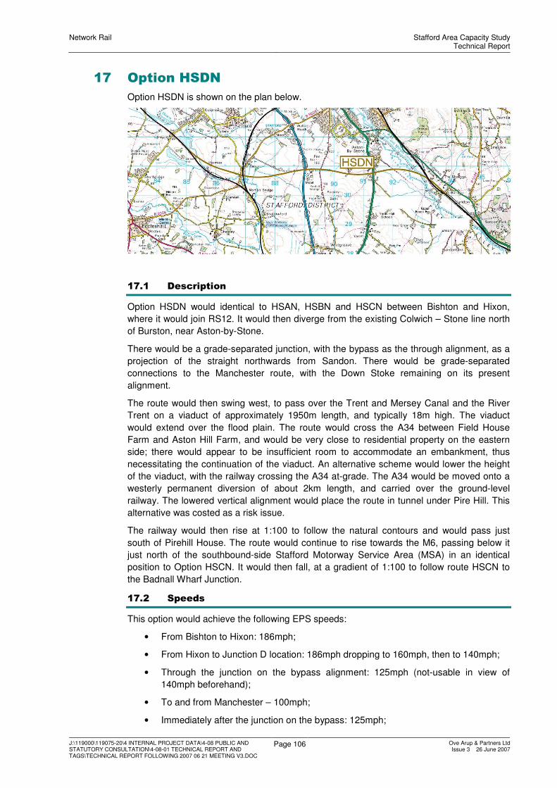
Network Rail Stafford Area Capacity StudyTechnical Report
J:\119000\119075-20\4 INTERNAL PROJECT DATA\4-08 PUBLIC AND STATUTORY CONSULTATION\4-08-01 TECHNICAL REPORT AND TAGS\TECHNICAL REPORT FOLLOWING 2007 06 21 MEETING V3.DOC
Page 106 Ove Arup & Partners LtdIssue 3 26 June 2007
17 Option HSDN
Option HSDN is shown on the plan below.
17.1 Description
Option HSDN would identical to HSAN, HSBN and HSCN between Bishton and Hixon,
where it would join RS12. It would then diverge from the existing Colwich – Stone line north
of Burston, near Aston-by-Stone.
There would be a grade-separated junction, with the bypass as the through alignment, as a
projection of the straight northwards from Sandon. There would be grade-separated
connections to the Manchester route, with the Down Stoke remaining on its present
alignment.
The route would then swing west, to pass over the Trent and Mersey Canal and the River
Trent on a viaduct of approximately 1950m length, and typically 18m high. The viaduct
would extend over the flood plain. The route would cross the A34 between Field House
Farm and Aston Hill Farm, and would be very close to residential property on the eastern
side; there would appear to be insufficient room to accommodate an embankment, thus
necessitating the continuation of the viaduct. An alternative scheme would lower the height
of the viaduct, with the railway crossing the A34 at-grade. The A34 would be moved onto a
westerly permanent diversion of about 2km length, and carried over the ground-level
railway. The lowered vertical alignment would place the route in tunnel under Pire Hill. This
alternative was costed as a risk issue.
The railway would then rise at 1:100 to follow the natural contours and would pass just
south of Pirehill House. The route would continue to rise towards the M6, passing below it
just north of the southbound-side Stafford Motorway Service Area (MSA) in an identical
position to Option HSCN. It would then fall, at a gradient of 1:100 to follow route HSCN to
the Badnall Wharf Junction.
17.2 Speeds
This option would achieve the following EPS speeds:
• From Bishton to Hixon: 186mph;
• From Hixon to Junction D location: 186mph dropping to 160mph, then to 140mph;
• Through the junction on the bypass alignment: 125mph (not-usable in view of
140mph beforehand);
• To and from Manchester – 100mph;
• Immediately after the junction on the bypass: 125mph;

Network Rail Stafford Area Capacity StudyTechnical Report
J:\119000\119075-20\4 INTERNAL PROJECT DATA\4-08 PUBLIC AND STATUTORY CONSULTATION\4-08-01 TECHNICAL REPORT AND TAGS\TECHNICAL REPORT FOLLOWING 2007 06 21 MEETING V3.DOC
Page 107 Ove Arup & Partners LtdIssue 3 26 June 2007
• Throughout the remainder of the bypass: 125mph.
17.3 Environmental Overview
17.3.1 Noise
There would be approximately 229 people within 300m, likely to be exposed to noise levels
in excess of 55dBLAeq, 18 hour in the absence of mitigation. Whilst there may be potential
impacts identified in this assessment for the operation of the route, it is anticipated that all
bar a few isolated properties could be mitigated through design.
17.3.2 Local Air Quality
There would be approximately 64 residential properties situated within 200m of the route
alignment. Whilst there may be a localised deterioration in air quality if minor road diversions
were required, these would be minor in nature and would have a negligible effect on the
local air quality.
17.3.3 Landscape and Townscape
The Colwich bypass would cut across the grain of the landscape between the Bishton and
Hixon area, where the Grange Hill farm south of Hixon would be demolished. The route
alignment would move further away from the village of Burston than the existing alignment,
generally in cut. The route would cross the flood plain, the Trent and Mersey canal and the
A34 on a viaduct 1950m x 18m high. The crossing of the river / canal corridor would be at
an awkward, oblique angle and would involve the longest and highest viaduct of all the HS
options. This would result in an adverse effect on the recreational value of the river/ canal
corridor. The route would traverse a narrow gap at the A34 crossing on 9.5m high viaduct
with effect on property immediately adjacent to the route. The route would continue under
the M6 motorway in a 9m deep cutting, emerging on embankment to cross the B5026 with
an effect on the Izaak Walton Golf Club.
17.3.4 The Heritage of Historic Resources
There would be impacts to the setting and context of the heritage resource at a number of
points along the route. The Trent and Mersey Canal would be bridged, which may destroy
some part of the heritage structure, and historic field patterns and boundaries would be
severely compromised. These impacts would be permanent, and in most cases unlikely to
be greatly alleviated over time. There is a possibility that as yet unidentified archaeology
could be affected, particularly those which are held on the Local Authority Sites and
Monuments Record, which remain unknown for this WebTAG appraisal. In summary the
main issues would be:
• 3 Conservation Areas;
• 12 Listed Buildings;
• 2 Registered Parks and Gardens;
• 16 SMR features (approximately, within 1kmof the study area);
• The severe impact on the form and context of non designated heritage features.
17.3.5 Biodiversity
It is likely that there would not be a significant ecological effect on the Special Area of
Conservation (SACs). This route alignment would affect floodplain grazing marsh, lowland
meadow, ancient and species rich hedgerows, and the rivers and streams proximal to the
route. In particular there would be significant ecological effects on Aston Hall Farm Wetland
Reserve. The Trent Valley crossing would affect lowland grazing marsh which is of high
biodiversity value.

Network Rail Stafford Area Capacity StudyTechnical Report
J:\119000\119075-20\4 INTERNAL PROJECT DATA\4-08 PUBLIC AND STATUTORY CONSULTATION\4-08-01 TECHNICAL REPORT AND TAGS\TECHNICAL REPORT FOLLOWING 2007 06 21 MEETING V3.DOC
Page 108 Ove Arup & Partners LtdIssue 3 26 June 2007
17.3.6 The Water Environment
The route would have a slight adverse impact on the water attributes because the proposal
may result in a degradation of the water environment. The features that are of greatest
significance would be:
• The crossing of the Trent and Mersey Canal;
• The crossing of the River Trent and its associated flood plain;
• The crossing of the Meece Brook and its associated floodplain, west of Heamies.
17.4 Implementation Planning and Outline Possession Requirements
Option HSDN would have virtually identical effects to Options HSAN, HSBN and HSCN.

Network Rail Stafford Area Capacity StudyTechnical Report
J:\119000\119075-20\4 INTERNAL PROJECT DATA\4-08 PUBLIC AND STATUTORY CONSULTATION\4-08-01 TECHNICAL REPORT AND TAGS\TECHNICAL REPORT FOLLOWING 2007 06 21 MEETING V3.DOC
Page 109 Ove Arup & Partners LtdIssue 3 26 June 2007
18 Option HSAS
The location of the route is shown on the plan below.
18.1 Description
Option HSAS would, like Option HSAN, include the Colwich Cut-Off between Bishton and
Hixon, and would use RS12 to an identical divergence point at Weston. It would, again as in
Option HSAN, have an identical Weston Junction, and would also pass under Sandon Bank
in a slightly more southerly tunnel. From the western tunnel portal, it would then adopt a
different horizontal and vertical alignment.
It would rise on shallow fill, severing Marston Lane, which would need to be bridged over the
route. It would enter into cutting before passing under Yarlet Lane, which would be carried
over the route on a bridge. The route would still rise, to pass below the A34, a dual
carriageway, south of Whitgreave Manor. The route would then fall, and emerge from
cutting, to pass under the M6, about 600m south of Whitgreave. There was some
uncertainty about ground levels and the topographical model in this area, and it could be
possible that the route would pass over the M6 on an overbridge, a cheaper option than a
thrust box. This matter was addressed as a risk/opportunity issue.
West of the M6, the route would swing north, on a falling gradient, to pass north of Worston
Hall, on an embankment up to 7m height. It would rise to pass over Worston Lane, the
existing WCML and the River Meece.
A number of options for the connection to the WCML in the Norton Bridge area were
developed, and any could be attached to the alignment of this option. These layout options
are discussed in Chapter 23.
18.2 Speeds
This option would achieve the following EPS speeds:
• From Bishton to Hixon: 186mph;
• From Hixon to Junction A location: 186mph dropping to 160mph;
• Through the junction on the bypass alignment: 186mph (potentially not-usable in
view of 160mph beforehand);
• To and from Manchester – a compliant 100mph or a non-compliant 125mph;
• Immediately after the junction on the bypass: 186mph;

Network Rail Stafford Area Capacity StudyTechnical Report
J:\119000\119075-20\4 INTERNAL PROJECT DATA\4-08 PUBLIC AND STATUTORY CONSULTATION\4-08-01 TECHNICAL REPORT AND TAGS\TECHNICAL REPORT FOLLOWING 2007 06 21 MEETING V3.DOC
Page 110 Ove Arup & Partners LtdIssue 3 26 June 2007
• Throughout the remainder of the bypass: 186mph.
18.3 Environmental Overview
18.3.1 Noise
There would be approximately 910 people within 300m, who are considered likely to be
exposed to noise levels in excess of 55dBLAeq, 18 hour in the absence of mitigation. Whilst
there may be potential impacts identified in this assessment for the operation of the route, it
is anticipated that all bar a few isolated properties could be mitigated through design.
18.3.2 Local Air Quality
There would be approximately 243 residential properties within 200m. There may be a
localised deterioration in air quality in areas close to road diversions, for example the
diverted road from the A51 to Salt village across the Trent Valley. The A34 and M6 would be
unaltered. It is expected that there would be a negligible effect on the local air quality.
18.3.3 Landscape and Townscape
The Colwich bypass element would cut across the grain of the landscape between Bishton
and Hixon, where the Grange Hill farm south of Hixon would be demolished. The alignment
would cross through the Special Landscape Area (SLA) in the Weston / Sandon Park area
to cross the River Trent flood plain and the Trent and Mersey Canal on a viaduct 1490m x
10m high, at an awkward oblique angle, close to the village of Salt. The effect on Sandon
Bank, where the route would pass in tunnel would be limited. The alignment would pass
under the A34 in 7m deep cutting and under the M6 motorway. The route would cross the
B5026 on a 7m high embankment to the south of Norton Bridge.
18.3.4 The Heritage of Historic Resources
There would be impacts to the setting and context of the heritage resource at a number of
points along the route. The Trent and Mersey Canal would be bridged, which may destroy
some part of the heritage structure, and historic field patterns and boundaries would be
severely compromised. Conservation areas would suffer visual intrusion. These impacts
would be permanent, and in most cases unlikely to be greatly alleviated over time. There is
a possibility that as yet unidentified archaeology could be affected, particularly that which is
held on the Local Authority Sites and Monuments Record, which remains unknown for the
purposes of this WebTAG appraisal.
18.3.5 Biodiversity
It is likely that there would not be a significant ecological effect on the Special Area of
Conservation (SACs). The alignment would affect floodplain grazing marsh, lowland
meadow, ancient and species-rich hedgerows, broad-leaved and mixed woodland, and the
rivers and streams proximal to the route. No designated nature conservation sites would be
directly affected. The Trent Valley crossing would affect lowland grazing marsh which is of
high biodiversity value. In particular there be significant ecological effects on Yelds Rough
(Ancient Woodland) SBI.
18.3.6 The Water Environment
The impacts were assessed as slight adverse to the water environment. The negative
impacts would be caused primarily by the Trent and Mersey canal, which the alignment
would cross. The crossing of the River Trent would result in four crossings within 1km.
There would also be a crossing of the major aquifer between Pitts Colum (Sandon Park) to
Sandon Bank.

Network Rail Stafford Area Capacity StudyTechnical Report
J:\119000\119075-20\4 INTERNAL PROJECT DATA\4-08 PUBLIC AND STATUTORY CONSULTATION\4-08-01 TECHNICAL REPORT AND TAGS\TECHNICAL REPORT FOLLOWING 2007 06 21 MEETING V3.DOC
Page 111 Ove Arup & Partners LtdIssue 3 26 June 2007
19 Option HSBS
The location of the route is shown on the plan below.
19.1 Description
Option HSBS would, like Option HSBN, include the Colwich Cut-Off between Bishton and
Hixon, and would use RS12 to an identical junction at Sandon Park. It would, again as in
Option HSBN, pass through Pea Hill to pass under the B5066, with the visually awkward
cutting and the demolition of perhaps 4 properties situated on the B5066.
The route would then swing south-west on a rising gradient to pass north of Marston. It
would pass over Marston Lane, which would need to be bridged. It would enter into cutting,
before passing under Yarlet Lane, which would remain. It would then fall to pass below the
A34, a dual carriageway, south of Whitgreave Manor. The route would emerge from cutting,
to pass under the M6, about 600m south of Whitgreave.
West of the M6, the route would swing north, on a falling gradient, to pass north of Worston
Hall, on an embankment. It would rise to pass over Worston Lane, the existing WCML and
the River Meece.
19.2 Speeds
This option would achieve the following EPS speeds:
• From Bishton to Hixon: 186mph;
• From Hixon to Junction B location: 186mph dropping to 160mph;
• Through the junction on the bypass alignment: 186mph (potentially not-usable in
view of 160mph beforehand);
• To and from Manchester – a compliant 100mph or a non-compliant 125mph;
• Immediately after the junction on the bypass: 125mph;
• Throughout the remainder of the bypass: 186mph.
19.3 Environmental Overview
19.3.1 Noise
There would be approximately 172 people within 300m, who are considered likely to be
exposed to noise levels in excess of 55dBLAeq, 18 hour in the absence of mitigation. Whilst
there may be potential impacts identified in this assessment for the operation of the route, it
is anticipated that all bar a few isolated properties could be mitigated through design.

Network Rail Stafford Area Capacity StudyTechnical Report
J:\119000\119075-20\4 INTERNAL PROJECT DATA\4-08 PUBLIC AND STATUTORY CONSULTATION\4-08-01 TECHNICAL REPORT AND TAGS\TECHNICAL REPORT FOLLOWING 2007 06 21 MEETING V3.DOC
Page 112 Ove Arup & Partners LtdIssue 3 26 June 2007
19.3.2 Local Air Quality
There would be 31 residential properties situated within 200m of the route alignment. Whilst
there may be a localised deterioration in air quality in those areas close to road diversions,
these would be temporary in nature and would have a negligible effect on local air quality.
19.3.3 Landscape and Townscape
The Colwich bypass would cut across the grain of the landscape between Bishton and
Hixon, where the Grange Hill farm south of Hixon would be demolished. The route
alignment would cross through the Special Landscape Area (SLA) at Sandon Park to cross
the River Trent flood plain and the Trent and Mersey canal on a viaduct 1200m x 10m high,
at an oblique angle. The Pea Hill cutting through Sandonbank would be visually awkward
and compounded by the busy, constricted location. The route would continue north-west,
alternating between embankment and cutting, before passing beneath the M6 motorway in a
6m deep cutting. The alignment would proceed in a cutting 10m deep under the B5026 to
the west of Norton Bridge.
19.3.4 The Heritage of Historic Resources
There would be impacts to the setting and context of the heritage resource at a number of
points along the route. The Trent and Mersey Canal would be bridged, which may destroy
some part of the heritage structure, and historic field patterns and boundaries would be
severely compromised. Conservation areas are likely to suffer visual intrusion. These
impacts would be permanent, and in most cases unlikely to be greatly alleviated over time.
There is a possibility that as yet unidentified archaeology could be affected, particularly that
which is held on the Local Authority Sites and Monuments Record, which remains unknown
for the purposes of this Web TAG appraisal. The route would impact the following features:
• 4 Conservation Areas;
• 30 Listed Buildings;
• 2 Registered Parks and Gardens;
• 18 SMR features (approximately, within 1km of the study area).
19.3.5 Biodiversity
It is likely that there would not be a significant ecological effect on the Special Area of
Conservation (SACs). This route would affect floodplain grazing marsh, lowland meadow,
ancient and species rich hedgerows, broad-leaved and mixed woodland, and the rivers and
streams proximal to the alignment. In particular there would be significant ecological effects
on Yelds Rough (Ancient Woodland) SBI, New Plantation, Maggies Fields and Maggies
Ditch SBIs.
19.3.6 The Water Environment
The route would have a slight adverse impact on the water attributes. The impacts that are
of greatest significance would be:
• The Trent and Mersey canal, which the route would cross and run adjacent to for
approximately 1300m.
• The crossing of the River Trent which would be extended due to the meandering
nature of this section of the river. This could be reduced to one single short crossing
nearer to Sandon Park;
The Meece Brook running adjacent to the Trent and Mersey canal for approx 1300m, that
concludes with the alignment making a long crossing of the canal.

Network Rail Stafford Area Capacity StudyTechnical Report
J:\119000\119075-20\4 INTERNAL PROJECT DATA\4-08 PUBLIC AND STATUTORY CONSULTATION\4-08-01 TECHNICAL REPORT AND TAGS\TECHNICAL REPORT FOLLOWING 2007 06 21 MEETING V3.DOC
Page 113 Ove Arup & Partners LtdIssue 3 26 June 2007
20 Option ER8+
20.1 Description
20.1.1 Introduction – Elements Required
Along the existing rail corridor, there are capacity problems at:
• Colwich Junction;
• Through Shugborough Tunnel.
• At Whitehouse Junction, where Up Trent Valley Slow services needed to cross
Down Fast services;
• At Stafford;
• Between Great Bridgeford and Norton Bridge, where track occupation was an issue;
• At Norton Bridge where junction margins were a problem;
The infrastructure solutions to the above capacity issues would, respectively, be:
• The Colwich Cut-off;
• 4-tracking through Shugborough Tunnel;
• Whitehouse flyover;
• Six-tracking through Stafford;
• A flyover near Great Bridgeford;
• A 5th track between Great Bridgeford and Norton Bridge.
It was found the Shugborough Tunnel 4-tracking would be only marginally effective at
improving capacity, but would incur a high adverse environmental impact, and a high cost.
The other infrastructure elements were therefore added to produce Option ER8+.
20.1.2 Colwich Cut-Off
This part of Option ER8+ would be identical to Options HSAN, HSBN, HSCN and HSDN.
There would be a grade-separated junction near Bishton, and a two-track new length of
railway between there and Hixon. The route would join the existing Colwich - Stone route
immediately south of New Road.
20.1.3 The Whitehouse Flyover
Shugborough Tunnel would remain unchanged. West of Milford, in the Whitehouse Junction
area, it would be necessary to construct a new flyover and approach retained-fill
embankments to carry the present Up Slow over the Up Fast and Down Fast. This new
flyover would lie in open land between Milford and the easterly Stafford suburbs in the
Baswich area. In order to accommodate the construction of this flyover, there would need to
be a permanent diversion of the Down Slow to the south. The Staffordshire and
Worcestershire Canal would need to be permanently re-aligned over a length of about
600m. Construction traffic access would be problematic, with a new access road needed,
and possibly a temporary Bailey bridge to gain access to the island site.
West and north of Whitehouse Junction, there would be no change to the existing railway as
far as Stafford, and the existing four-track Trent Valley lines round the Queensville curve
would remain.
20.1.4 Rickerscote to Trent Valley Junction
There would be a diversion of the two existing lines to the west. At Rickerscote, residential
gardens and allotments would be acquired. Rowley Grove Bridge would need to be replaced
by a bridge constructed to the south of the existing bridge. The new bridge would be a

Network Rail Stafford Area Capacity StudyTechnical Report
J:\119000\119075-20\4 INTERNAL PROJECT DATA\4-08 PUBLIC AND STATUTORY CONSULTATION\4-08-01 TECHNICAL REPORT AND TAGS\TECHNICAL REPORT FOLLOWING 2007 06 21 MEETING V3.DOC
Page 114 Ove Arup & Partners LtdIssue 3 26 June 2007
single span structure to provide maximum flexibility for the works and would connect to the
existing ramps via new approach ramps. At present it is not clear whether the DDA
regulations apply to this structure as the existing ramps are already steeper than the
regulations would permit. If it were decided that the regulations should be applied, then
there would be a need to construct considerably more new ramp than is currently proposed.
The location of the new bridge would inevitably require additional land and it is probable that
two properties would need to be purchased, one on each side of the railway corridor.
20.1.5 Trent Valley Junction
In Trent Valley Junction area, the two lines from Birmingham would be slewed to the west to
form a separate twin-track route. Trent Valley Junction would be abolished; the two new
lines would run alongside the existing four tracks to form a six-track route. The base scheme
assumes that it would be possible to signal the new tracks from Stoke Control Centre. There
would be no connections between the Trent Valley and Birmingham lines. Should
connections be required, it is possible that this could trigger complete resignalling of Stafford
No 4 and No 5 areas.
20.1.6 A449 Wolverhampton Road Bridge
At the A449, the two new lines would be located in an independent structure to be jacked
under the southerly approach embankment. They would probably be at a lower level than
existing, but this would be of no implication as the new tracks would not be connected to the
existing layout. The jacking would probably take place over 2 weekend closures of the road.
It is possible that it would be necessary to close the railway during the pushing of the box
underpass.
If the jacked box option were not possible, it would be necessary to consider a realignment
of the A449, with a wholly new structure placed over the railway at a right-angle. This would
involve, on the northerly side, the demolition of a motorcycle shop, petrol filling station, a
Public House, and 14 residential properties. If required, the new bridge would be
constructed on land to the west of the required location. This area is currently used as
sidings for the station area and the p-way in this area would need to be adjusted to provide
the necessary space. Additional land outside of Network Rail property would also need to be
acquired in order to provide sufficient construction space. It is probable that the new bridge
would be constructed on the partially-constructed approach embankment. Once
constructed, the new bridge would be launched into position from the pre-built abutments
during a possession. To facilitate the launch a temporary pier may need to be constructed in
the sidings area and a temporary launch nose would need to be fitted to the front of the
structure and dismantled upon landing at the northern abutment.
20.1.7 Newport Road
At Newport Road, it would be necessary to close the existing road for about 9 months, in
order to allow the demolition and on-line reconstruction of a replacement highway structure.
It was seen as unlikely that an off-line temporary structure could be constructed, given the
constraints of the site. This closure would cause considerable disruption to Stafford’s traffic
flows.
20.1.8 Stafford Station
All six tracks would continue through Stafford station, with Platform 7 being introduced into
public use, and the Birmingham line services being confined to Platforms 6 or 7. Platform 7
(the current Royal Mail platform) would be completely rebuilt with new passenger facilities
and access to the existing station. It is possible that the works to platform 6 could trigger
DDA compliancy works on Platform 5, and possibly throughout the whole station. In the
station area, it is likely that a number of OLE support structures would need to be replaced,
as existing supports would be affected by the works. This would require all-line blocks to
install the new supports, and to re-register over existing lines.
Network Rail Stafford Area Capacity StudyTechnical Report
J:\119000\119075-20\4 INTERNAL PROJECT DATA\4-08 PUBLIC AND STATUTORY CONSULTATION\4-08-01 TECHNICAL REPORT AND TAGS\TECHNICAL REPORT FOLLOWING 2007 06 21 MEETING V3.DOC
Page 115 Ove Arup & Partners LtdIssue 3 26 June 2007
20.1.9 Castle Street
At Castle Street, the existing road bridge would be demolished, and replaced by a
pedestrian / cycle structure, with vehicular access to the premises west of the railway being
achieved by the construction of a new connection from the roundabout at Martin Drive.
20.1.10 Doxey Road to Cresswell
Doxey Road would be realigned onto a permanent new alignment to the immediate south of
the existing. This would involve the demolition of adjacent factory premises.
The new pair of lines would run alongside the existing four through the Doxey area, to the
M6 Cresswell Viaduct. Residential property in the Baxter Green area of Doxey would be
affected. It would be necessary to demolish possibly 6 properties, and a further 10 might
lose a proportion of their gardens, depending on the separation between the existing four
and the proposed two new lines.
The route would be carried over Doxey and Tillington Marsh SSSI on a shallow viaduct, with
higher cost provision to minimise the effects on the SSSI.
20.1.11 Cresswell to Great Bridgeford
Just south of M6 Cresswell Viaduct, the new twin-track route would bifurcate to form a 4-
track route to allow the vertical separation of lines needed to create a flyover south of Great
Bridgeford.
At the flyover, it would be necessary to create a diversion of the Up Fast and Down Fast,
slewing them to the east to allow a new junction.
Two of the four lines would run from the west side of the layout to the east, to provide a
grade-separated route for trains from the Birmingham direction to access the Fast lines in
this area. The Down Flyover line would be taken over the Slow lines, and would then
descend on retained fill to merge into the diverted Down Fast. The other two lines would
create a direct connection to the Slow lines, to allow the Birmingham services to run Slow-
line north of Great Bridgeford.
20.1.12 Great Bridgeford to Norton Bridge 5Th Track
The Great Bridgeford flyover would carry an Up Birmingham Fast line from a new 5th track
on the east side of the layout. This 5th track would become the Up route from the
Stone/Norton Bridge direction. It would be necessary to demolish the A5013 bridge over the
railway to accommodate the 5th track, and a permanent diversion onto a new side road
overbridge would be needed. The additional track would require embankment and cutting
widenings, and the reconstruction of the road overbridge at Little Bridgeford. These works
would affect perhaps 6 residential properties.
The existing Up Fast would become bi-directional between the flyover and Norton Bridge.
Down trains towards Manchester would therefore run bi-directionally on the Up Fast, before
turning towards Stone. This arrangement would allow some parallel moves towards Crewe
and Stone.
20.2 Speeds
This option would provide:
• A virtual elimination of Stafford Trent Valley Junction and hence a major capacity
gain;
• A grade-separated movement for trains between the Birmingham and Fast lines;
• 125mph between Stafford and Norton Bridge.

Network Rail Stafford Area Capacity StudyTechnical Report
J:\119000\119075-20\4 INTERNAL PROJECT DATA\4-08 PUBLIC AND STATUTORY CONSULTATION\4-08-01 TECHNICAL REPORT AND TAGS\TECHNICAL REPORT FOLLOWING 2007 06 21 MEETING V3.DOC
Page 116 Ove Arup & Partners LtdIssue 3 26 June 2007
20.3 Environmental Overview
20.3.1 Noise
There are approximately 3267 properties located within 300 metres that may be potentially
affected by construction or operation of the route. The majority of these properties are
located in Stafford and its outlying villages.
Construction
Given that the construction of this route option is alongside an existing operational railway
line, some major elements of work would have to be undertaken during night-time
possessions. Undertaking such works during the night-time periods over a sustained period
of time is likely to give rise to adverse noise impacts on the properties located immediately
in the wayside of the route.
It is considered likely that noise barriers would need to be erected to mitigate construction
noise levels and even then it may still be necessary to place further restrictions on operating
hours in order to mitigate significant noise impacts.
Operation
This option theoretically suggests that a 50% increase in railway traffic could be achieved;
the addition of two extra lines will also move the railway closer to a considerable number of
properties
The potential increase in rail traffic movements would give rise to no more than 1dB
increase in noise levels at properties and the change in proximity the properties is unlikely to
result in more than 1-2 dB change in noise levels. Therefore the overall change in
operational noise levels is not anticipated to be of significance.
20.3.2 Local Air Quality
There are 1991 houses within a distance of 200m on either side of the proposed route.
The effect on local air quality is thought likely to be greatest through the construction phase,
particularly dust and fugitive emissions on residential properties proximal to construction
work.
Operational air quality issues might arise through the increased frequency of diesel-hauled
trains proximal to residential properties and on the overall air quality objectives for the
Stafford Borough. The pollutants likely to be under consideration from the emissions of
diesel hauled trains are Nitrogen Dioxide (NO2) and Particulates (PM10).
20.3.3 Landscape and Townscape
This option would have a limited impact within the urban section, resulting mainly from the
road realignments required, together with their associated earthworks.
Towards Great Bridgeford there would also be visual impact from the new flyover structures
and the associated approach ramps; this would also occur in a sensitive location adjacent to
the River Sow, but is not close to any designated landscapes.
20.3.4 The Heritage of Historic Resources
This route would have no known impact on designated features. Further data collection and
consultation would be required in order to ascertain the effect that this alignment would have
on undesignated and as yet unidentified heritage assets.
20.3.5 Biodiversity
There may be impacts to the following designated sites of European nature conservation
importance that are located within 10km of this route:
• Cannock Chase Special Area of Conservation (SAC) 5km to the south-east; and,
• Pasturefields Salt Marsh SAC 7km to the north-east.

Network Rail Stafford Area Capacity StudyTechnical Report
J:\119000\119075-20\4 INTERNAL PROJECT DATA\4-08 PUBLIC AND STATUTORY CONSULTATION\4-08-01 TECHNICAL REPORT AND TAGS\TECHNICAL REPORT FOLLOWING 2007 06 21 MEETING V3.DOC
Page 117 Ove Arup & Partners LtdIssue 3 26 June 2007
There may also be impacts to the following designated sites of nature conservation
importance that are located within 1km of this route:
• Doxey and Tillington Marshes Site of Special Scientific Interest (SSSI) which would
be directly affected; and
• Rowley Grove Site of Biological Interest (SBI).
The crossing of the SSSI at Doxey would be challenging, but not insurmountable, and there
might be significant cost implications.
Habitats that may be impacted include:
• a UK BAP priority habitat (floodplain grazing marsh); and,
• seven UK BAP broad habitats (boundary and linear features, built up areas and
gardens, fen, marsh and swamp, neutral grassland, rivers and streams and
standing open water).
Protected or otherwise notable species that may be impacted include: Otter, Water Vole,
White-clawed Crayfish, birds, bats, reptiles, amphibians, fish, invertebrates and plants.
20.3.6 The Water Environment
The option would follow the existing railway, which follows the 1% floodplains of the River
Sow and the Rising Brook for virtually its entire length.
Any widening of the existing rail corridor would impinge on the existing flood plains and
likely affect their conveyance and storage characteristics. Any impingements would need to
be compensated and may require considerable mitigation works. A flood defence has been
constructed on the southern fringes of Stafford to protect it from the River Sow; however, it
is thought that the proposed works would not affect this structure.
The route would pass through the Doxey and Tillington Marshes Site of Special Scientific
Interest, which is an area densely populated with land drains and smaller watercourses.
Any widening of the existing rail corridor through this area would need to be carefully
assessed to determine the effect on both the marshes and the existing drains and
watercourses. There may be a significant impact to the protected local water environment.
The route would pass through minor aquifer which is thought to be ‘possibly at risk’ from
diffuse pollution. The route would not pass through any groundwater protection zones.
20.4 Geotechnical Overview
This option would require little or no earthworks between Rickerscote and just north of
Stafford Station, but would then cross the Doxey Marshes. There would be some
engineering challenge here, with a variety of treatments which could be adopted to provide
a foundation for the railway consistent with the biodiversity and water environment issues
associated with the Marsh. Founding conditions may be poor, and there may be a
requirement for extensive ground improvement, geotextile solutions, low-level structures, all
with an understanding of settlement and aquatic issues. For costing purposes, it was
assumed that a low-level viaduct structure would be required to preserve watercourse
linkages to the maximum possible extent.
Near Great Bridgeford, the alignment would traverse the western edge of the River
Sow/Penk valley bottom, and is underlain by Alluvial deposits and a late glacial River
Terrace deposit. Beneath the fluvial deposits a poorly defined buried ‘glacial channel is
present. This feature is incised into the Mercia Mudstone to a depth of 23 – 30m, and is
infilled with Glaciolacustrine Silts and Fluvioglacial gravels.

Network Rail Stafford Area Capacity StudyTechnical Report
J:\119000\119075-20\4 INTERNAL PROJECT DATA\4-08 PUBLIC AND STATUTORY CONSULTATION\4-08-01 TECHNICAL REPORT AND TAGS\TECHNICAL REPORT FOLLOWING 2007 06 21 MEETING V3.DOC
Page 118 Ove Arup & Partners LtdIssue 3 26 June 2007
20.5 Implementation Planning and Outline Possession Requirements
20.5.1 Construction and Staging
Option ER8+ would be constructed largely remote from the existing railway in “Green Zone”
conditions.
The summary table below presents the possession requirements. It makes no reference to
the activities that have no impact on the railway, or on the highway.
It was assumed that certain works could be achieved on weekday evenings in preparation of
the activities requiring possessions listed below. There is a remit within Network Rail to
maximise the operational hours of the railway and minimise the maintenance / closed hours.
This may not be possible upon the introduction of Efficient Engineering Access (EEA) in
2008. EEA may require the introduction of bi-directional signalling to facilitate maintenance.
Network Rail were to advise on the changes necessary.
TABLE 20.1: STAGING – OPTION ER8+
Location Principal Activities Possession Requirements
“End-on” slews and commissioning of Up TV Fast
and Up TV Slow on diverted alignment.
Install and commission Up Cut-Off turnout in
diverted Up TV Fast
2 x 52-hour all lines
Commission replacement Rugeley and Colwich
interlockings.
2 x 52-hour all lines
Bishton Junction
Install S&C on remainder of layout, including
Rugeley North Junction new ladders
7 x 52-hour all lines
1 x 52-hour DF
Hixon, southwards
on existing line to
Colwich
Remove redundant Up Stoke infrastructure
between Hixon and Colwich Junction.
1 x 52-hour of Up lines at
Colwich Junction
Canal diversion Closure required – seasonal
Erect protective screens 1 x 52-hour UF
1 x 52-hour DS
Place beams and permanent formwork 7 x 52-hour all lines
Whitehouse
Flyover
Connect turnouts and slews 1 x 52-hour DS
1 x 52-hour US
1 x 52-hour UF
Rickerscote to
Great Bridgeford
(approx 7km)
Erect protective / palisade fence alongside Down
Slow to create segregated worksite
70 x 8-hour overnights of Down
Birmingham / Down Slow
Rickerscote Area Preparation of formation for, and end-on slews
of, Birmingham lines into new 5th
/6th
tracks (at
same time as connections at Great Bridgeford)
2 x 52-hour of Birmingham lines
Wolverhampton
Road
Thrust box under southern approach
embankment
No impact on railway operations
unless risk assessments requires
all-line block of 2 x 52-hour

Network Rail Stafford Area Capacity StudyTechnical Report
J:\119000\119075-20\4 INTERNAL PROJECT DATA\4-08 PUBLIC AND STATUTORY CONSULTATION\4-08-01 TECHNICAL REPORT AND TAGS\TECHNICAL REPORT FOLLOWING 2007 06 21 MEETING V3.DOC
Page 119 Ove Arup & Partners LtdIssue 3 26 June 2007
Possible weekend closure of
A449
Salop Sidings Remove connections to main lines 1 x 52-hour Up and Down
Birmingham/Slow
Platform 5 Erect protective screen to segregate Platform 5
passengers from Platform 6 works
Alter OLE support structures
Undertaken in conjunction with
Rickerscote to Great Bridgeford
fence
4 x 52-hour all lines
Demolish deck 1 x 52-hour all lines
Strengthen piers 12 x 52-hours all lines
Place beams 2 x 52-hours all lines
Shuttering 1 x 52-hour all lines
Newport Road
Note: Newport Road closed to road and
pedestrian traffic for approx 9 months
Demolition of road bridge 1 x 52-hour all lines
Place beams for new footbridge 1 x 52-hour all lines
Castle Street
Deck formwork 1 x 52-hour all lines
Erect protective screens at location of
replacement bridge
1 x 52-hour UF
1 x 52-hour DS
Place beams 1 x 52-hour all lines
Shuttering 1 x 52-hour all lines
Doxey Road
Demolish existing bridge 1 x 52-hour all lines
Erect protective screens 2 x 52-hour UF
2 x 52-hour DS
Place beams 12 x 52-hour all lines
Shuttering 4 x 52-hour all lines
Slew UF/DF 1 x 52-hour UF, DF and US
Install S&C 2 x 52-hour DS, US
Great Bridgeford
Install S&C 1 x 52-hour DF
Erect protective screens 1 x 52-hour UF
1 x 52-hour DS
Place beams 1 x 52-hour all lines
Shuttering 1 x 52-hour all lines
Demolish existing bridge 1 x 52-hour all lines
A5013 road
overbridge
replacement
Slew UF, DF 1 x 52-hour UF, DF, US
Norton Bridge Install S&C 1 x 52-hour UF

Network Rail Stafford Area Capacity StudyTechnical Report
J:\119000\119075-20\4 INTERNAL PROJECT DATA\4-08 PUBLIC AND STATUTORY CONSULTATION\4-08-01 TECHNICAL REPORT AND TAGS\TECHNICAL REPORT FOLLOWING 2007 06 21 MEETING V3.DOC
Page 120 Ove Arup & Partners LtdIssue 3 26 June 2007
21 Option GF2
Option GF2 is shown on the plan below.
21.1 Description
Option GF2 would be very similar to the Option HS alignments over the first 2.5km north
from Bishton Junction.
The route would then pass to the south of Tithebarn Farm. A grade-separated junction
would be provided to allow Manchester-bound services to gain access to the existing
railway near Hixon. This junction would have Option GF2 as the through route at an
unrestricted speed, with a 100mph turnout on the diverging route to Manchester. The Down
Manchester would have to be placed in tunnel to lower it sufficiently to pass under the
bypass. This would create large, complex earthworks in that locality, as the bypass would
already be in cutting.
The main route would then cross the A51, the existing Colwich – Stone railway, the River
Trent and the Trent and Mersey Canal on an elevated structure of 1250m length, typically
10m high, virtually perpendicular to the obstacles.
The route would then rise on embankment up to 6m height, to pass through the southern
extremity of Ingestre Golf Course. It would avoid woodland enclosing Lion Lodges. It would
then rise to a summit near Hanyards. In the Ingestre area, the route potentially impacts on
the northerly fringe of an Area of Outstanding Natural Beauty (AONB); a further northerly
move could avoid this issue, probably at the cost of introducing a short Hanyards Tunnel
and affecting the woodland.
The route would then be virtually level, running in cuts up to 9m deep, and on embankments
up to 9m height to carry the route over the A518 near Stafford Lodge.
The route would pass into the 350m length Beacon Hill Tunnel, and emerge onto
embankment up to 12m in height, and would then fall to pass about 500m south of the
village of Hopton. It would pass through part of the RAF housing at Hopton, but it is not
known with any certainty how many properties could be affected; possibly 2. The route

Network Rail Stafford Area Capacity StudyTechnical Report
J:\119000\119075-20\4 INTERNAL PROJECT DATA\4-08 PUBLIC AND STATUTORY CONSULTATION\4-08-01 TECHNICAL REPORT AND TAGS\TECHNICAL REPORT FOLLOWING 2007 06 21 MEETING V3.DOC
Page 121 Ove Arup & Partners LtdIssue 3 26 June 2007
would cross a diverted B5066, to pass immediately north of the RAF Fuel Depot and south
of Newbuildings Farm and north of Marstongate Farm.
The route would then lie at or about ground level, and would be on a rising gradient to pass
under the A34 immediately south of Whitgreave Manor.
The route would then fall gently to pass over the M6 motorway south of Whitgreave,
continuing to fall to cross over the Little Bridgeford to Shallowford road and the WCML south
of Shallowford (and hence south of Norton Bridge).
It would then pass to the west of Norton Bridge, and would be in very close proximity to
Rodgeley Lodge. It would then pass east of Scamnell Farm, before re-joining the existing
WCML near Baden Hall. In order to form the grade-separated junction, it would be
necessary to divert the existing WCML Slow lines between Worston Hall and Baden Hall,
and to divert the existing Down Fast over some of this length. The only line remaining in the
existing corridor from Baden Hall to Norton Bridge would be the Up Fast; south of Norton
Bridge there would only be the Up Fast, and the Down Stone towards Stoke and
Manchester.
21.2 Speeds
This option would achieve the following EPS speeds:
• On the main alignment from Bishton to Norton Bridge: 186mph;
• To and from Manchester – 100mph;
• Existing speeds on RS12.
21.3 Environmental Overview
21.3.1 Noise
There would be approximately 189 people within 300m, who are considered likely to be
exposed to noise levels in excess of 55dBLAeq, 18 hour in the absence of mitigation. Whilst
there may be potential impacts identified in this assessment for the operation of the route, it
is anticipated that all bar a few isolated properties could be mitigated through design.
21.3.2 Local Air Quality
There would be 22 residential properties within 200m. There may be a localised
deterioration in air quality in areas close to the permanent B5066 diversion near Hopton
Farm. Other minor roads might be temporarily diverted during construction, but these effects
would be temporary in nature and would have a negligible effect on the local air quality.
21.3.3 Landscape and Townscape
As with all the HS options, the removal of the existing railway west of Colwich, between the
Haywoods and Shugborough Park, would have a beneficial impact on the local landscape.
The route would initially be as for Options HSAN to HSDN, but would then cross the
floodplain of the River Trent, the A51 north of Great Haywood, and the river/canal
recreational corridor on a 1250m long viaduct x 10m high. The angle of this crossing,
approaching 90°, would reduce the adverse effects at this sensitive location. Between the
A51 and the A34, the route could affect the corner of the Cannock Chase Area of
Outstanding National Beauty (AONB), and the Ingestre Golf Club before entering an 18m
deep cutting. The effect on the AONB would produce a Large Adverse score (on the
WebTag analysis) and the boundary of the AONB in this area would require clarification with
the statutory authorities.
The alignment would pass through the well-wooded RAF base on embankment, severing
some housing from the other areas of the base. The alignment would then run, generally in
cutting, to the A518 proceeding via a 340m long tunnel under Beacon Hill. Views from the
Network Rail Stafford Area Capacity StudyTechnical Report
J:\119000\119075-20\4 INTERNAL PROJECT DATA\4-08 PUBLIC AND STATUTORY CONSULTATION\4-08-01 TECHNICAL REPORT AND TAGS\TECHNICAL REPORT FOLLOWING 2007 06 21 MEETING V3.DOC
Page 122 Ove Arup & Partners LtdIssue 3 26 June 2007
elevated properties in Hopton (Kings Drive) would be affected in this vicinity. From the A34
to the tie-in with the WCML, the route would proceed in a 10m cutting under the A34 and on
a 9m embankment over the M6 motorway. Further to the north-west, the route would
generally be in cutting, rising to cross the River Sow on a 390m long x 8m high viaduct.
21.3.4 The Heritage of Historic Resources
The effects would be as for the HS options over the first 2.5 km, but the route would then lie
to the north of the Conservation Area for Colwich and Little Haywood which are sandwiched
between the A51 and the River Trent. There would be views northwards towards the
railway.
The route could affect:
• the Conservation Area for Colwich and Little Haywood;
• the Conservation Area of Great Haywood and Shugborough;
• Shugborough Park;
• the Trent Valley’s archaeological remains;
• the Pasturefields Special Area of Conservation (but not to the degree of Option
GF1);
• the small Conservation Area of Tixall;
• Ingestre and the Conservation Area.
• Marston Brook’s preserved archaeological remains;
• the Conservation Area of Chebsey;
• Meece Brook’s archaeological and geo-archaeological material.
21.3.5 Biodiversity
There may be impacts to the following designated sites of European nature conservation
importance that are located within 10km of this route:
• Cannock Chase Special Area of Conservation (SAC) 2.5km to the south-west;
• Chartley Moss (part of the West Midlands Mosses SAC) 4.5km to the north; and,
• Pasturefields Salt Marsh SAC 1.5km to the north.
There may also be impacts to the following designated sites of nature conservation
importance that are located within 1km of this route:
• Bishton Site of Biological Interest (SBI);
• Higher Coley Farm SBI;
• Tixall Park Pool SBI;
• Lambert’s Coppice Ancient Woodland;
• Hopton Pools SBI;
• Yelds Rough Ancient Woodland;
• Drumble Wood Ancient Woodland; and,
• Meece Brook SBI.
Habitats that may be impacted include:
• a UK BAP priority habitat (floodplain grazing marsh); and,

Network Rail Stafford Area Capacity StudyTechnical Report
J:\119000\119075-20\4 INTERNAL PROJECT DATA\4-08 PUBLIC AND STATUTORY CONSULTATION\4-08-01 TECHNICAL REPORT AND TAGS\TECHNICAL REPORT FOLLOWING 2007 06 21 MEETING V3.DOC
Page 123 Ove Arup & Partners LtdIssue 3 26 June 2007
• seven UK BAP broad habitats (boundary and linear features, built up areas and
gardens, fen, marsh and swamp, neutral grassland, rivers and streams and
standing open water).
Protected or otherwise notable species that may be impacted include: Otter, Water Vole,
White-clawed Crayfish, birds, bats, reptiles, amphibians, fish, invertebrates and plants.
21.3.6 The Water Environment
This option would traverse the 1% flood plains of the River Trent, and the Meece Brook and
its tributaries.
The alignment would cross the Trent and Mersey Canal west of Great Haywood, the
proposals are not anticipated to affect the canal, although a bridge structure would be
required.
The route would cross the River Trent just to the west of Great Haywood. The proposed
perpendicular crossing is likely to be preferred by the Environment Agency to an oblique
crossing, especially if river or canal diversions could be avoided. The proposed alignment
would be elevated at this point, and therefore any structures located within the floodplain
would need to be checked to determine their affect on the floodplains conveyance and
storage characteristics. Any effects would be significant and need to be mitigated for, and
any loss in floodplain storage would need to be compensated for on a volume for volume,
level for level basis and may require considerable mitigation works.
The route would cross the Meece Brook just south of Shallowford. At this location there is a
formal flood defence, which the alignment would cross; this would require particular
attention. The works should not lower the level of protection afforded by this defence. The
alignment would then run parallel to the 1% floodplain of the Meece Brook south of
Heamies; any encroachment on the floodplain either as cutting or embankment would
require considerable mitigation works.
The proposed alignment would cross a number of land drains and other smaller
watercourses such as the Marston Brook and these would either need to be culverted or
realigned to ensure the existing drainage regime is maintained.
The route would pass over both minor and major aquifers, the minor aquifers being located
in the corridors of the Trent Valley and the Meece Brook, and the major aquifer being
located between Beacon Hill and Shugborough. However, groundwater for the entire route
was identified as being ‘possibly at risk’ from diffuse pollution, with the alignment in the
vicinity of Hanyards being identified as ‘at risk’. This would need to be considered in the
implication of any pollution control measures and disposal of surface waters. It should be
noted that the two tunnel sections on this option would pass across the major aquifer. No
part of this option would pass through any groundwater protection zones.
21.4 Implementation Planning and Outline Possession Requirements
21.4.1 Construction and Staging
Option GF2 would be constructed largely remote from the existing railway in genuine green-
field or “Green Zone” conditions.
The summary table below presents the possession requirements. It makes no reference to
the activities that have no impact on the railway, or on the highway.
It was assumed that certain works could be achieved on weekday evenings in preparation of
the activities requiring possessions listed below. There is a remit within Network Rail to
maximise the operational hours of the railway and minimise the maintenance / closed hours.
This may not be possible upon the introduction of Efficient Engineering Access (EEA) in
2008. EEA may require the introduction of bi-directional signalling to facilitate maintenance.
Network Rail were to advise on the changes necessary.

Network Rail Stafford Area Capacity StudyTechnical Report
J:\119000\119075-20\4 INTERNAL PROJECT DATA\4-08 PUBLIC AND STATUTORY CONSULTATION\4-08-01 TECHNICAL REPORT AND TAGS\TECHNICAL REPORT FOLLOWING 2007 06 21 MEETING V3.DOC
Page 124 Ove Arup & Partners LtdIssue 3 26 June 2007
TABLE 21.1: STAGING – OPTION GF2
Location Principal Activities Possession Requirements
“End-on” slews and commissioning of Up TV Fast
and Up TV Slow on diverted alignment.
Install and commission Up Cut-Off turnout in
diverted Up TV Fast
2 x 52-hour possessions of US,
UF and DF
Commission replacement Rugeley and Colwich
interlockings.
2 x 52-hour possession – all lines
Bishton Junction
Install S&C on remainder of layout, including
Rugeley North Junction new ladders
7 x 52-hour all lines
1 x 52-hour DF
Hixon to Colwich Remove redundant Up Stoke infrastructure
between Hixon and Colwich Junction
1 x 52-hour of Up lines at
Colwich Junction
M6 Crossing For overbridge, close motorway overnight to
place beams assuming single span.
For jacked box, close each carriageway with 2+2
on open carriageway, for 1 week.
About 20,000 vehicles affected.
Screens and bridge construction for bypass
bridge over WCML
3 x 52-hour all lines
Or
Open two lines on diversion
alignment, and divert all trains to
these.
Slew WCML lines and install S&C on diversion 1 x 52-hour US and DS
3 x 52-hour UF and DF
Northern Junction
(south of Norton
Bridge)
Slews of remaining infrastructure in existing
corridor
1 x 52-hour all remaining lines
(Up Stone / Down Stone / UF)

Network Rail Stafford Area Capacity StudyTechnical Report
J:\119000\119075-20\4 INTERNAL PROJECT DATA\4-08 PUBLIC AND STATUTORY CONSULTATION\4-08-01 TECHNICAL REPORT AND TAGS\TECHNICAL REPORT FOLLOWING 2007 06 21 MEETING V3.DOC
Page 125 Ove Arup & Partners LtdIssue 3 26 June 2007
22 Transposition
22.1 The Concept
One of the factors that could benefit performance was “transposition”, which could be
combined with the HS or GF options.
The concept of transposition was based around the train service pattern after a bypass was
complete. After the bypass, the majority of the remaining trains approaching Stafford from
the Trent Valley direction would be freight or stopping passenger services. These could be
routed almost exclusively to the present Fast lines north of Stafford. Equally, trains from the
Birmingham direction could be routed to the present Slow lines. This would vastly reduce
conflicts at Trent Valley Junction, and would avoid the costly and disruptive impact of
providing grade-separation in this area. Effectively, the layout through Stafford would
become two parallel, two-track railways, with no conflicts. The layout at Stafford would be
transposed from its present arrangements.
22.2 Schematic Layout
The schematic below presents transposition in its most simplistic, stylised form.
There would be no track or signalling changes at Stafford; transposition would simply be a
matter of routing. A further benefit would be that this reduction in conflicts could give the
opportunity to simplify the layout to something more appropriate to the residual movements,
possibly in conjunction with re-signalling.
22.3 Untransposition – Restoring the Existing Pattern of Trains
There would have to be “un-transposition” somewhere between Stafford and Badnall Wharf,
to re-establish the current pattern of movements from there northwards to Crewe.
It would be difficult, costly and environmentally poor to achieve untransposition between
Stafford and the Creswell area (the M6 viaduct location). It would be possible between the
M6 and the A5013 at Great Bridgeford, within a junction at Norton Bridge, or within a
junction at Badnall Wharf. Some type of grade separation would be needed to carry two
“Trent Valley” tracks over the “Birmingham” tracks.
22.4 The Options to which Transposition Could Apply
The options to which transposition could apply were:
• The “N” variants of the HS series of options, as they would join the WCML north of
Norton Bridge;
• The “S” variant of the HS options or the GF2 option, as all would join the WCML
south of Norton Bridge.
Network Rail Stafford Area Capacity StudyTechnical Report
J:\119000\119075-20\4 INTERNAL PROJECT DATA\4-08 PUBLIC AND STATUTORY CONSULTATION\4-08-01 TECHNICAL REPORT AND TAGS\TECHNICAL REPORT FOLLOWING 2007 06 21 MEETING V3.DOC
Page 126 Ove Arup & Partners LtdIssue 3 26 June 2007
22.4.1 Transposition in the “N” Variant
For the “N” variants, the untransposition could occur:
• within the Badnall Wharf junction;
• at Great Bridgeford.
Operational modelling showed that transposition ending within the Badnall Wharf Junction
would be ineffective, as the Birmingham to Manchester services would have left the network
towards the Stone line at Norton Bridge. It would need to be south of Norton Bridge to be
effective, possibly improving Birmingham - Manchester axis movements in addition.
Decisions on the number of freight trains routed via the bypass, or remaining on the existing
route via Stafford would also have an influence on the value of transposition. Only
transposition at Great Bridgeford would be meaningful in conjunction with an “N” variant.
22.4.2 Transposition in the “S” and GF Options
For the “S” variants or GF2, the untransposition could be
• within the junction of the bypass and the existing lines;
• at Great Bridgeford.
The variant within the junction would take the present Fast lines to the east of Little
Bridgeford / Worston, before merging with the twin-track bypass approaching from the
south. This would create a 4-track route northwards, and the present Fast lines would
emerge on the western, Slow, side of the 4-track layout towards Crewe. The remaining
existing Slow lines would be the only two tracks needing to remain between Great
Bridgeford and Norton Bridge. They would simply sweep round the curves at Norton Bridge
and on towards Stone on an uninterrupted manner, with Norton Bridge Junction having
been abolished. This would give the freedom to improve the alignments and speeds.
22.5 The Business Case for Transposition
Transposition was estimated to cost between £15m-77m. It would offer the opportunity to
rationalise the residual layout at Stafford, particularly in the Trent Valley Junction area, with
potential savings at a later re-signalling.
Only Network Rail/DfT can assess which outweighs the other, whether transposition is
justified, and what degree of inter-relationship there might be with the residual layout at
Stafford after the introduction of a bypass.
This report cannot resolve this issue, and can make no recommendations on whether
transposition should form part of the solution to the capacity issues at Stafford.

Network Rail Stafford Area Capacity StudyTechnical Report
J:\119000\119075-20\4 INTERNAL PROJECT DATA\4-08 PUBLIC AND STATUTORY CONSULTATION\4-08-01 TECHNICAL REPORT AND TAGS\TECHNICAL REPORT FOLLOWING 2007 06 21 MEETING V3.DOC
Page 127 Ove Arup & Partners LtdIssue 3 26 June 2007
23 Layouts at Norton Bridge - the “NB” Options
23.1 Introduction
For any bypass option south of Norton Bridge (HSAS, HSBS or GF2), there were a number
of layout options for connecting the bypass to the existing railway.
These variants would achieve varying degrees of conflict resolution, speed improvement,
grade separation, cost and environmental impact. Some would incorporate the concept of
transposition. All options would achieve 125mph on the bypass alignments.
This chapter addresses only a proportion of the potential layouts, and should not be
regarded as a comprehensive study of all potential options. Indeed, it was recognised that
none of the layouts discussed could be regarded as optimal, nor was the list exclusive.
23.2 Environmental Effects
The environmental effects of these NB options were addressed in the section relating to the
“S” variants of the HS options or Option GF2.
Within the Norton Bridge junction area, the northerly connections would potentially affect the
River Meece flood plain, and a westerly move might be needed, lengthening the route; this
was addressed as a risk issue. This issue would apply to all NB options.
23.3 Option NB1
North from Little Bridgeford to Baden Hall, the existing WCML would be affected. Three of
the four existing tracks (Down Slow, Up Slow and Down Fast) would be diverted to form an
almost straight alignment between these points. They would be on level gradient, and would
lie in a cutting of typically 9m depth, passing close to Rodgeley Lodge, and south of
Scamnell Farm.
In the southbound direction, the existing Up Fast would remain on its present alignment
southwards from Baden Hall to Norton Bridge, leaving it as the only one remaining track
over this length. The Up and Down Main towards Stone would then join a considerably
simplified Norton Bridge Junction to form a two-track route within the existing four-track
formation, giving scope for realignment and an increase in speed to 75mph on the Stone
route.
The Down Bypass would merge into the diverted Down Fast; the Up Bypass would diverge
from the Up Fast near Baden Hall. North of the merge of the Down Bypass and the diverted
WCML, there would be at-grade parallel connections between the Fast and Slow lines, to
allow trains from the bypass to access the Slow lines.

Network Rail Stafford Area Capacity StudyTechnical Report
J:\119000\119075-20\4 INTERNAL PROJECT DATA\4-08 PUBLIC AND STATUTORY CONSULTATION\4-08-01 TECHNICAL REPORT AND TAGS\TECHNICAL REPORT FOLLOWING 2007 06 21 MEETING V3.DOC
Page 128 Ove Arup & Partners LtdIssue 3 26 June 2007
23.4 Option NB2
Between Little Bridgeford and Baden Hall, all four of the existing WCML lines would be
diverted to form an almost straight alignment. They would be on level gradient, and would lie
in a cutting of typically 9m depth, passing close to Rodgeley Lodge, and south of Scamnell
Farm.
Southwards from Baden Hall to Norton Bridge, no lines would remain; this length of railway
would be abandoned. South of Norton Bridge Junction (which would cease to exist), the Up
and Down Main towards Stone would be the only remaining tracks within the existing four-
track formation, giving scope for realignment and an increase in speed to 75mph on the
Stone route.
Approaching the junction, the bypass would bifurcate to form a 3-track route, giving grade-
separated connections to the Fast lines as in Option NB1, with the third, bi-directional track
giving grade-separated access to the Slow lines on the WCML diversion.
23.5 Option NB3
At Little Bridgeford, this variant would take present Fast lines to the east, to pass to the east
of Little Bridgeford/Worston, before running alongside the bypass approaching from the
south. The diverted Fast lines would share the structure carrying the bypass over the
existing route. The bypass and diverted Fast lines would then form a grade-separated
junction.
On the Slow lines north from Little Bridgeford, there would be a double junction, with the
Slow lines continuing north towards Baden Hall as in NB1 and NB2, while the Manchester
route would sweep round the curves towards Norton Bridge and on to Stone in an
uninterrupted manner, with Norton Bridge Junction having been abolished. This would give
the freedom to improve the alignments and speeds. This option would allow Birmingham to
Manchester services to run on the Slow line north from Stafford without conflict with Trent
Valley services.

Network Rail Stafford Area Capacity StudyTechnical Report
J:\119000\119075-20\4 INTERNAL PROJECT DATA\4-08 PUBLIC AND STATUTORY CONSULTATION\4-08-01 TECHNICAL REPORT AND TAGS\TECHNICAL REPORT FOLLOWING 2007 06 21 MEETING V3.DOC
Page 129 Ove Arup & Partners LtdIssue 3 26 June 2007
Approaching the junction, the bypass would bifurcate to form a 3-track route, with the third,
bi-directional track giving grade-separated access to the Up Slow, and a flat connection to
the Down Slow.
23.6 Option NB4
Option NB4 would be similar in layout to Option NB3 in the sense of having a diversion to
the east of Little Bridgeford/Worston. The operational usage would be different, as this
option would include the transposition concept.
At Little Bridgeford, the present Fast lines would again pass to the east of Little
Bridgeford/Worston, before running alongside the bypass approaching from the south. The
diverted Fast lines would share the structure carrying the bypass over the existing route.
The bypass and diverted Fast lines would not merge, but the diverted lines would then run
to the westerly side of the layout, to adopt the position of the Slow lines north from Baden
Hall. This would create the transposition, such that Trent Valley services approaching
Stafford from the south would run on the Fast lines to this junction, but would then be
carried to run Slow line north to Crewe.
The Slow lines north from Little Bridgeford would sweep round the curves towards Norton
Bridge and on to Stone, with the freedom to improve the alignments and speeds. This option
would include the benefit of allowing Birmingham to Manchester services to run on the Slow
line north from Stafford without conflict with Trent Valley services.
There would be grade-separated connections from the Fast lines north of Baden Hall to the
slow lines at Little Bridgeford.
Approaching the junction, the bypass would bifurcate to form a 3-track route, with the third,
bi-directional track giving grade-separated access to the Up Slow and a flat connection to
the Down Slow.

Network Rail Stafford Area Capacity StudyTechnical Report
J:\119000\119075-20\4 INTERNAL PROJECT DATA\4-08 PUBLIC AND STATUTORY CONSULTATION\4-08-01 TECHNICAL REPORT AND TAGS\TECHNICAL REPORT FOLLOWING 2007 06 21 MEETING V3.DOC
Page 130 Ove Arup & Partners LtdIssue 3 26 June 2007
23.7 Option NB5
Option NB5 would totally abandon all four tracks of the present WCML between Little
Bridgeford and Baden Hall. Along with this abandonment, Norton Bridge Junction would be
abolished, not just as a junction, but in its entirety.
There would be a complex, almost all-moves, grade-separated junction near Rodgeley
Lodge. It would be a transposed layout, giving operational advantages. It would create a
wholly new route for the Birmingham to Manchester movements, tying into the present
Stone lines north of Norton Bridge.
23.8 Environmental Appraisal
Within Options NB3 and NB4, there would be a diversion of the easterly pair of WCML lines
to pass east of Little Bridgeford / Worston, before adopting the bypass corridor.
This section appraises the environmental effects of ONLY this section of route to the east of
Little Bridgeford / Worston.
23.8.1 Noise
There would be approximately 762 people falling within 300m, likely to be exposed to noise
levels in excess of 55dBLAeq, 18 hour in the absence of mitigation. This ‘option’ would skirt
around the eastern side of the Worston, surrounding the village by two railway lines. The
construction and operation are likely to have an effect in terms of noise.
23.8.2 Local Air Quality
There would be approximately 191 residential properties within 200m. No roads would be
permanently affected, so there should not be any deterioration in air quality.
23.8.3 Landscape/Townscape
An agricultural landscape rises from the floodplain of the River Sow, where existing railway
infrastructure is evident in the small village of Worston; the village being mainly to the west
side of a minor road. This sub-option would provide a new railway corridor in cutting to
north-east with limited impact and would have an adverse effect on Bridgeford Hall and Little
Bridgeford. The new rail corridor would also sever rural footpaths.
23.8.4 Heritage of Historic Resources
Although not designated as part of the historic local landscape, the settlement of Worston
would be affected by railway tracks on both sides. The form, setting and context of the
heritage would be impacted, and non designated features such as historic field boundaries
would be lost. There is a strong possibility that as yet unidentified archaeology could be
affected, particularly that which is held on the local authority Sites and Monuments Record
(SMR) data, which remain unknown for the purposes of this TAG appraisal. The
conservation area of Chebsey would also be affected. The main features of heritage that
would be affected are:

Network Rail Stafford Area Capacity StudyTechnical Report
J:\119000\119075-20\4 INTERNAL PROJECT DATA\4-08 PUBLIC AND STATUTORY CONSULTATION\4-08-01 TECHNICAL REPORT AND TAGS\TECHNICAL REPORT FOLLOWING 2007 06 21 MEETING V3.DOC
Page 131 Ove Arup & Partners LtdIssue 3 26 June 2007
• 1 Conservation Area;
• 3 Listed Buildings;
• 9 SMR features (approximately within 1km of the study area).
23.8.5 Biodiversity
It is likely that there will not be a significant ecological effect on the SACs. This route would
affect ancient and species rich hedgerows and rivers/streams. No designated nature
conservation sites would be directly affected.
23.8.6 Water Environment
The eastern section of the transposition would have a slight adverse impact on the water
environment. The main areas of impact would be the crossing of the River Sow and the
close proximity and encroachment of its 1 in 100yr flood plain. Within a 150m stretch of the
railway, the meander of the River Sow would be crossed three times.
23.9 Summary of Preferences
Of the NB options, some would involve transposition, while others would remove varying
amounts of the existing infrastructure between Badnall Wharf and Little Bridgeford. In the
work done to date, it would appear that Option NB5 would be preferred if transposition were
needed, or Options NB2 or NB5 if it were not needed. These options were at the higher end
of the cost range.
23.10 Further Work Requirements
It must be repeated that this chapter addresses only a small proportion of the potential
layouts, and should not be regarded as a comprehensive study of all potential options.
Indeed, it was recognised that none of the layouts discussed could be regarded as optimal,
nor was the list exclusive. More layout work is needed, together with costing and
environmental appraisal.
In addition, particularly as some of the NB layouts feature transposition, more work is
needed in the Trent Valley Junction area to determine a rationalised Stafford layout more
appropriate to the changed pattern of train flows.

Network Rail Stafford Area Capacity StudyTechnical Report
J:\119000\119075-20\4 INTERNAL PROJECT DATA\4-08 PUBLIC AND STATUTORY CONSULTATION\4-08-01 TECHNICAL REPORT AND TAGS\TECHNICAL REPORT FOLLOWING 2007 06 21 MEETING V3.DOC
Page 132 Ove Arup & Partners LtdIssue 3 26 June 2007
24 Costing and Risk Assessment
24.1 Capital Costs
24.1.1 Introduction
In order to build up the cost of each option, costs were calculated for separate geographical
sections, to allow easy aggregation into complete routes.
24.1.2 Prices and Quantities
The following were measured and costed:
• Site Clearance was based on a simple area measurement of the area to be cleared.
• Fencing was assumed as post and wire, unless high security fencing was needed in
urban areas.
• Drainage was assumed as a linear measure, adjacent to one or both sides of the
track lengths.
• Earthworks quantities were calculated from the drawings. Allowances were made
for the excavation and disposal of contaminated material, and for special ground
improvement measures such as stone columns or soil nailing.
• Permanent way plain line was calculated on a per-km basis. Turnout costs were
based on the speed of the proposed turnout; allowance was made for the laying of
turnouts in greenfield, or possession.
• OLE alterations were costed on a per-km basis for de-wiring, re-wiring, or providing
new OLE in a greenfield situation.
• Structures/retaining walls etc costs were individually calculated for each structure,
making an assessment of concrete volumes, anchors, foundation conditions, and
jacking / temporary works. Tunnelling costs were derived as described earlier,
dependent on cross-sectional area;
• Highways costs were estimated on a “per sq.m” basis for side roads, including all
roadworks items except earthworks, which were measured separately.
• Signalling works were estimated on the basis of new signals, amended signals, and
changes to interlockings / relay rooms. An SEU count was undertaken to determine
these costs;
• Communications costs were estimated on the basis of the change/re-siting required
to existing equipment.
• Service diversions were purely estimates based on site observations, not detailed
estimates from the utility companies.
The total of the above was regarded as “Net Construction Cost”.
• Ancillary Items such as environmental mitigation were added at 2%.
• Land and property costs were calculated using “in-house” historic data, based on
area measurements for categories of land. The land valuations were net costs,
allowing for re-sale values.
• Possession costs were estimated from historic knowledge of similar schemes. The
above items add to the “Total Construction Cost”.
• Risk Allowances were made, based on the 50%-ile point of the cost-risk distribution.
The above items add to the “Total Cost Including Risk”.

Network Rail Stafford Area Capacity StudyTechnical Report
J:\119000\119075-20\4 INTERNAL PROJECT DATA\4-08 PUBLIC AND STATUTORY CONSULTATION\4-08-01 TECHNICAL REPORT AND TAGS\TECHNICAL REPORT FOLLOWING 2007 06 21 MEETING V3.DOC
Page 133 Ove Arup & Partners LtdIssue 3 26 June 2007
The estimates did NOT include for the following, as these valuations were incorporated into
the Business Case model built by the DfT:
• “Optimism Bias”, in accordance with HM Treasury’s “Green Book”;
• Escalation costs for inflation adjustments;
• TOC/FOC compensation, which was valued as “genuine” values of time losses to
passengers, not Schedule 4 compensation values.
24.1.3 Tunnelling Costs
It was assumed that tunnelling costs would be £500 per sq.m giving a cost of £30,000 per
metre run (£30m/km) for a 60sq.m/125mph tunnel, and £50,000 per metre run (£50m/km)
for a 100sq.m/186mph tunnel. Considerable cost savings could potentially be achieved by
the inclusion of airshafts, the cost of each shaft being approximately £250,000. Any air
shafts would introduce some adverse environmental impact (both visual and audible)
especially if they were unavoidably situated near residential property.
The engineering feasibility of such proposals and the environmental and cost implications
need to be assessed in detail. Fundamental to any decisions are confirmation of the train
types to be considered and the most likely combinations, and the probability of passing
through the tunnel coincidentally. Detailed value engineering and risk assessment would
need to be undertaken in order to enable significant reductions to be made on the
construction costs.
24.1.4 Price Base
The costs were assumed to be at Q1, 2006. The costs were required at 2002 prices for
input to the Business Case, as this uses 2002 values of time etc in the benefit calculations.
Network Rail / DfT undertook this deflation calculation.
24.1.5 Risk Allowance
Cost-risk analysis was undertaken for all options, and the resulting P (mean) figure was
added to the Total Construction Cost to give the Estimated Total Cost.
24.1.6 Comparison with Trent Valley 4-Tracking Estimates
The scheme now under construction to widen the railway between Tamworth and Armitage
(known colloquially as “TV4”) has had recent tendered costs for civil engineering elements.
Later tenders will provide data on track, signalling and electrification. This cost data was
used to provide a validation of the methodologies.
24.1.7 Accuracy of Alignments and Corresponding Cost Estimates
For the option development, alignments were prepared on the basis of spot heights in the
ground model at 10m centres, at an accuracy of about ±0.5m. While this accuracy gave a
reasonable ground profile in a gently-sloping field, it was problematic for a discrete
obstruction such as a road, whose level could be identified with considerably less accuracy
than 0.5m. It should therefore be noted that a lateral movement of a centre-line could result
in a noticeable change in the ground profile, and hence the assumed cutting / embankment
heights. In some areas, visual inspection of the surrounding features was such that it could
be possible that taking the vertical profile over a road rather than under it, especially if a
road diversion were needed, might be a more cost-effective solution.
The lateral position of options in the more open country sections was not optimised; efforts
were concentrated in more sensitive areas such as Burston, Pea Hill and certain designated
sites. There remains some way to go on refining alignments in order to avoid individual
property constraints or to minimise impacts on designated environmental sites whose
boundaries are not known with accuracy.

Network Rail Stafford Area Capacity StudyTechnical Report
J:\119000\119075-20\4 INTERNAL PROJECT DATA\4-08 PUBLIC AND STATUTORY CONSULTATION\4-08-01 TECHNICAL REPORT AND TAGS\TECHNICAL REPORT FOLLOWING 2007 06 21 MEETING V3.DOC
Page 134 Ove Arup & Partners LtdIssue 3 26 June 2007
No major attempts were made to optimise earthworks balance, and there remains some
scope for adjustment of those alignments which might emerge from the selection process.
Equally, earthworks quantities and bridging options suggest that costs could move.
It would not be wise to dismiss or retain routes simply because of the impact shown on the
drawings; moving an alignment by 50m could result in cost changes (either positive or
negative).
24.1.8 A Note of Warning
Network Rail undertook estimates of the items not included in Arup’s costs and made other
adjustments to inform their Business Case analysis.
It is therefore quite likely that, when comparing cost data from this report and from Network
Rail’s own work, the reader of this report will encounter differing costs, apparently for an
identical scheme. It must be remembered that all the costs in this report are essentially
capital construction costs only, but are consistent in undertaking relative comparisons of one
option against another.
24.2 Risk Assessment Methodology
24.2.1 Introduction
The risk assessment methodology concentrated on capital cost risk exposure and was in
broad compliance with recognised guidance, principally from Network Rail’s GRIP Project
Management Manual PM10 and the Department for Transport’s Transport Appraisal and the
New Green Book TAG Unit 2.7.1.
24.2.2 Qualitative/Semi-Quantitative Risk Assessment
A Risk Workshop was held to identify a comprehensive list of capital cost risks of each
option. The Workshop was attended by suitably qualified and experienced staff from both
Network Rail and the Arup project team. Risk-related information was recorded in an MS
Excel-based risk register.
Risks were initially qualified/semi-quantified in terms of their probability and severity to
prioritise Quantitative Risk Analysis (QRA). The agreed risk classification scheme is shown
in Table 24.1. The probability or percentage bands (Columns 1 & 2) equate to a value
(Column 3). Judgements were made as to the most appropriate probability band for each
identified risk and the ‘value’ recorded in the risk register. The same was true of assessing
risk severity: the quantified bands (Columns 5 & 6) were used as guides for assigning the
appropriate value (Column 8).
TABLE 24.1 - PROJECT RISK CLASSIFICATION SCHEME
Probability of occurrence ( P ) Severity on the project (S)
Scale Typical Range
Value Scale Cost Ranges Programme Ranges
Safety Value
Nil 0%-1% 0 Nil 0k 0 Single minor injury 0
Very Low 1%-5% 1 Very Low £1 - £500k <l week Single major injury 1
Low 5%-10% 2 Low £500k - £2.5m 1 week – 1month Multiple major injuries
2
Médium 10%-25% 3 Médium £2.5m - £10m 1month – 3months Single fatality 3
High 25%-50% 4 High £10m - £50m 3months – 6months Multiple fataliies 4
Very High >50% 5 Very High >£50m >6months 5

Network Rail Stafford Area Capacity StudyTechnical Report
J:\119000\119075-20\4 INTERNAL PROJECT DATA\4-08 PUBLIC AND STATUTORY CONSULTATION\4-08-01 TECHNICAL REPORT AND TAGS\TECHNICAL REPORT FOLLOWING 2007 06 21 MEETING V3.DOC
Page 135 Ove Arup & Partners LtdIssue 3 26 June 2007
24.2.3 Quantitative Risk Analysis (QRA)
Table 24.1 was used to prioritise capital cost risks for quantitative analysis. The table
presents values of exposure (RE) for combinations of likelihood and severity. It has a linear
scale for increasing probability and a logarithmic scale for increasing severity. It therefore
re-orders the more significant risks, placing greater emphasis on risks with a high severity
rather than a high probability. The original values from Table 24.1 are shown in
parentheses.
Three-point estimates (i.e. minimum, most likely and maximum cost values) were gathered
for capital cost risks with a medium or high rating (RE≥0.8). These estimates were modelled
and analysed using @RISK. Five thousand iterations were run using the Latin Hypercube
sampling method. Direct costs were assessed separately from programme delay costs to
reduce the likelihood of overestimating contingencies. No correlation modelled between
risks was modelled at this stage.
TABLE 24.2 – RISK MATRIX
Risk Likelihood
Nil 0.05 (0)
Very Low 0.25(1)
Low 0.45(2)
Medium 0.65(3)
High 0.85(4)
Very High 1.00(5)
Very High 1.6(5)
0.08 0.4 0.72 1.04 1.36 1.68
High 0.8(4)
0.04 0.2 0.36 0.52 0.68 0.84
Medium 0.4(3)
0.02 0.1 0.18 0.26 0.34 0.42
Low 0.2(2)
0.01 0.05 0.09 0.13 0.17 0.21
Very Low 0.1(1)
0.005 0.025 0.045 0.065 0.085 0.1
Ris
k S
ever
ity
Nil 0.05(0)
0.0025 0.013 0.023 0.033 0.043 0.05
24.2.4 “Other Option Risk” Items
As described above, a risk analysis was undertaken to identify issues over and above the
risks included in the generic % add-on described above. This work aimed at identifying
major cost elements which any option might have to include. Such issues might be the
inclusion of a tunnel to allow a route re-alignment for higher speed, which could be regarded
as a different option, not a “risk” on the one being analysed.
24.2.5 Risk Allowances
The full sources of cost risk include:
• Constraints on construction works leading to programme delay;
• Delays to acceptance;
• Objections lead to increased capital cost of scheme;
• Delays in decision-making;
• Increased cost of providing suitable facilities;
• Poor definition of land in TWA Order;
• Increased objections to be dealt with during TWA process;
• Project Delays;
• Scarcity of resources;

Network Rail Stafford Area Capacity StudyTechnical Report
J:\119000\119075-20\4 INTERNAL PROJECT DATA\4-08 PUBLIC AND STATUTORY CONSULTATION\4-08-01 TECHNICAL REPORT AND TAGS\TECHNICAL REPORT FOLLOWING 2007 06 21 MEETING V3.DOC
Page 136 Ove Arup & Partners LtdIssue 3 26 June 2007
• Constraints of working, need for accommodation works & redesign;
• Injury to workers;
• Impositions by external authorities;
• Duration of accommodation works;
• Cost of accommodation works;
• Possessions overruns;
• Key possessions missed;
• Unplanned speed restrictions leading to TOC compensation;
• Dramatic increase in construction cost;
• Dramatic increase in construction programme;
• Injury to passengers;
• Varied cost of design & construction;
• Objections to construction of scheme;
• Settlement due to natural solution features;
• Increased drainage & dewatering required;
• Significant cost variation from spot cost estimate;
• Variation to cost of spoil disposal/treatment;
• Controls of discharges & potential treatments;
• Rapid movement of contaminants due to high water table;
• Increased analysis and design to achieve EA consent;
• Increased cost of mitigation measures;
• Risk of stop notice restricting hours of working;
• Requirement for noise insulation or temporary re-housing;
• Unknown effects on area of archaeology and cultural heritage;
• Mitigation following EIA;
• Prolonged CPO process;
• Increased land acquisition & compensation cost;
• Cost of compensating those affected;
• Network change not accepted;
• Residual signalling risks in layout;
• Inflated costs of signalling resource;
• Additional OLE power feeds required;
• Power costs different than expected.
In addition to these risks, further QRA was undertaken on content changes, as described
below.
24.2.6 Risk Assumptions
In the creation of the estimates, a number of key assumptions were made, as follows:

Network Rail Stafford Area Capacity StudyTechnical Report
J:\119000\119075-20\4 INTERNAL PROJECT DATA\4-08 PUBLIC AND STATUTORY CONSULTATION\4-08-01 TECHNICAL REPORT AND TAGS\TECHNICAL REPORT FOLLOWING 2007 06 21 MEETING V3.DOC
Page 137 Ove Arup & Partners LtdIssue 3 26 June 2007
• The potential to re-site the fuel pipeline in the Bishton to Hixon corridor (£1m
allowed, but could be exceeded);
• the contracting strategy will be the same as TV4, ie a “construction only” contract
awarded soon after TWA Order confirmation;
• The options may be more risky than the % referred to above;
• Estimating uncertainty was not allowed for in the estimate;
• There will need to be an extension to the Stoke SCC as there will be no room in
Stoke to take the additional signalling
• All excess spoil (unsuitable or excess cut) would be taken off site;
• The estimate is based on current NR standards;
• Bi-directional signalling on the bypass between Bishton and Norton Bridge was
excluded;
• No allowance was made for the potential removal of Norton Bridge Station;
• 10% was allowed for an “architectural” design of the Trent Viaduct;
• Accuracy of mapping in relation to the vertical alignment;
The existing railway requires no works where connecting to the bypass.
24.3 Cost and Risk Results
24.3.1 Geographical Splits
The geographical split of costs was used to build up the following capital cost estimates.
• Colwich Cut-Off (All options except GF2): £127m;
• Northern Bypass element of HSAN: £195m;
• Northern Bypass element of HSBN: £195m;
• Northern Bypass element of HSCN: £155m;
• Northern bypass element of HSDN: £157m;
• Northern Bypass element of HSAS: £218m
• Northern Bypass element of HSBS: £186m;
• GF2 (Bishton to south of Norton Bridge): £319m
• Badnall Wharf Junction Add-on to HS(N) options: £140m
• Norton Bridge Junction Add-On to GF2 (Range): £142m - £204m;
• ER8: £293m;
• Whitehouse Flyover Add-on to ER8: £52m.
24.3.2 Cost Summary
Risk valuations as described above were then added to give the following aggregated
capital costs. Those combinations where the same outputs could be achieved in a cheaper
manner are not discussed. For example, it would not be sensible to build an expensive
Norton Bridge junction that did not achieve transposition together with a flyover at Great
Bridgeford, if a Norton Bridge layout including transposition was cheaper.
The options considered were:
• HSAN: £482m;
• HSBN: £482m;

Network Rail Stafford Area Capacity StudyTechnical Report
J:\119000\119075-20\4 INTERNAL PROJECT DATA\4-08 PUBLIC AND STATUTORY CONSULTATION\4-08-01 TECHNICAL REPORT AND TAGS\TECHNICAL REPORT FOLLOWING 2007 06 21 MEETING V3.DOC
Page 138 Ove Arup & Partners LtdIssue 3 26 June 2007
• HSCN: £452m;
• HSDN: £454m;
• HSAS: £507m - £568m (depending on Norton Bridge Add-On);
• HSBS: £477m - £533m (depending on Norton Bridge Add-On);
• GF2: £492m - £554m (depending on Norton Bridge Add-On);
• ER8: £504m.
24.3.3 Discussion
The following points can be deduced from the above data:
• The overall cost range is not huge (£452m - £568m); they range about +/-13% of
the average.
• Option HSCN and HSDN are, within the limits of the estimating method, equal and
cheapest, and about £30m cheaper than Options HSAN and HSBN (Note that £30m
is only 6% of the average cost - within the margin of costing uncertainty);
• Options HSAS, HSBS and GF2, which pass south of Norton Bridge, are more
expensive than their HSAN and HSBN equivalent if the preferred options at Norton
Bridge (Options NB2 or NB5) are added in;
• Options HSAS, HSBS and GF2 are effectively equal in cost to HSAN and HSBN
equivalent if a “light” Norton Bridge option (Options NB1) was added in;
• Option ER8+ is “mid-range”.

Network Rail Stafford Area Capacity StudyTechnical Report
J:\119000\119075-20\4 INTERNAL PROJECT DATA\4-08 PUBLIC AND STATUTORY CONSULTATION\4-08-01 TECHNICAL REPORT AND TAGS\TECHNICAL REPORT FOLLOWING 2007 06 21 MEETING V3.DOC
Page 139 Ove Arup & Partners LtdIssue 3 26 June 2007
25 Planning Policy Assessment
25.1 National Planning Guidance
25.1.1 Policy Assessment
The national planning policies (PPS/PPG) sets out overriding principles for formulating
regional, sub-regional and local planning policies that will guide future development
programmes (major infrastructure projects of national, regional and local importance). The
national planning guidance supports the overall objectives of this scheme to promote
sustainable transport to provide improved public transport and accessibility in accordance
with the sustainable development objectives, however, the impact of the scheme on the
overall environment is considerable, particularly on the countryside and the natural, built and
historic environment.
Options in the HS Series and GF2
These options would run outside the main urban areas north of Stafford. The area is open
countryside without any specific designation of national importance. Whilst the alignments of
these options are outside any specific statutory designation, along certain sections of the
proposed route alignments fall close to areas of land with a number of designations such as
Green Belt, AONB, SSSI or Registered Parks and Garden, listed buildings, conservation
and areas of local landscape character.
Options ER8+
Options ER8+ would potentially impact Shugborough Park (Registered Park and Garden
and Cannock Chase AONB) where the existing route is in a tunnel. This is probably the
most environmentally sensitive, running through the AONB. A portion of the route would run
close to the residential areas of Weeping Cross and Baswich. The proposed option is close
to the AONB boundary and will therefore impact the visual amenity of the area.
It would partially pass through the urban area of Stafford and Stafford Station, and then
through an environmentally sensitive area with SSSI designation. The option would also run
close to residential areas.
25.1.2 Overview
All options are supportive of the overall sustainable development objectives set out in PPS1
will contribute to the improved performance of the railway network in this area which
underpins national planning and transport policy set out PPS13.
The options will also deliver the government’s sustainable communities agenda and in
particular support economic development. The options are also supportive of PPS6:
Planning for Town Centres as it will reduce congestion at the existing station and potentially
help to attract investment to the town. There may also be some conflicts with the policy
guidance for a number options if they affect the amenity within the town centre.
The options have the potential to run counter to elements of national policy guidance,
particularly relating to the natural and historic environment (PPS9 and PPG15, PPG16)
where the proposal is extension of the track through environmentally sensitive areas or a
new route through open countryside. The impact of these Options on the natural
environment and the countryside will need to be weighed against the potential benefits. All
options will need to be considered in terms of their impact on adjoining land uses, flood risk
(due to locations in or adjacent to flood plains), waste management, archaeology,
biodiversity and geology, noise and pollution. In this respect, it is reasonable to assume that
due to the amount of land take required in respect of all the options, they will have
considerable impact.

Network Rail Stafford Area Capacity StudyTechnical Report
J:\119000\119075-20\4 INTERNAL PROJECT DATA\4-08 PUBLIC AND STATUTORY CONSULTATION\4-08-01 TECHNICAL REPORT AND TAGS\TECHNICAL REPORT FOLLOWING 2007 06 21 MEETING V3.DOC
Page 140 Ove Arup & Partners LtdIssue 3 26 June 2007
Most options will require considerable land take within an area of predominantly open
countryside, particularly the HS series and GF2. The biggest issue in respect of these route
options is compliance with national planning policy guidance, in particular guidance relating
to environmental impact and the impact on rural areas. Whilst there are no rural settlements
along these routes that are directly affected, the alignment of each route is through a
number agricultural land holding and buildings that will impact the rural/agricultural industry.
Option ER8 will require land take-up along the existing WCML, however some section of the
track for some the options is through environmentally sensitive areas such as the AONB
and SSSI. Whilst these options will deliver benefits and meet the national planning policy
objectives for urban renaissance, sustainability, economic development and regeneration,
the biggest issue is compliance with particular policies relating to impact on the natural and
historic environment of areas such as Cannock Chase AONB, SSSI and registered parks
and gardens and further extension of visual intrusion in the open countryside.
25.2 Regional Planning Policy
25.2.1 Policy Assessment
There is support in principle within the RSS for improvements to the WCML. All route
options will contribute to the improved performance of the railway network within the region,
supporting the delivery of the improvements to the transport infrastructure and delivering
associated economic, environmental and social benefits. The improved performance of
Stafford station should assist in supporting the growth of retail / economic development in
Stafford town centre. However, as all route options by-pass Stafford station, there is the
potential for these options to affect the delivery of some policies of the Regional Spatial
Strategy. It will be necessary to assess the impact of any adverse affect against the direct
and/or indirect benefits of the improvements to the transport network.
These options will require careful consideration in terms of their relationship to work
underway by the Highways Agency to deliver the widening of the M6 Junction 11a – 19
(Policy T12) or an alternative parallel Expressway scheme. All options will have an impact
on the quality of the environment, rural settlements through and adjacent to which the routes
will pass, adjoining land uses, areas where there are environmental assets etc, areas of
flood risk (due to locations in or adjacent to flood plains) etc. Due to the considerable linear
land take required for each of the cross-country route options, it is likely that they will have
the greatest impact on the natural environment of the open countryside.
Options HS and GF2
These options run through the open countryside. The whole length of the route will be
through the rural areas and will have considerable impact on the agricultural holdings and
farmsteads. These Options need to be assessed against the environment policy in the RSS,
particularly Policy QE1 Conserve and Enhance the Environment. They will also have
considerable an impact on the character of the landscape through which the routes will pass
and the environmental impact in terms of noise and pollution.
The options also need to be assessed against Policies T10 (Freight) and T12 (Priorities for
Investment) to ensure that the alignment of these routes do not adversely affect other
transports proposals, including the widening of the M6 or other highway improvement
proposals with the Regional Transport Strategy.
Option ER8+
This option requires works along and within close proximity to the existing track, however as
some sections of the railway track runs through designated areas and others sections of the
track very close to the environmentally sensitive areas, these options need to be assessed
against the environment policy in the RSS.

Network Rail Stafford Area Capacity StudyTechnical Report
J:\119000\119075-20\4 INTERNAL PROJECT DATA\4-08 PUBLIC AND STATUTORY CONSULTATION\4-08-01 TECHNICAL REPORT AND TAGS\TECHNICAL REPORT FOLLOWING 2007 06 21 MEETING V3.DOC
Page 141 Ove Arup & Partners LtdIssue 3 26 June 2007
The options will increase the railway’s visual impact on the natural environment through
intensification of the transport corridor in the open countryside and through the
environmentally sensitive locations close to the AONB and registered parks and gardens.
The proposal will be subject to assessment against the Quality of Environment policies, in
particular policies QE5 (Protection and Enhancement of the Historic Environment), QE6
(The conservation, Enhancement and Restoration of the Region’s Landscape) and QE7
(Protecting, Managing and Enhancing the Region’s Biodiversity and Nature Conservation
Resource) in terms of their impact on the natural and historic environment of the AONB and
the registered park and garden.
The options will require minimum land take along the existing WCML, however, a section is
through an environmentally sensitive area and further extension of the track will impact the
AONB. It will deliver benefits to Stafford station. Again the biggest issue is compliance with
regional planning policy guidance, in particular policies relating to the AONB.
The development through the urban area of Stafford and Stafford Station will have an
impact on the adjoining land and uses in terms of land take-up and increased noise and
pollution.
The section between Stafford and the M6 is an environmentally sensitive area with SSSI
designation. The extension of the track through this section will have considerable impact on
the environmental designation. This option will be subject to assessment against a number
of policies relating to the natural, built and historic environment as well as policies relating to
the transport and urban and rural renaissance.
25.2.2 Overview
These options will deliver the wider objectives of RSS, policies relating to the renaissance of
the urban centres and rural settlements, improved transport and accessibility in and through
the region. However, the options will also impact the policies relating to the natural and
historic environment, the countryside and the rural areas.
25.3 County Structure Plan
25.3.1 Policy Assessment
Whilst the policies and proposals of the Structure Plan have been ‘saved’ under the new
planning system, they are now somewhat dated, particularly in terms of the outcomes of the
MIDMAN Multi Modal Study (see above). However, in general terms, the Structure Plan
offers support in principle for all options, in particular from a transport perspective. However,
dependent upon alignment and location of the preferred route, there may be matters of
detail which are contrary to certain elements of policy.
Options HS and GF2
The whole length of these route options are through the rural environment and setting of the
countryside and affecting a number of farmsteads and agricultural holdings. Each route will
have considerable impact on the countryside and will lead to intensification of the visual and
physical impact on the character of the countryside and its landscape. Whilst this area is not
afforded any special protection, the impact of this option will need to be assessed against
the general structure plan policies relating to the countryside, natural and historic
environment and impact on the rural environment.
These route options running through the open countryside will have considerable impact on
the quality of rural life through noise and pollution. These options will need to be assessed
against the Structure Plan policies set out above.
The plan wide protection policies (listed above) have particular relevance for these options,
as the scheme passes through largely undeveloped countryside. There is potential for
negative impacts on settlements, landscape, natural and built heritage conservation,

Network Rail Stafford Area Capacity StudyTechnical Report
J:\119000\119075-20\4 INTERNAL PROJECT DATA\4-08 PUBLIC AND STATUTORY CONSULTATION\4-08-01 TECHNICAL REPORT AND TAGS\TECHNICAL REPORT FOLLOWING 2007 06 21 MEETING V3.DOC
Page 142 Ove Arup & Partners LtdIssue 3 26 June 2007
floodplain and agricultural land etc, the extent of which will be subject to detailed
assessment.
Options ER8+
There are a number of designations on the structure plan diagram which affect the general
area through which these options pass, in particular the AONB and registered park and
garden, which has considerable relevance at Shugborough Park which is registered park
and garden and more importantly also within the Cannock Chase AONB.
The development and extension of the existing WCML through the urban area of Stafford
and Stafford Station will have an impact on the adjoining land and uses in terms of land
take-up and increased noise and pollution.
This section between Stafford and the M6 is an environmentally sensitive area with SSSI
designation. The extension of the track through this section will have considerable impact on
the environmental designation. This option will be subject to assessment against a number
of structure plan policies relating to the natural, built and historic environment as well as
policies relating to transport and managing change in the rural areas.
25.3.2 Overview
These options will deliver the Structure Plan policies relating to the renaissance of the urban
centres and rural settlements, improved transport and accessibility in and through the
region. However, the Options will also impact the policies relating to the natural and historic
environment, the countryside and the rural areas.
The plan wide protection policies have particular relevance for those options that are within
the designated landscape and affecting the natural and historic environment. The take-up of
adjoining land through largely undeveloped countryside will also impact the natural
environment and the wildlife along the existing transport corridors. There is a potential for
negative impacts on settlements, landscape, nature and build heritage conservation,
floodplain and agricultural land etc, the extent of this will be subject to detailed assessment.
25.4 Local Plan
25.4.1 Policy Assessment
Options HS and GF2
The whole length of these route options are through the rural environment and setting of the
countryside within Stafford Borough Council administrative area and would affect a number
of farmsteads and agricultural holdings. Each route will have an impact on the rural life and
economy through the intensification of the visual and physical impact and the character of
the countryside and its landscape. Whilst this area is not afforded any special protection, the
impact of these options will need to be assessed against the Stafford Borough Council Local
Plan policies set out above relating to the countryside, natural and historic environment and
impact on the rural environment. The eastern section of these route options will also be
assessed against the Lichfield District Local Plan as a small section of the route is within
Lichfield District Council and a number of land-use designation fall within the 5kM of the
proposed development.
The plan wide protection policies relating to the countryside, rural and natural environment,
landscape have particular relevance for these Options, as the scheme passes through
largely undeveloped countryside. There is potential for negative impacts on rural
settlements, landscape, natural and built environment, heritage and conservation, floodplain
and agricultural land etc, the extent of which will be subject to more detailed assessment
and evaluation. Route Option GF2 runs close to the built up areas of Stafford and will have
an impact on the amenity of the residential neighbourhood. Local Plan proposal for

Network Rail Stafford Area Capacity StudyTechnical Report
J:\119000\119075-20\4 INTERNAL PROJECT DATA\4-08 PUBLIC AND STATUTORY CONSULTATION\4-08-01 TECHNICAL REPORT AND TAGS\TECHNICAL REPORT FOLLOWING 2007 06 21 MEETING V3.DOC
Page 143 Ove Arup & Partners LtdIssue 3 26 June 2007
employment and residential development on the north-western fringe of Stafford will be
particularly affected by this Option
Options ER8+
There are a number of designations on the local plan diagram which affect the general area
through which these options pass, in particular the AONB and registered park and garden,
which has considerable relevance for at Shugborough Park and Cannock Chase AONB. .
The Local Plan policies relating to the land-use designation for environment and
conservation are particularly relevant and these options will have adverse impact on the
area and will be contrary to these policies. The route options through the built-up areas are
very close to a number of residential and commercial users and extension of the track will
have considerable impact on the amenity of these users.
The extension through the urban area of Stafford and Stafford Station will have an impact
on the adjoining land and uses in terms of land take-up and increased noise and pollution.
This section between Stafford and the M6 is an environmentally sensitive area with SSSI
designation. The extension of the track through this section will, therefore, have
considerable impact on the environmental designation. This option will be subject to
assessment against a number of local plan policies relating to the natural, built and historic
environment as well as policies relating to the transport and managing change in the rural
areas.
25.4.2 Overview
These options will deliver the local plan policies relating to the regeneration and economic
development of the main urban centres of Stafford and will also benefit rural settlements
through improved transport and accessibility in the sub-region and through the West
Midlands Region. Whilst there is no direct implication on the local transport and
accessibility, however an improved national and regional railway service through Stafford
will reduce congestion. The wider impact may lead to greater economic development in the
town centre. The Options will also have an impact at the local level on land-use and land
designation for policies relating to the natural and historic environment, the countryside and
the rural areas.
The plan wide protection policies, listed above, have particular relevance for those Options
that are within the designated landscape and affect the natural and historic environment.
The take-up of adjoining land through largely undeveloped countryside will also impact the
natural environment and the wildlife. There is potential for negative impacts on settlements,
landscape, natural and built heritage/conservation, floodplain and agricultural land etc, the
extent of this will be subject to detailed assessment.
25.5 Conclusion
All options will all deliver a number of national, regional and local objectives in terms of
improved and efficient railway through Stafford and Stafford station that will have a positive
impact in meeting the policy objectives relating to sustainable development, improved
accessibility and choice of transport mode, economic development and urban and rural
renaissance.
Most options will also have an impact on the natural, built and historic environment of the
urban and rural areas, in particularly areas of the countryside with statutory and local
designation of AONB, SSSI, Green Belt, Registered Park and Garden, Area of Green
Network and Areas of Landscape Value.
The options will undermine a number of national, regional and local environmental and
conservation policies in particular areas where there is statutory environmental designation.
Network Rail Stafford Area Capacity StudyTechnical Report
J:\119000\119075-20\4 INTERNAL PROJECT DATA\4-08 PUBLIC AND STATUTORY CONSULTATION\4-08-01 TECHNICAL REPORT AND TAGS\TECHNICAL REPORT FOLLOWING 2007 06 21 MEETING V3.DOC
Page 144 Ove Arup & Partners LtdIssue 3 26 June 2007
26 Operational Analysis Results – Summary
26.1 Basic Approach
As described earlier, a free-standing report on operational analysis was prepared; this
chapter summarises key data from that study.
The principal aim of the development of infrastructure options was to achieve a Capacity
Utilisation Index (CUI) of about 75% or below. This objective was one of the principal drivers
that demonstrated that the existing layout at Stafford would not cater adequately with
forecast 2015 train service flows.
Train graphs were prepared from the 2015 train service specification provided in the Project
Functional Specification. Train graphs were plotted, using established timetabling rules, and
placed at minimum intervals to establish the proportion of the hour needed to deliver the
hourly cycle of trains. Where trains could be accommodated in 36 minutes out of the 60, this
would give a CUI of 60%. Where the hourly pattern could not be accommodated in the hour,
a total of 66 minutes might be needed; this would represent a CUI of 110%.
These graphs were then translated by specially-developed software to produce a Network
Utilisation Model, which gave a geographical representation of the loading of links and
junctions, colour-coded to represent degrees of loading. These significantly aided analysis
and option optimisation.
26.2 Issues
Three key issues need to be highlighted. This report:
• makes no attempt to provide the reasoning behind the choice of the 75% value, this
having been determined by Strategic Rail Authority (SRA) work on Route Utilisation
Studies. It should also be noted that the value of 75% was contained in the Project
Functional Specification;
• includes infrastructure solutions which achieve 75%. Any “overcapacity” (eg 85%
CUI) could always be improved if trains were removed from the proposed timetable.
This would, however, negate the level playing-field nature of this study. If the project
remit were to be changed to remove trains, any number of other infrastructure
options could be assessed;
The assessment was based on a “busiest hour” which, for Stafford meant the evening Down
peak trains from Euston coinciding with a flow of Up freights heading towards Willesden etc.
This could skew the infrastructure solutions, and CUI values (and hence infrastructure
solutions) need checking for a corresponding Up passenger / Down freight pattern.
26.3 Key Findings
The key findings from the operational modelling are:
• the 2015 timetable would not perform satisfactorily on the 2008 infrastructure;
• adding Colwich Cut-Off only to 2008 would not provide sufficient capacity;
• a “simple” bypass alone would not deliver sufficient capacity in the Up direction. It
would also be very restrictive on train presentation throughout the network;
• adding an up Slow Chord only at Bishton Junction gains timetabling flexibility;
• a 3rd
track from Hixon to Bishton shows “Up” improvements but there were still
complex presentation issues;
• transposition ending within the Badnall Wharf Junction would be ineffective;

Network Rail Stafford Area Capacity StudyTechnical Report
J:\119000\119075-20\4 INTERNAL PROJECT DATA\4-08 PUBLIC AND STATUTORY CONSULTATION\4-08-01 TECHNICAL REPORT AND TAGS\TECHNICAL REPORT FOLLOWING 2007 06 21 MEETING V3.DOC
Page 145 Ove Arup & Partners LtdIssue 3 26 June 2007
• transposition south of Norton Bridge would be highly effective;
• satisfactory CUI values could be achieved by routing all freight via Stafford and
reducing the northern junction to a 2-track (rather than 4-track) tie-in;
• remodelling Norton Bridge would not affect CUI but would achieve time savings;
• decisions on the number of freight trains routed via the bypass, or remaining on the
existing route via Stafford, would adjust CUI values; there was no simple answer to
this conundrum;
• all the HS options’ A to D locations were assumed to give a common CUI value
(within the limits of the process);
• options in the “S” series (or GF2) were assumed to offer comparable CUI values to
the “N” options;
• ER8+ needs to include all the infrastructure elements defined.
• Option ER8+ would have no realistic flexibility to cater for further growth; it would be
very difficult to further enhance it, unlike a bypass option where additional facilities
could be added;
• the initial impression that the Wolverhampton to Stafford corridor was critical to the
overall CUI score was found not to be supported by the analysis;
• relief of Colwich Junction is required in all options, particularly in ER8+ where there
is a high Up usage through Shugborough Tunnel;
• Colwich Cut-Off was essential in ALL options;
• Options including Colwich Cut-Off, a bypass and transposition would generate the
highest journey time benefits which would improve the Business Case.
Again, it is emphasised that the Operational Analysis Results Report needs to be fully
understood to appreciate the subtleties.

Network Rail Stafford Area Capacity StudyTechnical Report
J:\119000\119075-20\4 INTERNAL PROJECT DATA\4-08 PUBLIC AND STATUTORY CONSULTATION\4-08-01 TECHNICAL REPORT AND TAGS\TECHNICAL REPORT FOLLOWING 2007 06 21 MEETING V3.DOC
Page 146 Ove Arup & Partners LtdIssue 3 26 June 2007
27 Summary Tables
This section presents a summary of the main attributes of each option. It does not list ALL
attributes, as some, such as the Business Case analysis, were undertaken by others.
27.1 WebTAG – Environmental Effects
Table 27.1 below sets out the overall aggregated appraisal scores for all options for all
environmental sub-objectives.
TABLE 27.1: SUMMARY OF WebTAG ENVIRONMENTAL APPRAISAL SCORES
HSAN HSBN HSCN HSDN GF2 HSAS HSBS Trans ER8+
Noise Needs traffic data – property count at 300m used as proxy
Local Air
Quality
Needs traffic data – property count at 200m used as proxy
Greenhouse
Gases
Needs data from transport model to fully assess
Landscape Moderate
Adverse
Large
Adverse
Large
Adverse
Large
Adverse
Large
Adverse
Large
Adverse
Large
Adverse
Slight
Adverse
Large
Adverse
Townscape Moderate
Adverse
Slight
Adverse
Large
Adverse
Moderate
Adverse
Moderate
Adverse
Moderate
Adverse
Slight
Adverse
Slight
Adverse
Moderate
Adverse
Heritage of
Historic
Resources
Large
Adverse
Large
Adverse
Large
Adverse
Large
Adverse
Large
Adverse
Large
Adverse
Large
Adverse
Moderate
Adverse
Moderate
Adverse
Biodiversity Moderate
Adverse
Moderate
Adverse
Slight
Adverse
Moderate
Adverse
Moderate
Adverse
Slight
Adverse
Moderate
Adverse
Slight
Adverse
Large
Adverse
Water
Environment
Slight
Adverse
Slight
Adverse
Slight
Adverse
Slight
Adverse
Slight
Adverse
Slight
Adverse
Slight
Adverse
Slight
Adverse
Large
Adverse
Physical
Fitness
No data - but minor issue
Journey
Ambience
No real relevance to rail schemes
27.2 WebTAG - The Accessibility Objective
Table 27.2 below sets out the overall aggregated appraisal scores for all options for the
accessibility sub-objectives.
TABLE 27.2: SUMMARY OF WebTAG ACCESSIBILITY APPRAISAL SCORES
HSAN HSBN HSCN HSDN GF2 HSAS HSBS Trans ER8+
Severance Slight
negative
Slight
negative
Slight
negative
Slight
negative
Slight
negative
Slight
negative
Slight
negative
Slight
negative
Neutral
Access to
transport system
Neutral Neutral Neutral Neutral Neutral Neutral Neutral Neutral Neutral

Network Rail Stafford Area Capacity StudyTechnical Report
J:\119000\119075-20\4 INTERNAL PROJECT DATA\4-08 PUBLIC AND STATUTORY CONSULTATION\4-08-01 TECHNICAL REPORT AND TAGS\TECHNICAL REPORT FOLLOWING 2007 06 21 MEETING V3.DOC
Page 147 Ove Arup & Partners LtdIssue 3 26 June 2007
27.3 WebTAG - The Integration Objective
Table 27.3 below sets out the overall aggregated appraisal scores for all options for the
integration sub-objectives. It can be seen that there would be no difference between
options.
TABLE 27.3: SUMMARY OF WebTAG INTEGRATION APPRAISAL SCORES
HSAN HSBN HSCN HSDN GF2 HSAS HSBS Trans ER8+
Land-Use Policy Local: Adverse / Regional: Beneficial / National: Beneficial (for all options)
27.4 Property Effects
Table 27.4 below presents a summary of the number of residential properties potentially
affected by each option.
TABLE 27.4: PROPERTY EFFECTS
HSAN HSBN HSCN HSDN GF2 HSAS HSBS ER8+
Land required
(ha)
86 76 68 66 116 79 81 62
Properties
probably directly
affected by
demolition.
1
(Grange
Hill Farm
– on
Colwich
Cut-off)
5
(Grange
Hill Farm,
plus
possibly
4 at
Sandon
Bank)
3
(Grange
Hill Farm,
Sandon
Station
House,
Pirehill
Cottage
Farm)
1
(Grange
Hill Farm)
2
(RAF
Hopton)
1
(Grange
Hill
Farm –
on
Colwich
Cut-off)
5
(Grange
Hill
Farm,
plus
possibly
4 at
Sandon
Bank)
13 (27)
(Grange
Hill Farm,
6 at Baxter
Green, 6
at
Bridgeford)
(plus
possibly
14 at A449
if diverted)
Properties within
200m (approx)
257 51 61 64 22 243 31 1991
People within
300m (approx)
909 276 238 229 189 910 172 6995
Note: Transposition at Little Bridgeford / Worston would add up to 191 properties when calculated in
accordance with the WebTag methodology, but many of these would be “double-counted” since they
are already within 20m of the existing railway.
27.5 Route Lengths
Table 27.5 below presents a summary of the total journey lengths from south of Bishton to
north of Badnall Wharf, for all route options. The table shows the length of new construction
and the total route length.

Network Rail Stafford Area Capacity StudyTechnical Report
J:\119000\119075-20\4 INTERNAL PROJECT DATA\4-08 PUBLIC AND STATUTORY CONSULTATION\4-08-01 TECHNICAL REPORT AND TAGS\TECHNICAL REPORT FOLLOWING 2007 06 21 MEETING V3.DOC
Page 148 Ove Arup & Partners LtdIssue 3 26 June 2007
TABLE 27.5: ROUTE LENGTHS
HSAN HSBN HSCN HSDN GF2 HSAS HSBS ER8+
Total Route Length 25.7 25.8 26.1 26.4 25.7 26.0 26.5 27.7 (existing)
Length of New
construction
22.5 21.5 19.2 18.7 23.7 22.5 22.0 N/A
27.6 Trent Viaduct Lengths and Heights
Table 27.6 below presents a summary of the length and height of the proposed Trent Valley
viaduct for the appropriate route options.
TABLE 27.6 : TRENT VIADUCT DIMENSIONS
HSAN
HSAS
HSBN
HSBS
HSCN HSDN GF2 HSAS HSBS
Length 1490m 1200m 1700m 1950m 1250m 1490m 1200m
Typical Height 10m 10m 10m 18m 10m 10m 10m

Network Rail Stafford Area Capacity StudyTechnical Report
J:\119000\119075-20\4 INTERNAL PROJECT DATA\4-08 PUBLIC AND STATUTORY CONSULTATION\4-08-01 TECHNICAL REPORT AND TAGS\TECHNICAL REPORT FOLLOWING 2007 06 21 MEETING V3.DOC
Page 149 Ove Arup & Partners LtdIssue 3 26 June 2007
28 Discussion of the Options - The Decision Tree
This report now presents a discussion of the above findings, attempting to find a logical path
through the decision process.
28.1 Option ER8+
The issues surrounding Option ER8+are:
• It was the least favoured environmentally;
• Making the most of the existing transport corridor is a point in its favour;
• It was mid-range in costs;
• It is in close proximity to the largest number of people;
• Its construction would involve prolonged traffic effects in a congested urban area,
particularly by the closure of Newport Road; these effects are not modelled in the
Business Case – pedestrians could be very adversely affected;
• Construction would cause the greatest disruption to the existing railway, and hence
would have the greatest TOC compensation (to be added by Network Rail outside
this study);
• It would offer the lowest time savings, and it would seem self-evident that it could
not offer the same Business Case benefits (it does offer London-Manchester
savings via the Colwich Cut-off, but no savings to the North-West or Scotland);
• It would not be as flexible as a bypass, offering no routing alternatives during
maintenance or disrupted operation;
• It would require the demolition of most houses, almost certainly 13, possibly up to
27;
• There would be only limited opportunities to further enhance this option by the
addition of further infrastructure should further growth occur;
• There could be signalling control issues arising from its potential impact on Stafford
signal box control areas.
It is therefore felt that Option ER8+ should not be considered further.
A corollary of this conclusion is that a bypass is required.
This is the main conclusion of this study.
28.2 HS Options - Locations A to D
Locations A or B cost about £30m more than Locations C or D, when a favoured Norton
Bridge junction is added, but all location costs are within 15% of the mean.
Location A would involve multiple crossings of the River Trent, and would be somewhat
close to the village of Salt.
Location A might require tunnelling at the A34 as a noticeable landscape improvement.
Location B brings with it an unfortunate landscape impact at Pea Hill that could potentially
be mitigated by a tunnel.
Location C would have particularly adverse environmental effects on Burston, but Location
A would have adverse effects on Salt; this is difficult to assess without more detailed study,
especially of the effects of the Trent Viaduct;
Locations C and D could not sensibly be combined with an “S” option for the alignment
towards Norton Bridge; they would be less flexible

Network Rail Stafford Area Capacity StudyTechnical Report
J:\119000\119075-20\4 INTERNAL PROJECT DATA\4-08 PUBLIC AND STATUTORY CONSULTATION\4-08-01 TECHNICAL REPORT AND TAGS\TECHNICAL REPORT FOLLOWING 2007 06 21 MEETING V3.DOC
Page 150 Ove Arup & Partners LtdIssue 3 26 June 2007
Locations C and D could not offer speeds higher than 125mph. Although 125mph is the
remitted speed requirement, Locations A or B are more adaptable for possible future
operational scenarios.
Location D has the largest Trent viaduct.
It is understood that the Business Case analysis does not reflect the route lengths, and
these gradually from A to D, D being the longest route and hence the poorest in terms of
benefit calculations.
If A or B were preferred, and higher speeds than 125mph were to be seriously considered:
• tunnel diameters would need to be increased;
• works on RS12 would be needed;
• RS12 works would add costs, making Option GF2 an attractive alternative.
Provision of the tunnel at Pea Hill, and its size, are therefore key decisions.
28.3 Option GF2
Option GF2 would cost between £492m and £554m (depending on Norton Bridge Add-On).
This is at the higher end of all options.
Option GF2 offers a very direct alignment from Bishton to south of Norton Bridge and looks
a “natural” solution when drawn on a large-scale map.
It is the shortest route between Bishton and Badnall Wharf, a fact which is not reflected in
the Business Case calculations, where all HS and GF options were assumed to have
identical benefits;
Although closest to Stafford, it affects fewest people.
The most notable adverse environmental impacts are in the Ingestre area, where it could
impact on an Area of Outstanding Natural Beauty (AONB), and it would pass through Yelds
Rough, an area of Ancient Woodland. It might, however, be possible to avoid both of the
constraints by moving the route further north, with a greater effect on Ingestre Golf Course.
There would be an intrusive cutting on the Colwich Cut-Off where the Manchester route
diverges from the through alignment between Bishton and Hixon.
The crossing of the Trent Valley is advantageously perpendicular in GF2 rather than oblique
in the HS options, with some advantage.
It offers an identical CUI value to all other HS options.
It passes south of Norton Bridge, offering operational advantages, so do other routes in the
“S” series.
GF2 could offer higher speeds, up to 186mph, an advantage which is outside the scope of
the study but which just might be an over-riding factor if other circumstances and network
developments were to prevail.
Overall, it would be difficult to dismiss Option GF2 on this report’s evidence.
28.4 “N” or “S” options north or south of Norton Bridge
This issue is difficult for this report to resolve.
The report concludes that Options HSAS, HSBS and GF2 are generally more expensive,
but not when compared with transposed N options. Those additional costs will be offset by
additional benefits of journey time savings on the Birmingham to Manchester axis.

Network Rail Stafford Area Capacity StudyTechnical Report
J:\119000\119075-20\4 INTERNAL PROJECT DATA\4-08 PUBLIC AND STATUTORY CONSULTATION\4-08-01 TECHNICAL REPORT AND TAGS\TECHNICAL REPORT FOLLOWING 2007 06 21 MEETING V3.DOC
Page 151 Ove Arup & Partners LtdIssue 3 26 June 2007
This report cannot resolve this issue. Only Network Rail/DfT can assess which outweighs
the other, and whether the “N” or “S” variant is preferred.
28.5 Discussion – the NB Options
A number of NB options were developed, with a wide range of attributes. Some would
involve transposition, while others would remove varying amounts of the existing
infrastructure between Badnall Wharf and Little Bridgeford. In the work done to date, it
would appear that Option NB5 would be preferred if transposition were needed, or Options
NB2 or NB5 if it were not needed.
28.6 The Effect of Transposition
Transposition would cost an incremental £15-77m, but these costs would be offset by
benefit gains that are to be assessed by the DfT. Transposition would offer the opportunity
to rationalise the residual layout at Stafford, particularly in the Trent Valley Junction area,
with potential savings at a later re-signalling.
This report cannot resolve this issue. Only Network Rail/DfT can assess which outweighs
the other, and whether transposition is justified.
28.7 The Preferred Option
It must be emphasised that this report cannot make any recommendations on a preferred
option, principally because there are other deciding factors outside the scope of the above
discussions.


Appendix A
Planning Policies

Network Rail Stafford Area Capacity StudyTechnical Report
J:\119000\119075-20\4 INTERNAL PROJECT DATA\4-08 PUBLIC AND STATUTORY CONSULTATION\4-08-01 TECHNICAL REPORT AND TAGS\TECHNICAL REPORT FOLLOWING 2007 06 21 MEETING V3.DOC
Page A1 Ove Arup & Partners LtdIssue 3 26 June 2007
A1 Planning Policies
A1.1 National, Regional and Local Planning Policies and Plans
The route options were assessed against all the relevant planning policy guidance and
development plans and all policies that apply are summarised below. The exercise has
been desk based, and relies on published documents only. The assessment is based on
the current available planning policies and plans, however the content of the local
development plans and policies are undergoing rapid change as progress is made in
preparing Local Development Framework (LDF).
A1.2 National Planning Guidance
Planning Policy Statements (PPS) are issued by central Government and are gradually
replacing the Planning Policy Guidance (PPG) notes. The PPSs / PPGs set out the
Government's national policies on different aspects of land use planning in England and
need to be taken into account by Regional Planning Bodies in the preparation of Regional
Spatial Strategies (RSS), and by Local Planning Authorities in the preparation of the LDFs.
They may also be material to decisions on individual planning applications.
The PPSs and PPGs considered relevant to this development have been examined from the
perspective of the Options being considered.
The following Planning Policy Statements and Planning Policy Guidance notes have been
identified as most likely to be relevant to the proposal. These documents are high level and
non site specific and provide a framework for the lower level development plans:
• Planning Policy Statement 1: Delivering Sustainable Development. PPS1 sets out
the overarching framework for planning policies on the delivery of sustainable
development through the planning system. It recognises the need for high quality
development to deliver sustainable development and secure sustainable
communities and emphasises the role of national planning policies, the RSS and
the LDFs in providing the framework for planning and managing sustainable
development effectively.
• Planning Policy Guidance Note 2: Green Belts. PPG2 sets out the aims of Green
Belt policy and establishes a general presumption against inappropriate
development within a Green Belt, except where there are special circumstances to
justify that development. It notes (para 3.13) that “When any large-scale
development or redevelopment of land occurs in the Green Belt (including
…….infrastructure developments or improvements), it should, so far as possible
contribute to the achievement of the objectives for the use of land in Green
Belts……...”
• Planning Policy Guidance Note 3: Housing (2000), Updates (2003 and 2005) and
Consultation Paper on a New Planning Policy Statement 3: Housing (Dec 2005).
The main objective of PPG 3, updates and the recent consultation paper on a new
PPS3, are to promote more sustainable patterns of development and make better
use of previously developed land, with the focus for additional housing being in
existing towns and cities.
• Planning Policy Statement 6: Planning for Town Centres. This PPS focuses on a
range of issues relating to town centres, and aims “to promote their vitality and
viability by planning for the growth and development of existing centres; promoting
and enhancing existing centres, by focusing development in such centres; and
encouraging a wide range of services in a good environment, accessible to all.”

Network Rail Stafford Area Capacity StudyTechnical Report
J:\119000\119075-20\4 INTERNAL PROJECT DATA\4-08 PUBLIC AND STATUTORY CONSULTATION\4-08-01 TECHNICAL REPORT AND TAGS\TECHNICAL REPORT FOLLOWING 2007 06 21 MEETING V3.DOC
Page A2 Ove Arup & Partners LtdIssue 3 26 June 2007
• Planning Policy Statement 7: Sustainable Development in Rural Areas. PPS7 sets
out the role of planning in facilitating and promoting sustainable patterns of
development and sustainable communities in rural areas. Where significant
development of agricultural land is unavoidable any adverse effects on the
environment should be minimised.
• Planning Policy Statement 9: Biodiversity and Geological Conservation. This PPS
sets out planning policies on protection of biodiversity and geological resources
through the planning system. It seeks to promote sustainable development through
the enhancement of biodiversity and geological resources as part of economic,
social and environmental development in that planning authorities should ensure
that appropriate consideration is attached to designated nature conservation sites,
biological and geological features of different value. PPS9 makes clear that the aim
of planning decisions should be to prevent harm to biodiversity and geological
interest.
• Planning Policy Statement 10: Planning for Sustainable Waste Management. This
PPG looks to achieve more sustainable waste management and requires that
“Proposed new development should be supported by site waste management plans
of the type encouraged by the Code of Practice published by the DTI.” These
should “identify the volume and type of material to be demolished, and / or
excavated, opportunities for reuse and recovery of material and to demonstrate how
off-site disposal of waste will be minimised”.
• Planning Policy Statement 11: Regional Spatial Strategies. PPS11 sets out the
processes and procedures to guide the preparation of Regional Spatial Strategies
(RSS) and Regional Transport Strategies (RTS). The RTS sets out a strategic
framework for regional and local transport planning, including rail services, to
ensure integration with spatial planning considerations at a regional or sub-regional
level.
• Planning Policy Statement 12: Local Development Frameworks. This sets out the
Government's policy on the preparation of Local Development Documents (LDDs)
which will comprise the Local Development Framework (LDF). It emphasises the
need for consistency and integration between LDDs and local transport plans. It
also states that where there are land-use implication of the local transport plan, then
these should be addressed in the LDD. Scheme commitments should be included
where there is a strong commitment to delivery from the relevant Agency.
• Planning Policy Guidance 13: Transport. The objective of this PPG is to integrate
planning and transport at a national, regional and local level to:
• • “Promote more sustainable transport choices for both people and for moving
freight;
• • Promote accessibility to jobs, shopping, leisure facilities and services by public
transport, walking and cycling;
• • Reduce the need to travel, especially by car.”
• It is recognised that an effective transport system is necessary for the benefit of the
local and national economy. Important routes should be maintained to allow good
levels of mobility.
• Annex C (Para 8-10) deals with Planning for New Railways, Tramways and Inland
Waterways and notes that “The Regional Transport Strategy (RTS) provides a
strategic steer on the role and future development of new railways, tramways and
inland waterways.” Annex C also deals with mitigating the impact of new transport
infrastructure and notes that “Care must be taken to avoid or minimise the

Network Rail Stafford Area Capacity StudyTechnical Report
J:\119000\119075-20\4 INTERNAL PROJECT DATA\4-08 PUBLIC AND STATUTORY CONSULTATION\4-08-01 TECHNICAL REPORT AND TAGS\TECHNICAL REPORT FOLLOWING 2007 06 21 MEETING V3.DOC
Page A3 Ove Arup & Partners LtdIssue 3 26 June 2007
environmental impact of any new transport infrastructure projects, or improvements
to existing infrastructure; this includes the impacts which may be caused during
construction (including the need to transport materials to and from the site, and
dispose of spoil).”
• Planning Policy Guidance 14: Development on Unstable Land. This PPG explains
briefly the effects of land instability on development and land use, and may be
relevant if ground conditions indicate a potential problem.
• Planning Policy Guidance 15: Planning and the Historic Environment. This PPG
sets out policies for the identification and protection of historic buildings,
conservation areas, and other elements of the historic environment and the role of
the planning system in their protection. It highlights the impact that “major new
transport infrastructure developments can have on the historic environment, not just
visually and physically, but indirectly, for example by altering patterns of movement
or commerce and generating new development pressures or opportunities in
historic areas”. There is a need to identify any features of the historic environment
and wherever possible keep new infrastructure away from them, however the PPG
acknowledges that at times a balance has to be struck between this need and that
of the environment, economics, safety and engineering feasibility.
• Planning Policy Guidance 16: Archaeology and Planning. This PPG sets out the
government’s policy on archaeological remains on land and how they should be
preserved or recorded both in an urban setting and in the countryside. It provides
advice on the handling of archaeological remains and discoveries, including the
weight to be given to them in planning decisions and planning conditions. An
explanation is given of the importance of archaeology and of procedures in the
event of remains being discovered. It aims to ensure that the impact of development
on areas of archaeological interest is kept to a minimum and there is a presumption
in favour of preservation ‘in situ’.
• Planning Policy Statement 23: Planning and Pollution Control. This PPS
emphasises the need for Local Planning Authorities, when considering proposals for
development, to take into account the risks of and from pollution and land
contamination, and how these can be managed or reduced.
• Planning Policy Guidance 24: Planning and Noise. This PPG provides advice and
guidance on matters to be taken into account when considering activities which will
generate noise, the impact on residential areas and planning conditions to minimise
the impact of noise. Local Planning Authorities are encouraged to locate noise
sensitive developments away from noise generators and vice versa. Where this is
not possible, mitigation measures should be considered.
• Planning Policy Guidance 25: Development and Flood Risk. Consultation on
Planning Policy Statement 25: Development and Flood Risk (Dec 2005). PPG 25
makes clear the importance of the management and reduction of flood risk, acting
on a precautionary basis and taking account of climate change. It makes clear that
a catchment-wide approach should be taken, and assuming the use of flood plains
for their natural purpose. The Environment Agency has the lead role in providing
advice on flood issues, and developers should fund flood defences where required
as a consequence of the development.
A1.3 Other Relevant National Policy Guidance
In preparing their development plans, local planning authorities and regional planning
bodies are also required to take into account other relevant government policy. Of key
importance to this project are the following:
Network Rail Stafford Area Capacity StudyTechnical Report
J:\119000\119075-20\4 INTERNAL PROJECT DATA\4-08 PUBLIC AND STATUTORY CONSULTATION\4-08-01 TECHNICAL REPORT AND TAGS\TECHNICAL REPORT FOLLOWING 2007 06 21 MEETING V3.DOC
Page A4 Ove Arup & Partners LtdIssue 3 26 June 2007
• Future of Transport White Paper 2005. This identifies the need that a transport
network can meet the challenges of a growing economy and the increasing demand
for travel, but can also achieve the government’s environmental objectives. In terms
of rail, this requires a network “providing a fast, reliable and efficient service,
particularly for interurban journeys and commuting into large urban areas”.
• Future of Rail White Paper 2005. This makes clear that the key priorities for the rail
industry are to control its costs and live within the level of public funding available to
it, and to improve its performance for passengers and freight users. When demand
grows faster than the supply of new transport services and infrastructure, problems
are likely to emerge such as road congestion and overcrowding on public transport
(which may in turn constrain economic growth). Investment in transport is needed to
alleviate and prevent these problems and rail has a vital and essential role in this.
Encouraging more people to use rail rather than road has a key role to play in
meeting the government’s environmental objectives and rail's environmental
advantage is at its highest when loadings are high. Decisions on where investment
should be focused, however, can only be taken as part of a wider strategy that looks
at all kinds of transport, and what part each should play in meeting an area or
community's needs. This means that rail should be considered alongside other
forms of transport, and decisions will also need to be linked with wider
considerations, such as planning, housing and regeneration.
A1.4 Regional Planning Policy
Regional Spatial Strategy for the West Midlands - RSS 11. The Regional Spatial Strategy
(RSS) incorporates the Regional Transport Strategy (RTS) and guides the preparation of
local authority development plans and local transport plans, so that they can deliver a
coherent framework for regional development. The RSS will also be material to decisions
on individual planning applications and appeals.
The RSS sets out four main challenges for the region:
• Urban renaissance – developing the major urban areas in such a way that they can
increasingly meet their own economic and social needs in order to counter the
unsustainable outward movement of people and jobs;
• Rural renaissance – addressing more effective the major changes which are
challenging the traditional roles of rural areas and the countryside;
• Diversifying and modernising the region’s economy – ensuring that opportunities for
growth are linked to meeting needs and that they help reduce social exclusion; and
• Modernising the transport infrastructure of the West Midlands – supporting the
sustainable development of the region.
The location of the region, at the centre of the road and rail network is recognised, along
with the competing demands that this brings in accommodating national, regional and local
transport needs. In terms of the study area, the transport policies reflect the
recommendations of the West Midlands – North West (MIDMAN) Multi Modal Study, which
looked at transport along M6 corridor between Birmingham and Manchester, including the
study area.
In terms of heavy rail, the WCML is identified in the priority Trans-European Transport
(TEN). Policies T1 (Developing accessibility and mobility within the region to support the
spatial strategy), T5 (Public Transport) and T10 (Freight) support all options under
consideration in that they will deliver improvements to rail network within the region. Policy
T12 identifies the priorities for transport investment and includes the completion of works to
the West Coast Mainline and other schemes primarily focused on the conurbation.

Network Rail Stafford Area Capacity StudyTechnical Report
J:\119000\119075-20\4 INTERNAL PROJECT DATA\4-08 PUBLIC AND STATUTORY CONSULTATION\4-08-01 TECHNICAL REPORT AND TAGS\TECHNICAL REPORT FOLLOWING 2007 06 21 MEETING V3.DOC
Page A5 Ove Arup & Partners LtdIssue 3 26 June 2007
The M6 Widening J11a – 19 is identified as a scheme within T12. This scheme would
involve the widening of the existing motorway between these junctions. An alternative
scheme to this is currently under investigation by the Highways Agency, the M6 Express
Way. The scheme option for a new motorway running parallel to the existing M6 is no long
being considered.
Policy RR1 deals with Rural Renaissance and draws attention to the relationship between
these areas and the larger cities and towns which serve them. Stafford is identified as a
county town and as such will continue “to act as a focus for new investment to support wider
regeneration and help meet the economic, social and cultural needs of the surrounding rural
areas”. Policy UR2 deals with Towns and Cities (which include both Rugeley (adjacent to
the south east corner of the study area, and Stafford) outside the major urban areas. The
rural parts of the study area do not fall within the Rural Regeneration Zone identified by
RSS. However much of the study area falls within open countryside and there are some
small villages which provide homes and jobs for the local population.
Stafford is identified as a strategic town centre within the region (Policy PA11), and as such
is a driver for the economy and a location for new retail, leisure and office development.
Stafford is also identified as a Market Town (Policy RR3), which are identified as the foci for
the rural renaissance in most parts of the region. It is intended that they should provide a
number of opportunities to their population including shopping, housing, training and
education “so that these benefits are widely available to people in the rural hinterland town
and with improvements to transport (particularly public transport),” para 5.14 o the RSS.
These improvements may be direct or may come about following improvements to other
parts of the network.
The RSS also contains a number of policies which seek to protect and conserve the region’s
natural and built heritage. Three of the four routes options are within 5KM of an Area of
Outstanding National Beauty (Cannock Chase) which Policy QE1 (Conserving and
Enhancing the Environment) seeks to conserve and protect.
Other relevant polices include QE5 (Protection and enhancement of the historic
environment), QE6 (Conservation, enhancement and restorations of the region’s
landscape), QE7 (Protecting, managing and enhancing the region’s biodiversity and nature
conservation resources), QE8 (Forestry and Wildlife) and QE9 (The water environment).
Within and /or adjacent to the study area RSS identifies a number of environmental areas of
enhancement including an Area of Concentrated Biodiversity Enhancement, Green Belt,
Strategic River Corridor for Enhancement, Canal, and environmental assets including
Cannock Chase AONB, Flood Plain, European Wildlife Site (West Midlands Region only) (at
Stafford) and a river basin catchment area.
A1.5 County Structure Plan Policy
Staffordshire and Stoke-on-Trent Structure Plan 1996 – 2011
The Structure Plan for Staffordshire and Stoke-on-Trent was prepared jointly by
Staffordshire County Council and Stoke-on-Trent City Council and covers the period 1996-
2011. The Plan was formally adopted in 2001. Under the new planning arrangements the
structure plan policies will be saved for 3 years. The aims of the Structure Plan are to:
• Increase the prosperity of Staffordshire and Stoke on Trent and reduce unemployment
levels;
• Maintain and enhance environmental quality
• Meet identified housing needs;
• Develop a more sustainable integrated accessibility strategy;

Network Rail Stafford Area Capacity StudyTechnical Report
J:\119000\119075-20\4 INTERNAL PROJECT DATA\4-08 PUBLIC AND STATUTORY CONSULTATION\4-08-01 TECHNICAL REPORT AND TAGS\TECHNICAL REPORT FOLLOWING 2007 06 21 MEETING V3.DOC
Page A6 Ove Arup & Partners LtdIssue 3 26 June 2007
• Revitalise the image of Staffordshire and Stoke on Trent.
Urban regeneration is central to many of the policies of the Structure Plan. The Economy
and Transport Policies that are relevant are set out below:
Policy E9 – The Rural Economy: The policy supports the provision of small business units in
rural area.
Policy E10 – Agricultural Related Development: The policy supports the development
related to the operational requirements of the agricultural industry that will improve or
maintain the local economy and protect the local countryside character and the
environment.
Policy E11A – Tourism: The policy supports the development of new or expansion of
existing tourist attractions or facilities provided that the development is in keeping with
policies that conserve and promote the landscape, wildlife and cultural heritage of the area.
Policy T1A – Sustainable Location: The policy supports development that located, sited and
designed to be most convenient, safe and provide attractive choice of transport mode.
Policy T1B - An Integrated Transport Strategy: The policy seeks an integrated and
sustainable transport strategy which will reduce the growth in the length and number of
motorised journeys and improve the availability, accessibility, efficiency and attractiveness
of walking, cycling and public transport.
Policy T7 – Public Transport Provision: The policy seeks the provision of a a comprehensive
and integrated public transport network throughout Staffordshire and Stoke-on-Trent, which
meets local and longer distance travel needs through partnership with operators.
Policy T8A – Improving the Rail Network: The policy seeks improvements to the rail network
in order to increase passenger journeys and movement of freight by rail, and encourages
the development of inter-regional and local services, the upgrading of the West Coast Main
Line and the modernisation and enhancement of other lines.
Policy T8B – New Stations: The policy seeks to open new or reopen old stations, including
support for strategic park and ride sites where they are justified.
Policy T10 – Freight Transport: The policy gives priority to reducing the environmental
impact of long distance freight movements.
Policy T14 – Routes of National and Regional Significance: The policy supports the free flow
of traffic on routes of national and regional significance, including the West Coast Main Line.
Policy T15A – Motorway, Trunk Road and National Rail Proposals: The policy seeks to
ensure that land is reserved for the implementation of improvements to the West Coast
mainline.
The key diagram in the Structure Plan identifies a number of policy designations within the
study area including :
• Strategic Highway Network (Policy T12),
• Areas of Outstanding Natural Beauty (Policy NC3),
• Cannock Chase Area of Outstanding Natural Beauty),
• Green Belt (Policy D5A),
• Development in the Green Belt (Policy D5B),
• National/Millennium Cycle Network, Urban Areas, Priority County and City Major
Transport Schemes (Policy T15B)
• Rugeley By-pass [Phase 2a and 2b]),

Network Rail Stafford Area Capacity StudyTechnical Report
J:\119000\119075-20\4 INTERNAL PROJECT DATA\4-08 PUBLIC AND STATUTORY CONSULTATION\4-08-01 TECHNICAL REPORT AND TAGS\TECHNICAL REPORT FOLLOWING 2007 06 21 MEETING V3.DOC
Page A7 Ove Arup & Partners LtdIssue 3 26 June 2007
• Upgrade of Walsall-Rugeley Railway Line and the Motorway.
There are also a number of plan wide protection policies which need to be taken into
account in assessing the route options. Some of these policies will have an impact on the
route options and they will need to be addressed and considered. The wider policy in the
Plan that may apply in respect of each Option includes:
• Sustainable Forms of Development (D1),
• Design and Environmental Quality of Development (D2),
• Managing Change in Rural Areas (D4),
• Conserving Agricultural Land (D6),
• Providing Infrastructure Services, Facilities Mitigating Measures Associated with
Development (D8),
• Protection of the Countryside - General Considerations (NC1),
• Landscape Protection and restoration (NC2),
• Biodiversity (NC5),
• Important Semi-Natural Habitats (NC6 ),
• Sites of International Nature Conservation Importance (NC7A),
• Sites of National Nature Conservation Importance (NC7B),
• Sites of Local Nature Conservation Importance (NC7C),
• Habitats of Protected Species (NC8), Water resources (NC9),
• Flood Risk (NC10),
• Protection of Trees, Hedgerows and Woodlands (NC13),
• Sites of Archaeological Importance (NC14),
• Registered Historic Battlefields (NC16),
• Historic parks and Gardens: Protected (NC17A),
• Listed Buildings (NC18),
• Conservation Areas (NC19),
• The Tame and Trent Valley (R5B),
• Canal Facilities (R7).
There is also Supplementary Planning Guidance ‘Planning for Landscape Change’
produced by the County Council. This does not have the status of an adopted development
plan, but is a material consideration which may be taken into account.
A1.6 Local Planning Policy
Adopted local planning policy in the study area is found in the following documents:
• Stafford Borough Local Plan 2001
• Cannock Chase Local Plan March 1997
• Lichfield District Local Plan 1998
• Lichfield Local Development Framework Submission Documents
• Stafford Local Development Framework Submission Documents

Network Rail Stafford Area Capacity StudyTechnical Report
J:\119000\119075-20\4 INTERNAL PROJECT DATA\4-08 PUBLIC AND STATUTORY CONSULTATION\4-08-01 TECHNICAL REPORT AND TAGS\TECHNICAL REPORT FOLLOWING 2007 06 21 MEETING V3.DOC
Page A8 Ove Arup & Partners LtdIssue 3 26 June 2007
With the exception of the emerging Stafford Local Development Framework Submission
Documents and Lichfield Local Development Framework submission documents, the plans
used were all prepared and adopted around 5 – 9 years ago and as such it is very likely
many of the specific sites identified for development may have since been delivered. As this
has been a desk based exercise this has not been checked.
The emerging Lichfield Local Development Framework was considered at an Examination in
Public during March and April 2006 and the emerging Stafford Local Development
Framework was considered at an Examination in Public in June 2006. The Planning
Inspectors’ decisions on both Local Development Frameworks have been received by the
local authorities. The recommendation of the Inspectorate is that they are not adopted as
the development plan documents are unsound. In view of this outcome, it is not considered
appropriate that these options should be assessed against the core policies in the
Development Plan Documents.
Stafford Borough Local Plan 2001
The Stafford Borough Local Plan 2001, adopted 1998, is the Council's statutory land-use
plan for the whole of the Borough. The Local Plan has been ‘saved’ for three years under
the new arrangements. In accordance with the new regulations for the LDF, Stafford
Borough Council has produced the Local Development Scheme and the Statement of
Community Involvement. These have been adopted by the Borough Council. The Local
Development Scheme sets out the work programme for preparing the LDF, which will
include a number of Local Development Documents covering a range of spatial planning
policies.
Until the Core Strategy Local Development Document is adopted, the Local Plan will remain
the development plan for the Borough and the Options will need to be assessed against
these policies. As the emerging Local Development Framework has not been supported by
the Planning Inspectorate as it is found to be unsound the Borough Council will be
reconsidering its position. It is, therefore, considered that the options should not be
assessed against emerging Stafford Local Development Framework.
Stafford Borough Proposals
The policies and proposals within the local plan that are relevant to the Options are:
• Policy MV7 Proposed New Road – Rugeley Eastern Bypass
Open Countryside and the Green Belt-
• Policy E and D7 (Development in the Countryside),
• Policy E and D8 ( Loss of High Quality Agricultural Land),
Protecting the Best of Built and Natural Environment –
• Policy E and D18 (Development Likely to Affect Conservation Areas),
• Policy E and D19 (Accommodating New Development within the Conservation
Area),
• Policy E and D20 (Demolition of Buildings in Conservation Areas),
• Policy E and D 26 (Protected Open Spaces),
• Policy E and D 27 (Green Network),
• Policy E and D 28 (Landscape Conservation),
• Policy E and D29 (Areas of Designated Landscape Value),
• Policy E and D31 (Cannock Chase AONB),

Network Rail Stafford Area Capacity StudyTechnical Report
J:\119000\119075-20\4 INTERNAL PROJECT DATA\4-08 PUBLIC AND STATUTORY CONSULTATION\4-08-01 TECHNICAL REPORT AND TAGS\TECHNICAL REPORT FOLLOWING 2007 06 21 MEETING V3.DOC
Page A9 Ove Arup & Partners LtdIssue 3 26 June 2007
• Policy E and 32 (Development Proposals in Special Landscape Areas),
• Policy E and D33 (Preservation of Archaeological Remains),
• Policy E and D34 (Archaeological Evaluation),
• Policy E and D35 (Historic parks and Gardens),
• Policy E and D37 (Nature Conservation Sites of International Importance),
• Policy E and D38 (Nature Conservation Sites of National Importance),
• Policy E and D39 (Nature Conservation Sites of Regional/Local Importance), Policy
E and D 41 (Protected Species),
• Policy E and D42 (Tree Preservation Order),
• Policy E and D43 (Tree in Conservation Areas),
• Policy E and D44 (Developments Affecting Tree and Hedgerows),
• Policy E and D45 (Protection of Ancient Woodlands),
• Policy E and D46 (Forestry Proposals),
There are also proposals in the Inset plan relating to specific sites that are relevant and also
applicable to the Options being considered, these include:
Stafford Inset Plan
Housing Proposal (Proposal HP1 – Residential Development of Land at Former British
Reinforced Concrete Works, Silkmore Lane)
Retail Warehouse Park (plus RET2)
Green Network (Policy E and D27)
Protected Open Space (Policy E and D26 – Protected Open Space)
Conservation Area
Residential Development Boundary
Site in Sites and Monuments Record
Sites of Special Scientific Interest
Proposal T2 – Hotel Development
Little Haywood and Colwich
Protected Open Space
Conservation Area
Registered Park and Garden
Scheduled Ancient Monument Site on Sites and Monuments Record
Edge of Area of Outstanding Natural Beauty
Great Haywood
Conservation Area
Registered parks and Gardens
Site in Sites and Monuments Record
Milford
Conservation Area

Network Rail Stafford Area Capacity StudyTechnical Report
J:\119000\119075-20\4 INTERNAL PROJECT DATA\4-08 PUBLIC AND STATUTORY CONSULTATION\4-08-01 TECHNICAL REPORT AND TAGS\TECHNICAL REPORT FOLLOWING 2007 06 21 MEETING V3.DOC
Page A10 Ove Arup & Partners LtdIssue 3 26 June 2007
Part of the Area of Outstanding Natural Beauty
Green Belt
Edge of Registered Park and Garden
Salt
Site in Sites and Monuments Record
A1.7 Adjoining Districts
Policies relating to Options that will have an impact as the route is within 5KM of Local Plan
Policies of the adjoining Districts is set out below:
Cannock Chase Local Plan March 1997
• Policy T9 - Rail-Passenger and Freight Services (extension of a passenger service
from Hednesford to Stafford including new station at Rugeley Town and route
electrification)
Plan Wide Protection Policies
• Protection of International Sites of Nature Conservation and Ecological Importance
(C9)
• Protection of National Sites of Nature Conservation and Ecological Importance
(C10)
• Protection of Other Sites of Nature Conservation and Ecological Importance (C11)
• Ecological Assessments and Mitigation Actions (C12)
• Safeguarding of Protected Species (C13)
• Protected Trees (C15)
• Listed Buildings (B2)
• Ancient Monuments and Archaeology (B5)
• Design Principles for New Built Development (B8)
• Water Pollution Prevention (PEP1)
• Development of Contaminated Land (PEP2)
• Unstable Land (PEP5)
• Safeguarding Amenity (PEP7)
• Developer Contributions (IMP1)
Lichfield District Local Plan 1998
• Development in Conservation Areas - C2, C3, C5, C6, C7
• New Roads (NA 15) 1 Rugeley Eastern Bypass (part)
Plan Wide Protection Policies
• Development in Rural Areas (E6)
• Protection of Agricultural Land (E8)
• Fragmentation of Farm Holdings (E9)
• Water Habitats (E14)
• Flood Protection (E15)

Network Rail Stafford Area Capacity StudyTechnical Report
J:\119000\119075-20\4 INTERNAL PROJECT DATA\4-08 PUBLIC AND STATUTORY CONSULTATION\4-08-01 TECHNICAL REPORT AND TAGS\TECHNICAL REPORT FOLLOWING 2007 06 21 MEETING V3.DOC
Page A11 Ove Arup & Partners LtdIssue 3 26 June 2007
• Development Affecting nature Conservation Sites (E18)
• National Sites (E18A)
• Protected Species (E19)
• Listed Buildings (C1)
• Amenity and Design Principles for Development (DC1)
• Amenity (DC2)
• Archaeological Assessment (DC15)
• Sites of Recognised Importance (Sites and Monuments sites) (DC14)
• Archaeological Assessment (DC15)
• Existing Trees and Hedges on Development Sites (DC17)
• New Tree Planting on Development Sites (DC18)