Embed Size (px)
Citation preview
Cooperative National Park Resources Studies Unit University of Hawaii at Manoa
Department of Botany
3190 Maile Way Honolulu, Hawaii 96822
(808) 948-8218 551-1247 (FTS)
Technical Report 68
Vegetation Maps of the U land Plant Communities on the Islan d' s of Hawai'i,
Maui, Moloka'i, and Lana'i
James D. Jacobi
U.S. Fish and Wildlife Service Patwent Wildlife Research Center
Laurel, Maryland 20708
Hawai'i Research Station P.O. Box 44
Hawai'iVolcanoes National Park Hawai'i 96817
June 1989
University of Hawaii at Manoa National Park Service
List of Tables
Table : 1 Summary of the types of vegetation information that can be displayed
............................................. on maps at .various scales 1
2 Summary of the 1:24,000-scale vegetation maps that were prepared for ....................... the islands of Hawai'i, Maui, Moloka'i, and Lana'i 3
List of Figures
Figure : 1 U.S. Geological Survey quadrangle maps for the island of Hawai'i for which
vegetation type overlays were prepared during the Hawai'i Forest ....................................................... Bird Survey. 22
2 U.S. Geological Survey quadrangle maps for the islands of Moloka'i, Maui, and Lana'i for which vegetation type overlays were prepared during
....................................... the Hawai'i Forest Bird Survey 23
3 Location of study areas and transects established on the island of Hawai'i ................................ during the Hawai'i Forest Bird Survey 24
4 Map of the eastern portion of the island of Hawai'i showing the locations of the 62 study plots (black dots) sampled during the 'Ohi'a Forest Study in
......... relation to areas of forest dieback (elevation contours in meters.) 25
Abstract
A set of vegetation maps describing the upland plant communities on four of the major Hawaiian Islands was prepared as part of a survey conducted by the U.S. Fish and Wildlife Service in 1976 - 1981 to deter- mine the current status of native forest birds and their associated habitats. During this project, 68 map sheets were produced at the scale of 1:24,000, over- laying U.S. Geological Survey topographic quad maps for selected portions of the islands of Hawai'i, Lana'i, Maui, and Moloka'i. Map units were differen- tiated on the basis of tree canopy cover, tree height, and dominant species composition of the tree and understory vegetation layers. A hierarchical clas- sification system was developed that allows for presentation and discussion of the vegetation units at three levels of detail.
Copies of the 1:24,000-scale map sheets for all areas mapped during this project are currently available for distribution on request. Efforts are now being directed toward the production of an additional set of map sheets displaying the major vegetation units on the islands of Hawai'i and Maui at the scale of 1:100,000.
Introduction
Vegetation maps are useful in providing a regional habitat framework for ecological investigations of in- dividual species or biological communities. The de- gree of detail expressed in a vegetation map is a function of the mapping objective (i.e., what com-
ponents are to be displayed) and the scale at which it is prepared (Table 1). A small-scale map is limited to units that are fairly generalized and may include considerable variation. A large-scale map, on the other hand, can display units that are quite detailed and relatively homogeneous.
Review of Some of the Previous Vegetation Maps for Hawai'i
Numerous maps have previously been prepared depictingvarious aspects of the Hawaiian vegetation. Some of these maps show general vegetation units for all of the Islands, while others are limited to smaller areas, usually mapped ingreater detail. The most fre- quently cited vegetation map has been Ripperton and Hosaka's (1942) "Vegetation Zones of Hawai'i." This map fits into the intermediate-scale range of maps with all of the Islands except Hawai'i mapped at 1:500,000. The island of Hawai'i was mapped at the scale of 1:1.5 million. Ripperton and Hosaka's map provides a good, but very generalized overview of potentialvegetation zones for all of the major Islands, based on a combination of existing vegetation, climatic patterns, and topography.
Two other intermediate-scale maps were prepared by Knapp (1965) and Lamoureux (1973). Knapp's map delineates major vegetation zpnes, primarily based on moisture and temperature regimes. Lamoureux's map is very similar to Ripperton and Hosaka's (1942) map, also displaying generalized vegetation zones for all of the Islands.
In the mid l W s , the U.S. Forest Service and the Hawai'i State Division of Forestry produced the
Table 1. Summary of the types of vegetation information that can be displayed on maps at various scales. (Adapted from Mueller-Dombois and Ellenberg 1974.)
Map Scale Scale Range Information Which Can be Displayed Minimum Unit Size (Approximately)
Small Scale 1: 1 million Generalized potential vegetation > 2,500 ha
Intermediate 1:l million to 1:100,000 Regional maps, potential vegetation 2,500 - 25 ha
Large 1:100,000 to 1:10,000 Generalized actual plant associations 25 - 0.25 ha
Very Large 1:10,000 to 1:100 Detailed plant associations, individual trees 2500 2,500 m2 - 1 m 2
Chart Maps 1:100 Foliage cover for individual shrubs and herbaceous plants < 1m2
- 1 -
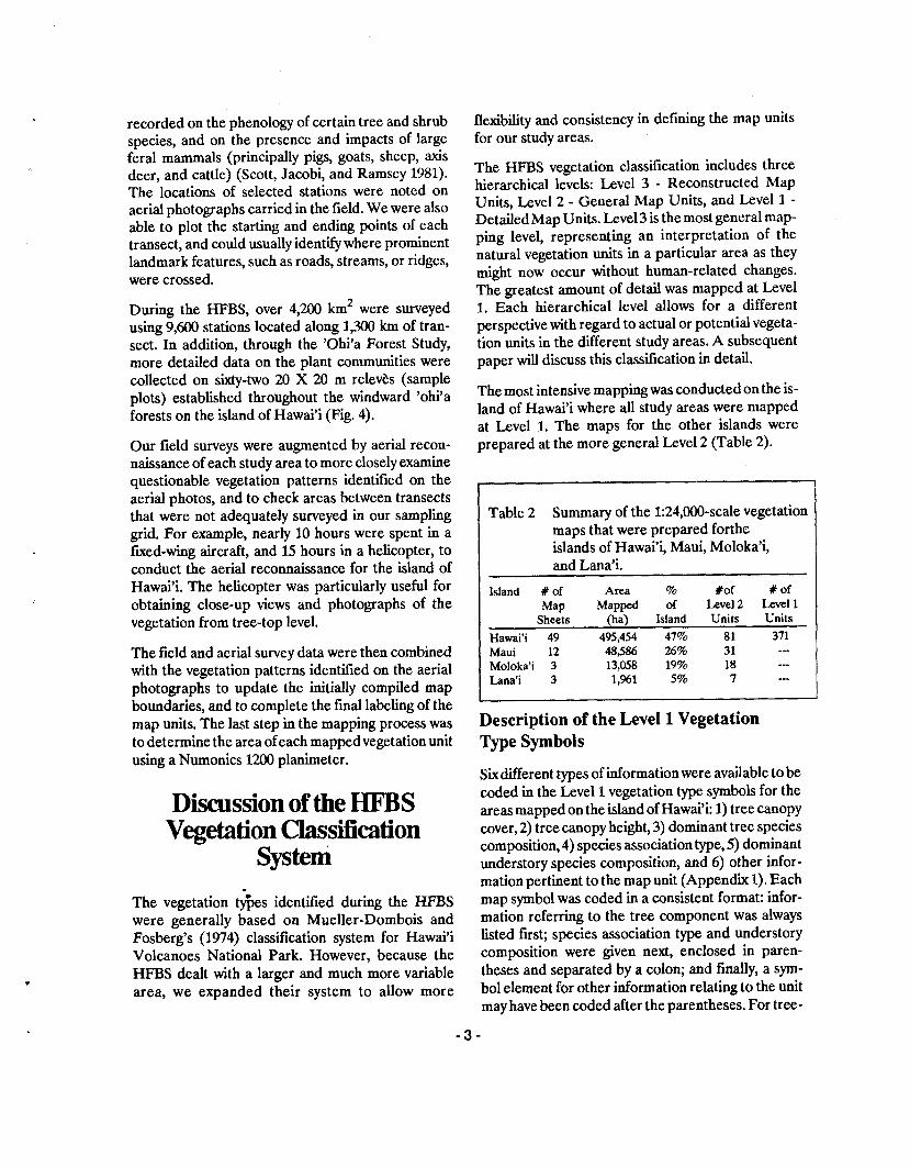
"Hawai'i Forest Type Maps" at the scale of 1:62,500, based on aerial photographs taken between 1950 and 1954 (Nelson 1967). These maps were prepared for all forested areas on all the major Hawaiian Islands, except National Park lands. The Forest Type map units provide information on 1) land use class, 2) forest type (i.e., tree species composition), 3) density of tree cover, and 4) tree stand size class in terms of sawtimber classes. Despite the greater level of map- ping detail at this large scale, the Hawai'i Forest Type maps were prepared at the reconnaissance level, with only a limited amount of unit verification in the field.
Several other detailed vegetation maps have been prepared for smaller areas on many of the Islands. A map by Mueller-Dombois and Fosberg (1974) dis- plays vegetation types within and adjacent to Hawai'i Volcanoes National Park on the island of Hawai'i. This map, at the scale of 1:52,000, presents both a detailed and accurate description of the dominant trees and understory plant associations in the Park. Whiteaker (1983) prepared a similar map of the plant communities in Haleakala National Park on Maui. Other recent vegetation maps of relatively small areas include those by Smathers (1967), Harrison (1972), Higashino and Mizuno (1976), Jacobi (1978), and McEldowney (1983).
Initiation of a New Vegetation Mapping Program
In 1976 the US. Fish and Wildlife Service (USFWS) began an extensive field survey to determine the cur- rent distribution, abundance, and status of the native forest birds and their habitats on all of the major Hawaiian Islands except 'Oahu (Scott, Jacobi, and Ramsey 1981; Scott et al. 1986). Because of the lack of recent, detailed vegetation maps covering the USFWS study areas, a new mapping program was in- itiated as a component of the Hawai'i Forest Bird Survey (HFBS). The maps serve as the habitat basis for analyzing the bird and plant species information collected during the HFBS.
The new vegetation map series was also set up to provide a habitat base for another research program, the 'Ohi'a Forest Study, directed by Dr. D. Mueller- Dombois of the Department of Botany at the Univer- sity of Hawai'i. This second project investigated the dynamics of the native rain forests on the windward side of the island of Hawai'i, and focused on deter-
mining the causes and results of arecent, widespread dieback of the dominant tree species, 'ohi'a (Metrosideros polymorpha), in that area (Petteys, Burgan, and Nelson 1975; Mueller-Dombois 1980; Jacobi 1983; Jacobi, Gerrish, and Mueller-Dombois 1983).
Methods
The HFBS vegetation map series was designed to overlay U.S. Geological Survey (USGS) topographic quadrangle maps at the scale of 1:24,000 (Figs. 1 and 2). The basic patterns of the vegetation were initially mapped on black and white aerial photographs taken by the USGS in 1976 - 1977 at the approximate scale of 1:40,000. This primary mapping step was ac- complished using a Leitz MS-27 mirror stereoscope with 3X and 6X magnification. The boundaries delineated on the aerial photographs were then com- piled into preliminary composite overlays on 1:24,000-scale orthophoto quad sheets using a Kern PG-2 stereoplotter. This optical plotter allowed for a very accurate transfer of the lines mapped on the aerial photographs to the base maps. Through a process of iterative scaling and parallax correction of control points on the photo model, we were able to consistently compile lines onto the topographic base maps to within 0.5 mm of their plotted location. This degree of accuracy during the compilation step vir- tually eliminated line plotting errors in the mapping procedure. Any errors detected in the map unit boundaries can be traced directlyback to the original delineation of the vegetation patterns on the aerial photographs.
One of the most important steps in the preparation of vegetation maps at this large scale is verification of the mapped units in the field. In conjunction with the HFBS, all mapped areas were field-checked along a series of transects established through each study area. On the island of Hawai'i, transects were spaced 3.2 km (2 mi) apart and oriented perpendicular to elevational contours (Fig. 3). Transects were located approximately 1.6 km (1 mi) apart in most of the other study areas. Sampling points, called stations, were established at 134-m (440-ft) intervals along each transect. Various types of data were recorded at these stations, including bird population counts and detailed information on the structure and com- position of the vegetation. Information was also
recorded on the phenology of certain tree and shrub species, and on the presence and impacts of large feral mammals (principally pigs, goats, sheep, axis deer, and cattle) (Scott, Jacobi, and Ramsey 1981). The locations of selected stations were noted on aerial photographs carried in the field. We were also able to plot the starting and ending points of each transect, and could usually identify where prominent landmark features, such as roads, streams, or ridges, were crossed.
During the HFBS, over 4,200 km2 were surveyed using 9,600 stations located along 1,300 km of tran- sect. In addition, through the 'Ohi'a Forest Study, more detailed data on the plant communities were collected on sixty-two 20 X 20 m relevhs (sample plots) established throughout the windward 'ohi'a forests on the island of Hawai'i (Fig. 4).
Our field surveys were augmented by aerial recon- naissance of each study area to more closely examine questionable vegetation patterns identified on the aerial photos, and to check areas between transects that were not adequately surveyed in our sampling grid. For example, nearly 10 hours were spent in a fured-wing aircraft, and 15 hours in a helicopter, to conduct the aerial reconnaissance for the island of Hawai'i. The helicopter was particularly useful for obtaining close-up views and photographs of the vegetation from tree-top level.
The field and aerial survey data were then combined with the vegetation patterns identified on the aerial photographs to update the initially compiled map boundaries, and to complete the final labeling of the map units. The last step in the mapping process was to determine the area of each mappedvegetation unit using a Nurnonics 1200 planimeter.
Discussion of the HFBS Vegetation Classifmtion
system
The vegetation t$es identged during the HFBS were generally based on Mueller-Dombois and Fosberg's (1974) classification system for Hawai'i Volcanoes National Park. However, because the HFBS dealt with a larger and much more variable area, we expanded their system to allow more
flexibility and consistency in defining the map units for our study areas.
The HFBS vegetation classification includes three hierarchical levels: Level 3 - Reconstructed Map Units, Level 2 - General Map Units, and Level 1 - Detailed Map Units. Level 3 is the most general map- ping level, representing an interpretation of the natural vegetation units in a particular area as they might now occur without human-related changes. The greatest amount of detail was mapped at Level 1. Each hierarchical level allows for a different perspective with regard to actual or potential vegeta- tion units in the different study areas. A subsequent paper will discuss this classification in detail.
The most intensive mapping was conducted on the is- land of Hawai'i where all study areas were mapped at Level 1. The maps for the other islands were prepared at the more general Level 2 (Table 2).
Table 2 Summary of the 1:24,000-scale vegetation maps that were prepared forthe islands of Hawai'i, Maui, Moloka'i, and Lana'i.
- -
Island # of Area % #of # o f Map Mapped of Level 2 Level 1
Sheets (ha) Island Units Units Hawai'i 49 495,454 47% 81 371 Maui 12 48,586 26% 31 -.- Moloka'i 3 13,058 19% 18 --- Lana'i 3 1,%1 5% 7 ---
Description of the Level 1 Vegetation Type Symbols
Sixdifferent types of informationwere available to be coded in the Level 1 vegetation type symbols for the areas mapped on the island of Hawai'i: 1) tree canopy cover, 2) tree canopy height, 3) dominant tree species composition, 4) species association type, 5) dominant understory species composition, and 6) other infor- mation pertinent to the map unit (Appendix 1). Each map symbol was coded in a consistent format: infor- mation referring to the tree component was always listed first; species association type and understory composition were given next, enclosed in paren- theses and separated by a colon; and finally, a syrn- bol element for other information relating to the unit may have been coded after the parentheses. For tree-
less vegetation types, the symbol elements pertaining to tree crown cover, height, and species composition were omitted.
1) Tree Canopy Cover. Tree cover was defined as the vertical projection of a tree's foliage outline on the ground, expressed as a percentage of a reference area . This definition assumed a relatively homogenous distribution of the leaves within the canopy and did not take into account either crown thickness or foliage layering.
Four tree canopy cover classes were recognized: closed or open canopy, and scattered or very scat- tered trees. The definition of closed canopy used (60% cover) coincides with Mueller-Dombois and Fosberg's (1974) closed forest unit. This cover class can easily be determined in the field or on aerial photographs when most of the tree crowns are inter- locking. The cover range for an open tree canopy was 25 - 60%, generally corresponding to the traditional definition of a woodland (Mueller-Dombois and El- lenberg 1974). For tree cover < 25%, two cover clas- ses wetrerecognized: scattered trees (5 - 25% cover) and very scattered trees ( ~ 5 % cover). This latter class was established because of the importance of even very reduced tree cover to certain bird popula- tions.
2) Tree Canopy Height. Tree height was divided into three classes: scrub trees (2 - 5 m tall), low trees (5 - 10 m), and tall trees (10 m).
3) Tree Species Composition. Species name ab- breviations for all trees composing 25% of the total crown cover were listed next in the map symbol. If a species did not attain this minimum cover value it was combined with other tree species and listed using a tree species association symbol ("xt" or "nt", refer- ring to "introduced trees" and "native trees", respec- tively). Introduced tree species were always grouped together and indicated by the "xt" symbol, regardless of their canopy cover.
For most symbols, more than one tree species or as- sociation element was coded, separated by either a dash, comma, o r slash. A dash indicates codominance. A comma means that the species or as- sociation coded first was dominant. The slash denotes combinations of elements in a mosaic pat- tern too small to separate at the mapping scale. For symbols with more than one tree element, a canopy
height symbol was coded for each element only if they were in different tree layers.
4) Species Association Type was used to indicate the species composition for any coded native tree or un- derstory plant association component (Appendix 2). For example, the native tree association symbol (nt) in a dry habitat (D:) is composed of one group of species, whereas in a moist (M:) or wet habitat (W:), other groups of species predominate.
5) Understory Species Composition was generally coded using only species association symbols. If more than one symbol element was listed for the under- story, they were separated by either a dash or a comma to again show dominance or codominance. The bare ground symbol (xx) indicates that at least 25% of the ground was not covered by vascular plants.
6) Other Information. Elements in this last category were used to provide additional information on cer- tain vegetation units. This information may further define the characteristics of that unit, such as when the element "pio" was used to indicate pioneer or early sera1 vegetation, or may provide additional in- formation on the condition of the unit: "sng" = numerous dead or dying trees present, "bur" = recently burned, "clr" = recently cleared, and "fum" = recently defoliated by volcanic fume.
Discussion of the Level 2 Vegetation Type Symbols
The more general Level 2 map unit symbols were based on tree and understory species composition and on relatively wide ranges of tree crown cover. Symbol components include the species association type designations (D:, M:, or W:) and species name abbreviations or association codes, following the same dominance or codominance conventions used for the Level 3 symbols. As with the Level 3 symbols, information relating to the understory is enclosed in parentheses. Tree canopy cover was divided into three categories: 1) closed or open forest ( > 25% tree cover), 2) scattered trees (< 25% cover), or 3) treeless. The symbol format of Level 2 units differs from Level 3 by the species association type listed first, followed by the codes relating to either the tree component or the understory component, depending on the tree cover (Appendix 3). The tree species or association abbreviations were listed in front of the
understory codes if the tree cover was greater than 25%. Conversely, map units with scattered trees (i.e., < 25% cover) have the tree components listed after the parentheses.
Availability of Vegetation Maps Prepared During the HFBS
Blue-line copies of the 1:24,000-scale vegetation map sheets for all areas mapped during the HFBS are cur- rentlyavailable for general use. Efforts are now being directed toward the preparation of an additional set of map sheets displaying Level 2 units for the islands of Hawai'i and Maui at the scale of 1:100,000. These smaller-scale maps will allow for a better regional overview of the distribution of the major vegetation types in Hawai'i than is possible with the 1:24,000- scale maps.
Requests for copies of the 1:24,000-scale maps, or for information on the status of the 1:100,000-scale maps, should be addressed to:
U.S. Fish and Wildlife Service Hawaii Research Station P.O. Box 44 Hawai'i National Park, Hawai'i %718 Phone: (808) %7-73%
U.S Fish and Wildlife Service Office of Environmental Sevices P.O. Box 50167 Honolulu, Hawai'i 96850 Phone: (808) 541-2749
Literature Cited
Harrison, B.C. (1972). The vegetation of Waihoi Val- ley. Pp. 94-136. In: J.I. Kjargaard (Ed.). Scientific Report of the Waihoi Valley Project. (Unpublished Report).
Higashino, P.K. and G. Mizuno (1976). Vegetation mapping and vascular plant check list. Pp. 41-120. In: D. Peterson (Ed.). The Scientific Report of the Manawainui Research Project. (Unpublished Report).
Jacobi, J.D. (1978). Vegetation map of the Ka'u Forest Reserve and adjacent land, island of Hawai'i. U.S.
Department of Agriculture, Forest Service, Pacific Southwest Forest and Range Experiment Station, Resource Bulletin PSW-16.
Jacobi, J.D. (1983). Metrosideros dieback in Hawai'i: A comparison of adjacent dieback and non-dieback rainforest stands. New Zealand Journal of Ecology 6: 79-97.
Jacobi, J.D., G. Gerrish, and D. Mueller-Dombois (1983). 'Ohi'a dieback in Hawai'i: Vegetation chan- ges in permanent plots. Pacific Science 37: 327-337.
Knapp, R. (1965). Die Vegetation von Nord- und Mittelamerika und der Hawaii-Inseln. Gustav Fis- cher Verlag, Stuttgart; 363 pp. Translation by A.Y. Yoshinaga and H.H. Iltis of the section on Hawai'i. Hawaiian Botanical Society Newsletter 14: 95-121.
Lamoureux, C.H. (1973). Vegetation Zones. Pp. 64- 65 In: R.W. Armstrong (Ed.). Atlm of Hawai'i. The University Press of Hawai'i, Honolulu; 222 pp.
McEldowney, H. (1983). A description of major vegetation patterns in the Waimea-Kawaihae region during the early historic period. Pp. 407-448 In: J.T. Clark and P.V. Kirch (Eds.). Archaeological Znves- tigations of the Mudlane- Waimea-Kawaihae Rd. Cor- ridor. B.P. Bishop Museum, Honolulu, Hawai'i, Anthropology Report 83-1.
Mueller-Dombois, D. (1980). The 'ohi'a dieback phenomenon in the Hawaiian rain forest. Pp. 153- 161. In: J. Cairns, Jr. (Ed.). The Recovery Process in Damaged Ecosystems. Ann Arbor Science Publishers, Inc., Ann Arbor, Michigan.
Mueller-Dombois, D. and H. Ellenberg (1974). Aims and Methodr of Vegetation Ecology. John Wiley and Sons, New York; 547 pp.
Mueller-Dombois, D. and F.R. Fosberg (1974). Vegetation map of Hawai'i Volcanoes National Park (at 152,000). Cooperative National Park Resources Study Unit, University of Hawai'i, Honolulu, Tech- nical Report Number 4.
Nelson, R.E. (1967). Recorh and maps of forest types in Hawai'i. U.S. Department of Agriculture, Forest Service, Pacific Southwest Forest and Range Experi- ment Station, Resource Bulletin PSW-8.
Petteys, E.Q.P., R.E. Burgan, and R.E. Nelson (1975). 'Ohi'a forest decline: its spread and severity in
Hawai'i. U.S. Department of Agriculture, Forest Ser- vice, Pacific Southwest Forest and Range Experi- ment Station, Research Paper PSW-105.
Porter, J,R. (1972). Hawaiian names for vascular plants. College of Tropical Agriculture, Hawai'i Agricultural Experiment Station, University of Hawai'i, Honolulu, Departmental Paper 1.
Ripperton, J.C. and E.Y Hosaka (1942). Vegetation zones of Hawai'i. Hawai'i Agricultural Experiment Station, Honolulu, Bulletin 89.
Scott, J.M., J.D. Jacobi, and F.L. Ramsey (1981). Avian surveys of large geographical areas: a sys- tematic approach. Wildlife Society Bulletin 9:190-200.
Scott, J.M., S. Mountainspring, F.L. Ramsey, and C.B. Kepler (1986). Forest bird communities of the Hawaiian Islands: nteir dynamics, ecology, and con- servation. Studies in Avian Biology 9. Cooper Or- nithological Society.
bathers , G.A. (1967). A preliminary survey of the phylogeography of Kipahulu Valley. Pp. 55-70 + maps. In: R.E. Warner (Ed.). ScientificReport of the Kipahulu Valley Expedition. (Unpublished Report to The Nature Conservancy).
St. John, H. (1973). List and summaly of flowering plants in the Hawaiian Islands. Pacific Tropical Botanical Garden, Lawai, Kaua'i, Hawai'i, Memoir No. 1.
Whiteaker, L.D. (1983). The vegetation and environ- ment of the Crater District of Haleakala National Park. Pacific Science 37: 1-24.
Acknowledgments
The successful completion of the HFBS vegetation mapping project was mainly due to the excellent cooperation and assistance provided by many dif- ferent individuals and agencies. I particularly thank the following people for their valuable help and sup- port during various stages of this project.
The development of the mapping strategy was aided by many useful suggestions from J.M. Scott, F.R. Warshauer, and C. van Riper 111 (members of the HFBS); D. Mueller-Dombois, K.W. Bridges, C.W. Smith, and L. Stemmermann (Dept. of Botany, Univ. Hawai'i); E. Petteys and M. Buck (State of Hawai'i, Division of Forestry and Wildlife). I also appreciated the many helpful comments on the manuscript provided by L. Cuddihy, P. Higashino, C. Robbins, J.M. Scott, and J. Williams.
Field-checking of the map units was accomplished with the help of F.R. Warshauer, H. McEldowney, R. Schuster, L. Stemmermann, P. Higashino, C. Ctivel- lone, G. Gerrish, R. Cooray, D. Mueller-Dombois, A. Holt, and N. Balakrishnan. Compilation and drafting of the preliminary map sheets was com- pleted by C. Crivellone, H. McEldowney, P. Higashino, S. Doyle, J. Williams, and P. Ashman of the U.S. Fish and Wildlife Service. E. Wingert and his staff at the Dept. of Geography, Univ. Hawai'i, photographically compiled the vegetation map over- lays and topographic base maps onto single sheets for easier duplication.
I also thank the staff at the Hawai'i Volcano Obser- vatory (U.S. Geological Survey) for the use of their equipment (particularly the Kern PG-2) and aerial photographs. Additional equipment and photographs were made available for this project by the State of Hawai'i, Division of Forestry and Wildlife.
Finally, I thank the numerous landowners throughout the State for allowing the HFBS access onto their lands to survey the plant and bird communities.
Primary financial support for this project was provided by the U.S. Fish and Wildlife Service (Patuxent Wildlife Research Center and Pacific Is- lands Office). Additional support for the mapping program were made available to the 'Ohi'a Forest Study (D. Mueller-Dombois, Dept. of Botany, Univ. Hawai'i) through grants from the National Park Ser- vice (Contract CX8000 6 0006) and the National Science Foundation (Grant DEB-7910993).
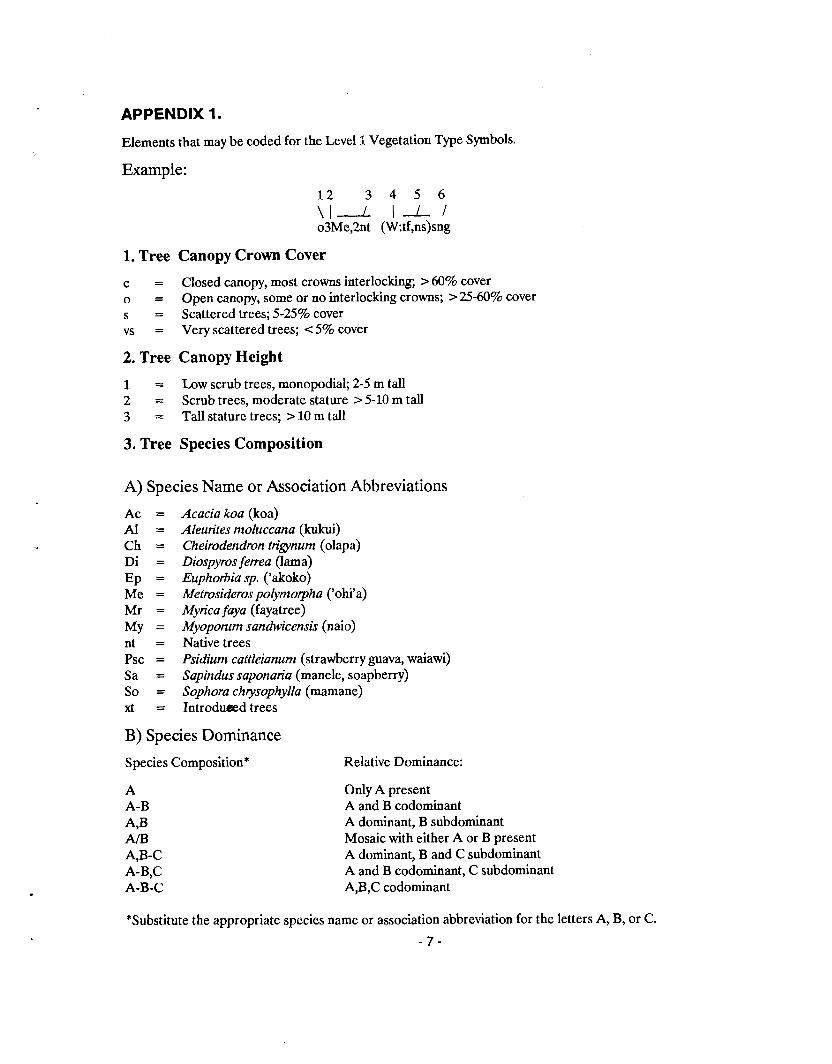
APPENDIX 1.
Elements that may be coded for the Level 1 Vegetation Type Symbols.
Example:
1. Tree Canopy Crown Cover
c = Closed canopy, most crowns interlocking; > 60% cover o = Open canopy, some or no interlocking crowns; > 25-60% cover s = Scattered trees; 525% cover vs = Very scattered trees; < 5% cover
2. Tree Canopy Height
1 = Low scrub trees, monopodial; 2-5 m tall 2 = Scrub trees, moderate stature > 5-10 m tall 3 = Tall stature trees; > 10 m tall
3. Tree Species Composition
A) Species Name or Association Abbreviations
Ac = A1 = Ch = Di = Ep = Me = Mr = My = nt = Psc = Sa = So = xt =
Acacia koa (koa) Aleurites moluccana (kukui) Cheirodendron trigynum (olapa) Diospyros ferea (lama) Euphorbia sp. ('akoko) Metrosideros polymorpha ('ohi'a) Myrica faya (fayatree) Myoporum sandwicensis (naio) Native trees Psidium cattleianum (strawberry guava, waiawi) Sapindus saponarirz (manele, soapberry) Sophora chrysophylla (mamane) Introduded trees
B) Species Dominance
Species Composition* Relative Dominance:
A A-B A,B Am A,B-C A-B,C A-B-C
Only A present A and B codominant A dominant, B subdominant Mosaic with either A or B present A dominant, B and C subdominant A and B codominant, C subdominant A,B,C codominant
*Substitute the appropriate species name or association abbreviation for the letters A, B, or C.
- 7 -
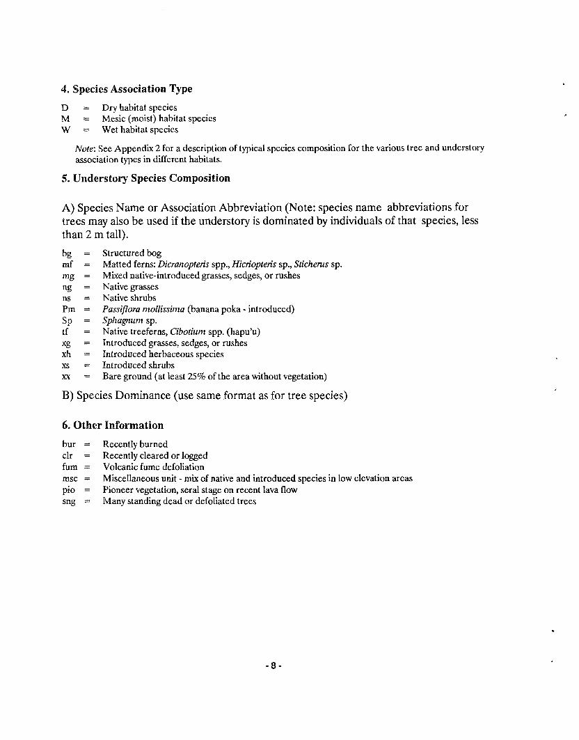
4. Species Association Type
D = Dry habitat species M = Mesic (moist) habitat species W = Wet habitat species
Note: See Appendix 2 for a description of typical species composition for the various tree and understory association types in different habitats.
5. Understory Species Composition
A) Species Name or Association Abbreviation (Note: species name abbreviations for trees may also be used if the understory is dominated by individuals of that species, less than 2 m tall).
Structured bog Matted ferns: Dicranopteris spp., Hicriopteris sp., Stichems sp. Mixed native-introduced grasses, sedges, or rushes Native grasses Native shrubs Passiflora mollissima (banana poka - introduced) Sphagnum sp. Native treeferns, Cibotium spp. (hapu'u) Introduced grasses, sedges, or rushes Introduced herbaceous species Introduced shrubs Bare ground (at least 25% of the area without vegetation)
B) Species Dominance (use same format as for tree species)
6. Other Information
bur = Recently burned clr = Recently cleared or logged fum = Volcanic fume defoliation msc = Miscellaneous unit - mix of native and introduced species in low elevation areas pio = Pioneer vegetation, sera1 stage on recent lava flow sng = Many standing dead or defoliated trees
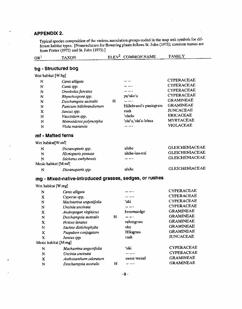
APPENDIX 2.
Typical species composition of the various association groups coded in the map unit symbols for dif- ferent habitat types. [Nomenclature for flowering plants follows St. John (1973); common names are from Porter (1972) and St. John (1973).]
OR' TAXON ELEV~ COMMON NAME FAMILY
bg - Structured bog Wet habitat w:bg]
N Carex alligata N Carex spp. N Oreobolus furcatus N Rhynchospora spp. N Deschampsia australis N Pmicum hillebrandianum X Juncus spp. N Vaccinium spp. N Metrosideros polymorpha N Viola maviensis
mf - Matted ferns Wet habitat[W:mfj
N Dicranopteris spp. N Hicriopteris pinnata N Sticherus owhyhensis
Mesic habitat [M:rnf]
N Dicranopteris spp.
-- - -- - -- pu'uko'a
H --- Hillebrand's panicgrass rush 'ohelo 'ohi'a,'ohi'a-lehua - - -
uluhe uluhe-lau-nui - --
uluhe
rng - Mixed-native-introduced grasses, sedges, or rushes Wet habitat [W:mg]
N Carex alligata X Cyperus spp. N Machaerina angustifolia N Uncinia uncinata X Andropogon virginicus N Deschampsia australis X Holcus lanatus N Sachne distichophylla X Paspalum conjugaturn X Juncus spp.
Mesic habitat [M:mg]
N Machaerina angustifolia N Uncinia uncinata X Anthoxanthum odoratum N Deschampsia australis
- -- - -- 'uki - - - broomsedge
H - - - velvetgrass ohe Hilogr ass rush
'uki - -- sweet vernal
H ---
CWERACEAE CYPERACEAE CWERACEAE CYPERACEAE GRAMINEAE GRAMINEAE JUNCACEAE ERICACEAE MYRTACEAE VIOLACEAE
GLEICHENIACEAE GLEICHENIACEAE GLEICHENIACEAE
GLEICHENIACEAE
CYPERACEAE CYPERACEAE CYPERACEAE CWERACEAE GRAMINEAE GRAMINEAE GRAMINEAE GRAMINEAE GRAMINEAE JUNCACEAE
CYPERACEAE CYPERACEAE GRAMINEAE GRAMINEAE
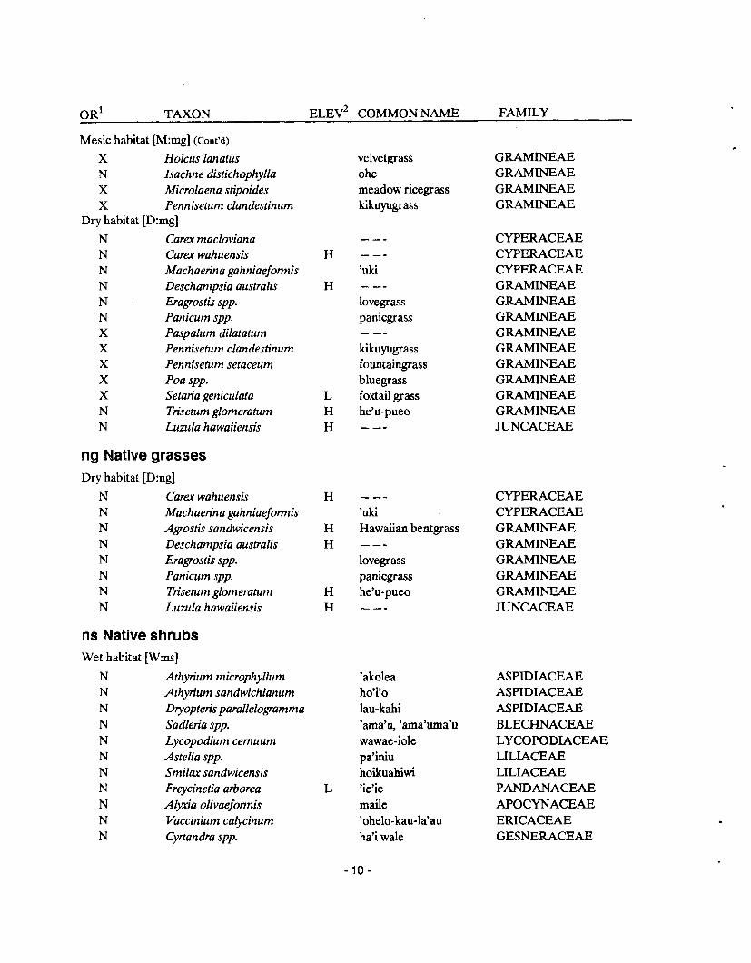
OR' TAXON ELEV~ COMMON NAME FAMILY
Mesic habitat [M:mg] (Cont'd)
X Holcus lanatus N Isachne distichophylla X Microlaena stipoides X Pennisetum clandestinum
Dry habitat [D:mg]
Cara macloviana Cara wahuensis Machaerina gahniaefomis Deschampsia australis Eragrostis spp. Panicum spp. Paspalum dilatatum Pennisetum clandestinum Pennisetum setaceum Poa spp. Setaria geniculata Trisetum glomeratum Lumla hawaiiensis
ng Native grasses Dry habitat [D:ng]
Cara wahuensis Machaerina gahniaefomiis Agrostis sandwicensis Deschampsia australis Eragrostis spp. Panicum spp. Trisehrm glomeratum Luzula hawaiiensis
ns Native shrubs Wet habitat [W:ns]
N Athyrium microphyllum N Athyrium sandwichianum N Dlyopteris parallelogramma N Sadleria spp. N Lycopodium cernuum N Astelia spp. N Smilax sandwicensis N Freycinetia arborea N AEyxia olivaefomis N Vaccinium calycinum N Cyrtandra spp.
velvetgrass ohe meadow ricegrass kikuyugrass
- -- 'uki - -- lovegrass panicgrass - -- kiuyugrass fountaingrass bluegrass foxtail grass he'u-pueo ---
- -- 'uki Hawaiian bentgrass --- lovegrass panicgrass he'u-pueo - --
'akolea ho'i'o lau-kahi 'ama'u, 'ama'uma'u wawae-iole pa'iniu hoikuahiwi 'ic'ie maile 'ohelo-kau-la'au ha'i wale
GRAMINEAE GRAMINEAE GRAMINEAE GRAMINEAE
CYF'ERACEAE CYF'ERACEAE CYPERACEAE GRAMINEAE GRAMINEAE GRAMINEAE GRAMINEAE GRAMINEAE GRAMINEAE GRAMINEAE GRAMINEAE GRAMINEAE JUNCACEAE
CYPERACEAE CYPEUCEAE GRAMINEAE GRAMINEAE GRAMINEAE GRAMINEAE GRAMINEAE JUNCACEAE
ASPIDIACEAE ASPIDIACEAE ASPIDIACEAE BLECHNACEAE LYCOPODIACEAE LILIACEAE LILIACEAE PANDANACEAE APOCYNACEAE ERICACEAE GESNERACEAE
OR' TAXON ELEV~ COMMON NAME FAMIY
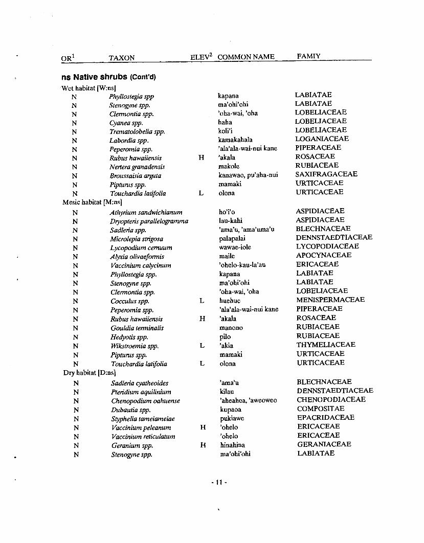
ns Native shrubs (Cont'd) Wet habitat [W:ns]
N Phyllostegia spp N Srenogyne spp. N Clemontia spp. N Cyanea spp. N Trematolobelia spp. N Labordia spp. N Peperomia spp. N Rubus hawaiiensis N Nertera granadensis N Broussaisia arguta N Pipfurus spp. N Touchardia latifolia
Mesic habitat [M:ns]
N Athyrium sandwichianum N Dtyopteris parallelogramma N Sadleria spp. N Microlepia strigosa N Lycopodium cemuum N Alym'a olivaefomis N Vaccinium calycinum N Phyllostegia spp. N Stenogyne spp. N Clemontia spp. N Cocculus spp. N Peperomia spp. N Rubus hawaiiensis N Gouldia tenninalis N Hedyotis spp. N Wikstroemia spp. N Pipturns spp. N Touchardia latifolia
Dry habitat [D:ns]
N Sadleria cyatheoides N Pteridium aquilinium N Chenopodium oahuense N Dubautia spp. N Styphelia tameiameiae N Vaccinium peleanum N Vaccinium reticulatum N Geranium spp. N Stenogyne spp.
kapana ma'ohi'ohi 'oha-wai, 'oha haha koli'i kamakahala 'ala'ala-wai-nui kane 'akala makole kanawao, pu'aha-nui mamaki olona
ho'i'o lau-kahi 'ama'u, 'ama'uma'u palapalai wawae-iole maile 'ohelo-kau-la'au kapana ma'ohi'ohi 'oha-wai, 'oha huehue 'ala'ala-wai-nui kane 'akala manono pi10 'akia mamaki olona
'ama'u kilau 'aheahea, 'aweoweo kupaoa pukiawe 'ohelo 'ohelo hinahina ma'ohi'ohi
LABIATAE LABIATAE LOBELIACEAE LOBELIACEAE LOBELIACEAE LOGANIACEAE PIPERACEAE ROSACEAE RUBIACEAE SAXIFRAGACEAE URTICACEAE URTICACEAE
ASPIDIACEAE ASPIDIACEAE BLECHNACEAE DENNSTAEDTIACEAE LYCOPODIACEAE APOCYNACEAE ERICACEAE LABIATAE LABIATAE LOBELIACEAE MENISPERMACEAE PIPERACEAE ROSACEAE RUBIACEAE RUBIACEAE THYMELIACEAE URTICACEAE URTICACEAE
BLECHNACEAE DENNSTAEDTIACEAE CHENOPODIACEAE COMPOSITAE EPACRIDACEAE ERICACEAE ERICACEAE GERANIACEAE LABIATAE
OR' TAXON ELEV~ COMMON NAME FAMILY
Dry habitat [Dm] (Cont'd)
N Cocculus spp. N Myoporum sandwicense N Sida spp. N Argemone glauca N Osteomeles anthyllid$olia W Coprosmaea nodeoides N Coprosma montana N Morinda trimera N Dodonaea spp. N Waltheria americana N Wkstroemia spp.
nt Native trees Wet habitat [W:nt]
N Pritchardia spp. N Rhus sandwicensis N Ilex anomala N Cheirodendron trigynum N Tetraplasandra meiandra N Perrottetia sandwicensis N Antidesma platyphyllum N Myrsine lessertiana N Myrsine sandwicensis N Metrosideros polymorpha N Pittosponim spp. N Bobea spp. N Coprosma spp. N Gouldia hillebrandii N Gouldia terminalis N Psychotria spp. N Pelea clusiaefolia N Urera spp.
Mesic habitat [M:nt]
N Charpen tiera spp . N Rhus sandwicensis N Ilex anomala N Perrottetia sandwicensis N Diospyros ferrea N Antidesma platyphylla N Xylosma hawaiiense N Pseudomoms sandwicensis N Myrsine lessertiana N Myrsine sandwicensis
buehue naio '%ma pua-kala 'dei kukae-nene pi10 noni a'ali'i hi'aloa 'akia
lo'ulu, hawane neneleau kawa'u olapa, olapalapa 'ohe olomea hame kolea-lau-nui kolea-lau-li'i 'ohi'a, 'ohia-lehua ho'awa 'ahakea pi10 manono manono kopiko alani opuhe
papala neneleau kawa'u olomea lama hame maua a'ia'i kolea-lau-nui kolea-lau-li'i
MENISPERMACEAE MYOPORACEAE MYRTACEAE PAPAKRACEAE ROSACEAE RUBIACEAE RUBIACEAE RUBIACEAE SAPINDACEAE STERCULIACEAE THYMELAEACEAE
PALMAE ANACARDIACEAE AQUIFOLIACEAE ARALIACEAE ARALIACEAE CELASTRACEAE EUPHORBIACEAE MYRSINACEAE MYRSINACEAE MYRTACEAE PITTOSPORACEAE RUBIACEAE RUBIACEAE RUBIACEAE RUBIACEAE RUBIACEAE RUTACEAE URTICACEAE
AMARANTHACEAE ANACARDIACEAE AQUIFOLIACEAE CELASTRACEAE EBENACEAE EUPHORBIACEAE FLACOURTIACEAE MORACEAE MYRSINACEAE MYRSINACEAE
OR' TAXON ELEV~ COMMON NAME FAMILY
Mesic habitat [M:nt](cont7d)
N Eugenia sandwicensis N Metrosideros polymolpha N Pisonia spp. N Osmanthus sandwicensis N Pittosporum spp. N Bobea spp. N Coprosma spp. N Gouldia hillebrandii N Gouldia terminalis
Dry habitat [D:nt]
N Pleomele spp. N Rauvolfia spp. N Reynoldsia sandwicensis N Diospyros ferrea N Xylosma hawaiiense N Erythrina sandwicensis N Mezoneuron kavaiense N Sophora chrysophylla N Myoporum sandwicense N Myrsine lanaiensis N Metrosideros polymorpha N Osmanthus sandwicensis N Alphitonia portderosa N Colubrina oppositifolia N Canthiurn odoratum N Santalum spp. N Planchonella spp.
tf - Native treeferns Wet habitat p : t f J
N Cibotium chamissoi N Cibotium glaucum
'ohi'a-ha 'ohi'a, 'ohi'a-lehua papala-kepau olupua ho'awa 'ahakea pi10 manono manono
halapepe hao 'ohe, 'ohe'ohe, makai lama maua wiliwili uhiuhi mamane naio kolea 'ohi'a,'ohi'a-lehua olupua kauwila, kauila kauwila, kauila lahe'e 'ilihi 'ala'a
haup'u 'i'i hapu'u
xg-Introduced grasses, sedges, or rushes Wet habitat [W:xg]
X Cyperus spp. - -- X Andropogon virginicus broomsedge X Holcus lanatus velvetgrass X Microlaena stipoides meadow ricegrass X Paspalum conjugatum Hilograss X Sacciolepis indica Glenwoodgrass X Setaria palmaefolia L palmgrass X Juncus spp. rush
MYRTACEAE MYRTACEAE NYCTAGINACEA OLEACEAE PITTOSPORACEAE RUBIACEAE RUBIACEAE RUBIACEAE RUBIACEAE
LILIACEAE APOCYNACEAE ARALIACEAE EBENACEAE FLACOURTIACEAE LEGUMINOSAE LEGUMINOSAE LEGUMINOSAE MYOPORACEAE MYRSINACEAE MYRTACEAE OLEACEAE RHAMNACEAE RHAMNACEAE RUBIACEAE SANTALACEAE SAPOTACEAE
DICKSO NIACEAE DICKSONIACEAE
CYPERACEAE GRAMINEAE GRAMINEAE GRAMINEAE GRAMINEAE GRAMINEAE GRAMINEAE JUNCACEAE
OR' TAXON ELEV~ COMMON NAME FAMILY
Mesic habitat [M:xg] X Cyperus spp. X Andropogon virginicus X Anthoxanthum odorahtni X Axonopus af f i is X Dactylis glomerata X Holcus lanatus X Microlaena stipoides X Paspalum spp. X Pennisetunt clandestinum
Dry habitat [D:xg] X Bulbostylis capillaris X Andropogon glomeratus X Andropogon virginicus X Anthoxanthum odor atum X Axonopus affinis X Bromus spp. X Danthonia sp. X Festuca spp. X Holcus lanatus X IIypamhenia rufa X Melinis minutiflora X Paspalum dilatahtm X Pennisetum clandestiriurn X Pennisetum setaceum X Poa spp. X Hhync1telytrum repens X Setaria geniculata
xh-Introduced herbaceous species Dry habitat [D:xh]
X Erigeron spp. X Heterotlieca grandiflora X Hypochoeris radicata X Rumex acetosella X Ver6ascum sp.
xs-introduced shrubs Wet habitat [W:xs]
X Nephrolepis multiflora X Arundina barnbusaefolia X Hedychium spp. X Ageratina riparia X Eupatorium adenophoruni
--- broomsedge sweet vernal carpetgrass orchardgrass velvetgrass meadow ricegrass - -- kikuyugrass
- -- bush bentgrass broomsedge sweet vernal carpetgrass --- - -- fescue velvetgrass thatchinggrass molassesgrass - - kikuyugrass foun taingrass bluegrass Nalal redtop foxtail grass
fleabane,hairyhorsewee telegraph plant gosmore sheep sorrel mullein
kupukupu, pamoho bamboo orchid
&inger pa-makane Maui pa-makani
CYPERACEAE GRAMINEAE GRAMINEAE GRAMINEAE GRAMINEAE GRAMINEAE GRAMINEAE GRAMINlEAE GRAMINEAE
CYPERACEAE GRAMINEAE GRAMINEAE GRAMINEAE GRAMINEAE GRAMINEAE GRAMINEAE GRAMINEAE GRAMINEAE GRAMINEAE GRAMINEAE GRAMINEAE GRAMINEAE GRAMINEAE GRAMINEAE GRAMINEAE GRAMINEAE
COMPOSITAE COMPOSITAE COMPOSITAE POLYGONACEAE SCROPHULARIACEAE
NEPHROLEPIDACEAE ORCHIDACEAE ZINGIBERACEAE COMPOSITAE COMPOSITAE
OR' TAXON ELEV~ COMMON NAME FAMILY
xs-Introduced shrubs(Cont'd) Wet habitat [W:xs]
X Melastoma malabathricurn X Psidium catlleianum X Epilobium spp. X Rubus penetrans X Rubu rosaefolius
Mesic habitat [M:xs]
X Nephrolepis multiflota X Hedychium spp. X Schinus terebinthifolius X Eupatorium adenophorum X Pluchea odorata X Ricinus communis X Buddleja asiatica X Lythrum maritimum X Melastoma malabathricum X Tibouchina urvilleana X Psidium cattleianum X Psidium guajava X Rubus penetrans X Rubus rosaefolius X Stachytarpheta spp.
Dry habitat [D:xs]
X Schinus terebinthifolius X Opuntia megacantha X Pluchea odorata X Verbesina encelioides X Ricinus communis X Cassia leschenaultiana X Indigofera suffruticosa X Buddleja asiatica X Lythrum maritimum X Psidium guajava X Lantana camara X Stachytaipheta spp. X Verbena litoralis
xt-Introduced trees Wet habitat [W:xt]
X Araucaria heterophylla X Pinus spp. X Ctyptomeria japonica
Malabar melastome strawberry guava - -- Florida blackberry thimbleberry
kupukupu, pamoho &%er Christmas berry Maui pa-makani fleabane castor bean Asiati butterfly bush pukamole Malabar melastome lasiandra strawberry guava guava Florida blackberry thimbleberry vervain
Christmas berry prickly pear pa-nini fleabane golden crown-beard castor bean partridge pea indigo Asiatic butterfly bush pukamole guava lantana vervain verbena
Norfolk Island pine pine tsugi
MELASTOMATACEAE MYRTACEAE ONAGRACEAE ROSACEAE ROSACEAE
NEPHROLEPIDACEAE ZINGIBERACEAE ANACARDIACEAE COMPOSITAE COMPOSITAE EUPHORBIACEAE LOGANIACEAE LYTHRACEAE MELASTOMATACEAE MELASTOMATACEAE MYRTACEAE MYRTACEAE ROSACEAE ROSACEAE VERBENACEAE
ANACARDIACEAE CACTACEAE COMPOSITAE COMPOSITAE EUPHORBIACEAE LEGUMINOSAE LEGUMINOSAE LOGANIACEAE LYTHRACEAE MYRTACEAE VERBENACEAE VERBENACEAE VERBENACEAE
ARAUCARIACEAE PINACEAE TAXODIACEAE
Wet habitat [W:xt] X Toona ciliata X Eucalyptus spp. X Melaleuca leucadendra X Psidium cattleianum
Mesic habitat [M:xt]
X Araucan'Q heterophylla X Pinus spp. X Cvptomeria japonica X Mangifera indica X Cassia bicapsularis X Toona ciliafa X Eucalyptus spp. X Eugenia jantbos X Melaleuca leucadendra X Psidium caftleianum X Psidium guajava X GreviIIea robusfa
Dry habitat [D:xt]
- -- paperbark strawberry guava
Norfolk Island pine pine sugi
L mango L - - -
toon
L rose apple paperbark strawberry guava
L guava L silk oak
X Schinus terebinthifolius L Christmas berry X Leucaena leucocephala L koa-haole, ekoa X Eucalyptus spp. - -- X Psidium guajava L guava X Grevillea robusta L silkoak
'OR (Ori 'n): #= Native species; ,
X = Introduced specles
FAMILY
MELIACEAE MYRTACEAE MYRTACEAE MYRTACEAE
ARAUCARIACEAE PIN ACE AE TAXODIACEAE ANACARDIACEAE LEGUMINOSAE MELIACEAE MYRTACEAE MYRTACEAE MYRTACEAE MYRTACEAE MYRTACEAE PROTEACEAE
ANACARDIACEAE LEGUMINOSAE MYRTACEAE MYRTACEAE PROTEACEAE
L~~~~ Elevation) k = G i e r a o found above 203 rn elevation L = Generally found beLow 1200 m elevation
APPENDIX 3.
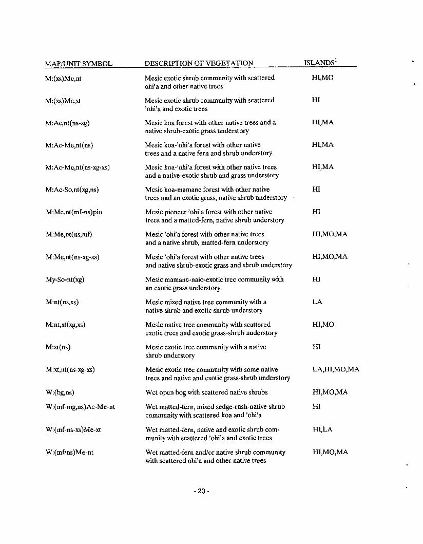
List of the Level 2 Map Units for the areas mapped during the HmS.
MAP/UNIT SYMBOL DESCRIPTION OF VEGETATION IS LANDS^ Dry mixed grassland with scattered mamane and naio trees
Dry mixed grass, native shrub community with scattered koa and other native trees
Dry mixed grass-native shrub community with scattered koa and other native trees
Dry mixed grass-native shrub community with scattered koa, 'ohi'a, and other native trees
Dry mixed grass-native shrub community with scattered koa mamane, and other native trees
Dry mixed grass-native shrub community with scattered mamane and naio trees
Dry mixed grass-native shrub community with scattered mamane trees
Dry native shrub community with scattered 'ohi'a and other native trees
Dry native shrub community with scattered mixed native trees
Dry native shrub with mixed grass community
Dry sparsely vegetated mixed native shrub, exotic grass, and shrub community
Dry native-exotic shrub community with scattered 'ohi'a
Dry exotic grassland
Dry exotic grassland with scattered koa, 'ohi'a, and other native trees
Dry exotic grassland with scattered koa, mamane, and other native trees
Dry exotic grassland with scattered koa and other native trees
Dry exotic grassland with scattered mamane and naio trees
W / U N I T SYMBOL DESCRIPTION OF VEGETATION IS LANDS^ Dry exotic grassland with scattered mamane trees
Dry exotic grassland with scattered native and exotic trees
Dry exotic grassland with some native shrubs, scattered 'ohi'a, and other native trees
Dry exotic grassland with native and exotic shrubs and scattered native trees
Dry exotic shrub community with some native shrubs
Dry sparsely vegetated native shrub community with scattered scrub 'ohi'a trees
Dry koa community with mixed native trees and a mixed grass-native shrub understory
Dry koa community with mixed native trees and a native shrub-exotic grass and shrub understory
Dry koa-'ohi'a community with a native shrub exotic grass understory
Dry koa-'ohi'a-mixed native trees community with a mixed grass-native shrub understory
Dry koa-mamane community with a mixed grass-native shrub understory
Dry koa-mamane community with an exotic grass and scattered native shrub understory
Dry kukui-mixed native trees community with a native shrub-exotic grass and shrub understory
Dry 'ohi'a forest with mixed native trees and a native shrub and mixed grass understory
Dry 'ohi'a forest with mixed native trees and a native shrub-exotic grass-shrub understory
Dry naio scrub forest with scattered mamane and an exotic grass and native shrub understory
Dry naio scrub forest with other native trees and native shrub-exotic grass understory
Dry mamane-naio scrub forest with a mixed grass and native shrub understory
MAPJUNIT SYMBOL DESCRIPTION OF VEGETATION ISLANDS'
D:So(mg-ns)
D:So(xg,ns)
D:So-nt(xg,ns)
D:nt(ns-@xs)
D:nt(xg,ns-xs)
D:xt(ns,mg)
D:xt,nt(xg)
M: (mg)
M:(mg,ns)Ac-Me-nt
M:(mg,ns)Me-nt
M : (ns)
M:(ns)Me pio
M: (ns) pio
M:(ns)Me
M:(ns-xs)nt
W x g )
M:(xg)Ac-Me-nt
M:(xg)Ac,nt
M: (xgN
M:(xg,ns)Me,nt
Dry mamane woodland with a mixed grass-native shrub understory
Dry mamane woodland with an exotic grass and scattered native shrub understory
Dry mamane-mixed native trees community with an exotic grass-native shrub understory
Dry mixed native tree community with a native shrub-exotic grass and shrub understory
Dry mixed native tree community with an exotic grass and native and exotic shrub understory
Dry exotic tree community with a native shrub and mixed grass understory
Dry exotic tree community with scattered native trees and an exotic grass understory
Mesic mixed grassland
Mesic mixed grass and native shrub community with scattered koa, 'ohi'a, and native trees
Mesic mixed grass and native shrub community with scattered 'ohi'a and other native trees
Mesic native shrub community
Mesic pioneer native shrub community with scattered scrub 'ohi'a trees
Mesic pioneer native shrub community
Mesic native shrub community with scattered 'ohi'a trees
Mesic native and exotic shrub community with scattered native trees
Mesic exotic grassland
Mesic exotic grassland with scattered koa, 'ohi'a, and other native trees
Mesic exotic grassland with scattered koa and other native trees
Mesic exotic grassland with scattered exotic trees
Mesic exotic grass and native shrub community with scattered 'ohi'a and other native trees
- 19-
MAPIUNIT SYMBOL DESCRIPTION OF VEGETATION IS LANDS^ Mesic exotic shrub community with scattered ohi'a and other native trees
Mesic exotic shrub community with scattered 'ohi'a and exotic trees
Mesic koa forest with other native trees and a native shrub-exotic grass understory
Mesic koa-'ohi'a forest with other native trees and a native fern and shrub understory
Mesic koa-'ohi'a forest with other native trees and a native-exotic shrub and grass understory
Mesic koa-mamane forest with other native trees and an exotic grass, native shrub understory
Mesic pioneer 'ohi'a forest with other native trees and a matted-fern, native shrub understory
Mesic 'ohi'a forest with other native trees and a native shrub, matted-fern understory
Mesic 'ohi'a forest with other native trees and native shrub-exotic grass and shrub understory
Mesic mamane-naio-exotic tree community with an exotic grass understory
Mesic mixed native tree community with a native shrub and exotic shrub understory
Mesic native tree community with scattered exotic trees and exotic grass-shrub understory
Mesic exotic tree community with a native shrub understory
Mesic exotic tree community with some native trees and native and exotic grass-shrub understory
Wet open bog with scattered native shrubs
Wet matted-fern, mixed sedge-rush-native shrub community with scattered koa and 'ohi'a
Wet matted-fern, native and exotic shrub com- munity with scattered 'ohi'a and exotic trees
Wet matted-fern and/or native shrub community with scattered ohi'a and other native trees
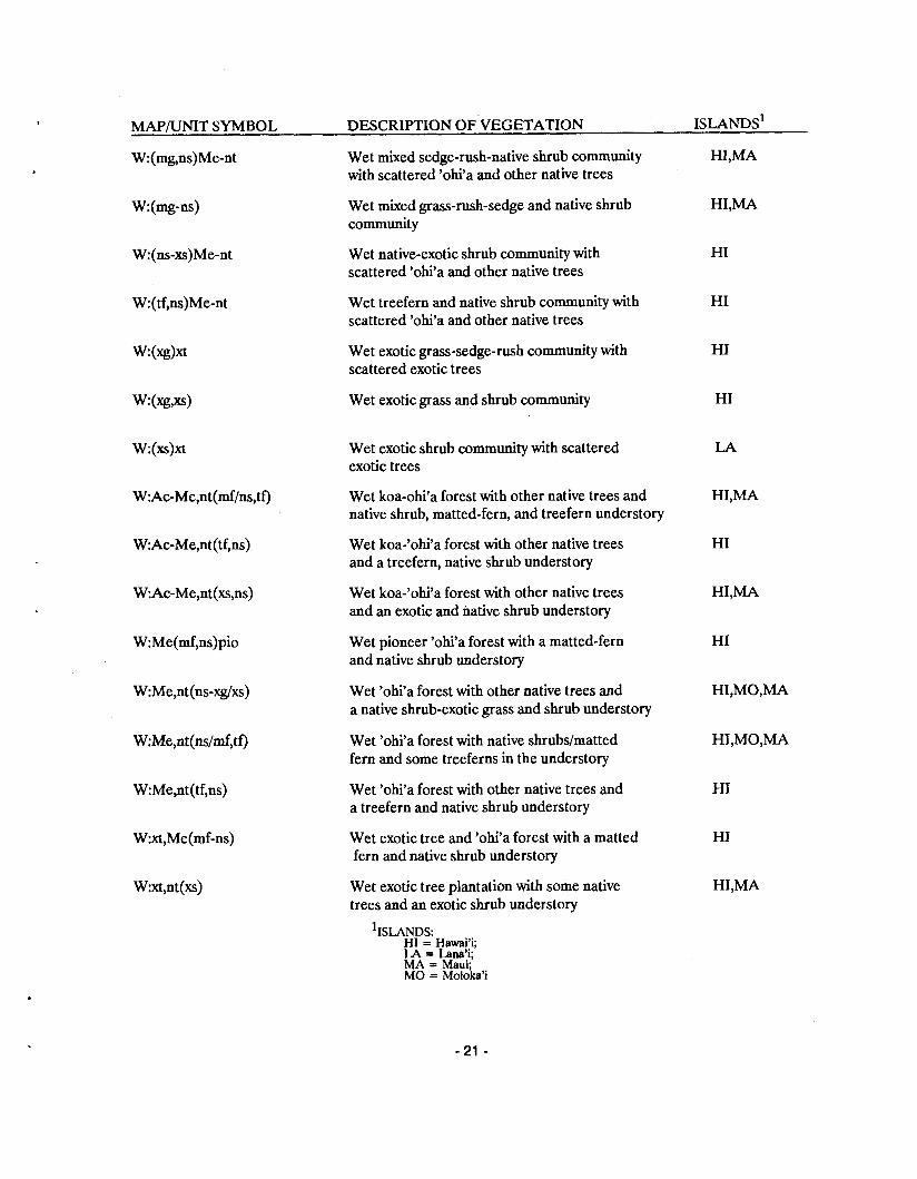
MAPIUNIT SYMBOL DESCRIPTION OF VEGETATION IS LANDS^ Wet mixed sedge-rush-native shrub community with scattered 'ohi'a and other native trees
Wet mixed grass-rush-sedge and native shrub community
Wet native-exotic shrub community with scattered 'ohi'a and other native trees
Wet treefern and native shrub community with scattered 'ohi'a and other native trees
Wet exotic grass-sedge-rush community with scattered exotic trees
Wet exotic grass and shrub community
Wet exotic shrub community with scattered exotic trees
Wet koa-ohi'a forest with other native trees and native shrub, matted-fern, and treefern understory
Wet koa-'ohi'a forest with other native trees and a treefern, native shrub understory
Wet koa-'ohi'a forest with other native trees and an exotic and native shrub understory
Wet pioneer 'ohi'a forest with a matted-fern and native shrub understory
Wet 'ohi'a forest with other native trees and a native shrub-exotic grass and shrub understory
Wet 'ohi'a forest with native shrubs/matted fern and some treeferns in the understory
Wet 'ohi'a forest with other native trees and a treefern and native shrub understory
Wet exotic tree and 'ohi'a forest with a matted fern and native shrub understory
Wet exotic tree plantation with some native trees and an exotic shrub understory
IS LANDS: HI = Hawai'i; LA = Lana'i; MA = Maui; MO = Moloka'i
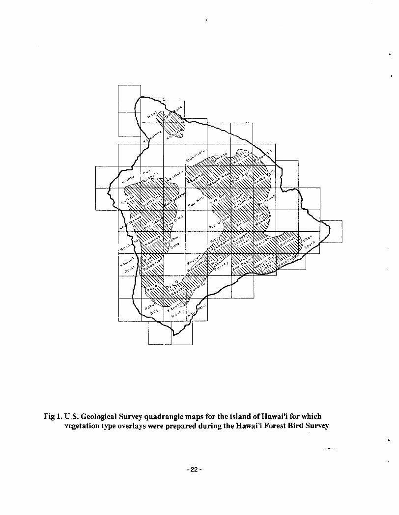
Fig 1. U.S. Geological Survey quadrangle maps for the island of Hawai'i for which vegetation type overlays were prepared during the Hawai'i Forest Bird Survey
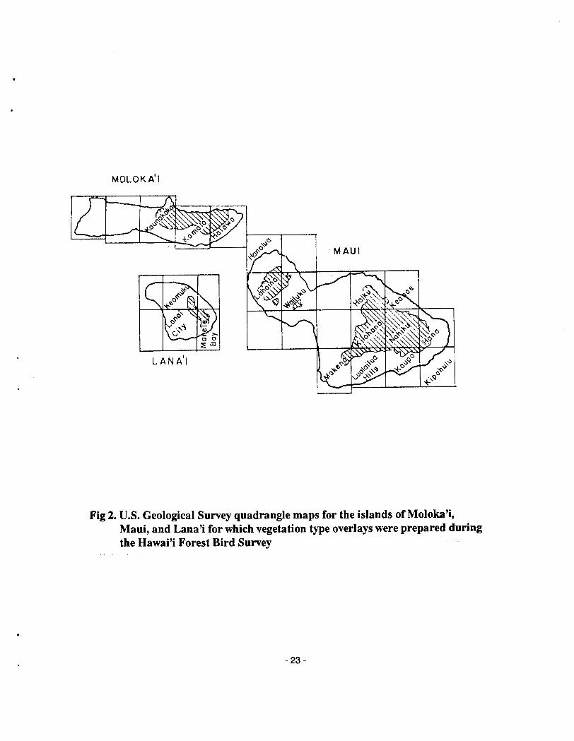
Fig 2. U.S. Geological Survey quadrangle maps for the islands of Moloka'i, Maui, and Lana'i for which vegetation type overlays were prepared during the Hawai'i Forest Bird Survey
Contour Interval 5 0 0 m
Fig 3. Location of study areas and transects established on the island of Hawai'i during the Hawai'i Forest Bird Survey
Fig 4. Map of the eastern portion of the island of Hawai'i showing the locations of the 62 study plots (black dots) sampled during the 'Ohi'a Forest Study in relation
- -. -- - - - -- -- - - to areas of forest dieback (elevation contours in meters.) . - - -