Embed Size (px)
Citation preview
Pakse Urban Environmental Improvement Project (RRP LAO 43316)
Pakse Urban Environmental Improvement Project
Asian Development Bank TA 7567-LAO
Lao People’s Democratic Republic Department of Public Works and Transport Champasack Province
Technical Note:
Urban Development Strategy June 2011
Pakse Urban Environmental Improvement Project ADB TA 7567-LAO Urban Development Strategy, April 2011
GHK International, in association with Halcrow& Lao Consulting Group i
Contents
1 Introduction ......................................................................................... 1 1.1 Background................................................................................................................................... 1 1.2 Urban Strategy Objectives ............................................................................................................ 2 1.3 Components of the Urban Strategy .............................................................................................. 2
2 Development Context .......................................................................... 3 2.1 Regional Policies and Plans ......................................................................................................... 3
2.1.1 Cooperative Development Projects in Region .......................................................................................... 3 2.2 National, Provincial and District Plans .......................................................................................... 4
2.2.1 National Socioeconomic Development Plans ........................................................................................... 4 2.2.2 National Urban Sector Strategy ............................................................................................................... 5 2.2.3 Champasack Province and Pakse District Socio-economic Plans ........................................................... 5
2.3 Road Networks and Transportation .............................................................................................. 6 2.3.1 Road Network .......................................................................................................................................... 6 2.3.2 Transportation .......................................................................................................................................... 7
2.4 Population Growth and Urban Expansion .................................................................................... 9 2.4.1 Population ................................................................................................................................................ 9 2.4.2 Urban Development ................................................................................................................................. 9
2.5 Geographic and Environmental Constraints ............................................................................... 10 2.6 Existing Urban Plans .................................................................................................................. 11
2.6.1 Master Plan and Master Plan Review .................................................................................................... 11 2.6.2 Champasack University Plan ................................................................................................................. 11
3 Development Issues and Needs ....................................................... 13 3.1 Consultation and Review ............................................................................................................ 13 3.2 Workshop and Meetings ............................................................................................................. 13
3.2.1 SWOT Analysis ...................................................................................................................................... 13 3.2.2 Vision Statement for Future Development ............................................................................................. 13 3.2.3 Issues and Concepts for Future Pakse Development ............................................................................ 14 3.2.4 Inception Report Meeting ....................................................................................................................... 16 3.2.5 Interim Report ........................................................................................................................................ 16
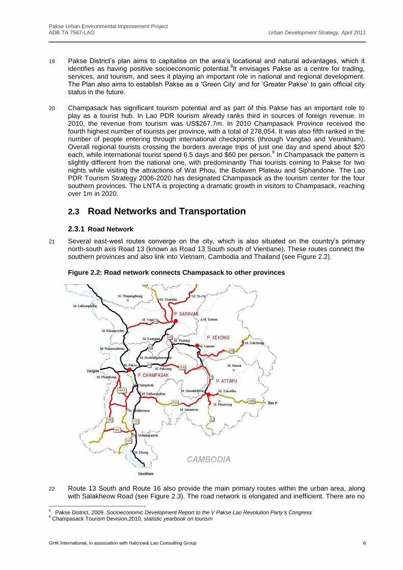
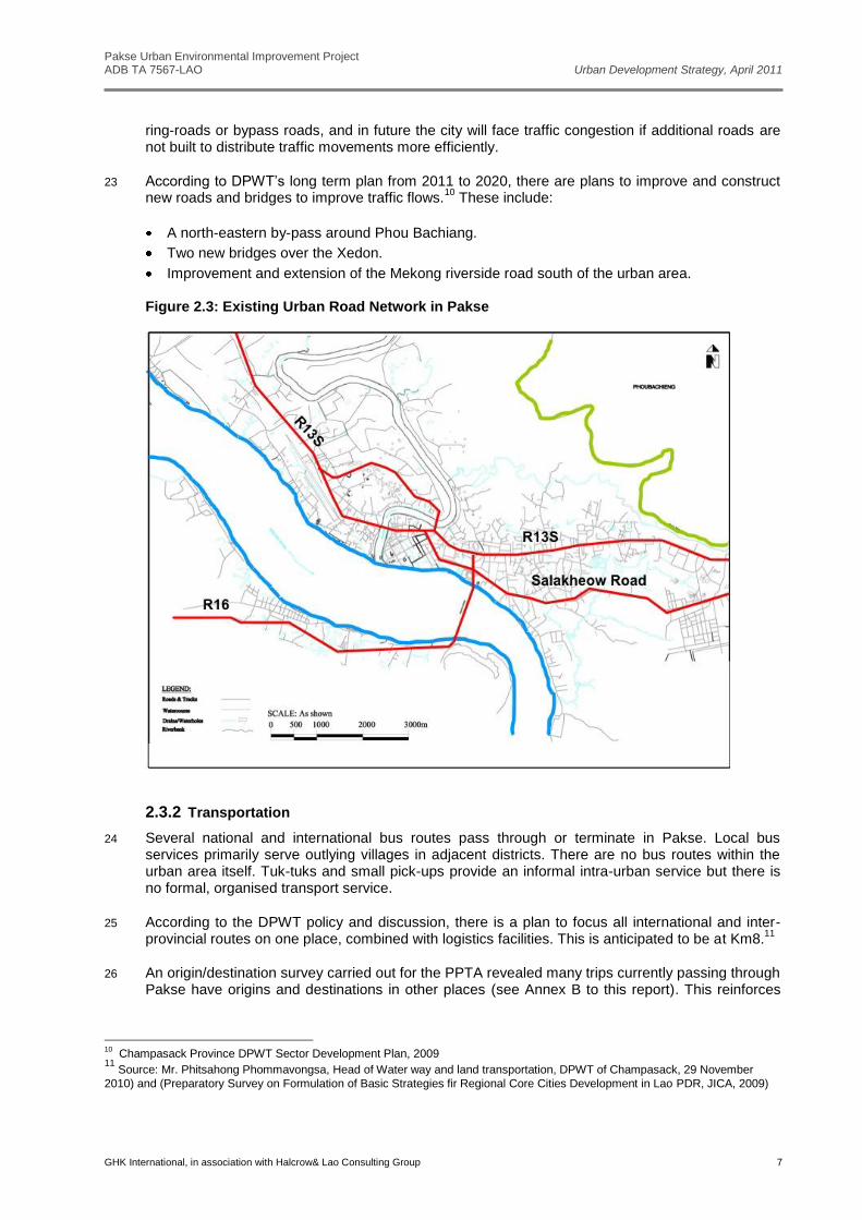
3.3 Issues and Needs ....................................................................................................................... 16
4 Development Targets and Concepts ................................................ 18 4.1 Development Targets ................................................................................................................. 18 4.2 Development Concept ................................................................................................................ 18
4.2.1 Directions for Growth ............................................................................................................................. 18 4.2.2 Development Framework ....................................................................................................................... 19 4.2.3 Sustainable Development ...................................................................................................................... 19
5 Phased Development Strategy ......................................................... 20 5.1 General ....................................................................................................................................... 20 5.2 Development Strategy Phase 1 - from 2011 to 2015 ................................................................. 20
5.2.1 Urban Development ............................................................................................................................... 20 5.2.2 Road network and Transport .................................................................................................................. 20 5.2.3 Environment/Green Infrastructure .......................................................................................................... 20
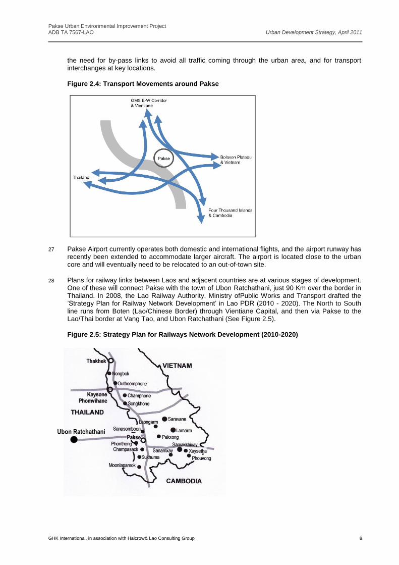
5.3 Development Strategy Phase 2 - from 2016 to 2020 ................................................................. 22 5.3.1 Urban Development ............................................................................................................................... 22 5.3.2 Road Network and Transportation ......................................................................................................... 22 5.3.3 Environment/Green Infrastructure .......................................................................................................... 22
5.4 Development Strategy Phase 3- from 2021-2030 ...................................................................... 23 5.4.1 Urban development ................................................................................................................................ 23 5.4.2 Road Network and Transportation ......................................................................................................... 23
Pakse Urban Environmental Improvement Project ADB TA 7567-LAO Urban Development Strategy, April 2011
GHK International, in association with Halcrow& Lao Consulting Group ii
List of Figures Figure 1.1: Suggested Extent of Study Area for Urban Strategy ................................................................. 1 Figure 2.1: GMS Economic Development Corridors .................................................................................... 3 Figure 2.2: Road network connects Champasack to other provinces .......................................................... 6 Figure 2.3: Existing Urban Road Network in Pakse ..................................................................................... 7 Figure 2.4: Transport Movements around Pakse ......................................................................................... 8 Figure 2.5: Strategy Plan for Railways Network Development (2010-2020) ................................................ 8 Figure 2.6: Urbanisation Trend in Pakse .................................................................................................... 10 Figure 2.7: Constraints to Urban Development .......................................................................................... 11 Figure 2.8: Land-use Concept for Main Urban Area from JICA Study ....................................................... 12 Figure 2.9: Champasack University Plan ................................................................................................... 12 Figure 3.1: Pakse Strategic Development SWOT Analysis ....................................................................... 14 Figure 4.1: Outline of development concept for Pakse .............................................................................. 19 Figure 5.1: Development Strategy Phase 1, 2011-2015 ............................................................................ 21 Figure 5.2: Development Strategy Phase 2, 2016-20120 .......................................................................... 22 Figure 5.3:Development Strategy Phase 3, 2021-2030 ............................................................................. 23 Figure 5.4: Possible Urban Form in 2030 ................................................................................................... 24
List of Tables Table 2.1: Total projected population of Pakse and other districts .............................................................. 9 Table 2.2: Projected Population in Greater Pakse Urban Area.................................................................... 9 Table 3.1: Issues Raised in Discussion Groups ......................................................................................... 15 Table 3.2: Assessment of Issues Potential Strategy Responses ............................................................... 16 Table 4.1:Targets for Phases of the Urban Development Strategy ........................................................... 18
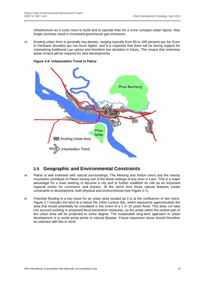
List of Annexes A Statistics from Government Economic Development Plans and Other Sources B Summary of Original of Destination Survey
Abbreviations ADB Asian Development Bank ASEAN Association of South East Asian Nations DPWT Department of Public Works and Transport GDP Gross Domestic Product GMS Greater Mekong Sub Region JICA Japanese International Cooperation Agency Lao PDR Lao People’ Democratic Republic MPWT Ministry of Public Work and Transport PPTA Project Preparation Technical Assistance SWOT Strengths, Weaknesses, Opportunities, and Threats USD United States Dollar Disclaimer The views expressed in this report are those of the consultant team, unless otherwise indicated. They are not necessarily the views of the Asian Development Bank or of the Government of Lao PDR.
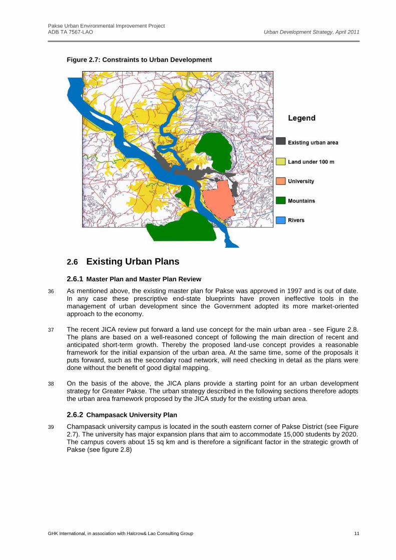
Pakse Urban Environmental Improvement Project ADB TA 7567-LAO Urban Development Strategy, April 2011
GHK International, in association with Halcrow& Lao Consulting Group 1
1 Introduction
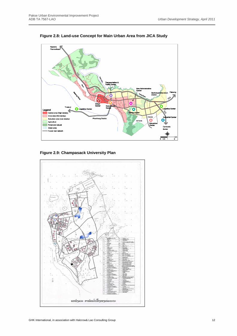
1.1 Background
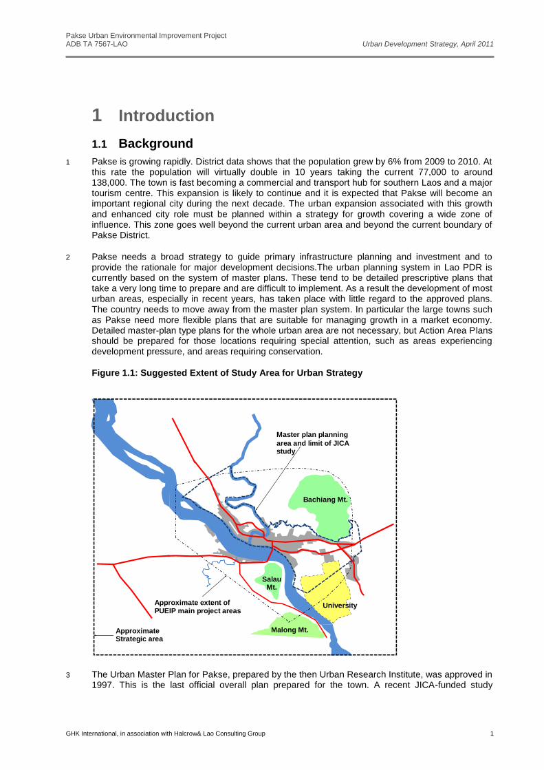
1 Pakse is growing rapidly. District data shows that the population grew by 6% from 2009 to 2010. At this rate the population will virtually double in 10 years taking the current 77,000 to around 138,000. The town is fast becoming a commercial and transport hub for southern Laos and a major tourism centre. This expansion is likely to continue and it is expected that Pakse will become an important regional city during the next decade. The urban expansion associated with this growth and enhanced city role must be planned within a strategy for growth covering a wide zone of influence. This zone goes well beyond the current urban area and beyond the current boundary of Pakse District.
2 Pakse needs a broad strategy to guide primary infrastructure planning and investment and to provide the rationale for major development decisions.The urban planning system in Lao PDR is currently based on the system of master plans. These tend to be detailed prescriptive plans that take a very long time to prepare and are difficult to implement. As a result the development of most urban areas, especially in recent years, has taken place with little regard to the approved plans. The country needs to move away from the master plan system. In particular the large towns such as Pakse need more flexible plans that are suitable for managing growth in a market economy. Detailed master-plan type plans for the whole urban area are not necessary, but Action Area Plans should be prepared for those locations requiring special attention, such as areas experiencing development pressure, and areas requiring conservation.
Figure 1.1: Suggested Extent of Study Area for Urban Strategy
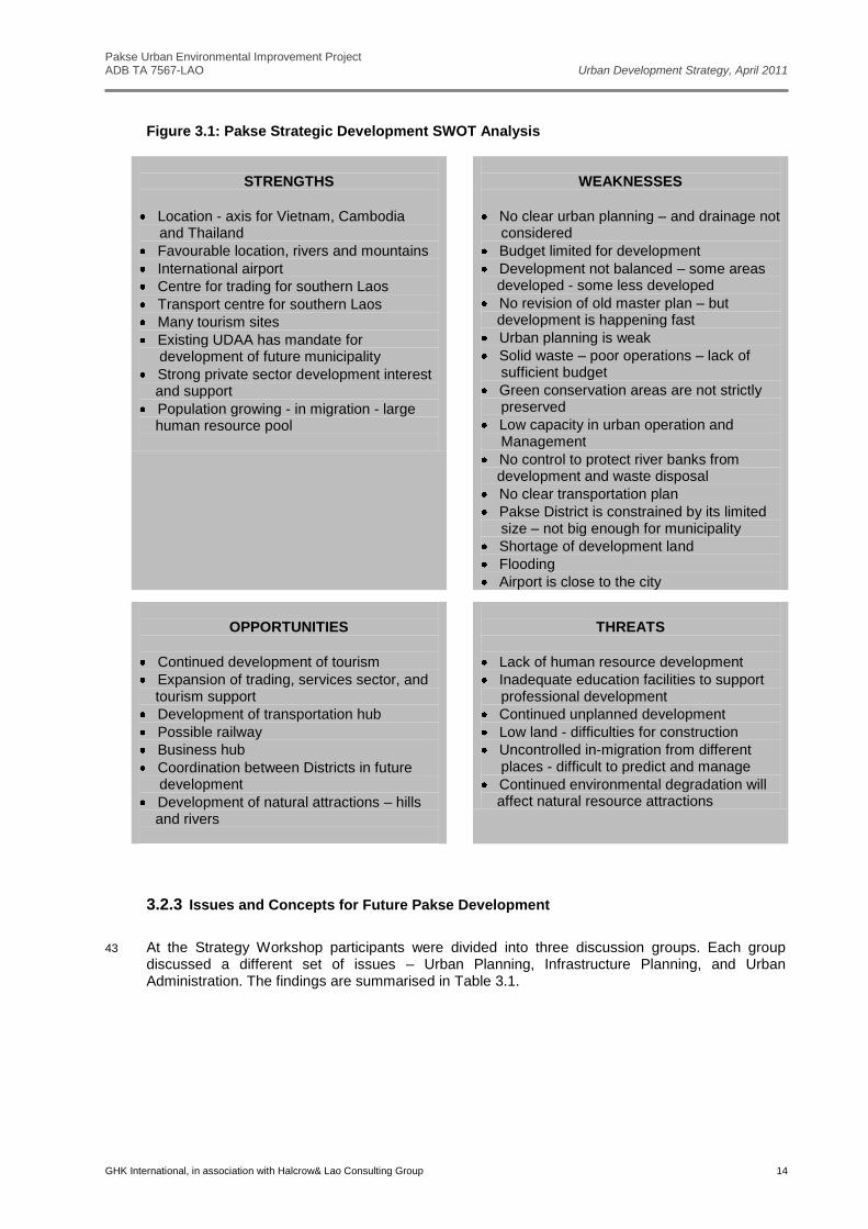
Bachiang Mt.
SalauMt.
Malong Mt.
UniversityApproximate extent of PUEIP main project areas
Master plan planning
area and limit of JICA study
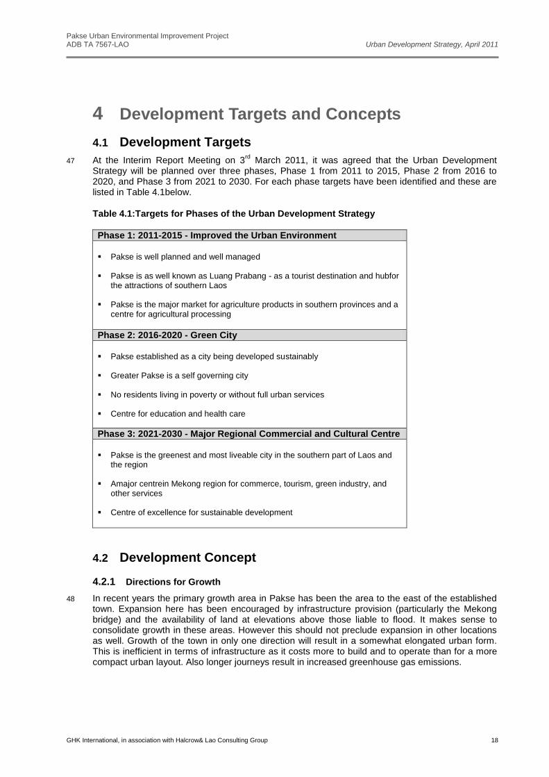
Approximate Strategic area
3 The Urban Master Plan for Pakse, prepared by the then Urban Research Institute, was approved in
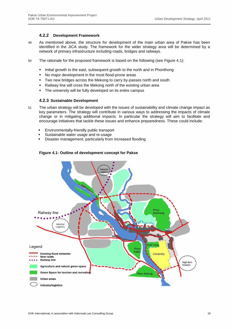
1997. This is the last official overall plan prepared for the town. A recent JICA-funded study
Pakse Urban Environmental Improvement Project ADB TA 7567-LAO Urban Development Strategy, April 2011
GHK International, in association with Halcrow& Lao Consulting Group 2
included a review of the Master Plan (along with that for Kaysone Phomvihane)1. Outputs from the
JICA study include development frameworks and a land-use concept plan.
4 A shortcoming of the JICA review, however, was that it was limited (by its Terms of Reference) to the planning area defined for the 1997 master plan. Pakse has already outgrown the master plan area and old plan boundaries should not be the basis for strategic decisions on the town’s future development. The plan for a major urban area should include a wider area than just the main development zones. An urban strategy for a wider area is therefore required for Pakse.
1.2 Urban Strategy Objectives
5 The Urban Strategy is intended to be a guiding tool in the management of Pakse’s future growth. By facilitating more efficient development and infrastructure investment it will thereby assist in the establishment of Pakse as a major regional centre. This in turn should strengthen the urban area’s economic ties with the neighbouring countries of Cambodia, Thailand, and Vietnam.
6 More specifically the strategy aims are:
To establish development targets and an overall goal for Pakse’s development
To identify the principal opportunities for town growth, including main areas for expansion
To identify the major constraints to expansion
To define key urban infrastructure requirements
To stimulate strategic thinking in urban planning and management
1.3 Components of the Urban Strategy
7 The urban strategy’s component include:
Regional and national context
Development needs assessment
Vision for future growth
Concept for city development
A phased urban development strategy
1 Preparatory Survey on Formulation of Basic Strategies for Regional Core Cities Development in Lao PDR, Pacet Corporation
International Development Centre of Japan Oriental Consultants Co., Ltd., Final Report, January 2010
Pakse Urban Environmental Improvement Project ADB TA 7567-LAO Urban Development Strategy, April 2011
GHK International, in association with Halcrow& Lao Consulting Group 3
2 Development Context
2.1 Regional Policies and Plans
8 As a land-locked country sharing borders with five other countries, Lao PDR is in a strategic location within the region. This presents opportunities for the country to participate in cooperative development projects that will directly and indirectly stimulate socio-economic development. At the same time it creates competition between neighbours, and raises issues of environmental impact across borders. Pakse is well placed to benefit from regional development initiatives as it is close to the borders with three countries, Vietnam, Cambodia and Thailand.
2.1.1 Cooperative Development Projects in Region
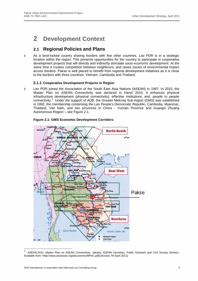
9 Lao PDR joined the Association of the South East Asia Nations (ASEAN) in 1997. In 2010, the Master Plan on ASEAN Connectivity was declared in Hanoi 2010. It enhances physical infrastructure development (physical connectivity), effective institutions, and, people to people connectivity.
2 Under the support of ADB, the Greater Mekong Sub-region (GMS) was established
in 1992, the membership comprising the Lao People's Democratic Republic, Cambodia, Myanmar, Thailand, Viet Nam, and two provinces in China - Yunnan Province and Guangxi Zhuang Autonomous Region – see Figure 2.1.
Figure 2.1: GMS Economic Development Corridors
Pakse
2 ASEAN,2010. Master Plan on ASEAN Connectivity. Jakarta. ASEAN Secretary, Public Outreach and Civil Society Division.
Available from <http://www.aseansec.org/documents/MPAC.pdf] [Access 7th April 2011]
Pakse Urban Environmental Improvement Project ADB TA 7567-LAO Urban Development Strategy, April 2011
GHK International, in association with Halcrow& Lao Consulting Group 4
10 There are many GMS projects and other initiatives that have the overall aim to enhance economic relations between the countries, building on their shared histories and cultures. These cover nine priority sectors: agriculture, energy, environment, human resource development, investment, telecommunications, tourism, transport infrastructure, and transport and trade facilitation.
3
11 Pakse is strategically located on the regional road network, and is on an interconnector link between the main GMS corridors.
12 Tourism is a key area for GMS cooperation. In 2005, under the support of ADB, the Greater Mekong Sub-region Tourism Sector Strategy was issued.
4 It aims to develop and promote the
Mekong as a single destination, offering a diversity of good quality and high-yielding sub-regional products that help to distribute the benefits of tourism more widely; add to the tourism development efforts of each GMS country; and contribute to poverty reduction, gender equality and empowerment of women, and sustainable development, while minimizing any adverse impacts. Pakse is rapidly becoming an important tourism hub and staging post for southern Lao PDR and the southern part of the GMS.
13 Integrated tourism development is also the aim of the Pakse Declaration on Tourism Cooperation in the ‘Emerald Triangle’ between Mekong, Thailand, Lao PDR and Cambodia.
2.2 National, Provincial and District Plans
2.2.1 National Socioeconomic Development Plans
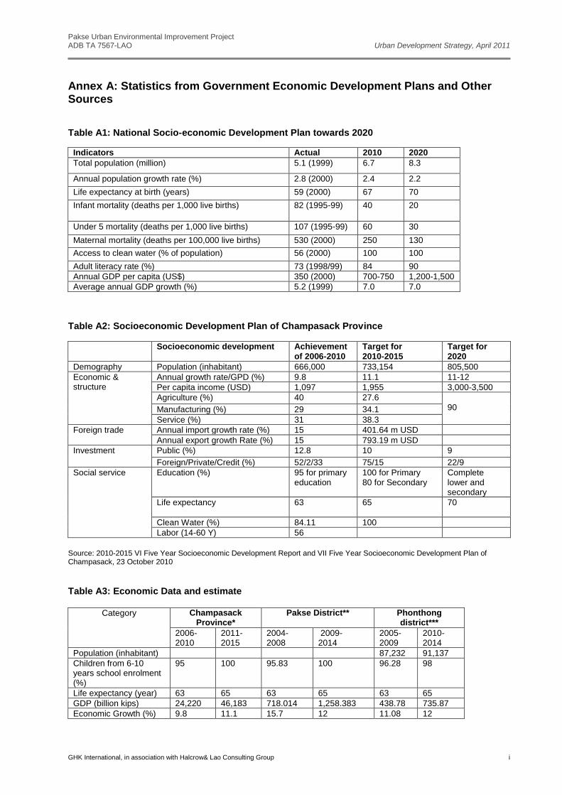
14 At the 6th Party Congress in 1996 the Government set the vision for the nation to graduate from the least development country by 2020. The vision has been maintained in subsequent National Socioeconomic Development Plans. It is also the Government’s aim to transform Lao PDR from a landlocked to a ‘land-linked’ country. It is expected that total population in Laos will be 8.3 million in 2020. Average annual GDP growth is expected to be 7% from 2010 to 2020, while the annual GDP per capital income is planned to increase from 700-750 USD in 2010 to1,200-1,500 USD in 2020
5
(see Annex A).
15 The 7th NSEDP for the period 2011 – 2015 has been drafted but not yet approved. Whilst the 7th NSEDP includes many targets and policies similar to previous versions, this latest one departs from the established formula of poverty reduction through the four traditional sectors of agriculture, forestry, education, and health. As well as setting broad economic and social targets the 7th NSEDP includes provisions for improving public administration, enhancing regional integration, sustainable use of natural resources, and infrastructure provision. Specific proposals relevant to urban development include the following:
Economic Development and Poverty Reduction
Reduce poverty to below 19% of total population
Reduce gap between urban and rural areas
Consider urban areas as focus points for economic development
Encourage dispersed populations to group in villages – ‘Focal Areas’
Environment
Establish new land-use system to protect natural resources and ensure sustainable
development
Protect quality of environment in towns
Set up models for managing green environment in Vientiane and the four secondary towns
Raise awareness on need for environmental protection
3 Asian Development Bank, 2010. Strategy and action plan for the Greater Mekong Sub-region East–West Economic Corridor.
Philippines. Available from http://www.adb.org/documents/strategy/gms/ewec/gms-action-plan-east-west.pdf 4 Asian Development Bank, 2005. The Greater Mekong Sub Region Tourism Sector Strategy.
Philippines. Public Stock No 100105. http://www.adb.org/Documents/Books/GMS-Tourism-Study/tourism-study.pdf 5 National Socio-economic Development Plan to 2020, GOL
Pakse Urban Environmental Improvement Project ADB TA 7567-LAO Urban Development Strategy, April 2011
GHK International, in association with Halcrow& Lao Consulting Group 5
Sustainable development of water resources
Complete land management plans at macro and micro levels
Infrastructure
Connect north-south and east-west economic corridors
Provide water supply to 67% of urban population
Increase population having access to clean water to 80%
Increase population having access to latrines to 60%
Build main roads in districts and rural roads that connect with priority areas
Secure the country from losses due to natural disasters
16 Previous socio-economic development plans in Lao PDR have been largely silent on urban issues. By being the drivers of economic growth urban areas have a major contribution to make to the country’s overarching goal of eradicating poverty. However, this is primarily an indirect impact that has been somewhat overlooked in national strategies. The draft of the 7th NSEDP indicates that more notice is being taken of the potential role of urban areas.
2.2.2 National Urban Sector Strategy
17 The DHUP has recently completed a draft of a National Urban Sector Strategy (NUSSIP)6.
Although the NUSSIP has not yet been approved by MPWT and it serves to identify DHUP’s ideas and priorities for the sector, and the main provisions are summarized below:
Objectives
To develop all urban areas from the capital city to village clusters to reduce the development
gap between the urban and rural areas step by step;
To strengthen the capacity of urban management authorities;
To create favorable conditions for civil society and the private sector to participate actively in
urban planning, management and sustainable development;
To preserve and expand cultural and national heritage resources through appropriate urban
development and environmental protection.
Priority Programmes
Capacity development in urban planning and development authorities
Improvement of legal and regulatory framework for urban sector
Preparation of national urban water supply development plan
Preparation of national urban wastewater management and solid waste management strategy
Preparation of national urban transport strategy
Preparation of national housing development strategy
Prepare and revise plans for urban areas, districts and provinces
Selected Proposals
To develop Luang Prabang, Luang Namtha, Kaysone Phomvihane and Pakse as regional
centres
To develop towns along regional corridors and at border points
2.2.3 Champasack Province and Pakse District Socio-economic Plans
18 The vision of Champasack Province is to develop Pakse as the ‘centre for southern provinces and the sub-region
7. The plan includes the establishment of 3 economic axes with links to Cambodia,
Thailand and Vietnam, development of 3 industrial zones, 4 agriculture zones and 4 tourism routes. The province aims to achieve 11-12% economic growth and average per capita income of 3,000-3,500 USD.
6 National Urban Sector Strategy and Investment Plan to the Year 2020, DHUP, 2011 (Draft)
7 Champasack Province Socio-economic Development Plan to 2015
Pakse Urban Environmental Improvement Project ADB TA 7567-LAO Urban Development Strategy, April 2011
GHK International, in association with Halcrow& Lao Consulting Group 6
19 Pakse District’s plan aims to capitalise on the area’s locational and natural advantages, which it identifies as having positive socioeconomic potential.
8It envisages Pakse as a centre for trading,
services, and tourism, and sees it playing an important role in national and regional development. The Plan also aims to establish Pakse as a ‘Green City’ and for ‘Greater Pakse’ to gain official city status in the future.
20 Champasack has significant tourism potential and as part of this Pakse has an important role to play as a tourist hub. In Lao PDR tourism already ranks third in sources of foreign revenue. In 2010, the revenue from tourism was US$267.7m. In 2010 Champasack Province received the fourth highest number of tourists per province, with a total of 278,054. It was also fifth ranked in the number of people entering through international checkpoints (through Vangtao and Veunkham). Overall regional tourists crossing the borders average trips of just one day and spend about $20 each, while international tourist spend 6.5 days and $60 per person.
9 In Champasack the pattern is
slightly different from the national one, with predominantly Thai tourists coming to Pakse for two nights while visiting the attractions of Wat Phou, the Bolaven Plateau and Siphandone. The Lao PDR Tourism Strategy 2006-2020 has designated Champasack as the tourism center for the four southern provinces. The LNTA is projecting a dramatic growth in visitors to Champasack, reaching over 1m in 2020.
2.3 Road Networks and Transportation
2.3.1 Road Network
21 Several east-west routes converge on the city, which is also situated on the country’s primary north-south axis Road 13 (known as Road 13 South south of Vientiane). These routes connect the southern provinces and also link into Vietnam, Cambodia and Thailand (see Figure 2.2).
Figure 2.2: Road network connects Champasack to other provinces
22 Route 13 South and Route 16 also provide the main primary routes within the urban area, along
with Salakheow Road (see Figure 2.3). The road network is elongated and inefficient. There are no
8 Pakse District, 2009. Socioeconomic Development Report to the V Pakse Lao Revolution Party’s Congress
9 Champasack Tourism Devision,2010, statistic yearbook on tourism
Pakse Urban Environmental Improvement Project ADB TA 7567-LAO Urban Development Strategy, April 2011
GHK International, in association with Halcrow& Lao Consulting Group 7
ring-roads or bypass roads, and in future the city will face traffic congestion if additional roads are not built to distribute traffic movements more efficiently.
23 According to DPWT’s long term plan from 2011 to 2020, there are plans to improve and construct new roads and bridges to improve traffic flows.
10 These include:
A north-eastern by-pass around Phou Bachiang.
Two new bridges over the Xedon.
Improvement and extension of the Mekong riverside road south of the urban area.
Figure 2.3: Existing Urban Road Network in Pakse
2.3.2 Transportation
24 Several national and international bus routes pass through or terminate in Pakse. Local bus services primarily serve outlying villages in adjacent districts. There are no bus routes within the urban area itself. Tuk-tuks and small pick-ups provide an informal intra-urban service but there is no formal, organised transport service.
25 According to the DPWT policy and discussion, there is a plan to focus all international and inter-provincial routes on one place, combined with logistics facilities. This is anticipated to be at Km8.
11
26 An origin/destination survey carried out for the PPTA revealed many trips currently passing through Pakse have origins and destinations in other places (see Annex B to this report). This reinforces
10
Champasack Province DPWT Sector Development Plan, 2009 11
Source: Mr. Phitsahong Phommavongsa, Head of Water way and land transportation, DPWT of Champasack, 29 November
2010) and (Preparatory Survey on Formulation of Basic Strategies fir Regional Core Cities Development in Lao PDR, JICA, 2009)
Pakse Urban Environmental Improvement Project ADB TA 7567-LAO Urban Development Strategy, April 2011
GHK International, in association with Halcrow& Lao Consulting Group 8
the need for by-pass links to avoid all traffic coming through the urban area, and for transport interchanges at key locations.
Figure 2.4: Transport Movements around Pakse
27 Pakse Airport currently operates both domestic and international flights, and the airport runway has recently been extended to accommodate larger aircraft. The airport is located close to the urban core and will eventually need to be relocated to an out-of-town site.
28 Plans for railway links between Laos and adjacent countries are at various stages of development. One of these will connect Pakse with the town of Ubon Ratchathani, just 90 Km over the border in Thailand. In 2008, the Lao Railway Authority, Ministry ofPublic Works and Transport drafted the ’Strategy Plan for Railway Network Development’ in Lao PDR (2010 - 2020). The North to South line runs from Boten (Lao/Chinese Border) through Vientiane Capital, and then via Pakse to the Lao/Thai border at Vang Tao, and Ubon Ratchathani (See Figure 2.5).
Figure 2.5: Strategy Plan for Railways Network Development (2010-2020)
Ubon Ratchathani
Pakse Urban Environmental Improvement Project ADB TA 7567-LAO Urban Development Strategy, April 2011
GHK International, in association with Halcrow& Lao Consulting Group 9
2.4 Population Growth and Urban Expansion
2.4.1 Population
29 The expansion of the Pakse urban area is expected to impact and draw population from five districts - Pakse, Phonthong, Bachiang, Xanasomboun, and Pathoumphone Districts.
30 Provincial statistics12
show that in 2010 the total population in Pakse is around 86,500. According to the population growth estimation from the CDIA PFS report,
13 population growth (a combination of
natural growth plus immigration) for Pakse is expected to be around 3% annually from 2010-2020. In the four other districts the rate is likely to be lower – about 2.4%. From 2021 to 2030 growth ratesare expected to slow to 2.5% in Pakse and 2.2% in the others. On this basis the total populations of the five districts is shown in Table 2.1.
Table 2.1: Total projected population of Pakse and other districts
Districts
Total pop.
in 2010 Total pop.
in 2015 Total pop.
in 2020 Total pop.
in 2030
Pakse 86,432 100,200 116,200 148,800
Xanasomboun 68,380 77,000 86,700 107,800
Bachiang 53,553 60,300 67,900 84,500
Pathoumphone 56,439 63,600 71,700 89,200
Phonthong 93,594 105,400 118,700 147,600
Source:Champasack Province Yearbook 2010, and UN Population Division estimates
31 According to the United Nation population estimates,
14 the urban population in Laos in 2015 will be
27 % of the total, 30% in2020 and 38% in 2030. Using these figures an estimate of the population living in the main urban area of ‘Greater Pakse’ has been derived. This is on the basis that 100% of population of Pakse will be urban, and about 60% of urban population from other four districts will be living within the City. The results of these calculations are shown in Table 2.2.
Table 2.2: Projected Population in Greater Pakse Urban Area
Districts Urban pop
in 2015 Urban pop.
in 2020 Urban pop.
in 2030
Pakse 100,200 116,200 148,800
Xanasomboun 12,700 15,700 24,800
Bachiang 10,000 12,300 19,400
Pathoumphone 10,500 13,000 20,500
Phonthong 17,400 21,400 33,900
2.4.2 Urban Development
32 In recent years the primary growth area in Pakse has been the area to the east of the established town. Expansion here is encouraged by infrastructure provision (particularly the Mekong bridge) and the availability of land at elevations above those liable to flood. Continued growth of the city in only one direction will result in a somewhat stretched urban form. This is inefficient in terms of
12
Champasack Provincial statistics, 2010 13
PUEIP Medium-term Urban Infrastructure Investment Programme, CDIA, 2010 14
UN Population Division/Lao: Urban Population/Global Virtual University/15th March 2011. Available from
http://globalis.gvu.unu.edu/indicator_detail.cfm?IndicatorID=30&Country=LA
Pakse Urban Environmental Improvement Project ADB TA 7567-LAO Urban Development Strategy, April 2011
GHK International, in association with Halcrow& Lao Consulting Group 10
infrastructure as it costs more to build and to operate than for a more compact urban layout. Also longer journeys result in increased greenhouse gas emissions.
33 Existing urban form is generally low density, ranging typically from 80 to 180 persons per ha. Even in Vientiane densities are not much higher, and it is expected that there will be strong support for maintaining traditional Lao values and therefore low densities in future. This means that extensive areas of land will be required for new developments.
Figure 2.6: Urbanisation Trend in Pakse
2.5 Geographic and Environmental Constraints
34 Pakse is well endowed with natural surroundings. The Mekong and Xedon rivers and the nearby mountains contribute to Pakse having one of the finest settings of any town in Laos. This is a major advantage for a town seeking to become a city and to further establish its role as an important regional centre for commerce and tourism. At the same time these natural features create constraints to development, both physical and environmental (see Figure 2.7).
35 Potential flooding is a key issue for an urban area located as it is at the confluence of two rivers. Figure 2.7 includes the land at or below the 100m contour line, which represents approximately the area that would potentially be inundated in the event of a 1 in 10 years flood. This does not take into account existing or proposed flood prevention measures, so the areas within the central part of the urban area will be protected to some degree. The sustainable long-term approach to urban development is to avoid areas prone to natural disaster. Future expansion areas should therefore be selected with this in mind.
Pakse Urban Environmental Improvement Project ADB TA 7567-LAO Urban Development Strategy, April 2011
GHK International, in association with Halcrow& Lao Consulting Group 11
Figure 2.7: Constraints to Urban Development
2.6 Existing Urban Plans
2.6.1 Master Plan and Master Plan Review
36 As mentioned above, the existing master plan for Pakse was approved in 1997 and is out of date. In any case these prescriptive end-state blueprints have proven ineffective tools in the management of urban development since the Government adopted its more market-oriented approach to the economy.
37 The recent JICA review put forward a land use concept for the main urban area - see Figure 2.8. The plans are based on a well-reasoned concept of following the main direction of recent and anticipated short-term growth. Thereby the proposed land-use concept provides a reasonable framework for the initial expansion of the urban area. At the same time, some of the proposals it puts forward, such as the secondary road network, will need checking in detail as the plans were done without the benefit of good digital mapping.
38 On the basis of the above, the JICA plans provide a starting point for an urban development strategy for Greater Pakse. The urban strategy described in the following sections therefore adopts the urban area framework proposed by the JICA study for the existing urban area.
2.6.2 Champasack University Plan
39 Champasack university campus is located in the south eastern corner of Pakse District (see Figure 2.7). The university has major expansion plans that aim to accommodate 15,000 students by 2020. The campus covers about 15 sq km and is therefore a significant factor in the strategic growth of Pakse (see figure 2.8)
Pakse Urban Environmental Improvement Project ADB TA 7567-LAO Urban Development Strategy, April 2011
GHK International, in association with Halcrow& Lao Consulting Group 12
Figure 2.8: Land-use Concept for Main Urban Area from JICA Study
Figure 2.9: Champasack University Plan
Pakse Urban Environmental Improvement Project ADB TA 7567-LAO Urban Development Strategy, April 2011
GHK International, in association with Halcrow& Lao Consulting Group 13
3 Development Issues and Needs
3.1 Consultation and Review
40 Development issues and needs, along with scenarios for future development of Pakse have been identified through a process of consultation and review. In November 2010 a Strategy Workshop undertook a SWOT analysis and arrived at a vision for the city. Key issues were also examined through separate discussion groups. Further comment and discussion was facilitated through the Inception Report Meeting in December and the Interim Report Meeting in March 2011.
3.2 Workshop and Meetings
3.2.1 SWOT Analysis
41 On 26th November of 2010, the Strategic Workshop was held in DPWT. The objective of the workshop was to present the initial concept for Pakse urban strategy by the PPTA team to stakeholders. Participants included representatives from Champasack Provincial Government Departments, District administration, and others. The findings of the SOT analysis are shown in Figure 3.1.
3.2.2 Vision Statement for Future Development
42 SWOT analysis was followed by a brainstorming session to develop a vision for the future. The final vision statement agreed upon is shown below:
‘A regional centre for commerce, culture and tourism, developed in a sustainable way keeping development and protection of natural resources in balance, and, providing a health environment for its citizens.’
Pakse Urban Environmental Improvement Project ADB TA 7567-LAO Urban Development Strategy, April 2011
GHK International, in association with Halcrow& Lao Consulting Group 14
Figure 3.1: Pakse Strategic Development SWOT Analysis
STRENGTHS
Location - axis for Vietnam, Cambodia and Thailand
Favourable location, rivers and mountains
International airport
Centre for trading for southern Laos
Transport centre for southern Laos
Many tourism sites
Existing UDAA has mandate for development of future municipality
Strong private sector development interest and support
Population growing - in migration - large human resource pool
WEAKNESSES
No clear urban planning – and drainage not considered
Budget limited for development
Development not balanced – some areas developed - some less developed
No revision of old master plan – but development is happening fast
Urban planning is weak
Solid waste – poor operations – lack of sufficient budget
Green conservation areas are not strictly preserved
Low capacity in urban operation and Management
No control to protect river banks from development and waste disposal
No clear transportation plan
Pakse District is constrained by its limited size – not big enough for municipality
Shortage of development land
Flooding
Airport is close to the city
OPPORTUNITIES
Continued development of tourism
Expansion of trading, services sector, and tourism support
Development of transportation hub
Possible railway
Business hub
Coordination between Districts in future development
Development of natural attractions – hills and rivers
THREATS
Lack of human resource development
Inadequate education facilities to support professional development
Continued unplanned development
Low land - difficulties for construction
Uncontrolled in-migration from different places - difficult to predict and manage
Continued environmental degradation will affect natural resource attractions
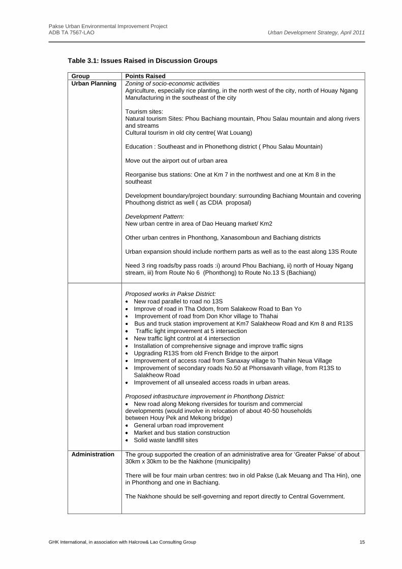
3.2.3 Issues and Concepts for Future Pakse Development
43 At the Strategy Workshop participants were divided into three discussion groups. Each group
discussed a different set of issues – Urban Planning, Infrastructure Planning, and Urban Administration. The findings are summarised in Table 3.1.
Pakse Urban Environmental Improvement Project ADB TA 7567-LAO Urban Development Strategy, April 2011
GHK International, in association with Halcrow& Lao Consulting Group 15
Table 3.1: Issues Raised in Discussion Groups
Group Points Raised
Urban Planning Zoning of socio-economic activities Agriculture, especially rice planting, in the north west of the city, north of Houay Ngang Manufacturing in the southeast of the city Tourism sites: Natural tourism Sites: Phou Bachiang mountain, Phou Salau mountain and along rivers and streams Cultural tourism in old city centre( Wat Louang) Education : Southeast and in Phonethong district ( Phou Salau Mountain) Move out the airport out of urban area Reorganise bus stations: One at Km 7 in the northwest and one at Km 8 in the southeast Development boundary/project boundary: surrounding Bachiang Mountain and covering Phouthong district as well ( as CDIA proposal) Development Pattern: New urban centre in area of Dao Heuang market/ Km2 Other urban centres in Phonthong, Xanasomboun and Bachiang districts Urban expansion should include northern parts as well as to the east along 13S Route Need 3 ring roads/by pass roads :i) around Phou Bachiang, ii) north of Houay Ngang stream, iii) from Route No 6 (Phonthong) to Route No.13 S (Bachiang)
Proposed works in Pakse District:
New road parallel to road no 13S
Improve of road in Tha Odom, from Salakeow Road to Ban Yo
Improvement of road from Don Khor village to Thahai
Bus and truck station improvement at Km7 Salakheow Road and Km 8 and R13S
Traffic light improvement at 5 intersection
New traffic light control at 4 intersection
Installation of comprehensive signage and improve traffic signs
Upgrading R13S from old French Bridge to the airport
Improvement of access road from Sanaxay village to Thahin Neua Village
Improvement of secondary roads No.50 at Phonsavanh village, from R13S to Salakheow Road
Improvement of all unsealed access roads in urban areas. Proposed infrastructure improvement in Phonthong District:
New road along Mekong riversides for tourism and commercial developments (would involve in relocation of about 40-50 households between Houy Pek and Mekong bridge)
General urban road improvement
Market and bus station construction
Solid waste landfill sites
Administration The group supported the creation of an administrative area for ‘Greater Pakse’ of about 30km x 30km to be the Nakhone (municipality) There will be four main urban centres: two in old Pakse (Lak Meuang and Tha Hin), one in Phonthong and one in Bachiang. The Nakhone should be self-governing and report directly to Central Government.
Pakse Urban Environmental Improvement Project ADB TA 7567-LAO Urban Development Strategy, April 2011
GHK International, in association with Halcrow& Lao Consulting Group 16
Development in the Nakhone will be focused on the following: (i) Human Resource Development (ii) Development in relation to social and environmental protection (ii) Development in relation to the utilisation of modern science and techniques (iii) To become a commercial and services centre (iv) To increase the participation of the community (v) To enhance land values
3.2.4 Inception Report Meeting
44 On the 7th of December 2010, the urban strategy was discussed at the Inception Report Meeting held in the Provincial Governor’s Office. The objective was to comments and policy guidance. Key aspects of the meeting’s findings were as follows:
The development strategy for Pakse should respect the desire of people to develop close to the
Mekong and Xedon rivers.
Development along the rivers will require the identification and enforcement of protection
zones, green zones, roads, public parks, and utility corridors.
By-pass roads are required to prevent all traffic passing through the urban area. The
Government has plans to build a second bridge over Mekong River, and two bridges over
Xedon River to facilitate the development of by-passes.
Tourism development is critical for the continued growth and prosperity of the city.
The provincial government hopes to establish the city as a ‘Nakhon’ by 2020.
3.2.5 Interim Report
45 On the 3rd
March of 2011, the Interim Report was presented to stakeholders. Participants included Champasack Provincial Departments, officers from four districts, representatives from DHUP and the ADB. The Draft Urban Strategy for Pakse was presented. Participants agreed on the proposed concepts of the strategy.
3.3 Issues and Needs
46 Based on the findings of the consultation process, and on analysis of the existing situation, a number of needs issues were identified. These are shown in Table 3.2 along with potential strategy responses.
Table 3.2: Assessment of Issues Potential Strategy Responses
Issues and Needs Potential Strategy Responses
Urban Land Use
Existing land use patterns result in conflicting, incompatible activities on adjacent sites causing nuisance and environmental impacts
Development has not followed the master plan resulting in inappropriate developments, some land unused or inaccessible, and inefficient urban expansion
Development control has not protected areas requiring conservation
Uncontrolled development has interfered with existing utilities such as drains
Identify areas for uses that are incompatible with general mixed residential/commercial development
Define clearly areas for urban development and areas to be preserved.
Protect key agriculture land from encroachment by urban expansion
Relocate activities that are in inappropriate locations – e.g. the wholesale market (currently in the city centre).
Roads and Transportation
Road Network
Currently all through traffic passes through the city centre resulting in traffic congestion and adverse environmental impacts
Identify by-pass routes to take long-distance traffic around the city
Provide addition bridge(s) over Xedon
Provide additional bridges over Mekong
Pakse Urban Environmental Improvement Project ADB TA 7567-LAO Urban Development Strategy, April 2011
GHK International, in association with Halcrow& Lao Consulting Group 17
Commercial traffic is due to increase, particularly the transportation of produce from the Bolaven Plateau
The existing French Bridge over the Xedon is a traffic bottleneck
Not all urban roads are sealed making them difficult to use in the wet season and causing ai pollution in the dry season
The road system is elongated and inefficient
Currently only one bridge over Mekong
Improve layout of urban road network
Transport
No public transport services in Pakse urban area resulting in additional trips by private vehicles
The airport is close to the city centre
Facilitate integrated public transport system
Identify sites for edge of town transport interchanges
Relocate airport to out of town site
Urban Management
Urban planning has not been well integrated with infrastructure planning and provision
Low capacity in urban management skills
Poor enforcement of plans and regulations
Low level of public awareness of urban management issues and procedures
Low levels of community participation in planning decisions and strategies
Develop strategic urban plans in parallel with infrastructure plans and programmes
Capacity building for urban management
Adopt participatory approach in development of urban strategies and other plans
Urban Green Infrastructure
Pakse’s extensive natural resources have not been well managed or protected
Insufficient attention has been paid to environmental issues and climate change
Existing green infrastructure has not been well managed and is underutilised for public access
Incorporate natural resource management and protection into urban strategy
Increase public awareness of environment issues
Develop capacities for climate change preparedness
Increase use and access to green infrastructure in and adjacent to the city
Pakse Urban Environmental Improvement Project ADB TA 7567-LAO Urban Development Strategy, April 2011
GHK International, in association with Halcrow& Lao Consulting Group 18
4 Development Targets and Concepts
4.1 Development Targets
47 At the Interim Report Meeting on 3rd
March 2011, it was agreed that the Urban Development Strategy will be planned over three phases, Phase 1 from 2011 to 2015, Phase 2 from 2016 to 2020, and Phase 3 from 2021 to 2030. For each phase targets have been identified and these are listed in Table 4.1below.
Table 4.1:Targets for Phases of the Urban Development Strategy
Phase 1: 2011-2015 - Improved the Urban Environment
Pakse is well planned and well managed Pakse is as well known as Luang Prabang - as a tourist destination and hubfor
the attractions of southern Laos Pakse is the major market for agriculture products in southern provinces and a
centre for agricultural processing
Phase 2: 2016-2020 - Green City
Pakse established as a city being developed sustainably
Greater Pakse is a self governing city No residents living in poverty or without full urban services Centre for education and health care
Phase 3: 2021-2030 - Major Regional Commercial and Cultural Centre
Pakse is the greenest and most liveable city in the southern part of Laos and
the region
Amajor centrein Mekong region for commerce, tourism, green industry, and other services
Centre of excellence for sustainable development
4.2 Development Concept
4.2.1 Directions for Growth
48 In recent years the primary growth area in Pakse has been the area to the east of the established town. Expansion here has been encouraged by infrastructure provision (particularly the Mekong bridge) and the availability of land at elevations above those liable to flood. It makes sense to consolidate growth in these areas. However this should not preclude expansion in other locations as well. Growth of the town in only one direction will result in a somewhat elongated urban form. This is inefficient in terms of infrastructure as it costs more to build and to operate than for a more compact urban layout. Also longer journeys result in increased greenhouse gas emissions.
Pakse Urban Environmental Improvement Project ADB TA 7567-LAO Urban Development Strategy, April 2011
GHK International, in association with Halcrow& Lao Consulting Group 19
4.2.2 Development Framework
49 As mentioned above, the structure for development of the main urban area of Pakse has been identified in the JICA study. The framework for the wider strategy area will be determined by a network of primary infrastructure including roads, bridges and railways.
50 The rationale for the proposed framework is based on the following (see Figure 4.1):
Initial growth to the east, subsequent growth to the north and in Phonthong
No major development in the most flood-prone areas
Two new bridges across the Mekong to carry by-passes north and south
Railway line will cross the Mekong north of the existing urban area
The university will be fully developed on its entire campus
4.2.3 Sustainable Development
51 The urban strategy will be developed with the issues of sustainability and climate change impact as key parameters. The strategy will contribute in various ways to addressing the impacts of climate change or in mitigating additional impacts. In particular the strategy will aim to facilitate and encourage initiatives that tackle these issues and enhance preparedness. These could include:
Environmentally-friendly public transport Sustainable water usage and re-usage Disaster management, particularly from increased flooding
Figure 4.1: Outline of development concept for Pakse
Pakse Urban Environmental Improvement Project ADB TA 7567-LAO Urban Development Strategy, April 2011
GHK International, in association with Halcrow& Lao Consulting Group 20
5 Phased Development Strategy
5.1 General
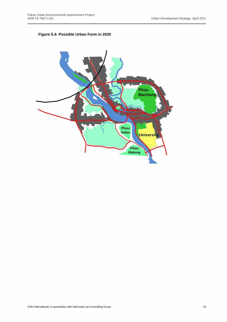
52 As described earlier, the Urban Development Strategyhas been divided into three phases. The proposed components of each phase are summarised below and illustrated inFigure 5.1 to Figure 5.3. If the strategy is adopted and followed the ultimate urban form in 2030 will look something like that shown in Figure 5.4.
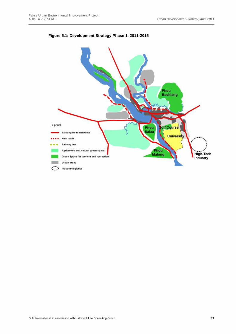
5.2 Development Strategy Phase 1 - from 2011 to 2015
5.2.1 Urban Development
Consolidate existing urban area through infill developments, and improvements in
infrastructureand development control.
Facilitate urban growth in expansion areas where infrastructure already exists (Ban Chat San,
Phonthong river bank).
High-tech/green industry near university.
University initial expansion.
Relocate fresh market sections of Dao Heuang market to edge of urban area locations
Relocate wholesale and construction dealers from Dao Heuang area to non-central locations
5.2.2 Road network and Transport
Extend and improve road along Mekong southwards.
Third Xedonbridge and road parallel to R13s (including some on bund).
Road on Xedon east bank to Chat San.
Secondary road connections between R13s, Salakheow and new road.
Riverside road in Phonthong (in association with riverbank works).
Relocate north and south bus stations to edge of urban area.
5.2.3 Environment/Green Infrastructure
PhouSalao as tourist development zone.
Urban parks improved.
Saphai and Don Kho established as tourism zone.
Develop waster water treatment plants which will serve a part of greater urban area.
Develop river bank protection along two sides of Mekong River.
Develop green belt along the new Mekong River bank protection.
Developmajor urban park in Pakse.
Pakse Urban Environmental Improvement Project ADB TA 7567-LAO Urban Development Strategy, April 2011
GHK International, in association with Halcrow& Lao Consulting Group 21
Figure 5.1: Development Strategy Phase 1, 2011-2015
Pakse Urban Environmental Improvement Project ADB TA 7567-LAO Urban Development Strategy, April 2011
GHK International, in association with Halcrow& Lao Consulting Group 22
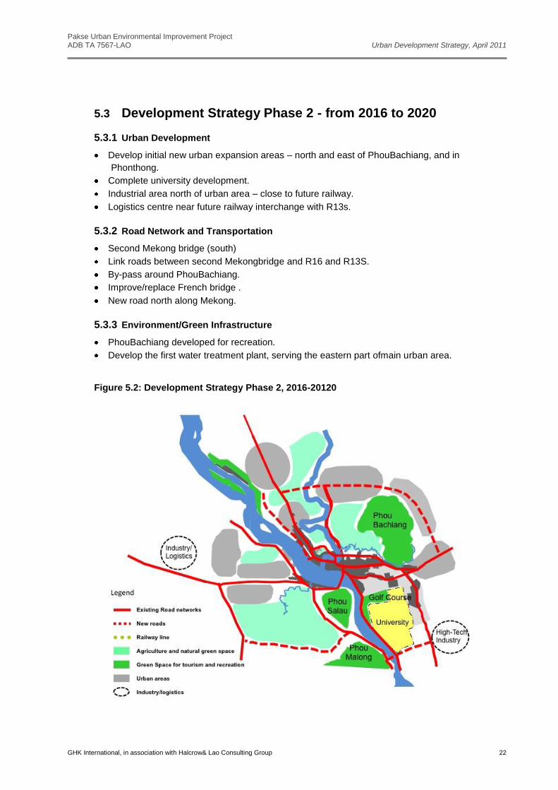
5.3 Development Strategy Phase 2 - from 2016 to 2020
5.3.1 Urban Development
Develop initial new urban expansion areas – north and east of PhouBachiang, and in
Phonthong.
Complete university development.
Industrial area north of urban area – close to future railway.
Logistics centre near future railway interchange with R13s.
5.3.2 Road Network and Transportation
Second Mekong bridge (south)
Link roads between second Mekongbridge and R16 and R13S.
By-pass around PhouBachiang.
Improve/replace French bridge .
New road north along Mekong.
5.3.3 Environment/Green Infrastructure
PhouBachiang developed for recreation.
Develop the first water treatment plant, serving the eastern part ofmain urban area.
Figure 5.2: Development Strategy Phase 2, 2016-20120
Pakse Urban Environmental Improvement Project ADB TA 7567-LAO Urban Development Strategy, April 2011
GHK International, in association with Halcrow& Lao Consulting Group 23
5.4 Development Strategy Phase 3- from 2021-2030
5.4.1 Urban development
More expansion in Phonthong.
Develop northern expansion area around railway/R13s interchange.
5.4.2 Road Network and Transportation
Third Mekong bridge (north).
Link roads between third Mekong bridge and R13s and R16.
Railway and bridge (possibly combined with third Mekong Road Bridge).
Move airport.
Figure 5.3:Development Strategy Phase 3, 2021-2030
Pakse Urban Environmental Improvement Project ADB TA 7567-LAO Urban Development Strategy, April 2011
GHK International, in association with Halcrow& Lao Consulting Group 24
Figure 5.4: Possible Urban Form in 2030
Phou
Bachiang
Phou
Salau
Phou
Malong
University
Pakse Urban Environmental Improvement Project ADB TA 7567-LAO Urban Development Strategy, April 2011
GHK International, in association with Halcrow& Lao Consulting Group 25
Annexes
Pakse Urban Environmental Improvement Project ADB TA 7567-LAO Urban Development Strategy, April 2011
GHK International, in association with Halcrow& Lao Consulting Group i
Annex A: Statistics from Government Economic Development Plans and Other Sources Table A1: National Socio-economic Development Plan towards 2020
Table A2: Socioeconomic Development Plan of Champasack Province
Socioeconomic development Achievement of 2006-2010
Target for 2010-2015
Target for 2020
Demography Population (inhabitant) 666,000 733,154 805,500
Economic & structure
Annual growth rate/GPD (%) 9.8 11.1 11-12
Per capita income (USD) 1,097 1,955 3,000-3,500
Agriculture (%) 40 27.6 90 Manufacturing (%) 29 34.1
Service (%) 31 38.3
Foreign trade Annual import growth rate (%) 15 401.64 m USD
Annual export growth Rate (%) 15 793.19 m USD
Investment Public (%) 12.8 10 9
Foreign/Private/Credit (%) 52/2/33 75/15 22/9
Social service Education (%) 95 for primary education
100 for Primary 80 for Secondary
Complete lower and secondary
Life expectancy 63 65
70
Clean Water (%) 84.11 100
Labor (14-60 Y) 56
Source: 2010-2015 VI Five Year Socioeconomic Development Report and VII Five Year Socioeconomic Development Plan of Champasack, 23 October 2010
Table A3: Economic Data and estimate
Category Champasack Province*
Pakse District** Phonthong district***
2006- 2010
2011- 2015
2004- 2008
2009- 2014
2005- 2009
2010- 2014
Population (inhabitant) 87,232 91,137
Children from 6-10 years school enrolment (%)
95 100 95.83 100 96.28 98
Life expectancy (year) 63 65 63 65 63 65
GDP (billion kips) 24,220 46,183 718.014 1,258.383 438.78 735.87
Economic Growth (%) 9.8 11.1 15.7 12 11.08 12
Indicators Actual 2010 2020
Total population (million) 5.1 (1999) 6.7 8.3
Annual population growth rate (%) 2.8 (2000) 2.4 2.2
Life expectancy at birth (years) 59 (2000) 67 70
Infant mortality (deaths per 1,000 live births) 82 (1995-99) 40 20
Under 5 mortality (deaths per 1,000 live births) 107 (1995-99) 60 30
Maternal mortality (deaths per 100,000 live births) 530 (2000) 250 130
Access to clean water (% of population) 56 (2000) 100 100
Adult literacy rate (%) 73 (1998/99) 84 90
Annual GDP per capita (US$) 350 (2000) 700-750 1,200-1,500
Average annual GDP growth (%) 5.2 (1999) 7.0 7.0
Pakse Urban Environmental Improvement Project ADB TA 7567-LAO Urban Development Strategy, April 2011
GHK International, in association with Halcrow& Lao Consulting Group ii
Per capital incomes (USD/capita/y)
1,097 1,955
1,100
1,773
900
Economic structure
Agriculture(%) 40 27.6 13.17 8.5 88.2 86
Industrial 29 34.1 36.36 38.5 7.07
Trading and service
31 38.3% 50.47 53 6.93
Import (million USD) 328
Export (Million USD) 181
Investment
Public investment(%)
12.8 10 22,921b 15.5
Domestic investment
54%
75%
815.578b (kip)
56.14
Foreign investment
24.116m (kip)
11.41
People 33% 15% 4.637 b (kip)
16.95
Average tourists/annum 201,668
465,224 109,514 192,500
6,947
9,000
Sources: * Champasack Province, 2010. VI Socioeconomic Plan Implementation and VII Socioeconomic Development Plan ** Pakse District, 2009. Socioeconomic Development Report to the V Pakse Lao Revolution Party’s Congress *** Phonthong District, 2009. Socioeconomic Development Report to the VI Phonthong Lao Revolution Party’s Congress
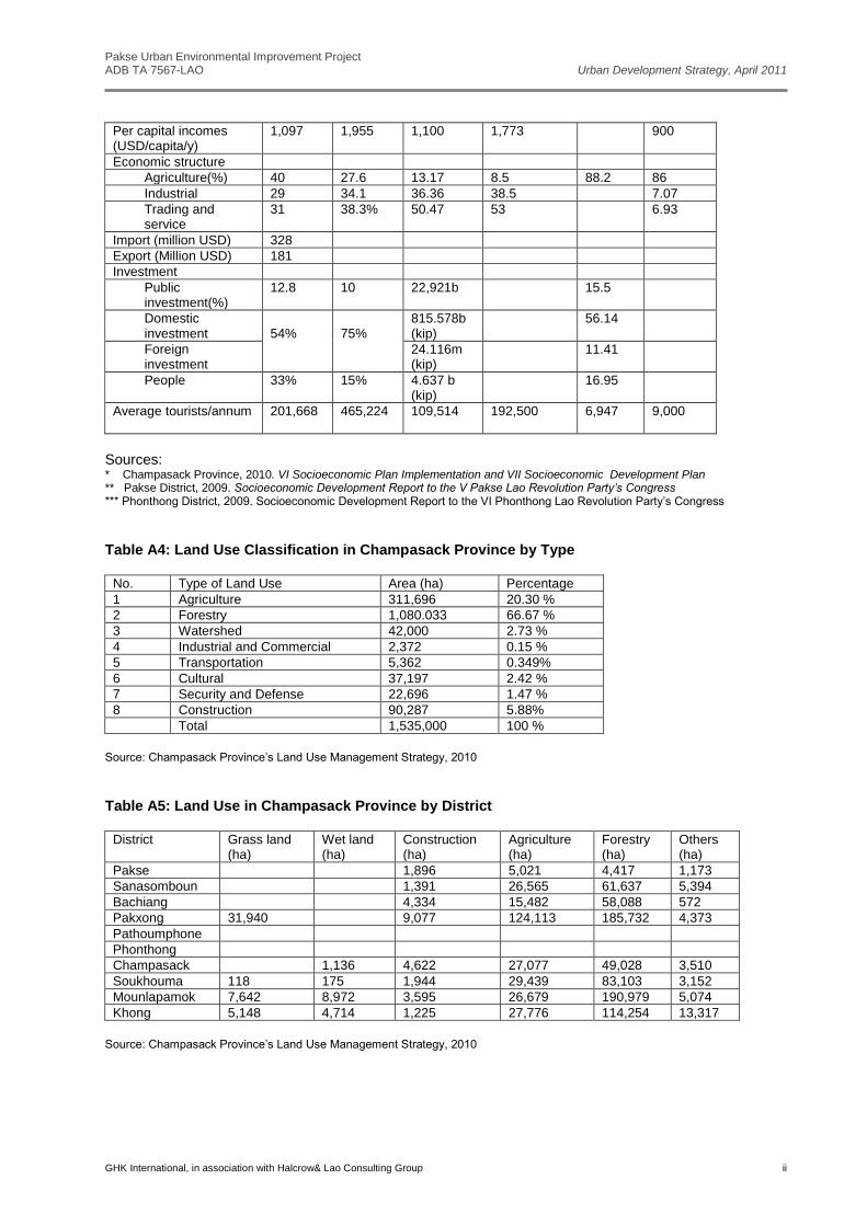
Table A4: Land Use Classification in Champasack Province by Type
No. Type of Land Use Area (ha) Percentage
1 Agriculture 311,696 20.30 %
2 Forestry 1,080.033 66.67 %
3 Watershed 42,000 2.73 %
4 Industrial and Commercial 2,372 0.15 %
5 Transportation 5,362 0.349%
6 Cultural 37,197 2.42 %
7 Security and Defense 22,696 1.47 %
8 Construction 90,287 5.88%
Total 1,535,000 100 %
Source: Champasack Province’s Land Use Management Strategy, 2010
Table A5: Land Use in Champasack Province by District
District Grass land (ha)
Wet land (ha)
Construction (ha)
Agriculture (ha)
Forestry (ha)
Others (ha)
Pakse 1,896 5,021 4,417 1,173
Sanasomboun 1,391 26,565 61,637 5,394
Bachiang 4,334 15,482 58,088 572
Pakxong 31,940 9,077 124,113 185,732 4,373
Pathoumphone
Phonthong
Champasack 1,136 4,622 27,077 49,028 3,510
Soukhouma 118 175 1,944 29,439 83,103 3,152
Mounlapamok 7,642 8,972 3,595 26,679 190,979 5,074
Khong 5,148 4,714 1,225 27,776 114,254 13,317
Source: Champasack Province’s Land Use Management Strategy, 2010
Pakse Urban Environmental Improvement Project ADB TA 7567-LAO Urban Development Strategy, April 2011
GHK International, in association with Halcrow& Lao Consulting Group iii
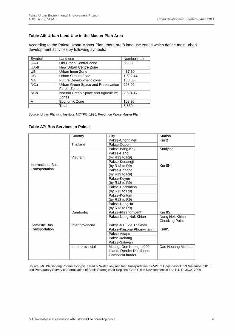
Table A6: Urban Land Use in the Master Plan Area According to the Pakse Urban Master Plan, there are 8 land use zones which define main urban development activities by following symbols:
Symbol Land use Number (ha)
UA-I Old Urban Central Zone 85.08
UA-II New Urban Centre Zone
UB Urban Inner Zone 457.60
UC Urban Suburb Zone 1,692.44
NA Future Development Zone 188.86
NCa Urban Green Space and Preservation Forest Zone
268.02
NCb Natural Green Space and Agriculture Zones
2,694.47
A Economic Zone 108.96
Total 5,580
Source: Urban Planning Institute, MCTPC, 1996. Report on Pakse Master Plan
Table A7: Bus Services in Pakse
International Bus Transportation
Country City Station
Thailand
Pakse-ChongMek Km 2
Pakse-Oubon
Pakse-Bang Kok Studying
Vietnam
Pakse-Hanoi (by R13 to R9)
Km 8N
Pakse-Kouangji (by R13 to R9)
Pakse-Danang (by R13 to R9)
Pakse-Kuyern (by R13 to R9)
Pakse-Hochiminh (by R13 to R9)
Pakse-Kontum (by R13 to R9)
Pakse-DongHa (by R13 to R9)
Cambodia Pakse-Phranompenh Km 8S
Pakse-Nong Nok Khian Nong Nok Khian Checking Point
Domestic Bus Transportation
Inter provincial Pakse-VTE via Thakhek Km8S Pakse-Kaisone Phomvihanh
Pakse-Attapu
Pakse-Xekong
Pakse-Salavan
Inner provincial Muang, Don Khong, 4000 Island, Dondet-Donkhone, Cambodia border
Dao Heuang Market
Source: Mr. Phitsahong Phommavongsa, Head of Water way and land transportation, DPWT of Champasack, 29 November 2010) and Preparatory Survey on Formulation of Basic Strategies fir Regional Core Cities Development in Lao P.D.R, JICA, 2009
Pakse Urban Environmental Improvement Project ADB TA 7567-LAO Urban Development Strategy, April 2011
GHK International, in association with Halcrow& Lao Consulting Group iv
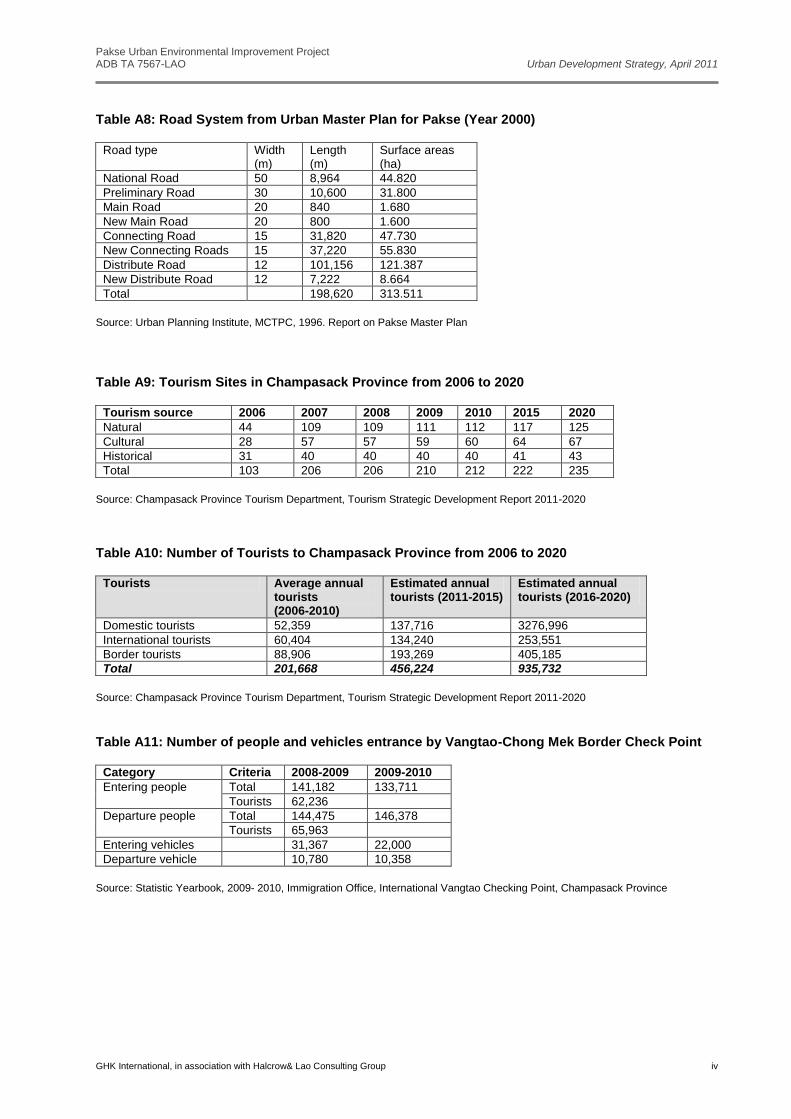
Table A8: Road System from Urban Master Plan for Pakse (Year 2000)
Road type Width (m)
Length (m)
Surface areas (ha)
National Road 50 8,964 44.820
Preliminary Road 30 10,600 31.800
Main Road 20 840 1.680
New Main Road 20 800 1.600
Connecting Road 15 31,820 47.730
New Connecting Roads 15 37,220 55.830
Distribute Road 12 101,156 121.387
New Distribute Road 12 7,222 8.664
Total 198,620 313.511
Source: Urban Planning Institute, MCTPC, 1996. Report on Pakse Master Plan
Table A9: Tourism Sites in Champasack Province from 2006 to 2020
Tourism source 2006 2007 2008 2009 2010 2015 2020
Natural 44 109 109 111 112 117 125
Cultural 28 57 57 59 60 64 67
Historical 31 40 40 40 40 41 43
Total 103 206 206 210 212 222 235
Source: Champasack Province Tourism Department, Tourism Strategic Development Report 2011-2020
Table A10: Number of Tourists to Champasack Province from 2006 to 2020
Tourists Average annual tourists (2006-2010)
Estimated annual tourists (2011-2015)
Estimated annual tourists (2016-2020)
Domestic tourists 52,359 137,716 3276,996
International tourists 60,404 134,240 253,551
Border tourists 88,906 193,269 405,185
Total 201,668 456,224 935,732
Source: Champasack Province Tourism Department, Tourism Strategic Development Report 2011-2020
Table A11: Number of people and vehicles entrance by Vangtao-Chong Mek Border Check Point
Category Criteria 2008-2009 2009-2010
Entering people Total 141,182 133,711
Tourists 62,236
Departure people Total 144,475 146,378
Tourists 65,963
Entering vehicles 31,367 22,000
Departure vehicle 10,780 10,358
Source: Statistic Yearbook, 2009- 2010, Immigration Office, International Vangtao Checking Point, Champasack Province
Pakse Urban Environmental Improvement Project ADB TA 7567-LAO Urban Development Strategy, April 2011
GHK International, in association with Halcrow& Lao Consulting Group v
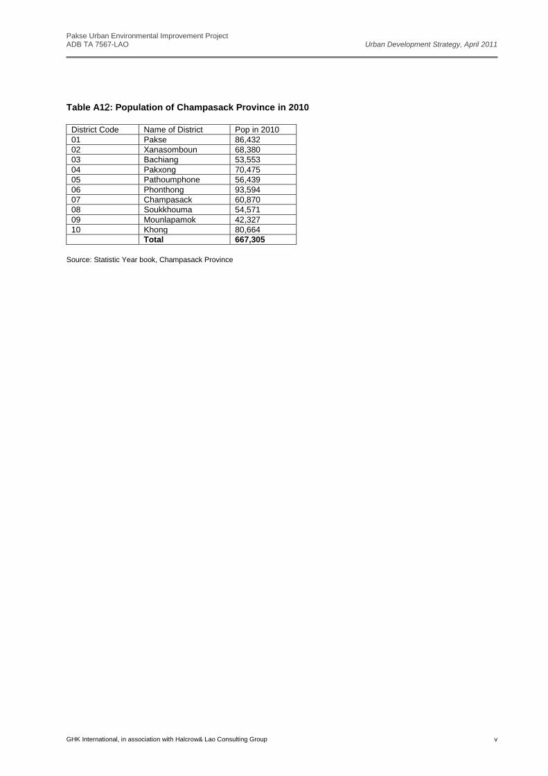
Table A12: Population of Champasack Province in 2010
District Code Name of District Pop in 2010
01 Pakse 86,432
02 Xanasomboun 68,380
03 Bachiang 53,553
04 Pakxong 70,475
05 Pathoumphone 56,439
06 Phonthong 93,594
07 Champasack 60,870
08 Soukkhouma 54,571
09 Mounlapamok 42,327
10 Khong 80,664
Total 667,305
Source: Statistic Year book, Champasack Province
Pakse Urban Environmental Improvement Project ADB TA 7567-LAO Urban Development Strategy, April 2011
GHK International, in association with Halcrow& Lao Consulting Group vi
Annex B: Summary of Original of Destination Survey
Figure 1: Map of Pakse with zone for Original and destination and stops for passenger interview
Zone 3Zone 4
Zone 2
Zone 1
Zone 5
Zone 6
Zone 7
Zone 8
1
2
4
3
Zone 9
Stops for passenger interview
Zones for original and destination
Figure 2: Matrix table of Origin and Final Destination
Zone
1 Zone
2 Zone
3 Zone
4 Zone
5 Zone
6 Zone
7 Zone
8 Zone
9 No
answer
Total 13 50 119 27 30 66 73 21 72 37
Zone1 2 2
Zone2 42 26 1 2 2 7 1 3
Zone3 149 1 35 2 7 14 34 7 45 4
Zone4 31 4 1 1 10 7 2 3 3
Zone5 36 3 1 3 14 9 5 1 0
Zone6 61 6 16 12 8 8 4 1 5 1
Zone7 80 1 30 6 6 8 2 4 8 18
Zone8 24 1 10 1 5 2 2
Zone9 72 12 29 5 2 3 7 1 8 5
No information 11 3 1 1 2 1 1 1 1
Destination
Original trip