Embed Size (px)
Citation preview

CJMT EIS/OEIS Appendix N
April 2015 Draft Cultural Resources
i
APPENDIX N
CULTURAL RESOURCES TECHNICAL MEMO
Table of Contents
INTRODUCTION ..................................................................................................................... 1 1.0
1.1 CULTURAL RESOURCES REGULATIONS, STANDARDS, AND GUIDELINES .....................................................1
CULTURAL RESOURCES AFFECTED ENVIRONMENT .................................................................. 2 2.0
2.1 TINIAN ....................................................................................................................................3
Historical Overview ............................................................................................................. 3 2.1.1 Previous Studies and Recorded Cultural Resources ........................................................... 7 2.1.2
2.2 PAGAN .................................................................................................................................. 13
Historical Overview ........................................................................................................... 13 2.2.1 Previous Studies and Recorded Cultural Resources ......................................................... 16 2.2.2
CULTURAL RESOURCES ENVIRONMENTAL CONSEQUENCES ................................................... 19 3.0
3.1 METHODOLOGY ....................................................................................................................... 20
Approach to Analysis ........................................................................................................ 20 3.1.1 Resource Management Measures .................................................................................... 21 3.1.2
3.2 TINIAN .................................................................................................................................. 23
Tinian Alternative 1 ........................................................................................................... 23 3.2.1 Tinian Alternative 2 ........................................................................................................... 39 3.2.2 Tinian Alternative 3 ........................................................................................................... 45 3.2.3
3.3 PAGAN .................................................................................................................................. 50
Pagan Alternative 1 ........................................................................................................... 50 3.3.1 Pagan Alternative 2 ........................................................................................................... 58 3.3.2
REFERENCES ........................................................................................................................ 62 4.0

CJMT EIS/OEIS Appendix N
April 2015 Draft Cultural Resources
ii
LIST OF FIGURES
1 Cultural Resource Surveys within the Area of Potential Effects on Tinian ................................... 11
2 Cultural Resource Surveys within the Area of Potential Effects on Pagan ................................... 17
LIST OF TABLES
1 Cultural Resource Surveys in the Military Lease Area, Tinian International Airport, and Port of Tinian ............................................................................................................................ 8
2 Contributing Features to the North Field National Historic Landmark ......................................... 12
3 Cultural Resource Surveys on Pagan ............................................................................................. 16
4 Local Place Names ......................................................................................................................... 19
5 Tinian Alternative 1 Summary of Direct Adverse Effects on Historic Properties from Construction .................................................................................................................................. 23
6 Historic Properties Directly Affected by Range Complex A (Construction) Under Tinian Alternative 1 .................................................................................................................................. 24
7 Historic Properties Directly Affected by Range Complex B (Construction) Under Tinian Alternative 1 .................................................................................................................................. 26
8 Historic Properties Directly Affected by Range Complex C (Construction) Under Tinian Alternative 1 .................................................................................................................................. 26
9 Historic Properties Directly Affected by Range Complex D (Construction) Under Tinian Alternative 1 .................................................................................................................................. 27
10 Historic Properties Directly Affected by Convoy Course Engagement Areas (Construction) Under Tinian Alternative 1 .................................................................................... 29
11 Historic Properties Directly Affected by Munitions Storage Area (Construction) Under Tinian Alternative 1 ....................................................................................................................... 29
12 Historic Properties Directly Affected by Roads, Fences, and Utilities, Tracked Vehicle Driver’s Course (Construction) Under Tinian Alternative 1 .......................................................... 30
13 Historic Properties Directly Affected by Base Camp (Construction) Under Tinian Alternative 1 ....................................................................................................................... 33
14 Historic Properties Directly Affected by Tactical Training Areas (Construction) Under Tinian Alternative 1 ....................................................................................................................... 33
15 Historic Properties Directly Affected by Landing Zones, Artillery Firing Points, Observation Posts, and Surface Radar Sites (Construction) Under Tinian Alternative 1 ............. 33
16 Historic Properties Directly Affected by Tinian International Airport (Construction) Under Tinian Alternative 1 ............................................................................................................ 35
17 Historic Properties Directly Affected by Port of Tinian Improvement and Tracked Vehicle Transit Lanes/Supply Route (Construction) Under Tinian Alternative 1 .......................... 35
18 Tinian Alternative 1 Summary of Direct Adverse Effects on Historic Properties from Operations .................................................................................................................................... 36
19 Historic Properties Directly Affected by Range Complex A (Operations) Under Tinian Alternative 1 ....................................................................................................................... 37

CJMT EIS/OEIS Appendix N
April 2015 Draft Cultural Resources
iii
20 Historic Properties Directly Affected by Tactical Amphibious Training Areas (Operations) Under Tinian Alternative 1 ...................................................................................... 38
21 Tinian Alternative 2 Summary of Direct Adverse Effects on Historic Properties from Construction .................................................................................................................................. 39
22 Historic Properties Directly Affected by Range Complex C (Construction) Under Tinian Alternative 2 ....................................................................................................................... 41
23 Historic Properties Directly Affected by Convoy Course Engagement Areas (Construction) Under Tinian Alternative 2 .................................................................................... 42
24 Tinian Alternative 2 Summary of Direct Adverse Effects on Historic Properties from Operations .................................................................................................................................... 43
25 Tinian Alternative 3 Summary of Direct Adverse Effects on Historic Properties from Construction .................................................................................................................................. 46
26 Tinian Alternative 3 Summary of Direct Adverse Effects on Historic Properties from Operations .................................................................................................................................... 49
27 Pagan Alternative 1 Summary of Direct Adverse Effects on Historic Properties from Construction .................................................................................................................................. 51
28 Historic Properties Directly Affected by North High Hazard Impact Area (Construction) Under Pagan Alternative 1 .................................................................................... 52
29 Historic Properties Directly Affected by Landing Zones (Construction) Under Pagan Alternative 1.................................................................................................................................. 52
30 Historic Properties Directly Affected by Field Artillery Direct and Indirect Fire Ranges (Construction) Under Pagan Alternative 1 .................................................................................... 53
31 Historic Properties Directly Affected by Access Roads/Trails (Construction) Under Pagan Alternative 1 ....................................................................................................................... 53
32 Historic Properties Directly Affected by Airfield/Base Camp/Bivouac Area (Construction) Under Pagan Alternative 1 .................................................................................... 54
33 Pagan Alternative 1 Summary of Direct Adverse Effects on Historic Properties from Operations .................................................................................................................................... 55
34 Historic Properties Directly Affected by Live-Fire Maneuver Areas (Operations) Under Pagan Alternative 1 ....................................................................................................................... 55
35 Historic Properties Directly Affected by Tactical Amphibious Training Areas (Operations) Under Pagan Alternative 1 ...................................................................................... 56
36 Historic Properties Directly Affected by Live-Fire Maneuver Areas (Operations) Under Pagan Alternative 1 ....................................................................................................................... 56
37 Pagan Alternative 2 Summary of Direct Adverse Effects on Historic Properties from Construction .................................................................................................................................. 59
38 Pagan Alternative 2 Summary of Direct Adverse Effects on Historic Properties from Operations .................................................................................................................................... 60
39 Historic Properties Directly Affected by Live-Fire Maneuver Areas (Operations) Under Pagan Alternative 2 ....................................................................................................................... 61

CJMT EIS/OEIS Appendix N
April 2015 Draft Cultural Resources
iv
This page intentionally left blank.

CJMT EIS/OEIS Appendix N April 2015 Draft Cultural Resources
N-1
INTRODUCTION 1.0
This technical memo supports Sections 3.11 and 4.11, Cultural Resources Affected Environment and
Environmental Consequences, respectively of the Commonwealth of the Northern Mariana Islands Joint
Military Training (CJMT) Environmental Impact Statement (EIS)/Overseas Environmental Impact
Statement (OEIS). Section 1.0, Introduction, of this technical memo presents a more detailed discussion
of the resource standards and regulations. This is followed by Section 2.0, Cultural Resources Affected
Environment, where previous cultural resources studies and recorded sites, as well as the history of
Tinian and Pagan before World War II are presented. Section 3.0, Cultural Resources Environmental
Consequences, details the methodology used to evaluate potential impacts, measures taken as part of
the proposed action to reduce impacts to cultural resources, identification of impacts specific to the
three action alternatives on Tinian and the two on Pagan, and description of the types of sites affected.
1.1 CULTURAL RESOURCES REGULATIONS, STANDARDS, AND
GUIDELINES
Statutory and regulatory requirements for cultural resources arise from the National Environmental
Policy Act (NEPA), National Historic Preservation Act, and other statutes and executive orders, including
the Antiquities Act (1906) and the Sunken Military Craft Act (2004). Additional regulations include
Curation of Federally-owned and Administered Archeological Collections (36 Code of Federal
Regulations [CFR] § 79), Criteria for Evaluation (36 CFR § 60.4), and Protection of Historic Properties (36
CFR § 800). The Antiquities Act allows the President of the United States (U.S.) to establish national
monuments that are then managed by the National Park Service. The Sunken Military Craft Act protects
sunken U.S. military vessels and aircraft and the remains of their crews from unauthorized disturbance.
Regulation 36 CFR § 60.4 establishes the criteria to evaluate properties for listing in the National
Register of Historic Places and 36 CFR § 800 describes the process for the identification and assessment
of adverse effects to historic properties (the Section 106 process). Other laws and regulations governing
cultural resources include:
Abandoned Shipwreck Act, 43 U.S. Code § 2101-2106
Historic Sites Act, 16 U.S. Code § 461-467
National Historic Landmarks Program (36 CFR 65)
Curation of Federally-owned and Administered Archeological Collections (36 CFR 79)
Protection of Historic Properties (36 CFR 800)
Preservation of American Antiquities (43 CFR 3)
Executive Order 11593, Protection and Enhancement of the Cultural Environment
Executive Order 13287, Preserve America
The process for identifying and evaluating historic properties is established under authority of the
National Historic Preservation Act. Section 106 of the Act directs federal agencies to make reasonable
and good faith efforts to identify historic properties (36 CFR 800.4(b)(1)). Agencies are to take into
account past planning, research, and studies; the magnitude and nature of the undertaking and the

CJMT EIS/OEIS Appendix N April 2015 Draft Cultural Resources
N-2
degree of federal involvement; the nature and extent of potential effects on historic properties; and the
likely nature and location of historic properties within areas that may be affected. Additionally, the
Secretary of the Interior has developed standards (e.g., Historic Preservation Qualification Standards)
and guidelines for the identification of historic properties.
A historic property is defined as a district, site, building, structure, or object that meets the specific
criteria of the National Register of Historic Places. A property’s historic significance is determined by
applying certain criteria that evaluate the eligibility of a property to be placed in the National Register of
Historic Places. National Register Bulletin 15 (National Park Service 2002) defines these criteria.
Properties may be considered eligible for listing in the National Register of Historic Places if they possess
integrity of location, design, setting, materials, workmanship, feeling, association, and:
A. Are associated with events that have made a significant contribution to the broad pattern of
history; or
B. Are associated with the lives of persons significant in the past; or
C. Embody the distinctive characteristics of a type, period, or method of construction,
represent the work of a master, possess high artistic value or represent a significant and
distinguishable entity whose components may lack individual distinction; or
D. Have yielded, or may be likely to yield, information important in prehistory or history
(National Park Service 2002).
Properties that meet these criteria are considered “historic properties” and impacts to historic
properties are subject to review under Section 106 of the National Historic Preservation Act. The Section
106 process provides interested parties such as local governments, agencies, and the public, an
opportunity to provide input and affords the Advisory Council on Historic Preservation an opportunity to
comment prior to a federal agency initiating the proposed undertaking. Federal regulation 36 CFR Part
800, Protection of Historic Properties, defines specific procedures for federal agencies to follow in
complying with the Section 106 process. An important part is consultation with interested parties
regarding potential effects to historic properties that may result from a proposed undertaking. Section
106 consultation for the CJMT proposed action was initiated in April 2013 with the Commonwealth of
the Northern Mariana Islands (CNMI) Historic Preservation Officer, and is being conducted in
coordination with the NEPA process.
Under NEPA, cultural resources can also include other resources that hold special cultural significance,
including cultural practices, cemeteries, memorials, sacred sites, or medicinal plants.
CULTURAL RESOURCES AFFECTED ENVIRONMENT 2.0
Consistent with the standards and guidelines identified above, several methods were used to identify
historic properties in the potential impact areas. These included reviewing existing research and
literature, evaluating previously recorded sites, and conducting cultural resources studies where
needed.
CJMT EIS/OEIS Appendix N April 2015 Draft Cultural Resources
N-3
2.1 TINIAN
Historical Overview 2.1.1
On Tinian, few archaeological and architectural resources show evidence of the area’s status as a colony
of Spain and Germany, while numerous structures and relics attest to the island’s role in World War II.
Other areas on the island are important because of their historical and traditional use, to the Chamorro
as well as to former residents of American, Japanese, and Korean descent.
2.1.1.1 Pre-Contact Period in the Mariana Islands
Early Settlement: Pre-Latte Period
The Pre-Latte Period dates from the time of initial settlement, approximately 3,500 years ago to 1,013
years ago. Moore et al. (2002) subdivides the Pre-Latte Period into four phases based on pottery styles:
Early Unai, Middle Unai, Late Unai, and Huyong. Archaeological sites dating to the Pre-Latte Period are
limited to several coastal and a few inland sites. The basic settlement pattern appears to have been one
of small population groups living along the sandy coasts, especially near coastal lagoons with easy access
to marine resources (Tomonari-Tuggle et al. 2007). The great quantity of shellfish and reef fish remains
found at coastal sites suggests that subsistence practices of early inhabitants relied heavily on nearshore
reefs. People used a mixture of hunting, fishing, and collecting activities (Reinman 1977; Kurashina and
Clayshulte 1983; Tomonari-Tuggle et al. 2007).
Sites from early in this period, also known as the Early Unai Phase, include Unai Chulu on Tinian and the
Achuagao and San Roque sites on Saipan. Excavations at the Unai Chulu site have yielded the most
substantial body of data for interpreting the Early Unai Phase. The excavations have produced evidence
of intensive use, including postholes and hearths, with substantial amounts of habitation debris
indicating cooking, food storage, and tool manufacturing. Food remains recovered from the site include
marine shells, fish and bird bones, and charred plant material. As is true of most early settlements on
the Pacific Islands, birds were an important part of the diet. The Unai Chulu site also produced flaked
and ground stone items, and implements and ornaments of bone and shell, including shell fishhooks
(Haun et al. 1999).
Sites from the next period, the Middle Unai Phase, include Mochong on Rota, Laulau on Saipan, and
Taga on Tinian. As in the Early Unai Phase, remains of settlement are evidenced by occasional postholes,
hearths, and midden deposits, primarily in coastal caves and rock shelters. Most sites from the period
occur along the coastlines.
The Late Unai Phase is characterized by the presence of large, thick-walled, shallow, pan-like ceramic
vessels. Late Unai sites occur throughout coastal and inland areas of Tinian, Saipan, Guam, and Rota. The
Huyong Phase exhibits a continuation of large flat-bottomed pans, but they decline in frequency as pots
with rounded bases become more common.
Latte Period
The Latte Period is distinguished from earlier periods by the presence of stone structures called latte.
The earliest latte structures date to approximately 1,013 years ago and are accompanied by a change in

CJMT EIS/OEIS Appendix N April 2015 Draft Cultural Resources
N-4
pottery technology. During this period, populations increased and settlements expanded into areas
outside of the coastal environments. Latte Period sites are more abundant than Pre-Latte sites on all of
the Mariana Islands.
Latte are typically large limestone pillars, or more infrequently basalt, each topped by a capstone. These
pillars were placed in two parallel rows of even numbered uprights forming a single set. Variation in the
number and size of latte probably reflect differentiation in function, family size, and perhaps the status
of the occupants. Latte are most commonly found along the shorelines of all the major Mariana Islands
and can consist of clusters of up to 18 individual structures forming hamlets or villages (although the
Mochong site of Rota has at least 47 documented structures). Marine resources, such as fish and
shellfish provided the primary source of protein during this period. Shell middens contain gastropods or
at earlier sites, bivalves. Other resources exploited included birds, fruit bats, lizards, turtles, and land
snails. Human burials are also commonly associated with latte sites where individuals were either buried
beneath the structure or adjacent to it.
2.1.1.2 Post-Contact Period
European Contact
Western contact in the Mariana Islands is considered to have occurred in 1521, the year that Ferdinand
Magellan landed on Guam. At the time of western contact, the Mariana Islands were inhabited by a
group of people that came to be known as the Chamorro. Latte continued to be built into the Post-
Contact period (the period between Magellan’s landing on Guam in 1521 and full Spanish colonization).
Spanish-introduced materials are found at sites dating to this period and include cattle, pig, sheep, and
deer bones; maize (corn) remains; iron; and glass fragments. Breadfruit, yams, and taro were the staple
crops during this period as well as bananas, sugarcane, and rice. Marine resources also remained a
staple food source.
Colonization Periods
The Mariana Islands were colonized by Spain for over 200 years. Colonization of the Marianas began in
1668 with the arrival of Catholic missionaries. Opposition to the missionaries by the indigenous
population soon arose, which led to open revolt against the priests and Spanish troops (Rogers 1995).
Sporadic conflicts continued until 1694, when, as a last measure, the Spanish began the forced
relocation of all Chamorro to villages on Saipan and Guam. This consolidation program was called the
reducción by the Spaniards (Rogers 1995), and it took approximately 4 years to complete. Those
Chamorro who were initially sent to Saipan were forced to move to Guam in 1698 (Driver 1983; Hezel
1989). In that year, a final Spanish mission to the Northern Mariana Islands removed the last of the
Chamorro community from Tinian (Rogers 1995). The northern islands were visited after 1700 by
Chamorro fishing and hunting parties, but the Spanish administration restricted Chamorro settlements
to Guam, Saipan, and Rota.
During the 1700s, cattle, pigs, and goats introduced by the Spanish, grazed freely on Tinian (Bowers
1950). In 1742, the English vessel H.M.S. Centurion dropped anchor off Tinian for almost 2 months,
providing several of the early historic accounts of the island. British Commodore George Anson of the
Centurion observed that the free-roaming livestock was minimally tended and occasionally harvested by
Guam residents (Farrell 2011). Sometime between 1815 and 1820, Carolinian refugees began arriving in
CJMT EIS/OEIS Appendix N April 2015 Draft Cultural Resources
N-5
the Marianas (Driver and Brunal-Perry 1995). In 1835 the Spanish government transported Chamorro
and Carolinian victims of Hansen’s disease to the Tinian Leper Colony. The colony supported itself by
selling beef and hides to Guam. The colony closed after a small pox epidemic in 1837 (Farrell 2012). It
was re-established in 1855, when the administration of Governor Felipe Maria de la Corte allowed
Spanish prisoners to establish the village of Sanhalom on Tinian. In 1865, the population of Tinian
consisted of about 15 individuals, probably Spanish prisoners, who worked as ranchers and farmers
(Farrell 2012). Every 6 months, Carolinians from Saipan would sail to Tinian and transport goods to
Guam.
In 1869, Tinian was leased by the Spanish to a rancher named George Johnston, who established a cattle
ranch. Johnston brought 230 to 250 Carolinians from Piserasch or Piherarh on the Namunito atoll to
work on his ranch (Bowers 1950; Farrell 2012 p. 13). The Johnston ranch did not last long. Johnston was
lost at sea and the lease was terminated in 1877. Some of the Tinian Carolinians decided to move to
Saipan. By the end of 1886, there were 235 Carolinians and only one Chamorro family (the deputy
magistrate on Tinian), all living in a village called San Luis Medina (Olive y Garcia 2006). A severe drought
in 1888 caused many of the Carolinians to move to Saipan. A year later, the Governor of the Northern
Mariana Islands ordered the remaining Carolinians on Tinian to join the rest on Saipan. The leper colony
on Tinian was presumably abandoned when the Carolinians moved to Saipan.
Following the Spanish occupation, the Mariana Islands, with the exception of Guam, were sold to
Germany in 1899. The Germans saw the islands as an opportunity to pursue aggressive economic and
commercial endeavors they had already begun in the Marshall Islands and subsequently, Palau.
Germany’s primary interest was the development of a cash-based agricultural economy based on copra
(dried coconut meat used for coconut oil) production. Coconut trees were planted on the island, but in
1905 two typhoons devastated the plantations and the Germans were convinced that their economic
gamble had failed (Tomonari-Tuggle et al. 2007). German authority over the islands ended in 1914,
when a Japanese naval squadron seized control of Saipan along with other German possessions in
Micronesia. Saipan was placed under military jurisdiction and German nationals were expelled. The
League of Nations awarded Micronesia to Japan in 1921, with the stipulation that it not be fortified for
military use.
Between 1914 and 1922, the Japanese military controlled the Northern Mariana Islands until it was
turned over to a Japanese civilian entity called South Seas Bureau in 1922. The South Seas Bureau, or the
Nan’yo Kohatsu Kabushiki Kaisha Company, developed large-scale sugarcane production for trade on
Saipan. Large tracts of lands were leased by the company and sublet to tenant farmers, most of whom
were colonists from Japan and Korea. Plantations were also developed on Tinian, Rota, and Aguijan. The
pattern of Japanese occupation was most intensive on Tinian, with sugarcane fields occupying 80% of
the island. Tinian was divided into rectangular plots, 14.7 acres (5.9 hectares) in size, each of which were
leased by tenant farmers. Their homes, constructed of wood and thatch or sheet metal, were destroyed
during World War II, but ruins of cisterns and secondary structures remain to mark the farm sites
(Bowers 1950; Dixon et al. 2000).
Japanese war preparation brought further changes to Tinian. Using forced labor composed of the local
Japanese population and imported laborers from Korea and Japan, the Japanese constructed two
airfields on Tinian (one at Ushi and one at the present airport location), and started a third to the west

CJMT EIS/OEIS Appendix N April 2015 Draft Cultural Resources
N-6
at Kahet (Dixon and Welch 2002). Beginning with the attack on Pearl Harbor on December 7, 1941 and
the entrance of the U.S. into World War II, the Japanese quickly occupied Guam on December 8, 1941,
cementing their hold on the Mariana Islands. During the war, the Japanese took over local schools on
Tinian to house the influx of Japanese troops. By 1944, Tinian’s civilian population was 17,900 with only
26 of those being Chamorro; most of the population was Japanese (Bowers 1950).
The U.S. began systematic air and naval bombardment of Tinian on June 11, 1944. On July 24, 1944
(Invasion Day), fire concentrated on Tinian Town (currently known as San Jose) as U.S. ships and landing
craft feinted offshore in an attempt to fool the Japanese into thinking that the invasion would take place
there. Instead, the invasion took place at two lightly defended narrow beaches on the northwest side of
the island, designated by the Allies as White One (Unai Babui) and White Two (Unai Chulu). The first
wave of the 4th Marine Division landed at 7:40 p.m. and by nightfall, 15,614 troops were ashore. The
following day, the 2nd Marine Division landed, and the push inland began to the northeast toward the
airstrips, and to the south toward Tinian Town. By July 31, 1944, the 2nd and 4th Marine Divisions had
compressed the remaining Japanese forces at the southern end of Tinian, and by the end of the day the
last desirable defense locality had been penetrated (Richard 1957). After bitter fighting, throughout the
night and the next day, Tinian was declared secured by U.S. Forces at 6:55 p.m. on August 1, 1944, but
not without almost complete devastation of Tinian Town and much of the island’s rural infrastructure
(Dixon and Welch 2002). Japanese soldiers hiding in caves in the southern end of the island staged
banzai attacks over the next several days, and some 500 stragglers continued to raid U.S. camps until
the end of the war.
Tinian was then transformed into the largest U.S. base in the Pacific (Russell 1995). West Field, the
present Tinian International Airport (Dixon et al. 2000; Dixon and Welch 2002) was used by General
Curtis LeMay for the high-level bombing of selected Japanese military targets by B-29s, and then for
low-level carpet bombing campaigns of other Japanese cities. Pilots used a tall homing tower near
Mount Lasso to guide their return to the airfield. At North Field, the former Ushi Field, the SeaBees of
the Sixth Naval Construction Brigade constructed 4 additional runways, taxiways, 173 Quonset huts, and
92 steel arch-rib buildings. The airfield also supported two loading pits that were used for the atomic
bombs dropped on Hiroshima and Nagasaki, which brought about the end of the war on August 10,
1945.
Following the end of the war, the Japanese civilian population at Camp Churo totaled 10,639 before
repatriation in January and February of 1946 (Russell 1998). The few Japanese soldiers who surrendered
during the war were also repatriated. The Koreans, Chinese, and Japanese were also returned to their
homelands. Following the repatriation of the Japanese and departure of the U.S. military in 1946, the
island was largely abandoned except for the U.S. Trust Territory Colony for the Treatment of Hansen’s
Disease below West Field, which housed individuals with leprosy from all over Micronesia (Farrell 1992
p. 71). This facility was established by the U.S. Navy in 1948, and expanded in 1950 (Farrell 2012). Much
of the abandoned military infrastructure and most former sugarcane fields reverted to jungle or fields of
dense sword grass.
The village of San Jose (formerly known as Tinian Town during the Japanese Administration) was
resettled in 1948 by Chamorro immigrants from Yap Island, who first occupied Camp Chulu (Athens
2009). By 1949, Tinian’s population was 354 (Bowers 1950). Families were each given 12, 15, or 17 acres
(5, 6, or 7 hectares) of land to homestead by the U.S. government who was administering the island. The

CJMT EIS/OEIS Appendix N April 2015 Draft Cultural Resources
N-7
more land a family could cultivate, the more they were given. The land was covered in non-native plant
species, such as tangantangan, which had to be cleared for farming. Homesteaders planted fruit trees,
raised pigs and cattle, and some tried to farm or ranch near Old Village because it was considered good
grazing land. Some farmers continued to use the military land, bulldozing concrete slabs, portions of
runways, and other remnant military facilities that were a hindrance to farming. Farmers grew
watermelon, tomatoes, tapioca, corn, sweet potatoes, and yams (Fowler et al. 2010). Others found the
remaining unexploded ordnance scattered across the landscape a deterrent to farming, and instead
collected and sold the abundant scrap metal to several scrap businesses on Guam. Farmers eventually
moved south to the Marpo Valley (Fowler et al. 2010).
During the Korean War (1950-1953), the U.S. military again used some of the abandoned facilities on
Tinian. North Field supported a base camp for the Navy Patrol Squadron VP-6, as well as a single-target
bombing range (Fowler et al. 2010). Since the late 1950s, a minor military presence has continued. In
1975, the leadership of the Mariana Islands (with the exception of Guam) signed the Covenant to
Establish a Commonwealth of the Northern Mariana Islands in Political Union with the United States of
America with concurrence by the Mariana Islands Legislature. This agreement contained a stipulation
that the U.S. military maintain a lease for the northern two-thirds of Tinian for training purposes (Farrell
1992 p. 79). In January 1983, the U.S. federal government and the CNMI government finalized a lease
agreement for military use of the northern two-thirds of Tinian (i.e., the Military Lease Area). Farming
and ranching continued in many areas across the island through the 1980s, but vegetation slowly began
to take over the fields as farming became less commonly practiced. Today, tourism and a casino are
important economic assets that help to support the population.
The Tinian Landing Beaches, Ushi Field, and North Field were collectively designated as a National
Historic Landmark in 1985 (hereinafter referred to as the “North Field National Historic Landmark”). The
landmark possesses significance for the invasion of the island by U.S. Marines, considered “the perfect
amphibious operation in the Pacific war.” Further significance derives from the fact that North Field, the
largest airfield in the Pacific, played a critical role in the Allied victory in the war. The North Field
National Historic Landmark encompasses landing beaches White 1 (Unai Babui) and 2 (Unai Chulu), the
U.S. Marines’ beachhead, Japanese structures at Ushi Point Field, and North Field. Today, this landmark
consists of beaches, runways, remnants of Japanese and American military structures, and the atomic
bomb loading pits.
Previous Studies and Recorded Cultural Resources 2.1.2
Our analysis identified 52 cultural resources investigations in the Military Lease Area, immediately north
of the Tinian International Airport runways, and the Port of Tinian improvements area. These include
archaeological assessments, Phase I surveys, Phase II testing, data recovery excavations, traditional
cultural properties studies, and architectural surveys, as well as a cultural landscape study. Testing
and/or intensive excavation have been part of nine major studies. Extensive research of U.S., Japan, and
Micronesia archives, including references to collections of historical maps and photographs,
supplemented the fieldwork. Table 1 summarizes previous cultural resources investigations and
locations of previous cultural resources investigations are depicted on Figure 1 (following the table).

CJMT EIS/OEIS Appendix N April 2015 Draft Cultural Resources
N-8
Table 1. Cultural Resource Surveys in the Military Lease Area,
Tinian International Airport, and Port of Tinian
Authors Year of
Publication Type of Work Location Acres/ Hectares
Marche (1882) 1982 Excavation House of Taga/Port of Tinian vicinity
Site specific
Hornbostel 1924-1925 Excavation House of Taga/Port of Tinian vicinity
Site specific
Hasebe 1928 Excavation House of Taga/Port of Tinian vicinity
Site specific
Spoehr 1957 Excavation House of Taga/Port of Tinian vicinity
Site specific
Pellet and Spoehr
1961 Excavation House of Taga/Port of Tinian vicinity
Site specific
Thomas 1980 Excavation House of Taga/Port of Tinian vicinity
Site specific
Pangelinan 1982 Survey, site specific North Field 1,436/581
Denfeld 1983 Survey, site specific North Field Site specific
Moore et al. 1986 Survey and testing All beaches 1,779/720
Donham 1986 Survey North end of North Field 312/126
Haun 1988 Survey North end of North Field 80/32
Haun 1989 Site recording North end of North Field 80/32
Haun and Donham
1989a Site recording North end of North Field 80/32
Haun and Donham
1989b Site recording North end of North Field 80/32
Haun et al. 1990 Survey North end of North Field 37/15
Jones 1991 Historic architectural survey Military Lease Area, Tinian Port
17,798/7,202
Welch and Bodnar
1993 Known site assessments Military Lease Area Site specific
Welch 1994 Site specific assessment Unai Chulu, Unai Dankulo Site specific
Craib 1995 Survey Unai Chiget, roadways 528/214
Henry and Haun
1995 Survey and testing Unai Chulu 25/10
Franklin and Haun
1995a Survey Unai Dankulo 200/81
Franklin and Haun
1995b Data recovery excavations Road corridor (8
th
Avenue) 83/34
Eblé et al. 1997 Survey International Broadcasting Bureau
Sample of 2,400/971
Putzi et al. 1997 Survey International Broadcasting Bureau, Area A
192/78
Athens and Ward
1998 Sediment coring Lake Hagoi Site specific
Bouthillier 1998 Site recording (Post-Contact Period sites)
Exclusive Military Use Area
Site specific
Craib 1998 Survey and testing Exclusive Military Use Area
750/304
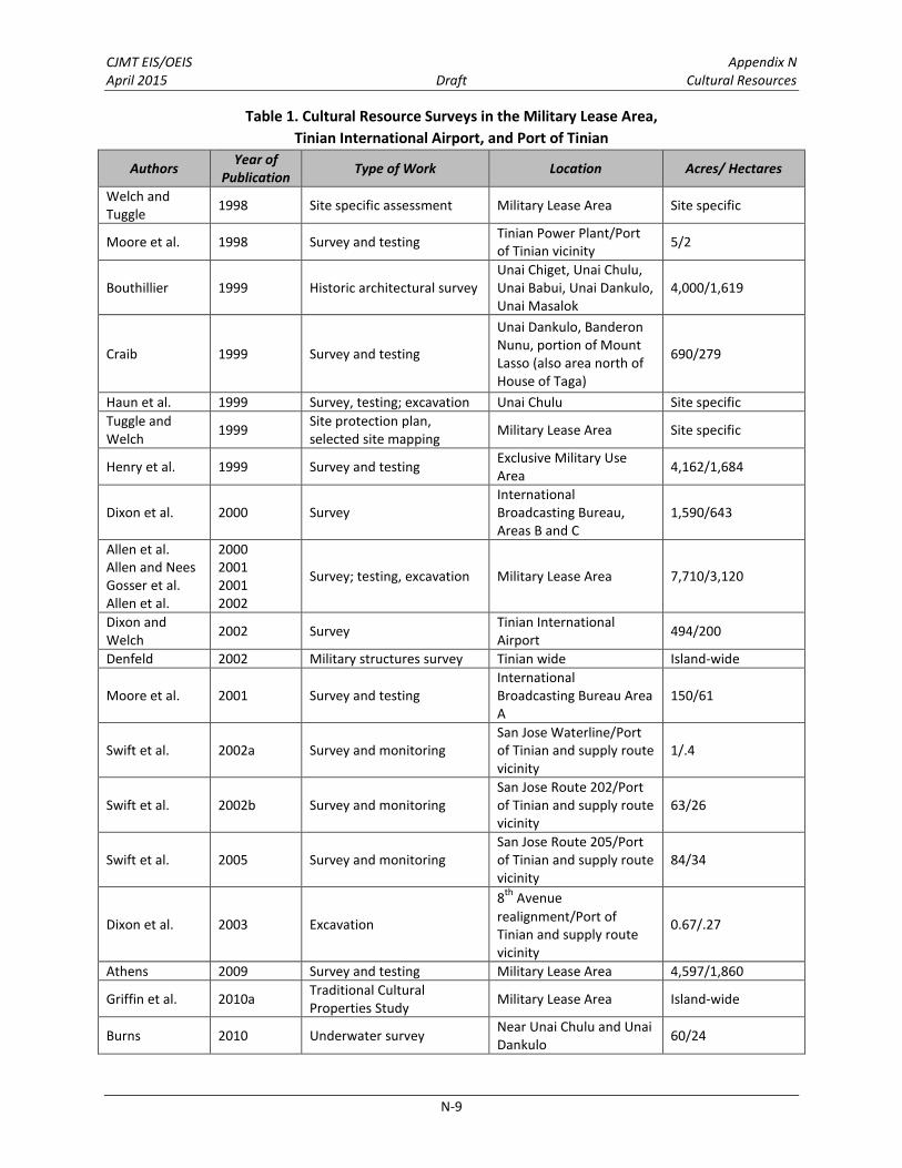
CJMT EIS/OEIS Appendix N April 2015 Draft Cultural Resources
N-9
Table 1. Cultural Resource Surveys in the Military Lease Area,
Tinian International Airport, and Port of Tinian
Authors Year of
Publication Type of Work Location Acres/ Hectares
Welch and Tuggle
1998 Site specific assessment Military Lease Area Site specific
Moore et al. 1998 Survey and testing Tinian Power Plant/Port of Tinian vicinity
5/2
Bouthillier 1999 Historic architectural survey Unai Chiget, Unai Chulu, Unai Babui, Unai Dankulo, Unai Masalok
4,000/1,619
Craib 1999 Survey and testing
Unai Dankulo, Banderon Nunu, portion of Mount Lasso (also area north of House of Taga)
690/279
Haun et al. 1999 Survey, testing; excavation Unai Chulu Site specific
Tuggle and Welch
1999 Site protection plan, selected site mapping
Military Lease Area Site specific
Henry et al. 1999 Survey and testing Exclusive Military Use Area
4,162/1,684
Dixon et al. 2000 Survey International Broadcasting Bureau, Areas B and C
1,590/643
Allen et al. Allen and Nees Gosser et al. Allen et al.
2000 2001 2001 2002
Survey; testing, excavation Military Lease Area 7,710/3,120
Dixon and Welch
2002 Survey Tinian International Airport
494/200
Denfeld 2002 Military structures survey Tinian wide Island-wide
Moore et al. 2001 Survey and testing International Broadcasting Bureau Area A
150/61
Swift et al. 2002a Survey and monitoring San Jose Waterline/Port of Tinian and supply route vicinity
1/.4
Swift et al. 2002b Survey and monitoring San Jose Route 202/Port of Tinian and supply route vicinity
63/26
Swift et al. 2005 Survey and monitoring San Jose Route 205/Port of Tinian and supply route vicinity
84/34
Dixon et al. 2003 Excavation
8th
Avenue
realignment/Port of Tinian and supply route vicinity
0.67/.27
Athens 2009 Survey and testing Military Lease Area 4,597/1,860
Griffin et al. 2010a Traditional Cultural Properties Study
Military Lease Area Island-wide
Burns 2010 Underwater survey Near Unai Chulu and Unai Dankulo
60/24

CJMT EIS/OEIS Appendix N April 2015 Draft Cultural Resources
N-10
Table 1. Cultural Resource Surveys in the Military Lease Area,
Tinian International Airport, and Port of Tinian
Authors Year of
Publication Type of Work Location Acres/ Hectares
Fowler et al. 2010 Cultural Landscape study North Field National Historic Landmark
Site specific
Thursby 2010 Architectural survey Tinian Port Site specific
Carson 2014 Excavation House of Taga/Port of Tinian vicinity
Site specific
DoN 2014a Traditional Cultural Properties Study
Military Lease Area Island-wide
DoN 2014b Survey Tinian Port/roads 79/32
DoN 2015 Survey Tinian Port/roads 7.8/3.2 Legend: DoN = Department of Navy.
Military Lease Area
Approximately 98% of the Military Lease Area has been surveyed for archaeological resources with only
a portion of the property leased by the International Broadcasting Bureau on the western side of the
island, yet to be surveyed. Systematic recording of archaeological sites in the Military Lease Area began
in the 1980s. Since that time, archaeological surveys of varying intensities have covered the entire
Military Lease Area. Athens (2009) surveyed over 15,000 acres (6,070 hectares) by systematic ground
surveys with detailed site recording. Several architectural studies have also been conducted, beginning
in the 1980s; however, much of the built environment comprises relict World War II structures, which
are classified as archaeological resources. There are few intact structures or buildings. Most
architectural studies have concentrated on military structures or specific areas, such as the North Field
(Denfeld 1983, 2002; Jones 1991; Bouthillier 1999; Fowler et al. 2010). With the exception of the cultural
landscape report for the North Field National Historic Landmark, information on other structures within
the Military Lease Area is incorporated into archaeological site records and reports.
The previous archaeological, cultural, and historical studies have resulted in the identification of 356
archaeological sites. Of these 356 sites, 2 are listed in the National Register of Historic Places (the North
Field National Historic Landmark [including the Tinian Landing Beaches and Ushi Point Field] and the
Unai Dankulo petroglyphs), 319 are considered eligible for listing, and 31 are not eligible for the National
Register of Historic Places. Recorded sites include Pre-Contact Chamorro, Spanish Administration, pre-
World War II Japanese Administration, American and Japanese World War II, and post-World War II
American military, as well as various agricultural sites.

NorthField
MountLasso
Tinian InternationalAirport
San Jose
Tinian Harbor
Unai Chulu
Unai Lam Lam
Unai Chiget
Unai Masalok
LakeHagoi
Unai Babui
Unai Dankulo
InternationalBroadcastingBureau
Figure 1Cultural Resource Surveys
within the Area of Potential Effects on Tinian0 1 20.5
Miles
0 1 20.5Kilometers
LegendMilitary Lease Area
Previous SurveysSpoehr 1957Donham 1986Moore et al. 1986Haun 1988Haun 1989Haun and Donham 1989a, bHaun et al. 1990Craib 1995Franklin and Haun 1995aFranklin and Haun 1995bHenry and Haun 1995Eblé et al. 1997Putzi et al. 1997Athens and Ward 1998Craib 1998Haun et al. 1999Moore et al. 1998Craib 1999Henry et al. 1999Dixon et al. 2000Moore et al. 2001Allen et al. 2002Dixon and Welch 2002Swift et al. 2002aSwift et al. 2002bDixon et al. 2003Swift et al. 2005Athens 2009Burns 2010Carson 2014DoN 2014bJones 1991Thursby 2010
NN-11
CJMT EIS/OEIS Appendix N April 2015 Draft Cultural Resources
N-12
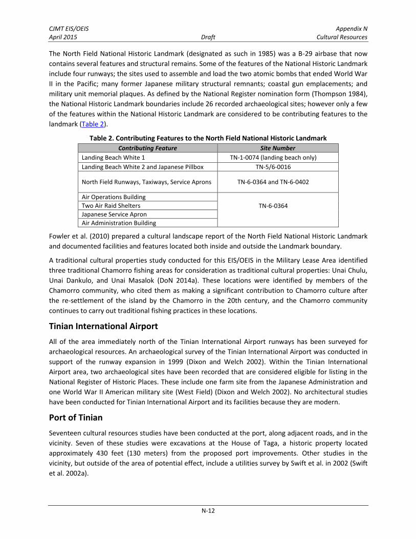
The North Field National Historic Landmark (designated as such in 1985) was a B-29 airbase that now
contains several features and structural remains. Some of the features of the National Historic Landmark
include four runways; the sites used to assemble and load the two atomic bombs that ended World War
II in the Pacific; many former Japanese military structural remnants; coastal gun emplacements; and
military unit memorial plaques. As defined by the National Register nomination form (Thompson 1984),
the National Historic Landmark boundaries include 26 recorded archaeological sites; however only a few
of the features within the National Historic Landmark are considered to be contributing features to the
landmark (Table 2).
Table 2. Contributing Features to the North Field National Historic Landmark
Contributing Feature Site Number
Landing Beach White 1 TN-1-0074 (landing beach only)
Landing Beach White 2 and Japanese Pillbox TN-5/6-0016
North Field Runways, Taxiways, Service Aprons TN-6-0364 and TN-6-0402
Air Operations Building
TN-6-0364
Two Air Raid Shelters
Japanese Service Apron
Air Administration Building
Fowler et al. (2010) prepared a cultural landscape report of the North Field National Historic Landmark
and documented facilities and features located both inside and outside the Landmark boundary.
A traditional cultural properties study conducted for this EIS/OEIS in the Military Lease Area identified
three traditional Chamorro fishing areas for consideration as traditional cultural properties: Unai Chulu,
Unai Dankulo, and Unai Masalok (DoN 2014a). These locations were identified by members of the
Chamorro community, who cited them as making a significant contribution to Chamorro culture after
the re-settlement of the island by the Chamorro in the 20th century, and the Chamorro community
continues to carry out traditional fishing practices in these locations.
Tinian International Airport
All of the area immediately north of the Tinian International Airport runways has been surveyed for
archaeological resources. An archaeological survey of the Tinian International Airport was conducted in
support of the runway expansion in 1999 (Dixon and Welch 2002). Within the Tinian International
Airport area, two archaeological sites have been recorded that are considered eligible for listing in the
National Register of Historic Places. These include one farm site from the Japanese Administration and
one World War II American military site (West Field) (Dixon and Welch 2002). No architectural studies
have been conducted for Tinian International Airport and its facilities because they are modern.
Port of Tinian
Seventeen cultural resources studies have been conducted at the port, along adjacent roads, and in the
vicinity. Seven of these studies were excavations at the House of Taga, a historic property located
approximately 430 feet (130 meters) from the proposed port improvements. Other studies in the
vicinity, but outside of the area of potential effect, include a utilities survey by Swift et al. in 2002 (Swift
et al. 2002a).

CJMT EIS/OEIS Appendix N April 2015 Draft Cultural Resources
N-13
Ten studies have been conducted within or near the area of potential effects, including locations of the
port improvement projects and the munitions supply route and tracked vehicle transit lanes. In 1984,
the Harbor Breakwater was briefly described as part of a survey of historical resources conducted by the
Department of Navy (DoN) within the Military Lease Area. Due to its diminished integrity, the Harbor
Breakwater was not recommended for nomination to the National Register of Historic Places (Jones
1991). In 2008, an architectural survey and archival study for the entire Port of Tinian, which included all
structures along the wharf or quay, was conducted (Thursby 2010). Although these structures have
deteriorated, the remnant architectural features, such as the breakwater and portions of the quay, are
considered to be eligible for listing in the National Register of Historic Places as part of an archaeological
site for their association with World War II.
Archaeological surveys of 6th and 8th Avenues were conducted by Franklin and Haun (1995), Henry and
Haun (1995), Moore et al. (1986, 1998), Swift et al. (2002b, 2005), and Athens (2009). Additional
archaeological surveys were conducted in 2014 and 2015 along portions of training and support facilities
that extended from the Port to the Military Lease Area along 6th and 8th Avenues (DoN 2014b, 2015).
Roadways leading from the Port of Tinian to the Military Lease Area would be used for munitions supply
routes and tracked vehicle transit lanes. There are 13 sites on these roads. Eight of the sites are eligible
for listing in the National Register of Historic Places and five sites are not eligible.
2.2 PAGAN
Historical Overview 2.2.1
The basic chronology on Pagan is similar to the chronology presented for Tinian; however, the specific
history of Pagan is not well documented because of its relative isolation from the larger Mariana Islands
to the south, where Spanish exploration and settlement was focused (Athens 2011). General
background information on the Pre-Contact and Post-Contact history was predominately derived from
Athens (2009) and presented in detail in Section 2.2.2, Previous Studies and Recorded Cultural
Resources.
The chronology of early settlement on Pagan is currently based upon three radiocarbon-dated contexts
from one latte site above Regusa Beach (Egami and Saito 1973), and four radiocarbon-dated strata from
one shovel test at a latte site above Apansanmena Beach (Athens 2009). Taken together, these dates
appear to reflect Latte Period occupation of prime coastal settings around Mount Pagan from at least
700 years ago into the early historic period.
Noticeably absent from the archaeological record of Pagan are surface pottery scatters and evidence of
Pre-Latte Period settlement. The absence of pottery scatters may be explained by the depth of historic
to modern ash or cinder falls and lava covering much of the slopes of Mount Pagan, as well as the high
degree of disturbance related to Japanese-era agricultural endeavors on all but the steepest slopes in
the north half of the island. The lack of evidence of Pre-Latte Period habitation on Pagan may be
attributable to the fact that sea levels were about 6 feet (1.8 meter) higher 1,000 years ago (Dickinson
2000), so that the beach settings so attractive to early settlers were likely too narrow and abrupt to
encourage permanent settlement.

CJMT EIS/OEIS Appendix N April 2015 Draft Cultural Resources
N-14
Current knowledge of Pre-Contact sites on Pagan implies that much of the terrain with arable soils, of
under 15% slope and with access to the coast, was likely used by inhabitants of Latte Period villages
(Athens 2009, 2011). They also practiced horticulture or gathering and hunting of native plants and
animals in the nearby dense forests. “Traditional horticulture probably was reasonably productive with
the major caveat that it would have been subject to potentially severe droughts” (Athens 2011 p. 117).
Seventy-six latte sites with scattered lusongs or occasional boulder grinding stones have been recorded
on the slopes of Mount Pagan above prominent beaches such as Regusa, Apansantate, Apansanmena,
and Palapala. All of these locations had reliable access to beaches for launching outrigger sailing vessels
or fishing canoes. Recent surveys of rugged interior settings (DoN 2014c) and more inaccessible coastal
settings (Higelmire and DeFant 2013) suggest some marginal locations with pockets of sheltered
resources may also have been used, although most such areas were avoided.
The Spanish explorer Magellan made the first European contact with the Mariana Islands in 1521, and
Pagan was claimed by Spain 1565. The indigenous Chamorro continued to inhabit the islands with little
external interference well after initial contact with Spain. European trade goods, along with foreign
diseases, probably reached most communities in the Marianas, but prior to the late 1600s, there are few
documentary sources on the population of the Marianas, and none specific to Pagan.
In 1668, Spanish Jesuit missionaries, who had established a mission on Guam, came to the Northern
Mariana Islands. Though the Jesuit priest in charge of the Mariana Islands mission, Father Diego Luis de
Sanvitores, renamed each of the Mariana Islands with Spanish names, use of the traditional Chamorro
names persisted on the islands with a permanent population (Russell 1998). Pagan was probably
populated by the Chamorro at this time, as were the islands of Guam, Rota, Saipan, and Tinian (Athens
2011). Opposition to the missionaries soon arose in the Marianas populace, which led to open revolt
against the priests and Spanish troops. Sporadic conflicts continued until 1694, when, as a last measure,
the Spanish transported inhabitants of all the islands to either Saipan or Guam. This forced relocation
program was called the reducción by the Spaniards. Pagan was depopulated in 1697 by the Spanish fleet
organized for the forced reducción of the Mariana Islands by Governor Madrazo. A significant loss of the
island’s population occurred when seven canoes carrying Pagan residents to Saipan were lost in a
typhoon (Russell 1998). Those who survived the voyage were initially sent to Saipan and later forced to
move to Guam in 1698 (Driver 1983; Hezel 1989).
No documentary sources have been found describing the indigenous population in detail during the
Spanish colonial period. Pagan was officially resettled for the first time post-reducción in 1865 as 265
Carolinians were brought in from Pulusuk to produce copra for a fledgling agricultural concern named La
Sociedad Agrícola de la Concepción; the operation was not profitable and ended in 1869 (Spence 1993).
In 1887, Antoine-Alfred Marche (1982 p. 20), a French explorer, ethnographer, and scientist observed,
“On Pagan, there are only a few Carolinians settled there to harvest coconuts, which trade is carried on
by Captain William.”
After Spain’s defeat in the Spanish-American war, Guam became a U.S. territory and Spain sold the
Northern Mariana Islands to Germany in 1899. From then on the Northern Mariana Islands remained
politically and administratively separate from Guam. The German administration (1899 to 1914)
continued its efforts to expand the copra industry, although its success was limited due to damaging
typhoons. In 1905, there were an estimated 32,000 coconut palms on Pagan, and by 1912, 951 acres
(385 hectares) were dedicated to copra production (Spennemann 1999). The Germans encouraged

CJMT EIS/OEIS Appendix N April 2015 Draft Cultural Resources
N-15
cultivation of land and diversification of crops, requiring property owners to farm a quarter-hectare plot
at minimum.
Beginning in 1914, the Japanese Navy occupied the German Micronesian Islands. From the Japanese
military, the administration of these islands was turned over to a Japanese civilian entity called South
Seas Bureau in 1922, which continued the production of copra and intensive agricultural practices of the
German administration. Large quantities of sweet potatoes were grown and exported. Due to an
increasing need for labor on Pagan, the population in 1923 rose to 137 with 134 “islanders” (Chamorro
and Carolinians) and 3 Japanese. The Japanese also built a factory for dried bonito (a Pacific-region fish)
near Shomshon Bay and this industry brought Japanese fishermen and their families from Saipan to
Pagan.
During the 1930s, major economic activities included coconut tree plantations and a small dried bonito
factory along Shomshon Bay. The South Seas Bureau established a branch weather station south of
Laguna Lake in November 1936. In December 1938, the Japanese military converted the weather station
to a Navy Hydrographic Department Weather Station. With the outbreak of war, the station provided
weather forecasts to Japanese military ships and planes. Installation of a government wireless
communication system occurred in 1938; a steel tower in Shomshon and a police substation were built
as late as 1939; and in April 1940, the first school on Pagan opened near the Pagan Jinja (a Shinto shrine)
in Gayapa. By 1940, the “town” had been formed and included a pastry store, tofu store, coffee shop,
and a brothel on the inner landside. There was a church and graveyard near the Chamorro village. There
was no piped water on the island, but there were water tanks at the weather station, Nan’kō Suisan,
and Nan’yō Bōeki. Additionally, each family collected rainwater from their roofs because well water
could not be used for drinking.
Construction of an airfield by the Japanese was first initiated in early 1933 to support naval maneuvers
scheduled later that year. For military secrecy, it was externally referred to as a “place for drying fishing
nets.” A larger-scale construction effort began in September 1938 for use of large ground attack planes.
In 1939, after cutting part of a hill for the extended runway, the airfield was constructed, but it was only
suitable for smaller aircraft. Also in 1939, a pier for loading and unloading ships was built, as was a
barracks near the airfield. By August 1941, a hangar and several water systems, including a concrete
water storage tank, pond, water supply pond, a filtration plant, the runway, oil tank, and bomb storage
area were completed or under construction.
By 1944, there was only one main road and a number of branch roads established on Pagan. The main
road for military use ran south of the airfield below the caldera escarpment, to the west it extended to
Shomshon Bay, curved around the west end of the airfield, and then went to the small peninsula, ending
at the base of the cliff at Gunkanjima (Puntan Bandera), where it connected to the pier. A branch road
also went north from the west end of the airfield to Shomshon town, the steel communication tower,
the dried bonito factory, the weather station, and the Chamorro village near Lake Laguna. The National
School, civilian residences, and stores were also located along this branch and other side branches.
Although Pagan was under the Japan Fifth Special Base Force in Saipan, there were no defense
installations except for the airfield until early 1944. The Japanese Army constructed anti-aircraft gun
positions, 70-millimeter battalion guns, anti-tank guns, and mountain guns, as well as expanding the
airfield. On June 12, 1944, U.S. air raids began on Pagan and the barracks, a hangar, and runway were

CJMT EIS/OEIS Appendix N April 2015 Draft Cultural Resources
N-16
destroyed. Following the surrender of the Japanese, U.S. forces occupied Pagan from 1945 to the early
1950s, with U.S. Marines occupying a camp at the north end of lower Lake Laguna (Corwin et al. 1957).
Since 1951, Pagan has been inhabited sporadically by Chamorro and Carolinians from Saipan and
Agrigan. Island residents continued to harvest copra and engaged in a largely subsistence style of living
until 1981 (Athens 2009) when they were evacuated after Mount Pagan’s eruption. The residents were
taken to Saipan, and since then Pagan has not been resettled because of public safety concerns
involving a lack of ability to provide adequate emergency services for the island. Unofficially, a few
people continue to visit the island.
Previous Studies and Recorded Cultural Resources 2.2.2
Eight cultural resource investigations have been conducted on Pagan. These investigations include a
historical overview, site photo documentation, intensive and reconnaissance level surveys, limited
excavations, and traditional cultural properties studies (see Table 3). Extensive research of archives in
the U.S., Japan, and Micronesia, including references to collections of historical maps and photographs,
supplemented the fieldwork. Figure 2 shows previous cultural resources survey locations on Pagan.
Approximately 60% of the island is covered in lava or has topography with slopes greater than 30%,
which are unlikely to contain historic properties. Of the areas with less than 30% slope, approximately
33% of Pagan has been surveyed for archaeological resources. However, many of these areas are in the
central portion of the island and are not located near coastlines where most sites tend to be found.
Unsurveyed areas with the potential to contain historic properties occur primarily in the southern
portion of Pagan. To provide information on unsurveyed areas, archaeological surveys were
supplemented by aerial inspections and oral history interviews with former residents, which included
additional information on the presence of Pre-Contact villages and other resources of cultural
importance in the area (Athens 2009; DoN 2014c).
Table 3. Cultural Resource Surveys on Pagan
Authors Year of
Publication Type of Work Location Acres/Hectares
Egami and Saito
1973 Site recording and excavations Regusa, Apansantate, Parialu, and Talage (Taragie)
Site specific
Marche 1982 Observation made in 1882 by Marche and translated by Chang
Pagan Island-wide
Wells 1997 Site photo documentation Pagan Island-wide
Athens 2009 Surveys; oral histories, Japanese era history
Pagan 1,853/750
Griffin et al. 2010b Traditional cultural properties study
Pagan Island-wide
Higelmire and DeFant
2013 Survey and monitoring Pagan 69/28
DoN 2014c Survey Pagan Pedestrian: 245/99 Visual: 1,510/611
DoN 2014d Traditional cultural properties study
Pagan Island-wide

North Beach
Gold BeachSouth Beach
Green Beach
Blue Beach
South PaganVolcano
MountPagan
LagunaSanhiyon
LagunaSanhalom
Kutake Yashi
Mount Maru
Mount Togari
Minami Saki(South Point)
PhilippineSea
PacificOcean
Red Beach
Legend0 - 30% SlopeGreater than 30% SlopeHistoric Era Lava FlowOpen Water
Cultural Resource SurveysAthens 2009Egami and Saito 1973Higelmire and DeFant 2013DoN 2014c: Pedestrian SurveyDoN 2014c: Visual Survey
0 1 20.5Miles
0 1 20.5Kilometers
Figure 2 Cultural Resource Surveys on Paganwithin the Area of Potential Effects N
N-17

CJMT EIS/OEIS Appendix N April 2015 Draft Cultural Resources
N-18
The first mention of Pagan archaeology was from French naturalist Antoine-Alfred Marche in 1887
(Marche 1982 p. 21). In the early 1970s, Egami and Saito documented several latte at the Regusa,
Apansantate, Parialu, and Talage (Taragie) sites (Egami and Saito 1973). This team conducted
excavations over a 3-week period in 1972 to 1973 at the Regusa site, located on the southeastern shore
of Mount Pagan.
In 1994, and also during the last decade, brief field reconnaissance surveys have been conducted on
Pagan by staff members of the CNMI Historic Preservation Office (Athens 2009). The 1994 survey
documented a Japanese site and the other surveys have verified previously known latte sites and
identified one previously unreported latte site near the center of the island. Wells (1997) visited and
photographed archaeological sites throughout the island from 1977 through 1996 and documented site
conditions.
In 2008, an archaeological survey was conducted on Pagan (Athens 2009). The survey included
approximately 247 acres (100 hectares) near the airfield and about 1,606 acres (650 hectares) in the
central part of the island (see Figure 2). The survey identified 171 sites.
In 2013, the U.S. Army Engineer Research and Development Center and the U.S. Geological Survey
conducted a reconnaissance survey and monitoring of a 17.3-mile (27.8-kilometer) corridor surrounding
the northern caldera, along the northern, northeastern, and western sides, and along the island’s
isthmus (Higelmire and DeFant 2013). All areas coincided with existing roads/trails. The survey identified
four new archaeological sites, including three World War II Japanese defensive sites and one Pre-
Contact habitation site.
As part of this EIS/OEIS, 245 acres (99 hectares) were intensively surveyed with pedestrian transects and
1,510 acres (611 hectares) were visually inspected from vantage points on the ground or aloft from a
helicopter (DoN 2014c). As most of this area contained steep topography and was located away from
the coast, few sites were identified and primarily consisted of World War II Japanese defensive sites.
Archaeological surveys at Pagan have identified 181 sites (Athens 2009; Higelmire and DeFant 2013;
DoN 2014c). The archaeological sites include 25 Pre-Contact sites, 155 Post-Contact sites, plus 1 site
with a single feature that was not determinable. Of the 181 sites, 110 were evaluated and
recommended eligible for listing in the National Register of Historic Places and 71 were recommended
not eligible.
No Post-Contact sites pre-dating the 20th century were identified. Numerous sites dating to the World
War II era or to the pre-World War I Japanese occupation were identified (Athens 2009; Higelmire and
DeFant 2013; DoN 2014c). Pre-Contact sites dating to the late Latte Period primarily consist of latte
structures of coral or basalt and grinding stones or lusong. There are also cobble pavements, upright
stone alignments, possible medicine grinding stones, a latte quarry, and a site with dark organic soil and
midden (i.e., food remains), all likely associated with the same general period of traditional Chamorro
occupation (Athens 2009). These sites are found in relatively sheltered areas, with a fringing reef and
beach access to launch fishing canoes, and leeward of prevailing trade winds during the majority of the
year.
In addition to recorded archaeological sites, former Pagan residents identified a number of areas in the
southern portion of the island that contained the remains of village sites (Athens 2009).

CJMT EIS/OEIS Appendix N April 2015 Draft Cultural Resources
N-19
Archaeological surveys have recorded remnants of a few standing structures, such as cisterns and
bunkers (Athens 2009; DoN 2014c). Most of the Post-Contact sites and features pertained to the
Japanese military occupation of Pagan both prior to and during World War II. These sites include
concrete water cisterns, defensive tunnels, bunkers and lookouts, air raid shelters, building foundations,
traditional cooking ovens, the Naval airfield and hangar with a drainage and reservoir system, barracks,
airplane wreckage and parts, the remains of a meteorological tower, shoreline piers, possible tank trap
berms, and traditional Japanese cemeteries, monuments, and shrines.
A traditional cultural properties study was conducted in 2014 (DoN 2014d) and recommended six
potential traditional cultural properties on Pagan—traditional fishing areas at South (Regusa) Beach, Red
(Shomshon) Beach, Paliat, and Apansanmena, and traditional healing locations at Pialama and a
mortar/medicine stone. Local place names for beaches and lakes are presented in Table 4.
Table 4. Local Place Names
Map Place Name Local Place Name
Blue Beach Apan
Gold Beach Dikiki (or Unai Dikidiki)
Green Beach Palapala
Lower Lake Laguna Sanhiyon
North Beach Tarague/Talagie
Red Beach Shomshon
South Beach Regussa/Regusa
South Point Minami Saki
Upper Lake Laguna Sanhalom
Resources of cultural importance include a variety of medicinal plants, including fofgo (morning glory
vine), gàso’so’ (type of bush), puntan talisai (tips of Terminalia catappa), galak (Asplenium nidus, a fern),
niyok (coconut), Flores Mayu (a flower), and ahgao (Premna obtusifolia, a tree). Gathering locations for
these plants are widely dispersed across the island, and occur in upland settings and along clifflines
adjacent to the shore. Beaches and near-shore reefs used as traditional fishing areas occur along the
coast. There are also named locations for the gathering of resources such as gaddo’ (wild yam), gapgap
(arrowroot), suni (taro), pugua (betel nut), dagu (yams), and kahet (oranges). These are dispersed
resource patches that tend to cluster along the southwestern and eastern coasts of the island.
Shomshon Bay is used for mortuary practice. The gathering of betel nuts as a cultural practice occurs in
certain locations along the steep slopes on the isthmus and is associated with marriage rituals.
CULTURAL RESOURCES ENVIRONMENTAL CONSEQUENCES 3.0
Under NEPA, the significance of an impact to a cultural resources is driven by the context and intensity
of the effects associated with the action. According to Section 106 of the National Historic Preservation
Act, adverse effects to historic properties can be caused by alteration or loss of certain aspects or
character-defining features of a historic property that contribute to its significance. Adverse effects may
result from direct impacts such as physical destruction or damage to a historic property, as well as
indirect impacts such as public access restrictions, or changes in setting through visual or audible
intrusions when these characteristics are important to the significance of the resource. Several factors

CJMT EIS/OEIS Appendix N April 2015 Draft Cultural Resources
N-20
need to be considered to identify and evaluate potential impacts on historic properties and other
resources of cultural importance in each alternative.
In the following discussion, the impact analysis is described by range complex, the Military Lease Area-
wide proposals, and the projects associated with the proposed action that are located outside of the
Military Lease Area. The discussion includes information on the types of activities proposed for each
location, the types of impacts that could occur, and the specific historic properties that would be
affected.
Department of Defense actions within this area are currently covered by two Programmatic
Agreements—one for military training activities relating to the Mariana Islands Range Complex EIS/OEIS
(DoN 2010a), and one for the Guam and CNMI Military Relocation EIS (DoN 2010b) to establish four
ranges on Tinian. If an action alternative is selected, then a new Section 106 of the National Historic
Preservation Act programmatic agreement would be signed and implemented to resolve adverse effects
to historic properties. The programmatic agreement for this proposed action would reference the
Mariana Islands Range Complex EIS/OEIS programmatic agreement and supersede the Tinian-specific
portions of the Guam and CNMI Military Relocation EIS programmatic agreement. If the no-action
alternative were selected, then Tinian-specific stipulations in the Guam and CNMI Military Relocation
Programmatic Agreement (Department of Defense 2011) would be implemented. Section 106
consultation for the current proposed action was initiated on April 20, 2013 and will be completed prior
to publication of the Final EIS/OEIS.
3.1 METHODOLOGY
Approach to Analysis 3.1.1
The cultural resources impact analysis addresses potential effects to historic properties (districts, sites,
buildings, structures, or objects that are listed in or considered eligible for listing in the National Register
of Historic Places). The analysis also considers potential impacts to other kinds of resources that may not
be eligible for the National Register of Historic Places, including cultural practices, cemeteries,
memorials, sacred sites, or medicinal plants. The Tinian and Pagan Range and Training Areas (RTAs) and
their associated support facilities/infrastructure construction footprints (described in Chapter 2,
Proposed Action and Alternatives in the EIS/OEIS) were examined in relation to locations of historic
properties and resources of cultural importance using Geographic Information System to identify
potential impacts due to construction and operations. Training area disturbance footprints were also
accounted for to ensure that the full range of potential impacts was identified. Under the proposed
action, impacts may be either direct or indirect and are distinguished as follows.
Direct impacts occur at the same place and/or time as actions generated by proposed construction (e.g.,
ground-disturbing activities) and operations (e.g., range use). These impacts may include, but are not
limited to, the following:
Physical destruction, damage, or alteration
Ground disturbances such as excavating, filling, grubbing (i.e., use of heavy equipment to
remove vegetation), and vegetation maintenance (i.e., trimming vegetation, mowing grass,
limbing trees)

CJMT EIS/OEIS Appendix N April 2015 Draft Cultural Resources
N-21
Demolition
Direct impacts from construction ground disturbance and operational vegetation clearing were assumed
within all areas labeled as facility footprints in Chapter 2, Proposed Action and Alternatives, and as
“Vegetation Maintenance” in Appendix F, Geology and Soils Technical Memo in the EIS/OEIS. Vegetation
clearance, including grubbing, would occur in areas such as along roads, Convoy Course engagement
areas, Tracked Vehicle Driver’s Course, objective areas, and target areas (e.g., Range Complex A).
Indirect impacts are caused by or result from project- or operation-related activities, occur usually later
in time or space, and are reasonably foreseeable. Potential causes of indirect impacts include, but are
not limited to, the following:
Reducing public access to historic properties and resources of cultural importance
Changes in setting through visual or audible intrusions when these characteristics are important to the significance of the resource
Potential increase in erosion and ground disturbance related to project-related activities
Deferred monitoring or stabilization of sites, if needed, while ranges are in operation
The process for identifying and evaluating the significance of the impact is determined by the magnitude
and nature of the action; the nature and extent of potential effects on historic properties and resources
of cultural importance; and the likely nature and location of historic properties and resources of cultural
importance within areas that may be affected. Under the National Historic Preservation Act, adverse
effects result from the direct loss of character-defining features and/or aspects of integrity of a historic
property. Under NEPA, significant impacts to resources of cultural importance could occur if the
characteristics that make the resource important to the culture are altered. If significant impacts were
determined, then mitigation may be proposed to minimize or mitigate the adverse effects or impacts.
In Section 4.11, Cultural Resources, NEPA terminology, such as significant direct impacts, less than
significant impacts, or no impacts were used to describe the effects of the proposed action on historic
properties. In this appendix, terminology associated with Section 106 of the National Historic
Preservation Act will be used when examining project effects to historic properties. This terminology
includes adverse effect, no adverse effect, or no effect. When discussing resources of cultural
importance, the NEPA terminology will be used.
Resource Management Measures 3.1.2
Several resource management measures were incorporated during the planning stages of the project
and have been incorporated into the proposed action to reduce impacts to historic properties and
resources of cultural importance. Resource management measures applicable to cultural resources
include the following:
Avoidance and Minimization Measures
To the degree possible, historic properties and resources of cultural importance were avoided
when planning initial construction and operations areas for the proposed action. This included
moving target locations, firing positions, engagement zones, and Surface Radar sites, and
moving the High Hazard Impact Area boundaries to avoid the North Field National Historic
Landmark. The Department of Defense also minimized construction associated with the use of

CJMT EIS/OEIS Appendix N April 2015 Draft Cultural Resources
N-22
Amphibious Assault Vehicles to a certain beach, and sited roads and construction laydown areas
to avoid impacting historic properties where feasible. Construction was avoided on the historic
runways in the North Field National Historic Landmark and use of tracked vehicles was avoided
on historic roads associated with the landmark. The Department of Defense will further avoid
impacts to historic properties and resources of cultural importance during construction and
operations through troop education, marking of sensitive areas, repairing roads, and policing
areas at the completion of exercises.
On Tinian and Pagan, if beach sand is compacted or displaced by landing craft so that the natural
appearance of the beach has been altered, the beach topography will be restored within 3 days
of the exercise using non-mechanized methods (e.g., rakes or other hand tools).
Specific measures for avoiding and minimizing impacts to historic properties will be stipulated in
a Programmatic Agreement regarding the current undertaking. These measures include
implementation of the Secretary of the Interior’s Standards for Rehabilitation for all
maintenance and repair of runways for the North Field Historic Landmark and the evaluation of
archaeological resources found during construction or operations. The Department of Defense
would follow standard operating procedures as outlined in the agreement document for
inventorying areas or properties that have not been inventoried.
Best Management Practices and Standard Operating Procedures
Best management practices and standard operating procedures that are applicable to cultural resources
are listed below and described in Appendix D, Best Management Practices.
Best management practices for erosion control, Spill Prevention, Control and Countermeasures
Plans, Facility Response Plans, and Hazardous Materials Management Plans will be implemented
to prevent indirect impacts to historic properties during construction and operations from
potential contaminants and sediments. A Fire Prevention and Management plan will be
implemented to minimize fire risk from training activities that could have an indirect impact to
historic properties and resources of cultural importance.
The Department of Defense would implement a Range Training Area Management Plan that
would include stipulations to adhere to protection measures established in cultural resource
management plans and implement a monitoring program for minimizing groundwater
contamination. Through the Range Environmental Vulnerability Assessment program, the
Marine Corps will identify potential release of munitions constituents and develop additional
best management practices at the ranges to minimize off-site contamination.
A complete listing of best management practices is provided in Appendix D, Best Management Practices
of the EIS/OEIS.

CJMT EIS/OEIS Appendix N April 2015 Draft Cultural Resources
N-23
3.2 TINIAN
Tinian Alternative 1 3.2.1
3.2.1.1 Construction Impacts
As described in Chapter 2, Section 2.4, Tinian Alternatives, Tinian Alternative 1 RTA (Range and Training
Areas) development and construction would include construction and improvements for support
facilities and infrastructure (e.g., base camp, airport, port, Munitions Storage Area, roadways, utilities)
and training facilities (e.g., Range Complexes A, B, C, D, and Military Lease Area-wide training assets).
These activities would result in ground disturbance (e.g., vegetation clearing, grubbing, grading,
excavation, and filling), and potentially affect historic properties and resources of cultural importance.
In total, 1,902 acres (771 hectares) of ground disturbance would occur under Tinian Alternative 1.
Specific vegetation clearance areas within Range Complexes A, B, C, and D; the Landing Zone within
Range Complex D; and the Military Lease Area-wide training assets are discussed in Section 4.2, Geology
and Soils, and Appendix F, Geology and Soils Technical Memo, in the EIS/OEIS. Table 5 summarizes the
historic properties affected by construction activities associated with Tinian Alternative 1. Specific
adverse effects to historic properties and impacts to resources of cultural importance are described in
more detail by RTA or construction project.
Table 5. Tinian Alternative 1 Summary of Direct Adverse Effects on
Historic Properties from Construction
Complex Range Number of
Historic Properties
Range Complex A High Hazard Impact Area 20
Range Complex B Multi-Purpose Training Range, Combat Pistol Range, Anti-Armor Tracking Range, Battle Site Zero Range
9
Range Complex C Infantry Platoon Battle Course, Field Fire Range, Multi-Purpose Automated Unknown Distance Range
14
Range Complex D Northern Battle Area Complex, Urban Assault Course
3
Military Lease Area-wide Training Assets and Support Facilities Outside of the Range Complexes
Convoy Course Engagement Areas 8
Munitions Storage Area 3
Roads, Fences, and Utilities, Tracked Vehicle Driver’s Course
86
Base Camp 1
Tactical Amphibious Training Areas 3
Landing Zones, Artillery Firing Points, Observation Posts, Surface Radar Sites
19
Outside Military Lease Area
Tinian International Airport 2
Port of Tinian 0
Tracked Vehicle Transit Lanes/Supply Route 4
Total 172

CJMT EIS/OEIS Appendix N April 2015 Draft Cultural Resources
N-24
Range Complex A: Proposed Range Complex A contains a High Hazard Impact Area. Within the High
Hazard Impact Area footprint is a perimeter road, a firebreak/buffer, perimeter road and four ground
ranges: (1) a Live Hand Grenade Range; (2) a Grenade Launcher Range; (3) a Light Anti-armor Weapon
Range; and (4) a Mortar Range (with 10 firing positions). In addition, within the High Hazard Impact Area
are target areas for the ground ranges as well as targets for Indirect Artillery Firing Range (firing
positions are distributed within various locations in the Military Lease Area) and two aviation ranges –
Offensive Air Support Range and Close Air Support Range.
As described in Chapter 2, Section 2.4, Tinian Alternatives, ground disturbance within Range Complex A
would occur within the footprint of the ground ranges as well as within the target areas. Construction-
related activities, such as clearing, grading, excavation, and soil removal associated with construction of
a perimeter road, an access road, and target areas, would directly and adversely affect 20 historic
properties (Table 6) including 3 Pre-Contact sites (1 ceramic scatter, 2 cave sites), 7 pre-World War II
Japanese Administration sites, 4 World War II-era Japanese defensive sites, and 6 World War II American
military sites. Two of these sites include two memorials, the Hinode American Memorial Shrine and the
Nan‘yo Kohatsu Kaisha (NKK) Shrine. Adverse effects would occur to eight historic properties because of
the construction of fences and roads around the perimeter of the High Hazard Impact Area. Since sites
in this area tend to be large and dispersed, complete avoidance is not possible. However, in most cases
only a portion of the site would be affected by construction activities associated with Alternative 1.
Construction would also directly impact 3 acres (1 hectare) of native limestone forest, which could
contain resources of cultural importance, such as medicinal plants. Direct impacts to other cultural
resources of cultural importance would include the disturbance of the two memorials described above.
Indirect effects to historic properties and impacts to resources of cultural importance due to visual
intrusions, access restrictions during construction, and noise increase during construction would not be
adverse as they would be intermittent and temporary. The roundabout, a portion of Broadway Avenue,
which is an entrance to the North Field National Historic Landmark and a contributing feature to the
cultural landscape, would be closed during construction of Range Complex A target objectives. This
closure would be temporary and the effect would not be adverse.
Table 6. Historic Properties Directly Affected by Range Complex A (Construction)
Under Tinian Alternative 1
Temporary Number
CNMI Site Number
Site Description Historic Period (s) NRHP Eligibility
Criteria
NA TN-1/5-0015 Defensive caves Pre-Contact, Japanese Administration
A,C,D
NA TN-1/5-0432 Laderan Chiget Defenses, Rockshelters
Pre-Contact, Japanese Administration
A,C,D
NA TN-1-0441 Ceramic scatter Pre-Contact D
NA TN-4-0007 Asahi (Sunrise) Shrine, Reconstruction
Japanese Administration, American Administration
A,C,D
NA TN-4-0008 NKK Shrine Japanese Administration A,C,D
NA TN-5-0439 Laderan Gatot Defensive Caves Japanese Administration A,D
NA TN-5-0468 Laderan Gagot Defenses Japanese Administration A,D
NA TN-5-0488 Gun position, Fuel Drum, Japanese Defenses
Japanese Administration A,D
NA TN-6-0442 Central Bomb Dump American Administration A

CJMT EIS/OEIS Appendix N April 2015 Draft Cultural Resources
N-25
Table 6. Historic Properties Directly Affected by Range Complex A (Construction)
Under Tinian Alternative 1
Temporary Number
CNMI Site Number
Site Description Historic Period (s) NRHP Eligibility
Criteria
NA TN-6-0471 67th
NCB Camp American Administration A,D
NA TN-6-0478 Fuel Tanks, East H-14-C, North Field
American Administration A,D
NA TN-6-0480A 121st
NCB Camp American Administration A,D
NA TN-6-0489 “C” Battery, 17th
AAA American Administration A,C,D
NA TN-6-0491 Mine Depot Number 4 American Administration D
SC-5031 NA Fourth Farm District (I) Japanese Administration A,D
SC-5056 NA Fourth Farm District (II) Japanese Administration A,D
SC-5059 NA Defensive Complex Japanese Administration A,D
SC-5060 NA Fourth Farm District (VIII) Japanese Administration A,D
SC-5061 NA Fourth Farm District (X) Japanese Administration A,D
SC-5062 NA Fourth Farm District (XI) Japanese Administration A,D
Range Complex B: Range Complex B would include six ground ranges: (1) the Combat Pistol Range; (2)
Anti-Armor Tracking Range; (3) Tank/Fighting Vehicle Stationary Target Range; (4) Battle Sight Zero
Range; (5) Multi-Purpose Training Range; and (6) the Tank/Fighting Vehicle Multi-Purpose Range
Complex. Within Range Complex B, ground disturbance associated with construction would include
areas of interior roadways and target firing points and objectives. The total ground disturbance area
associated with construction for this range complex would be approximately 47 acres (20 hectares).
Construction-related activities such as vegetation clearing, excavation, and soil removal as well as
grubbing associated with vegetation clearance of interior roadways and target firing points would
directly and adversely affect 9 historic properties (Table 7), including 4 pre-World War II Japanese
Administration sites, 2 World War II-era Japanese defensive sites, and 3 World War II American military
sites. No resources of cultural importance were identified within Range Complex B.
As stated above, indirect effects to historic properties and resources of cultural importance due to visual
intrusions, access restrictions during construction, and noise increase during construction would be less
than significant as they would be intermittent and temporary. Broadway Avenue, an entrance to the
North Field National Historic Landmark and a contributing feature to the cultural landscape, would be
closed during construction of Range Complex B target objectives. This closure would be temporary
would not be an adverse effect to the Landmark.
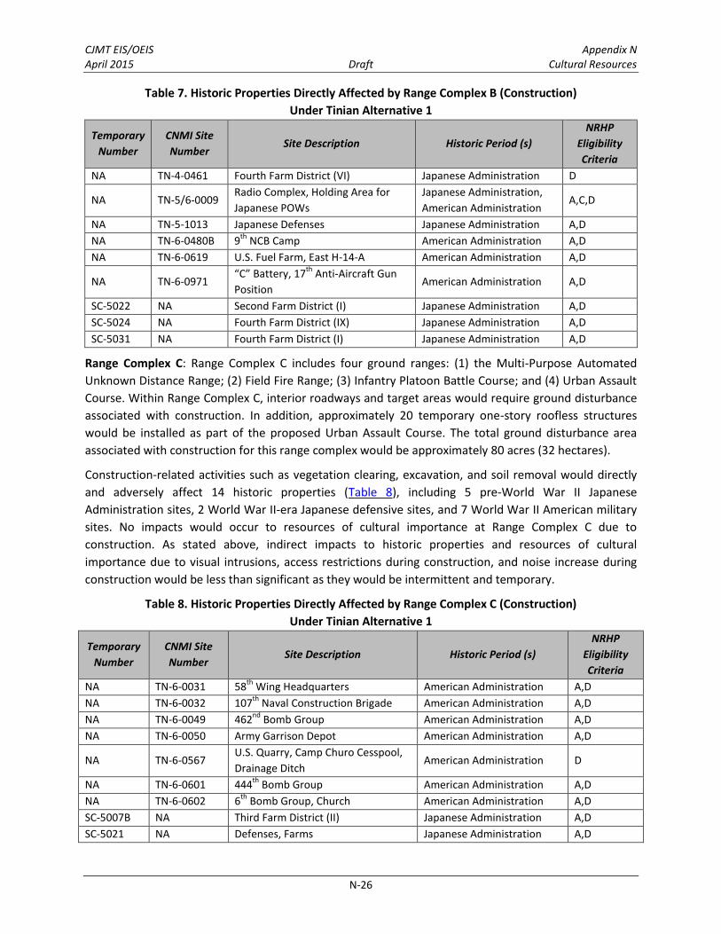
CJMT EIS/OEIS Appendix N April 2015 Draft Cultural Resources
N-26
Table 7. Historic Properties Directly Affected by Range Complex B (Construction)
Under Tinian Alternative 1
Temporary
Number
CNMI Site
Number Site Description Historic Period (s)
NRHP
Eligibility
Criteria
NA TN-4-0461 Fourth Farm District (VI) Japanese Administration D
NA TN-5/6-0009 Radio Complex, Holding Area for
Japanese POWs
Japanese Administration,
American Administration A,C,D
NA TN-5-1013 Japanese Defenses Japanese Administration A,D
NA TN-6-0480B 9th
NCB Camp American Administration A,D
NA TN-6-0619 U.S. Fuel Farm, East H-14-A American Administration A,D
NA TN-6-0971 “C” Battery, 17
th Anti-Aircraft Gun
Position American Administration A,D
SC-5022 NA Second Farm District (I) Japanese Administration A,D
SC-5024 NA Fourth Farm District (IX) Japanese Administration A,D
SC-5031 NA Fourth Farm District (I) Japanese Administration A,D
Range Complex C: Range Complex C includes four ground ranges: (1) the Multi-Purpose Automated
Unknown Distance Range; (2) Field Fire Range; (3) Infantry Platoon Battle Course; and (4) Urban Assault
Course. Within Range Complex C, interior roadways and target areas would require ground disturbance
associated with construction. In addition, approximately 20 temporary one-story roofless structures
would be installed as part of the proposed Urban Assault Course. The total ground disturbance area
associated with construction for this range complex would be approximately 80 acres (32 hectares).
Construction-related activities such as vegetation clearing, excavation, and soil removal would directly
and adversely affect 14 historic properties (Table 8), including 5 pre-World War II Japanese
Administration sites, 2 World War II-era Japanese defensive sites, and 7 World War II American military
sites. No impacts would occur to resources of cultural importance at Range Complex C due to
construction. As stated above, indirect impacts to historic properties and resources of cultural
importance due to visual intrusions, access restrictions during construction, and noise increase during
construction would be less than significant as they would be intermittent and temporary.
Table 8. Historic Properties Directly Affected by Range Complex C (Construction)
Under Tinian Alternative 1
Temporary
Number
CNMI Site
Number Site Description Historic Period (s)
NRHP
Eligibility
Criteria
NA TN-6-0031 58th
Wing Headquarters American Administration A,D
NA TN-6-0032 107th
Naval Construction Brigade American Administration A,D
NA TN-6-0049 462nd
Bomb Group American Administration A,D
NA TN-6-0050 Army Garrison Depot American Administration A,D
NA TN-6-0567 U.S. Quarry, Camp Churo Cesspool,
Drainage Ditch American Administration D
NA TN-6-0601 444th
Bomb Group American Administration A,D
NA TN-6-0602 6th
Bomb Group, Church American Administration A,D
SC-5007B NA Third Farm District (II) Japanese Administration A,D
SC-5021 NA Defenses, Farms Japanese Administration A,D

CJMT EIS/OEIS Appendix N April 2015 Draft Cultural Resources
N-27
Table 8. Historic Properties Directly Affected by Range Complex C (Construction)
Under Tinian Alternative 1
Temporary
Number
CNMI Site
Number Site Description Historic Period (s)
NRHP
Eligibility
Criteria
SC-5034 NA Kahi Farm District (I) Japanese Administration A,D
SC-5036 NA Mound of Bulldozed farmhouse
Debris Japanese Administration D
SC-5038 NA Latte set and ceramic sherds;
U.S. gun position and other
Pre-Contact; American
Administration A,D
SC-5039 NA Kahi Farm District (II) Japanese Administration A,D
SC-5046 NA Kahi Farm District (IV) Japanese Administration A,D
Range Complex D: Range Complex D would include: (1) an aviation Drop Zone; (2) an aviation Landing
Zone (i.e., existing cleared runways Able, Baker, Charlie); (3) Unmanned Aircraft Systems Ground
Station; and (4) a Forward Arming and Refueling Point. Within Range Complex D, there would be
expeditionary runways (North Field runways), pathways, and roadways that would require ground
disturbance associated with construction. The total ground disturbance area associated with
construction for this range complex would be approximately 475 acres (192 hectares). Historic assets,
such as runways and remnant structures would be avoided during construction. However, ground
disturbance from grading, vegetation clearing, and soil removal would occur in between these assets
along interior roadways and at proposed target areas. These construction-related activities would
directly and adversely affect three historic properties (Table 9), all World War II American military
archaeological sites. One of the properties, the North Field runways, is a contributing feature to the
North Field National Historic Landmark. The landmark would be directly and adversely affected by
ground disturbance associated with the construction of the target areas and a portion of the convoy
course. The vegetation clearance at the existing runways, however, is considered to be beneficial as it
prevents deterioration of the pavement and restores the area to its historic appearance.
No resources of cultural importance were identified within Range Complex D. As stated above, indirect
impacts to historic properties and resources of cultural importance due to visual intrusions, access
restrictions during construction, and noise increase during construction would be less than significant as
they would be intermittent and temporary.
Table 9. Historic Properties Directly Affected by Range Complex D (Construction)
Under Tinian Alternative 1
Temporary
Number
CNMI Site
Number Site Description Historic Period (s)
NRHP
Eligibility
Criteria
NA TN-5-0936 Battleline Japanese Administration A,C,D
NA TN-6-0364 North Field Runways and Aprons
(NHL) American Administration A,B,C,D
NA TN-6-0426 121
st Construction Battalion
Service Area American Administration A,B,C,D
CJMT EIS/OEIS Appendix N April 2015 Draft Cultural Resources
N-28
Military Lease Area-wide Training Assets and Support Facilities Outside of the Range Complexes:
Military Lease Area-wide training assets for all alternatives consist of: (1) 5 aviation Landing Zones; (2) 8
Observation Posts; (3) 4 tactical amphibious training beaches; (4) 10 Field Artillery Indirect Firing Range
firing points; (5) a Convoy Course; (6) a Tracked Vehicle Driver’s Course; and (7) 6 Surface Radar sites.
Support facilities, including the base camp, Munitions Storage Area, access roads, gates, fences, and
utilities (including water, wastewater, electrical, information technology, communications, and solid
waste), that are located in the Military Lease Area are also discussed in this section.
Construction-related activities would directly and adversely affect 120 historic properties:
Eight historic properties would be affected by affected by grading, excavation, and soil removal
associated with road construction and grubbing associated with vegetation clearance of the
proposed Convoy Course Engagement Areas (Table 10). These historic properties include 3 pre-
World War II Japanese Administration sites, 2 World War II-era Japanese defensive sites, and 3
World War II American military sites (including a contributing feature to the Landmark);
Three historic properties would be affected by grading, excavation and soil removal within the
proposed Munitions Storage Area (Table 11). These historic properties include three pre-World
War II Japanese Administration sites;
Eighty-six historic properties would be affected by grading, excavation, and soil removal through
widening of roads, trenching for utility lines, erection of fences, and improvements for the
Tracked Vehicle Driver’s Course (Table 12). These historic properties include 4 Pre-Contact latte
sites, 5 Pre-Contact ceramic scatters, 2 Pre-Contact cave sites, 29 pre-World War II Japanese
Administration sites, 17 World War II-era Japanese defensive sites, and 29 World War II
American military sites;
One historic property, West Field, would be affected by grading, excavation, and soil removal
within the proposed base camp (Table 13);
Three historic properties at the amphibious training areas would be affected by grading,
excavation, and soil removal associated with road construction and heavy machinery use during
construction activities (Table 14), including the World War II landing beach at Unai Chulu, a
potential traditional cultural property, and a latte site; and
Nineteen historic properties would be affected by grading, excavation, and soil removal
associated with clearing and construction at artillery firing points, Surface Radar locations, and
Observation Posts, and grubbing and vegetation clearing at the landing zones (Table 15). These
historic properties include 1 Pre-Contact latte site, 8 pre-World War II Japanese Administration
sites, 4 World War II-era Japanese defensive sites, and 6 World War II American military sites.

CJMT EIS/OEIS Appendix N April 2015 Draft Cultural Resources
N-29
Table 10. Historic Properties Directly Affected by Convoy Course Engagement Areas (Construction)
Under Tinian Alternative 1
Temporary
Number
CNMI Site
Number Site Description Historic Period (s)
NRHP
Eligibility
Criteria
NA TN-5-0589A JPN Airfield No. 2 Japanese Administration A,C
NA TN-5/6-0355 Unai Babui Defenses Japanese Administration,
American Administration A,C,D
NA TN-6-0364 North Field Runways and Aprons
(NHL) American Administration A,B,C,D
NA TN-5-0526 Defensive platform Japanese Administration A,D
NA TN-6-0567 U.S. Quarry, Camp Churo
Cesspool, Drainage Ditch American Administration D
NA TN-6-0612 Extension of West Field Runway
No. 4 American Administration A
SC-5044 NA Kahi Farm District (III) Japanese Administration A,C,D
SC-5049 NA Shinminato Farm District (II) Japanese Administration A,D
Table 11. Historic Properties Directly Affected by Munitions Storage Area (Construction)
Under Tinian Alternative 1
Temporary
Number
CNMI Site
Number Site Description Historic Period (s)
NRHP
Eligibility
Criteria
NA TN-5-0589A JPN Airfield No. 2 Japanese Administration A,C
NA TN-5/6-0589C JPN Airfield No. 2; U.S. West Field
Runway No. 4
Japanese Administration,
American Administration A
SC-5042 NA Third Farm District (III) Japanese Administration A,D

CJMT EIS/OEIS Appendix N April 2015 Draft Cultural Resources
N-30
Table 12. Historic Properties Directly Affected by Roads, Fences, and Utilities, Tracked Vehicle
Driver’s Course (Construction) Under Tinian Alternative 1
Temporary
Number
CNMI Site
Number Site Description Historic Period (s)
NRHP
Eligibility
Criteria
NA TN-1/2/4-0592 Masalok Latte sets
Pre-Contact, Spanish
Administration, Japanese
Administration
A,D
NA TN-1/2-0591 Latte sets Pre-Contact, Spanish
Administration A,D
NA TN-1/5-0015 Defensive caves Pre-Contact, Japanese
Administration A,C,D
NA TN-1/5-0432 Rockshelters, Laderan Chiget
Defenses
Pre-Contact, Japanese
Administration A,C,D
NA TN-1-0073 Unai Chulu Latte Complex Pre-Contact A,C,D
NA TN-1-0074 Unai Babui Latte Set (not landing
beach) Pre-Contact A,D
NA TN-1-0404 Ceramic scatter Pre-Contact D
NA TN-1-0431 Ceramic scatter Pre-Contact D
NA TN-1-0594 Artifact scatter Pre-Contact D
NA TN-1-0691 Artifact scatter Pre-Contact D
NA TN-4/6-002 Chulu/Churo Village and
Internment Camp
Japanese Administration,
American Administration A,D
TN-4/6-0599 Agricultural Facility, 696 Signal
Aircraft Warning Company
Japanese Administration,
American Administration A,C,D
NA TN-4-0006 Japanese Village (Hagoi) with
Railroad line Japanese Administration A,D
TN-4-0461 Fourth Farm District (VI) Japanese Administration D
NA TN-4-1108 Japanese agricultural feature:
rock enclosure Japanese Administration D
NA TN-4-1178 Farmstead Japanese Administration A,C,D
NA TN-4-1182 Japanese railroad Japanese Administration A,C,D
NA TN-5/6-0016
NHL: Unai Chulu Pillboxes, White
Beach 2 (Chulu), Bunkers and
World War II Assault Beach
Japanese Administration,
American Administration A,B,C,D
NA TN-5/6-0355 Unai Babui Defenses Japanese Administration,
American Administration A,C,D
NA TN-5/6-0589B JPN Airfield No. 2; U.S. West
Field Runway No. 4
Japanese Administration,
American Administration A
NA TN-5/6-589C JPN Airfield No. 2; U.S. West
Field Runway No. 4
Japanese Administration,
American Administration A
NA TN-5-0018 Ushi Field Drainage Ditch Japanese Administration A,C,D
NA TN-5-0019 Tahgong Revetment Japanese Administration A,C,D
NA TN-5-0363 Gun emplacement Japanese Administration A,C,D
NA TN-5-0463 Mount Lasso Defenses Japanese Administration A,C,D
NA TN-5-0543 Radio Direction Finding Tower
Bases, Radio Station Japanese Administration A,C,D

CJMT EIS/OEIS Appendix N April 2015 Draft Cultural Resources
N-31
Table 12. Historic Properties Directly Affected by Roads, Fences, and Utilities, Tracked Vehicle
Driver’s Course (Construction) Under Tinian Alternative 1
Temporary
Number
CNMI Site
Number Site Description Historic Period (s)
NRHP
Eligibility
Criteria
NA TN-5-0558 Japanese gun positions, fuel
drum enclosures Japanese Administration A,D
NA TN-5-0574 JPN Concrete Terraced Structure
(Possible Water Management) Japanese Administration D
NA TN-5-0589A JPN Airfield No. 2 Japanese Administration A,C
NA TN-5-0690 Anti-Aircraft Defenses Japanese Administration A,C,D
NA TN-5-0936 Battleline Japanese Administration A,C,D
NA TN-5-1010 NKK East Building Japanese Administration D
NA TN-5-1013 JPN Defenses (expanded) Japanese Administration A,D
NA TN-5-1025 JPN Defenses, Foxhole Complex Japanese Administration A,D
NA TN-5-1089 JPN Defenses (expanded) Japanese Administration A,C,D
NA TN-5-1140 Japanese defensive position,
machine-gun post Japanese Administration A,C,D
NA TN-6-0030 West Field American Administration A,D
NA TN-6-0036 313th
Bomb Wing Headquarters American Administration A,D
NA TN-6-0038 Army Hospital American Administration A,C,D
NA TN-6-0039 509th
Composite Group American Administration A,B,C,D
NA TN-6-0042 17
th Anti-Aircraft Artillery
Recreational Structure American Administration A,B,C,D
NA TN-6-0043 Munitions Quonsets, Masalok
Bomb Dump American Administration A
NA TN-6-0045 Masalok Revetments American Administration A,D
NA TN-6-0051 Guard Rail American Administration D
NA TN-6-0056 504th
BG Camp American Administration A,D
NA TN-6-0362 509
th Composite Group Service
Area American Administration A,C,D
TN-6-0364 NHL: North Field Runways and
Aprons American Administration A,B,C,D
NA TN-6-0398 U.S. Marine Corps Former
Cemetery American Administration A
NA TN-6-0401 313
th Wing Base Service
Command American Administration A,D
NA TN-6-0402 B-29 Service Apron American Administration A,B,D
NA TN-6-0471 67
th Naval Construction Battalion
Camp American Administration A,D
NA TN-6-0480A 121
st Naval Construction
Battalion Camp American Administration A,D
NA TN-6-0481
18th
Naval Construction
Battalion, Temporary 509th
Composite Camp
American Administration A,B,D
NA TN-6-0491 Mine Depot Number 4 American Administration D
NA TN-6-0531 West H-14C fuel tanks American Administration D

CJMT EIS/OEIS Appendix N April 2015 Draft Cultural Resources
N-32
Table 12. Historic Properties Directly Affected by Roads, Fences, and Utilities, Tracked Vehicle
Driver’s Course (Construction) Under Tinian Alternative 1
Temporary
Number
CNMI Site
Number Site Description Historic Period (s)
NRHP
Eligibility
Criteria
NA TN-6-0603 9th
Bomb Group American Administration A,D
NA TN-6-0605 40th
Bomb Group American Administration A,D
NA TN-6-0606 87th
and 25th
Service Corps American Administration A,D
NA TN-6-0609 “C” Battery, 18
th Anti-Aircraft
Artillery American Administration A,D
NA TN-6-0610 “A” Battery, 18th
AAA American Administration A,D
NA TN-6-0612 Extension of West Field Runway
No. 4 American Administration A
NA TN-6-0613 “D” Battery, 18th
AAA American Administration A,D
NA TN-6-0619 U.S. Fuel Farm, East H‑14‑A American Administration A,D
SC-5003 NA Artifacts, East Hagoi Farm
District (II)
Pre-Contact, Japanese
Administration A,D
SC-5009B NA Chulu Farm District (II) Japanese Administration A,C,D
SC-5018 NA Fourth Farm District (V) Japanese Administration A,C,D
SC-5020 NA Defensive Caves Japanese Administration A,D
SC-5027 NA 112th
NCB Camp American Administration A,D
SC-5040 NA Kahi Administrative Center
(portion) Japanese Administration A,D
SC-5042 NA Third Farm District (III) Japanese Administration A,D
SC-5043 NA Third Farm District (IV) Japanese Administration A,D
SC-5044 NA Kahi Farm District (III) Japanese Administration A,C,D
SC-5048 NA Shinminato Farm District (I) Japanese Administration A,D
SC-5049 NA Shinminato Farm District (II) Japanese Administration A,D
SC-5053 NA U.S. Quarry American Administration D
SC-5054 NA Shinminato Farm District (III) Japanese Administration A,D
SC-5055 NA Fourth Farm District (IV) Japanese Administration A,D
SC-5056 NA Fourth Farm District (II) Japanese Administration A,D
SC-5059 NA Defensive cave Japanese Administration A,D
SC-5060 NA Fourth Farm District (VII) Japanese Administration A,D
SC-5061 NA Fourth Farm District (X) Japanese Administration A,D
SC-5062 NA Fourth Farm District (XI) Japanese Administration A,D
SC-5065 NA Second Farm District (III) Japanese Administration A,D
SC-5066 NA Second Farm District (IV) Japanese Administration A,D
SC-5067 NA Second Farm District (V) Japanese Administration A,D
SC-5068 NA Second Farm District (VI), Piña
section Japanese Administration A,D

CJMT EIS/OEIS Appendix N April 2015 Draft Cultural Resources
N-33
Table 13. Historic Properties Directly Affected by Base Camp (Construction) Under Tinian Alternative 1
Temporary
Number
CNMI Site
Number Site Description Historic Period (s)
NRHP
Eligibility
Criteria
NA TN-6-0030 West Field American Administration A,D
Table 14. Historic Properties Directly Affected by Tactical Training Areas (Construction) Under Tinian
Alternative 1
Temporary Number
CNMI Site Number
Site Description Historic Period (s) NRHP
Eligibility Criteria
NA TN-1-0073 Unai Chulu Latte Set Pre-Contact A,D
NA TN-5/6-0016
Unai Chulu Pillboxes, White Beach 2 (Chulu), Bunkers and World War II Assault Beach (NHL)
Japanese Administration, American Administration
A,C,D
NA NA Unai Chulu Beach Traditional Cultural Property
Post World War II A
Table 15. Historic Properties Directly Affected by Landing Zones, Artillery Firing Points, Observation
Posts, and Surface Radar Sites (Construction) Under Tinian Alternative 1
Temporary
Number
CNMI Site
Number Site Description Historic Period (s)
NRHP
Eligibility
Criteria
NA TN-1-0074 Latte site (Unai Babui) (not
landing beach) Pre-Contact A,D
NA TN-4/6-0599 Agricultural Facility, 696 Signal
Aircraft Warning Company
Japanese Administration,
American Administration A,C,D
NA TN-5-0019 Revetments Japanese Administration A,C,D
NA TN-5-0439 Laderan Gatot Defensive Caves Japanese Administration A,D
NA TN-6-0030 West Field American Administration A,D
NA TN-6-0042 17
th Anti-Aircraft Artillery
Recreational Structure American Administration A,B,C,D
NA TN-6-0442 Central Bomb Dump American Administration A
NA TN-6-0491 Mine Depot Number 4 American Administration D
NA TN-6-0606 87th
and 25th
Service Corps American Administration A,D
SC-5001 NA 17th
AAA Camp (Camp Stinsom) American Administration D
SC-5009B NA Chulu Farm District (II) Japanese Administration A,D
SC-5020 NA Defenses, Farms Japanese Administration A,D
SC-5021 NA Defenses, Farms Japanese Administration A,D
SC-5031 NA Fourth Farm District (I) Japanese Administration A,D
SC-5055 NA Fourth Farm District (IV) Japanese Administration A,D
SC-5059 NA Defensive Cave Japanese Administration A,D
SC-5062 NA Fourth Farm District (XI) Japanese Administration A,D
SC-5065 NA Second Farm District (III) Japanese Administration A,D
SC-5067 NA Second Farm District (V) Japanese Administration A,D

CJMT EIS/OEIS Appendix N April 2015 Draft Cultural Resources
N-34
Most of the adverse effects associated with these properties occur because of the construction of
fences and roads or the grubbing associated with the clearance of landing areas and Observation Posts.
As these are large, dispersed sites occurring throughout the Military Lease Area, complete avoidance is
not possible. However, in most cases only a portion of the site would be affected by the proposed
action. Existing roads surrounding the North Field National Historic Landmark, which are recommended
as contributing features to the cultural landscape, would be improved for public access and for use by
the Convoy Course and the Tracked Vehicle Driver’s Course. Improvement of poorly maintained roads
would be a beneficial impact to the landmark; however, grubbing and clearing associated with the
construction of the roads would have an adverse effect to other historic properties.
Additionally, an amphibious landing area would be constructed at Unai Chulu. Construction would occur
at the access roads leading to the beach and on an area off shore, where a ramp would be erected to
assist in AAV training operations. Heavy machinery would be used on the beach and a construction
laydown area would be placed behind the beach in an area of low archaeological sensitivity as defined
through archaeological testing (Athens 2009). Ground disturbance associated with the use of heavy
machinery on the beach and on the existing access roads would have a direct and adverse effect on
three historic properties. Unai Chulu, in addition to being a contributing feature of the North Field
National Historic Landmark, includes a Pre-Contact latte site and is considered a potential traditional
cultural property. A permanent change in the setting of the beach would be an adverse effect to the
potential traditional cultural property. An additional staging area would be located at North Field on an
existing cleared runway, which would not adversely affect the runways or the landmark since it would
be temporary and not involve ground disturbance.
An underwater study (Burns 2010) identified a series of magnetic anomalies that potentially represent a
submerged cultural resource (e.g., an Amphibious Assault Vehicle, portions of a shipwreck, or historic
debris) within the area of proposed dredging around the ramp at Unai Chulu. Marine biological surveys
in the area have identified anchors and remnants of World War II-era amphibious assault vehicles.
Depending upon the type of submerged cultural resource, it could be managed under the Sunken
Military Craft Act, as well as the National Historic Preservation Act.
The purpose of the Sunken Military Craft Act is to protect sunken military vessels and aircraft and the
remains of their crews from unauthorized disturbance. This statute confirms that these vessels are
sovereign property and provides for archaeological research permits and civil enforcement measures,
including substantial penalties, to prevent unauthorized disturbance. Under the Sunken Military Craft
Act, a permit is required before any disturbance or investigations can occur to a sunken military craft.
Wreck sites that are not entire aircraft or ships, but are parts strewn in a debris field are considered
archaeological sites and are managed in accordance with the National Historic Preservation Act. Further
investigation would be required to identify the nature of the anomalies. To the degree possible, these
anomalies would be avoided during construction. If they cannot be avoided, identification efforts would
be conducted to determine whether the anomalies represent a historic property. Therefore,
construction of an amphibious landing ramp may impact submerged historic properties.
No resources of cultural importance were identified within the construction areas for these training
asset areas. As stated above, indirect impacts to historic properties and resources of cultural importance
due to visual intrusions, access restrictions during construction, and noise increase during construction
would be less than significant as they would be intermittent and temporary.

CJMT EIS/OEIS Appendix N April 2015 Draft Cultural Resources
N-35
Construction of the ramp would likely cause a change in the local fish populations; some populations
could decrease, while others may increase (see Chapter 4, Marine Biology, Section 4.10.3.1, Tinian
Alternative 1). As this change would be temporary during the construction process, it would not be an
adverse effect to the potential traditional cultural property.
Outside the Military Lease Area: Construction-related activities outside of the Military Lease Area would
occur in an area immediately north of the Tinian International Airport runways and at the Port of Tinian,
as well as along road modified to accommodate Tracked Vehicle Transit Lanes and a Supply Route. The
proposed Port of Tinian improvements consist of the following proposed improvements: (1) a
Biosecurity Vehicle Inspection Area; (2) a Biosecurity Cargo Inspection & Holding Area; (3) Biosecurity
Facility; (4) a Vehicle Washdown Facility; (5) Notional Stormwater Retention Ponds; (6) a Bulk Fuel
Storage Area; (7) improvements to existing boat ramps and (8) a Landscaped Area. All of the area
proposed for development at the Port of Tinian and along the Tracked Vehicle Transit Lanes and Supply
Route have been surveyed. Construction-related activities such as clearing, excavation, and soil removal
as well as grubbing and vegetation clearance of roadways and port and aircraft support structures would
directly and adversely affect six historic properties, which include two Pre-Contact sites (ceramic/artifact
scatters), three pre-World War II Japanese Administration sites, and one World War II American military
site (Table 16 and Table 17).
Table 16. Historic Properties Directly Affected by Tinian International Airport (Construction)
Under Tinian Alternative 1
Temporary
Number
CNMI Site
Number Site Description Historic Period (s)
NRHP Eligibility
Criteria
NA TN-6-0030 West Field American Administration A,D
SC-5043 NA Third Farm District (IV) Japanese Administration A,D
Table 17. Historic Properties Directly Affected by Port of Tinian Improvement and Tracked Vehicle
Transit Lanes/Supply Route (Construction) Under Tinian Alternative 1
Temporary
Number
CNMI Site
Number Site Description Historic Period (s)
NRHP Eligibility
Criteria
NA TN-1-0691 Artifact scatter Pre-Contact D
NA TN-4-1182 Japanese railroad Japanese Administration A,C,D
SC-5043 NA Third Farm District (IV) Japanese Administration A,D
T-9 Artifact scatter Pre-Contact, Japanese
Administration D
No resources of cultural importance were identified within the proposed construction areas for these
training asset areas. As stated above, indirect effects to historic properties and resources of cultural
importance due to visual intrusions, access restrictions during construction, and noise increase during
construction would be less than significant as they would be intermittent and temporary.
3.2.1.2 Operation Impacts
Training facility operations and maintenance would occur within the Military Lease Area, immediately
north of Tinian International Airport runways, and at the Port of Tinian. Live-fire and aviation training
would occur at Range Complex A; vehicle-mounted and dismounted (i.e., by foot) training involving
firing at stationary and moving targets by rifles, machine guns and rocket launchers would occur at

CJMT EIS/OEIS Appendix N April 2015 Draft Cultural Resources
N-36
Range Complex B; platoon level training involving firing at targets with rifles and inert grenades, rockets,
and mortars at Range Complex C; and aviation training and ground training would occur at Range
Complex D. The ground training at Range Complex D would involve mostly foot traffic and use of rifles
and inert ammunition for grenade launchers, mortars, and rockets.
Other operations within the Military Lease Area would include use of firing points into the High Hazard
Impact Area, convoy course engagement areas, landing zones and the Observation Posts and Surface
Radar sites, and foot and vehicle traffic on roads and the Tracked Vehicle Driver’s Course. In general, the
footprint for operations is very similar to construction footprints and most ground disturbance and
effects to historic properties and resources of cultural importance would occur during construction of
the RTA. Therefore, since disturbance to historic properties has been accounted for in the ranges under
construction impacts, impacts to historic properties from training operations at the range complexes B,
C, and D will focus on training maneuvers. Training maneuvers concern vehicle and foot traffic within
areas; no digging would occur within maneuver areas. However, potential ground disturbance to historic
properties in Range Complex A is larger than the footprint for construction and could occur throughout
the High Hazard Impact Area.
Table 18 summarizes the historic properties affected by operations for Tinian Alternative 1; impacts
associated with construction are summarized in Table 17. In Range Complex A, twelve sites, also
affected by construction activities under Tinian Alternative 1, would be significantly impacted by
operations (Table 19).
Table 18. Tinian Alternative 1 Summary of Direct Adverse Effects on
Historic Properties from Operations
Complex Range Number of Historic Properties
Range Complex A High Hazard Impact Area 12*
Range Complex B Multi-Purpose Training Range, Combat Pistol Range, Anti-Armor Tracking Range, Battle Site Zero Range
0
Range Complex C Infantry Platoon Battle Course, Field Fire Range, Multi-Purpose Automated Unknown Distance Range
0
Range Complex D Northern Battle Area Complex, Urban Assault Course
0
Military Lease Area-wide Training Assets and Support Facilities Outside of the Range Complexes
Convoy Course Engagement Areas 0
Munitions Storage Area 0
Roads, Fences, and Utilities, Tracked Vehicle Driver’s Course
0
Base Camp 0
Tactical Amphibious Training Areas 3
Landing Zones, Artillery Firing Points, Observation Posts, Surface Radar Sites
0
Outside Military Lease Area
Tinian International Airport 0
Port of Tinian 0
Tracked Vehicle Transit Lanes/Supply Route 0
Total 15 Note: *All of these sites are affected under construction, but are located outside of the area of proposed ground disturbance for construction. Sites solely in the construction area are not included in this total.

CJMT EIS/OEIS Appendix N April 2015 Draft Cultural Resources
N-37
Table 19. Historic Properties Directly Affected by Range Complex A (Operations)
Under Tinian Alternative 1
Temporary
Number
CNMI Site
Number Site Description Historic Period (s)
NRHP
Eligibility
Criteria
NA TN-5-0468 Laderan Gagot Defenses Japanese Administration A,D
NA TN-5-0488 Gun position, Fuel Drum,
Japanese Defenses Japanese Administration A,D
NA TN-6-0442 Central Bomb Dump American Administration A
NA TN-6-0471 67th NCB Camp American Administration A,D
NA TN-6-0478 Fuel Tanks, East H-14-C, North
Field American Administration A,D
NA TN-6-0489 “C” Battery, 17th AAA American Administration A,C,D
NA TN-6-0491 Mine Depot Number 4 American Administration D
SC-5031 NA Fourth Farm District (I) Japanese Administration A,D
SC-5056 NA Fourth Farm District (II) Japanese Administration A,D
SC-5060 NA Fourth Farm District (VIII) Japanese Administration A,D
SC-5061 NA Fourth Farm District (X) Japanese Administration A,D
SC-5062 NA Fourth Farm District (XI) Japanese Administration A,D
During training events, foot and vehicle maneuvering would occur within range complexes, Tracked
Vehicle Driver’s Course, Convoy Course, maneuver areas, and roads. Vehicle traffic would be confined to
established roads and trails that are designed to avoid historic properties and, therefore, would not
impact historic properties. Use of historic roads associated with the North Field National Historic
Landmark by convoys and other vehicles would be in keeping with existing use and would not have an
adverse effect on this historic property. Tracked vehicles would use newly constructed gravel roads
adjacent to the historic roads to prevent damage. Effects to historic properties from foot traffic would
be minimal, as it would occur primarily on roads and designated pathways or sporadically throughout
the maneuver areas.
Tactical amphibious training would occur at four beaches—Unai Chulu, Unai Babui, Unai Masalok, and
Unai Lam Lam. Training at Unai Chulu would involve Amphibious Assault Vehicles, Landing Craft Air
Cushion vessels, inflatable boats, and combat swimmers. Training at Unai Babui and Unai Masalok would
involve the use of Landing Craft Air Cushion vessels, combat swimmers, and inflatable boats.
Amphibious training at Unai Lam Lam would involve inflatable boats and combat swimmers. No direct
adverse effects would occur to historic properties associated with these beaches due to training
operations. Training and range management activities associated with Tinian Alternative 1 would
directly affect three historic properties (Table 20), the landing beach at Unai Chulu, which is part of the
North Field National Historic Landmark, a potential traditional cultural property, and a latte site due to
ground disturbance caused by Amphibious Assault Vehicle traffic. As much as possible impacts to the
latte site would be avoided by using existing and newly constructed roads.

CJMT EIS/OEIS Appendix N April 2015 Draft Cultural Resources
N-38
Table 20. Historic Properties Directly Affected by Tactical Amphibious Training Areas (Operations)
Under Tinian Alternative 1
Temporary
Number
CNMI Site
Number Site Description Historic Period (s)
NRHP
Eligibility
Criteria
NA TN-1-0073 Unai Chulu Latte Complex Pre-Contact A,C,D
NA TN-5/6-0016
NHL: Unai Chulu Pillboxes,
White Beach 2 (Chulu), Bunkers
and World War II Assault
Beach/Traditional Cultural
Property
Japanese Administration,
American Administration A,C,D
NA NA Unai Chulu Beach Traditional
Cultural Property Post-World War II A
Within the surface danger zones, which are safety buffers that surround target areas and live-fire
maneuver areas and would contain projectiles, fragments, debris and components resulting from the
firing of weapons, the potential for direct impacts from strikes from stray rounds is extremely low. The
ranges would be designed to contain live-fire inside the boundaries to minimize the potential for rounds
landing outside the surface danger zones. Additionally, if a stray round were to escape the ranges, the
chance of it hitting a historic property is remote, given the size of the surface danger zones and dispersal
of historic properties.
Resources of cultural importance, such as cemeteries, memorials, or potential areas with medicinal
plants, would not be directly impacted at these training asset areas by training operations.
In general, public access would be allowed to all locations except for the High Hazard Impact Area, the
Munitions Storage Area, the base camp, and the Observation Posts and Surface Radar sites, when
training is not occurring. It is envisioned that public access to some or all areas of the RTA, with the
exceptions mentioned above, would occur during a couple of daylight hours on a nearly daily basis
during the 20 weeks of live-fire training. A range control facility and dedicated range scheduler would be
in place to assess public access in real-time and to provide advance notice of public access dates, time
frames, and areas. Range control and the scheduler would coordinate public access directly with the
Tinian Mayor's Office and other interested parties, such as ranchers and entities within the tourism
industry. Access procedures would be implemented to ensure safety and provide guidance and
direction. Therefore, intermittent and temporary loss of public access is not considered a significant
indirect impact to cultural resources. Historic properties within the High Hazard Impact Area, base camp,
Munitions Storage Area, and the Observation Posts and Surface Radar sites would already have been
adversely affected by construction activities and loss of access to these areas would be a less than
significant impact.
The roundabout, a portion of Broadway Avenue, which is an entrance to the North Field National
Historic Landmark and a contributing feature to the cultural landscape, would be closed permanently by
the use of the High Hazard Impact Area of Range Complex A. This closure would be permanent and
would be an indirect adverse effect to the Landmark.
The permanent presence of Observation Posts and Surface Radar Sites would not be visible to most
historic properties. However, towers associated with Surface Radar sites would be constructed at Unai

CJMT EIS/OEIS Appendix N April 2015 Draft Cultural Resources
N-39
Babui and near Unai Dankulo. A Surface Radar site would be constructed adjacent and south of Unai
Dankulo and would be visible from the beach, which is a potential traditional cultural property. Another
Surface Radar site would be constructed within a latte site at Unai Babui. The permanent location of
these towers would have an indirect adverse effect to these historic properties.
Construction of the ramp would likely cause a change in the local fish populations through a permanent
loss in coral reef habitat; some populations could decrease, while others may increase, with a decrease
in fishes relying on coral reefs. As this shoreline is part of a potential traditional cultural property
associated with fishing, this change would be an indirect adverse effect to the historic property.
Tinian Alternative 2 3.2.2
3.2.2.1 Construction Impacts
As described in Chapter 2, Section 2.4.3, Tinian Alternative 2 construction activities would occur within
the Military Lease Area, immediately north of the Tinian International Airport runways, and at the Port
of Tinian. Tinian Alternative 2 construction activities would occur within the same areas as Tinian
Alternative 1, but would accommodate an additional Battle Area Complex (Range Complex C) and five
additional Convoy Course Engagement Areas. This development and construction would result in 2,025
acres (820 hectares) of ground disturbance (e.g., vegetation clearing, grubbing, grading, excavation, and
filling), and affect historic properties and resources of cultural importance. Table 21 summarizes the 182
historic properties affected by construction-related activities for Tinian Alternative 2, which is slightly
more than the 172 affected under Tinian Alternative 1. Specific adverse effects to historic properties and
resources of cultural importance are described in more detail by RTA or construction project below.
Table 21. Tinian Alternative 2 Summary of Direct Adverse Effects on
Historic Properties from Construction
Complex Range Number of Historic
Properties
Range Complex A High Hazard Impact Area 20
Range Complex B Multi-Purpose Training Range, Combat Pistol Range, Anti-Armor Tracking Range, Battle Site Zero Range
9
Range Complex C
Southern Battle Area Complex: Infantry Platoon Battle Course, Field Fire Range, Multipurpose Automated Unknown Distance Range, Urban Assault Course
25
Range Complex D Northern Battle Area Complex, Urban Assault Course 3
Military Lease Area-wide Training Assets and Support Facilities Outside of the Range Complexes
Convoy Course Engagement Areas 7
Munitions Storage Area 3
Roads, Fences, and Utilities, Tracked Vehicle Driver’s Course
86
Base Camp 1
Tactical Amphibious Training Areas 3
Landing Zones, Artillery Firing Points, Observation Posts, Surface Radar Sites
19
Outside Military Lease Area
Tinian International Airport 2
Port of Tinian 0
Tracked Vehicle Transit Lanes/Supply Route 4
Total 182

CJMT EIS/OEIS Appendix N April 2015 Draft Cultural Resources
N-40
Range Complex A: Construction-related activities such as grubbing, grading, and soil removal at Range
Complex A under Tinian Alternative 2 would be the same as under Tinian Alternative 1 and would
directly and adversely affect the same 20 historic properties as described in Table 6 and the same
resources of cultural importance (native limestone forest and two memorials) discussed under Tinian
Alternative 1. Visual intrusions, access restrictions during construction, and noise increase during
construction would not adversely affect historic properties as these effects would be intermittent and
temporary. The roundabout, a portion of Broadway Avenue, which is an entrance to the North Field
National Historic Landmark and a contributing feature to the cultural landscape, would be closed during
construction of Range Complex A target objectives. This closure would be temporary and the impact
would not be an adverse effect.
Range Complex B: Construction-related activities at Range Complex B under Tinian Alternative 2 would
be the same as under Tinian Alternative 1 and would directly and adversely affect the same 9 historic
properties as described in Table 7. No resources of cultural importance were identified within Range
Complex B.
Range Complex C: Under Tinian Alternative 2, the proposed Range Complex C consists of: (1) a Multi-
Purpose Automated Unknown Distance Range; (2) Infantry Platoon Battle Course Objective Areas; (3)
Infantry Platoon Battle Course Lines of Sight; (4) Urban Assault Course South Objective Area; (5) Urban
Assault Course South Line of Sight; (6) Infantry Platoon Battle Course Access Roads; (7) southern Battle
Area Complex Objective Areas; (8) southern Battle Area Complex Lines of Sight; (9) southern Battle Area
Complex Access Roads; (10) southern Battle Area Complex Urban Assault Course Objective Area; and
(11) southern Battle Area Complex Urban Assault Course Line of Sight. Within the Infantry Platoon Battle
Course there are firing points, lines of sight to the targets (objective areas), and objective areas. Within
the Urban Assault Course there are approximately 20 one-story open-roofed structures as well as target
objective areas.
Construction-related activities such as vegetation clearing, excavation, and soil removal would directly
and adversely affect 25 historic properties (Table 22), compared to the 14 affected under Tinian
Alternative 1. They would include 1 Pre-Contact site, 14 pre-World War II Japanese Administration sites,
1 World War II-era Japanese defensive site, and 9 World War II American military sites. Most of these
adverse effects occur because of the construction of roads to the target areas. Since sites in this area
tend to be large and dispersed, complete avoidance is not possible. However, in most cases only a
portion of the site would be affected by the proposed action. No resources of cultural importance were
identified within Range Complex C. Visual intrusions, access restrictions during construction, and noise
increase during construction would not have an adverse effect to historic properties as they would be
intermittent and temporary.
Range Complex D: Construction-related activities under Tinian Alternative 2 would be the same as
under Tinian Alternative 1 and would directly and adversely affect three historic properties, all World
War II American military archaeological sites (see Table 9). One of the properties, the North Field
runways and associated areas, is a contributing feature to the North Field National Historic Landmark.
Although the runways themselves would be avoided, the surrounding area would be disturbed by
construction and vegetation clearing. Therefore, the Landmark would be adversely affected by ground
disturbance associated with the construction of the target areas and a portion of the Convoy Course.
Vegetation clearance at the existing runways within the proposed Drop Zone, however, is considered to

CJMT EIS/OEIS Appendix N April 2015 Draft Cultural Resources
N-41
be beneficial as it prevents deterioration of the pavement and restores the area to its historic
appearance.
Table 22. Historic Properties Directly Affected by Range Complex C (Construction)
Under Tinian Alternative 2
Temporary
Number
CNMI Site
Number Site Description Historic Period (s)
NRHP
Eligibility
Criteria
NA TN-4-0631 Japanese concrete structure Japanese Administration A,D
NA TN-4-1182 Japanese railroad Japanese Administration A,C,D
NA TN-6-0031 58th
Wing Headquarters American Administration A,D
NA TN-6-0032 107th
Naval Construction Brigade American Administration A,D
NA TN-6-0036 313th
Bomb Wing Headquarters American Administration A,D
NA TN-6-0049 462nd
Bomb Group American Administration A,D
NA TN-6-0050 Army Garrison Depot American Administration A,D
NA TN-6-0567 U.S. Quarry, Camp Churo
Cesspool, Drainage Ditch American Administration D
NA TN-6-0601 444th
Bomb Group American Administration A,D
NA TN-6-0606 87th
and 25th
Service Corps American Administration A,D
SC-5007A NA Third Farm District (I) Japanese Administration A,D
SC-5007B NA Third Farm District (II) Japanese Administration A,D
SC-5009A NA Chulu Farm District (I) Japanese Administration A,D
SC-5009B NA Chulu Farm District (II) Japanese Administration A,C,D
SC-5010 NA Churo Latte (Disturbed) Pre-Contact D
SC-5011 NA Earth Terraces Japanese Administration A,C,D
SC-5017 NA Fourth Farm District (III) Japanese Administration A,C,D
SC-5018 NA Fourth Farm District (V) Japanese Administration A,C,D
SC-5034 NA Kahi Farm District (I) Japanese Administration A,D
SC-5038 NA Latte set and ceramic sherds;
U.S. gun position and other
Pre-Contact; American
Administration A,D
SC-5046 NA Kahi Farm District (IV) Japanese Administration A,D
SC-5049 NA Shinminato Farm District (II) Japanese Administration A,D
SC-5053 NA U.S. Quarry American Administration D
SC-5054 NA Shinminato Farm District (III) Japanese Administration A,D
SC-5055 NA Fourth Farm District (IV) Japanese Administration A,D
No resources of cultural importance would be directly and adversely impacted at Range Complex D.
Visual intrusions, access restrictions during construction, and noise increase during construction would
not have an adverse effect to historic properties as they would be intermittent and temporary.
Military Lease Area-Wide Training Assets and Support Facilities Outside of the Range Complexes:
Construction associated with Military Lease Area-wide assets under Tinian Alternative 2 would be similar
to Tinian Alternative 1, but would include additional road improvements. It would directly and adversely
affect 119 historic properties, one less than under Tinian Alternative 1. Seven sites, one fewer site than
under Tinian Alternative 1, would be affected by the Convoy Course Engagement Areas (Table 23). The
historic properties would include 13 Pre-Contact sites (6 latte sites, 5 ceramic scatters, and 2 rock
overhangs/caves), 43 pre-World War II Japanese Administration sites, 23 World War II-era Japanese

CJMT EIS/OEIS Appendix N April 2015 Draft Cultural Resources
N-42
defensive sites, 39 World War II American military sites, and 1 potential traditional cultural property
(see Tables 11 through 15). Most of these adverse effects occur because of the construction of roads.
Since sites in this area tend to be large and dispersed, complete avoidance is not possible. However, in
most cases only a portion of the site would be affected by the proposed action. Existing roads
surrounding the North Field National Historic Landmark, which are recommended as contributing
features to the cultural landscape, would be improved for public access and for use by the Convoy
Course and the Tracked Vehicle Driver’s Course. Improvement of poorly maintained roads would be a
beneficial impact to the Landmark; however, vegetation clearance adjacent to the roads could have an
adverse effect to other historic properties.
Table 23. Historic Properties Directly Affected by Convoy Course Engagement Areas (Construction)
Under Tinian Alternative 2
Temporary
Number
CNMI Site
Number Site Description Historic Period (s)
NRHP
Eligibility
Criteria
NA TN-5/6-0355 Unai Babui Defenses Japanese Administration,
American Administration A,C,D
NA TN-5-0526 Defensive platform Japanese Administration A,D
NA TN-5-0589A JPN Airfield No. 2 Japanese Administration A,C
NA TN-6-0612 Extension of West Field Runway
No. 4 American Administration A
NA TN-6-0544 “B” Battery, 17th AAA and ABCD
Annex American Administration A,C,D
SC-5044 NA Kahi Farm District (III) Japanese Administration A,C,D
SC-5055 NA Fourth Farm District (IV) Japanese Administration A,D
Additionally under Tinian Alternative 2, construction activities at the amphibious landing beach at Unai
Chulu, would be the same as under Tinian Alternative 1 and would have an adverse effect to the same
three historic properties (the landing beach, which is part of the North Field National Historic Landmark
and would constitute as adverse effect to the Landmark, a potential traditional cultural property, and a
latte site). A permanent change in the setting of the beach would be an adverse effect to the potential
traditional cultural property. An additional staging area would be located at North Field on an existing
cleared runway, which would not affect the runways or the Landmark since it would be temporary and
not involve ground disturbance. Construction of an amphibious landing ramp may impact submerged
historic properties.
No resources of cultural importance were identified within these training asset areas. As stated above,
indirect effects to historic properties and resources of cultural importance due to visual intrusions,
access restrictions during construction, and noise increase during construction would be less than
significant as they would be intermittent and temporary. Construction of the amphibious landing ramp
would likely cause a change in the local fish populations; some populations could decrease, while others
may increase (see Section 4.10.3.1, Marine Biology). As this change would be temporary during the
construction process, the impact would be less than significant.
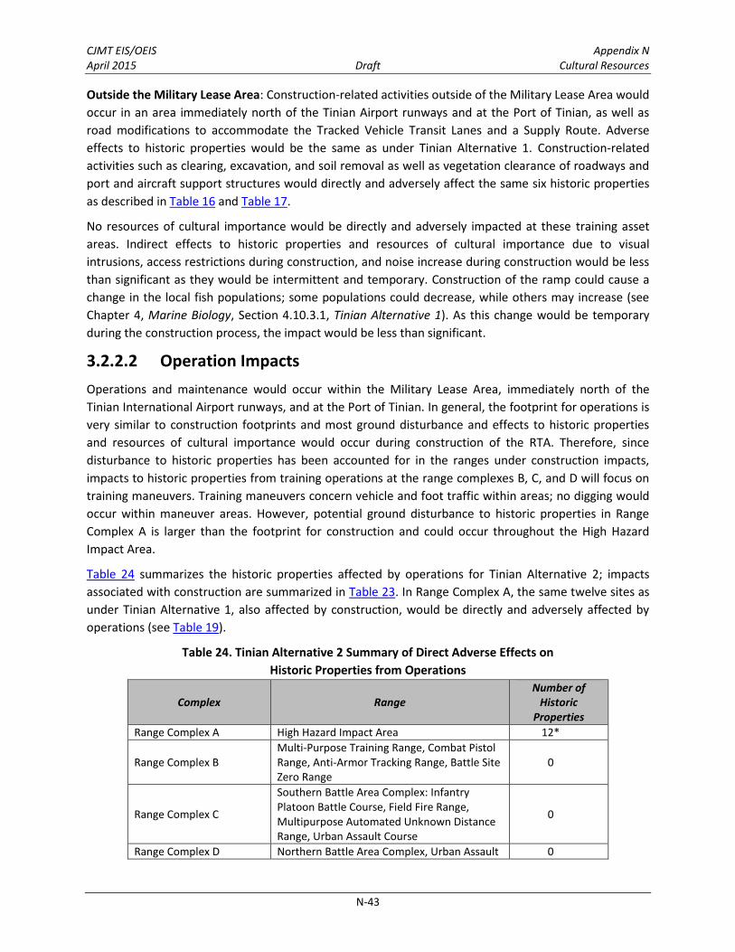
CJMT EIS/OEIS Appendix N April 2015 Draft Cultural Resources
N-43
Outside the Military Lease Area: Construction-related activities outside of the Military Lease Area would
occur in an area immediately north of the Tinian Airport runways and at the Port of Tinian, as well as
road modifications to accommodate the Tracked Vehicle Transit Lanes and a Supply Route. Adverse
effects to historic properties would be the same as under Tinian Alternative 1. Construction-related
activities such as clearing, excavation, and soil removal as well as vegetation clearance of roadways and
port and aircraft support structures would directly and adversely affect the same six historic properties
as described in Table 16 and Table 17.
No resources of cultural importance would be directly and adversely impacted at these training asset
areas. Indirect effects to historic properties and resources of cultural importance due to visual
intrusions, access restrictions during construction, and noise increase during construction would be less
than significant as they would be intermittent and temporary. Construction of the ramp could cause a
change in the local fish populations; some populations could decrease, while others may increase (see
Chapter 4, Marine Biology, Section 4.10.3.1, Tinian Alternative 1). As this change would be temporary
during the construction process, the impact would be less than significant.
3.2.2.2 Operation Impacts
Operations and maintenance would occur within the Military Lease Area, immediately north of the
Tinian International Airport runways, and at the Port of Tinian. In general, the footprint for operations is
very similar to construction footprints and most ground disturbance and effects to historic properties
and resources of cultural importance would occur during construction of the RTA. Therefore, since
disturbance to historic properties has been accounted for in the ranges under construction impacts,
impacts to historic properties from training operations at the range complexes B, C, and D will focus on
training maneuvers. Training maneuvers concern vehicle and foot traffic within areas; no digging would
occur within maneuver areas. However, potential ground disturbance to historic properties in Range
Complex A is larger than the footprint for construction and could occur throughout the High Hazard
Impact Area.
Table 24 summarizes the historic properties affected by operations for Tinian Alternative 2; impacts
associated with construction are summarized in Table 23. In Range Complex A, the same twelve sites as
under Tinian Alternative 1, also affected by construction, would be directly and adversely affected by
operations (see Table 19).
Table 24. Tinian Alternative 2 Summary of Direct Adverse Effects on
Historic Properties from Operations
Complex Range Number of
Historic Properties
Range Complex A High Hazard Impact Area 12*
Range Complex B Multi-Purpose Training Range, Combat Pistol Range, Anti-Armor Tracking Range, Battle Site Zero Range
0
Range Complex C
Southern Battle Area Complex: Infantry Platoon Battle Course, Field Fire Range, Multipurpose Automated Unknown Distance Range, Urban Assault Course
0
Range Complex D Northern Battle Area Complex, Urban Assault 0

CJMT EIS/OEIS Appendix N April 2015 Draft Cultural Resources
N-44
Table 24. Tinian Alternative 2 Summary of Direct Adverse Effects on
Historic Properties from Operations
Complex Range Number of
Historic Properties
Course
Military Lease Area-wide Training Assets and Support Facilities Outside of the Range Complexes
Convoy Course Engagement Areas 0
Munitions Storage Area 0
Roads, Fences, and Utilities, Tracked Vehicle Driver’s Course
0
Base Camp 0
Tactical Amphibious Training Areas 3
Landing Zones, Artillery Firing Points, Observation Posts, Surface Radar Sites
0
Outside Military Lease Area
Tinian International Airport 0
Port of Tinian 0
Tracked Vehicle Transit Lanes/Supply Route 0
Total 15 Note: *All of these sites are also impacted under construction, but are located outside of the area of proposed ground disturbance for construction. Sites solely in the construction area are not included in this total.
Use of historic roads associated with the North Field National Historic Landmark by convoys and other
vehicles would be in keeping with existing use and would not adversely affect this historic property.
Tracked vehicles would use newly constructed gravel roads adjacent to the historic roads to prevent
damage. Effects to historic properties from foot traffic would be minimal, as it would occur primarily on
roads and designated pathways or sporadically throughout the maneuver areas.
Training and range management activities associated with Tinian Alternative 2 would have a direct and
adverse effect to three historic properties, the landing beach at Unai Chulu, which is part of the North
Field National Historic Landmark, a potential traditional cultural property, and a latte site due to ground
disturbance caused by Amphibious Assault Vehicle traffic (see Table 20). As much as possible impacts to
the latte site would be avoided by using existing and newly constructed roads.
Within the surface danger zones, which are safety buffers that surround target areas and live-fire
maneuver areas and would contain projectiles, fragments, debris and components resulting from the
firing of weapons, the potential for direct impacts from strikes from stray rounds is extremely low. The
ranges would be designed to contain live-fire inside the boundaries to minimize the potential for rounds
landing outside the surface danger zones. Additionally, if a stray round were to escape the ranges, the
chance of it hitting a historic property is remote, given the size of the surface danger zones and dispersal
of historic properties.
In general, public access would be allowed to all locations except for the High Hazard Impact Area, the
Munitions Storage Area, the base camp, the Observation Posts, and Surface Radar sites, when training is
not occurring. It is envisioned that public access to some or all areas of the RTA, with the exceptions
mentioned above, would occur during a couple of daylight hours on a nearly daily basis during the 20
weeks of live-fire training. A range control facility and dedicated range scheduler would be in place to
assess public access in real-time and to provide advance notice of public access dates, time frames, and
areas. Range control and the scheduler would coordinate public access directly with the Tinian Mayor's

CJMT EIS/OEIS Appendix N April 2015 Draft Cultural Resources
N-45
Office and other interested parties, such as ranchers and entities within the tourism industry. Access
procedures would be implemented to ensure safety and provide guidance and direction. Therefore,
intermittent and temporary loss of public access is not considered an adverse effect to historic
properties. Historic properties within the High Hazard Impact Area, base camp, Munitions Storage Area,
the Observation Posts, and Surface Radar sites would already have been directly and adversely affected
by construction activities and loss of access to these areas would not be an adverse effect.
No resources of cultural importance were identified within these training asset areas.
The roundabout, a portion of Broadway Avenue, which is an entrance to the North Field National
Historic Landmark and a contributing feature to the cultural landscape, would be closed permanently by
the use of the High Hazard Impact Area of Range Complex A. This closure would be an adverse effect to
the Landmark.
The permanent presence of Observation Posts and Surface Radar sites would not be visible to most
historic properties. However, towers associated with Surface Radar sites would be constructed at Unai
Babui and near Unai Dankulo. A Surface Radar site would be constructed adjacent and south of Unai
Dankulo and would be visible from the beach, which is a potential traditional cultural property. Another
Surface Radar site would be constructed within a latte site at Unai Babui. The permanent location of
these towers would have an indirect adverse effect to these historic properties.
Construction of the ramp at Unai Chulu would likely cause a change in the local fish populations through
a permanent loss in coral reef habitat. Some populations could decrease, while others may increase,
especially those associated with coral reefs. As this shoreline is part of a potential traditional cultural
property associated with fishing, this change would be an indirect adverse effect to the historic
property.
Tinian Alternative 3 3.2.3
3.2.3.1 Construction Impacts
As described in Chapter 2, Section 2.4.4, Tinian Alternative 3 training facility development and
construction would result in 2,003 acres (811 hectares) of ground disturbance (e.g., vegetation clearing,
grubbing, grading, excavation, and filling), and potentially affect historic properties and resources of
cultural importance. Tinian Alternative 3 construction activities would occur within the same areas as
Tinian Alternative 1, but would accommodate a southern Battle Area Complex (Range Complex C) and
five additional Convoy Course Engagement Areas. Only a Drop Zone would be established in Range
Complex D. Table 25 summarizes the 179 historic properties affected by construction-related activities
for Tinian Alternative 3; 7 more than found under Tinian Alternative 1. Specific adverse effects to
historic properties and resources of cultural importance are described in more detail by RTA or
construction project below.

CJMT EIS/OEIS Appendix N April 2015 Draft Cultural Resources
N-46
Table 25. Tinian Alternative 3 Summary of Direct Adverse Effects on
Historic Properties from Construction
Complex Range Number of Historic
Properties
Range Complex A High Hazard Impact Area 20
Range Complex B Multi-Purpose Training Range, Combat Pistol Range, Anti-Armor Tracking Range, Battle Site Zero Range
9
Range Complex C
Southern Battle Area Complex: Infantry Platoon Battle Course, Field Fire Range, Multipurpose Automated Unknown Distance Range, Urban Assault Course
25
Range Complex D Drop Zone 0
Military Lease Area-wide Training Assets and Support Facilities Outside of the Range Complexes
Convoy Course Engagement Areas 7
Munitions Storage Area 3
Roads, Fences, and Utilities, Tracked Vehicle Driver’s Course
86
Base Camp 1
Tactical Amphibious Training Areas 3
Landing Zones, Artillery Firing Points, Observation Posts, Surface Radar Sites
19
Outside Military Lease Area
Tinian International Airport 2
Port of Tinian 0
Tracked Vehicle Transit Lanes/Supply Route
4
Total 179
Range Complex A: Construction-related activities at Range Complex A under Tinian Alternative 3 would
be the same as under Tinian Alternative 1 and would directly and adversely affect the same 20 historic
properties as listed in Table 6) and the same resources of cultural importance (native limestone forest
and two memorials) discussed under Tinian Alternative 1. Indirect effects to historic properties and
resources of cultural importance due to visual intrusions, access restrictions during construction, and
noise increase during construction would be less than significant as they would be intermittent and
temporary. The roundabout, a portion of Broadway Avenue, which is an entrance to the North Field
National Historic Landmark and a contributing feature to the cultural landscape, would be closed during
construction of Range Complex A target objectives. This closure would be temporary and not be an
adverse effect to the Landmark.
Range Complex B: Construction-related activities at Range Complex B under Tinian Alternative 3 would
be the same as under Tinian Alternative 1 and would directly and adversely affect the same 9 historic
properties as described in Table 7. No resources of cultural importance were identified within Range
Complex B.
Range Complex C. Construction-related activities under Tinian Alternative 3 would be similar to that
under Tinian Alternative 1 except that there would be the construction of a southern Battle Area
Complex and associated Urban Assault Course. Construction-related activities such as vegetation
clearing, excavation, and soil removal would directly and adversely affect 25 historic properties (see
Table 22) compared to the 14 affected under Tinian Alternative 1. Most of these adverse effects occur

CJMT EIS/OEIS Appendix N April 2015 Draft Cultural Resources
N-47
because of the construction of roads to the target areas. Since sites in this area tend to be large and
dispersed, complete avoidance is not possible. However, in most cases only a portion of the site would
be affected by the proposed action. No resources of cultural importance have been identified in Range
Complex C. Indirect effects to historic properties and resources of cultural importance due to visual
intrusions, access restrictions during construction, and noise increase during construction would be less
than significant as they would be intermittent and temporary.
Range Complex D: Proposed Range Complex D (Alternative 3) consists of: (1) a Drop Zone and (2) an
aviation landing zone on North Field. The Landing Zone, an Unmanned Aircraft Systems Ground Station,
and a Forward Arming and Refueling Point would be located within the Drop Zone. No construction
would be conducted at Range Complex D under Tinian Alternative 3, although vegetation would be
cleared around the runways similar to Tinian Alternative 1. This vegetation clearance is considered to be
beneficial as it prevents deterioration of the historic runways, which are a contributing feature to the
North Field National Historic Landmark and restores the area to its historic appearance.
Military Lease Area-wide Training Assets and Support Facilities Outside of the Range Complexes:
Construction associated with Military Lease Area-wide assets under Tinian Alternative 3 would be similar
to Tinian Alternative 1, but would include additional road improvements. It would directly and adversely
affect 119 historic properties; one less than under Tinian Alternative 1, but the same as under Tinian
Alternative 2 (see Tables 11 through 15, and Table 23). Most of these adverse effects occur because of
the construction of roads. Since sites in this area tend to be large and dispersed, complete avoidance is
not possible. However, in most cases only a portion of the site would be affected by the proposed
action. Existing roads surrounding the North Field National Historic Landmark, which are recommended
as contributing features to the cultural landscape, would be improved for public access and for use by
the Convoy Course and the Tracked Vehicle Driver’s Course. Improvement of poorly maintained roads
would be beneficial to the Landmark; however, vegetation clearance associated with the construction of
the roads would have an adverse effect to other historic properties.
Construction activities at the amphibious landing beach at Unai Chulu, would be the same as under
Tinian Alternative 1 and would directly and adversely affect the same three historic properties (the
landing beach [Unai Chulu], which is part of the North Field National Historic Landmark and would
constitute an adverse effect to the landmark, a potential traditional cultural property, and a latte site) as
described in Table 14. An additional staging area would be located at North Field on an existing cleared
runway, which would not affect the runways or the Landmark since it would be temporary and not
involve ground disturbance. Construction of an amphibious landing ramp may impact submerged
historic properties.
No resources of cultural importance were identified within these training asset areas. As stated above,
indirect impacts to historic properties and resources of cultural importance due to visual intrusions,
access restrictions during construction, and noise increase during construction would be less than
significant as they would be intermittent and temporary. Construction of the ramp would likely cause a
change in the local fish populations; some populations could decrease, while others may increase. As
this change would be temporary during the construction process, the impact would be less than
significant.

CJMT EIS/OEIS Appendix N April 2015 Draft Cultural Resources
N-48
Outside the Military Lease Area: Construction-related activities immediately north of the Tinian Airport
runways and at the Port of Tinian, as well as road modifications to accommodate the Tracked Vehicle
Transit Lanes and a Supply Route would be the same as under Tinian Alternative 1. Construction-related
activities such as vegetation clearing, excavation, and soil removal as well as vegetation clearance of
roadways and port and aircraft support structures would directly and adversely affect the same six
historic properties as described in Table 16 and Table 17.
No resources of cultural importance were identified within these training asset areas. Indirect impacts to
historic properties and resources of cultural importance due to visual intrusions, access restrictions
during construction, and noise increase during construction would be less than significant as they would
be intermittent and temporary.
3.2.3.2 Operation Impacts
Under Tinian Alternative 3, operations and maintenance would occur within the Military Lease Area,
immediately north of the Tinian International Airport runways, and at the Port of Tinian. Effects to
historic properties and resources of cultural importance would be the same as Tinian Alternative 1. In
general, the footprint for operations is very similar to construction footprints and most ground
disturbance and impacts to historic properties and resources of cultural importance would occur during
construction of the RTA. Therefore, since disturbance to historic properties has been accounted for in
the ranges under construction impacts, adverse effects to historic properties from training operations at
the range complexes B, C, and D will focus on training maneuvers. Training maneuvers concern vehicle
and foot traffic within areas; no digging would occur within maneuver areas. However, potential ground
disturbance to historic properties in Range Complex A is larger than the footprint for construction and
could occur throughout the High Hazard Impact Area. Table 26 summarizes the historic properties
affected by operations for Tinian Alternative 3; adverse effects associated with construction are
summarized in Table 25. In Range Complex A, twelve sites, also affected by construction, would be
directly and adversely affected by operations (see Table 19).
Use of historic roads associated with the North Field National Historic Landmark by convoys and other
vehicles would be in keeping with existing use and would not adversely affect this historic property.
Tracked vehicles would use newly constructed gravel roads adjacent to the historic roads to prevent
damage. Effects to historic properties from foot traffic would be minimal, as it would occur primarily on
roads and designated pathways or sporadically throughout the maneuver areas.

CJMT EIS/OEIS Appendix N April 2015 Draft Cultural Resources
N-49
Table 26. Tinian Alternative 3 Summary of Direct Adverse Effects on
Historic Properties from Operations
Complex Range Number of
Historic Properties
Range Complex A High Hazard Impact Area 12
Range Complex B Multi-Purpose Training Range, Combat Pistol Range, Anti-Armor Tracking Range, Battle Site Zero Range
0
Range Complex C
Southern Battle Area Complex: Infantry Platoon Battle Course, Field Fire Range, Multipurpose Automated Unknown Distance Range, Urban Assault Course
0
Range Complex D Drop Zone 0
Military Lease Area-wide Training Assets and Support Facilities Outside of the Range Complexes
Convoy Course Engagement Areas 0
Munitions Storage Area 0
Roads, Fences, and Utilities, Tracked Vehicle Driver’s Course
0
Base Camp 0
Tactical Amphibious Training Areas 3
Landing Zones, Artillery Firing Points, Observation Posts, Surface Radar Sites
0
Outside Military Lease Area
Tinian International Airport 0
Port of Tinian NA
Tracked Vehicle Transit Lanes/Supply Route
0
Total 15
Note: *All of these sites are also impacted under construction, but are located outside of the area of proposed ground disturbance for construction. Sites solely in the construction area are not included in this total.
Training and RTA management activities associated with Tinian Alternative 3, however, would directly
and adversely affect three historic properties at the landing beach at Unai Chulu (see Table 20)—the
same as found under Tinian Alternative 1 (the landing beach at Unai Chulu, which is part of the North
Field National Historic Landmark, a potential traditional cultural property, and a latte site).
Within the surface danger zones, which are safety buffers that surround target areas and live-fire
maneuver areas and would contain projectiles, fragments, debris and components resulting from the
firing of weapons, the potential for direct impacts from strikes from stray rounds is extremely low. The
ranges would be designed to contain live-fire inside the boundaries to minimize the potential for rounds
landing outside the surface danger zones. Additionally, if a stray round were to escape the ranges, the
chance of it hitting a historic property is remote, given the size of the surface danger zones and dispersal
of historic properties.
In general, public access would be allowed to all locations except for the High Hazard Impact Area, the
Munitions Storage Area, the base camp, and the Observation Posts and Surface Radar sites, when
training is not occurring. It is envisioned that public access to some or all areas of the RTA, with the
exceptions mentioned above, would occur during a couple of daylight hours on a nearly daily basis
during the 20 weeks of live-fire training. A range control facility and dedicated range scheduler would be
in place to assess public access in real-time and to provide advance notice of public access dates, time

CJMT EIS/OEIS Appendix N April 2015 Draft Cultural Resources
N-50
frames, and areas. Range control and the scheduler would coordinate public access directly with the
Tinian Mayor's Office and other interested parties, such as ranchers and entities within the tourism
industry. Access procedures would be implemented to ensure safety and provide guidance and
direction. Therefore, intermittent and temporary loss of public access is not considered an adverse
effect to historic properties. Historic properties within the High Hazard Impact Area, base camp,
Munitions Storage Area, and the Observation Posts and Surface Radar sites would already have been
directly and adversely affected by construction activities and loss of access to these areas would not be
an adverse effect.
No resources of cultural importance were identified within these training asset areas.
The roundabout, a portion of Broadway Avenue, which is an entrance to the North Field National
Historic Landmark and a contributing feature to the cultural landscape, would be closed permanently by
the use of the High Hazard Impact Area of Range Complex A. This closure would be an adverse effect to
the Landmark.
The permanent presence of Observation Posts and Surface Radar sites would not be visible to most
historic properties. However, towers associated with Surface Radar sites would be constructed at Unai
Babui and near Unai Dankulo. A Surface Radar site would be constructed adjacent and south of Unai
Dankulo and would be visible from the beach, which is a potential traditional cultural property. Another
Surface Radar site would be constructed within a latte site at Unai Babui. The permanent location of
these towers would have an indirect adverse effect to these historic properties.
Construction of the ramp at Unai Chulu would likely cause a change in the local fish populations through
a permanent loss in coral reef habitat. Some populations could decrease, while others may increase,
especially those associated with coral reefs. As this shoreline is part of a potential traditional cultural
property associated with fishing, this change would be an indirect adverse effect to the property
3.3 PAGAN
Pagan Alternative 1 3.3.1
3.3.1.1 Construction Impacts
Two High Hazard Impact Areas would be established in the North Range Complex under Pagan
Alternative 1. The expeditionary airfield, a temporary munitions storage area, and base camp would be
developed just north of the isthmus. This development and construction would result in 764 acres (310
hectares) of ground disturbance (primarily due to vegetation clearance), and potentially affect historic
properties and resources of cultural importance. Table 27 summarizes the historic properties affected by
construction-related activities for Pagan Alternative 1. Specific adverse effects to historic properties are
described in more detail below.
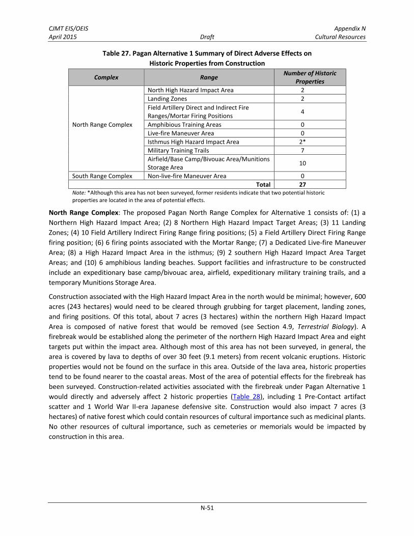
CJMT EIS/OEIS Appendix N April 2015 Draft Cultural Resources
N-51
Table 27. Pagan Alternative 1 Summary of Direct Adverse Effects on
Historic Properties from Construction
Complex Range Number of Historic
Properties
North Range Complex
North High Hazard Impact Area 2
Landing Zones 2
Field Artillery Direct and Indirect Fire Ranges/Mortar Firing Positions
4
Amphibious Training Areas 0
Live-fire Maneuver Area 0
Isthmus High Hazard Impact Area 2*
Military Training Trails 7
Airfield/Base Camp/Bivouac Area/Munitions Storage Area
10
South Range Complex Non-live-fire Maneuver Area 0
Total 27 Note: *Although this area has not been surveyed, former residents indicate that two potential historic properties are located in the area of potential effects.
North Range Complex: The proposed Pagan North Range Complex for Alternative 1 consists of: (1) a
Northern High Hazard Impact Area; (2) 8 Northern High Hazard Impact Target Areas; (3) 11 Landing
Zones; (4) 10 Field Artillery Indirect Firing Range firing positions; (5) a Field Artillery Direct Firing Range
firing position; (6) 6 firing points associated with the Mortar Range; (7) a Dedicated Live-fire Maneuver
Area; (8) a High Hazard Impact Area in the isthmus; (9) 2 southern High Hazard Impact Area Target
Areas; and (10) 6 amphibious landing beaches. Support facilities and infrastructure to be constructed
include an expeditionary base camp/bivouac area, airfield, expeditionary military training trails, and a
temporary Munitions Storage Area.
Construction associated with the High Hazard Impact Area in the north would be minimal; however, 600
acres (243 hectares) would need to be cleared through grubbing for target placement, landing zones,
and firing positions. Of this total, about 7 acres (3 hectares) within the northern High Hazard Impact
Area is composed of native forest that would be removed (see Section 4.9, Terrestrial Biology). A
firebreak would be established along the perimeter of the northern High Hazard Impact Area and eight
targets put within the impact area. Although most of this area has not been surveyed, in general, the
area is covered by lava to depths of over 30 feet (9.1 meters) from recent volcanic eruptions. Historic
properties would not be found on the surface in this area. Outside of the lava area, historic properties
tend to be found nearer to the coastal areas. Most of the area of potential effects for the firebreak has
been surveyed. Construction-related activities associated with the firebreak under Pagan Alternative 1
would directly and adversely affect 2 historic properties (Table 28), including 1 Pre-Contact artifact
scatter and 1 World War II-era Japanese defensive site. Construction would also impact 7 acres (3
hectares) of native forest which could contain resources of cultural importance such as medicinal plants.
No other resources of cultural importance, such as cemeteries or memorials would be impacted by
construction in this area.

CJMT EIS/OEIS Appendix N April 2015 Draft Cultural Resources
N-52
Table 28. Historic Properties Directly Affected by North High Hazard Impact Area (Construction)
Under Pagan Alternative 1
Temporary
Number
CNMI Site
Number Site Description Historic Period (s)
NRHP
Eligibility
Criteria
PA-2 NA Artifact scatter and Latte Period
ceramic scatter Pre-Contact D
PA-3 NA Tunnel complex Japanese Administration A,D
Construction associated with the High Hazard Impact Area located on the isthmus would likewise be
minimal. A firebreak would be established along the perimeter and vegetation within one target would
be cleared during construction. About 7 acres (3 hectares) of this vegetation is composed of native
forest that would be removed (see Section 4.9, Terrestrial Biology). Because of thick vegetation and
steep topography, the isthmus area has not been surveyed for archaeological resources, but it does
contain two areas identified by former residents as the location of Kannathomhum, a latte village
located close to the coast, and one unnamed location, which probably contained World War II Japanese
military features. Other archaeological sites in the area are unlikely based on the steep topography and
lack of accessibility to coastal resources. Construction of a firebreak would not directly and adversely
affect these resources, but vegetation clearance associated with a target would directly and adversely
affect these resources. Construction would also directly and adversely affect 7 acres (3 hectares) of
native forest which could contain resources of cultural importance such as medicinal plants. A resource
of cultural importance, a potential area for collecting betel nuts, could be affected by construction.
No construction would occur at the Amphibious landing beaches or within the Live-fire Maneuver Area.
Eleven landing zones, 1 Field Artillery Direct Firing Range Position, 10 Field Artillery Indirect Firing
Positions (8 co-occur with landing zones), and 6 firing points associated with the Mortar Range would be
constructed throughout the northern portion of the island. Most of the landing zones and artillery firing
points have either been surveyed or are located on lava. Of the 2 unsurveyed landing zones and the 2
unsurveyed firing points associated with the Mortar Range, 3 are located in steep interior areas
surrounding Mount Pagan and one is located in the High Hazard Impact Area on the isthmus in an area
surrounded by steep topography. Both of these areas have a low potential for containing historic
properties. Construction-related activities associated with the clearing and grubbing of Landing Zones
and firing points under Pagan Alternative 1 would directly and adversely affect 6 historic properties
(Table 29 and Table 30), including 1 Pre-Contact latte site and 1 pre-World War II Japanese
Administration site, and 4 World War II –era Japanese defensive sites.
Table 29. Historic Properties Directly Affected by Landing Zones (Construction)
Under Pagan Alternative 1
Temporary
Number
CNMI Site
Number Site Description Historic Period (s)
NRHP
Eligibility
Criteria
NA PN-1-0072 Latte complex Pre-Contact D
NA PN-4-0021 Historic settlement area Japanese Administration D

CJMT EIS/OEIS Appendix N April 2015 Draft Cultural Resources
N-53
Table 30. Historic Properties Directly Affected by Field Artillery Direct and Indirect Fire Ranges
(Construction) Under Pagan Alternative 1
Temporary
Number
CNMI Site
Number Site Description Historic Period (s)
NRHP
Eligibility
Criteria
NA PN-5-0064 Tunnel complex Japanese Administration A,D
NA PN-5-0066 Tunnel complex Japanese Administration A,D
NA PN-5-0067 Bunker Japanese Administration A,D
NA PN-5-0068 Tunnel Japanese Administration A,D
A military training trail network would be constructed around the perimeter of the northern portion of
Pagan to provide access to the base camp/bivouac area, Landing Zones, and the northern High Hazard
Impact Area. A portion of the access road construction would involve the improvement of existing trails,
while new trails would be constructed as well. A total of 37 acres (15) hectares would be cleared and
graded in the construction of these trails. Construction-related activities under Pagan Alternative 1
would directly and adversely affect 7 historic properties (Table 31), including 2 Pre-Contact sites (latte
sites), 2 pre-World War II Japanese Administration sites, and 3 World War II-era Japanese defensive
sites. Given the steep topography, which restricts the locations of trails, it is difficult to avoid known
historic properties. Construction would also impact 5 acres (2 hectares) of native forest which could
contain resources of cultural importance. No other resources of cultural importance have been
identified in this area.
Table 31. Historic Properties Directly Affected by Access Roads/Trails (Construction)
Under Pagan Alternative 1
Temporary
Number
CNMI Site
Number Site Description Historic Period (s)
NRHP
Eligibility
Criteria
NA PN-1-0086 Latte complex Pre-Contact D
NA PN-1-0092 Latte complex Pre-Contact D
NA PN-4-0021 Historic settlement area Japanese Administration D
NA PN-4-0128 Cisterns, hearth, concrete box Japanese Administration D
NA PN-5-0003 Barracks complex Japanese Administration A,D
NA PN-5-0057 Bunker Japanese Administration A,D
NA PN-5-0133 Bunker and tunnel Japanese Administration A,D
The area adjacent to an existing airfield would contain the expeditionary base camp/bivouac area,
interior roads, temporary munitions storage, and airfield improvements. A grass airfield would be
improved, and a temporary munitions storage area would be constructed. These areas would be cleared
of vegetation. Construction-related activities such as grading, vegetation clearing, and soil removal
would directly and adversely affect 10 historic properties (Table 32), including 1 Pre-Contact site (latte
site or complex), 4 pre-World War II Japanese Administration sites, and 5 World War II-era Japanese
defensive sites. No resources of cultural importance would be affected by construction. No resources of
cultural importance would be impacted by construction.

CJMT EIS/OEIS Appendix N April 2015 Draft Cultural Resources
N-54
Table 32. Historic Properties Directly Affected by Airfield/Base Camp/Bivouac Area (Construction)
Under Pagan Alternative 1
Temporary
Number
CNMI Site
Number Site Description Historic Period (s)
NRHP
Eligibility
Criteria
NA PN-1-0082 Latte complex Pre-Contact D
NA PN-4-0007 Obelisk Japanese Administration A,D
NA PN-4-0015 Shrine Japanese Administration A,D
NA PN-5-0001 Airfield Japanese Administration A,D
NA PN-5-0009 Bunker Japanese Administration A,D
NA PN-5-0014 Bunker and tunnel complex Japanese Administration A,D
NA PN-5-0017 Pier Japanese Administration A,D
NA PN-5-0070 Tunnel complex Japanese Administration A,D
NA PN-5-0071 Enclosure Japanese Administration A,D
PA-1 NA Concrete foundation with wall
and pillar remnants Japanese Administration A,D
Although public access would not be allowed in the construction area, the public may be allowed in
nearby areas depending upon the type of construction. An increase in noise and changes in visual setting
may occur during construction in the vicinity of historic properties, including potential traditional
cultural properties, when members of the public are present. This change in noise and visual setting
would be intermittent and temporary and would not have an adverse effect to these properties.
South Range Complex: The South Range Complex would be used as a Non-live-fire Maneuver Area.
There would be no construction-related ground clearance undertaken; therefore, there would be no
direct or indirect adverse effects to historic properties or resources of cultural importance from
construction activities associated with the establishment of the South Range Complex.
Although public access would not be allowed to the construction area, the public may be allowed in
nearby areas in south Pagan when construction is ongoing. An increase in noise and changes in visual
setting may occur during construction in the vicinity of historic properties, including potential traditional
cultural properties, when members of the public are present. This change in noise and visual setting
would be intermittent and temporary and not result in an adverse effect to historic properties.
3.3.1.2 Operation Impacts
As described in Chapter 2, Section 2.5, Pagan Alternatives, under Pagan Alternative 1, operations and
maintenance would occur within the North and South Range Complexes. In general, the footprint for
operations is very similar to construction footprints and most ground disturbance and impacts to
historic properties and resources of cultural importance would occur during construction of the RTA.
Therefore, since disturbance to historic properties has been accounted for in most areas under
construction impacts, impacts to historic properties from training operations will focus on training
maneuvers. Training maneuvers consist of vehicle and foot traffic within maneuver areas; no digging
would occur within the maneuver areas. However, potential ground disturbance to historic properties in
the High Hazard Impact Areas is larger than the footprint for construction and target placement and
could occur throughout either of the High Hazard Impact Areas.

CJMT EIS/OEIS Appendix N April 2015 Draft Cultural Resources
N-55
Table 33 summarizes the historic properties affected by operations for Pagan Alternative 1; impacts
associated with construction are summarized in Table 32. In the High Hazard Impact Areas, seven
historic properties, also affected by construction, would be significantly impacted by operations (Table
34). Although not all of the northern High Hazard Impact Area has been surveyed; it is primarily covered
in lava. Should sites be preserved under the lava, impacts are unlikely since the depth of the ground
disturbance associated with munitions would be less than the depth of the lava. Other archaeological
sites within the isthmus High Hazard Impact Area are unlikely based on the steep topography and lack of
accessibility to coastal resources.
Table 33. Pagan Alternative 1 Summary of Direct Adverse Effects on
Historic Properties from Operations
Complex Range Number of Historic
Properties
North Range Complex
North High Hazard Impact Area 5*
Landing Zones 0
Field Artillery Direct and Indirect Fire Ranges/Mortar Firing Positions
0
Amphibious Training Areas 1
Live-fire Maneuver Area 46
Isthmus High Hazard Impact Area 2*
Military Training Trails 0
Airfield/Base Camp/Bivouac Area/Munitions Storage Area
0
South Range Complex Non-five-fire Maneuver Area NA
Total 54 Notes: *All of these sites are impacted by vegetation clearing in target areas, but are located outside of the area of proposed clearing. Sites solely in the construction/cleared area are not included in this total. Legend: NA = not applicable.
Table 34. Historic Properties Directly Affected by Live-Fire Maneuver Areas (Operations)
Under Pagan Alternative 1
Temporary Number
CNMI Site Number
Site Description Historic Period (s) NRHP
Eligibility Criteria
PA-2 NA Artifact scatter and Latte Period ceramic scatter
Pre-Contact D
PA-3 NA Tunnel complex Japanese Administration A,D
PN-5-0062 Tunnel Japanese Administration A,D
PN-4-0063 Water valves Japanese Administration D
T-PAG-6 NA Concrete bunker Japanese Administration D
Amphibious training, consisting of swimmer and inflatable boat landings, would occur at six beaches—
Red, Green, Blue, South, North, and Gold. Amphibious Assault Vehicles and Landing Craft Air Cushion
vessels would be used at Red, Green, and Blue beaches. Landing Craft Air Cushion vessels would be used
at Red, Green, Blue, and South beaches. Use by swimmers and inflatable boats would have a minimal
impact to any historic properties, including traditional cultural properties, and resources of cultural
importance. Use of Amphibious Assault Vehicles and Landing Craft Air Cushion vessels could cause

CJMT EIS/OEIS Appendix N April 2015 Draft Cultural Resources
N-56
ground disturbance on the beach. Landing Craft Air Cushion vessels would have a significant direct
impact to one historic property, a World War II-era Japanese airfield (Table 35). All beaches have been
surveyed and no other resources are recorded within the vicinity of the training areas. The beach areas
associated with two potential traditional cultural properties, Red Beach (Shomshon) and South Beach
(Regusa), would be disturbed by amphibious landing operations. However, the beach would be restored
to its original appearance by contouring and cleaning up expended materials at the end of the exercises
(see Section 3.1.2, Resource Management Measures). No adverse effects would occur to these potential
traditional cultural properties.
Table 35. Historic Properties Directly Affected by Tactical Amphibious Training Areas (Operations)
Under Pagan Alternative 1
Temporary
Number
CNMI Site
Number Site Description Historic Period (s)
NRHP
Eligibility
Criteria
NA PN-5-0001 Airfield Japanese Administration A,D
Training in the northern maneuver areas includes patrolling, establishing defensive positions, and firing
live-fire weapons into and/or around the High Hazard Impact Area and integrating supporting arms
(including aviation, artillery, and naval gunfire assets). Where possible, mounted wheeled and tracked
vehicle maneuvering would be accomplished in the northern maneuver area as well. Vehicles would
move along military training trails as well as other terrain that they could safely navigate. Ground
disturbance associated with wheeled and tracked vehicles off of roadways and trails would have an
adverse effect to 46 historic properties, including 5 Pre-Contact latte sites, 1 Pre-Contact midden site,
and 40 Japanese Administration sites (Table 36). Off-road vehicle use would also impact resources of
cultural importance such as medicinal plants and plant gathering areas near the shoreline, but would
not affect such resources located along clifflines or on steep slopes. However, training units would be
required to identify engagement area locations, direction of attack, targets/threats to be engaged, and
types of weapon and ammunition to be used during an engagement. Developed scenarios would be
submitted to range control for approval prior to implementation. This process would allow
implementation of measures to avoid and protect historic properties and resources of cultural
importance.
Table 36. Historic Properties Directly Affected by Live-Fire Maneuver Areas (Operations)
Under Pagan Alternative 1
Temporary Number
CNMI Site Number
Site Description Historic Period (s) NRHP
Eligibility Criteria
PA-4 NA Stone alignment (possible defensive feature)
Japanese Administration A,D
NA PN-1-0072 Latte complex Pre-Contact D
NA PN-1-0082 Latte Complex Pre-Contact D
NA PN-1-0084 Latte Set Pre-Contact D
NA PN-1-0102 Midden Pre-Contact D
NA PN-1-0108 Latte Pre-Contact D
NA PN-1-0110 Latte Pre-Contact D
NA PN-4-0111 Cistern Japanese Administration D
NA PN-5-0004 Military Building Japanese Administration A,D

CJMT EIS/OEIS Appendix N April 2015 Draft Cultural Resources
N-57
Table 36. Historic Properties Directly Affected by Live-Fire Maneuver Areas (Operations)
Under Pagan Alternative 1
Temporary Number
CNMI Site Number
Site Description Historic Period (s) NRHP
Eligibility Criteria
NA PN-5-0005 Pillars Japanese Administration A,D
NA PN-5-0022 Bunker Japanese Administration A,D
NA PN-5-0043 Cistern and Bunker Japanese Administration A,D
NA PN-5-0044 Bunker Japanese Administration A,D
NA PN-5-0045
Cistern, Bunker, Concrete Foundation
Japanese Administration A,D
NA PN-5-0046 Bunker Japanese Administration A,D
NA PN-5-0048 Tunnel Complex Japanese Administration A,D
NA PN-5-0049 Bunker Complex Japanese Administration A,D
NA PN-5-0050 Bunker Japanese Administration A,D
NA PN-5-0051 Bunker Japanese Administration A,D
NA PN-5-0069 Tunnel Complex Japanese Administration A,D
NA PN-5-0074 Bunker Japanese Administration A,D
NA PN-5-0075 Bunker Japanese Administration A,D
NA PN-5-0076 Tunnel Complex Japanese Administration A,D
NA PN-5-0085 Tunnel and Walls Japanese Administration A,D
NA PN-5-0087 Tunnel Complex Japanese Administration A,D
NA PN-5-0088 Bunker and Tunnel Japanese Administration A,D
NA PN-5-0089 Bunker Japanese Administration A,D
NA PN-5-0090 Bunker Japanese Administration A,D
NA PN-5-0091 Tunnel Complex Japanese Administration A,D
NA PN-5-0093 Tunnel Complex Japanese Administration A,D
NA PN-5-0094 Tunnel Complex Japanese Administration A,D
NA PN-5-0095 Bunker Japanese Administration A,D
NA PN-5-0096 Bunker Japanese Administration A,D
NA PN-5-0097 Bunker Japanese Administration A,D
NA PN-5-0098 Bunker Japanese Administration A,D
NA PN-5-0099 Tunnel Japanese Administration A,D
NA PN-5-0100 Bunker Japanese Administration A,D
NA PN-5-0103 Tunnel Complex Japanese Administration A,D
NA PN-5-0105 Bunker and Tunnel Complex Japanese Administration A,D
NA PN-5-0106 Bunker Japanese Administration A,D
NA PN-5-0107 Bunker Japanese Administration A,D
NA PN-5-0109 Bunker Japanese Administration A,D
NA PN-5-0113 Tunnel Complex and Wall Japanese Administration A,D
NA PN-5-0114 Bunker and Tunnel Complex Japanese Administration A,D
NA PN-5-0142 Tunnel Japanese Administration A,D
NA PN-5-0171 Tunnel Complex Japanese Administration A,D
On-foot maneuvers would occur in South Range Complex. Very little of the southern portion of Pagan
has been surveyed because of steep topography and access limitations. Information from surveys
conducted in the south and interviews with former residents indicates that there are probably at least 8
latte villages located primarily along coastal areas. However, effects to historic properties from foot
traffic would be minimal, as it would occur primarily on designated pathways or sporadically throughout
the maneuver area.

CJMT EIS/OEIS Appendix N April 2015 Draft Cultural Resources
N-58
Within the surface danger zones, which are safety buffers that surround target areas and live-fire
maneuver areas and would contain projectiles, fragments, debris and components resulting from the
firing of weapons, the potential for direct impacts from strikes from stray rounds is extremely low. The
ranges would be designed to contain live-fire inside the boundaries to minimize the potential for rounds
landing outside the surface danger zones. Additionally, if a stray round were to escape the ranges, the
chance of it hitting a historic property is remote, given the size of the surface danger zones and dispersal
of historic properties.
In general, public access would be allowed to all locations except for the High Hazard Impact Areas,
which would be permanently restricted due to the presence of unexploded ordnance, when training is
not occurring. It is envisioned that public access would be allowed at times when such training events
are not taking place and may be available during other times depending upon the type of training taking
place. This may include public access to areas of southern Pagan while training is occurring elsewhere.
Therefore, intermittent and temporary loss of public access is not considered an adverse effect to
historic properties. Historic properties within the High Hazard Impact Area would already have been
adversely affected by construction activities and loss of access to these areas would not have an adverse
effect.
Indirect adverse effects to historic properties and resources of cultural importance due to visual
intrusions and noise-level increase from training would be less than significant. An increase in noise and
changes in visual setting may occur during operations in the vicinity of historic properties, including
potential traditional cultural properties, when members of the public are present. This change in noise
and visual setting would be intermittent and temporary and result in a less than significant impact.
Indirect impacts to resources of cultural importance such as Laguna Sanhalom due to contamination by
munitions in the northern High Hazard Impact Area would be less than significant due to the
implementation of best management practices associated with a Range Training Area Management Plan
(see Section 3.1.2, Resource Management Measures).
Pagan Alternative 2 3.3.2
3.3.2.1 Construction Impacts
Under Pagan Alternative 2, only one, smaller northern High Hazard Impact Area would be established in
the North Range Complex. This would potentially affect historic properties and resources of cultural
importance. Ground disturbance primarily associated with vegetation removal would total 696 acres
(283 hectares), or 38 fewer acres (28 hectares) when compared to Pagan Alternative 1. Table 37
summarizes the historic properties affected by construction-related activities for Pagan Alternative 2.
Specific adverse effects to historic properties and resources of cultural importance would be the same
as found under Pagan Alternative 1, with the exception being that the isthmus High Hazard Impact Area
in the south would not be established. A more detailed description of potential impacts follows the
table.

CJMT EIS/OEIS Appendix N April 2015 Draft Cultural Resources
N-59
Table 37. Pagan Alternative 2 Summary of Direct Adverse Effects on
Historic Properties from Construction
Complex Range Number of Historic
Properties
North Range Complex
Northern High Hazard Impact Area 2
Landing Zones 2
Field Artillery Direct and Indirect Fire Ranges/Mortar Firing Positions
4
Tactical Amphibious Training Areas 0
Live-fire Maneuver Area 0
Military Training Trails 7
Airfield/ Base Camp/Bivouac Area/Munitions Storage Area
10
South Range Complex Non-live-fire Maneuver Area NA
Total 25
North Range Complex: Construction associated with the High Hazard Impact Area in the north differs
from construction under Pagan Alternative 1 as there would be no High Hazard Impact Area on the
isthmus. Although the size of the High Hazard Impact Area would be smaller than the northern High
Hazard Impact Area under Pagan Alternative 1, the target clearance would be the same. Although most
of this area has not been surveyed, in general, the area is covered by lava to depths of over 30 feet (9.1
meters) from recent volcanic eruptions. Historic properties would not be found on the surface in this
area. Outside of the lava area, historic properties tend to be found nearer to the coastal areas. Most of
the area of potential effects for the firebreak has been surveyed. Construction-related activities
associated with the firebreak under Pagan Alternative 2 would have an adverse effect to the same two
historic properties (one Pre-Contact artifact scatter and one World War II-era Japanese defensive site) as
under Pagan Alternative 1 (see Table 28). Construction would also impact 7 acres (3 hectares) of native
forest which could contain resources of cultural importance, such as medicinal plants. No other
resources of cultural importance, such as cemeteries or memorials, would be directly impacted by
construction in this area.
Like under Pagan Alternative 1, no construction would occur at the amphibious training beaches or
within the Live-Fire Maneuver Area. Thirteen Landing Zones would be cleared, which is two more than
under Pagan Alternative 1 and five firing points would be cleared for the Mortar Range. Most of the
landing zones and artillery firing points have either been surveyed or are located on lava. Of the four
unsurveyed landing zones and the one unsurveyed firing point associated with the Mortar Range, all are
located in steep interior areas surrounding Mount Pagan and have a low potential for containing historic
properties. As under Pagan Alternative 1, construction-related activities associated with clearing landing
zones and firing points under Pagan Alternative 2 would have an adverse effect to six historic properties
(see Table 29 and Table 30), including one Pre-Contact latte site, one pre-World War II Japanese
Administration site, and four World War II-era Japanese defensive sites. Adverse effects to historic
properties from construction of a military trail network would affect the same seven historic properties
as under Pagan Alternative 1 (see Table 31).
Under Pagan Alternative 2, construction-related impacts associated with the base camp/bivouac area
would be the same as found under Pagan Alternative 1 and directly affect the same 10 historic
properties as under Pagan Alternative 1 (see Table 32). Like under Pagan Alternative 1, although public

CJMT EIS/OEIS Appendix N April 2015 Draft Cultural Resources
N-60
access would not be allowed in the construction area, the public may be allowed in nearby areas
depending upon the type of construction. An increase in noise and changes in visual setting may occur
during construction in the vicinity of historic properties, including potential traditional cultural
properties, when members of the public are present. This change in noise and visual setting would be
intermittent and temporary and would not have an adverse effect.
South Range Complex: Under Pagan Alternative 2, the same Non-live-fire Maneuver Area would be
established. There would be no construction-related ground clearance undertaken; therefore, there
would be no direct or indirect adverse effects to historic properties or resources of cultural importance
from construction. Although public access would not be allowed in the construction area, the public may
be allowed in nearby areas in south Pagan when construction is ongoing. An increase in noise and
changes in visual setting may occur during construction in the vicinity of historic properties, including
potential traditional cultural properties, when members of the public are present. This change in the
noise and visual setting would be intermittent and temporary and would not result in adverse effect to
historic properties.
3.3.2.2 Operation Impacts
Operations and maintenance would be similar to Pagan Alternative 1. The primary difference would be
that there would that there would only be one, smaller High Hazard Impact Area established in the
North Range Complex. In addition, 13 landing zones would be maintained and used; two more than
under Pagan Alternative 1. As a result of the smaller High Hazard Impact area in the north and
elimination of the High Hazard Impact Area in the isthmus, four fewer historic properties would be
adversely affected by operations. Adverse effects would result from Pagan Alternative 2 operational
activities to 50 historic properties. Table 38 summarizes the historic properties affected by operations
for Pagan Alternative 2; impacts associated with construction are summarized in Table 37. In the High
Hazard Impact Area, three historic properties, also affected by construction, would be adversely
affected by operations (Table 39). Although not all of the High Hazard Impact Area has been surveyed; it
is primarily covered in lava. Should sites be preserved under the lava, impacts are unlikely since the
depth of the ground disturbance associated with munitions would be less than the depth of the lava.
Table 38. Pagan Alternative 2 Summary of Direct Adverse Effects on
Historic Properties from Operations Complex Range Number of Historic Properties
North Range Complex
Northern High Hazard Impact Area 3*
Landing Zones 0
Field Artillery Direct and Indirect Fire Ranges/Mortar Firing Positions
0
Tactical Amphibious Training Areas 1
Live-fire Maneuver Area 46
Military Training Trails 0
Airfield/ Base Camp/Bivouac Area/Munitions Storage Area
0
South Range Complex Non-live-fire Maneuver Area NA
Total 50 Note: *All of these sites are impacted by vegetation clearing in target areas, but are located outside of the area of proposed clearing. Sites solely in the construction/cleared area are not included in this total.

CJMT EIS/OEIS Appendix N April 2015 Draft Cultural Resources
N-61
Table 39. Historic Properties Directly Affected by Live-Fire Maneuver Areas (Operations)
Under Pagan Alternative 2
Temporary Number
CNMI Site Number
Site Description Historic Period (s) NRHP
Eligibility Criteria
PA-2 NA Artifact scatter and Latte Period ceramic scatter
Pre-Contact D
PA-3 NA Tunnel complex Japanese Administration A,D
PN-4-0063 Water valves Japanese Administration D
As with Pagan Alternative 1, amphibious training, consisting of swimmer and inflatable boat landings,
would occur at six beaches—Red, Green, Blue, South, North, and Gold under Pagan Alternative 2.
Amphibious Assault Vehicles and Landing Craft Air Cushion vessels would be used at Red, Green, and
Blue beaches. Landing Craft Air Cushion vessels would be used at Red, Green, Blue, and South beaches.
Use by swimmers and inflatable boats would have a minimal impact to any historic properties, including
traditional cultural properties, and resources of cultural importance. Use of Amphibious Assault Vehicles
and Landing Craft Air Cushion vessels could cause ground disturbance on the beach. Landing Craft Air
Cushion vessels would have a significant direct impact to one historic property, a World War II-era
Japanese airfield (see Table 35). All beaches have been surveyed and no other resources are recorded
within the vicinity of the training areas. The beach areas associated with two potential traditional
cultural properties, Red Beach (Shomshon) and South Beach (Regusa), would be disturbed by
amphibious landing operations. However, the beach would be restored to its original appearance by
contouring and cleaning up expended materials at the end of the exercises (see Section 3.1.2, Resource
Management Measures). No adverse effects would occur to these potential traditional cultural
properties. The potential for direct impacts to historic properties and resources of cultural importance
from stray rounds in surface danger zones is considered to be extremely low.
Training in the northern maneuver area would be the same as under Pagan Alternative 1 and would
have an adverse effect to the same 46 historic properties from tracked and wheeled vehicle use (see
Table 36). Foot maneuvers would occur in the South Range Complex, but effects to historic properties
would be minimal.
As with Pagan Alternative 1, restrictions in public access to historic properties and resources of cultural
importance would not have an adverse effect to these properties since loss of access to all areas except
for the High Hazard Impact Area would be intermittent and temporary. Indirect adverse effects to
historic properties and resources of cultural importance due to visual intrusions and noise-level increase
from training would be less than significant. An increase in noise and changes in visual setting may occur
during operations in the vicinity of historic properties, including potential traditional cultural properties,
when members of the public are present. This change in noise and visual setting would be intermittent
and temporary and result in a less than significant impact. Indirect impacts to resources of cultural
importance such as Laguna Sanhalom due to contamination by munitions in the northern High Hazard
Impact Area would be less than significant due to the implementation of best management practices
associated with a Range Training Area Management Plan (see Section 3.1.2, Resource Management
Measures).

CJMT EIS/OEIS Appendix N April 2015 Draft Cultural Resources
N-62
REFERENCES 4.0
Allen, J., D. Gosser, R. Nees, and B. Dixon. (2002). Final Report Cultural Resources Survey of the Military
Leaseback Area, Tinian, Commonwealth of the Northern Mariana Islands. Volume 5: Synthesis and
Recommendations. Ogden Environmental and Energy Services Co., Inc., Honolulu.
Allen, J., D.C. Gosser, R.C. Nees, and C.R. O’Hare. (2000). Cultural Resources Survey of the Military
Leaseback Area, Tinian, Commonwealth of the Northern Mariana Islands. Volume I: Introduction,
Environmental and Cultural Background, Research Design, and Methods. Prepared for the
Department of the Navy, Pacific Division, Naval Facilities Engineering Command, Honolulu, HI by
Ogden Environmental and Energy Services Co., Inc., Honolulu, HI.
Allen, J. and R. C. Nees. (2001). Cultural Resources Survey of the Military Leaseback Area, Tinian,
Commonwealth of the Northern Mariana Islands. Volume II: Site Descriptions and Excavation Results,
Eastern Leaseback Areas 8-14, with Summaries of Laboratory Results. Prepared for the Department
of the Navy, Pacific Division, Naval Facilities Engineering Command, Honolulu, HI by Ogden
Environmental and Energy Services Co., Inc., Honolulu, HI.
Athens, S. (2009). Final Archaeological Surveys and Cultural Resources Studies on Guam and the
Commonwealth of the Northern Mariana Islands in Support of the Joint Guam Build-Up
Environmental Impact Statement Volume III-I: Tinian Narrative Report. Prepared by International
Archaeological Research Institute, Inc. December.
Athens, S. (2011). Latte Period Occupation of Pagan and Sarigan, Northern Mariana Islands. Journal of Coastal and Island Archaeology 6:314-330.
Athens, S., and J. Ward. (1998). Paleoenvironment and Prehistoric Landscape Change: A Sediment Core
Record from Lake Hagoi, Tinian, CNMI. Prepared for Department of the Navy, Pacific Division, Naval
Facilities Engineering Command, Pearl Harbor, Hawai‘i. International Archaeological Research
Institute, Inc., Honolulu.
Bouthillier, K. (1998). Cultural Resource Management Overview Survey of Historic Period Sites on U.S.
Military Lease Lands at Tinian, Commonwealth of the Northern Mariana Islands. Prepared for
Department of the Navy, Pacific Division, Naval Facilities Engineering Command. Ogden
Environmental and Energy Services Co., Inc., Honolulu, HI.
Bouthillier, K. (1999). Historic Context and Evaluation of Historic Sites. Appendix B, in Henry et al.,
Archaeological Inventory Survey in Conjunction with the EIS for Training Exercises on Tinian Island.
Prepared for the Department of the Navy, Pacific Division, Naval Facilities Engineering Command,
Honolulu, HI by Paul H. Rosendahl, Ph.D., Inc., Hilo, HI.
Bowers, N. (1950). Problems of Resettlement on Saipan, Tinian, and Rota, Mariana Islands. Coordinated
Investigation of Micronesian Anthropology Report, No. 31. Pacific Science Research Board and
National Research Council, Ann Arbor, Michigan.
Burns, J. (2010). Underwater Archaeology Remote Sensing Survey of the Proposed AAV and LCAC Landing
Beaches on Tinian (Unai Chulu and Unai Dankulo), Commonwealth of the Northern Mariana Islands.
Prepared by Southeastern Archaeological Research, Inc. October.

CJMT EIS/OEIS Appendix N April 2015 Draft Cultural Resources
N-63
Carson, M. (2014). First Settlement of Remote Oceania Earliest Sites in the Mariana Islands. Springer,
New York.
Corwin, G., L.D. Bonham, M.J. Terman, and G.W. Viele. (1957). Military Geology of Pagan, Mariana
Islands. Prepared under the direction of the Chief of Engineers, U.S. Army by the Intelligence
Division, Office of the Engineer, Headquarters United States Army, Japan, with personnel of the
United States Geological Survey.
Craib, J.L. (1995). Archaeological Surveys in U.S. Military Lease Lands, Tinian, Commonwealth of the
Northern Mariana Islands. Prepared for the Department of the Navy, Pacific Division, Naval Facilities
Engineering Command, Pearl Harbor, HI by Ogden Environmental and Energy Services Co., Inc.,
Honolulu, HI.
Craib, J.L. (1998). Archaeological Surveys of Military Lease Lands on Tinian for the Partial Mitigation of
Adverse Effects in Conjunction with the FY93 Tandem Thrust Training Exercise. Prepared for the
Department of the Navy, Pacific Division, Naval Facilities Engineering Command. Ogden
Environmental and Energy Services, Company, Inc., Honolulu.
Craib, J.L. (1999). Archaeological Survey and Subsurface Testing of Selected Areas in the Military Lease
Lands, Tinian, Commonwealth of the Northern Mariana Islands. Prepared for the Department of the
Navy, Pacific Division, Naval Facilities Engineering Command, Pearl Harbor, HI by Ogden
Environmental and Energy Services Co., Inc., Honolulu, HI.
Denfeld, C. (1983). A Field Survey and Historical Overview, North Field, Tinian. Prepared for the Division
of Historic Preservation, CNMI.
Denfeld, C. (2002). Japanese World War II Fortifications and Other Military Structures in the Central
Pacific. N.M.I. Division of Historic Preservation, Saipan.
Department of Defense. (2011). Programmatic Agreement Among the Department of Defense, the
Advisory Council on Historic Preservation, the Guam State Historic Preservation Officer, and the
Commonwealth of the Northern Mariana Islands State Historic Preservation Officer Regarding the
Military Relocation to the Islands of Guam and Tinian.
Department of the Navy (DoN). (2014a). Identification and Evaluation of Traditional Cultural Properties
on the Island of Tinian, Commonwealth of the Northern Mariana Islands. Prepared by Naval Facilities
Engineering Command, Pacific. July.
DoN. (2014b). Cultural Resources Survey on the Tinian in Support of the Commonwealth of the Northern
Mariana Islands Joint Military Training Environmental Impact Statement/Overseas Environmental
Impact Statement. Prepared by Naval Facilities Engineering Command, Pacific. June.
DoN. (2014c). Final V3 Cultural Resources Survey on Pagan in Support of the Commonwealth of the
Northern Mariana Islands Joint Military Training Environmental Impact Statement/Overseas
Environmental Impact Statement. Prepared by Naval Facilities Engineering Command, Pacific. May.
DoN. (2014d). Draft Identification and Evaluation of Traditional Cultural Properties on the Island of
Pagan, Commonwealth of the Northern Mariana Islands. Prepared by Naval Facilities Engineering
Command, Pacific. July.
CJMT EIS/OEIS Appendix N April 2015 Draft Cultural Resources
N-64
DoN. (2015). Draft Additional Cultural Resources Survey on Tinian in Support of the Commonwealth of the Northern Mariana Islands Joint Military Training Environmental Impact Statement/Overseas Environmental Impact Statement. Prepared by Naval Facilities Engineering Command, Pacific. February.
Dickinson, W.R. (2000). Hydro-isostatic and Tectonic Influences on Emergent Holocene Paleoshorelines
in the Mariana Islands, Western Pacific Ocean. Journal of Coastal Research 16:735-746.
Dixon, B., D. Welch, and C. Magnuson. (2003). Archaeological Data Recovery of Site TN-1-691, West
Tinian Airport Improvement Area, Commonwealth of the Northern Mariana Islands. IARII, Honolulu.
Dixon, B., and D. Welch. (2002). Archaeological Survey of the West Tinian Airport Improvement Area,
Commonwealth of the Northern Mariana Islands. IARII, Honolulu.
Dixon, B., D. Welch, T. Dye, and T. Mangieri. (2000). Phase II Archaeological Survey of the Military Lease
Area (Former VOA Areas B and C), Island of Tinian, Commonwealth of the Northern Mariana Islands.
IARII, Honolulu.
Donham, T.K. (1986). Historic Resources Survey and Inventory, North Field, Island of Tinian,
Commonwealth of the Northern Mariana Islands. Prepared for VTN Pacific, Inc. by Paul H.
Rosendahl, Ph.D., Inc., Hilo, HI.
Driver, M. (1983). Fray Juan Pobre De Zamora and His Account of the Mariana Islands. Journal of Pacific
History 18:198-216.
Driver, M., and O. Brunal-Perry (editors). (1995). Carolinians in the Marianas in the 1800s. Micronesia
Area Research Center, University of Guam.
Eblé, F.J., M. Swift, I. Carlson, J. Farquhar, and J. Pantaleo. (1997). Report of Archaeological Monitoring
and Sampling During the Remedial Study of the Garapan Fuel Line, Garapan, Island of Saipan,
Commonwealth of the Northern Mariana Islands. Prepared for U.S. Army Engineer Division, Pacific
Ocean, Fort Shafter, HI by Garcia and Associates, Honolulu, HI.
Egami, T. and F. Saito. (1973). Archaeological Excavation on Pagan in the Mariana Islands. The Journal of
the Anthropological Society of Nippon, Volume 81, No. 3. September.
Farrell, D. (1992). Tinian. Micronesian Productions, Commonwealth of the Northern Mariana Islands,
Tinian.
Farrell, D. (2011). History of the Mariana Islands to Partition. Public School System, Commonwealth of
the Northern Mariana Islands, Saipan.
Farrell, D. (2012). Tinian, A Brief History. Pacific Historic Parks, Honolulu, Hawaii.
Fowler, A., S. Dyer-Carroll, L. Bandara, R. Evans Loyd, J. Mauzy, E. Wright, S. Bemis, and J. O’Brien.
(2010). Tinian North Field Cultural Landscape Report. Prepared for Department of the Navy, Pacific
Division, Naval Facilities Engineering Command, Honolulu, HI by AECOM in association with TEC Joint
Venture, Inc. May.
Franklin, L.J. and A.E. Haun. (1995a). Phase I Archaeological Survey and Emergency Data Recovery in the
Military Lease Area, Island of Tinian, Commonwealth of the Northern Mariana Islands. Prepared for

CJMT EIS/OEIS Appendix N April 2015 Draft Cultural Resources
N-65
the Department of the Navy, Pacific Division Naval Facilities Engineering Command, Honolulu, HI by
Paul H. Rosendahl, Ph.D., Inc., Hilo, HI.
Franklin, L.J. and A.E. Haun. (1995b). Archaeological Survey in Conjunction with FY95 Tandem Thrust 95,
Island of Tinian, Commonwealth of the Northern Mariana Islands. Prepared for the Department of
the Navy, Pacific Division, Naval Facilities Engineering Command, Honolulu, HI by Paul H. Rosendahl,
Ph.D., Inc., Hilo, HI.
Gosser, D., J. Allen, R.C. Nees, K. Aronson, C. O’Hare, and M.F. Riford. (2001). Cultural Resources Survey
of the Military Leaseback Area, Tinian, Commonwealth of the Northern Mariana Islands. Volume 3:
Site Descriptions. Prepared for the Department of the Navy, Pacific Division, Naval Facilities
Engineering Command, Honolulu, HI by Ogden Environmental and Energy Services Company, Inc.,
Honolulu, HI.
Griffin, A.E., M. Carson, and J. Peterson. (2010a). A Study of Potential Traditional Cultural Properties in
Tinian. Prepared for Department of the Navy, Naval Facilities Engineering Command Pacific, Pearl
Harbor, HI. May.
Griffin, A.E., M. Carson, and J. Peterson. (2010b). A Study of Potential Traditional Cultural Properties in
Pagan. Prepared for Department of the Navy, Naval Facilities Engineering Command Pacific, Pearl
Harbor, HI. May.
Haun, A.E. (1988). Archaeological Field Inspections of Relocatable Over-the-Horizon Radar Sites on
Tinian, Mariana Islands, Micronesia. Prepared for Wilson Okamoto and Associates by Paul H.
Rosendahl, Ph.D., Inc., Hilo, HI.
Haun, A.E. (1989). Archaeological Reconnaissance Survey of Relocatable Over-the-Horizon Radar Site P-
002, Tinian, Mariana Islands, Micronesia. Prepared for Wilson Okamoto and Associates by Paul H.
Rosendahl, Ph.D., Inc., Hilo, HI.
Haun, A.E., R.S. Brown, and B.J. Dilli. (1990). Archaeological Inventory Survey, Relocatable Over-the-
Horizon Radar Support Facilities Sites, Tinian, Mariana Islands, Micronesia. Prepared for Wilson
Okamoto and Associates by Paul H. Rosendahl, Ph.D., Inc., Hilo, HI.
Haun, A.E. and T.K. Donham. (1989a). Archaeological Reconnaissance Survey of Relocatable Over-the-
Horizon Radar Site P-233, Tinian, Mariana Islands, Micronesia. Prepared for Wilson Okamoto and
Associates by Paul H. Rosendahl, Ph.D., Inc., Hilo, HI.
Haun, A.E. and T.K. Donham. (1989b). Archaeological Reconnaissance Survey of Relocatable Over-the-
Horizon Radar Site P-225, Tinian, Mariana Islands, Micronesia. Prepared for Wilson Okamoto and
Associates by Paul H. Rosendahl, Ph.D., Inc., Hilo, HI.
Haun, A.E., J.A. Jimenez, M.A. Kirkendall, and S.T. Goodfellow. (1999). Archaeological Investigations at
Unai Chulu, Island of Tinian, Commonwealth of the Northern Mariana Islands. Prepared for
Department of the Navy, Pacific Division, Naval Facilities Engineering Command, Pearl Harbor, HI by
Paul H. Rosendahl, Ph.D., Inc., Hilo, HI.
Hasebe, K. (1928). Ruins and Relics in the Islands of Saipan and Tinian. Zinruigaku Zassi 43(88):243-274.
Henry, J.D. and A.E. Haun. (1995). Additional Phase I Archaeological Inventory and Phase II
Archaeological Inventory Survey in the Military Lease Area, Island of Tinian, Commonwealth of the

CJMT EIS/OEIS Appendix N April 2015 Draft Cultural Resources
N-66
Northern Mariana Islands. Prepared for Department of the Navy, Pacific Division, Naval Facilities
Engineering Command, Honolulu, HI by Paul H. Rosendahl, PhD., Inc., Hilo, HI.
Henry, J.D., A. Haun, M. Kirkendall, and D. DeFant. (1999). Archaeological Inventory Survey in
Conjunction with the EIS for Training Exercises on Tinian Island. Prepared for Department of the
Navy, Pacific Division, Naval Facilities Engineering Command, Honolulu, HI, by Paul H. Rosendahl,
PhD., Inc., Hilo, HI.
Hezel, F. (1989). From Conquest to Colonization: Spain in the Mariana Islands 1690 to 1740. Division of
Historic Preservation, Saipan.
Higelmire, K. and D. DeFant. (2013). End of Fieldwork Letter Report regarding Archaeological Monitoring
in Support of the Pagan Volcano Imaging and Monitoring Program, Island of Pagan, Commonwealth
of Northern Mariana Islands.
Hornbostel, Hans G. (1924-25). Unpublished notes from the Bernice P. Bishop Museum, Honolulu.
Microfilm on file, Micronesian Area Research Center, University of Guam, Mangilao.
Jones, J.B. (1991). Archaeological Survey of Non-Indigenous Historic Resources on the Portion of the
Island of Tinian, Commonwealth of the Northern Mariana Islands (CNMI) Leased for Military
Purposes. Prepared for the Department of the Navy, Pacific Division, Naval Facilities Engineering
Command.
Kurashina, H. and R. Clayshulte. (1983). Site Formation Processes and Cultural Sequence at Tarague,
Guam. Bulletin of the Indo-Pacific Prehistory Association 4:114-122.
Marche, A. (1982). The Mariana Islands. Translated by S. Chang, MARC, University of Guam, Mangilao.
Moore, D.R., R.L. Hunter-Anderson, E.F. Wells, and J.R. Amesbury. (2001). Final Report on Phase III
Archaeological Survey and Testing Voice of America Mariana Radio Relay Station Within Area A
Tinian Island, Commonwealth of the Northern Mariana Islands. Prepared for the U.S. Army Corps of
Engineers, Pacific Ocean Division by Micronesian Archaeological Research Services, Mangilao, Guam.
Moore, D.R., R.L. Hunter-Anderson, E.F. Wells, and J.R. Amesbury. (2002). Archaeological Data Recovery
and Construction Monitoring for the Proposed International Broadcasting Bureau (IBB) Mariana
Radio Relay Station, Island of Tinian, Commonwealth of the Northern Mariana Islands. Prepared for
the U.S. Army Corps of Engineers, Pacific Ocean Division by Micronesian Archaeological Research
Services, Mangilao, Guam.
Moore, D.R., M.J. McNerney, and R.L. Hunter-Anderson. (1986). An Archaeological Survey of Portions of
Tinian Island, Commonwealth of the Northern Mariana Islands. Prepared for Pacific Division, Naval
Facilities Engineering Command, Honolulu, HI by American Resources Group, Ltd., Carbondale, IL.
Moore, D.R., R.L. Hunter-Anderson, E.F. Wells, and J.R. Amesbury. (1998). Archaeological and Historical
Research at the Tinian Power Plant Site San Jose Village, Tinian Island, Commonwealth of the
Northern Mariana Islands. Prepared by Micronesian Archaeological Research Services.
National Park Service. (2002). Bulletin 15: How to Apply the Nation Register Criteria for Evaluation.
Olive y Garcia, F. (2006). The Mariana Islands 1884-1887 Random Notes. University of Guam. Translated
and annotated by Marjorie G. Driver, (Second edition).
CJMT EIS/OEIS Appendix N April 2015 Draft Cultural Resources
N-67
Pangelinan, J.B. (1982). Documentation to Accompany the Determination of Eligibility: North Field
Historic Area. Prepared for the CNMI Historic Preservation Office. Copy in the Office of the Tinian
Historic Preservation Coordinator.
Pellett, M., and A. Spoehr. (1961). Marianas Archaeology: A Report on an Excavation on Tinian. Journal
of the Polynesian Society 70(3):321-325.
Putzi, J.L., F.J. Eblé, D.R. Moore, J.R. Amesbury, and R.L. Hunter-Anderson. (1997). Phase II
Archaeological Survey and Testing at the Proposed Voice of America Relay Station Site within Area A,
Tinian Island, Commonwealth of the Northern Mariana Islands. Prepared for the U.S. Army Corps of
Engineers, Pacific Ocean Division by Garcia and Associates, Honolulu, HI.
Reinman, F. (1977). An Archaeological Survey and Preliminary Test Excavations on the Island of Guam,
Mariana Islands, 1965-1966. Miscellaneous Publications No.1. Micronesian Area Research Center,
University of Guam, Mangilao.
Richard, Dorothy E. (1957). The Wartime Military Government Period 1942-1945. United States Naval
Administration of the Trust Territory of the Pacific Islands, Volume I. U.S. Government Printing
Office, Washington, D.C.
Rogers, R. (1995). Destiny’s Landfall A History of Guam. University of Hawai`i Press, Honolulu, HI.
Russell, S. (1995). Tinian The Final Chapter. CNMI Division of Historic Preservation, Saipan.
Russell, S. (1998). Tiempon I Manmofo’na: Ancient Chamorro Culture and History of the Northern
Mariana Islands. Micronesian Archaeological Survey Report No. 32. Division of Historic Preservation.
Pp. 165-197.
Spence, T. (1993). Volcanoes Disrupt Islands’ Calm. Pacific Daily News (Guam), June 14, 1993, p. 5.
Spennemann, D.H.R. (1999). Australis: The German Period in the Mariana Islands, 1899-1914.
Occasional Historical Papers Series No. 5, Division of Historic Preservation, Saipan.
Spoehr, A. (1957). Marianas Prehistory: Archaeological Survey and Excavations on Saipan, Tinian, and
Rota. Fieldiana: Anthropology 48. Field Museum of Natural History, Chicago.
Swift, M., R. Harper, and M. Fleming. (2002a). Draft Final Archaeological Phase I Survey New West San
Jose Village Homestead Project, Tinian. Swift Harper Archaeological Resource Consulting, Saipan.
Swift, M., R. Harper, and M. Fleming. (2002b). Draft Final Archaeological Phase I Survey Reconstruction
of Route 202 with Drainage Improvements San Jose Village, Tinian. Swift Harper Archaeological
Resource Consulting, Saipan.
Swift, M., R. Harper, and M. Fleming. (2005). Draft Final Archaeological Mitigation San Jose Tinian
Waterline Improvements. Swift Harper Archaeological Resource Consulting, Saipan.
Thomas, Michael R. (1980). Cultural Resource Inventory of the House of Taga Site on Tinian. Prepared for
the Historic Preservation Office, Commonwealth of the Northern Mariana Islands. Pacific Studies
Institute, Agaña, Guam.

CJMT EIS/OEIS Appendix N April 2015 Draft Cultural Resources
N-68
Thompson, E.N. (1984). National Register of Historic Places Inventory-Nomination Form for Tinian
Landing Beaches, Ushi Point Field, and North Field, Tinian Island (North Field Historic District).
National Park Service, Denver, June.
Thursby, L. (2010). Final Architectural Survey of the Tinian Harbor and Voice of America Facility, Tinian,
Commonwealth of the Northern Mariana Islands Supporting the Joint Guam Build-Up Environmental
Impact Statement. Prepared for NAVFAC Pacific, by TEC, Inc. Joint Venture. October.
Tomonari-Tuggle, M.J., H.D. Tuggle, J. Allen, D.J. Welch, and M.T. Carson. (2007). Archaeological
Assessment Study in Support of the Strategic Forward Basing Initiative, Guam and the
Commonwealth of the Northern Mariana Islands. Prepared for Department of the Navy, Naval
Facilities Engineering Command, Pacific, Pearl Harbor, HI by International Archaeological Research
Institute, Inc., Honolulu, HI.
Tuggle, H.D. and D.J. Welch. (1999). Tinian Historic Site Protection Plan for the Military Lease Area.
Prepared for Belt Collins Hawai’i. International Archaeological Research Institute, Inc., Honolulu.
Welch, D. (1994). Archaeological Assessment of Historic Sites in Conjunction with the Tinian Tandem
Thrust 95 Military Exercises, Tinian, CNMI. Prepared for Belt Collins Hawaii. International
Archaeological Research Institute, Inc., Honolulu.
Welch, D.J. and H.D. Tuggle. (1998). Military Exercises and Historic Sites in the Military Retention Area of
the Island of Tinian, CMNI: An Archaeological Assessment. Prepared for Belt Collins Hawai’i by
International Archaeological Research Institute, Inc., Honolulu, HI.
Welch, D.J. and D.H. Bodnar. (1993). Archaeological Assessment of Historic Properties for Military
Exercises, North Field, Exclusive Use Area, Tinian, CNMI. Prepared for Belt Collins and Associates.
International Archaeological Research Institute, Inc., Honolulu.
Wells, E. (1997). Cultural Resources on Pagan Island. Prepared for MI 599: Readings in Micronesian
Studies, Survey and Theory, Department of History, University of Guam.