Embed Size (px)
DESCRIPTION
A detailed description of trail notes for the Globally recognized national hiking trail of New Zealand.
Citation preview

Canterbury Trail Notes

Harper Pass Track (including the Tui and Flood Tracks) (Map 92, 93, 94, 95, 96 and 97) Northern Start St James carpark at Boyle Village - Lewis Pass Rd SH 7
Southern End SH 73 at the Morrison footbridge
Distance 86.5km
Time 4 - 6 days
Track Standard Tramping track
Route
Note this track is currently affected by some significant treefall particularly on the northern side of Lake Sumner and around the No 3 Hut - allow some extra time (up to 2hrs) through these sections for slower going.
This tramp follows an historic crossing of the Southern Alps at Harper Pass (962m).
Maori used the route to access pounamu (greenstone) on the West Coast and European settlers used it for access and supply purposes during the gold rush of in the 1860s. Harper Pass is named after Leonard Harper who at 20 years of age became the first European to cross the pass and reach the West Coast in 1857.
The route fell into disuse from 1867 following the development of an alternative route through Arthur’s Pass, which provided more direct access to the Coast.
In the 1930s the track was reopened and 4 substantial huts were constructed by the Physical Welfare Division of the Department of Internal Affairs in an attempted to recreate the Milford Track’s model for tourism success. While the Harper Pass Track has never reached the Milford Track’s status it still affords a quality tramping experience of relative ease.
On the West Coast side of Harper Pass the route requires numerous crossings of the Taramakau and Otehake Rivers. Trampers with river-crossings skills and experience will find these rivers passable in normal to low flows but impassable when river levels are high. Locke Stream Hut has a radio link to DOC’s visitor centre in Arthur’s Pass, which can be used to obtain weather information. Extra food should be carried to enable trampers backtrack or to wait until river levels subside.
Note: The traditional Harper Pass Track starts at Windy Point and ends at Aickens but these notes include the Tui Track and Flood Track, which link the Harper Pass Track into Te Araroa from the north and south.
St James Car Park (Boyle Village) to Hope-Kiwi Lodge 6.5 -8 hours
This Te Araroa section starts at the St James car park at Boyle Village. Follow the Tui Track sign and markers to the highway and then on the landward side of the fence on the left to a driveway leading to the old Boyle Base Hut. Cross the road here and follow the markers down to a terrace, and then along to the Boyle River.
If safe to cross, ford the Boyle River where markers indicate and continue down the true right bank on river flats to the confluence with the Doubtful River.
If the river can't be crossed safely then back-track and continue down on the road shoulder for about 2 hours to the sign-post marking the entrance road to the Lake Sumner Forest Park at Windy Point. You will pass the

Engineers Camp along the way. There is a car park and shelter at Windy Point, a short distance down the entrance road. This marks the alternative, and traditional, start point to the Harper Pass Track.
After fording the Doubtful River where marked the track continues down the true right of the Boyle River and joins a farm track that leads onwards to a deer fence. Follow this fence around until markers show the track heading up hill through manuka and beech forest towards the main Hope Valley track. Te Araroa joins the Harper Pass Track proper here. Turn right and the track climbs through manuka scrub and farm land to the beech forest’s edge. Once inside the forest the track sidles above the Hope River to Hope Shelter, a basic 6 bunk hut that is old but still in reasonable condition.
Beyond Hope Shelter the track continues through the forest and then breaks out across grassy flats. The track then crosses the Hope River on a swingbridge. Across the bridge there is a junction with the track to St Jacobs Hut. From here Te Araroa heads south on the track to Hope-Kiwi Hut, situated in a large clearing near the forest edge.
Hope-Kiwi Lodge to Hurunui Hut 5 – 6 hours (19 km)
Below Hope-Kiwi Lodge the track crosses open cattle flats then climbs through bush towards Kiwi Saddle (677m). A lookout nearby affords good views of Lake Sumner. Beyond the saddle the track descends towards the lake shore and to a swingbridge over Three Mile Stream. Cross the bridge, continue to the lake head and beyond up the Hurunui River’s true left side. Keep to the marked track until it deviates across the valley to another swingbridge, this time over the Hurunui River. Once on the other side of the river the track climbs and sidles for about 30 minutes to Hurunui Hut, a modern hut with sleeping platforms and elevated views over the valley below.
Hurunui Hut to Hurunui No. 3 Hut 4-5 hours (10 km)
The track descends from the hut through manuka forest to the open flats of the valley floor. After about 1 ½ hours look out for steam rising from a stream that crosses the track. A short distance beyond a sign indicates access to a hot pool. Another sign at the pool warns that “Amoebic meningitis is fatal and caused by water entering nasal passages. Do not immerse head”. This stark warning need not deter trampers from an indulgent soak to neck level, a Te Araroa highlight.
Beyond the hot spring the track continues through flats and forest on the Hurunui’s true right all the way to Hurunui No. 3 Hut. While one of the original 4 huts on the route, the No. 3 Hut remains a comfortable 16 bunk hut. It has that has an unusual looking DOC research building nearby.
Hurunui No.3 Hut to Locke Stream Hut 7 hours (15 km)
Soon after leaving the No. 3 Hut the track crosses Cameron Stream. An emergency 3 wire bridge can be used here to avoid getting wet feet. Continue across the flat towards Cameron Hut (4 bunks). This hut is affords basic emergency accommodation for anyone in need.
Beyond Cameron Flat the track leaves cattle country and ascends towards Harper Pass Bivvy, a cramped 2 bunk box with one tiny window and a helpful sign on the door that reads ‘fire exit’.
From the Biv the track crosses the Hurunui headwaters and climbs more steeply for ½ an hour to Harper Pass. Kiwi are present in the area in reasonable numbers and can be heard at night. Watch out for their 3-pronged foot prints as they are sometimes visible where the ground is soft.
On the West Coast side of the Pass the track drops steeply and crosses the Upper Taramakau River to the true right side. It continues down to a swingbridge, which takes trampers to the true left side. From here it is about 1 ½ hours downstream to Locke Stream Hut.

Locke Stream Hut is another Physical Welfare Division classic. It was built in 1940 with hand-hewn timber by 65 year old packman, Sam Burrows. The hut was restored in 1993 through a bequest from Tom Beeston's estate. It has a radio link to DOC’s visitor centre in Arthur’s Pass, which can be used to obtain weather information.
Locke Stream Hut to Morrison footbridge via Aitkens 6 - 8 hours (23km)
Beyond the hut, travel is down the Taramakau River and is easy through bush and open river terraces. There are, however, numerous river crossings that become impassable after heavy rain.
Kiwi Hut is located approximately half way down the Taramakau. Look out for DOC markers that point the way on the true right side. If the river is up it is safer to cross again above the Otehake confluence and then cross this river separately. It is then possible to remain on the true left all the way down to the sign-posted turn off onto the Flood Track to the Morrison Footbridge.
Trampers wishing to exit to the Aitkens carpark on SH 73 should continue down the Taramakau past a shelter and then ford the Otira River. Meanwhile Te Araroa continues left on the Flood Track for 2 hours and joins with the Mingha-Deception Track at the Morrison Footbridge. The Flood Track is clearly defined and well marked. It is through bush and involves a series of sharp climbs and descents along a steep face above the Otira River. Cross the footbridge to access SH 73. There is a carpark across the road.
Other Information
Car parks at Northern and Southern ends of track.

Mingha - Deception Track (Map 97 and 98) Northern Start Morrison Footbridge, SH 73 - 5 km north of Otira
Southern End Greyney’s Shelter, SH 73 – about 5 km south of Arthur's Pass Village
Distance 24.4 km
Time 2 days
Track Standard Tramping track
Route
This route forms the mountain run component of the celebrated Coast-to-Coast race. Top athletes complete it in around 3 hours. On the Deception side the track is rough and not regularly marked. However, in good conditions it is a reasonable route which most trampers take 2 days to complete.
The route involves many river crossing so is vulnerable to bad weather. Don’t attempt it in heavy rain or when heavy rain is forecast. Come prepared to wait out flood conditions.
The area is home to rare and protected blue duck/whio. DOC asks for sightings to be reported to staff at the
Visitor Centre in Arthur’s Pass.
SH 73 – Goat Pass Hut (8 -9 hours)
Cross the Otira River on the Morrison footbridge and follow the Deception River up the true right side across river flats. Cross to the true left and follow rock cairns through the lower gorge, re-crossing the river where necessary. Continue up to Good Luck Creek. Upper Deception Hut, which is easy to miss, is located a short distance beyond on the true right side.
Beyond the hut trampers can pick their way upwards, mostly in the riverbed though there are some small tracked portions under bush cover. There is a final steep climb over rough terrain to get up to the Goat Pass Hut (20 bunks), located a short distance below the pass itself. This hut has a radio link to DOC’s visitor’s centre at Arthur’s Pass, which trampers can use to obtain weather forecasts and other information.
Goat Pass Hut to SH 73 Bealey River (5 hours)
From the hut the track improves significantly but still has many river crossings. The track crosses Goat Pass on boardwalk sections then descends towards the bushline into the Mingha Valley. The track departs the river course towards Dudley’s Knob to avoid a difficult gorge and continues down to the Lower Mingha flats. Look for a safe crossing of the Bealey River near its confluence with the Mingha River and continue down towards Greyney Shelter Campsite on SH 73. The track line rises to the road along the way.
Other Information
Car parks at both Northern and Southern ends of track.

Klondyke Track (Map 98) Northern Start Greyney Shelter Campsite (SH 73)
Southern End Car park Cora Lynn Rd
Distance 9 km
Time 2 to 3 hours
Track Standard Tramping track
Route
The Klondyke Track is a Te Araroa specific link. At this point in time it reduces, but does not completely eliminate, the road connection between the Mingha-Deception and Harper River Tracks.
The track starts on SH73 at Greyneys Shelter Campsite and heads south, initially on the road shoulder but soon diverts to the Bealey River margin. This is from the left hand side of the road. The track then heads towards Klondyke Corner Campsite, a basic campsite with a pavilion, carpark and toilets.
The track beyond Klondyke Corner remains on the true right bank of the Bealey River. There are occasional marker poles which lead to the Waimakariri River confluence. Cross the river, as water levels allow, and climb up to the Bealey Spur settlement. If the Waimakariri is up, trampers are able to cross on the road bridge, about 1 km to the west. The Bealey Hotel, which is 12 km east of Arthur’s Pass and150 km west of Christchurch, offers backpacker and motel type accommodation, a restaurant and bar. Trampers can organize transport from here with most operators passing on their way to Arthur’s Pass or Christchurch. A little further beyond the Hotel, on the end of Bealey Spur, is the Arthurs Pass Eco Lodge, run by Helen Nugteren who is also a keen tramper and often joins walkers out on Te Araroa. The Lodge does bed and breakfast, and also delicious dinners and packed lunches on request. It always pays to book ahead so see www.arthurspassecolodge.co.nz for further details including pricing or email [email protected] From Bealey Spur, continue east on SH 73 and follow the road's shoulder to Cora Lynn Rd. Turn right here and walk past the Arthur’s Pass Wilderness Lodge and through the gate marked ‘Cass-Lagoon Track’. The track ends at the car park a short distance further along. Bealey Hut (6-bunks) is a five minute walk beyond the car park, up the track and on the right hand side.
Other Information
Accommodation on route - Bealey Hotel, Arthurs Pass Eco Lodge
Accommodation at southern end - Arthur's Pass Wilderness Lodge

Harper River Track (Map 98, 99 and 100) Northern Start Cora Lynn Rd off SH 73
Southern End Harper Rd
Distance 33.2 km
Time 2 - 3 days
Track Standard Tramping track
Route
The track starts at the sign-posted carpark off Cora Lynn Rd, about 14 km east of Arthur's Pass on SH 73. Refer the link on this page for more details.
The initial section, to Hamilton Hut, is on DOC’s Cass Saddle–Lagoon Saddle Track and through Craigieburn Forest Park.
The final portion of the track is adjacent to Glenthorne Station and finishes at Harper Rd. Here trampers are able to walk a route based on a paper road, which runs proximate to the Harper River fringe. Te Araroa Trust is seeking access to an alternative route to this final section and details will be published as soon as agreement is reached.
Carpark to Hamilton Hut (6-7 Hours)
The track climbs a short distance from the carpark to Bealey Hut, a basic 6 bunk hut off on a short side trail to the right. Beyond the hut the track continues to climb through beech and exotic forest. It then traverses the broad north face of Mt Bruce, initially through forest but then through open tussock country. This is up towards Lagoon Saddle.
From the Saddle, follow board-walked sections down to the bushline. Lagoon Saddle A-Frame Shelter (2 bunks) is a short distance lower down. The track then descends to the Harper River. The next section down to West Harper Hut has numerous river crossings but these are straightforward in normal conditions.
West Harper Hut, with its dirt floor and canvas bunks, provides historical interest and welcome shelter in poor weather. Beyond the hut the route is an all weather one. The Harper River is crossed on a swing bridge. There is also a 3-wire bridge across Hamilton Creek near Hamilton Hut, a modern 20 bunk hut complete with wood stove and radio link through to the Arthur’s Pass Visitors Centre.
Hamilton Hut to Harper Rd (5 – 6 hours)
Return to the sign at the true left side of Hamilton Creek. From here Te Araroa heads down to the Harper River confluence, beyond which the track follows the Harper River downstream. For much of the way an old 4WD track can be used but this leads to numerous river crossings. If the river is high it is possible to remain on the true left all the way down to the Pinnacles without too much additional effort or time.
The track remains within Craigieburn Forest Park until about a 3rd of the way down to the Pinnacles. It then enters Glenthorne Station on a route based on a paper road. This is along the fringe of the Harper River on the true left side. The Pinnacles become visible lower down across the river on the true right side.

Below the Pinnacles the track continues down the Harper River, which trampers need to ford to make further progress. The best place to do this is above the Avoca River confluence. This river is in turn is crossed separately. Continue down the farm track to Harper Road and cross Harper River on the road bridge. Harper Road reaches a junction near Harper Village where the Harper River Track ends. If you need somewhere to stay then there is a free overnight campsite on Trust Power owned land about 300m distant. This is down the road marked with the “2km to Lake Coleridge” sign. The campsite is sign-posted on the left hand side of this road. Water should be carried from the river or may be available from canal near the campsite. The nearest toilet, is further down towards the lake on the Oakden Canal.
Other Information
Northern end – car park, accommodation at Bealey Hut a short distance up the track, full range of amenities
14 km away at Arthur's Pass.

Lake Coleridge Connection Bypass (Map 100 and 101) Northern Start Harper Rd at the junction just beyond Harper Village
Southern End Homestead Rd
Distance 21.7 km
Time 5-6 hours
Track Standard Road margin
Route
This road connection joins the southern end of the Harper River Track with the eastern end of the Lake Hill Track.
If transport is required then Lake Coleridge Lodge may be able to assist. However, a lack of cell phone coverage means arrangements would have to be made in advance. See www.lakecoleridgelodge.co.nz for contact details.
Travel is along Harper Rd past Lake Selfe, Lake Evelyn and over the Ryton River Road Bridge to the Homestead Rd junction. Turn right here and Te Ararao's next section, the Lake Hill Track, starts at the stile about 900m down on the right hand side of the road.
Other Information
Roadside parking only, accommodation at Lake Coleridge Lodge.
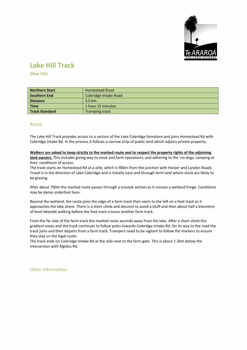
Lake Hill Track (Map 101) Northern Start Homestead Road
Southern End Coleridge-Intake Road
Distance 3.5 km
Time 1 hour 15 minutes
Track Standard Tramping track
Route
The Lake Hill Track provides access to a section of the Lake Coleridge foreshore and joins Homestead Rd with Coleridge Intake Rd. In the process it follows a narrow strip of public land which adjoins private property.
Walkers are asked to keep strictly to the marked route and to respect the property rights of the adjoining land owners. This includes giving way to stock and farm operations, and adhering to the ’no dogs, camping or fires’ conditions of access. The track starts on Homestead Rd at a stile, which is 900m from the junction with Harper and Lyndon Roads. Travel is in the direction of Lake Coleridge and is initially easy and through farm land where stock are likely to be grazing.
After about 700m the marked route passes through a tussock section as it crosses a wetland fringe. Conditions may be damp underfoot here.
Beyond the wetland, the route joins the edge of a farm track then veers to the left on a foot track as it approaches the lake shore. There is a short climb and descent to avoid a bluff and then about half a kilometre of level lakeside walking before the foot track crosses another farm track.
From the far side of the farm track the marked route ascends away from the lake. After a short climb the gradient eases and the track continues to follow poles towards Coleridge-Intake Rd. On its way to the road the track joins and then departs from a farm track. Trampers need to be vigilant to follow the markers to ensure they stay on the legal route. The track ends on Coleridge-Intake Rd at the stile next to the farm gate. This is about 1.3km below the intersection with Algidus Rd.
Other Information

Road Connection to Arboretum Track (Map 101) Northern Start Coleridge-Intake Rd
Southern End Coleridge-Intake Rd
Distance 2.9 km
Time 40 minutes
Track Standard Road margin
Route
This road connection joins the western end of Lake Hill Track with the northern end of the Arboretum Track.
Walk south up Coleridge-Intake Rd (away from the lake) from the Lake Hill Track trailhead towards the Algidus Rd intersection. Continue through the intersection on Coleridge-Intake Rd.
Beyond the cattle stop the road and surrounding land is owned by Trust Power Limited.Continue on the road as it enters pine forest and veers to the right. The Arboretum Track, the next Te Araroa track, starts on the right hand side of the road just as it makes its first hair pin turn to the left. Look out for oragne markers attached to a fence post.
Other Information

Arboretum Track (Map 101) Northern Start Coleridge-Intake Road
Southern End Hummocks Road, Lake Coleridge Village
Distance 900 m
Time 20 minutes
Track Standard Tramping track
Route
The track starts on Coleridge Intake Rd on the Rakaia River side of the Algidus Rd intersection and on Trust Power owned land. This is on the right as Coleridge-Intake Rd makes its first hair pin turn to the left. Look out for markers here and a track that has been cut through broom. This formed track quickly opens up and for a few metres follows the penstock pipes down towards the power station before turning left to enter pine forest.
Lower down the track leaves the forest, turns right, and descends directly through open country. It enters the Arboretum at a gate on the left and follows a well formed path passing a number of sign posted specimen trees along the way. The track end is through the memorial gate marking the exit from the Arboretum to Hummocks Rd.
The Arboretum comprises a site of approximately 2 ha and was established from 1933 by Harry Hart, who served as superintendent of the Lake Coleridge Power Station for 30 years until 1954. It now contains one of New Zealand’s best mature conifer collections including examples of at least two thirds of the world’s pine species.
Other Information
Lake Coleridge Lodge can be found a short distance down Hummocks Rd on the left. The Lodge provides good quality dinner, bed, and breakfast packages as well as free laundrey and a transport option for guests staying at standard rates (refer link on this page). The transport is great value at the rate of $75.00 to Glenrock Stream, where Te Araroa continues on the south side of the Rakaia River (for up to 2 people) - book in advance to ensure availability. The Lodge cannot provide transport for people not staying at the Lodge.
By prior arrangement Lodge guests also receive free storage of their dry goods for their onward journey.

Rakaia River Hazard Zone (Map 101 and 102) Northern Start
Southern End
Distance
Time
Track Standard Road margin
Route
The Rakaia is a large braided river with an unsettled shingle bed. Even in low flows it is not possible to safely ford this river on foot anywhere near Te Araroa's trailhead on the north bank. As a result, Te Araroa Trust has declared the Rakaia a hazard zone which does not form part of the trail. Instead it marks a natural break in the continuum, just like Cook Strait.
The trailheads on either side of the Rakaia make natural beginning or end points for Te Araroa section trampers and it is really only through-trampers that have to deal with the issue of getting from one trail head to the other. Don't risk a foot crossing. Instead go around the road in a vehicle. Doing so will not be compromising the integrity of a through-tramp. The Rakaia is a large braided river with an unsettled shingle bed. Even in low flows it is not possible to safely ford this river on foot anywhere near Te Araroa's trailhead on the north bank. As a result, Te Araroa Trust has declared the Rakaia a hazard zone which does not form part of the trail. Instead, it marks a natural break in the continuum like Cook Straight does.
The trailheads on either side of the Rakaia make natural beginning or end points for Te Araroa section trampers and it is really only through-trampers that have to deal with the issue of getting from one trail head to the other. Don't risk a foot crossing. Instead go around the road in a vehicle. Doing so will not be compromising the integrity of a through-tramp. On the north bank the trailhead is adjacent to Lake Coleridge Lodge on Hummocks Rd, which is within Lake Coleridge Village.
Other Information
The Lodge provides good quality dinner, bed, and breakfast packages as well as free laundrey and transport options for guests staying at standard rates (refer link on this page). The transport is great value at the rate of $75.00 to Glenrock Stream, where Te Araroa continues on the south side of the Rakaia River (for up to 2 people) - book in advance to ensure availability. The Lodge cannot provide transport for people not staying at the Lodge. By prior arrangement Lodge guests also receive free storage of their dry goods for their onward journey.

Clent Hills Track (Map 102, 103 and 104) Northern Start Glenrock Stream 34 km from SH 77 on Blackford Rd and then Double Hill Run
Rd.
Southern End Hakatere Heron Road 4.4 km beyond Buicks Bridge
Distance 45.7 km
Time 3 days
Track Standard Tramping track
Route
This Te Araroa section, from the Rakaia River to the Hakatere Heron Road, starts on a public access easement over Glenariffe Station. It then crosses the 60 000 hectare Hakatere Conservation Park before finishing in the Heron Basin on a paper road that runs through Castle Ridge Station.
It’s an area rich in high country history dating back to 1857 when Clent Hills Station was first farmed as a 20,000 hectare run under licence from the Crown. Over the years the station has survived many incarnations the most recent being the Nature Heritage Fund purchase of 10,000 hectares, which reduced the station to a rump of 2000 hectares within the Heron Basin.
The Clent Hills pastoral lease was in the Buick family from 1923 to 1982. The first 3 years of this tenure was spent eradicating rabbits before stock could be reintroduced to the property.
Glenrock Stream to Comyns Hut - 15.7 km (4-5 hours) From the DOC sign notifying “Access to North Branch Ashburton Stream” the track follows markers through farm land up the true right side of Glenrock Stream. At the 1.7 km mark the track crosses the stream and then merges with a farm track that begins to climb towards the Conservation Park boundary. Along the way the track passes a stand of Kowhai trees. No camping is permissible until inside the Conservation Park boundary. From the Conservation Park boundary the route zig-zags up an old farm track to Turtons Saddle (1120m). Beyond the saddle travel remains on the farm track and is initially east and upwards but soon turns south sidling then descending towards the Turtons Stream’s true left bank. The A-Frame Hut toilet becomes visible in the lower portions of the descent. After 8.7 km the track reaches Turtons Stream, which is the first water source en route that is both reliable and potable. The track remains on the true left and crosses Ensor Stream 1.5 km before A-Frame Hut, a tidy 3-bunk hut near the Comyns Stream’s confluence with Turtons Stream., It takes about an hour from the saddle to reach this hut. Beyond A-Frame Hut the track continues down the true left of Turtons Stream for about 2 km. This is to the first of 4 river crossings in close succession. The track then climbs and descends into Mutton Gully. Once out of this gully, Turtons Stream is forded a final time. It's then an easy 700 m walk to Comyns Hut (8 bunks). The current Comyns Hut was built in 1957 to replace the original and derelict hut, which was built in the 1890s and still stands nearby. The ‘new’ hut is basic but was improved following restoration work in 2008. The hut door and walls act as an informal and historic register and make interesting reading. Comyns Hut to Double Hut junction – 16 km (6 – 8 hours)

This part of the track is rough and unformed. Trampers are required to pick their own route between markers which, in poor weather, may not be visible from one to the next. The physical and navigational challenges rise accordingly. A marker behind the hut shows the route heading west up the North Branch Ashburton River towards Round Hill Creek. Travel quickly becomes confined to the stream bed and involves frequent river crossings. These are straightforward in normal flows. Round Hill Creek joins North Branch Ashburton as the latter heads north towards Petticoat Lane. From this confluence Te Araroa continues up Round Hill Creek, past Logan Stream, and then departs to begin theascent towards Clent Hills Saddle (1480m). On a clear day the saddle affords great views of the Longman Range, Ricki Spur and the wider Lake Heron Basin. Care needs to be taken to ascertain the correct route beyond the saddle. Do not descend. Instead continue to the right along the saddle and link to the upper-most track crossing a large scree slope. On the far side of the scree the route continues to sidle through tussock to the next ridge. Marker poles become evident again along the way. From the ridge the poles lead down and to the right, diagonally away from the Swin. Eventually, after crossing 3 further scree slopes, the track reaches a dilapidated fence along another ridge line. Follow the fence line down the ridge to a rock cairn and arrow, which indicate the way down and to the right towards the next pole and ultimately to an unnamed stream, which is a tributary to the Swin River. Once across this stream the final climb begins towards the Mellish Saddle. The route down from the saddle becomes easier and remains above the true left bank of Mellish Stream. It emerges into the wider Heron Basin and passes a sign-posted junction with a side trail out to the road end at Lake Heron. Continue on the main track for about 1 km to another junction near the Swin River, which is crossed on foot but seldom an issue. From here Double Hut (6 bunks) is 1 km away on another side trail. Double Hut has 6 bunks and is in reasonable condition. Double Hut junction to Hakatere Heron Rd (via Manuka Hut) - 14 km (3 - 4 hours) The track continues south for 6.4 km across grassy and gravel flats passing the Seagull and Manuka Lakes along the way. This is to a junction from where Manuka Hut (6 bunks) is hidden 300 upstream and to the left. Note: The next reliable water source on Te Araroa beyond Manuka Hut is on the Clearwater Track and 17.3 km distant. Beyond the Manuka Hut junction Te Araroa continues south for a little over 2 km and then turns west to climb to the ridge on Emily Hill’s south flank. The poled track line then sidles down through matagouri and spear grass to the flats. From here it's easier going across to a carpark at Lake Emily. At this point the track leaves the Hakatere Conservation Park and joins with a marked paper road that bisects Castle Ridge Station. Trampers should take care to follow the markers to avoid straying onto private property. Its 5 km from Manuka Hut to the Lake Emily carpark and then another 3.2 km on the Castle Ridge paper road to Hakatere Heron Rd. This is where the Clent Hills Track ends. There is a farm gate across the paper road about 600m before the finish point. This gate should be left open or closed as it is found. For trampers continuing south, turn left onto Hakatere Heron Road and walk 4.4 km to the Clearwater Track trail head. This is on the right hand side of the road just beyond Buicks Bridge.
Other Information
Carpark for 4x4 vehicles at Lake Emily. Otherwise roadside parking near Hakatere Heron Rd.

Road Connection to Clearwater Track (Map 104) Northern Start Hakatere Heron Rd junction with Castle Hill paper road - 4.4 km north of
Buicks Bridge
Southern End Hakatere Heron Rd - south side of Buicks Bridge
Distance 4.4km
Time 1 hour
Track Standard Road margin
Route
This connection is on the Hakatere Heron Rd and joins the south end of the Clent Hills Track with the eastern end of the Hakatere Track.
Other Information
Northern start - car park, standard campsite nearby
Accommodation at Lake Clearwater
Southern end – no amenities, accommodation a possibility at Mt Potts Station (refer to link on this page)

Clearwater Track (Map 105 and 106) Northern Start Hakatere Heron Rd on the south side of Buicks Bridge
Southern End Carpark at the Potts River Bridge on Hakatere Potts Road.
Distance 21.4 km
Time 4 - 6 hours
Track Standard Tramping track
Route
This high county track passes through the Hakatere Conservation Park on land formally comprised in the 9119 hectare Hakatere Station. This pastoral leasehold property was purchased by the Nature Heritage Fund in October 2007 and returned to the conservation estate. Free public access is now afforded, as is protection to significant wetlands and expansive tussocked landscapes.
There are no huts en route but trampers can camp as it suits.
From the south side of Buicks Bridge, which crosses the South Branch Ashburton River, marker poles lead westward across easy open country . This is towards the gap between Mt Guy and Dogs Hill. At the 5 km mark the track crosses a fence line and later it joins an old farm track, where it stays for another 5 km. At this point the marked track turns left and heads towards a saddle at the western end of Mt Guy. It passes a tarn along the way.
From the Saddle there are sweeping views over Lake Clearwater towards the Harper Range, of Mt Potts, and to, then beyond, the Rangitata River. Follow the fence line down to the creek at the base of the hill. The track then heads south-west towards the head of Lake Clearwater and joins with another old farm track, which continues towards the Potts River but stops at a gate. Te Araroa heads northward here to avoid crossing private property then bends around towards the lip on the Potts River's true left bank. Once on the lip the track stays high and follows the fence line. It then drops steeply into a gully, which opens to the Potts River bed. If the Potts River is running clear then the best travel is usually downstream direct to the carpark at the road bridge.
If the Potts is discoloured this exit will be impassable. The proper course then is up the other side of the gully. Trampers are then able to remain on the Potts side of the fence line through to the road. From here it’s a short walk down hill to the car park and trailhead.
Other Information

Rangitata River Hazard Zone (Map 106) Northern Start
Southern End
Distance
Time Track Standard Road margin
Route
The Rangitata is a large braided river with an unsettled shingle bed. It poses a significant danger to trampers on foot and, as a result, Te Araroa Trust has declared it a hazard zone which does not form part of the trail. Instead it marks a natural break in the continuum like Cook Strait does.
The Potts River and Bush Stream trailheads on either side of the Rangitata, make ideal beginning or end points for Te Araroa section trampers and it is really only through-trampers that have to deal with the issue of getting from one trailhead to the other. Trampers are urged not to risk a foot crossing. It's best to find an alternative way around and doing this will not compromising the integrity of a through-tramp. While trampers are cautioned not to attempt to cross the Rangitata on foot, fit adults experienced with river crossing techniques have been known to cross safely in low-flow summer conditions. The best crossing point is above the confluence with the Potts River. Conditions suitable for a foot crossing are most likely to occur in the late summer months. Be aware though, even in high summer this river can flood and become impassable at any time. For more information on river crossings refer Mountain Safety Council web site available through the link on this page. Wayne from Alps 2 Ocean can assist crossing using inflatables - to enquire contact him on [email protected]
Other Information

Two Thumbs Track (Map 106, 107, 108 and 109) Northern Start Bush Stream carpark, Rangitata Gorge Rd
Southern End Boundary Stream carpark, Lilybank Rd
Distance 55 km
Time 2 -3 days
Track Standard Tramping track
Route
The Two Thumbs Track is a fine high country trail that provides a challenging traverse through the Te Kahui Kaupeka Conservation Park. This is from the south side of the Rangitata River through to Boundary Stream at Lake Tekapo. The park opened in April 2009 and resulted from the successful tenure review of the Mesopotamia and Richmond Station pastoral leases.
Mesopotamia Station was once owned by the English polymath, Samuel Butler. The surrounding mountains, wide braided river and hanging valleys give this remote part of the South Island its lost world character, and inspired Butler’s fantastical satire, Erewhon. It’s an open and expansive environment that has a big country feel to it.
New Zealand’s Colonial Secretary Dr Andrew Sinclair was drowned in the Rangitata River after surveying the wide braids of the river system with Julius von Haast in 1861. He was seeking a way through the river to get back to Butler’s homestead. His grave is now marked as an historic site.
In pre-human times lower areas were most likely forested. However, burning reduced forest cover to remnants and resulted in the snow tussock cover that predominates today.
The start of the track is sign-posted, at the Bush Stream carpark beyond Mesopotamia Station, and is mostly unformed but marked with poles from there. Access is via Rangitata Gorge Rd. The huts en route are classic musterers’ huts and add an important historic dimension to this tramp.
Bush Stream car park to Crooked Spur Hut (4 hours)
Follow markers from the carpark up towards Bush Stream. Once at the stream, travel is up or adjacent to the river bed, crossings as required. These crossings are straightforward in normal flows but can be tricky after rain or during spring when the stream is fed by snow melt.
The track leaves the stream bed on the left to avoid a gorged section. In the process it climbs and then descends back towards Bush Stream. Ford Bush Stream a final time near a concrete slab, the last remains of an old swing bridge. From the true left side a formed track climbs towards Crooked Spur Hut (5 bunks). This track was still used for mustering purposes up until 2009 and the climb to the hut takes about 1 hour.
Crooked Spur Hut is tired but provides adequate accommodation. It’s in a good location with views down Bush Stream to the Rangitata River.
Crooked Spur Hut to Stone Hut (5 hours)

From Crooked Spur Hut the track goes west around Crooked Spur and climbs steadily for 1-½ hours to a saddle at 1500m.
From the saddle the track descends to cross Pack Horse and Sweeps Streams before returning to Bush Stream. Travel is then up the true left bank to an old stock bridge. Cross it to reach Stone Hut.
Stone Hut (8 bunks) is in reasonable condition.
Stone Hut to Royal Hut (2 hours)
Beyond the hut Te Araroa follows Bush Stream to Royal Hut (8 bunks). Prince Charles and Princess Anne reputedly visited as children, hence the hut’s name.
Royal Hut to Camp Stream Hut (5 hours)
The first part of the day involves a climb over the Two Thumb Range via Stag Saddle (1925m), the highest point on Te Araroa. From the hut cross Bush Stream and follow the poles upwards. The climb to the saddle is fairly steep in places but quite safe in reasonable weather. The contours ease towards the saddle, where cell phone coverage is available. From the saddle it is possible to scramble up to the ridge on the right hand side and then to descend the ridge line past the turn off to Rex Simpson Memorial Hut (private) and .1468 to a 4WD track. While unmarked this route is generally sound underfoot and affords excellent views across Lake Tekapo to Mt Cook. It is the preferred route in fair weather. Turn left onto the 4WD track, which fords Camp Stream on its way to Camp Stream Hut (6-bunks). The alternative poor weather route down from Stag Saddle is lightly poled and runs down into the tussock covered Camp Stream Valley. Lower down this valley the 2 routes converge at the 4WD track, turn right here to access Camp Stream Hut, which is on the true left side of the stream. Camp Stream Hut is compact but in reasonable condition. Camp Stream Hut to Boundary Stream car park (5 hours)
The track leaves Camp Stream Hut for the Ski Field Road. Trampers must ford Coal River along the way. From the far side of the river it’s a steep but short climb to the road. There is a car park well down the road for those wanting to exit here.
Meanwhile Te Araroa continues on conservation land parallel with Lake Tekapo and along the base of the Richmond Range. The track crosses Washdyke Stream on its way to Boundary Stream where it descends above the true right bank to a car park at Lilybank Road.
Other Information
Transport to and from the trailheads is available.
To/from Geraldine - to either end of the trail, contact Wayne from Alps 2 Ocean on [email protected] for
assistance.

Road Connection to Tekapo-Twizel Track (Map 109 and 110) Northern Start Boundary Stream car park, Lilybank Rd
Southern End Lake Tekapo Village
Distance 15 km
Time 3-4 hours
Track Standard Road margin
Route
This connection along Lilybank Rd joins the southern Two Thumbs Track with the northern end of the Tekapo-Twizel Track. An off road route is being pursued by Te Araroa Trust and it is hoped that this will become available in due course.
In the meantime follow the road shoulder south towards SH 8. The road ordeal ends at the Lake Tekapo Regional Park, which affords lakeside walking for the final section into Lake Tekapo Village.
Other Information
Lilybank Rd – car park only.
Lake Tekapo Village - full range of amenities.

Tekapo-Twizel Track (Map 110, 111, 112 and 113) Northern Start Tekapo Power Station
Southern End Junction SH8 and Ruataniwha Rd, Twizel
Distance 70 km
Time Two days
Track Standard Tramping track
Route
The Tekapo-Twizel Track is easy but long. The previous route along the Tekapo Canal is closed indefinitely as Genesis Energy undertake siginifcant construction work on the Canal. The amended route is a quiet and picturesque alternative.
47 kilometres from Lake Tekapo you can camp at the Pines Camping Area just past the outlet into Lake Pukaki, which has pit toilets but only lake water. Nicer toilets and drinking water are available at the now closed Lake Pukaki Visitor Information Centre about a kilometre further along.
Unless you plan to treat water en route, carry plenty of drinking water. Tekapo - SH 8 From Lake Tekapo township, follow SH8 5km, and turn right into Braemar Rd.
SH 8 - Pukaki Follow Braemar Rd 22km up and over the hills dropping down to meet Lake Pukaki. Although this is "road" walking, it is a gravel road through spectacular scenery and you're unlikely to see a vehicle all day. When you reach the shores of Lake Pukaki, Te Araroa joins with the Alps 2 Ocean Cycle Trail through Lake Pukaki village and onto Twizel.
Pukaki - Pines Camp From joining the A2O Trail, the track continues around the lakeshore for 20 kilometres to reach the Pines Camping Area.
Pines Camp - Twizel Continue along the A2O Cycle Trail though the signage on the ground may not yet reflect this. Where there is conflicting signage follow the A2O signs. You'll be led along the shore to Lake Pukaki Village then the track heads south into the Department of Conservation’s Pukaki Flats Reserve then turns right and exits to the highway for at Bendrose Reserve. Turn left onto the highway for one last kilometre into Twizel. You’ll see finger signs indicating the safest crosspoint just outside the town.
Other Information

Lake Ohau Track (Map 113, 114, 115 and 116) Northern Start SH8 opposite Ruataniwha Rd at Twizel
Southern End Glen Mary Ski Club at Lake Ohau
Distance 33 km
Time 8-9 hours
Track Standard Easy tramping track
Route
This track traces the lower sections of the Mackenzie Basin power scheme to Lake Ohau and then follows the lakeshore. On the approach, the track also skirts Lake Ruataniwha.
Lake Ruataniwha is manmade and its dam was built between 1978 and 1981. In addition to storing water for power generation, the lake provides recreational opportunity. It’s a world class rowing venue. It’s also where Peter Knight broke a world speed record for Grand Prix hydroplanes in 1996. In doing so he reached a speed of 286.5 kilometres per hour. In addition to being part of Te Araroa the section around the Lake Ohau shoreline will be part of the Alps 2 Ocean Cycleway. Construction of the cycleway is scheduled for the summer of 2012/13 but at present the track is unmarked and included some road margin. Regardless, it is a straightforward walk and the route is easy to follow with the use of these notes.
The track starts on SH 8 outside Twizel opposite Ruataniwha Rd where Te Araroa’s next section to the north is sign-posted. From here follow the gravelled walk/cycleway south for 2 km past Meridian Energy’s Twizel office, then continue on down the left side of the road to cross the spill way and then the bridge over the Ohau B canal.
Once across the canal bridge immediately cross the road (i.e. before the salmon farm and Ohau Riverside Drive) and join a formed track that runs along the terrace above Lake Ruataniwha for about 3 km. From the end of this track the trail joins Ohau Riverside Drive and descends around a cove with a large patch of rushes at its head.
Beyond the cove travel is predominantly on the road to the lake head and beyond along the Ohau River to the Weir at Lake Ohau. Walkers have some opportunity for off road walking here. This is on tracks that run on the land between the road and the lake/river.
From the Weir a lakeside track is scheduled for development as part of the Alps to Ocean Cycleway but travel is already straightforward on foot. This is mostly on an old grassed farm track around the Lake Ohau margin. Scrub encroaches in places but doesn’t unduly impede. There are 4 fence lines en route, which can be climbed with care.
Trampers can pick up the track by walking west from the Weir around towards the lake shore. It takes about an hour to reach a private hut set back from shore within a small bay. In the next bay the track breaks through Maori Swamp but travel is okay proximate to the lakeshore on good stock tracks.

In time the lake side track resumes. Continue on to a locked gate at the 4th fences line just before Lake Ohau Road.
Turn right onto the road and follow the road shoulder to Lake Middleton, then follow the eastern shore to the lakehead. Return to road shoulder here and walk past the Alpine Village to a small stand of beech. From this point there is a good track between the road and Lake Ohau around to Glen Mary Ski Club where the next Te Araroa section begins.
Other Information
Twizel - full range of amenities
Lake Ohau - roadside parking only

East Ahuriri Track (Map 116 and 117) Northern Start Glen Mary Ski Club on Lake Ohau Road
Southern End Birchwood Rd approximately 7 km from SH8
Distance 24 km
Time 1 - 2 days
Track Standard Tramping track
Route
The track climbs 800 m from Lake Ohau over the Ohau Range to the Ahuriri River. This is through the Ruataniwha and Ahuriri Conservation Parks. The track has no obvious ground trail for long stretches and the markers are often distant. That said, the East Ahuriri Track is a gem and provides a good transitional tramp for moderately experienced trampers looking to go the next step, off the heavily used and well-groomed tracks where they’ve learned their craft and onto Te Araroa’s more remote and demanding sections. The track starts next to the Glen Mary Ski Club and traverses to Freehold Creek. It then climbs through beech forest to the tree line. It’s a well marked and clearly formed track to this point – a good day walk for anyone wanting a return trip from the Ski Club. From the tree line the track is unformed and lightly marked but finding the way will still be fairly obvious if you’re well prepared. The going becomes slow and it’s reasonably rough underfoot as you cross the range and head down the East Ahuriri Valley but travel quickens as the terrain eases lower down. Just before the track ends trampers encounter the Ahuriri River which, in normal flows, is the largest unbridged river on Te Araroa in the South Island. If it’s unsafe to ford, however, there is a road bridge 5 km downstream. This provides the bailout option. The track starts on the 4 wheel drive track next to Glen Mary Ski Club and climbs to join with the marked Parsons MTB track, which traverses across to Sawyers Creek and beyond to Freehold Creek.
Once at Freehold Creek follow DOC markers up through the beech forest remnant to an informal camp site. The treeline is just a few minutes further along.
Beyond the treeline the track initially follows the poles and light ground trail towards Dumb-bell Lake. This is on the true right of Freehold Creek. The East Ahuriri Track peels off this track in a southwest direction towards point 1374 but it is not obviously marked lower down. There is a marker pole at S44 16.669 E169 46.015 and from here there are regular poles (though they are not always visible from one to the next) along the east side of the swamp between points 1516 and 1489. The poles continue on this line until the beginning of the descent into the East Ahuriri. This is at the bluffs immediately east of point 1374.
Descend with care to the East Ahuriri River. From here travel is downstream by the most practical route. There are only infrequent markers, just enough for occasional reassurance if any is needed. There are a few river crossings but these are straightforward in normal flows.
The track climbs and sidles above the true right bank when it needs to avoid two gorged sections. Along the way a hut becomes visible in the distance on the true left side of the river but this is derelict.The going becomes easier as the river opens up lower down.
The track reaches the first line of pine trees as it emerges into the wider Ahuriri Valley. There are more pine trees further along as you continue straight ahead towards the Ahuriri River.

Follow the fence down to the Ahuriri's Bank and look across for the track markers on the other side. They continues about 50m downstream from the 4WD track that cuts down far bank. Once you’ve identified this spot it’s time to look for a safe place to cross the river. Note: if the Ahuriri cannot be forded safely continue downstream for about 5 km to the Ireland Road Bridge. It is then about the same distance back up Birchwood Rd to the trailhead. From the far side of the river the track follows marker poles straight up the steep bank. The track then turns left and follows the top of the river bank to the next fence line, which marks a right hand turn and the final walk out to the trailhead on Birchwood Rd. There is a carpark across the road, which is where Te Araroa’s next section starts - the Breast Hill Track.
Other Information
Lake Ohau - Accommodation nearby at Lake Ohau Lodge.
At Southern end, car park only.