Embed Size (px)
Citation preview
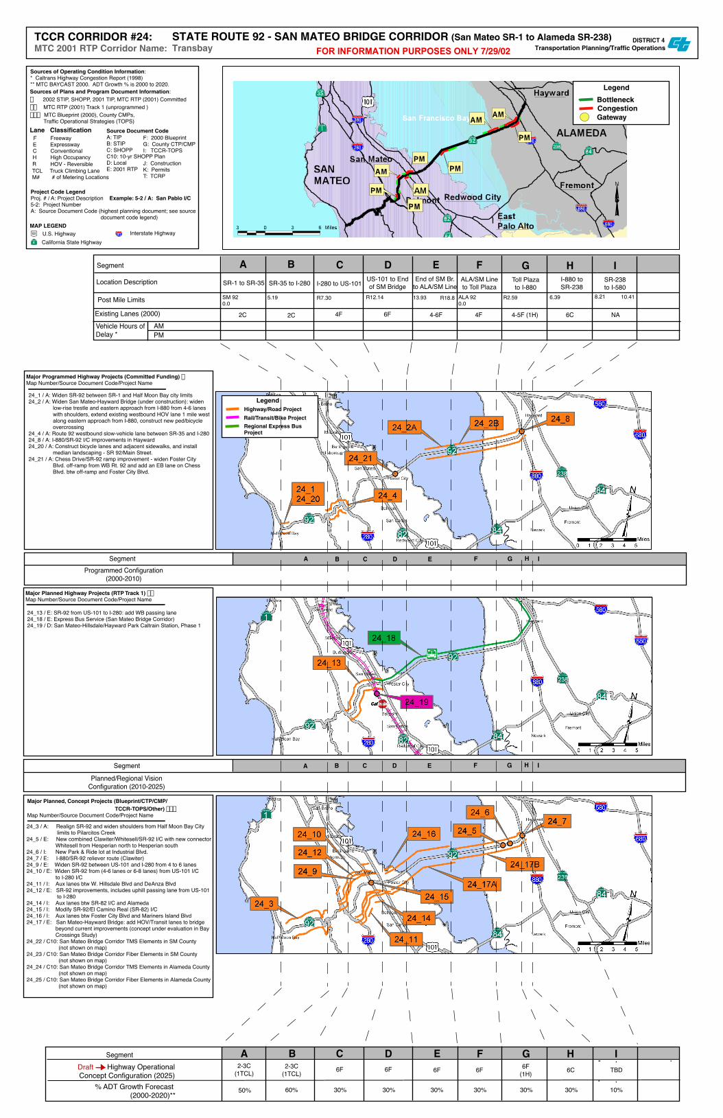
Segment
Segment
Programmed Configuration(2000-2010)
Planned/Regional VisionConfiguration (2010-2025)
Major Programmed Highway Projects (Committed Funding) fMap Number/Source Document Code/Project Name
Major Planned Highway Projects (RTP Track 1) ffMap Number/Source Document Code/Project Name
Major Planned, Concept Projects (Blueprint/CTP/CMP/ TCCR-TOPS/Other) fffMap Number/Source Document Code/Project Name
Legend
Rail/Transit/Bike Project
Highway/Road Project
Regional Express BusProject
A B C D E F G H I
EDCBA
Location Description
Segment
Vehicle Hours ofDelay *
Existing Lanes (2000)AMPM
Post Mile Limits SM 920.0
R7.30 R12.14 R18.8 ALA 920.0
6.39 8.21
SR-1 to SR-35 I-280 to US-101 I-880 toSR-238
F G H I
2C 2C 4F 6F 4-6F 4F 4-5F (1H) 6C NA
5.19 13.93 R2.59
SR-35 to I-280 US-101 to Endof SM Bridge
End of SM Br.to ALA/SM Line
ALA/SM Lineto Toll Plaza
Toll Plazato I-880
SR-238to I-580
SegmentHighway Operational
Concept Configuration (2025)% ADT Growth Forecast
(2000-2020)**
DraftEDCBA F G H I
2-3C(1TCL)
2-3C(1TCL) 6F 6F 6F 6F 6F
(1H) 6C TBD
50% 60% 30% 30% 30% 30% 30% 30% 10%
24_1 / A: Widen SR-92 between SR-1 and Half Moon Bay city limits24_2 / A: Widen San Mateo-Hayward Bridge (under construction): widen low-rise trestle and eastern approach from I-880 from 4-6 lanes with shoulders, extend existing westbound HOV lane 1 mile west along eastern approach from I-880, construct new ped/bicycle overcrossing24_4 / A: Route 92 westbound slow-vehicle lane between SR-35 and I-28024_8 / A: I-880/SR-92 I/C improvements in Hayward24_20 / A: Construct bicycle lanes and adjacent sidewalks, and install median landscaping - SR 92/Main Street.24_21 / A: Chess Drive/SR-92 ramp improvement - widen Foster City Blvd. off-ramp from WB Rt. 92 and add an EB lane on Chess Blvd. btw off-ramp and Foster City Blvd.
24_13 / E: SR-92 from US-101 to I-280: add WB passing lane24_18 / E: Express Bus Service (San Mateo Bridge Corridor)24_19 / D: San Mateo-Hillsdale/Hayward Park Caltrain Station, Phase 1
24_3 / A: Realign SR-92 and widen shoulders from Half Moon Bay City limits to Pilarcitos Creek24_5 / E: New combined Clawiter/Whitesell/SR-92 I/C with new connector Whitesell from Hesperian north to Hesperian south24_6 / I: New Park & Ride lot at Industrial Blvd.24_7 / E: I-880/SR-92 reliever route (Clawiter)24_9 / E: Widen SR-92 between US-101 and I-280 from 4 to 6 lanes24_10 / E: Widen SR-92 from (4-6 lanes or 6-8 lanes) from US-101 I/C to I-280 I/C24_11 / I: Aux lanes btw W. Hillsdale Blvd and DeAnza Blvd24_12 / E: SR-92 improvements, includes uphill passing lane from US-101 to I-28024_14 / I: Aux lanes btw SR-82 I/C and Alameda24_15 / I: Modify SR-92/El Camino Real (SR-82) I/C24_16 / I: Aux lanes btw Foster City Blvd and Mariners Island Blvd24_17 / E: San Mateo-Hayward Bridge: add HOV/Transit lanes to bridge beyond current improvements (concept under evaluation in Bay Crossings Study)24_22 / C10: San Mateo Bridge Corridor TMS Elements in SM County (not shown on map)24_23 / C10: San Mateo Bridge Corridor Fiber Elements in SM County (not shown on map)24_24 / C10: San Mateo Bridge Corridor TMS Elements in Alameda County (not shown on map)24_25 / C10: San Mateo Bridge Corridor Fiber Elements in Alameda County (not shown on map)
A B C D E F G H I
10.41
Legend
CongestionBottleneck
Gateway
Project Code LegendProj. # / A: Project Description Example: 5-2 / A: San Pablo I/C5-2: Project NumberA: Source Document Code (highest planning document; see source document code legend)
Sources of Operating Condition Information:* Caltrans Highway Congestion Report (1998)** MTC BAYCAST 2000. ADT Growth % is 2000 to 2020.
H High Occupancy
Lane Classification F Freeway E Expressway C Conventional
TCL Truck Climbing LaneM# # of Metering Locations
R HOV - Reversible
Sources of Plans and Program Document Information:f 2002 STIP, SHOPP, 2001 TIP, MTC RTP (2001) Committedff MTC RTP (2001) Track 1 (unprogrammed )fff MTC Blueprint (2000), County CMPs, Traffic Operational Strategies (TOPS)
MAP LEGENDU.S. HighwayCalifornia State Highway
Interstate Highway
Source Document CodeA: TIPB: STIPC: SHOPPC10: 10-yr SHOPP PlanD: LocalE: 2001 RTP
F: 2000 BlueprintG: County CTP/CMPI: TCCR-TOPS
J: ConstructionK: PermitsT: TCRP
DISTRICT 4Transportation Planning/Traffic OperationsFOR INFORMATION PURPOSES ONLY 7/29/02
TCCR CORRIDOR #24:MTC 2001 RTP Corridor Name:
STATE ROUTE 92 - SAN MATEO BRIDGE CORRIDOR (San Mateo SR-1 to Alameda SR-238)Transbay