Embed Size (px)
Citation preview

Pag
e1
Libya: Project E&P Potential and
Rank of Onshore and
Offshore Quadrants Including Delineated Undeveloped Fields, Single
Well Discoveries and Dry-holes
Target Exploration
Target Exploration

Pag
e2
The Report To speedup negotiation with the Libyan NOC we have updated and modified our popular database review and rank of offshore and onshore E&P Concessions of Libya, to a database review and rank of 208 offshore and onshore quadrants of Libya, which, as well can be loaded on a laptop and taken into the negotiation room. In this study we used >666 well records, numerous well logs, stratigraphic sections, structural sections, and stratigraphic, geochemical, tectonic and structural maps of Cyrenaica, Ghadames, Murzuk, Sirt, Tripolitania, and offshore basins of Libya. Due to the large number of parameters, and to impartially assess, compare, and rank the E&P potentials of the 208 Quadrants, one concession and well location map was drafted, two main EXCEL© databases were compiled, and five subsidiary EXCEL© databases were generated to summarise well records, exploration records, and geological, geochemical, and tectonic parameters of the 208 Quadrants:
1. A well location map of the 208 quadrants (Scale 1/2500) was drafted to illustrate the exploration or production status of the wells within the quadrant.

Pag
e3
2. . 2The first E&P database lists drilling, engineering and geological data, status and results of the 666 wells in all quadrants (28*666 data entries). One sort variation of the second database was generated to alphabetically list wells per each quadrant.
The second E&P database summarises the drilling, engineering and geological data per quadrant (31*208 data entries). An exploration risk equation was modified to rank the relative E&P potential of the individual quadrants, via comparing the source, reservoirs, cap rocks, tectonics, remaining undrilled anomalies, and exploration results of each quadrant. Four sort variations of the second database were generated in order to rank every one of the 208 quadrants, and to produce 51 charts illustrating the relative E&P ranks of the quadrants of every basin-province, the relative E&P rank of the quadrants for all basins-provinces in Libya, the relative size and distribution of the proven, probable and possible discovered hydrocarbon reserves of all quadrants, as well as other parameters not included in the ranking equation
Fig. 2. Libyan Quadrants, NOC 2012
Pag
e4
1. Introduction Apart from the surface stratigraphic divisions, there are no less than 20 stratigraphic nomenclatures charts for Sirte Basin alone, for almost every one of the early operating companies has one or several charts of the encountered subsurface stratigraphic units. Similar situations, though to a lesser magnitudes exist for other sedimentary basins of Libya. This E&P history produced variegated stratigraphic correlation levels, which are hard to correlate without the actual lithologic and electric logs. Published records of 666 wells (Figure 1) within the 208 Quadrants of offshore and onshore Libya as published by the NOC in early 2012 (Figure 2) were reviewed through this study, also a large number of documents, well logs, cross-sections, and tectonic, stratigraphic, geochemical and structural maps of onshore and offshore Libya as published in the Al Fateh University series of conferences on the geology of Libya, (e.g. Wenneker et al 1996 and Ibrahim, 1992, 2000b, 2001a, 2001b). 2. Geological Input Proven source rocks of Libya were found in the Silurian, Devonian, Carboniferous, Triassic, Lower and Upper Cretaceous, Paleocene and Eocene Rocks. Proven reservoir rocks of Libya are in Basement, Ordovician, Silurian, Devonian, Carboniferous, Triassic, Cretaceous, Paleocene, Eocene and Oligocene Rocks, (Winnekers, 1996). More than 30 maps showing the regional tectonic elements, thickness, distribution and structural configuration of source, reservoir and cap rocks of onshore and offshore Libya were updated and used in this study, including: large scale geological map sheets of Libya, and tectonic elements map of Libya.

Pag
e5
Regional structural maps includes: structural contour map of Precambrian-Cambrian Basement rocks, structural contour map of top of Hercynian unconformity, structural contour map of top of Mesozoic rocks, lap-out map on top of Precambrian-Cambrian Basement. Regional isopach maps are: isopach and facies map of the Ordovician rocks, isopach and facies map of the Silurian rocks, isopach map of the Devonian rocks, isopach map of the Permo-Carboniferous rocks, isopach map of the Triassic rocks, isopach map of the Jurassic rocks, isopach map of the Lower Cretaceous rocks, isopach map of the Upper Cretaceous rocks, facies map of the Upper Cretaceous rocks, isopach and facies map of the Paleocene rocks, isopach and facies map of the Eocene rocks, isopach and facies map of the Oligocene rocks, isopach and facies map of the Miocene rocks. Regional source rock maps used are: isopach map of proven-possible Silurian source rocks, isopach map of probable-possible Devonian source rocks, isopach map of proven-possible Triassic source rocks, distribution map of proven-possible Lower Cretaceous source rocks, distribution map of proven-possible Upper Cretaceous source rocks, and distribution map of proven-possible Paleocene-Eocene source rocks. Added to all this geochemical source rock analysis of Upper Cretaceous formations, and play fairway maps of several formations. The primary source of the above information are the regional study the regional geology team of Sirte Oil Company (Wennekers et al., 1996), and publications in Al Fateh University series of conferences on the geology of Libya (such as Ibrahim 1992).

Pag
e6
The NOC’s tectonic elements map of Libya indicates that every one of the main Libyan oil provinces can be subdivided into several tectonic elements see table 1 below:
Table 1 Tectonic Elements of the Main oil Provinces of Libya
1.1. Cyrenaica Quadrants: Inverted Jabal Akhdar Basin, Cyrenaica Platform, Marmarica Trough As-Solouq
Depression.
1.2. Ghadames Quadrants: Ghadames Basin, Al Hamra High.
1.3. Murzuk Quadrants: Murzuk Basin, Dor El Gussa Trough and Gargaf Uplift.
1.4. Offshore Quadrants: Sebratah Basin, Offshore Hagfa Trough, Offshore Agdabia
Trough, Benghazi Basin and Offshore Al Bottnan Basin?
1.5. Sirte Quadrants: Hon Graben, Dor Al Abd Trough, Zella Trough, Hagfa Trough, Bu Tumaym Trough,
Ajdabia Trough, Hameimat Trough, Maragh Trough, Sarir Trough and Siwa Basin?
1.6. Tripolitania Quadrants : Jeffara Trough and Zamzam Trough.
Pag
e7
3. Using Databases to Rank Quadrants To impartially rank, and illustrate the reasons for ranking the top most promising quadrants thirty regional source, reservoir structural and tectonic maps of onshore and offshore Libya were updated, and source, reservoir and seal rocks parameters, and past exploration results of each quadrant were listed and plotted. The ranking of the Quadrant was done objectively by using a RLATIVE E&P POTENTIAL (SCORE); which is a modified risk equation, modified to accommodate proven reserves within the quadrants. This equation can be changed should the priorities change (e.g. gas rather than oil), on the spot. Due to the tripartite well classification of the Libyan National Oil Corporation (Dry, Oil, Gas, with few Suspended Wells), a concessions map showing the location, status (dry hole, oil well, gas well and shows) of 666 wells, undeveloped oil and gas fields, and discoveries within the Quadrants (Scale 1/2500). Two Basic Excel Databases were compiled: 1. EXCEL Database 1: lists data, status and results of every well in the 208 quadrants as 666*28 data
entries. A sort variation of this database (Database 1A) lists the wells per each quadrant. 2. EXCEL Database 2: summarises E&P data, exploration histories, geological etc. and all parameters used
in ranking the Quadrant as 208*31 data entries. Six sort variations of Database 2, which rank every one of the 208 quadrants were used to produce 51 charts illustrating: the relative E&P ranks of the quadrants of every basin in database 2A, the proven, probable and possibly discovered oil and gas reserves in dbase 2Bo and 2Bg for the entire country with charts illustrating the size and distribution of
Pag
e8
the proven, probable and possible discovered reserves of all the quadrants. These sort variations and other variations such as database 2D, and database 2E will be discussed below.
4. Database Number 1: Wells, Undeveloped Fields, and Discoveries in 208 Quadrants of Libya Database No. 1 is an Excel Database of 666*28 cells/entries (9 to 28 entries per every one of the 666 wells in the 208 quadrant in onshore and offshore Libya), which summarises Target's information, as well as published technical data on fields and wells in Libya. All information were checked for accuracy and reliability or modified and corrected before using them in this study. The titles of the 28 entries/well are: 208 Quadrant, Well Name, Longitude, Latitude, Well Number, Original Concession, Original Operator, Location, Completion, Completion Date, TD in Meters, Formation at TD, Results. If the review proved that the well discovered commercial Oil and or Gas additional entries are added: Field Name, Trap Type, Pay (s), Reservoir Lithology, Depth of Reservoir in Meters, Net/Gross Pay Thickness, Reservoir (s) Age(s), Oil density in Number of Wells in 1999, Number of Producing Wells, Number of P&A Wells, Present Status of the Field/Discovery, and Comments. 4.1. Database 1A This is a modification of Database No. 1, in which the wells were sorted alphabetically for each of the Quadrants.

Pag
e9
5. Database No. 2: Ranks, Relative E&P Potentials, and Undeveloped Oil and Gas Fields and Discoveries of 208 Quadrants in Onshore and Offshore Libya Database No. 2 is an Excel database of 208*31 entries, which summarises all available published information, and data on source facies, richness, and maturity, reservoir rocks facies, and the structural configuration of on-and offshore Libya. All information was checked for reliability and correctness before synthesis. The titles of the 31 entries for each Quadrant are: 208 Quadrant, Decimal Long. Decimal Lat. modified risk equation to accommodate proven reserves, it can be changed should priorities change, on the spot), Area of the Quadrant in Kms 2, Proven Oil Reserves (in MMBbls) of undeveloped fields/discoveries if present within the quadrant, Estimated Oil Reserves, (to quantify Probable Oil Reserves =2 MMBbls and Possible oil reserves =1 MMBbls), Proven Gas Reserves (in TCF) of undeveloped fields/discoveries if present within the quadrant, Estimated Gas Reserves, (to quantify probable Gas Reserves =0.02 TCF and possible Gas Reserves =0.01 TCF), Total Number of Wells in the Quadrant, Number of Discovery and/or Suspended Wells, Number of Delineation Wells, Number of Producible Wells. (Wells judged to be completed as a producer), Number of Wells Which Encountered HC Shows, Number of Dry and/or Junked Wells, Kms 2/Exploration Well (Area in Sq Km/((Total Number of Wells in the Quadrant+1)-Delineation Wells), Discovery / Dry holes Ratio of the Wells in the Quadrant= 0.1+(Discovery + Suspended Wells) / (Dry Holes-Delineation Wells). Hence, if there are no wells or there is no discovery in the Quadrant 0.1 was used as the average of Libya, Proven and Potential Mature and Spent Source Rocks (by age within charging distance), Number of Proven and Potential Source Rocks (to quantify the relative source potential), Proven and Potential Reservoir Rocks (by age within the quadrant), Number

Pag
e10
of Proven and Potential Reservoir Rocks (to quantify relative reservoir availability), Estimated Number of Undrilled Anomalies (estimate of number of anomaly in the area - drilled wells), Estimated Maximum Size Factor of the Undrilled Anomalies (Small (less than 100 MMBO Eq in Place)=1, Medium (>100<300 MMSTBO Eq in Place) =1.5, and Large (>300 MMSTBO Equivalent in place)=2), Depth of Proven and/or deepest Potential Reservoirs (in meters), Name of Nearest Field or Discovery, Number of Nearest Fields and Discoveries, UNDEVELOPED FIELD AND/OR DISCOVERIES WITHIN, Number of Undeveloped Fields and Discoveries within the Quadrant, Distance to the Nearest Oil Pipeline (in Kms from the edge of the quadrant), Logistics, water depth and Terrain, Expected Hydrocarbon (from source rocks maturity and nearby fields or fields within the quadrant). Database 2 is a sequential and un-sorted listing of the relative E&P potential per basin/area; it includes relative E&P potential charts: 1. Ranks and relative E&P potential of the quadrants of Cyrenaica. 2. Ranks and relative E&P potential of the quadrants of Ghadames. 3. Ranks and relative E&P potential of the quadrants of Murzuk. 4. Ranks and relative E&P potential of the quadrants of Offshore Libya. 5. Ranks and relative E&P potential of the top 25 quadrants of Sirte. 6. Ranks and relative E&P potential of the middle 25 quadrants of Sirte. 7. Ranks and relative E&P potential of the last 25 quadrants of Sirte. 8. Ranks and relative E&P potential of the quadrants of Tripolitania.

Pag
e11
5.1. Database 2A This is a sort variation of Database 2, in which the quadrants of each basin were sorted according to their relative E&P potential per basin/area. This Excel database includes the following relative E&P potential charts: 9. Ranks and relative E&P potential of the quadrants of Cyrenaica. 10. Ranks and relative E&P potential of the quadrants of Ghadames. 11. Ranks and relative E&P potential of the
quadrants of Murzuk. 12. Ranks and relative E&P potential of the quadrants of Offshore Libya. 13. Ranks and relative E&P potential of the top 23 quadrants of Sirte. 14. Ranks and relative E&P potential of the middle 23 quadrants of Sirte. 15. Ranks and relative E&P potential of the last 24 quadrants of Sirte, shown in figure 3. 16. Ranks and relative E&P potential of the quadrants of Tripolitania, shown in figure 4.
Fig. 3

Pag
e12
5.2. Database 2Bg This is another sort variation of Database 2 in which the Quadrants were sorted according to their proven, probable and possible gas rather than oil reserves in all of the 208 quadrants. This variation of Database 2 includes chart: 17. Proven, probable and possible discovered Gas Fields in all 208 quadrants, Libya, figure 5. 5.3. Database 2Bo Another sort variation of Database 2, in which the Quadrants were sorted according to their proven, probable and possible oil rather than gas reserves in all of the 208 quadrants, it includes chart:
18. Proven, probable and possible discovered Oil Fields in all 208 quadrants, Libya, figure 6. 5.4. Database 2C . Another variation of Database 2, in which the Quadrants were sorted according to their relative E&P potential. This Database includes the following charts:
Fig. 5
Fig. 6

Pag
e13
19. Relative ranks and E&P Potential of the 208 quadrants, Libya 20. Relative E&P potential of the first 20 quadrants, Libya. 21. Relative E&P potential of the second 20 quadrants, Libya. 22. Relative E&P potential of the third 20 quadrants, Libya. 23. Relative E&P potential of the fourth 20 quadrants, Libya. 24. Relative E&P potential of the fifth 20 quadrants, Libya. 25. Relative E&P potential of the sixth 20 quadrants, Libya. 26. Relative E&P potential of the last 19 quadrants, Libya, figure 7. 27. Quadrant area vs. relative E&P potential of the 208 quadrants, Libya (Area in Km2). 28. Quadrant area vs. relative E&P potential of the 208 quadrants, Libya (Quadrants). 29. Total number of wells vs. relative E&P potential of the 208 quadrants, Libya. 30. Well / Kms vs. relative E&P potential of the 208 quadrants, Libya. 31. Discovery / dry hole ratio vs. relative E&P potential of the 208 quadrants, Libya. 32. Number of remaining undrilled anomalies vs. relative E&P potential of the 208 quadrants, Libya. 33. Average depth of primary reservoirs (in m) vs. relative E&P potential of the 208 quadrants, Libya. 34. Distance to nearest oil pipeline vs. relative E&P potential of the 208 quadrants, Libya. 35 Number of discovered oil and gas fields vs. relative E&P potential of the 208 quadrants, Libya.
Fig. 7
Pag
e14
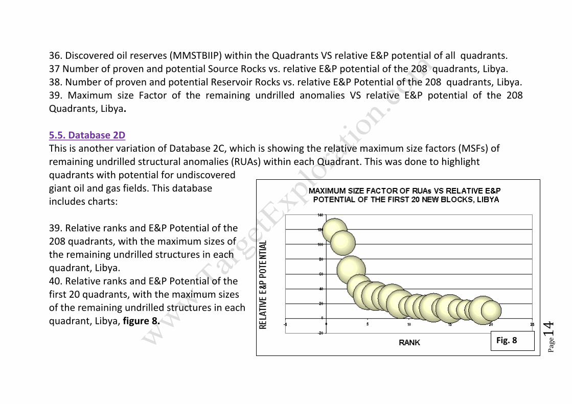
36. Discovered oil reserves (MMSTBIIP) within the Quadrants VS relative E&P potential of all quadrants. 37 Number of proven and potential Source Rocks vs. relative E&P potential of the 208 quadrants, Libya. 38. Number of proven and potential Reservoir Rocks vs. relative E&P Potential of the 208 quadrants, Libya. 39. Maximum size Factor of the remaining undrilled anomalies VS relative E&P potential of the 208 Quadrants, Libya. 5.5. Database 2D This is another variation of Database 2C, which is showing the relative maximum size factors (MSFs) of remaining undrilled structural anomalies (RUAs) within each Quadrant. This was done to highlight quadrants with potential for undiscovered giant oil and gas fields. This database includes charts:
39. Relative ranks and E&P Potential of the 208 quadrants, with the maximum sizes of the remaining undrilled structures in each quadrant, Libya. 40. Relative ranks and E&P Potential of the first 20 quadrants, with the maximum sizes of the remaining undrilled structures in each quadrant, Libya, figure 8.
Fig. 8

Pag
e15
41. Relative ranks and E&P Potential of second 20 quadrants, with the maximum sizes of the remaining undrilled structures in each quadrant, Libya. 42. Relative ranks and E&P Potential of the third 20 quadrants, with the maximum sizes of the remaining undrilled structures in each quadrant, Libya. 43. Relative ranks and E&P Potential of the fourth 20 quadrants, with the maximum sizes of the remaining undrilled structures in each quadrant, Libya. 44. Relative ranks and E&P Potential of the fifth 20 quadrants, with the maximum sizes of the remaining undrilled structures in each quadrant, Libya. 45. Relative ranks and E&P Potential of the sixth 20 quadrants, with the maximum sizes of the remaining undrilled structures in each quadrant, Libya. 46. Relative ranks and E&P Potential of the last 19 quadrants, with the maximum sizes of the remaining undrilled structures in each quadrant, Libya, figure 9. 5.6. Database 2E A variation in plotting the Quadrants of Database 2, in which the Quadrants are plotted at their central locations on a grid of decimal latitudes and longitudes. These locations can be superimposed on the concession base map (figure 2), this database contain charts: 47. Location and relative E&P potential of every Quadrant of the 208 Quadrants, Libya. 48, Locations and number of discovered Oil and Gas fields in every Quadrant of the 208 Quadrants, Libya.
FIGURE 9 is missing

Pag
e16
49. Locations and volume of discovered Oil reserves (MMSTBIIP) within the 208 Quadrants, Libya. 50. Locations and number of remaining undrilled anomalies (RUAs) of the 208 Quadrants, Libya. 51. Locations and maximum size factors (MSFs) of the remaining undrilled anomalies of the 208 Quadrants, Libya, figure 10. 6. Translating the Database into Evaluation Report, Quadrant ----- (Sirte Basin) as an Example Libya is like any other oil and gas-producing country had its share of “undiscovery wells”, (Ibrahim, 2000a), hence to illustrate the importance of critically reviewing exploration records, and versatility of the databases as source of information as well as a ranking method; a summary of Quadrant S25 of Sirte Basin was compiled from the data listed in database 1 and database 2. Quadrant ---- (Figure 2, at the intersection of Lat. 28º N and Long. 21º E) ranks 88 among the 208 E&P Quadrants, however it is one of the Quadrants assessed to have proven, probable and possible undeveloped discovered oil and/or gas fields and/or discoveries, figure 11.
Fig. 11

Pag
e17
Quadrant S25---- (about 435 Kms2. in area) is located in southeastern Sirte Basin. It is part of relinquished areas of older Concessions (Conc. 59 of Oasis Oil, and Conc. 126 of Mobil Oil Libya). There are 9 wells drilled in the sixties and early seventies which fall within the present Quadrant boundaries, two dry holes SS1-59, and X1-59 drilled by Oasis, and 7 wells (A1, A2, A3, B1, B1a, I1, and K1-126) drilled by Mobil Oil. Mobil well A1- discovered and tested commercial oil from the continental Nubian (Lower Cretaceous) sandstone at about 3000 m. below KB. Probable source rocks of the oil are the Upper Cretaceous Sirte shale and the Lower Cretaceous Nubian shale. The A1-26 discovery was delineated by two wells: A2-126 (oil well) and A3-126 (dry) both drilled to Basement. The discovery was significant enough to merit upgrading it to field status; hence it was named the Chadar Oil Field, a structural trap estimated to have about 35 MMBbls of 45 API oil. Other exploration wells of Mobil within the present boundaries of Quadrant S25 failed to encounter commercial oil: B1-126 (junked) B1a-126 (dry), I1-126 (dry), and K1-126 (dry). Quadrant S25 is 15 Kms from the nearest pipeline, and the field itself is 35 Kms from the same pipeline. The exploration record of the quadrant reflects discovery/dry ratio of 0.15, which is above the Sirte Basin average. There is probably still one more drillable anomaly in the quadrant. 7. Epilogue:
Results indicate that database analysis produces an impartial ranking of the relative E&P potentialities of a large number of quadrants in several types of basins, and can graphically illustrate the reasons for
Pag
e18
ranking the quadrants, per basin, as well as per several basins. Combined with well data databases, a review of any of the listed quadrants is also feasible.
The offshore E&P Quadrants of Libya rank higher than the Ghadames, Cyrenaica, Sirte, Murzuk, Kufra and Tripolitania Quadrants.
More than 19 Quadrants have proven undeveloped oil and gas fields/oil and gas discoveries within. Estimated total discovered oil within the E&P Quadrants to be more than 1361 MMSTBOIIP. More than 19 Quadrants have probable and/or possible oil and gas discoveries/oil and gas fields
within. Estimated total discovered gas within the E&P Quadrants to be more than 0.67 TCF IIP. Up to 300 MMBSTB oil, or 0.4 TCF gas of
proven undeveloped reserves are within some of the “ quadrants”.
Total area of the E&P Quadrants is around 1,110,200.00 Km²
Estimated total number of remaining undrilled anomalies is around 765.
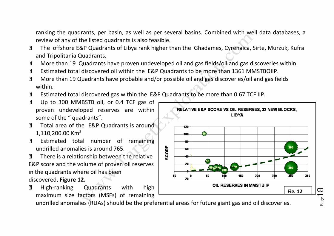
There is a relationship between the relative E&P score and the volume of proven oil reserves in the quadrants where oil has been discovered, Figure 12.
High-ranking Quadrants with high maximum size factors (MSFs) of remaining undrilled anomalies (RUAs) should be the preferential areas for future giant gas and oil discoveries.
Fig. 12

Pag
e19
8. Selected References: Ibrahim M.W. 1992, Petroleum geology of the Sirt group Sandstones, eastern Sirte basin. In 3rd Symposium of the Geology of Libya, 27-30 September 1987, College of Science, Al-Fateh University, Tripoli, Libya, Vol. 7, pp 2757-2779. Ibrahim, M.W 2000a, Missed, By-passed, and Under-estimated Hydrocarbon Traps: Examination of Basic Exploration Records Reveals Potential "Un-Discovery" Wells in Libya, (Abstract). AAPG Annual Convention, 16-19 April 2000,Louisiana, p. A-72. Ibrahim, M.W. 2000b, Rank, Potential, Dry holes, Undeveloped Fields and Discoveries of the 97 E&P Quadrants of Onshore and Offshore Libya, Paper Presented to MENA 2000 Oil and Gas Conference, September 18-19, 2000, Imperial College, London, UK, 13 p. Ibrahim, M.W., 2001a, Rank, Potential, Undeveloped Fields and Discoveries of the 137 E&P Quadrants of Onshore and Offshore Libya, Abstract, 2001 AAPG Annual Convention, June 3-6, 2001,Denver, Colorado, PA97. Ibrahim, M.W. 2001b, E&P Quadrants of Onshore and Offshore Libya, Report and Databases, Target Exploration, London, UK 15p, 52 figures, 7 Excel Spreadsheets and one CD-ROM. Wennekers, J. et al. 1996, The Geology and Hydrocarbons of the Sirte Basin: A Synopsis. In Volume 1, The Geology of Sirte Basin, M. J. Salem et al, Edit, Elsevier Pub. Co. P3-56.
Pag
e20
The report is available from
Target Exploration
Click to order your copy
For full list of it’s contents and to purchase your copy from Target Exploration, Contact:
M. Casey
Target Exploration Consultants
65 Kenton Court, London W14 8NW, UK.
www.targetexploration.com
Target Exploration
Revised 20-01-2019