Embed Size (px)
Citation preview
Welcome to Tamborine National Park
Take a scenic escape into the Gold Coast Hinterland and lose yourself in the shade of subtropical rainforest thick with piccabeen palms. Walk past white-washed flooded gums and silvery eucalypt trees, letting the fresh mountain air revitalise every step. Admire spectacular views from numerous lookouts, have a family picnic or barbecue, or enjoy strolling one of many bushwalks on offer. See red-necked pademelons bound across the forest floor and large land mullets bask in warm patches of sunlight. Peaceful waterfalls and tranquil pools offer the perfect place to stop, rest and take in the natural mountain surrounds. Take a break from the golden coast and escape to the heart of the hinterland at Tamborine National Park.
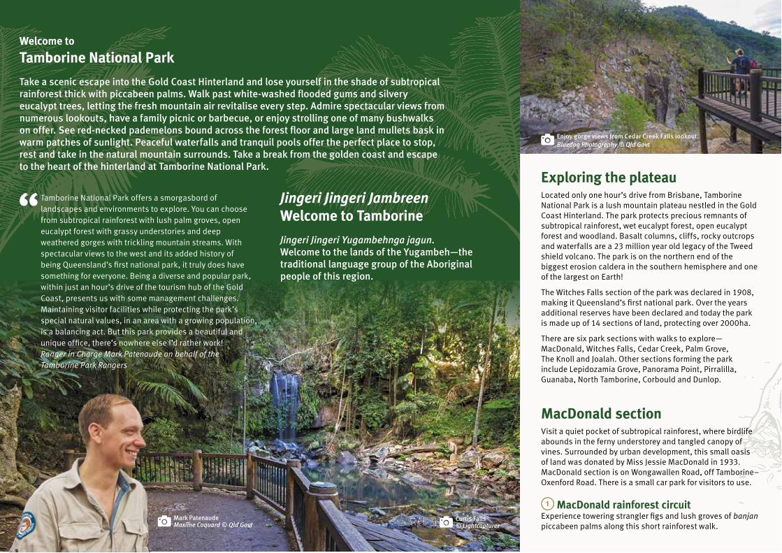
Exploring the plateauLocated only one hour’s drive from Brisbane, Tamborine National Park is a lush mountain plateau nestled in the Gold Coast Hinterland. The park protects precious remnants of subtropical rainforest, wet eucalypt forest, open eucalypt forest and woodland. Basalt columns, cliffs, rocky outcrops and waterfalls are a 23 million year old legacy of the Tweed shield volcano. The park is on the northern end of the biggest erosion caldera in the southern hemisphere and one of the largest on Earth!
The Witches Falls section of the park was declared in 1908, making it Queensland’s first national park. Over the years additional reserves have been declared and today the park is made up of 14 sections of land, protecting over 2000ha.
There are six park sections with walks to explore— MacDonald, Witches Falls, Cedar Creek, Palm Grove, The Knoll and Joalah. Other sections forming the park include Lepidozamia Grove, Panorama Point, Pirralilla, Guanaba, North Tamborine, Corbould and Dunlop.
MacDonald sectionVisit a quiet pocket of subtropical rainforest, where birdlife abounds in the ferny understorey and tangled canopy of vines. Surrounded by urban development, this small oasis of land was donated by Miss Jessie MacDonald in 1933. MacDonald section is on Wongawallen Road, off Tamborine–Oxenford Road. There is a small car park for visitors to use.
MacDonald rainforest circuitExperience towering strangler figs and lush groves of banjan piccabeen palms along this short rainforest walk.
Curtis Falls© Lightcapturer
Enjoy gorge views from Cedar Creek Falls lookout.Bluedog Photography © Qld Govt
Tamborine National Park offers a smorgasbord of landscapes and environments to explore. You can choose from subtropical rainforest with lush palm groves, open eucalypt forest with grassy understories and deep weathered gorges with trickling mountain streams. With spectacular views to the west and its added history of being Queensland’s first national park, it truly does have something for everyone. Being a diverse and popular park, within just an hour’s drive of the tourism hub of the Gold Coast, presents us with some management challenges. Maintaining visitor facilities while protecting the park’s special natural values, in an area with a growing population, is a balancing act. But this park provides a beautiful and unique office, there’s nowhere else I’d rather work!Ranger in Charge Mark Patenaude on behalf of the Tamborine Park Rangers
Jingeri Jingeri Jambreen Welcome to Tamborine
Jingeri Jingeri Yugambehnga jagun. Welcome to the lands of the Yugambeh—the traditional language group of the Aboriginal people of this region.
Mark PatenaudeMaxime Coquard © Qld Govt

Witches Falls sectionVisit Queensland’s first national park. Be enthralled by towering basalt boulders, large red cedar trees, palm and cycad groves and panoramic views from the western side of the plateau. Trace the footsteps of folklore—local children once believed this forest was haunted by witches and giants. Witches Falls section is located on Main Western Road. Parking is suitable for larger vehicles at the southern end of the picnic area.
Witches Falls circuitDescend through rainforest featuring giant bujei strangler figs, seasonal lagoons and banjan piccabeen palm groves to the lookout platform beside Witches Falls. After rain, view the waterfall flowing over basalt cliffs into the valley below.
Witches Chase trackBranching off the Witches Falls circuit, this track leads to Witches Chase entry off Beacon Road. Pass Witches Falls lookout as you explore eucalypt forest and rainforest featuring large red cedar trees. Return along the same track to rejoin the circuit.
Cedar Creek sectionWith waterfalls and a large, grassy picnic area, it’s easy to see why Cedar Creek is a popular family destination. Listen to rushing cascades and birdlife chirping overhead. Cedar Creek section is located on Cedar Creek Falls Road. Parking is available in the designated car spaces only. There is no access for large buses, caravans and motorhomes.
Cedar Creek Falls lookout track Take a walk to Cedar Creek Falls and admire views of the gorge and waterfalls. The track to the lookout is suitable for strollers and wheelchairs with assistance.
Cedar Creek Falls track to rock poolsFrom Cedar Creek Falls lookout, descend through eucalypt forest and dry rainforest to the rock pools below. There are many steps on this walk, so be prepared for an uphill climb on your return.
Palm Grove sectionEscape to the cool, dappled forest at Palm Grove, where you’ll discover biyan pademelons, banjan piccabeen palms and cathedral buttress roots. Palm Grove Avenue is the main access point for the walking tracks but you can also enter from Curtis Road. Parking for buses and caravans is not available.
Palm Grove circuitExplore the lush and diverse world of subtropical rainforest on this shady walk. Discover peaceful palm groves, giant bujei (strangler figs), immense buttress roots and fascinating fungi along the way.
Jenyns circuitIncorporating Palm Grove circuit, this walk branches into the mountain’s drier eucalypt forest. Walk through stands of bimbil hoop pines, brush box, grey gums and a grove of ancient burrawang cycads. Sections of this track travel close to steep cliff edges, so please stay on the track and watch children at all times.
The Knoll sectionEnjoy a barbecue picnic in this lovely setting nestled among tall open eucalypt forest. Marvel at sweeping views out to Flinders Peak and Brisbane from the northern edge of the picnic area.
Access is via Main Street and Knoll Road in North Tamborine. The parking area is small and not suitable for large vehicles.
Sandy Creek circuitExplore lush rainforest with towering man-garagin flooded gums emerging through the canopy. Follow Sandy Creek to Cameron Falls lookout, where you’ll be rewarded with spectacular views of the waterfall and out across the valley to Brisbane, Mt Coot-tha and D’Aguilar Range. This track travels close to steep cliff edges, so please keep children close by.
Joalah sectionView spectacular Curtis Falls plunging over basalt columns into a large rock pool, home to wajun platypus and a fragile ngari jalngay glow-worm colony. In winter, listen for the loud cries of the male kalbun Albert’s lyrebird calling for its mate. Joalah section is located at the headwaters of Cedar Creek and accessed from Dapsang Drive car park. Larger vehicle parking is available.
Eagle Heights Road access track Take a short walk to explore rainforest on the outer edge of Joalah. The walk links to cafes and shops on Eagle Heights Road.
Curtis Falls track This enchanting walk begins in wet eucalypt forest beneath towering man-garagin flooded gums. Feel the temperature drop as you descend into lush rainforest. Look up to a ceiling of beautiful jumbil crows nest and dumbin staghorn ferns growing in the canopy above. There are over 100 steps on this walk, so be prepared for the uphill return.
Lower creek circuitBranching off Curtis Falls track, this circuit crosses Cedar Creek, passing rainforest, rock pools, cascades and a giant, fallen strangler fig. Beyond the bujei strangler fig, the track becomes more challenging with creek crossings that involve rock hopping.
Explore drier eucalypt forest on the Jenyns circuit.
© Lightcapturer
Look for eastern whipbirds in the rainforest.
Nicholas Hill © Qld Govt

Connect with Queensland National Parks
qld.gov.au/nationalparks
qld.gov.au/park-alerts (access, closures and conditions)
qldnationalparks
@QldParks; #QldParks
For help planning your holiday, visit queensland.com or visitgoldcoast.com
This brochure is also available online at qld.gov.au/parkbrochures
Wildlife spottingWith its diverse forest vegetation, Tamborine National Park
provides an essential wildlife refuge from surrounding urban
and residential development.
Listen for strange gurgling sounds coming from the forest
floor—these may be giant Tamborine earthworms, up to
1m long, travelling through their underground burrows.
In summer, colourful jalngay-ngarian Richmond birdwing
butterflies and jahwun-gawang noisy pittas add vibrancy
to the forest greenery. Look around for wagun Australian
brush-turkey mounds—a huge pile of leaf litter used to
incubate eggs—scratched together by the tireless male.
While walking in the cooler months, you may be lucky
enough to hear mimicry of the near-threatened kalbun
Albert’s lyrebird (Menura alberti). The lyrebird mixes its
own call—a mellow, far-crying ’caw-cree-craw-wheat’—
with other rainforest noises, including the calls of
bowerbirds, nyimara whipbirds and bilin rosellas.
Freshwater creeks and rock pools provide the perfect
sanctuary for taran cascade treefrogs, tusked frogs and
jurun long-fin eels. At night, white-striped freetail bats come
out to feed, flying above treetops as they hunt their insect
prey. The park’s old growth trees provide hollows—essential
nesting sites for bats, owls and gliders.
Stand on traditional landTamborine Mountain has long been the traditional land
of the Yugambeh people—the traditional language group
of Aboriginal people of this region. Rainforest plants and
animals provided them with food and resources. Banjan
piccabeen palm fronds made excellent baskets for carrying
water, food or honey. The ngabul lawyer vine, also known as
wait-a-while, was used for basket making after the spikes
had been removed.
Yugambeh people still walk the land of their ancestors,
telling stories and reminding visitors that this land is our
shared heritage. Ngulli yanbalehla bu—we are still here.
Did you know?The place name ‘Tamborine’ comes from the local Yugambeh word Jambreen. It means wild lime and refers to the finger lime trees (Citrus australasica) that grow wild on the mountain and were eaten by the Yugambeh people as a tangy thirst quencher.
(Above): If you’re quiet, you may see shy red-necked pademelons hiding in the shadows of the Palm Grove section.
(Left): The female Albert’s lyrebird usually builds her dome-like nest of sticks, moss and ferns on rock ledges, between buttress roots or on top of tree ferns.Lightcapturer © Qld Govt
(Front cover): Maxime Coquard © Qld Govt(This page): © Lightcapturer
North Tamborine
Canungra
Beenleigh
North Stradbroke
Island
SurfersParadise
Nerang
Coomera
Oxenford
Pacific H
ighway
Kerry R
d
Lam
ing
ton
Nat
iona
l Par
k R
d
Bee
ch
mont R
d
1
NerangNational
Park
TamborineNational
Park
NerangConservation
Park
Tamborine Mountain
To Brisbane
Locality map To Brisbane
WickhamNational
Park
PlunkettConservation
Park
5 10kmScale0
Other adventures
Horseriding Ride your horse on designated trails in Corbould and Cedar Creek sections of the park. Most trails are intermediate-class with some steep sections and natural hazards such as loose gravel. Access is from Beaudesert–Beenleigh
Road or Tamborine Mountain Road. Visit des.qld.gov.au/experiences/horse-trails for information about the SEQ horse riding trail network.
Overnight staysStay a little longer to give yourself time to see all that Tamborine has to offer. Camp at one of the private campgrounds on Tamborine Mountain or treat yourself to a stay at a range of holiday accommodation including hotels, motels, bed and breakfasts and cabins. For more information see visittamborinemountain.com.au or visitscenicrim.com.au
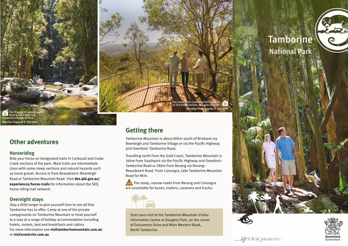
The views from Cameron Falls lookout, in The Knoll section, are spectacular.
Start your visit at the Tamborine Mountain Visitor Information Centre at Doughty Park, on the corner of Geissmann Drive and Main Western Road, North Tamborine.
Getting there Tamborine Mountain is about 80km south of Brisbane via Beenleigh and Tamborine Village or via the Pacific Highway and Oxenford–Tamborine Road.
Travelling north from the Gold Coast, Tamborine Mountain is 36km from Southport via the Pacific Highway and Oxenford–Tamborine Road or 28km from Nerang via Nerang–Beaudesert Road. From Canungra, take Tamborine Mountain Road for 8km.
The steep, narrow roads from Nerang and Canungra are unsuitable for buses, trailers, caravans and trucks.
You’ll want to spend more than a day exploring
Tamborine National Park.Maxime Coquard © Qld Govt
Bluedog Photography © Qld Govt
Tamborine National Park
Palm Grove circuitMaxime Coquard © Qld Govt
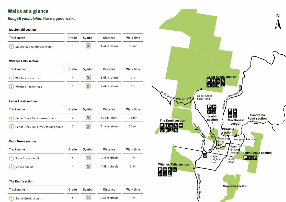
Walks at a glanceBaugull yanbalehla. Have a good walk.
MacDonald section
Track name Grade Symbol Distance Walk time
MacDonald rainforest circuit 3 1.4km return 30min
Witches Falls section
Track name Grade Symbol Distance Walk time
Witches Falls circuit 4 3.6km return 1hr
Witches Chase track 4 2.6km return 1hr
Cedar Creek section
Track name Grade Symbol Distance Walk time
Cedar Creek Falls lookout track 1 500m return 15min
Cedar Creek Falls track to rock pools 3 1.1km return 30min
Palm Grove section
Track name Grade Symbol Distance Walk time
Palm Grove circuit 4 2.7km circuit 1hr
Jenyns circuit 4 4.8km circuit 1.5hr
The Knoll section
Track name Grade Symbol Distance Walk time
Sandy Creek circuit 4 2.6km circuit 1hr
Joalah section
Track name Grade Symbol Distance Walk time
Eagle Heights Road access track 3 400m return 10min
Curtis Falls track 3 1.1km return 30min
Lower creek circuit 4 2.5km return 1hr
Walking track classification
Grade Symbol Suits Track description
1Strollers and wheelchairs with assistance
No bushwalking experience required. Flat, even surface with no steps or steep sections.
3People with some bushwalking experience
Suitable for most ages and fitness levels. Tracks may have short steep hill sections, a rough surface and many steps.
4 Experienced bushwalkersBushwalking experience recommended. Tracks may be long, rough and very steep. Directional signs may be limited.
Caring for TamborineNyah-nyah ngalingah gamaygay gaban. Take care of our wilderness.
• Leave your pets at home. No domestic animals are
allowed in the national park. Horses are permitted only
on designated horse trails in the park.
• Please take your rubbish home. There are no bins
provided in the national park.
• Let animals find their natural food. Human food can make
native animals susceptible to disease and can cause
overpopulation and aggressive behaviour.
• Stay on the walking tracks. Shortcutting causes erosion,
damages plants and can be dangerous on steep slopes.
• Please use gas barbecues provided. Lighting a fire in the
national park is prohibited.
• Do not take or disturb plants and animals. Everything
is protected.
Explore safelyMake your visit to the park memorable for the right reasons.• Protect yourself—wear sturdy shoes, a hat, protective
clothing and sunscreen.
• Wear insect repellent to prevent ticks and leeches.
• Bring your own drinking water. Creek water is unsuitable
for drinking as it may contain organisms that can
cause illness.
• Stay on the walking tracks and supervise children at all
times, especially around lookouts and steep track edges.
• Never dive or jump into rivers, creeks or pools as they
may be shallow or hide submerged debris, rocks
or objects.
• Walk safely. Walk with a group and follow directions
provided on signs to avoid getting lost. Tracks and steps
can be slippery, especially after rain.
• Do not disturb snakes—give them space and wait for
them to move on. Some snakes are dangerous. If bitten,
seek medical attention immediately.
• Take care of your property. Do not leave valuables in
parked cars in case of theft.
In an emergency, call Triple Zero (000) or 112 from a mobile phone. Mobile reception may be limited or unavailable.
Important safety information Access to the Curtis Falls rock pool and the
surrounding rock face is prohibited. Please observe
the restricted access area notice. This is for the safety
of visitors and the protection of glow-worm and
platypus populations.
Access to the Cedar Creek section is prohibited at
night. The entry gate is closed and locked each evening.
Between 1 October and 31 March, the gate is open from
6am to 8pm. Between 1 April and 30 September, it is open
from 6am to 6pm.
Access to the gorge at Cedar Creek is prohibited.
Please observe the restricted access area notice. This is
for the safety of visitors—serious injuries and deaths have
occurred there.
Ranger favourites
For a cooler walk try the Palm Grove circuit. It has lush rainforest and some swampy areas that the frogs love to call home.Ranger John
Cameron Falls lookout, on the Sandy Creek circuit, is my favourite spot. It has great views of Brisbane and on a clear day you can see all the way to the Glass House Mountains! Ranger Paul
If you don’t have much time, but would still like to experience Tamborine’s rainforest, the MacDonald rainforest circuit is for you. Take in towering strangler figs and look for shy pademelons on this great short walk.Ranger Jess
Joalah section is my favourite, it has it all! Along a relatively short walk you get tranquil Curtis Falls and plenty of wildlife like flying foxes, platypus, land mullets, snakes and plenty of birds.Ranger Elisha
Enjoy a picnic with a view at The Knoll day-use area.Bluedog Photography © Qld Govt
Cameron FallsBluedog Photography © Qld Govt
MacDonald rainforest circuitBluedog Photography © Qld Govt
Explore tranquil rock pools on Joalah’s Lower creek circuit.
© Lightcapturer
Panorama Point section
Pirralillasection
MacDonald section
Cedar Creek section
Joalah section
Knoll Road
Cedar Creek Falls Road
Wongawallan Road
Palm Grove Avenue Palm Grove section
Guanaba section
Dapsang Drive
EagleHeights Road
Mai
n S
t
Curtis Road
Witches Falls section
Lepidozamia Grove section
The Knoll section
Geiss
ma
nn
Driv
e
Tam
borin
e–Oxenford R
oad
Tamborine Mountain Road
Main W
estern Roa
d
Note:
* Parking (limited) is available for large buses and vehicles such as caravans and motorhomes in Joalah and Witches Falls sections only.
** Wheelchair-assisted access is only available in the day-use areas at Witches Falls, The Knoll and Cedar Creek sections, and along the Cedar Creek Falls lookout track.
1 2 3 4kmScale0
Access
track
Curtis
Jen
yns circuit
Palm Grove circuit
Falls track
Knoll R
oad
Cameron Falls
The Knoll sectionEagle Heights Road
Curtis Rd
Palm
Gro
ve
Aven
uePalm Grove section
MacDonald section
Wongawallan Road
Dapsang
Drive
Joalah section
Gei
ssm
ann
Driv
e
Rock pools(restricted access)
Rock pool(restricted access)
Cedar Creek rock pools
Cedar Creek
Cedar Creek section
Witches Chase
Witches Falls
Witches Falls section
Beacon Road
Fenwick C
reek
Ce
dar C
reek
Eag le Heights Road
Sandy
Main Western Road
MacDonald ra
infor e
st c
ircu
it
Lower creek circuit
Witches C
hase track Witches Falls circuit
Sandy Creek circuit
Ced
ar C
reek
Falls
trac
k
1
1
7
7
6
6
Cedar Creek Falls Road
Creek
100mScale0
200 400mScale0
300 600mScale0
100 200mScale0
Scale0 200 400m
0Scale
100m
4
10
9
5
4
11
3
112
2
8
8
8
8
Male satin bowerbird© Jodie Bray
The Witches Falls circuit features giant strangler figs.
Maxime Coquard © Qld Govt
Legend for maps
National park
Restricted access area
Seasonal lagoon
Major sealed road
Minor sealed road
Walking track
Access track
Creek
Waterfall
Park entrance
Information centre
Parking *
Toilets
Wheelchair-assisted access **
Walking track
Picnic table
Sheltered picnic table
BBQ (gas)
BBQ (electric)
Lookout
Viewpoint
Shops and cafés

Palm Grove circuitMaxime Coquard © Qld Govt
Walks at a glanceBaugull yanbalehla. Have a good walk.
MacDonald section
Track name Grade Symbol Distance Walk time
MacDonald rainforest circuit 3 1.4km return 30min
Witches Falls section
Track name Grade Symbol Distance Walk time
Witches Falls circuit 4 3.6km return 1hr
Witches Chase track 4 2.6km return 1hr
Cedar Creek section
Track name Grade Symbol Distance Walk time
Cedar Creek Falls lookout track 1 500m return 15min
Cedar Creek Falls track to rock pools 3 1.1km return 30min
Palm Grove section
Track name Grade Symbol Distance Walk time
Palm Grove circuit 4 2.7km circuit 1hr
Jenyns circuit 4 4.8km circuit 1.5hr
The Knoll section
Track name Grade Symbol Distance Walk time
Sandy Creek circuit 4 2.6km circuit 1hr
Joalah section
Track name Grade Symbol Distance Walk time
Eagle Heights Road access track 3 400m return 10min
Curtis Falls track 3 1.1km return 30min
Lower creek circuit 4 2.5km return 1hr
Walking track classification
Grade Symbol Suits Track description
1Strollers and wheelchairs with assistance
No bushwalking experience required. Flat, even surface with no steps or steep sections.
3People with some bushwalking experience
Suitable for most ages and fitness levels. Tracks may have short steep hill sections, a rough surface and many steps.
4 Experienced bushwalkersBushwalking experience recommended. Tracks may be long, rough and very steep. Directional signs may be limited.
Caring for TamborineNyah-nyah ngalingah gamaygay gaban. Take care of our wilderness.
• Leave your pets at home. No domestic animals are
allowed in the national park. Horses are permitted only
on designated horse trails in the park.
• Please take your rubbish home. There are no bins
provided in the national park.
• Let animals find their natural food. Human food can make
native animals susceptible to disease and can cause
overpopulation and aggressive behaviour.
• Stay on the walking tracks. Shortcutting causes erosion,
damages plants and can be dangerous on steep slopes.
• Please use gas barbecues provided. Lighting a fire in the
national park is prohibited.
• Do not take or disturb plants and animals. Everything
is protected.
Explore safelyMake your visit to the park memorable for the right reasons.• Protect yourself—wear sturdy shoes, a hat, protective
clothing and sunscreen.
• Wear insect repellent to prevent ticks and leeches.
• Bring your own drinking water. Creek water is unsuitable
for drinking as it may contain organisms that can
cause illness.
• Stay on the walking tracks and supervise children at all
times, especially around lookouts and steep track edges.
• Never dive or jump into rivers, creeks or pools as they
may be shallow or hide submerged debris, rocks
or objects.
• Walk safely. Walk with a group and follow directions
provided on signs to avoid getting lost. Tracks and steps
can be slippery, especially after rain.
• Do not disturb snakes—give them space and wait for
them to move on. Some snakes are dangerous. If bitten,
seek medical attention immediately.
• Take care of your property. Do not leave valuables in
parked cars in case of theft.
In an emergency, call Triple Zero (000) or 112 from a mobile phone. Mobile reception may be limited or unavailable.
Important safety information Access to the Curtis Falls rock pool and the
surrounding rock face is prohibited. Please observe
the restricted access area notice. This is for the safety
of visitors and the protection of glow-worm and
platypus populations.
Access to the Cedar Creek section is prohibited at
night. The entry gate is closed and locked each evening.
Between 1 October and 31 March, the gate is open from
6am to 8pm. Between 1 April and 30 September, it is open
from 6am to 6pm.
Access to the gorge at Cedar Creek is prohibited.
Please observe the restricted access area notice. This is
for the safety of visitors—serious injuries and deaths have
occurred there.
Ranger favourites
For a cooler walk try the Palm Grove circuit. It has lush rainforest and some swampy areas that the frogs love to call home.Ranger John
Cameron Falls lookout, on the Sandy Creek circuit, is my favourite spot. It has great views of Brisbane and on a clear day you can see all the way to the Glass House Mountains! Ranger Paul
If you don’t have much time, but would still like to experience Tamborine’s rainforest, the MacDonald rainforest circuit is for you. Take in towering strangler figs and look for shy pademelons on this great short walk.Ranger Jess
Joalah section is my favourite, it has it all! Along a relatively short walk you get tranquil Curtis Falls and plenty of wildlife like flying foxes, platypus, land mullets, snakes and plenty of birds.Ranger Elisha
Enjoy a picnic with a view at The Knoll day-use area.Bluedog Photography © Qld Govt
Cameron FallsBluedog Photography © Qld Govt
MacDonald rainforest circuitBluedog Photography © Qld Govt
Explore tranquil rock pools on Joalah’s Lower creek circuit.
© Lightcapturer
Panorama Point section
Pirralillasection
MacDonald section
Cedar Creek section
Joalah section
Knoll Road
Cedar Creek Falls Road
Wongawallan Road
Palm Grove Avenue Palm Grove section
Guanaba section
Dapsang Drive
EagleHeights Road
Mai
n S
t
Curtis Road
Witches Falls section
Lepidozamia Grove section
The Knoll section
Geiss
ma
nn
Driv
e
Tam
borin
e–Oxenford R
oad
Tamborine Mountain Road
Main W
estern Roa
d
Note:
* Parking (limited) is available for large buses and vehicles such as caravans and motorhomes in Joalah and Witches Falls sections only.
** Wheelchair-assisted access is only available in the day-use areas at Witches Falls, The Knoll and Cedar Creek sections, and along the Cedar Creek Falls lookout track.
1 2 3 4kmScale0
Access
track
Curtis
Jen
yns circuit
Palm Grove circuit
Falls track
Knoll R
oad
Cameron Falls
The Knoll sectionEagle Heights Road
Curtis Rd
Palm
Gro
ve
Aven
uePalm Grove section
MacDonald section
Wongawallan Road
Dapsang
Drive
Joalah section
Gei
ssm
ann
Driv
e
Rock pools(restricted access)
Rock pool(restricted access)
Cedar Creek rock pools
Cedar Creek
Cedar Creek section
Witches Chase
Witches Falls
Witches Falls section
Beacon RoadFenw
ick Creek
Ce
dar C
reek
Eag le Heights Road
Sandy
Main Western Road
MacDonald ra
infor e
st c
ircu
it
Lower creek circuit
Witches C
hase track Witches Falls circuit
Sandy Creek circuit
Ced
ar C
reek
Falls
trac
k
1
1
7
7
6
6
Cedar Creek Falls Road
Creek
100mScale0
200 400mScale0
300 600mScale0
100 200mScale0
Scale0 200 400m
0Scale
100m
4
10
9
5
4
11
3
112
2
8
8
8
8
Male satin bowerbird© Jodie Bray
The Witches Falls circuit features giant strangler figs.
Maxime Coquard © Qld Govt
Legend for maps
National park
Restricted access area
Seasonal lagoon
Major sealed road
Minor sealed road
Walking track
Access track
Creek
Waterfall
Park entrance
Information centre
Parking *
Toilets
Wheelchair-assisted access **
Walking track
Picnic table
Sheltered picnic table
BBQ (gas)
BBQ (electric)
Lookout
Viewpoint
Shops and cafés
Legend for maps
National park
Restricted access area
Seasonal lagoon
Major sealed road
Minor sealed road
Walking track
Access track
Creek
Waterfall
Park entrance
Information centre
Parking *
Toilets
Wheelchair-assisted access **
Walking track
Picnic table
Sheltered picnic table
BBQ (gas)
BBQ (electric)
Lookout
Viewpoint
Shops and cafés

Palm Grove circuitMaxime Coquard © Qld Govt
Walks at a glanceBaugull yanbalehla. Have a good walk.
MacDonald section
Track name Grade Symbol Distance Walk time
MacDonald rainforest circuit 3 1.4km return 30min
Witches Falls section
Track name Grade Symbol Distance Walk time
Witches Falls circuit 4 3.6km return 1hr
Witches Chase track 4 2.6km return 1hr
Cedar Creek section
Track name Grade Symbol Distance Walk time
Cedar Creek Falls lookout track 1 500m return 15min
Cedar Creek Falls track to rock pools 3 1.1km return 30min
Palm Grove section
Track name Grade Symbol Distance Walk time
Palm Grove circuit 4 2.7km circuit 1hr
Jenyns circuit 4 4.8km circuit 1.5hr
The Knoll section
Track name Grade Symbol Distance Walk time
Sandy Creek circuit 4 2.6km circuit 1hr
Joalah section
Track name Grade Symbol Distance Walk time
Eagle Heights Road access track 3 400m return 10min
Curtis Falls track 3 1.1km return 30min
Lower creek circuit 4 2.5km return 1hr
Walking track classification
Grade Symbol Suits Track description
1Strollers and wheelchairs with assistance
No bushwalking experience required. Flat, even surface with no steps or steep sections.
3People with some bushwalking experience
Suitable for most ages and fitness levels. Tracks may have short steep hill sections, a rough surface and many steps.
4 Experienced bushwalkersBushwalking experience recommended. Tracks may be long, rough and very steep. Directional signs may be limited.
Caring for TamborineNyah-nyah ngalingah gamaygay gaban. Take care of our wilderness.
• Leave your pets at home. No domestic animals are
allowed in the national park. Horses are permitted only
on designated horse trails in the park.
• Please take your rubbish home. There are no bins
provided in the national park.
• Let animals find their natural food. Human food can make
native animals susceptible to disease and can cause
overpopulation and aggressive behaviour.
• Stay on the walking tracks. Shortcutting causes erosion,
damages plants and can be dangerous on steep slopes.
• Please use gas barbecues provided. Lighting a fire in the
national park is prohibited.
• Do not take or disturb plants and animals. Everything
is protected.
Explore safelyMake your visit to the park memorable for the right reasons.• Protect yourself—wear sturdy shoes, a hat, protective
clothing and sunscreen.
• Wear insect repellent to prevent ticks and leeches.
• Bring your own drinking water. Creek water is unsuitable
for drinking as it may contain organisms that can
cause illness.
• Stay on the walking tracks and supervise children at all
times, especially around lookouts and steep track edges.
• Never dive or jump into rivers, creeks or pools as they
may be shallow or hide submerged debris, rocks
or objects.
• Walk safely. Walk with a group and follow directions
provided on signs to avoid getting lost. Tracks and steps
can be slippery, especially after rain.
• Do not disturb snakes—give them space and wait for
them to move on. Some snakes are dangerous. If bitten,
seek medical attention immediately.
• Take care of your property. Do not leave valuables in
parked cars in case of theft.
In an emergency, call Triple Zero (000) or 112 from a mobile phone. Mobile reception may be limited or unavailable.
Important safety information Access to the Curtis Falls rock pool and the
surrounding rock face is prohibited. Please observe
the restricted access area notice. This is for the safety
of visitors and the protection of glow-worm and
platypus populations.
Access to the Cedar Creek section is prohibited at
night. The entry gate is closed and locked each evening.
Between 1 October and 31 March, the gate is open from
6am to 8pm. Between 1 April and 30 September, it is open
from 6am to 6pm.
Access to the gorge at Cedar Creek is prohibited.
Please observe the restricted access area notice. This is
for the safety of visitors—serious injuries and deaths have
occurred there.
Ranger favourites
For a cooler walk try the Palm Grove circuit. It has lush rainforest and some swampy areas that the frogs love to call home.Ranger John
Cameron Falls lookout, on the Sandy Creek circuit, is my favourite spot. It has great views of Brisbane and on a clear day you can see all the way to the Glass House Mountains! Ranger Paul
If you don’t have much time, but would still like to experience Tamborine’s rainforest, the MacDonald rainforest circuit is for you. Take in towering strangler figs and look for shy pademelons on this great short walk.Ranger Jess
Joalah section is my favourite, it has it all! Along a relatively short walk you get tranquil Curtis Falls and plenty of wildlife like flying foxes, platypus, land mullets, snakes and plenty of birds.Ranger Elisha
Enjoy a picnic with a view at The Knoll day-use area.Bluedog Photography © Qld Govt
Cameron FallsBluedog Photography © Qld Govt
MacDonald rainforest circuitBluedog Photography © Qld Govt
Explore tranquil rock pools on Joalah’s Lower creek circuit.
© Lightcapturer
Panorama Point section
Pirralillasection
MacDonald section
Cedar Creek section
Joalah section
Knoll Road
Cedar Creek Falls Road
Wongawallan Road
Palm Grove Avenue Palm Grove section
Guanaba section
Dapsang Drive
EagleHeights Road
Mai
n S
t
Curtis Road
Witches Falls section
Lepidozamia Grove section
The Knoll section
Geiss
ma
nn
Driv
e
Tam
borin
e–Oxenford R
oad
Tamborine Mountain Road
Main W
estern Roa
d
Note:
* Parking (limited) is available for large buses and vehicles such as caravans and motorhomes in Joalah and Witches Falls sections only.
** Wheelchair-assisted access is only available in the day-use areas at Witches Falls, The Knoll and Cedar Creek sections, and along the Cedar Creek Falls lookout track.
1 2 3 4kmScale0
Access
track
Curtis
Jen
yns circuit
Palm Grove circuit
Falls track
Knoll R
oad
Cameron Falls
The Knoll sectionEagle Heights Road
Curtis Rd
Palm
Gro
ve
Aven
uePalm Grove section
MacDonald section
Wongawallan Road
Dapsang
Drive
Joalah section
Gei
ssm
ann
Driv
e
Rock pools(restricted access)
Rock pool(restricted access)
Cedar Creek rock pools
Cedar Creek
Cedar Creek section
Witches Chase
Witches Falls
Witches Falls section
Beacon Road
Fenwick C
reek
Ce
dar C
reek
Eag le Heights Road
Sandy
Main Western Road
MacDonald ra
infor e
st c
ircu
it
Lower creek circuit
Witches C
hase track Witches Falls circuit
Sandy Creek circuit
Ced
ar C
reek
Falls
trac
k
1
1
7
7
6
6
Cedar Creek Falls Road
Creek
100mScale0
200 400mScale0
300 600mScale0
100 200mScale0
Scale0 200 400m
0Scale
100m
4
10
9
5
4
11
3
112
2
8
8
8
8
Male satin bowerbird© Jodie Bray
The Witches Falls circuit features giant strangler figs.
Maxime Coquard © Qld Govt
Legend for maps
National park
Restricted access area
Seasonal lagoon
Major sealed road
Minor sealed road
Walking track
Access track
Creek
Waterfall
Park entrance
Information centre
Parking *
Toilets
Wheelchair-assisted access **
Walking track
Picnic table
Sheltered picnic table
BBQ (gas)
BBQ (electric)
Lookout
Viewpoint
Shops and cafés
Legend for maps
National park
Restricted access area
Seasonal lagoon
Major sealed road
Minor sealed road
Walking track
Access track
Creek
Waterfall
Park entrance
Information centre
Parking *
Toilets
Wheelchair-assisted access **
Walking track
Picnic table
Sheltered picnic table
BBQ (gas)
BBQ (electric)
Lookout
Viewpoint
Shops and cafés