Embed Size (px)
Citation preview

Taking the Mystery out of Base Flood Elevation (BFE) Calculations
April 30, 2009Abigail Margelofsky

Initial Reconnaissance
Determine the status of the community in the NFIP program
Identify all past actions by FEMA or contractor that may affect the request. (i.e.: past studies on site, upstream or downstream)

Required Data
Required data includes, but is not limited to:1. MT-2 for (with municipality floodplain
managers approval/signature)
2. Certification by a Registered Professional Engineer or Licensed Land Surveyor.
3. Topographic work map (includes site area, floodplain, BFEs, cross-section locations, etc.)
4. The effective map panels with the proposed floodplain overlaid
5. Adjacent property owner notification.
6. Hydrologic analysis

Topography Requirements
Existing Topographical Maps
• The greater level of detail on the map, the more accurate the BFE determination
• The minimum topographic survey should be as detailed as the US Geological Survey quadrangle maps, if better data is not available
Field Surveys
• Must be on the same datum as the FIRM map
• Cross sections must be < 1 ft of water surface elevation change between two cross-sections, or less than 500 ft apart
• Cross section perpendicular to the flow path, at major changes in channel characteristics, changes in discharge, or where a structure is located.

Technical Review Revisions involving the addition of detailed
flood hazard information or changes to flooding sources originally studied by detailed methods, may required additional data/studies.
• Hydrologic Analyses
Discharge-Drainage Area Relationship
Regression Equations
TR-55
Rational Formula
HEC-HMS computer program
• Hydraulic Analyses
Normal Depth
Critical Depth
Step-Backwater Analysis (HEC-RAS)

Technical Review
Hydraulic Structures
• Hand calculations are also accepted for each of the following flows:
Weir Flow – Flow over a road, railroad, embankment, dam or canal
Culverts – HEC-RAS requires 2 cross sections. One upstream and one downstream of the road/crossing
Bridges – HEC-RAS requires 4 cross sections. Two upstream and two downstream of the road/crossing.

Accepted Hydrologic Analyses
Discharge-Drainage Area Relationship
• Use existing FIS report to find discharge flows
• Plot flows on log-log graph to create a straight line
Regression Equations
• Q = K*AX*BY*CZ
• Where: Q = the discharge, K= the regression constant, A, B, and C = watershed variables, and X, Y, and Z are exponents
TR-55
• Graphical Peak Discharge method
• Tabular Hydrograph method
Rational Formula
• Q=ciA
HEC-HMS computer program

Accepted Hydraulic Analyses Normal Depth
• The depth expected for a stream when the flow is uniform, steady, one-dimensional, and is not affected by downstream obstructions or flow changes
Critical Depth
• If the velocity head from the normal depth computation is equal to or more than half the hydraulic depth, the flow is supercritical and the critical depth should be used to establish the BFE
Step-Backwater Analysis (HEC-RAS)
• Based on conservation of energy. The energy at the upstream cross section is equal to the energy at the downstream cross section plus the losses between the two cross sections.

Flood Zone Labels
*Zone A – Areas of 100-year flood inundation as determined by approximate methods. (no BFE associated with delineation)
*Zone AE – Areas of 100-year flood inundation as determined by detailed hydraulic analyses. BFEs are shown at select intervals on the FIRM and are listed at lettered cross sections in the Floodway Data Tables of the FIS.
Zone AO – Areas of 100-year shallow flooding (usually sheet flow on sloping terrain), where average water depths during the base flood event range between 1 and 3 ft. Average depths of inundation are shown on the map.

Flood Zone Labels
Zone AH – Areas of 100-year shallow flooding (usually areas of ponding), where average water depths are between 1 and 3 ft and BFEs are shown.
Zone A99 – Areas subject to 100-year flood inundation to be protected by a federal flood protection system under construction (BFEs are not shown).
Zone AR – Areas of special flood hazard that result from the decertification of a previously accredited flood protection system now being restored to provide a 100-year or greater level of protection.

Flood Zone Labels
*Shaded Zone X – Areas between limits of the 100-year floodplain and 500-year floodplain. This zone also includes areas protected by levees, 100-year floodplains where water depths are less than 1 ft, and areas with drainage areas less than on square mile. Flood insurance is available is available in this zone, but is not required. (Shaded Zone X has replaced Zone B)
*Unshaded Zone X – Areas of minimal flooding; land elevations exceed the 500-year flood level. (Unshaded Zone X has replaced Zone C).
Zone D – Areas where flood hazards are undetermined, but flooding may be possible

Flood Zone Labels
*Zone V – Areas of 100-year coastal flood with wave action where BFEs have not yet been determined.
*Zone VE – Areas of 100-year coastal flood with wave action where BFEs have been determined.

Importance of Vertical Datums
There are two datums currently used by FEMA
• NGVD29 – The National Geodetic Vertical Datum of 1929
• NAVD88 – The North American Vertical Datum of 1988
The average difference in Chatham County is 0.92’. Therefore:
• Elevation 10 on NGVD29 would be the same as elevation 9.08 on NAVD88.

Letter of Map Revision
• LOMR process for requests made in a Zone A area.
• Must create 1-2 models:
• Existing Conditions
• Proposed Conditions
• LOMR process for requests made in a Zone AE area.
• Must create 3-4 models:
• Duplicate Effective
• Corrective Effective
• Existing Conditions
• Proposed Conditions

LOMR in a Zone A

LOMR in a Zone AE (Floodway)
Digital Elevation Model (DEM)

Digital Elevation Models (DEM)
What are DEMs used for?
• Watershed delineation
Stream network
Watershed boundaries
• Characteristics determination
Slopes (watershed and stream)
Lengths

Old DEMs
Quad Maps – Finding the direction of flow

FIRM on NGVD29
Floodplain: Zone A

dFIRM on NAVD88
Floodplain: Zone A

Preparing DEM/LiDAR data
Elevation correction with survey data
Hydrologically correct DEM
• Sinks – Fill sinks to allow surface water flow through.
• Streams – Are the drainage patterns correct?
• Catchment boundaries – Are ridge lines in the appropriate locations?

Preparing DEM/Lidar data
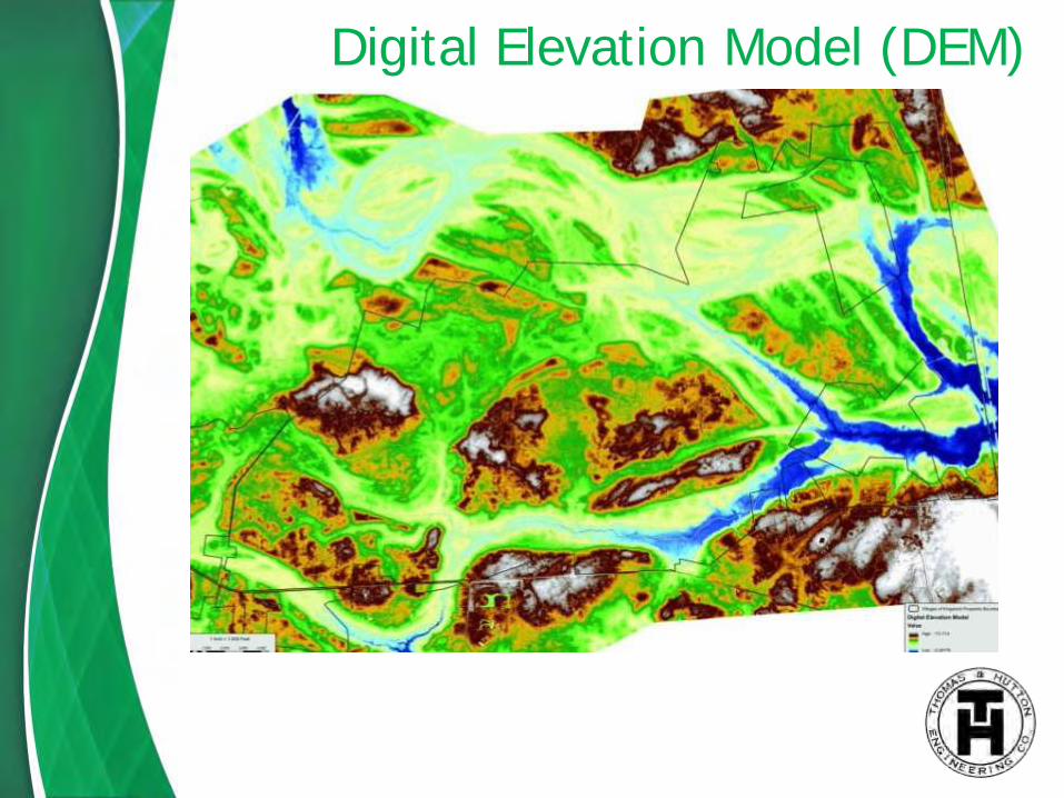
Generating Basins using GeoHEC-HMS
• Using the parent DEM grid create child grids including flow direction, flow accumulation, stream grid, stream link grid, and catchment grid.

Quad Map with Basin Layout

Extracting Hydrologic Parameters• Hydrologic features such as
the Land Use grid are used to create the Curve Number grid.
• The final output for CN calculations is a composite CN per basin.
• The Watershed slope gird generated by GIS is used with the land cover to calculate Time of Concentration.
• Final output for TCs shows longest flow path per basin.

GeoHEC-HMS HMS Schematic
Using HEC-HMS symbols, the model schematic is created in GeoHEC-HMS and then exported to HEC-HMS with the data attached including basin area, CN, TofC, reach length, and reach slope.

HEC-HMS
Once the GeoHEC-HMS schematic is imported into HEC-HMS (the basin model), the file is edited to include:
• Basin model – additional channel or node characteristics or distances
• Meteorologic Models – design storm method (type 3 in Chatham) and depth
• Control Specifications – Start and End Times for the Hydrology run and time interval.
• Time-series Data and Paired data –used for additional calibration.

HEC-HMS

GeoHEC-RAS
GeoHEC-RAS is
• A GIS extension
• Used to generate:
Stream centerlines
Cross-section locations
Channel, left bank, and right bank flow paths
Bank stations
Bridges/culvert locations
Ineffective flow areas
Land use areas
Etc.

GeoHEC-RAS

Cross Section Locations
Cross sections are placed at
• Changes in channel geometry
• Every 500 lf throughout streams
• At drastic changes in water surface elevation
• Upstream and downstream of bridge crossings
• At points of interest along a stream

Cross-Section Exhibit with Basins

HEC-RAS
Enter/Edit Geometric Data
• Add Junctions
• Cross Sectional data
Manning’s n
Bank stations
Downstream reach lengths
• Bridge / Culvert data
• Inline Structures
• Lateral Structures
• Storage Areas and connections
• Pump Stations

HEC-RAS – Cross section Editor

HEC-RAS – Bridge Editor

Combining HEC-HMS & HEC-RAS• By setting DSS Connections, you can easily import both
steady and unsteady flow data after each manipulation to the hydrologic and hydraulic change.

Final Floodplain mapping in GeoHEC-RAS

Proposed Floodplain vs. dFIRM

Proposed Floodplain vs. FIRM

Challenges
Direction of flow during design storm. Are your basins routed the correct way?
Are off-site properties accounted for in the basins?
Changes in minimum cross-section elevation. Is the water ponding between two cross-sections or is there relief somewhere else? Do you need to add weir’s to move water between parallel streams?
Width of Cross-section. Is the entire floodplain covered? Do parallel streams have concurring BFEs?

Challenges
Which model is best to use in the situation, steady state model or unsteady state model?
Is the model stabilized and calculating viable answers?
Are off-site properties affected by the changes in floodplain delineation? Property Owner Notification letters.

LOMR process for requests made in a Zone AE area
Request current models from FEMA
Re-build current FEMA models in the same program that you will be using for subsequent models. (Duplicate Effective Model)
Locate Existing Surveyed cross section locations
• Re-survey at existing cross-section locations
• Or, extract wetted data from existing model

Site Location
Project Site

FIRM on NGVD29
Floodplain: Zone AE
Floodway

dFIRM on NAVD88
Floodway
Floodplain: Zone AE

LOMR in a Zone AE
Quad Maps –Finding the direction of Flow
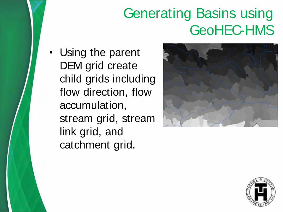
Cross-Section Exhibit

Overview of process
Use GeoHEC-HMS to update watersheds if needed
Create HEC-HMS model
Use GeoHEC-RAS to cut cross-sections in newest available DEM data
Export data into HEC-RAS and merge surveyed sections into DEM data
Correct HEC-HMS and HEC-RAS data and export to GeoHEC-RAS for mapping

New proposed Floodplain
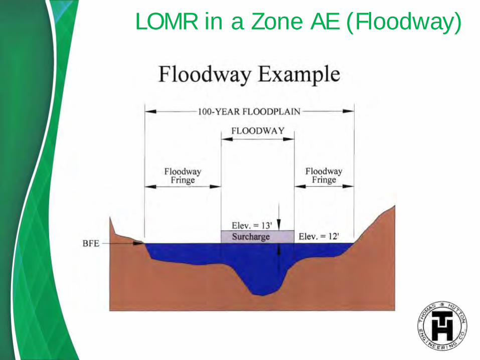
LOMR in a Zone AE (Floodway)

Floodway using HEC-RAS Methods
HEC-RAS Methods include:
Method 1: User enters right and left encroachments stations
Method 2: User enters a fixed top width
Method 3: User specifies the percent reduction in conveyance
Method 4: User specifies a target water surface increase.
Method 5: User specifies target water surface increase and maximum change in energy.

Floodway on a cross-section

Floodway by location

Proposed Floodplain vs. FIRM

Final Approval Letter

Final Approval Letter

Final Approval Letter

Final Approval Letter

Property Owner Notification Letters are sent when the LOMR is sent to FEMA for acceptance. However, sometimes FEMA will request that a certified letter be sent to the property owners AFTER the LOMR is approved.
After the LOMR has been accepted, the municipality will be sent the approved LOMR study. A notification will then be published in the local news paper twice. After the publications, the property owners have a 90-day time frame to appeal/dispute the approved LOMR with better information.
FEMA Guidelines for Property Owner Concerns:

Were in a high risk zone, now in a low risk:
• You will no longer have a Federal requirement to purchase flood insurance when the new map take effect. However, lenders can still require flood insurance. Preferred rates are available when outside of the 100-year floodplain.
Were NOT in a high risk zone, now in a high risk:
• If you have Federally back financing, you WILL be required to have flood insurance. You have 45 days to get flood insurance, if you don’t, the lender can force place the insurance.
Were in a high risk zone, now in a high risk zone with an increased BFE:
• If you can show your house was built in compliance with local floodplain management regulations and the flood map in effect at the time of construction, the basis for rating your policy does not change and your premium will be the same.
FEMA Guidelines for Property Owner Concerns:

What’s next?

Questions?