Embed Size (px)
Citation preview

Taking Advantage of the Improved Availability of Census Data:
A First Look at the Gridded Population of the World, Version 4 (GPWv4)
Erin Doxsey-WhitfieldKytt MacManus
Susana B. AdamoLinda PistolesiJohn Squires
Olena BorkovskaSandra Baptista
October 17, 2014Applied Geography ConferenceAtlanta, Georgia

Socioeconomic Data & Applications Center (SEDAC)
• Integration of social and earth science data, especially with remote sensing
• Focus on human dimensions of environmental change
• Direct support to scientists, applied and operational users, decision makers, and policy communities
• Strong links to geospatial data community
2
Outline1. What is Gridded Population of the World (GPW)?
2. Methods for GPWv4
3. Improvements made in GPWv4
4. Challenges with acquiring/integrating census data
5. Recommendations for National Statistics Offices

Gridded Population of the World (GPW)• Global population grid (raster) developed to provide a spatially-disaggregated
population layer that is compatible with data sets from social, economic, and Earth science fields.
• Input data: census population counts and census geography
• Census population data are transformed from their native spatial units to a global grid of quadrilateral latitude-longitude cells (Balk et al. 2010)
• Free and openly available
GPW version 3, 2000 population density

History of GPW
GPWv1 GPWv2 GPWv3 GPWv4
Publication Year 1995 2000 2005 2014/2015
Years of Estimation 1994 1990, 1995 1990, 1995, 2000 2000, 2005, 2010, 2015, 2020
Number of Input Units (subnational geographic
units)19,000 127,000 c. 400,000 ~ 12,500,000
Grid Resolution 2.5 arc-minute 2.5 arc-minute 2.5 arc-minute 30 arc-second (1 km)
Census variables Total Population Total Population Total Population Total Population, Sex, Age, Urban/Rural status
• GPWv1 was an outgrowth of a Global Demography Workshop held at CIESIN in 1994 (produced by Waldo Tobler, Uwe Deichmann, and others)
• Consensus that a consistent global database of population totals in raster format would be invaluable for interdisciplinary study (Deichmann et al., 2001)

Applications of GPW
Broad use in research, policy making, communications, and
human and environmental problem-solving
Often combined with satellite remote sensing or other
biophysical data
Areas of application:• Health dimensions of
environmental change• Vulnerability mapping• Disaster impacts

Outline1. What is Gridded Population of the World (GPW)?
2. Methods for GPWv4
3. Improvements made in GPWv4
4. Challenges with acquiring/integrating census data
5. Recommendations for National Statistics Offices
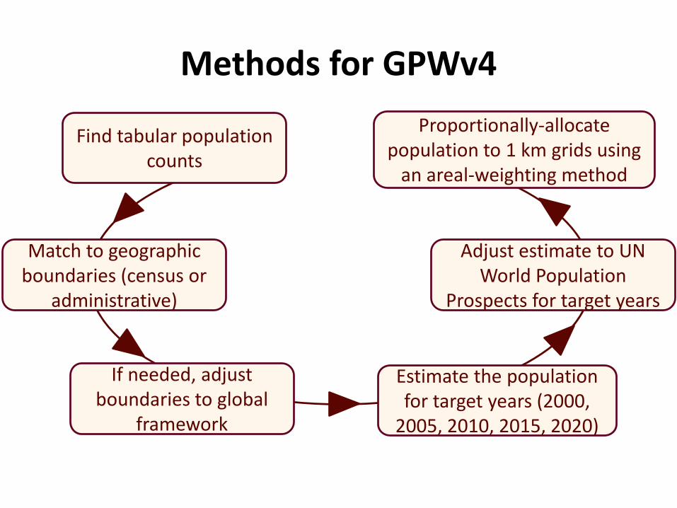
Methods for GPWv4
If needed, adjust boundaries to global
framework
Estimate the population for target years (2000,
2005, 2010, 2015, 2020)
Adjust estimate to UN World Population
Prospects for target years
Find tabular population counts
Match to geographic boundaries (census or
administrative)
Proportionally-allocate population to 1 km grids using
an areal-weighting method

GPW is minimally-modeled • GPW uses the areal-weighting method
– Does not incorporate ancillary data (e.g. land use/land cover, transportation networks, elevation, etc.)
– Uniformly distributes population based on land area
• Maintains fidelity to input data
• The accuracy of GPW pixel estimates is directly related to the size of the input census units
Higher resolution boundaries in eastern China lead to more accurate population distributions

Outline1. What is Gridded Population of the World (GPW)?
2. Methods for GPWv4
3. Improvements made in GPWv4
4. Challenges with acquiring/integrating census data
5. Recommendations for National Statistics Offices

GPWv4 2010 Population Density Estimates
Source: CIESIN, 2014

Improvements to GPWv41. Increased spatial resolution of input data
GPWv3 GPWv4
Global 399,747 12,497,563
USA 60,884 10,608,747 Rest of World 338,863 1,888,816
Number of Input Units
Accuracy of GPW depends upon the size of the input census units
Number of Input Census Units

Improvements to GPWv41. Increased spatial resolution of input data
0
20
40
60
80
100
0 1 2 3 4 5 6
Num
ber
of C
ount
ries
Administrative Level Used
Frequency of Administrative Level Used
GPWv3
GPWv4
# of countries atLevel 3 or higher:
GPWv3: 47GPWv4: 87
Country Census block

Improvements in Input Data Resolution
98 countries11 countries 132 countries

GPWv4 Administrative Level

Improvements to GPWv42. Additional census variables
Demand to include demographic information in global population grids
GPWv4 will include detailed global grids for:• Sex• Age (single year or 5-year age groups)• Urban/Rural status

Improvements to GPWv42. Additional census variables
2010 % rural population, Panama 2010 % urban population, Panama

Improvements to GPWv42. Additional census variables
http://blogs.ei.columbia.edu/

Reasons for Improvements
• GPWv4 has finer grid resolution– 30 arc-second (~1km) vs 2.5 arc-minute (~4km)
• Technological advancements by NSOs– More census data is available online– More is open source– More interactive, online databases

Outline1. What is Gridded Population of the World (GPW)?
2. Methods for GPWv4
3. Improvements made in GPWv4
4. Challenges with acquiring/integrating census data
5. Recommendations for National Statistics Offices

Challenges with acquiring census data
• Room for ongoing improvements with online dissemination
• Asymmetry between availability of tabular census data and census geography
• Challenges can lead to compromises in data processing
Primary method of census data dissemination
Percent of respondents (121 countries)
Paper publications 52%
Static web pages (html, excel, PDF)
28%
Interactive online databases
14%
CD/DVD 4%
Other 2%Source: 2011/2012 survey for the review of the 2010 World Programme on Population and Housing Censuses; UN Statistics Division, 2013.

• GIS data from non-Census Source• Refer to the same unit by different names• GIS data might not capture changes in boundaries over
time and therefore requires editing• Significant effort is needed to reconcile census areas
with those present in the GIS data and to assign common identifiers
Challenges with integrating census dataIdeally, the NSO releases census population
data and digital census geography, with a common identifying code

Outline1. What is Gridded Population of the World (GPW)?
2. Methods for GPWv4
3. Improvements made in GPWv4
4. Challenges with acquiring/integrating census data
5. Recommendations for National Statistics Offices

Recommendations for NSOs and National Mapping Agencies
1. Developing a digital data dissemination strategy at the highest resolution possible
2. Providing census data in a database format (e.g. Excel)3. Including common identifying codes that are shared by tabular
and boundary data4. Documenting changes in administrative areas
Obtaining high-resolution census data and matching census geography remains a priority for
improving global gridded population data sets

AcknowledgementsThis work was funded by NASA under contract NNG08HZ11C for thecontinued operation of the Socioeconomic Data and ApplicationsCenter (SEDAC) at CIESIN, a center of Columbia University.
The authors would like to thank Lisa Lukang, Valentina, Mara,Jared Talkin, Jane Mills, Ilyun Koh, Sneha Rao, Chenyang Zhao,and Evan Drewry, who all contributed to the data set production.
Erin Doxsey-Whitfield http://sedac.ciesin.columbia.edu/[email protected]