Embed Size (px)
Citation preview

TAIWAT Component WATMAN Feasibility Study
Task 1.4 – Hydro-Works in Romania 1/10
SEPIC Support to Enhance Privatization, Investment, and Competitiveness in the Water Sector of the Romanian Economy
HYDRO-TECHNICAL INFRASTRUCTURE IN ROMANIA
Submitted to: U.S. Agency for International Development/Romania
and also to
ANAR and MEWM
July, 2004 Bucharest, Romania
The SEPIC project, Task Order 822 under USAID’s GBTI IQC (PCE-I-00-98-00015-00), is implemented by Chemonics International Inc., 1133 20th Street, NW, Washington, DC 20036, with assistance from its principal subcontractor, International Resources Group (IRG). Romanian subcontractors include SC AQUAPROIECT SA, SC AUDITECO SRL, SC ECEROM GROUP SRL, Interactive Communications Systems and Business Consulting, Technical University of Civil Engineering of Bucharest

TAIWAT Component WATMAN Feasibility Study
Task 1.4 – Hydro-Works in Romania 2/10
Table of Contents Section Page
Table of Contents 2 Acronyms 3 Introduction 4 Characterization of Water Works in Romania 6 1. Somes – Tisa Basin 6 2. Crisuri Basin 9 3. Mures Basin 13 4. Banat Basin 16 5. Jiu Basin 20 6. Olt Basin 23 7. Arges – Vedea Basin 27 8. Ialomita – Mostistea – Buzau Basin 33 9. Siret Basin 37 10. Prut – Barlad Basin 40 11. Dobrogea Basin 44 12. Dunarea Basin 47
TAIWAT Component WATMAN Feasibility Study
Task 1.4 – Hydro-Works in Romania 3/10
Acronyms Ac. – accumulation (lake) Am. - arrangement/ (hydro) work C.F. – railway Dig. – regularizarion H.B/ B.H. – hydrographic basin H.S./ S.H. – hydrographic space Jud. – judet/ county R. – river Reg. - regularization SCADA – System of Commend and Control of Data Acquisition SEPIC – Support to Enhance Privatization, Investment and Competitiveness
in the Water Sector of the Romanian Economy TAIWAT – Trade and Investment for Water UHE - Hydro-Electric Unit V. – Valley WATMAN – Water Management

TAIWAT Component WATMAN Feasibility Study
Task 1.4 – Hydro-Works in Romania 4/10
Introduction The main hydro-technical water works affecting the flow regime of the rivers are: reservoirs, deviations and water transfers from neighborough basin into a reservoir, embankments and dykes. This types of infrastructures are in fact the most useful instruments for water management, offering possibilities in getting regulation of different volumes during the seasons and sometimes during the year, to offer flood protection or dilution in case of accidental spills.
To be more effective we need to plan carefully these water resources and water volume transfers, depending of the water regime on the rivers. Two main instruments may help in this planning: forecasting models and a decisional support system to assist the deciders what plan is the best for the analyze moment. To be able to build such instruments we need to know the inventory of water works and the main characteristics of these.
A special attention was given to reservoirs, deviations and dykes. These water works have direct link to water management with respect to water allocation and flood prevention. At the same time, these represent the main infrastructure of the hydro-technical systems using the informational and SCADA systems for water management, which are susceptible for modernization through WATMAN Project.
In Romania the water resources useful during a mean year in natural regime are round 5 billions cm. The demands for the moment are round 100 billion cm/year. This water demands cannot be secured without reservoirs. This is the reason of the dynamic in developing such investments in Romania. During the period 1950 – 1975 the principal objective of water schemas was to assure the hydropower need and industry and agriculture demands. Between 19950-1966 were built dams to Bistriţa and Argeş Rivers for hydropower generation, dams Secu on Bârzava River, Teliuc on Cerna and Strâmtori on Firiza River. During 1966 – 1982 were build the cascade of Oieşti – Goleşti on Argeş River and Dăieşti – Drăgăşani on Olt River, and Iron I and II on the Danube River, Vidra on Lotru, Tarniţa on Someş, Paltinu on Doftana, Poiana Uzului on Uz, Pucioasa on Ialomiţa, Bucecea on Siret, Stânca-Costeşti (1400 millions cm) on Prut and Gura Râului on Cibin, some of them mainly useful for hydropower production, but some other for water supply. After 1983 it was continued with building the cascade of Olt to Izbiceni – the Danube confluence, reservoirs on Sebeş and Râul Mare - Retezat, on Siret at Galbeni – Bereşti and Călimăneşti, Siriu on Buzău, Poiana Mărului on Bistra, Pecineagu on Dâmboviţa, Bolboci on Bistriţa, Râuşor on Târgului, Mihoieşti on Arieş, Goleşti, Mărăcineni and Zăvoiul Orbului on Argeş and Surduc on Timiş. At the moment, in conformity of the Romanian September 2002 inventory of dams the total number of the reservoirs (including fishery dams and touristic reservoirs) is of 1840. 1232 are permanent reservoirs, 217 are non-permanent reservoirs (polders) and 391 are fish ponds.
For the purposes of WATMAN Project to renew the informational system for water management and to increase the ability in integrated water management were selected 241 reservoirs, representative for water management and flood attenuation. Other criteria were: the dam is higher then 10 m and the retention volume more than 1 million cm; but in case the volume is less than 1 mil. cm but the dam is higher then 10 m, the reservoir was included on the list. Even in case that the reservoirs were less then 1 mil. cm but was very useful for water allocation, it was included on the list.
TAIWAT Component WATMAN Feasibility Study
Task 1.4 – Hydro-Works in Romania 5/10
DEVIATION AND WATER DIVERSION The first water works regarding deviations were built beginning with the 18-th century for high water protection of Bucharest and to assure the needed water demands (deviation from Dâmboviţa to Argeş and Răstoaca was diverted in Sabar). In the same period of time Bega was regulated on 115 km length (40 km on Romanian territory).
In north-west and west of the country, there were regulated Crasna and Crişuri water course. This hydro-technical water works had the role of drying some humid areas. After that (1900) Crasna got a new water course, and large areas were given to agriculture.
During the 20th century flood protection works were promoted, works for water supply in the industrial areas and in new developed urban areas. As examples of such works are: Ogrezeni – Roşu (an 1950), Bilciureşti – Ghimpaţi (an 1936), Iazul Morilor – Ialomiţa, Iazul Morilor – Prahova, Leaotul, Iazul Morilor – Teleajen channels; a lot of deviations were designed for water supply, irrigation purposes or for transportation (as Danube River-Black See Channel or Maritime Danube Channel).
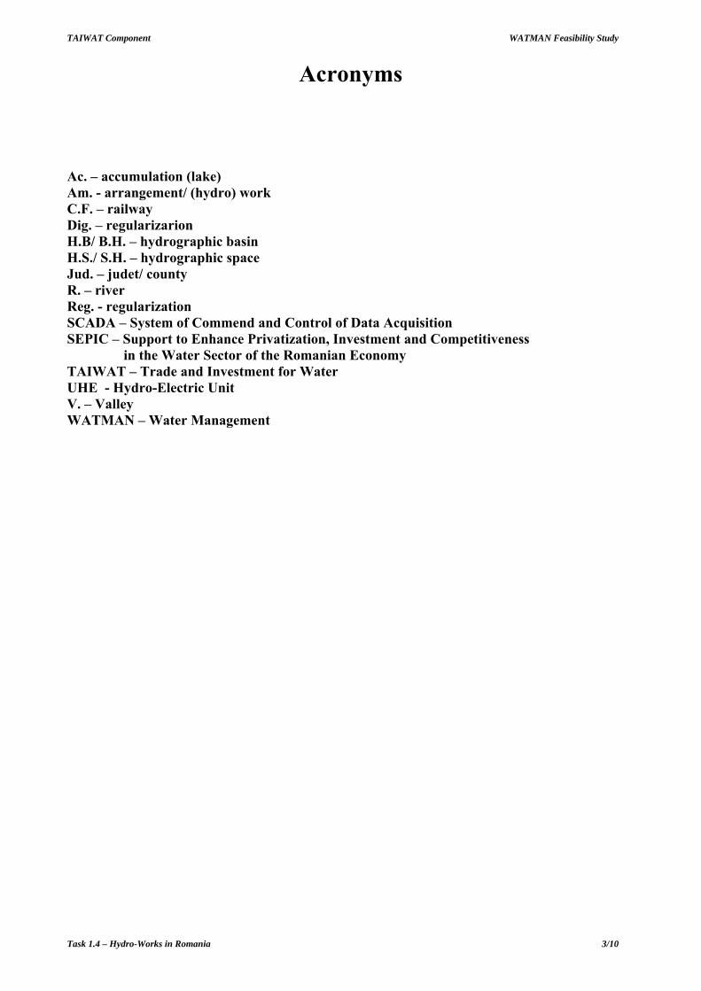
The inventory provided by the 2002 Year Book, established that for all Romania there are 153 flood deviations, cu with a total length of 2070 km and a total installed discharge of about 3458 cm/s.
For WATMAN purposes there were selected 104 deviations and intakes important for water management. The length of these deviations is of 2170 km and an installed discharge of 3500 cm/s.
In Table 1 it is a synthetical presentation of these selected deviations/intakes.
Table 1: Deviates in each basin with the main characteristics
No. Hydrographic space/Basin Number Length (km)
Installed discharge (m3/s)
0 1 2 3 4 1 SOMEŞ - TISA 9 169.4 47.3 2 CRIŞURI 5 249.1 347.5 3 MUREŞ 7 264.0 21.2 4 BANAT 11 106.6 455.9 5 JIU 8 212.6 95.5 6 OLT 18 352.5 223.3 7 ARGEŞ - VEDEA 17 146.2 1322.1 8 IALOMIŢA 12 177.4 231.8 9 SIRET 4 223.3 203.5 10 PRUT - BÂRLAD 5 53.3 17.0 11 DOBROGEA 2 33.6 79.0 12 DUNĂRE 6 182.3 456.8
TOTAL 104 2170.3 3500.8
DYKES AND REGULARIZATION WATER WORKS For the documentation of WATMAN Project there will be analyzed 309 dykes and regulatory water works with a total length of 8022 km dykes and 5053 km regulatory water works; these are presented by each basin in table 2.

TAIWAT Component WATMAN Feasibility Study
Task 1.4 – Hydro-Works in Romania 6/10
Table 2 – Dikes and regularization water works in Romania
No. Basin Number of water works
Regulatory water works (km)
Dykes length (km)
0 2 3 4 5 1 SOMEŞ - TISA 33 564.7 716.5 2 CRIŞURI 32 627.7 1009.6 3 MUREŞ 41 644.3 381.2 4 BANAT 11 972.7 1068.4 5 JIU 23 392.3 508.1 6 OLT 23 324.4 642.1 7 ARGEŞ -
VEDEA 28 195.5 169.4
8 IALOMIŢA 18 284.2 487.9 9 SIRET 23 602.3 454.9 10 PRUT -
BÂRLAD 15 183.8 726.6
11 DOBROGEA 11 119.2 187.0 12 DUNĂRE 51 141.6 1670.1 TOTAL 309 5052.5 8021.8
CHARACTERIZATION OF THE WATER WORKS IN ROMANIA 1. SOMEŞ – TISA BASIN Someş-Tisa basin covers the counties of Maramureş and Bistriţa-Năsăud and partially the counties of: Sălaj, Satu Mare and Cluj. From water management point of view, Someş-Tisa area includes the following river basins: Someş, Crasna, Tisa and Tur, with a total surface of 22.380 km2 – Figure 1. The mean annual water stock is around 6122 mil. m3/year and it is made mainly by Someş (65 %), Tisa (27 %), Crasna (3 %) and Tur (5 %).
This hydrographical space is characterized by flash flood phenomena. The greatest floods were produced during March-May, 2001 of mix provenience (rain and snow). The highest floods were produced in 1970 in the entire basin.
The principal water works are presented in Figure 1.

TAIWAT Component WATMAN Feasibility Study
Task 1.4 – Hydro-Works in Romania 7/10
Figure 1. Somes Basin Water Works
(a) Reservoirs In this area 13 reservoirs were selected, 12 permanents and 1 non-permanent.
The main complex reservoirs are: Călineşti on Tur River, Colibiţa on Bistriţa River, Strâmtori on Firiza and Vârşolţ on Crasna River.
The principal reservoirs with energetic purpose are Fântânele,Tarniţa, Someşul Cald on Someşul Cald and Floreşti on Someşul Mic. Some complex reservoirs, especially dedicated to water supply, have as subordinated task hydropower production (ex. Gilău, Colibiţa, Strâmtori) and flood prevention (Călineşti, Colibiţa, Strâmtori, Gaga, Salting,Vârşolţ).
Non-permanent reservoir Moftin on Crasna River has a flood protection role for localities situated on Crasna river downstream.
At the moment there is built the Runcu Reservoir on Mara (Vbr=26 mil. m3, Vu=24 mil. m3), which will assure the water supply for Baia Mare - Baia Sprie area.

TAIWAT Component WATMAN Feasibility Study
Task 1.4 – Hydro-Works in Romania 8/10
Strâmtori Dam – p. Firiza (b.h. Săsar)
b) Derivations and intakes
In the Someş-Tisa hydrographic space, there have been retained as the most important ones 9 derivations of total length of 169,4 km and with an installed debit of 47,3 m3/s. From the water uses view point, 2 are for the electric power production, and 7 for the supply with potable and industrial water. These are:
- Someşul Rece - Tarniţa (jud. Cluj) derivation, which transfers debits from Someşul Rece in Someşul Cald for the supplementation of the water stock in Tarniţa accumulation, for energetic purposes;
- Iara - Someşu Cald (jud. Cluj) derivation, which transfers debits through the catchments of 4 tributaries of Iara brook from the Arieş river sub-basin, the Mureş hydrographical basin, and of other 4 tributaries of Someşul Rece river, within the Fântânele accumulation situated on Someşul Cald river, for energetic purposes. At Someş – Tisa hydrographic space there have been registered only the capacities afferent to the catchments from this basin;
- Brazi - Valea Neagră (jud. Maramureş) derivation, which transfers debits from Runcu brook in Iza sub-basin of the Tisa hydrographic basin, in Strâmtori accumulation on Firiza brook from Lăpuş sub-basin of Someş hydrographic basin, in view of the supply with potable and industrial water of Baia Mare area;
- Vârşolţ – Zalău (jud. Sălaj) intake, which transfers regularized debits in Vârşolţ accumulation on Crasna river toward Zalău municipality situated on Zalău brook, tributary of Crasna river, in view of potable water supply;
- Vârşolţ – Şimleul Silvaniei (jud. Sălaj) intake, which draws off regularized debits in Vârşolţ accumulation on Crasna river, for the supply with potable water of Şimleul Silvaniei town, situated downstream on the same water flow;
- Cluj - Gherla (jud. Cluj) intake, which draws off regularized debits in Gilău accumulation on r. Someşul Mic for the supply with potable water of Gherla town, situated on the same water flow;
- Gilău - Aghireş (jud. Cluj) intake, which transfers regularized debits in Gilău accumulation on r. Someşul Mic for the supply with industrial water of Aghireş mining, situated on Nadăş brook, tributary of Someşul Mic;
- Someş – Zalău (jud. Sălaj) intake, which transfers debits from Someş river, Jibou area, for the supply with industrial water of Zalău municipality - CET Zalău, situated on Zalău brook, affluent of r. Crasna;

TAIWAT Component WATMAN Feasibility Study
Task 1.4 – Hydro-Works in Romania 9/10
- Lăpuş - Baia Mare (jud. Maramureş) intake, which transfers debits from Lăpuş river, at Cătălina, for the supply with industrial water of Baia Mare municipality, situated on Firiza brook, tributary of Lăpuş river.
c) Dykes and water sectors regulations
In the hydrographic space of Someş-Tisa there exist a number of 514 river bed regularizations of 1005 km length and 136 dykes of 1087 km length total. These works offer protection against floods to: 16 towns, 74 industrial units, cca. 31000 homes or residences, cca. 144000 ha surface, roads, bridges, railways, etc.
Among the regularization and dyke works of Someş – Tisa hydrographic space, there have been retained as most important 33 river bed regularization works of 564,7 km and 716,5 km dikes.
The majority of the selected works are mainly protecting localities, rather then extra-vilane terrain. Among the protected localities there are: Cluj – Napoca, Baia Mare, Bistriţa, Zalău, Dej, Beclean, Năsăud and Jibou.
Among the protected categories of objectives there are industrial platforms, bridges, roads, railways and others.
The most important regularization and dike works would be:
- r. Tur dike, Turulung-Negreşti drainage area (Lreg= 15,3 km, Ldig=199 km);
- r. Someş dike, both river banks, upstream and downstream to Satu Mare municipality (Lreg=30,2 km, Ldig=95,1 km);
- regularizations and dikes on r. Crasna the inferior flow (Lreg=24,1 km, Ldig=62,1 km);
- floods abatement on r. Crasna in Moftin-Craidorolţ-Vârşolţ area (Lreg=49,2 km, Ldig=99,7 km);
- floods abatement and of the excess of humidity in Homorodului wetland (Lreg=23 km, Ldig=67,7 km).
2. B.H. CRIŞURI
The hydrographic space of Crişurilor, component of Tisa basin, is situated in Western Romania and has a surface of 14.860 km2. Uniting the hydrographic basins of some main rivers (Ierul, Barcăul, Crişul Repede, Crişul Negru, Crişul Alb), and of some small tributaries which cross the border (901 km2), the hydrographic space of Crişurilor comprises in totality the Bihor county, partially the Arad and Satu Mare counties, and smaller surfaces from the: Sălaj, Cluj and Hunedoara counties.
The average multi-annual stock of the water flows from Crişuri hydrographic space, gather, in the border sectors cca. 2,98 bil. m3 (cca. 94,4 m3/s). The average multi-annual debits at the HS situated on the inferior sectors of the main water courses are of cca. 2,60 m3/s on Ier at Săcuieni hydrographic space; 6,01 m3/s on Barcău at Sălard hydrographic space; 25,0 m3/s on Crişul Repede at Oradea hydrographic space; 29,8 m3/s on Crişul Negru at Zerind hydrographic space and of 23,8 m3/s on Crişul Alb at Chişineu Criş hydrographic space.
The water works are presented in Figure 2.
a) Accumulation lakes In the Crişuri hydrographic space, there have been retained, as most important 23 accumulation lakes from which 9 are permanent and 14 non-permanent. The maximum volume of these accumulations is of 476,5 mil m3, from which 338,1 mil. m3 in permanent accumulations and 138,4 mil m3 in non-permanent accumulations. The permanent accumulation lakes gather a useful volume

TAIWAT Component WATMAN Feasibility Study
Task 1.4 – Hydro-Works in Romania 10/10
of 231,9 mil. m3 and an attenuation volume of 52,6 mil m3. The attenuation volume afferent to the non-permanent accumulations is of 131,5 mil. m3.
The main complex accumulations, with important role within the schema of waters management, are: Leşu on Iad valley, Drăgan on r. Drăgan, Lugaşu on Crişul Repede, Tileag on Crişul Repede, Tăuţ on r. Cigher.
For assuring the needs for potable and industrial waters of Brad – Gurabarza area, it is undergoing the construction of the Mihăileni accumulation lake on Crişul Alb.
The main non-permanent accumulation lakes, with important role in the protection against floods of localities, economic units and of the agricultural terrains are:
- in the Ier hydrographic basin: Sirid - on Ierului valley, Simian - on v. Salcia and Galoşontreu - on v. Rât;
- in the Barcău hydrographic basin: Sălard polder on r. Barcău;
- in the Crişul Negru hydrographic basin: Tămaşda and Zerind polders on r. Crişul Negru, non-permanent accumulation Carand on r. Teuz, Beliu, Sartiş, Leveleş I and Leveleş II accumulations on Beliu-Carney-Tăuţ canal;
- in the Crişul Alb hydrographic basin: Chier polder on v. Dudiţa.
- Five most important complex accumulations: Leşu, Drăgan, Lugaşu, Tileag and Tăuţ have important attenuation volumes.
A grouping of main destinations is presented in table 1. Thus, from the total of 23 accumulations, 7 have complex purposes, 2 have the main purpose the water allocation/ supply and 14 floods attenuation purpose.
Drăgan Dam and Lake – v. Drăgan (b.h. Crişul Repede)

TAIWAT Component WATMAN Feasibility Study
Task 1.4 – Hydro-Works in Romania 11/50
Figure 2. Crisuri Basin and its water works
TAIWAT Component WATMAN Feasibility Study
Task 1.4 – Hydro-Works in Romania 12/50
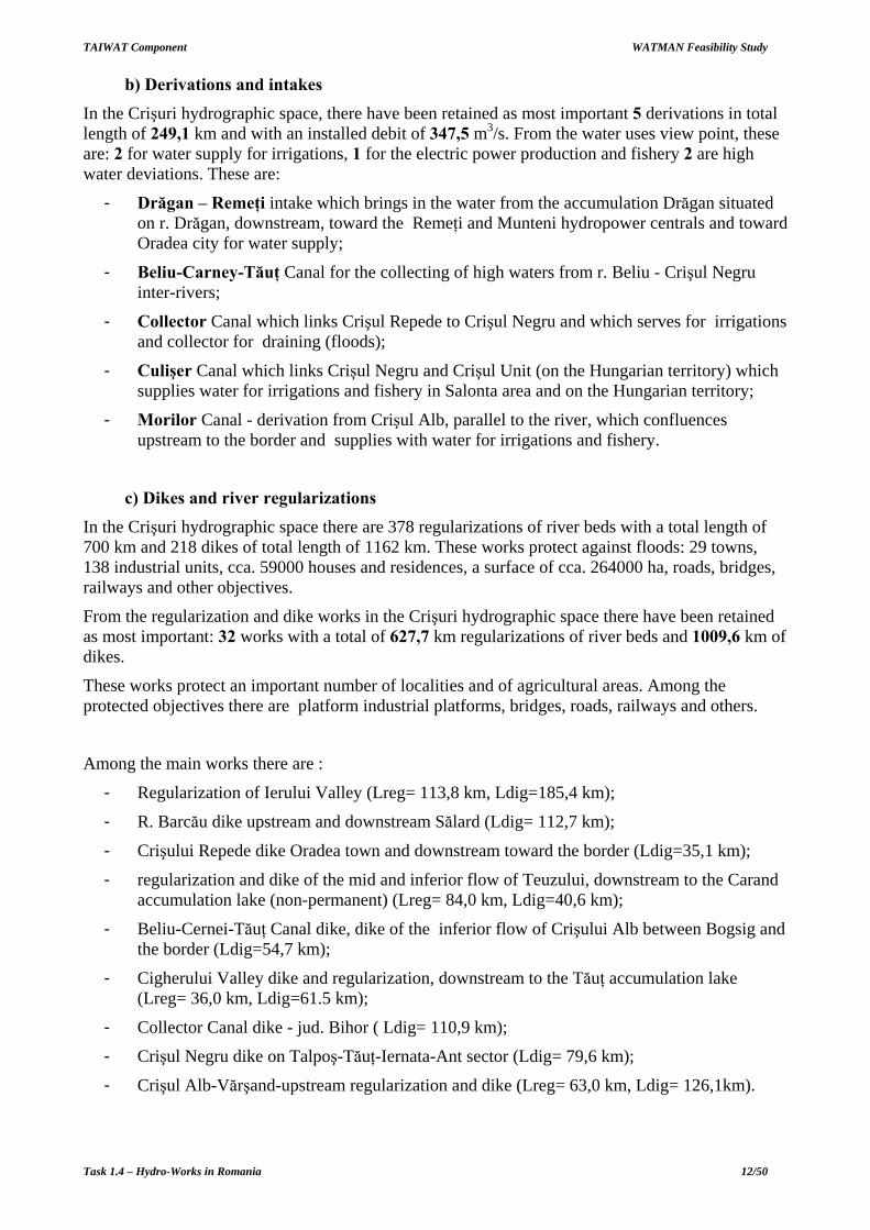
b) Derivations and intakes In the Crişuri hydrographic space, there have been retained as most important 5 derivations in total length of 249,1 km and with an installed debit of 347,5 m3/s. From the water uses view point, these are: 2 for water supply for irrigations, 1 for the electric power production and fishery 2 are high water deviations. These are:
- Drăgan – Remeţi intake which brings in the water from the accumulation Drăgan situated on r. Drăgan, downstream, toward the Remeţi and Munteni hydropower centrals and toward Oradea city for water supply;
- Beliu-Carney-Tăuţ Canal for the collecting of high waters from r. Beliu - Crişul Negru inter-rivers;
- Collector Canal which links Crişul Repede to Crişul Negru and which serves for irrigations and collector for draining (floods);
- Culişer Canal which links Crişul Negru and Crişul Unit (on the Hungarian territory) which supplies water for irrigations and fishery in Salonta area and on the Hungarian territory;
- Morilor Canal - derivation from Crişul Alb, parallel to the river, which confluences upstream to the border and supplies with water for irrigations and fishery.
c) Dikes and river regularizations
In the Crişuri hydrographic space there are 378 regularizations of river beds with a total length of 700 km and 218 dikes of total length of 1162 km. These works protect against floods: 29 towns, 138 industrial units, cca. 59000 houses and residences, a surface of cca. 264000 ha, roads, bridges, railways and other objectives.
From the regularization and dike works in the Crişuri hydrographic space there have been retained as most important: 32 works with a total of 627,7 km regularizations of river beds and 1009,6 km of dikes.
These works protect an important number of localities and of agricultural areas. Among the protected objectives there are platform industrial platforms, bridges, roads, railways and others.
Among the main works there are :
- Regularization of Ierului Valley (Lreg= 113,8 km, Ldig=185,4 km);
- R. Barcău dike upstream and downstream Sălard (Ldig= 112,7 km);
- Crişului Repede dike Oradea town and downstream toward the border (Ldig=35,1 km);
- regularization and dike of the mid and inferior flow of Teuzului, downstream to the Carand accumulation lake (non-permanent) (Lreg= 84,0 km, Ldig=40,6 km);
- Beliu-Cernei-Tăuţ Canal dike, dike of the inferior flow of Crişului Alb between Bogsig and the border (Ldig=54,7 km);
- Cigherului Valley dike and regularization, downstream to the Tăuţ accumulation lake (Lreg= 36,0 km, Ldig=61.5 km);
- Collector Canal dike - jud. Bihor ( Ldig= 110,9 km);
- Crişul Negru dike on Talpoş-Tăuţ-Iernata-Ant sector (Ldig= 79,6 km);
- Crişul Alb-Vărşand-upstream regularization and dike (Lreg= 63,0 km, Ldig= 126,1km).

TAIWAT Component WATMAN Feasibility Study
Task 1.4 – Hydro-Works in Romania 13/50
3. B.H. MUREŞ The Mureş hydrographic basin with a surface of cca. 29.500 km
2 is situated in the area delineated
by the Carpaţii Orientali, Meridionali and Apuseni, also comprising the eastern part of the Câmpia Tisei centre. In this space there are integrally included the Mureş and Alba counties, partially the Harghita, Sibiu, Cluj, Hunedoara, Arad, Timiş counties and small surfaces from the Braşov, Bistriţa Năsăud, Caraş Severin counties.
Along its flow, the multi-annual average debit grows from 37,9 m3/s at Glodeni (Târgu Mureş), up to 108 m3/s at Alba Iulia, 169 m3/s at Branişca (downstream Deva) and reaches 174 m3/s at Arad (5491 mil.m3/year), identically with the value from the border section. The periods when floods have a bigger frequency are: Spring – early Summer and Autumn, of maximum debits due to water from precipitations and of the one from the snow melt. The biggest contribution to the floods on r. Mures comes from: Arieş, Gurghiu, Lut, Niraj, Târnave, Streiul and Râul Mare tributaries.
Historic values of maximum debits have been registered in 1932, 1970, 1975, 1981 and 1995 (Arieş). On r. Mureş at Glodeni, the maximum debits have exceeded 1% in 1970 and 1995, have reached 1% at Alba Iulia in 1970 and have reached aprox. 1% at Arad in 1970 and 1975. On r. Arieş at Turda the maximum debits have been of approximate at 2% in 1975 and 1995, and on r Târnava Mare at Blaj and Târnava Mică at Târnăveni have exceeded 1% in 1975.
The water works in the basin are presented in Figure 3.
a) Accumulation lakes In the Mureş hydrographic basin there have been retained as most important 21 accumulation lakes, from which 14 are permanent and 7 non-permanent. The maximum volume of these accumulations, all together is of 655,0 mil m3, from which 575,0 mil. m3 in permanent accumulations and 80,0 mil m3 in non-permanent accumulations. The permanent accumulation lakes have a global utile volume of 428,4 mil. m3 and of a total attenuation volume of 98,1 mil m3. The attenuation volume afferent to the non-permanent accumulations is of 70,0 mil. m3.
The most important accumulation lakes with complex use are: Cinciş on r. Cerna for Hunedoara, Zetea area on r. Târnava Mare for water needs from r. Târnava Mare basin and Bezid on r. Cuşmed for water needs from Târnăveni.
The significant accumulation lakes with role of protection against floods are: Vânători on r. Târnava Mare and Bălăuşeri on r. Târnava Mică.
From the most important accumulations for energetic purposes there are: Gura Apelor on r. Mare and Oaşa and Tău on r. Sebeş.
A grouping on main destinations is presented in table 1. Thus, from the total of 21 accumulations, 5 have complex purposes, 1 is meant for water supply, 8 are of hydro-power production purpose and 7 for floods attenuation purpose.

TAIWAT Component WATMAN Feasibility Study
Task 1.4 – Hydro-Works in Romania 14/50
Tău Dam – r. Sebeş
b) Derivations and intakes In the Mureş hydrographic basin, there have been retained as most important 7 derivations of total length of 264,0 km and with an installed debit of 21,2 m3/s. From the water uses view point, 1 is for the electric power production, 4 are meant for potable and industrial water supply, and 2 are for irrigations and draining. These are:
- Râul Mare – Deva intake, jud. Hunedoara, which draws off water from Haţeg accumulation, situated at the downstream end of the hydro-energetic water falls of R. Mare for water supply of Deva municipality;
- Sebeş - Alba Iulia – Blaj – Aiud - Ocna Mureş intake, jud. Alba, which draws off water from Petreşti accumulation on r. Sebeş, situated at the downstream end of the hydro-energetic water fall on this river and directs it towards Alba Iulia, Blaj, Ocna Mureş localities for their supply with water and which can be called under derivations;
- Mureş - Criş (Canalul Matca) derivation, jud. Arad, with the main role of securing water for irrigations in the Câmpia de Vest area, on Mureş – Crişul Alb inter-river, at Mureş intake (Păuliş);
- Ighiş intake-discharge, jud. Sibiu, which draws off water from Ighiş accumulation on Ighiş brook, tributary of Târnava Mare, for the water supply of Copşa Mică locality.
- Iara – Someş derivation, jud. Cluj, which derives debits from Arieş sub-basin, respectively Mureş basin, in Someş basin for energetic purposes in the remediation of r. Someşul Cald;
- Mureş - Ier derivation (canal Ier), jud. Arad, with main role to insure water for irrigations in Câmpia de Vest area, Mureş – Crişul Alb inter-rivers, from the Mureş water source;
- r. Bărbat - ac. Cinciş derivation, jud. Hunedoara, which supplements the debits in Cinciş accumulation on r. Cerna, tributary of Mureşului downstream Strei, through an gravitational intake from r Bărbat, tributary of r. Strei, for water supply of Hunedoara municipality.
c) Dikes and river regularizations In the Mureş hydrographic basin there are 583 regularizations of river beds of a total length of 816 km and 210 dikes of a total length of 827 km. These works protect against floods: 55 towns, 381 industrial units, cca 69000 houses and residences, a surface of cca. 194000 ha, roads, bridges, railways, roads and other objectives.

TAIWAT Component WATMAN Feasibility Study
Task 1.4 – Hydro-Works in Romania 15/50
Figure 3. Mures River Basin Water Works

TAIWAT Component WATMAN Feasibility Study
Task 1.4 – Hydro-Works in Romania 16/50
From the works of regularization and dike of the Mureş hydrographic space, there have been retained as most important 41 works with a total of 644,3 km regularizations of rived beds and 381,2 km dikes.
These works protect mainly localities, but also some agricultural areas. From the protected localities there are Tg. Mureş, Alba Iulia, Deva, Arad, Sighişoara municipalities, and Luduş, Copşa Mică, Târnăveni, etc. towns.
Among the protected objectives there are industrial platforms, bridges, roads, railways and others.
From the main works there can be listed:
- Regularization and dikes r. Mureş in Gheorgheni creek, jud. Harghita (Lreg = 25.0 km, Ldig = 5.0 km);
- Dikes and regularization r. Mureş and tributaries at Tg. Mureş, jud Mureş (Lreg = 23,4 km, Ldig = 19,9 km);
- Dikes r. Mureş on Pecica – Vladimirescu sector, jud. Arad (Ldig = 32.2 km);
- Dikes r. Mureş on Felnac-Perian sector, jud Arad (Ldig = 22.2 km);
- Regularization and dike on r. Târnava Mare on Porumbenii Mari-Odorheiu sector, jud Harghita (Lreg = 23,0 km, Ldig = 4,5 km);
- Dikes and regularizations in Târnava Mare hydrographic basin at Sighişoara, jud Mureş (Lreg = 30,7 km, Ldig = 34,0 km);
- Regularization and dike r. Târnava Mică at Târnăveni, jud Mureş (Lreg = 26,6 km, Ldig = 29,0 km);
- Regularization of Ierii Valley (Lreg = 50.5 km);
- Regularization of Crac Valley (Lreg = 25,0 km);
- Regularization on Voiniceni brook at Voiniceni (Lreg = 22,0 km);
- Regularization on Secaş river, downstream Roşia de Secaş (Lreg = 22,0 km);
- Regularization and dikes on v. Nirajului, downstream loc. Miercurea Nirajului (Lreg = 52,4 km, Ldig = 55,0 km);
- Dikes of Veţca canal (on going) (Ldig = 44.6 km);
- Dike r. Arieş, sector Cheia - Câmpia Turzii (Lreg = 19,6 km, Ldig = 21,1 km).
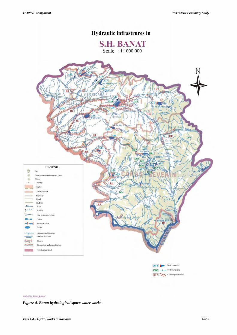
4. S.H. BANAT Banat hydrographic space is situated at south – west extremity of Romania and it almost covers the Timiş and Caraş – Severin counties. Its surface is of 16891 km2, which corresponds to 7,11% from the total surface of the country.
The hydrographic network from s.h. Banat, is composed of 5 main water courses. From these, 4 cross the border with R.F. Yugoslavia: r. Bega with its main tributary Bega Veche, r.Timiş with its main tributary Bârzava, r. Caraş , r. Nera, and the fifth, r. Cerna, is the most important from the downstream tributaries of the Danube, with its outflow in this big river on the Romanian territory afferent to Banat space.
The multi-annual average stock of the rivers from s.h. Banat is evaluated at cca 3875 mil.m3/year (122,3 m3/s). The main water course is r. Timiş, with a multi-annual average debit – at the border - of 45,3 m3/s (1429 mil. m3/year). The smallest multi-annual average debit – of only 0,29 m3/s (30 mil.m3/year) – is registered on r. Moraviţa.

TAIWAT Component WATMAN Feasibility Study
Task 1.4 – Hydro-Works in Romania 17/50
The big variation of the flow registered in the hydrographic basins which make up the Banat hydrographic space, are mainly due to the geomorphologic and climatic diversity of the areas in which these are situated. The biggest debits have been registered in 1966, 1968, 1970, 1974, 1987, 1989, 1995, 1997, 1999.
The water works in the Banat hydrological space are presented in Figure 4.
a) Accumulation lakes In the Banat hydrographic space, there have been retained as most important 24 accumulation lakes from which 10 are permanent and 14 non-permanent. The maximum volume gathered by these accumulations is of 455,1 mil m3, from which 244,4 mil. m3 in permanent accumulations and 210,7 mil m3 in non-permanent accumulations. The permanent accumulation lakes have a global utile volume of 186,5 mil. m3 and an attenuation volume of 48,5 mil m3. The attenuation volume afferent to the non-permanent accumulations is of 202,3 mil. m3.
The main accumulation lakes with complex purposes are:
- Surduc accumulation (p. Gladna) for the supply with potable and industrial water, irrigations and servitude;
- Gozna, Văliug, Secu accumulations (r. Bârzava) and Timiş Trei Ape (r. Timiş) for the water supply of Reşiţa and for the production of electric power;
- Valea lui Iovan accumulation, on Cerna river for the alimentation with industrial water at Turceni and Işalniţa (b.h. Jiu) and for the production of the electric power.
Principal non-permanent accumulations of the Banat hydrographic space, respectively Cenei, Hitiaş, Pădureni, Gad, Cadar-Duboz, Gherteniş, Vărădia I and II, Lişava, Moraviţa – Clopodia, are designated to comply with the boarder conditions regarding the maximum debits, respectively those debits which may cross the border within the limits of the values imposed by the Romanian-Yugoslavian agreements in action.
A grouping on main destinations of these rivers is presented in table 1. Thus, from the total of 24 accumulations, 9 have complex purposes, 1 of energetic purpose and 14 for floods attenuation purpose.
Secu Dam and Lake – r. Bârzava
b) Derivations and intakes In the Banat hydrographic space, there have been retained as most important 11 derivations of total length of 106,6 km and with an installed debit of 455,9 m3/s. From the water uses view point, 4 have preponderantly energetic purpose, 2 have as purpose the supply with potable and industrial
TAIWAT Component WATMAN Feasibility Study
Task 1.4 – Hydro-Works in Romania 18/50
Figure 4. Banat hydrological space water works

TAIWAT Component WATMAN Feasibility Study
Task 1.4 – Hydro-Works in Romania 19/50
water, 3 ensure the water supply and the production of electric power, 1 is a derivation for high waters and 1 has complex purposes. These are:
- Timiş - Bega derivation (Coştei-Chizătău canal), jud.Timişoara, which starts from r. Timiş, from the hydro-technical node Coştei and has the role to supply with water the uses along Bega canal, in Timişoara area and downstream, having as water source the r. Timiş;
- Bega - Timiş derivation (Topolovăţ-Hitiaş canal), jud. Timişoara, which starts from the Topolovăţ hydro-technical node on r. Bega and brings the water toward r. Timiş to the Hitiaş hydro-technical node. It has the main role in the derivation of high waters toward r. Timiş for the protection against floods of the Timişoara municipality and with role to limit the maximum admitted debits on r. Bega at the border with Yugoslavia.
- Semenic derivation, jud. Caraş Severin, which contributes to the supplementation of the supply with water of the Reşiţa municipality and to the production of electric power, making the derivation of the water from r. Timiş in r. Bârzava through the intermediary of the pumping station which draws off water from Timiş 3 Ape, the discharge being at UHE Crăinicel;
- Nera-Bârzava derivation, jud. Caraş Severin, which contributes to the supplementation of the supply with water of the Reşiţa municipality and to the production of electric power, making the derivation of the waters from r. Nera in r. Bârzava through UHE Crăinicel;
- Secu –Reşiţa intake, jud. Caraş Severin, for the supply with water of Reşiţa municipality from Secu accumulation;
- Gozna and Safra intakes, jud. Caraş Severin, with energetic role which draws off water from Guzna accumulation, respectively through the catchments of some tributaries of r. Bârzava and bring it to UHE Crăinicel;
- Breazova and Grebla intakes, jud. Caraş Severin, with energetic role which bring waters between UHE Crăinicel and UHE Breazova, respectively between UHE Breazova (and ac. Văliug) to UHE Grebla;
- Nera-Oraviţa derivation, jud. Caraş Severin, which draws off debits from r. Nera downstream from Sacsca Montană locality for the supply with water of Oraviţa town, situated on Oraviţa brook, tributary of r. Caraş;
- Ruieni intake, jud. Caraş Severin, with energetic role which draws off water from Poiana Mărului accumulation and brings it to UHE Ruieni.
c) Dikes and river regularizations In the Banat hydrographic space there exist 82 regularizations of river beds of a total length of 1040 km and 141 dikes with a total length of 1067 km. These works protect against floods: 19 towns, 46 industrial units, cca 64000 houses and residences, a surface of cca. 343000 ha, roads, bridges, railways and other objectives.
From the regularization and dike works of the Banat hydrographic space, there have been retained as most important 11 works with a total of 972,7 km regularizations of river beds and 1068,4 km dikes.
These works protect both localities and important agricultural areas. Among the protected objectives there are industrial units, bridges, roads, railways and others. The main hydro-works gainst floods are on Bega and Timiş rivers. From the main works : a
- Regularizations and dikes on r. Bega Veche, jud. Timiş (Lreg = 200,7 km, Ldig = 65,4 km);
- Regularizations and dikes on r. Bega, jud. Timiş (Lreg = 187,3 km, Ldig = 155,7 km);
- Regularizations and dikes on r. Timiş, jud. Caraş Severin (Lreg = 273,0 km, Ldig = 471,9 km);

TAIWAT Component WATMAN Feasibility Study
Task 1.4 – Hydro-Works in Romania 20/50
- Regularizations and dikes on r. Bârzava, jud. Timiş and jud. Caraş Severin (Lreg = 23,0 km, Ldig = 4,5 km);
- Regularizations and dikes on r. Moraviţa, jud. Timiş (Lreg = 47,8 km, Ldig = 50,0 km);
- Regularizations and dikes on r. Caraş, jud. Caraş Severin (Lreg = 48,2 km, Ldig = 89,3 km);
- Regularization of r. Bega and tributaries in sect. Leucuşeşti – Curtea wetland area, jud. Timiş (Lreg = 25,4 km, Ldig = 16,0 km).
5. B.H. JIU Jiu hydrographic space is situated at south-west and has a surface of 10080 km2. From administrative view point it goes on: Dolj, Gorj, Mehedinţi, Alba, Vâlcea and Hunedoara counties territory.
The multi-annual average stock of r. Jiu is estimated at cca 2800 mil.m3/year (88,7 m3/s). Jiul does not have important tributaries, the stock being made up almost evenly along its course.
From the water uses view point the water resources of Jiu hydrographic space, there can be identified areas reach in waters like r. Jiu de Vest (19,2 l/s km2), Jiu de Est (16 l/s km2), Orlea (39,1 l/s km2), Jofş (27,8 1/s km2), etc., but also areas poor in waters like r. Amaradia (2,6 l/s km2). The specific average debit for b.h. Jiu is of 8,8 l/s/km2.
The maximum volumes are registered in Spring (cca. 47% from the annual volume), and the minimum ones at the end of Summer – early Autumn (cca 7-14% from the annual volume).
Due to its flow direction, from north-south, of the Jiu hydrographic space and of having a maximum width in its superior third, floods are in general concentrated in mid course and attenuated in the inferior course. The statistical analyze of these floods show that, in Jiu basin, the origin of floods is of90%pluvial nature.
In the Jiu hydrographic space the biggest floods have been registered in 1940, 1960, 1964, 1965, 1970, 1972, 1973, 1991.
The daily average debits are of 95%. Variations are between 5,20 m3/s in Filiaşi sector and of 8,10 m3/s in Podari sector on r. Jiu, in Topple on r. Cerna and Goicea on r. Desnăţui sections these being of 3,8 m3/s respectively 0,2 m3/s.
The map with the hydrological water works for Jiu hydrographic space is presented in Figure 5.
a) Accumulation lakes In the Jiu hydrographic space, there have been retained as most important 12 accumulation lakes, from which 11 are permanent and 1 non-permanent. The maximum volume of these accumulation lakes gather 200,0 mil. m3, from which 100,0 mil. m3 in permanent accumulations and 100,0 mil. m3 in non-permanent accumulations. The permanent accumulation lakes gather a total utile volume non-permanent accumulations is of 94,0 mil. m3.
In b.h. Jiu the most important accumulation has a complex role - Fântânele on Desnăţui brook, and the Valea de Peşti accumulation, on the brook of the same name, has the main role to supply with potable water of the localities on Valea Jiului.
The Valea Mare accumulations on Motru, Vija and Clocotiş on Bistriţa and Tismana - downstream on r. Tismana, which pertains to the hydro-energetic system and for the water supply from Cerna - Motru – Tismana, has energetic role and also supply the industries of Turceni, Rovinari and Işalniţa.

TAIWAT Component WATMAN Feasibility Study
Task 1.4 – Hydro-Works in Romania 21/50
Figure 5. Jiu River Basin water works

TAIWAT Component WATMAN Feasibility Study
Task 1.4 – Hydro-Works in Romania 22/50
Only one non-permanent accumulation - Rovinari on r. Jiu.
A grouping on main destinations is presented in table 1. Thus, from the total of 12 accumulations, 1 is of complex purposes, 2 for water supply, 8 with energetic purpose and 1 for floods attenuation purpose.
Valea de Peşti – p. Valea de Peşti (b.h. Jiul de West)
b) Derivations and intakes
In the Jiu hydrographic space, there have been retained as most important 8 derivations in total length of 212,6 km and with an installed debit of 95,5 m3/s. From the water uses view point, 5 are for the supply with potable and industrial water and 3 for water supply the electric power production. These are:
- Buta - Valea de Peşti intake, jud. Hunedoara, which catches debits from b.h. Jiul de Vest upstream and transfers them in Valea de Peşti accumulation, situated on the tributary from downstream of the river with the same name. The purpose of the intake is the supplementation of the debit for the supply with water of the localities from Valea Jiului;
- Valea de Peşti – Petroşani intake, jud. Hunedoara, which draws off debits from Valea de Peşti accumulation and brings them to Petroşani for water supply of the localities from Valea Jiului;
- Runcu - Târgu Jiu intake, jud. Gorj, which catches the waters of Runcu brook – Vâlceaua, tributary of Jiu in Rovinari area, for the water supply of Târgu Jiu town;
- Suşiţa - Târgu Jiu intake, jud. Gorj, which catches the waters of Şuşiţa brook, tributary of Jiu in Rovinari area, for the water supply of Târgu Jiu town;
- Izvarna - Craiova intake, jud. Gorj and Dolj, which brings water from the catching of Izvarna source (Orlea brook, sub-basin Tismana) to the reservoirs of Craiova town, for the water supply of the city;
- Cerna – Motru derivation, jud. Gorj, which derives waters from accumulation Valea lui Iovan situated on r. Cerna in Valea Mare accumulation situated on r. Motru and which pertains to Cerna - Motru –Tismana system, meant for the supply with industrial water at Turceni, Rovinari and Işalniţa and for the production of electric power;
- Motru - Pocruia – Tismana derivation, jud. Gorj, which derives waters from Valea Mare accumulation – r. Motru and Pocruia brook -upstream to r. Tismana – downstream, for the supply with water in the same system Cerna -Motru –Tismana;

TAIWAT Component WATMAN Feasibility Study
Task 1.4 – Hydro-Works in Romania 23/50
- Bistriţa – Tismana derivation, jud. Gorj, which derives the waters from Clocotiş accumulation – Bistriţa brook (tributary of Jiu, Rovinari area) and from catching of some tributaries of Bistriţa and Tismana brooks on r. Tismana – downstream, for water supply in the same system Cerna -Motru –Tismana;
c) Dikes and river regularizations
In the Jiu hydrographic space there exist 127 regularizations of river beds of a total length of 290 km and130 dikes of a total length of 432 km. These works protect against floods 26 towns, 65 industrial units, cca 6000 houses and residences, a surface of cca. 33000 ha, roads, bridges, railways and other objectives.
From the regularization and dike works of the Jiu hydrographic space, there have been retained as most important 23 works of a total of 392,3 km regularizations of river beds and 508,1 km dikes.
These works protect both localities and agricultural areas, as well as bridges, roads, railways and others.
A mong the main works there are:
- Regularizations and dikes on Jiu de West and tributary, jud. Hunedoara (Lreg = 30,7 km, Ldig = 19,1 km);
- Regularization of Jiu on Rovinari Plopşoru sector, jud. Gorj (Lreg = 25,8 km, Ldig = 51,6 km);
- Regularizations and dikes r. Huşniţa, jud. Mehedinţi (Lreg = 24,9 km, Ldig = 6,4 km); - Regularizations and dikes r. Jiu, jud. Dolj (Lreg = 24,2 km, Ldig = 125,7 km); - Regularizations and dikes r. Amaradia, jud. Dolj (Lreg = 11,6 km, Ldig = 7,2 km); - Regularizations and dikes p. Raznic, jud. Dolj (Lreg = 30,7 km, Ldig = 5,0 km); - Regularizations and dikes pr Zlaştiu la Budieni - Drăguţeasti, jud Gorj (Lreg = 17,0 km,
Ldig = 24,0 km); - Regularizations and dikes r. Jiu between Tatomireşti city and the river reaching of Danube,
jud. Dolj (Lreg = 84,7 km, Ldig = 123,2 km); - Regularization r. Jilţ in Drăgoteşti area, Mătăsari sector – Calo brook, jud. Gorj (Lreg =
25,6 km); - Regularization Rasnic brook in Cernăteşti area, Tiu - Rasnicu Oghian sector, jud. Gorj
(Lreg = 24,3 km). - Runcu - Stolojani.
6. B.H. OLT
The Olt hydrographic space is situated central-south, with a total surface of 24050 km
2 and a
length of the main course of the Olt river of 615 km. From the water uses view point, b.h. Olt covers territories in 8 counties: Harghita, Covasna, Braşov, Sibiu, Vâlcea, Olt and partially Argeş and Dolj .
The Olt hydrographic space has as important tributaries: Râul Negru, Cibin, Lotru and Olteţ. By consequence, r. Olt has a compensated and well balanced hydrological regime.
The multi-annual average stock of Olt in the discharge section to the Danube, is of 5491 mil.m3
(174 m3/s), placing r.Olt the 2 (after Siret), among the most important rivers of Romania. Oltul does
not have important tributaries, its water stock being almost uniform on its entire course.
From the water resources view point of the Olt hydrographic space there can be identified the tributaries of Olt – left banks - Făgăraş area, but also areas of scarce resources like r. Homorod, Hârtibaciu, Teslui basins.

TAIWAT Component WATMAN Feasibility Study
Task 1.4 – Hydro-Works in Romania 24/50
The maximum volume of water flow is registered in April on the superior course of Olt and in May on the mid and the inferior one, and the minimum flow in January and September – November.
In b.h. Olt, the highest debits have been registered in 1790, 1972, 1975, 1981, 1984.
The minimum flow happens both in Summer - Autumn, due to the small quantities of water from August - September and of the high temperatures, and during winters with very low temperatures, when the supply of the rivers is exclusively from the underground reserves.
The map of Olt basin and the existing water works is presented in Figure 6.
a) Accumulation lakes In the Olt hydrographic space, there have been retained as most important 44 accumulation lakes, from which 40 are permanent and 4 non-permanent. The total maximum volume of these accumulations is of 1579,5 mil. m3, from which 1554,3 mil. m3 in permanent accumulations and 25,2 mil. m3 in non-permanent accumulations. The permanent accumulation lakes gather a total utile volume of 986,1 mil. m3 and of a total attenuation volume of 111,7 mil. m3. The attenuation volume afferent to the non-permanent accumulations is of 24,3 mil. m3.
For the supply with potable water there are in function 5 accumulation lakes: Measteacănu on r. Olt, Frumoasa on r. Frumoasa, Săcele on r. Târlung, Dopca on Valea Mare, Gura Râului on r. Cibin).
The capitalization of the hydro-energetic potential called for the regularization of r. Olt through 24 accumulations disposed in cascades, with a total gross volume of cca. 1000 mil. m3, the utile volume totaling cca. 500 mil. m
3.
Due to the high hydro-energetic potential, r. Lotru and Sadu brooks have been entirely arranged for energetic exploitation. On r. Lotru there exist 3 energetic accumulations, from which the most important it is Vidra accumulation with a utile volume of 300 mil.m
3.
The existing accumulation lakes in the energetic cascade on r. Olt, Băbeni-Izbiceni sector, can secure, at the same time, the water needs for the irrigation of cca. 190000 ha in Oltul inferior basin.
Gura Râului Dam – r. Cibin

TAIWAT Component WATMAN Feasibility Study
Task 1.4 – Hydro-Works in Romania 25/50
Figure 6. Olt River Basin and the water works

TAIWAT Component WATMAN Feasibility Study
Task 1.4 – Hydro-Works in Romania 26/50
A grouping of main destinations is presented in table 1. Thus, from the total of 44 accumulations, 5 are for water supply, 35 for energetic purpose and 4 for floods attenuation purpose.
b) Derivations and intakes In the Olt hydrographic space, there have been retained as most important 18 derivations of total length of 352,5 km and with an installed debit of 223,3 m3/s. From the water uses view point, 6 are for electric power production, 8 for supply with water of localities, 2 for irrigation waters and 2 are derivations for high waters. These are:
- Sădurel - CHE Sadu V derivation, jud. Sibiu, which is meant for the supplementation of the water stock used by UHE Sadu V through the catching of the Sădurel brook, tributary of R. Sadu;
- The energetic derivations for the supplementation of the stock in Vidra accumulation (r. Lotru), jud. Vâlcea: catchments of Lotru, Olteţ, Gilort and Jieţ tributaries (North, South and West arms);
- The energetic derivations for the supplementation of the water stock in Brădişor accumulation (r. Lotru), jud. Vâlcea, catching of Lotru and Olt tributaries;
- Brădişor intake having as water source Brădişor accumulation and as purpose the supply with water of Râmnicu Vâlcea municipality and of other localities;
- Bâsca Mare – Covasna derivation, jud. Covasna, which derivates debits from Bâsca Mare brook in b.h. Olt for the supply of Covasna locality.
- Frumoasa intake from Frumoasa accumulation for the supply with water of Miercurea Ciuc municipality;
- Vârghiş-Harghita derivation for the supply with water of Vlăhiţa city area;
- Timiş Canal having as water source Timişul Sec and as purpose the water consumption in Braşov area;
- Vulcanita – Bârsa derivation which transfers the debits in case of high waters between l Vulcăniţa canal and r. Bârsa;
- Vulcaniţa Canal which draws off water from r. Bârsa upstream for the water supply of Codlea – Feldioara area;
- Derivation of high waters Berivoi-Racoviţa-Hurez derivation which discharges waters from Berivoi and Racoviţa brooks in Hurez brook;
- Tarlung intake (fir I + fir II) which draws off water from ac. Sacele and brings it to the treatment unit of Braşov municipality;
- Ipoteşti derivation, jud. Olt, which has for the source of water ac. Ipoteşti on r. Olt and it is aimed for securing irrigation waters in Ipoteşti North 1 and 2 irrigation systems;
- Drăgăneşti derivation through which water is drawn off from ac. Drăgăneşti for irrigations in the Drăgăneşti system.
c) Dikes and river regularizations In the Olt hydrographic space there exist 184 regularizations of river beds of a total length of 801 km and 259 dikes of a total length of 912 km. These works protect against floods 33 towns, 79 industrial units, cca 8000 houses and residences, a surface of cca. 33000 ha, roads, bridges, railways and other objectives.
From the regularization and dike works of the Olt hydrographic space, there have been retained as most important 23 works with a total of 324,4 km regularizations of river beds and 642,1 km dike.
Most of these dikes are on the superior flow of r. Olt (upstream to Hoghiz).

TAIWAT Component WATMAN Feasibility Study
Task 1.4 – Hydro-Works in Romania 27/50
T he main of these works would be:
- Regularizations and dikes on r. Olt at Siculeni -Tuşnad Băi, jud. Harghita (Lreg = 39,5 km, Ldig = 92,0 km);
- Regularizations and dikes on r.Negru and tributaries, jud. Covasna (Lreg = 11,0 km, Ldig = 171,3 km);
- Regularization and dikes on r. Olt in Sâmontru -Racoş area, jud. Braşov and Covasna (Lreg = 67,0 km, Ldig = 115,1 km);
- Regularizations and dikes Ghimbăşel brook at Bod, jud. Braşov (Lreg = 11,4 km, Ldig = 25,0 km);
- Regularizations and dikes on r.Hârtibaciu, jud. Sibiu (Lreg = 49,7 km, Ldig = 99,7 km); - Regularization on Gemărtălui brook, jud. Olt (Lreg = 22,0 km); - Dike on r. Olt on Sf. Gheorghe – Chichiş sector (Ldig = 47,0 km).
7. S.H. ARGEŞ – VEDEA The Argeş - Vedea hydrographic space is situated to the south of Romania, including the territories of: Arges, Dâmboviţa, Teleorman, Călăraşi, Giurgiu, Ilfov, counties and the Bucureşti municipality area. The Argeş - Vedea hydrographic space has a surface of 12.550 Km2 being centered on the Argeş main rivers, in length of 350 km and Vedea, in length of 224 km. This basin is of the greatest importance for the WATMAN Project, regarding the applications that are developed, being the pilot basin for the project.
b.h. Argeş has as important tributaries: Vâlsanul, Râul Doamnei, Sabarul, Neajlovul and Dâmboviţa.
R. Vedea has as main tributary r. Teleorman, and in Argeş – Vedea hydrographic space there is included also the r. Călmăţui basin, with flow into Suhaia lake, at the limits to the Danube.
The territory of b. h. Argeş is characterized by a strong industrial development, as well as of the hydro-energetic potential from the superior and mid basins of r. Argeş, Dâmboviţa, Vâlsan, Târgului and Doamnei.
In the Arges hydrographic space the smallest debits had values of 1,87 m3/s at Malul Spart on r. Argeş and of 0,72 m3/s at Conteşti on r. Dâmboviţa.
The multi-annual average stock of r. Argeş at the reach of Danube is of 2.193 mil. m3 (69,5 m3/s), placing r. Argeş on average, among the important rivers of Romania.
More then 1/2 from the stock (1170 mil.m3 - cca. 54%) comes from the superior sector of the basin, downstream the confluence of r. Argeş with r. Doamnei, the main contributors being r. Doamnei (cca. 30%), r. Dâmboviţa (cca. 17%) and r. Neajlov (cca. 10%).
The rich water resources are in r. Doamnei basin (11,2 l/s km2); the scarce areas are in r. Dâmboviţa (4,2 l/s km2, Sabar (2,67 l/s km2) and Neajlov (1,98 l/s km2) basins.
The maximum flow volume (50% from stock) is registered in April-June, and minimum flow in January (in the mountains) and September-November (in plain areas).
The multi-annual average debit of r. Vedea, while reaching the Danube is of 14 m3/s, and for r. Călmăţui at the reach of Suhaia lake of 1,7 m3/s.
The minimum flow in Vedea and Călmăţui basins are in general of small values, due to the lack of catchments basins in the mountain area. On Cotmeana platform all local rivers are intermittent, with annual draining periods.

TAIWAT Component WATMAN Feasibility Study
Task 1.4 – Hydro-Works in Romania 28/50
Characteristic to the Argeş hydrographic space is that on the rivers with small catchments basins, the heavy rains produce very high debits, while in sub-basins of big surfaces, the rains effect decreases significantly; the major role in forming the maximum debits being due to the overlapping of Spring rains with the Winter snows melt.
The biggest debits in the Argeş hydrographic basin have been on r. Argeş and Dâmboviţa:
at Malu Spart (r. Argeş) - 2000 m3/s (1941), 1522 m3/s (1975), by report to the multi-annual average debit in section of 38,5 m3/s;
at Conteşti (r. Dâmboviţa) - 654 m3/s (1975) by report to the multi-annual average debit in section of 11,2 m3/s.
The majority of the rivers from Vedea and Călmăţui hydrographic basins in torrent regime, have the report between the maximum debits and the multi-annual average ones very high.
One of the main floods produced in Vedea hydrographic space was in 1972, when the maximum debits have had values with the probability between 5% and 1%. In Figure 7 is presented Arges Basin and the water works in this basin.
a) Accumulation lakes In the Argeş – Vedea hydrographic space, there have been retained as most important 29 accumulation lakes from which 28 are permanent and1 non-permanent. The total maximum volume maxim of these accumulations is of 1113,1 mil. m3, from which 1077,4 mil. m3 in permanent accumulations and 38,7 mil. m3 in non-permanent accumulations. The permanent accumulation lakes gather a total utile volume of 771,1 mil. m3 and a total attenuation volume of 206,4 mil. m3. The attenuation volume afferent to the non-permanent accumulations is of 38,5 mil. m3.
The most important accumulation lakes of complex uses from Argeş – Vedea hydrographic space:
- Vidraru, Vâlcele, Budeasa, Goleşti, and Mihăileşti on r. Argeş;
- Pecineagu and Văcăreşti on r. Dâmboviţa;
- Râuşor on Râul Târgului.
These accumulations provide the supply with potable and industrial water of Curtea de Argeş, Câmpulung Muscel towns and of Piteşti and Bucureşti municipalities, the production of electric power, the irrigation of a surface of more then100.000 ha downstream to Piteşti and for other purposes (dilution - r. Dâmboviţa Bucureşti, lake refreshing - on v. Colentina, etc.).
Goleşti Dam – r. Argeş

TAIWAT Component WATMAN Feasibility Study
Task 1.4 – Hydro-Works in Romania 29/50
Figure 7. Arges River Basin and its water works

TAIWAT Component WATMAN Feasibility Study
Task 1.4 – Hydro-Works in Romania 30/50
Bascov, Prundu, Ogrezeni and Zăvoiul Orbului lakes have the purpose of potable and industrial water supply of Piteşti and Bucureşti.
Oieşti, Cerbureni, Curtea de Argeş lakes, situated in cascade immediately downstream to the Vidraru lake have the energetic destination, preponderantly.
In Călmăţui hydrographic basin there is the complex accumulation of Crângeni, and in b.h. Vedea the accumulation Rusciori on r. Plapcea.
From the non-permanent accumulations there are to be listed: ac. Mărăcineni on Râul Doamnei, which is in progress for regularization, and the polders Budeasa and Văcăreşti. A grouping on main destinations is presented in table 1. Thus, from the total of 29 accumulations, 18 have complex purposes, 4 the water supply, 6 are preponderantly energetic and 1 for floods attenuation purpose.
Pecineagu Dam – r. Dâmboviţa (b.h. Argeş) Râuşor Dam - r Târgului (b.h. Argeş)
Ogrezeni Intake Dam – r. Argeş
b) Derivations and intakes
In the Argeş – Vedea hydrographic space, there have been retained as most important 17 derivations of total length of 146,2 km and with an installed debit of 1322,1 m3/s. From the water uses view point, 4 are for the supply with potable and industrial water, 4 are derivations for high waters and 9 have complex character for other uses (irrigations, fishery, recreation, etc). These are:
- Argeş – Ilfovăţ derivation, jud. Giurgiu, which transfers debits from r. Argeş (av. Crivina) in Grădinari and Făcău accumulations on r. Ilfovăţ for irrigations;
- Argeş – Sabar derivation, jud. Giurgiu, which transfers debits from r. Argeş (av. Crivina) in r. Sabar for irrigations;
TAIWAT Component WATMAN Feasibility Study
Task 1.4 – Hydro-Works in Romania 31/50
- Crivina – Arcuda derivation, jud. Giurgiu, which transfers debits from r. Argeş (Crivina) to the Arcuda treatment station with the discharge in r. Ciorogârla for the supply with potable water of Bucuresti;
- Crivina – Bucureşti derivation, jud. Giurgiu and Ilfov which draws off debits from r. Argeş (Crivina) and transfers them to the Roşu treatment station with discharge in Lacul Morii for supply with potable water of Bucuresti;
- Dâmboviţa – Ilfov derivation, jud. Dâmboviţa, which transfers debits from ac. Văcăreşti on r. Dâmboviţa in ac. Adunaţi and Ilfoveni for water supply of Bucuresti and for irrigations;
- Dâmboviţa - Argeş (Brezoaele) derivation, jud. Dâmboviţa and Giurgiu, which draws off high waters on r. Dâmboviţa ( loc. Brezoaele) and deviates them in r. Argeş (am. ac.Ogrezeni), being meant for the protection against floods of Bucureşti;
- Doamnei - Vâlsan – Vidraru derivation, jud. Argeş, which catches debits from the superior basins of r. Vâlsan and Doamnei for supplementing the stock of water of the Vidraru accumulation, of complex character;
- Dragomireşti – Chitila derivation, jud. Giurgiu and Ifov, which draws off debits from r. Argeş through the Crivina – Roşu deviation, transfers them in r. Colentina for the supply with industrial water of Bucureşti;
- Ilfov - Colentina ( Bolovani ) derivation, jud. Dâmboviţa, which deviates the waters of r. Ilfov (av. Bolovani) in r. Colentina (am. Ciocăneşti) for protecting Bucureşti and supplements the debits in the lakes along the Colentina Valley;
- Lunguleţu derivation, jud. Dâmboviţa, which draws off debits from r. Argeş (Zăvoiul Orbului intake dam) and transfers them in r. Dâmboviţa (Arcuda) for supplementing debits at Arcuda station and for irrigations in Titu – Ogrezeni system;
- Găieşti derivation, jud. Dâmboviţa, which deviates the high on r. Cobia, Potopu and Răstoaca and discharges them in r. Argeş upstream ac. Zăvoiul Orbului, for the protection against floods of Găieşti town;
- Ilfov - Dâmboviţa – Ciorogârla derivation, jud. Giurgiu, which deviates the high waters of r. Ilfov and Dâmboviţa (downstream NH Brezoaele) in r. Ciorogârla, for the protection against floods of Arcuda station and of Bucuresti;
- Ilfov - Dâmboviţa (Mircea Vodă) derivation, jud. Dâmboviţa, which transfers debits from r. Ilfov (Mircea Vodă) to the treatment station Arcuda for supply with water of Bucuresti;
- Topolog-Argeş derivation, jud Argeş, which transfers through r. Topolog intake, av. Topologel debits from b.h. Olt in b.h. Argeş for supplementing the water stock in ac. Vidraru;
- Bilciureşti – Ghimpaţi derivation, jud. Dâmboviţa which derivates debits from r. Ialomiţa in the accumulations on r. Colentina for recreation and fishery;
- Cocani Dârza derivation, jud. Dâmboviţa which derivates debits from Ialomiţa to Cociovaliştea Valley for irrigations;
- Snagov Ialomiţa derivation which drains and transfers the debits excess on Snagov Valley, in r. Ialomiţa.
c) Dikes and river regularizations In the Argeş - Vedea hydrographic space there are 144 regularizations of river beds of a total length of 244 km and 61 dikes of a total length of 332 km. These works protect against floods: 12 towns, 63 industrial units, cca 16000 houses and residences, a surface of cca. 27000 ha, roads, bridges, railways and other objectives.

TAIWAT Component WATMAN Feasibility Study
Task 1.4 – Hydro-Works in Romania 32/50
From the regularization and dike works of the Argeş – Vedea hydrographic space, there have been retained as most important 28 works of a total length of 195,5 km regularizations of river beds and 169,4 km dikes.
These works protect both localities (Câmpulung Muşcel and Alexandria) and agricultural areas, as well as industrial units, bridges, roads and others.
From the main works:
- Regularizations on r. Sabar downstream Poenari (highway bridge), jud. Giurgiu (Lreg = 11,4 km, Ldig = 25,0 km);
- Regularizations on r. Cărcinov - loc. Topoloveni, jud. Argeş (Lreg = 23,5 km);
- Regularization on r. Ilfov at Conţeşti - Bălteni, jud. Dâmboviţa (Lreg = 13,0 km);
- Regularizations and dikes p. Răstoca around Potlogeni Valley, jud. Dâmboviţa (Lreg = 11,4 km, Ldig = 22,7 km);
- Dikes on r. Argeş at Grădinari, jud. Giurgiu (Ldig = 14,0 km);
- Dike on r. Dâmboviţa at Conţeşti (Ldig = 10,0 km);
- River bed regularization on r. Argeş downstream ac. Zăvoiu Orbului in Petreşti – Corbeanca areas (Ldig = 11,2 km);
- Regularizations and dikes on r. Vedea on Tufeni-Văleni sector, jud. Teleorman (Lreg = 1,4 km, Ldig = 18,0 km);
- Regularization r. Călmăţuiu Sec - area Mihăieşti (Lreg = 15,0 km);
- Regularization on r.Teleorman on Costeşti – Orbeasca sector, jud. Argeş and jud. Teleorman (Lreg = 4,4 km, Ldig = 13,5 km);
- Regularization on r.Vedea, loc.Tigăneşti-Brânceni area, jud.Teleorman (Lreg = 1,9 km, Ldig = 10,0 km).
Dâmboviţa Canal in Bucureşti (N.H. Popeşti) Dâmboviţa Canal in Bucureşti In s.h. Argeş - Vedea, from the areas of major risk for flooding, there are: - r. Neajlov on sect. Vadu Lat - Călugăreni - r. Sabar on sect. Puţu cu Salcie - Găiseni and on sect. derivations Brezoaiele - Ogrezeni. - r. Ciorogârla - on sect. Joiţa - c.f. Videle. - r. Ilfov, sect. Mircea Vodă - Cuza Vodă. - r. Dâmboviţa - area loc. Săveşti, sect. Tătărani - Săveşti. - r. Arg eş - area Găiseni - Popa Nae.

TAIWAT Component WATMAN Feasibility Study
Task 1.4 – Hydro-Works in Romania 33/50
8. S.H. IALOMIŢA – MOSTIŞTEA – BUZĂU The Ialomiţa - Mostiştea – Buzău hydrographic space is situated to south – east and has a total surface of 19130 km2, which is afferent to the Ialomiţa, Mostiştea, Buzău and Călmăţui basins. The area comprises territories from: Prahova, Buzău and Ialomiţa counties and partially from: Covasna, Dâmboviţa, Călăraşi and Brăila.
R. Ialomiţa (L = 417 km) has as main tributaries: Prahova, Cricovul Dulce and Sărata, and the ones of r. Buzău (L = 302 km) are: r. Bâsca Roziliei, r. Bâsca Chiojdului and r. Slănic.
The r. Mostiştea (L = 98 km) and r. Călmăţui (L = 152km) basins are part of the Danube basin. Characteristic to these two basins is that they have a low specific flow (under 1 l/s, km2) with draining phenomena on some of their main tributaries.
The multi-annual average stock of r. Ialomiţa at its reach to Danube section is of 1430 mil.m3 (45,5 m3/s), from which cca. 57% pertains to r. Prahova. R. Buzău has its reach of r. Siret 1030 mil.m3 (33,0 m3/s), from which 68% pertains to r. Buzău, downstream to the confluence with r. Bâsca Roziliei section.
The stock of r. Ialomiţa upstream to the confluence with r. Prahova is of 490 mil.m3/an (15,6 m3/s) where cca. 60% pertains to the superioar part of the basin in section s.h. Târgovişte, and for r. Prahova to upstream of the confluence is of 810 mil.m3/year (25,8 m3/s), 50% coming from the section downstream to the confluence with r. Doftana.
From the water uses view point, in b.h. Ialomiţa there are areas with rich specific debits (l/s, km2) of high values, like the sub-basins of r.: Azuga 25 l/s, km2 Ialomiţa Superior 18,0 l/s, km2, Doftana 17,0 l/s, km2, and in b.h. Buzău, the sub-basins: Buzăul Superior and Bâsca Roziliei with 14,0 l/s, km2, but also some poor areas like: b.h. Sărata, b.h. Slănic, b.h. Câlnău with very large catchments surfaces and very low specific debits of 1,0 - 1,5 l/s, km2.
The water resources\ of Mostiştea hydrographic basin and Călmăţui hydrographic basin are very modest, the multi-annual average stock of r. Mostiştea in the section of its discharge is of 38 mil.m3 (1,2 m3/s), respectively for r. Călmăţui of 47 mil.m3 (1,5 m3/s) .
On r. Ialomiţa, Prahova and Buzău the biggest debits (p=2%) have been registered in July 1975, and the losses have been very big.
On r. Călmăţui and Mostiştea floods have been small, with little losses/ of small damage.
R. Ialomiţa and Buzău, have a minimum flow of importance.
The "drought" phenomena is evidentiated on r. Mostiştea. R. Călmăţui, has a monthly minimum debit of p = 95% of 0,010 m3/s.
The minimum monthly stock is registered in January-February for rivers from the mountain area and in September-October for the mid and inferior part of the hydrographic space.
The water works in the basin, as well as the river network are presented in the map of Figure 8. a) Accumulation lakes
In the Ialomiţa - Mostiştea – Buzău hydrographic space, there have been retained as most important 17 accumulation lakes which are all permanent. The maximum global volume of these is of 860,4 mil. m3; the total utile volume is of 562,3 mil. m3 and the total attenuation volume is of volume 182,0 mil. m3.
For satisfying the needs for potable and industrial water in Ialomiţa - Mostiştea - Buzău hydrographic space there have been made 5 important accumulation lakes of complex character: ac. Paltinu on r. Doftana, ac. Pucioasa and ac. Bolboci on r. Ialomiţa, ac. Mâneciu on r. Teleajen, ac. Siriu on r. Buzău.

TAIWAT Component WATMAN Feasibility Study
Task 1.4 – Hydro-Works in Romania 34/50
Figure 3. Ialomita – Mostistea - Buzau Basin Water Works

TAIWAT Component WATMAN Feasibility Study
Task 1.4 – Hydro-Works in Romania 35/50
There also have been made 6 other important accumulation lakes: ac. Dridu on r. Ialomiţa, ac. Căldăruşani on v. Cociovaliştea, ac. Iezer, ac. Frăsinet, ac. Gurbăneşti and ac. Fundulea on v. Mostiştea, for irrigation purposes. Excepting ac. Căldăruşani, all the other 5 pertain to Mostiştea hydro-technical system done for securing water for irrigations in Bărăgan using for the water source both Ialomiţa basin and soon the Siret, as well as debits pumped from the Danube.
As non-permanent accumulation lakes of volumes for floods attenuation there are: Lata Sărata accumulation lake on Valea Strachina, which collects and attenuates the maximum debits from the stimuli which serves Ialomiţa-Călmăţui.
In the Ialomiţa-Mostiştea-Buzău hydrographic space, at the main accumulation lakes (Dridu, Paltinu, Mâneciu, Siriu, Iezer, Frăsinet, etc.) the total volume of protection gathers cca.120 mil.m3, which stays in majority in the lakes on Mostistea.
A grouping on main destinations is presented in table 1. Thus, from the total of 17 accumulations, 15 have complex purposes and 2 are preponderantly energetic.
Paltinu Dam – r. Doftana (b.h. Prahova) Siriu Dam – r. Buzău
b) Derivations and intakes
In the Ialomiţa - Mostiştea – Buzău hydrographic space, there have been retained as most important 12 derivations of total length of 177,4 km and with an installed debit of 231,8 m3/s. From the water uses view point, 2 are for the supply with potable and industrial water, 3 are derivations for high waters and 7 are derivations of complex purposes (irrigations, fishery, recreation, etc). These are:
- Iazul Morilor Canal, jud. Prahova, which draws off water from r. Prahova, Floreşti intake and transfers it in r. Cricovul Dulce at Băltiţa for irrigations;
- Leaotu Canal, jud. Prahova, which draws off water from r. Prahova (Nedelea Buda canal) for irrigations, with discharge also in r. Prahova;
- Nedelea – Dambu Canal, jud. Prahova, which draws off water from r. Prahova (Nedelea Buda canal) for irrigations, with discharge in Dâmbu brook;
- Cotorca – Sărata derivation, jud. Ilfov, which functions as evacuator of high waters from v. Cotorca (upstream CF) in r. Sărata (am. CF Buc. bridge – Urziceni), for protection against floods of Urziceni town;
- Ialomiţa – Ilfov derivation, jud. Dâmboviţa, which draws off debits from r. Ialomiţa at Valea Voevozilor intake (Târgovişt city) and transfers them in r. Ilfov (am. ac. Udreşti) in the accumulations on r. Ilfov for irrigations and water supply;

TAIWAT Component WATMAN Feasibility Study
Task 1.4 – Hydro-Works in Romania 36/50
- Ialomiţa – Mostiştea derivation, jud. Ilfov, which transits exceeding debits from r. Ialomiţa (ac. Dridu) in v. Mostiştea (Hagieşti hydro-technical node) for irrigations in Mostiştea system;
- Iazul Morilor - Teleajen Canal, which draws off water from r. Teleajen downstream Vălenii de Munte for irrigation on Valea Teleajenului, with discharge also in Teleajen upstream CF Ploieşti – Buzău bridge;
- v. Plopi – Cotorca derivation, jud. Ilfov, which derivates the high waters from v. Plopi (upstream Plugari dam) in v. Cotorca (Cotorca 1 lake), for the protection against floods of Urziceni town;
- Ialomiţa – Scroviştea derivation, jud. Ilfov, which derivates debits from r. Ialomiţa (am. CF. Bucureşti – Ploieşti) in v. Scroviştea (am. CF Bucureşti - Ploieşti) for recreation and fishery;
- Pârscov – Ialomiţa derivation which derivates the high debits of Pârscov brook in r. Ialomiţa for the protection of Gheboaia locality;
- Voila-Movila Vulpii intake which transports potabilizated water from r. Doftana (ac. Paltinu) toward the distribution node Movila Vulpii for the supply with water of Ploieşti city, Brazi industrial platform and of other localities from the area;
- Vălenii de Munte - Movila Vulpii intake which transports the potabilized water from r. Teleajen (ac. Măneciu) toward the distribution node Movila Vulpii for the supply with water of Ploieşti municipality, Brazi and Petrotel industrial platforms and of other localities from the area.
c) Dikes and river regularizations In the Ialomiţa - Mostiştea – Buzău hydrographic space, there have been executed and are in function 572 km of dikes and 554 km of regularizations of water courses. These works protect against floods: cca. 115 localities, 8 towns and cities, cca. 10.000 houses, 200 km national and county roads, 100 km railways and cca. 80.000 ha terrains.
From the regularization and dike works of the Ialomiţa - Mostiştea - Buzău hydrographic space there have been retained as most important 18 works with a total of 284,2 km regularizations of river beds and 487,9 km dikes.
These works protect a series of localities (Buzău and Slobozia municipalities), agricultural terrains and industrial units, as well as bridges, roads, railways and others.
From the main works there can be listed:
- Regularization of r. Ialomiţa between Slobozia and Danube, jud. Ilfov (Lreg = 70,5 km); - Regularization of r. Cricovul Dulce at Măneşti and Vişineşti, jud. Dâmboviţa (Lreg =
16,5 km); - Regularization of r. Teleajen, jud. Prahova (Lreg = 13,6 km); - Regularization of Strâmnil, Dâmbu, Bălana, Vitrău, Bertea tributaries of r. Prahova, jud.
Prahova (Lreg = 64,8 km); - Regularization of Sărăţel, Bercani, Bălăneasa, Pleşcari tributaries of r. Buzău (Lreg =
14,9 km, Ldig = 8,6 km); - Regularization of r. Călmăţui, jud. Buzău (Lreg = 81,7); - Dike of r. Ialomiţa between Dridu and Slobozia, jud. Ilfov (Ldig = 101,2 km); - Dike of r. Ialomiţa between Slobozia and Danube, jud. Ilfov (Ldig = 116,1 km); - Dike of r. Călmăţui, jud. Buzău (Ldig = 168,4 km);

TAIWAT Component WATMAN Feasibility Study
Task 1.4 – Hydro-Works in Romania 37/50
- Dike of r. Buzău, jud. Buzău (Ldig = 73,2 km).
In this space the potential for floods exists in the inferior sectors of Ialomiţa and Buzău, were there have been produced flood related damages, especially in July 1975. At the same time, in the superior sector, within the mountains, the floods have created complex damages: erosions, banks deterioration, land sliding, losses at objectives social - economic.
9. B.H. SIRET The Siret hydrographic basin has a total surface of cca. 44520 km2, from which in Romania 42890 km2. Siret hydrographic space comprises almost integrally Suceava, Vrancea, Neamţ and Bacău counties and in a smaller proportion Galaţi, Harghita, Iaşi, Botoşani, Buzău, Brăila, Covasna, Bistriţa and Maramureş counties.
The hydrographic network has a total length of the cadastral water courses of 15.157 km, from which r. Siret has 559 km and an average density of cca. 0,35 km/km2.
The multi-annual flows volume (5800 mil.m3) is distributed unevenly on seasons and month, so that during the vegetation time (April - September) the flow is maxim (cca. 70% from the annually total), and the minimum flow is registered during the winter time.
The minimum flow is produced in b.h. Siret during the Winter when the supply of the rives comes exclusively from the underground waters, and during Summer - Autumn when the high temperatures favorite intense water evaporations.
Characteristic for Siret hydrographic space is that the maximum debits are three times more the maximum floods debit from Spring, baying in general bigger then whenever observed. The maximum historic debits in Siret hydrographic space is due to some powerful cyclones, while the maximum usual debits are generated by local heavy rains.
The biggest floods in Siret hydrographic basin have been in 1969, 1975 and 1991 when on the main course of r. Siret there have been registered (1969) debits situated between 5% and 1% probability, and on Trotuş and Tazlău (1991) debits of cca. 2% probability.
The map with the regulatory water works in Siret basin is presented in Figure 9.
a) Accumulation lakes In the Siret hydrographic basin (excluding Buzău and Bârlad sub-hydrographic basins), there have been retained as most important 18 accumulation lakes, all permanent. The total maximum volume of these accumulations is of 1857,7 mil. m3, the utile total volume is of 1256,5 mil. m3 and the total attenuation volume is of 236,0 mil. m3.
From the most important accumulations with complex uses there are:
- Izvorul Muntelui accumulation on r. Bistriţa, used at present preponderantly for energetic purposes, is also used for the irrigation of cca. 300.000 ha, water supply and floods attenuation;
- Galbeni, Răcăciuni and Bereşti accumulations on r. Siret, which are used at present also preponderantly for energetic purposes;
- Rogojeşti and Bucecea accumulations on r. Siret, which supply water for supply the area, the supplementary debit for the supply with potable water of Botoşani and Dorohoi towns and also cover the deficit for irrigations;
TAIWAT Component WATMAN Feasibility Study
Task 1.4 – Hydro-Works in Romania 38/50
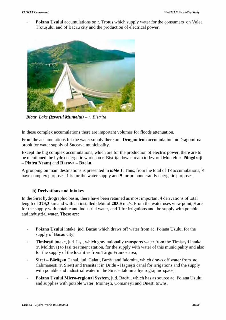
- Poiana Uzului accumulations on r. Trotuş which supply water for the consumers on Valea Trotuşului and of Bacău city and the production of electrical power.
Bicaz Lake (Izvorul Muntelui) – r. Bistriţa
In these complex accumulations there are important volumes for floods attenuation.
From the accumulations for the water supply there are Dragomirna accumulation on Dragomirna brook for water supply of Suceava municipality.
Except the big complex accumulations, which are for the production of electric power, there are to be mentioned the hydro-energetic works on r. Bistriţa downstream to Izvorul Muntelui: Pângăraţi – Piatra Neamţ and Racova – Bacău.
A grouping on main destinations is presented in table 1. Thus, from the total of 18 accumulations, 8 have complex purposes, 1 is for the water supply and 9 for preponderantly energetic purposes.
b) Derivations and intakes
In the Siret hydrographic basin, there have been retained as most important 4 derivations of total length of 223,3 km and with an installed debit of 203,5 mc/s. From the water uses view point, 3 are for the supply with potable and industrial water, and 1 for irrigations and the supply with potable and industrial water. These are:
- Poiana Uzului intake, jud. Bacău which draws off water from ac. Poiana Uzului for the supply of Bacău city;
- Timişeşti intake, jud. Iaşi, which gravitationally transports water from the Timişeşti intake (r. Moldova) to Iaşi treatment station, for the supply with water of this municipality and also for the supply of the localities from Târgu Frumos area;
- Siret – Bărăgan Canal, jud, Galaţi, Buzău and Ialomiţa, which draws off water from ac. Călimăneşti (r. Siret) and transits it in Dridu - Hagieşti canal for irrigations and the supply with potable and industrial water in the Siret – Ialomiţa hydrographic space;
- Poiana Uzului Micro-regional System, jud. Bacău, which has as source ac. Poiana Uzului and supplies with potable water: Moineşti, Comăneşti and Oneşti towns.

TAIWAT Component WATMAN Feasibility Study
Task 1.4 – Hydro-Works in Romania 39/50
Figure 9. Siret basin water works

TAIWAT Component WATMAN Feasibility Study
Task 1.4 – Hydro-Works in Romania 40/50
c) Dikes and river regularizations In the Siret hydrographic basin, there have been made and are functional 48 regularizations of river beds of a total length of cca. 450 km and 172 dikes of 512 km length.
These work protect against floods: 82 localities from which 12 municipalities, 162 industrial units, 8643 houses and residences, cca. 90300 ha agricultural areas, railways and roads and other objectives.
From the works in the Siret hydrographic basin, there have been retained as most important 23 works with a total of 602,3 km regularizations of river beds and 454,9 km dikes.
These works protect against floods localities, agricultural areas and industrial units, as well as bridges, roads, railways and others. From the protected localities there are to be mentioned: Suceava, Piatra Neamţ, Bacău and Roman.
From the works there are to be mentioned:
- Regularizations and dikes r. Suceava, jud. Suceava (Lreg = 55,4 km, Ldig = 25,0 km);
- Regularizations and dikes r. Moldova, jud. Suceava (Lreg = 46,4 km, Ldig = 25,5 km);
- Dike and regularization r. Siret jud.Iaşi (Lreg = 3,6 km, Ldig = 30,3 km);
- Regularizations and dikes r. Siret jud. Neamţ (Lreg = 11,7 km, Ldig = 21,3 km);
- Regularizations and dikes r. Moldova jud. Neamţ (Lreg = 15,7 km, Ldig = 16,6 km);
- Regularizations and dikes r. Bistriţa jud. Neamţ (Lreg = 30,9 km, Ldig = 8,5 km);
- Regularizations and dikes r. Trotuş jud. Bacău Lreg = 50,3 km, Ldig = 40,0 km);
- Dike and regularization r. Siret, jud. Vrancea (Lreg = 3,6 km, Ldig = 37,5 km);
- Regularizations and dikes r. Putna jud. Vrancea (Lreg = 104,5 km, Ldig = 26,9 km);
- Regularizations and dikes r. Siret jud. Galaţi (Lreg = 27,2 km, Ldig = 94,4 km);
- Regularizations and dikes r. Siret jud. Brăila (Lreg = 30,8 km, Ldig = 40,7 km);
The areas of risks to flooding are related to the works of cca. 30 years old, which will need rehabilitation: localities on r. Suceava, Izvorul Sucevei - Frătăuţii Vechi sector; r. Moldova, on Suliţa - Vama and Cornu Luncii - Baia, Gura Humorului – Păltinoasa sectors, r. Răcătău on Parincea – Horgeşt sector; r. Bistriţa, Ţibău - Iacobeni and Borca - Poiana Teiului, Buhuşi – Hemeiuşi sectors; r. Bicaz on Telec - Bicazu Ardelean sector; r. Cracău, Bodeşti – Roznov sector; r. Tazlău, Frumoasa – Belci sector.
The areas of risks to flooding in b.h. Siret are especially in the sectors with banks erosions, as registered in1997 on cca. 700 km, putting in danger both the river banks and the pier.
10. S.H. PRUT - BÂRLAD The Prut-Bârlad hydrographic space, is situated north-east of Romania, neighboring at west and south b.h. Siret, comprises integrally: Botoşani (90 %), Iaşi (83 %) and Vaslui (100 %) counties and partially: Neamţ, Bacău, Vrancea and Galaţi counties. S.h. Prut - Bârlad of a surface of 18320 km2 is made of Prut basin of a surface of 10.990 km2 and Bârlad basin, of a surface of 7.330 km2.
The hydrographic network has a total length of the cadastral waters from Prut hydrographic basin of 4183 km, of an average density 0,38 km/km2, and those from Bârlad hydrographic basin of 2639 km, with an average density of 0,323 km/km2.
Prut main tributaries are: Başeul, Jijia, Chineja and Elanul. From the main tributaries of r. Bârlad: Sacovăţ, Rebricea, Racova, Vasluiul, Tutova and Berheci.

TAIWAT Component WATMAN Feasibility Study
Task 1.4 – Hydro-Works in Romania 41/50
The multi-annual average debit of r. Prut growth from 78,1 m3/s (2462 mil.m
3) in Rădăuţi section,
at 86,7 m3/s (2736 mil.m
3) in Ungheni section and of 105 m
3/s (3314 mil.m
3) at the confluence with
Danube. The main tributary of r. Prut, Jijia, brings in 10 m3/s (316 mil.m
3).
For r. Bârlad, the average debits vary from 9,48 m3/s (300 mil.m
3) in Bârlad section, to 11m
3/s (347
mil.m3) at the confluence with Siret. The contributions of the main tributaries is of: 1 m
3/s (31
mil.m3) r. Vaslui in Moara Domnească section, 1 m
3/s (31 mil.m
3) r. Tutova in ac. Cuibul Vulturilor
section.
Except for r. Prut and Bârlad, the specific of this hydrographic area is of heavy rains, with big variations from a period to another, from an year to another; the permanent flow is registered only on the main tributaries of r. Prut (Bahlui and Jijia), the other river mostly having a temporary /semi-permanent flow.
The biggest floods registered in Prut hydrographic basin have been in l969 with maximum debits situated over 1% probability at Rădăuţi and between 5% and 1% on tributaries Bahlui and Jijia. In Bârlad hydrographic basin, the biggest values were in 1979 and 1985 and there have situated between 5% and 1%.
The minimum flow of the Prut hydrographic basin tributaries is very reduced, the most part of them have a non-permanent character. Draughts are also present in Bârlad hydrographic basin. The minimum monthly average debits of 95% and the minimum average daily of 95% is registered between 0 and 0.5 m
3/s on the majority of r. Prut tributaries.
Prut basin network and water works is presented in Figure 10.
a) Accumulation lakes In the Prut-Bârlad hydrographic space, there have been retained as most important 33 accumulation lakes from which 26 are permanent and 7 non-permanent. The total maximum volume of these accumulations is of 1921,6 mil. m3, from which 1877,4 mil. m3 in permanent accumulations and 44,2 mil. m3 in non-permanent accumulations. The permanent accumulation lakes have a total utile volume of 591,4 mil. m3 and of a total attenuation volume of 1040,9 mil m3. The attenuation volume afferent to the non-permanent accumulations is of 41,7 mil. m3.
The most important complex accumulations are:
- Stânca Costeşti accumulation, the most important complex accumulation, on r. Prut, which provides potable and industrial water for Iaşi and Vaslui cities and for irrigations and the production of electric power;
- Cal Alb and Negreni accumulations on r. Başeu for irrigations, the water supply of Săveni town and fishery;
- Cătămăreşti and Hălceni accumulation on r. Sitna, and Miletin, for irrigations, the water supply for Vlădeni locality and fishery;
- Pârcovaci, Podul Iloaiei and Tansa - Belceşti accumulations on r. Bahlui and tributaries for irrigations, the water supply and fishery;
- Soleşti accumulation on r. Vaslui and Puşcaşi on r. Racova from b.h. Bârlad which provides potable and industrial water for Vaslui town and for irrigations;
- Cuibul Vulturilor accumulation on r. Tutova and ac. Râpa Albastră on r. Simila which provides potable and industrial water for Bârlad town and for irrigations;

TAIWAT Component WATMAN Feasibility Study
Task 1.4 – Hydro-Works in Romania 42/50
Figure 10. Prut River Basin network and the water works

TAIWAT Component WATMAN Feasibility Study
Task 1.4 – Hydro-Works in Romania 43/50
- Tungujei accumulation on r. Sacovăţ for the water supply of Tibana and Tibăneşti cities and for irrigations;
- Căzăneşti accumulation on r. Durduc for the water supply of Negreşti locality and for irrigations;
- Mânjeşti accumulation on r. Crasna and ac. Pereschiv on r. Pereschiv for irrigations and fishery.
Through the floods attenuation, all accumulations have an important role for the floods prevention.
The most important non-permanent accumulation lakes: Bârca, Ciurea and Cornet in Nicolina sub-basin - Bahlui basin with role of protection against floods Iaşi town, Câmpeni on r. Miletin for the downstream area protection and of Valea Seacă on Valea Seacă for the protection of Bârlad municipality.
A grouping on main destinations is presented in table 1. Thus, from the total of 33 accumulations, 26 have complex purposes and 7 floods attenuation purpose.
Stânca Costeşti Lake and Dam – r. Prut
b) Derivations and intakes In the Prut - Bârlad hydrographic space, there have been retained as most important 5 derivations in total length of 53,3 km and with an installed debit of 17,0 mc/s. From the water uses view point, 3 are for the supply with potable and industrial water and 2 for the supply with potable and industrial water and for irrigation. These are:
- Cuibul Vulturilor intake, jud. Bârlad, which draws off water from Cuibul Vulturilor accumulation (r.Tutova) and brings it to the treatment station of Bârlad city for its supply cu with water;
- Prut intake (Tuţora - Iaşi), jud. Iaşi, which draws off water from Tuţora intake - r. Prut and brings it to the treatment station of Iaşi municipality for the supply with potable and industrial water;
- Bârlad -Ac. Râpa Albastră derivation, jud. Vaslui, which ensures the filling debits for the Râpa Albastră accumulation from r. Bârlad (Captare Zorleni) for the water supply of Bârlad city;
- Prut – Bârlad derivation, Jud. Iaşi, which fills in the Soleşti accumulation (r. Vaslueţ) from r. Prut (Captare Oprişeni) for the water supply of Vaslui town and for irrigations (1500 ha).
- Siret – Sitna derivation, jud. Botoşani, which draws off water from ac. Bucecea (r. Siret) for the water supply of the localities from Botoşani - Dorohoi area and for irrigations in Cătămărăşti system.

TAIWAT Component WATMAN Feasibility Study
Task 1.4 – Hydro-Works in Romania 44/50
c) Dikes and river regularizations
In the Prut – Bârlad hydrographic space there have been made and are in function 182 regularizations of river beds of a total length of 900 km and 124 dikes of a total length of 1088 km.
The protected objectives by these works are: 120 rural localities, 12 urban localities (7 municipalities), 146 industrial units, 150.000 ha agricultural areas, roads, railways and other objectives.
From the regularization and dike works on the Prut – Bârlad hydrographic space there have been retained as most important 15 works of a total of 183,8 km regularizations of river beds and 726,6 km dikes.
These works protect both localities, agricultural areas and industrial units, as well as bridges, roads, railways and others. From the protected localities there are Iaşi, Galaţi, Vaslui and Tecuci towns.
From the main works :
- Regularizations and dikes on r. Bahlui in Iaşi, jud. Iaşi (Lreg = 13,8 km, Ldig = 22,4 km);
- Dikes on r. Prut on Trifeşti - Suculeni - Ţuţora - Gorban sector, jud. Iaşi (Ldig = 105,7 km);
- Dikes on r. Prut on Albiţa – Fălciu sector, jud. Vaslui (Ldig = 67,8 km);
- Dikes on r. Prut on Brateşu de Sus - Vlădeşti – Şiviţa sector, jud. Galaţi (Ldig = 49,5 km);
- Dikes on r. Prut on Brateşu de Jos Siviţa – Galaţi sector, jud. Galaţi (Ldig = 31,8 km);
- Dikes on r. Jijia on Bosia - Oprişeni,Tuţora – Siviţa sector, jud. Galaţi (Ldig = 3,8 km);
- Dike and regularization on r. Chineja at Brateşul de Jos Siviţa - Galaţi, jud. Galaţi (Lreg = 18,2 km, Ldig = 12,2 km);
- Regularizations and dikes on r. Bârlad on Negreşti – Tutova sector, jud. Vaslui (Lreg= 115,3 km, Ldig = 225,0 km);
- Regularizations and dikes on r. Vaslueţ on Soleşti – Vaslui sector, jud. Vaslui (Lreg = 17,7 km, Ldig = 41,4 km);
- Dikes on r. Bârlad, Ghidigeni - Munteni sector, jud. Galaţi (Ldig = 68,8 km);
- Dikes on r. Bârlad, Albeşti – Crasna sector, jud. Vaslui (Ldig = 27,0 km).
11. S.H. DOBROGEA The Dobrogea hydrographic space, is situated south - east of Romania, with a surface of 10.240 km2. It is delineated at West and North by Lunca Dunării, at East by Delta Dunării between Murighiol and Gura Portiţei respectively the Black Sea Litoral between Gura Portiţei and Vama Veche, and at South by the border with Bulgaria.
Dobrogea hydrographic space covers Tulcea and Constanţa counties as 36%, respectively 64%.
The total length of the permanent water courses on the whole territory is of 660 km. From these, on basins, 71% pertain to the Litoral hydrographic basin and 29% to the Danube hydrographic basin, and per zones, 90% pertain to Northern Dobrogea and 10% to Southern Dobrogea.
The most important water courses here are: Casimcea, Taiţa, Topolog Teliţa and Hamangia, all of Northern Dobrogea.

TAIWAT Component WATMAN Feasibility Study
Task 1.4 – Hydro-Works in Romania 45/50
Dobrogea is very poor in surface resources of water: just some rivers and the lakes afferent to the litoral.
The multi-annual average stock is of cca. 145 mil.m3/year (4,59 m
3/s) which shows that Dobrogea
is the poorest part of the country, with respect to the surface water flow resources. The biggest part of this stock comes from the water courses of Litoral hydrographic basin and it is of 3,57 m
3/s.
Floods which happened were generated by heavy rains, ex. on Topolog, Taiţa, Tăiţa and Cartal valleys, in 1972, 1975, 1977 and 1985.
In 1985 on Cartal brook it has been a big flood due to heavy rains (p = 0,1%) the maximum debit being of 490 m
3/s. Usually, the floods are short, 1-2 days, with maximum of no more then 24 hours.
Minimum flow on water courses of Dobrogea is characterized by minimum daily average debits of 95% which are almost nothing for their majority. The highest value (of 20 l/s) is registered on Casimcea brook, at its discharge.
S.h. Dobrogea is presented in Figure 11.
a) Accumulation lakes In the Dobrogea hydrographic space there have been retained as most important 5 accumulation lakes, all permanent. The total maximum volume of these accumulations is of 28,2 mil. m3, and the total utile volume of 14,7 mil. m3 , while the total attenuation volume is of 12,8 mil. m3.
These are: ac. Nazarlîc on r. Topolog, ac. Horia on r. Taiţa, ac. Limanu on r. Albeşti, ac. Traianu on v. Cernei and ac. Ţibrin on r. Ţibrin
The accumulation lakes on Dobrogea space ensure the water resources for irrigations, fishery and floods attenuation, thus being of complex purposes.
A grouping on main destinations is presented in table 1. Thus, from the total of 5 accumulations, all have complex purposes.
There also are 23 non-permanent accumulation lakes with a total volume of 27 mil.m3 which are
for the protection of the Danube – Black Sea Canal, and 3 small accumulation lakes of a total volume of 1 mil.m
3, for the protection of Techirghiol lake.
Most of Dobrogea lakes are colmatated (ex: Viţeilor, Cişmelei, Medgidia, Agicabul, Atmagea, Dulbencea, Topolog, Casimcea, etc.).
A special commentary for Razelm-Sinoe. Is has a surface of 79 ha of waters in its own basins (total 95 th. ha including all segments) and has a normal capacity of 1.255 mil.m
3 in Razelm
respectively 450 mil. m3 in Sinoe. The main uses are the irrigations, fishery and recreation. It is
registered to the Danube hydrographic space.
b) Derivations and intakes
In the Dobrogea hydrographic space, there have been retained as most important 2 derivations in total length of 33,6 km and with an installed debit of 79,0 m3/s. From the water uses view point, 1 has complex purposes and 1 is for potable and industrial water supply. These are:
- Poarta Albă-Midia-Năvodari Canal ramification of the Dunăre - Marea Neagră Canal at Poarta Albă with discharge in Black Sea in Midia port. The work has complex uses both for navigation and irrigation purposes and the industrial water supply and energy production;

TAIWAT Component WATMAN Feasibility Study
Task 1.4 – Hydro-Works in Romania 46/50
Figure 11. Dobrogea Hydrographical space

TAIWAT Component WATMAN Feasibility Study
Task 1.4 – Hydro-Works in Romania 47/50
- Poarta Albă – Constanţa intake for transporting the water drawn off from Poarta Albă-Midia-Năvodari Canal through Gofşu intake, to the Palas treatment station for the supply with potable and industrial water at Constanţa.
c) Dikes and river regularizations In the Dobrogea hydrographic space, there have been done 11 works of a total length of 180,2 km regularizations of river beds and 66,0 km dikes.
These works protect against floods 1 town (Babadag), 17 rural localities, 1500 houses and residences, cca 6000 ha agricultural terrain, roads and other objectives, and the touristic litoral of the Black Sea. The most important works are:
- Regularizations and dikes r. Hamangia, jud. Tulcea (Lreg = 19,0 km, Ldig = 19,0 km);
- Regularizations and dikes r. Taiţa, jud. Tulcea (Lreg = 24,0 km, Ldig = 25,5 km);
- Regularization r. Teliţa, jud. Tulcea (Lreg = 38,0 km);
- Regularization r. Slava, jud. Tulcea (Lreg = 35,0 km);
- Regularizations and dikes r. Ciucurova, jud. Tulcea (Lreg = 22,0 km, Ldig = 4,5 km);
- Piers for the protection of the touristic litoral (Ldig = 11,0 km). Specific to the litoral there are the protection works for the seashores and beaches.
12. S.H. DUNĂRE The Danube hydrographic space is situated in Central Europe, comprises 8 countries and covers 10 % from the surfaces of the entire continent. The river crosses 8 countries and 4 capital-cities, is oriented from V-NV to E-SE and represents an essential component of the trans-European water navigation way known as " Rin-Main-Danube System". The total surface of the catchments basin is of 805.300 km2, a length of 2860 km, from which 1075 km on the Romanian territory.
From the total catchments area of the Danube hydrographic basin, 29 % pertains to our country, the Romanian territory being drained by 98 % by this river.
By the Danube hydrographic we mean the Danube hydrographic basin as it is treated in the waters management annuity from which the direct tributaries, like Călmăţui - Olt, Mosţiştea, Călmăţui – Buzău, tributaries from the right side of the Danube, from Călăraşi and Brăila, are distributed to the Argeş – Vedea, Ialomiţa – Mostiştea – Buzău, respectively Dobrogea hydrographic spaces.
This hydrographic space is situated in southern Romania and goes administratively on the boarder territories of the: Caraş-Severin, Mehedinţi, Dolj, Olt, Teleorman, Giurgiu, Călăraşi, Ialomiţa, Brăila, Constanţa (Cernavodă and Hârşova towns) and Tulcea (Danube Delta) counties.
The multi-annual stock of the Danube, at the entrance to Romania (Orşova) is of cca. 175.144 millions m
3/year going up to cca. 203.546 million m
3/year at the entry to the Danube Delta (Ceatal
Izmail).
The maximum flow is achieved Spring-Summer. The entrance to Romania the highest values are registered in April, because of the hydrological regime of the Drava, Sava, Tisa and Velika-Morava rivers. In Romania, at Zimnicea and Ceatal Izmail, the maximum flow is achieved in May-June, due to the hydrological regime of the tributaries from the Romanian territory.

TAIWAT Component WATMAN Feasibility Study
Task 1.4 – Hydro-Works in Romania 48/50
The main characteristic of the uses along the Danube is that their duration is very big, usually 2-3 month, to 6 month.
Among the floods of big debits, in the last 60 years, there have been: 1940, 1942, 1955, 1970, 1975 and 1981.
The highest registered values during floods on the Danube there have been at Orşova in 1940 and in 1981 and at Ceatal-Izmail in 1897 (much over 1%). The flood from 1970, by the debit values registered on Danube, there have reached the probability of 2%.
It is to be mentioned that, for the Danube, floods regime means debits which go higher then 8000-9000 m
3/s, as it is the transport capacity of the minor streambed downstream Porţile de Fier II.
The periods of small waters on the Danube are during the Winter and especially in Autumn. The daily minimum debit values vary as it follows: the smallest values have been of 1060 m
3/s at
Orşova in 1985 and of 1350 m3/s at Ceatal Izmail in 1921. These are situated bellow the level of the
minimum daily debits with the probability of 95%.
The works done along its course and in the Delta there have been aimed the following main goals:
- Take of from the floods influence of the areas from the Danube innundable wetlands;
- Capitalization of the hydro-energetic potential of the river;
- Set-up some irrigation systems, with the supply source from the Danube, which totalizes circa 2,27 million ha;
- Cutting short of the navigable way between the Danube and the Black Sea, through the Dunăre-Marea Neagră Canal, including the possibility to catch on the cooling water for C.N.E. Cernavodă;
- The supply with potable and industrial water of the important localities situated on the Danube bank;
- Prevention of the phenomena of atomization of the flow on Sf. Gheorghe arm;
- Ensure some debit transfers from Sf. Gheorghe arm in Razelm and Sinoe lakes in view of preventing of their metrification;
- The prevention of the Delta litoral erosion phenomena and of the Litoral Belt;
- The restoration of the ecological balance of the Danube Delta Reservation.
a) Accumulation lakes
In the Danube hydrographic space, there have been retained for presentation the two energetic accumulation lakes Porţile de Fier I and Porţile de Fier II. The maximum global volume of these accumulations is of 3900,0 mil m3. These two accumulations gather an utile volume of 250,0 mil. m3 and of a total attenuation volume of 670,0 mil m3.
The hydro-energetic potential of the river has been evaluated to cca. 26 mil. KWh/year, from which almost 1/2 pertains to Romania. This potential is created by an average debit of 5550 m
3/s at the
entrance to Romania and of 6500 m3/s at Ceatal Izmail, on a level difference of 63 m. The hydro-
energetic potential of the Danube represents almost 32 % from the hydro-energetic potential of the country and it is concentrated in the area of the Porţile de Fier I and II accumulation lakes.

TAIWAT Component WATMAN Feasibility Study
Task 1.4 – Hydro-Works in Romania 49/50
Porţile de Fier I Dam – fl. Dunăre
The accumulation lake Porţile de Fier I of which dam is situated on the Danube at km 943 has the following characteristics: Vtot=2900 mil. m3 from which Vutile=150 mil. m3. The hydroelectric Centrals has Pi = 1050 MW and Em= 5120 GWh/year;
The Porţile de Fier II accumulation lake of which dam is also located on the Danube at kml 863 has the following characteristics: Vtot= 800 mil. m3 from which Vutile=100 mil. m3. The hydroelectric Centrals has Pi=216 MW and Em=1030 GWh/year.
b) Derivations and intakes In the Dunăre hydrographic space, there have been retained as most important 6 derivations of total length of 182,3 km and with an installed debit of 456,8 m3/s. From the water uses view point, 1 has complex purposes, 1 is for the supply with potable and industrial water, 2 are meant to ensure irrigations, fishery and navigation, 1 is exclusively aimed for navigation and 1 is meant for navigation and fishery. These are:
- Slobozia derivation, jud. Călăraşi and Ialomiţa, which draws off water from Danube (Modelu and Chiciu intakes) and transfer it to b.h. Ialomiţa for the water supply of Slobozia city;
- Dunăre Canal - Marea Neagră - jud. Constanţa, which ensures from the Danube water for complex uses: cooling water at CNE Cernavodă, irrigations in Carasu system, potable and industrial water supply for Constanţa city through the Gofşu intake from the Poarta Albă-Midia-Năvodari branch, cutting short of the navigation way between Black Sea and Danube and the production of electric power;
- Dunavăţ Canal - jud. Tulcea, which links Sf. Gheorghe arm (km 54) from Danube Delta with Razelm lake and which is meant to supplement the water volume of Razelm lake, for irrigations and fishery;
- Dranov Canal - jud. Tulcea, which links Sf. Gheorghe arm (km 44) from Danube Delta with Razelm lake and which is meant for the supplementation of the water volume of the Razelm lake for irrigations and fishery;

TAIWAT Component WATMAN Feasibility Study
Task 1.4 – Hydro-Works in Romania 50/50
- Tulcea - Pardina Canal - jud. Tulcea, which links Tulcea arm (Mm 34) from the Danube Delta to the Chilia arm(km 82.5) for cutting short the navigable way.
c) Dikes and river regularizations
In the Danube hydrographic space there exist cca. 174 dikes and regularizations of river beds of a total length of 2288 km, mostly along the Danube and in the Delta.
These works protect against floods: 172 localities from which 13 towns and municipalities, cca. 20000 houses from rural and urban areas, cca. 700000 ha, from which cca. 440000 ha in Lunca Dunarii, railways, roads, ports and other objectives.
From the regularization and dike works of the Danube hydrographic space, there have been retained as most important 52 works with a total of 141,6 km regularizations of river beds and 1679,1 km dikes. Four distinct groups can be evidentiated:
- Regularizations and dikes on Blahniţa, Bahniţa and Baboia brooks, direct tributaries of the Danube in Mehedinţi and Dolj counties, with regularization lengths up to 41 km and of dikes up to 78 km;
- Dikes for the protection of cca. 30 big agricultural areas along the Danube, with lengths of more then 30 km, up to 174 km (Insula Mare a Brăilei), and dikes for the protection of some important agricultural, silvic, fishery units, or with complex functions from the Danube Delta with lengths of more then 20 km, up to 76 km (Incinta Pardina);
- Dikes for the protection of some localities from the Danube Delta, like the dike of the Sulina arm, at Sulina on both banks (Ldig = 13,4km);
- Works for the Delta litoral protection against marine erosions, like the:
• Sulina Sf. Gheorghe Pier (Ldig = 30.0 km); • Sinoe Pier for the litoral shore consolidation (Ldig = 19.0 km); • North - Portiţa Pier for the litoral protection (Ldig = 9.0 km);