Embed Size (px)
Citation preview
TACNA WATER PLANNING PROJECT ENVIRONMENTAL REPORT
Prepared for: United States Department of Agriculture Rural Development- Arizona State Office 230 North 1st Avenue, Suite 206 Phoenix, AZ 85003 Prepared by:
Stantec Consulting Services Inc. 6995 Sierra Center Parkway Reno, Nevada 89511
January 21, 2020
Tacna Water Planning Project Environmental Report Yuma County
January 21, 2020 i
Table of Contents
1.0 Introduction ................................................................................................................... 1 1.1 Purpose and Need for the Proposal ................................................................ 1 1.2 Project Background........................................................................................... 1 1.3 Project Location and Description .................................................................... 1
1.3.1 Water Supply and Treatment ................................................................ 2 1.3.2 Water Storage ........................................................................................ 2 1.3.3 Replacement Distribution System ......................................................... 3
1.4 Project Alternatives............................................................................................ 3 1.4.1 Alternative 1 ........................................................................................... 3 1.4.2 Alternative 2 (Preferred Alternative)..................................................... 4 1.4.3 Alternative 3 ........................................................................................... 4 1.4.4 Alternative 4 ........................................................................................... 4 1.4.5 Alternative 5 ........................................................................................... 4 1.4.6 Alternative 6 (No Action) ....................................................................... 4
2.0 Project Environment ...................................................................................................... 6 2.1 Land Ownership/Land Use ................................................................................ 6 2.2 Historic Preservation .......................................................................................... 7 2.3 Threatened and Endangered Species/Biological Resources ........................ 7 2.4 Wetlands ............................................................................................................ 9 2.5 Floodplains ......................................................................................................... 9 2.6 Coastal Areas, Zone and Barriers ................................................................... 10 2.7 Important Farmland ........................................................................................ 10 2.8 Environmental Risk Management .................................................................. 10 2.9 Other Resources .............................................................................................. 10
2.9.1 Water Resources .................................................................................. 10 2.9.2 Air Quality ............................................................................................. 11 2.9.3 Noise ...................................................................................................... 11 2.9.4 Visual Impacts ...................................................................................... 11 2.9.5 Transportation ....................................................................................... 11
3.0 Summary of Environmental Measures ....................................................................... 12 3.1 Biological Resources ........................................................................................ 12 3.2 Construction Activities ..................................................................................... 12
4.0 References ................................................................................................................... 13
List of Tables
Table 1 Proposed Water Storage .......................................................................................... 2 Table 2 Land Ownership of Potential Sites ............................................................................ 6
List of Figures
Figure 1 Vicinity Map Figure 2 Site Plan
Tacna Water Planning Project Environmental Report Yuma County
January 21, 2020 ii
Figure 3 Land Ownership Figure 4 National Wetland Inventory Map Figure 5 FEMA Floodplains Figure 6 Prime Farmlands
List of Appendices
Appendix A EJCREEN Maps Appendix B Class III Cultural Resources Inventory Report Summary Form Appendix C Biological Survey Report
Acronyms and Abbreviations
ADEQ Arizona Department of Environmental Quality AGFD Arizona Game and Fish Department BMPs Best Management Practices E East ER Environmental Report FPPA Farmland Protection Policy Act gpm gallons per minute NEPA National Environmental Policy Act NRCS Natural Resources Conservation Service NWI National Wetland Inventory R Range RD Rural Development Stantec Stantec Consulting Services Inc. T Township Tacna Water Yuma County Improvement District 2017-02 U.S. United States USDA United States Department of Agriculture USFWS United States Fish and Wildlife Service W West WMIDD Wellton Mohawk Irrigation and Drainage District
Tacna Water Planning Project Environmental Report Yuma County
January 21, 2020 1
1.0 INTRODUCTION
1.1 Purpose and Need for the Proposal
An application for federal funding by the United States (U.S.) Department of Agriculture (USDA), Rural Development (RD) is being submitted by Yuma County on behalf of the Yuma County Improvement District 2017-02 (Tacna Water). The purpose of the funding application is to replace the current water distribution system to the town of Tacna, Arizona, which is an USDA eligible area for water systems funding. The town of Tacna currently has a water distribution system that is more than 39 years old and has drinking water deemed as non-drinkable due to high levels of arsenic.
Funding is needed to provide safe drinking water to the residents of Tacna. The proposed Project will upgrade the current water distribution system in order to address leaks and erosion. Additionally, plans are in place to address the existing poor water quality, as the Arizona Department of Environmental Quality (ADEQ) placed an Administrative Order on the water system deeming the water non-drinkable due to high arsenic levels in 2012. The current water system is operating under an administrative order from the ADEQ and if the current water distribution system is not addressed the community will continue to be out of compliance with the ADEQ. This report has been prepared to evaluate the appropriate level of National Environmental Policy Act (NEPA) documentation for the USDA RD funding assistance to construct and operate a clean and reliable drinking water system for Tacna Water.
1.2 Project Background
The existing water system in Tacna has been in place since 1980. It is owned by the Tacna Water Management Company. The system includes a groundwater well, piping, pumps and water storage. Some upgrading of the system has been completed since 1980 including installation of a water intake on the Wellton-Mohawk canal, installation of water treatment in 2007, and repainting of the water storage tank. The existing water system serving the community of Tacna includes approximately 10,000 linear feet of polyvinyl chloride and transit pipe, an above ground welded steel water storage tank, a well, a booster pump and an intake on the Wellton-Mohawk canal. The system includes 175 service connections and typically provides water to 135 to 160 customers (approximately 310 people). The water system includes no fire hydrants and currently does not provide fire protection. No water treatment is currently provided. The piping and the tank are reported to be in poor conditions with evidence of leaks (Stantec, 2019a).
1.3 Project Location and Description
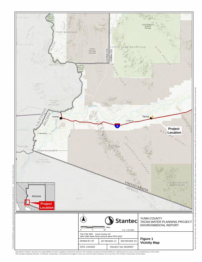
The proposed Project is located in the town of Tacna in Yuma County, Arizona, approximately 42 miles from Yuma, Arizona (Figure 1). The Project can be accessed east or west along Interstate 8. The proposed replacement water system would include infrastructure located within portions of Township (T) 8 South (S), Range (R) 17 West (W), Section 25 and T8S, R16W, Section 30, Gila and Salt River Baseline and Meridian.
Tacna Water Planning Project Environmental Report Yuma County
January 21, 2020 2
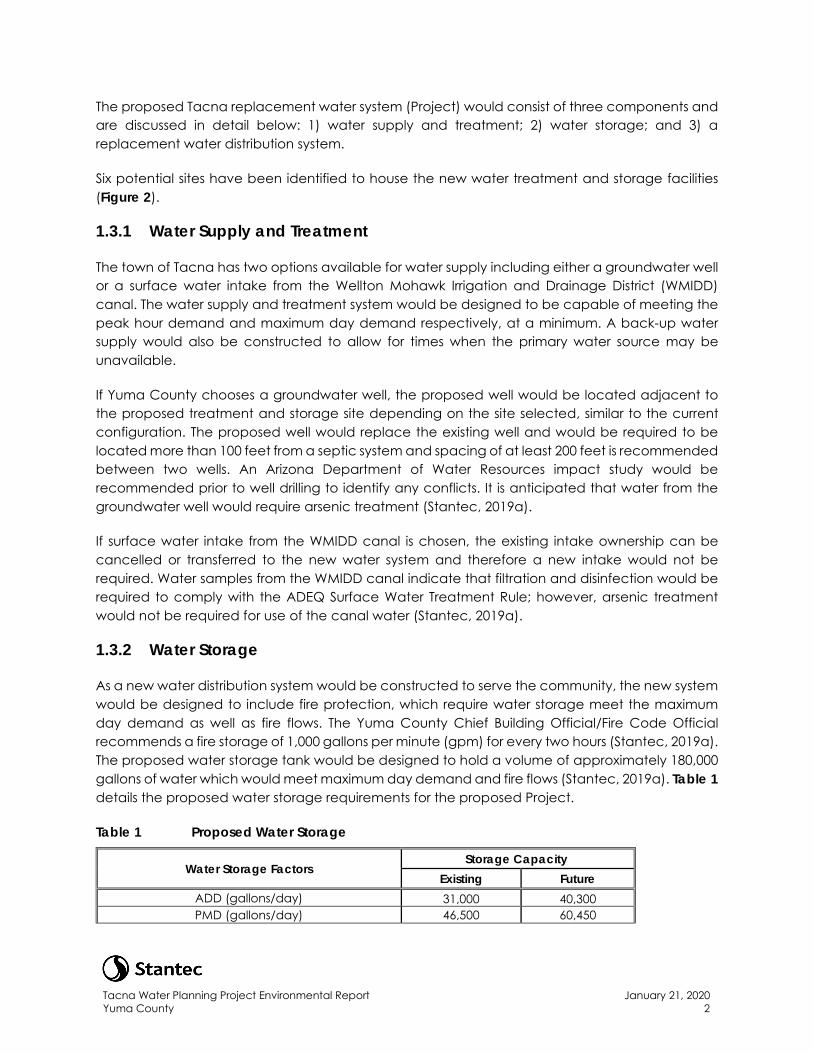
The proposed Tacna replacement water system (Project) would consist of three components and are discussed in detail below: 1) water supply and treatment; 2) water storage; and 3) a replacement water distribution system.
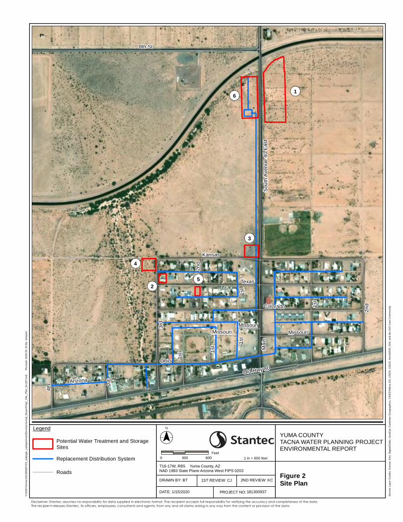
Six potential sites have been identified to house the new water treatment and storage facilities (Figure 2).
1.3.1 Water Supply and Treatment
The town of Tacna has two options available for water supply including either a groundwater well or a surface water intake from the Wellton Mohawk Irrigation and Drainage District (WMIDD) canal. The water supply and treatment system would be designed to be capable of meeting the peak hour demand and maximum day demand respectively, at a minimum. A back-up water supply would also be constructed to allow for times when the primary water source may be unavailable.
If Yuma County chooses a groundwater well, the proposed well would be located adjacent to the proposed treatment and storage site depending on the site selected, similar to the current configuration. The proposed well would replace the existing well and would be required to be located more than 100 feet from a septic system and spacing of at least 200 feet is recommended between two wells. An Arizona Department of Water Resources impact study would be recommended prior to well drilling to identify any conflicts. It is anticipated that water from the groundwater well would require arsenic treatment (Stantec, 2019a).
If surface water intake from the WMIDD canal is chosen, the existing intake ownership can be cancelled or transferred to the new water system and therefore a new intake would not be required. Water samples from the WMIDD canal indicate that filtration and disinfection would be required to comply with the ADEQ Surface Water Treatment Rule; however, arsenic treatment would not be required for use of the canal water (Stantec, 2019a).
1.3.2 Water Storage
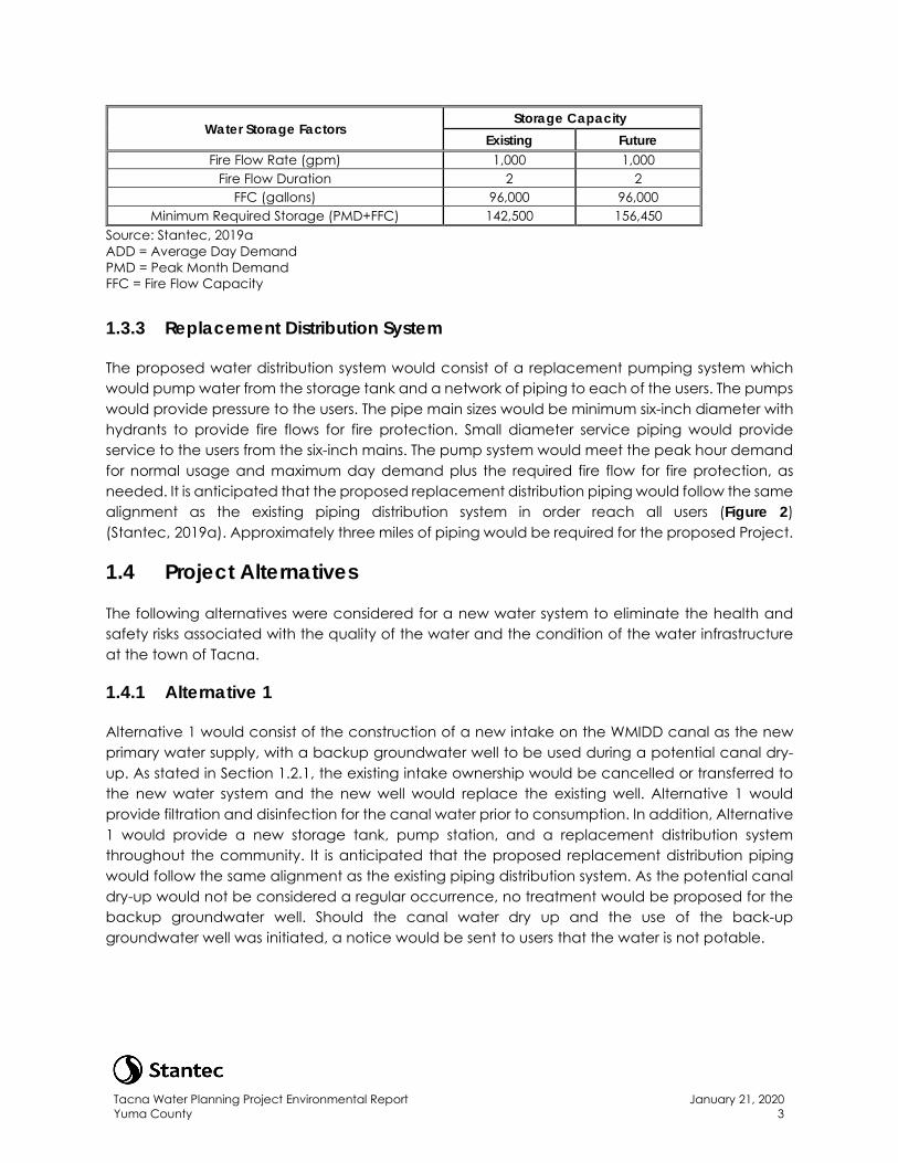
As a new water distribution system would be constructed to serve the community, the new system would be designed to include fire protection, which require water storage meet the maximum day demand as well as fire flows. The Yuma County Chief Building Official/Fire Code Official recommends a fire storage of 1,000 gallons per minute (gpm) for every two hours (Stantec, 2019a). The proposed water storage tank would be designed to hold a volume of approximately 180,000 gallons of water which would meet maximum day demand and fire flows (Stantec, 2019a). Table 1 details the proposed water storage requirements for the proposed Project.
Table 1 Proposed Water Storage
Water Storage Factors Storage Capacity
Existing Future ADD (gallons/day) 31,000 40,300 PMD (gallons/day) 46,500 60,450
Tacna Water Planning Project Environmental Report Yuma County
January 21, 2020 3
Water Storage Factors Storage Capacity
Existing Future Fire Flow Rate (gpm) 1,000 1,000
Fire Flow Duration 2 2 FFC (gallons) 96,000 96,000
Minimum Required Storage (PMD+FFC) 142,500 156,450 Source: Stantec, 2019a ADD = Average Day Demand PMD = Peak Month Demand FFC = Fire Flow Capacity
1.3.3 Replacement Distribution System
The proposed water distribution system would consist of a replacement pumping system which would pump water from the storage tank and a network of piping to each of the users. The pumps would provide pressure to the users. The pipe main sizes would be minimum six-inch diameter with hydrants to provide fire flows for fire protection. Small diameter service piping would provide service to the users from the six-inch mains. The pump system would meet the peak hour demand for normal usage and maximum day demand plus the required fire flow for fire protection, as needed. It is anticipated that the proposed replacement distribution piping would follow the same alignment as the existing piping distribution system in order reach all users (Figure 2) (Stantec, 2019a). Approximately three miles of piping would be required for the proposed Project.
1.4 Project Alternatives
The following alternatives were considered for a new water system to eliminate the health and safety risks associated with the quality of the water and the condition of the water infrastructure at the town of Tacna.
1.4.1 Alternative 1
Alternative 1 would consist of the construction of a new intake on the WMIDD canal as the new primary water supply, with a backup groundwater well to be used during a potential canal dry-up. As stated in Section 1.2.1, the existing intake ownership would be cancelled or transferred to the new water system and the new well would replace the existing well. Alternative 1 would provide filtration and disinfection for the canal water prior to consumption. In addition, Alternative 1 would provide a new storage tank, pump station, and a replacement distribution system throughout the community. It is anticipated that the proposed replacement distribution piping would follow the same alignment as the existing piping distribution system. As the potential canal dry-up would not be considered a regular occurrence, no treatment would be proposed for the backup groundwater well. Should the canal water dry up and the use of the back-up groundwater well was initiated, a notice would be sent to users that the water is not potable.
Tacna Water Planning Project Environmental Report Yuma County
January 21, 2020 4
1.4.2 Alternative 2 (Preferred Alternative)
Alternative 2 would be similar to Alternative 1 and would include the construction of a new intake on the WMIDD canal as the new primary water supply, with a backup groundwater well to be use during a potential canal dry-up. As stated in Section 1.2.1, the existing intake ownership would be cancelled or transferred to the new water system and the new well would replace the existing well. However, under Alternative 2, the new system would provide filtration and disinfection for the canal water and arsenic treatment for the groundwater well so that either water source can be used at any time. In addition, Alternative 2 would provide a new storage tank, pump station, and a replacement distribution system throughout the community. It is anticipated that the proposed replacement distribution piping would follow the same alignment as the existing piping distribution system. Yuma County has identified Alternative 2 as the preferred option for the proposed Project.
1.4.3 Alternative 3
Under Alternative 3, construction of a new intake on the WMIDD canal would occur as the new primary water supply. Under Alternative 3, there would be no back-up water supply and only replacement parts would be made available for repairs as needed. The water supply from the WMIDD canal would have filtration and disinfection. Additionally, a new storage tank, pump station, and a replacement distribution system would be constructed. It is anticipated that the proposed replacement distribution piping would follow the same alignment as the existing piping distribution system.
1.4.4 Alternative 4
Under Alternative 4, construction of a new groundwater well would occur as the primary water supply, with a second groundwater well to be used as the back-up water supply. Both wells would be treated for arsenic and a new storage tank, pump station, and a replacement distribution system would be constructed. It is anticipated that the proposed replacement distribution piping would follow the same alignment as the existing piping distribution system.
1.4.5 Alternative 5
Under Alternative 5, construction of a new groundwater well would occur as the primary water supply and an additional back-up water supply would not be constructed. Replacement parts, including a back-up pump, would be made available for repairs as needed. The well would be treated for arsenic and a new storage tank, pump station, and a replacement distribution system would be constructed. It is anticipated that the proposed replacement distribution piping would follow the same alignment as the existing piping distribution system.
1.4.6 Alternative 6 (No Action)
Under Alternative 6, Yuma County would take no action and would continue to operate with the existing water system. The No Action Alternative would not be considered a viable option, as the ADEQ has issued an administrative order on the current water system and the town of Tacna would continue to be out of compliance with the ADEQ. Under the Safe Drinking Water Act,

Tacna Water Planning Project Environmental Report Yuma County
January 21, 2020 5
pursuant to Arizona Revised Statutes § 49-353(A)(2)(a), the ADEQ enforces safe drinking water standards and drinking water rules and programs. The ADEQ provides technical assistance to water suppliers and can take legal action against systems that fail to provide water that meets drinking water standards. This alternative does not address the impacts of the deteriorating existing water system components and, therefore it is not considered feasible and has not be developed further.
Tacna Water Planning Project Environmental Report Yuma County
January 21, 2020 6
2.0 PROJECT ENVIRONMENT The format of this Environmental Report (ER) follows the guidance provided in RD Instruction 1970-B, Subpart B - NEPA Categorical Exclusions under §1970.54, Exhibit C: Guide to Applicants for Preparing Environmental Reports for Categorical Exclusions. Resources covered in this ER follow the provided guidance and include the following:
• Land Ownership/Land Use;
• Historic Preservation;
• Threatened and Endangered Species/Biological Resources;
• Wetlands and Section 404 Waterways;
• Floodplains;
• Coastal Areas;
• Important Farmland;
• Environmental Risk Management; and
• Other Resources (Water Resources, Air Quality, Noise, Visual, and Transportation).
2.1 Land Ownership/Land Use
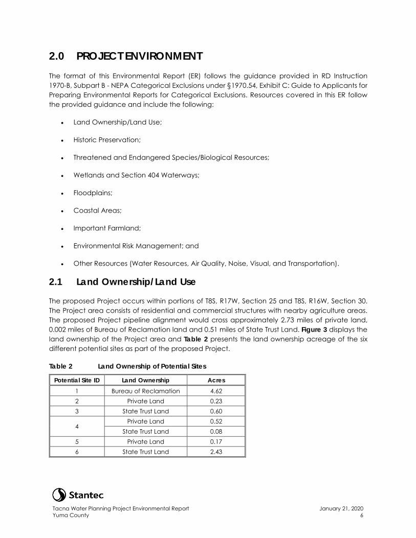
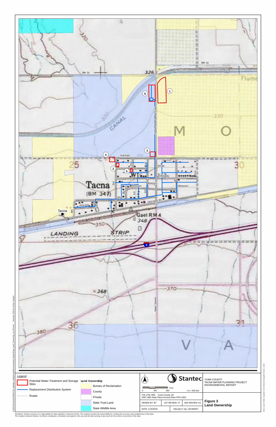
The proposed Project occurs within portions of T8S, R17W, Section 25 and T8S, R16W, Section 30. The Project area consists of residential and commercial structures with nearby agriculture areas. The proposed Project pipeline alignment would cross approximately 2.73 miles of private land, 0.002 miles of Bureau of Reclamation land and 0.51 miles of State Trust Land. Figure 3 displays the land ownership of the Project area and Table 2 presents the land ownership acreage of the six different potential sites as part of the proposed Project.
Table 2 Land Ownership of Potential Sites
Potential Site ID Land Ownership Acres 1 Bureau of Reclamation 4.62 2 Private Land 0.23 3 State Trust Land 0.60
4 Private Land 0.52
State Trust Land 0.08 5 Private Land 0.17 6 State Trust Land 2.43
Tacna Water Planning Project Environmental Report Yuma County
January 21, 2020 7
There are no special areas as determined by the Arizona Game and Fish Department (AZGFD) or critical habitats as determined by the U.S. Fish and Wildlife Service (USFWS) within the Project area. In addition, there are no Formally Classified Lands (Wild and Scenic Rivers, National Natural Landmarks, National Parks, or Wilderness Areas) within the Project area.
The proposed Project is not anticipated to adversely impact land use as it would only be a replacement to the existing system that currently exists in the town of Tacna. Nearby residences and businesses would have minor disturbances from construction activities including a short-term, temporary increase in noise and dust during construction. The final treatment site selection would require Yuma County work with the legal, existing landowner prior to any development and secure any required permits.
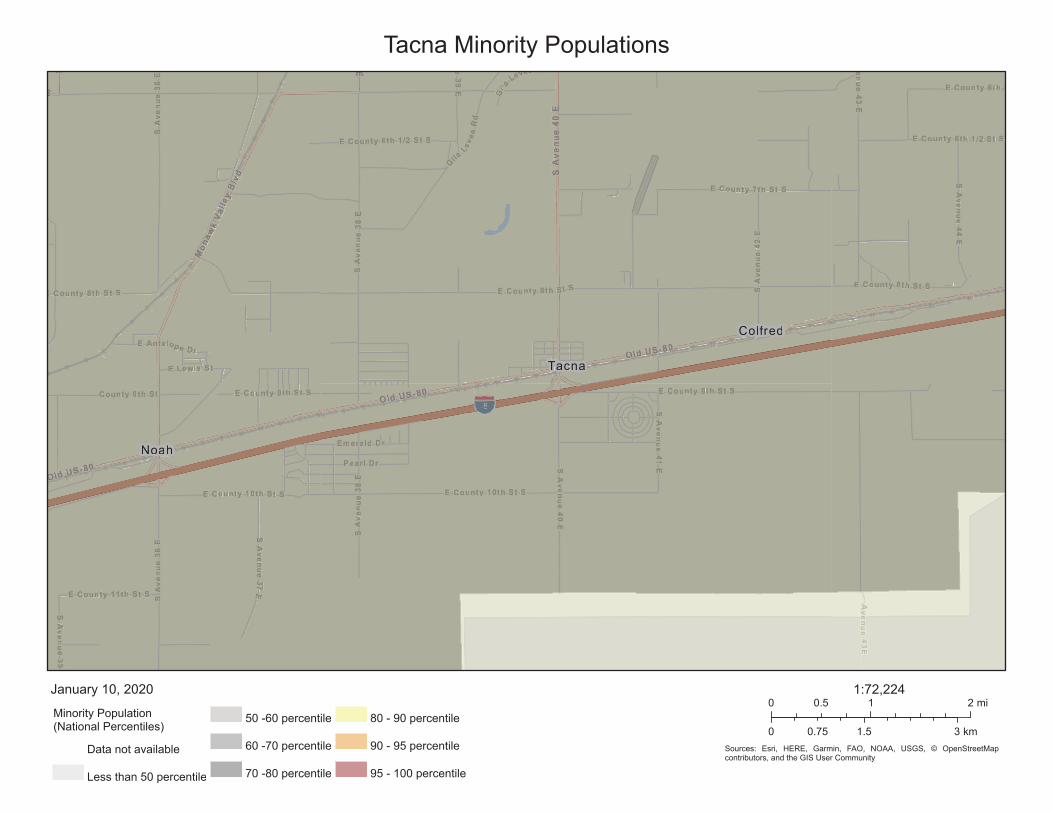
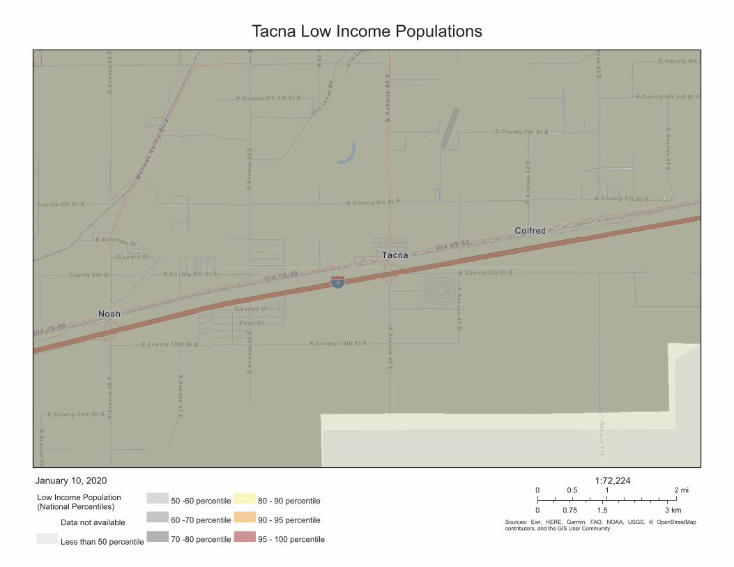
The town of Tacna has a 58 percent minority population with 49 percent of the population identified as low income (EPA, 2019a) (Appendix A). While, the population of Tacna has a large low income, minority population, the proposed Project would comply with water quality regulations and would result in safe drinking water for the residents and would not negatively affect the quality and/or level of services provided to the community. The Project would not change the current land use pattern of the area, it would provide the residents a degree of protection from health hazards, and the Project would not result in a disproportionate adverse impact to the residents of Tacna.
2.2 Historic Preservation
A Class III cultural resources inventory was completed on October 10, 2019 for the proposed Project to fulfill the cultural resources compliance requirements of the USDA RD as required under Section 106 of the National Historic Preservation Act. The results of the survey are contained in a separate report which follows the Arizona State Historic Preservation Office Survey Report Summary Form guidelines (Stantec, 2019b) (Appendix B).
Prior to conducting the field survey, a records search was conducted at the Arizona State Museum. The search revealed that six archaeological surveys were previously conducted within the 0.5-mile radius of the Project area and there were no surveys previously conducted directly within the Project area. Furthermore, no archaeological sites were previously documented within the Project area; however, four previously documented sites are located within the 0.5-mile radius of the Project area.
No historic or prehistoric cultural resources and/or isolated occurrences were identified during the field survey; therefore, no impacts to cultural resources from the proposed Project are anticipated to occur.
2.3 Threatened and Endangered Species/Biological Resources
Stantec Consulting Services Inc. (Stantec) completed a biological baseline field survey on September 18, 2019 for the purpose of identifying vegetation communities present, the presence of noxious weeds, the presence of federally threatened and endangered species or state listed
Tacna Water Planning Project Environmental Report Yuma County
January 21, 2020 8
sensitive species or their habitat, and any other wildlife species within the Project area. Prior to performing the biological baseline surveys, Stantec contacted the USFWS and the AZGFD to request information regarding threatened and endangered and sensitive wildlife and vegetation species as having the potential to occur in the Project area.
The USFWS identified the following Threatened, Endangered, or Candidate species have the potential to occur within the Project area (Appendix C):
• Sonoran pronghorn (Antilocapra americana sonoriensis);
• Southwestern willow flycatcher (Empidonax trailii extimus);
• Yellow-billed cuckoo (Coccyzus americanus); and
• Yuma clapper rail (Rallus longirostris yumanensis).
In addition, the AZGFD’s Environmental Online Review Tool was utilized to identify potential Special Status Species and Species of Greatest Conservation Concern that may occur within the Project area or the vicinity of the Project area. The AZGFD identified numerous Special Status Species and Species of Greatest Conservation Concern that may occur or have suitable habitat in the Project area or vicinity of the Project area. Suitable habitat for migratory birds were also identified during initial data review. The specific species identified as having the potential to occur, or having potential habitat within or adjacent to the Project area, are detailed in Appendix C.
No Threatened, Endangered, or Candidate species were identified during the biological baseline field survey for the Project. Furthermore, it was determined that the Project area had a low potential of occurrence for the four species identified by the USFWS due to marginal habitat conditions and proximity to human activity and disturbance. Suitable habitat for the Sonoran pronghorn was identified, but it was determined that this species would likely avoid the habitat as a result of existing human activity and disturbance. Habitat for the other three USFWS identified species was not found during the field survey; however, all four species may travel through the Project area (Stantec, 2019c).
No AZGFD Special Status Species or Species of Greatest Conservation Concern were identified during the general wildlife survey. Habitat for those species identified as having potential to occur during review of the AZGFD Environmental Online Review Tool was assessed to be non-existent or low to medium during the field survey, with the existing human presence and disturbance likely deterring the use of any potential habitat under existing conditions. However, potential habitat for western burrowing owl (Athene cunicularia hypugaea), Sonoran Desert toad (Incilius alvarius), migratory birds, and two mammal species was identified. Potential foraging habitat for several bat species was identified because of the Project’s proximity to the Welton-Mohawk canal, but roosting habitat was found to be lacking within the Project area due to limited roosting locations. The proposed Project is not anticipated to have significant impacts on wildlife species and impacts are assumed to be short-term and negligible if pre-construction clearance surveys are conducted. Indirect impacts may include avoidance of suitable habitat due to noise generated from construction of the Project. Direct or indirect impacts would cease once construction of the Project is completed (Stantec, 2019c).
Tacna Water Planning Project Environmental Report Yuma County
January 21, 2020 9
It is recommended that prior to construction activities, the unpaved areas of surface disturbance should be surveyed for active western burrowing owl burrows by a qualified biologist within three to five days prior to surface disturbance. Identified suitable habitat should be surveyed by a qualified biologist utilizing the AZGFD 2009 Burrowing Owl Survey Protocol. Surveys should be conducted within the first two hours of dawn or dusk during calm weather. If active burrows are discovered, then the AZGFD should be notified to implement conservation measures prior to surface disturbance. If inactive burrows are discovered, then the biologist should implement conservation measures prior to surface disturbance in coordination with AZGFD.
In addition, all vegetation clearing should be completed during the non-migratory bird breeding season, September through April. If it is necessary to clear trees or shrubs during the breeding season, then a migratory bird survey should be completed by a qualified biologist on the lands identified for disturbance and adjacent areas of potential effect. If an active migratory bird nest is discovered, then a buffer around the nest should be established in coordination with AZGFD and disturbance should be avoided until the young have fledged the nest.
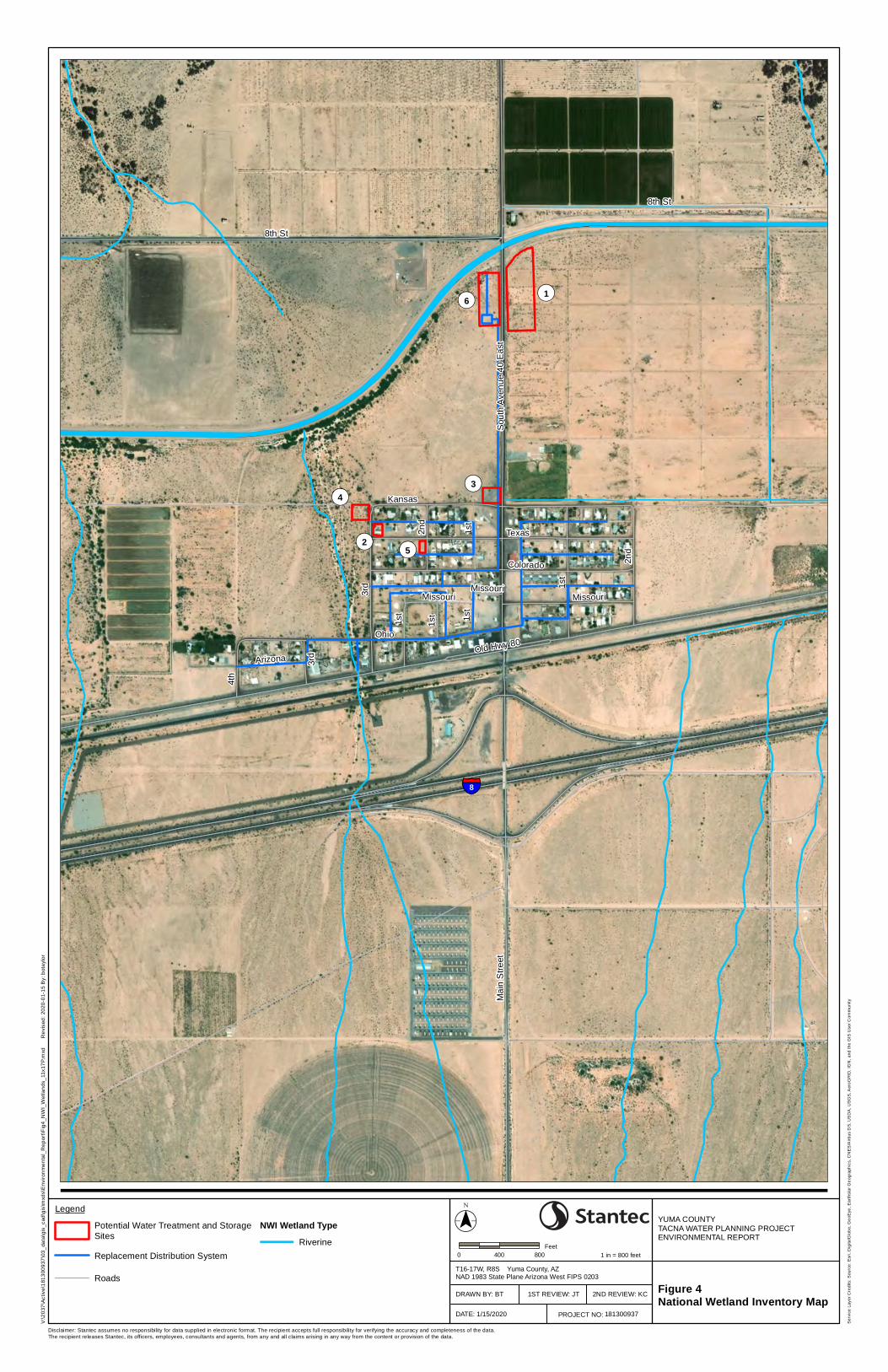
2.4 Wetlands
The National Wetland Inventory (NWI) identified a small number of riverine channels near the vicinity of the proposed Project, including the Welton-Mohawk canal (Figure 4). None of the NWI-identified channels fall within the proposed disturbance footprint of the Project except for one intermittent or ephemeral channel which crosses a very small portion of the existing water piping distribution system in the southwest portion of the Project area (Figure 4).
It is not anticipated that the proposed Project would impact the NWI-identified wetlands as the proposed replacement distribution piping would follow the same alignment as the existing piping distribution system and disturbance would occur within the existing footprint of the current distribution system. In addition, the proposed water treatment and storage sites would not occur on any area of NWI-mapped wetlands or channels. If surface water intake from the WMIDD canal is chosen, the existing intake ownership can be cancelled or transferred to the new water system and therefore a new intake would not be required so impacts to the Welton-Mohawk canal would be negligible. The vegetation within the Project was not characteristic of wetland environments. In addition, none of the soil types found within the Project area are classified as hydric soil by the Natural Resources Conservation Service (NRCS)
2.5 Floodplains
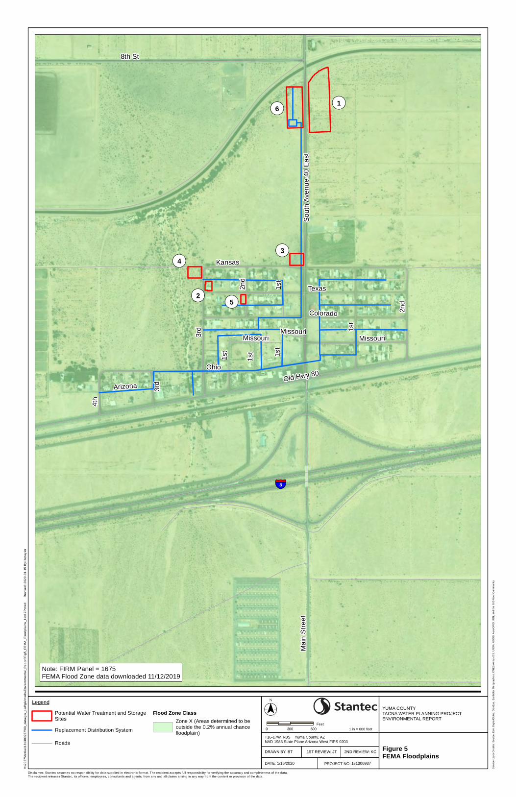
The proposed Project would be located with the Federal Emergency Management Agency Flood Insurance Rate Map Panel 1675E within a Zone X, area of minimal flood hazard, which is determined to be outside the 100-year and 500-year floodplain or other Special Flood Hazard Area (Figure 5) (FEMA, 2008). The proposed Project is not anticipated to impact floodplains as the Project would not be constructed in a 100-year or 500-year floodplain, nor would it impact any intermittent or ephemeral channels beyond existing conditions.
Tacna Water Planning Project Environmental Report Yuma County
January 21, 2020 10
2.6 Coastal Areas, Zone and Barriers
There are no coastal areas, zones or barriers within the proposed Project area. Construction of the proposed Project would not be within coastal areas, zones or barriers and therefore no impacts to coastal areas would occur from the proposed Project.
2.7 Important Farmland
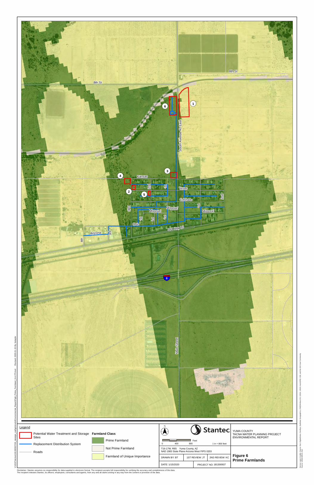
The proposed Project is located in areas that are designated as prime farmland and/or farmland of unique importance by the NRCS (Figure 6). These areas are considered prime or unique farmland by NRCS if they are irrigated or reclaimed of excess salts. However, the area is currently not farmed or irrigated and is not used as farmland and does not appear to have been used as farmland in the recent past. The Farmland Protection Policy Act (FPPA) is intended to minimize irreversible conversion of farmland to nonagricultural uses. Under the FPPA requirements, it states that should a project occur on land already in urban development or used for water storage, the activity is not subject to the FPPA (NRCS, 2019).
As the proposed Project would be located on lands that have been previously developed into an urban setting and would also include lands used for water storage, the proposed Project would be exempt from the requirements of the FPPA. The proposed Project would not be permanently converting existing agriculture lands to non-agricultural uses and no impacts are anticipated to occur to important farmlands.
2.8 Environmental Risk Management
The proposed Project would include the replacement of the existing water distribution system, water supply and treatment, and water storage and is not anticipated to include hazardous materials or require waste handling.
Construction crews are not expected to encounter hazardous material during construction. Any chemicals or material used for treatment would be stored in an approved location and comply with applicable regulations. There is the potential for vehicles used during construction to release oil, gasoline, diesel fuel or hydraulic fluid, but is considered negligible and similar to a normal construction site and construction would comply with applicable regulations regarding petroleum spills and cleanup. No environmental impacts are anticipated.
2.9 Other Resources
2.9.1 Water Resources
The proposed Project is not located within any key water resource areas (i.e., sole source aquifers) (EPA, 2019b). There are no surface water bodies within the proposed Project sites. No environmental impacts are anticipated to water resources as the Project is not within a sole source aquifer and no surface water is within the Project area. The Welton-Mohawk canal is located to the north of the Project, but it is not anticipated that additional groundwater pumping or surface
Tacna Water Planning Project Environmental Report Yuma County
January 21, 2020 11
water withdrawal would be required beyond existing conditions. Implementing appropriate storm water pollution prevention Best Management Practices (BMPs) are anticipated to occur during construction activities to minimize impacts to water resources.
2.9.2 Air Quality
Yuma County, Arizona is currently in a moderate nonattainment area for particulate matter 10 microns or less and marginal nonattainment for 8-hour ozone with the U.S. Environmental Protection Agency’s National Ambient Air Quality Standards (EPA, 2019c). The proposed Project is not anticipated to require any new operations sources of air emissions. During Project construction, there would be a temporary increase in air emissions from Project construction activities due to an increase in diesel and gasoline powered vehicles and heavy machinery, as well as fugitive dust related to earthmoving activities. Construction activities are anticipated to occur for approximately one year. These impacts are considered short-term and negligible. After completion of construction, disturbed areas would be void of vegetation which may result in increased wind erosion, contributing to increased dust levels until the area is naturally revegetated. This would result in a long-term, negligible impact since much of the area is already bare ground and void of vegetation.
In addition, the proposed Project would implement the Yuma County recommended BMPs for dust control methods during construction activities. With the implementation of dust control BMPs, the proposed Project is not anticipated to significantly contribute to dust emissions in the Project area.
2.9.3 Noise
The proposed Project would be located within a sparsely populated area with an existing water system (Stantec, 2019a). No increase in noise levels are expected after construction of the Project is completed as there is already an existing water system and this Project does not propose anything that would increase noise levels beyond existing conditions.
2.9.4 Visual Impacts
The proposed Project is not anticipated to have significant visual impacts in the Project area. The proposed Project would be located within an urban setting that currently has structures on the visual landscape. In addition, the water pipeline distribution system would be buried and would not be visible on the landscape of the Project area. It is anticipated that the new water storage and treatment systems would be constructed to blend with the existing form, line, color and texture of the landscape.
2.9.5 Transportation
The proposed Project would be located within a sparsely populated area (Stantec, 2019a). Traffic increases and related impacts would only occur during construction and would cease once construction of the Project is finished. In addition, Yuma County would also require a traffic control permit to further reduce traffic impacts during construction.
Tacna Water Planning Project Environmental Report Yuma County
January 21, 2020 12
3.0 SUMMARY OF ENVIRONMENTAL MEASURES Environmental protection measures and BMPs would be implemented during construction activities to reduce potential impacts from the proposed Project. A summary of BMPs and mitigation measures are provided below.
3.1 Biological Resources
Pre-construction clearance surveys should be conducted prior to construction activities to avoid impacts to wildlife species.
3.2 Construction Activities
The proposed Project would be required to obtain a traffic control permit to reduce traffic related impacts during construction. In addition, the proposed Project would implement the Yuma County recommended BMPs for dust control methods during construction activities.
Tacna Water Planning Project Environmental Report Yuma County
January 21, 2020 13
4.0 REFERENCES Federal Emergency Management Agency (FEMA). 2008. FIRM Flood Insurance Rate Map. Panel
1675E. Accessed November 2019 online at: https://msc.fema.gov/portal/home.
Natural Resources Conservation Service (NRCS). 2019. Farmland Protection Policy Act. Accessed December 2019 online at: https://www.nrcs.usda.gov/wps/portal/nrcs/main/national/landuse/fppa/.
Stantec Consulting Services Inc. (Stantec). 2019a. Preliminary Engineering Report. Tanca Water Planning. November 2019.
Stantec Consulting Services Inc. (Stantec). 2019b. Archaeological Survey of 46.2 acres of Land for the Proposed Tacna Water Distribution System Replacement Project, Tacna, Yuma County, Arizona. November 10, 2019.
Stantec Consulting Services Inc. (Stantec). 2019c. Biological Survey Report. Tacna Water Planning Project. November 26, 2019.
United States Environmental Protection Agency (EPA). 2019a. EJSCREEN. EPA’s Environmental Justice Screening and Mapping Tool. Accessed November 2019 online at: https://ejscreen.epa.gov/mapper/.
United States Environmental Protection Agency (EPA). 2019b. Map of Sole Source Aquifer Locations. Accessed December 2019 online at: https://www.epa.gov/dwssa/map-sole-source-aquifer-locations.
United States Environmental Protection Agency (EPA). 2019c. Arizona Nonattainment/Maintenance Status for Each Count by Year for All Criteria Pollutants. Accessed December 2019 online at: https://www3.epa.gov/airquality/greenbook/anayo_az.html.

FIGURES
§̈¦8CALI
FORN
IAAR
IZO
NA
LA PA
Z CO.
YUMA
CO.
TacnaYuma
($$¯0 5 10
Miles
YUMA COUNTYTACNA WATER PLANNING PROJECTENVIRONMENTAL REPORT
T16-17W, R8S Yuma County, AZNAD 1983 State Plane Arizona West FIPS 0203
V:\2
037\
Act
ive\
1813
0093
7\03
_dat
a\gi
s_ca
d\gi
s\m
xds\
Env
ironm
enta
l_R
epor
t\Fig
1_V
icin
ity M
ap_8
x11P
.mxd
Rev
ised
: 202
0-01
-15
By:
bot
aylo
r
Disclaimer: Stantec assumes no responsibility for data supplied in electronic format. The recipient accepts full responsibility for verifying the accuracy and completeness of the data. The recipient releases Stantec, its officers, employees, consultants and agents, from any and all claims arising in any way from the content or provision of the data.
Figure 1Vicinity Map
1 in = 10 miles
181300937
1ST REVIEW: CJDRAWN BY: BT 2ND REVIEW: KC
DATE: 1/15/2020
Ser
vice
Lay
er C
redi
ts: S
ourc
es: E
sri,
HE
RE
, Gar
min
, Int
erm
ap, i
ncre
men
t P C
orp.
, GE
BC
O, U
SG
S, F
AO
, NP
S, N
RC
AN
, Geo
Bas
e, IG
N, K
adas
ter N
L, O
rdna
nce
Sur
vey,
Esr
i Jap
an, M
ETI
, Esr
i Chi
na (H
ong
Kon
g), (
c) O
penS
tree
tMap
con
tribu
tors
, and
the
GIS
Use
r Com
mun
ity
PROJECT NO:
Arizona
Project Location
Project Location
¬«1
¬«4
¬«2
¬«3
¬«5
¬«6
4th
1st
Sout
h Av
enue
40
East
Mai
n
3rd
2nd
Kansas
1st
Texas
Missouri
Ohio
Missouri
2nd
1st
3rd
1st
1st
Old Hwy 80
Colorado
Missouri
Arizona
8th St
($$¯0 300 600
Feet
YUMA COUNTYTACNA WATER PLANNING PROJECTENVIRONMENTAL REPORT
T16-17W, R8S Yuma County, AZNAD 1983 State Plane Arizona West FIPS 0203
V:\2
037\
Act
ive\
1813
0093
7\03
_dat
a\gi
s_ca
d\gi
s\m
xds\
Env
ironm
enta
l_R
epor
t\Fig
2_S
ite_P
lan_
8x11
P.m
xd
R
evis
ed: 2
020-
01-1
5 B
y: b
otay
lor
Disclaimer: Stantec assumes no responsibility for data supplied in electronic format. The recipient accepts full responsibility for verifying the accuracy and completeness of the data. The recipient releases Stantec, its officers, employees, consultants and agents, from any and all claims arising in any way from the content or provision of the data.
Figure 2Site Plan
1 in = 600 feet
181300937
Legend
Potential Water Treatment and StorageSites
Replacement Distribution System
Roads1ST REVIEW: CJDRAWN BY: BT 2ND REVIEW: KC
DATE: 1/15/2020
Ser
vice
Lay
er C
redi
ts: S
ourc
e: E
sri,
Dig
italG
lobe
, Geo
Eye
, Ear
thst
ar G
eogr
aphi
cs, C
NE
S/A
irbus
DS
, US
DA
, US
GS
, Aer
oGR
ID, I
GN
, and
the
GIS
Use
r Com
mun
ity
PROJECT NO:
"
§̈¦8
¬«3
¬«5¬«2
¬«4
¬«1¬«6
Mai
n S
treet
4th
1st
Sout
h Av
enue
40
East
3rd
1st
Texas
Missouri
2nd
Ohio
Missouri
1st
2nd
3rd
1st
1st
Old Hwy 80
Missouri
Colorado
Arizona
8th St
8th St
Kansas
Tacna
Disclaimer: Stantec assumes no responsibility for data supplied in electronic format. The recipient accepts full responsibility for verifying the accuracy and completeness of the data. The recipient releases Stantec, its officers, employees, consultants and agents, from any and all claims arising in any way from the content or provision of the data.
V:\2
037\
Activ
e\18
1300
937\
03_d
ata\
gis_
cad\
gis\
mxd
s\E
nviro
nmen
tal_
Rep
ort\F
ig3_
Land
_Ow
ners
hip_
11x1
7P.m
xd
R
evis
ed: 2
020-
01-1
5 B
y: b
otay
lor
LegendPotential Water Treatment and StorageSites
Replacement Distribution System
Roads
Land OwnershipBureau of Reclamation
County
Private
State Trust Land
State Wildlife Area
Ser
vice
Lay
er C
redi
ts: C
opyr
ight
:© 2
013
Nat
iona
l Geo
grap
hic
Soc
iety
, i-c
ubed
YUMA COUNTYTACNA WATER PLANNING PROJECTENVIRONMENTAL REPORT
T16-17W, R8S Yuma County, AZNAD 1983 State Plane Arizona West FIPS 0203
Figure 3Land Ownership
1 in = 800 feet
1ST REVIEW: JTDRAWN BY: BT 2ND REVIEW: KC
DATE: 1/15/2020
($$¯0 400 800
Feet
181300937PROJECT NO:
§̈¦8
¬«3
¬«5¬«2
¬«4
¬«1¬«6
Mai
n S
treet
4th
1st
Sout
h Av
enue
40
East
3rd
1st
Texas
Missouri
2nd
Ohio
Missouri
1st
2nd
3rd
1st
1st
Old Hwy 80
Missouri
Colorado
Arizona
8th St
8th St
Kansas
Disclaimer: Stantec assumes no responsibility for data supplied in electronic format. The recipient accepts full responsibility for verifying the accuracy and completeness of the data. The recipient releases Stantec, its officers, employees, consultants and agents, from any and all claims arising in any way from the content or provision of the data.
V:\2
037\
Activ
e\18
1300
937\
03_d
ata\
gis_
cad\
gis\
mxd
s\E
nviro
nmen
tal_
Rep
ort\F
ig4_
NW
I_W
etla
nds_
11x1
7P.m
xd
R
evis
ed: 2
020-
01-1
5 B
y: b
otay
lor
Legend
Potential Water Treatment and StorageSites
Replacement Distribution System
Roads
NWI Wetland TypeRiverine
Ser
vice
Lay
er C
redi
ts: S
ourc
e: E
sri,
Dig
italG
lobe
, Geo
Eye
, Ear
thst
ar G
eogr
aphi
cs, C
NE
S/A
irbus
DS
, US
DA
, US
GS
, Aer
oGR
ID, I
GN
, and
the
GIS
Use
r Com
mun
ity
YUMA COUNTYTACNA WATER PLANNING PROJECTENVIRONMENTAL REPORT
T16-17W, R8S Yuma County, AZNAD 1983 State Plane Arizona West FIPS 0203
Figure 4National Wetland Inventory Map
1 in = 800 feet
1ST REVIEW: JTDRAWN BY: BT 2ND REVIEW: KC
DATE: 1/15/2020
($$¯0 400 800
Feet
181300937PROJECT NO:
§̈¦8
¬«3
¬«5¬«2
¬«4
¬«1¬«6
Mai
n St
reet
4th
1st
Sout
h Av
enue
40
East
3rd
1st
Texas
Missouri
2nd
Ohio
Missouri
1st
2nd
3rd
1st
1st
Old Hwy 80
Missouri
Colorado
Arizona
8th St
8Th St
Kansas
Disclaimer: Stantec assumes no responsibility for data supplied in electronic format. The recipient accepts full responsibility for verifying the accuracy and completeness of the data. The recipient releases Stantec, its officers, employees, consultants and agents, from any and all claims arising in any way from the content or provision of the data.
V:\2
037\
Activ
e\18
1300
937\
03_d
ata\
gis_
cad\
gis\
mxd
s\E
nviro
nmen
tal_
Rep
ort\F
ig5_
FEM
A_F
lood
plai
ns_1
1x17
P.m
xd
R
evis
ed: 2
020-
01-1
5 B
y: b
otay
lor
Legend
Potential Water Treatment and StorageSites
Replacement Distribution System
Roads
Flood Zone ClassZone X (Areas determined to beoutside the 0.2% annual chancefloodplain)
Ser
vice
Lay
er C
redi
ts: S
ourc
e: E
sri,
Dig
italG
lobe
, Geo
Eye
, Ear
thst
ar G
eogr
aphi
cs, C
NE
S/A
irbus
DS
, US
DA
, US
GS
, Aer
oGR
ID, I
GN
, and
the
GIS
Use
r Com
mun
ity
YUMA COUNTYTACNA WATER PLANNING PROJECTENVIRONMENTAL REPORT
T16-17W, R8S Yuma County, AZNAD 1983 State Plane Arizona West FIPS 0203
Figure 5FEMA Floodplains
1 in = 600 feet
1ST REVIEW: JTDRAWN BY: BT 2ND REVIEW: KC
DATE: 1/15/2020
($$¯0 300 600
Feet
181300937PROJECT NO:
Note: FIRM Panel = 1675FEMA Flood Zone data downloaded 11/12/2019
§̈¦8
¬«3
¬«5¬«2
¬«4
¬«1¬«6
Mai
n S
treet
4th
1st
Sout
h Av
enue
40
East
3rd
1st
Texas
Missouri
2nd
Ohio
Missouri
1st
2nd
3Rd
1st
1st
Old Hwy 80
Missouri
Colorado
Arizona
8th St
8th St
Kansas
Disclaimer: Stantec assumes no responsibility for data supplied in electronic format. The recipient accepts full responsibility for verifying the accuracy and completeness of the data. The recipient releases Stantec, its officers, employees, consultants and agents, from any and all claims arising in any way from the content or provision of the data.
V:\2
037\
Activ
e\18
1300
937\
03_d
ata\
gis_
cad\
gis\
mxd
s\E
nviro
nmen
tal_
Rep
ort\F
ig6_
Prim
e_Fa
rmla
nd_1
1x17
P.m
xd
R
evis
ed: 2
020-
01-1
5 B
y: b
otay
lor
Legend
Potential Water Treatment and StorageSites
Replacement Distribution System
Roads
Farmland ClassPrime Farmland
Not Prime Farmland
Farmland of Unique Importance
Ser
vice
Lay
er C
redi
ts: S
ourc
e: E
sri,
Dig
italG
lobe
, Geo
Eye
, Ear
thst
ar G
eogr
aphi
cs, C
NE
S/A
irbus
DS
, US
DA
, US
GS
, Aer
oGR
ID, I
GN
, and
the
GIS
Use
r Com
mun
ityS
ourc
e: U
SD
A N
RC
S, E
sri
YUMA COUNTYTACNA WATER PLANNING PROJECTENVIRONMENTAL REPORT
T16-17W, R8S Yuma County, AZNAD 1983 State Plane Arizona West FIPS 0203
Figure 6Prime Farmlands
1 in = 800 feet
1ST REVIEW: JTDRAWN BY: BT 2ND REVIEW: KC
DATE: 1/15/2020
($$¯0 400 800
Feet
181300937PROJECT NO:
Appendix A
EJSCREEN Maps
Appendix B
Class III Cultural Resources Inventory Report Summary Form
Page 1 of 13. Tacna Water Distribution System Replacement Project, Yuma County, Arizona. Stantec # 181300937
STATE HISTORIC PRESERVATION OFFICE SURVEY REPORT SUMMARY FORM
1. REPORT TITLE 1.a Report Title: Archaeological Survey of 46.2 acres of Land for the Proposed Tacna Water Distribution System Replacement Project, Tacna, Yuma County, Arizona 1.b Report Author: Mitch Marken, Ph.D., Hubert Switalski, B.A. 1.c Date: November 10, 2019 1d. Report No.: Pending 2. PROJECT REGISTRATION/PERMITS 2a. ASM Accession Number: Pending 2b. AAA Permit Number: 2019-057bl 2c. ASLD Lease Application Number: N/A 2d. Other Permit Number: N/A 3. ORGANIZATION/CONSULTING FIRM 3a. Name: Stantec Consulting Services, Inc. 3b. Internal Project Number: 181300937 3c. Internal Project Name: Tacna Water Distribution System Replacement Project 3d. Contact Names: Hubert Switalski, Mitch Marken, Ph.D. 3e. Contact Address: 38 Technology Drive, Irvine, CA. 92618-5312 3f. Contact Phone: 310-971-1500 3g. Contact Email: [email protected]; [email protected]
4. SPONSOR/LEAD AGENCY 4a. Sponsor: United States Department of Agriculture (USDA), Rural Department (RD) 4b. Lead Agency: Yuma County Improvement District 4c. Agency Project Number(s): N/A 4d. Agency Project Name: Tacna Water Distribution System Replacement Project 4e. Funding Source(s): USDA 4f. Other Involved Agencies: N/A 4g. Applicable Regulations: ASLD requirement to comply with the Arizona State Historic Preservation Act (ARS § 41-861 et seq.) in the issuance of leases and permits. 5.0 DESCRIPTION OF PROJECT OR UNDERTAKING: Summary of Project The existing water system in Tacna has been in place since 1980. It is owned by the Tacna Water Management Company. The system includes a groundwater well, piping, pumps and storage. Some upgrading of the system was completed since 1980 including installation of a water intake on the Wellton-Mohawk canal and installation of water treatment in 2007 and repainting of the water storage tank. The existing water system serving the community of Tacna includes approximately 10,000 linear feet of PVC and transit pipe, an above ground welded steel water storage tank, a well, a booster pump and an intake on the Wellton-Mohawk canal. The system includes 175 service connections and typically provides water to 135 to 160 customers (approximately 310 people). The water system includes no fire hydrants and currently does not provide fire protection. No water treatment is provided. The piping and the tank are reported to be in poor conditions with evidence of leaks (Stantec, 2019).
Page 2 of 13. Tacna Water Distribution System Replacement Project, Yuma County, Arizona. Stantec # 181300937
The proposed water distribution system would consist of a replacement pumping system which would pump water from the storage tank and a network of piping to each of the users. The pumps would provide pressure to the users. The pipe main sizes would be minimum six-inch diameter with hydrants to provide fire flows for fire protection. Small diameter service piping would provide service to the users from the six-inch mains. The pump system would meet the peak hour demand for normal usage and maximum day demand plus the required fire flow for fire protection, as needed. It is anticipated that the proposed replacement distribution piping would follow the same alignment as the existing piping distribution system in order to reach all users (Stantec, 2019a). It is anticipated that approximately 17,105 feet (3.24 miles) of piping would be required for the proposed project. The extent of the entire project is depicted on the Tacna, AZ (1982) USGS 7.5-minute topographic quadrangle (Figure 2), including an aerial imagery of the entire community of Tacna (Figure 3). 6. PROJECT AREA/AREA OF POTENTIAL EFFECTS: The project area includes alignment of the proposed water lines as well as the location of the proposed water filtration plant, including a 30-meter buffer surrounding each area, for the total of 46.2 acres. It is anticipated that any impacts from the proposed project will be contained within this acreage. 7. PROJECT LOCATION 7a. Address: N/A 7b. Route: N/A 7c. Mileposts Limits: N/A 7d. Nearest City/Town: Tacna, Arizona 7e. County: Yuma County 7f. Project Locator UTM: Center points of Segments – South to North Northern-most extent (E 223249/N 3622795) Southern-most extent (E 222683/N 3621494) Eastern-most extent (E 223537/N 3621734) Western-most extent (E 222310/N 3621522)
7g. NAD 83 7h. Zone: 12 7i. Baseline & Meridian: Gila and Salt River Meridian 7j. USGS Quadrangle(s): Tacna, AZ 7k. Legal Description(s): Township 8 South, Range 17 West, Section 25, and Township 8 South, Range 16 West, Section 30. E ½ of Section 25 and W ½ of Section 30. 8. SURVEY AREA 8a. Total Acres: 46.2 8b. Survey Area. 1. Land Jurisdiction 2. Total Acres Surveyed 3. Total Acres Not Surveyed: Arizona State Lands 46.2 acres N/A 9. ENVIRONMENTAL CONTEXTS 9a. Landform: Valley floor (Mohawk Valley) within the Lechuguilla Desert, and northern portion of the Sonoran Desert. 9b. Elevation: 320 – 360 feet AMSL
Page 3 of 13. Tacna Water Distribution System Replacement Project, Yuma County, Arizona. Stantec # 181300937
9c. Surrounding Topographic Features: The Project Area is surrounded by Muggins Mountains to the northwest, Mohawk Mountains to the southeast, and Copper Mountains to the south. 9d. Nearest Drainage: The Project Area is located approximately two miles south of Gila River and three miles southwest of Mohawk Wash. 9e. Local Geology: The Sonoran Desert is part of the Great American Desert of western North America, extending from the northern part of the United States deep into Mexico. This portion of southern Arizona is within the Basin and Range Geologic Province, which stretches from southeastern Oregon and southward through Nevada into southern Arizona. The northern extension of the Sonoran Desert is largely determined by cold temperatures while the eastern boundary is delimited biologically, physically, and geographically by high mountain ranges to the south. Geologically, the Sonoran Desert is located within the Basin and Range Geologic Province characterized by elongated mountain ranges which are separated by broad, nearly flat valleys (Norris and Webb 1990:178). In the Sonoran Desert many craggy low to mid elevation mountain ranges rise above vast basins. These ranges generally trend northwest-southeast and parallel one another. With the limited vegetative cover, there is a discreet break between the bedrock of the range and the eroded sands and gravel which form the relatively smooth skirt at their base. These alluvial fans form as rain washes weathered rock down into the valley from the slopes of the mountains above. A major period of volcanic activity occurred in southern Arizona about 25 million years ago. Glowing avalanches of hot gas and fragmented rock erupted from large volcanoes called calderas and flowed across the landscape incinerating everything in their path. Many of the volcanic deposits in the Sonoran Desert, including some exposed in Organ Pipe Cactus National Monument, are from this period of intense volcanism. The Sonoran Desert is subdivided into several regions including the Lower Colorado Valley, which includes the Lecheguilla Desert (Shreve and Wiggins 1964). The Lower Colorado Valley is the largest subdivision of the Sonoran Desert and it occupies the lower drainages of the Colorado and Gila Rivers, the Salton Basin and the eastern coast of the Baja California. About 85% of the area outside of the delta of the Colorado River is comprised of bajadas or nearly level plains. 9f. Vegetation: The project area is located within the Lechuguilla Desert, within the northern portion of the Sonoran Desert. The vegetation of the Lower Colorado Valley, distinguished by its simplicity, is dominated by creosote bush (Larrea tridentata) and white bursage (Ambrosia dumosa), often making up 90 to 95 percent of the vegetation on the upland; and by mesquite (Prosopis juliflora), ironwood (Olneya tesota), blue paloverde (Cercidium floridum), and smoke tree (Dalea spinosa) along drainageways. Big galleta (Hilaria rigida) occurs on sandy soils, which often support a galaxy of annual plants during the winter rainy season. 9g. Soils/Deposition: The project area is located south of the Mohawk Canal and south of the Gila River and it is located within the flood plain of the Gila River. The surrounding area can be characterized as very typical of valley floor within a larger desert, without any observable granite outcrops, or any other geologic features. The soils of the Sonoran Desert are typical warm desert soils, showing modification of the parent materials associated with aridity. Distinguishing features are the low humus content and high content of readily soluble salts. The latter may lead to lime accumulations in the subsoil or the development of alkali conditions where drainage is impaired. The characteristic bajada slopes exhibit a
Page 4 of 13. Tacna Water Distribution System Replacement Project, Yuma County, Arizona. Stantec # 181300937
mixture of soil materials ranging from rocky near the top to fine materials at their lower extremities, these often giving way to fine-textured alluvial bottoms (McGinnies 1976). 9h. Buried Deposits: Not likely 9i. Justification: Most of the project area is located along existing paved roadways and within the small desert community of Tacna. 10. BUILT ENVIRONMENT: No structures or features observed. 11. INVENTORY CLASS COMPLETED 11a. Class I Inventory: No 11b. Researcher(s): N/A 11c. Class II Survey: No 11d Sampling Strategy: N/A 11e. Class III Inventory: Yes 12. BACKGROUND RESEARCH SOURCES 12a. AZSITE: N/A 12b. ASM Archaeological Records Office: During the records search (ASM Job No. 1772) conducted at the Arizona State Museum (ASM) the search revealed that six archaeological surveys were previously conducted within the ½-mile radius of the project area and there were no surveys previously conducted directly within the project area. Furthermore, no archaeological sites were previously documented within the project area; however, four previously documented sites are located within the ½-mile Study Area. 12c. SHPO Inventories and/or SHPO Library: N/A 12d. NRHP Database: N/A 12e. ADOT Portal: N/A 12f. GLO Maps: 1923 GLO Plat map reviewed – no resources near or within APE 12g. Land- Managing Agency Files: N/A 12h. Tribal Cultural Resources Files: N/A 12i. Local Government Websites: N/A 12j. Other: Historic period USGS topographic quadrangles, including Mohawk, AZ (1928) and Tacna, AZ (1968) were reviewed for presence of built environment resources. 13. BACKGROUND RESEARCH RESULTS: The background research for the project revealed that relatively little in terms of previous archaeological work was conducted within the project area and the surrounding Study Area. Based on the results of the archival background research most of the previous projects were conducted along the alignment of the old US Highway 50, along an existing Union Pacific Railroad, and along the Mohawk Canal. The surveys resulted in the recordation of in-use segments of the Union Pacific Railroad (AZ Z:2:40 ASM) and the alignment of the old US Highway 50 (AZ FF:9:17 ASM). These resources were documented outside of the current project area and are considered in-use as existing transportation routes. 14. CULTURAL CONTEXTS 14a. Prehistoric Culture: The earliest period of human occupation in North America is the Paleoindian Period which extends roughly from 10,000 to 8,000 B.C. when much of what is now Arizona was covered by open juniper-scrub oak woodlands. Moist grasslands in southwestern Arizona supported large game including now extinct wooly

Page 5 of 13. Tacna Water Distribution System Replacement Project, Yuma County, Arizona. Stantec # 181300937
mammoth. This period was characterized by large lanceolate, fluted projectile (spear) points and emphasized large game hunting. A separate, contemporaneous tradition existed in western Arizona and the Great Basin, which incorporated crude, percussion flaked lithic tools rather than the finely manufactured bifaces of the Plains-center Paleoindian complexes. In portions of California and the Great Basin, this tradition was manifested as the San Dieguito complex (Rogers 1966). Archaic Period The end of the Pleistocene witnessed the retreat of the continental glaciers and initiated a trend of increasing temperatures and aridity resulting in vegetation shifts and desiccation of pluvial lakes in the Great Basin (Stone 1986). As a result, to the changing conditions, many large mammal species became extinct and in western Arizona there appears to have been a rapid retreat of the juniper woodlands. Furthermore, the end of the Pleistocene was also accompanied by shifts in human subsistence strategies include reliance on a broad range of plants and fauna with much less emphasis on the hunting of large game (Stone 1986). Cultural developments of the Archaic Period in the region have been variously categorized as the San Dieguito-Pinto Complex (Cordell 1984), San Dieguito-Amargosa (Haury 1975), or the Western tradition of the Picosa Culture (Irwin-Williams 1979), or treated as separate cultural phenomena as the Amargos tradition and the Pinto complex (Ezzo 1994; Sterner 1992, among others). Rogers (1939) who defined the Amargosa tradition believed that an Amargosan incursion resulted in the displacement or absorption of San Dieguits groups in western Arizona (Rogers 1958). In general, this time period witnessed the addition of grinding implements and various projectile points reminiscent of the early San Dieguito tradition, which included scrapers, scraper planes, and flake choppers. Generally, the Archaic Period, including the various subdivisions and phases extends roughly from 6,000 B.C. to A.D 1. The Ceramic Period Stone (1986) points out that by definition, the Archaic Period in the Southwest ended with the introduction of ceramics and the practice of agriculture. While this transition took place over a long period of time, however, the events and processes that caused this transformation are unclear. Wilcox (1979) argues that near the end of the Archaic Period increasing population densities and decline in average effective precipitation may have reduced the efficiency of small hunting groups and favored the adoption of farming, and thus, increasing the reliance on storage, and caused a major shift towards rivers and perennial streams. This period further witnessed changes in the cultural assemblage in the Southwest, possibly caused by influences from the south (Patayan), north (Anasazi), and east (Hohokam). As with most studies based on surface evidence, pottery is one of the most useful indicators of the temporal and cultural affiliation of the Native Americans who occupied the general project area. Based on observations and collections from several sites along the Colorado River, Rogers (1929) and Ezell (1954) concluded that the ceramic evidence points overwhelmingly toward Patayan or Yuman use during the latest prehistoric period and into historical times. Rogers emphasized differences in surface treatments and vessels and rim forms and proposed three periods of Patayan prehistory, which he coined Yuman I, II and III; however, this terminology was changed by Colton (1939), who rejected the terms, claiming it was a reference to an ethnographic culture and therefore not appropriate for prehistoric assemblages and replaced the term Yuman with Patayan, and renamed Rogers’ phases accordingly to Patayan I, II, and III.
Page 6 of 13. Tacna Water Distribution System Replacement Project, Yuma County, Arizona. Stantec # 181300937
Patayan I Rogers (1945) argued that the Patayan sequence, which started at A.D. 900 and lasted until A.D. 1050, began with immigration by either Hokan (Yuman) people from southern California or non-Hokan people from Papaqueria or Sonora. He defined Pataya I phase ceramics as polished red ware and vessels with the Colorado shoulder. Additional ceramic types characteristic of this period as defined by Rogers (1945) include Black Mesa Buff, Black Mesa Red-on-buff, Colorado Beige, Colorado Red-on-beige, and Colorado Red. Patayan II The subsequent Patayan II Period, which lasted between A.D. 1050 to 1500) witnessed a greater variation in ceramics and the spread of these forms from the Colorado Basin into the California and Arizona Deserts. This also coincides with at least two of the major Lake Cahuilla filling episodes with settlements occurring primarily along the shores of the lake and the Colorado River. Habitation camps and sites tended to be relatively short-term, with temporary camps being established away from known and reliable water sources. Ceramics characteristic of this period seem to change forms, including the disappearance of the Colorado shoulder, and the introduction of recurved rims and flaring margins (Schaefer 1988). 14b. Protohistoric Culture: The Patayan III (Protohistoric Period A.D. 1500 +) is a period of ceramic continuity, increasing population size, and changing settlement patters. Wasley and Johnson (1965) point to an increase and movement of human population to the Lower Gila River and its displacement of the Hohokam people. It is believed that a desiccation of the Salton Trough may have caused local populations reliant on lake resources, to migrate further south towards the Colorado River delta or further west to inland mountains of California. This period is characterized by an increase and spread of buff wares and the introduction of smaller-sized projectile points such as the Desert side-notched and Cottonwood Triangular type points. 14c. Indigenous Historic Culture: Pima and Papago The Project Area encompasses lands that ethnographically may have been occupied by the Pima Indians,
who speak a Piman language of the Uto-Aztecan language family. All Pima Indians call themselves
O’odham, meaning the people, and they further separate themselves into Akimel O’odham and Tohono
O’odham, meaning the ‘river people’ and the ‘desert people’, respectively. As the project area is located
approximately two miles south of the Gila River, it is very likely the over all project area was occupied by
the Akimel O’odham, who found an abundance of floral and faunal resources along the river and within
its floodplain (Fontana 1983:125-126).
14d. Euro-American Culture: The Euro-American history of the area, including early Spanish contact, is described in detail by Ezell
(1983). By the time of the Euro-American contact in the early 1700s, the Pima occupied at least seven
rancherias separated from each other by distances of seven to nearly 40 miles, which were clustered along
Santa Cruz and Gila Rivers (Ezell 1983:150). Gathering of wild plant foods was an important source of
supplementary or emergency food. While hunting was of less importance, with the deer being the largest
game taken, the mountain sheep may have been important in pre-Hispanic times. However, rabbits
seemed to be the animal most frequently sought (Ezell 1983:151-152). The focus of the Pima subsistence
was the reliance on irrigation with the waters of the Gila, the Salt, and Santa Cruz rivers, and an extensive
system of canals and irrigation ditches distributed to water the field.
Page 7 of 13. Tacna Water Distribution System Replacement Project, Yuma County, Arizona. Stantec # 181300937
By the beginning of the Hispanic Period (1694-1853), the Pima, who lived beyond the Hispanic frontier,
seemed to be preoccupied with the growth of the Apache and Quechan raiding, rather than with the
Spanish settlements further south. As the Spanish seemed to favor the Pima and their possession of land
that no Spanish presidio nor Spanish or Mexican settlement was ever founded on the Gila (Ezell 1983:151-
153).
During the American Period (1853-), the Pima enjoyed an expanding economy of the first 15 years of the
American rule. However, in 1867, a construction of a canal intended to reclaim 4,000 acres of land using
the water from the Salt River and completed in 1868, caused many settlers to occupy lands above the
Pima reservation. Subsequently, the introduction of new settlers, government agents and teachers,
started an irreversible and pervasive process of change within the Pima society (Ezell 1983:157-160).
15. FIELD SURVEY PERSONNEL 15a. Principal Investigator: Ellen Brady 15b. Field Supervisor: Mitch Marken Ph.D. (with written permission to use Stantec’s current 2019 permit, previous ASL blanket permit holder PI and FS levels) 15c. Crew: Mitch Marken, Ph.D., Hubert Switalski, and Sandra Hollispeasy 15d. Fieldwork Date(s): October 10, 2019 16. SURVEY METHODS 16a. Transect Intervals: Parallel transects spaced 10 to 15 meters apart. 16b. Coverage (%): 100 % coverage of the entire 46.2-acre Project Area. 16c. Site Recording Criteria: Any resources present. 16d. Ground Surface Visibility: Excellent. 16e. Observed Disturbances: The project area is located within the small desert community of Tacna. As a result, paved roadways, abandoned mobile homes, and general landscaping of residential areas was observed within the project area. Additionally, areas within the northern portion of the Project Area, immediately south of Wellton Mohawk Canal, appeared to have been flooded, either naturally or as part of an agricultural irrigation. Several abandoned modern (less than 50 years old) foundations and mechanically moved modern era refuse were observed on the west side of South Avenue 40 E. 17. FIELD SURVEY RESULTS 17a. No Cultural Resources Identified: X 17b. Isolated Occurrences (IOs) Only: 17c. Number of IOs Recorded: 0 17d. Table of IOs. N/A 18. COMMENTS: None 19. ATTACHMENTS 19a. Project Location Maps: Figure 1 – Project Location and Vicinity Map Figure 2 – Project Area with Archaeological Survey Coverage Map Figure 3 – Project Area depicted on aerial imagery 19b. Land Jurisdiction Map: N/A 19c. Background Research Map(s): N/A 19d. GLO Map(s): N/A
Page 8 of 13. Tacna Water Distribution System Replacement Project, Yuma County, Arizona. Stantec # 181300937
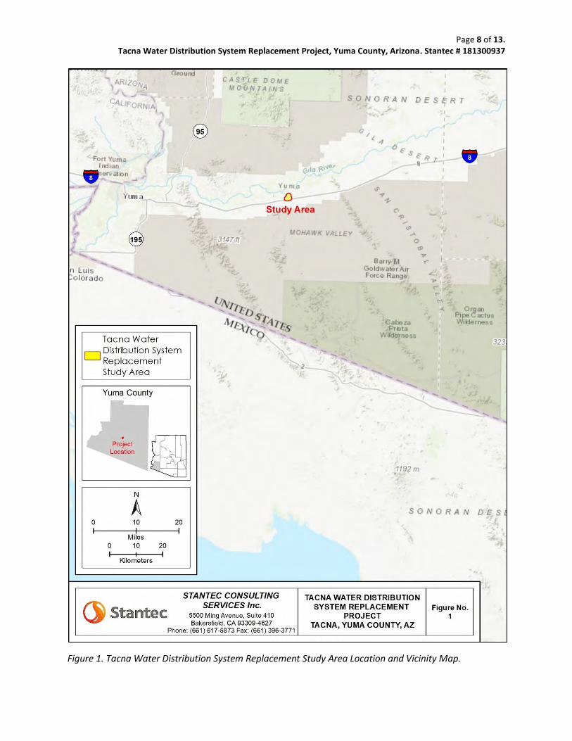
Figure 1. Tacna Water Distribution System Replacement Study Area Location and Vicinity Map.
Page 9 of 13. Tacna Water Distribution System Replacement Project, Yuma County, Arizona. Stantec # 181300937
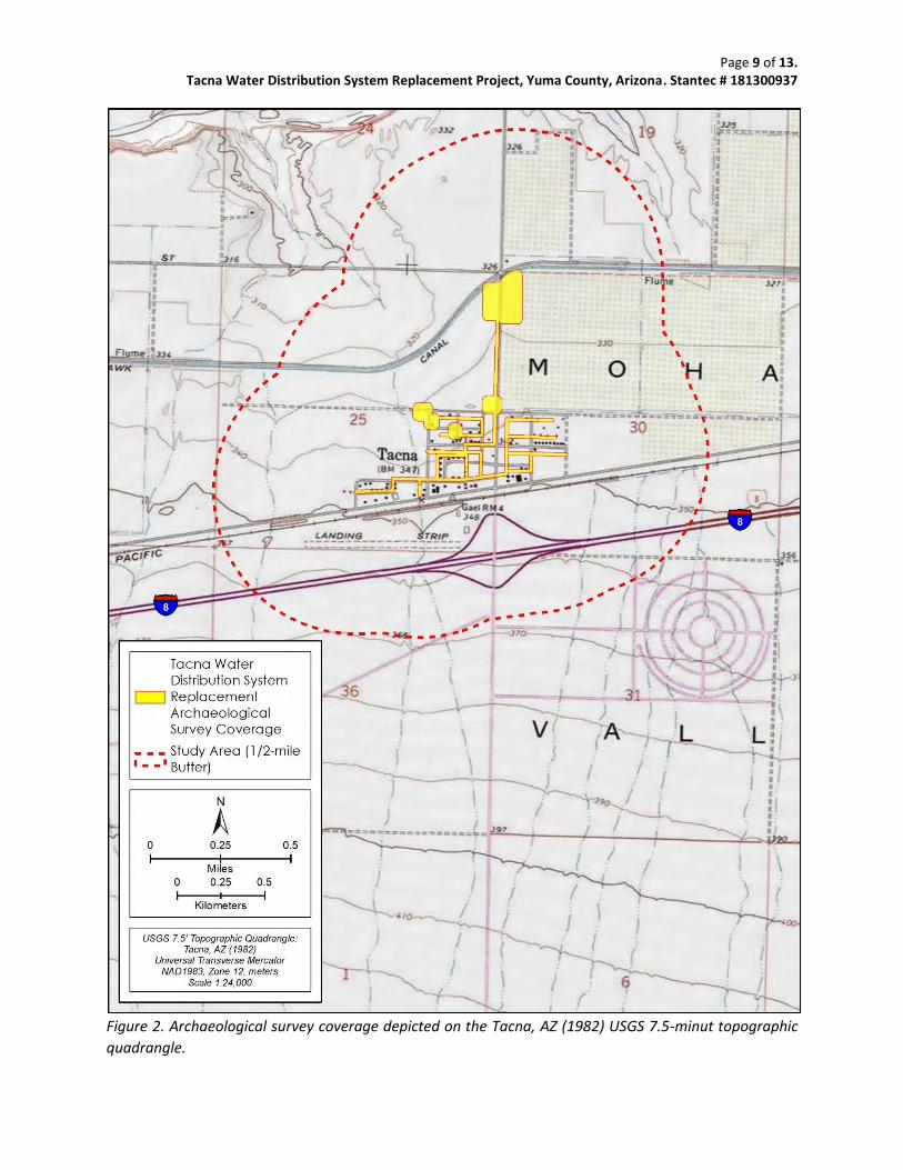
Figure 2. Archaeological survey coverage depicted on the Tacna, AZ (1982) USGS 7.5-minut topographic
quadrangle.
Page 10 of 13. Tacna Water Distribution System Replacement Project, Yuma County, Arizona. Stantec # 181300937
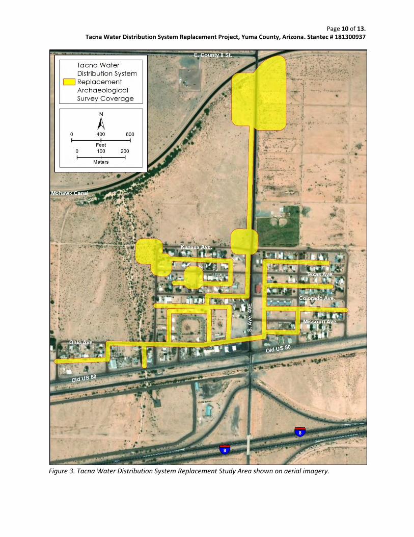
Figure 3. Tacna Water Distribution System Replacement Study Area shown on aerial imagery.
Page 11 of 13. Tacna Water Distribution System Replacement Project, Yuma County, Arizona. Stantec # 181300937
19e. References: Colton, H. 1939. Prehistoric Cultural Units and Their Relationships in Northern Arizona. Bulletin No. 17. Museum
of Northern Arizona, Flagstaff. Cordell, L. 1984. Prehistory of the Southwest. Academic Press, Orlando. Ezell, P. 1954. An Archaeological Survey of Northwestern Papagueria. The Kiva 19:1-26. 1983. History of the Pima. In Southwest, edited by A. Ortiz, pp. 149-160. Handbook of North American
Indians, Vol. 10. William Sturtevant, general editor. Smithsonian Institution Press, Washington, DC. Ezzo, J. 1994. On the Trail to Avikwaame: Results of a Noncollection Class II Cultural Resources Survey of Quien
Sabe/Big Maria Terrace, Riverside County California. Technical Series No. 49 Statistical Research, Inc. Tucson.
Fontana, B. 1983. Pima and Papago: Introduction. In Southwest, edited by A. Ortiz, pp. 125-136. Handbook of
North American Indians, Vol. 10. William Sturtevant, general editor. Smithsonian Institution Press, Washington, DC.
Haury, E. 1975. The Stratigraphy and Archaeology of Ventana Cave. University of Arizona Press, Tucson. Irwin-Williams, C. 1979. Post-Pleistocene Archaeology, 7000-2000 BC. In Southwest, edited by A. Ortiz, pp. 31-42.
Handbook of North American Indians, Vol. 9. William Sturtevant, general editor. Smithsonian Institution Press, Washington, DC.
McGinnies, W. 1976. An Overview of the Sonoran Desert. Paper presented at the Second Annual Conference of the
Consortium of Arid Lands Institutions (CALI), February 1976, Tucson, Arizona, https://web.archive.org /web/20030121161839/http://alic.arid.arizona.edu/sonoran/documents/mcginnies/McGinnies_overview.html, Electronic document, accessed November 10, 2019.
Norris, R., and R. Webb 1990. Geology of California. John Wiley and Sons, Inc., New York. Rogers, M. 1929. Report of an Archaeological Reconnaissance in the Mojave Sink Region. Papers No. 1. San Diego
Museum of Man, San Diego. 1939. Early Lithic Industries of the Lower Basin of the Colorado River and Adjacent Desert Areas. Papers
No. 3. San Diego Museum of Man, San Diego.
Page 12 of 13. Tacna Water Distribution System Replacement Project, Yuma County, Arizona. Stantec # 181300937
1945. An Outline of Yuman Prehistory. Southwestern Journal of Anthropology 1:167-198. 1958. San Dieguito Implements from the Terrace of the Rincon-Pantano and Rilito Drainage Systems.
The Kiva 24:1-23. 1966. Ancient Hunters of the Far West, Richard Pourade, editor, Union-Tribune Publishing Company,
San Diego. Schaefer, J. 1988. Lowland Patayan Adaptations to Ephemeral Alkali Pans at Superstition Mountain, West Mesa,
Imperial County, California. https://www.academia.edu/36922446/03_-_Lowland_ Patayan_ Adaptations_to_Ephemeral_Alkali_Pans_at_Superstition_Mountain.pdf, Electronic document, accessed November 10, 2019.
Shreve, F., and I. Wiggins 1964. Vegetation and Flora of the Sonoran Desert. Stanford University Press, Palo Alto. Stantec 2019. Preliminary Engineering Report. Report submitted to Tacna Water Planning, November 2019. Sterner, M. 1992. Cultural Resources Overview of the Yuma District Project. Statistical Research, Inc., Tucson. Stone, C. 1986. Deceptive Desolation: Prehistory of the Sonoran Desert in West Central Arizona. Cultural
Resources Series No. 1, Bureau of Land Management, Arizona. Wasley, W., and A. Johnson 1965. Salvage Archaeology in Painted Rock Reservoir, Western Arizona. Anthropological Papers No. 9.
University of Arizona, Tucson. Wilcox, D. 1979. The Hohokam System. In An Archaeological Test of Sites in the Gila Butte-Santan Region, South
Central Arizona, edited by G. Rice, D. Wilcox, K. Rafferty, and J. Schoenwetter, pp. 77-116. Anthropological Research Papers No. 18. Arizona State University, Tempe.
Page 13 of 13. Tacna Water Distribution System Replacement Project, Yuma County, Arizona. Stantec # 181300937
20. CONSULTANT CERTIFICATION I certify the information provided herein has been reviewed for content and accuracy and all work meets applicable agency standards.
_______________________________________________ Signature ___Principal Investigator Title 21. DISCOVERY CLAUSE If previously unreported cultural resources are encountered during ground disturbing activities, all work must immediately cease within 30 meters (100 feet) until a qualified archaeologist has documented the discovery and evaluated its eligibility for the Arizona or National Register of Historic Places in consultation with the lead agency, the SHPO, and Tribes, as appropriate. Work must not resume in this area without approval of the lead agency. If human remains are encountered during ground-disturbing activities, all work must immediately cease within 30 meters (100 feet) of the discovery and the area must be secured. The Arizona State Museum, lead agency, SHPO, and appropriate Tribes must be notified of the discovery. All discoveries will be treated in accordance with NAGPRA (Public Law 101-601; 25 U.S.C. 3001-3013) or Arizona Revised Statutes (A.R.S. § 41-844 and A.R.S. § 41-865), as appropriate, and work must not resume in this area without authorization from ASM and the lead agency.

Appendix C
Biological Survey Report
BIOLOGICAL SURVEY REPORT TACNA WATER PLANNING PROJECT
Prepared for: Yuma County Department of Development Services 2351 West 26th Street Yuma, AZ 85364
Prepared by:
Stantec Consulting Services Inc. 6995 Sierra Center Parkway Reno, Nevada 89511
January 21, 2020
Biological Survey Report – Tacna Water Planning Project Yuma County
January 21, 2020 i
Table of Contents
1.0 INTRODUCTION ............................................................................................................. 1 1.1 PROJECT LOCATION .......................................................................................... 1 1.2 PROJECT AREA DESCRIPTION ............................................................................ 1
2.0 AGENCY CONSULTATION ............................................................................................. 3 2.1 USFWS ................................................................................................................. 3
2.1.1 Sonoran Pronghorn ................................................................................ 3 2.1.2 Southwestern Willow Flycatcher ........................................................... 3 2.1.3 Yellow-billed Cuckoo ............................................................................. 3 2.1.4 Yuma Clapper Rail ................................................................................. 4
2.2 AZGFD ................................................................................................................. 4 3.0 SURVEY RESULTS ............................................................................................................ 7
3.1 METHODS ............................................................................................................ 7 3.2 GENERAL HABITAT DESCRIPTIONS ..................................................................... 7
3.2.1 Site 1 ........................................................................................................ 7 3.2.2 Site 2 ........................................................................................................ 7 3.2.3 Site 3 ........................................................................................................ 7 3.2.4 Site 4 ........................................................................................................ 7 3.2.5 Site 5 ........................................................................................................ 8 3.2.6 Site 6 ........................................................................................................ 8 3.2.7 Pipeline Alignment ................................................................................. 8
3.3 WILDLIFE OBSERVED ........................................................................................... 8 4.0 CONCLUSIONS ............................................................................................................ 10 5.0 REFERENCES ................................................................................................................. 12 LIST OF TABLES Table 1 Special Status Wildlife Species with the Potential to Occur .......................... 4 Table 2 Wildlife Species Observed ............................................................................... 8 Table 3 Likelihood of Sensitive Species to Occur .......................................................10 LIST OF FIGURES Figure 1 Project Location Figure 2 Survey Area Figure 3 Southwest ReGAP Vegetation Communities LIST OF ABBREVIATIONS °F Degrees Fahrenheit amsl Above Mean Sea Level AZGFD Arizona Game and Fish Department
Biological Survey Report – Tacna Water Planning Project Yuma County
January 21, 2020 ii
Project Tacna Replacement Water System R Range S South SGCN Species of Greatest Conservation Need Stantec Stantec Consulting Services Inc. SWReGAP Southwest Regional Gap Analysis Project T Township U.S. United States USFWS United States Fish and Wildlife Service W West
LIST OF APPENDICES Appendix A Agency Correspondence Appendix B Site Photographs
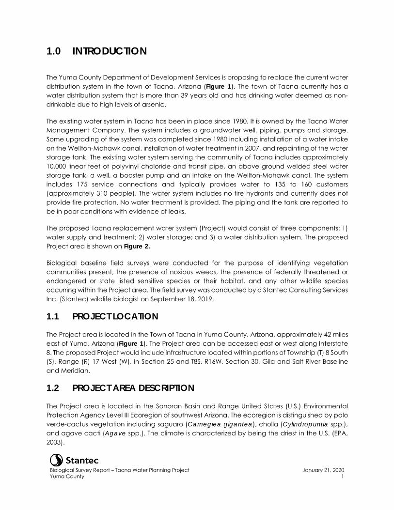
Biological Survey Report – Tacna Water Planning Project Yuma County
January 21, 2020 1
1.0 INTRODUCTION
The Yuma County Department of Development Services is proposing to replace the current water distribution system in the town of Tacna, Arizona (Figure 1). The town of Tacna currently has a water distribution system that is more than 39 years old and has drinking water deemed as non-drinkable due to high levels of arsenic.
The existing water system in Tacna has been in place since 1980. It is owned by the Tacna Water Management Company. The system includes a groundwater well, piping, pumps and storage. Some upgrading of the system was completed since 1980 including installation of a water intake on the Wellton-Mohawk canal, installation of water treatment in 2007, and repainting of the water storage tank. The existing water system serving the community of Tacna includes approximately 10,000 linear feet of polyvinyl choloride and transit pipe, an above ground welded steel water storage tank, a well, a booster pump and an intake on the Wellton-Mohawk canal. The system includes 175 service connections and typically provides water to 135 to 160 customers (approximately 310 people). The water system includes no fire hydrants and currently does not provide fire protection. No water treatment is provided. The piping and the tank are reported to be in poor conditions with evidence of leaks.
The proposed Tacna replacement water system (Project) would consist of three components: 1) water supply and treatment; 2) water storage; and 3) a water distribution system. The proposed Project area is shown on Figure 2.
Biological baseline field surveys were conducted for the purpose of identifying vegetation communities present, the presence of noxious weeds, the presence of federally threatened or endangered or state listed sensitive species or their habitat, and any other wildlife species occurring within the Project area. The field survey was conducted by a Stantec Consulting Services Inc. (Stantec) wildlife biologist on September 18, 2019.
1.1 PROJECT LOCATION
The Project area is located in the Town of Tacna in Yuma County, Arizona, approximately 42 miles east of Yuma, Arizona (Figure 1). The Project area can be accessed east or west along Interstate 8. The proposed Project would include infrastructure located within portions of Township (T) 8 South (S), Range (R) 17 West (W), in Section 25 and T8S, R16W, Section 30, Gila and Salt River Baseline and Meridian.
1.2 PROJECT AREA DESCRIPTION
The Project area is located in the Sonoran Basin and Range United States (U.S.) Environmental Protection Agency Level III Ecoregion of southwest Arizona. The ecoregion is distinguished by palo verde-cactus vegetation including saguaro (Carnegiea gigantea), cholla (Cylindropuntia spp.), and agave cacti (Agave spp.). The climate is characterized by being the driest in the U.S. (EPA, 2003).
Biological Survey Report – Tacna Water Planning Project Yuma County
January 21, 2020 2
Elevation within the Project area ranges from approximately 329 to 350 feet above mean sea level (amsl). Average precipitation is about 4.1 inches per year, with temperatures ranging from an average of 54 degrees Fahrenheit (°F) to 88°F (WRCC, 2005).
The Project area is within the Basin and Range Physiographic Province, Sonoran Desert subdivision, with approximately 20 percent mountains and 80 percent plains. The topography is characterized by mountain ranges that are roughly parallel. The basins between the ranges are relatively flat with gentle slopes next to the mountains that vary from hills and buttes up to mountains rising 4,000 feet amsl (Fenneman, 1931). The desert plains mostly lie below 2,000 feet amsl (Fenneman, 1931).
The Southwest Regional Gap Analysis Project (SWReGAP) data was used to gather vegetation community information for the Project area. The Project area is comprised of seven vegetation communities, with the Sonora-Mojave Creosote-White Bursage Desert Scrub community the dominant community type in the Project area (Figure 3).
The Sonora-Mojave Creosote-White Bursage Desert Scrub forms the vegetation matrix in broad valleys, lower bajadas, plains and low hills in the Mojave and lower Sonoran deserts. This desert scrub is characterized by a sparse to moderately dense layer (two to 50 percent cover) of xeromorphic microphyllous and broad-leaved shrubs. Creosote bush (Larrea tridentata) and Payne burrobush (Ambrosia dumosa) are typically dominants, but many different shrubs, dwarf-shrubs, and cacti may co-dominate or form typically sparse understories. Associated species may include: fourwing saltbush (Atriplex canescens), desert holly (Atriplex hymenelytra), brittlebush (Encelia farinosa), Nevada jointfir (Ephedra nevadensis), ocotillo (Fouquieria splendens), water jacket (Lycium andersonii), and beavertail cactus (Opuntia basilaris). The herbaceous layer is typically sparse, but may be seasonally abundant with ephemerals (USGS, 2005).
Biological Survey Report – Tacna Water Planning Project Yuma County
January 21, 2020 3
2.0 AGENCY CONSULTATION
Prior to performing the biological baseline surveys, Stantec contacted the U.S. Fish and Wildlife Service (USFWS) and Arizona Game and Fish Department (AZGFD) to request information regarding threatened and endangered and sensitive wildlife and vegetation species with the potential to occur in the Project area. Appendix A includes agency responses to those requests and a summary of each Agency’s response is provided below.
2.1 USFWS
The USFWS response letter identified four threatened, endangered, or candidate species with the potential to occur within the Project area.
2.1.1 Sonoran Pronghorn
Sonoran pronghorn (Antilocapra americana sonoriensis) are classified as endangered species by the USFWS and as a Species of Greatest Conservation Need (SGCN) in Arizona by the AZGFD (AZGFD, 2012). Sonoran pronghorn occupy desert plains and bajadas, and occasionally rocky hills and mountainous habitats. These animals are nomadic and require large expanses of land to survive as localized droughts are frequent and summer rains are sporadic. They must be able to move across the landscape during all seasons to locate areas with sufficient food and water. Sonoran pronghorn are very wary, capable of seeing long distances across the open desert, and flee the area when disturbed. No critical habitat has been identified for this species.
2.1.2 Southwestern Willow Flycatcher
The southwestern willow flycatcher (Empidonax trailii extimus) is classified as federally endangered by the USFWS and as a SGCN in Arizona by the AZGFD (AZGFD, 2012). The southwestern willow flycatcher nests in willows (Salix spp.) and other dense riparian vegetation along streams, rivers, lakes, and wetlands. Southwestern willow flycatchers are found along the lower Colorado River and tributaries where suitable dense stands of willow or salt cedar (Tamarix spp.) are adjacent to water or saturated soil. Critical habitat for this species has been designated but none occurs in the Project area. The nearest critical habitat occurs approximately 100 miles north of the Project area.
2.1.3 Yellow-billed Cuckoo
The western distinct population segment of the yellow-billed cuckoo (Coccyzus americanus) is classified as threatened by the USFWS and as a SGCN by the AZGFD (AZGFD, 2012). Western yellow-billed cuckoos are found during the summer in low to medium elevation deciduous riparian woodlands throughout much of western North America. They nest in relatively large patches of riparian woodlands (generally larger than 50 acres) that typically have a well-developed riparian overstory canopy and an understory of shrubs (Halterman et al., 2015 and USFWS, 2013). Critical habitat for this species has been proposed by the USFWS along a 139-mile-long section of the
Biological Survey Report – Tacna Water Planning Project Yuma County
January 21, 2020 4
Colorado River north of the border with Mexico (USFWS, 2013). The nearest critical habitat is approximately 0.7 mile northwest of the Project area along the Gila River, a tributary to the Colorado River.
2.1.4 Yuma Clapper Rail
The Yuma clapper rail (Rallus longirostris yumanensis) is listed as endangered by the USFWS and as a SGCN in Arizona by the AZGFD (AZGFD, 2012). Critical habitat has not been designated for this bird. Yuma clapper rails are generally found in freshwater and alkali marshes dominated by stands of emergent vegetation interspersed with areas of open water and drier, upland benches. This species prefers mature marsh stands along margins of shallow ponds with stable water levels. Nest sites selected by this species are near upland areas in shallow sites dominated by mature vegetation, often in the base of a shrub. Yuma clapper rails move into different cover types in winter, showing a preference for denser cover than in summer (USFWS, 2014).
2.2 AZGFD
In response to the request for data, the AZGFD’s response letter included results from a data search of a three-mile buffer around the Project area. Table 1 details the species identified by the AZGFD to potentially occur within the three-mile buffer of the Project.
Table 1 Special Status Wildlife Species with the Potential to Occur
Scientific Name Common Name Habitat
Amphibians
Incilius alvarius Sonoran Desert toad Central and southern Arizona within several miles of permanent or temporary water sources.
Lithobates yavapaiensis Lowland leopard frog
Inhabits aquatic systems in desert grasslands to pinyon-juniper. They are habitat generalists and breed in a variety of natural and man-made aquatic systems.
Reptiles
Heloderma suspectum Gila monster Prefers rocky areas in desert scrub and semi-desert grassland. Found in lower mountain slopes, rocky bajadas, canyon bottoms, and arroyos.
Birds
Melozone aberti Abert’s towhee
Low-elevation desert riparian and desert wash habitats. Habitat includes dense vegetation, including thickets of willow, cottonwood (Populus spp.), mesquite (Prosopis spp.), and salt cedar. Likely restricted to within and near xeroriparian washes with dense shrubs and agricultural areas within Project area.
Botaurus lentiginosus American bittern Marshlands and very wet meadows. Rarely seen away from dense reeds, rushes, cordgrass (Spartina spp.), cattails and other emergent vegetation.
Vireo bellii arizonae Arizona Bell’s vireo Desert riparian woodlands, primarily with dense willow or mesquite. Uncommon along lower Colorado River.
Biological Survey Report – Tacna Water Planning Project Yuma County
January 21, 2020 5
Scientific Name Common Name Habitat
Haliaeetus leucocephalus Bald eagle
Coasts, rivers, and large lakes. Open country and mountains during migration. Migrant and winter resident along lower Colorado River.
Spizella breweri Brewer’s sparrow Sagebrush, brushy plains; in winter, also weedy fields. In summer typically in open flats covered with sagebrush; sometimes in stands of saltbush.
Calypte costae Costa’s hummingbird Occurs in desert scrub in the Sonoran and Mojave Deserts, and chaparral and sage scrub areas in coastal California.
Buteo regalis Ferruginous hawk Plains and prairies throughout western North America. In southwestern Arizona, migrant and winter resident primarily near cultivated fields.
Melanerpes uropygialis Gila woodpecker Upper Sonoran Desert in areas with stands of saguaro, riparian woodlands, and suburban areas.
Colaptes chrysoides Gilded flicker Upper Sonoran Desert in areas with stands of saguaro, riparian woodlands, and suburban areas.
Toxostoma lecontei LeConte’s thrasher Flat desert areas with sparse vegetation, especially saltbush flats.
Melospiza lincolnii Lincoln’s sparrow Winters in the southern United States in brushes and weedy habitats.
Oerothlypis luciae Lucy’s warbler
Mesquite along desert streams and washes; willows, cottonwoods. Breeds mostly in cottonwood-mesquite woods near desert streams or in open groves of mesquite along dry washes in the Sonoran Desert.
Cistothorus palustris Marsh wren
Marsh wrens occupy wetlands filled with cattails, sedges, bulrushes, and Phragmites. In the winter they also use brushy thickets near wetlands, tidal saltmarshes, and weedy agricultural canals.
Charadrius montanus Mountain plover Winters in semiarid plains and flats in the southwestern United States. Uncommon or rare along lower Colorado River.
Troglodytes pacificus Pacific wren Found in mixed forests near streams. During the nonbreeding season, may use more types of habitat including parks and gardens.
Sphyrapicus nuchalis Red-naped sapsucker
They tend to avoid oak or pine-oak forests during the breeding season, but use them during migration and winter, along with orchards and woodlands near streams
Passerculus sandwichensis Savannah sparrow
Live in grasslands with few trees, including meadows, pastures, grassy roadsides, sedge wetlands, and cultivated fields planted with cover crops like alfalfa.
Anthus spragueii Sprague’s pipit
On wintering grounds in Mexico and border areas of the southern U.S., they use both native and non-native grasslands with limited shrub cover, including some shortgrass environments, even occasionally athletic fields and heavily grazed pastures.
Rallus limicola Virginia rail Occupy shallow freshwater wetlands with tall stands of cattails and rushes.
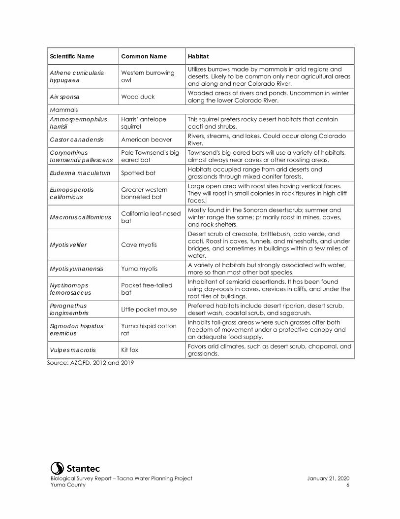
Biological Survey Report – Tacna Water Planning Project Yuma County
January 21, 2020 6
Scientific Name Common Name Habitat
Athene cunicularia hypugaea
Western burrowing owl
Utilizes burrows made by mammals in arid regions and deserts. Likely to be common only near agricultural areas and along and near Colorado River.
Aix sponsa Wood duck Wooded areas of rivers and ponds. Uncommon in winter along the lower Colorado River.
Mammals Ammospermophilus harrisii
Harris’ antelope squirrel
This squirrel prefers rocky desert habitats that contain cacti and shrubs.
Castor canadensis American beaver Rivers, streams, and lakes. Could occur along Colorado River.
Corynorhinus townsendii pallescens
Pale Townsend’s big-eared bat
Townsend's big-eared bats will use a variety of habitats, almost always near caves or other roosting areas.
Euderma maculatum Spotted bat Habitats occupied range from arid deserts and grasslands through mixed conifer forests.
Eumops perotis californicus
Greater western bonneted bat
Large open area with roost sites having vertical faces. They will roost in small colonies in rock fissures in high cliff faces.
Macrotus californicus California leaf-nosed bat
Mostly found in the Sonoran desertscrub; summer and winter range the same; primarily roost in mines, caves, and rock shelters.
Myotis velifer Cave myotis
Desert scrub of creosote, brittlebush, palo verde, and cacti. Roost in caves, tunnels, and mineshafts, and under bridges, and sometimes in buildings within a few miles of water.
Myotis yumanensis Yuma myotis A variety of habitats but strongly associated with water, more so than most other bat species.
Nyctinomops femorosaccus
Pocket free-tailed bat
Inhabitant of semiarid desertlands. It has been found using day-roosts in caves, crevices in cliffs, and under the roof tiles of buildings.
Perognathus longimembris Little pocket mouse Preferred habitats include desert riparian, desert scrub,
desert wash, coastal scrub, and sagebrush.
Sigmodon hispidus eremicus
Yuma hispid cotton rat
Inhabits tall-grass areas where such grasses offer both freedom of movement under a protective canopy and an adequate food supply.
Vulpes macrotis Kit fox Favors arid climates, such as desert scrub, chaparral, and grasslands.
Source: AZGFD, 2012 and 2019
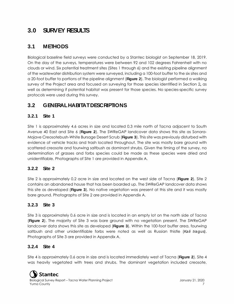
Biological Survey Report – Tacna Water Planning Project Yuma County
January 21, 2020 7
3.0 SURVEY RESULTS
3.1 METHODS
Biological baseline field surveys were conducted by a Stantec biologist on September 18, 2019. On the day of the surveys, temperatures were between 92 and 102 degrees Fahrenheit with no clouds or wind. Six potential treatment sites (Sites 1 through 6) and the existing pipeline alignment of the wastewater distribution system were surveyed, including a 100-foot buffer to the six sites and a 20-foot buffer to portions of the pipeline alignment (Figure 2). The biologist performed a walking survey of the Project area and focused on surveying for those species identified in Section 2, as well as determining if potential habitat was present for those species. No species-specific survey protocols were used during this survey.
3.2 GENERAL HABITAT DESCRIPTIONS
3.2.1 Site 1
Site 1 is approximately 4.6 acres in size and located 0.3 mile north of Tacna adjacent to South Avenue 40 East and Site 6 (Figure 2). The SWReGAP landcover data shows this site as Sonora-Mojave Creosotebush-White Bursage Desert Scrub (Figure 3). This site was previously disturbed with evidence of vehicle tracks and trash located throughout. The site was mostly bare ground with scattered creosote and fourwing saltbush as dominant shrubs. Given the timing of the survey, no determination of grasses and forbs species could be made as these species were dried and unidentifiable. Photographs of Site 1 are provided in Appendix A.
3.2.2 Site 2
Site 2 is approximately 0.2 acre in size and located on the west side of Tacna (Figure 2). Site 2 contains an abandoned house that has been boarded up. The SWReGAP landcover data shows this site as developed (Figure 3). No native vegetation was present at this site and it was mostly bare ground. Photographs of Site 2 are provided in Appendix A.
3.2.3 Site 3
Site 3 is approximately 0.6 acre in size and is located in an empty lot on the north side of Tacna (Figure 2). The majority of Site 3 was bare ground with no vegetation present. The SWReGAP landcover data shows this site as developed (Figure 3). Within the 100-foot buffer area, fourwing saltbush and other unidentifiable forbs were noted as well as Russian thistle (Kali tragus). Photographs of Site 3 are provided in Appendix A.
3.2.4 Site 4
Site 4 is approximately 0.6 acre in size and is located immediately west of Tacna (Figure 2). Site 4 was heavily vegetated with trees and shrubs. The dominant vegetation included creosote,
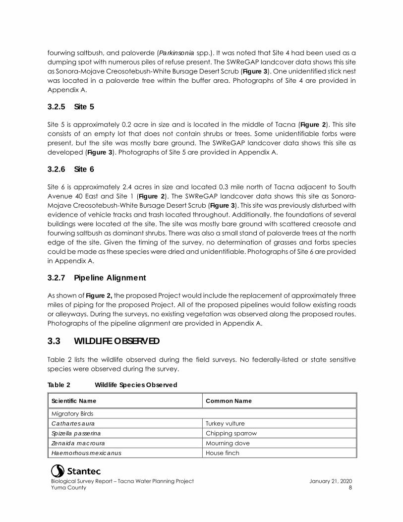
Biological Survey Report – Tacna Water Planning Project Yuma County
January 21, 2020 8
fourwing saltbush, and paloverde (Parkinsonia spp.). It was noted that Site 4 had been used as a dumping spot with numerous piles of refuse present. The SWReGAP landcover data shows this site as Sonora-Mojave Creosotebush-White Bursage Desert Scrub (Figure 3). One unidentified stick nest was located in a paloverde tree within the buffer area. Photographs of Site 4 are provided in Appendix A.
3.2.5 Site 5
Site 5 is approximately 0.2 acre in size and is located in the middle of Tacna (Figure 2). This site consists of an empty lot that does not contain shrubs or trees. Some unidentifiable forbs were present, but the site was mostly bare ground. The SWReGAP landcover data shows this site as developed (Figure 3). Photographs of Site 5 are provided in Appendix A.
3.2.6 Site 6
Site 6 is approximately 2.4 acres in size and located 0.3 mile north of Tacna adjacent to South Avenue 40 East and Site 1 (Figure 2). The SWReGAP landcover data shows this site as Sonora-Mojave Creosotebush-White Bursage Desert Scrub (Figure 3). This site was previously disturbed with evidence of vehicle tracks and trash located throughout. Additionally, the foundations of several buildings were located at the site. The site was mostly bare ground with scattered creosote and fourwing saltbush as dominant shrubs. There was also a small stand of paloverde trees at the north edge of the site. Given the timing of the survey, no determination of grasses and forbs species could be made as these species were dried and unidentifiable. Photographs of Site 6 are provided in Appendix A.
3.2.7 Pipeline Alignment
As shown of Figure 2, the proposed Project would include the replacement of approximately three miles of piping for the proposed Project. All of the proposed pipelines would follow existing roads or alleyways. During the surveys, no existing vegetation was observed along the proposed routes. Photographs of the pipeline alignment are provided in Appendix A.
3.3 WILDLIFE OBSERVED
Table 2 lists the wildlife observed during the field surveys. No federally-listed or state sensitive species were observed during the survey.
Table 2 Wildlife Species Observed
Scientific Name Common Name
Migratory Birds Cathartes aura Turkey vulture Spizella passerina Chipping sparrow Zenaida macroura Mourning dove Haemorhous mexicanus House finch
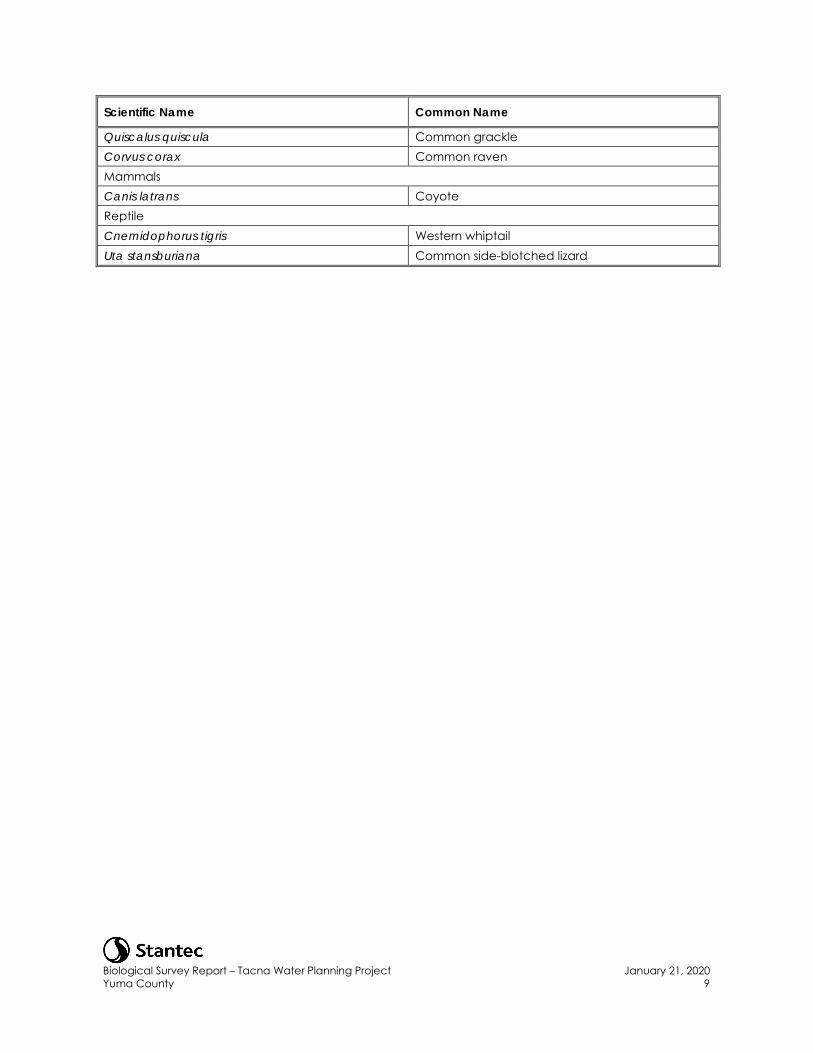
Biological Survey Report – Tacna Water Planning Project Yuma County
January 21, 2020 9
Scientific Name Common Name
Quiscalus quiscula Common grackle Corvus corax Common raven Mammals Canis latrans Coyote Reptile Cnemidophorus tigris Western whiptail Uta stansburiana Common side-blotched lizard
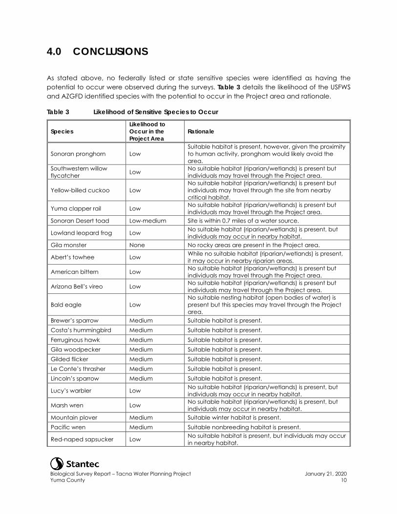
Biological Survey Report – Tacna Water Planning Project Yuma County
January 21, 2020 10
4.0 CONCLUSIONS
As stated above, no federally listed or state sensitive species were identified as having the potential to occur were observed during the surveys. Table 3 details the likelihood of the USFWS and AZGFD identified species with the potential to occur in the Project area and rationale.
Table 3 Likelihood of Sensitive Species to Occur
Species Likelihood to Occur in the Project Area
Rationale
Sonoran pronghorn Low Suitable habitat is present, however, given the proximity to human activity, pronghorn would likely avoid the area.
Southwestern willow flycatcher Low No suitable habitat (riparian/wetlands) is present but
individuals may travel through the Project area.
Yellow-billed cuckoo Low No suitable habitat (riparian/wetlands) is present but individuals may travel through the site from nearby critical habitat.
Yuma clapper rail Low No suitable habitat (riparian/wetlands) is present but individuals may travel through the Project area.
Sonoran Desert toad Low-medium Site is within 0.7 miles of a water source.
Lowland leopard frog Low No suitable habitat (riparian/wetlands) is present, but individuals may occur in nearby habitat.
Gila monster None No rocky areas are present in the Project area.
Abert’s towhee Low While no suitable habitat (riparian/wetlands) is present, it may occur in nearby riparian areas.
American bittern Low No suitable habitat (riparian/wetlands) is present but individuals may travel through the Project area.
Arizona Bell’s vireo Low No suitable habitat (riparian/wetlands) is present but individuals may travel through the Project area.
Bald eagle Low No suitable nesting habitat (open bodies of water) is present but this species may travel through the Project area.
Brewer’s sparrow Medium Suitable habitat is present. Costa’s hummingbird Medium Suitable habitat is present. Ferruginous hawk Medium Suitable habitat is present. Gila woodpecker Medium Suitable habitat is present. Gilded flicker Medium Suitable habitat is present. Le Conte’s thrasher Medium Suitable habitat is present. Lincoln’s sparrow Medium Suitable habitat is present.
Lucy’s warbler Low No suitable habitat (riparian/wetlands) is present, but individuals may occur in nearby habitat.
Marsh wren Low No suitable habitat (riparian/wetlands) is present, but individuals may occur in nearby habitat.
Mountain plover Medium Suitable winter habitat is present. Pacific wren Medium Suitable nonbreeding habitat is present.
Red-naped sapsucker Low No suitable habitat is present, but individuals may occur in nearby habitat.
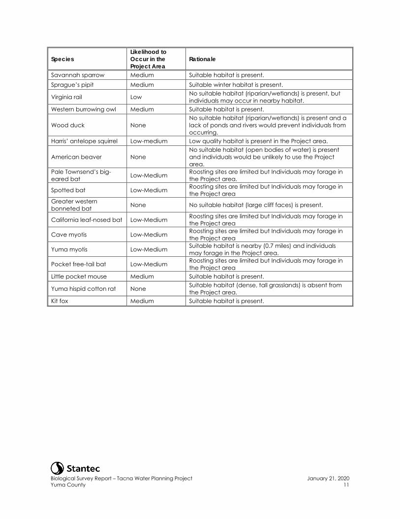
Biological Survey Report – Tacna Water Planning Project Yuma County
January 21, 2020 11
Species Likelihood to Occur in the Project Area
Rationale
Savannah sparrow Medium Suitable habitat is present. Sprague’s pipit Medium Suitable winter habitat is present.
Virginia rail Low No suitable habitat (riparian/wetlands) is present, but individuals may occur in nearby habitat.
Western burrowing owl Medium Suitable habitat is present.
Wood duck None No suitable habitat (riparian/wetlands) is present and a lack of ponds and rivers would prevent individuals from occurring.
Harris’ antelope squirrel Low-medium Low quality habitat is present in the Project area.
American beaver None No suitable habitat (open bodies of water) is present and individuals would be unlikely to use the Project area.
Pale Townsend’s big-eared bat Low-Medium Roosting sites are limited but Individuals may forage in
the Project area.
Spotted bat Low-Medium Roosting sites are limited but Individuals may forage in the Project area
Greater western bonneted bat None No suitable habitat (large cliff faces) is present.
California leaf-nosed bat Low-Medium Roosting sites are limited but Individuals may forage in the Project area
Cave myotis Low-Medium Roosting sites are limited but Individuals may forage in the Project area
Yuma myotis Low-Medium Suitable habitat is nearby (0.7 miles) and individuals may forage in the Project area.
Pocket free-tail bat Low-Medium Roosting sites are limited but Individuals may forage in the Project area
Little pocket mouse Medium Suitable habitat is present.
Yuma hispid cotton rat None Suitable habitat (dense, tall grasslands) is absent from the Project area.
Kit fox Medium Suitable habitat is present.
Biological Survey Report – Tacna Water Planning Project Yuma County
January 21, 2020 12
5.0 REFERENCES
Arizona Game and Fish Department (AZGFD). 2019. Status Definitions. Accessed November 2019 online at: https://www.azgfd.com/wildlife/planning/wildlifeguidelines/statusdefinitions/.
Arizona Game and Fish Department (AZGFD). 2012. Arizona’s State Wildlife Action Plan: 2012-2022. Accessed November 2019 online at: https://s3.amazonaws.com/azgfd-portal-wordpress/PortalImages/files/wildlife/2012-2022_Arizona_State_Wildlife_Action_Plan.pdf.
Fenneman, Nevin M. 1931. Physiography of Western United States. London: McGraw Hill.
Halterman, M., M.J. Johnson, J.A. Holmes and S.A. Laymon. 2015. A Natural History Summary and Survey Protocol for the Western Distinct Population Segment of the Yellow-billed Cuckoo: U.S. Fish and Wildlife Techniques and Methods, 45 p.
United States Environmental Protection Agency (EPA). 2013. Level III ecoregions of the continental United States: Corvallis, Oregon, U.S. EPA – National Health and Environmental Effects Research Laboratory, map scale 1:7,500,000. https://www.epa.gov/eco-research/level-iii-and-iv-ecoregions-continental-united-states.
United States Fish and Wildlife Service (USFWS). 2013. Proposed Threatened Status for the Western Distinct Population Segment of the Yellow-billed Cuckoo (Coccyzus americanus). Federal Register 78: 78321-78322.
United States Fish and Wildlife Service (USFWS). 2014. Yuma Clapper Rail Information. https://www.fws.gov/nevada/protected_species/birds/species/yucr.html. Accessed on September 23, 2019.
United States Geological Survey National Gap Analysis Program (USGS). 2005. Southwest Regional GAP Analysis Project—Land Cover Descriptions. RS/GIS Laboratory, College of Natural Resources, Utah State University. https://rsgis-swregap.s3-us-west-2.amazonaws.com/public/docs/swgap_legend_desc.pdf.
Western Region Climate Center. (WRCC). 2005. Tacna, Arizona Period of Record Monthly Climate Summary. Accessed September 2019 online at: http://www.wrcc.dri.edu.

FIGURES
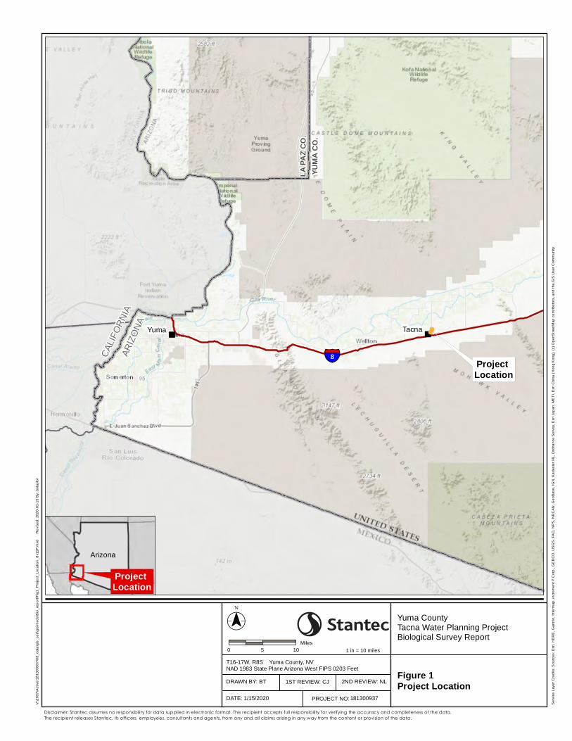
""
§̈¦8CALI
FORN
IAAR
IZO
NA
LA PA
Z CO.
YUMA
CO.
TacnaYuma
($$¯0 5 10
Miles
Yuma CountyTacna Water Planning ProjectBiological Survey Report
T16-17W, R8S Yuma County, NVNAD 1983 State Plane Arizona West FIPS 0203 Feet
V:\2
037\
Act
ive\
1813
0093
7\03
_dat
a\gi
s_ca
d\gi
s\m
xds\
Bio
_rep
ort\F
ig1_
Pro
ject
_Loc
atio
n_8x
11P.
mxd
Rev
ised
: 202
0-01
-15
By:
bot
aylo
r
Disclaimer: Stantec assumes no responsibility for data supplied in electronic format. The recipient accepts full responsibility for verifying the accuracy and completeness of the data. The recipient releases Stantec, its officers, employees, consultants and agents, from any and all claims arising in any way from the content or provision of the data.
Figure 1Project Location
1 in = 10 miles
181300937
1ST REVIEW: CJDRAWN BY: BT 2ND REVIEW: NL
DATE: 1/15/2020
Ser
vice
Lay
er C
redi
ts: S
ourc
es: E
sri,
HE
RE
, Gar
min
, Int
erm
ap, i
ncre
men
t P C
orp.
, GE
BC
O, U
SG
S, F
AO
, NP
S, N
RC
AN
, Geo
Bas
e, IG
N, K
adas
ter N
L, O
rdna
nce
Sur
vey,
Esr
i Jap
an, M
ETI
, Esr
i Chi
na (H
ong
Kon
g), (
c) O
penS
tree
tMap
con
tribu
tors
, and
the
GIS
Use
r Com
mun
ity
PROJECT NO:
Arizona
Project Location
Project Location
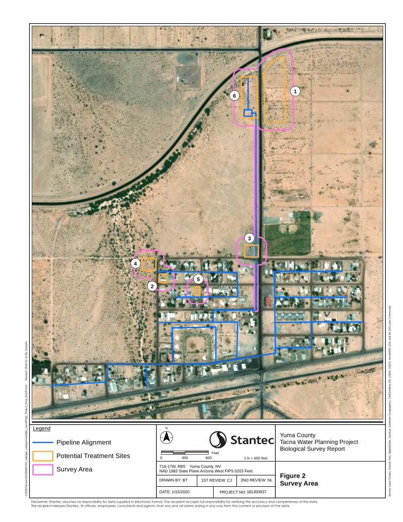
¬«1
¬«4
¬«2
¬«3
¬«5
¬«6
($$¯0 300 600
Feet
Yuma CountyTacna Water Planning ProjectBiological Survey Report
T16-17W, R8S Yuma County, NVNAD 1983 State Plane Arizona West FIPS 0203 Feet
V:\2
037\
Act
ive\
1813
0093
7\03
_dat
a\gi
s_ca
d\gi
s\m
xds\
Bio
_rep
ort\F
ig2_
Pro
ject
_Are
a_8x
11P.
mxd
Rev
ised
: 202
0-01
-15
By:
bot
aylo
r
Disclaimer: Stantec assumes no responsibility for data supplied in electronic format. The recipient accepts full responsibility for verifying the accuracy and completeness of the data. The recipient releases Stantec, its officers, employees, consultants and agents, from any and all claims arising in any way from the content or provision of the data.
Figure 2Survey Area
1 in = 600 feet
181300937
Legend
Pipeline Alignment
Potential Treatment Sites
Survey Area1ST REVIEW: CJDRAWN BY: BT 2ND REVIEW: NL
DATE: 1/15/2020
Ser
vice
Lay
er C
redi
ts: S
ourc
e: E
sri,
Dig
italG
lobe
, Geo
Eye
, Ear
thst
ar G
eogr
aphi
cs, C
NE
S/A
irbus
DS
, US
DA
, US
GS
, Aer
oGR
ID, I
GN
, and
the
GIS
Use
r Com
mun
ity
PROJECT NO:
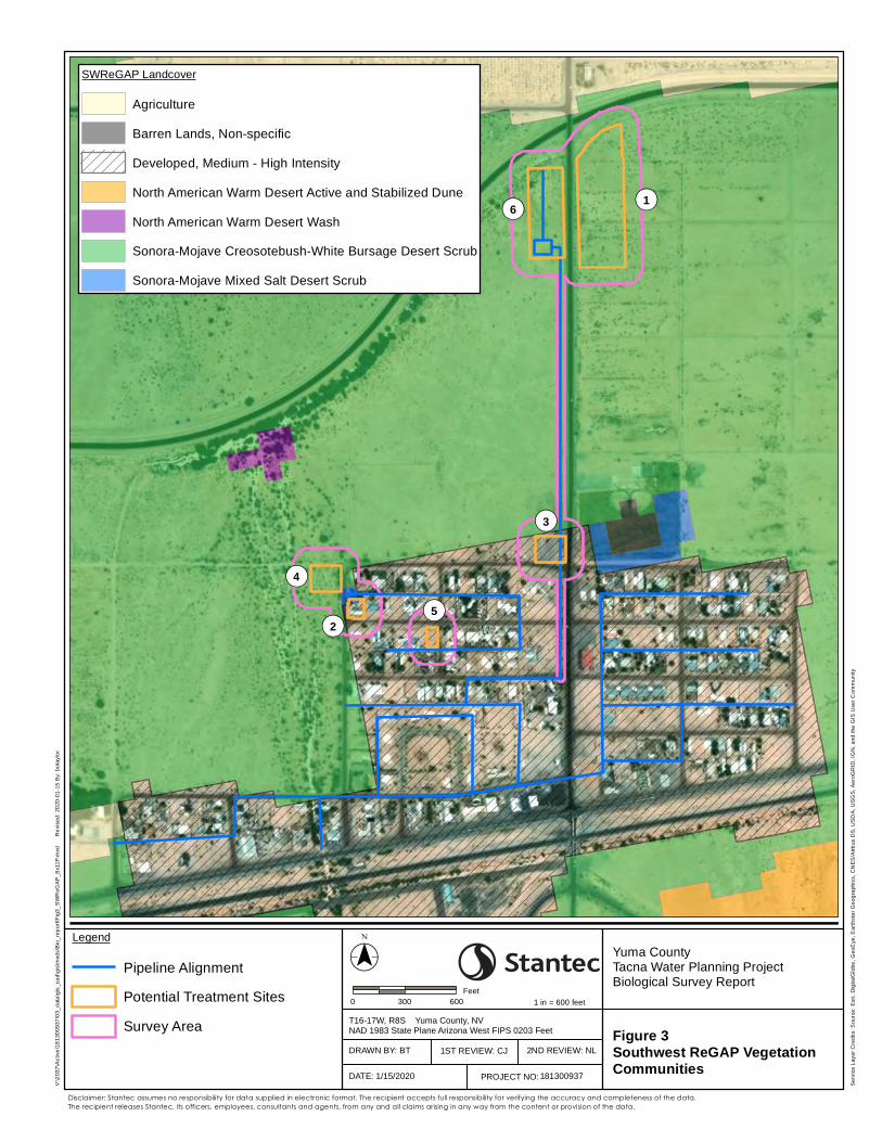
¬«1
¬«4
¬«2
¬«3
¬«5
¬«6
($$¯0 300 600
Feet
Yuma CountyTacna Water Planning ProjectBiological Survey Report
T16-17W, R8S Yuma County, NVNAD 1983 State Plane Arizona West FIPS 0203 Feet
V:\2
037\
Act
ive\
1813
0093
7\03
_dat
a\gi
s_ca
d\gi
s\m
xds\
Bio
_rep
ort\F
ig3_
SW
ReG
AP
_8x1
1P.m
xd
R
evis
ed: 2
020-
01-1
5 B
y: b
otay
lor
Disclaimer: Stantec assumes no responsibility for data supplied in electronic format. The recipient accepts full responsibility for verifying the accuracy and completeness of the data. The recipient releases Stantec, its officers, employees, consultants and agents, from any and all claims arising in any way from the content or provision of the data.
Figure 3Southwest ReGAP VegetationCommunities
1 in = 600 feet
181300937
Legend
Pipeline Alignment
Potential Treatment Sites
Survey Area1ST REVIEW: CJDRAWN BY: BT 2ND REVIEW: NL
DATE: 1/15/2020
Ser
vice
Lay
er C
redi
ts: S
ourc
e: E
sri,
Dig
italG
lobe
, Geo
Eye
, Ear
thst
ar G
eogr
aphi
cs, C
NE
S/A
irbus
DS
, US
DA
, US
GS
, Aer
oGR
ID, I
GN
, and
the
GIS
Use
r Com
mun
ity
PROJECT NO:
SWReGAP Landcover
Agriculture
Barren Lands, Non-specific
Developed, Medium - High Intensity
North American Warm Desert Active and Stabilized Dune
North American Warm Desert Wash
Sonora-Mojave Creosotebush-White Bursage Desert Scrub
Sonora-Mojave Mixed Salt Desert Scrub
Appendix A
AGENCY CORRESPONDENCE
Arizona Environmental Online Review Tool Report
Arizona Game and Fish Department MissionTo conserve Arizona's diverse wildlife resources and manage for safe, compatible outdoor recreation
opportunities for current and future generations.
Project Name:Tacna Water System Replacement
Project Description:The proposed Tacna replacement water system (Project) would consist of three components : 1) water
supply and treatment; 2) water storage; and 3) a water distribution system.
Project Type:Water Use, Transfer, and Channel Activities, Water delivery and supply line or effluent delivery line
(operated by municipality or water company), New lines or expansion of existing lines
Contact Person:Kim Carter
Organization:Stantec
On Behalf Of:YUMA
Project ID:HGIS-09705
Please review the entire report for project type and/or species recommendations for the locationinformation entered. Please retain a copy for future reference.
Page 1 of 10
Arizona Game and Fish Department project_report_tacna_water_system_replacem_32595_33629.pdfProject ID: HGIS-09705 Review Date: 9/9/2019 12:59:00 PM
Disclaimer:
1. This Environmental Review is based on the project study area that was entered. The report must beupdated if the project study area, location, or the type of project changes.
2. This is a preliminary environmental screening tool. It is not a substitute for the potential knowledgegained by having a biologist conduct a field survey of the project area. This review is also not intended toreplace environmental consultation (including federal consultation under the Endangered Species Act),land use permitting, or the Departments review of site-specific projects.
3. The Departments Heritage Data Management System (HDMS) data is not intended to include potentialdistribution of special status species. Arizona is large and diverse with plants, animals, andenvironmental conditions that are ever changing. Consequently, many areas may contain species thatbiologists do not know about or species previously noted in a particular area may no longer occur there.HDMS data contains information about species occurrences that have actually been reported to theDepartment. Not all of Arizona has been surveyed for special status species, and surveys that have beenconducted have varied greatly in scope and intensity. Such surveys may reveal previouslyundocumented population of species of special concern.
4. HabiMap Arizona data, specifically Species of Greatest Conservation Need (SGCN) under our StateWildlife Action Plan (SWAP) and Species of Economic and Recreational Importance (SERI), representpotential species distribution models for the State of Arizona which are subject to ongoing change,modification and refinement. The status of a wildlife resource can change quickly, and the availability ofnew data will necessitate a refined assessment.
Locations Accuracy Disclaimer:Project locations are assumed to be both precise and accurate for the purposes of environmental review. Thecreator/owner of the Project Review Report is solely responsible for the project location and thus the correctnessof the Project Review Report content.
Page 2 of 10
Arizona Game and Fish Department project_report_tacna_water_system_replacem_32595_33629.pdfProject ID: HGIS-09705 Review Date: 9/9/2019 12:59:00 PM
Recommendations Disclaimer:
1. The Department is interested in the conservation of all fish and wildlife resources, including thosespecies listed in this report and those that may have not been documented within the project vicinity aswell as other game and nongame wildlife.
2. Recommendations have been made by the Department, under authority of Arizona Revised StatutesTitle 5 (Amusements and Sports), 17 (Game and Fish), and 28 (Transportation).
3. Potential impacts to fish and wildlife resources may be minimized or avoided by the recommendationsgenerated from information submitted for your proposed project. These recommendations are preliminaryin scope, designed to provide early considerations on all species of wildlife.
4. Making this information directly available does not substitute for the Department's review of projectproposals, and should not decrease our opportunity to review and evaluate additional project informationand/or new project proposals.
5. Further coordination with the Department requires the submittal of this Environmental Review Report witha cover letter and project plans or documentation that includes project narrative, acreage to be impacted,how construction or project activity(s) are to be accomplished, and project locality information (includingsite map). Once AGFD had received the information, please allow 30 days for completion of projectreviews. Send requests to:Project Evaluation Program, Habitat BranchArizona Game and Fish Department5000 West Carefree HighwayPhoenix, Arizona 85086-5000Phone Number: (623) 236-7600Fax Number: (623) [email protected]
6. Coordination may also be necessary under the National Environmental Policy Act (NEPA) and/orEndangered Species Act (ESA). Site specific recommendations may be proposed during furtherNEPA/ESA analysis or through coordination with affected agencies
Page 3 of 10
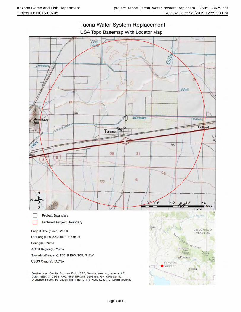
Arizona Game and Fish Department project_report_tacna_water_system_replacem_32595_33629.pdfProject ID: HGIS-09705 Review Date: 9/9/2019 12:59:00 PM
Page 4 of 10
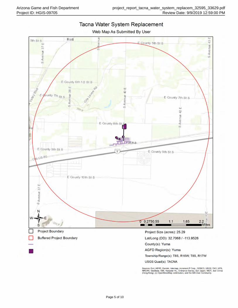
Arizona Game and Fish Department project_report_tacna_water_system_replacem_32595_33629.pdfProject ID: HGIS-09705 Review Date: 9/9/2019 12:59:00 PM
Page 5 of 10
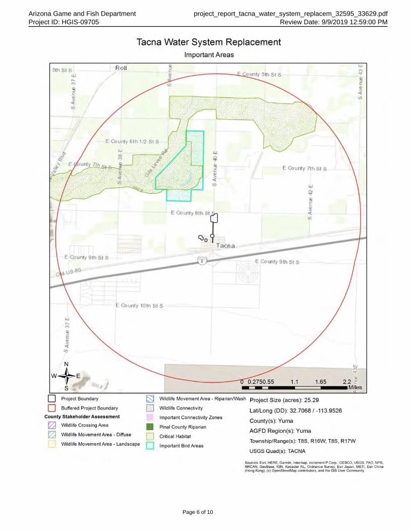
Arizona Game and Fish Department project_report_tacna_water_system_replacem_32595_33629.pdfProject ID: HGIS-09705 Review Date: 9/9/2019 12:59:00 PM
Page 6 of 10
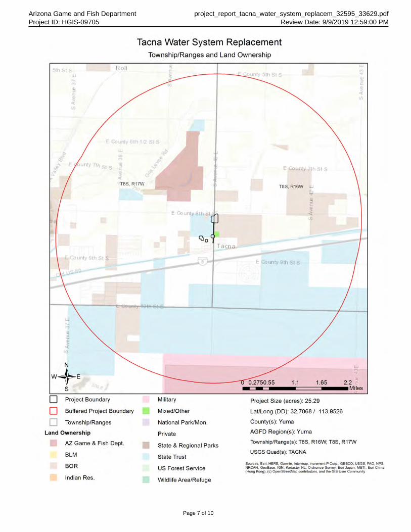
Arizona Game and Fish Department project_report_tacna_water_system_replacem_32595_33629.pdfProject ID: HGIS-09705 Review Date: 9/9/2019 12:59:00 PM
Page 7 of 10
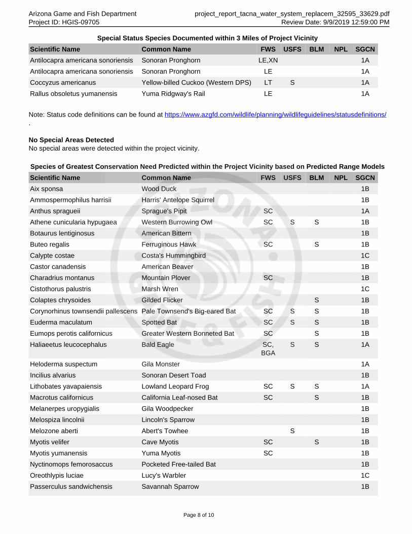
Arizona Game and Fish Department project_report_tacna_water_system_replacem_32595_33629.pdfProject ID: HGIS-09705 Review Date: 9/9/2019 12:59:00 PM
Special Status Species Documented within 3 Miles of Project Vicinity
Scientific Name Common Name FWS USFS BLM NPL SGCN
Antilocapra americana sonoriensis Sonoran Pronghorn LE,XN 1A
Antilocapra americana sonoriensis Sonoran Pronghorn LE 1A
Coccyzus americanus Yellow-billed Cuckoo (Western DPS) LT S 1A
Rallus obsoletus yumanensis Yuma Ridgway's Rail LE 1A
Note: Status code definitions can be found at https://www.azgfd.com/wildlife/planning/wildlifeguidelines/statusdefinitions/.
No Special Areas DetectedNo special areas were detected within the project vicinity.
Species of Greatest Conservation Need Predicted within the Project Vicinity based on Predicted Range Models
Scientific Name Common Name FWS USFS BLM NPL SGCN
Aix sponsa Wood Duck 1B
Ammospermophilus harrisii Harris' Antelope Squirrel 1B
Anthus spragueii Sprague's Pipit SC 1A
Athene cunicularia hypugaea Western Burrowing Owl SC S S 1B
Botaurus lentiginosus American Bittern 1B
Buteo regalis Ferruginous Hawk SC S 1B
Calypte costae Costa's Hummingbird 1C
Castor canadensis American Beaver 1B
Charadrius montanus Mountain Plover SC 1B
Cistothorus palustris Marsh Wren 1C
Colaptes chrysoides Gilded Flicker S 1B
Corynorhinus townsendii pallescens Pale Townsend's Big-eared Bat SC S S 1B
Euderma maculatum Spotted Bat SC S S 1B
Eumops perotis californicus Greater Western Bonneted Bat SC S 1B
Haliaeetus leucocephalus Bald Eagle SC,BGA
S S 1A
Heloderma suspectum Gila Monster 1A
Incilius alvarius Sonoran Desert Toad 1B
Lithobates yavapaiensis Lowland Leopard Frog SC S S 1A
Macrotus californicus California Leaf-nosed Bat SC S 1B
Melanerpes uropygialis Gila Woodpecker 1B
Melospiza lincolnii Lincoln's Sparrow 1B
Melozone aberti Abert's Towhee S 1B
Myotis velifer Cave Myotis SC S 1B
Myotis yumanensis Yuma Myotis SC 1B
Nyctinomops femorosaccus Pocketed Free-tailed Bat 1B
Oreothlypis luciae Lucy's Warbler 1C
Passerculus sandwichensis Savannah Sparrow 1B
Page 8 of 10
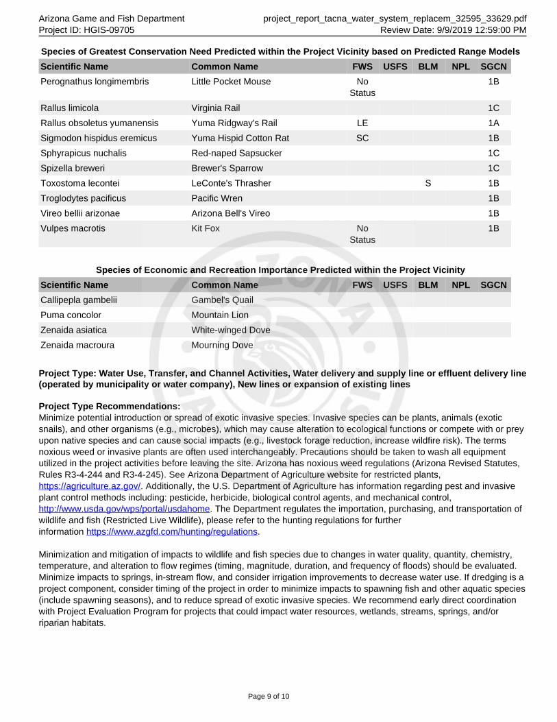
Arizona Game and Fish Department project_report_tacna_water_system_replacem_32595_33629.pdfProject ID: HGIS-09705 Review Date: 9/9/2019 12:59:00 PM
Species of Greatest Conservation Need Predicted within the Project Vicinity based on Predicted Range Models
Scientific Name Common Name FWS USFS BLM NPL SGCN
Perognathus longimembris Little Pocket Mouse NoStatus
1B
Rallus limicola Virginia Rail 1C
Rallus obsoletus yumanensis Yuma Ridgway's Rail LE 1A
Sigmodon hispidus eremicus Yuma Hispid Cotton Rat SC 1B
Sphyrapicus nuchalis Red-naped Sapsucker 1C
Spizella breweri Brewer's Sparrow 1C
Toxostoma lecontei LeConte's Thrasher S 1B
Troglodytes pacificus Pacific Wren 1B
Vireo bellii arizonae Arizona Bell's Vireo 1B
Vulpes macrotis Kit Fox NoStatus
1B
Species of Economic and Recreation Importance Predicted within the Project Vicinity
Scientific Name Common Name FWS USFS BLM NPL SGCN
Callipepla gambelii Gambel's Quail
Puma concolor Mountain Lion
Zenaida asiatica White-winged Dove
Zenaida macroura Mourning Dove
Project Type: Water Use, Transfer, and Channel Activities, Water delivery and supply line or effluent delivery line(operated by municipality or water company), New lines or expansion of existing lines
Project Type Recommendations:Minimize potential introduction or spread of exotic invasive species. Invasive species can be plants, animals (exoticsnails), and other organisms (e.g., microbes), which may cause alteration to ecological functions or compete with or preyupon native species and can cause social impacts (e.g., livestock forage reduction, increase wildfire risk). The termsnoxious weed or invasive plants are often used interchangeably. Precautions should be taken to wash all equipmentutilized in the project activities before leaving the site. Arizona has noxious weed regulations (Arizona Revised Statutes,Rules R3-4-244 and R3-4-245). See Arizona Department of Agriculture website for restricted plants, https://agriculture.az.gov/. Additionally, the U.S. Department of Agriculture has information regarding pest and invasiveplant control methods including: pesticide, herbicide, biological control agents, and mechanical control, http://www.usda.gov/wps/portal/usdahome. The Department regulates the importation, purchasing, and transportation ofwildlife and fish (Restricted Live Wildlife), please refer to the hunting regulations for furtherinformation https://www.azgfd.com/hunting/regulations.
Minimization and mitigation of impacts to wildlife and fish species due to changes in water quality, quantity, chemistry,temperature, and alteration to flow regimes (timing, magnitude, duration, and frequency of floods) should be evaluated.Minimize impacts to springs, in-stream flow, and consider irrigation improvements to decrease water use. If dredging is aproject component, consider timing of the project in order to minimize impacts to spawning fish and other aquatic species(include spawning seasons), and to reduce spread of exotic invasive species. We recommend early direct coordinationwith Project Evaluation Program for projects that could impact water resources, wetlands, streams, springs, and/orriparian habitats.
Page 9 of 10
Arizona Game and Fish Department project_report_tacna_water_system_replacem_32595_33629.pdfProject ID: HGIS-09705 Review Date: 9/9/2019 12:59:00 PM
The Department recommends that wildlife surveys are conducted to determine if noise-sensitive species occur within theproject area. Avoidance or minimization measures could include conducting project activities outside of breedingseasons.
Based on the project type entered, coordination with State Historic Preservation Office may be required(http://azstateparks.com/SHPO/index.html).
Trenches should be covered or back-filled as soon as possible. Incorporate escape ramps in ditches or fencing along theperimeter to deter small mammals and herptefauna (snakes, lizards, tortoise) from entering ditches.
Based on the project type entered, coordination with Arizona Department of Environmental Quality may be required(http://www.azdeq.gov/).
Vegetation restoration projects (including treatments of invasive or exotic species) should have a completed site-evaluation plan (identifying environmental conditions necessary to re-establish native vegetation), a revegetation plan(species, density, method of establishment), a short and long-term monitoring plan, including adaptive managementguidelines to address needs for replacement vegetation.
Project Location and/or Species Recommendations:HDMS records indicate that one or more Listed, Proposed, or Candidate species or Critical Habitat (Designated orProposed) have been documented in the vicinity of your project. The Endangered Species Act (ESA) gives the US Fishand Wildlife Service (USFWS) regulatory authority over all federally listed species. Please contact USFWS EcologicalServices Offices at http://www.fws.gov/southwest/es/arizona/ or: Phoenix Main Office Tucson Sub-Office Flagstaff Sub-Office9828 North 31st Avenue #C3 201 N. Bonita Suite 141 SW Forest Science Complex
Phoenix, AZ 85051-2517 Tucson, AZ 85745 2500 S. Pine Knoll Dr.
Phone: 602-242-0210 Phone: 520-670-6144 Flagstaff, AZ 86001
Fax: 602-242-2513 Fax: 520-670-6155 Phone: 928-556-2157
Fax: 928-556-2121
Powered by TCPDF (www.tcpdf.org)
Page 10 of 10
United States Department of the Interior
FISH AND WILDLIFE SERVICEArizona Ecological Services Field Office
9828 North 31st Ave
#c3
Phoenix, AZ 85051-2517
Phone: (602) 242-0210 Fax: (602) 242-2513
http://www.fws.gov/southwest/es/arizona/
http://www.fws.gov/southwest/es/EndangeredSpecies_Main.html
In Reply Refer To:
Consultation Code: 02EAAZ00-2019-SLI-0984
Event Code: 02EAAZ00-2019-E-02288
Project Name: Tacna Water System Replacement
Subject: List of threatened and endangered species that may occur in your proposed project
location, and/or may be affected by your proposed project
To Whom It May Concern:
The Fish and Wildlife Service (Service) is providing this list under section 7(c) of the
Endangered Species Act (Act) of 1973, as amended (16 U.S.C. 1531 et seq.). The list you have
generated identifies threatened, endangered, proposed, and candidate species, and designated and
proposed critical habitat, that may occur within one or more delineated United States Geological
Survey 7.5 minute quadrangles with which your project polygon intersects. Each quadrangle
covers, at minimum, 49 square miles. In some cases, a species does not currently occur within a
quadrangle but occurs nearby and could be affected by a project. Please refer to the species
information links found at:
http://www.fws.gov/southwest/es/arizona/Docs_Species.htm
http://www.fws.gov/southwest/es/arizona/Documents/MiscDocs/AZSpeciesReference.pdf .
The purpose of the Act is to provide a means whereby threatened and endangered species and the
habitats upon which they depend may be conserved. Under sections 7(a)(1) and 7(a)(2) of the
Act and its implementing regulations (50 CFR 402 et seq.), Federal agencies are required to
utilize their authorities to carry out programs for the conservation of Federal trust resources and
to consult with us if their projects may affect federally listed species and/or designated critical
habitat. A Biological Assessment is required for construction projects (or other undertakings
having similar physical impacts) that are major Federal actions significantly affecting the quality
of the human environment as defined in the National Environmental Policy Act (42 U.S.C.
4332(2)(c)). For projects other than major construction activities, we recommend preparing a
biological evaluation similar to a Biological Assessment to determine whether the project may
September 09, 2019
09/09/2019 Event Code: 02EAAZ00-2019-E-02288 2
affect listed or proposed species and/or designated or proposed critical habitat. Recommended
contents of a Biological Assessment are described at 50 CFR 402.12.
If the Federal action agency determines that listed species or critical habitat may be affected by a
federally funded, permitted or authorized activity, the agency must consult with us pursuant to 50
CFR 402. Note that a "may affect" determination includes effects that may not be adverse and
that may be beneficial, insignificant, or discountable. You should request consultation with us
even if only one individual or habitat segment may be affected. The effects analysis should
include the entire action area, which often extends well outside the project boundary or
"footprint.” For example, projects that involve streams and river systems should consider
downstream effects. If the Federal action agency determines that the action may jeopardize a
proposed species or adversely modify proposed critical habitat, the agency must enter into a
section 7 conference. The agency may choose to confer with us on an action that may affect
proposed species or critical habitat.
Candidate species are those for which there is sufficient information to support a proposal for
listing. Although candidate species have no legal protection under the Act, we recommend
considering them in the planning process in the event they become proposed or listed prior to
project completion. More information on the regulations (50 CFR 402) and procedures for
section 7 consultation, including the role of permit or license applicants, can be found in our
Endangered Species Consultation Handbook at:
http://www.fws.gov/endangered/esa-library/pdf/TOC-GLOS.PDF.
We also advise you to consider species protected under the Migratory Bird Treaty Act (MBTA)
(16 U.S.C. 703-712) and the Bald and Golden Eagle Protection Act (Eagle Act) (16 U.S.C. 668 et
seq.). The MBTA prohibits the taking, killing, possession, transportation, and importation of
migratory birds, their eggs, parts, and nests, except when authorized by the Service. The Eagle
Act prohibits anyone, without a permit, from taking (including disturbing) eagles, and their parts,
nests, or eggs. Currently 1026 species of birds are protected by the MBTA, including species
such as the western burrowing owl (Athene cunicularia hypugea). Protected western burrowing
owls are often found in urban areas and may use their nest/burrows year-round; destruction of the
burrow may result in the unpermitted take of the owl or their eggs.
If a bald eagle (or golden eagle) nest occurs in or near the proposed project area, you should
evaluate your project to determine whether it is likely to disturb or harm eagles. The National
Bald Eagle Management Guidelines provide recommendations to minimize potential project
impacts to bald eagles:
https://www.fws.gov/migratorybirds/pdf/management/
nationalbaldeaglenanagementguidelines.pdf
https://www.fws.gov/birds/management/managed-species/eagle-management.php.
The Division of Migratory Birds (505/248-7882) administers and issues permits under the MBTA
and Eagle Act, while our office can provide guidance and Technical Assistance. For more
information regarding the MBTA, BGEPA, and permitting processes, please visit the following:
https://www.fws.gov/birds/policies-and-regulations/incidental-take.php. Guidance for
minimizing impacts to migratory birds for communication tower projects (e.g. cellular, digital
09/09/2019 Event Code: 02EAAZ00-2019-E-02288 3
television, radio, and emergency broadcast) can be found at:
https://www.fws.gov/birds/bird-enthusiasts/threats-to-birds/collisions/communication-
towers.php.
Activities that involve streams (including intermittent streams) and/or wetlands are regulated by
the U.S. Army Corps of Engineers (Corps). We recommend that you contact the Corps to
determine their interest in proposed projects in these areas. For activities within a National
Wildlife Refuge, we recommend that you contact refuge staff for specific information about
refuge resources.
If your action is on tribal land or has implications for off-reservation tribal interests, we
encourage you to contact the tribe(s) and the Bureau of Indian Affairs (BIA) to discuss potential
tribal concerns, and to invite any affected tribe and the BIA to participate in the section 7
consultation. In keeping with our tribal trust responsibility, we will notify tribes that may be
affected by proposed actions when section 7 consultation is initiated.
We also recommend you seek additional information and coordinate your project with the
Arizona Game and Fish Department. Information on known species detections, special status
species, and Arizona species of greatest conservation need, such as the western burrowing owl
and the Sonoran desert tortoise (Gopherus morafkai) can be found by using their Online
Environmental Review Tool, administered through the Heritage Data Management System and
Project Evaluation Program https://www.azgfd.com/Wildlife/HeritageFund/.
For additional communications regarding this project, please refer to the consultation Tracking
Number in the header of this letter. We appreciate your concern for threatened and endangered
species. If we may be of further assistance, please contact our following offices for projects in
these areas:
Northern Arizona: Flagstaff Office 928/556-2001
Central Arizona: Phoenix office 602/242-0210
Southern Arizona: Tucson Office 520/670-6144
Sincerely,
/s/ Steven L. Spangle Field Supervisor
Attachment
Attachment(s):
▪ Official Species List
09/09/2019 Event Code: 02EAAZ00-2019-E-02288 1
Official Species ListThis list is provided pursuant to Section 7 of the Endangered Species Act, and fulfills the
requirement for Federal agencies to "request of the Secretary of the Interior information whether
any species which is listed or proposed to be listed may be present in the area of a proposed
action".
This species list is provided by:
Arizona Ecological Services Field Office
9828 North 31st Ave
#c3
Phoenix, AZ 85051-2517
(602) 242-0210
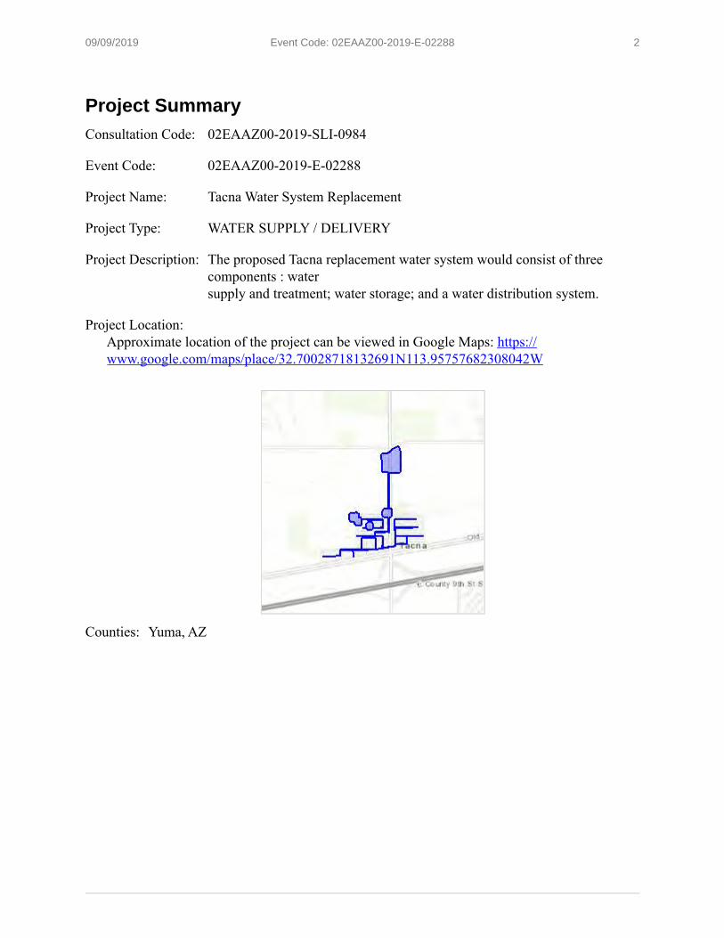
09/09/2019 Event Code: 02EAAZ00-2019-E-02288 2
Project SummaryConsultation Code: 02EAAZ00-2019-SLI-0984
Event Code: 02EAAZ00-2019-E-02288
Project Name: Tacna Water System Replacement
Project Type: WATER SUPPLY / DELIVERY
Project Description: The proposed Tacna replacement water system would consist of three
components : water
supply and treatment; water storage; and a water distribution system.
Project Location:
Approximate location of the project can be viewed in Google Maps: https://
www.google.com/maps/place/32.70028718132691N113.95757682308042W
Counties: Yuma, AZ
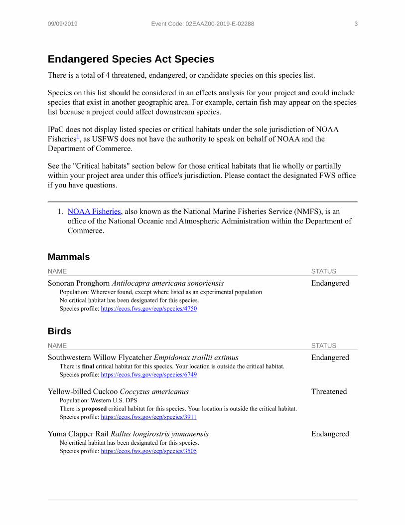
09/09/2019 Event Code: 02EAAZ00-2019-E-02288 3
Endangered Species Act SpeciesThere is a total of 4 threatened, endangered, or candidate species on this species list.
Species on this list should be considered in an effects analysis for your project and could include
species that exist in another geographic area. For example, certain fish may appear on the species
list because a project could affect downstream species.
IPaC does not display listed species or critical habitats under the sole jurisdiction of NOAA
Fisheries , as USFWS does not have the authority to speak on behalf of NOAA and the
Department of Commerce.
See the "Critical habitats" section below for those critical habitats that lie wholly or partially
within your project area under this office's jurisdiction. Please contact the designated FWS office
if you have questions.
1. NOAA Fisheries, also known as the National Marine Fisheries Service (NMFS), is an
office of the National Oceanic and Atmospheric Administration within the Department of
Commerce.
MammalsNAME STATUS
Sonoran Pronghorn Antilocapra americana sonoriensisPopulation: Wherever found, except where listed as an experimental population
No critical habitat has been designated for this species.
Species profile: https://ecos.fws.gov/ecp/species/4750
Endangered
BirdsNAME STATUS
Southwestern Willow Flycatcher Empidonax traillii extimusThere is final critical habitat for this species. Your location is outside the critical habitat.
Species profile: https://ecos.fws.gov/ecp/species/6749
Endangered
Yellow-billed Cuckoo Coccyzus americanusPopulation: Western U.S. DPS
There is proposed critical habitat for this species. Your location is outside the critical habitat.
Species profile: https://ecos.fws.gov/ecp/species/3911
Threatened
Yuma Clapper Rail Rallus longirostris yumanensisNo critical habitat has been designated for this species.
Species profile: https://ecos.fws.gov/ecp/species/3505
Endangered
1

09/09/2019 Event Code: 02EAAZ00-2019-E-02288 4
Critical habitatsTHERE ARE NO CRITICAL HABITATS WITHIN YOUR PROJECT AREA UNDER THIS OFFICE'S JURISDICTION.

Appendix B
SITE PHOTOGRAPHS
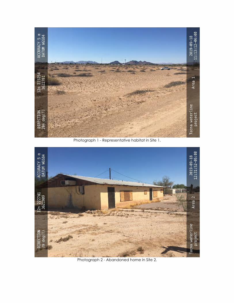
Photograph 1 - Representative habitat in Site 1.
Photograph 2 - Abandoned home in Site 2.
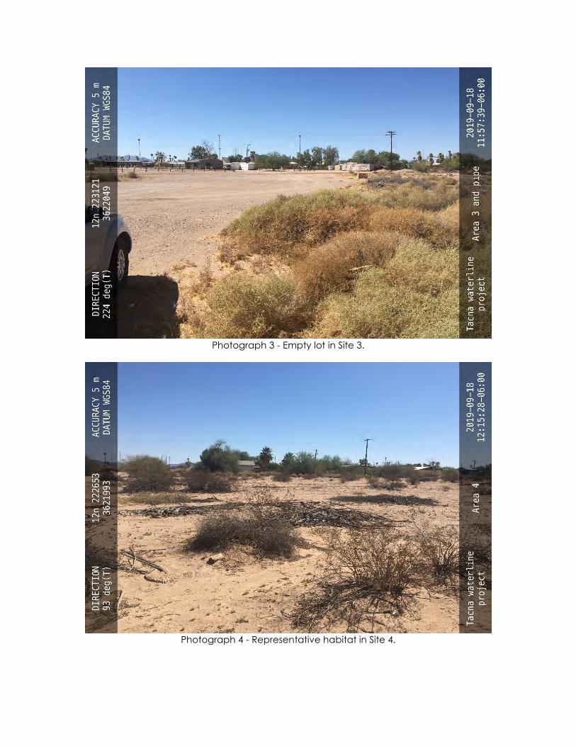
Photograph 3 - Empty lot in Site 3.
Photograph 4 - Representative habitat in Site 4.
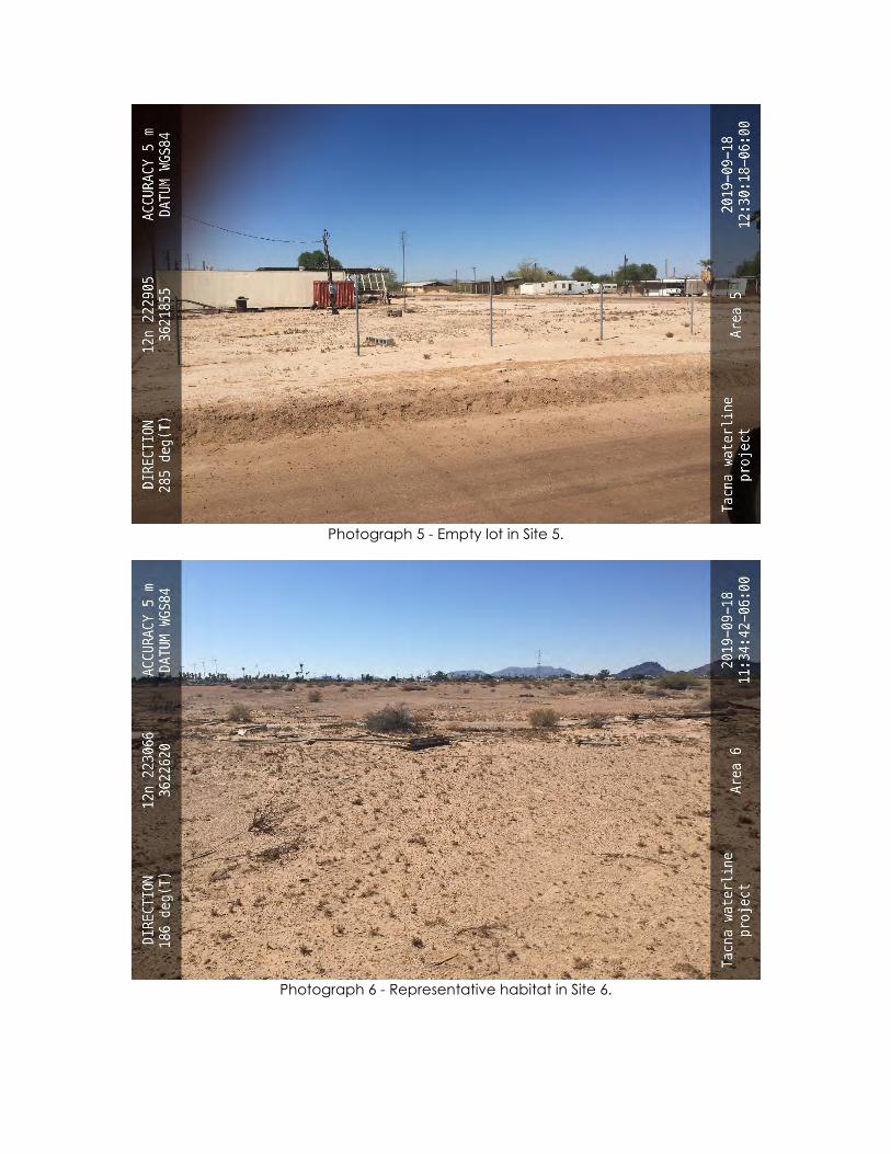
Photograph 5 - Empty lot in Site 5.
Photograph 6 - Representative habitat in Site 6.
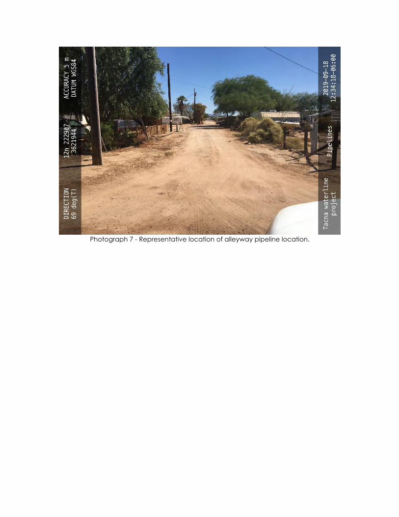
Photograph 7 - Representative location of alleyway pipeline location.