Embed Size (px)
Citation preview
Page 1 of 137
Table of Contents 1.0 Introduction ................................................................................................................................................................ ....... 2
1.1 Southeast Conference (SEC) ................................................................................................................................... 2 1.2 Central Council Tlingit & Haida Indian Tribes of Alaska (CCTHITA) ..................................................... 6 1.3 CEDS Steering Committee ...................................................................................................................................... 10
2.0 Southeast Alaska Overview ........................................................................................................................................ 13 2.1 Physical Geography .................................................................................................................................................. 13 2.2 Population & Workforce ......................................................................................................................................... 13 2.3 Regional Facilities & Services ............................................................................................................................... 15 2.4 Infrastructure.............................................................................................................................................................. 21 2.5 Regional Economy .................................................................................................................................................... 30
3.0 Goals ................................................................................................................................................................ .................... 47 Goal 1: Community & Regional Development ....................................................................................................... 47 Goal 2: Economic Development .................................................................................................................................. 47 Goal 3: Quality Environment ........................................................................................................................................ 48
4.0 Strategic Projects, Programs and Activities: Southeast Alaska Regional Action Initiatives (Objectives) ................................................................................................................................................................ .............. 49
4.1 Southeast Asset Map: Analysis of Economic Development Problems and Opportunities .......... 49 4.2 CEDS Plan of Action .................................................................................................................................................. 49 4.3 Performance Measures ........................................................................................................................................... 64
5.0 Community Profiles & Project Lists ........................................................................................................................ 67 5.1 Haines Borough .......................................................................................................................................................... 67 5.2 Hoonah-Angoon Census Area ............................................................................................................................... 69 5.3 Juneau, City & Borough ........................................................................................................................................... 84 5.4 Ketchikan Gateway Borough ................................................................................................................................ 88 5.6 Petersburg Census Area ......................................................................................................................................... 95 5.7 Prince of Wales-Hyder Census Area ............................................................................................................... 103 5.8 Sitka, City & Borough ............................................................................................................................................ 125 5.9 Skagway, Municipality of..................................................................................................................................... 129 5.10 Wrangell, City & Borough ................................................................................................................................. 131 5.11 Yakutat, City & Borough .................................................................................................................................... 135
6.0 Regional Native Corporation .................................................................................................................................. 136 Sealaska Corporation ................................................................................................................................................... 136
Page 2 of 137
1.0 Introduction The purpose of a Comprehensive Economic Development Strategy (CEDS) is to initiate and sustain a local planning and implementation process by which jobs are created, more stable and diversified economies are fostered, and living conditions are improved. A CEDS is a mechanism for coordinating economic developments activities and is a valuable tool for bringing focus to the planning and development efforts of these unique and diverse communities throughout the region. This CEDS has been prepared, in part, to meet a prerequisite for designation as an Economic Development District (EDD). EDD designation is necessary in order to qualify for Economic Development Administration (EDA) assistance under its public works, economic adjustment and planning programs. These 23 incorporated and 21 unincorporated communities that have been included in this regional plan are also eligible to seek funding under the EDD designation for projects that have been outlined in the CEDS. In 2000 Southeast Conference and Central Council Tlingit Haida Tribes of Alaska established a CEDS Steering Committee with representatives of various communities, Tribes, Native Corporations, non-profit organizations, professions, and industries to provide additional background information and to assist with the development of the goals, objectives and strategies. The first CEDS for Southeast Alaska was completed in June 2001. The result was a publication that gives a comprehensive overview of Southeast Alaska economic history, current developments, and future opportunities. Also included is a list of projects each Southeast Alaska community hopes to accomplish to improve the economic health of that community. The Southeast Alaska CEDS has been recognized nationally by EDA as an excellent example of a CEDS document. The preparation of this CEDS has been again undertaken as a joint project of Southeast Conference (SEC) and Central Council Tlingit and Haida Indian Tribes of Alaska (CCTHITA) with special assistance from the Juneau Economic Development Council. The requirements of our respective economic development programs stipulate our participation in and the production of a regional economic development plan for Southeast Alaska. It was agreed that our region, our constituencies, and our organizations are best served by cooperating in the production of a single document. Although the CEDS has been jointly produced, each organization is individually responsible for the preparation of its own annual work plan for achieving mutual objectives and for evaluating and reporting progress in the CEDS updates. Insofar as the Southeast Conference is the designated Alaska Regional Development Organization (ARDOR) for Southeast, this CEDS has been prepared to fulfill the requirements for preparation of an ARDOR Regional Development Strategy.
1.1 Southeast Conference (SEC) Southeast Conference was formed in 1958 as an association of communities joined to advocate for the establishment of the Alaska Marine Highway System. While our commitment to its development and efficient operation continues, Southeast Conference has greatly expanded both its membership base and its overall mission. Today, Southeast Conference is a regional, nonprofit corporation that advances the collective interests of the people, communities, and businesses in southeast Alaska. Southeast Conference is the State-designated Alaska Regional Development Organization (ARDOR) and on September 18th, 2002 was federally-designated Economic Development District (EDD) for Southeast Alaska. Each of these designations requires Southeast Conference to take an active role in regional resource management and economic development planning.
Page 3 of 137
The Southeast Alaska Economic Development District is one of 4 Districts authorized by the EDA in Alaska and 382 throughout United States. To attain federal designation as an EDD, Southeast Conference was required to develop a regional Comprehensive Economic Development Strategy (CEDS). The purpose of the CEDS process is to help create jobs, foster more stable and diversified economies, and improve living conditions. It provides a mechanism for coordinating the efforts of individuals, organizations, local governments, and private industry concerned with economic development.
1.1a Mission Statement Southeast Conference will work to build a strong economy and healthy communities while maintaining a quality environment. Southeast Conference shall strive to develop and maintain a stable and diversified economy throughout Southeast Alaska that provides employment and business development opportunities for the citizens of the region. This development shall be based on a sensitive understanding of the perspectives within and among the communities of Southeast Alaska regarding cultural heritage, community needs, and the desire of the Southeast people to maintain and enhance the positive aspects and characteristics of the region that are vital to individual, family, and community well being.
1.1b Contact Information Physical Address: 612 West Willoughby Avenue, Suite B Mailing Address: P.O. Box 21989, Juneau Alaska 99801 Phone: (907) 523-4350 Fax: (907) 463-5670 Website: www.seconference.org Email: [email protected]
1.1c FY2012 Board of Directors North/Public North/Private South/Public South/Public North/Private North/Private North/Public North/Public South/Private North/Private North/Public North/Private South/Private
President 1st Vice President 2nd Vice President Treasurer Secretary Past President Director Director Director Director Director Director Director
Janice Hill Gordy Wrobel Timothy D. Rooney Leo Luczak Lori Blood Maxine L. Thompson Jim Dinley Patricia Phillips Tory Korn Merrill Sanford Richard Peterson Hap Symmonds Bryce Dahlsrom
-Haines Borough Mayor -Owner, Cove Lodge/Commercial Fisherman -Borough Mngr, City & Borough of Wrangell -Community Dvpmt Director, City of Petersburg -Executive Account Manager, AC-Juneau -President, Thompson Mngmt Svcs Inc.-Angoon -Municipal Admin, City & Borough of Sitka -Managing Owner, Pacific Fishing Inc. -GM, AKRS & AKCA-Ketchikan -Assembly Member, City & Borough of Juneau -2nd Vice President, CCTHITA -Chairman, Cordova Electric Coop-Cordova -Transportation Superintendent, Viking
Lumber-Craig
1.1d Staff Executive Director Administrator/CEDS Coordinator Chief Finance Officer Energy Coordinator
Shelly Wright Sara Henderson Cheri Lancaster Robert Venables
[email protected] [email protected] [email protected] [email protected]
Page 4 of 137
1.1e Committees All of our members have the opportunity to provide input and serve on Southeast Conference committees. Southeast Conference committees deal with pertinent Southeast Alaska issues, and make recommendations to the Board of Directors as to how the Conference should proceed. If you are interested in becoming a member, or serving on a committee, please contact the Executive Director.
• Communications – Lori Blood • Energy - Merrill Sanford • Economic Development - Patricia Phillips • Fisheries – Hap Symmonds • Health, Education, & Social Services (HESS)- Gordy Wrobel • Timber – Bryce Dahlstrom & Merrill Sanford • Tourism-Tory Korn • Transportation-Maxine L. Thompson & Mike Korsmo
1.1f FY2011 SEC Membership ACE Coalition AIDEA / AEA AK DCCED / DCRA AK DoTPF, AMHS AK State Governor AK State Legislature Alaska Airlines Alaska Committee Alaska Communications Alaska Cruise Association AK Electric Light & Power AK Forest Association AK Island Community Svcs Alaska Litho Alaska Marine Lines Alaska Municipal League AK Permanent Capital Mgmt AP&TAlaska Power Association AK Rainforest Sanctuary/AK Canopy Adventures AK Resource Development Council AK Sea Grant Marine Advisory Program AK Seafood Mrktg Institute AK Services Group AK Ship & Drydock AK Sm Business Develop Cntr AK State Chamber of Commerce Alaskan Brewing Co. Allen Marine Ballard & Associates Bartlett Regional Hospital
BBC Human Resource Dev. Corp Cape Fox Corporation Carson Dorn Inc. Cascade Creek LLC Catholic Community Services CCTHITA Chatham Electric Chelan Produce Company Chilkat Indian Village Chilkoot Indian Association City & Borough of Juneau City & Borough of Sitka City & Borough of Wrangell City & Borough of Yakutat City of Angoon City of Coffman Cove City of Cordova City of Craig City of Gustavus City of Hoonah City of Hydaburg City of Kake City of Kasaan City of Ketchikan City of Klawock City of Pelican City of Petersburg City of Prince Rupert City of Saxman City of Tenakee Springs City of Thorne Bay City of Whitehorse Coastal Helicopters Coeur Alaska
Commonwealth Associates Community of Elfin Cove Non-Profit Corp. Copy Express Cordova Electric Cooperative Craig Community Association Cruise West, SEAK Operations D. Hittle & Associates, Inc. Denali Commission District of Port Edward Eastern Tree Company Edna Bay Community Electric Power Systems Elgee Rehfeld Mertz LLC Elliott Bay Design Group First Bank First National Bank of Alaska Goldbelt, Inc. Greater Ketchikan Chamber of Commerce Greater Sitka Chamber of Commerce Greens Creek Mining Company, Hecla Gruening & Spitzfadden Gustavus Electric Company Haida Corporation Haines Borough Haines Chamber of Commerce Hames Corporation Hansen Gress Holland America Line Huna Totem Corp. Hydaburg Cooperative Association
Page 5 of 137
FY2011 Membership cont. Hyder Board of Trade Hyder Community Association IPEC Inter-Island Ferry Authority International Union of Operating Engineers Local 302 J.M.Walsh Juneau Chamber of Commerce Juneau Charter Boat Operators Association Juneau Convention & Visitor Bureau Juneau Economic Development Council Kake Tribal Corporation Ketchikan Gateway Borough Ketchikan General Hospital Ketchikan Indian Community Ketchikan Visitors Bureau Kootznoowoo LB2 Madison Lumber & Hardware McDowell Group Metlakatla Indian Community Municipality of Skagway Nalder, Nan Naukati Bay, Inc. Northland Services, Inc. Ocean Beauty Seafoods, LLC
Oceans Alaska Organized Village of Kake Organized Village of Kasaan Pacific Seafood Processors Petersburg Chamber of Commerce Petersburg Economic Development Council PND Engineers, Inc. Polarconsult Alaska, Inc. Port of Bellingham Prince of Wales Chamber of Commerce Princess Tours Red Onion Saloon, Inc. Reg District of Kitimat-Stikine Samuelson, Steven Sandor, John A. Seafood Producers Cooperative Sealaska Corp. Southeast AK Power Assoc. SEARHC Service Auto Parts Sgt. Preston's Lodge Shattuck & Grummett Shee Atika, Inc. Sheinberg Associates Sitka Convention & Visitor Bureau
Sitka Economic Development Association Sitka Tribe of Alaska Skagway Development Corporation Skagway Traditional Council SE AK Fishermen's Alliance Southeast AK Regional Dive Fisheries Assoc. Southeast Stevedoring Southeast Strategies Southern Southeast Regional Aquaculture Assoc. Taku River Reds The Nature Conservancy Thomas Bay Power Authority Thompson Management Services, Inc. University of AK, Southeast US Congressman Don Young, US EPA US Senator Lisa Murkowski USDA Rural Development Viking Lumber Watson, Dennis Waypoint Inn at Herring Bay Wells Fargo Bank White Pass & Yukon Route Wostmann & Associates, Inc. Wrangell Oil Inc.
1.1g Honorary Lifetime Members • Bill Allen • Tom Briggs • Herb Pond • Carol Rushmore • David Stone • Robert W. Ward Jr. • Bill Williams
Page 6 of 137
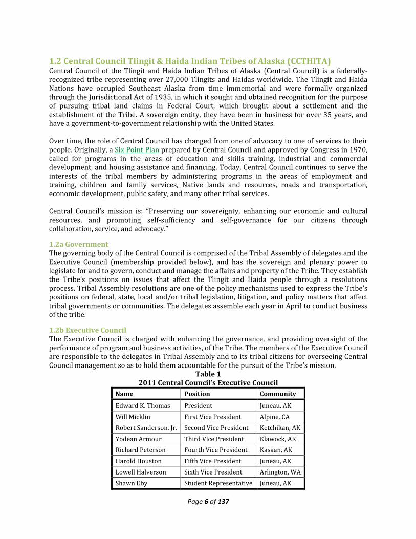
1.2 Central Council Tlingit & Haida Indian Tribes of Alaska (CCTHITA) Central Council of the Tlingit and Haida Indian Tribes of Alaska (Central Council) is a federally-recognized tribe representing over 27,000 Tlingits and Haidas worldwide. The Tlingit and Haida Nations have occupied Southeast Alaska from time immemorial and were formally organized through the Jurisdictional Act of 1935, in which it sought and obtained recognition for the purpose of pursuing tribal land claims in Federal Court, which brought about a settlement and the establishment of the Tribe. A sovereign entity, they have been in business for over 35 years, and have a government-to-government relationship with the United States. Over time, the role of Central Council has changed from one of advocacy to one of services to their people. Originally, a Six Point Plan prepared by Central Council and approved by Congress in 1970, called for programs in the areas of education and skills training, industrial and commercial development, and housing assistance and financing. Today, Central Council continues to serve the interests of the tribal members by administering programs in the areas of employment and training, children and family services, Native lands and resources, roads and transportation, economic development, public safety, and many other tribal services. Central Council’s mission is: “Preserving our sovereignty, enhancing our economic and cultural resources, and promoting self-sufficiency and self-governance for our citizens through collaboration, service, and advocacy.”
1.2a Government The governing body of the Central Council is comprised of the Tribal Assembly of delegates and the Executive Council (membership provided below), and has the sovereign and plenary power to legislate for and to govern, conduct and manage the affairs and property of the Tribe. They establish the Tribe’s positions on issues that affect the Tlingit and Haida people through a resolutions process. Tribal Assembly resolutions are one of the policy mechanisms used to express the Tribe's positions on federal, state, local and/or tribal legislation, litigation, and policy matters that affect tribal governments or communities. The delegates assemble each year in April to conduct business of the tribe.
1.2b Executive Council The Executive Council is charged with enhancing the governance, and providing oversight of the performance of program and business activities, of the Tribe. The members of the Executive Council are responsible to the delegates in Tribal Assembly and to its tribal citizens for overseeing Central Council management so as to hold them accountable for the pursuit of the Tribe’s mission.
Table 1 2011 Central Council’s Executive Council
Name Position Community
Edward K. Thomas President Juneau, AK Will Micklin First Vice President Alpine, CA Robert Sanderson, Jr. Second Vice President Ketchikan, AK Yodean Armour Third Vice President Klawock, AK Richard Peterson Fourth Vice President Kasaan, AK Harold Houston Fifth Vice President Juneau, AK Lowell Halverson Sixth Vice President Arlington, WA Shawn Eby Student Representative Juneau, AK
Page 7 of 137
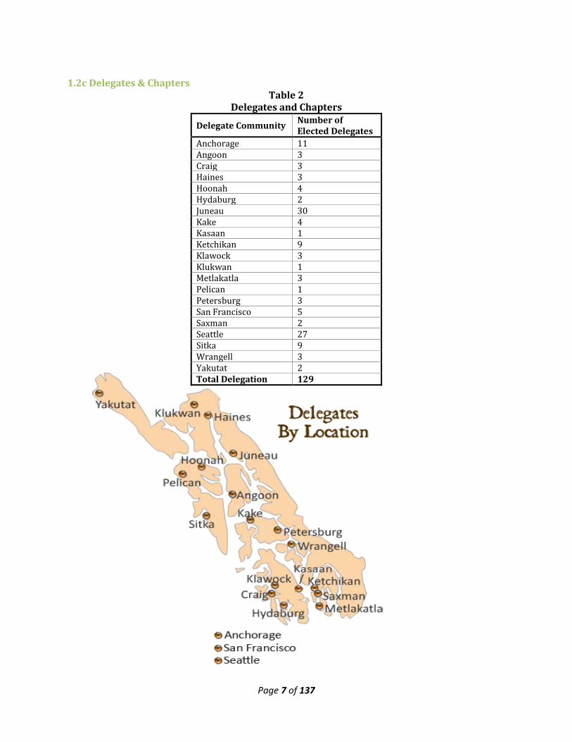
1.2c Delegates & Chapters Table 2
Delegates and Chapters
Delegate Community Number of Elected Delegates
Anchorage 11 Angoon 3 Craig 3 Haines 3 Hoonah 4 Hydaburg 2 Juneau 30 Kake 4 Kasaan 1 Ketchikan 9 Klawock 3 Klukwan 1 Metlakatla 3 Pelican 1 Petersburg 3 San Francisco 5 Saxman 2 Seattle 27 Sitka 9 Wrangell 3 Yakutat 2 Total Delegation 129
Page 8 of 137
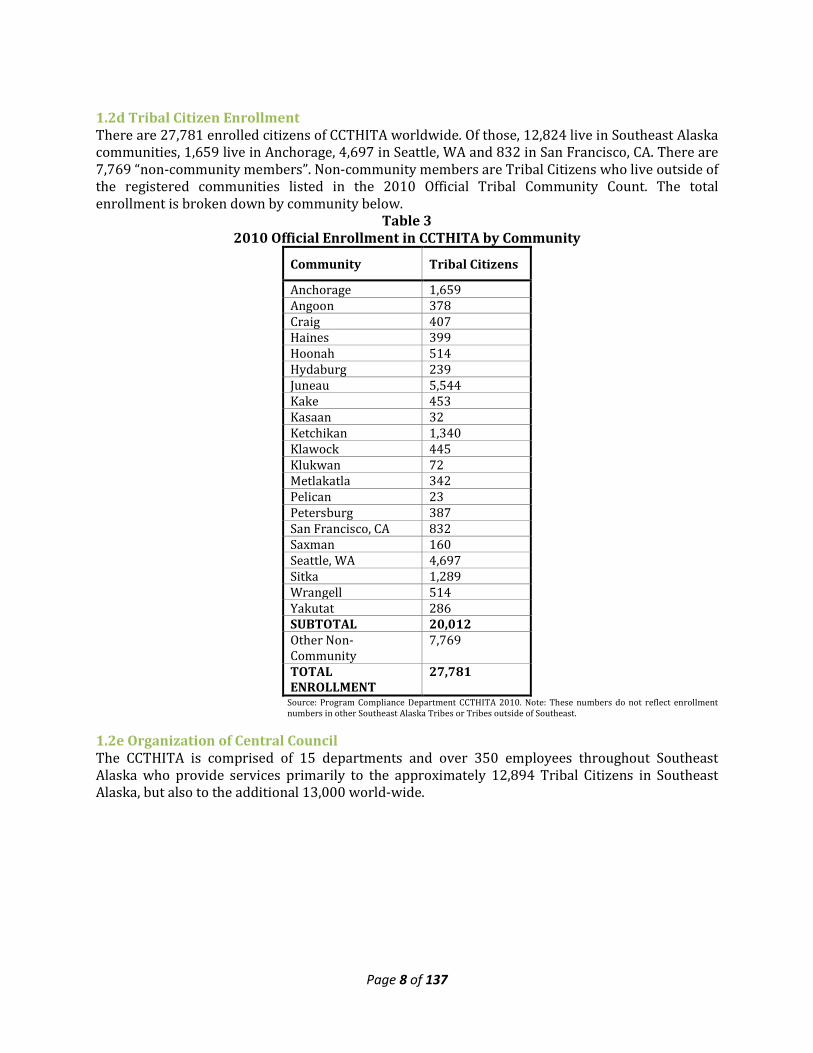
1.2d Tribal Citizen Enrollment There are 27,781 enrolled citizens of CCTHITA worldwide. Of those, 12,824 live in Southeast Alaska communities, 1,659 live in Anchorage, 4,697 in Seattle, WA and 832 in San Francisco, CA. There are 7,769 “non-community members”. Non-community members are Tribal Citizens who live outside of the registered communities listed in the 2010 Official Tribal Community Count. The total enrollment is broken down by community below.
Table 3 2010 Official Enrollment in CCTHITA by Community
Community Tribal Citizens
Anchorage 1,659 Angoon 378 Craig 407 Haines 399 Hoonah 514 Hydaburg 239 Juneau 5,544 Kake 453 Kasaan 32 Ketchikan 1,340 Klawock 445 Klukwan 72 Metlakatla 342 Pelican 23 Petersburg 387 San Francisco, CA 832 Saxman 160 Seattle, WA 4,697 Sitka 1,289 Wrangell 514 Yakutat 286 SUBTOTAL 20,012 Other Non-Community
7,769
TOTAL ENROLLMENT
27,781
Source: Program Compliance Department CCTHITA 2010. Note: These numbers do not reflect enrollment numbers in other Southeast Alaska Tribes or Tribes outside of Southeast.
1.2e Organization of Central Council The CCTHITA is comprised of 15 departments and over 350 employees throughout Southeast Alaska who provide services primarily to the approximately 12,894 Tribal Citizens in Southeast Alaska, but also to the additional 13,000 world-wide.
Page 9 of 137
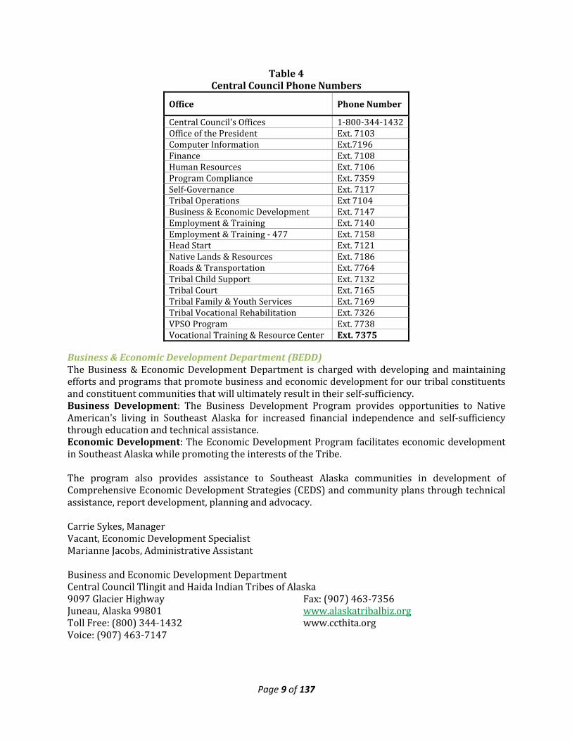
Table 4 Central Council Phone Numbers
Office Phone Number
Central Council's Offices 1-800-344-1432 Office of the President Ext. 7103 Computer Information Ext.7196 Finance Ext. 7108 Human Resources Ext. 7106 Program Compliance Ext. 7359 Self-Governance Ext. 7117 Tribal Operations Ext 7104 Business & Economic Development Ext. 7147 Employment & Training Ext. 7140 Employment & Training - 477 Ext. 7158 Head Start Ext. 7121 Native Lands & Resources Ext. 7186 Roads & Transportation Ext. 7764 Tribal Child Support Ext. 7132 Tribal Court Ext. 7165 Tribal Family & Youth Services Ext. 7169 Tribal Vocational Rehabilitation Ext. 7326 VPSO Program Ext. 7738 Vocational Training & Resource Center Ext. 7375
Business & Economic Development Department (BEDD) The Business & Economic Development Department is charged with developing and maintaining efforts and programs that promote business and economic development for our tribal constituents and constituent communities that will ultimately result in their self-sufficiency. Business Development: The Business Development Program provides opportunities to Native American's living in Southeast Alaska for increased financial independence and self-sufficiency through education and technical assistance. Economic Development: The Economic Development Program facilitates economic development in Southeast Alaska while promoting the interests of the Tribe. The program also provides assistance to Southeast Alaska communities in development of Comprehensive Economic Development Strategies (CEDS) and community plans through technical assistance, report development, planning and advocacy. Carrie Sykes, Manager Vacant, Economic Development Specialist Marianne Jacobs, Administrative Assistant Business and Economic Development Department Central Council Tlingit and Haida Indian Tribes of Alaska 9097 Glacier Highway Juneau, Alaska 99801 Toll Free: (800) 344-1432 Voice: (907) 463-7147
Fax: (907) 463-7356 www.alaskatribalbiz.org www.ccthita.org
Page 10 of 137
1.2f Tlingit & Haida Regional Housing Authority (THRHA) Since 1973, Tlingit & Haida Regional Housing Authority has been providing quality affordable housing to tribal residents and other residents of Southeast Alaska. They partner with 12 communities, service 823 homes, and offer a variety of housing opportunities for all residents of Southeast Alaska. Their extensive activities result in a significant spending and employment in the region. Initially, THRHA was primarily an Indian housing authority providing services to Native American Housing Self Determination Act (NAHASDA) eligible clients. As part of their current strategic plan they have developed several public housing programs that allow THRHA to offer a wider variety of housing opportunities for all Southeast Alaskans.
• Homeownership Opportunities • Rent-To-Own • Family Rentals • Transitional Housing • Senior Independent Living • Home Loans • Down-Payment Assistance • Project & Home Construction
They continue to play a critical role by working closely with twelve tribal partners in communities throughout Southeast Alaska to identify the needs for affordable housing in the region, secure the funding to meet the need by providing the kind of housing solutions that are desirable and affordable within the local communities. The various housing programs are designed to meet the full spectrum of affordable housing needs ranging from federally subsidized programs to conventional home loans. THRHA extends its services to include LIHEAP Assistance Program; home repairs; weatherization program and weatherization training, the address the needs of the family and overall housing affordability and comfort. Tlingit-Haida Regional Housing Authority is comprised of a board of commissioners; seven departments including Administration; Development, Construction and Maintenance, Fiscal; Housing Management; Mortgage Loans; Realty Corporation; Tribal Services; and field offices in nine different communities. They also work with various state and federal supported agencies to employ staff for construction.
1.3 CEDS Steering Committee The Southeast Conference Economic Development Committee is the committee of record for the Community Economic Development Strategy (CEDS). Committee membership includes representation from city, State and Federal government agencies, business, organized labor, education, community organizations and tribal administrations.
Page 11 of 137
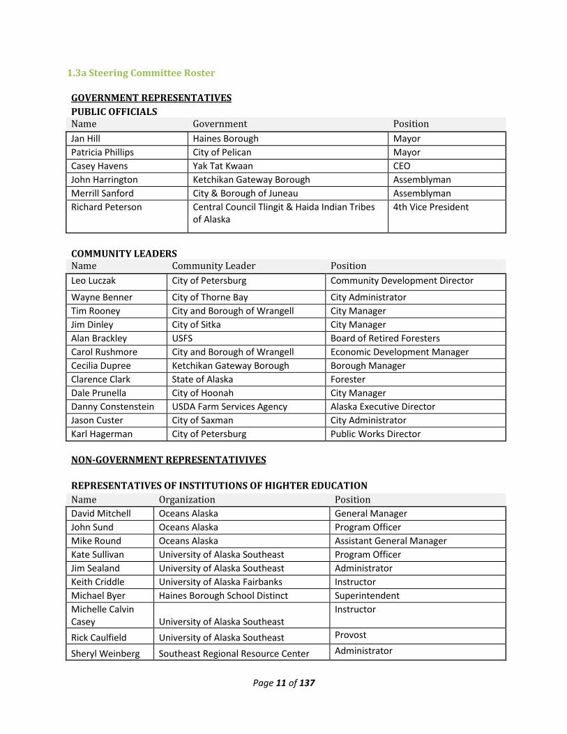
1.3a Steering Committee Roster GOVERNMENT REPRESENTATIVES PUBLIC OFFICIALS
Name Government Position Jan Hill Haines Borough Mayor Patricia Phillips City of Pelican Mayor Casey Havens Yak Tat Kwaan CEO John Harrington Ketchikan Gateway Borough Assemblyman Merrill Sanford City & Borough of Juneau Assemblyman Richard Peterson Central Council Tlingit & Haida Indian Tribes
of Alaska 4th Vice President
COMMUNITY LEADERS Name Community Leader Position Leo Luczak City of Petersburg Community Development Director Wayne Benner City of Thorne Bay City Administrator Tim Rooney City and Borough of Wrangell City Manager Jim Dinley City of Sitka City Manager Alan Brackley USFS Board of Retired Foresters Carol Rushmore City and Borough of Wrangell Economic Development Manager Cecilia Dupree Ketchikan Gateway Borough Borough Manager Clarence Clark State of Alaska Forester Dale Prunella City of Hoonah City Manager Danny Constenstein USDA Farm Services Agency Alaska Executive Director Jason Custer City of Saxman City Administrator Karl Hagerman City of Petersburg Public Works Director
NON-GOVERNMENT REPRESENTATIVIVES
REPRESENTATIVES OF INSTITUTIONS OF HIGHTER EDUCATION Name Organization Position David Mitchell Oceans Alaska General Manager John Sund Oceans Alaska Program Officer Mike Round Oceans Alaska Assistant General Manager Kate Sullivan University of Alaska Southeast Program Officer Jim Sealand University of Alaska Southeast Administrator Keith Criddle University of Alaska Fairbanks Instructor Michael Byer Haines Borough School Distinct Superintendent Michelle Calvin Casey University of Alaska Southeast
Instructor
Rick Caulfield University of Alaska Southeast Provost
Sheryl Weinberg Southeast Regional Resource Center Administrator
Page 12 of 137
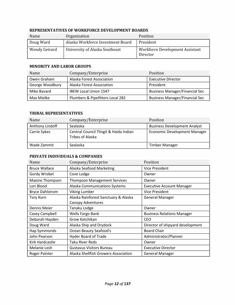
REPRESENTATIVES OF WORKFORCE DEVELOPMENT BOARDS Name Organization Position Doug Ward Alaska Workforce Investment Board President
Wendy Geirard University of Alaska Southeast Workforce Development Assistant Director
MINORITY AND LABOR GROUPS Name Company/Enterprise Position Owen Graham Alaska Forest Association Executive Director George Woodbury Alaska Forest Association President Mike Bavard IBEW Local Union 1547 Business Manager/Financial Sec Max Mielke Plumbers & Pipefitters Local 282 Business Manager/Financial Sec
TRIBAL REPRESENTATIVES Name Company/Enterprise Position Anthony Lindoff Sealaska Business Development Analyst Carrie Sykes Central Council Tlingit & Haida Indian
Tribes of Alaska Economic Development Manager
Wade Zammit Sealaska Timber Manager PRIVATE INDIVIDUALS & COMPANIES Name Company/Enterprise Position Bruce Wallace Alaska Seafood Marketing Vice President Gordy Wrobel Cove Lodge Owner Maxine Thompson Thompson Management Services Owner Lori Blood Alaska Communications Systems Executive Account Manager Bryce Dahlstrom Viking Lumber Vice President Tory Korn Alaska Rainforest Sanctuary & Alaska
Canopy Adventures General Manager
Dennis Meier Tanaku Lodge Owner Casey Campbell Wells Fargo Bank Business Relations Manager Deborah Hayden Grow Ketchikan CEO Doug Ward Alaska Ship and Drydock Director of shipyard development Hap Symmonds Ocean Beauty Seafood's Board Chair John Pearson Hyder Board of Trade Administrator/Planner Kirk Hardcastle Taku River Reds Owner Melanie Lesh Gustavus Visitors Bureau Executive Director Roger Painter Alaska Shellfish Growers Association General Manager
Page 13 of 137
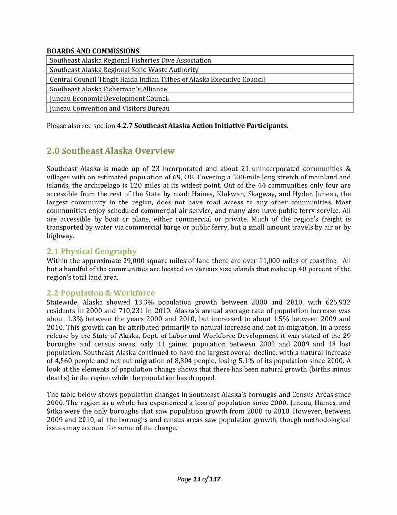
BOARDS AND COMMISSIONS Southeast Alaska Regional Fisheries Dive Association Southeast Alaska Regional Solid Waste Authority Central Council Tlingit Haida Indian Tribes of Alaska Executive Council Southeast Alaska Fisherman's Alliance Juneau Economic Development Council Juneau Convention and Visitors Bureau
Please also see section 4.2.7 Southeast Alaska Action Initiative Participants.
2.0 Southeast Alaska Overview Southeast Alaska is made up of 23 incorporated and about 21 unincorporated communities & villages with an estimated population of 69,338. Covering a 500-mile long stretch of mainland and islands, the archipelago is 120 miles at its widest point. Out of the 44 communities only four are accessible from the rest of the State by road; Haines, Klukwan, Skagway, and Hyder. Juneau, the largest community in the region, does not have road access to any other communities. Most communities enjoy scheduled commercial air service, and many also have public ferry service. All are accessible by boat or plane, either commercial or private. Much of the region’s freight is transported by water via commercial barge or public ferry, but a small amount travels by air or by highway.
2.1 Physical Geography Within the approximate 29,000 square miles of land there are over 11,000 miles of coastline. All but a handful of the communities are located on various size islands that make up 40 percent of the region’s total land area.
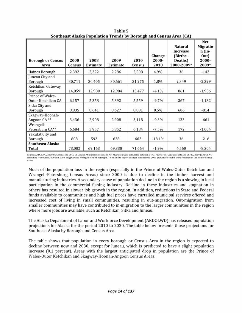
2.2 Population & Workforce Statewide, Alaska showed 13.3% population growth between 2000 and 2010, with 626,932 residents in 2000 and 710,231 in 2010. Alaska’s annual average rate of population increase was about 1.3% between the years 2000 and 2010, but increased to about 1.5% between 2009 and 2010. This growth can be attributed primarily to natural increase and not in-migration. In a press release by the State of Alaska, Dept. of Labor and Workforce Development it was stated of the 29 boroughs and census areas, only 11 gained population between 2000 and 2009 and 18 lost population. Southeast Alaska continued to have the largest overall decline, with a natural increase of 4,560 people and net out migration of 8,304 people, losing 5.1% of its population since 2000. A look at the elements of population change shows that there has been natural growth (births minus deaths) in the region while the population has dropped. The table below shows population changes in Southeast Alaska’s boroughs and Census Areas since 2000. The region as a whole has experienced a loss of population since 2000. Juneau, Haines, and Sitka were the only boroughs that saw population growth from 2000 to 2010. However, between 2009 and 2010, all the boroughs and census areas saw population growth, though methodological issues may account for some of the change.
Page 14 of 137
Table 5 Southeast Alaska Population Trends by Borough and Census Area (CA)
Borough or Census Area
2000 Census
2008 Estimate
2009 Estimate
2010 Census
Change 2000-2010
Natural Increase (Births -Deaths)
2000-2009*
Net Migratio
n (In-Out)
2000-2009*
Haines Borough 2,392 2,322 2,286 2,508 4.9% 36 -142 Juneau City and Borough 30,711 30,405 30,661 31,275 1.8% 2,349 -2,399 Ketchikan Gateway Borough 14,059 12,980 12,984 13,477 -4.1% 861 -1,936 Prince of Wales-Outer Ketchikan CA 6,157 5,358 5,392 5,559 -9.7% 367 -1,132 Sitka City and Borough 8,835 8,641 8,627 8,881 0.5% 606 -814 Skagway-Hoonah-Angoon CA ** 3,436 2,908 2,908 3,118 -9.3% 133 -661 Wrangell-Petersburg CA** 6,684 5,957 5,852 6,184 -7.5% 172 -1,004 Yakutat City and Borough 808 592 628 662 -18.1% 36 -216 Southeast Alaska Total 73,082 69,163 69,338 71,664 -1.9% 4,560 -8,304
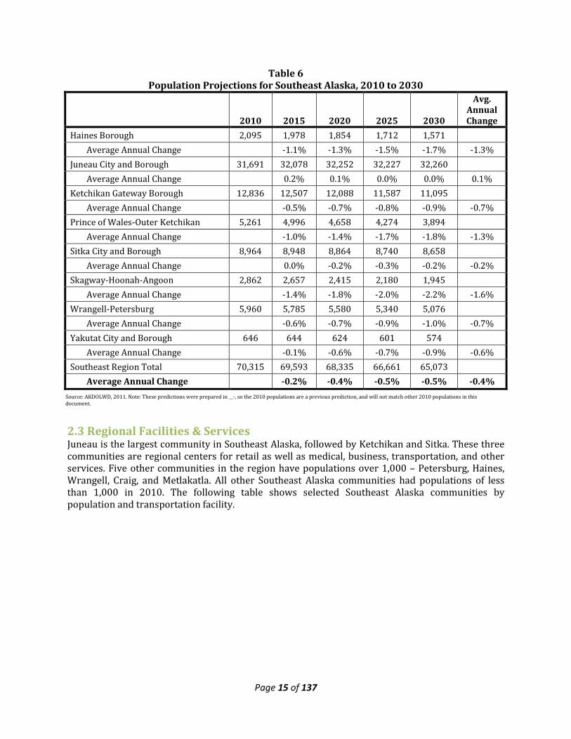
Much of the population loss in the region (especially in the Prince of Wales-Outer Ketchikan and Wrangell-Petersburg Census Areas) since 2000 is due to decline in the timber harvest and manufacturing industries. A secondary cause of population decline in the region is a slowing in local participation in the commercial fishing industry. Decline in these industries and stagnation in others has resulted in slower job growth in the region. In addition, reductions in State and Federal funds available to communities and high fuel prices have curtailed municipal services offered and increased cost of living in small communities, resulting in out-migration. Out-migration from smaller communities may have contributed to in-migration to the larger communities in the region where more jobs are available, such as Ketchikan, Sitka and Juneau. The Alaska Department of Labor and Workforce Development (AKDOLWD) has released population projections for Alaska for the period 2010 to 2030. The table below presents those projections for Southeast Alaska by Borough and Census Area. The table shows that population in every borough or Census Area in the region is expected to decline between now and 2030, except for Juneau, which is predicted to have a slight population increase (0.1 percent). Areas with the largest anticipated drop in population are the Prince of Wales-Outer Ketchikan and Skagway-Hoonah-Angoon Census Areas.
Source: AKDOLWD, 2000 US Census, and 2010 US Census. *Natural Increase and Net Migration were calculated between 04/01/2000 (U.S. Census count) and 06/30/2009 (AKDOLWD estimate). **Between 2000 and 2008, Skagway and Wrangell formed boroughs. To be able to report changes consistently, 2009 population counts were reported in the former Census Areas.
Page 15 of 137
Table 6 Population Projections for Southeast Alaska, 2010 to 2030
2010 2015 2020 2025 2030
Avg. Annual Change
Haines Borough 2,095 1,978 1,854 1,712 1,571 Average Annual Change -1.1% -1.3% -1.5% -1.7% -1.3% Juneau City and Borough 31,691 32,078 32,252 32,227 32,260 Average Annual Change 0.2% 0.1% 0.0% 0.0% 0.1% Ketchikan Gateway Borough 12,836 12,507 12,088 11,587 11,095 Average Annual Change -0.5% -0.7% -0.8% -0.9% -0.7% Prince of Wales-Outer Ketchikan 5,261 4,996 4,658 4,274 3,894 Average Annual Change -1.0% -1.4% -1.7% -1.8% -1.3% Sitka City and Borough 8,964 8,948 8,864 8,740 8,658 Average Annual Change 0.0% -0.2% -0.3% -0.2% -0.2% Skagway-Hoonah-Angoon 2,862 2,657 2,415 2,180 1,945 Average Annual Change -1.4% -1.8% -2.0% -2.2% -1.6% Wrangell-Petersburg 5,960 5,785 5,580 5,340 5,076 Average Annual Change -0.6% -0.7% -0.9% -1.0% -0.7% Yakutat City and Borough 646 644 624 601 574 Average Annual Change -0.1% -0.6% -0.7% -0.9% -0.6% Southeast Region Total 70,315 69,593 68,335 66,661 65,073 Average Annual Change -0.2% -0.4% -0.5% -0.5% -0.4%
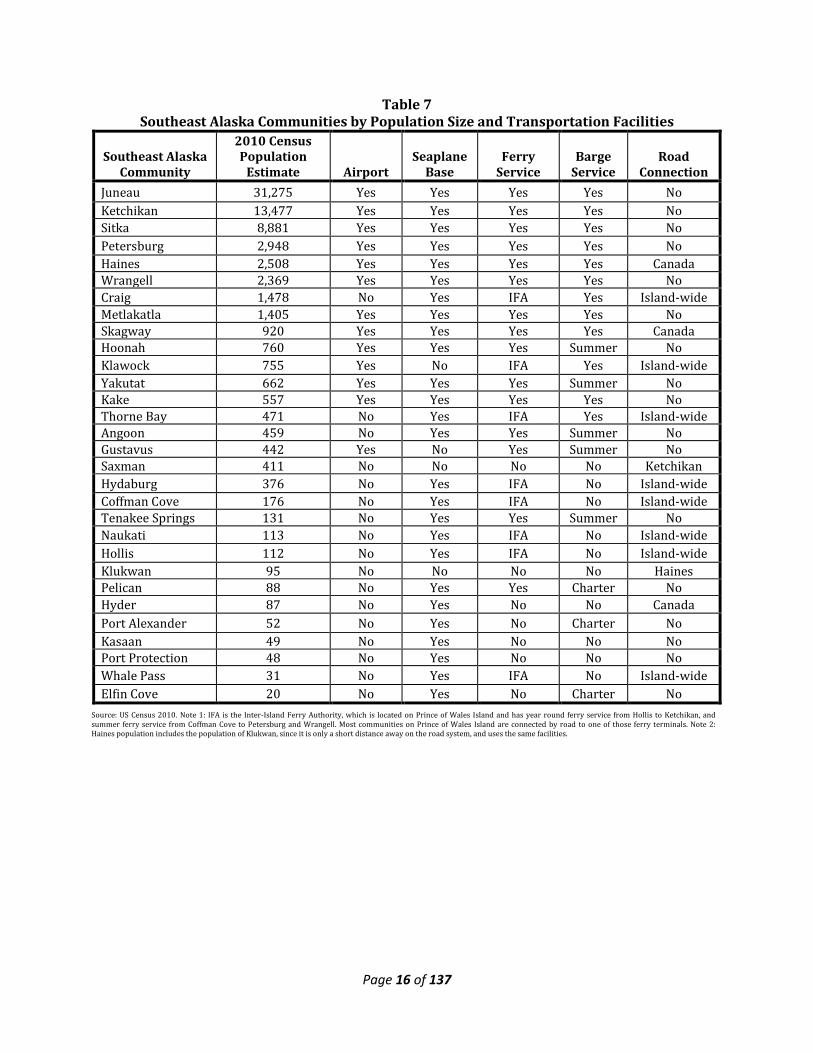
2.3 Regional Facilities & Services Juneau is the largest community in Southeast Alaska, followed by Ketchikan and Sitka. These three communities are regional centers for retail as well as medical, business, transportation, and other services. Five other communities in the region have populations over 1,000 – Petersburg, Haines, Wrangell, Craig, and Metlakatla. All other Southeast Alaska communities had populations of less than 1,000 in 2010. The following table shows selected Southeast Alaska communities by population and transportation facility.
Source: AKDOLWD, 2011. Note: These predictions were prepared in __-, so the 2010 populations are a previous prediction, and will not match other 2010 populations in this document.
Page 16 of 137
Table 7 Southeast Alaska Communities by Population Size and Transportation Facilities
Southeast Alaska Community
2010 Census Population
Estimate Airport Seaplane
Base Ferry
Service Barge
Service Road
Connection Juneau 31,275 Yes Yes Yes Yes No Ketchikan 13,477 Yes Yes Yes Yes No Sitka 8,881 Yes Yes Yes Yes No Petersburg 2,948 Yes Yes Yes Yes No Haines 2,508 Yes Yes Yes Yes Canada Wrangell 2,369 Yes Yes Yes Yes No Craig 1,478 No Yes IFA Yes Island-wide Metlakatla 1,405 Yes Yes Yes Yes No Skagway 920 Yes Yes Yes Yes Canada Hoonah 760 Yes Yes Yes Summer No Klawock 755 Yes No IFA Yes Island-wide Yakutat 662 Yes Yes Yes Summer No Kake 557 Yes Yes Yes Yes No Thorne Bay 471 No Yes IFA Yes Island-wide Angoon 459 No Yes Yes Summer No Gustavus 442 Yes No Yes Summer No Saxman 411 No No No No Ketchikan Hydaburg 376 No Yes IFA No Island-wide Coffman Cove 176 No Yes IFA No Island-wide Tenakee Springs 131 No Yes Yes Summer No Naukati 113 No Yes IFA No Island-wide Hollis 112 No Yes IFA No Island-wide Klukwan 95 No No No No Haines Pelican 88 No Yes Yes Charter No Hyder 87 No Yes No No Canada Port Alexander 52 No Yes No Charter No Kasaan 49 No Yes No No No Port Protection 48 No Yes No No No Whale Pass 31 No Yes IFA No Island-wide Elfin Cove 20 No Yes No Charter No
Source: US Census 2010. Note 1: IFA is the Inter-Island Ferry Authority, which is located on Prince of Wales Island and has year round ferry service from Hollis to Ketchikan, and summer ferry service from Coffman Cove to Petersburg and Wrangell. Most communities on Prince of Wales Island are connected by road to one of those ferry terminals. Note 2: Haines population includes the population of Klukwan, since it is only a short distance away on the road system, and uses the same facilities.
Page 17 of 137
Following is a brief report on the Southeast Alaska regional transportation systems and regional facilities such as health care, colleges, and ship repair facilities.
2.3a Transportation
Road Links Southeast Alaska is connected to the continental road system at three locations as follows:
• Hyder links to the Cassiar Highway via a 40-mile paved road. • Haines links to the Alaska Highway (in Canada) via the 146-mile Haines Highway. • Skagway links to the Alaska Highway (in Canada) via the 99-mile South Klondike Highway.
With the exception of the communities on Prince of Wales Island, most Southeast Alaska communities do not have road connections to any other communities. Of the over 1,500 miles of road system on Prince of Wales Island (mostly timber harvest related roads), approximately 125 miles are paved connecting 6 of the 8 communities on the island.
Air Links Air service in Southeast Alaska includes jet service from Seattle to the south and Anchorage to the north, between the major communities (Juneau, Ketchikan, Sitka, Petersburg, Wrangell, Yakutat and seasonally – Gustavus). Air cargo and air courier services are also available. Smaller air carriers in 4 to 9-seat wheel or floatplanes provide service within the region and to Prince Rupert, British Columbia to the south. Scheduled air service is available to most communities, and charter service is also available. Currently, two companies provide medical evacuation service via jet aircraft in the region. The U.S. Coast Guard has an air station at Sitka that provides medical evacuations via helicopter when necessary, as well as search and rescue services. Southeast Alaska has several types and sizes of airports, and virtually every community has an air facility of some kind. Many are airport runways, but some are seaplane bases. Following are the larger airports as classified by the Alaska Department of Transportation and Public Facilities’ 2008 Alaska Aviation System Plan Update.
Regional Center Airports (jet serviced) - Juneau Sitka Ketchikan
District Airports (jet serviced) - Petersburg Wrangell
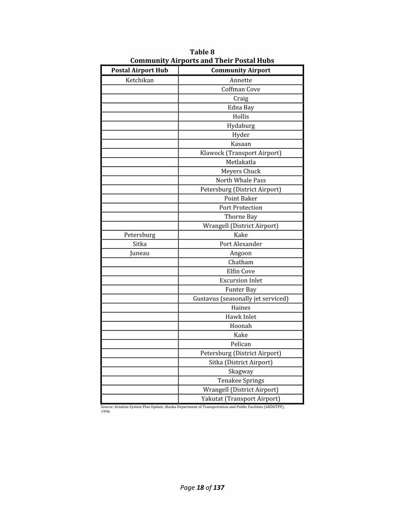
Transport Airports - Yakutat (jet serviced) Gustavus (jet serviced, seasonally) Klawock (jet capable, not currently jet serviced) To reach the smaller communities not served by direct airline flights, mail goes through an airport hub where it can be centralized and then distributed to the surrounding area. The following table lists community airports with their respective postal airport hub.
Page 18 of 137
Table 8 Community Airports and Their Postal Hubs
Postal Airport Hub Community Airport Ketchikan Annette
Coffman Cove Craig Edna Bay Hollis Hydaburg Hyder Kasaan Klawock (Transport Airport) Metlakatla Meyers Chuck North Whale Pass Petersburg (District Airport) Point Baker Port Protection Thorne Bay Wrangell (District Airport)
Petersburg Kake Sitka Port Alexander
Juneau Angoon Chatham Elfin Cove Excursion Inlet Funter Bay Gustavus (seasonally jet serviced) Haines Hawk Inlet Hoonah Kake Pelican Petersburg (District Airport) Sitka (District Airport) Skagway Tenakee Springs Wrangell (District Airport) Yakutat (Transport Airport)
Source: Aviation System Plan Update, Alaska Department of Transportation and Public Facilities (AKDOTPF), 1996.
Page 19 of 137
Source: Alaska Marine Highway System. Does not include fast ferry time, approx. ½ the time.
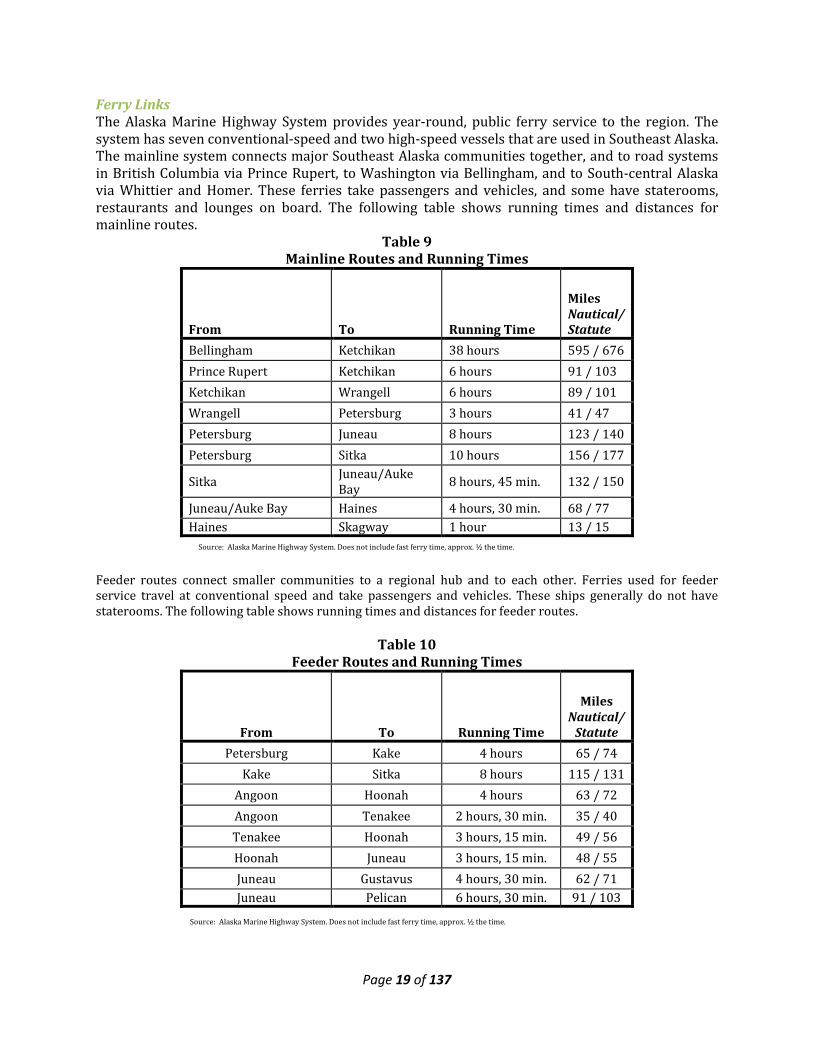
Ferry Links The Alaska Marine Highway System provides year-round, public ferry service to the region. The system has seven conventional-speed and two high-speed vessels that are used in Southeast Alaska. The mainline system connects major Southeast Alaska communities together, and to road systems in British Columbia via Prince Rupert, to Washington via Bellingham, and to South-central Alaska via Whittier and Homer. These ferries take passengers and vehicles, and some have staterooms, restaurants and lounges on board. The following table shows running times and distances for mainline routes.
Table 9 Mainline Routes and Running Times
From To Running Time
Miles Nautical/Statute
Bellingham Ketchikan 38 hours 595 / 676 Prince Rupert Ketchikan 6 hours 91 / 103 Ketchikan Wrangell 6 hours 89 / 101 Wrangell Petersburg 3 hours 41 / 47 Petersburg Juneau 8 hours 123 / 140 Petersburg Sitka 10 hours 156 / 177
Sitka Juneau/Auke Bay 8 hours, 45 min. 132 / 150
Juneau/Auke Bay Haines 4 hours, 30 min. 68 / 77 Haines Skagway 1 hour 13 / 15
Feeder routes connect smaller communities to a regional hub and to each other. Ferries used for feeder service travel at conventional speed and take passengers and vehicles. These ships generally do not have staterooms. The following table shows running times and distances for feeder routes.
Table 10
Feeder Routes and Running Times
From To Running Time
Miles Nautical/
Statute Petersburg Kake 4 hours 65 / 74
Kake Sitka 8 hours 115 / 131 Angoon Hoonah 4 hours 63 / 72 Angoon Tenakee 2 hours, 30 min. 35 / 40 Tenakee Hoonah 3 hours, 15 min. 49 / 56 Hoonah Juneau 3 hours, 15 min. 48 / 55 Juneau Gustavus 4 hours, 30 min. 62 / 71 Juneau Pelican 6 hours, 30 min. 91 / 103
Source: Alaska Marine Highway System. Does not include fast ferry time, approx. ½ the time.
Page 20 of 137
The Alaska Marine Highway System will sometimes dedicate a vessel to a particular route, especially during the summer months. These shuttle ferries can be either conventional-speed or high-speed vessels. Currently, a dedicated vessel provides year-round service between Ketchikan and Metlakatla. In addition, the Inter-Island Ferry Authority provides year-round passenger and vehicle service on a conventional speed ferry between Hollis on Prince of Wales Island, and Ketchikan. In the summer of 2006, another Inter-Island Ferry Authority vessel began providing summer passenger and vehicle service between Coffman Cove on Prince of Wales Island, Wrangell and Petersburg. However, at the end of the 2008 summer season this service was discontinued due to rising operational costs. Private companies in the region provide charter ferry service, but generally only for passengers and cargo.
Transportation – Barge Links Three major barge lines serve Southeast Alaska from Seattle, delivering freight, vehicles and equipment. One line serves the communities of Ketchikan, Wrangell, Petersburg, Sitka and Juneau weekly, and some smaller communities less frequently (in some cases, seasonally). A second line serves Ketchikan, Petersburg, Sitka, and Juneau twice weekly; Wrangell, Craig, Klawock, Thorne Bay, Haines, and Skagway weekly; and Angoon, Pelican, Hoonah, Gustavus, and Yakutat seasonally. A third line serves Sitka every two weeks, and then continues on to Alaska destinations north and west. Following are the approximate transit times between Seattle and several Southeast Alaska ports.
Table 11 Barge Transit Times to Southeast Ports
Port Transit
Time
Ketchikan 4 Days Metlakatla 6 Days
Prince of Wales Island 5 Days Wrangell 5 Days
Petersburg 5 Days Sitka 5 Days
Juneau 5 Days
Ship Yard/Boat Building Southeast Alaska has several boat haul-out and repair facilities. They include: Ketchikan
• 50-ton lift • 200-ton marine railway • Dry dock for ships up to 10,000 tons • Full shipbuilding and repair services
Wrangell • 30-ton marine railway • 150-ton lift and uplands work yard • 40-ton hydraulic trailer
Page 21 of 137
Craig • Hydraulic Trailer – 50-foot/60-ton maximum • Storage yard • Diesel mechanic repair services
Petersburg • Floating dry dock for vessels up to 45 feet • 300-ton marine railway with multiple cradles • Full shipbuilding and repair services
Sitka • 80-ton lift • Full shipbuilding and repair services
Juneau • 15-ton lift • 35-ton lift • Full shipbuilding and repair services
Hoonah • Hydraulic Trailer – 40 foot/200-ton maximum • Developing a bulkhead and uplands work yard with a 150-ton lift.
Haines • Small storage yard • Plans to develop an uplands work yard with a 70 to 100-ton lift.
Skagway • Hydraulic Trailer – 40foot/20-ton maximum • Storage yard • Mechanic/electronic repair services
2.4 Infrastructure
2.4a Energy The major communities in Southeast Alaska have been well served for decades with renewable hydroelectric power. The cost of power in these communities is among the lowest, if not the lowest, in all of Alaska. These communities want to ensure new renewable energy projects are developed so their energy supply remains abundant and at the lowest attainable price. These communities include Ketchikan, Wrangell, Petersburg, Sitka, and Juneau. Other communities in Southeast Alaska are served with hydroelectric facilities (such as Prince of Wales Island and Upper Lynn Canal), but their electric rates are higher than those in the major southeast communities. Ratepayers in those communities would like lower cost power and continued development of new hydroelectric generation (or other renewable alternative projects) so their energy supplies remain abundant and at lowest attainable cost. The more remote and isolated communities in Southeast Alaska do not have access to renewable energy, and rely on diesel generation to meet their energy needs. Typically electricity costs are very high, in part due to the costs of the diesel fuel for power generation. While residential electricity costs are partially offset by the Power Cost Equalization program, commercial and industrial users face very high rates. Most of these communities in southeast Alaska are not able to support significant commercial development because of this.
Page 22 of 137
Although the area is rich with hydroelectric potential, there is a continuing reliance by the region’s communities on producing their own electricity through the use of diesel generation. Larger communities like Juneau, Ketchikan and Sitka, that have developed hydroelectric power, are reaching their electrical generation capacity, increasing the need for supplemental power from diesel generation. Many area residents use a combination of heat sources including wood or pellet-burning stoves, newly designed small efficiency oil stoves and electric heat generated by hydroelectric power (although electric resistant heat use is straining the hydroelectric systems and causing many utilities to supplement with diesel-generated power to meet demands). In rural areas that have not developed hydroelectric power, the cost of electricity is much higher and has a long history of being subsidized by state government for residential use (businesses and public facilities such as schools, etc. pay the full rate which has been as high as $0.64kwh). Eighteen communities in Southeast benefit from the Power Cost Equalization (PCE) program, implemented in 1985. Changes to the program in 1999 removed commercial customers, schools, and governments from eligibility and reduced from 700 to 500 the maximum monthly kwh eligible for subsidy. Statewide, the PCE program reduces the average residential rate paid for 500 kwh by 42 percent. According to a January 2007 report of the Alaska Department of Commerce, Division of Community Advocacy on Fuel Prices Across Alaska for the Fall-Winter 2006, the PCE program pays for 30 percent of all kilowatt hours sold by participating utilities. The current endowment of the PCS is now $365 million with annual return for utility payments of $25 million. The Alaska Legislature requested an additional $400 million to fully fund the endowment with the intention that the endowment will keep PCE funded into perpetuity. The State of Alaska, through the Alaska Energy Authority (AEA) is conducting a planning process for a Regional Energy Plan for Southeast Alaska (from Yakutat to Metlakatla). The purpose of the plan is to create a document that identifies actions Southeast Alaskans can take so that all residents can enjoy access to affordable, reliable energy for electricity, heating and transportation. This plan is envisioned to be a tool that Southeast Alaskans can use to facilitate future economic development and energy independence. This Southeast Integrated Resource Energy Plan is a long-range, 50-year plan intended to update the 1997 Southeast Alaska Electrical Intertie System Plan and:
• Reduce reliance on fossil fuel energy in Southeast Alaska, • Develop strategies for long run energy security within the region • Develop strategies for wisely and effectively making use of the region’s renewable energy
resources • Develop least cost options for the provision of electricity, space heating and transportation
for the long run, to enhance regional economic development. This plan will look at a number of opportunities and mix of resources to reduce the cost of power generation and energy consumption throughout the region. The community of Gustavus, which is not on the regional grid, has recently commissioned a small hydro facility to serve local needs. Cape Fox Corporation and the City of Saxman are proposing a hydroelectric facility at Mahoney Lake near Ketchikan, while nearby Metlakatla pursues an intertie between Annette Island and Ketchikan in order to market its excess power capacity. On Prince of Wales Island, Haida Energy is constructing the 5MW Reynolds Creek hydro project near the community of Hydaburg. An intertie to connect Kake into the existing hydroelectric system in Petersburg is also a high priority for the region. The Thayer Creek hydroelectric project is currently undergoing permitting on Admiralty Island and is the renewable energy resource to serve the community of Angoon. Yakutat is pursuing the
Page 23 of 137
development of alternative energy sources, including using a tidal hydro-turbine generator, wave technology and biomass fuel sources. Hoonah had pursued an intertie to the Juneau hydro, but the project’s cost has made it uneconomical. Nearby streams are being looked to as a way to displace some of the diesel generated power. While limited electrical transmission line grids exist on Prince of Wales Island, Southeast Alaska Power Agency (SEAPA) and Upper Lynn Canal transmission networks, Southeast Alaska as a region is not interconnected with transmission lines. Southeast Alaska has a rugged and remote topography, and because of this construction costs for transmission infrastructure can be very high. This has hampered build-out of an interconnected electrical transmission system in Southeast Alaska. With its geography of mountainous terrain, numerous hydroelectric power water resources, relatively warm climate and abundant precipitation, consideration of renewable resources must be a key part of energy planning for Southeast Alaska. The area also has known sources of tidal energy, evidence of surface geothermal energy release and locations where the wind is known to blow in frequency and speed to make power generation with wind turbines possible. With the exception of Upper Lynn Canal, there are no road connections to Canada or the rest of Alaska. Most communities have limited road systems, which could make this region an ideal candidate for the emerging electric vehicle technology. The State of Alaska operates a vehicle and passenger ferry service to serve transportation needs, and placement of ferry terminals and frequency of service also affects the economies of Southeast communities. The State Department of Transportation and Public Facilities (DOT&PF) has a regional transportation plan (SATP), which defines the long-range plans for ferry service and road construction. The time is also nearing for the development of Alaska’s natural gas resources. National and international demand for the resource is skyrocketing with economic forces aligning to make a natural gas pipeline project potentially feasible. Depending on the pipeline route chosen, Southeast stands to benefit to some degree. The region may benefit significantly through the provision of services and skilled workers. The ports of Haines and Skagway would likely become transshipment centers for construction equipment and materials. In all of the region’s communities, affordable energy is a critical component of any economic diversification plan as well as necessary to meet the basic needs of daily life.
2.3b Housing At 39.7 years, the median age in Southeast is greater than in the rest of the state. This results in a higher incidence of households with no children. The average household size in Alaska in 2010 was 2.7 persons. Southeast has the state’s smallest households, having dropped from an average of 2.75 persons in 1990, to 2.51 in 1998. People in Southeast Alaska live in an assortment of housing types including single-family homes, apartments and condominiums, manufactured homes, cabins and boats. In 1998, there were 29,041 occupied housing units in the region. The percent of housing that was occupied for seasonal, recreational or occasional use was 7.4 percent for Alaska and 5.7 percent for Southeast. Skagway and Haines had the highest percentage of such housing, 23.4 percent and 18.5 percent respectively. In some places, this type of housing may be associated with fish camps, fish processing facilities or seasonal recreation activities.
Page 24 of 137
The need for moderate to low-income housing is an issue for many of the region’s communities, especially since housing costs often increase at a higher rate than growth in income. There is a shortage of affordable single family, senior and assisted living housing in the region. The disparity between the annual household incomes of Native and non-Native populations also has an impact on the quality of housing available to the region’s Native residents. Nearly half of Native families living in the region own their own homes. However, about a quarter of all Native-owned homes in Southeast have serious health or safety related deficiencies. Although they cannot afford necessary improvements, occupants often remain in their substandard homes because they are more affordable than renting, buying, or building safer homes. About 30 percent of the Native population rents housing, the majority of which is substandard, according to federal guidelines. Among those who rent, 75 percent live with extended family. Over half the region’s Native elders are disabled and in need of assisted living housing units. As reported in a 2005 Housing Rental Survey, the Alaska Housing Finance reported that regional median rental costs (rent and utilities) are highest in Juneau at $1,617 per month and lowest in the Wrangell-Petersburg C.A, at $800 per month. Lack of available financing is frequently cited as a constraint, not only for housing construction, but also for the expansion of public works infrastructure necessary for developing new housing units. Average single-family home sales prices (2006 Housing Market Indicator Report of the Alaska Housing Finance Authority) are highest in Juneau at $310,412 and lowest in Ketchikan at $209,763 for those areas surveyed. In the 2007 Alaska Housing Finance Corporation Construction cost survey average prices for single home family construction materials in the areas reported are the highest in Juneau at $27,852 and lowest in Ketchikan at $23,329. Sitka costs are reported at $26,255. Door and window costs add between $3,000-3,700 in material costs per unit. Transportation costs (not including concrete, rebar, doors and windows) for the same materials is highest to Sitka at $5,598 and lowest to Ketchikan at $2,179. Juneau costs are reported at $3,603. Factors that increase housing development costs include high transportation costs, lack of available building sites, lack of infrastructure at building sites, limited competition from contractors, a scarcity of skilled laborers to work in remote sites and the application of Davis-Bacon wage rates.
2.3c Housing Needs A November 2010 Housing Needs Assessment for the City and Borough Juneau was completed by the Juneau Economic Development Council. That document reported the following statistics for the Juneau area:
• Renter-occupied housing units comprise 34 percent of housing; 66 percent are owner occupied.
• Juneau's vacancy rate is 5 percent; this low number is extremely unhealthy. The overall Alaska vacancy rate 3.9 percent, and Anchorage's rate at 1.8 percent.
• One third, (nearly 4,000) Juneau households spent more than 30 percent of their household income on household costs. This number includes 12 percent or 1,350 households who spend more than 50 percent of their income on household costs.
• Between 2000-2010, THRHA built 88 of the 124 low-income/affordable housing units in Juneau.
• Of the 4,040 Juneau households that rent, 1,540 renter households cannot afford to rent. Of the 7,700 Juneau homeowners, 2,500 cannot afford to own. (Paying more than 30% of the income in either rent or mortgage payments.)
Page 25 of 137
• Documents the average rental prices, including utilities, for Juneau in 2009 at $1,131 per month, which is a 1 percent increase over 2008 and 23 percent increase over 2000.
Although this document only reports for the Juneau area, there are similar needs throughout Southeast Alaska. There is a real need for a comprehensive housing assessment study for Southeast Alaska that accurately documents and forecasts needs for the next ten years that would include information on the immigration patterns of current and upcoming senior population that move due to medical, financial hardship, family circumstances. Such an assessment would provide guidance and direction for necessary services, programs and housing needs for our region.
2.3d University and Vocational Centers Throughout Alaska, vocational education is offered in public schools, the University of Alaska system, two state-funded technical centers, a Job Corps center, private non-profit agencies, apprenticeship programs, and private career education institutions. The University of Alaska Southeast has campuses in Juneau, Ketchikan and Sitka, offering an assortment of associate, bachelor and master degrees in business, education, public administration, health management, science, liberal arts, law enforcement and environmental technology. Obstacles to increased course offerings in rural communities are the availability of teachers and the small student populations. The University of Alaska offers Distance Education courses for credit that especially benefits remote communities. In 1998, an alliance of six Southeast Alaska Tribal organizations, including Central Council Tlingit and Haida Indian Tribes of Alaska, secured HUD funding and constructed the Vocational Training & Resource Center (VTRC) in Juneau. At least 100 individuals should be recruited for all three tiers of the program, and at least 75 should enroll in the program with anticipated training goals of 60 individuals complete the program and 39 individuals placed in employment. Although the Vocational Training & Resource Center focuses on training for all Alaska Natives/American Indian adults, it holds an open admissions policy for individuals of any race, creed, color, nationality, or ethnic origin. Based upon the economic development and employment needs that exist within the region, the VTRC will provide opportunities for training and career advancement through high quality, postsecondary academic and vocational education, and is a State of Alaska authorized postsecondary institution.
2.3e Recently Central Council Awarded Job Training Program Central Council is required to deliver three job-training programs to isolated villages in Southeast Alaska. The grant award must target the training on topics relevant to local employers. This was determined based on an Employer Needs Assessment Survey conducted by the McDowell Group for Central Council in March 2011. Training will be delivered through the use of media technology such as videos, teleconferencing, computers, and the Internet. While these training services will be available to everyone, this training is meant to target low-income and unemployed Alaska Native individuals. The training programs will include certifications and job placement for the following three programs:
Page 26 of 137
1. CDL. The distance education piece of the training will be delivered from VTRC in Juneau and
will serve isolated villages in Southeast Alaska. The required hands-on training will be provided in Prince of Wales. Since the CDL training curriculum is already complete, it is possible the training can begin in early fall rather than waiting until January. This will allow more students to participate. This is especially critical because the classes are small (three students per class), and the classes run 4-6 weeks at a time.
2. Health Care, specifically targeting training for Certified Nursing Program (CNA) which is entry-level positions for placing students in senior care facilities. This area of study has a high level of turnover, but also has a career ladder that students could be encouraged to pursue at UAS while they are employed in entry-level jobs. In addition, by using SEARHC as an employer partner, jobs would be available in most villages.
3. Clerical and entry level skill training. This program area can be translated to many jobs and is of high interest to many individuals.
2.3f Cultural and Recreational Resources Southeast Alaska, richly endowed with magnificent landscapes, waterways and wildlife, offers an abundance of outdoor recreation opportunities. While it may present an obstacle to economic development, the region’s remoteness is an attribute highly valued by many residents, as it is a perfect backdrop for popular summertime activities like hunting, camping, fishing, boating, kayaking, hiking, biking, parasailing, rock and mountain climbing. In winter, cross-country, downhill and extreme skiing, snow shoeing, snowboarding, ice-skating and hockey lure residents as well as visitors to the outdoors. The region’s most popular indoor sport is basketball, and both school and adult teams travel between communities by air and ferry to compete. Throughout the region, public school systems, municipalities, and a number of nonprofit organizations provide a variety of organized sports and recreation activities and facilities. The performing and visual arts play an equally vital role in the lives of Southeasterners as the region’s rich historical and cultural heritage provides a fertile environment for nurturing the arts. Parks, historical sites, museums and interpretive centers showcase many of the region’s cultural treasures. Communities large and small offer a wide variety of theatrical, musical and dance groups, a number of which have achieved national and international acclaim. Southeast’s visual artists work in an array of media, producing traditional and contemporary art ranging from crafts to gallery and museum quality pieces. Dance, storytelling and the visual arts are also important elements of Native culture, which is known for its Northwest Coast design. Absent written languages, these were the primary means of recording and sharing Tribal histories and for celebrating important events. As a result, the region is blessed with inspiring examples of woodcarving, weaving, beadwork, and jewelry crafting that is recognized throughout the world for quality and purity of design. Increasing emphasis on the preservation and strengthening of Native cultures has resulted in a growing number of Tribal performing art groups and more attention being directed to identifying and explaining the value of authentic Native-produced art. For example, the biennial Celebration, sponsored since 1982 by Sealaska Heritage Institute, draws approximately 6,500 dancers and audience members, and features dance performances, cultural and language workshops, a juried art show, and a Native Artists Market. As many as 40 regional artists participate in the market, and the art show celebrates the best in the Northwest Coast art produced by the region’s best artists. Events of this nature serve not only to transmit traditions and inspire Native youth, but also expose a diverse audience to the beauty and richness of Southeast’s Native culture.
Page 27 of 137
Additionally, cultural attractions, visual and performing arts and sports events all draw visitors to communities and create opportunities for local businesses and entrepreneurs. This impact is aptly illustrated by the annual Gold Medal Basketball Tournament, organized by the Juneau Lions Club, which draws hundreds of players and fans to Juneau each March. This major event, now in its 66th year, brings together people from communities large and small not only for sport, but also for socializing, shopping, doctors’ appointments and lobbying their legislators. Consequently, beyond the excitement of outstanding basketball, the tournament has significant economic impact for Juneau.
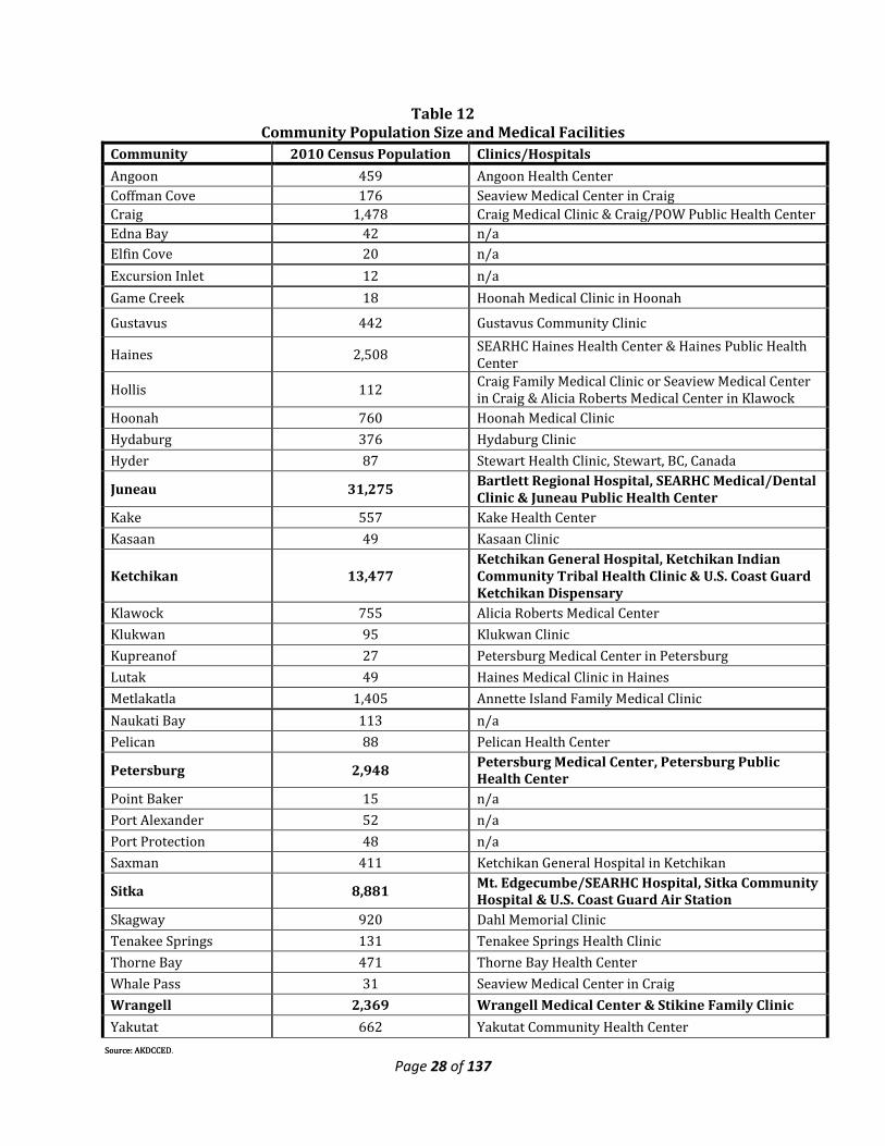
2.3g Regional Health Care Facilities Geographic, demographic and ethnic characteristics shape a unique health care system in Alaska. Large corporations operate acute care hospitals and there are small, community-based providers. No accredited HMOs serve the state according to an American Association of Retired Persons January 2006 report. In Southeast, general acute care hospitals are found in Juneau, Ketchikan, Sitka, Petersburg and Wrangell. Community hospitals and some private providers are found in communities with as few as 2,500 residents. Yakutat, Pelican, Hoonah, Gustavus, Haines, Skagway, Kake, Klawock and Tenakee Springs are served by rural health clinics. The state provides itinerant public health nursing, with an emphasis on maternal and child health care services, in some rural communities. Emergency medical technicians and community health aides are also an important part of the health care delivery system. Throughout the region, patients are referred to tertiary care centers or specialized facilities in Anchorage and Seattle, when necessary. While nursing homes and facilities for the elderly are available in the region’s population centers, they remain on the wish list for most rural communities. The major health care facilities in the region are as follows. Hospitals
• Ketchikan General Hospital - 46 beds • Sitka Community Hospital - 13 beds • SEARHC Hospital (Sitka) - 64 beds • Bartlett Memorial Hospital (Juneau) – 55 in-patient/16 out-patient beds
Medical Centers (resident doctors) • Petersburg Medical Center - 14 beds • Wrangell Medical Center - 8 beds • Craig Clinic – outpatient only • Haines Clinic – outpatient only • Alicia Roberts Medical Center (Klawock) – 2 in-patient/2 out-patient beds
Many other Southeast Alaska communities have local outpatient clinics that are generally staffed by a nurse practitioner or a physician’s assistant, but no resident doctor. The following table shows community population compared to the medical services that are available in the region.
Page 28 of 137
Table 12 Community Population Size and Medical Facilities
Community 2010 Census Population Clinics/Hospitals Angoon 459 Angoon Health Center Coffman Cove 176 Seaview Medical Center in Craig Craig 1,478 Craig Medical Clinic & Craig/POW Public Health Center Edna Bay 42 n/a Elfin Cove 20 n/a Excursion Inlet 12 n/a Game Creek 18 Hoonah Medical Clinic in Hoonah
Gustavus 442 Gustavus Community Clinic
Haines 2,508 SEARHC Haines Health Center & Haines Public Health Center
Hollis 112 Craig Family Medical Clinic or Seaview Medical Center in Craig & Alicia Roberts Medical Center in Klawock
Hoonah 760 Hoonah Medical Clinic Hydaburg 376 Hydaburg Clinic Hyder 87 Stewart Health Clinic, Stewart, BC, Canada
Juneau 31,275 Bartlett Regional Hospital, SEARHC Medical/Dental Clinic & Juneau Public Health Center
Kake 557 Kake Health Center Kasaan 49 Kasaan Clinic
Ketchikan 13,477 Ketchikan General Hospital, Ketchikan Indian Community Tribal Health Clinic & U.S. Coast Guard Ketchikan Dispensary
Klawock 755 Alicia Roberts Medical Center Klukwan 95 Klukwan Clinic Kupreanof 27 Petersburg Medical Center in Petersburg Lutak 49 Haines Medical Clinic in Haines Metlakatla 1,405 Annette Island Family Medical Clinic Naukati Bay 113 n/a Pelican 88 Pelican Health Center
Petersburg 2,948 Petersburg Medical Center, Petersburg Public Health Center
Point Baker 15 n/a Port Alexander 52 n/a Port Protection 48 n/a Saxman 411 Ketchikan General Hospital in Ketchikan
Sitka 8,881 Mt. Edgecumbe/SEARHC Hospital, Sitka Community Hospital & U.S. Coast Guard Air Station
Skagway 920 Dahl Memorial Clinic Tenakee Springs 131 Tenakee Springs Health Clinic Thorne Bay 471 Thorne Bay Health Center Whale Pass 31 Seaview Medical Center in Craig Wrangell 2,369 Wrangell Medical Center & Stikine Family Clinic Yakutat 662 Yakutat Community Health Center
Source: AKDCCED Source: AKDCCED.

Page 29 of 137
Approximately 15,500 people live in Southeast’s rural communities (those outside of Juneau, Ketchikan, Sitka, Petersburg, and Wrangell). For them, access to community hospitals is often difficult and they tend instead to use urban primary care facilities. About 4,400 of these people reside in the region’s 25 communities that are without primary health care services. They must travel by plane or boat to access medical care. An additional 2,000+ seasonal workers in the timber, fishing and tourism industries live in these rural communities 5 to 6 months a year and use local medical services. The rural communities of Southeast that enjoy health care services to any degree do so largely with the aid and support of Bartlett Regional Hospital in Juneau, Ketchikan General Hospital, and the Southeast Alaska Regional Health Consortium (SEARHC). Bartlett Regional Hospital, a nonprofit enterprise fund of the City and Borough of Juneau, serves as a regional secondary care center for northern Southeast. The hospital has 54 credentialed medical staff representing 22 medical specialties and provides a full range of in-house and outpatient services. A two-year renovation and expansion project of the Bartlett facility in Juneau was completed in 2010. Bartlett Regional Hospital supports community health centers in Gustavus, Skagway, Tenakee Springs, and Yakutat. Medivac transports are provided by Airlift Northwest, which has an air ambulance based in Juneau full-time. Ketchikan General Hospital is a nonprofit regional hospital serving Southern Southeast, including Prince of Wales Island, Petersburg, and Wrangell. The twenty-six credentialed staff provides a full range of surgical, medical and family practice services. Additionally, the Wrangell Medical Center, with an 8-bed acute care hospital, a long-term care facility and the Stikine Family Clinic has begun outreach services to rural communities on the north end of Prince of Wales Island. The Seaview Family Medical Center in Craig also provides services, including Locum Tenens physicians, to nearby Prince of Wales Island communities. SEARHC is a nonprofit, Native-administered health consortium established in 1975 to represent the health care needs of Tlingit, Haida, Tsimpshian and other Native people from eighteen Southeast Alaska communities. The consortium is governed by a board of directors made up of elected Native representatives from each community – Angoon, Craig, Douglas, Haines, Hoonah, Hydaburg, Juneau, Kake, Kasaan, Klawock, Klukwan, Pelican, Petersburg, Sitka, Skagway, Tenakee Springs, and Wrangell. SEARHC programs and facilities serve a beneficiary (Alaska Native/American Indian) population of over 14,000 individuals in Southeast Alaska and over 7,000 non-Natives. For over 35 years, SEARHC has provided the highest quality health care services for Native and rural-dwelling residents. The full array of comprehensive services provided include medical, dental, behavioral health, community-based prevention, health promotion, environmental health and safety, medivac and various health-training programs throughout the region. SEARHC operates Mt. Edgecumbe hospital in Sitka, regional medical-dental clinics in Juneau and Sitka, sub-regional clinics in Haines and on Prince of Wales Island, and eight village clinics. The SEARHC Sitka campus includes Mt. Edgecumbe Hospital with acute care, critical care, obstetrics, surgery, preoperative, and inpatient mental health care. S’áxt Hít has twenty-four physicians and an average daily inpatient census of twenty-four patients. There are also numerous specialty clinics offered by Mt. Edgecumbe Hospital not available in the smaller communities such as: neurology, orthopedic, dermatology, urology, cardiac, hepatology, rheumatology, ophthalmology, orthodontics, and denture clinic. The Sitka campus has three residential substance abuse treatment programs: Bill Brady Healing Center for adults, Déilee Hít – Safe Harbor program for women with children, and Raven’s Way, an adolescent experiential treatment program. Medical,
Page 30 of 137
behavioral health and health promotion services in the sub-regional and village clinics are provided by Community Health Services that is also located on the Sitka campus. There are many obstacles to accessing health care, particularly in Southeast’s rural areas. The cost, availability and reliability of transportation are perhaps the most significant problems in a region highly dependent on air and marine transport. Between May 1998 and May 2000, six air taxi operators in the region either ceased operating or substantially reduced their service. This loss makes it difficult for many rural residents to reach primary care facilities or regional transportation hubs. A lack of appropriate outpatient housing, similar to the recently completed Bartlett House in Juneau and the SEARHC patient housing complex in Sitka, also inhibits underserved populations from receiving care. Southeast’s medically uninsured population is largely a result of unemployment or under-employment. Many Alaskans are self-employed in the fishing industry or in seasonal jobs like tourism, logging, mining and fish processing that do not offer health care benefits. Due to high costs involved, many of these people cannot or do not buy insurance or buy only limited coverage for catastrophic illness. Alaska is also a state with a young population who often do not consider themselves at risk or in need of insurance coverage. In fact, these are the very people who most often require emergency medical services and are hospitalized with injuries. Telemedicine offers great potential for alleviating some of the problems associated with providing health care in locales with limited medical capabilities. This technology provides distant physicians and laboratories the information necessary to determine appropriate treatments and whether or not patients require transport to a medical facility. It can reduce unnecessary patient travel as well as disruptions to the patient’s family, work and lifestyle. Telemedicine has been in use throughout Southeast for a number of years, supporting patient consults, distance education, trauma conferences, tumor boards and tele-radiology. The next step in providing access and timeliness of care to those in remote communities may be telemedicine using desktop conferencing. This is especially promising for distance psychiatric, radiology and even patient consults, where a physician and patient can interact desktop to desktop. As a member of the Alaska Federal Health Care Access Network Project, SEARHC benefits from the project’s mission to provide telemedicine services to 225 villages throughout the state. Expanded use of this technology promises to ease many of the pressures now experienced throughout the region. Distinct and nonintegrated systems of care now exist in both rural and urban parts of the region. A model of health care delivery that joins private, state, local government, federal and tribal resources to create a comprehensive system of care uniquely adapted to meet the challenging delivery environment of Alaska is desirable. Partnering among health care providers can better maximize service delivery and achieve economies of scale.
2.5 Regional Economy Major economic sectors that bring money into Southeast Alaska (basic industries) include commercial fishing, timber, mining, tourism, and some government jobs (mostly State and Federal government). Manufacturing is also considered a basic industry and is made up mostly of businesses processing fish but also includes some other smaller scale activity including timber processing, boat building, brewing, and others. Businesses which support local businesses and population by providing goods and services also provide jobs and income in local communities.
2.4a Employment and Earnings Employment in Southeast Alaska averaged 36,450 jobs in 2010, according to the latest estimates from AKDOLWD. This estimate is based on a survey of employers and is subject to minor revisions as the more detailed job-count data becomes available. Employment in the region (and the region’s
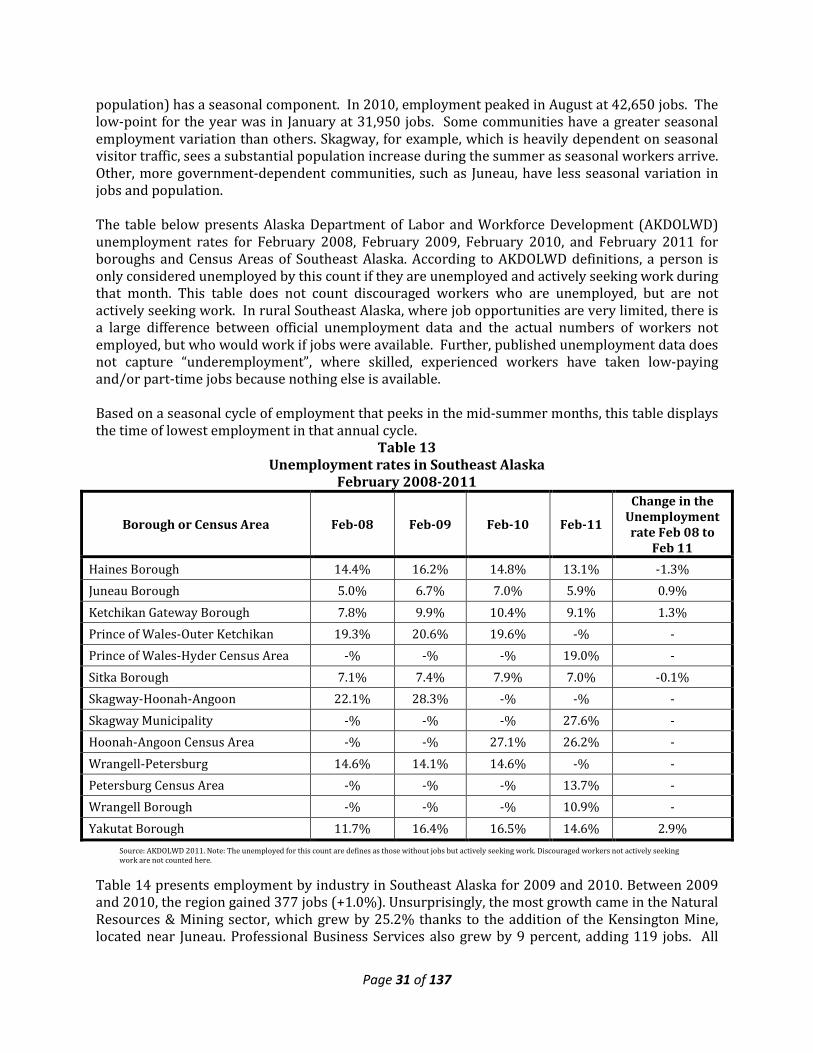
Page 31 of 137
population) has a seasonal component. In 2010, employment peaked in August at 42,650 jobs. The low-point for the year was in January at 31,950 jobs. Some communities have a greater seasonal employment variation than others. Skagway, for example, which is heavily dependent on seasonal visitor traffic, sees a substantial population increase during the summer as seasonal workers arrive. Other, more government-dependent communities, such as Juneau, have less seasonal variation in jobs and population. The table below presents Alaska Department of Labor and Workforce Development (AKDOLWD) unemployment rates for February 2008, February 2009, February 2010, and February 2011 for boroughs and Census Areas of Southeast Alaska. According to AKDOLWD definitions, a person is only considered unemployed by this count if they are unemployed and actively seeking work during that month. This table does not count discouraged workers who are unemployed, but are not actively seeking work. In rural Southeast Alaska, where job opportunities are very limited, there is a large difference between official unemployment data and the actual numbers of workers not employed, but who would work if jobs were available. Further, published unemployment data does not capture “underemployment”, where skilled, experienced workers have taken low-paying and/or part-time jobs because nothing else is available. Based on a seasonal cycle of employment that peeks in the mid-summer months, this table displays the time of lowest employment in that annual cycle.
Table 13 Unemployment rates in Southeast Alaska
February 2008-2011
Borough or Census Area Feb-08 Feb-09 Feb-10 Feb-11
Change in the Unemployment rate Feb 08 to
Feb 11 Haines Borough 14.4% 16.2% 14.8% 13.1% -1.3% Juneau Borough 5.0% 6.7% 7.0% 5.9% 0.9% Ketchikan Gateway Borough 7.8% 9.9% 10.4% 9.1% 1.3% Prince of Wales-Outer Ketchikan 19.3% 20.6% 19.6% -% - Prince of Wales-Hyder Census Area -% -% -% 19.0% - Sitka Borough 7.1% 7.4% 7.9% 7.0% -0.1% Skagway-Hoonah-Angoon 22.1% 28.3% -% -% - Skagway Municipality -% -% -% 27.6% - Hoonah-Angoon Census Area -% -% 27.1% 26.2% - Wrangell-Petersburg 14.6% 14.1% 14.6% -% - Petersburg Census Area -% -% -% 13.7% - Wrangell Borough -% -% -% 10.9% - Yakutat Borough 11.7% 16.4% 16.5% 14.6% 2.9%
Table 14 presents employment by industry in Southeast Alaska for 2009 and 2010. Between 2009 and 2010, the region gained 377 jobs (+1.0%). Unsurprisingly, the most growth came in the Natural Resources & Mining sector, which grew by 25.2% thanks to the addition of the Kensington Mine, located near Juneau. Professional Business Services also grew by 9 percent, adding 119 jobs. All
Source: AKDOLWD 2011. Note: The unemployed for this count are defines as those without jobs but actively seeking work. Discouraged workers not actively seeking work are not counted here.
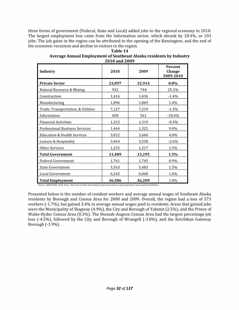
Page 32 of 137
three forms of government (Federal, State and Local) added jobs to the regional economy in 2010. The largest employment loss came from the Information sector, which shrank by 18.4%, or 103 jobs. The job gains in the region can be attributed to the opening of the Kensington, and the end of the economic recession and decline in visitors to the region.
Table 14 Average Annual Employment of Southeast Alaska residents by Industry
2010 and 2009
Industry 2010 2009 Percent Change
2009-2010
Private Sector 23,097 22,914 0.8% Natural Resource & Mining 932 744 25.2% Construction 1,416 1,436 -1.4% Manufacturing 1,896 1,869 1.4% Trade, Transportation, & Utilities 7,127 7,219 -1.3% Information 458 561 -18.4% Financial Activities 1,315 1,319 -0.3% Professional Business Services 1,444 1,325 9.0% Education & Health Services 3,812 3,666 4.0% Leisure & Hospitality 3,464 3,558 -2.6% Other Services 1,235 1,217 1.5% Total Government 13,489 13,295 1.5% Federal Government 1,761 1,745 0.9% State Government 5,563 5,483 1.5% Local Government 6,165 6,068 1.6%
Total Employment 36,586 36,209 1.0% Source: AKDOLWD, 2010. Note: Does not include self-employed persons such as sole proprietors and commercial fishers
Presented below is the number of resident workers and average annual wages of Southeast Alaska residents by Borough and Census Area for 2008 and 2009. Overall, the region had a loss of 573 workers (-1.7%), but gained 3.4% in average annual wages paid to residents. Areas that gained jobs were the Municipality of Skagway (4.9%), the City and Borough of Yakutat (2.5%), and the Prince of Wales-Hyder Census Area (0.3%). The Hoonah-Angoon Census Area had the largest percentage job loss (-4.5%), followed by the City and Borough of Wrangell (-3.8%), and the Ketchikan Gateway Borough (-1.9%).
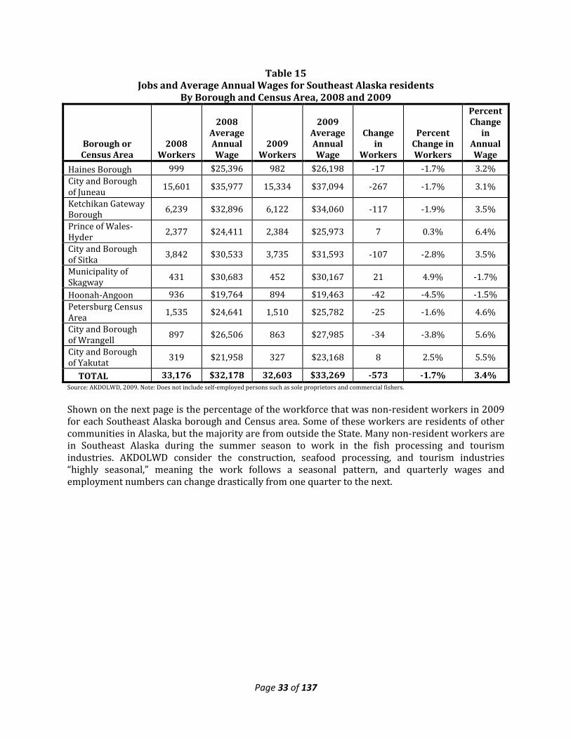
Page 33 of 137
Table 15 Jobs and Average Annual Wages for Southeast Alaska residents
By Borough and Census Area, 2008 and 2009
Borough or Census Area
2008 Workers
2008 Average Annual Wage
2009 Workers
2009 Average Annual Wage
Change in
Workers
Percent Change in Workers
Percent Change
in Annual Wage
Haines Borough 999 $25,396 982 $26,198 -17 -1.7% 3.2% City and Borough of Juneau 15,601 $35,977 15,334 $37,094 -267 -1.7% 3.1%
Ketchikan Gateway Borough 6,239 $32,896 6,122 $34,060 -117 -1.9% 3.5%
Prince of Wales-Hyder 2,377 $24,411 2,384 $25,973 7 0.3% 6.4%
City and Borough of Sitka 3,842 $30,533 3,735 $31,593 -107 -2.8% 3.5%
Municipality of Skagway 431 $30,683 452 $30,167 21 4.9% -1.7%
Hoonah-Angoon 936 $19,764 894 $19,463 -42 -4.5% -1.5% Petersburg Census Area 1,535 $24,641 1,510 $25,782 -25 -1.6% 4.6%
City and Borough of Wrangell 897 $26,506 863 $27,985 -34 -3.8% 5.6%
City and Borough of Yakutat 319 $21,958 327 $23,168 8 2.5% 5.5%
TOTAL 33,176 $32,178 32,603 $33,269 -573 -1.7% 3.4% Source: AKDOLWD, 2009. Note: Does not include self-employed persons such as sole proprietors and commercial fishers.
Shown on the next page is the percentage of the workforce that was non-resident workers in 2009 for each Southeast Alaska borough and Census area. Some of these workers are residents of other communities in Alaska, but the majority are from outside the State. Many non-resident workers are in Southeast Alaska during the summer season to work in the fish processing and tourism industries. AKDOLWD consider the construction, seafood processing, and tourism industries “highly seasonal,” meaning the work follows a seasonal pattern, and quarterly wages and employment numbers can change drastically from one quarter to the next.
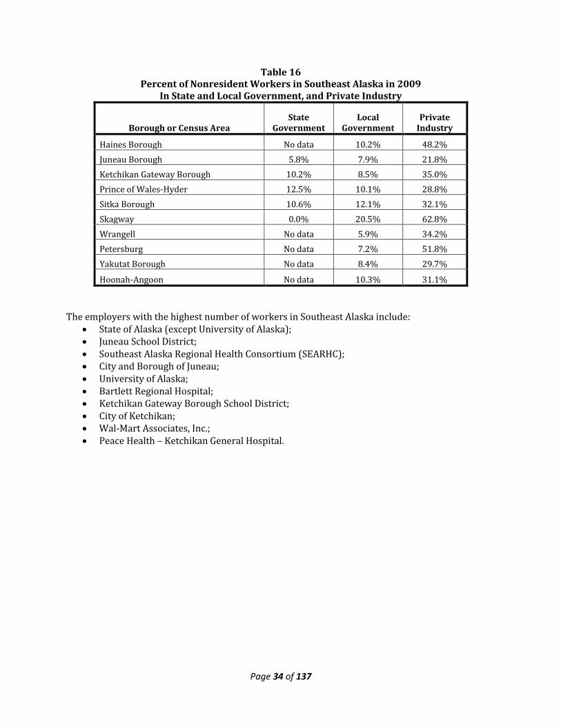
Page 34 of 137
Table 16 Percent of Nonresident Workers in Southeast Alaska in 2009
In State and Local Government, and Private Industry
Borough or Census Area State
Government Local
Government Private
Industry
Haines Borough No data 10.2% 48.2% Juneau Borough 5.8% 7.9% 21.8% Ketchikan Gateway Borough 10.2% 8.5% 35.0% Prince of Wales-Hyder 12.5% 10.1% 28.8% Sitka Borough 10.6% 12.1% 32.1% Skagway 0.0% 20.5% 62.8% Wrangell No data 5.9% 34.2% Petersburg No data 7.2% 51.8% Yakutat Borough No data 8.4% 29.7%
Hoonah-Angoon No data 10.3% 31.1% The employers with the highest number of workers in Southeast Alaska include:
• State of Alaska (except University of Alaska); • Juneau School District; • Southeast Alaska Regional Health Consortium (SEARHC); • City and Borough of Juneau; • University of Alaska; • Bartlett Regional Hospital; • Ketchikan Gateway Borough School District; • City of Ketchikan; • Wal-Mart Associates, Inc.; • Peace Health – Ketchikan General Hospital.
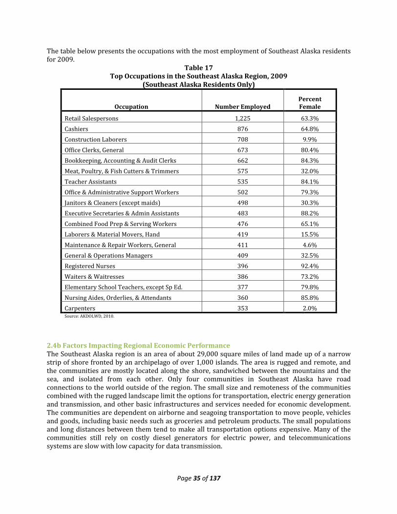
Page 35 of 137
The table below presents the occupations with the most employment of Southeast Alaska residents for 2009.
Table 17 Top Occupations in the Southeast Alaska Region, 2009
(Southeast Alaska Residents Only)
Occupation Number Employed Percent Female
Retail Salespersons 1,225 63.3% Cashiers 876 64.8% Construction Laborers 708 9.9% Office Clerks, General 673 80.4% Bookkeeping, Accounting & Audit Clerks 662 84.3% Meat, Poultry, & Fish Cutters & Trimmers 575 32.0% Teacher Assistants 535 84.1% Office & Administrative Support Workers 502 79.3% Janitors & Cleaners (except maids) 498 30.3% Executive Secretaries & Admin Assistants 483 88.2% Combined Food Prep & Serving Workers 476 65.1% Laborers & Material Movers, Hand 419 15.5% Maintenance & Repair Workers, General 411 4.6% General & Operations Managers 409 32.5% Registered Nurses 396 92.4% Waiters & Waitresses 386 73.2% Elementary School Teachers, except Sp Ed. 377 79.8% Nursing Aides, Orderlies, & Attendants 360 85.8% Carpenters 353 2.0% Source: AKDOLWD, 2010.
2.4b Factors Impacting Regional Economic Performance The Southeast Alaska region is an area of about 29,000 square miles of land made up of a narrow strip of shore fronted by an archipelago of over 1,000 islands. The area is rugged and remote, and the communities are mostly located along the shore, sandwiched between the mountains and the sea, and isolated from each other. Only four communities in Southeast Alaska have road connections to the world outside of the region. The small size and remoteness of the communities combined with the rugged landscape limit the options for transportation, electric energy generation and transmission, and other basic infrastructures and services needed for economic development. The communities are dependent on airborne and seagoing transportation to move people, vehicles and goods, including basic needs such as groceries and petroleum products. The small populations and long distances between them tend to make all transportation options expensive. Many of the communities still rely on costly diesel generators for electric power, and telecommunications systems are slow with low capacity for data transmission.
Page 36 of 137
The region is blessed with abundant natural resources, but energy to process raw materials and transportation to get products to market are costly, so most added value-added production occurs outside of the region (and generally outside of the state). In addition, the high costs of energy and transportation greatly impact the quality of life in our communities, limiting the amount and quality of affordable housing, health care, education, and other amenities. In 2010 the Juneau Economic Development Council partnered with Southeast Conference to conduct a Southeast Alaska Business Climate Survey to better comprehend the barriers and benefits associated with owning and operating business in Southeast Alaska. The survey was completed by 243 business owners and top managers, representing every community in Southeast Alaska. According to the region’s business owners and top managers, the top business impediments in Southeast Alaska are as follows:
• Freight Costs—75% of all business leaders surveyed called freight costs a barrier, with nearly half of regional business leaders calling freight costs a significant barrier.
o Nearly all of those involved in the seafood and timber industry called freight costs a problem (94% and 100% respectively).
• The High Price of Real Estate—both in terms of the high cost of housing in general, deemed a barrier to 60% of respondents, and in terms of business real estate costs, called a barrier by 57% of respondents.
o For some business leaders, these numbers are significantly higher, with 74% of Sitka businesses saying that the cost of business real estate is a barrier, and this emerged as Juneau’s top business barrier at 70%.
o In Sitka, 83% called the price of housing a problem, along with 74% of business respondents from Ketchikan, and 66% of Juneau respondents.
• Federal Regulations—56% of the region’s business leaders called Federal regulations a barrier to operating their business, with 34% referring to this as a “significant” barrier.
o Those responding from the seafood, timber and mining sectors were most likely to call federal regulations a barrier (72%, 88%, and 100% respectively).
• The High Price of Electricity—When the region was analyzed for non-Juneau respondents only, the cost of electricity emerged as a second major barrier to business, with 62% of those outside Juneau calling the cost of electricity a moderate or significant barrier.
o 72% of those from the Hoonah-Angoon Census Area called the cost of electricity a business barrier (while 43% of respondents from Sitka called the price of electricity a benefit to their business). 88% of those involved in forestry say energy costs are a barrier.
These are issues that Southeast Conference continues to address, with the goal of improving the economic well being and quality of life of all residents of the region. Improvement in the reliability and cost of transportation, communications, and electric energy generation; improved workforce development; and reduced opposition to responsible development of local resources can pave the way for increased economic development in Southeast Alaska.
2.4c Economic Sectors The major economic sectors in Southeast Alaska include commercial fish harvest and processing, tourism, mining, timber harvest and processing, and government. Commercial fish harvest does not appear in most published industry employment counts because commercial fishers are considered self-employed, and so are outside the system requiring contributions to unemployment insurance for workers (the unemployment system allows us to count workers by industry). Seafood and timber processing employment and earnings are counted in the Manufacturing industry category. Much of the tourist industry employment is accounted for in the Leisure and Hospitality industry
Page 37 of 137
category; however, many other types of businesses in the region also derive employment and earnings from visitors to the region, especially in the transportation and retail sectors.
Commercial Fisheries The table below shows the number of commercial fishing permits and crew licenses issued to Southeast Alaska residents in 2000 and 2008-2010. Early in the decade, prices for commercially caught fish dropped, but they have since rebounded. However, Southeast Alaska continues to lose commercial fishing permits and crew licenses to non-residents. Between 2000 and 2010, regional residents lost a total of 462 (-16.4 percent) State-issued limited entry commercial fishing permits, and 291 (-10.3 percent) fewer residents held commercial fishing crew licenses. The largest losses in commercial fishing permits over that time were in the City and Borough of Juneau (-25 percent), and the Skagway-Hoonah-Angoon Census Area (-28 percent). Prince of Wales-Outer Ketchikan Census Area followed with an 18 percent loss in resident-owned permits. The Haines Borough lost the most crew licenses between 2000 and 2010 (-36 percent) and the Skagway-Hoonah-Angoon Census Area (-25 percent). Between 2009 and 2010, 17 commercial fishing permits left the region, and local residents lost 18 fishing crew licenses. The Ketchikan Gateway Borough gained the most crew licenses between 2009 and 2010.
Table 18 Southeast Alaska Residents with Commercial Fishing Permits and Crew Licenses
2000 and 2008-2010
Borough
2000 Permit
Holders
2008 Permit
Holders
2009 Permit
Holders
2010 Permit
Holders
2000 Crew
License Holders
2008 Crew
License Holders
2009 Crew
License Holders
2010 Crew
License Holders
Haines Borough 128 109 110 107 136 87 97 87
City and Borough of Juneau
521 406 387 389 412 413 441 431
Ketchikan Gateway Borough
391 343 331 338 424 296 317 355
Prince of Wales-Outer Ketchikan
410 338 333 337 322 327 297 269
City and Borough of Sitka
583 551 572 563 565 547 547 552
Skagway-Hoonah-Angoon
291 221 223 210 196 147 149 147
Wrangell-Petersburg 818 765 746 744 717 677 645 649
City and Borough of Yakutat
161 163 156 153 46 29 52 37
TOTAL 3,303 2,896 2,858 2,841 2,818 2,523 2,545 2,527 Source: AKCFEC,
2011
Page 38 of 137
Table 19 presents pounds and value of fish landed by commercial fishers residing in Southeast Alaska. These fish were not necessarily caught or landed in Southeast Alaska, but they were caught by Southeast Alaska residents, and the earnings accrue to those resident permit holders. The 2010 data is preliminary and may not report the total catch and earnings for that year. In general, 2010 prices were down from 2008, but still higher than 2009.
Table 19 Commercial Fishing Activity by Southeast Alaska Residents
1990, 2000, 2008 to 2010
1990 2000 2008 2009 2010
Haines Borough ($/lb) $1.48 $0.60 $0.96 $0.86 $1.07
Pounds Landed (1,000) 4,395 6,843 7,602 6,105 6,347
Dollar Value ($1,000) $6,497 $4,092 $7,312 $5,244 $6,771
Juneau City and Borough ($/lb) $1.38 $0.94 $1.33 $0.95 $1.14
Pounds Landed (1,000) 17,974 17,497 16,789 18,486 18,777
Dollar Value ($1,000) $24,874 $16,373 $22,342 $17,527 $21,452
Ketchikan Gateway Borough ($/lb) $0.80 $0.51 $0.81 $0.57 $0.69
Pounds Landed (1,000) 29,868 27,350 24,714 31,285 30,881
Dollar Value ($1,000) $23,787 $13,921 $20,037 $17,959 $21,282 Prince of Wales-Outer Ketchikan ($/lb) $1.16 $0.83 $1.26 $0.76 $0.83
Pounds Landed (1,000) 10,524 8,740 11,458 15,032 15,854
Dollar Value ($1,000) $12,189 $7,277 $14,484 $11,461 $13,093
Sitka City and Borough ($/lb) $1.35 $1.10 $1.74 $1.04 $1.19
Pounds Landed (1,000) 22,682 29,145 22,001 29,350 33,882
Dollar Value ($1,000) $30,564 $32,041 $38,266 $30,489 $40,151
Skagway-Hoonah-Angoon ($/lb) $1.36 $1.32 $1.98 $1.49 $1.68
Pounds Landed (1,000) 9,180 4,758 3,851 3,759 3,894
Dollar Value ($1,000) $12,526 $6,273 $7,643 $5,590 $6,530
Wrangell-Petersburg ($/lb) $1.03 $0.89 $1.25 $0.82 $0.94
Pounds Landed (1,000) 61,215 52,578 54,419 64,249 66,685
Dollar Value ($1,000) $62,748 $46,698 $67,904 $52,621 $62,797
Yakutat City and Borough ($/lb) $1.67 $0.84 $1.51 $1.07 $1.32
Pounds Landed (1,000) 3,330 1,801 2,167 2,226 3,236
Dollar Value ($1,000) $5,565 $1,507 $3,266 $2,374 $4,257
Southeast Region Total ($/lb) $1.12 $0.86 $1.27 $0.84 $0.98
Pounds Landed (1,000) 159,167 148,711 142,999 170,492 179,556
Dollar Value ($1,000) $178,750 $128,182 $181,255 $143,264 $176,334
Source: AKCFEC. Notes: Preliminary figures are generally low, so 2008 totals will likely increase. Some earnings data is not available to preserve confidentiality of earnings in small fisheries.
Page 39 of 137
Seafood processing activity in Southeast Alaska has slowed since the early 2000s. In 2003, Wards Cove Packing Company ceased operation of nine salmon processing plants in Alaska (three in Southeast Alaska). However, the plants were purchased and are operating again, and seafood processing employment, despite some fluctuation, appears to be strong in the region. Average annual wages in this industry have dropped slightly in recent years. Employment and earnings in the seafood processing industry are reported under the manufacturing category in tables above. Mariculture and aquaculture farming are relatively new to Southeast Alaska, and have great potential for expansion. Out of the 56 farms in Alaska, about half of them are located in Southeast and most of those are in southern Southeast. Due to colder-water climates, which slow down maturation, oysters grown in Alaskan waters are of a higher quality and available year round. The growth of this industry in recent years has spurred private stakeholders to seek the development of a regional shellfish-processing facility. Currently, individual farms are processing their own product for distribution to the market. A regional facility would improve efficiency in costs, time it takes to get the goods to the market, and holding capacity for efficient transportation. In addition, several facilities produce shellfish seeds, or spat, for shipment to other farms outside the region. A regional shellfish processing facility could facilitate the development and growth of an industry with a total farm gate value of $2.5 million and create 40-50 new jobs in the area. Seventy cents of every dollar is spent in direct industry purchases remains in the local economy. Table 16 provides production and value statistics for Southeast Alaska shellfish farms.
Table 20 Aquatic Farming Production and Farm Gate Value*
Year Farms Productive Permitted
Farms
Oysters (ea) Sales Clams (lbs) Sales Other
(lb) Sales Total Sales
1990 16 7 166,503 $45,638 0 $0 0 $0 $45,638 1991 26 7 160,376 $44,440 0 $0 0 $0 $44,440 1992 25 8 355,762 $112,980 0 $0 0 $0 $112,980 1993 21 11 328,290 $114,908 0 $0 150 $288 $115,196 1994 17 9 528,540 $138,993 5,396 $18,238 0 $0 $157,231 1995 15 11 599,106 $185,723 8,319 $28,118 0 $0 $213,841 1996 12 11 624,091 $222,196 16,593 $43,796 500 $2,200 $268,192 1997 13 11 553,694 $202,965 24,814 $93,869 0 $0 $296,834 1998 12 9 579,290 $226,418 28,166 $89,002 238 $417 $315,837 1999 11 9 489,421 $187,605 38,666 $124,054 0 $0 $311,659 2000 11 7 352,478 $146,510 39,135 $120,636 0 $0 $267,146 2001 15 8 247,289 $105,018 35,700 $105,071 10 $150 $210,239 2002 27 9 287,364 $124,770 40,726 $115,038 23 $345 $240,153 2003 25 10 396,684 $163,908 61,658 $148,924 14 $210 $313,042 2004 23 9 446,820 $187,448 68,453 $156,921 1,244 $2,612 $346,981 2005 34 10 538,116 $233,215 43,234 $103,772 0 $0 $336,987 2006 33 11 532,128 $220,907 45,882 $130,930 0 $0 $351,837 2007 33 10 468,018 $199,796 14,374 $40,198 0 $0 $239,994 2008 40 9 449,040 $194,769 8,020 $20,560 0 $0 $215,329 2009 41 10 413,330 $158,725 7,839 $24,841 0 $0 $183,766 2010 49 12 523,288 $166,022 8,446 $26,339 0 $0 $192,361
AKDF&G. Note: * Total Sales represent the total farm gate value that is defined as the unprocessed value, excluding the costs of packaging or transport of the product to its first point of sale.
Page 40 of 137
Mining Southeast Alaska has significant mineral resource development potential. The region’s mineral deposits are large and diverse. They include gold, silver, lead, zinc, copper, molybdenum, platinum, limestone, marble, uranium, and a number of rare earth minerals. There are also substantial quantities of rock, sand, and gravel for use in construction around the region. Mining has played a major role in the history of the region. Prince of Wales Island had the first gold mine in Alaska. The Island also supplied the world with first-class marble for buildings for years. Gold was discovered in Juneau in 1880, and the area hosted two of the largest gold mining operations in the world at the time they were in production. There are two producing mines in Southeast, Greens Creek and Kensington. Hecla Mining Company’s Green’s Creek mine on Admiralty Island is the second largest silver mine in North America and is the largest private sector employer in the Juneau area in terms of annual payroll. Coeur Alaska’s Kensington Gold Mine began producing gold in 2010 after a decision by the U.S. Supreme Court allowed the mine to open. Both mines are supported out of Juneau. Exploration and evaluation of undeveloped mineral bodies in the region is ongoing. Notable exploration projects include the Niblack and Bokan Mountain projects on Prince of Wales Island. Located on eastern Prince of Wales Island, Heatherdale Resources’ Niblack is an advanced-stage exploration project with significant copper-gold-zinc-silver mineralization. In 2011 two drill rigs were active on the site. Ucore’s Bokan Mountain project, located on southern Prince of Wales Island, is a uranium and rare earth element prospect that includes the old Ross Adams Mine, which intermittently produced uranium between 1957 and 1971. Mining jobs in Southeast Alaska paid an average annual wage of about $92,000 in 2009, the highest wage in the region.
Tourism Between the summer months of May and September of 2010, just over 875,000 cruise ship visitors came to Alaska. Visits to Alaska dropped by 14% from 2009. Traffic in 2011 is expected to be slightly above the 2010 level. The majority of the visitors made port calls at the primary ports of Ketchikan, Juneau and Skagway. Sitka and Haines also host significant numbers of cruise ship passengers. Hoonah began receiving cruise ships in 2004 with development of Icy Strait Point, and hosted a total of 123,000 passengers in 2010. A 2006 survey of Alaska visitors, conducted for the Alaska Office of Tourism Development, indicated that visitors arriving by cruise ship spent an average of $636 per person in Alaska,. Cruise ship passengers spent an estimated $600 million in the Southeast Alaska in 2006. Table 21 presents the number of cruise ship passengers visiting Southeast Alaska ports from 2000 and 2005 to 2010.
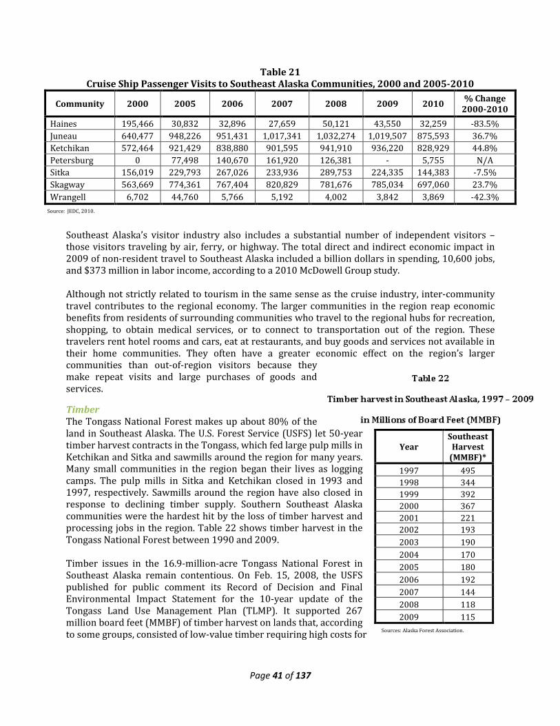
Page 41 of 137
Year Southeast
Harvest (MMBF)*
1997 495 1998 344 1999 392 2000 367 2001 221 2002 193 2003 190 2004 170 2005 180 2006 192 2007 144 2008 118 2009 115
Sources: Alaska Forest Association.
Table 21 Cruise Ship Passenger Visits to Southeast Alaska Communities, 2000 and 2005-2010
Community 2000 2005 2006 2007 2008 2009 2010 % Change 2000-2010
Haines 195,466 30,832 32,896 27,659 50,121 43,550 32,259 -83.5% Juneau 640,477 948,226 951,431 1,017,341 1,032,274 1,019,507 875,593 36.7% Ketchikan 572,464 921,429 838,880 901,595 941,910 936,220 828,929 44.8% Petersburg 0 77,498 140,670 161,920 126,381 - 5,755 N/A Sitka 156,019 229,793 267,026 233,936 289,753 224,335 144,383 -7.5% Skagway 563,669 774,361 767,404 820,829 781,676 785,034 697,060 23.7% Wrangell 6,702 44,760 5,766 5,192 4,002 3,842 3,869 -42.3%
Southeast Alaska’s visitor industry also includes a substantial number of independent visitors – those visitors traveling by air, ferry, or highway. The total direct and indirect economic impact in 2009 of non-resident travel to Southeast Alaska included a billion dollars in spending, 10,600 jobs, and $373 million in labor income, according to a 2010 McDowell Group study. Although not strictly related to tourism in the same sense as the cruise industry, inter-community travel contributes to the regional economy. The larger communities in the region reap economic benefits from residents of surrounding communities who travel to the regional hubs for recreation, shopping, to obtain medical services, or to connect to transportation out of the region. These travelers rent hotel rooms and cars, eat at restaurants, and buy goods and services not available in their home communities. They often have a greater economic effect on the region’s larger communities than out-of-region visitors because they make repeat visits and large purchases of goods and services.
Timber The Tongass National Forest makes up about 80% of the land in Southeast Alaska. The U.S. Forest Service (USFS) let 50-year timber harvest contracts in the Tongass, which fed large pulp mills in Ketchikan and Sitka and sawmills around the region for many years. Many small communities in the region began their lives as logging camps. The pulp mills in Sitka and Ketchikan closed in 1993 and 1997, respectively. Sawmills around the region have also closed in response to declining timber supply. Southern Southeast Alaska communities were the hardest hit by the loss of timber harvest and processing jobs in the region. Table 22 shows timber harvest in the Tongass National Forest between 1990 and 2009. Timber issues in the 16.9-million-acre Tongass National Forest in Southeast Alaska remain contentious. On Feb. 15, 2008, the USFS published for public comment its Record of Decision and Final Environmental Impact Statement for the 10-year update of the Tongass Land Use Management Plan (TLMP). It supported 267 million board feet (MMBF) of timber harvest on lands that, according to some groups, consisted of low-value timber requiring high costs for
Source: JEDC, 2010.
Page 42 of 137
extraction. The actual number of board feet harvested in recent years has been a fraction of this amount. There are several mostly small saw mills operating in Southeast Alaska. The Viking Lumber sawmill on Prince of Wales Island, however, is the largest private timber industry employer on the island. Sealaska, a regional Native corporation, has large timber holdings in Southern Southeast Alaska and generally harvests between 50 and 70 million board feet (MMBF) annually and accounts for approximately two-thirds of the region’s timber activities. If Sealaska Timber Corporation (STC) is not able to get the balance of their entitlement S.881 (Southeast Alaska Native Land Entitlement Finalization Act) they will be out of timber in two years. They expect to continue similar level of harvest into the future. The USFS still has substantial holdings of timber suitable for harvest. Although the current political climate has hindered sales of many USFS timber stands, a few small mills have been able to operate with what is available. The mills would prefer to have three years’ worth of timber on contract, but that has been difficult to obtain because nearly every timber sale has been subject to litigation by environmental groups. A bright spot in the industry is that a small portion of wood waste is now successfully being used for fuel in the region. Hopefully this will expand to help sawmills so they can avoid paying expensive costs to dispose of wood waste. More recently, SEC has been asked to support the efforts of Alaska Mills Inc. to construct and operate pellet plants in Southeast Alaska. There is a move to replace oil burners with bio fuel burners. The City of Craig uses chips to heat the swimming pool and a school, and the U.S. Coast Guard and Sealaska Corporation replaced oil-fired boilers with wood pellet boilers.
Government As is evident from the tables above, the government sector has a major impact on the economy of the region. While both state and local government employment had declined in recent years, it appears to have rebounded slightly in the past couple of years. Recent high oil prices bode well for State of Alaska revenues, though the long-term decline in North Slope oil production is expected to continue. Federal government employment has exhibited the opposite trend, showing growth until recently. Increasing pressure to address the nation’s growing debt may eventual result in less federal spending in Southeast, but in the meantime federal dollars flowing through the region’s economy in the form of payroll for federal employees, transfer payments to individual for entitlement programs, grants for other federally-supported health and social service programs, federal highway-related construction spending, and other spending will continue to serve as a primary component of the region’s economy.
Other Economic Sectors While generally not considered part of an industry, retirees have an effect on the regional economy. Those who settle in Southeast Alaska spend their retirement income to live as any other worker would spend a paycheck. Most retirement income originates outside of the community, classifying this income as part of the basic economy. Retirees are a significant portion of the clientele of the health care and social services sectors. They also tend to contribute much to their communities through volunteerism, and serve as an anchor for families who stay in the region to be near them. In 2009, 6,981 people age 65 and over lived in Southeast Alaska, making this group larger than both the State government and the local government sectors in terms of participation, which employed 5,339 and 6,433 people respectively in the region in that year. Senior citizens receive income from
Page 43 of 137
retirement benefits, Social Security, Medicare, investments and savings, private annuities and insurances, and other sources that they spend in Southeast Alaska. The health and social services sector is one of the fastest growing in the state and the region. In 2009, 3,409 people were employed in the private sector in this sector, and more were employed in the government sector dealing with health and social services. Major health care employers in the region include Southeast Alaska Regional Health Consortium (SEARHC), Bartlett Regional Hospital, and Ketchikan General Hospital. Trained health care professionals are in high demand in the region, and continued growth in the industry is expected. Tribal governments and Alaska Native corporations in the region also generate economic activity. In 2008, tribal governments employed an annual average of 887 workers in the region. Jobs with Alaska Native corporations and other Alaska Native organizations are more difficult to isolate, as they are categorized under several industries along with non-Native entities. These businesses and organizations work in the Hospitality and Leisure, Transportation, Manufacturing, and other industries in the region. Regional Native Corporation: Sealaska Corporation (See section 6.0 for further information) Of the 200 Alaska Native Village Corporations in the State of Alaska there are 12 in the Southeast region. Village Councils (Federally Recognized Tribes) are listed in each community’s section. Native Village/Urban Corporation & Community
• Cape Fox Corporation, Saxman • Goldbelt Inc., Juneau • Haida Corporation, Hydaburg • Huna Totem Corporation, Hoonah • Kake Tribal Corporation, Kake • Kavilco Inc., Kasaan • Klawock Heenya Corporation, Klawock • Klukwan, Inc., Klukwan • Kootznoowoo Inc., Angoon • Shaan-Seet Inc., Craig • Shee Atiká, Inc., Sitka • Yak-tat Kwaan Inc., Yakutat
Central Council Tlingit & Haida Indian Tribes of Alaska Economic Impacts Annually, over the last five years, Central Council has brought between $25 million and $27 million in funding for 200 programs and services to the region that enhance the lives and well-being of tribal citizens, families, and communities in terms of employment, health, education, and cultural identity. The programs place special emphasis on the children and elders. This unique and comprehensive organization has economic and program impacts far beyond what most regional residents and even tribal citizens may observe in their day-to-day lives. A comprehensive report of "Contributions of Central Council Tlingit and Haida Indian Tribes of Alaska" was completed March 2010 by the McDowell Group, Inc. This document presented a complete picture of the economic impacts of one of the region’s major economic contributors, as well as a description of important social impacts of Central Council programs. While Central Council headquarters are located in Juneau where the largest tribal citizen population resides, the
Page 44 of 137
programs and economic impacts extend to 17 other Southeast Alaska communities, Anchorage, and numerous other Alaska communities where tribal families reside. Central Council generates total Southeast regional economic activity valued at $31.6 million, including payroll-related economic activity of $16 million. Central Council's direct employment of 204 people resulted in approximately 61 additional indirect and induced jobs in the region, for a total estimated regional employment of 265 people in 2008. Many of these jobs are “family wage” jobs and are very important to the economic health of Juneau and Southeast Alaska. Central Council ranks as the Capital City’s seventh largest employer among all private for-profit and non-profit entities. Central Council’s economic impacts are concentrated in Southeast Alaska – the tribal region of origin – where more than four of every five Central Council dollars are spent. In 2008, direct economic impacts totaled $22.5 million in the region including $11.5 million in payroll and benefits, and $11 million in other Central Council spending. The $22.5 million in direct expenditures generated an additional $9 million in indirect and induced (multiplier) economic activity, for an estimated total regional impact of $31.6 million. Juneau’s economy benefits significantly from Central Council spending and employment. In 2008, Central Council had direct spending of $16.3 million in Juneau including $9.4 million in payroll and benefits and $6.9 million in other Council spending, resulting in estimated total economic activity of $22.8 million in the community. Central Council direct employment (152 people) and spending generated approximately 43 additional jobs, resulting in about 195 Juneau jobs related to Central Council employment and spending in 2008. Estimated total payroll and benefits in Juneau associated with these jobs was $13.1 million ($9.4 million direct payroll and $3.8 million indirect and induced). There are three types of economic impacts from Central Council-related spending:
• Direct impacts: Central Council spending for payroll, goods and services, and tribal citizen direct benefits.
• Indirect impacts: Jobs and income in businesses providing goods and services to the Central Council.
• Induced impacts: Jobs and income created as a result of Central Council employees spending their payroll dollars in the local economies.
Indirect and induced economic impacts, often described as multiplier effects, are an important component of Central Council economic impacts. In general, however, multiplier effects for Alaska are limited, as few goods are actually produced in the state.
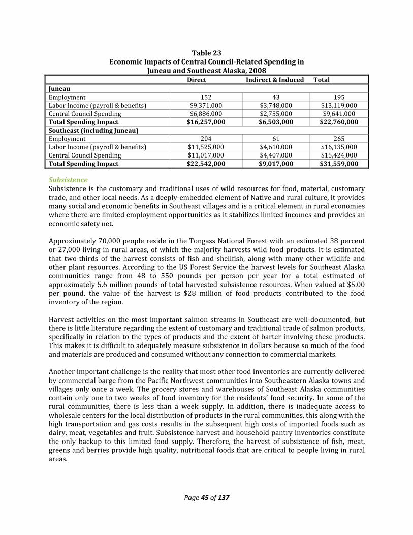
Page 45 of 137
Table 23 Economic Impacts of Central Council-Related Spending in
Juneau and Southeast Alaska, 2008 Direct Indirect & Induced Total Juneau Employment 152 43 195 Labor Income (payroll & benefits) $9,371,000 $3,748,000 $13,119,000 Central Council Spending $6,886,000 $2,755,000 $9,641,000 Total Spending Impact $16,257,000 $6,503,000 $22,760,000 Southeast (including Juneau) Employment 204 61 265 Labor Income (payroll & benefits) $11,525,000 $4,610,000 $16,135,000 Central Council Spending $11,017,000 $4,407,000 $15,424,000 Total Spending Impact $22,542,000 $9,017,000 $31,559,000
Subsistence Subsistence is the customary and traditional uses of wild resources for food, material, customary trade, and other local needs. As a deeply-embedded element of Native and rural culture, it provides many social and economic benefits in Southeast villages and is a critical element in rural economies where there are limited employment opportunities as it stabilizes limited incomes and provides an economic safety net. Approximately 70,000 people reside in the Tongass National Forest with an estimated 38 percent or 27,000 living in rural areas, of which the majority harvests wild food products. It is estimated that two-thirds of the harvest consists of fish and shellfish, along with many other wildlife and other plant resources. According to the US Forest Service the harvest levels for Southeast Alaska communities range from 48 to 550 pounds per person per year for a total estimated of approximately 5.6 million pounds of total harvested subsistence resources. When valued at $5.00 per pound, the value of the harvest is $28 million of food products contributed to the food inventory of the region. Harvest activities on the most important salmon streams in Southeast are well-documented, but there is little literature regarding the extent of customary and traditional trade of salmon products, specifically in relation to the types of products and the extent of barter involving these products. This makes it is difficult to adequately measure subsistence in dollars because so much of the food and materials are produced and consumed without any connection to commercial markets. Another important challenge is the reality that most other food inventories are currently delivered by commercial barge from the Pacific Northwest communities into Southeastern Alaska towns and villages only once a week. The grocery stores and warehouses of Southeast Alaska communities contain only one to two weeks of food inventory for the residents’ food security. In some of the rural communities, there is less than a week supply. In addition, there is inadequate access to wholesale centers for the local distribution of products in the rural communities, this along with the high transportation and gas costs results in the subsequent high costs of imported foods such as dairy, meat, vegetables and fruit. Subsistence harvest and household pantry inventories constitute the only backup to this limited food supply. Therefore, the harvest of subsistence of fish, meat, greens and berries provide high quality, nutritional foods that are critical to people living in rural areas.
Page 46 of 137
In Southeast Alaska, the Tongass Forest is a part of the national forest system that encompasses 95 percent of the lands and waters of Southeastern Alaska. Therefore, it is important to consider traditional and customary hunting, fishing, and harvesting, otherwise known as subsistence as an important part of American agriculture in our region. One of the outputs of the national forests and the conservation lands of the Tongass is the harvest of the many available natural resources. Subsistence is protected on federal land under the Alaska National Interest Lands Conservation Act (ANILCA), which established it as a priority over other resource uses on federal lands in times of scarcity in rural Alaska. In addition to the economic and health benefits, subsistence harvesting activities provide a basis for social order. The gathering and exchange of subsistence products through multiple means and channels are among the most important activities by which the cultural heritage of Southeast Alaska Natives is maintained at family and group levels. Family activities are centered on the seasonal cycle of harvests, with men most often involved with the harvesting and women with the processing of the food, and children and elderly also providing important roles. Knowledge, labor and material goods are shared, with foods distributed and shared among households to provide a form of social support for those who cannot provide for themselves due to age or disability. The social roles connected with subsistence activity are important to the psychological and emotional well-being of rural villagers.
Page 47 of 137
3.0 Goals Presented below is a list of goals, and goal subparts, designed to respond to the economic problems of Southeast Alaska. The objectives for the Southeast Alaska 2011-2015 CEDS plan are presented in the form of action initiatives that resulted from a regional collaboration and process involving the private sector; regional industries; local, state, and federal government; the CEDS committee; and non-profits such as Southeast Conference and Central Council Tlingit and Haida. A full description of this process and the resulting action initiatives (objectives) are in section 4.0.
Goal 1: Community & Regional Development Initiate activities, support and assist communities and boroughs, tribes, and other organizations in efforts to improve the region as a good place to live and work.
1.1: Infrastructure Development Advocate, support, and assist in development, maintenance, and enhancement of public infrastructure throughout the region.
1.2: Quality of Life Improvements Support and assist communities, boroughs, tribes, and other organizations in developing and maintaining community services and facilities throughout Southeast Alaska.
Goal 2: Economic Development Support and assist in planning and implementation of local and regional economic development projects and initiatives.
2.1: Business and Industrial Development Promote and assist continuation of existing businesses and development of new enterprises in Southeast Alaska.
2.2: Renewable Energy Development Support and assist the creation, development, and transmission of renewable energy; and the conservation of existing energy related resources within Southeast Alaska.
2.3: Visitor Products Development Encourage and assist communities in development in the tourism sector of Southeast Alaska's economy.
2.4: Ocean Products Development Encourage and assist in development in fisheries and mariculture sector of Southeast Alaska's economy.
2.5: Forest Products Development Initiate activities, encourage and assist in development in the forest product segment of Southeast Alaska's economy.
2.6: Marine Industry Development Enhance the efficiency and capacity of Alaska’s Marine Industry, which will support a wide array of existing and emerging economic activity dependent upon marine transportation; reduce environmental impacts; and provide social benefits which increase the livability of rural communities.
Page 48 of 137
2.7: Minerals Development Encourage and assist in development in the mineral development sector of Southeast Alaska's economy.
2.8: Advanced Business Services Development Advance the development professional business services for the communities of Southeast Alaska
Goal 3: Quality Environment Support and assist communities, boroughs, tribes, and other organizations in efforts to sustain and improve the quality of the region's environment.
3.1: Environmental Quality Encourage and assist in local and regional resource development and conservation efforts.
Page 49 of 137
4.0 Strategic Projects, Programs and Activities: Southeast Alaska Regional Action Initiatives (Objectives) 4.1 Southeast Asset Map: Analysis of Economic Development Problems and Opportunities In October 2010, the U.S. Department of Agriculture (USDA) Forest Service contracted with a team comprised of the Juneau Economic Development Council (JEDC) and Southeast Conference to complete an Economic Development Asset Map and a Strategic Plan for Southeast Alaska that would focus on actions to strengthen select industry sectors in the region. This team’s first product, the Southeast Alaska Economic Asset Map, was issued in December 2010 and used the CEDS as the starting point. It identifies the human, financial, institutional, and natural resource assets of Southeast Alaska, as well as the strategic relationships among assets. Building on the data and information developed in the CEDS and incorporating updated Alaska Department of Labor data, US Census data, GIS maps, and other relevant materials; the result was an in-depth analysis of the economic development problems and opportunities in the region. The asset map also identifies and analyzes the economic clusters within Southeast Alaska. It also presents the strengths and weaknesses of Southeast’s human and economic assets, as well as the problems and opportunities posed by external and internal forces affecting the regional economy. The 2011-2015 CEDS presents a shortened version (30+ page version) of the Southeast Alaska Economic Asset Map. A full version of the full 300-page document is Appendix II, and can be found here (http://jedc.org/assetmapping-seakregionalassetmap.php). As part of the regional asset map and strategic planning process, JEDC and Southeast Conference conducted a Southeast Alaska Business Climate Survey. The purpose of the Southeast Alaska Business Climate Survey was to better comprehend the barriers and benefits of owning and operating a business in Southeast Alaska. The survey also explored the different regional norms and attitudes, and which regional networks and institutions are most valuable to local businesses. Using the Southeast Conference membership database to request survey participation, the survey was completed by 243 business owners and top managers, representing every community in Southeast Alaska. Southeast Alaska business leaders cited top regional barriers as freight and real estate costs while quality of life attributes, such as access to recreation, cultural opportunities and safety, were seen as key benefits to businesses in the region. This survey is important because Southeast Conference can use the same survey instrument to measure changes in regional business climate perceptions to gauge the effectiveness of this five-year CEDS action plan. (A full version of the Southeast Alaska Business Climate Survey can be found here: http://jedc.org/library.shtml.)
4.2 CEDS Plan of Action The CEDS Plan of Action is to work to implement the Southeast Alaska Action Initiatives developed by the Southeast Conference CEDS Committee, Southeast Alaska Ocean, Forest and the Visitor Products Cluster Working Groups. Progress and performance on the CEDS Plan of Action will be tracked and reported using the Performance Measures for CEDS Implementation Matrix (see page 66). The team’s second report, Southeast Alaska: Action Initiatives for Key Economic Clusters, was issued in May 2011. This report details the Cluster Working Group (CWG) approach to regional economic development initiated by JEDC and Southeast Conference, and the resulting action initiatives.
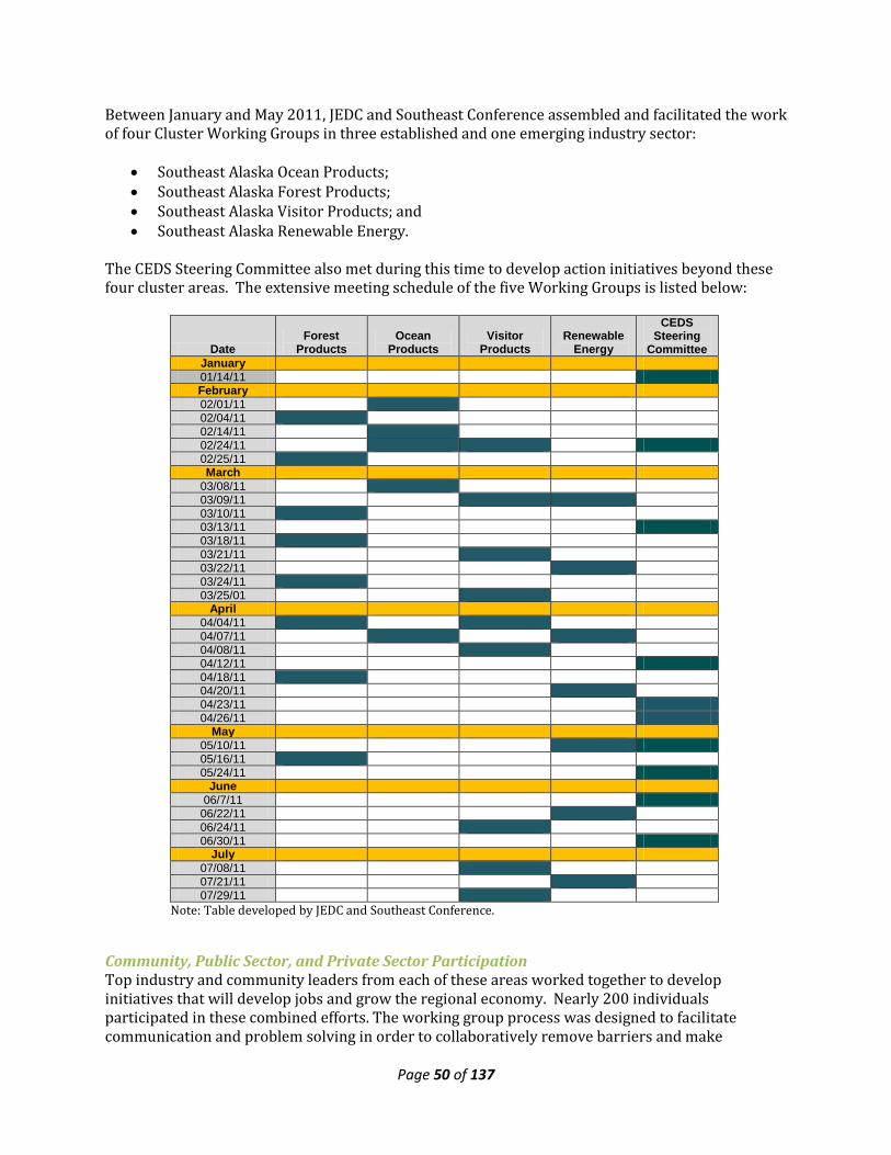
Page 50 of 137
Between January and May 2011, JEDC and Southeast Conference assembled and facilitated the work of four Cluster Working Groups in three established and one emerging industry sector:
• Southeast Alaska Ocean Products; • Southeast Alaska Forest Products; • Southeast Alaska Visitor Products; and • Southeast Alaska Renewable Energy.
The CEDS Steering Committee also met during this time to develop action initiatives beyond these four cluster areas. The extensive meeting schedule of the five Working Groups is listed below:
Date Forest
Products Ocean
Products Visitor
Products Renewable
Energy
CEDS Steering
Committee January 01/14/11 February 02/01/11 02/04/11 02/14/11 02/24/11 02/25/11 March
03/08/11 03/09/11 03/10/11 03/13/11 03/18/11 03/21/11 03/22/11 03/24/11 03/25/01
April 04/04/11 04/07/11 04/08/11 04/12/11 04/18/11 04/20/11 04/23/11 04/26/11
May 05/10/11 05/16/11 05/24/11
June 06/7/11
06/22/11 06/24/11 06/30/11
July 07/08/11 07/21/11 07/29/11
Note: Table developed by JEDC and Southeast Conference.
Community, Public Sector, and Private Sector Participation Top industry and community leaders from each of these areas worked together to develop initiatives that will develop jobs and grow the regional economy. Nearly 200 individuals participated in these combined efforts. The working group process was designed to facilitate communication and problem solving in order to collaboratively remove barriers and make
Page 51 of 137
connections that will allow growth in jobs and businesses. The resulting Action Initiatives (Objectives) reflect the priorities and steps needed to strengthen the industry, commerce and businesses of Southeast Alaska, and set out the steps necessary to solve economic problems, and capitalize on the resources of the region. Each Action Initiative is a Strategic Project, and each has numerous steps outlined in Appendix I that when completed will accomplish the Action Initiative, and will achieve the following:
• Creation of jobs in the region; • Retention of jobs in Southeast Alaska; • Attract investment from private and public sources; • Grow the economy of the region as a whole; • Make communities stronger and more sustainable.
The action initiatives and metrics will be refined and revisited on an annually, or semi-annual basis. One of the major benefits of this process is that it allowed Southeast Conference to develop its 2011-2015 CEDS in concert with the regional planning efforts of USDA and JEDC, along with significant input from all public an private sectors. By working together, Southeast Conference and Central Council have ensured that any resulting government investment strategies will be responding to a single set of evolving action initiatives, with many organizations teaming together to focus their results. The USDA and USEDA agencies have an important role in implementing many of the initiatives. Collaborative work will be needed among many parties, including the private sector; most departments of the State of Alaska; the Governor’s Office; Sealaska Corporation and Southeast’s Native Village Corporations; municipal and tribal governments; the University of Alaska; trade organizations; and JEDC. Southeast Conference intends to continue to work with these groups as work on the Southeast Alaska Action Initiatives continues. After the initial Action Initiative effort was completed and the suggested Action Initiatives were selected, the CEDS Steering Committee and the USDA identified vital regional Action Initiatives to receive additional resources and support. A full description of each vital initiative, along with an action plan and funding phases is in Appendix I. The full list of action initiatives appears below, along with the lead agency responsible for implementing the initiative. These initiatives (objectives) are as follows:
4.2.1 Southeast Alaska Ocean Products Action Initiatives (Objectives) These action initiatives implement Goal 2, along with Goal 2 subparts 2.4: Ocean Projects Development, and 2.6: Marine Industry Development.
Strategic Ocean Products Vital Projects
Develop a Sea Otter Management Program in Southeast Alaska Southeast organizations, under the leadership of CCTHITA, have formed a Task Force to look at realistic management approaches to protect important shellfish species and to allow a less restrictive harvest of sea otters by Alaskan Natives. Southeast organizations are requesting that Federal and State agencies examine the impact of sea otters with the ultimate goal of an ecosystem-based sea otter management plan. This plan should benefit all users of shellfish resources, protect
Page 52 of 137
shellfish resources from depletion, and allow effective subsistence harvest of sea otters by the Alaska Native people. Partner Organizations: Oceans Products Cluster Working Group; JEDC; Southeast Conference; Central Council Tlingit Haida Indian Tribes of Alaska; DCCED Lead: Central Council Tlingit Haida Indian Tribes of Alaska
Strengthen the Region-Wide Mariculture Industry Through Zoning and Support to Entrepreneurs The goal of this initiative is to create a strong and sustainable mariculture industry that supports vibrant coastal communities. It will reduce red tape, cost, time and energy associated with aquatic farm permitting new sites. The identification of an area for specific farm sites needs to include access to reliable seed supply, cluster development of farm sites, access to training and education and good transportation systems. These actions will help attract the new farmers and investment of private capital to build successful farms and create year round, sustainable jobs for the region. Partner Organizations: Oceans Products Cluster Working Group; JEDC; Southeast Conference; Oceans Alaska; Farm Service Agency; Central Council Tlingit Haida Indian Tribes of Alaska Lead: Oceans Products Cluster Working Group
Maritime Industry and Workforce Development Enhance the efficiency and capacity of Alaska's Maritime Industry Cluster, which will support a wide array of existing and emerging economic activity dependent upon marine transportation; reduce environmental impacts; and provide social benefits which increase the livability of rural communities. Reverse the long-term trend of declining population, business closures, and school enrollments. Partner Organizations: Southeast Conference; Alaska Shipyard and Dry Dock; Alaska Workforce Investment Board; Central Council; University of Alaska; Alaska Fisheries Development Foundation; Oceans Products Cluster Working Group; JEDC; DCCED Lead: Southeast Conference
Ensure Southeast’s Fishing Future through Targeted Education & Training As boat/permit owners (fish business owners) age and seek retirement, we see these businesses purchased by non-locals and the businesses leave the community. This initiative will provide residents with the necessary skills to acquire and operate successful businesses in the region. If this initiative is successful, local ownership of the businesses associated with the Ocean Products CWG will at a minimum be stable and hopefully increase. The objective is to develop the awareness and capability of the local population to capitalize on economic opportunities within their communities. The next generation of business owners needs a new skill set to compete. They need to be innovative in structuring business deals, and proficient in financing to purchase these businesses. Partner Organizations: Oceans Products Cluster Working Group; JEDC; Southeast Conference; University of Alaska Fisheries Technology Program; Alaska Sea Grant Marine Advisory Program; Central Council Tlingit Haida Indian Tribes of Alaska Lead: Alaska Sea Grant Marine Advisory Program
Include the Seafood Industry in USDA Programs (Regulatory Review) The objective is to change the regulatory definitions of fish, farm, farmer, rancher, livestock, agricultural operation, and co-producers (and any other regulations identified in the process) in order to include (rather than exclude) the seafood industry in USDA programs. The benefits would be felt in Southeast Alaska and across the nation primarily in coastal areas. Access to these programs would:
• help stabilize some of the natural volatility of the industry • help the industry compete on a level playing field with other U.S. food producers
Page 53 of 137
• help the industry invest in improvements which will yield tangible economic benefits • help stabilize coastal communities
Partner Organizations: Oceans Products Cluster Working Group; JEDC; Southeast Conference; USDA; Farm Service Agency; Central Council Tlingit Haida Indian Tribes of Alaska Lead: Oceans Products Cluster Working Group
Study the Conversion of Fish Byproduct to Biogas & Fertilizer via Anaerobic Digestion This initiative will allow the ocean products industry cluster to determine if and how this method of fish byproduct utilization can meet the individual needs of a single processor, cluster of processors or entire community. Such a study will also include the identification of the specific bacteria (“psychrophiles”) that currently break down fish waste in, and are uniquely adapted to, the anaerobic conditions [and pressure, depth, temperature and salinity] of Southeast Alaska waterways. If this initiative is successfully accomplished, several benefits to the Ocean Products Industry cluster could be realized in the long-term, including the following: renewable energy development, fertilizer product, lower byproduct disposal costs, regulatory compliance, Southeast Alaska becomes an R&D hub, improved marine environment, and promotional opportunity. Partner Organizations: Oceans Products Cluster Working Group; JEDC; Southeast Conference; Rural Development; Fishermen’s Daughters Ecofuels; Central Council Tlingit Haida Indian Tribes of Alaska Lead: Oceans Products Cluster Working Group; Fishermen’s Daughters Ecofuels
Enhance Salmon Production The initiative will lay the groundwork for additional permitted chum, pink, or sockeye salmon production on the order of 200 million eggs/fry using existing facilities where feasible and/or constructing new facilities where necessary. The benefits would begin with construction of a $10 to $15 million facility or perhaps two. Most importantly, when returns reach full production potential in approximately 8 to 10 years the first wholesale value would be $40,000,000.00 per year. Total job equivalents for direct and indirect impacts of a program of this size would provide 700 to 800 jobs in all sectors combined. Partner Organizations: Oceans Products Cluster Working Group; JEDC Lead: Oceans Products Cluster Working Group
Further Develop Renewable Energy Production The development of significant additional renewable energy resources will be a major boon to the ocean products as well as other energy intensive industries in SE Alaska. This initiative will educate the public, and especially municipal and state leadership, on the advantages of planning ahead to create energy independence for SE Alaska based on developing our renewable energy resources, work to improve federal regulations to make them more appropriate to specific conditions in Alaska, and collaborate with electrical utilities to refocus their strategic planning on the development of renewable energy resources. Partner Organizations: Oceans Products Cluster Working Group; JEDC Lead: Oceans Products Cluster Working Group
Protect Long Term Assured Access to Fishery Resources for Both Current and Developing Fisheries It is important to maintain access to fishery resources for viable and vibrant commercial fisheries throughout Southeast Alaska, particularly in smaller rural communities where commercial fisheries are/were the backbone of the community. Let science be the driving force for decisions made in our management agencies based on the abundance of the resource. Commercial fishermen do not object to declining harvest limits when science based rather than a response to uncontrolled growth of sport fishing. The benefit to the region is the continuation of thousands of small
Page 54 of 137
businesses, maintaining important infrastructure within the communities such as harbors and processing facilities etc. Partner Organizations: Oceans Products Cluster Working Group; JEDC Lead: Oceans Products Cluster Working Group
Increase Wild Salmon Production through Habitat Restoration By performing restoration activities, wild salmon production can be improved. Increased salmon production results in increased opportunity for commercial, sport, and subsistence harvest. Increasing the economic output of wild salmon harvests for all sectors of the fishing industry will increase the number of jobs directly and indirectly stemming from wild salmon production for all sectors of the salmon industry in SE Alaska. Partner Organizations: Alaska Gillnetter’s Association; Forest Service; Oceans Products Cluster Working Group Lead: Oceans Products Cluster Working Group
4.2.2 Southeast Alaska Visitor Products Action Initiatives (Objectives) These action initiatives implement Goal 2, along with Goal 2 subparts 2.3: Visitor Products Development
Strategic Visitor Products Vital Projects
Develop Land and Water Trails and Support Facilities In a 2007 report ISER estimated that nature-based tourism generated over $250 million per year of direct business revenues in Sitka, Juneau, and Chichagof Island. The ISER report goes on to say that nature based tourism creates an economic ripple effect and visitors are willing to pay premium prices for higher quality experiences in more pristine environments – something we have in Southeast Alaska. Independent travelers stay longer and have more open itineraries than cruise visitors. SEAtrails, a regional non-profit, awarded $120,000 in grants to 10 communities for trail projects, maps, and signs. SEAtrails is a coalition of communities across the region. This initiative will explore how to move the SEAtrails agenda forward. Partner Organizations: Visitor Products Cluster Working Group; JEDC; SEAtrails; Central Council Tlingit Haida Indian Tribes of Alaska Lead: Visitor Products Cluster Working Group
Increase Guided Access to Land Demand exceeds permitted access levels. Agency permitting processes are limiting economic opportunity in the tourism industry in the Tongass National Forest and other public lands. This initiative addresses the lack of permitting flexibility to make quick changes in response to market conditions (more adaptive management and a more micro managed approach). The outcome will be more access to public lands (and to existing areas) to increase capacity. Partner Organizations: Visitor Products Cluster Working Group; JEDC; Forest Service; Central Council Tlingit Haida Indian Tribes of Alaska Lead: Visitor Products Cluster Working Group
Promote Multi-Community and Regional Visitor Packages There needs to be a one-stop place for information for the independent tourist to figure out how to design a multi-community itinerary for the region. This initiative will promote more multi-community, regional visitor itineraries through better marketing and promotion of these opportunities. Partner Organizations: Visitor Products Cluster Working Group; JEDC; Southeast Conference Tourism Committee; Central Council Tlingit Haida Indian Tribes of Alaska
Page 55 of 137
Lead: Visitor Products Cluster Working Group
Strengthen Accountability for Tongass Recreation Fees This initiative addresses the development of a mechanism for more private sector input to decide where fees are allocated. The industry will work with Forest Service to establish more affordable access and /or local control of fee structure and more accountability. More revenues from users will be reflected locally on user benefits: Secure a portion of the revenue collected to improve local infrastructure and enterprise support. Partner Organizations: Visitor Products Cluster Working Group; JEDC; Forest Service Lead: Visitor Products Cluster Working Group
Integrate Tourism Course with University of Alaska Southeast Existing Degree Program Create more employment and educational opportunities for Alaskans. Groom more prepared managers and guides to showcase the Tongass and other Southeast Alaska attractions. Provide an opportunity for UAS to attract and retain four-year students. The initiative will produce a more qualified and larger group of local applicants for entry level as well as management level positions in tourism. Partner Organizations: Visitor Products Cluster Working Group; JEDC; University of Alaska Southeast Lead: Visitor Products Cluster Working Group
4.2.3 Southeast Alaska Forest Products Action Initiatives (Objectives) These action initiatives implement Goal 2, along with Goal 2 subparts 2.5: Forest Products Development, and 2.1: Business and Industrial Development.
Strategic Forest Products Vital Projects
Restore a Viable Timber Industry in Southeast Alaska To sustain a Forest Products Industry in Southeast Alaska it is essential for transitional purposes that there is access to an old growth supply as well as a definitive, predictable and growing volume of 2nd growth timber. A fixed land base that is protected from encroachment of other uses is essential. The land base requires management under predominantly even aged harvesting with an overhaul of the process to bring sales to market. This solution benefits the current and future investors, creates sustainable employment, creates positive stumpage values to further invest in forest management and provides continuity of supply to customers, potential for growth and diversification of the industry. This initiative will recommend extensions, changes and additions to current USFS timber sale policies and programs and eligibilities that can build a viable and sustainable operation under the following four pillars: Existing Old Growth Value Add Manufacturing- Large Grade type logs; Log Exporting; Additional Log Manufacturing; Residual options (i.e. Bio fuels). Partner Organizations: Southeast Conference; Alaska Forest Association; Central Council Tlingit Haida Indian Tribes of Alaska Lead: Southeast Conference
Use Young Growth Wood for Cabin & Recreational Structures on Prince of Wales Island The objective is to work with the Forest Service to develop young growth cabins and structures (round log and/or milled) that meet Forest Service cabin and structure specifications and to ensure that future recreational structure RFPs will consider young growth as a legitimate and desired building material. The goal is that the Forest Service should specify regionally produced building materials for all of their building projects. The benefits would be the development of a local (Prince of Wales Island and regional) value-added industry for utilization of young-growth materials.
Page 56 of 137
Partner Organizations: Forest Products Cluster Working Group; JEDC; Forest Service Lead: Forest Products Cluster Working Group
Simplify Small Timber Sale Process to Allow Small Mills on Prince of Wales Island to Operate More Efficiently, Economically, and with More Supply Certainty Small mills on Prince of Wales are dealing with a variety of issues that are threatening their continued operation and/or prohibiting them from operating as efficiently and as economically as they could. The goal is to help the small mills on Prince of Wales to operate more efficiently, economically, and with more supply certainty. Partner Organizations: Forest Products Cluster Working Group; JEDC; Forest Service Lead: Forest Products Cluster Working Group
Where Feasible, Substitute Biomass for Diesel to Meet Energy Needs of Southeast Alaska The goal of this initiative is to develop a vision and roadmap to the development of a vibrant and thriving biomass energy industry that economically meets the energy needs of the region’s residents, while creating local jobs. Securing a reliable, economical supply of biomass feedstock will also be essential. A second key goal of this initiative, in the near term, is to transform Southeast mill by-product residues into a usable biomass stream. In the long run, a thorough, out-of-the-box analysis needs to be conducted of every possible source including mill residues, thinning byproducts, young growth, and non-wood sources (fish waste, sewage sludge, recycled paper, etc.). Partner Organizations: Forest Products Cluster Working Group; JEDC; Forest Service; Rural Development Lead: Forest Products Cluster Working Group
Conduct a Timber Base Analysis to Determine the Volume of Young Growth and Old Growth Supply Available for Sustaining and Strengthening the Forest Industry in Southeast Alaska How quickly can a sustainable young growth harvest commence in the Tongass based on current harvest information with respect to available acreage, growth, yield, harvesting costs, markets and rotation age? The team is evaluating the land base and corresponding volumes of Young Growth and Old Growth under minimum (current rules, regulations and exclusions) and maximum (assumptions in original data set) conditions. Partner Organizations: Forest Products Cluster Working Group; JEDC; Forest Service Lead: Forest Products Cluster Working Group
Increase Knowledge about Building with Alaskan Wood and Influence Attitudes about Southeast Alaska Woodworking Industries This initiative aims to influence attitudes toward Alaskan wood and Southeast Alaska woodworking industries and to increase knowledge about building with Alaskan woods. Particular emphasis will be placed upon the increase of in-region processing of forest products while capturing higher economic value from those products. The important role of wood for the environment and society will be highlighted with the message that wood can offer one solution to climate change since it binds carbon dioxide and is a renewable raw material. Partner Organizations: Forest Products Cluster Working Group; JEDC Lead: Forest Products Cluster Working Group
Continuously Improve Select USFS Processes Timber Sale customers are not satisfied with the delivery of timber sales, stating that by the time they get to Gate 5 (bid) nearly 4 years has transpired. Customers seeking permits, timber related permits and special use permits for non-timber related activities, also have expressed a desire to improve permit delivery. The objective of the initiative is to improve product delivery. The benefits to Southeast Alaska would be improved confidence that the Forest Service could deliver its
Page 57 of 137
products/permits/partnerships cooperation timely and reliably. Improved confidence should translate into more activities taking place while ideas and opportunities are still fresh, which should lead to greater economic activity. Partner Organizations: Forest Products Cluster Working Group; JEDC Lead: Forest Products Cluster Working Group
Establish the “Tongass National Forest – Congressionally Designated Timberlands” to Provide a Secure and Perpetual Working Forest Land Base Managed Under Forest Regulations and Guidelines that Streamline Process and Improve Predictable Delivery of Supply To sustain a Forest Products Industry in Southeast Alaska it is essential for transitional purposes that there is access to an old growth supply as well as a definitive, predictable and growing volume of 2nd growth timber. A fixed land base is essential, protected from encroachment of other uses is essential. The land base requires management under predominantly even aged harvesting with an overhaul of the process to bring sales to market. This solution benefits the current and future investors, creates sustainable employment, creates positive stumpage values to further invest in forest management and provides continuity of supply to our customers, potential for growth and diversification of the industry. Partner Organizations: Forest Products Cluster Working Group; JEDC Lead: Forest Products Cluster Working Group
Create a 1.5 Million Acre State Forest (from Tongass lands) to be Managed by State of Alaska The goal is to establish a timber supply for an integrated forest products industry in SE Alaska. This is a strategy that has been on the table for 10-15 years and has not been moved because of the heavy lifting necessary to make it happen. To not move this strategy now will mean that all options available to restore an industry were not tried. Partner Organizations: Forest Products Cluster Working Group; JEDC Lead: Forest Products Cluster Working Group
4.2.4 Southeast Alaska Renewable Energy Action Initiatives (Objectives) These action initiatives implement Goal 2, along with Goal 2 subparts 2.2: Renewable Energy Development, and 2.1: Business and Industrial Development; and Goal 1: Community & Regional Development subpart 1.1: Infrastructure Development.
Strategic Renewable Energy Vital Projects
Implement Regional Integrated Resources Energy Plan Reduce dependence on fossil fuels for electricity, space heat and potentially transportation. Create a long-range action plan to bring affordable renewable energy to communities with least cost options, including the development of electrical grids interconnecting Southeast communities and utilities with hydroelectric generation where this is technically and economically feasible (updates 1997 SE System Plan). Develop strategies for long-term energy security, enhance regional economic development and self-sustaining communities within the region. Work with member communities and utilities to develop adequate energy infrastructure including alternative energy resources (geo-thermal, biomass, wind, tidal) to meet future needs. Reduce and stabilize costs to ratepayers and communities thus increasing economic development opportunities. Effectively and wisely make the highest and best use of the region’s energy resources. Partner Organizations: Southeast Conference (Energy Coordinator); Central Council Lead: Southeast Conference
Page 58 of 137
Support Biomass Energy Demand Development in Southeast Alaska Biomass energy has tremendous potential to meet the region’s energy needs with a local renewable energy source. The objective of this initiative is to identify a transition strategy to biomass energy to complement our hydroelectric energy supply, with the ultimate goal to wean the region off of oil to the maximum extent possible. As oil prices rise, residents in the region have demonstrated that they can rapidly shift to other energy sources for building heating – and that source is mainly electricity. Hydro capacity cannot easily respond in a timely manner, and even a relatively small percentage shift from oil heating to electrical heating (even using heat pump technology) can quickly consume the utility’s reservoir capacity, causing higher rates and supply issues. Partner Organizations: Renewable Energy Cluster Working Group; JEDC; Rural Development Lead: Renewable Energy Cluster Working Group
Establish a Renewable Energy Revolving Loan Fund for Residences and Small Businesses to Promote Local Installation and Fueling Industries One of the fundamental steps in moving Southeast Alaska to a renewable energy economy is for residences and small businesses to convert from fossil fuels to renewable energy sources such as heat pumps and pellet stoves. These renewable fuels have many advantages: they can be relatively inexpensive, the supply is local and therefore more reliable, and the consumer is protected against future oil price shocks and supply disruptions. However, the initial equipment installation costs can be high and create a significant impediment to adoption for most potential users. A revolving loan fund would provide a very attractive means for enabling the installation of, or conversion to, renewable energy heating systems, with the savings in utility costs being used to pay back the capital improvement loans. Partner Organizations: Renewable Energy Cluster Working Group; JEDC Lead: Renewable Energy Cluster Working Group
Conduct Market-driven Renewable Energy Economic Modeling for Southeast Alaska, including Multiple Transmission and Energy Storage Strategies This initiative will develop a marketing and economic modeling study that can be used by firms to attract investment resources for Southeast Alaska’s nascent renewable energy industry. The study will also be used to promote Southeast as a research, development and demonstration site. Partner Organizations: Renewable Energy Cluster Working Group; JEDC Lead: Renewable Energy Cluster Working Group
Develop Renewable Energy Education for SE Alaska Residents, Students and Businesses Increase the awareness of the public—including municipal and State leadership–of renewable energy through fact-driven informational campaigns. This education will increase public support for renewable energy issues and projects, which is especially important when public policy changes (regulations, etc.) will be required for the successful development of a renewable energy industry in Southeast Alaska. Partner Organizations: Renewable Energy Cluster Working Group; JEDC Lead: Renewable Energy Cluster Working Group
4.2.5 CEDS Steering Committee Action Initiatives (Objectives) In addition to the Action Initiatives developed in the designated cluster areas, the CEDS Steering Committee used a similar process to develop seven more regional action initiatives on focus areas outside the four cluster areas. These action initiatives implement Goal 1: Community & Regional Development, Goal 2: Economic Development, and Goal 3: Quality Environment.
Page 59 of 137
Additional Vital Southeast Alaska Projects
Expand Research & Development in Southeast Enhancing the capacity of the Alaska Coastal Rainforest Center (ACRC) to develop a research hub in Southeast Alaska will support a wide array of existing and emerging economic activity. It will continue to provide a sustainable development framework that addressed environmental change, provides enormous social benefits through the creation of professional jobs, and build a resource base for professional growth. These in turn will enhance the livability of our communities. We will help Southeast Alaska change the long-term trend of declining populations, lowered school enrollments, departure of young professionals building families, and closures of business. A greater portion of the Federal and State forests and waterways could be used for more explicit research. Because we already have several hundred Federal, State, and municipal employees here in Southeast, we have a base of operations from which research capacity can grow. Juneau’s Research and Development teams include the Forest Service Juneau Forestry Sciences Laboratory, the NOAA Ted Stevens Marine Institute, the University of Alaska Fairbanks (School of Fisheries and Ocean Sciences), and several professors at the largely undergraduate-oriented University of Alaska Southeast. Partner Organizations: Southeast Conference; Alaska Coastal Rainforest Center (UAS); Central Council Tlingit Haida Indian Tribes of Alaska; JEDC Lead: Alaska Coastal Rainforest Center; JEDC
Develop Rural Broadband Planning Project The project will result in a Strategic Plan and implementation of affordable Broadband throughout Southeast Alaska. The Strategic Plan will show that Broadband implementation in Southeast is a critical need in order to be able to fill the gap that isolates communities from each other and the rest of the world and that it will allow people to obtain valuable information, adequate health care, employment, and education. Partner Organizations: Southeast Conference; Central Council Tlingit Haida Indian Tribes of Alaska Lead: Central Council Tlingit Haida Indian Tribes of Alaska
Enhance Senior Care Services The primary objective is to enhance the existing system of services to provide for additional in-home and locally based community services for seniors. An additional goal is to provide an enhanced continuum of services that would better screen individuals so that an appropriate medical plan can be developed. This will help the system anticipate the demand for services. An enhanced system will provide the region with a better understanding of the need for services. This will be the result especially in small and rural communities. The system would train and employ local senior care providers to provide services in communities that do not have senior centers. The system would also assure that ongoing training and consultation is available region-wide. Partner Organizations: Catholic Community Service: Southeast Senior Services; Southeast Conference; Central Council Tlingit Haida Indian Tribes of Alaska Lead: Southeast Conference
Continue to Support and Develop Southeast Solid Waste Authority • Long term stability of solid waste disposal rates for our communities. • Economic development opportunities for a centralized project site community or several
project site communities. • Improved environmental stewardship through potential implementation of recycling
programs, improved awareness of environmental protection and reduction of unlined landfills.
Page 60 of 137
Partner Organizations: Southeast Alaska Solid Waste Authority; Southeast Conference; Central Council Tlingit Haida Indian Tribes of Alaska Lead: Southeast Alaska Solid Waste Authority
Develop Stronger Regional Food Systems More local food can be produced, processed, distributed and consumed in Southeast. New, small businesses can be created in each step of the food supply chain. It can result in more “food dollars” remaining in Southeast communities. These “food dollars” have a significant multiplier effect and will benefit other local businesses. Other benefits to the region can be measured by improved health outcomes, such as reduced levels of obesity, diabetes, and other food-related diseases. The project will also increase awareness about where our food comes from it will also promote self-reliance and stronger, more sustainable communities. Partner Organizations: Pacific Fishing Inc.; Southeast Conference; Central Council Tlingit Haida Indian Tribes of Alaska Lead: Central Council Tlingit Haida Indian Tribes of Alaska
Expand Telemedicine The primary objective of this initiative is to enhance the existing system of physical and mental health telemedicine services by providing broader coverage to include small and rural communities in Southeast. An additional goal is to provide for expanded training opportunities for first responder/EMS staff and volunteers. The system will result in improved first responder/EMS care provided, improved triage, and improved outcomes for patients. Partner Organizations: Southeast Alaska Regional Health Consortium (SEARHC); Southeast Conference; Central Council Tlingit Haida Indian Tribes of Alaska Lead: Southeast Conference; SEARHC
Support Transportation Projects • Maintain open communication between the Governor’s office, Department of
Transportation, the Alaska Legislature, MTAB and the communities in Southeast Alaska. • Establish a system of safe, affordable and dependable transportation for Southeast Alaska. • Solid support for the AMHS fleet amongst the Legislature and encourage fiscal certainty. • Implementation of the Southeast Alaska Transportation Plan’s objectives of providing
improved, cost-effective regional transportation in Southeast Alaska. • Region-wide enhancement, repair and development of the many harbors and port facilities,
while networking export and import opportunities within the region and internationally. Partner Organizations: Southeast Conference; Central Council Tlingit Haida Indian Tribes of Alaska Lead: Southeast Conference
4.2.6 Workforce Development Strategy Southeast Conference will expanding it efforts to coordinate efforts between industries (mining, marine, healthcare, timber) and education (State Department of Labor, area schools, University of Alaska, vocational training facilities) to develop a viable workforce that can fulfill industry’s need for many years to come. To do this, Southeast Conference will work closely with the region’s educational facilities, Alaska Department of Labor, Native vocational programs, industry, unions and citizens. Prioritized workforce development tasks of Southeast Conference include:
• Assess available vocational programs offered by local area schools in SE Alaska and tribal associations.
• Assess University of Alaska Southeast vocational and career degree programs that try to meet the needs of industry.
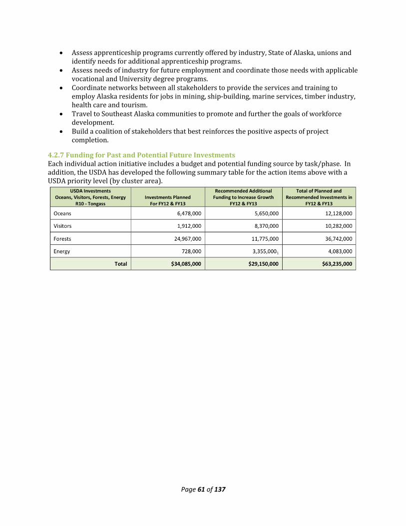
Page 61 of 137
• Assess apprenticeship programs currently offered by industry, State of Alaska, unions and identify needs for additional apprenticeship programs.
• Assess needs of industry for future employment and coordinate those needs with applicable vocational and University degree programs.
• Coordinate networks between all stakeholders to provide the services and training to employ Alaska residents for jobs in mining, ship-building, marine services, timber industry, health care and tourism.
• Travel to Southeast Alaska communities to promote and further the goals of workforce development.
• Build a coalition of stakeholders that best reinforces the positive aspects of project completion.
4.2.7 Funding for Past and Potential Future Investments Each individual action initiative includes a budget and potential funding source by task/phase. In addition, the USDA has developed the following summary table for the action items above with a USDA priority level (by cluster area).
Page 62 of 137
4.2.8 Southeast Alaska Action Initiative Participants Below is a list of those who participated in the Southeast Alaska Cluster Development process. There was extensive private sector participation. For a list of the CEDS steering committee, please also see section 1.3a: Steering Committee Roster
4.2.8a Ocean Products CWG Anthony Lindoff, Ha'ani/Sealaksa Bart Watson, Armstrong-Keta, Inc. Brian Holst, JEDC Bruce Wallace, Seiner, UFA, Silver Bay, ASMI Casey Campbell, Wells Fargo Casey Havens, Yak Tat Kwaan Chris Knight, United Southeast Alaska Gillnetter's Assn. Deborah Hayden, Grow Ketchikan Don Martin, Forest Service Doug Ward, Alaska Ship & Drydock Eric Norman, Taku Smokeries Galen Tromble, National Marine Fisheries Service Garry White, Sitka Economic Development Assn. Geron Bruce, Alaska Department of Fish and Game Heather Hardcastle, Trout Unlimited Ian Fisk, Primo Prawns Jev Shelton, fisherman Jim Seeland, University of Alaska Southeast John Sund, self Jon Martin, USFS Julianne Curry, Petersburg Vessel Owner Assn. Julie Decker, UFA: National Seafood Marketing Coalition Kathy Hansen, Southeast Alaska Fishermen's Alliance Keith Criddle, University of Alaska Fairbanks Kris Norosz, Icicle Seafoods Len Peterson, Taku River Reds Meilani Schijvens, JEDC Mike Forbush, Ocean Beauty Mike Goldstein, Alaska Coastal Rainforest Center Mike Round, Oceans Alaska & SSRAA Patricia Phillips, Pacific Fishing Inc. Phil Doherty, SARDFA (Dive Fisheries Assn.) Randy Lantiegne, Icicle Seafoods Ray Ralonde, Sea Grant Marine Advisory Program
Ray Riutta, Alaska Seafood Marketing Institute Rick Focht, DIPAC Rick Harris, Sealaska Ron Medel, Forest Service Russell Dick, Ha'ani/Sealaksa Shannon Stevens, Alaska Airlines Shelly Wright, Southeast Conference Steve Reifenstuhl, NSRAA Steve Stromme, Elfin Cove Tim Blust, Armstrong-Keta, Inc. Tom Gemmell, fisherman Brian Holst, JEDC
4.2.8b Visitor Products CWG Bill Hagevig, HAP Alaska-Yukon Bob Janes, Gastineau Guiding Brian Holst, JEDC Brent Fischer, City and Borough of Juneau Carol Rushmore, City and Borough of Wrangell Derek Duncan, Goldbelt Corporation Drew Green, Cruise Line Agencies of Alaska Erica Simpson, Alaska Canopy Adventures Ernestine Hayes, UAS, School of Arts and Sciences Eva Bornstein, JEDC Forest Wagner, UAS, Outdoor Studies Greg Brown, Weather Permitting Alaska Jodi Wise, Huna Totem Corporation Johan Dybdahl, Icy Strait Point John McConnochie, Cycle Alaska Jon Martin, USFS Katherine Eldemar, Sealaska Corporation Kathy DiLorenzo, UAS, School of Professional & Technical Studies Kelli Dindinger, Alaska Travel Adventures, Inc. Larry Gaffaney, Huna Totem Corporation Linda Kadrlik, Adventures Afloat Linda Kruger, USFS PNW Research Station Louis Juergens, Alaska Galore Tours Marc Matsil, City and Borough of Juneau Marsha Sousa, University of Alaska Southeast

Page 63 of 137
Marti Marshall, USFS, Juneau District Ranger Melanie Lesh, Gustavus City Council Michael Goldstein, AK Coastal Rainforest Center, UAS Michael Neussl, Alaska DOT&PF Odin Brudie, Alaska DCCED Rick Wolk, UAS, School of Management S. Kirby Day, III, Princess Cruises Sean Smith, Glacier Gardens Sharon Gaiptman, Gaiptman Communications Steve Krause, UAS Tim McDonnell, TEMSCO Tory Korn, Alaska Rainforest Sanctuary/Alaska Canopy Adventures
4.2.8c Forest Products CWG Allen Brackley, Research Forester, USFS Andrew Thoms, Sitka Conservation Society Bill Thomason, Wood Cuts Brian Holst, JEDC Bob Deering, USCG - Civil Engineering Unit Juneau Bruce Abel, Don Abel Building Supplies Bryce Dahlstrom, Viking Lumber Company Carol Rushmore, City and Borough of Wrangell Carolyn Thomason, Wood Cuts Chris Maisch, Alaska DNR Clarence Clark, Alaska DNR Dan Parrent, USFS Dave Harris, USFS Ernie Eads, Thuja Plicata Lumber Co Eva Bornstein, JEDC George Woodbury, Alaska Forest Assn. Greg Erickson, Erickson Economics/SEACC Jackie Durette, Durette Construction John Sisk, The Nature Conservancy Jon Martin, USFS Karen Petersen, UAF Cooperative Extension Service Keith Landers, Prince of Wales Biofuels Keith Rush, The Nature Conservancy Kent Nicholson, USFS Larry Jackson, Tongass Forest Enterprises Lindsey Ketchel, SEACC Marie Messing, USDA Forest Service Merrill Sanford, Southeast Conference Michael Kampnich, The Nature Conservancy Mike Goldstein, Alaska Coastal Rainforest Center, UAS Owen Graham, Alaska Forest Assn.
Paul Slenkamp, The Trust Land Office Richard Stubbe, Alaska Wood Products Shelly Wright, Southeast Conference Wade Zammit, Sealaska Timber Corporation Wes Tyler, Icy Strait Lumber
4.2.8d Renewable Energy CWG Adrien Lopez, JEDC Barbara Stanley, USFS Bart Watson, Armstrong-Keta, Inc. Ben Haight, Haight & Associates Bill Leighty, The Leighty Foundation/Alaska Applied Sciences, Inc. Bob Deering, US Coast Guard Brandon Smith, Alaska Brewing Brian Hirsch, National Renewable Energy Brian Holst, JEDC Laboratory Dan Lesh, SEACC Duff Mitchell, Juneau Hydropower, Inc. Heather Hardcastle, Fisherman's Daughter Biofuels Jackie Stewart, Business Works John Hickey, US Coast Guard John Sandor, self Jon Martin, USFS Kirk Hardcastle, Alaska Center for Energy and Power Larry Miles, Wind Turbine Company Lew Madden, Ma-Su owners representative Nathan Soboleff, Ha'ani/Sealaska Corporation Paul Southland, Alaska Canada Energy Coalition Peter Naoroz, Kootznoowoo Corporation Rob Holman, Self Robert Venables, Southeast Conference Ross Good, Elcon Corp Zach Wilkinson, SpringBoard
Page 64 of 137
4.3 Performance Measures The overall impact of implementing the CEDS Plan of Action in its entirety will be measured by tracking the overall growth of the individual sectors upon which the CEDS plan focused. The key performance measures will track the overall efforts to improve the economic health in the region. Naturally, measures of success are different depending on whether they are tied to a specific action initiative, or to the CEDS implementation as a whole. The impacts of this CEDS cluster plan with respect to regional prosperity will take time to realize and will likely be difficult to attribute to any one cause; however, by tracking growth in the main economic clusters of this plan focuses, we will gain a clear understanding of the overall success of implementing specific measures. On the following page is a list of the following performance metrics with baseline 2009 data that can be used to evaluate the Southeast Conference’s successful development and implementation of the overall CEDS action initiatives plan.
• Total Employment (avg.) – Each sectors has target new employment goals based on the successful implementation of the CEDS action initiatives.
• Total New Jobs– Employment will be tracked based by sector, as well as known new jobs created by the successful implementation of strategic projects. It is expected that implementation of the CEDS will result in the creation of 120-650 jobs. Job growth targets for individual action initiatives will be developed during the first year of the CEDS, if they do not yet exist.
• Total Jobs Retained – Generally, the implementation of the individual action initiatives is expected to allow for 90%-100% of jobs to be retained, in addition to the creation of new jobs.
• Total Businesses – Total growth in the number of businesses within a sector targeted by the action initiatives (seafood, tourism, forestry, energy) will be tracked.
• Total New Business Licenses - Total number of new businesses created within a sector targeted by the action initiatives will be tracked.
• Total Wages ($000) – The increase to the total wages within a sector targeted by the action initiatives will be tracked – and will be expected to increase over time, as a result of the implementation of the action initiatives.
• Average Annual Wages - The increase to the average wages within a sector targeted by the action initiatives will be tracked – and will be expected to increase over time, as a result of the implementation of the action initiatives.
• Total USDA Investment – Total USDA investments planned and recommended will be tracked by sector (and action initiative, if possible.
• Additional New Investment – Additional new investments, such as investments by the EDA, will also be tracked, where possible.
• Number of Major Accomplishments on Action Initiatives – Each action item has within it several steps or tasks listed that, when implemented, will help increase jobs and bring investment to the region. Successful completion of major accomplishments will be tracked. The individual initiatives each have lengthy comprehensive action plans in Appendix I that include the following:
o Specific steps/tasks o Key people who need to be involved to accomplish step (ID business, agency, or
people) o Resources needed to accomplish step o Timeline to accomplish step o Obstacles and impediments likely to affect implementation
Page 65 of 137
o Funding o Outcome/results o Some, but not all of the action initiatives, include outcomes that show specific
expected job and investment growth as a result of successful implementation. • Number of Significant Meetings on Action Initiatives – Each project champion will
continue to meet with their respective teams to enable the successful implementation of individual action items. These meetings will be tracked.
• Business Attitude – The 2011 Southeast Alaska Business Climate Survey asked business leaders how they viewed the overall business climate in Southeast Alaska. As part of the fifth year – the overall impact of the implementation of these action initiatives can be reviewed, along with specific areas.
• Other, Action Item Specific Performance Measures: o Number of Entities/ Communities with High Speed Access o Number of sites with telemedicine access o Number of local food related entities or programs o Number of regional transportation projects
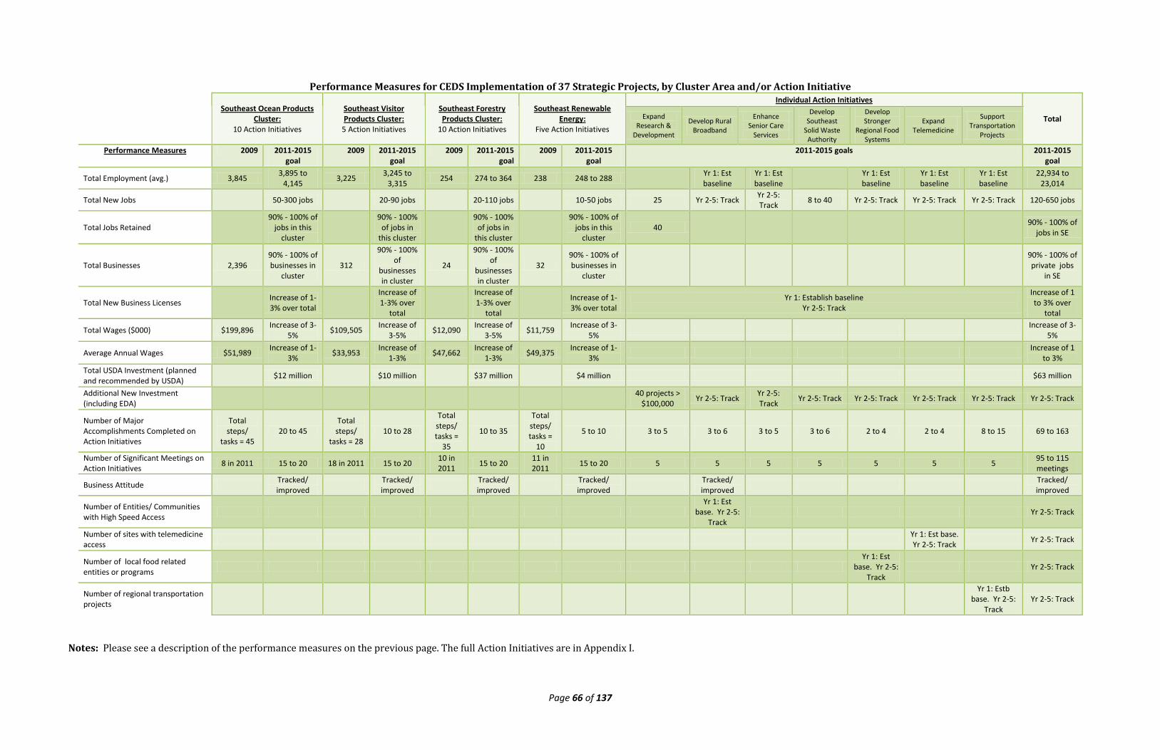
Page 66 of 137
Performance Measures for CEDS Implementation of 37 Strategic Projects, by Cluster Area and/or Action Initiative
Southeast Ocean Products
Cluster: 10 Action Initiatives
Southeast Visitor Products Cluster:
5 Action Initiatives
Southeast Forestry Products Cluster:
10 Action Initiatives
Southeast Renewable Energy:
Five Action Initiatives
Individual Action Initiatives
Total Expand Research &
Development
Develop Rural Broadband
Enhance Senior Care
Services
Develop Southeast
Solid Waste Authority
Develop Stronger
Regional Food Systems
Expand Telemedicine
Support Transportation
Projects
Performance Measures 2009 2011-2015 goal
2009 2011-2015 goal
2009 2011-2015 goal
2009 2011-2015 goal
2011-2015 goals 2011-2015 goal
Total Employment (avg.) 3,845 3,895 to 4,145 3,225 3,245 to
3,315 254 274 to 364 238 248 to 288 Yr 1: Est baseline
Yr 1: Est baseline
Yr 1: Est baseline
Yr 1: Est baseline
Yr 1: Est baseline
22,934 to 23,014
Total New Jobs 50-300 jobs 20-90 jobs 20-110 jobs 10-50 jobs 25 Yr 2-5: Track Yr 2-5: Track 8 to 40 Yr 2-5: Track Yr 2-5: Track Yr 2-5: Track 120-650 jobs
Total Jobs Retained
90% - 100% of jobs in this
cluster
90% - 100% of jobs in
this cluster
90% - 100% of jobs in
this cluster
90% - 100% of jobs in this
cluster 40
90% - 100% of jobs in SE
Total Businesses 2,396 90% - 100% of businesses in
cluster 312
90% - 100% of
businesses in cluster
24
90% - 100% of
businesses in cluster
32 90% - 100% of businesses in
cluster
90% - 100% of private jobs
in SE
Total New Business Licenses Increase of 1-3% over total
Increase of 1-3% over
total
Increase of 1-3% over
total Increase of 1-3% over total
Yr 1: Establish baseline Yr 2-5: Track
Increase of 1 to 3% over
total
Total Wages ($000) $199,896 Increase of 3-5% $109,505 Increase of
3-5% $12,090 Increase of 3-5% $11,759 Increase of 3-
5% Increase of 3-5%
Average Annual Wages $51,989 Increase of 1-3% $33,953 Increase of
1-3% $47,662 Increase of 1-3% $49,375 Increase of 1-
3% Increase of 1 to 3%
Total USDA Investment (planned and recommended by USDA) $12 million $10 million $37 million $4 million $63 million
Additional New Investment (including EDA)
40 projects > $100,000 Yr 2-5: Track Yr 2-5:
Track Yr 2-5: Track Yr 2-5: Track Yr 2-5: Track Yr 2-5: Track Yr 2-5: Track
Number of Major Accomplishments Completed on Action Initiatives
Total steps/
tasks = 45 20 to 45
Total steps/
tasks = 28 10 to 28
Total steps/ tasks =
35
10 to 35
Total steps/ tasks =
10
5 to 10 3 to 5 3 to 6 3 to 5 3 to 6 2 to 4 2 to 4 8 to 15 69 to 163
Number of Significant Meetings on Action Initiatives 8 in 2011 15 to 20 18 in 2011 15 to 20 10 in
2011 15 to 20 11 in 2011 15 to 20 5 5 5 5 5 5 5 95 to 115
meetings
Business Attitude Tracked/ improved Tracked/
improved Tracked/ improved Tracked/
improved Tracked/ improved Tracked/
improved
Number of Entities/ Communities with High Speed Access
Yr 1: Est base. Yr 2-5:
Track Yr 2-5: Track
Number of sites with telemedicine access Yr 1: Est base.
Yr 2-5: Track Yr 2-5: Track
Number of local food related entities or programs
Yr 1: Est base. Yr 2-5:
Track Yr 2-5: Track
Number of regional transportation projects
Yr 1: Estb base. Yr 2-5:
Track Yr 2-5: Track
Notes: Please see a description of the performance measures on the previous page. The full Action Initiatives are in Appendix I.
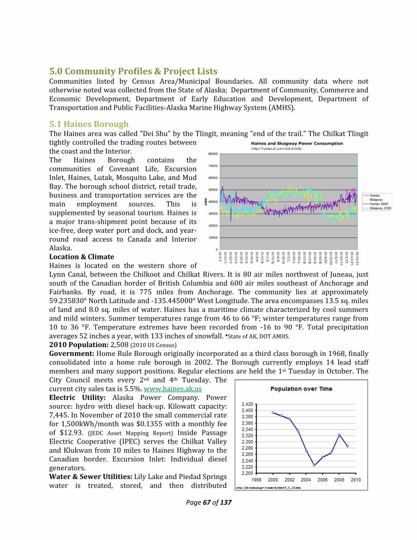
Page 67 of 137
5.0 Community Profiles & Project Lists Communities listed by Census Area/Municipal Boundaries. All community data where not otherwise noted was collected from the State of Alaska; Department of Community, Commerce and Economic Development, Department of Early Education and Development, Department of Transportation and Public Facilities-Alaska Marine Highway System (AMHS).
5.1 Haines Borough The Haines area was called "Dei Shu" by the Tlingit, meaning "end of the trail." The Chilkat Tlingit tightly controlled the trading routes between the coast and the Interior. The Haines Borough contains the communities of Covenant Life, Excursion Inlet, Haines, Lutak, Mosquito Lake, and Mud Bay. The borough school district, retail trade, business and transportation services are the main employment sources. This is supplemented by seasonal tourism. Haines is a major trans-shipment point because of its ice-free, deep water port and dock, and year-round road access to Canada and Interior Alaska. Location & Climate Haines is located on the western shore of Lynn Canal, between the Chilkoot and Chilkat Rivers. It is 80 air miles northwest of Juneau, just south of the Canadian border of British Columbia and 600 air miles southeast of Anchorage and Fairbanks. By road, it is 775 miles from Anchorage. The community lies at approximately 59.235830° North Latitude and -135.445000° West Longitude. The area encompasses 13.5 sq. miles of land and 8.0 sq. miles of water. Haines has a maritime climate characterized by cool summers and mild winters. Summer temperatures range from 46 to 66 °F; winter temperatures range from 10 to 36 °F. Temperature extremes have been recorded from -16 to 90 °F. Total precipitation averages 52 inches a year, with 133 inches of snowfall. *State of AK, DOT AMHS. 2010 Population: 2,508 (2010 US Census) Government: Home Rule Borough originally incorporated as a third class borough in 1968, finally consolidated into a home rule borough in 2002. The Borough currently employs 14 lead staff members and many support positions. Regular elections are held the 1st Tuesday in October. The City Council meets every 2nd and 4th Tuesday. The current city sales tax is 5.5%. www.haines.ak.us Electric Utility: Alaska Power Company. Power source: hydro with diesel back-up. Kilowatt capacity: 7,445. In November of 2010 the small commercial rate for 1,500kWh/month was $0.1355 with a monthly fee of $12.93. (JEDC Asset Mapping Report) Inside Passage Electric Cooperative (IPEC) serves the Chilkat Valley and Klukwan from 10 miles to Haines Highway to the Canadian border. Excursion Inlet: Individual diesel generators. Water & Sewer Utilities: Lily Lake and Piedad Springs water is treated, stored, and then distributed
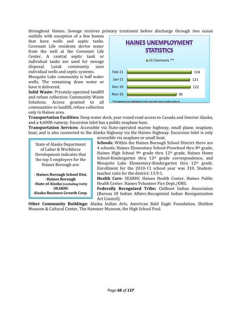
Page 68 of 137
95
122
121
124
Nov-10
Dec-10
Jan-11
Feb-11
UI Claimants **
**UI claimants are individuals in this area who had an active claim at
throughout Haines. Sewage receives primary treatment before discharge through two ocean outfalls with exception of a few homes that have wells and septic tanks. Covenant Life residents derive water from the well at the Covenant Life Center. A central septic tank or individual tanks are used for sewage disposal. Lutak community uses individual wells and septic systems. Mosquito Lake community is half water wells. The remaining draw water or have it delivered. Solid Waste: Privately-operated landfill and refuse collection: Community Waste Solutions. Access granted to all communities to landfill, refuse collection only in Haines area. Transportation Facilities: Deep water dock, year round road access to Canada and Interior Alaska, and a 4,600ft runway. Excursion Inlet has a public seaplane base. Transportation Services: Accessible via State-operated marine highway, small plane, seaplane, boat, and is also connected to the Alaska Highway via the Haines Highway. Excursion Inlet is only
accessible via seaplane or small boat. Schools: Within the Haines Borough School District there are 4 schools; Haines Elementary School-Preschool thru 8th grade, Haines High School 9th grade thru 12th grade, Haines Home School-Kindergarten thru 12th grade correspondence, and Mosquito Lake Elementary-Kindergarten thru 12th grade. Enrollment for the 2010-11 school year was 310. Student-teacher ratio for the district: 13.9:1. Health Care: SEARHC Haines Health Center. Haines Public Health Center. Haines Volunteer Fire Dept./EMS. Federally Recognized Tribe: Chilkoot Indian Association (Bureau Of Indian Affairs-Recognized Indian Reorganization Act Council).
Other Community Buildings: Alaska Indian Arts, American Bald Eagle Foundation, Sheldon Museum & Cultural Center, The Hammer Museum, the High School Pool.
State of Alaska Department of Labor & Workforce
Development indicates that the top 5 employers for the
Haines Borough are: - Haines Borough School Dist.
-Haines Borough -State of Alaska (excluding UofA)
-SEARHC Alaska Business Growth Corp.
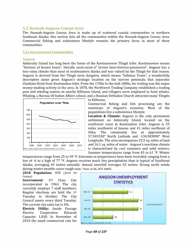
Page 69 of 137
5.2 Hoonah-Angoon Census Area The Hoonah-Angoon Census Area is made up of scattered coastal communities in northern Southeast Alaska; this section lists all the communities within the Hoonah-Angoon Census Area. Commercial fishing and subsistence lifestyle remains the primary focus in most of these communities.
5.2a Incorporated Communities
Angoon Admiralty Island has long been the home of the Kootznoowoo Tlingit tribe. Kootznoowoo means "fortress of brown bears", literally xoots-noow-ú" brown bear-fortress-possessive". Angoon has a less-rainy climate than most of southeastern Alaska and was valued by the Tlingit for that reason. Angoon is derived from the Tlingit term Aangóon, which means "Isthmus Town", a wonderfully descriptive name given Angoon's strategic location on the narrow peninsula that separates Chatham Strait from Kootznahoo Inlet. From the 1700s to the mid-1800s, fur trading was the major money-making activity in the area. In 1878, the Northwest Trading Company established a trading post and whaling station on nearby Killisnoo Island, and villagers were employed to hunt whales. Whaling, a Bureau Of Indian Affairs school, and a Russian Orthodox Church attracted many Tlingits
to Killisnoo. Commercial fishing and fish processing are the mainstays of Angoon’s economy. Most of the populations live a subsistence lifestyle. Location & Climate: Angoon is the only permanent settlement on Admiralty Island, located on the southwest coast at Kootznahoo Inlet. Angoon is 55 miles southwest of Juneau and 41 miles northeast of Sitka. The community lies at approximately 57.503330° North Latitude and -134.583890° West Longitude. The area encompasses 22.5 sq. miles of land and 16.1 sq. miles of water. Angoon's maritime climate is characterized by cool summers and mild winters. Summer temperatures range from 45 to 61 °F. Winter
temperatures range from 25 to 39 °F. Extremes in temperature have been recorded, ranging from a low of -6 to a high of 77 °F. Angoon receives much less precipitation than is typical of Southeast Alaska, averaging 43 inches annually. Annual snowfall averages 63 inches. Strong north winds during winter months cause rough seas. *State of AK, DOT AMHS. 2010 Population: 459 (2010 US Census) Government: 2nd Class City incorporated in 1963. The city currently employs 7 staff members. Regular elections are held the 1st Tuesday in October. The City Council meets every third Tuesday. The current city sales tax is 3%. Electric Utility: Inside Passage Electric Cooperative Kilowatt Capacity: 1,830. In November of 2010 the small commercial rate for
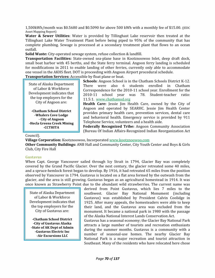
Page 70 of 137
State of Alaska Department of Labor & Workforce
Development indicates that the top employers for the
City of Angoon are:
-Chatham School District -Whalers Cove Lodge
- City of Angoon -Hecla Greens Creek Mining
-CCTHITA
State of Alaska Department of Labor & Workforce
Development indicates that the top employers for the
City of Gustavus are:
-Chatham School District -City of Gustavus Alaska
-State of AK Dept of Admin -Gustavus Electric Inc
-Air Excursions LLC
1,500kWh/month was $0.5680 and $0.5090 for above 500 kWh with a monthly fee of $15.00. (JEDC Asset Mapping Report) Water & Sewer Utilities: Water is provided by Tillinghast Lake reservoir then treated at the Tillinghast Lake Water Treatment Plant before being piped to 95% of the community that has complete plumbing. Sewage is processed at a secondary treatment plant that flows to an ocean outfall. Solid Waste: City-operated sewage system, refuse collection & landfill. Transportation Facilities: State-owned sea-plane base in Kootznoowoo Inlet, deep draft dock, small boat harbor with 45 berths, and the State ferry terminal. Angoon ferry landing is scheduled for modifications in 2011 to enable landing of other ferries, currently only able to accommodate one vessel in the AKHS fleet. DOT is proceeding with Angoon Airport procedural schedule. Transportation Services: Accessible by float plane or boat.
Schools: Angoon School is in the Chatham Schools District K-12. There were also 6 students enrolled in Chatham Correspondence for the 2010-11 school year. Enrollment for the 2010-11 school year was 78. Student-teacher ratio: 11.5:1. www.chathamsd.org Health Care: Jessie Jim Health Care, owned by the City of Angoon and operated by SEARHC. Jessie Jim Health Center provides primary health care, prevention services, dental care and behavioral health. Emergency service is provided by 911 Telephone Service, volunteers and a health aide. Federally Recognized Tribe: Angoon Community Association (Bureau Of Indian Affairs-Recognized Indian Reorganization Act
Council). Village Corporation: Kootznoowoo, Incorporated www.kootznoowoo.com Other Community Buildings: ANB Hall and Community Center, City Youth Center and Boys & Girls Club, City Fire Hall
Gustavus When Capt. George Vancouver sailed through Icy Strait in 1794, Glacier Bay was completely covered by the Grand Pacific Glacier. Over the next century, the glacier retreated some 40 miles, and a spruce-hemlock forest began to develop. By 1916, it had retreated 65 miles from the position observed by Vancouver in 1794. Gustavus is located on a flat area formed by the outwash from the glacier, and the area is still growing. Gustavus began as an agricultural homestead in 1914. It was once known as Strawberry Point due to the abundant wild strawberries. The current name was
derived from Point Gustavus, which lies 7 miles to the southwest. Glacier Bay National Monument (including Gustavus) was established by President Calvin Coolidge in 1925. After many appeals, the homesteaders were able to keep their land, and the Gustavus area was excluded from the monument. It became a national park in 1980 with the passage of the Alaska National Interest Lands Conservation Act. Gustavus has a seasonal economy; the Glacier Bay National Park attracts a large number of tourists and recreation enthusiasts during the summer months. Gustavus is a community with a number of seasonal-use homes. The nearby Glacier Bay National Park is a major recreation and tourist attraction in Southeast. Many of the residents who have relocated here chose
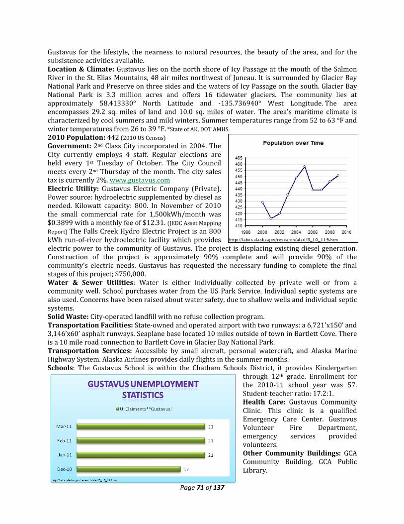
Page 71 of 137
Gustavus for the lifestyle, the nearness to natural resources, the beauty of the area, and for the subsistence activities available. Location & Climate: Gustavus lies on the north shore of Icy Passage at the mouth of the Salmon River in the St. Elias Mountains, 48 air miles northwest of Juneau. It is surrounded by Glacier Bay National Park and Preserve on three sides and the waters of Icy Passage on the south. Glacier Bay National Park is 3.3 million acres and offers 16 tidewater glaciers. The community lies at approximately 58.413330° North Latitude and -135.736940° West Longitude. The area encompasses 29.2 sq. miles of land and 10.0 sq. miles of water. The area's maritime climate is characterized by cool summers and mild winters. Summer temperatures range from 52 to 63 °F and winter temperatures from 26 to 39 °F. *State of AK, DOT AMHS. 2010 Population: 442 (2010 US Census) Government: 2nd Class City incorporated in 2004. The City currently employs 4 staff. Regular elections are held every 1st Tuesday of October. The City Council meets every 2nd Thursday of the month. The city sales tax is currently 2%. www.gustavus.com Electric Utility: Gustavus Electric Company (Private). Power source: hydroelectric supplemented by diesel as needed. Kilowatt capacity: 800. In November of 2010 the small commercial rate for 1,500kWh/month was $0.3899 with a monthly fee of $12.31. (JEDC Asset Mapping Report) The Falls Creek Hydro Electric Project is an 800 kWh run-of-river hydroelectric facility which provides electric power to the community of Gustavus. The project is displacing existing diesel generation. Construction of the project is approximately 90% complete and will provide 90% of the community's electric needs. Gustavus has requested the necessary funding to complete the final stages of this project; $750,000. Water & Sewer Utilities: Water is either individually collected by private well or from a community well. School purchases water from the US Park Service. Individual septic systems are also used. Concerns have been raised about water safety, due to shallow wells and individual septic systems. Solid Waste: City-operated landfill with no refuse collection program. Transportation Facilities: State-owned and operated airport with two runways: a 6,721'x150’ and 3,146’x60’ asphalt runways. Seaplane base located 10 miles outside of town in Bartlett Cove. There is a 10 mile road connection to Bartlett Cove in Glacier Bay National Park. Transportation Services: Accessible by small aircraft, personal watercraft, and Alaska Marine Highway System. Alaska Airlines provides daily flights in the summer months. Schools: The Gustavus School is within the Chatham Schools District, it provides Kindergarten
through 12th grade. Enrollment for the 2010-11 school year was 57. Student-teacher ratio: 17.2:1. Health Care: Gustavus Community Clinic. This clinic is a qualified Emergency Care Center. Gustavus Volunteer Fire Department, emergency services provided volunteers. Other Community Buildings: GCA Community Building, GCA Public Library.
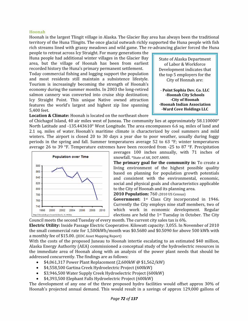
Page 72 of 137
Hoonah Hoonah is the largest Tlingit village in Alaska. The Glacier Bay area has always been the traditional territory of the Huna Tlingits. The once glacial outwash richly supported the Huna people with fish rich streams lined with grassy meadows and wild game. The re-advancing glacier forced the Huna people to retreat across Icy Straight. For many generations the Huna people had additional winter villages in the Glacier Bay area, but the village of Hoonah has been from earliest recorded history the Huna’s primary permanent settlement. Today commercial fishing and logging support the population and most residents still maintain a subsistence lifestyle. Tourism is increasingly becoming the strength of Hoonah’s economy during the summer months. In 2003 the long-retired salmon cannery was converted into cruise ship destination; Icy Straight Point. This unique Native owned attraction features the world’s largest and highest zip line spanning 5,400 feet. Location & Climate: Hoonah is located on the northeast shore of Chichagof Island, 40 air miles west of Juneau. The community lies at approximately 58.110000° North Latitude and -135.443610° West Longitude. The area encompasses 6.6 sq. miles of land and 2.1 sq. miles of water. Hoonah's maritime climate is characterized by cool summers and mild winters. The airport is closed 20 to 30 days a year due to poor weather, usually during foggy periods in the spring and fall. Summer temperatures average 52 to 63 °F; winter temperatures average 26 to 39 °F. Temperature extremes have been recorded from -25 to 87 °F. Precipitation
averages 100 inches annually, with 71 inches of snowfall. *State of AK, DOT AMHS. The primary goal for the community is: To create a living environment of the highest possible quality based on planning for population growth potentials and consistent with the environmental, economic, social and physical goals and characteristics applicable to the City of Hoonah and its planning area. 2010 Population: 760 (2010 US Census) Government: 1st Class City incorporated in 1946. Currently the City employs nine staff members, two of which work in economic development. Regular elections are held the 1st Tuesday in October. The City
Council meets the second Tuesday of every month. The current city sales tax is 6%. Electric Utility: Inside Passage Electric Cooperative. Kilowatt capacity: 3,055. In November of 2010 the small commercial rate for 1,500kWh/month was $0.5680 and $0.5090 for above 500 kWh with a monthly fee of $15.00. (JEDC Asset Mapping Report) With the costs of the proposed Juneau to Hoonah intertie escalating to an estimated $40 million, Alaska Energy Authority (AEA) commissioned a conceptual study of the hydroelectric resources in the immediate area of Hoonah along with an analysis of the power plant needs that should be addressed concurrently. The findings are as follows:
• $4,061,317 Power Plant Replacement (2,600kW @ $1,562/kW) • $4,558,500 Gartina Creek Hydroelectric Project (600kW) • $3,946,500 Water Supply Creek Hydroelectric Project (600kW) • $4,393,500 Elephant Falls Hydroelectric Project (600kW)
The development of any one of the three proposed hydro facilities would offset approx 30% of Hoonah's projected annual demand. This would result in a savings of approx 129,000 gallons of
State of Alaska Department of Labor & Workforce
Development indicates that the top 5 employers for the
City of Honnah are:
- Point Sophia Dev. Co. LLC -Hoonah City Schools
-City of Hoonah -Hoonah Indian Association
-Ward Cove Holdings LLC
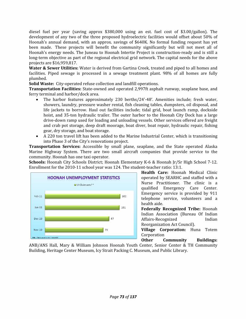
Page 73 of 137
diesel fuel per year (saving approx $380,000 using an est. fuel cost of $3.00/gallon). The development of any two of the three proposed hydroelectric facilities would offset about 50% of Hoonah's annual demand, with an approx. savings of $640K. No formal funding request has yet been made. These projects will benefit the community significantly but will not meet all of Hoonah's energy needs. The Juneau to Hoonah Intertie Project is construction-ready and is still a long-term objective as part of the regional electrical grid network. The capital needs for the above projects are $16,959,817. Water & Sewer Utilities: Water is derived from Gartina Creek, treated and piped to all homes and facilities. Piped sewage is processed in a sewage treatment plant. 98% of all homes are fully plumbed. Solid Waste: City-operated refuse collection and landfill operations. Transportation Facilities: State-owned and operated 2,997ft asphalt runway, seaplane base, and ferry terminal and harbor/dock area.
• The harbor features approximately 230 berths/24’-48’. Amenities include; fresh water, showers, laundry, pressure washer rental, fish cleaning tables, dumpsters, oil disposal, and life jackets to borrow. Haul out facilities include; tidal grid, boat launch ramp, dockside hoist, and 35-ton hydraulic trailer. The outer harbor to the Hoonah City Dock has a large drive-down ramp used for loading and unloading vessels. Other services offered are freight and crab pot storage, deep draft moorage, boat diver, boat repair, hydraulic repair, fishing gear, dry storage, and boat storage.
• A 220 ton travel lift has been added to the Marine Industrial Center, which is transitioning into Phase 3 of the City’s renovations project.
Transportation Services: Accessible by small plane, seaplane, and the State operated Alaska Marine Highway System. There are two small aircraft companies that provide service to the community. Hoonah has one taxi operator. Schools: Hoonah City Schools District; Hoonah Elementary K-6 & Hoonah Jr/Sr High School 7-12. Enrollment for the 2010-11 school year was 124. The student-teacher ratio: 13:1.
Health Care: Hoonah Medical Clinic operated by SEARHC and staffed with a Nurse Practitioner. The clinic is a qualified Emergency Care Center. Emergency service is provided by 911 telephone service, volunteers and a health aide. Federally Recognized Tribe: Hoonah Indian Association (Bureau Of Indian Affairs-Recognized Indian Reorganization Act Council). Village Corporation: Huna Totem Corporation Other Community Buildings:
ANB/ANS Hall, Mary & William Johnson Hoonah Youth Center, Senior Center & TH Community Building, Heritage Center Museum, Icy Strait Packing C. Museum, and Public Library.
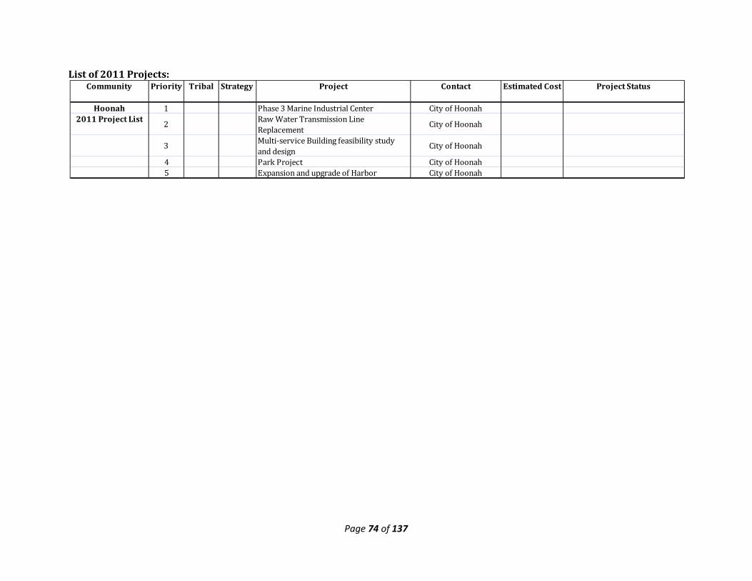
Page 74 of 137
List of 2011 Projects:
Community Priority Tribal Strategy Project Contact Estimated Cost Project Status
Hoonah 1 Phase 3 Marine Industrial Center City of Hoonah2011 Project List 2 Raw Water Transmission Line
Replacement City of Hoonah
3 Multi-service Building feasibility study and design
City of Hoonah
4 Park Project City of Hoonah5 Expansion and upgrade of Harbor City of Hoonah
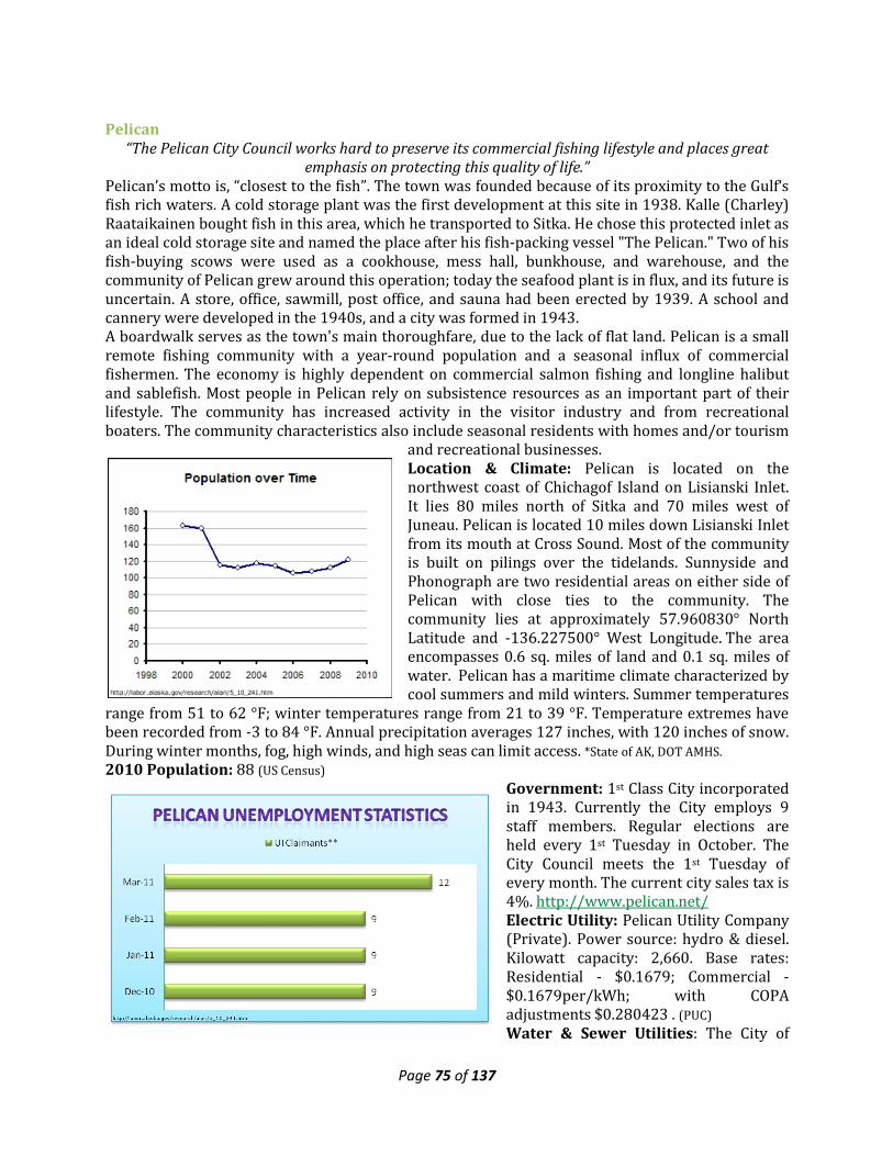
Page 75 of 137
Pelican “The Pelican City Council works hard to preserve its commercial fishing lifestyle and places great
emphasis on protecting this quality of life.” Pelican’s motto is, “closest to the fish”. The town was founded because of its proximity to the Gulf‘s fish rich waters. A cold storage plant was the first development at this site in 1938. Kalle (Charley) Raataikainen bought fish in this area, which he transported to Sitka. He chose this protected inlet as an ideal cold storage site and named the place after his fish-packing vessel "The Pelican." Two of his fish-buying scows were used as a cookhouse, mess hall, bunkhouse, and warehouse, and the community of Pelican grew around this operation; today the seafood plant is in flux, and its future is uncertain. A store, office, sawmill, post office, and sauna had been erected by 1939. A school and cannery were developed in the 1940s, and a city was formed in 1943. A boardwalk serves as the town's main thoroughfare, due to the lack of flat land. Pelican is a small remote fishing community with a year-round population and a seasonal influx of commercial fishermen. The economy is highly dependent on commercial salmon fishing and longline halibut and sablefish. Most people in Pelican rely on subsistence resources as an important part of their lifestyle. The community has increased activity in the visitor industry and from recreational boaters. The community characteristics also include seasonal residents with homes and/or tourism
and recreational businesses. Location & Climate: Pelican is located on the northwest coast of Chichagof Island on Lisianski Inlet. It lies 80 miles north of Sitka and 70 miles west of Juneau. Pelican is located 10 miles down Lisianski Inlet from its mouth at Cross Sound. Most of the community is built on pilings over the tidelands. Sunnyside and Phonograph are two residential areas on either side of Pelican with close ties to the community. The community lies at approximately 57.960830° North Latitude and -136.227500° West Longitude. The area encompasses 0.6 sq. miles of land and 0.1 sq. miles of water. Pelican has a maritime climate characterized by cool summers and mild winters. Summer temperatures
range from 51 to 62 °F; winter temperatures range from 21 to 39 °F. Temperature extremes have been recorded from -3 to 84 °F. Annual precipitation averages 127 inches, with 120 inches of snow. During winter months, fog, high winds, and high seas can limit access. *State of AK, DOT AMHS. 2010 Population: 88 (US Census)
Government: 1st Class City incorporated in 1943. Currently the City employs 9 staff members. Regular elections are held every 1st Tuesday in October. The City Council meets the 1st Tuesday of every month. The current city sales tax is 4%. http://www.pelican.net/ Electric Utility: Pelican Utility Company (Private). Power source: hydro & diesel. Kilowatt capacity: 2,660. Base rates: Residential - $0.1679; Commercial - $0.1679per/kWh; with COPA adjustments $0.280423 . (PUC) Water & Sewer Utilities: The City of
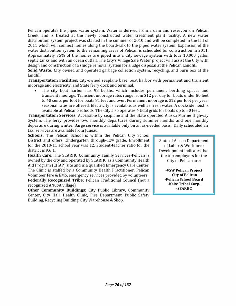
Page 76 of 137
State of Alaska Department of Labor & Workforce
Development indicates that the top employers for the
City of Pelican are:
-VSW Pelican Project -City of Pelican
-Pelican School Board -Kake Tribal Corp.
-SEARHC
Pelican operates the piped water system. Water is derived from a dam and reservoir on Pelican Creek, and is treated at the newly constructed water treatment plant facility. A new water distribution system project was started in the summer of 2010 and will be completed in the fall of 2011 which will connect homes along the boardwalk to the piped water system. Expansion of the water distribution system to the remaining areas of Pelican is scheduled for construction in 2011. Approximately 75% of the homes are piped into a City sewage system with four 10,000 gallon septic tanks and with an ocean outfall. The City’s Village Safe Water project will assist the City with design and construction of a sludge removal system for sludge disposal at the Pelican Landfill. Solid Waste: City owned and operated garbage collection system, recycling, and burn box at the landfill. Transportation Facilities: City-owned seaplane base, boat harbor with permanent and transient moorage and electricity, and State ferry dock and terminal.
• The city boat harbor has 98 berths, which includes permanent berthing spaces and transient moorage. Transient moorage rates range from $12 per day for boats under 80 feet to 40 cents per foot for boats 81 feet and over. Permanent moorage is $12 per foot per year; seasonal rates are offered. Electricity is available, as well as fresh water. A dockside hoist is available at Pelican Seafoods. The City also operates 4 tidal grids for boats up to 50 feet.
Transportation Services: Accessible by seaplane and the State operated Alaska Marine Highway System. The ferry provides two monthly departures during summer months and one monthly departure during winter. Barge service is available only on an as-needed basis. Daily scheduled air taxi services are available from Juneau. Schools: The Pelican School is within the Pelican City School District and offers Kindergarten through-12th grade. Enrollment for the 2010-11 school year was 12. Student-teacher ratio for the district is 9.6:1. Health Care: The SEARHC Community Family Services-Pelican is owned by the city and operated by SEARHC as a Community Health Aid Program (CHAP) site and is a qualified Emergency Care Center. The Clinic is staffed by a Community Health Practitioner. Pelican Volunteer Fire & EMS, emergency services provided by volunteers. Federally Recognized Tribe: Pelican Traditional Council (not a recognized ANCSA village) Other Community Buildings: City Public Library, Community Center, City Hall, Health Clinic, Fire Department, Public Safety Building, Recycling Building, City Warehouse & Shop.
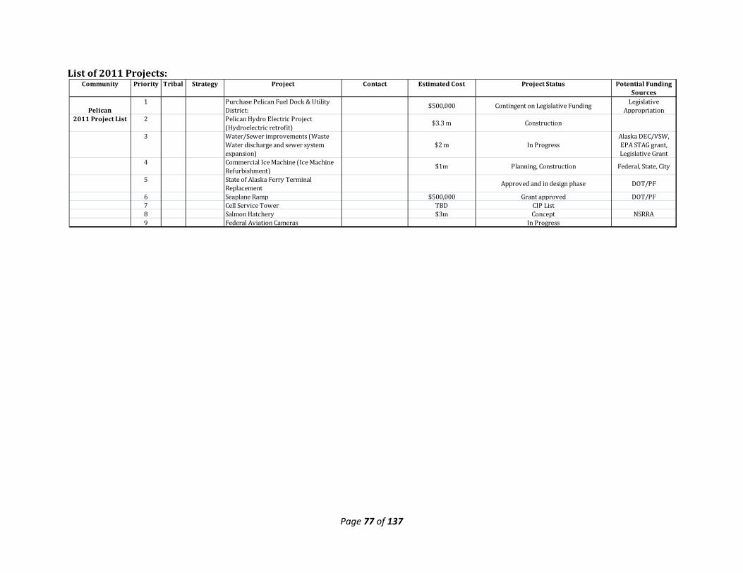
Page 77 of 137
List of 2011 Projects:
Community Priority Tribal Strategy Project Contact Estimated Cost Project Status Potential Funding Sources
Pelican 1 Purchase Pelican Fuel Dock & Utility
District: $500,000 Contingent on Legislative Funding Legislative Appropriation
2011 Project List 2 Pelican Hydro Electric Project (Hydroelectric retrofit) $3.3 m Construction
3 Water/Sewer improvements (Waste Water discharge and sewer system expansion)
$2 m In ProgressAlaska DEC/VSW, EPA STAG grant, Legislative Grant
4 Commercial Ice Machine (Ice Machine Refurbishment) $1m Planning, Construction Federal, State, City
5 State of Alaska Ferry Terminal Replacement Approved and in design phase DOT/PF
6 Seaplane Ramp $500,000 Grant approved DOT/PF7 Cell Service Tower TBD CIP List8 Salmon Hatchery $3m Concept NSRRA9 Federal Aviation Cameras In Progress
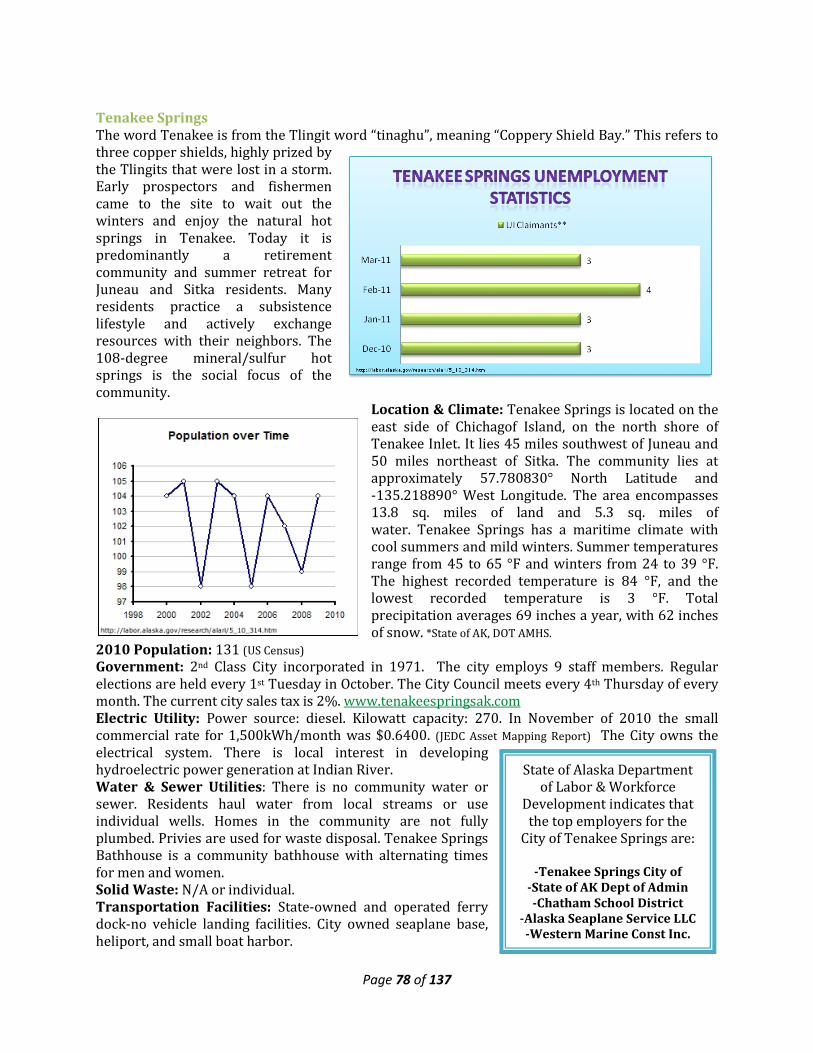
Page 78 of 137
State of Alaska Department of Labor & Workforce
Development indicates that the top employers for the
City of Tenakee Springs are:
-Tenakee Springs City of -State of AK Dept of Admin -Chatham School District
-Alaska Seaplane Service LLC -Western Marine Const Inc.
Tenakee Springs The word Tenakee is from the Tlingit word “tinaghu”, meaning “Coppery Shield Bay.” This refers to three copper shields, highly prized by the Tlingits that were lost in a storm. Early prospectors and fishermen came to the site to wait out the winters and enjoy the natural hot springs in Tenakee. Today it is predominantly a retirement community and summer retreat for Juneau and Sitka residents. Many residents practice a subsistence lifestyle and actively exchange resources with their neighbors. The 108-degree mineral/sulfur hot springs is the social focus of the community.
Location & Climate: Tenakee Springs is located on the east side of Chichagof Island, on the north shore of Tenakee Inlet. It lies 45 miles southwest of Juneau and 50 miles northeast of Sitka. The community lies at approximately 57.780830° North Latitude and -135.218890° West Longitude. The area encompasses 13.8 sq. miles of land and 5.3 sq. miles of water. Tenakee Springs has a maritime climate with cool summers and mild winters. Summer temperatures range from 45 to 65 °F and winters from 24 to 39 °F. The highest recorded temperature is 84 °F, and the lowest recorded temperature is 3 °F. Total precipitation averages 69 inches a year, with 62 inches of snow. *State of AK, DOT AMHS.
2010 Population: 131 (US Census)
Government: 2nd Class City incorporated in 1971. The city employs 9 staff members. Regular elections are held every 1st Tuesday in October. The City Council meets every 4th Thursday of every month. The current city sales tax is 2%. www.tenakeespringsak.com Electric Utility: Power source: diesel. Kilowatt capacity: 270. In November of 2010 the small commercial rate for 1,500kWh/month was $0.6400. (JEDC Asset Mapping Report) The City owns the electrical system. There is local interest in developing hydroelectric power generation at Indian River. Water & Sewer Utilities: There is no community water or sewer. Residents haul water from local streams or use individual wells. Homes in the community are not fully plumbed. Privies are used for waste disposal. Tenakee Springs Bathhouse is a community bathhouse with alternating times for men and women. Solid Waste: N/A or individual. Transportation Facilities: State-owned and operated ferry dock-no vehicle landing facilities. City owned seaplane base, heliport, and small boat harbor.
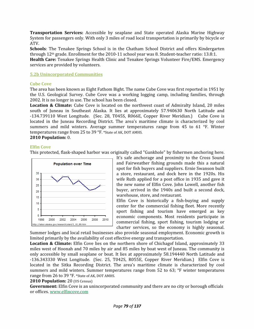
Page 79 of 137
Transportation Services: Accessible by seaplane and State operated Alaska Marine Highway System for passengers only. With only 3 miles of road local transportation is primarily by bicycle or ATV. Schools: The Tenakee Springs School is in the Chatham School District and offers Kindergarten through 12th grade. Enrollment for the 2010-11 school year was 8. Student-teacher ratio: 13.8:1. Health Care: Tenakee Springs Health Clinic and Tenakee Springs Volunteer Fire/EMS. Emergency services are provided by volunteers.
5.2b Unincorporated Communities
Cube Cove The area has been known as Eight Fathom Bight. The name Cube Cove was first reported in 1951 by the U.S. Geological Survey. Cube Cove was a working logging camp, including families, through 2002. It is no longer in use. The school has been closed. Location & Climate: Cube Cove is located on the northwest coast of Admiralty Island, 20 miles south of Juneau in Southeast Alaska. It lies at approximately 57.940630 North Latitude and -134.739110 West Longitude. (Sec. 28, T045S, R066E, Copper River Meridian.) Cube Cove is located in the Juneau Recording District. The area's maritime climate is characterized by cool summers and mild winters. Average summer temperatures range from 45 to 61 °F. Winter temperatures range from 25 to 39 °F. *State of AK, DOT AMHS. 2010 Population: 0.
Elfin Cove This protected, flask-shaped harbor was originally called "Gunkhole" by fishermen anchoring here.
It’s safe anchorage and proximity to the Cross Sound and Fairweather fishing grounds made this a natural spot for fish buyers and suppliers. Ernie Swanson built a store, restaurant, and dock here in the 1920s. His wife Ruth applied for a post office in 1935 and gave it the new name of Elfin Cove. John Lowell, another fish buyer, arrived in the 1940s and built a second dock, warehouse, store, and restaurant. Elfin Cove is historically a fish-buying and supply center for the commercial fishing fleet. More recently sport fishing and tourism have emerged as key economic components. Most residents participate in commercial fishing, sport fishing, tourism lodging or charter services, so the economy is highly seasonal.
Summer lodges and local retail businesses also provide seasonal employment. Economic growth is limited primarily by the availability of cost effective energy and transportation. Location & Climate: Elfin Cove lies on the northern shore of Chichagof Island, approximately 33 miles west of Hoonah and 70 miles by air and 85 miles by boat west of Juneau. The community is only accessible by small seaplane or boat. It lies at approximately 58.194440 North Latitude and -136.343330 West Longitude. (Sec. 25, T042S, R055E, Copper River Meridian.) Elfin Cove is located in the Sitka Recording District. The area's maritime climate is characterized by cool summers and mild winters. Summer temperatures range from 52 to 63; °F winter temperatures range from 26 to 39 °F. *State of AK, DOT AMHS. 2010 Population: 20 (US Census) Government: Elfin Cove is an unincorporated community and there are no city or borough officials or offices. www.elfincove.com
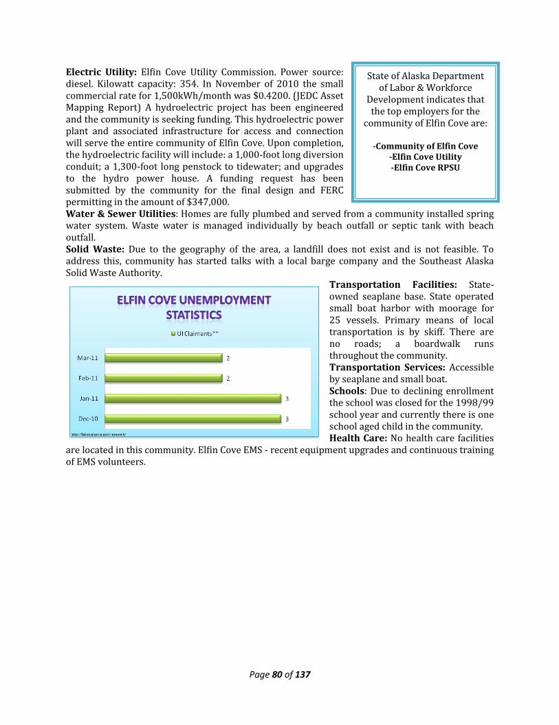
Page 80 of 137
State of Alaska Department of Labor & Workforce
Development indicates that the top employers for the
community of Elfin Cove are:
-Community of Elfin Cove -Elfin Cove Utility -Elfin Cove RPSU
Electric Utility: Elfin Cove Utility Commission. Power source: diesel. Kilowatt capacity: 354. In November of 2010 the small commercial rate for 1,500kWh/month was $0.4200. (JEDC Asset Mapping Report) A hydroelectric project has been engineered and the community is seeking funding. This hydroelectric power plant and associated infrastructure for access and connection will serve the entire community of Elfin Cove. Upon completion, the hydroelectric facility will include: a 1,000-foot long diversion conduit; a 1,300-foot long penstock to tidewater; and upgrades to the hydro power house. A funding request has been submitted by the community for the final design and FERC permitting in the amount of $347,000. Water & Sewer Utilities: Homes are fully plumbed and served from a community installed spring water system. Waste water is managed individually by beach outfall or septic tank with beach outfall. Solid Waste: Due to the geography of the area, a landfill does not exist and is not feasible. To address this, community has started talks with a local barge company and the Southeast Alaska Solid Waste Authority.
Transportation Facilities: State-owned seaplane base. State operated small boat harbor with moorage for 25 vessels. Primary means of local transportation is by skiff. There are no roads; a boardwalk runs throughout the community. Transportation Services: Accessible by seaplane and small boat. Schools: Due to declining enrollment the school was closed for the 1998/99 school year and currently there is one school aged child in the community. Health Care: No health care facilities
are located in this community. Elfin Cove EMS - recent equipment upgrades and continuous training of EMS volunteers.
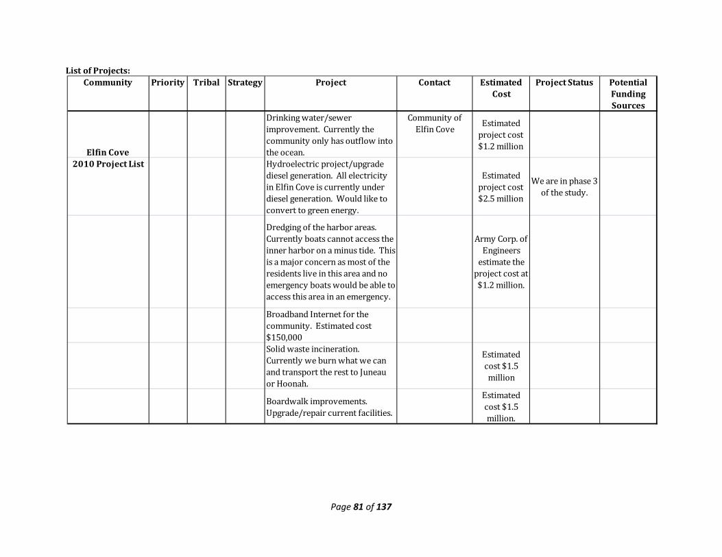
Page 81 of 137
List of Projects:
Community Priority Tribal Strategy Project Contact Estimated Cost
Project Status Potential Funding Sources
Elfin Cove
Drinking water/sewer improvement. Currently the community only has outflow into the ocean.
Community of Elfin Cove
Estimated project cost $1.2 million
2010 Project List Hydroelectric project/upgrade diesel generation. All electricity in Elfin Cove is currently under diesel generation. Would like to convert to green energy.
Estimated project cost $2.5 million
We are in phase 3 of the study.
Dredging of the harbor areas. Currently boats cannot access the inner harbor on a minus tide. This is a major concern as most of the residents live in this area and no emergency boats would be able to access this area in an emergency.
Army Corp. of Engineers
estimate the project cost at $1.2 million.
Broadband Internet for the community. Estimated cost $150,000Solid waste incineration. Currently we burn what we can and transport the rest to Juneau or Hoonah.
Estimated cost $1.5 million
Boardwalk improvements. Upgrade/repair current facilities.
Estimated cost $1.5 million.
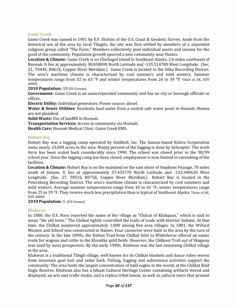
Page 82 of 137
Game Creek Game Creek was named in 1901 by E.F. Dickins of the U.S. Coast & Geodetic Survey. Aside from the historical use of the area by local Tlingits, the site was first settled by members of a separatist religious group called "The Farm." Members collectively pool individual assets and income for the good of the community. Population growth spurred a new community near Haines. Location & Climate: Game Creek is on Chichagof Island in Southeast Alaska, 2.6 miles southwest of Hoonah. It lies at approximately 58.058090 North Latitude and -135.514780 West Longitude. (Sec. 21, T044S, R061E, Copper River Meridian.) Game Creek is located in the Sitka Recording District. The area's maritime climate is characterized by cool summers and mild winters. Summer temperatures range from 52 to 63 °F and winter temperatures from 26 to 39 °F. *State of AK, DOT AMHS. 2010 Population: 18 (US Census) Government: Game Creek is an unincorporated community and has no city or borough officials or offices. Electric Utility: Individual generators. Power source: diesel. Water & Sewer Utilities: Residents haul water from a central safe water point in Hoonah. Homes are not plumbed. Solid Waste: Use of landfill in Hoonah. Transportation Services: Access to community via Hoonah. Health Care: Hoonah Medical Clinic. Game Creek EMS.
Hobart Bay Hobart Bay was a logging camp operated by Goldbelt, Inc. The Juneau-based Native Corporation owns nearly 23,000 acres in the area. Ninety percent of the logging is done by helicopter. The work force has been scaled back considerably since 1990. The school was closed prior to the 98/99 school year. Since the logging camp has been closed, employment is now limited to caretaking of the facilities. Location & Climate: Hobart Bay is on the mainland on the east shore of Stephens Passage, 70 miles south of Juneau. It lies at approximately 57.435770 North Latitude and -133.340620 West Longitude. (Sec. 27, T051S, R075E, Copper River Meridian.) Hobart Bay is located in the Petersburg Recording District. The area's maritime climate is characterized by cool summers and mild winters. Average summer temperatures range from 45 to 61 °F; winter temperatures range from 25 to 39 °F. They receive much less precipitation than is typical of Southeast Alaska. *State of AK, DOT AMHS. 2010 Population: 1. (US Census)
Klukwan In 1880, the U.S. Navy reported the name of the village as "Chilcat of Klukquan," which is said to mean "the old town." The Chilkat tightly controlled the trails of trade with Interior Indians. At that time, the Chilkat numbered approximately 1,000 among five area villages. In 1881, the Willard Mission and School was constructed in Haines. Four canneries were built in the area by the turn of the century. In the late 1890s, the Dalton Trail from Chilkat Inlet to Whitehorse offered an easier route for wagons and cattle to the Klondike gold fields. However, the Chilkoot Trail out of Skagway was used by most prospectors. By the early 1900s, Klukwan was the last remaining Chilkat village in the area. Klukwan is a traditional Tlingit village, well known for its Chilkat blankets and dance robes woven from mountain goat hair and cedar bark. Fishing, logging and subsistence activities support the community. The area hosts the largest concentration of bald eagles in the world, at the Chilkat Bald Eagle Reserve. Klukwan also has a Jilkaat Cultural Heritage Center containing artifacts stored and displayed, an arts and crafts studio, and a replica tribal house, as well as cultural tours that present
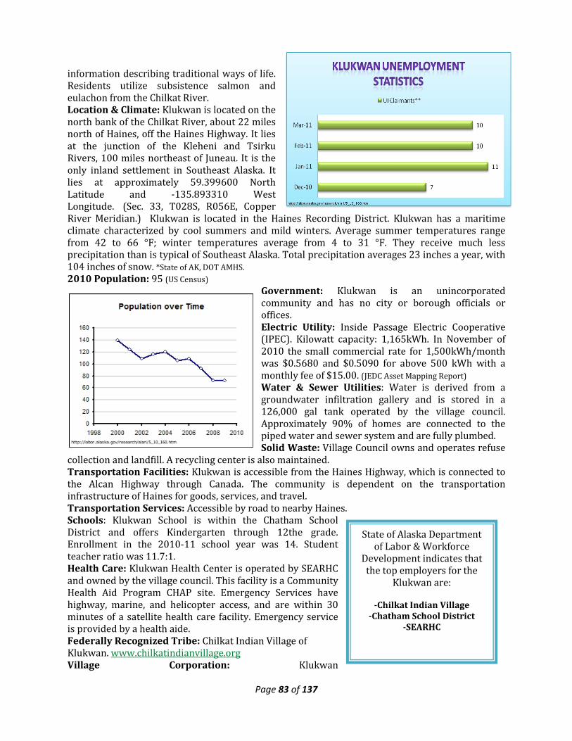
Page 83 of 137
State of Alaska Department of Labor & Workforce
Development indicates that the top employers for the
Klukwan are:
-Chilkat Indian Village -Chatham School District
-SEARHC
information describing traditional ways of life. Residents utilize subsistence salmon and eulachon from the Chilkat River. Location & Climate: Klukwan is located on the north bank of the Chilkat River, about 22 miles north of Haines, off the Haines Highway. It lies at the junction of the Kleheni and Tsirku Rivers, 100 miles northeast of Juneau. It is the only inland settlement in Southeast Alaska. It lies at approximately 59.399600 North Latitude and -135.893310 West Longitude. (Sec. 33, T028S, R056E, Copper River Meridian.) Klukwan is located in the Haines Recording District. Klukwan has a maritime climate characterized by cool summers and mild winters. Average summer temperatures range from 42 to 66 °F; winter temperatures average from 4 to 31 °F. They receive much less precipitation than is typical of Southeast Alaska. Total precipitation averages 23 inches a year, with 104 inches of snow. *State of AK, DOT AMHS. 2010 Population: 95 (US Census)
Government: Klukwan is an unincorporated community and has no city or borough officials or offices. Electric Utility: Inside Passage Electric Cooperative (IPEC). Kilowatt capacity: 1,165kWh. In November of 2010 the small commercial rate for 1,500kWh/month was $0.5680 and $0.5090 for above 500 kWh with a monthly fee of $15.00. (JEDC Asset Mapping Report) Water & Sewer Utilities: Water is derived from a groundwater infiltration gallery and is stored in a 126,000 gal tank operated by the village council. Approximately 90% of homes are connected to the piped water and sewer system and are fully plumbed. Solid Waste: Village Council owns and operates refuse
collection and landfill. A recycling center is also maintained. Transportation Facilities: Klukwan is accessible from the Haines Highway, which is connected to the Alcan Highway through Canada. The community is dependent on the transportation infrastructure of Haines for goods, services, and travel. Transportation Services: Accessible by road to nearby Haines. Schools: Klukwan School is within the Chatham School District and offers Kindergarten through 12the grade. Enrollment in the 2010-11 school year was 14. Student teacher ratio was 11.7:1. Health Care: Klukwan Health Center is operated by SEARHC and owned by the village council. This facility is a Community Health Aid Program CHAP site. Emergency Services have highway, marine, and helicopter access, and are within 30 minutes of a satellite health care facility. Emergency service is provided by a health aide. Federally Recognized Tribe: Chilkat Indian Village of Klukwan. www.chilkatindianvillage.org Village Corporation: Klukwan
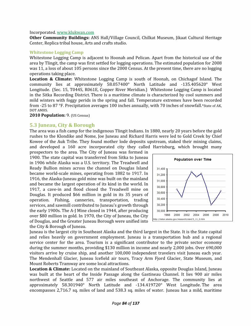
Page 84 of 137
Incorporated. www.klukwan.com Other Community Buildings: ANS Hall/Village Council, Chilkat Museum, Jikaat Cultural Heritage Center, Replica tribal house, Arts and crafts studio.
Whitestone Logging Camp Whitestone Logging Camp is adjacent to Hoonah and Pelican. Apart from the historical use of the area by Tlingit, the camp was first settled for logging operations. The estimated population for 2008 was 11, a loss of about 105 persons since the 2000 Census. At the present time, there are no logging operations taking place. Location & Climate: Whitestone Logging Camp is south of Hoonah, on Chichagof Island. The community lies at approximately 58.057400° North Latitude and -135.405620° West Longitude. (Sec. 15, T044S, R061E, Copper River Meridian.) Whitestone Logging Camp is located in the Sitka Recording District. There is a maritime climate is characterized by cool summers and mild winters with foggy perids in the spring and fall. Temperature extremes have been recorded from -25 to 87 °F. Precipitation averages 100 inches annually, with 70 inches of snowfall.*State of AK, DOT AMHS. 2010 Population: 9. (US Census)
5.3 Juneau, City & Borough The area was a fish camp for the indigenous Tlingit Indians. In 1880, nearly 20 years before the gold rushes to the Klondike and Nome, Joe Juneau and Richard Harris were led to Gold Creek by Chief Kowee of the Auk Tribe. They found mother lode deposits upstream, staked their mining claims, and developed a 160 acre incorporated city they called Harrisburg, which brought many prospectors to the area. The City of Juneau was formed in 1900. The state capital was transferred from Sitka to Juneau in 1906 while Alaska was a U.S. territory. The Treadwell and Ready Bullion mines across the channel on Douglas Island became world-scale mines, operating from 1882 to 1917. In 1916, the Alaska-Juneau gold mine was built on the mainland and became the largest operation of its kind in the world. In 1917, a cave-in and flood closed the Treadwell mine on Douglas. It produced $66 million in gold in its 35 years of operation. Fishing, canneries, transportation, trading services, and sawmill contributed to Juneau's growth through the early 1900s. The A-J Mine closed in 1944, after producing over $80 million in gold. In 1970, the City of Juneau, the City of Douglas, and the Greater Juneau Borough were unified into the City & Borough of Juneau. Juneau is the largest city in Southeast Alaska and the third largest in the State. It is the State capital and relies heavily on government employment. Juneau is a transportation hub and a regional service center for the area. Tourism is a significant contributor to the private sector economy during the summer months, providing $130 million in income and nearly 2,000 jobs. Over 690,000 visitors arrive by cruise ship, and another 100,000 independent travelers visit Juneau each year. The Mendenhall Glacier, Juneau Icefield air tours, Tracy Arm Fjord Glacier, State Museum, and Mount Roberts Tramway are some local attractions. Location & Climate: Located on the mainland of Southeast Alaska, opposite Douglas Island, Juneau was built at the heart of the Inside Passage along the Gastineau Channel. It lies 900 air miles northwest of Seattle and 577 air miles southeast of Anchorage. The community lies at approximately 58.301940° North Latitude and -134.419720° West Longitude. The area encompasses 2,716.7 sq. miles of land and 538.3 sq. miles of water. Juneau has a mild, maritime
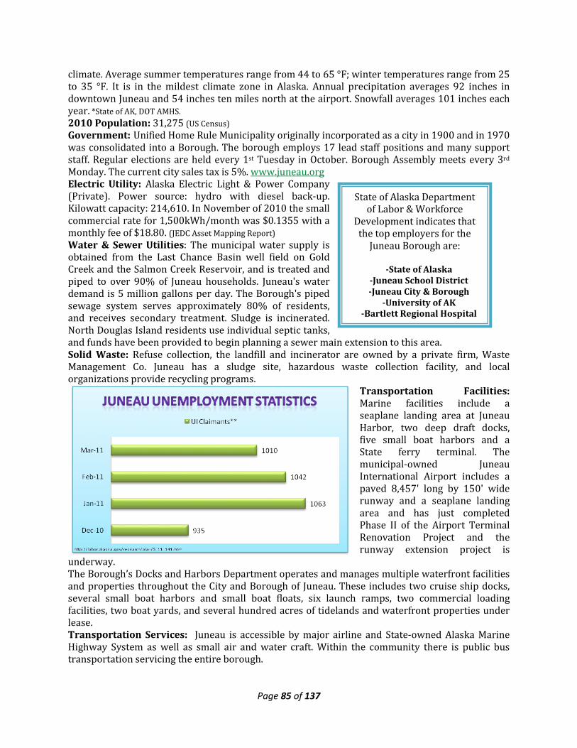
Page 85 of 137
State of Alaska Department of Labor & Workforce
Development indicates that the top employers for the
Juneau Borough are:
-State of Alaska -Juneau School District -Juneau City & Borough
-University of AK -Bartlett Regional Hospital
climate. Average summer temperatures range from 44 to 65 °F; winter temperatures range from 25 to 35 °F. It is in the mildest climate zone in Alaska. Annual precipitation averages 92 inches in downtown Juneau and 54 inches ten miles north at the airport. Snowfall averages 101 inches each year. *State of AK, DOT AMHS. 2010 Population: 31,275 (US Census) Government: Unified Home Rule Municipality originally incorporated as a city in 1900 and in 1970 was consolidated into a Borough. The borough employs 17 lead staff positions and many support staff. Regular elections are held every 1st Tuesday in October. Borough Assembly meets every 3rd Monday. The current city sales tax is 5%. www.juneau.org Electric Utility: Alaska Electric Light & Power Company (Private). Power source: hydro with diesel back-up. Kilowatt capacity: 214,610. In November of 2010 the small commercial rate for 1,500kWh/month was $0.1355 with a monthly fee of $18.80. (JEDC Asset Mapping Report) Water & Sewer Utilities: The municipal water supply is obtained from the Last Chance Basin well field on Gold Creek and the Salmon Creek Reservoir, and is treated and piped to over 90% of Juneau households. Juneau's water demand is 5 million gallons per day. The Borough's piped sewage system serves approximately 80% of residents, and receives secondary treatment. Sludge is incinerated. North Douglas Island residents use individual septic tanks, and funds have been provided to begin planning a sewer main extension to this area. Solid Waste: Refuse collection, the landfill and incinerator are owned by a private firm, Waste Management Co. Juneau has a sludge site, hazardous waste collection facility, and local organizations provide recycling programs.
Transportation Facilities: Marine facilities include a seaplane landing area at Juneau Harbor, two deep draft docks, five small boat harbors and a State ferry terminal. The municipal-owned Juneau International Airport includes a paved 8,457' long by 150' wide runway and a seaplane landing area and has just completed Phase II of the Airport Terminal Renovation Project and the runway extension project is
underway. The Borough’s Docks and Harbors Department operates and manages multiple waterfront facilities and properties throughout the City and Borough of Juneau. These includes two cruise ship docks, several small boat harbors and small boat floats, six launch ramps, two commercial loading facilities, two boat yards, and several hundred acres of tidelands and waterfront properties under lease. Transportation Services: Juneau is accessible by major airline and State-owned Alaska Marine Highway System as well as small air and water craft. Within the community there is public bus transportation servicing the entire borough.
Page 86 of 137
Schools: Within the Juneau School District, there are a total of 14 schools; six elementary with two offering pre-school classes, two middle schools, and three high schools. There is also a home school program, a correspondence program, as well as grades 9-12 offered through the Johnson Youth Center. Enrollment for the district for the 2010-11 school year was 5,065. Student-teacher ratio: 14.3:1. University of Alaska Southeast, Juneau Campus. Health Care: Bartlett Regional Hospital. SEARHC Medical/Dental Clinic. Juneau Public Health Center. The hospital is a qualified Acute Care facility and Medevac Service. Long Term Care: Juneau Pioneers' Home; St. Ann's Nursing Home. Specialized Care: Juneau Recovery Hospital/Bartlett; Aiding Women in Abuse & Rape Emergencies. Juneau Public Health Center. US Coast Guard Dispensary. Emergency service is provided by 911 telephone service, paid EMS Service and volunteers. Federally Recognized Tribe: Central Council Tlingit & Haida Indian Tribes of Alaska (Represents Tlingit and Haida Indians in all of Southeast and parts of the continental United States),(Village Council; Non-Profit for Sealaska and Bureau Of Indian Affairs-Recognized Traditional Council), Douglas Indian Association, and Aukquan Traditional Council. Village Coorporation: Goldbelt Incorporated (Urban Corporation, one of four established in ANCSA), Sealaska Corporation (Regional Native Corporation). Other Communty Buildings: Three Public Libraries, Eagle Crest Ski Area, Juenau Douglas Museaum, State of Alaska Museaum, Diamond Park Aquatic Center, Augustus Brown Pool, Treadwell Ice Arena, Cenntenial Hall Convention Center, Zack Gordon Youth Center, Jensen-Olsen Arboretum, ANB/ANS Hall, State Superior Court/District Court Buildings, Lemon Creek Correctional Center, multiple senior care centers.
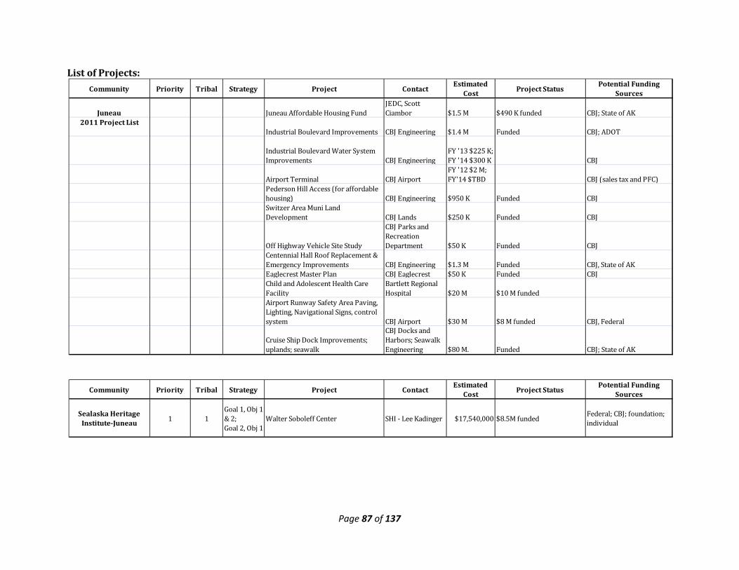
Page 87 of 137
List of Projects:
Community Priority Tribal Strategy Project Contact Estimated Cost Project Status Potential Funding
Sources
Juneau Juneau Affordable Housing FundJEDC, Scott Ciambor $1.5 M $490 K funded CBJ; State of AK
2011 Project ListIndustrial Boulevard Improvements CBJ Engineering $1.4 M Funded CBJ; ADOT
Industrial Boulevard Water System Improvements CBJ Engineering
FY '13 $225 K; FY '14 $300 K CBJ
Airport Terminal CBJ AirportFY '12 $2 M; FY'14 $TBD CBJ (sales tax and PFC)
Pederson Hill Access (for affordable housing) CBJ Engineering $950 K Funded CBJSwitzer Area Muni Land Development CBJ Lands $250 K Funded CBJ
Off Highway Vehicle Site Study
CBJ Parks and Recreation Department $50 K Funded CBJ
Centennial Hall Roof Replacement & Emergency Improvements CBJ Engineering $1.3 M Funded CBJ, State of AKEaglecrest Master Plan CBJ Eaglecrest $50 K Funded CBJChild and Adolescent Health Care Facility
Bartlett Regional Hospital $20 M $10 M funded
Airport Runway Safety Area Paving, Lighting, Navigational Signs, control system CBJ Airport $30 M $8 M funded CBJ, Federal
Cruise Ship Dock Improvements; uplands; seawalk
CBJ Docks and Harbors; Seawalk Engineering $80 M. Funded CBJ; State of AK
Community Priority Tribal Strategy Project Contact Estimated Cost Project Status Potential Funding
Sources
Sealaska Heritage Institute-Juneau 1 1
Goal 1, Obj 1 & 2; Goal 2, Obj 1
Walter Soboleff Center SHI - Lee Kadinger $17,540,000 $8.5M funded Federal; CBJ; foundation; individual
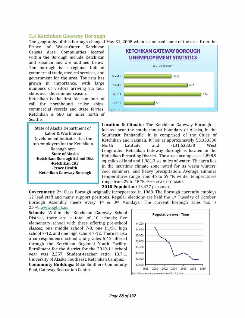
Page 88 of 137
State of Alaska Department of Labor & Workforce
Development indicates that the top employers for the Ketchikan
Borough are: -State of Alaska
-Ketchikan Borough School Dist -Ketchikan City -Peace Health
-Ketchikan Gateway Borough
5.4 Ketchikan Gateway Borough The geography of this borough changed May 31, 2008 when it annexed some of the area from the Prince of Wales-Outer Ketchikan Census Area. Communities located within the Borough include Ketchikan and Saxman and are outlined below. The borough is a regional hub of commercial trade, medical services, and government for the area. Tourism has grown in importance, with large numbers of visitors arriving via tour ships over the summer season. Ketchikan is the first Alaskan port of call for northbound cruise ships, commercial vessels and state ferries; Ketchikan is 680 air miles north of Seattle.
Location & Climate: The Ketchikan Gateway Borough is located near the southernmost boundary of Alaska, in the Southeast Panhandle. It is comprised of the Cities of Ketchikan and Saxman. It lies at approximately 55.333330 North Latitude and -131.633330 West Longitude. Ketchikan Gateway Borough is located in the Ketchikan Recording District. The area encompasses 4,898.9 sq. miles of land and 1,981.3 sq. miles of water. The area lies in the maritime climate zone noted for its warm winters, cool summers, and heavy precipitation. Average summer temperatures range from 46 to 59 °F; winter temperatures range from 29 to 48 °F. *State of AK, DOT AMHS. 2010 Population: 13,477 (US Census)
Government: 2nd Class Borough originally incorporated in 1968. The Borough currently employs 12 lead staff and many support positions. Regular elections are held the 1st Tuesday of October. Borough Assembly meets every 1st & 3rd Mondays. The current borough sales tax is 2.5%. www.kgbak.us Schools: Within the Ketchikan Gateway School District, there are a total of 10 schools; five elementary school with three offering pre-school classes, one middle school 7-8, one Jr./Sr. high school 7-12, and one high school 7-12. There is also a correspondence school and grades 5-12 offered through the Ketchikan Regional Youth Facility. Enrollment for the district for the 2010-11 school year was 2,257. Student-teacher ratio: 13.7:1. University of Alaska Southeast, Ketchikan Campus. Community Buildings: Mike Smithers Community Pool, Gateway Recreation Center
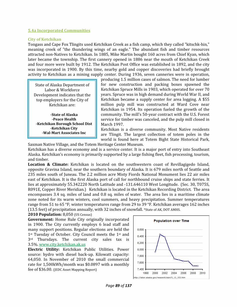
Page 89 of 137
State of Alaska Department of Labor & Workforce
Development indicates that the top employers for the City of
Ketchikan are:
-State of Alaska -Peace Health
-Ketchikan Borough School Dist -Ketchikan City
-Wal-Mart Associates Inc
5.4a Incorporated Communities
City of Ketchikan Tongass and Cape Fox Tlingits used Ketchikan Creek as a fish camp, which they called "kitschk-hin," meaning creek of "the thundering wings of an eagle." The abundant fish and timber resources attracted non-Natives to Ketchikan. In 1885, Mike Martin bought 160 acres from Chief Kyan, which later became the township. The first cannery opened in 1886 near the mouth of Ketchikan Creek and four more were built by 1912. The Ketchikan Post Office was established in 1892, and the city was incorporated in 1900. By this time, nearby gold and copper discoveries had briefly brought activity to Ketchikan as a mining supply center. During 1936, seven canneries were in operation,
producing 1.5 million cases of salmon. The need for lumber for new construction and packing boxes spawned the Ketchikan Spruce Mills in 1903, which operated for over 70 years. Spruce was in high demand during World War II, and Ketchikan became a supply center for area logging. A $55 million pulp mill was constructed at Ward Cove near Ketchikan in 1954. Its operation fueled the growth of the community. The mill's 50-year contract with the U.S. Forest service for timber was canceled, and the pulp mill closed in March 1997. Ketchikan is a diverse community. Most Native residents are Tlingit. The largest collection of totem poles in the world is found here at Totem Bight State Historical Park,
Saxman Native Village, and the Totem Heritage Center Museum. Ketchikan has a diverse economy and is a service center. It is a major port of entry into Southeast Alaska. Ketchikan’s economy is primarily supported by a large fishing fleet, fish processing, tourism, and timber. Location & Climate: Ketchikan is located on the southwestern coast of Revillagigedo Island, opposite Gravina Island, near the southern boundary of Alaska. It is 679 miles north of Seattle and 235 miles south of Juneau. The 2.2 million acre Misty Fiords National Monument lies 22 air miles east of Ketchikan. It is the first Alaska port of call for northbound cruise ships and state ferries. It lies at approximately 55.342220 North Latitude and -131.646110 West Longitude. (Sec. 30, T075S, R091E, Copper River Meridian.) Ketchikan is located in the Ketchikan Recording District. The area encompasses 3.4 sq. miles of land and 0.8 sq. miles of water. The area lies in a maritime climate zone noted for its warm winters, cool summers, and heavy precipitation. Summer temperatures range from 51 to 65 °F; winter temperatures range from 29 to 39 °F. Ketchikan averages 162 inches (13.5 feet) of precipitation annually, with 32 inches of snowfall. *State of AK, DOT AMHS. 2010 Population: 8,050 (US Census) Government: Home Rule City originally incorporated in 1900. The City currently employs 6 lead staff and many support positions. Regular elections are held the 1st Tuesday of October. City Council meets the 1st and 3rd Thursdays. The current city sales tax is 3.5%. www.city.ketchikan.ak.us Electric Utility: Ketchikan Public Utilities. Power source: hydro with diesel back-up. Kilowatt capacity: 64,050. In November of 2010 the small commercial rate for 1,500kWh/month was $0.0897 with a monthly fee of $36.00. (JEDC Asset Mapping Report)
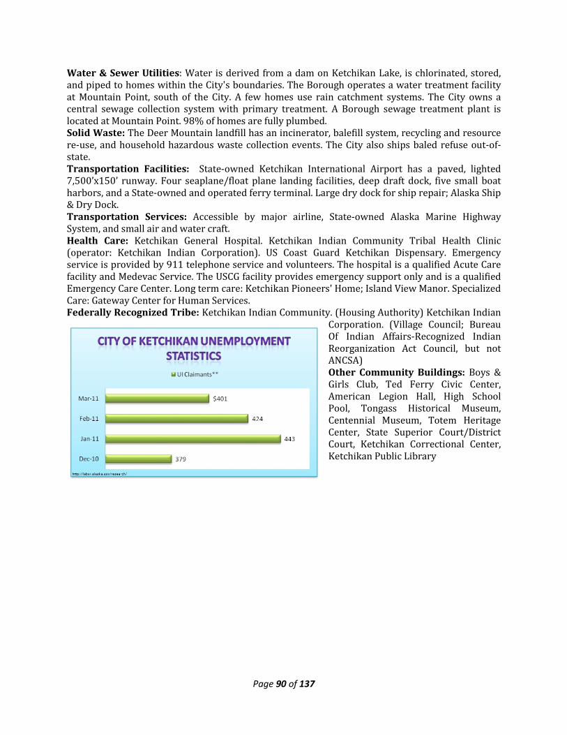
Page 90 of 137
Water & Sewer Utilities: Water is derived from a dam on Ketchikan Lake, is chlorinated, stored, and piped to homes within the City's boundaries. The Borough operates a water treatment facility at Mountain Point, south of the City. A few homes use rain catchment systems. The City owns a central sewage collection system with primary treatment. A Borough sewage treatment plant is located at Mountain Point. 98% of homes are fully plumbed. Solid Waste: The Deer Mountain landfill has an incinerator, balefill system, recycling and resource re-use, and household hazardous waste collection events. The City also ships baled refuse out-of-state. Transportation Facilities: State-owned Ketchikan International Airport has a paved, lighted 7,500’x150’ runway. Four seaplane/float plane landing facilities, deep draft dock, five small boat harbors, and a State-owned and operated ferry terminal. Large dry dock for ship repair; Alaska Ship & Dry Dock. Transportation Services: Accessible by major airline, State-owned Alaska Marine Highway System, and small air and water craft. Health Care: Ketchikan General Hospital. Ketchikan Indian Community Tribal Health Clinic (operator: Ketchikan Indian Corporation). US Coast Guard Ketchikan Dispensary. Emergency service is provided by 911 telephone service and volunteers. The hospital is a qualified Acute Care facility and Medevac Service. The USCG facility provides emergency support only and is a qualified Emergency Care Center. Long term care: Ketchikan Pioneers' Home; Island View Manor. Specialized Care: Gateway Center for Human Services. Federally Recognized Tribe: Ketchikan Indian Community. (Housing Authority) Ketchikan Indian
Corporation. (Village Council; Bureau Of Indian Affairs-Recognized Indian Reorganization Act Council, but not ANCSA) Other Community Buildings: Boys & Girls Club, Ted Ferry Civic Center, American Legion Hall, High School Pool, Tongass Historical Museum, Centennial Museum, Totem Heritage Center, State Superior Court/District Court, Ketchikan Correctional Center, Ketchikan Public Library
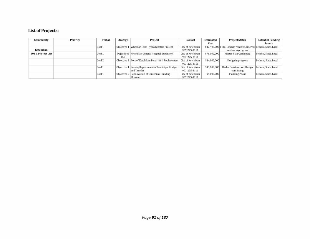
Page 91 of 137
List of Projects:
Community Priority Tribal Strategy Project Contact Estimated Cost
Project Status Potential Funding Source
KetchikanGoal 1 Objective 1 Whitman Lake Hydro Electric Project City of Ketchikan
907-225-3111$17,400,000 FERC License received, internal
review in progressFederal, State, Local
2011 Project List Goal 1 Objectives 1&2
Ketchikan General Hospital Expansion City of Ketchikan 907-225-3111
$76,000,000 Master Plan Completed Federal, State, Local
Goal 2 Objective 3 Port of Ketchikan Berth I & II Replacement City of Ketchikan 907-225-3111
$14,000,000 Design in progress Federal, State, Local
Goal 1 Objective 1 Repair/Replacement of Municipal Bridges and Trestles
City of Ketchikan 907-225-3111
$19,100,000 Under Construction, Design continuing
Federal, State, Local
Goal 1 Objective 2 Rennovation of Centennial Building Museum
City of Ketchikan 907-225-3111
$4,000,000 Planning Phase Federal, State, Local
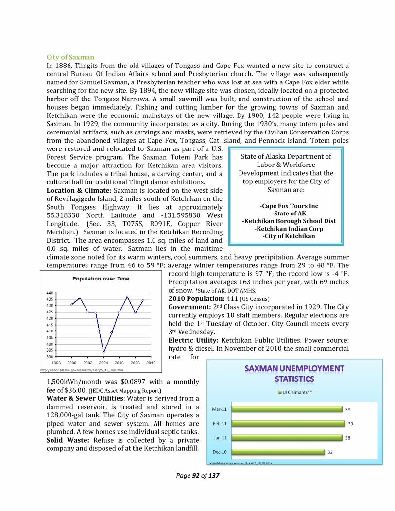
Page 92 of 137
State of Alaska Department of Labor & Workforce
Development indicates that the top employers for the City of
Saxman are:
-Cape Fox Tours Inc -State of AK
-Ketchikan Borough School Dist -Ketchikan Indian Corp
-City of Ketchikan
City of Saxman In 1886, Tlingits from the old villages of Tongass and Cape Fox wanted a new site to construct a central Bureau Of Indian Affairs school and Presbyterian church. The village was subsequently named for Samuel Saxman, a Presbyterian teacher who was lost at sea with a Cape Fox elder while searching for the new site. By 1894, the new village site was chosen, ideally located on a protected harbor off the Tongass Narrows. A small sawmill was built, and construction of the school and houses began immediately. Fishing and cutting lumber for the growing towns of Saxman and Ketchikan were the economic mainstays of the new village. By 1900, 142 people were living in Saxman. In 1929, the community incorporated as a city. During the 1930’s, many totem poles and ceremonial artifacts, such as carvings and masks, were retrieved by the Civilian Conservation Corps from the abandoned villages at Cape Fox, Tongass, Cat Island, and Pennock Island. Totem poles were restored and relocated to Saxman as part of a U.S. Forest Service program. The Saxman Totem Park has become a major attraction for Ketchikan area visitors. The park includes a tribal house, a carving center, and a cultural hall for traditional Tlingit dance exhibitions. Location & Climate: Saxman is located on the west side of Revillagigedo Island, 2 miles south of Ketchikan on the South Tongass Highway. It lies at approximately 55.318330 North Latitude and -131.595830 West Longitude. (Sec. 33, T075S, R091E, Copper River Meridian.) Saxman is located in the Ketchikan Recording District. The area encompasses 1.0 sq. miles of land and 0.0 sq. miles of water. Saxman lies in the maritime climate zone noted for its warm winters, cool summers, and heavy precipitation. Average summer temperatures range from 46 to 59 °F; average winter temperatures range from 29 to 48 °F. The
record high temperature is 97 °F; the record low is -4 °F. Precipitation averages 163 inches per year, with 69 inches of snow. *State of AK, DOT AMHS. 2010 Population: 411 (US Census) Government: 2nd Class City incorporated in 1929. The City currently employs 10 staff members. Regular elections are held the 1st Tuesday of October. City Council meets every 3rd Wednesday. Electric Utility: Ketchikan Public Utilities. Power source: hydro & diesel. In November of 2010 the small commercial rate for
1,500kWh/month was $0.0897 with a monthly fee of $36.00. (JEDC Asset Mapping Report) Water & Sewer Utilities: Water is derived from a dammed reservoir, is treated and stored in a 128,000-gal tank. The City of Saxman operates a piped water and sewer system. All homes are plumbed. A few homes use individual septic tanks. Solid Waste: Refuse is collected by a private company and disposed of at the Ketchikan landfill.
Page 93 of 137
Transportation Facilities: Saxman and Ketchikan are connected by the South Tongass Highway. A dock and commercial barge off-loading facilities are available at the Saxman Seaport. Transportation Services: The community relies on Ketchikan for its boat moorage, air travel, and State ferry services. Health Care: Ketchikan General Hospital and other facilities located in Ketchikan. Federally Recognized Tribe: Organized Village of Saxman. (Village Council; Bureau of Indian Affairs-Recognized Indian Reorganization Act Council) Village Corporation: Cape Fox Corporation. (Village Corporation; Ketchikan and Saxman) Other Community Buildings: Cape Fox Heritage Building, Beaver Tribal House, Saxman Totem Park containing a carving house, cultural hall and tribal house.
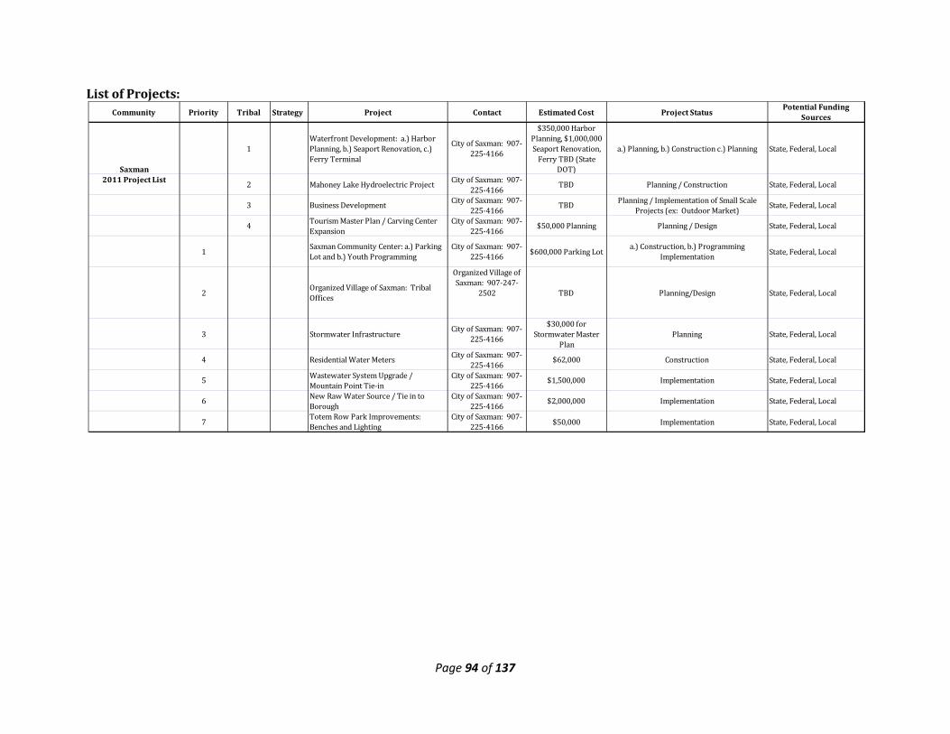
Page 94 of 137
List of Projects: Community Priority Tribal Strategy Project Contact Estimated Cost Project Status Potential Funding
Sources
Saxman
1Waterfront Development: a.) Harbor Planning, b.) Seaport Renovation, c.) Ferry Terminal
City of Saxman: 907-225-4166
$350,000 Harbor Planning, $1,000,000 Seaport Renovation,
Ferry TBD (State DOT)
a.) Planning, b.) Construction c.) Planning State, Federal, Local
2011 Project List 2 Mahoney Lake Hydroelectric Project City of Saxman: 907-225-4166 TBD Planning / Construction State, Federal, Local
3 Business Development City of Saxman: 907-225-4166 TBD Planning / Implementation of Small Scale
Projects (ex: Outdoor Market) State, Federal, Local
4 Tourism Master Plan / Carving Center Expansion
City of Saxman: 907-225-4166 $50,000 Planning Planning / Design State, Federal, Local
1 Saxman Community Center: a.) Parking Lot and b.) Youth Programming
City of Saxman: 907-225-4166 $600,000 Parking Lot a.) Construction, b.) Programming
Implementation State, Federal, Local
2 Organized Village of Saxman: Tribal Offices
Organized Village of Saxman: 907-247-
2502 TBD Planning/Design State, Federal, Local
3 Stormwater Infrastructure City of Saxman: 907-225-4166
$30,000 for Stormwater Master
PlanPlanning State, Federal, Local
4 Residential Water Meters City of Saxman: 907-225-4166 $62,000 Construction State, Federal, Local
5 Wastewater System Upgrade / Mountain Point Tie-in
City of Saxman: 907-225-4166 $1,500,000 Implementation State, Federal, Local
6 New Raw Water Source / Tie in to Borough
City of Saxman: 907-225-4166 $2,000,000 Implementation State, Federal, Local
7 Totem Row Park Improvements: Benches and Lighting
City of Saxman: 907-225-4166 $50,000 Implementation State, Federal, Local
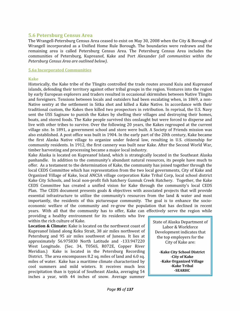
Page 95 of 137
State of Alaska Department of Labor & Workforce
Development indicates that the top employers for the
City of Kake are:
-Kake City School District -City of Kake
-Kake Organized Village -Kake Tribal
-SEARHC
5.6 Petersburg Census Area The Wrangell-Petersburg Census Area ceased to exist on May 30, 2008 when the City & Borough of Wrangell incorporated as a Unified Home Rule Borough. The boundaries were redrawn and the remaining area is called Petersburg Census Area. The Petersburg Census Area includes the communities of Petersburg, Kupreanof, Kake and Port Alexander (all communities within the Petersburg Census Area are outlined below).
5.6a Incorporated Communities
Kake Historically, the Kake tribe of the Tlingits controlled the trade routes around Kuiu and Kupreanof islands, defending their territory against other tribal groups in the region. Ventures into the region by early European explorers and traders resulted in occasional skirmishes between Native Tlingits and foreigners. Tensions between locals and outsiders had been escalating when, in 1869, a non-Native sentry at the settlement in Sitka shot and killed a Kake Native. In accordance with their traditional custom, the Kakes then killed two prospectors in retribution. In reprisal, the U.S. Navy sent the USS Saginaw to punish the Kakes by shelling their villages and destroying their homes, boats, and stored foods. The Kake people survived this onslaught but were forced to disperse and live with other tribes to survive. Over the following 20 years, the Kakes regrouped at the current village site. In 1891, a government school and store were built. A Society of Friends mission was also established. A post office was built in 1904. In the early part of the 20th century, Kake became the first Alaska Native village to organize under federal law, resulting in U.S. citizenship for community residents. In 1912, the first cannery was built near Kake. After the Second World War, timber harvesting and processing became a major local industry. Kake Alaska is located on Kupreanof Island, which is strategically located in the Southeast Alaska panhandle. In addition to the community’s abundant natural resources, its people have much to offer. As a testament to the determination of Kake, the community has joined together through the local CEDS Committee which has representation from the two local governments, City of Kake and Organized Village of Kake, local ANCSA village corporation Kake Tribal Corp, local school district Kake City Schools, and local non-profit fish hatchery Gunnuk Creek Hatchery. Together, the Kake CEDS Committee has created a unified vision for Kake through the community’s local CEDS Plan. The CEDS document presents goals & objectives with associated projects that will provide essential infrastructure to utilize the community’s resources from the land & water and most importantly, the residents of this picturesque community. The goal is to enhance the socio-economic welfare of the community and re-grow the population that has declined in recent years. With all that the community has to offer, Kake can effectively serve the region while providing a healthy environment for its residents who live within the rich culture of Kake. Location & Climate: Kake is located on the northwest coast of Kupreanof Island along Keku Strait, 38 air miles northwest of Petersburg and 95 air miles southwest of Juneau. It lies at approximately 56.975830 North Latitude and -133.947220 West Longitude. (Sec. 34, T056S, R072E, Copper River Meridian.) Kake is located in the Petersburg Recording District. The area encompasses 8.2 sq. miles of land and 6.0 sq. miles of water. Kake has a maritime climate characterized by cool summers and mild winters. It receives much less precipitation than is typical of Southeast Alaska, averaging 54 inches a year, with 44 inches of snow. Average summer
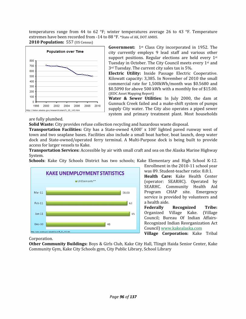
Page 96 of 137
temperatures range from 44 to 62 °F; winter temperatures average 26 to 43 °F. Temperature extremes have been recorded from -14 to 88 °F. *State of AK, DOT AMHS. 2010 Population: 557 (US Census)
Government: 1st Class City incorporated in 1952. The city currently employs 9 lead staff and various other support positions. Regular elections are held every 1st Tuesday in October. The City Council meets every 1st and 3rd Tuesday. The current city sales tax is 5%. Electric Utility: Inside Passage Electric Cooperative. Kilowatt capacity: 3,385. In November of 2010 the small commercial rate for 1,500kWh/month was $0.5680 and $0.5090 for above 500 kWh with a monthly fee of $15.00. (JEDC Asset Mapping Report) Water & Sewer Utilities: In July 2000, the dam at Gunnuck Creek failed and a make-shift system of pumps supply City water. The City also operates a piped sewer system and primary treatment plant. Most households
are fully plumbed. Solid Waste: City provides refuse collection recycling and hazardous waste disposal. Transportation Facilities: City has a State-owned 4,000' x 100' lighted paved runway west of town and two seaplane bases. Facilities also include a small boat harbor, boat launch, deep water dock and State-owned/operated ferry terminal. A Multi-Purpose dock is being built to provide access for larger vessels to Kake. Transportation Services: Accessible by air with small craft and sea on the Alaska Marine Highway System. Schools: Kake City Schools District has two schools; Kake Elementary and High School K-12.
Enrollment in the 2010-11 school year was 89. Student-teacher ratio: 8.8:1. Health Care: Kake Health Center (operator: SEARHC). Operated by SEARHC. Community Health Aid Program CHAP site. Emergency service is provided by volunteers and a health aide. Federally Recognized Tribe: Organized Village Kake. (Village Council; Bureau Of Indian Affairs-Recognized Indian Reorganization Act Council) www.kakealaska.com Village Corporation: Kake Tribal
Corporation. Other Community Buildings: Boys & Girls Club, Kake City Hall, Tlingit Haida Senior Center, Kake Community Gym, Kake City Schools gym, City Public Library, School Library
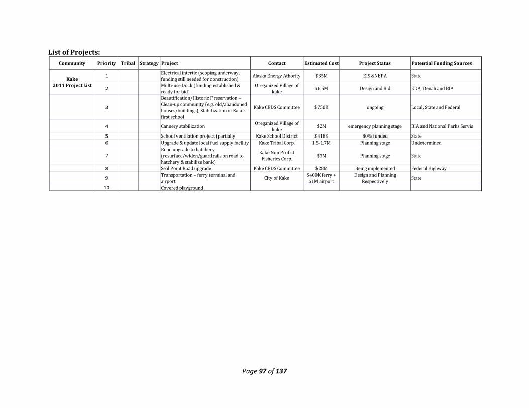
Page 97 of 137
List of Projects: Community Priority Tribal Strategy Project Contact Estimated Cost Project Status Potential Funding Sources
Kake 1 Electrical intertie (scoping underway, funding still needed for construction) Alaska Energy Athority $35M EIS &NEPA State
2011 Project List 2 Multi-use Dock (funding established & ready for bid)
Oreganized Village of kake $6.5M Design and Bid EDA, Denali and BIA
3
Beautification/Historic Preservation -- Clean-up community (e.g. old/abandoned houses/buildings), Stabilization of Kake’s first school
Kake CEDS Committee $750K ongoing Local, State and Federal
4 Cannery stabilization Oreganized Village of kake $2M emergency planning stage BIA and National Parks Servis
5 School ventilation project (partially Kake School District $418K 80% funded State6 Upgrade & update local fuel supply facility Kake Tribal Corp. 1.5-1.7M Planning stage Undetermined
7Road upgrade to hatchery (resurface/widen/guardrails on road to hatchery & stabilize bank)
Kake Non Profrit Fisheries Corp. $3M Planning stage State
8 Seal Point Road upgrade Kake CEDS Committee $28M Being implemented Federal Highway
9 Transportation – ferry terminal and airport City of Kake $400K ferry +
$1M airportDesign and Planning
Respectively State
10 Covered playground
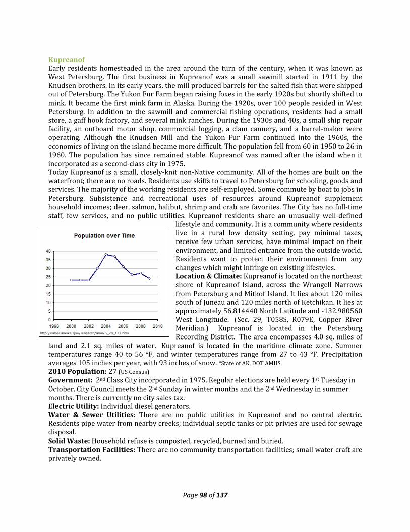
Page 98 of 137
Kupreanof Early residents homesteaded in the area around the turn of the century, when it was known as West Petersburg. The first business in Kupreanof was a small sawmill started in 1911 by the Knudsen brothers. In its early years, the mill produced barrels for the salted fish that were shipped out of Petersburg. The Yukon Fur Farm began raising foxes in the early 1920s but shortly shifted to mink. It became the first mink farm in Alaska. During the 1920s, over 100 people resided in West Petersburg. In addition to the sawmill and commercial fishing operations, residents had a small store, a gaff hook factory, and several mink ranches. During the 1930s and 40s, a small ship repair facility, an outboard motor shop, commercial logging, a clam cannery, and a barrel-maker were operating. Although the Knudsen Mill and the Yukon Fur Farm continued into the 1960s, the economics of living on the island became more difficult. The population fell from 60 in 1950 to 26 in 1960. The population has since remained stable. Kupreanof was named after the island when it incorporated as a second-class city in 1975. Today Kupreanof is a small, closely-knit non-Native community. All of the homes are built on the waterfront; there are no roads. Residents use skiffs to travel to Petersburg for schooling, goods and services. The majority of the working residents are self-employed. Some commute by boat to jobs in Petersburg. Subsistence and recreational uses of resources around Kupreanof supplement household incomes; deer, salmon, halibut, shrimp and crab are favorites. The City has no full-time staff, few services, and no public utilities. Kupreanof residents share an unusually well-defined
lifestyle and community. It is a community where residents live in a rural low density setting, pay minimal taxes, receive few urban services, have minimal impact on their environment, and limited entrance from the outside world. Residents want to protect their environment from any changes which might infringe on existing lifestyles. Location & Climate: Kupreanof is located on the northeast shore of Kupreanof Island, across the Wrangell Narrows from Petersburg and Mitkof Island. It lies about 120 miles south of Juneau and 120 miles north of Ketchikan. It lies at approximately 56.814440 North Latitude and -132.980560 West Longitude. (Sec. 29, T058S, R079E, Copper River Meridian.) Kupreanof is located in the Petersburg Recording District. The area encompasses 4.0 sq. miles of
land and 2.1 sq. miles of water. Kupreanof is located in the maritime climate zone. Summer temperatures range 40 to 56 °F, and winter temperatures range from 27 to 43 °F. Precipitation averages 105 inches per year, with 93 inches of snow. *State of AK, DOT AMHS. 2010 Population: 27 (US Census) Government: 2nd Class City incorporated in 1975. Regular elections are held every 1st Tuesday in October. City Council meets the 2nd Sunday in winter months and the 2nd Wednesday in summer months. There is currently no city sales tax. Electric Utility: Individual diesel generators. Water & Sewer Utilities: There are no public utilities in Kupreanof and no central electric. Residents pipe water from nearby creeks; individual septic tanks or pit privies are used for sewage disposal. Solid Waste: Household refuse is composted, recycled, burned and buried. Transportation Facilities: There are no community transportation facilities; small water craft are privately owned.
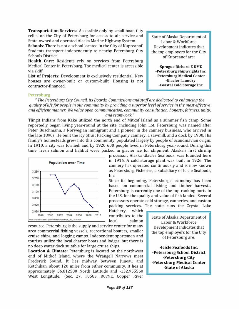
Page 99 of 137
State of Alaska Department of Labor & Workforce
Development indicates that the top employers for the City
of Kupreanof are:
-Sprague Richard E DMD -Petersburg Shipwrights Inc -Petersburg Medical Center
-Glacier Laundry -Coastal Cold Storage Inc
State of Alaska Department of Labor & Workforce
Development indicates that the top employers for the City
of Petersburg are:
-Icicle Seafoods Inc. -Petersburg School District
-Petersburg City -Petersburg Medical Center
-State of Alaska
Transportation Services: Accessible only by small boat. City relies on the City of Petersburg for access to air service and State-owned and operated Alaska Marine Highway System. Schools: There is not a school located in the City of Kupreanof. Students transport independently to nearby Petersburg City Schools District. Health Care: Residents rely on services from Petersburg Medical Center in Petersburg. The medical center is accessible via skiff. List of Projects: Development is exclusively residential. New houses are owner-built or custom-built. Housing is not contractor-financed.
Petersburg “ The Petersburg City Council, its Boards, Commissions and staff are dedicated to enhancing the
quality of life for people in our community by providing a superior level of service in the most effective and efficient manner. We value open communication, community consultation, honesty, fairness, unity,
and teamwork.” Tlingit Indians from Kake utilized the north end of Mitkof Island as a summer fish camp. Some reportedly began living year-round at the site, including John Lot. Petersburg was named after Peter Buschmann, a Norwegian immigrant and a pioneer in the cannery business, who arrived in the late 1890s. He built the Icy Strait Packing Company cannery, a sawmill, and a dock by 1900. His family's homesteads grew into this community, populated largely by people of Scandinavian origin. In 1910, a city was formed, and by 1920 600 people lived in Petersburg year-round. During this time, fresh salmon and halibut were packed in glacier ice for shipment. Alaska's first shrimp
processor, Alaska Glacier Seafoods, was founded here in 1916. A cold storage plant was built in 1926. The cannery has operated continuously and is now known as Petersburg Fisheries, a subsidiary of Icicle Seafoods, Inc. Since its beginning, Petersburg's economy has been based on commercial fishing and timber harvests. Petersburg is currently one of the top-ranking ports in the U.S. for the quality and value of fish landed. Several processors operate cold storage, canneries, and custom packing services. The state runs the Crystal Lake Hatchery, which contributes to the local salmon
resource. Petersburg is the supply and service center for many area commercial fishing vessels, recreational boaters, smaller cruise ships, and logging camps. Independent sportsmen and tourists utilize the local charter boats and lodges, but there is no deep water dock suitable for large cruise ships. Location & Climate: Petersburg is located on the northwest end of Mitkof Island, where the Wrangell Narrows meet Frederick Sound. It lies midway between Juneau and Ketchikan, about 120 miles from either community. It lies at approximately 56.812500 North Latitude and -132.955560 West Longitude. (Sec. 27, T058S, R079E, Copper River
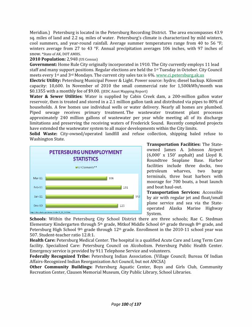
Page 100 of 137
Meridian.) Petersburg is located in the Petersburg Recording District. The area encompasses 43.9 sq. miles of land and 2.2 sq. miles of water. Petersburg's climate is characterized by mild winters, cool summers, and year-round rainfall. Average summer temperatures range from 40 to 56 °F; winters average from 27 to 43 °F. Annual precipitation averages 106 inches, with 97 inches of snow. *State of AK, DOT AMHS. 2010 Population: 2,948 (US Census) Government: Home Rule City originally incorporated in 1910. The City currently employs 11 lead staff and many support positions. Regular elections are held the 1st Tuesday in October. City Council meets every 1st and 3rd Mondays. The current city sales tax is 6%. www.ci.petersburg.ak.us Electric Utility: Petersburg Municipal Power & Light. Power source: hydro; diesel backup. Kilowatt capacity: 10,600. In November of 2010 the small commercial rate for 1,500kWh/month was $0.1355 with a monthly fee of $9.00. (JEDC Asset Mapping Report) Water & Sewer Utilities: Water is supplied by Cabin Creek dam, a 200-million gallon water reservoir, then is treated and stored in a 2.1 million gallon tank and distributed via pipes to 80% of households. A few homes use individual wells or water delivery. Nearly all homes are plumbed. Piped sewage receives primary treatment. The wastewater treatment plant processes approximately 240 million gallons of wastewater per year while meeting all of its discharge limitations and preserving the receiving waters of Frederick Sound. Recently completed projects have extended the wastewater system to all major developments within the City limits. Solid Waste: City-owned/operated landfill and refuse collection, shipping baled refuse to Washington State.
Transportation Facilities: The State-owned James A. Johnson Airport (6,000' x 150' asphalt) and Lloyd R. Roundtree Seaplane Base. Harbor facilities include three docks, two petroleum wharves, two barge terminals, three boat harbors with moorage for 700 boats, a boat launch and boat haul-out. Transportation Services: Accessible by air with regular jet and float/small plane service and sea via the State-operated Alaska Marine Highway System.
Schools: Within the Petersburg City School District there are three schools; Rae C. Stedman Elementary Kindergarten through 5th grade, Mitkof Middle School 6th grade through 8th grade, and Petersburg High School 9th grade through 12th grade. Enrollment in the 2010-11 school year was 507. Student-teacher ratio 12.8:1. Health Care: Petersburg Medical Center. The hospital is a qualified Acute Care and Long Term Care facility. Specialized Care: Petersburg Council on Alcoholism. Petersburg Public Health Center. Emergency service is provided by 911 Telephone Service and volunteers. Federally Recognized Tribe: Petersburg Indian Association. (Village Council; Bureau Of Indian Affairs-Recognized Indian Reorganization Act Council, but not ANCSA) Other Community Buildings: Petersburg Aquatic Center, Boys and Girls Club, Community Recreation Center, Clausen Memorial Museum, City Public Library, School Libraries.
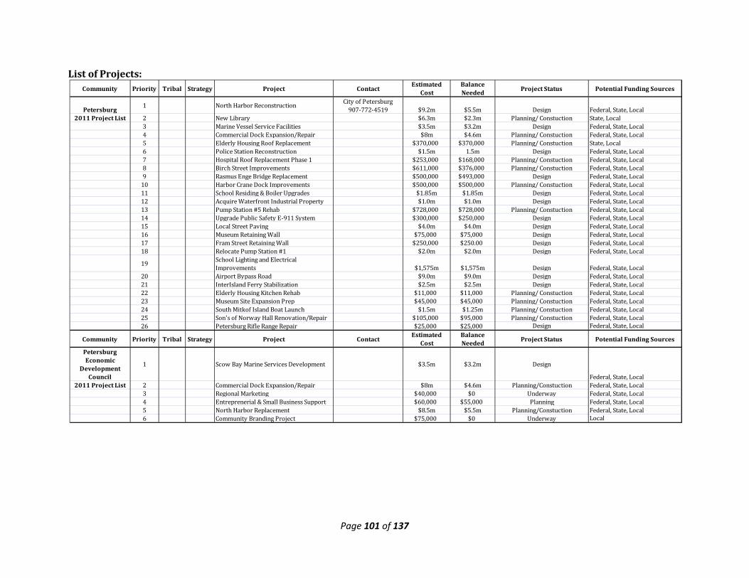
Page 101 of 137
List of Projects:
Community Priority Tribal Strategy Project Contact Estimated Cost
Balance Needed Project Status Potential Funding Sources
Petersburg 1 North Harbor Reconstruction City of Petersburg 907-772-4519 $9.2m $5.5m Design Federal, State, Local
2011 Project List 2 New Library $6.3m $2.3m Planning/ Constuction State, Local3 Marine Vessel Service Facilities $3.5m $3.2m Design Federal, State, Local4 Commercial Dock Expansion/Repair $8m $4.6m Planning/ Constuction Federal, State, Local5 Elderly Housing Roof Replacement $370,000 $370,000 Planning/ Constuction State, Local6 Police Station Reconstruction $1.5m 1.5m Design Federal, State, Local7 Hospital Roof Replacement Phase 1 $253,000 $168,000 Planning/ Constuction Federal, State, Local8 Birch Street Improvements $611,000 $376,000 Planning/ Constuction Federal, State, Local9 Rasmus Enge Bridge Replacement $500,000 $493,000 Design Federal, State, Local
10 Harbor Crane Dock Improvements $500,000 $500,000 Planning/ Constuction Federal, State, Local11 School Residing & Boiler Upgrades $1.85m $1.85m Design Federal, State, Local12 Acquire Waterfront Industrial Property $1.0m $1.0m Design Federal, State, Local13 Pump Station #5 Rehab $728,000 $728,000 Planning/ Constuction Federal, State, Local14 Upgrade Public Safety E-911 System $300,000 $250,000 Design Federal, State, Local15 Local Street Paving $4.0m $4.0m Design Federal, State, Local16 Museum Retaining Wall $75,000 $75,000 Design Federal, State, Local17 Fram Street Retaining Wall $250,000 $250.00 Design Federal, State, Local18 Relocate Pump Station #1 $2.0m $2.0m Design Federal, State, Local
19 School Lighting and Electrical Improvements $1,575m $1,575m Design Federal, State, Local
20 Airport Bypass Road $9.0m $9.0m Design Federal, State, Local21 InterIsland Ferry Stabilization $2.5m $2.5m Design Federal, State, Local22 Elderly Housing Kitchen Rehab $11,000 $11,000 Planning/ Constuction Federal, State, Local23 Museum Site Expansion Prep $45,000 $45,000 Planning/ Constuction Federal, State, Local24 South Mitkof Island Boat Launch $1.5m $1.25m Planning/ Constuction Federal, State, Local25 Son's of Norway Hall Renovation/Repair $105,000 $95,000 Planning/ Constuction Federal, State, Local26 Petersburg Rifle Range Repair $25,000 $25,000 Design Federal, State, Local
Community Priority Tribal Strategy Project Contact Estimated Cost
Balance Needed Project Status Potential Funding Sources
Petersburg Economic
Development Council
1 Scow Bay Marine Services Development $3.5m $3.2m Design
Federal, State, Local2011 Project List 2 Commercial Dock Expansion/Repair $8m $4.6m Planning/Constuction Federal, State, Local
3 Regional Marketing $40,000 $0 Underway Federal, State, Local4 Entreprenerial & Small Business Support $60,000 $55,000 Planning Federal, State, Local5 North Harbor Replacement $8.5m $5.5m Planning/Constuction Federal, State, Local6 Community Branding Project $75,000 $0 Underway Local
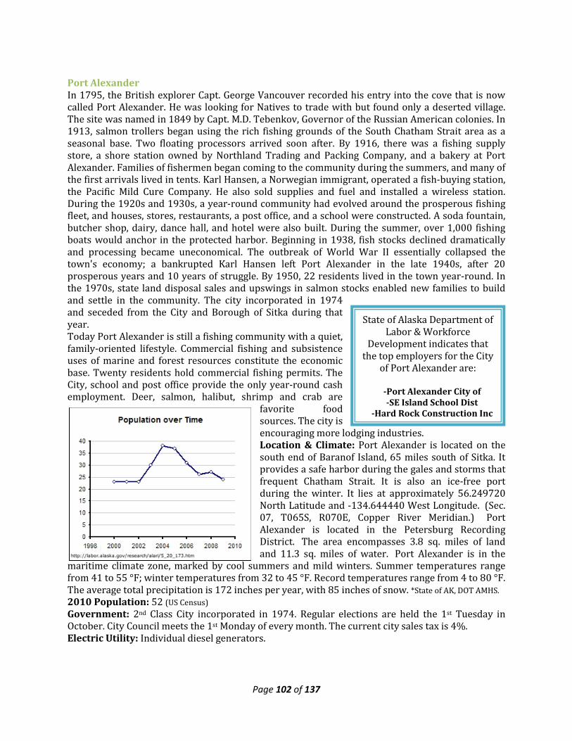
Page 102 of 137
State of Alaska Department of Labor & Workforce
Development indicates that the top employers for the City
of Port Alexander are:
-Port Alexander City of -SE Island School Dist
-Hard Rock Construction Inc
Port Alexander In 1795, the British explorer Capt. George Vancouver recorded his entry into the cove that is now called Port Alexander. He was looking for Natives to trade with but found only a deserted village. The site was named in 1849 by Capt. M.D. Tebenkov, Governor of the Russian American colonies. In 1913, salmon trollers began using the rich fishing grounds of the South Chatham Strait area as a seasonal base. Two floating processors arrived soon after. By 1916, there was a fishing supply store, a shore station owned by Northland Trading and Packing Company, and a bakery at Port Alexander. Families of fishermen began coming to the community during the summers, and many of the first arrivals lived in tents. Karl Hansen, a Norwegian immigrant, operated a fish-buying station, the Pacific Mild Cure Company. He also sold supplies and fuel and installed a wireless station. During the 1920s and 1930s, a year-round community had evolved around the prosperous fishing fleet, and houses, stores, restaurants, a post office, and a school were constructed. A soda fountain, butcher shop, dairy, dance hall, and hotel were also built. During the summer, over 1,000 fishing boats would anchor in the protected harbor. Beginning in 1938, fish stocks declined dramatically and processing became uneconomical. The outbreak of World War II essentially collapsed the town's economy; a bankrupted Karl Hansen left Port Alexander in the late 1940s, after 20 prosperous years and 10 years of struggle. By 1950, 22 residents lived in the town year-round. In the 1970s, state land disposal sales and upswings in salmon stocks enabled new families to build and settle in the community. The city incorporated in 1974 and seceded from the City and Borough of Sitka during that year. Today Port Alexander is still a fishing community with a quiet, family-oriented lifestyle. Commercial fishing and subsistence uses of marine and forest resources constitute the economic base. Twenty residents hold commercial fishing permits. The City, school and post office provide the only year-round cash employment. Deer, salmon, halibut, shrimp and crab are
favorite food sources. The city is encouraging more lodging industries. Location & Climate: Port Alexander is located on the south end of Baranof Island, 65 miles south of Sitka. It provides a safe harbor during the gales and storms that frequent Chatham Strait. It is also an ice-free port during the winter. It lies at approximately 56.249720 North Latitude and -134.644440 West Longitude. (Sec. 07, T065S, R070E, Copper River Meridian.) Port Alexander is located in the Petersburg Recording District. The area encompasses 3.8 sq. miles of land and 11.3 sq. miles of water. Port Alexander is in the
maritime climate zone, marked by cool summers and mild winters. Summer temperatures range from 41 to 55 °F; winter temperatures from 32 to 45 °F. Record temperatures range from 4 to 80 °F. The average total precipitation is 172 inches per year, with 85 inches of snow. *State of AK, DOT AMHS. 2010 Population: 52 (US Census) Government: 2nd Class City incorporated in 1974. Regular elections are held the 1st Tuesday in October. City Council meets the 1st Monday of every month. The current city sales tax is 4%. Electric Utility: Individual diesel generators.
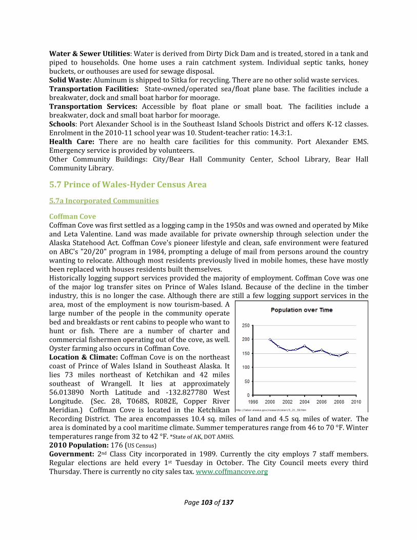
Page 103 of 137
Water & Sewer Utilities: Water is derived from Dirty Dick Dam and is treated, stored in a tank and piped to households. One home uses a rain catchment system. Individual septic tanks, honey buckets, or outhouses are used for sewage disposal. Solid Waste: Aluminum is shipped to Sitka for recycling. There are no other solid waste services. Transportation Facilities: State-owned/operated sea/float plane base. The facilities include a breakwater, dock and small boat harbor for moorage. Transportation Services: Accessible by float plane or small boat. The facilities include a breakwater, dock and small boat harbor for moorage. Schools: Port Alexander School is in the Southeast Island Schools District and offers K-12 classes. Enrolment in the 2010-11 school year was 10. Student-teacher ratio: 14.3:1. Health Care: There are no health care facilities for this community. Port Alexander EMS. Emergency service is provided by volunteers. Other Community Buildings: City/Bear Hall Community Center, School Library, Bear Hall Community Library.
5.7 Prince of Wales-Hyder Census Area
5.7a Incorporated Communities
Coffman Cove Coffman Cove was first settled as a logging camp in the 1950s and was owned and operated by Mike and Leta Valentine. Land was made available for private ownership through selection under the Alaska Statehood Act. Coffman Cove's pioneer lifestyle and clean, safe environment were featured on ABC's "20/20" program in 1984, prompting a deluge of mail from persons around the country wanting to relocate. Although most residents previously lived in mobile homes, these have mostly been replaced with houses residents built themselves. Historically logging support services provided the majority of employment. Coffman Cove was one of the major log transfer sites on Prince of Wales Island. Because of the decline in the timber industry, this is no longer the case. Although there are still a few logging support services in the area, most of the employment is now tourism-based. A large number of the people in the community operate bed and breakfasts or rent cabins to people who want to hunt or fish. There are a number of charter and commercial fishermen operating out of the cove, as well. Oyster farming also occurs in Coffman Cove. Location & Climate: Coffman Cove is on the northeast coast of Prince of Wales Island in Southeast Alaska. It lies 73 miles northeast of Ketchikan and 42 miles southeast of Wrangell. It lies at approximately 56.013890 North Latitude and -132.827780 West Longitude. (Sec. 28, T068S, R082E, Copper River Meridian.) Coffman Cove is located in the Ketchikan Recording District. The area encompasses 10.4 sq. miles of land and 4.5 sq. miles of water. The area is dominated by a cool maritime climate. Summer temperatures range from 46 to 70 °F. Winter temperatures range from 32 to 42 °F. *State of AK, DOT AMHS. 2010 Population: 176 (US Census) Government: 2nd Class City incorporated in 1989. Currently the city employs 7 staff members. Regular elections are held every 1st Tuesday in October. The City Council meets every third Thursday. There is currently no city sales tax. www.coffmancove.org
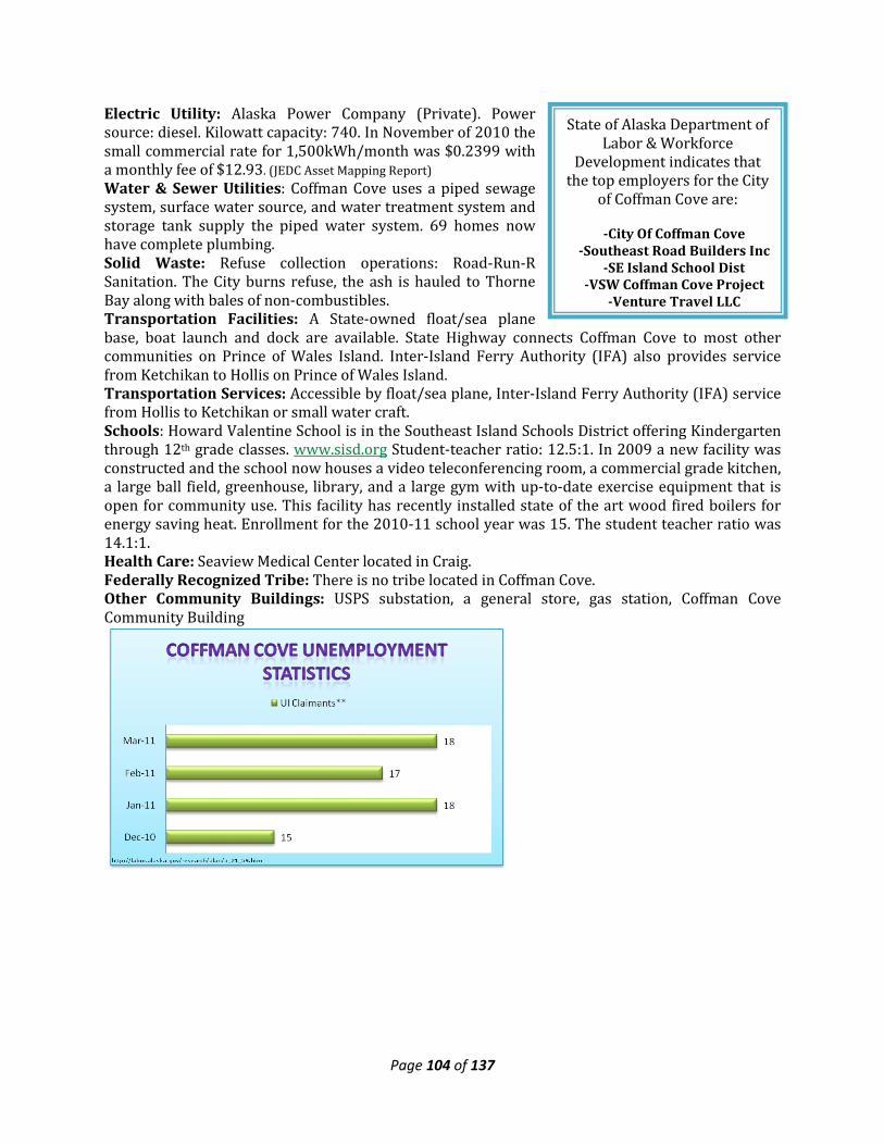
Page 104 of 137
State of Alaska Department of Labor & Workforce
Development indicates that the top employers for the City
of Coffman Cove are:
-City Of Coffman Cove -Southeast Road Builders Inc
-SE Island School Dist -VSW Coffman Cove Project
-Venture Travel LLC
Electric Utility: Alaska Power Company (Private). Power source: diesel. Kilowatt capacity: 740. In November of 2010 the small commercial rate for 1,500kWh/month was $0.2399 with a monthly fee of $12.93. (JEDC Asset Mapping Report) Water & Sewer Utilities: Coffman Cove uses a piped sewage system, surface water source, and water treatment system and storage tank supply the piped water system. 69 homes now have complete plumbing. Solid Waste: Refuse collection operations: Road-Run-R Sanitation. The City burns refuse, the ash is hauled to Thorne Bay along with bales of non-combustibles. Transportation Facilities: A State-owned float/sea plane base, boat launch and dock are available. State Highway connects Coffman Cove to most other communities on Prince of Wales Island. Inter-Island Ferry Authority (IFA) also provides service from Ketchikan to Hollis on Prince of Wales Island. Transportation Services: Accessible by float/sea plane, Inter-Island Ferry Authority (IFA) service from Hollis to Ketchikan or small water craft. Schools: Howard Valentine School is in the Southeast Island Schools District offering Kindergarten through 12th grade classes. www.sisd.org Student-teacher ratio: 12.5:1. In 2009 a new facility was constructed and the school now houses a video teleconferencing room, a commercial grade kitchen, a large ball field, greenhouse, library, and a large gym with up-to-date exercise equipment that is open for community use. This facility has recently installed state of the art wood fired boilers for energy saving heat. Enrollment for the 2010-11 school year was 15. The student teacher ratio was 14.1:1. Health Care: Seaview Medical Center located in Craig. Federally Recognized Tribe: There is no tribe located in Coffman Cove. Other Community Buildings: USPS substation, a general store, gas station, Coffman Cove Community Building
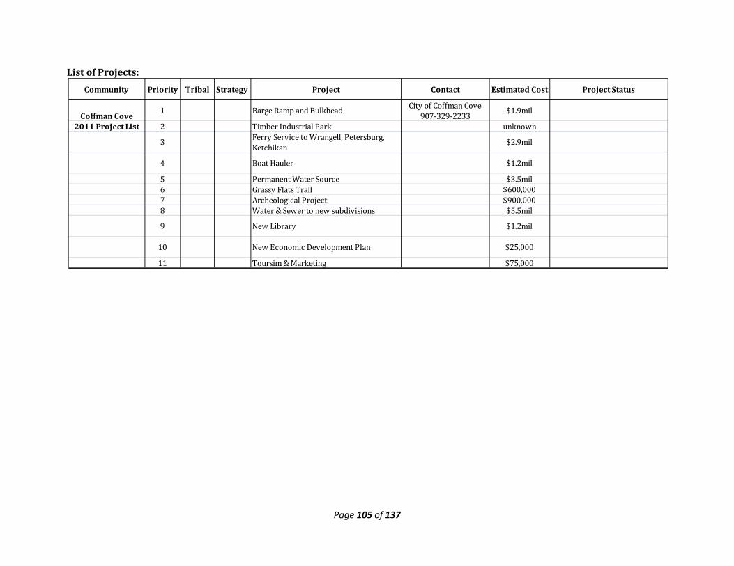
Page 105 of 137
List of Projects:
Community Priority Tribal Strategy Project Contact Estimated Cost Project Status
Coffman Cove 1 Barge Ramp and Bulkhead City of Coffman Cove
907-329-2233 $1.9mil
2011 Project List 2 Timber Industrial Park unknown
3 Ferry Service to Wrangell, Petersburg, Ketchikan $2.9mil
4 Boat Hauler $1.2mil
5 Permanent Water Source $3.5mil6 Grassy Flats Trail $600,000 7 Archeological Project $900,000 8 Water & Sewer to new subdivisions $5.5mil
9 New Library $1.2mil
10 New Economic Development Plan $25,000
11 Toursim & Marketing $75,000
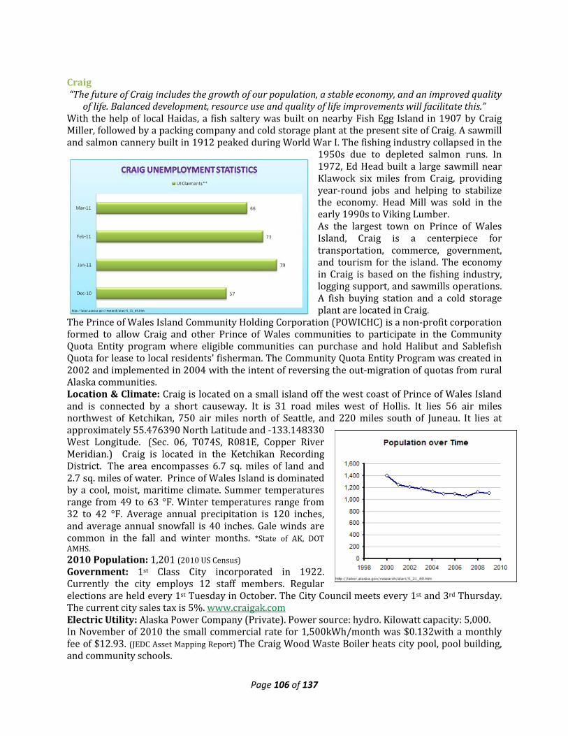
Page 106 of 137
Craig “The future of Craig includes the growth of our population, a stable economy, and an improved quality
of life. Balanced development, resource use and quality of life improvements will facilitate this.” With the help of local Haidas, a fish saltery was built on nearby Fish Egg Island in 1907 by Craig Miller, followed by a packing company and cold storage plant at the present site of Craig. A sawmill and salmon cannery built in 1912 peaked during World War I. The fishing industry collapsed in the
1950s due to depleted salmon runs. In 1972, Ed Head built a large sawmill near Klawock six miles from Craig, providing year-round jobs and helping to stabilize the economy. Head Mill was sold in the early 1990s to Viking Lumber. As the largest town on Prince of Wales Island, Craig is a centerpiece for transportation, commerce, government, and tourism for the island. The economy in Craig is based on the fishing industry, logging support, and sawmills operations. A fish buying station and a cold storage plant are located in Craig.
The Prince of Wales Island Community Holding Corporation (POWICHC) is a non-profit corporation formed to allow Craig and other Prince of Wales communities to participate in the Community Quota Entity program where eligible communities can purchase and hold Halibut and Sablefish Quota for lease to local residents’ fisherman. The Community Quota Entity Program was created in 2002 and implemented in 2004 with the intent of reversing the out-migration of quotas from rural Alaska communities. Location & Climate: Craig is located on a small island off the west coast of Prince of Wales Island and is connected by a short causeway. It is 31 road miles west of Hollis. It lies 56 air miles northwest of Ketchikan, 750 air miles north of Seattle, and 220 miles south of Juneau. It lies at approximately 55.476390 North Latitude and -133.148330 West Longitude. (Sec. 06, T074S, R081E, Copper River Meridian.) Craig is located in the Ketchikan Recording District. The area encompasses 6.7 sq. miles of land and 2.7 sq. miles of water. Prince of Wales Island is dominated by a cool, moist, maritime climate. Summer temperatures range from 49 to 63 °F. Winter temperatures range from 32 to 42 °F. Average annual precipitation is 120 inches, and average annual snowfall is 40 inches. Gale winds are common in the fall and winter months. *State of AK, DOT AMHS. 2010 Population: 1,201 (2010 US Census) Government: 1st Class City incorporated in 1922. Currently the city employs 12 staff members. Regular elections are held every 1st Tuesday in October. The City Council meets every 1st and 3rd Thursday. The current city sales tax is 5%. www.craigak.com Electric Utility: Alaska Power Company (Private). Power source: hydro. Kilowatt capacity: 5,000. In November of 2010 the small commercial rate for 1,500kWh/month was $0.132with a monthly fee of $12.93. (JEDC Asset Mapping Report) The Craig Wood Waste Boiler heats city pool, pool building, and community schools.
Page 107 of 137
State of Alaska Department of Labor & Workforce
Development indicates that the top employers for the
City of Craig are:
-Craig City School District -Craig City
-AK Commercial Co -State of AK Dept of Admin
-Ruth Ann’s Restaurant
Water & Sewer Utilities: Water is supplied by a dam on North Fork Lake, is treated then stored in a tank and piped to homes. Sewage is collected by a piped gravity system, and receives primary treatment before discharge into Bucareli Bay. All households are fully plumbed. Solid Waste: Refuse is collected and taken to the Klawock transshipment facility for shipment to the lower 48. Transportation Facilities: A City-owned seaplane base and U.S. Coast Guard helipad. A 5,000 foot paved runway is located 7 miles away in Klawock and the Inter Island Ferry Authority (IFA) terminal is located in Hollis 30 miles away. Two small boat harbors; at North Cove and South Cove, a transient float and dock in the downtown area and boat launch ramps at North Cove and False Island. The City owns and operates a vessel haul out trailer at False Island.
• Can accommodate vessels up to 125’ at the float. There is a full service fuel dock. • The City of Craig owns a self-propelled boat haul out trailer. The trailer is capable of moving
boats up to 60 tons and 50-60 feet long from the water to an upland location where they can be blocked up to make repairs, do maintenance and arrange long term storage of their boats. At the JT Brown Industrial Park in Craig the city has built a wash down area and an upland work area with water and electrical power available.
Transportation Services: Accessible by scheduled air service, by float/sea plane into Craig, wheeled plane service into Klawock, and Inter Island Ferry Authority (IFA) service via Hollis. In the last few years two air carriers have established regular air passenger and freight service to the Klawock Airport; one carrier services Klawock-Ketchikan and the other services Klawock-Sitka. Schools: Within the Craig City School District there are 5 schools: Craig Elementary School Preschool thru 5th grade, Craig Middle School 6th grade thru 8th grade, Craig High School 9th grade thru 12th grade, as well as a PACE Correspondence School that serves Kindergarten thru 12th grade and Craig Alternative High School. www.craigschools.com Enrollment for the 2010-11 school year was 684. Student-teacher ratio: 9.0:1. Health Care: Prince of Wales Health Center (PeaceHealth Clinic), Alicia Roberts Medical Clinic (SEARHC) located in Klawock, Craig EMS & Prince of Wales Island Area EMS. In 2010 The City transitioned ownership and operations of the Prince of Wales Health Center to PeachHealth, a private non-profit. Communities for Health Options (COHO) stopped operating in 2010. COHO provided mental health and substance abuse services, most of which have been picked up by other providers. The Prince of Wales Health Center is qualified as an Emergency Care Center. Federally Recognized Tribe: Craig Community Association. Village Corporation: Shaan-Seet, Incorporated Other Community Buildings: Craig Public Library, Craig Aquatic Center, Craig Recreation Center Other Industry Support Facilities: In 2009 The City completed a cold storage and seafood processing plant; this facility is currently leased to Silver Bay Seafoods.
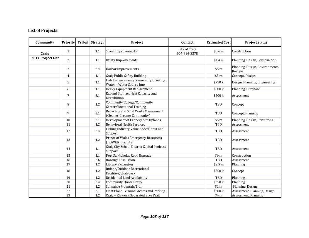
Page 108 of 137
List of Projects:
Community Priority Tribal Strategy Project Contact Estimated Cost Project Status
Craig1 1.1 Street Improvements City of Craig
907-826-3275 $5.6 m Construction
2011 Project List 2 1.1 Utility Improvements $1.4 m Planning, Design, Construction
3 2.4 Harbor Improvements $5 m Planning, Design, Environmental Review
4 1.1 Craig Public Safety Building $5 m Concept, Design
5 1.1 Fish Enhancement/Community Drinking Water – Water Source Imp.
$750 k Design, Planning, Engineering
6 1.1 Heavy Equipment Replacement $600 k Planning, Purchase
7 3.1 Expand Biomass Heat Capacity and Distribution $500 k Assessment
8 1.2 Community College/Community Center/Vocational Training TBD Concept
9 3.1 Recycling and Solid Waste Management (Cleaner-Greener Community) TBD Concept, Planning
10 2.1 Development of Cannery Site Uplands $5 m Planning, Design, Permitting11 1.2 Behavioral Health Services TBD Assessment
12 2.4 Fishing Industry Value Added Input and Support TBD Assessment
13 1.2 Prince of Wales Emergency Resources (POWER) Facility
TBD Assessment
14 1.1 Craig City School District Capital Projects Support TBD Assessment
15 1.1 Port St. Nicholas Road Upgrade $6 m Construction16 2.6 Borough Discussion TBD Assessment17 1.2 Library Expansion $2.5 m Planning
18 1.2 Indoor/Outdoor Recreational Facilities/Skatepark
$250 k Concept
19 1.2 Residential Land Availability TBD Planning20 2.4 Community Quota Entity $250 k Planning21 1.2 Sunnahae Mountain Trail $1 m Planning, Design22 2.1 Float Plane Terminal Access and Parking $200 k Assessment, Planning, Design23 1.2 Craig – Klawock Separated Bike Trail $4 m Assessment, Planning
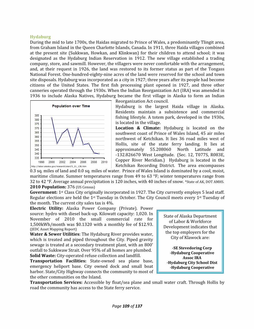
Page 109 of 137
State of Alaska Department of Labor & Workforce
Development indicates that the top employers for the
City of Klawock are:
-SE Stevedoring Corp -Hydaburg Cooperative
Assoc IRA -Hydaburg City School Dist
-Hydaburg Cooperative
Hydaburg During the mid to late 1700s, the Haidas migrated to Prince of Wales, a predominantly Tlingit area, from Graham Island in the Queen Charlotte Islands, Canada. In 1911, three Haida villages combined at the present site (Sukkwan, Howkan, and Klinkwan) for their children to attend school; it was designated as the Hydaburg Indian Reservation in 1912. The new village established a trading company, store, and sawmill. However, the villagers were never comfortable with the arrangement, and, at their request in 1926, the land was restored to its former status as part of the Tongass National Forest. One-hundred-eighty-nine acres of the land were reserved for the school and town site disposals. Hydaburg was incorporated as a city in 1927; three years after its people had become citizens of the United States. The first fish processing plant opened in 1927, and three other canneries operated through the 1930s. When the Indian Reorganization Act (IRA) was amended in 1936 to include Alaska Natives, Hydaburg became the first village in Alaska to form an Indian
Reorganization Act council. Hydaburg is the largest Haida village in Alaska. Residents maintain a subsistence and commercial fishing lifestyle. A totem park, developed in the 1930s, is located in the village. Location & Climate: Hydaburg is located on the southwest coast of Prince of Wales Island, 45 air miles northwest of Ketchikan. It lies 36 road miles west of Hollis, site of the state ferry landing. It lies at approximately 55.208060 North Latitude and -132.826670 West Longitude. (Sec. 12, T077S, R083E, Copper River Meridian.) Hydaburg is located in the Ketchikan Recording District. The area encompasses
0.3 sq. miles of land and 0.0 sq. miles of water. Prince of Wales Island is dominated by a cool, moist, maritime climate. Summer temperatures range from 49 to 63 °F; winter temperatures range from 32 to 42 °F. Average annual precipitation is 120 inches, with 40 inches of snow. *State of AK, DOT AMHS. 2010 Population: 376 (US Census) Government: 1st Class City originally incorporated in 1927. The City currently employs 5 lead staff. Regular elections are held the 1st Tuesday in October. The City Council meets every 1st Tuesday of the month. The current city sales tax is 4%. Electric Utility: Alaska Power Company (Private). Power source: hydro with diesel back-up. Kilowatt capacity: 1,020. In November of 2010 the small commercial rate for 1,500kWh/month was $0.1320 with a monthly fee of $12.93. (JEDC Asset Mapping Report) Water & Sewer Utilities: The Hydaburg River provides water, which is treated and piped throughout the City. Piped gravity sewage is treated at a secondary treatment plant, with an 800' outfall to Sukkwaw Strait. Over 95% of all homes are plumbed. Solid Waste: City-operated refuse collection and landfill. Transportation Facilities: State-owned sea plane base, emergency heliport base. City owned dock and small boat harbor. State/City Highway connects the community to most of the other communities on the Island. Transportation Services: Accessible by float/sea plane and small water craft. Through Hollis by road the community has access to the State ferry service.
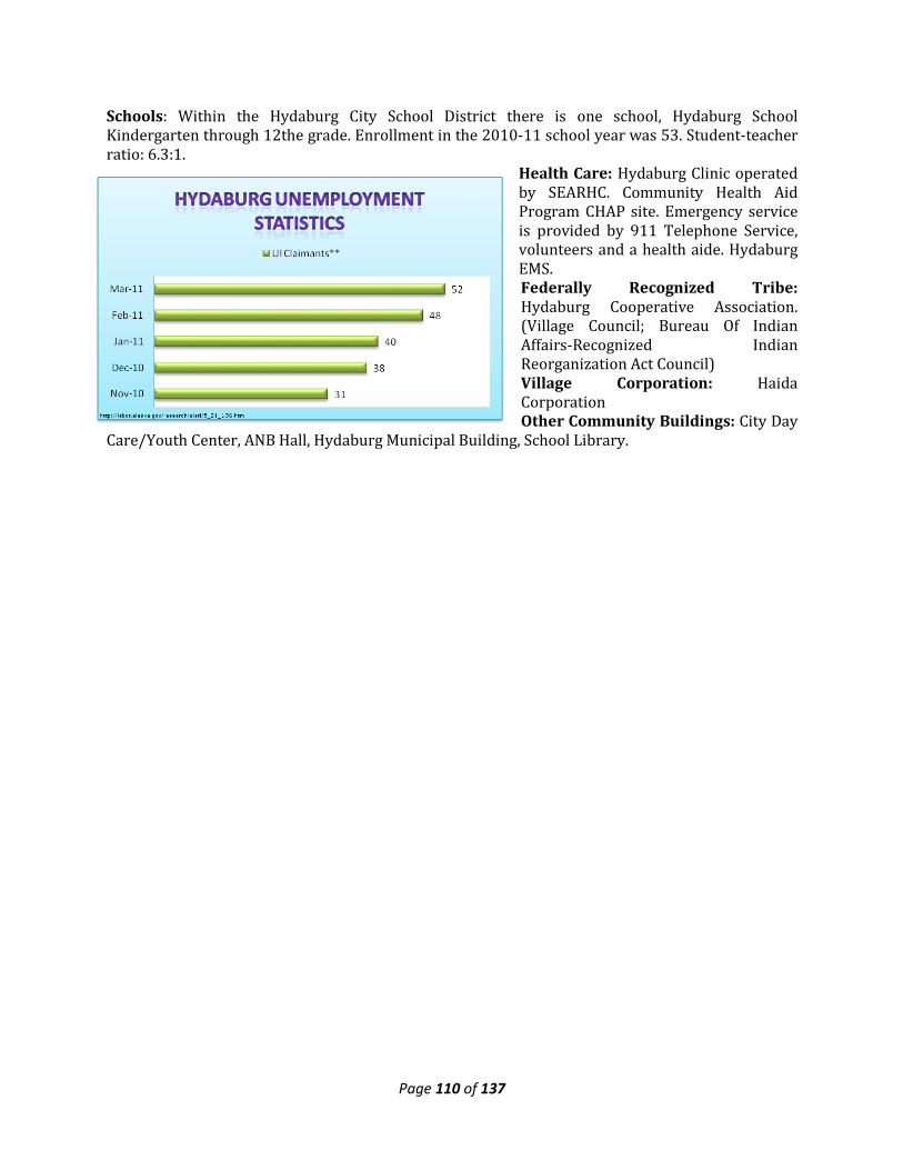
Page 110 of 137
Schools: Within the Hydaburg City School District there is one school, Hydaburg School Kindergarten through 12the grade. Enrollment in the 2010-11 school year was 53. Student-teacher ratio: 6.3:1.
Health Care: Hydaburg Clinic operated by SEARHC. Community Health Aid Program CHAP site. Emergency service is provided by 911 Telephone Service, volunteers and a health aide. Hydaburg EMS. Federally Recognized Tribe: Hydaburg Cooperative Association. (Village Council; Bureau Of Indian Affairs-Recognized Indian Reorganization Act Council) Village Corporation: Haida Corporation Other Community Buildings: City Day
Care/Youth Center, ANB Hall, Hydaburg Municipal Building, School Library.
Page 111 of 137
List of Projects:
Community Priority Tribal Strategy Project Contact Estimated Cost
Project Status Potential Funding Sources
Hydaburg1
Subsistance: Preserve Cultural Traditions by protecting areas used, Cultural trade/bartering
City of Hydaburg 907-285-3761
2011 Project List 2 Cultural Center: Totem Project, Visitors Center, Preserve Language, traditions, protocols
3 ANB Hall4 Multi-use Facility5 Bulk Fuel Facility6 Community Economic
Development: CQE Program, Fisheries Programs (Hand troll permit, Seine permit, Shrimp fishery)
7 Sawmill/Kiln
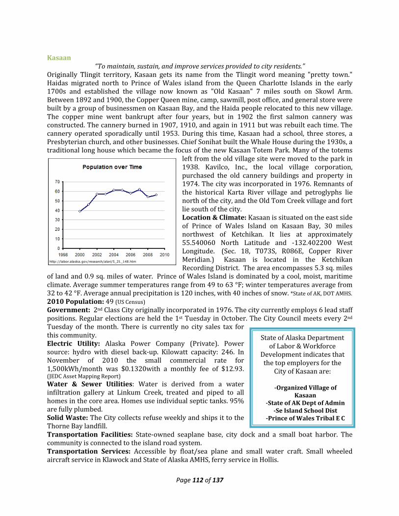
Page 112 of 137
State of Alaska Department of Labor & Workforce
Development indicates that the top employers for the
City of Kasaan are:
-Organized Village of Kasaan
-State of AK Dept of Admin -Se Island School Dist
-Prince of Wales Tribal E C
Kasaan “To maintain, sustain, and improve services provided to city residents.”
Originally Tlingit territory, Kasaan gets its name from the Tlingit word meaning "pretty town." Haidas migrated north to Prince of Wales island from the Queen Charlotte Islands in the early 1700s and established the village now known as "Old Kasaan" 7 miles south on Skowl Arm. Between 1892 and 1900, the Copper Queen mine, camp, sawmill, post office, and general store were built by a group of businessmen on Kasaan Bay, and the Haida people relocated to this new village. The copper mine went bankrupt after four years, but in 1902 the first salmon cannery was constructed. The cannery burned in 1907, 1910, and again in 1911 but was rebuilt each time. The cannery operated sporadically until 1953. During this time, Kasaan had a school, three stores, a Presbyterian church, and other businesses. Chief Sonihat built the Whale House during the 1930s, a traditional long house which became the focus of the new Kasaan Totem Park. Many of the totems
left from the old village site were moved to the park in 1938. Kavilco, Inc., the local village corporation, purchased the old cannery buildings and property in 1974. The city was incorporated in 1976. Remnants of the historical Karta River village and petroglyphs lie north of the city, and the Old Tom Creek village and fort lie south of the city. Location & Climate: Kasaan is situated on the east side of Prince of Wales Island on Kasaan Bay, 30 miles northwest of Ketchikan. It lies at approximately 55.540060 North Latitude and -132.402200 West Longitude. (Sec. 18, T073S, R086E, Copper River Meridian.) Kasaan is located in the Ketchikan Recording District. The area encompasses 5.3 sq. miles
of land and 0.9 sq. miles of water. Prince of Wales Island is dominated by a cool, moist, maritime climate. Average summer temperatures range from 49 to 63 °F; winter temperatures average from 32 to 42 °F. Average annual precipitation is 120 inches, with 40 inches of snow. *State of AK, DOT AMHS. 2010 Population: 49 (US Census) Government: 2nd Class City originally incorporated in 1976. The city currently employs 6 lead staff positions. Regular elections are held the 1st Tuesday in October. The City Council meets every 2nd Tuesday of the month. There is currently no city sales tax for this community. Electric Utility: Alaska Power Company (Private). Power source: hydro with diesel back-up. Kilowatt capacity: 246. In November of 2010 the small commercial rate for 1,500kWh/month was $0.1320with a monthly fee of $12.93. (JEDC Asset Mapping Report) Water & Sewer Utilities: Water is derived from a water infiltration gallery at Linkum Creek, treated and piped to all homes in the core area. Homes use individual septic tanks. 95% are fully plumbed. Solid Waste: The City collects refuse weekly and ships it to the Thorne Bay landfill. Transportation Facilities: State-owned seaplane base, city dock and a small boat harbor. The community is connected to the island road system. Transportation Services: Accessible by float/sea plane and small water craft. Small wheeled aircraft service in Klawock and State of Alaska AMHS, ferry service in Hollis.
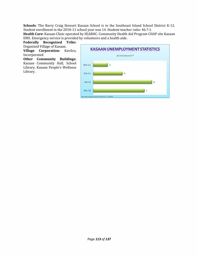
Page 113 of 137
Schools: The Barry Craig Stewart Kasaan School is in the Southeast Island School District K-12. Student enrollment in the 2010-11 school year was 14. Student-teacher ratio: 46.7:1. Health Care: Kasaan Clinic operated by SEARHC. Community Health Aid Program CHAP site Kasaan EMS. Emergency service is provided by volunteers and a health aide. Federally Recognized Tribe: Organized Village of Kasaan. Village Corporation: Kavilco, Incorporated Other Community Buildings: Kasaan Community Hall, School Library, Kasaan People’s Wellness Library.
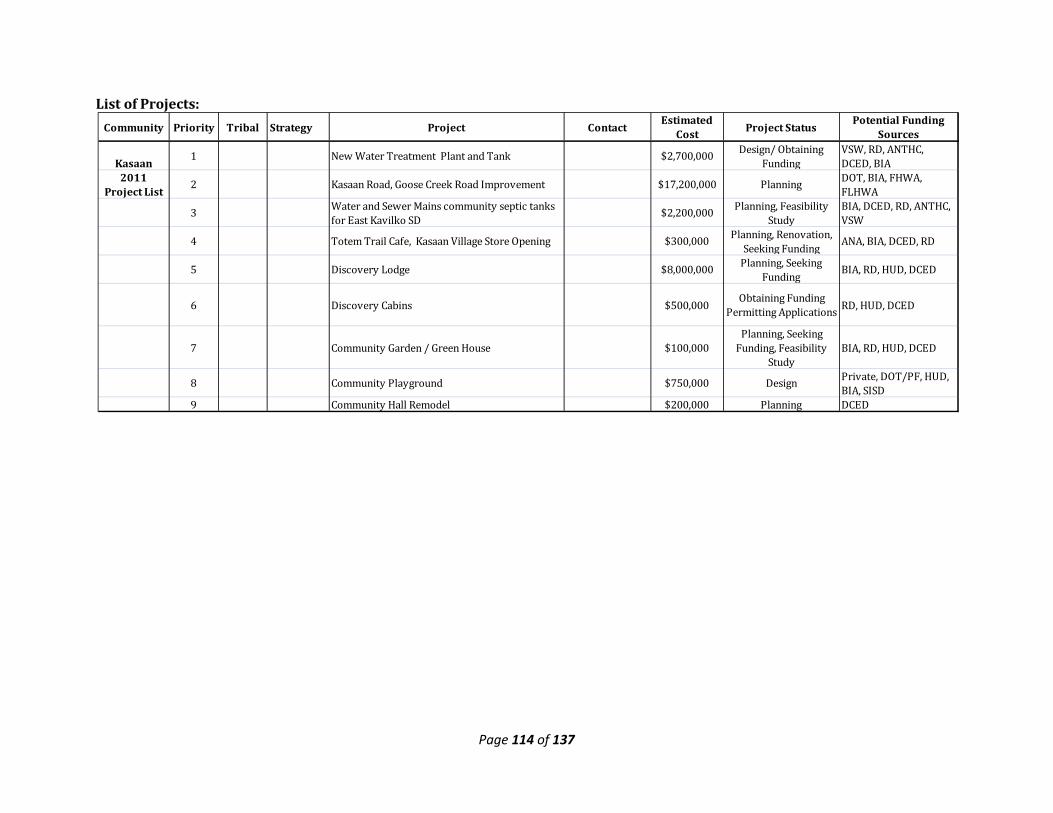
Page 114 of 137
List of Projects:
Community Priority Tribal Strategy Project Contact Estimated Cost Project Status Potential Funding
Sources
Kasaan1 New Water Treatment Plant and Tank $2,700,000 Design/ Obtaining
FundingVSW, RD, ANTHC, DCED, BIA
2011 Project List 2 Kasaan Road, Goose Creek Road Improvement $17,200,000 Planning DOT, BIA, FHWA,
FLHWA
3 Water and Sewer Mains community septic tanks for East Kavilko SD
$2,200,000 Planning, Feasibility Study
BIA, DCED, RD, ANTHC, VSW
4 Totem Trail Cafe, Kasaan Village Store Opening $300,000 Planning, Renovation, Seeking Funding ANA, BIA, DCED, RD
5 Discovery Lodge $8,000,000 Planning, Seeking Funding BIA, RD, HUD, DCED
6 Discovery Cabins $500,000 Obtaining Funding Permitting Applications RD, HUD, DCED
7 Community Garden / Green House $100,000 Planning, Seeking
Funding, Feasibility Study
BIA, RD, HUD, DCED
8 Community Playground $750,000 Design Private, DOT/PF, HUD, BIA, SISD
9 Community Hall Remodel $200,000 Planning DCED

Page 115 of 137
State of Alaska Department of Labor & Workforce
Development indicates that the top employers for the
City of Klawock are:
-AK Commercial Co -Klawock City School
District -City of Klawock
-SEARHC
Klawock Vision Statement: We, a group of Indians having common bonds of occupation in the fish industry,
including the catching, processing and the selling of fish and the building of fishing boats and equipment, in Klawock Territory of Alaska, in order to promote our welfare through the development
and operation of economic and social enterprises. Early inhabitants were from Tuxekan, a Tlingit winter village to the north. Klawock was used as a summer fishing camp and has been known as Klawerak, Tlevak, Clevak, and Klawak. The history of Klawock is closely tied to the fishing industry. A trading post and salmon saltery were established in 1868, and the first cannery in Alaska was built in Klawock by a San Francisco firm in 1878. The subsequent canneries that sprouted in the area were operated under contract with Chinese laborers. A hatchery for red salmon operated at Klawock Lake between 1897 and 1917. In 1929, Klawock incorporated as a city, and a school was constructed. In 1934, Klawock received federal funds under the Wheeler Howard Act to develop a local cannery, on the condition that residents vote to be liquor-free. In 1971, the Alaska Timber Corporation built a sawmill. Soon after, the Klawock-Heenya Village Corporation, the Shaan Seet Corporation of Craig, and Sealaska Timber Corporation expanded area facilities with a log-sort yard outside of Klawock and a deep-water dock on Klawock Island. The state constructed a salmon hatchery on Klawock Lake in 1978, very near the former hatchery site. Today Klawock is a mixed Tlingit and non-Native city. The Island has been greatly influenced by
logging operations. Most residents pursue a subsistence lifestyle to provide food sources. The community takes great pride in its Totem Park, which displays 21 restored totem poles and replicas from the old village. The Totem Park includes a Heritage Center and Long House. Location & Climate: Klawock is located on the west coast of Prince of Wales Island, on Klawock Inlet, across from Klawock Island. It is 7 road miles north of Craig, 24 road miles from Hollis, and 56 air miles west of Ketchikan. It lies at approximately 55.552220 North Latitude and -133.095830 West Longitude. (Sec. 09, T073S, R081E, Copper River Meridian.) Klawock is
located in the Ketchikan Recording District. The area encompasses 0.6 sq. miles of land and 0.3 sq. miles of water. Prince of Wales Island is dominated by a cool, moist, maritime climate. Summer temperatures range from 49 to 63 °F; winter temperatures range from 32 to 42 °F. Average annual precipitation is 120 inches, with 40 inches of snow. *State of AK, DOT AMHS. 2010 Population: 755 (US Census) Government: 1st Class City originally incorporated in 1929. The City currently employs 5 staff members. Regular elections are held every 1st Tuesday in October. The City Council meets every 1st Tuesday of the month. The current city sales tax is 5.5%. Electric Utility: Alaska Power Company (Private). Power source: hydro with diesel back-up. Kilowatt capacity: 1,375. In November of 2010 the small commercial rate for 1,500kWh/month was $0.1320 with a monthly fee of $12.93. (JEDC Asset Mapping Report)
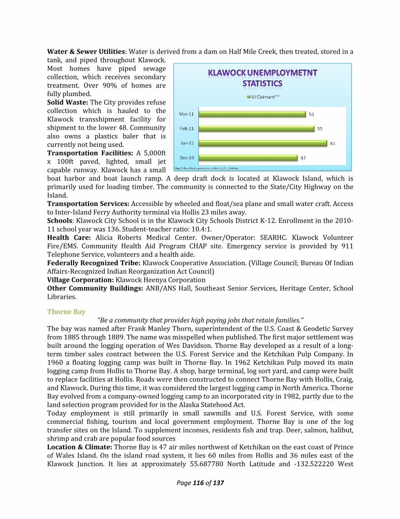
Page 116 of 137
Water & Sewer Utilities: Water is derived from a dam on Half Mile Creek, then treated, stored in a tank, and piped throughout Klawock. Most homes have piped sewage collection, which receives secondary treatment. Over 90% of homes are fully plumbed. Solid Waste: The City provides refuse collection which is hauled to the Klawock transshipment facility for shipment to the lower 48. Community also owns a plastics baler that is currently not being used. Transportation Facilities: A 5,000ft x 100ft paved, lighted, small jet capable runway. Klawock has a small boat harbor and boat launch ramp. A deep draft dock is located at Klawock Island, which is primarily used for loading timber. The community is connected to the State/City Highway on the Island. Transportation Services: Accessible by wheeled and float/sea plane and small water craft. Access to Inter-Island Ferry Authority terminal via Hollis 23 miles away. Schools: Klawock City School is in the Klawock City Schools District K-12. Enrollment in the 2010-11 school year was 136. Student-teacher ratio: 10.4:1. Health Care: Alicia Roberts Medical Center. Owner/Operator: SEARHC. Klawock Volunteer Fire/EMS. Community Health Aid Program CHAP site. Emergency service is provided by 911 Telephone Service, volunteers and a health aide. Federally Recognized Tribe: Klawock Cooperative Association. (Village Council; Bureau Of Indian Affairs-Recognized Indian Reorganization Act Council) Village Corporation: Klawock Heenya Corporation Other Community Buildings: ANB/ANS Hall, Southeast Senior Services, Heritage Center, School Libraries.
Thorne Bay “Be a community that provides high paying jobs that retain families.”
The bay was named after Frank Manley Thorn, superintendent of the U.S. Coast & Geodetic Survey from 1885 through 1889. The name was misspelled when published. The first major settlement was built around the logging operation of Wes Davidson. Thorne Bay developed as a result of a long-term timber sales contract between the U.S. Forest Service and the Ketchikan Pulp Company. In 1960 a floating logging camp was built in Thorne Bay. In 1962 Ketchikan Pulp moved its main logging camp from Hollis to Thorne Bay. A shop, barge terminal, log sort yard, and camp were built to replace facilities at Hollis. Roads were then constructed to connect Thorne Bay with Hollis, Craig, and Klawock. During this time, it was considered the largest logging camp in North America. Thorne Bay evolved from a company-owned logging camp to an incorporated city in 1982, partly due to the land selection program provided for in the Alaska Statehood Act. Today employment is still primarily in small sawmills and U.S. Forest Service, with some commercial fishing, tourism and local government employment. Thorne Bay is one of the log transfer sites on the Island. To supplement incomes, residents fish and trap. Deer, salmon, halibut, shrimp and crab are popular food sources Location & Climate: Thorne Bay is 47 air miles northwest of Ketchikan on the east coast of Prince of Wales Island. On the island road system, it lies 60 miles from Hollis and 36 miles east of the Klawock Junction. It lies at approximately 55.687780 North Latitude and -132.522220 West
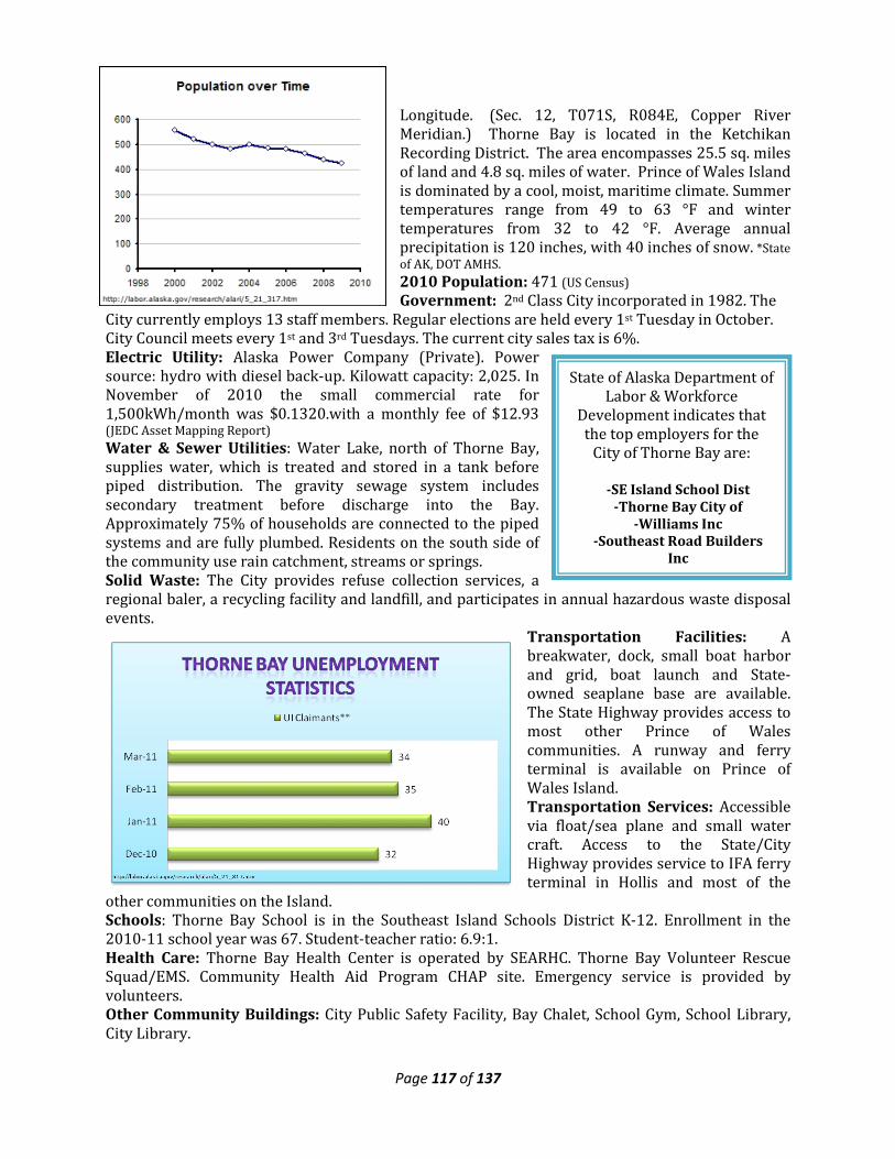
Page 117 of 137
State of Alaska Department of Labor & Workforce
Development indicates that the top employers for the
City of Thorne Bay are:
-SE Island School Dist -Thorne Bay City of
-Williams Inc -Southeast Road Builders
Inc
Longitude. (Sec. 12, T071S, R084E, Copper River Meridian.) Thorne Bay is located in the Ketchikan Recording District. The area encompasses 25.5 sq. miles of land and 4.8 sq. miles of water. Prince of Wales Island is dominated by a cool, moist, maritime climate. Summer temperatures range from 49 to 63 °F and winter temperatures from 32 to 42 °F. Average annual precipitation is 120 inches, with 40 inches of snow. *State of AK, DOT AMHS. 2010 Population: 471 (US Census) Government: 2nd Class City incorporated in 1982. The
City currently employs 13 staff members. Regular elections are held every 1st Tuesday in October. City Council meets every 1st and 3rd Tuesdays. The current city sales tax is 6%. Electric Utility: Alaska Power Company (Private). Power source: hydro with diesel back-up. Kilowatt capacity: 2,025. In November of 2010 the small commercial rate for 1,500kWh/month was $0.1320.with a monthly fee of $12.93 (JEDC Asset Mapping Report) Water & Sewer Utilities: Water Lake, north of Thorne Bay, supplies water, which is treated and stored in a tank before piped distribution. The gravity sewage system includes secondary treatment before discharge into the Bay. Approximately 75% of households are connected to the piped systems and are fully plumbed. Residents on the south side of the community use rain catchment, streams or springs. Solid Waste: The City provides refuse collection services, a regional baler, a recycling facility and landfill, and participates in annual hazardous waste disposal events.
Transportation Facilities: A breakwater, dock, small boat harbor and grid, boat launch and State-owned seaplane base are available. The State Highway provides access to most other Prince of Wales communities. A runway and ferry terminal is available on Prince of Wales Island. Transportation Services: Accessible via float/sea plane and small water craft. Access to the State/City Highway provides service to IFA ferry terminal in Hollis and most of the
other communities on the Island. Schools: Thorne Bay School is in the Southeast Island Schools District K-12. Enrollment in the 2010-11 school year was 67. Student-teacher ratio: 6.9:1. Health Care: Thorne Bay Health Center is operated by SEARHC. Thorne Bay Volunteer Rescue Squad/EMS. Community Health Aid Program CHAP site. Emergency service is provided by volunteers. Other Community Buildings: City Public Safety Facility, Bay Chalet, School Gym, School Library, City Library.
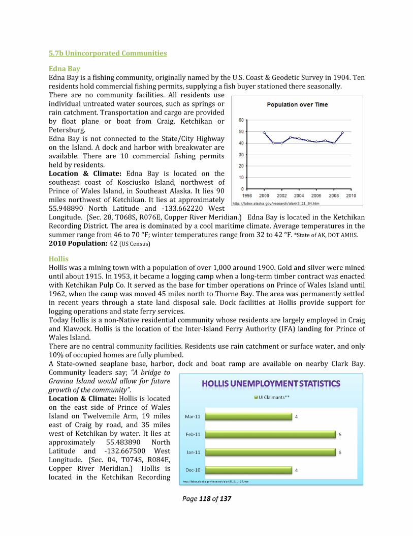
Page 118 of 137
5.7b Unincorporated Communities
Edna Bay Edna Bay is a fishing community, originally named by the U.S. Coast & Geodetic Survey in 1904. Ten residents hold commercial fishing permits, supplying a fish buyer stationed there seasonally. There are no community facilities. All residents use individual untreated water sources, such as springs or rain catchment. Transportation and cargo are provided by float plane or boat from Craig, Ketchikan or Petersburg. Edna Bay is not connected to the State/City Highway on the Island. A dock and harbor with breakwater are available. There are 10 commercial fishing permits held by residents. Location & Climate: Edna Bay is located on the southeast coast of Kosciusko Island, northwest of Prince of Wales Island, in Southeast Alaska. It lies 90 miles northwest of Ketchikan. It lies at approximately 55.948890 North Latitude and -133.662220 West Longitude. (Sec. 28, T068S, R076E, Copper River Meridian.) Edna Bay is located in the Ketchikan Recording District. The area is dominated by a cool maritime climate. Average temperatures in the summer range from 46 to 70 °F; winter temperatures range from 32 to 42 °F. *State of AK, DOT AMHS. 2010 Population: 42 (US Census)
Hollis Hollis was a mining town with a population of over 1,000 around 1900. Gold and silver were mined until about 1915. In 1953, it became a logging camp when a long-term timber contract was enacted with Ketchikan Pulp Co. It served as the base for timber operations on Prince of Wales Island until 1962, when the camp was moved 45 miles north to Thorne Bay. The area was permanently settled in recent years through a state land disposal sale. Dock facilities at Hollis provide support for logging operations and state ferry services. Today Hollis is a non-Native residential community whose residents are largely employed in Craig and Klawock. Hollis is the location of the Inter-Island Ferry Authority (IFA) landing for Prince of Wales Island. There are no central community facilities. Residents use rain catchment or surface water, and only 10% of occupied homes are fully plumbed. A State-owned seaplane base, harbor, dock and boat ramp are available on nearby Clark Bay. Community leaders say; “A bridge to Gravina Island would allow for future growth of the community”. Location & Climate: Hollis is located on the east side of Prince of Wales Island on Twelvemile Arm, 19 miles east of Craig by road, and 35 miles west of Ketchikan by water. It lies at approximately 55.483890 North Latitude and -132.667500 West Longitude. (Sec. 04, T074S, R084E, Copper River Meridian.) Hollis is located in the Ketchikan Recording
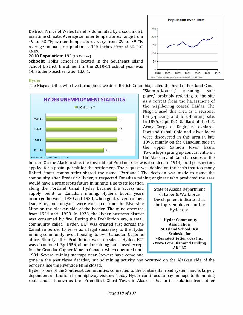
Page 119 of 137
State of Alaska Department of Labor & Workforce
Development indicates that the top 5 employers for the
Hyder are:
- Hyder Community Association
-SE Island School Dist. -Sealaska Inn
-Remote Site Services Inc. -More Core Diamond Drilling
AK LLC
District. Prince of Wales Island is dominated by a cool, moist, maritime climate. Average summer temperatures range from 49 to 63 °F; winter temperatures vary from 29 to 39 °F. Average annual precipitation is 145 inches. *State of AK, DOT AMHS. 2010 Population: 193 (US Census) Schools: Hollis School is located in the Southeast Island School District. Enrollment in the 2010-11 school year was 14. Student-teacher ratio: 13.0:1.
Hyder The Nisga'a tribe, who live throughout western British Columbia, called the head of Portland Canal
"Skam-A-Kounst," meaning "safe place," probably referring to the site as a retreat from the harassment of the neighboring coastal Haidas. The Nisga'a used this area as a seasonal berry-picking and bird-hunting site. In 1896, Capt. D.D. Gaillard of the U.S. Army Corps of Engineers explored Portland Canal. Gold and silver lodes were discovered in this area in late 1898, mainly on the Canadian side in the upper Salmon River basin. Townships sprang up concurrently on the Alaskan and Canadian sides of the
border. On the Alaskan side, the township of Portland City was founded. In 1914, local prospectors applied for a postal permit for the settlement. The request was denied on the basis that too many United States communities shared the name "Portland." The decision was made to name the community after Frederick Hyder, a respected Canadian mining engineer who predicted the area would have a prosperous future in mining. Due to its location along the Portland Canal, Hyder became the access and supply point to Canadian mining. Hyder's boom years occurred between 1920 and 1930, when gold, silver, copper, lead, zinc, and tungsten were extracted from the Riverside Mine on the Alaskan side of the border. The mine operated from 1924 until 1950. In 1928, the Hyder business district was consumed by fire. During the Prohibition era, a small community called "Hyder, BC" was created just across the Canadian border to serve as a legal speakeasy to the Hyder mining community, even housing its own Canadian Customs office. Shortly after Prohibition was repealed, "Hyder, BC" was abandoned. By 1956, all major mining had closed except for the Granduc Copper Mine in Canada, which operated until 1984. Several mining startups near Stewart have come and gone in the past three decades, but no mining activity has occurred on the Alaskan side of the border since the Riverside Mine closed. Hyder is one of the Southeast communities connected to the continental road system, and is largely dependent on tourism from highway visitors. Today Hyder continues to pay homage to its mining roots and is known as the "Friendliest Ghost Town in Alaska." Due to its isolation from other
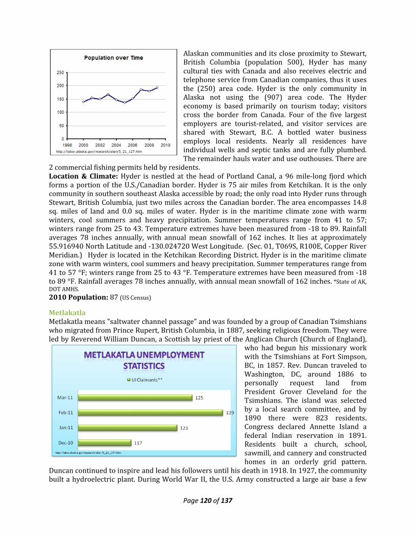
Page 120 of 137
Alaskan communities and its close proximity to Stewart, British Columbia (population 500), Hyder has many cultural ties with Canada and also receives electric and telephone service from Canadian companies, thus it uses the (250) area code. Hyder is the only community in Alaska not using the (907) area code. The Hyder economy is based primarily on tourism today; visitors cross the border from Canada. Four of the five largest employers are tourist-related, and visitor services are shared with Stewart, B.C. A bottled water business employs local residents. Nearly all residences have individual wells and septic tanks and are fully plumbed. The remainder hauls water and use outhouses. There are
2 commercial fishing permits held by residents. Location & Climate: Hyder is nestled at the head of Portland Canal, a 96 mile-long fjord which forms a portion of the U.S./Canadian border. Hyder is 75 air miles from Ketchikan. It is the only community in southern southeast Alaska accessible by road; the only road into Hyder runs through Stewart, British Columbia, just two miles across the Canadian border. The area encompasses 14.8 sq. miles of land and 0.0 sq. miles of water. Hyder is in the maritime climate zone with warm winters, cool summers and heavy precipitation. Summer temperatures range from 41 to 57; winters range from 25 to 43. Temperature extremes have been measured from -18 to 89. Rainfall averages 78 inches annually, with annual mean snowfall of 162 inches. It lies at approximately 55.916940 North Latitude and -130.024720 West Longitude. (Sec. 01, T069S, R100E, Copper River Meridian.) Hyder is located in the Ketchikan Recording District. Hyder is in the maritime climate zone with warm winters, cool summers and heavy precipitation. Summer temperatures range from 41 to 57 °F; winters range from 25 to 43 °F. Temperature extremes have been measured from -18 to 89 °F. Rainfall averages 78 inches annually, with annual mean snowfall of 162 inches. *State of AK, DOT AMHS. 2010 Population: 87 (US Census)
Metlakatla Metlakatla means "saltwater channel passage" and was founded by a group of Canadian Tsimshians who migrated from Prince Rupert, British Columbia, in 1887, seeking religious freedom. They were led by Reverend William Duncan, a Scottish lay priest of the Anglican Church (Church of England),
who had begun his missionary work with the Tsimshians at Fort Simpson, BC, in 1857. Rev. Duncan traveled to Washington, DC, around 1886 to personally request land from President Grover Cleveland for the Tsimshians. The island was selected by a local search committee, and by 1890 there were 823 residents. Congress declared Annette Island a federal Indian reservation in 1891. Residents built a church, school, sawmill, and cannery and constructed homes in an orderly grid pattern.
Duncan continued to inspire and lead his followers until his death in 1918. In 1927, the community built a hydroelectric plant. During World War II, the U.S. Army constructed a large air base a few
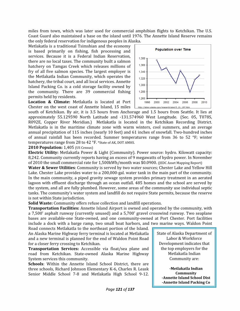
Page 121 of 137
State of Alaska Department of Labor & Workforce
Development indicates that the top employers for the
Metlakatla Indian Community are:
-Metlakatla Indian
Community -Annette Island School Dist -Annette Island Packing Co
miles from town, which was later used for commercial amphibian flights to Ketchikan. The U.S. Coast Guard also maintained a base on the island until 1976. The Annette Island Reserve remains the only federal reservation for indigenous peoples in Alaska. Metlakatla is a traditional Tsimshian and the economy is based primarily on fishing, fish processing and services. Because it is a Federal Indian Reservation, there are no local taxes. The community built a salmon hatchery on Tamgas Creek which releases millions of fry of all five salmon species. The largest employer is the Metlakatla Indian Community, which operates the hatchery, the tribal court, and all local services. Annette Island Packing Co. is a cold storage facility owned by the community. There are 39 commercial fishing permits held by residents. Location & Climate: Metlakatla is located at Port Chester on the west coast of Annette Island, 15 miles south of Ketchikan. By air, it is 3.5 hours from Anchorage and 1.5 hours from Seattle. It lies at approximately 55.129590 North Latitude and -131.574960 West Longitude. (Sec. 05, T078S, R092E, Copper River Meridian.) Metlakatla is located in the Ketchikan Recording District. Metlakatla is in the maritime climate zone with warm winters, cool summers, and an average annual precipitation of 115 inches (nearly 10 feet) and 61 inches of snowfall. Two-hundred inches of annual rainfall has been recorded. Summer temperatures range from 36 to 52 °F; winter temperatures range from 28 to 42 °F. *State of AK, DOT AMHS. 2010 Population: 1,405 (US Census) Electric Utility: Metlakatla Power & Light (Community). Power source: hydro. Kilowatt capacity: 8,242. Community currently reports having an excess of 9 megawatts of hydro power. In November of 2010 the small commercial rate for 1,500kWh/month was $0.0900. (JEDC Asset Mapping Report) Water & Sewer Utilities: Community is served by two water sources; Chester Lake and Yellow Hill Lake. Chester Lake provides water to a 200,000-gal. water tank in the main part of the community. In the main community, a piped gravity sewage system provides primary treatment in an aerated lagoon with effluent discharge through an ocean outfall. 485 homes and the school are served by the system, and all are fully plumbed. However, some areas of the community use individual septic tanks. The community's water system and landfill do not require State permits, because the reserve is not within State jurisdiction. Solid Waste: Community offers refuse collection and landfill operations. Transportation Facilities: Annette Island Airport is owned and operated by the community, with a 7,500' asphalt runway (currently unused) and a 5,700' gravel crosswind runway. Two seaplane bases are available-one State-owned, and one community-owned at Port Chester. Port facilities include a dock with a barge ramp, two small boat harbors, and two marine ways. Waldon Point Road connects Metlakatla to the northeast portion of the Island. An Alaska Marine Highway ferry terminal is located at Metlakatla and a new terminal is planned for the end of Waldon Point Road for a closer ferry crossing to Ketchikan. Transportation Services: Accessible via float/sea plane and road from Ketchikan. State-owned Alaska Marine Highway System services this community. Schools: Within the Annette Island School District, there are three schools, Richard Johnson Elementary K-6, Charles R. Leask Senior Middle School 7-8 and Metlakatla High School 9-12.
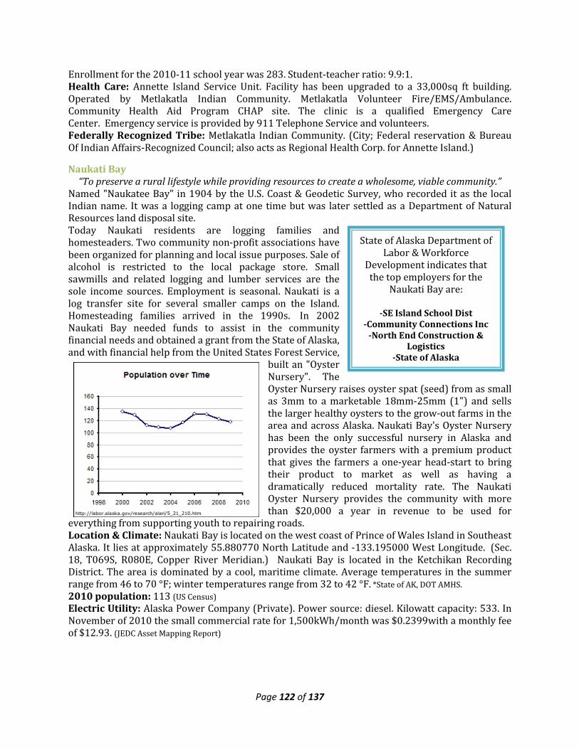
Page 122 of 137
State of Alaska Department of Labor & Workforce
Development indicates that the top employers for the
Naukati Bay are:
-SE Island School Dist -Community Connections Inc
-North End Construction & Logistics
-State of Alaska
Enrollment for the 2010-11 school year was 283. Student-teacher ratio: 9.9:1. Health Care: Annette Island Service Unit. Facility has been upgraded to a 33,000sq ft building. Operated by Metlakatla Indian Community. Metlakatla Volunteer Fire/EMS/Ambulance. Community Health Aid Program CHAP site. The clinic is a qualified Emergency Care Center. Emergency service is provided by 911 Telephone Service and volunteers. Federally Recognized Tribe: Metlakatla Indian Community. (City; Federal reservation & Bureau Of Indian Affairs-Recognized Council; also acts as Regional Health Corp. for Annette Island.)
Naukati Bay “To preserve a rural lifestyle while providing resources to create a wholesome, viable community.”
Named "Naukatee Bay" in 1904 by the U.S. Coast & Geodetic Survey, who recorded it as the local Indian name. It was a logging camp at one time but was later settled as a Department of Natural Resources land disposal site. Today Naukati residents are logging families and homesteaders. Two community non-profit associations have been organized for planning and local issue purposes. Sale of alcohol is restricted to the local package store. Small sawmills and related logging and lumber services are the sole income sources. Employment is seasonal. Naukati is a log transfer site for several smaller camps on the Island. Homesteading families arrived in the 1990s. In 2002 Naukati Bay needed funds to assist in the community financial needs and obtained a grant from the State of Alaska, and with financial help from the United States Forest Service,
built an "Oyster Nursery". The Oyster Nursery raises oyster spat (seed) from as small as 3mm to a marketable 18mm-25mm (1") and sells the larger healthy oysters to the grow-out farms in the area and across Alaska. Naukati Bay's Oyster Nursery has been the only successful nursery in Alaska and provides the oyster farmers with a premium product that gives the farmers a one-year head-start to bring their product to market as well as having a dramatically reduced mortality rate. The Naukati Oyster Nursery provides the community with more than $20,000 a year in revenue to be used for
everything from supporting youth to repairing roads. Location & Climate: Naukati Bay is located on the west coast of Prince of Wales Island in Southeast Alaska. It lies at approximately 55.880770 North Latitude and -133.195000 West Longitude. (Sec. 18, T069S, R080E, Copper River Meridian.) Naukati Bay is located in the Ketchikan Recording District. The area is dominated by a cool, maritime climate. Average temperatures in the summer range from 46 to 70 °F; winter temperatures range from 32 to 42 °F. *State of AK, DOT AMHS. 2010 population: 113 (US Census) Electric Utility: Alaska Power Company (Private). Power source: diesel. Kilowatt capacity: 533. In November of 2010 the small commercial rate for 1,500kWh/month was $0.2399with a monthly fee of $12.93. (JEDC Asset Mapping Report)
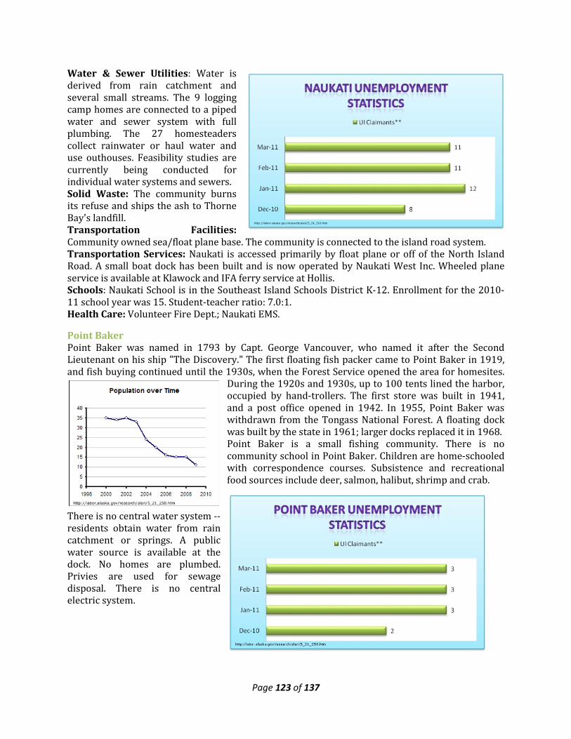
Page 123 of 137
Water & Sewer Utilities: Water is derived from rain catchment and several small streams. The 9 logging camp homes are connected to a piped water and sewer system with full plumbing. The 27 homesteaders collect rainwater or haul water and use outhouses. Feasibility studies are currently being conducted for individual water systems and sewers. Solid Waste: The community burns its refuse and ships the ash to Thorne Bay's landfill. Transportation Facilities: Community owned sea/float plane base. The community is connected to the island road system. Transportation Services: Naukati is accessed primarily by float plane or off of the North Island Road. A small boat dock has been built and is now operated by Naukati West Inc. Wheeled plane service is available at Klawock and IFA ferry service at Hollis. Schools: Naukati School is in the Southeast Island Schools District K-12. Enrollment for the 2010-11 school year was 15. Student-teacher ratio: 7.0:1. Health Care: Volunteer Fire Dept.; Naukati EMS.
Point Baker Point Baker was named in 1793 by Capt. George Vancouver, who named it after the Second Lieutenant on his ship "The Discovery." The first floating fish packer came to Point Baker in 1919, and fish buying continued until the 1930s, when the Forest Service opened the area for homesites.
During the 1920s and 1930s, up to 100 tents lined the harbor, occupied by hand-trollers. The first store was built in 1941, and a post office opened in 1942. In 1955, Point Baker was withdrawn from the Tongass National Forest. A floating dock was built by the state in 1961; larger docks replaced it in 1968. Point Baker is a small fishing community. There is no community school in Point Baker. Children are home-schooled with correspondence courses. Subsistence and recreational food sources include deer, salmon, halibut, shrimp and crab.
There is no central water system -- residents obtain water from rain catchment or springs. A public water source is available at the dock. No homes are plumbed. Privies are used for sewage disposal. There is no central electric system.
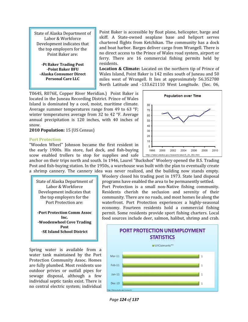
Page 124 of 137
State of Alaska Department of Labor & Workforce
Development indicates that the top employers for the
Point Baker are:
-Pt Baker Trading Post -Point Baker BFU
-Alaska Consumer Direct Personal Care LLC
State of Alaska Department of Labor & Workforce
Development indicates that the top employers for the
Port Protection are: -Port Protection Comm Assoc
Inc. -Woodenwheel Cove Trading
Post -SE Island School District
Point Baker is accessible by float plane, helicopter, barge and skiff. A State-owned seaplane base and heliport serves chartered flights from Ketchikan. The community has a dock and boat harbor. Barges deliver cargo from Wrangell. There is no direct access to the Prince of Wales road system, airport or ferry. There are 16 commercial fishing permits held by residents. Location & Climate: Located on the northern tip of Prince of Wales Island, Point Baker is 142 miles south of Juneau and 50 miles west of Wrangell. It lies at approximately 56.352780 North Latitude and -133.621110 West Longitude. (Sec. 06,
T064S, R076E, Copper River Meridian.) Point Baker is located in the Juneau Recording District. Prince of Wales Island is dominated by a cool, moist, maritime climate. Average summer temperatures range from 49 to 63 °F; winter temperatures average from 32 to 42 °F. Average annual precipitation is 120 inches, with 40 inches of snow. 2010 Population: 15 (US Census)
Port Protection "Wooden Wheel" Johnson became the first resident in the early 1900s. His store, fuel dock, and fish-buying scow enabled trollers to stop for supplies and safe anchor on their trips north and south. In 1946, Laurel "Buckshot" Woolery opened the B.S. Trading Post and fish-buying station. In the 1950s, a warehouse was built with the plan to eventually create a shrimp cannery. The cannery idea was never realized, and the building now stands empty.
Woolery closed his trading post in 1973. State land disposal programs have enabled the area to be permanently settled. Port Protection is a small non-Native fishing community. Residents cherish the seclusion and serenity of their community. There are no roads, and most homes lie along the waterfront. Port Protection experiences a highly-seasonal economy. Fourteen residents hold a commercial fishing permit. Some residents provide sport fishing charters. Local food sources include deer, salmon, halibut, shrimp and crab.
Spring water is available from a water tank maintained by the Port Protection Community Assoc. Homes are fully plumbed. Most residents use outdoor privies or outfall pipes for sewage disposal, although a few individual septic tanks exist. There is no central electric system; individual
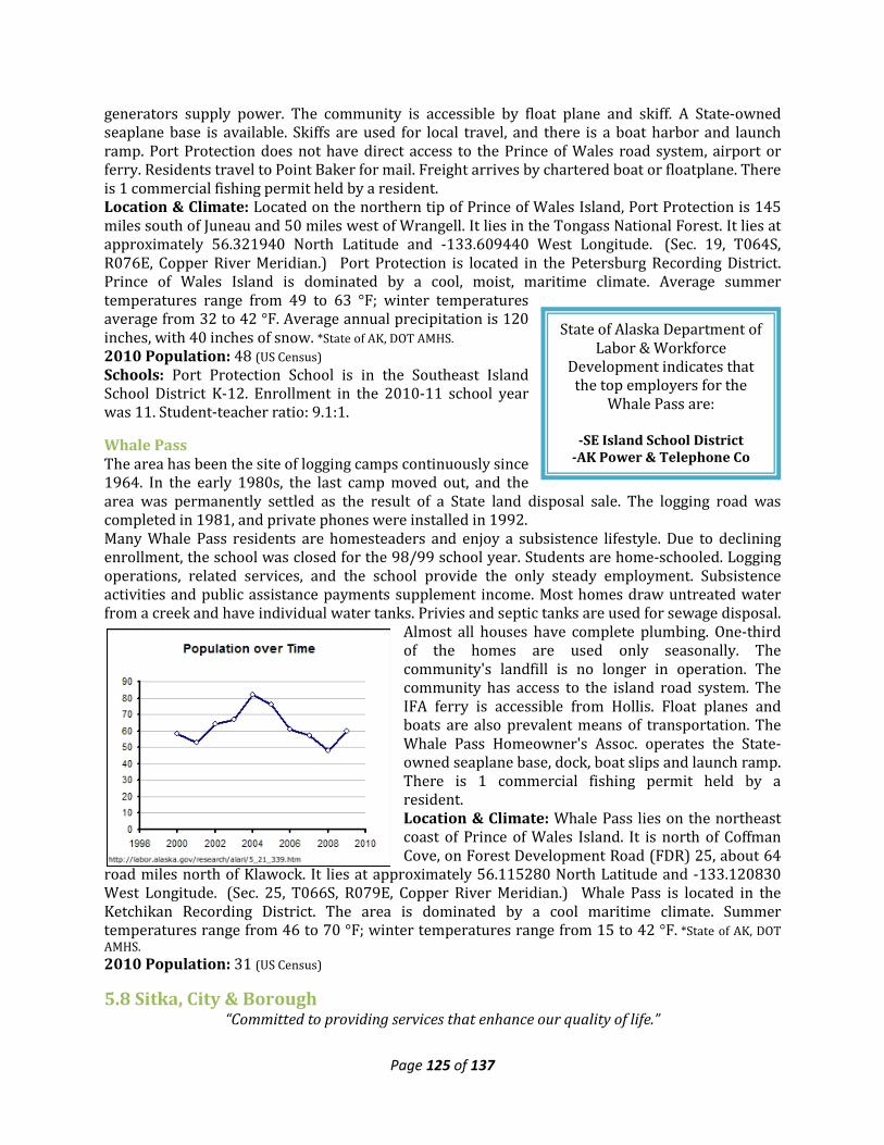
Page 125 of 137
State of Alaska Department of Labor & Workforce
Development indicates that the top employers for the
Whale Pass are:
-SE Island School District -AK Power & Telephone Co
generators supply power. The community is accessible by float plane and skiff. A State-owned seaplane base is available. Skiffs are used for local travel, and there is a boat harbor and launch ramp. Port Protection does not have direct access to the Prince of Wales road system, airport or ferry. Residents travel to Point Baker for mail. Freight arrives by chartered boat or floatplane. There is 1 commercial fishing permit held by a resident. Location & Climate: Located on the northern tip of Prince of Wales Island, Port Protection is 145 miles south of Juneau and 50 miles west of Wrangell. It lies in the Tongass National Forest. It lies at approximately 56.321940 North Latitude and -133.609440 West Longitude. (Sec. 19, T064S, R076E, Copper River Meridian.) Port Protection is located in the Petersburg Recording District. Prince of Wales Island is dominated by a cool, moist, maritime climate. Average summer temperatures range from 49 to 63 °F; winter temperatures average from 32 to 42 °F. Average annual precipitation is 120 inches, with 40 inches of snow. *State of AK, DOT AMHS. 2010 Population: 48 (US Census) Schools: Port Protection School is in the Southeast Island School District K-12. Enrollment in the 2010-11 school year was 11. Student-teacher ratio: 9.1:1.
Whale Pass The area has been the site of logging camps continuously since 1964. In the early 1980s, the last camp moved out, and the area was permanently settled as the result of a State land disposal sale. The logging road was completed in 1981, and private phones were installed in 1992. Many Whale Pass residents are homesteaders and enjoy a subsistence lifestyle. Due to declining enrollment, the school was closed for the 98/99 school year. Students are home-schooled. Logging operations, related services, and the school provide the only steady employment. Subsistence activities and public assistance payments supplement income. Most homes draw untreated water from a creek and have individual water tanks. Privies and septic tanks are used for sewage disposal.
Almost all houses have complete plumbing. One-third of the homes are used only seasonally. The community's landfill is no longer in operation. The community has access to the island road system. The IFA ferry is accessible from Hollis. Float planes and boats are also prevalent means of transportation. The Whale Pass Homeowner's Assoc. operates the State-owned seaplane base, dock, boat slips and launch ramp. There is 1 commercial fishing permit held by a resident. Location & Climate: Whale Pass lies on the northeast coast of Prince of Wales Island. It is north of Coffman Cove, on Forest Development Road (FDR) 25, about 64
road miles north of Klawock. It lies at approximately 56.115280 North Latitude and -133.120830 West Longitude. (Sec. 25, T066S, R079E, Copper River Meridian.) Whale Pass is located in the Ketchikan Recording District. The area is dominated by a cool maritime climate. Summer temperatures range from 46 to 70 °F; winter temperatures range from 15 to 42 °F. *State of AK, DOT AMHS. 2010 Population: 31 (US Census)
5.8 Sitka, City & Borough “Committed to providing services that enhance our quality of life.”
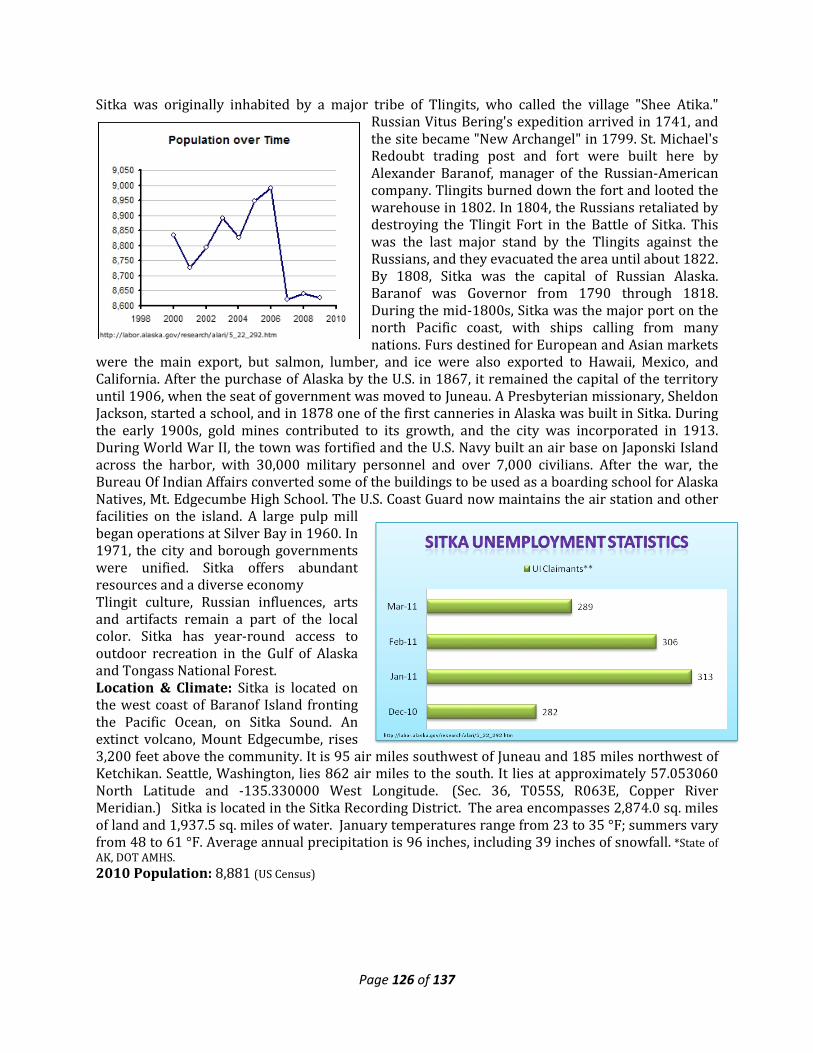
Page 126 of 137
Sitka was originally inhabited by a major tribe of Tlingits, who called the village "Shee Atika." Russian Vitus Bering's expedition arrived in 1741, and the site became "New Archangel" in 1799. St. Michael's Redoubt trading post and fort were built here by Alexander Baranof, manager of the Russian-American company. Tlingits burned down the fort and looted the warehouse in 1802. In 1804, the Russians retaliated by destroying the Tlingit Fort in the Battle of Sitka. This was the last major stand by the Tlingits against the Russians, and they evacuated the area until about 1822. By 1808, Sitka was the capital of Russian Alaska. Baranof was Governor from 1790 through 1818. During the mid-1800s, Sitka was the major port on the north Pacific coast, with ships calling from many nations. Furs destined for European and Asian markets
were the main export, but salmon, lumber, and ice were also exported to Hawaii, Mexico, and California. After the purchase of Alaska by the U.S. in 1867, it remained the capital of the territory until 1906, when the seat of government was moved to Juneau. A Presbyterian missionary, Sheldon Jackson, started a school, and in 1878 one of the first canneries in Alaska was built in Sitka. During the early 1900s, gold mines contributed to its growth, and the city was incorporated in 1913. During World War II, the town was fortified and the U.S. Navy built an air base on Japonski Island across the harbor, with 30,000 military personnel and over 7,000 civilians. After the war, the Bureau Of Indian Affairs converted some of the buildings to be used as a boarding school for Alaska Natives, Mt. Edgecumbe High School. The U.S. Coast Guard now maintains the air station and other facilities on the island. A large pulp mill began operations at Silver Bay in 1960. In 1971, the city and borough governments were unified. Sitka offers abundant resources and a diverse economy Tlingit culture, Russian influences, arts and artifacts remain a part of the local color. Sitka has year-round access to outdoor recreation in the Gulf of Alaska and Tongass National Forest. Location & Climate: Sitka is located on the west coast of Baranof Island fronting the Pacific Ocean, on Sitka Sound. An extinct volcano, Mount Edgecumbe, rises 3,200 feet above the community. It is 95 air miles southwest of Juneau and 185 miles northwest of Ketchikan. Seattle, Washington, lies 862 air miles to the south. It lies at approximately 57.053060 North Latitude and -135.330000 West Longitude. (Sec. 36, T055S, R063E, Copper River Meridian.) Sitka is located in the Sitka Recording District. The area encompasses 2,874.0 sq. miles of land and 1,937.5 sq. miles of water. January temperatures range from 23 to 35 °F; summers vary from 48 to 61 °F. Average annual precipitation is 96 inches, including 39 inches of snowfall. *State of AK, DOT AMHS. 2010 Population: 8,881 (US Census)
Page 127 of 137
State of Alaska Department of Labor & Workforce
Development indicates that the top employers for the City
& Borough of Sitka are:
-SEARHC -Sitka School Dist
-State of AK Dept of Admin -Sitka City & Borough
-Sitka Community Hospital
Government: Unified Home Rule Municipality incorporated in 1971. The City currently employs 14 lead staff and many support positions. Regular elections are held every 1st Tuesday of October. City Assembly meets every 2nd and 4th Tuesdays. The current city sales tax is 5% from Oct-Mar.; 6% from Apr. - Sept. Electric Utility: Sitka Electric Department. Power source: hydro with diesel back-up. Kilowatt capacity: 34,840. In November of 2010 the small commercial rate for 1,500kWh/month was $0.1417 and $0.0903 for above 500 kWh with a monthly fee of $21.25. (JEDC Asset Mapping Report) Water & Sewer Utilities: Water is drawn from a reservoir on Blue Lake and Indian River, is treated, stored, and piped to nearly all homes in Sitka. The maximum capacity is 8.6 million gallons per day, with 197 million gallons of storage capacity. 95% of homes are connected to the piped sewage system, which receives primary treatment. Solid Waste: Refuse is collected by a private firm, under contract to the City, and is shipped out. The community participates in annual hazardous waste disposal events. Transportation Facilities: The State-owned Rocky Gutierrez Airport on Japonski Island has a 6,500' x 150' paved and lighted runway, an instrument landing system, and a 24-hour FAA Flight Service Station. Over the past five years, the community has continued to improve airport facilities. City & Borough operates five small boat harbors with 1,350 stalls. There is a seaplane base on Sitka Sound and one in Baranof Warm Spring Bay. There is a breakwater at Thompson Harbor, but no deep-draft dock. A boat launch, haul-out, boat repairs and other services are available. Cruise ships anchor in the Harbor and lighter visitors to shore; a new lightering facility is needed. The Alaska Marine Highway ferry terminal is located 7 miles north of town. Transportation Services: Accessible via major airline, small air craft, State-owned Alaska Marine Highway System. Daily jet service is provided, and several scheduled air taxis, air charters and helicopter services are available. The AMHS fast ferry M/V Fairweather serves Sitka twice a week with a 6-hour run to Juneau. US Coast Guard Air Station Sitka provides search and rescue services throughout the State. Schools: Sitka Borough School District. There are two elementary schools-one offering preschool and 1st grade the other 2-5, one middle school 6-8, three high schools 9-12, and a correspondence course that offers K-12 classes. Enrollment for the 2010-11 school year was 1,373. Student-teacher ratio: 12.4:1. University of Alaska Southeast, Sitka Campus. Health Care: Mt. Edgecombe/SEARHC Hospital. Sitka Community Hospital. Sitka Fire Dept./Ambulance/Rescue. SEARHC Air Medical. US Coast Guard Air Station/Medevac. The hospitals are qualified Acute Care facilities. The USCG Air Station provides emergency support only and Medevac Services, and is a qualified Emergency Care Center. Long Term Care: Sitka Pioneers' Home. Specialized Care: Aurora's Watch (operated by Shee Atika Corp.); Sitka Council on Alcoholism & Other. Emergency service is provided by 911 Telephone Service, volunteers and the military. Federally Recognized Tribe: Sitka Tribe of Alaska. (Village Council; Bureau Of Indian Affairs-
Recognized Indian Reorganization Act Council; urban ANCSA village) Village Corporation: Shee Atika, Inc. (Urban Corporation; One of four Urban Corporations established in ANCSA) Other Community Buildings: Sitka Teen Resource Center, Boys and Girls Club, Harrigan Hall, Sheetka Kwaan Naa Kahidi Community House, ANB Hall, Sitka Senior Center, Pioneer Home, Center for Community, Sheldon Jackson, Americal Legion Post #3, 2 Public Municipal Libraries, School Libraries, College Libraries.
Page 128 of 137
List of Projects:
Community Priority Tribal Strategy Project Contact Estimated Cost Project Status Potential Funding Sources
Sitka Dorothy Lake Hydro Expansion Project $1m Pre-construction Municipal, State, Federal2011 Project
List UV Water Disinfection $8,966,000 Desing Municipal, State, Federal
Sawmill Cove Insudtrial Park Waterfront Improvements $10,850,000 Preliminary Engineering Municipal, State, Federal
Supplemental/Emergency Diesel Generation $9,500,000 Planning Municipal, State, Federal
Takatz Lake Hydro TBD Pre-permiting Municipal, State, FederalKettleson Memorial Library Upgrade $15,000,000 Planning Municipal, State
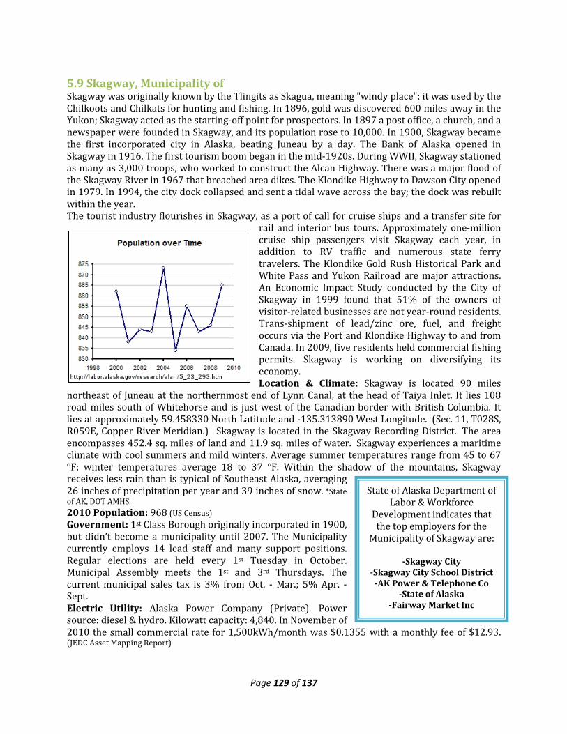
Page 129 of 137
State of Alaska Department of Labor & Workforce
Development indicates that the top employers for the
Municipality of Skagway are:
-Skagway City -Skagway City School District
-AK Power & Telephone Co -State of Alaska
-Fairway Market Inc
5.9 Skagway, Municipality of Skagway was originally known by the Tlingits as Skagua, meaning "windy place"; it was used by the Chilkoots and Chilkats for hunting and fishing. In 1896, gold was discovered 600 miles away in the Yukon; Skagway acted as the starting-off point for prospectors. In 1897 a post office, a church, and a newspaper were founded in Skagway, and its population rose to 10,000. In 1900, Skagway became the first incorporated city in Alaska, beating Juneau by a day. The Bank of Alaska opened in Skagway in 1916. The first tourism boom began in the mid-1920s. During WWII, Skagway stationed as many as 3,000 troops, who worked to construct the Alcan Highway. There was a major flood of the Skagway River in 1967 that breached area dikes. The Klondike Highway to Dawson City opened in 1979. In 1994, the city dock collapsed and sent a tidal wave across the bay; the dock was rebuilt within the year. The tourist industry flourishes in Skagway, as a port of call for cruise ships and a transfer site for
rail and interior bus tours. Approximately one-million cruise ship passengers visit Skagway each year, in addition to RV traffic and numerous state ferry travelers. The Klondike Gold Rush Historical Park and White Pass and Yukon Railroad are major attractions. An Economic Impact Study conducted by the City of Skagway in 1999 found that 51% of the owners of visitor-related businesses are not year-round residents. Trans-shipment of lead/zinc ore, fuel, and freight occurs via the Port and Klondike Highway to and from Canada. In 2009, five residents held commercial fishing permits. Skagway is working on diversifying its economy. Location & Climate: Skagway is located 90 miles
northeast of Juneau at the northernmost end of Lynn Canal, at the head of Taiya Inlet. It lies 108 road miles south of Whitehorse and is just west of the Canadian border with British Columbia. It lies at approximately 59.458330 North Latitude and -135.313890 West Longitude. (Sec. 11, T028S, R059E, Copper River Meridian.) Skagway is located in the Skagway Recording District. The area encompasses 452.4 sq. miles of land and 11.9 sq. miles of water. Skagway experiences a maritime climate with cool summers and mild winters. Average summer temperatures range from 45 to 67 °F; winter temperatures average 18 to 37 °F. Within the shadow of the mountains, Skagway receives less rain than is typical of Southeast Alaska, averaging 26 inches of precipitation per year and 39 inches of snow. *State of AK, DOT AMHS. 2010 Population: 968 (US Census) Government: 1st Class Borough originally incorporated in 1900, but didn’t become a municipality until 2007. The Municipality currently employs 14 lead staff and many support positions. Regular elections are held every 1st Tuesday in October. Municipal Assembly meets the 1st and 3rd Thursdays. The current municipal sales tax is 3% from Oct. - Mar.; 5% Apr. - Sept. Electric Utility: Alaska Power Company (Private). Power source: diesel & hydro. Kilowatt capacity: 4,840. In November of 2010 the small commercial rate for 1,500kWh/month was $0.1355 with a monthly fee of $12.93. (JEDC Asset Mapping Report)
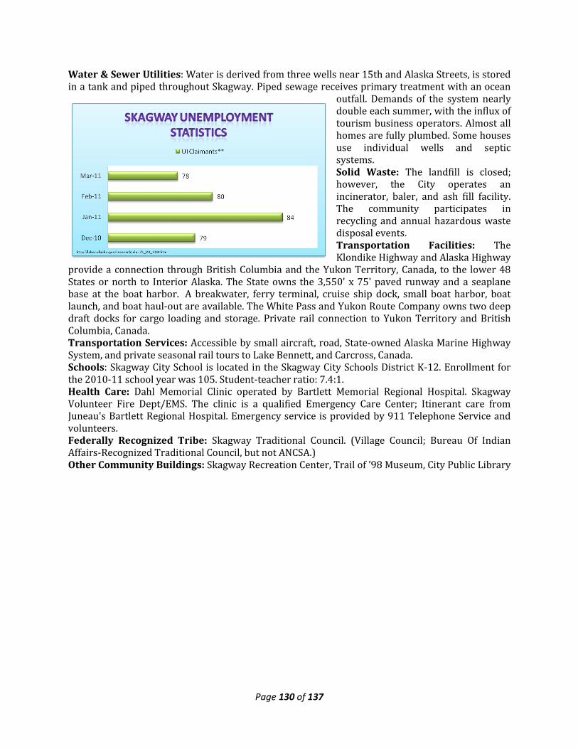
Page 130 of 137
Water & Sewer Utilities: Water is derived from three wells near 15th and Alaska Streets, is stored in a tank and piped throughout Skagway. Piped sewage receives primary treatment with an ocean
outfall. Demands of the system nearly double each summer, with the influx of tourism business operators. Almost all homes are fully plumbed. Some houses use individual wells and septic systems. Solid Waste: The landfill is closed; however, the City operates an incinerator, baler, and ash fill facility. The community participates in recycling and annual hazardous waste disposal events. Transportation Facilities: The Klondike Highway and Alaska Highway
provide a connection through British Columbia and the Yukon Territory, Canada, to the lower 48 States or north to Interior Alaska. The State owns the 3,550' x 75' paved runway and a seaplane base at the boat harbor. A breakwater, ferry terminal, cruise ship dock, small boat harbor, boat launch, and boat haul-out are available. The White Pass and Yukon Route Company owns two deep draft docks for cargo loading and storage. Private rail connection to Yukon Territory and British Columbia, Canada. Transportation Services: Accessible by small aircraft, road, State-owned Alaska Marine Highway System, and private seasonal rail tours to Lake Bennett, and Carcross, Canada. Schools: Skagway City School is located in the Skagway City Schools District K-12. Enrollment for the 2010-11 school year was 105. Student-teacher ratio: 7.4:1. Health Care: Dahl Memorial Clinic operated by Bartlett Memorial Regional Hospital. Skagway Volunteer Fire Dept/EMS. The clinic is a qualified Emergency Care Center; Itinerant care from Juneau's Bartlett Regional Hospital. Emergency service is provided by 911 Telephone Service and volunteers. Federally Recognized Tribe: Skagway Traditional Council. (Village Council; Bureau Of Indian Affairs-Recognized Traditional Council, but not ANCSA.) Other Community Buildings: Skagway Recreation Center, Trail of ’98 Museum, City Public Library
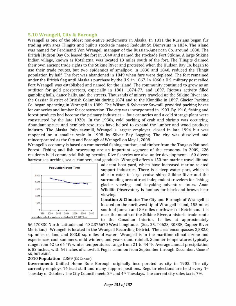
Page 131 of 137
5.10 Wrangell, City & Borough Wrangell is one of the oldest non-Native settlements in Alaska. In 1811 the Russians began fur trading with area Tlingits and built a stockade named Redoubt St. Dionysius in 1834. The island was named for Ferdinand Von Wrangel, manager of the Russian-American Co. around 1830. The British Hudson Bay Co. leased the fort in 1840 and named the stockade Fort Stikine. A large Stikine Indian village, known as Kotzlitzna, was located 13 miles south of the fort. The Tlingits claimed their own ancient trade rights to the Stikine River and protested when the Hudson Bay Co. began to use their trade routes, but two epidemics of smallpox, in 1836 and 1840, reduced the Tlingit population by half. The fort was abandoned in 1849 when furs were depleted. The fort remained under the British flag until Alaska's purchase by the U.S. in 1867. In 1868 a U.S. military post called Fort Wrangell was established and named for the island. The community continued to grow as an outfitter for gold prospectors, especially in 1861, 1874-77, and 1897. Riotous activity filled gambling halls, dance halls, and the streets. Thousands of miners traveled up the Stikine River into the Cassiar District of British Columbia during 1874 and to the Klondike in 1897. Glacier Packing Co. began operating in Wrangell in 1889. The Wilson & Sylvester Sawmill provided packing boxes for canneries and lumber for construction. The city was incorporated in 1903. By 1916, fishing and forest products had become the primary industries -- four canneries and a cold storage plant were constructed by the late 1920s. In the 1930s, cold packing of crab and shrimp was occurring. Abundant spruce and hemlock resources have helped to expand the lumber and wood products industry. The Alaska Pulp sawmill, Wrangell's largest employer, closed in late 1994 but was reopened on a smaller scale in 1998 by Silver Bay Logging. The city was dissolved and reincorporated as the City and Borough of Wrangell on May 1, 2008. Wrangell's economy is based on commercial fishing, tourism, and timber from the Tongass National Forest. Fishing and fish processing are an important segment of the economy. In 2009, 226 residents held commercial fishing permits. Dive fisheries are also under development -- 60 divers harvest sea urchins, sea cucumbers, and geoducks. Wrangell offers a 150-ton marine travel lift and
adjacent boat yard, which have increased marine-related support industries. There is a deep-water port, which is able to cater to large cruise ships. Stikine River and the surrounding area attract independent travelers for fishing, glacier viewing, and kayaking adventure tours. Anan Wildlife Observatory is famous for black and brown bear viewing. Location & Climate: The City and Borough of Wrangell is located on the northwest tip of Wrangell Island, 155 miles south of Juneau and 89 miles northwest of Ketchikan. It is near the mouth of the Stikine River, a historic trade route to the Canadian Interior. It lies at approximately
56.470830 North Latitude and -132.376670 West Longitude. (Sec. 25, T062S, R083E, Copper River Meridian.) Wrangell is located in the Wrangell Recording District. The area encompasses 2,582.0 sq. miles of land and 883.0 sq. miles of water. Wrangell is in the maritime climatic zone and experiences cool summers, mild winters, and year-round rainfall. Summer temperatures typically range from 42 to 64 °F; winter temperatures range from 21 to 44 °F. Average annual precipitation is 82 inches, with 64 inches of snowfall. Fog is common from September through December. *State of AK, DOT AMHS. 2010 Population: 2,369 (US Census) Government: Unified Home Rule Borough originally incorporated as city in 1903. The city currently employs 14 lead staff and many support positions. Regular elections are held every 1st Tuesday of October. The City Council meets 2nd and 4th Tuesdays. The current city sales tax is 7%.
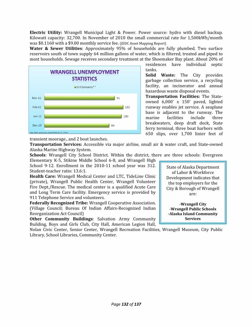
Page 132 of 137
State of Alaska Department of Labor & Workforce
Development indicates that the top employers for the
City & Borough of Wrangell are:
-Wrangell City
-Wrangell Public Schools -Alaska Island Community
Services
Electric Utility: Wrangell Municipal Light & Power. Power source: hydro with diesel backup. Kilowatt capacity: 32,700. In November of 2010 the small commercial rate for 1,500kWh/month was $0.1160 with a $9.00 monthly service fee. (JEDC Asset Mapping Report) Water & Sewer Utilities: Approximately 95% of households are fully plumbed. Two surface reservoirs south of town supply 64 million gallons of water, which is filtered, treated and piped to most households. Sewage receives secondary treatment at the Shoemaker Bay plant. About 20% of
residences have individual septic tanks. Solid Waste: The City provides garbage collection service, a recycling facility, an incinerator and annual hazardous waste disposal events. Transportation Facilities: The State-owned 6,000' x 150' paved, lighted runway enables jet service. A seaplane base is adjacent to the runway. The marine facilities include three breakwaters, deep draft dock, State ferry terminal, three boat harbors with 650 slips, over 1,700 linier feet of
transient moorage., and 2 boat launches. Transportation Services: Accessible via major airline, small air & water craft, and State-owned Alaska Marine Highway System. Schools: Wrangell City School District. Within the district, there are three schools: Evergreen Elementary K-5, Stikine Middle School 6-8, and Wrangell High School 9-12. Enrollment in the 2010-11 school year was 312. Student-teacher ratio: 13.6:1. Health Care: Wrangell Medical Center and LTC, TideLine Clinic (private), Wrangell Public Health Center, Wrangell Volunteer Fire Dept./Rescue. The medical center is a qualified Acute Care and Long Term Care facility. Emergency service is provided by 911 Telephone Service and volunteers. Federally Recognized Tribe: Wrangell Cooperative Association. (Village Council; Bureau Of Indian Affairs-Recognized Indian Reorganization Act Council) Other Community Buildings: Salvation Army Community Building, Boys and Girls Club, City Hall, American Legion Hall, Nolan Civic Center, Senior Center, Wrangell Recreation Facilities, Wrangell Museum, City Public Library, School Libraries, Community Center.
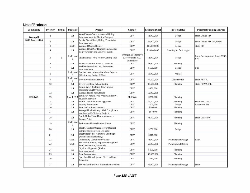
Page 133 of 137
List of Projects:
Community Priority Tribal Strategy Project Contact Estimated Cost Project Status Potential Funding Sources
Wrangell 1 1.1 Wood Street Cosntruction and Utility Improvements for Medical Campus CBW $1,000,000 Design State, Denali, RD
2011 Project List 2 1.1 Cassiar Street Road/Utility/Pedestrian Improvements
CBW $4,000,000 Design State, Denali, RD, IRR, CDBG
3 Goal 1 Wrangell Medical Center CBW $26,000,000 Design State, RD
4 1.1 Wrangell Boat Yard Improvements: 250 Ton Travel Lift and Concrete Work CBW $10,000,000 Planning for final stages
5 1 Goal 1 and 2 Chief Shakes Tribal House/Carving Shed
Wrangell Cooperative Association: S HED
Committee$1,000,000 Design Rural Development; State; CDBG;
NPS
6 1.1 Waste Reduction Facility - Turnkey CBW $3,000,000 Planning
7 1.1 Webber Street Road and Pedestrian Improvements CBW $500,000 Design IRR
8 Goal 1 and 3
Sunrise Lake - alternative Water Source (Monitoring, Design, NEPA)
CBW $3,000,000 Pre EIS
9 Goal 1 and 2
Downtown Revitalization CBW $9,200,000 Construction State, FHWA,
10 1.1 Evergreen Road Rehabilitation CBW $3,500,000 Planning State, FHWA, IRR
11 1.1 Public Safety Building Renovations - Including Court System CBW $950,000
12 1.1 Wrangell Road Resrufacing CBW $2,000,000
SEASWA 13 Goal 1 , 2, 3 Southeast Alaska solid Waste Authority - SEASWA Start Up SEASWA $250,000 Planning
14 1.1 Water Treatment Plant Upgrades CBW $2,300,000 Planning State, RD, CDBG15 1.1 Library Automation CBW $100,000 Design Rasmuson, RD16 1.1 Pool Locker Replacements CBW $50,000 Planning
17 1.1 Wrangell Radio Group - ADA Compliance and Energy Eefficiency Project
CBW $67,000 Planning
18 1.1 South Mitkof Island Improvements - Banana Point CBW $1,500,000 Planning State, USFS-RAC
19 Goal 1 and 2
Retirement Home/Pioneer Home CBW Planning
20 1.1 Electric System Upgrades (for Medical Campus and Boat Haul Out Yard)
CBW $250,000 Design
21 1.1 Electrification of Municipal Buildings (Middle and Elementary) CBW $517,000
22 Goal 1 Community Center Renovations CBW $1,000,000 Planning and Design HUD;
23 Goal 1 Recreation Facility Improvements (Pool Roof, Mechanical, Remodel) CBW $2,000,000 Planning and Design
24 1.2 City Park Upgrades (Shelter Improvements)
CBW $100,000 Planning
25 1.1 Dam Replacement CBW $3,000,000 Planning
26 1.1 Spur Road Development Electrical Line Extension CBW $180,000 Planning
27 1.1 Shoemaker Bay Float System Replacement CBW $8,000,000 Planning and Design State
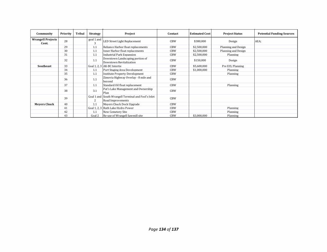
Page 134 of 137
Community Priority Tribal Strategy Project Contact Estimated Cost Project Status Potential Funding Sources
Wrangell Projects Cont.
28 goal 1 and 3 LED Street Light Replacement CBW $380,000 Design AEA;
29 1.1 Reliance Harbor float replacements CBW $2,500,000 Planning and Design30 1.1 Inner Harbor float replacements CBW $2,500,000 Planning and Design31 1.1 Industrial Park Expansion CBW $2,500,000 Planning
32 1.1 Downtown Landscaping portion of Downtown Revitalization
CBW $150,000 Design
Southeast 33 Goal 1, 2, 3 AK-BC Intertie CBW $5,600,000 Pre EIS; Planning34 1.1 Port Staging Area Development CBW $1,000,000 Planning35 1.1 Institute Property Development CBW Planning
36 1.1 Zimovia Highway Overlay - 8 mile and beyond CBW
37 1.1 Standard Oil float replacement CBW Planning
38 3.1 Pat's Lake Management and Ownership Plan CBW
39 Goal 1 and 2
South Wrangell Terminal and Fool's Inlet Road Improvements CBW
Meyers Chuck 40 1.1 Meyers Chuck Dock Upgrade CBW41 Goal 1, 2, 3 Ruth Lake Hydro Power CBW Planning42 1.1 New Cemetery Site CBW Planning43 Goal 2 Re-use of Wrangell Sawmill site CBW $3,000,000 Planning
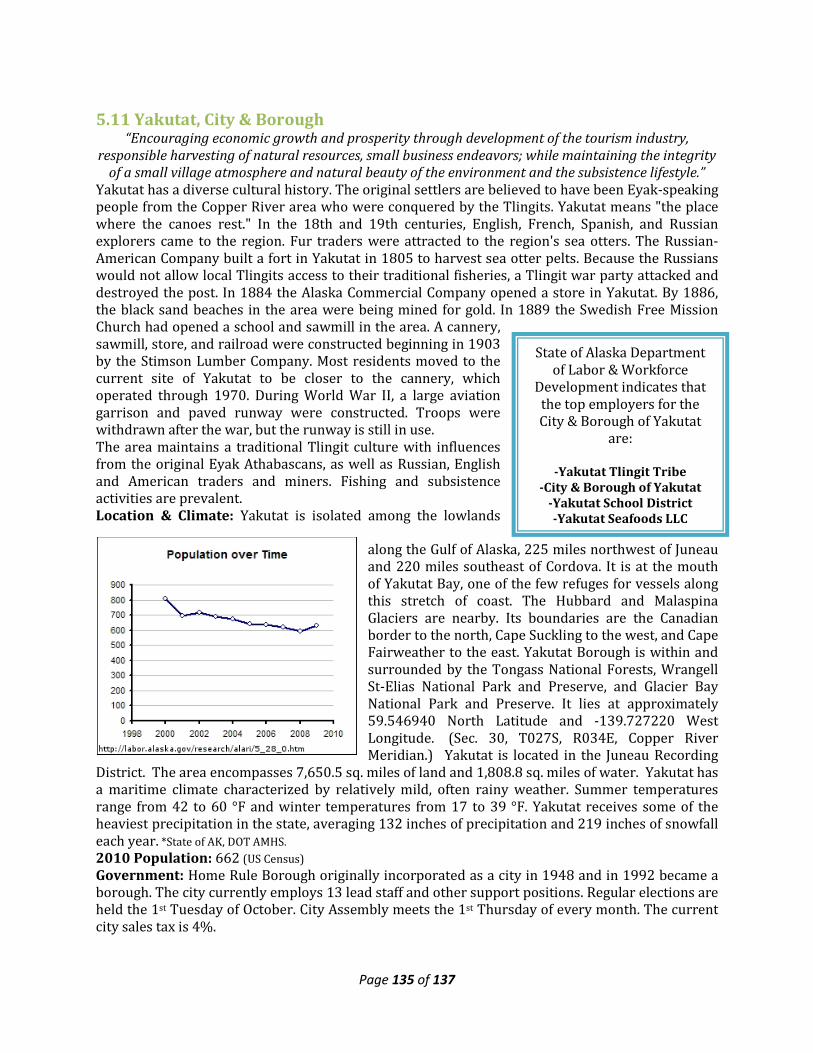
Page 135 of 137
State of Alaska Department of Labor & Workforce
Development indicates that the top employers for the City & Borough of Yakutat
are:
-Yakutat Tlingit Tribe -City & Borough of Yakutat
-Yakutat School District -Yakutat Seafoods LLC
5.11 Yakutat, City & Borough “Encouraging economic growth and prosperity through development of the tourism industry,
responsible harvesting of natural resources, small business endeavors; while maintaining the integrity of a small village atmosphere and natural beauty of the environment and the subsistence lifestyle.”
Yakutat has a diverse cultural history. The original settlers are believed to have been Eyak-speaking people from the Copper River area who were conquered by the Tlingits. Yakutat means "the place where the canoes rest." In the 18th and 19th centuries, English, French, Spanish, and Russian explorers came to the region. Fur traders were attracted to the region's sea otters. The Russian-American Company built a fort in Yakutat in 1805 to harvest sea otter pelts. Because the Russians would not allow local Tlingits access to their traditional fisheries, a Tlingit war party attacked and destroyed the post. In 1884 the Alaska Commercial Company opened a store in Yakutat. By 1886, the black sand beaches in the area were being mined for gold. In 1889 the Swedish Free Mission Church had opened a school and sawmill in the area. A cannery, sawmill, store, and railroad were constructed beginning in 1903 by the Stimson Lumber Company. Most residents moved to the current site of Yakutat to be closer to the cannery, which operated through 1970. During World War II, a large aviation garrison and paved runway were constructed. Troops were withdrawn after the war, but the runway is still in use. The area maintains a traditional Tlingit culture with influences from the original Eyak Athabascans, as well as Russian, English and American traders and miners. Fishing and subsistence activities are prevalent. Location & Climate: Yakutat is isolated among the lowlands
along the Gulf of Alaska, 225 miles northwest of Juneau and 220 miles southeast of Cordova. It is at the mouth of Yakutat Bay, one of the few refuges for vessels along this stretch of coast. The Hubbard and Malaspina Glaciers are nearby. Its boundaries are the Canadian border to the north, Cape Suckling to the west, and Cape Fairweather to the east. Yakutat Borough is within and surrounded by the Tongass National Forests, Wrangell St-Elias National Park and Preserve, and Glacier Bay National Park and Preserve. It lies at approximately 59.546940 North Latitude and -139.727220 West Longitude. (Sec. 30, T027S, R034E, Copper River Meridian.) Yakutat is located in the Juneau Recording
District. The area encompasses 7,650.5 sq. miles of land and 1,808.8 sq. miles of water. Yakutat has a maritime climate characterized by relatively mild, often rainy weather. Summer temperatures range from 42 to 60 °F and winter temperatures from 17 to 39 °F. Yakutat receives some of the heaviest precipitation in the state, averaging 132 inches of precipitation and 219 inches of snowfall each year. *State of AK, DOT AMHS. 2010 Population: 662 (US Census) Government: Home Rule Borough originally incorporated as a city in 1948 and in 1992 became a borough. The city currently employs 13 lead staff and other support positions. Regular elections are held the 1st Tuesday of October. City Assembly meets the 1st Thursday of every month. The current city sales tax is 4%.
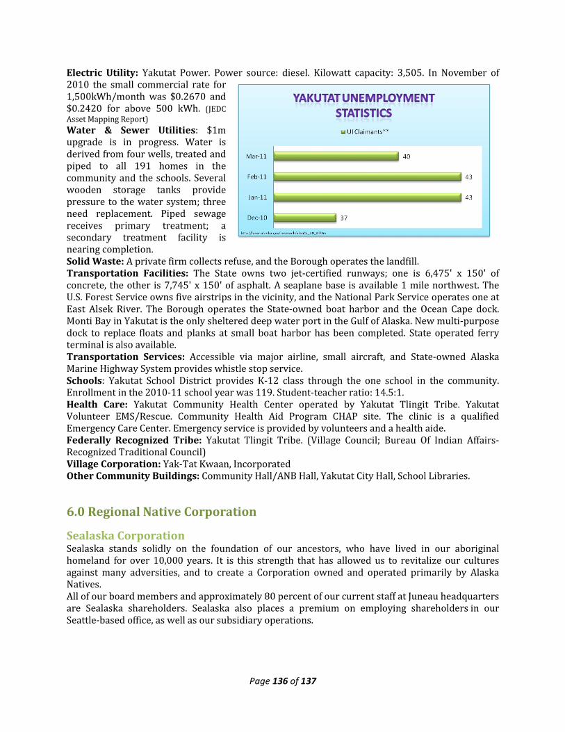
Page 136 of 137
Electric Utility: Yakutat Power. Power source: diesel. Kilowatt capacity: 3,505. In November of 2010 the small commercial rate for 1,500kWh/month was $0.2670 and $0.2420 for above 500 kWh. (JEDC Asset Mapping Report) Water & Sewer Utilities: $1m upgrade is in progress. Water is derived from four wells, treated and piped to all 191 homes in the community and the schools. Several wooden storage tanks provide pressure to the water system; three need replacement. Piped sewage receives primary treatment; a secondary treatment facility is nearing completion. Solid Waste: A private firm collects refuse, and the Borough operates the landfill. Transportation Facilities: The State owns two jet-certified runways; one is 6,475' x 150' of concrete, the other is 7,745' x 150' of asphalt. A seaplane base is available 1 mile northwest. The U.S. Forest Service owns five airstrips in the vicinity, and the National Park Service operates one at East Alsek River. The Borough operates the State-owned boat harbor and the Ocean Cape dock. Monti Bay in Yakutat is the only sheltered deep water port in the Gulf of Alaska. New multi-purpose dock to replace floats and planks at small boat harbor has been completed. State operated ferry terminal is also available. Transportation Services: Accessible via major airline, small aircraft, and State-owned Alaska Marine Highway System provides whistle stop service. Schools: Yakutat School District provides K-12 class through the one school in the community. Enrollment in the 2010-11 school year was 119. Student-teacher ratio: 14.5:1. Health Care: Yakutat Community Health Center operated by Yakutat Tlingit Tribe. Yakutat Volunteer EMS/Rescue. Community Health Aid Program CHAP site. The clinic is a qualified Emergency Care Center. Emergency service is provided by volunteers and a health aide. Federally Recognized Tribe: Yakutat Tlingit Tribe. (Village Council; Bureau Of Indian Affairs-Recognized Traditional Council) Village Corporation: Yak-Tat Kwaan, Incorporated Other Community Buildings: Community Hall/ANB Hall, Yakutat City Hall, School Libraries.
6.0 Regional Native Corporation
Sealaska Corporation Sealaska stands solidly on the foundation of our ancestors, who have lived in our aboriginal homeland for over 10,000 years. It is this strength that has allowed us to revitalize our cultures against many adversities, and to create a Corporation owned and operated primarily by Alaska Natives. All of our board members and approximately 80 percent of our current staff at Juneau headquarters are Sealaska shareholders. Sealaska also places a premium on employing shareholders in our Seattle-based office, as well as our subsidiary operations.
Page 137 of 137
Our commitment is to continually build Sealaska leadership from within the Native community. In this capacity, Sealaska offers a variety of internships and scholarships so our Native youth can learn from those who went before them and lead our company into the future. We are the descendants of the original inhabitants of Southeast Alaska and we carry the strengths of our culture and our Native values into the 21st century. Our heritage is our connection to the land and our commitment to future generations. To survive as Alaska Native people we must take the gifts of our past and use every effort today to keep our culture, language, art, stories, songs and Native values alive. The success of Sealaska's business operations enables us to support activities and programs that strengthen our cultural way of life. The Sealaska Heritage Institute (SHI) is a Native nonprofit organization conceived by clan leaders, traditional scholars and Elders at the first Sealaska Elders Conference in 1980 and established in 1981 by Sealaska Corporation.