Embed Size (px)
Citation preview


Table of Contents INTRODUCTION ...................................................................................................................1 I. Street Design Concepts..................................................................................2 II. Street Width ....................................................................................................2 III. Block Length ...................................................................................................5 IV. Connectivity ....................................................................................................5 V. Pedestrians and Bicycle Amenities ................................................................6 VI. Examples from Selected Cities.......................................................................8 A. Sacramento .................................................................................8 B. Eugene, Oregon..........................................................................9 SUGGESTED STREET STANDARDS .................................................................................10 VII. Local Streets ...................................................................................................10 VIII. Collector Streets .............................................................................................10 IX. Arterial Streets ................................................................................................10 MAKING STREETS MATCH THEIR CONTEXT...................................................................18 PLANNING FOR TRANSIT ...................................................................................................20 RE-DEVELOPMENT IN CONSTRAINED RIGHT-OF-WAYS...............................................22 LOCAL EXAMPLES ............................................................................................................23 Table of Figures Figure 1: Relationship Between Pavement Width and Speed.......................................2
Figure 2: Neighborhood Street Sizes.............................................................................4
Figure 3: Relationship Between Unimpeded Block Length and Speed .........................5
Figure 4: An Example of Poor Street Connectivity in the Sacramento Area .................6
Figure 5: Street Standards.............................................................................................11
Figure 6: Low-Volume Local Residential Street.............................................................13
Figure 7: Local Industrial Street .....................................................................................14
Figure 8: Front-Loading Residential Collector ...............................................................15
Figure 9: Main Street......................................................................................................16
Figure 10: Minor Commercial Arterial Street....................................................................17
Figure 11: Combinations of Street Types and Functional Classifications .......................18
Complete Streets Best Practices

INTRODUCTION Historically, jurisdictions have relied on street standards based on the anticipated traffic volume of a given street without consideration of adjacent land uses. This volume-oriented approach, while simple and direct, does not allow the street designer much flexibility when creating a new street. Moreover, it often results in streets that perform poorly in other respects, such as serving pedestrians and bicyclists and in enhancing the visual appeal and quality-of-life of the area it serves. This document outlines an approach to designing streets that are more “complete” in the sense of accomplishing all of the goals associated with the dominant form of public space in urban societies – our streets. The purpose of this booklet is threefold:
• To provide suggested street standards for use when designing new streets and developments and when planning for future transit corridors
• To provide guidance when dealing with a constrained right-of-way
• To illustrate local examples of streets that work or do not work for various user groups
This booklet focuses on urban and suburban streets in accordance with the urban focus of the visioning exercise. Rural roads warrant a different type of evaluation and a different set of standards. In some parts of Sacramento County rural roads are being transformed into urban streets due to development of nearby properties. In such cases these guidelines may be helpful in determining the right-of-way that should be preserved to allow for a successful transition to urban standards. This booklet provides some suggestions on traffic calming features that can be built-into street designs, but it is not intended to address the broader topic of traffic calming, for which guidance is available from several other documents1. Traffic calming measures are largely intended to address unforeseen problems that arise after roadways are constructed. While traffic calming can be included in the initial design of streets, the specific treatments are a function of very localized circumstances.
1 For example Traffic Calming – State of the Practice, Reid Ewing for FHWA, 1999
Complete Streets Best Practices October 2005
1

I. Street Design Concepts Complete streets are those that adequately provide for all roadway users, including bicyclists, pedestrians, transit riders, and motorists, to the extent appropriate to the function and context of the street. American streets were once quite successful in this regard. However, for several decades there was a drift towards a focus on the automobile. More recently there has been a growing recognition that minimizing driving delay should not be the only goal of a roadway and may even be undesirable depending on the context. Street design is now recognized as an important determinant of neighborhood character and quality of life. This has resulted in growing public pressure to:
Improve the functionality and appearance of new streets
Facilitate pedestrian and bicycle travel
Reduce the potential for speeding and other safety problems without resorting to speed bumps
Introduce desirable design elements, such as landscaped strips and detached sidewalks
that are commonly found in older residential neighborhoods
Use shorter blocks in certain environments, such as along residential, commercial, and downtown corridors, to slow traffic and shorten walking distances.
II. Street Width Research shows that narrower streets result in slower travel speeds. For example, a recent study conducted in the City of Longmont, Colorado (population 72,000) looked at 20,000 police collision reports to determine the effect of street design in contributing to accidents. The most significant relationship between injury accidents and street design was found to be with street width and curvature. As street widths widen, accidents per mile increase exponentially.2
Figure 1: Relationship Between Pavement Width and Speed Additional research has found that3:
Wider streets experience higher
average and 85th percentile speeds than narrow streets. Residents’ perception of the impact of traffic on quality of life correlates strongly and negatively with speeds. Where speeds are high, residents are more likely to perceive a degraded quality of life
Source: City of San Antonio, Texas
2 Peter Swift, “Residential Street Typology and Injury Accident Frequency” , 2003 3 James Daisa and John Peers, Fehr & Peer, “Narrow Residential Streets: Do They Really Slow Down
Speeds”, 1997; and Matthew Ridgway, Fehr & Peers, “Residential Streets – Quality of Life Assessment”, 1997
Complete Streets Best Practices October 2005
2
On-street parking significantly affects speeds. On-street parking on both sides of the
street visually narrows the street for those traveling along it. High parking densities on narrow streets can dramatically reduce travel speeds. Narrow streets with low parking density have an effective width similar to wide streets with high parking density. Narrow streets with high parking density have the highest “traffic calming” effect. On-street parking also provides a buffer between pedestrians and traffic.
Because street standards are determined locally and practices have evolved over time, there are great variations in residential street widths. Figure 2 depicts the range of neighborhood street widths found in the street standards of thirty-four communities. Much of the variation has to do with whether on-street parking is permitted. Nevertheless, the fact that widths vary by a factor of three in cities with the same sized automobiles, fire trucks, etc. indicates that there is more freedom to match street widths to the local context than most people realize.
Effect of Width: Wide, straight, long streets are an invitation to speed. Frequent speed humps are needed to counteract the tendency to speed on this overly wide (40ft curb-to-curb) street.
Complete Streets Best Practices October 2005
3

Figure 2: Neighborhood Street Sizes
Complete Streets Best Practices October 2005
4

III. Block Length The City of San Antonio, Texas, received many complaints regarding speeding in residential areas. Citizens perceived speeding on residential streets as a quality-of-life issue. Efforts ensued to implement traffic calming measures on existing streets. As part of this effort, data was collected to establish a relationship between travel speeds, unimpeded block length and street width. Unimpeded block length is the distance drivers may travel on a particular street segment without being required to slow or stop. The study found (see Figure 3) that streets exceeding 600 feet in unimpeded block length typically had 85th percentile speeds exceeding the legal speed limit4. As a result of these findings, new street standards were developed that limited the unimpeded street length to 900 feet when traffic volume exceeds 500 vehicles per day and further limits the unimpeded street length to 700 feet in some cases.
Figure 3: Relationship Between Unimpeded Block Length and Speed Block length also affects pedestrian routing; for example by reducing the likelihood of jaywalking. A grid pattern of short blocks provides pedestrians a choice of blockfaces from which to choose a pleasant path. This issue is taken up further in the next section. IV. Connectivity One unintended consequence of the drift towards wide residential streets with long blocks was that traffic began to cut through residential neighborhoods, since speeds were similar to those on collector streets. Instead of reducing widths, the typical response to cut-through traffic was widespread use of dead-end cul-de-sacs. Not only individual streets but entire neighborhoods were designed with only one exit or two exits that were both on the same blockface. As can be seen in the example below, one effect of these cul-de-sacs is to force all traffic onto the arterial roads. At the same time, unless these cul-de-sacs are permeable to bicyclists and pedestrians they too will be forced to use the arterial corridors, which creates conflicts and safety issues. Moreover, this design lengthens non-auto trips to the point where they may become impractical.
4 For residential streets the speed limit is 30MPH in San Antonio. The California Vehicle Code sets the
prima facie speed limit for residential streets at 25MPH, which implies that block lengths should be shorter in California than in San Antonio.
Complete Streets Best Practices October 2005
5

Stubs provided to connect to adjacent area but ignored by subsequent development
No access to east, west, or south
Figure 4: An Example of Poor Street Connectivity in the Sacramento Area In the last decade there has been a movement towards adopting street standards that encgreater connectivity. Street design should include road access in at least two directioped/bike access in at least three directions where this is not precluded by wholly incomadjacent land uses. V. Pedestrian and Bicycle
Amenities It is an all-too-common planning error to assume that pedestrian facilities are optional or only needed for walking trips. In fact, almost all trips involve walking outdoors at one or both ends. The success of rail and bus transit, but also auto-oriented facilities like city-owned parking garages, depends to some extent on the quality of the pedestrian experience leading to and from the site.
Complete Streets Best Practices October 2005
6
No access to north, south, or west
No access to north, east, or west
ourage ns and patible
Unsafe Conditions: Sometimespeople must walk whether a safeplace to do so is provided or not. Thismother is taking her child to a daycarecenter located on a road with nopedestrian facilities
No access to north, south, or west

Pedestrians and bicyclists are more exposed to the environment than auto users and so are more sensitive to design features such as the width and location of sidewalks, the presence of planting strips, shading, and street crossing conditions. The photos below show how different two walking environments can be even when sidewalks are provided in both.
Giimlot Adstrca
CoOc
The mere existence of a sidewalk is not enough; quality also matters. The street at lefthas a wide sidewalk and planting strip. The sidewalk at right is narrow, sloped, and has noshade except from utility poles that partially block the sidewalk. There is no buffer betweenpedestrians and cars; in fact, cars intrude into the pedestrian realm
ven Sacramento’s climate, the issue of shading, and thus planter strips, is particularly portant. It is ironic that some cities in California require shade trees to be planted in parking s yet forbid the creation of planting strips that would shade on-street parking.
ditional design elements that should be considered on a case-by-case basis are bulbouts, eet furniture, and display windows. In urban areas, the installation of bicycle lanes and routes n facilitate bicycle travel.
Street Furniture: Where space permits, street furniture can enhance the attractiveness of a street as well as providing resting places that extend the distance people are willing to walk
mplete Streets Best Practices tober 2005
7
VI. Examples from Selected Cities Many cities have revised their street design standards in recent years to include at least some of the design concepts discussed on the preceding pages. Here are two examples: A. Sacramento The City of Sacramento updated its streets design standards in 1998. The update was in response to a consistent message from residents that the previous set of standards did not result in livable neighborhoods, protests from the development community that the previous standards were too rigid, and City staff’s desire to improve the clarity of the design standards. Many neighborhood groups had complained that high residential traffic volumes and speeds had contributed to a decline in quality-of-life. In response, the City initiated an aggressive program of traffic calming to reduce travel speeds on existing streets with identified problems. However, the City recognized that this program required substantial resources and could only address the existing street system. The development of new street standards arose from a desire to improve the design of streets at the outset so that corrective measures will not be needed later. Additionally, it was felt by many that the best streets in Sacramento included elements such as detached sidewalks and landscaped medians that were no longer allowed in the standards. In developing the new standards, City staff adopted certain guidelines regarding right-of-way width, width of parking spaces, sidewalk design, Fire Code requirements and tree planter specifications. Some trade-offs were necessary; for example, may residents and developers wanted narrower streets while the fire department wanted wider streets. Residents wanted vertical curbs while developers wanted rolled curbs. Others advocated for wider landscaped strips and bicycle lanes, while developers desired to limit the width of the overall right-of-way. Following the development of draft standards and a public participation process, the City of Sacramento developed new standards that included:
The minimum width of local residential streets was reduced from 36 feet to 30 feet Flexibility in the design of new streets was introduced by providing options. For
example, sidewalk and planter strips were designated as minimums and can be increased at the request of the developer
For collector streets, landscaped medians are required if the projected traffic volume
exceeds a certain threshold
7” parking lanes may be included depending on the adjacent land use
Bicycle lanes are required on arterial streets
Planter strips are required on all streets.
Traffic calming devices such as bulbouts or traffic circles are encouraged to enhance the pedestrian environment
Sacramento has made some recent notable achievements with regard to street standards. At a residential street design level, Sacramento’s Pedestrian Friendly Street Standards are revised street design standards that consider pedestrian accommodation on par with the automobile. The goals and objectives are clearly articulated with the guiding policies being to diversify
Complete Streets Best Practices October 2005
8

community transportation choices and enhance neighborhood livability. The Pedestrian Friendly Street Standards were incorporated into the Design and Procedures Manual in 2003. B. Eugene, Oregon The City of Eugene adopted a Local Street Plan in 1996 that responded to desires for narrower streets, shorter blocks, greater street connectivity and a desire for the reintroduction of elements such as planter strips, detached sidewalks and alleys, commonly found in older neighborhoods, into new subdivisions. The new street standards included a reduction in the maximum block length for a residential street from 1,200 feet to 600 feet. The new standard was based on the existing grid pattern found in Eugene’s older neighborhoods, which contained blocks measuring 400 feet by 600 feet. Other key elements of the new standards for local streets included:
A range of local street classifications, based on expected traffic volume, which included minimum widths varying from 21 feet for an “access lane”, carrying less than 250 average daily traffic (ADT), to 34 feet for a medium-volume residential street carrying up to 750 ADT. Residential alleys were permitted with a width of 12 feet for one-way traffic or 16 feet for two-way traffic
Local commercial and industrial streets would have a width of 30 to 44 feet
Street connectivity was required and cul-de-sacs were discouraged unless necessitated
by topographic or other physical barriers; if cul-de-sacs were necessary, then bicycle and pedestrian connections were required, wherever possible, to connect the ends of cul-de-sacs
The key lesson to be learned from these two examples is that local jurisdictions can correct street standards that have drifted too far towards wide expanses of pavement, and successfully re-introduce elements that enhance the appeal of neighborhoods.
Complete Streets Best Practices October 2005
9

SUGGESTED STREET STANDARDS The first set of recommendations is for basic street standards. These standards include provisions for narrow street widths where low speeds are appropriate, detached sidewalks, bicycle facilities, and shorter block lengths. VII. Local Streets Key provisions of the street standards are:
The maximum width of local residential streets is 30-32 feet (two 7-foot parking lanes and two 8-9 foot travel lanes) depending on the expected traffic volume.
Landscape strips, separating the curb from the sidewalk, are required on local residential streets
Maximum block length is 600 feet for low-volume residential streets and 800 feet for medium-volume residential streets
6” Vertical curbs are required
VIII. Collector Streets Key provisions of the collector street standards are:
Landscape strips, separating the curb from the sidewalk, would be required on most new streets
Maximum block length is 1,000 feet for collector streets
On streets with on-street parking bulbouts are encouraged at intersections to reduce the crossing distance for pedestrians and discourage speeding through intersections
Roundabouts should be considered where residential streets intersect and the ultimate combined volume will exceed 1,000 vehicles daily or where the unimpeded distance on any of the approaches not subject to stop control exceeds 600 feet.
Bicycle lanes should be provided on all collector streets
IX. Arterial Streets Key provisions of the arterial street standards are:
Bulbouts would be allowed at some intersections to reduce the crossing distance for
pedestrians and discourage speeding through intersections
Maximum block length is 1,320 feet (four intersections per mile). This could be lengthened if bike/ped paths were provided that shorten the effective block length for non-auto users
Raised medians with turn pockets should be provided
Bicycle lanes should be provided on all arterial streets
Complete Streets Best Practices October 2005
10

Figure 5: Street Standards
Low Volume Residential
Medium Volume
ResidentialNon-
ResidentialFront-loading
Residential
Rear-loading Residential
(no driveways)
Non-Residential
Daily Volume (ADT) 0 - 750 750 - 1,500 up to 5,000 1,500 - 5,000 1,500 - 5,000 13,000 or less 20,000 or less 30,000 or less
No. of Travel Lanes 2 2 2 2 2 2 4 6
Width (curb-to-curb) (feet) 30 32 34 to 36 41 to 43 27 to 30 55 to 58 64 to 71 87 to 96
On-Street Parking (Y,N) Y Y Y Y N Y N N
Parking Lane Width (feet) 7 7 7 7 N/A 8 N/A N/A
Travel Lane Width (feet) 8 9 10 to 11 10 10 11 11 to 14 11 to 14Left-Turn Lane Width (feet) N/A N/A N/A N/A N/A 10 10 to 12 10 to 12Raised Median (Y,N) N N N N N N Y YMaximum Block length (ft) 600 800 800 1,000 1,000 1,000 1,300 1,300
Mimimum Sidewalk Width (feet)
5 (attached) 4.5 (detached)
5 (attached) 4.5 (detached)
5 (attached) 4.5 (detached) 6 to 8 6 to 8 6 to 8 6 to 8 6 to 8
Bicycle Lanes (Y, N) N N N Y Y Y Y Y
Transit Accomodation None NonePossibly bus
stopsPossibly bus
stopsPossibly bus
stops Bus Stops Bus StopsEnhanced Bus
Stops
Landscape strip (Y, N) Y Y Optional Y Y Y Y Y
Minimum Landscape Strip Width (feet) 6 6 6 8
15 including sidewalk
15 including sidewalk
15 including sidewalk
15 including sidewalk
Street Characteristics
Major ArterialItem Minor Arterial
Complete Streets Best Practices October 2005
11

The creation of street types that could be combined with functional classifications would allow for street designs that take into account the context of the street, that is, the adjacent land uses. There are five basic designations under this hierarchy:
• Commercial Streets – These streets are typically dominated by autos maneuvering into and out of parking lot driveways in conflict with other flows. The design goal should be to keep these movements orderly by separating the flows using detached sidewalks and marked crosswalks, bicycle lanes, and medians with turn pockets
• Mixed Use Streets – These slower streets have wide sidewalks and parking lanes.
• Main Streets – The design goal of these streets is to make pedestrians comfortable so as to encourage them to make use of adjacent land uses.
• Residential Streets – The design goal is to allow people to feel comfortable in their neighborhood. This means keeping speeds low while allowing motorists to get to and from their house without undue delay
• Industrial Streets – These streets are designed for the movement of trucks and so require wider travel lanes than, say, residential roads
The following figures illustrate the key differences among the streets.
Complete Streets Best Practices October 2005
12

Figure 6: Low-Volume Local Residential Street
Complete Streets Best Practices October 2005
13

Figure 7: Local Industrial Street
Complete Streets Best Practices October 2005
14

Figure 8: Front-Loading Residential Collector
Complete Streets Best Practices October 2005
15

Figure 9: Main Street
Complete Streets Best Practices October 2005
16

Figure 10: Minor Commercial Arterial
Complete Streets Best Practices October 2005
17
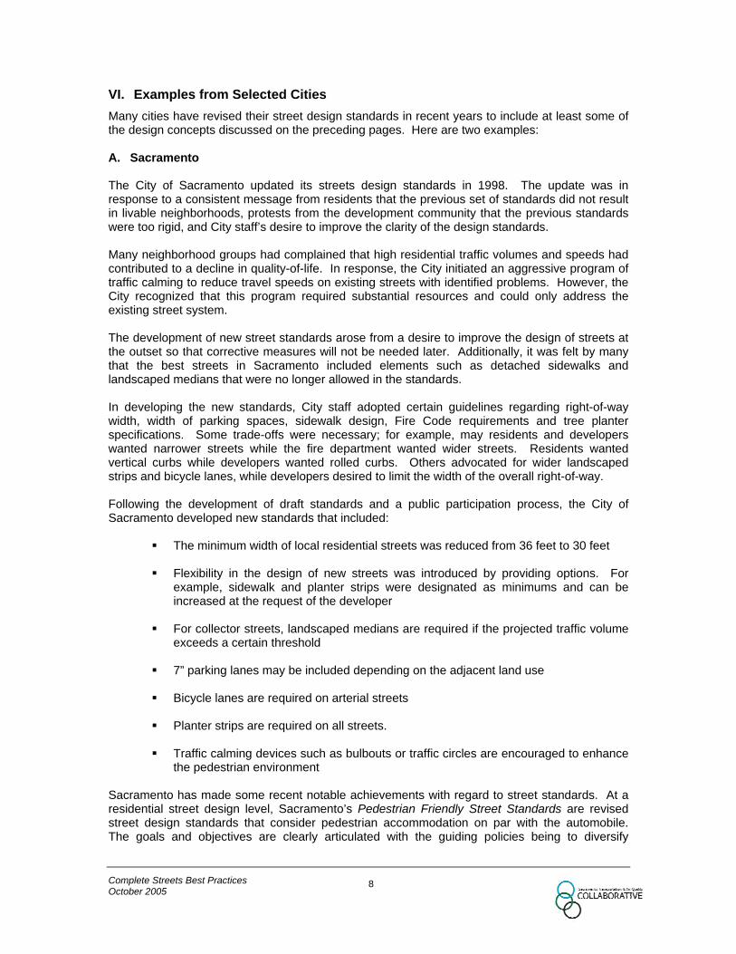
MAKING STREETS MATCH THEIR CONTEXT The next refinement in the creation of street standards is to differentiate between the different types of access needs. For instance, a downtown area or neighborhood commercial district has a much greater reliance on pedestrian mobility and on-street parking than an industrial or strip commercial districts, which typically rely on automobile mobility and off-street parking. The design of the street should reflect this context. As shown below, the traditional functional classification system (the left-hand column) can be expanded to reflect street type as well as function.
Figure 11: Combinations of Street Types and Functional Classification
Street Type Functional
Class Residential Street
Main Street
Mixed-Use Street
Commercial Street
Industrial Street
Arterial X X X Collector X X X X X Local X X X X
Note that most street types can be found in more than one functional class, and vice versa. Certain combinations such as residential/arterial seldom occur by design but occasionally occur as unintended consequences of changes to the street and/or the neighborhood. Incompatible combinations often lead to operational problems.
Incompatibility between road type and land use: This driver is attempting to back out of his driveway into an arterial road. After several unsuccessful attempts, he eventually got a family member to stand in the road to create a gap in the traffic.
The cells in the table indicate different characteristics that should be considered in design. For example, a street that has a main street type and an arterial function will have different characteristics and design features than a main street with a collector or local access function. Arterial streets serve longer distance trips than residential collector or local streets. As such, maintaining the through capacity should be a higher priority on a mixed-use arterial than on a mixed-use collector or local street. Similarly, a residential collector street and an industrial collector street have different characteristics. A mixed-use collector emphasizes accommodating several transportation modes while an industrial collector emphasizes accommodating heavy trucks and automobiles over other
Complete Streets Best Practices October 2005
18

forms of transportation. The images below show how pedestrian accommodation along a residential street, a mixed use street, and a main street can differ.
Residential Area Mixed-Use Area Main Street Developing street types that could be combined with existing functional classifications allows for the adoption of multiple design and access standards within each functional classification to account for these differing needs. This allows for the introduction of street elements and operational changes in order to provide a more balanced street function for pedestrians, bicyclists, transit users, and motorists, especially in relation to adjacent land uses.
Complete Streets Best Practices October 2005
19

PLANNING FOR TRANSIT
Most plans for the future of the Sacramento county-wide area call for communities to be more transit-oriented than is currently the case. The key design issue in planning for transit is the out-of-vehicle time (time spent waiting and time spent walking to and from the transit stop) which often plays a more important role in the decision to use transit than time spent in the vehicle itself. Lack of attention to pedestrian facilities and amenities in the recent past has been one of the leading contributors to the declining share of transit usage. Or, to put it another way, better street design can play a major role in revitalizing transit. A transit system that features a short, comfortable walk followed by a short, comfortable wait, and then concludes with a comfortable ride will be used much more than one lacking these features. Connectivity to the Neighborhood
Transit stops and bike/ped paths should be planned together so as to minimize walking distances. While this may seem obvious, there are many examples of transit stops in the region that are located where sound walls or other obstacles block access from the neighborhoods the stop is intended to serve.
Locating the east-west and north-south bus stops on the same corner encourages a more seamless transfer from one bus line to another. Bus stops also should maintain a clear area for disabled access from the bus shelter to a waiting transit vehicle.
Access from Neighborhood: This bus stop lacks convenient access to neighboring areas and has nosafe place for passengers to wait for the bus.
Bus Stop Bulbouts and Exclusive Bus Lanes
Bus bulbouts are more pedestrian friendly than bus turnouts. Besides allowing for better visibility of transit riders waiting at stops, they can be an effective traffic calming strategy for traffic adjacent to the curb. Bus turnouts should be used only where there is ample opportunity for buses to re-enter the traffic stream, such as on the far side of a traffic signal. Along corridors with high bus frequencies, exclusive bus-only lanes improve transit travel times and reliability.
Complete Streets Best Practices October 2005
20
Source: Architectural Transportation and Barriers Compliance Board

Bus Turn-out. Bus Bulb-out. Pe
Unlimtreac
En
CoOc
Mid-Block Bus Bulb-Out: Mid-block bus stops often feature a bus turn-out like the one shown in the left figure. This narrows the sidewalk in the worst possible spot; where people waiting for a bus may impede pedestrians. It may also be difficult for the bus to re-enter the traffic stream. In contrast, a mid-block bulb out removes waiting passengers from the path of pedestrians, provides a space for amenities such as benches, and makes it much easier for buses to resume their journey. The choice between the two treatments should be based on context; whether at the particular site through traffic should be favored (leading to a bus turn-out) or whether the emphasis should be on pedestrian and transit service (leading to a mid-block bulb out).
destrian Crossings
improved (unmarked or otherwise uncontrolled) pedestrian crossings near major transit stops can it access to transit as well as present a safety hazard. Providing enhanced pedestrian crossing atments near light rail stations and major bus stops can improve transit ridership through ease of cess.
hancements near transit can include:
• Shorter and fewer traffic signal phases to reduce pedestrian wait times at intersections
• High-visibility crosswalks
• Pedestrian crossing improvements such as countdown signals and audible signals.
• “Train Approaching” warning signs for LRT stations
• Priority for transit vehicles to encourage efficient transit operation
mplete Streets Best Practices tober 2005
21

RE-DEVELOPMENT IN CONSTRAINED RIGHTS-OF-WAY
The Blueprint Preferred Scenario envisions significant densification of land development in selected infill areas such as transit corridors and under-used commercial sites. This will increase the transportation demand locally (though may decrease the demand on a regional basis). In addition, the Blueprint calls for greater accommodation of non-auto modes throughout the region. Add to this the understandable reluctance on the part of agencies to accommodate these needs by widening public rights-of-way in existing neighborhoods, and it is clear that the right-of-way will need to be used differently. The tool that most cities use to guide the re-design of streets is automobile level of service (LOS). LOS is a scale that quantifies the average delay experienced by drivers at an intersection or through a corridor. Because LOS is measured on a scale from A to F, many people mistakenly believe that it is analogous to the grading system used in schools; i.e. that LOS “A” is good and LOS “D” is bad. In fact, better analogies would be temperature or weight or price, where values convey no inherent message regarding desirability; a value of one hundred (100o, 100 lbs, $100) might be either good or bad, depending on the situation. Similarly, an LOS of “B” might be desirable in some contexts (a country road) but not in others (on a main street in front of a large pre-school). This issue is important because some jurisdictions have LOS policies that hamper Blueprint-style redevelopment. Particularly unhelpful are policies that lock in a high minimum auto LOS, often “C”, while not offering similar protection to bicyclists, pedestrians, and the neighborhood the road passes through. Such policies hamper densification by:
• In some cases approval for infill projects may be denied because nearby intersections either do not meet LOS “C” prior to the project or would not meet it if the project were built. The fact that the project would reduce the overall county-wide demand for roadspace might not be taken into account
• An infill project might be allowed, but only if nearby intersections are widened. This would raise the cost of the project in order to help the auto mode in a place where transit usage is being promoted. Moreover, road widening projects in infill areas typically reduce the space available for pedestrian amenities that are more needed after the project than before.
A better practice would be to have a flexible policy that takes into account auto LOS but only as one of a number of context-related factors that need to be considered. This would ensure that the trade-offs inherent in street re-design are open to examination and discussion. For instance, in order to provide wider sidewalks through a key transit corridor, planners and engineers may need to compromise another street element, such as parking or travel lanes. One way to guide these decisions is to prioritize roadway users. When establishing bicycle, pedestrian, and transit networks, cities have an opportunity to re-visit the function of the street. Along certain streets, a city may wish to prioritize pedestrian or bicycle level-of-service over auto level-of-service. There are established ways to measure bicycle and pedestrian level-of-service, included in the Best Practices for Bicycle and Pedestrian Planning (a companion piece to this document). Current best practice is to apply level of service D as the acceptable auto level of service for all facilities, with consideration of LOS E or F for freeways, main streets, and pedestrian zones. In addition to considering modifying vehicular level of service objectives, policy direction to assess convenience and comfort of transit, pedestrian and bicycle travel may be key considerations. Level of service objectives could also include a context sensitivity component such that priority modes are identified for various street types. For example, for an industrial arterial vehicle level of service would likely be defined as the highest priority function, while for a main street (i.e., neighborhood shopping district) pedestrian level of service may be the highest priority function.
Complete Streets Best Practices October 2005
22

LOCAL EXAMPLES The photos below show examples of good and bad streets in the Sacramento area. These photos are not intended to draw attention to specific sites but rather to point out to the reader things to look for in the field.
Bad: This street lacks pedestrianfacilities and has vehicles crossing the frontage road mid-block from both sides. It is in a residential area.
Good: This street features planter strips, detached sidewalks, a planted median, and a roundabout that slows vehicles without stopping them.
Complete Streets Best Practices October 2005
23

Bad: This wide (36ft) straight street encourages speeding. Rolled curbs, narrow sidewalks, and lack of planter strips make pedestrians nervous when cars pass. Besides the extra-wide street itself, there are underground utilities in an 8ft band on the outside of the sidewalk. Shade trees must be planted outside this band, effectively eliminating any possibility of a canopy over this street.
Better: This street serves a similar neighborhood to the previous photo, but has planter strips and detached sidewalks. The improvement is immediate and will literally grow over time as the tree mature and begin to provide shade. Note the human-scale lamp post compared to the highway-style street light in the previous photo. This is another visual cue that high speeds are not appropriate in this area.
Best: This street features shaded sidewalks, planter strips, vertical curbs, short blocks and narrow lanes. This is close to the ideal for a residential street.
Complete Streets Best Practices October 2005
24

TRANSPORTATION TEAM
• David Aladjem • Mike Barnbaum • Carol Borden • Mary Brill • Lea Brooks • Margaret Buss • Tim Cahill • Barney Donnelly • Tom Garcia • Anne Geraghty • Fran Halbakken • Robert Holderness • Nancy Kays • Bob Lee • Vicki Lee • Larry Masuoka • Pamela May • Mike Penrose • Mary Poole • Mike Wiley
Complete Streets Best Practices October 2005
25