Embed Size (px)
Citation preview

i
i
TABLE OF CONTENTS
Chapter I The History of Tagaytay 1
Chapter II Geo-Physical Environment
2.1. Geophysical Location 3
2.2. Political Subdivision 3
2.3. Topography
2.3.1. Slope 5
2.4. Geology
2.4.1. Rock Formations 6
2.4.2. Soils 7
2.4.2.1. Soil Suitability Classification 8
2.4.3. Land Capability Classes 10
2.5. Land Resources
2.5.1. Existing General Land Use 13
2.5.2. Urban Land Use Pattern 20
2.6. Climate
2.6.1. Atmospheric Temperature 21
2.6.2. Relative Humidity 21
2.6.3. Rainfall 22
2.6.4. Wind Direction 22
2.6.5. Typhoons 22
Chapter III Population and Social Profile
3.1. Social Composition and Characteristics 23
3.2. Population Size and Growth Rate 24
ii
3.3. Household Distribution 26
3.4. Urban – Rural Distribution 27
3.5. Present Status of Well-Being 27
3.5.1 Health 28
3.5.2 Social Welfare 29
3.5.3 Education 30
3.5.4 Housing 31
3.5.5 Employment and Income 33
3.5.6 Recreation and Sports Facilities 33
3.5.7 Protective Services 35
Chapter IV Local Economy
4.1 The Primary Sector
4.1.1 Tourism 36
4.1.2 Agriculture 36
4.1.3 Livestock and Poultry 37
4.1.4 Commerce and Industry 38
4.2 The Secondary Sector
4.2.1 Construction 39
4.3 Tertiary Sector
4.3.1 Financial Institutions 39
4.3.2 Wholesale and Retail Trade 39
4.3.3 Transportation and Communications 39
4.3.4 Personal Services 42
4.3.5 Community Services 42
iii
Chapter V Infrastructure / Utilities / Facilities
5.1. Roads 43
5.2. Bridges 44
5.3. Domestic Water Supply 45
5.4. Electric Power Supply 46
5.5. Waste Disposal System
5.5.1. Solid Waste 47
5.5.2. Liquid Waste 48
5.6. Cemetery 48
5.7. Slaughterhouse 48
5.8. Public Market 48
Chapter VI Local Institutional Capability
6.1. Governance 50
6.2. Financial Profile
6.2.1. Income 53
6.2.2. Expenditure 54
iv
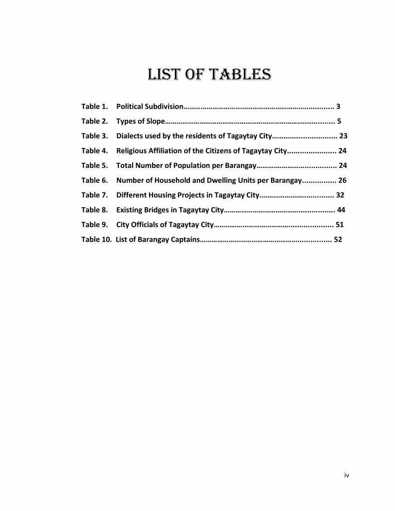
LIST OF TABLES
Table 1. Political Subdivision……………………………………………………….............. 3
Table 2. Types of Slope………………………………………………………………............... 5
Table 3. Dialects used by the residents of Tagaytay City……………................. 23
Table 4. Religious Affiliation of the Citizens of Tagaytay City....................... 24
Table 5. Total Number of Population per Barangay……….……………............... 24
Table 6. Number of Household and Dwelling Units per Barangay................ 26
Table 7. Different Housing Projects in Tagaytay City.…………………............... 32
Table 8. Existing Bridges in Tagaytay City…………………………………................. 44
Table 9. City Officials of Tagaytay City…………………………………..................... 51
Table 10. List of Barangay Captains……………………………………………................ 52
1
Chapter I
The History of Tagaytay City
Legendarily, the word Tagaytay came from “TAGA” meaning to cut and “ITAY”
which means father. A father and son were said to be on a wild boar chase when
the animal they were pursuing suddenly turned and attacked them. Fearing for his
father’s safety as the boar violently charged the old man, the son cried out “TAGA,
ITAY!” which means “cut him down, father!” The son’s exhortation and shouts
reverberated in the valleys of the ridge and were heard by the residents, wood
gatherers, hunters and kaingeros in the forests. Thus, the shout and the words
“Taga, Itay” became the subject of conversation among the people in the
countryside for several days. In time, the place from where the shouts came began
to be known as the beautiful southern city of Tagaytay.
During the Philippine Revolution of 1896, Tagaytay became a place of refuge
and hideaway for revolutionaries from the nearby provinces of Batangas and Laguna
and other neighboring towns of Masilao (now Amadeo), Malabon Grande (now Gen.
Trias), Silang, Dasmariñas, Mendez and Indang. Its central location amidst these
towns and provinces, the wild preponderance of forests on its ridges and the vast
undulating topography of its lands characterized by wide stretches of cogon offered
a ready sanctuary and haven from pursuit of the Katipuneros. As a passageway for
the revolutionary activities in the said provinces, the natives and revolutionaries
described movement to and from the towns via Tagaytay with the word
“MANANAGAYTAY,” which means traversing the ridges of Tagaytay.
At the outbreak of the Second World War, the 11th Airborne Division of
Lieutenants General William Krugers 8th Army airdropped military supplies and
personnel on the Tagaytay ridge, prior to the Liberation of Manila from the Japanese
on February 3, 1945. To commemorate this event, the city officials, in coordination
2
with the Philippine Historical Institute installed a marker at the junction of the
Silang-Canlubang-Nasugbu roads.
On June 21, 1938, Tagaytay became a chartered city with the passage and
signing by the late President Manuel L. Quezon of Commonwealth Act No. 338, a bill
authored by Rep. Justiniano S. Montano of Cavite. Among the city’s past mayors
were Arsenio Natividad, Mariano Bondoc, Melchor Benitez, Miguel Taña, Isaac
Tolentino, Hilarion Maglabe, Benjamin Erni, Francis Tolentino and Abraham N.
Tolentino. The incumbent City Mayor is Hon. Agnes D. Tolentino.
Today, the City of Tagaytay is identified as one of the priority areas for
tourism development of the Department of Tourism. Likewise, the city has been
identified in the CALABARZON as a tourist center.
3
Chapter II
Geo-Physical Environment
2.1 Geophysical Location
Tagaytay City is located in the Province of Cavite, island of Luzon. It is
approximately 56 kilometers south of Manila, with a total land area of 6,500
hectares, which represents about 5.14% of the total land area of Cavite. It lies within
120o 56’ latitude and 14o 16’ longitude and overlooks Manila Bay on the north, Taal
Volcano and Taal Lake on the south and Laguna de Bay on the east.
The city is linked by the national highway to the Metropolitan Manila Area
and to the Province of Batangas. It is also connected by roads to the adjoining
municipalities of Amadeo, Mendez, Indang, Silang and Alfonso in Cavite towards the
northwest, to the municipalities of Calamba and Sta. Rosa in Laguna in the northeast
and to the town of Talisay in Batangas in the south.
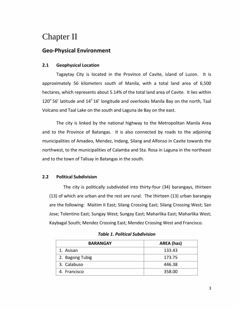
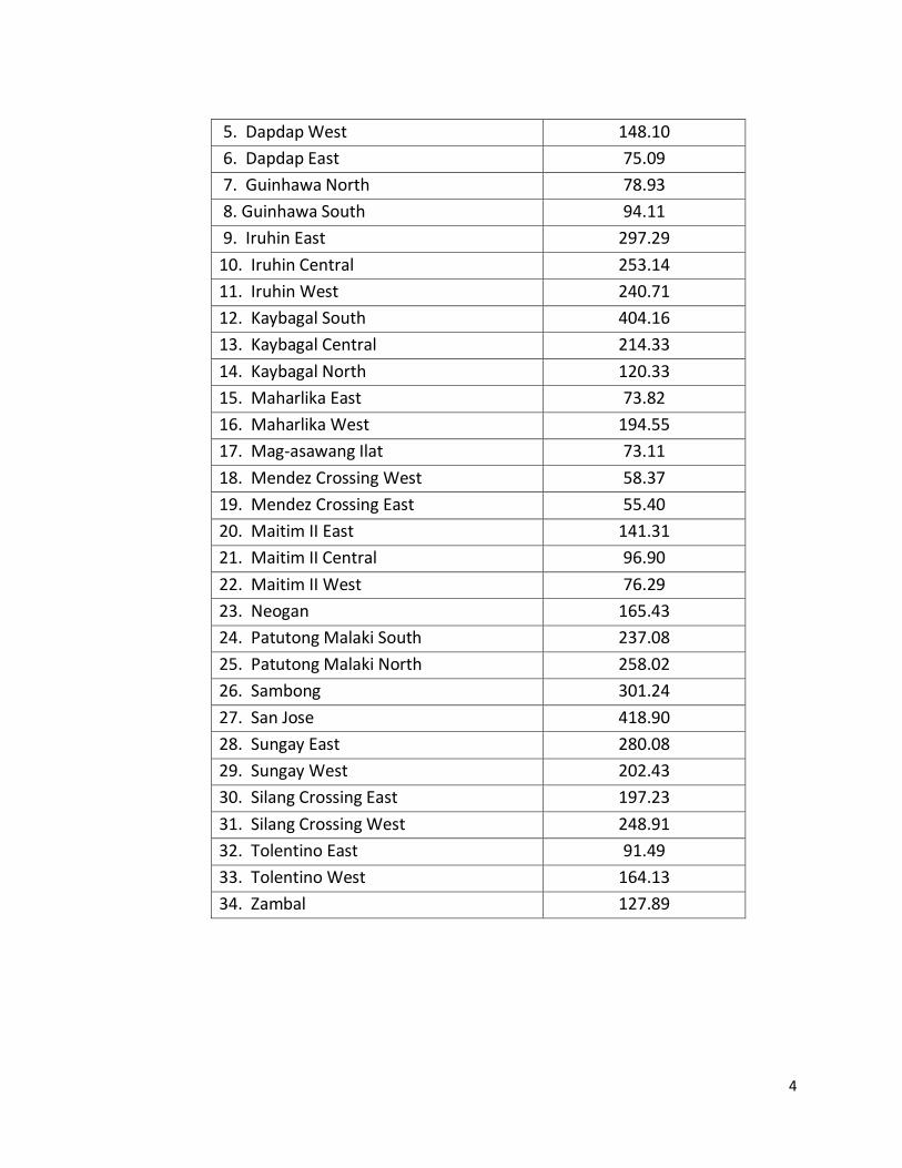
2.2 Political Subdivision
The city is politically subdivided into thirty-four (34) barangays, thirteen
(13) of which are urban and the rest are rural. The thirteen (13) urban barangay
are the following: Maitim II East; Silang Crossing East; Silang Crossing West; San
Jose; Tolentino East; Sungay West; Sungay East; Maharlika East; Maharlika West;
Kaybagal South; Mendez Crossing East; Mendez Crossing West and Francisco.
Table 1. Political Subdivision
BARANGAY AREA (has)
1. Asisan 133.43
2. Bagong Tubig 173.75
3. Calabuso 446.38
4. Francisco 358.00
4
5. Dapdap West 148.10
6. Dapdap East 75.09
7. Guinhawa North 78.93
8. Guinhawa South 94.11
9. Iruhin East 297.29
10. Iruhin Central 253.14
11. Iruhin West 240.71
12. Kaybagal South 404.16
13. Kaybagal Central 214.33
14. Kaybagal North 120.33
15. Maharlika East 73.82
16. Maharlika West 194.55
17. Mag-asawang Ilat 73.11
18. Mendez Crossing West 58.37
19. Mendez Crossing East 55.40
20. Maitim II East 141.31
21. Maitim II Central 96.90
22. Maitim II West 76.29
23. Neogan 165.43
24. Patutong Malaki South 237.08
25. Patutong Malaki North 258.02
26. Sambong 301.24
27. San Jose 418.90
28. Sungay East 280.08
29. Sungay West 202.43
30. Silang Crossing East 197.23
31. Silang Crossing West 248.91
32. Tolentino East 91.49
33. Tolentino West 164.13
34. Zambal 127.89
5
2.3 Topography
2.3.1 Slope
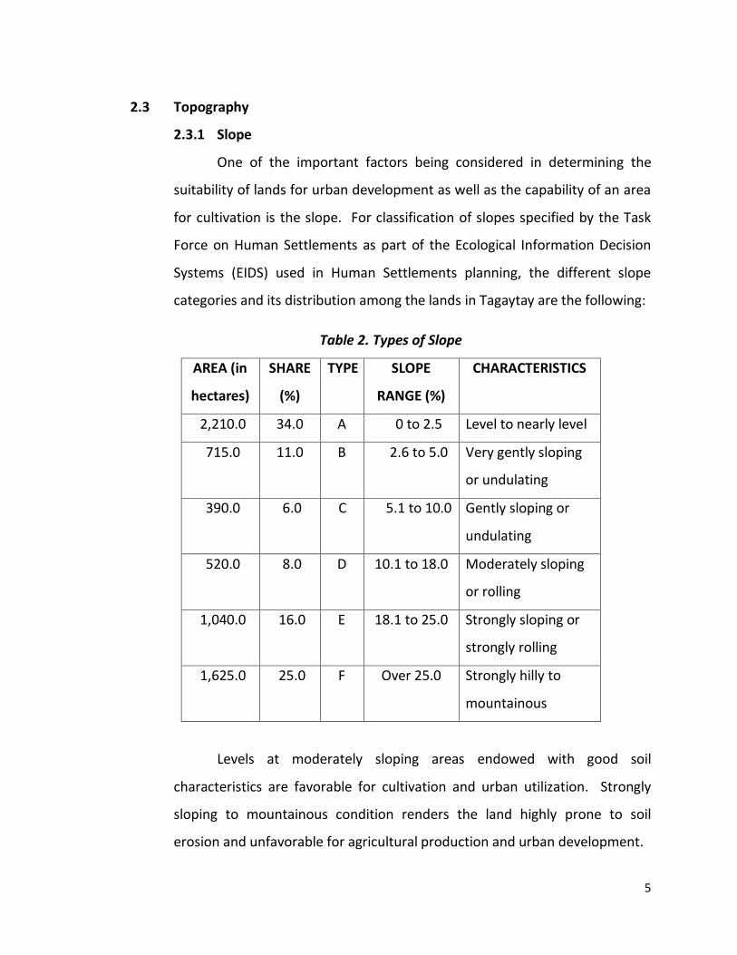
One of the important factors being considered in determining the
suitability of lands for urban development as well as the capability of an area
for cultivation is the slope. For classification of slopes specified by the Task
Force on Human Settlements as part of the Ecological Information Decision
Systems (EIDS) used in Human Settlements planning, the different slope
categories and its distribution among the lands in Tagaytay are the following:
Table 2. Types of Slope
AREA (in
hectares)
SHARE
(%)
TYPE SLOPE
RANGE (%)
CHARACTERISTICS
2,210.0 34.0 A 0 to 2.5 Level to nearly level
715.0 11.0 B 2.6 to 5.0 Very gently sloping
or undulating
390.0 6.0 C 5.1 to 10.0 Gently sloping or
undulating
520.0 8.0 D 10.1 to 18.0 Moderately sloping
or rolling
1,040.0 16.0 E 18.1 to 25.0 Strongly sloping or
strongly rolling
1,625.0 25.0 F Over 25.0 Strongly hilly to
mountainous
Levels at moderately sloping areas endowed with good soil
characteristics are favorable for cultivation and urban utilization. Strongly
sloping to mountainous condition renders the land highly prone to soil
erosion and unfavorable for agricultural production and urban development.
6
Approximately 2,665 hectares of land, which represent 41.0% of the
city’s total land area, have slopes of above 18.0%. These strongly rolling and
mountainous portions are situated along the ridge and on the eastern end of
the city. Due to the unsuitability of these mountainous and strongly sloping
portions for cultivation and urban use, most of these areas are currently
utilized as forests or abandoned as open grasslands.
Areas with Type D slopes (10.1 to 18.0 percent) cover 520.0 hectares
of land in portions of Barangays Calabuso, Dapdap, Iruhin, Sungay, Sambong,
Kaybagal, San Jose and Silang Crossing. Due to the good soil characteristics in
the city, these moderately or rolling areas are planted to diversified crops
although there are still vast tracks of open grasslands in Barangays Dapdap
and Calabuso.
Type C slopes (5.1 to 10.0 percent) are most prevalent in Barangays
Francisco, Iruhin, Sungay, Tolentino and San Jose. These gently undulating
slopes are mostly devoted to different crops due to their suitability for
cultivation.
Except for the eastern end of the city, the lands situated at the north
of the National Highway leading to Batangas have slopes ranging from 0.0 to
5.0 percent. Slopes in these thirty four percent (34%) or 2,210 hectares of
land are classified as Type A.
2.4 Geology
2.4.1 Rock Formations
The two types of rocks found in Tagaytay City are (1) volcanic rocks
and (2) clastic rocks. Volcanic rocks are made up chiefly of andesite and
basalt lava flows with some interpolated pyroclastic rocks, while clastic rocks
7
consist of interbedded shale and sandstone with occasional thin leases of
limestone, tuff and reworked sandy tuffs, calcareous and partly tuffaceous
shale.
Only approximately 128.05 hectares of land representing 1.97 percent
of the city’s total land area are underlain by volcanic rocks. These cover
portions of Barangays Dapdap, Calabuso, Iruhin East and Iruhin West. The
rest of the city is underlain by clastic rocks.
2.4.2 Soils
Knowledge of the soil types and soil characteristics provides some
guiding principles in selecting and recommending various uses of land. The
basic types of soils found in Tagaytay City belong to Tagaytay series. These
are the Tagaytay sandy loam and the Tagaytay loam.
The central and western portions of the city are covered by the
Tagaytay sandy loam. The surface soil of the Tagaytay is sandy loam which is
12 to 50 centimetres deep, dark brown to nearly black, friable and granular
sandy loam with a considerable amount of volcanic sand. The subsoil is dark
brown to very dark brown and varies in texture from clay loam to clay. It is
underlain by reddish-brown to yellowish brown adobe clay. This adobe clay
varies in depth depending on the topography of the place.
On the other hand, the eastern portion of the city is covered by
Tagaytay loam, which has a surface soil consisting of a 15 to 35-centimeter
thick layer of brown to dark brown loam containing more or less fine sandy
material. The soil is moderately friable when moist. In the disturbed
condition, it becomes hard and cakes when dry. This type of soil is easy to
work on. Among the crops that grow best in this type of soil are upland rice,
8
corn, sugarcane, coconuts, citrus, coffee, pineapple, avocado and various
vegetables.
2.4.2.1 Soil Suitability Classification
Soil suitability classification is a more specific method of
showing the relative suitability of the different soil units to specific
crops of land uses based on the soil qualities and other limitations,
which affect the crop or specific use.
Soil suitability is divided into two categories:
1. Soil Suitability for Urban Use
a. Class I (Good) – soils that have properties favorable for the
rated use with none to slight limitations that can easily be
overcome
b. Class II (Fair) – soils that have properties which are
moderately suitable for the rated use with moderate soil
limitations that can be overcome or modified with good
planning, design or special maintenance
c. Class III (Poor) – soils that have one or more characteristics
unfavourable for the rated use with severe soil limitations
that are difficult and costly to modify or overcome,
requiring major soil reclamation, special design or intensive
maintenance
d. Class IV (Not Suitable) – soils that have one or more
properties so unfavourable for urban use that overcoming
the limitation is most difficult and costly
9
2. Soil Suitability for Agricultural Use
a. Highly Suitable or Good – the soils are suitable for use
under simple but good management practices. Slight soil
limitations, if any, are easy to overcome.
b. Moderately Suitable or Fair – the presence of minor or
moderate soil limitations or restrictions can be overcome
with easily applied farming practices
c. Marginally Suitable or Poor – the existence of serious soil
limitations or restrictions can be overcome with intensive
and complex farming practices and special management,
and;
d. Not Suitable – the presence of very serious limitations or
restrictions renders the soil not suitable or uneconomical to
use under any management condition.
Based on the soil suitability study for urban use, 4,901 hectares or
75.4% of the city could be utilized for urban development. Out of this, 2,940
hectares or 60% are good lands, 882.18 hectares or 18% are rated fair while
1,078.22 hectares or 22% are rated poor. The good lands are generally
situated along the north of the national highway leading to Batangas
province. At present, the city’s built-up areas are dispersed in these lands.
On the other hand, 24.6% of the total land area or 1,599 hectares of strongly
hilly to mountainous areas along the ridge are rated as not suitable for urban
use. These strongly sloping portions of the city are currently being utilized as
forest or abandoned as open grasslands. However, even these areas are
experiencing the pressure of land conversion owing to their have
unobstructed view of the Taal Lake.
10
On the other hand, lands suitable for upland rice cover 61.63% of the
city’s total land area. These consist of highly, moderately and marginally
suitable lands which have slopes ranging from 0.0 to 5.0 percent. A survey of
the existing land use in the city revealed, however, that only an insignificant
portion of the total land area is devoted to rice production.
Lands that were once utilized as rice fields are small patches of land
dispersed in the level to nearly level lands of the city. This indicates that
areas suitable for upland rice, which are also suitable for tree crops and
diversified crops are instead being used for the production of high-income
yielding crops such as coffee, pineapple, bananas, tomatoes and string beans.
Lands suitable for diversified crops cover a total area of 4,995.25
hectares or 76.85% of the city’s total land area. On the other hand, the
mountainous area along the ridge, which is too steep for cultivation, is rated
as not suitable for diversified crops.
Lands suitable for tree crops include lands that are characterized by
strongly hilly topography. These lands, with slope qualifications that range
from Type A through D equal 61.63% of the total land area and amounts to
4,005.95 hectares are highly suitable. The strongly sloping areas covering
988.65 hectares or 15.21% of the city’s total land area are moderately
suitable while the mountainous areas generally situated along the ridge are
marginally suitable.
2.4.3. Land Capability Classes
Land capability classification is a scheme for grouping soil units
together according to the best use of lands in order to optimise production,
preserve land and prevent soil damage through improper use. The
11
classification indicated the relative suitability of land for agriculture and the
corresponding land management requirements. This serves as one of the
important bases in recommending the use land, especially for areas to be
returned for agriculture. The four major factors considered in land capability
classification are: (1) soil properties (2) degree of erosion and (300) drainage
and flooding hazard.
Land capability classes are grouped into four general uses from the
standpoint of agricultural as well as economic capabilities. This can be any or
a combination of the four general purposes, namely: (1) Lands suitable for
cultivation (2) Lands limited to pasture (3) Lands limited to forests and (4)
Lands limited to wildlife and recreation.
In Tagaytay City, the lands suited for agriculture consists of four land
capability classes. These arable lands which cover 3,836.95 hectares or
59.03% of the total land area and are currently cultivated and planted to
diversified crops such as coffee, pineapple, corn, banana, sweet potatoes,
coconuts, palay and vegetables. The land capability classes to which those
lands belong are as follows:
Land Capability Class “A”
This class includes very good lands, which can be cultivated safely and
require only simple but good farm management practices.
Land Capability Class “Be”
This class include good lands that are nearly level to gently sloping,
slightly to moderately eroded and can be cultivated safely if carefully planned
erosion control management practices and intensive soil conservation
practices are observed.
12
Land Capability Class “Ce”
This class consists of moderately good lands that are moderately
sloping, moderately to severely eroded, and can be cultivated safely if
carefully planned erosion control management practices and intensive soil
conservation practices are observed.
Land Capability Class “De”
This class include fairly good lands that are slightly sloping, moderately
to severely eroded due to excessive run-off and can be cultivated occasionally
if handled with care. These lands require very careful management and
complex conservation practices and are most suitable to pasture or tree
farms.
On the other hand the non-arable lands in the city cover 2494.05
hectares or 38.37% of the total land area. These lands are unsuitable for
agriculture and consist of land capability classes “M” and “N” which are
mostly situated along the ridge area and the eastern portion of the city.
These non-arable lands are characterized by the following:
Land Capability Class “M”
Lands included here are those which are very steep to mountainous,
excessively eroded or shallow for cultivation. Stones and rock outcrops are
occasionally present. These lands are good for grazing or for forest and need
careful farm management.
Land Capability Class “N”
This includes very steep lands, which are excessively eroded, shallow,
rough or dry for cultivation but can be used for grazing with careful
management and definite restriction. These lands are best suited to forest
with careful management.
13
2.5 Land Resources
2.5.1 Existing General Land Use
Tagaytay City has a total land area of 6,500 hectares, which is roughly
5.19% of the total land area of the Province of Cavite. The City is politically
subdivided into thirty-four (34) barangays from the original twenty (20).
1. LAND USE TYPES
As shown in Figure 1 and based on City Ordinance 97-93 series of
December 1997, the following are the land use types:
a. Tourism Strip
The tourism strip is comprised of a 60-meter northward distance
from the center of the Tagaytay-Nasugbu-Calamba Road and all areas
within 18% downward slope on the southern side of the said road. It shall
serve as one of the key venues for the “sustainable ecological tourism
base” and shall be in line with the realization of the city’s vision.
Restaurants, entertainment, recreational and similar
establishments of the urban-tourism type shall be the developments
herein. This area is also classified into two: (1) Northern Tourism Strip,
which is located at the north of Tagaytay-Nasugbu-Calamba Road, and (2)
Southern Tourism Strip, situated at the southern side of the said road.
Rules on building heights and densities shall be heavily regulated in order
to protect the general view of the Lake area. The Southern Tourism Strip
structures are still classified into: (1) Obstructive (those that block the
lake view) and (2) Non-obstructive (those that do not block the lake view).
14
b. Primary Urban Core
The block enclosed by J.P. Rizal Avenue and the Tagaytay-Nasugbu
Road is the Primary Urban Core. What make the sight an ideal urban core
are its central location, sufficient size for unitary planning and the
location of major urban facilities. All property owners shall confirm to a
pre-agreed Master Plan since this shall be a Planned Unit Development
(PUD) Area.
Developments shall focus on the provision of urban facilities and
amenities such as hotels, convention halls, parks and similar institutions.
This area shall revolve around the existing Tagaytay Centrum or the
government center.
The coverage area under PUC was expanded by virtue of Amended
Zoning Ordinance (City Ord. # 2009-054) enacted in 2009.
The areas covered are located in four (4) clusters (Clusters 1-4)
along Tagaytay-Nasugbu Road and Tagaytay-Calamba Road respectively.
c. Secondary Urban Core (SUC)
Secondary Urban Core Areas are located at the four points of
intersection, namely: Tagaytay-Mendez, Tagaytay-Amadeo and Tagaytay
Sta. Rosa and Tagaytay Aguinaldo Highway from Silang Junction extending
northward in a linear function along the Tagaytay-Manila Road. These
areas shall be of the neighborhood development type providing primary
services and facilities to the adjacent barangays. Included in the Amended
Zoning Ordinance is the expansion of coverage of SUC as covered under
Cluster 4, 5 and 6.
15
d. General Development Areas
This is the predominantly residential / subdivision area with the
necessary facilities and amenities. Easy accessibility to stores, schools,
etc. for the dynamics of urban existence are realized by allowing the
existence of these complimentary activities within one area management
unit. The opportunities to house the internal residential requirements of
the city’s population are provided by this area.
e. Agricultural Development Areas
These areas provide wedges to the general development area and
are located in the northern periphery. The center of activity shall be on
the development and strengthening of agricultural production and to
maintain the rural ambiance of the city. These areas shall also serve to
stop the severity of urban sprawl that the city has been experiencing in
the past years.
f. Ecological Development Areas
These areas comprise the steep and critical slopes and the
southern portions of the city below the ridge. Its objective is to provide a
permanent yet productive vegetative cover and its main development
thrust shall be agro-industry.
g. High Density Housing Areas
These areas are intended for socialized housing projects and are
located in the eastern, central and western parts of Tagaytay in order to
attain an even distribution of housing areas in the city.
(See Table 7 for the Different Housing Projects in Tagaytay)
16
h. Ecological Tourism Areas
These are located at the east where the quiet location, terrain and
panorama are highly suited for ecological-tourism development.
Developments in these areas need to be “…an environmentally sound
tourism activity in a given ecosystem yielding socio-economic benefits and
enhancing natural and cultural diversity conservation.”
i. Special Conservation Area
As defined by Proclamation No. 740 dated February 16, 1996, this
includes all areas within one kilometre radius from the People’s Park in
the Sky. All uses shall be in consonance to the Proclamation’s
stipulations: recreational, scientific, planned area for new development
and other similar purposes and this shall be developed as another
Planned Unit Development (PUD).
j. Special Institutional Areas
These are located on the north-eastern part of the city. Under a
quiet, rural setting, all new sites for church-related institutions are to be
located in this area.
k. Greenbelt Zone
A 30-meter greenbelt strip shall be maintained along the entire
periphery with emphasis on the major roads leading to the city to further
strengthen the Nature City image.
17
2. LAND ALLOCATION
The type of land use to which majority of land (26.73%) in Tagaytay
are devoted is the Ecological Development Area. Second is the Agricultural
Development Area (20.86%) followed by General Development Area
(20.59%).
3. LAND USE PER BARANGAY
The barangays which host the Primary Urban Core include Mendez
Crossing East, Kaybagal South, Maharlika West, Tolentino East, Silang
Crossing East and West, Sungay East and San Jose. Almost all barangays
comprise the General Development Areas except Zambal, Bagong Tubig and
Sambong (Ecological Development Area), Dapdap West, Dapdap East and
Calabuso North (Ecological Tourism Area).
4. GENERAL LAND USE SHIFTS
a. Built-up Areas
The built-up areas, which were initially confined along the major
arteries of the City, have grown considerably. The expansion has
exhibited an accelerated pace within the last decade. The core built-up
area exhibited a substantial sprawl plus the opening up of new urban
developments in the interior areas contributed to the significant annual
growth rate from 1989 to 1995 which is 16.84%. Urban sprawl posted a
27.70% annual growth rate from 1995 to 1997. This is due to the
accelerated expansion of residential subdivisions.
18
b. Agricultural Areas
By 1995, Agricultural Areas was the predominant land use with
58.50% of the city’s land. There is a great decline from 1995 to 1997 due
to its majority’s conversion from agricultural land to non-agricultural land
as the real estate industry continued to expand.
c. Woodland Areas
There has been a consistent decline of the Woodland Areas since
1946. As of 1995, the average yearly decline is 0.98%. This is due to the
continuous and increasing pressure of urbanization and the demand for
land to accommodate the increase in population. Forestland was still the
second most dominant land use type in 1995 because of the ruggedness
of the terrain.
d. Open Grasslands
The city’s open grasslands have a continuous decline from 1995 to
1989, which recorded a decrease of 9.24%.
e. Urban Land Use Shifts
When Baguio City was devastated by the 1990 Luzon earthquake,
realtors have looked toward Tagaytay as its alternative. As such, there
was a 200% increase in construction projects, both from residential and
commercial developers. Over 25 housing developers sell vacation homes
with the cool climate and panoramic view of Taal Volcano as their selling
advantage.
In 1997, Tagaytay’s urban land is primarily used for residential
purposes (60.98%). It took the place of institutions that dominated the
19
urban lands from 1980 to 1989. Also in 1997, 18.72% of the city’s urban
land is devoted to commercial and tourism related uses.
f. Land Ownership
Only minimal areas are left in the possession of the government
since most lands, including those at the steep slopes, are titled to
individual owners. Other owners are religious institutions, residential
subdivision developers and commercial / tourism realtors.
g. The Comprehensive Agrarian Reform Program (CARP)
The Comprehensive Agrarian Reform Program (CARP) has a total
coverage of 482.70 hectares. They are located at the ridges and eastern
part of the City. Barangay Iruhin East and San Jose-Silang Crossing East
Cluster are the two areas declared as Agrarian Reform Communities.
h. Land Values
Lands located at the busiest intersections and along the ridge
overlooking the Taal Lake show higher trends in the current land values.
Premium is based on the potential offered by existing density of
commercial activities and the presence of environmental amenities.
Three commercial nodes and a prime strip appear to be emerging
based on these trends. They are the Mendez Junction linked by the prime
strip defined as the Tagaytay-Nasugbu-Calamba Road. Three branch
arteries are emerging defined by the roads leading to Manila, Amadeo
and Sta. Rosa. Considering the behavior of the land market, they may be
the area that will continue to experience rapid urbanization pressures.
20
i. Assessed Values
The assessed values supplied by the City Assessor’s Office are:
Mendez Junction commercial node: ₱3,000.00 per m2 (highest land value);
land along the southern side of the National Road overlooking Taal Lake at
₱2,500.00 per m2 (this figure is 150% higher than the value of land across
the road); immediate vicinity of the Silang and Tagaytay-Sta. Rosa
Junction at ₱2,000.00 per m2; lands at the north side of the National Road
(without the lake view) and along the roads leading to Manila and
Amadeo ₱1,000.00 per m2; interior residential land ₱100.00 to ₱500.00
per m2 (depending on the accessibility); agricultural land at the flat areas
₱18.77 per m2; and those at the south side (steep slopes) at ₱13.32 per
m2.
j. Actual market Values
The cost of commercial lots along the ridge (with view) range from
₱15,000.00 to ₱25,000.00 per m2. Residential lots along the same area
cost ₱7,000.00 per m2. Interior northern portion cost ₱2,000.00 per m2
(individual lots) to ₱5,000.00 per m2.
The cost of land on completely planned residential enclaves range
from ₱19,000.00 to ₱37,000.00 per m2. These are mostly available in
various subdivisions around the city. Usually offered in this area are
house and lot packages with landscaping, paving, security and other
services and amenities.
2.5.2 Urban Land Use Pattern
The urban area embraced thirteen (13) barangays namely: Maitim
East, Silang Crossing East, Silang Crossing West, San Jose, Tolentino East,
21
Sungay West, Sungay East, Maharlika East, Maharlika West, Kaybagal South,
Francisco, Mendez Crossing East and West. These thirteen barangays
account for 51.18% of the total population in 2010.
The urban area has a variety of land uses dominated by residential
followed by commercial and functional open spaces like parks and other
recreational areas.
2.6 Climate
Tagaytay City’s climate is characterized by relatively low temperature, low
humidity and abundant rainfall. Like most areas in the Province of Cavite, the City
has two pronounced seasons: dry from November through April and wet during the
rest of the year.
2.6.1 Atmospheric Temperature
The city is endowed with a cool and invigorating climate with an
average temperature of 22.7o C. Situated approximately 600 meters above
sea level, the city is misty and is relatively cooler during the months of
December, January and February.
2.6.2 Relative Humidity
Relative humidity is a measure of the moisture content of the
atmosphere. The average relative humidity of Tagaytay is 78 percent. This
makes the city cooler than the Metropolitan Manila area where the average
relative humidity exceeds 81 percent.
22
2.6.3 Rainfall
Maximum rainfall usually occurs from July to September. The city’s
annual rainfall is 2,546 mm with a peak of 459 mm in August and low of 27
mm in February.
2.6.4 Wind Direction
North-eastern winds prevail in the city during the months of October,
November, December, January, February, March and April. Winds came from
the southwest during May, June, July, August and September. The average
speed of the wind is 6 knots per hour.
2.6.5 Typhoons
Thirty one to forty percent of the typhoons visiting the Philippines
affect Tagaytay City. The probable months of typhoon season are from June
to December.
23
Chapter III
Population and Social Profile
3.1. Social Composition and Characteristics
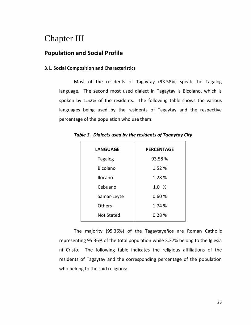
Most of the residents of Tagaytay (93.58%) speak the Tagalog
language. The second most used dialect in Tagaytay is Bicolano, which is
spoken by 1.52% of the residents. The following table shows the various
languages being used by the residents of Tagaytay and the respective
percentage of the population who use them:
Table 3. Dialects used by the residents of Tagaytay City
LANGUAGE
Tagalog
Bicolano
Ilocano
Cebuano
Samar-Leyte
Others
Not Stated
PERCENTAGE
93.58 %
1.52 %
1.28 %
1.0 %
0.60 %
1.74 %
0.28 %
The majority (95.36%) of the Tagaytayeños are Roman Catholic
representing 95.36% of the total population while 3.37% belong to the Iglesia
ni Cristo. The following table indicates the religious affiliations of the
residents of Tagaytay and the corresponding percentage of the population
who belong to the said religions:
24
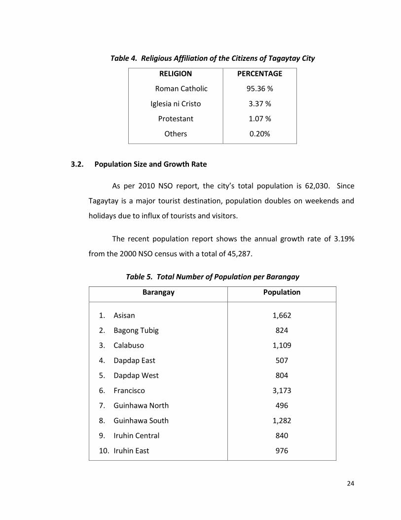
Table 4. Religious Affiliation of the Citizens of Tagaytay City
RELIGION
Roman Catholic
Iglesia ni Cristo
Protestant
Others
PERCENTAGE
95.36 %
3.37 %
1.07 %
0.20%
3.2. Population Size and Growth Rate
As per 2010 NSO report, the city’s total population is 62,030. Since
Tagaytay is a major tourist destination, population doubles on weekends and
holidays due to influx of tourists and visitors.
The recent population report shows the annual growth rate of 3.19%
from the 2000 NSO census with a total of 45,287.
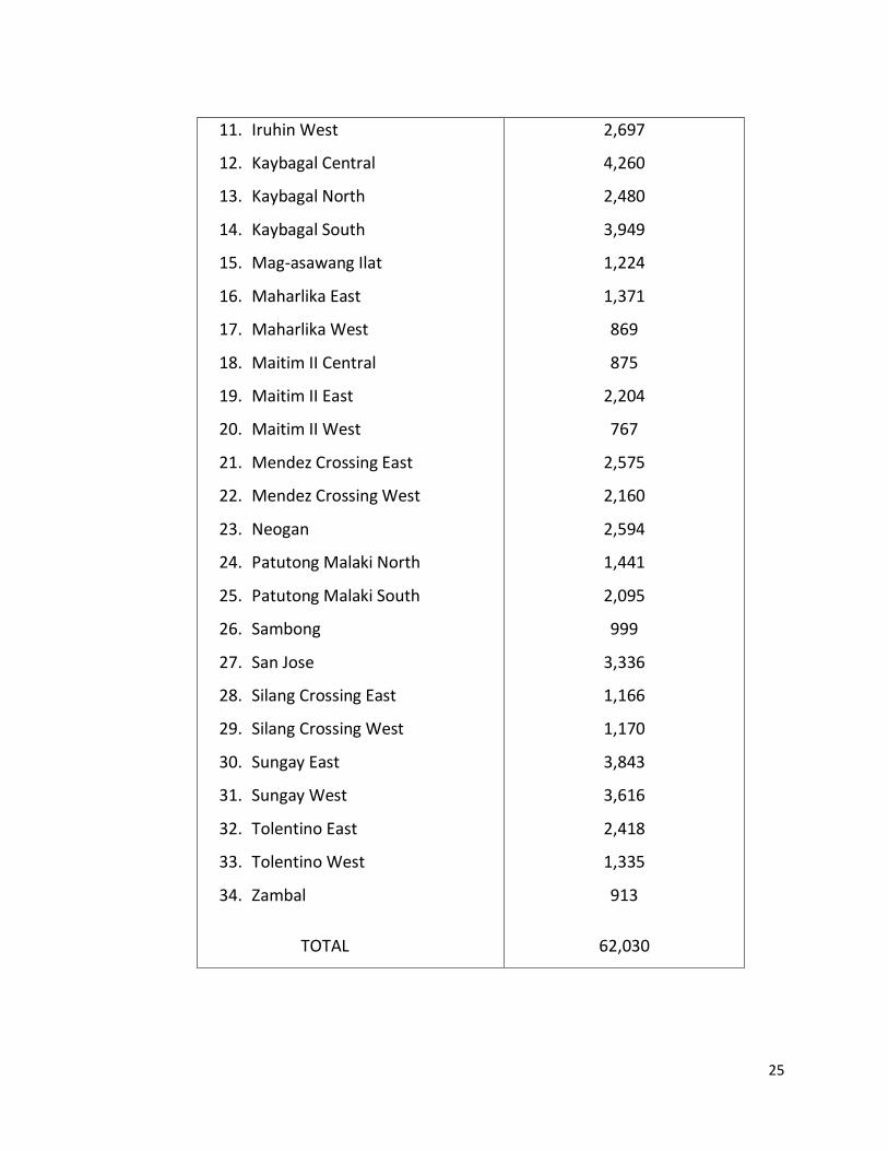
Table 5. Total Number of Population per Barangay
Barangay Population
1. Asisan
2. Bagong Tubig
3. Calabuso
4. Dapdap East
5. Dapdap West
6. Francisco
7. Guinhawa North
8. Guinhawa South
9. Iruhin Central
10. Iruhin East
1,662
824
1,109
507
804
3,173
496
1,282
840
976
25
11. Iruhin West
12. Kaybagal Central
13. Kaybagal North
14. Kaybagal South
15. Mag-asawang Ilat
16. Maharlika East
17. Maharlika West
18. Maitim II Central
19. Maitim II East
20. Maitim II West
21. Mendez Crossing East
22. Mendez Crossing West
23. Neogan
24. Patutong Malaki North
25. Patutong Malaki South
26. Sambong
27. San Jose
28. Silang Crossing East
29. Silang Crossing West
30. Sungay East
31. Sungay West
32. Tolentino East
33. Tolentino West
34. Zambal
TOTAL
2,697
4,260
2,480
3,949
1,224
1,371
869
875
2,204
767
2,575
2,160
2,594
1,441
2,095
999
3,336
1,166
1,170
3,843
3,616
2,418
1,335
913
62,030
26
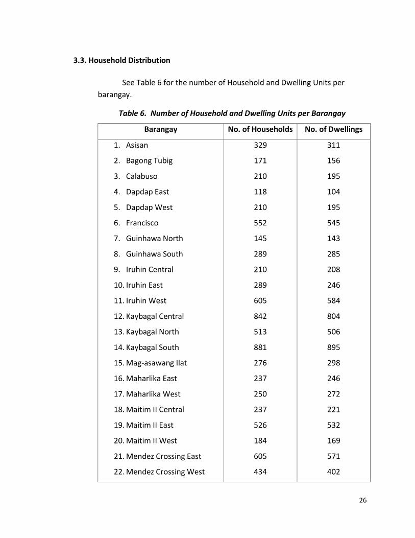
3.3. Household Distribution
See Table 6 for the number of Household and Dwelling Units per
barangay.
Table 6. Number of Household and Dwelling Units per Barangay
Barangay No. of Households No. of Dwellings
1. Asisan
2. Bagong Tubig
3. Calabuso
4. Dapdap East
5. Dapdap West
6. Francisco
7. Guinhawa North
8. Guinhawa South
9. Iruhin Central
10. Iruhin East
11. Iruhin West
12. Kaybagal Central
13. Kaybagal North
14. Kaybagal South
15. Mag-asawang Ilat
16. Maharlika East
17. Maharlika West
18. Maitim II Central
19. Maitim II East
20. Maitim II West
21. Mendez Crossing East
22. Mendez Crossing West
329
171
210
118
210
552
145
289
210
289
605
842
513
881
276
237
250
237
526
184
605
434
311
156
195
104
195
545
143
285
208
246
584
804
506
895
298
246
272
221
532
169
571
402
27
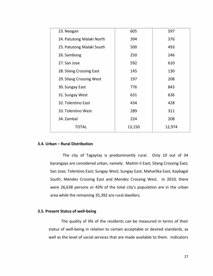
23. Neogan
24. Patutong Malaki North
25. Patutong Malaki South
26. Sambong
27. San Jose
28. Silang Crossing East
29. Silang Crossing West
30. Sungay East
31. Sungay West
32. Tolentino East
33. Tolentino West
34. Zambal
TOTAL
605
394
500
250
592
145
197
776
631
434
289
224
13,150
597
376
493
246
610
130
208
843
636
428
311
208
12,974
3.4. Urban – Rural Distribution
The city of Tagaytay is predominantly rural. Only 10 out of 34
barangays are considered urban, namely: Maitim II East; Silang Crossing East;
San Jose; Tolentino East; Sungay West; Sungay East; Maharlika East; Kaybagal
South; Mendez Crossing East and Mendez Crossing West. In 2010, there
were 26,638 persons or 43% of the total city’s population are in the urban
area while the remaining 35,392 are rural dwellers.
3.5. Present Status of well-being
The quality of life of the residents can be measured in terms of their
status of well-being in relation to certain acceptable or desired standards, as
well as the level of social services that are made available to them. Indicators
28
of well-being include health, education, social welfare, housing, employment
and income, recreation and protective services.
3.5.1 Health
The delivery of basic health care services to the general public is
basically one of the primary concerns of the city. Thus, the City established its
own Primary Hospital (Ospital ng Tagaytay) in 1997 to render health services
for the city residents especially to underprivileged patients. In order to
improve its services and accommodate the increasing number of in-patient,
the City Government constructed additional building (expansion) for
additional hospital beds and to comply with the minimum requirement of the
Department of Health for hospital upgrading from primary to secondary.
In addition, the construction of a state-of- the-art private tertiary
hospital (Tagaytay Medical Center) located at Barangay Silang Crossing East
near Rotunda, also caters the needs not only of local residents but also the
adjoining towns as well tourists who visited the city.
For minor cases, the City Health Office is open from Monday to Friday
providing medical and dental services to the city residents. The 34 barangay
have also their respective barangay health centers under the direct
supervision of City Health Office personnel assisted by Barangay Health
Workers (BHWs) and Purok Social Workers (PSWs). Non-government
Organizations (NGOs) such as Project Health, Augustinian Sisters and private
institutions also provide medical services to the residents.
At present the city has one (1) City Health Center, 34 barangay health
centers, two (2) hospitals, thirty six (36) medical/dental clinics, and thirteen
(13) drugstores to meet the health and medical needs of the people.
29
The city has twenty one (21) licensed physicians; seventeen (17)
dentists; eighty two (82) nurses; and fifty (50) Barangay Health Workers
(BHW).
The City Nutrition Office’s records show that from 1998 to 2015, the
malnutrition rate in the city is below 1%. As a concrete manifestation of the
efficiency of the city’s nutrition program, the city has received several
Nutrition Awards from the regional even up to national level.
3.5.2 Social Welfare
Tagaytay City, like most towns and cities in the country, is beset
with its own social problems, which include unemployment, malnutrition,
inadequate housing provisions and drug addiction. To help solve these
problems, social welfare assistance in the city is therefore extended by the
City Social Welfare and Development Office (CSWDO).
Among the services offered by the CSWDO are family life education and
counselling, family planning and assistance, day care services, supplemental
feeding, and emergency shelter assistance, relief and rehabilitation. In terms
of facilities, it has set up one family clinic in every day care center.
Some government offices and private organizations operating within
the locality provide invaluable support to CSWDO in extending social welfare
assistance to those who are needy. The government agencies that also assist
the CSWDO are the Department of Agriculture and the Department of Health.
The civic and religious organizations on the other hand, include the Ladies of
Charity, Tagaytay City Credit Association, Society of St. Vincent de Paul, Marian
Center, Women’s Club, Poveda and Verbum Dei.
30
To monitor and concentrate on the social problems that arise in the
city, the following Programs and Services are provided by the CSWDO: (1) Self-
Employment Assistance, (2) Family and Community Welfare, (3) Women’s
Welfare, (4) Child and Youth Welfare, (5) Emergency Assistance Program, (6)
Program for Disabled Persons and the Elderly, (7) Lingap sa Barangay and (8)
Day Care Services.
3.5.3 Education
At present, there are eight (8) high school in the city, five (5) of which
are private and three (3) are public, 16 Public Elementary Schools; 12 Private
Elementary Schools; located at different barangays. Out of the 34 barangays,
32 have their own day care center with playgrounds. Some barangays have
also established their own Community Learning Center. There are four (4)
colleges in the city –City College of Tagaytay (CCT), Olivarez College, STI
College and Divine Word Seminary. CCT, STI and Olivarez College are open to
all enrolees for tertiary education while Divine Word Seminary offers post
graduate studies to the seminarians aspiring for priesthood and brotherhood.
For the out-of-school youth residents who were not given the
opportunity to formal education, the City Government in coordination with
the Department of Education provides an alternative pathway by which out of
school youth could earn/obtain educational qualification comparable to the
formal education through the Alternative Learning System (ALS). The ALS
coordinators conduct Continuing Education Program (CEP); massive
information campaign and Literacy Classes in Elementary and Secondary
School Leavers; Basic Computer Literacy Program and Livelihood Programs.
The service provider also reviews and prepares the examinees for the
Accreditation and Equivalence Test. To date, nine (9) Elementary A&E Test
31
Passers were promoted to Secondary Level while thirty eight (38) Secondary
A&E Test Passers were promoted to college. At present, the City has one (1)
Mobile Teacher, two (2) ALS Coordinators and one (1) ALS Instructional
Manager.
The City’s participation rate for elementary school is 101.00% and
88.69% for secondary school, respectively. Cohort Survival Rate is 82.87% for
elementary and 90.35% for secondary.
3.5.4 Housing
In response of the City Government to improve and alleviate the living
condition of the homeless constituents, the City Mayor created the Tagaytay
Housing Office (THO), which is tasked to regulate and implement the
Comprehensive Housing Program of the city. The City Government likewise
purchased several vacant / idle private lands for housing settlement.
Tagaytay at the moment has not yet experienced housing problems as
pressing as compared to other highly-urbanized cities in the country.
However, it is hoped that with the implementation of the subsidized housing
program, the city will, in a way, regulate the squatters in the city. In addition
to this, the city is not merely providing decent housing units to qualified
program beneficiaries, but also trying its best to establish a decent and
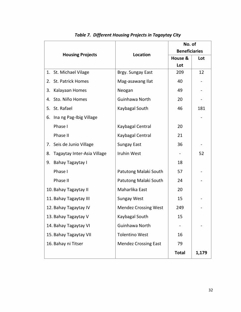
sustainable community. As of 2015, fifteen (16) housing projects were
established with a total of 1,179 beneficiaries.
32
Table 7. Different Housing Projects in Tagaytay City
Housing Projects Location
No. of
Beneficiaries
House &
Lot
Lot
1. St. Michael Vilage
2. St. Patrick Homes
3. Kalayaan Homes
4. Sto. Niño Homes
5. St. Rafael
6. Ina ng Pag-Ibig Village
Phase I
Phase II
7. Seis de Junio Village
8. Tagaytay Inter-Asia Village
9. Bahay Tagaytay I
Phase I
Phase II
10. Bahay Tagaytay II
11. Bahay Tagaytay III
12. Bahay Tagaytay IV
13. Bahay Tagaytay V
14. Bahay Tagaytay VI
15. Bahay Tagaytay VII
16. Bahay ni Titser
Brgy. Sungay East
Mag-asawang Ilat
Neogan
Guinhawa North
Kaybagal South
Kaybagal Central
Kaybagal Central
Sungay East
Iruhin West
Patutong Malaki South
Patutong Malaki South
Maharlika East
Sungay West
Mendez Crossing West
Kaybagal South
Guinhawa North
Tolentino West
Mendez Crossing East
209
40
49
20
46
20
21
36
-
18
57
24
20
15
249
15
-
16
79
Total
12
-
-
-
181
-
-
52
-
-
-
-
-
1,179
33
3.5.5 Employment and Income
In 2010 NSO Census reported an employment rate of 97%. This means
that only 3% of the labor force is unemployed.
3.5.6 Recreation and Sports Facilities
The City of Tagaytay provides for its residents, visitors and tourists a
number of facilities for both sports and recreational activities. Available
sports facilities include: fourteen (14) Covered Courts, six (6) Barangay
Basketball/ Open Courts, two (2) Public Parks, one (1) Theme Park, two (2)
Mini Zoo, three (3) Museums, one (1) Golf Course, one (1) Public Swimming
Pool, three (3) Amusement Centers for Kids, two (2) Horseback Riding Track,
three (3) Ziplines, one (1) Track Field Oval/ Baseball and Softball Field and
thirty-four (34) Playgrounds. Alternatively, establishments for passive leisure
interest are also available in Tagaytay. One of which is Tagaytay Picnic Grove
being managed/ operated by the City Government. It is located at Barangay
Sungay East. It offers facilities for picnicking, horseback riding, swimming,
overnight stay and the now famous zipline and cable car. Another is the
Casino-Filipino, being managed by the Philippine Amusement and Gaming
Corporation (PAGCOR). Development Academy of the Philippines (DAP), which
is situated at Barangay Sungay East, is among the favorite venues for
conventions, seminars and conferences. Various facilities that can be availed
of at the DAP include pelota court, ping pong room, game room for chess and
mah-jong, children’s playground, covered tennis court, covered squash
beating lagoon, skating rink, swimming pool and one goal basketball court.
The Philippine Judicial Academy located at Barangay Silang Crossing East
offers facilities such as dartboard, pool tables, ping-pong tables, billiard
tables, swimming pools, and basketball and volleyball courts. Another is the
34
Residence Inn/Mini Zoo, situated at the western part of the city, along
Tagaytay-Nasugbu Road. The famous Tagaytay Highlands and International
Golf Club at Barangay Calabuso is an exclusive golf club being managed /
operated by a private firm. Facilities/amenities that can be availed at
Tagaytay Highlands include: 18-hole golf course, billiard halls, ping pong
tables, tennis courts, squash courts, fitness gym, swimming pool, wading
pool, bridle path, bicycle and jogging trails, and gardens where one can relax
and feel the refreshing breeze of Tagaytay. Shuttles and cable cars are
available within the premises.
Skyranch, a leisure park is the newest tourists’ destination in the city
and where the Sky Eye, one of the biggest and known as the tallest Ferris
wheel in the country can be found is a complete day destination for families
and groups of friends. The park offers selected amusement park rides and
activities. Viking, Jump Around, Log Coaster and Flying Bus are among others
that can be found inside the Sky Ranch Complex. It also offers Zipline, Sky Eye
and horseback riding for an amazing view of Taal Lake and Volcano and the
provinces and cities surrounding these landmarks. Other amenities include
“The Venue” which can accommodate small to big gatherings and events,
parking, breastfeeding station, clinic and ATMs.
With regard to sports development, all schools in the city, whether
public or private, conduct physical and sports development programs for
their students. These programs are being supported by the City Government
through the designated Sangguniang Kabataan Coordinator and City Sports
Coordinator. Inter-Barangay basketball tournament for the youth is also
being held during summer.
35
3.5.7 Protective Services
Tagaytay City’s peace and order situation is safeguarded by the
Philippine National Police Force, which is under the Department of the
Interior and Local Government (DILG). The total police force is composed of
two (2) officers, one hundred nine (109) non-officers and six (6) non-
uniformed personnel. There are seven (7) police sub-stations strategically
located in the busiest parts of the city such as the Centrum in Barangay
Kaybagal South, Mendez Crossing West, Silang Crossing East, Mahogany
Market, City Market in Tolentino East, Barangay Sungay East and Barangay
Maitim II East. Sustained maximum security for the citizens is ensured
through the 24-hour service.
The police force is supported by Barangay Tanods (average of 10 per
barangay); Bantay-Lungsod under the Tagaytay Office of Public Safety
(TOPS), Traffic Aides and private security personnel manned by different
Security Agencies.
36
Chapter IV
Local Economy
4.1 The Primary Sector
4.1.1 Tourism
Tagaytay City is one of the vital tourist sites, which play a very
significant role in the country’s tourism industry. From the National and
Regional points of view, Tagaytay City ranks very high in tourism potentials
due to its scenic attraction and available accommodation facilities that meet
international standards. Because it is very accessible and strategically near
Metro Manila, which is the main entry and exit point of the country’s local
and international travellers, Tagaytay remains one of the leading tourist areas
in the country.
The main tourist attraction of Tagaytay is the captivating panoramic
view of the natural beauty of the Taal Volcano, which is the smallest volcano
in the world and where two delectable rare species of fish, the “maliputo”
and “tawilis” are found. In spite of its nearness to Metro Manila, Tagaytay
has a unique rustic atmosphere and invigorating cool climate. This is the
reason why people do not only want to visit the place but prefer to hold
seminars / conferences the city. Complementing the natural endowment are
several tourist establishments, which are attractions themselves.
4.1.2 Agriculture
Agriculture has been the traditional economic base of Tagaytay City as
such will remain be a significant sector in the city’s economic development.
37
While soil characteristics of the City are generally highly suitable for
agriculture, topography on the other hand, is determined as the natural
constraint, which has limited available land area that may be conveniently
cultivated. With very rugged topography in the ridge area and eastern
section of the city, only about 2,304 hectares of 34.83% of the city’s total land
area of 6,500 hectares are highly suitable for cultivation. Because of this
natural constraint, substantial areas of the agriculturally unsuited land, the
steep land which comprise the south-eastern part of central part of the ridge
have been pressured to shifting diversified crops cultivation.
The proven adaptability of the Tagaytay land to various cultivation
encourages shifting of agricultural lands to high-income crops. Because of
unlimited market for and high income derived from coffee, substantial
portion of the city’s land have been developed into coffee farms.
As per 2015 City Agriculture Office’s report, the total number of
households with vegetable gardens is 1,870.
4.1.3 Livestock and Poultry
The city’s favourable climate has attracted commercial and semi-
commercial livestock farms to locate in the area. Inventory of livestock and
poultry registered increases in the past years. Cattle are raised principally as
work animals, while other forms of livestock are raised essentially for
consumption.
As of 2015, the total number of households with livestock production is 612.
38
4.1.4 Commerce and Industry
The City of Tagaytay has no defined central business district. Instead,
commercial activities tend to conglomerate at four (4) different parts of the
city namely: Barangays Mendez Crossing East and West; Silang Crossing East,
City Market at Barangay Tolentino East and the Mahogany Beef Market at
Barangay Kaybagal South.
There are 2,295 commercial establishments situated at Tagaytay City
based on the record from the License Office for businesses with more than
Php50,000.00 Gross Receipts or Initial Capital and establishments with below
Php50,000.00 Initial Capital or Gross Receipts that are registered at the
barangays. These consist of 285 Restaurants and Food Chains, 64
Carinderia/Canteens, 83 Refreshment Parlors, 56 Hotels/Motels, 47
Commercial Buildings, 61 Space for Rent, 63 Rooms for Rent, 18 Banks, 27
Pawnshops/Money Shops, 12 Lending Investors, 5 supermarkets, 95 Sari-sari
Stores, 60 General Merchandise, 28 Computer/IT Shop, 13 Pharmacies/
drugstores, 36 Medical/Dental Clinic, 12 Cooperatives, 11 Lumber/Hardware,
7 Gas Stations, 22 Private Schools, 22 Water Refilling Stations, 1
Rehabilitation Centers, 20 Spa/Massage Centers, 128 Souvenir shops, 50
Pasalubong Shops, 9 In-land Resorts, 10 Photoshops, 12 Laundry/Dry
Cleaning, 1,038 other services.
Tagaytay City, being basically an agricultural area has relatively few
industries within its vicinity. There are on 11 industries found in the city, Two
(2) of which are agro-based, three (3) are manufacturing oriented and the
remaining are cottage/livelihood industries.
39
4.2 The Secondary Sector
4.2.1 Construction
Lack of data makes it impossible to assess the contribution to total
output.
4.3 Tertiary Sector
4.3.1 Financial Institutions
Based on the report of Business Licensing Office of 2015, there are
eighteen (18) banks, twenty seven (27) pawnshops / money shops and twelve
(12) lending investors in the city.
4.3.2 Wholesale and Retail Trade
There are five (5) supermarkets, sixty (60) General Merchandise,
ninety five (95) Sari-Sari Stores, thirteen (13) Pharmacies/Drugstores, twenty
two (22) Water Refilling Stations, one hundred twenty eight (128) Souvenir
Shops and fifty (50) Pasalubong Shops.
4.3.3 Transportation and Communications
As in other towns and cities, the major modes of transport in Tagaytay
are buses, jeeps, tricycle and cars. These transit types provide mobility
services within the city.
The following bus liners provide transport services to commuters in
Tagaytay:
1. Saulog Transit
2. Celyrosa Express
3. Alfonso Transit
4. San Agustin Liner
40
5. Kirby Liner
6. Erjohn & Almark Transit Corp.
7. Kersteen
8. DLTB Co.
9. Cavite-Batangas Transport Coop.
10. BSC Transit
Public-utility-jeepneys (PUJ’s) are made accessible at strategic places
where people usually unload. They are situated in the following locations:
Barangay Silang Crossing – jeepney route is towards Silang to Barangay
Dapdap East and vice versa
City Market – jeepney route taken is from the City Market to Balibago,
Sta. Rosa, Laguna and vice versa
Barangay Kaybagal – jeepney route is towards Amadeo and vice versa
Barangay Mendez Crossing – jeepney route is towards Indang;
Anuling, Mendez; Silang, Cavite; Nasugbu and vice versa.
Postal Services
The city has only one Post Office managed by the Bureau of Post,
which is located at the City Hall Complex. Delivery of mails in areas
beyond the 5-kilometer radius is done twice a week.
Incoming mails throughout the year 2015 totalled up to 486,808.
Delivered mails went up to 478,109 this year while undelivered mails
totalled up to 8,699. Influx of mail is observed during the months of
November and December.
The post office takes charge of the following: (1) Priority Mails; (2)
Domestic Air Mail Service or DEMS; (3) Registered Mails; (4) Ordinary
Mails; (5) Parcel and Printed Matters; (6) Postal Money Orders; (7)
Packaging Services; (8) Issuance of Postal IDs; (9) Operation of Mailing
Centers; (10) Air Mail Letters; and (11) Special Delivery of Foreign Mails.
41
Telephone Services
Telephone Services within the city is mainly being serviced by the
Philippine Long Distance Telephone Company (PLDT). Its main office is
located at the Centrum along Tagaytay-Nasugbu Road, and adjacent to
the Tagaytay City International Convention Center. The rest is being
managed by Digitel. Direct Distance Dialing is available in PLDT and Digitel
lines.
Mobile Phone Services (including Cell sites and their location)
Several relay stations for cellular phones (Smart, Globe and Sun
Cellular Telecommunications) are also found within the city.
Cellular Sites
Globe Telecommunication
Barangay Dapdap East
Barangay Francisco
Barangay Kaybagal South
Barangay SilangCrossing West
Barangay Maitim II East
Barangay Calabuso
Sun CellularTelecommunication
Maitim II East
Smart Telecommunication
Barangay Sungay West
Barangay San Jose
Barangay Maharlika West
Barangay Neogan
Barangay Calabuso
42
Cable TV Services
There are three (3) Cable TV Service Providers within the city, the
Amadeo-Tagaytay Cable TV, Cignal TV- Tagaytay and Mountain Top Cable
TV.
4.4.4 Personal Services
These include twenty two (22) Beauty Parlors, six (6) Barber Shop,
eight (8) Dress and Tailoring Shops, ten (10) Photo Studios and twenty (20)
Spa/Massage Clinics.
4.4.5 Community Services
These include two (2) Hospitals, five (5) Rehabilitation Centers, two
hundred eighty five (285) Restaurants/ Food Chains, sixty four (64)
Carinderia/Canteens, eighty three (83) Refreshment Parlors, fifty six (56)
Hotels/Motels and sixty three (63) Rooms for Rent.
43
Chapter V
Infrastructure / Utilities / Facilities
5.1. Roads
For purposes of prioritizing the development maintenance of the
roads within Tagaytay, the city’s circulation system is thus, categorized into
three (3) functional hierarchical classifications: national highways, arterial
collector and service road classification. Based on these classifications, roads
characterized as arterial are given top priority as to
development/maintenance while the service roads are comparatively given
low priority.
The major arterial road of the city is the national Highway horizontally
traversing the city. Aside from being the city’s primary road, which links most
of the city’s barangays, it also serves as a national thoroughfare connecting
Tagaytay to the province of Laguna and to the province of Batangas.
Running almost perpendicular to the arterial roads are eight other
arterial roads, seven of which are maintained by the national government. At
present, all of these are vital road linkages in as much as they provide access
to the towns and cities of the four regions/provinces, namely: Metro Manila,
Laguna, Batangas and Cavite. These arterial roads are enumerated as follows:
1. Tagaytay – Manila via Silang Road (National Road)
2. Tagaytay – Ulat Sto. Domingo – Sta. Rosa Road (National Road)
3. Tagaytay – Cavite vi Mendez Road (National Road)
4. Tagaytay – General Trias via Amadeo Road (City Road)
5. Tagaytay – Talisay Road (2) (National Road)
6. Tagaytay – Laguna via Calamba Road (National Road)
7. Tagaytay – Taal Lake Road (National Road)
44
8. Tagaytay – Batangas via Tuy Road (National Road)
Meanwhile, collector and service roads are those which branch out
from these arterial roads. These include all the city and Barangay roads in the
area. Aside from serving as the main access of the population in the inner
portion of Tagaytay, these roads particularly, the service roads are also used
as farm-to-market roads by the farmers of the city.
Tagaytay City has a total road length of 139.250 kilometers. Out of
this total road length, about 39.70 kms are classified as National Roads,
29.829 kms are City Roads and 69.721 kms are Barangay Roads.
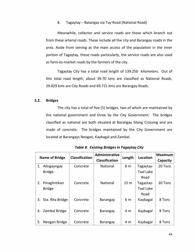
5.2. Bridges
The city has a total of five (5) bridges, two of which are maintained by
the national government and three by the City Government. The bridges
classified as national are both situated at Barangay Silang Crossing and are
made of concrete. The bridges maintained by the City Government are
located at Barangays Neogan, Kaybagal and Zambal.
Table 8. Existing Bridges in Tagaytay City
Name of Bridge Classification Administrative
Classification Length Location
Maximum
Capacity
1. Alingayngay
Bridge
2. Pinaglintikan
Bridge
3. Sta. Rita Bridge
4. Zambal Bridge
5. Neogan Bridge
Concrete
Concrete
Concrete
Concrete
Concrete
National
National
Barangay
Barangay
Barangay
8 m
15 m
6 m
4 m
4 m
Tagaytay-
Taal Lake
Road
Tagaytay-
Taal Lake
Road
Kaybagal
Kaybagal
Kaybagal
20 Tons
20 Tons
8 Tons
8 Tons
8 Tons
45
5.3. Domestic Water Supply
The city’s main sources of water are springs, rainwater and ground
water. The main springs are: Kaybubutong Spring, which are located at
Barangay Sambong and serving eighteen (18) barangays, Matang Tubig Spring
in Barangay Francisco serves eight (8) barangays and the Pulong Usiw Spring
located at Barangay Iruhin Central is serving the barangay itself. Monthly
bacterial testing is made to ensure that safe potable water is served to the
inhabitants.
The Kaybubutong Spring has an estimated total water output of 118
liters per second and is situated at an elevation of 324 meters. The Matang
Tubig Spring on the other hand, has a capacity of 11.35 liters per second and
has an altitude of 505 meters. Pulong-Usiw has a capacity of 1.76 liters per
second. Majority of the barangays depend on these springs. These are also
minor spring within the city, from which the residents draw water. They are
the following:
1. Banauan Spring - Barangay Iruhin East
2. Naalas Spring - Barangay San Jose
3. Alingayngay Spring - Barangay Silang Crossing
4. Ambon-ambon - Barangay Iruhin East
5. Bayanan Spring - Dapdap West
6. Calabuso Spring - Brgy. Calabuso
The barangays in the city which have water systems are those being
served by the Tagaytay City Water District (TCWD). Barangays Sambong and
Bagong Tubig and Sitio Labak ng Sungay in Barangay Sungay East derive water
from an elevated spring source by free flow through pipeline in Level II Water
System. Barangay Calabuso, Dapdap West and Sitio Bulalong Matanda in
Iruhin East obtain water from a spring below through submersible pump and
46
operate in Level II Water System. Barangay Maitim II West and Maitim II
Central get their water from deep well with a 5 Hp submersible pump also
operate in level III Water System. Other deep wells in the city are privately
owned.
The TCWD derives its water supply from the city’s three major springs.
In each of these springs, it has set up waterworks facilities which include a
spring intake structure, pump station, transmission line, distribution
reservoir, distribution lines and appurtenances.
TCWD’s pumping stations (20) are located at the following areas: two
(2) at Brgy. Francisco; two (2) at Brgy. Sambong; Brgy. Mendez Crossing East;
Brgy. Iruhin West; Brgy. Iruhin Central; Brgy. Mag-asawang Ilat; two (2) at
Southridge Subdivision, Brgy. Sungay East; Brgy. Kaybagal North; Brgy.
Patutong Malaki North; Brgy. Guinhawa South; TCH III, Brgy. Silang Crossing
West; Brgy. Sungay East; Brgy. Kaybagal south; Brgy. Maitim II Central; TCH I,
Brgy. Silang Crossing West; Sotogrande, Brgy. Asisan; and Daang Luma Rd.,
Brgy. Kaybagal North.
At present, about 98.66% of the total number of households is being
served by the TCWD. Other households obtain water directly from springs,
rainwater or deep wells. Thirty three (33) out of thirty four (34) barangays are
being served by TCWD.
5.4. Electric Power Supply
In 2014, 98.43% of the total household have access to electricity
(MERALCO).
47
5.5. Waste Disposal System
5.5.1. Solid Waste
It is the city’s inherent environmental characteristics, which has
fuelled its present state of growth. Environmental management measures
are provided for the city’s terrestrial, natural scenic environment, water
resource and urban and rural environments. The protection and
management of all these is the key towards sustaining the city’s growth and
development.
Increasing population is putting a lot of stress on the environment,
particularly on the volume of waste generated by the residents and the
commercial establishments in the city. Garbage collection in the city is being
managed by the local government unit through the City Environment and
Natural Resources Office (CENRO). The volume of solid waste is around 197.4
metric tons a week or an average of 28.2 metric tons a day. Of the entire
population, 85 percent of the households have access to solid waste
collection, which is done on a daily basis. Individual households particularly
those in barangays that are hardly reached by garbage trucks dispose their
garbage by dumping in an open area, while the limited number engage in
backyard composting. Toxic and hazardous wastes from hospitals are
collected and disposed of in a separate dumpsite.
In addition, the City Government constructed a Materials Recovery
Facility covering an area of 4,000 square meters with equipment to process
mixed waste per day. It is designed to receive, sort, process and store
compostable and recyclable materials efficiently and in an environmentally-
sound manner in compliance with RA 9003 or the Solid Waste Management
Act, and is in line with the city’s action towards proper protection of the
environment.
48
5.5.2. Liquid Waste
Tagaytay suffers from the absence of central sewerage system/waste
water treatment system. Since these facilities require massive resources, the
city resorts are using natural drainage and a multi-chamber (sealed) septic
vault.
5.6. Cemetery
There are three (3) cemeteries can be found in the city - two of which
are public cemeteries located in Barangay Maitim II Central. The private
cemetery is located in Barangay Patutong Malaki North. In order to address
congestion in the public cemetery, the city government recently established
the City Crematorium and Columbarium located adjacent to existing public
cemeteries.
5.7. Slaughterhouse
The existing slaughterhouse is located at Barangay Kaybagal South
across the Mahogany Public Market. In 2015, the average number of cattle
and swine butchered per month is totalled to 1,814 and 2,001 respectively.
5.8. Public Market
Tagaytay has two public markets, namely, the Tagaytay City and
Mahogany Markets. Tagaytay City Market was established in the early 50s. It
is located at Barangay Tolentino East, Tagaytay City within a 2.5 hectare
property donated by the city’s political icon - Tolentino-Oñate clan. It started
with only makeshift structure like “talipapa” and then Marcos Type Building
was constructed in the late 60s. It is known in the upper-Cavite Province as
the main source of fresh fruits particularly sweet pineapple, banana, and
papaya.
49
A new building was completed in 2005 to accommodate the wet,
grocery, dry sections. To meet the increasing volume of business in the area,
another three-storey building was constructed in 2008. Regular market day is
every Wednesdays and Saturdays. Nevertheless, several stalls in the dry and
wet sections are open daily to serve the public.
Mahogany Market was established in 1994. It is known as the main
source of quality beef not only within the province but also in the adjoining
provinces including Metro Manila.
The construction and renovation of the new Mahogany Market
building is on-going, and will soon be open to public.
50
Chapter VI
Local Institutional Capability
6.1. Governance
The present organization of the Local Government of Tagaytay is a
divisional structure with two distinct branches: the Executive and the
Legislative Branches.
A. Executive Branch of Local Governance
The Executive Branch is composed of eighteen (18) departments and
eight (8) offices, which are divided into services, divisions and sections. The
City Mayor heads the organization, from whom all the executive authority
and responsibility originates. The City Administrator is positioned next in the
hierarchy in so far as it exercises delegated authority from the City Mayor.
He supervises the operations of line and staff departments, offices and units.
B. Legislative Branch of Local Governance
The Vice Mayor presided over the Sangguniang Panglungsod (SP),
which is the policy-making body of the city. The SP is composed of the Vice
Mayor, the elected regular council members, the president of the city chapter
of the Liga ng mga Barangay and the president of the Pederasyon ng mga
Sangguniang Kabataan. The Office of the City Secretary serves as the
Secretary to the Council. It also provides legislative, administrative and
secretarial support services to the said body.
As the main policy-making body of the local government, the SP,
among others, enacts ordinances, approves resolutions and appropriates
fund for the general welfare of the city residents. It likewise regulates
activities related to the use of land, street, sidewalks, bridges, parks and
other public places and approves of the construction of the same.
51
A unique feature of the Sangguniang Panglungsod in Tagaytay City is
that the councillors have their designated political jurisdiction known as the
Councilor’s Area of Responsibility (CAR). This serves as an extension of the
Mayor’s Office. It aims to ensure that public services are delivered efficiently,
effectively and equitably. In this sense, the lead legislators also perform a
policy-implementation function. In addition, the councillors act either as
chairpersons, vice chairperson and / or members of regular committees of
the local development council.
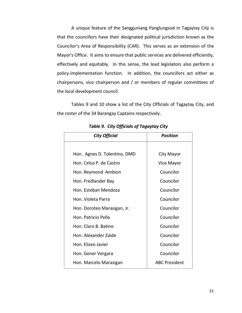
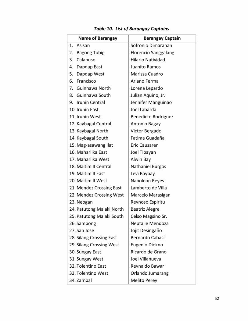
Tables 9 and 10 show a list of the City Officials of Tagaytay City, and
the roster of the 34 Barangay Captains respectively.
Table 9. City Officials of Tagaytay City
City Official Position
Hon. Agnes D. Tolentino, DMD
Hon. Celso P. de Castro
Hon. Reymond Ambion
Hon. Fredlander Bay
Hon. Esteban Mendoza
Hon. Violeta Parra
Hon. Doroteo Marasigan, Jr.
Hon. Patricio Pello
Hon. Claro B. Batino
Hon. Alexander Zaide
Hon. Eliseo Javier
Hon. Gener Vergara
Hon. Marcelo Marasigan
City Mayor
Vice Mayor
Councilor
Councilor
Councilor
Councilor
Councilor
Councilor
Councilor
Councilor
Councilor
Councilor
ABC President
52
Table 10. List of Barangay Captains
Name of Barangay Barangay Captain
1. Asisan
2. Bagong Tubig
3. Calabuso
4. Dapdap East
5. Dapdap West
6. Francisco
7. Guinhawa North
8. Guinhawa South
9. Iruhin Central
10. Iruhin East
11. Iruhin West
12. Kaybagal Central
13. Kaybagal North
14. Kaybagal South
15. Mag-asawang Ilat
16. Maharlika East
17. Maharlika West
18. Maitim II Central
19. Maitim II East
20. Maitim II West
21. Mendez Crossing East
22. Mendez Crossing West
23. Neogan
24. Patutong Malaki North
25. Patutong Malaki South
26. Sambong
27. San Jose
28. Silang Crossing East
29. Silang Crossing West
30. Sungay East
31. Sungay West
32. Tolentino East
33. Tolentino West
34. Zambal
Sofronio Dimaranan
Florencio Sanggalang
Hilario Natividad
Juanito Ramos
Marissa Cuadro
Ariano Ferma
Lorena Lepardo
Julian Aquino, Jr.
Jennifer Manguinao
Joel Labarda
Benedicto Rodriguez
Antonio Bagay
Victor Bergado
Fatima Guadaña
Eric Causaren
Joel Tibayan
Alwin Bay
Nathaniel Burgos
Levi Baybay
Napoleon Reyes
Lamberto de Villa
Marcelo Marasigan
Reynoso Espiritu
Beatriz Alegre
Celso Magsino Sr.
Neptalie Mendoza
Jojit Desingaňo
Bernardo Cabasi
Eugenio Diokno
Ricardo de Grano
Joel Villanueva
Reynaldo Bawar
Orlando Jumarang
Melito Perey
53
6.2. Financial Profile
6.2.1. Income
For the year 2015, the City Government collected a total income of
NINE HUNDRED SEVENTY NINE MILLION SIX HUNDRED NINETY NINE
THOUSAND FOUR HUNDRED FOURTEEN PESOS and 07/100
(Php979,699,414.07) with decrease of 0.32% from the city’s income of 2014.
Out of the city’s income in 2015, General Fund has the biggest share
having a total collection of EIGHT HUNDRED THIRTY EIGHT MILLION NINE
HUNDRED EIGHTY EIGHT THOUSAND EIGHT HUNDRED TWENTY SEVEN PESOS
and 77/100 (Php838,988,827.77), covering the 85.64% of the city’s total
revenue. It has a decrease of 0.19% from 2014 income of EIGHT HUNDRED
FORTY MILLION SIX HUNDRED FORTY SIX THOUSAND SEVEN HUNDRED
NINETY PESOS and 67/100 (Php840,646,790.67).
Special Education Fund has a total collection of ONE HUNDRED FORTY
MILLION SEVEN HUNDRED TEN THOUSAND FIVE HUNDRED EIGHTY SIX PESOS
and 30/100 (Php140,710,586.30) contributing 14.36% of the city’s total
income in 2015. It has a decrease of 1.73% from 2014 collection of ONE
HUNDRED FORTY THREE MILLION ONE HUNDRED NINETY FOUR THOUSAND
NINE HUNDRED FORTY NINE PESOS and 7/100 (Php143,194,949.07).
The bulk of the city’s General Fund income came from: Real Property
Tax collected a total amount of ONE HUNDRED FIFTY SIX MILLION NINETY
FIVE THOUSAND EIGHT HUNDRED EIGHTY ONE PESOS and 60/100
(Php156,095,881.60) contributing 18.60%. Share from the National Tax
Collection (IRA) is TWO HUNDRED SIXTY FIVE MILLION FIVE HUNDRED FOUR
THOUSAND NINE HUNDRED NINETY FOUR PESOS (Php265,504,994.00)
contributing 31.65% of the total General Fund. Tax on Business collected the
amount of EIGHTY SEVEN MILLION NINE HUNDRED EIGHTY SEVEN
54
THOUSAND EIGHT HUNDRED FIFTY PESOS and 89/100 (Php87,987,850.89)
contributing 10.49%. Income collected from Other Taxes has a total amount
of FORTY FOUR MILLION FOUR HUNDRED FORTY THREE THOUSAND NINE
HUNDRED PESOS and 34/100 (Php44,443,900.34) contributing 5.30%.
Regulatory Fees (Permits and Licenses) collected a total amount of THIRTY
SEVEN MILLION THREE HUNDRED SIXTY FOUR THOUSAND FIVE HUNDRED
FORTY SEVEN PESOS and 27/100 (Php37,364,547.27) contributing 4.45%.
Service Income collected a total amount of NINE MILLION SEVEN HUNDRED
NINETY SIX THOUSAND ONE HUNDRED SEVENTEEN PESOS and 21/100
(Php9,796,117.21) contributing 1.17%. Other Income (coming from the
Interest Income) collected a total amount of FIVE MILLION THIRTY THREE
THOUSAND THIRTY EIGHT PESOS and 04/100 (Php5,033,038.04) contributing
0.60%. Income collected from Economic Enterprises has a total amount of
TWO HUNDRED THIRTY TWO MILLION SEVEN HUNDRED SIXTY TWO
THOUSAND FOUR HUNDRED NINETY EIGHT PESOS and 42/100
(Php232,762,498.42) contributing 27.74% of the total General Fund.
6.2.1. Expenditure
For the year 2015, the City Government of Tagaytay had a total
expenditure of ONE HUNDRED EIGHTEEN MILLION THREE HUNDRED
NINETEEN THOUSAND EIGHT HUNDRED FORTY SIX PESOS and 53/100
(Php118,319,846.53) which shows an increase of 86.31% from the city’s
expenditure in 2014 of EIGHT HUNDRED SIXTY FOUR MILLION FIVE HUNDRED
SEVENTY THREE THOUSAND ONE HUNDRED FIFTY SIX PESOS and 74/100
(Php864,573,156.74).
Out of the total expenditures in 2015, SIXTY FIVE MILLION ONE
HUNDRED FORTY SIX THOUSAND FIVE HUNDRED FORTY SIX PESOS and
41/100 (Php65,146,546.41) or 55.06% came from the General Fund. This
55
showed a decrease of 91.05% from 2014 General Fund expenses of SEVEN
HUNDRED TWENTY SEVEN MILLION NINE HUNDRED THIRTY NINE THOUSAND
SEVEN HUNDRED EIGHTY FOUR PESOS and 66/100 (Php727,939,784.66).
Special Education Fund (SEF) expended a total amount of FIFTY THREE
MILLION ONE HUNDRED SEVENTY THREE THOUSAND THREE HUNDRED PESOS
and 12/100 (Php53,173,300.12) or 44.94% of the city’s total expenditures.
Decreased by 99.25% from SEF expenditures of 2014 with ONE HUNDRED
THIRTY SIX MILLION SIX HUNDRED THIRTY THREE THOUSAND THREE
HUNDRED SEVENTY TWO PESOS and 08/100 (Php136,633,372.08).
![The Archmage’s Lost Hideaway 1 & Dragons [multi]/5th...hideaway, seeking gems and precious reagents within. One severely injured mezzodaemon accidently passed he Archmage’s Hideaway](https://img.pdfslide.us/doc/110x75/60b6f7dc8f24eb7e3b321b56/the-archmageas-lost-hideaway-1-dragons-multi5th-hideaway-seeking.jpg)