Embed Size (px)
Citation preview

Drainage Memorandum Riverview Drive: 18th Street to 22nd Street COP Project: ST85110072 SCI Project: 21916
November 2017
Prepared for:
City of Phoenix 200 W. Washington St Phoenix, AZ 85003
Prepared by:
Stanley Consultants 1661 East Camelback Rd, Suite 400 Phoenix, AZ 85016
11/1/17

Drainage Memorandum Riverview Drive: 18th Street to 22nd Street
Riverview Draft Offsite Drainage Report2.docx 11/16/2017 i
TABLE OF CONTENTS Page
1 INTRODUCTION ............................................................................. 1-1
1.1 PURPOSE OF MEMORANDUM ........................................................................ 1-1
1.2 PREVIOUS DESIGN STUDIES ......................................................................... 1-1
1.3 DESIGN CRITERIA ........................................................................................ 1-1
2 PROJECT LOCATION .................................................................... 2-1
3 PROJECT CORRIDOR AND PROPOSED IMPROVEMENTS ........ 3-1
3.1 PROJECT NEED ........................................................................................... 3-1
3.2 PROPOSED DESCRIPTION ............................................................................. 3-1
4 FEMA FLOODPLAIN CLASSIFICATION ........................................ 4-1
5 OFFSITE DRAINAGE ..................................................................... 5-1
5.1 BACKGROUND ............................................................................................. 5-1
5.2 PROPOSED OFFSITE FLOW MANAGEMENT ..................................................... 5-1
6 REFERENCES ................................................................................ 6-2

Drainage Memorandum Riverview Drive: 18th Street to 22nd Street
Riverview Draft Offsite Drainage Report2.docx 11/16/2017 ii
FIGURES Page Figure 2-1: Project Location and Vicinity Map .......................................................... 2-1 Figure 4-1. FEMA FIRM Panel 2145 ......................................................................... 4-1 APPENDICES Appendix A: HECRAS ANALYSES Appendix B: BOX CULVERT PLANS Appendix B: ADOT CHANNEL AS-BUILTS

Drainage Memorandum Riverview Drive: 18th Street to 22nd Street
Riverview Draft Offsite Drainage Report2.docx 11/16/2017 Page 1-1
1 INTRODUCTION
1.1 Purpose of Memorandum This purpose of this memorandum is to document the hydraulic analysis necessary for the completion of the design of proposed drainage facilities to be constructed as part of the City of Phoenix, Riverview Drive: 18th St to 22nd Street Improvements project.
1.2 Previous Design Studies Stanley Consultants (Stanley) prepared a Design Concept Report as part of Phase 1 for this project. The DCR identified four alternative methods to cross the ADOT Outfall Channel: three were bridges and a fourth was a was custom concrete box culvert. The recommended and accepted alternative was the large custom box culvert. The hydraulic analysis was based upon the Final Drainage Design Report for Inner Loop Drainage Tunnel Outfalls (Project No. I-10-3(143) PE).
1.3 Design Criteria The design criteria and methodologies for the project drainage design are outlined in the following documents:
• City of Phoenix Storm Water Policies and Standards, City of Phoenix,
• Drainage Design Manual for Maricopa County, Arizona, Hydraulics, Flood Control District of Maricopa County, April, 2010.
• Drainage Design Manual for Maricopa County, Arizona, Policies and Regulations, Flood Control District of Maricopa County, July 2010.
• 50-yr Frequency Event based upon Final Drainage Design Report for Inner Loop
Drainage Tunnel Outfalls (Project No. I-10-3(143) PE of 5,000 cfs.

Drainage Memorandum Riverview Drive: 18th Street to 22nd Street
Riverview Draft Offsite Drainage Report2.docx 11/16/2017 Page 2-1
2 PROJECT LOCATION The project site is located within the City of Phoenix, on Riverview Drive between 16th Street and 22nd Street (see Figure 2-1). Project is between I-17 to the north and the Salt River to the south. Figure 2-1: Project Location and Vicinity Map
Drainage Memorandum Riverview Drive: 18th Street to 22nd Street
Riverview Draft Offsite Drainage Report2.docx 11/16/2017 Page 3-1
3 PROJECT CORRIDOR AND PROPOSED IMPROVEMENTS
3.1 Project Need The City of Phoenix would like Riverview Drive to be a continuous roadway between 16th and 24th Streets. Currently, Riverview Drive east of 16th Street ends in a cul-de-sac near 18th Place and no roadway exists between this location and 24th Street. A planned development between the ADOT outfall channel and 24th Street will construct Riverview Drive west from 24th Street to a cul-de-sac approximately a few hundred feet east of the ADOT outfall channel. This leaves a gap between 18th Place and 22nd Street.
3.2 Proposed Description Riverview Drive is located within the City of Phoenix and currently ends in a cul-de-sac approximately ¼ mile east of 16th Street. Connecting Riverview Drive from 16th Street to 24th Street will improve planned commercial development along the North bank of the Salt River. Extending Riverview Drive requires crossing an existing Arizona Department of Transportation (ADOT) drainage channel. The existing ADOT channel is a shotcrete lined trapezoidal channel running from north to south. The channel is approximately 95’ wide at the top and 25’ feet deep. The channel is part a major storm sewer system design to convey storm water from Interstate 10, SR 51 and SR 202L to the Salt River. The area south of Riverview Drive is part of the City of Phoenix Parks Department, Rio Salado recreational park/trail system along the North bank of the Salt River. East and West of the channel, the existing Riverview Drive cross section consists of a 40’ two-lane paved roadway with curb and gutter and detached sidewalks. Riverview Drive will transition at the channel to incorporate a 40’ wide two-lane paved roadway, a 6’ sidewalk on the north side and a 10’ sidewalk on the south side. The parapet on the north side will be a standard 32” tall F-shape concrete barrier and on the south side the 32” high F-shape barrier will also incorporate a decorative railing to provide a total 54” high parapet. Project improvements will consist of widening Riverview Drive to provide a paved four-lane road with a center turn lane and bike lanes on both sides of the road. Curb and gutter will be constructed along the south side of the road and a storm drain system will be constructed for street drainage. Existing cross road culverts at 40th Lane will be replaced and upsized and serve as an outfall for the proposed drainage system. Storm drain systems will be constructed for street drainage and to capture offsite flows. One system will outlet to the new culverts at 40th Lane. Two other storm drain systems will tie into new storm drain systems being constructed as part of the COP Riverview Drive: 47th Avenue to 55th Avenue Paving and Storm Drain Improvements Project.

Drainage Memorandum Riverview Drive: 18th Street to 22nd Street
Riverview Draft Offsite Drainage Report2.docx 11/16/2017 Page 4-1
4 FEMA FLOODPLAIN CLASSIFICATION Flood Insurance Rate Map Number 04013C2145H indicates that a delineated floodplain extends to the outlet of the east tunnel outfall and is designated Zone AE. The floodplain is delineated at an elevation of 1086 feet in North American Datum of 1983 (NAD83), Western Hemisphere.
Figure 4-1. FEMA FIRM Panel 2145

Drainage Memorandum Riverview Drive: 18th Street to 22nd Street
Riverview Draft Offsite Drainage Report2.docx 11/16/2017 Page 5-1
5 OFFSITE DRAINAGE
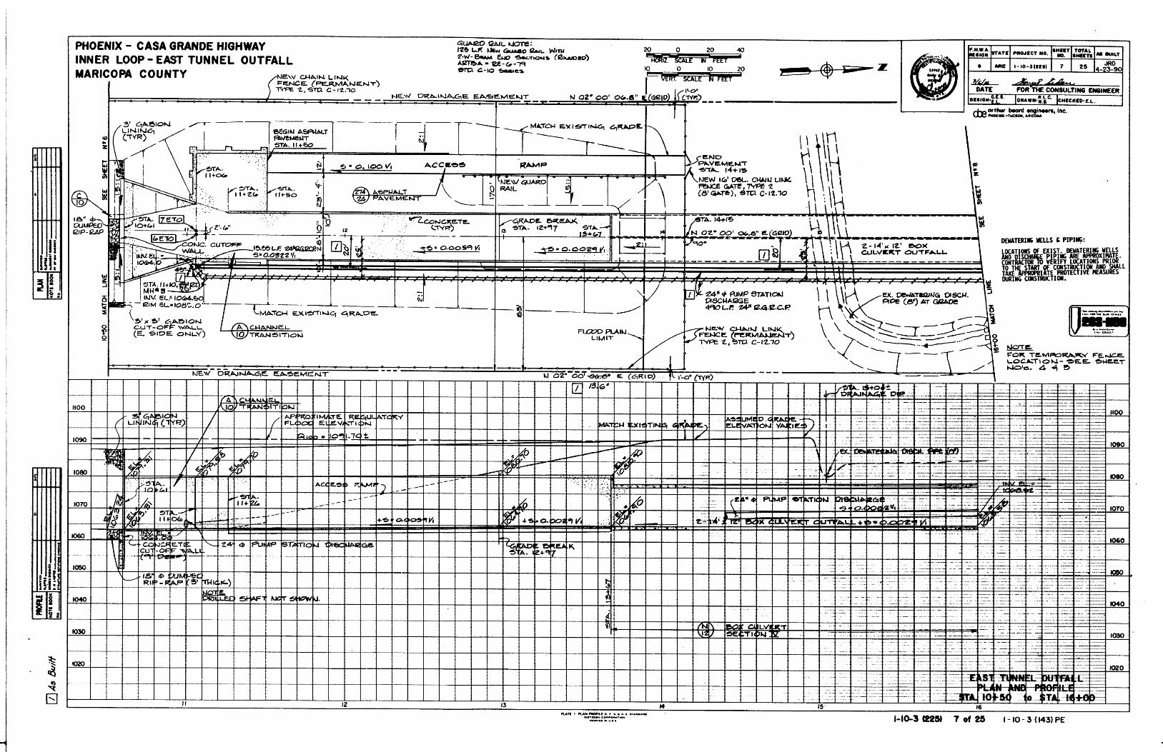
5.1 Background Regional drainage is generally north to south. The roadway project is bisected by a large shotcrete lined drainage channel belonging to ADOT. The outfall channel connects the east tunnel of the Phoenix, Arizona I-10 interstate highway offsite drainage systems with the Salt River. The outfall from I-10 tunnel consists of several hundred feet of concrete lined open channel. According to Final Drainage Design Report for Inner Loop Drainage Tunnel Outfalls (Project No. I-10-3(143) PE), the channel conveys a 50-year design flow of 5,000 cfs.
5.2 Proposed Offsite Flow Management Stanley Consultants conducted a culvert analysis for the concrete box alternative in the ADOT Outfall Channel. Riverview Drive roadway alignment crosses the open channel approximately 100 feet upstream from the outfall to the Salt River (See Photo 3 & 9).
The proposed culvert was analyzed using HEC-RAS 4.0 Beta. Inner Loop East Tunnel Outfall as-built design plans were used in conjunction with the final drainage design report HEC-2 model to gather data for existing condition HEC-RAS model.
Channel geometry was based on as-built plans, review of the data used in HEC-2 model, and our field survey. Manning’s n values were reviewed and adjusted to account for
removal of energy dissipators (See Photo) between the box culvert and the proposed box culvert. Dissipator removal is necessary to allow vehicular access for maintenance.
Using an open channel analysis, a culvert with varying transition lengths was simulated. The current model reflects 50 feet transition lengths upstream and downstream from the culvert. The proposed culvert is a two barrel 16 ft by 14
ft reinforced concrete box. The box culvert configuration is necessary for vehicular access.
The existing condition open channel HEC-RAS model computed water surface elevation of 1074.49 feet at river station 10.61, which is located approximately 500 feet upstream from the outfall to the Salt River. The proposed condition HEC-RAS model with above mentioned culvert computed a water surface elevation of 1074.49 feet at station 10.61, which is located approximately 500 feet upstream from the outfall and 350 feet upstream from the culvert inlet. Based on HEC-2 model output, section number 5 is located approximately 500 feet upstream from the outfall and 350 feet upstream from the proposed culvert inlet with computed water surface elevation of 1074.91 feet.

Drainage Memorandum Riverview Drive: 18th Street to 22nd Street
Riverview Draft Offsite Drainage Report2.docx 11/16/2017 Page 6-2
The proposed culvert does not increase the water surface elevation and therefore does not exceed existing condition HEC-2 or FEMA water surface elevations. Therefore the box culvert alternative is hydraulically acceptable.
6 REFERENCES City Of Phoenix, Stormwater Policies & Standards, March, 2004. Flood Control District of Maricopa County, Drainage Design Manual for Maricopa County, Volume 1 – Hydrology, November 18, 2009. Flood Control District of Maricopa County, Drainage Design Manual for Maricopa County, Volume II – Hydraulics (Draft), March 2009. Final Drainage Design Report for Inner Loop Drainage Tunnel Outfalls (Project No. I-10-3(143) PE),

APPENDIX A
HECRAS ANALYSES
Appendix A: HECRAS ANALYSES

HEC-RAS River: ADOT Dr Channel Reach: Riverview Profile: PF 1
Reach River Sta Profile Plan Q Total Min Ch El W.S. Elev Crit W.S. E.G. Elev E.G. Slope Vel Chnl Flow Area Top Width Froude # Chl
(cfs) (ft) (ft) (ft) (ft) (ft/ft) (ft/s) (sq ft) (ft)
Riverview 13.67 PF 1 DESIGN 5000.00 64.04 72.03 74.12 80.07 0.005903 22.75 219.83 27.50 1.42
Riverview 13.67 PF 1 EXISTING 5000.00 64.04 72.03 74.12 80.07 0.005903 22.75 219.83 27.50 1.42
Riverview 12.97 PF 1 DESIGN 5000.00 63.84 71.52 73.70 79.72 0.004046 22.97 217.67 28.34 1.46
Riverview 12.97 PF 1 EXISTING 5000.00 63.84 71.52 73.70 79.72 0.004046 22.97 217.67 28.34 1.46
Riverview 11.26 PF 1 DESIGN 5000.00 63.04 70.65 72.90 79.00 0.004158 23.19 215.56 28.34 1.48
Riverview 11.26 PF 1 EXISTING 5000.00 63.04 70.65 72.90 79.00 0.004158 23.19 215.56 28.34 1.48
Riverview 11.06 PF 1 DESIGN 5000.00 62.95 68.67 71.62 78.73 0.006061 25.45 196.44 34.34 1.88
Riverview 11.06 PF 1 EXISTING 5000.00 62.95 68.67 71.62 78.73 0.006061 25.45 196.44 34.34 1.88
Riverview 10.61 PF 1 DESIGN 5000.00 62.95 73.63 73.63 77.17 0.002043 15.10 331.22 47.03 1.00
Riverview 10.61 PF 1 EXISTING 5000.00 62.95 73.63 73.63 77.17 0.002044 15.10 331.17 47.03 1.00
Riverview 7.35 PF 1 DESIGN 5000.00 61.02 73.84 71.70 75.85 0.000959 11.40 438.55 53.44 0.70
Riverview 7.35 PF 1 EXISTING 5000.00 61.02 69.88 71.70 76.06 0.004346 19.95 250.64 41.58 1.43
Riverview 7 PF 1 DESIGN 5000.00 60.88 73.61 69.81 75.81 0.000666 11.90 420.07 33.00 0.59
Riverview 6.85 Culvert
Riverview 6 PF 1 DESIGN 5000.00 60.37 71.61 74.43 0.000941 13.48 370.94 33.00 0.71
Riverview 5.75 PF 1 DESIGN 5000.00 60.08 71.56 70.76 74.40 0.002091 13.52 369.88 49.44 0.87
Riverview 5.75 PF 1 EXISTING 5000.00 60.08 68.66 70.76 75.45 0.004937 20.91 239.15 40.74 1.52
Riverview 5.61 PF 1 DESIGN 5000.00 60.00 70.69 70.69 74.22 0.002850 15.08 331.63 47.06 1.00
Riverview 5.61 PF 1 EXISTING 5000.00 60.00 68.81 70.68 75.09 0.004443 20.11 248.61 41.43 1.45

Riverview
13.6712.97 11.267.35 6 5.75
ADOT Dr Channe l
None of the XS's are Geo-Referenced ( Geo-Ref user entered XS Geo-Ref interpolated XS Non Geo-Ref user entered XS Non Geo-Ref interpolated XS)Some schematic data outside default extents (see View/Set Schematic Plot Extents...)

0 10 20 30 40 50 60 70 8060
65
70
75
80
85
90
95
Riverview Dr Crossing Plan: 1) DESIGN 11/10/2017 2) EXISTING 11/10/2017
RS = 13.67 ADOT Station 13+67
Station (ft)
Ele
vation (
ft)
Legend
EG PF 1 - DESIGN
EG PF 1 - EXISTING
Crit PF 1 - EXISTING
Crit PF 1 - DESIGN
WS PF 1 - DESIGN
WS PF 1 - EXISTING
Ground
Bank Sta
.015 .012 .015
0 10 20 30 40 50 60 7060
65
70
75
80
85
90
Riverview Dr Crossing Plan: 1) DESIGN 11/10/2017 2) EXISTING 11/10/2017
RS = 12.97 ADOT Station 12+97
Station (ft)
Ele
vation (
ft)
Legend
EG PF 1 - DESIGN
EG PF 1 - EXISTING
Crit PF 1 - DESIGN
Crit PF 1 - EXISTING
WS PF 1 - EXISTING
WS PF 1 - DESIGN
Ground
Bank Sta
.015 .012 .015
0 10 20 30 40 50 60 7060
65
70
75
80
85
90
Riverview Dr Crossing Plan: 1) DESIGN 11/10/2017 2) EXISTING 11/10/2017
RS = 11.26 ADOT Station 11+26
Station (ft)
Ele
vation (
ft)
Legend
EG PF 1 - DESIGN
EG PF 1 - EXISTING
Crit PF 1 - EXISTING
Crit PF 1 - DESIGN
WS PF 1 - DESIGN
WS PF 1 - EXISTING
Ground
Bank Sta
.015 .012 .015
0 10 20 30 40 50 60 7060
65
70
75
80
85
90
Riverview Dr Crossing Plan: 1) DESIGN 11/10/2017 2) EXISTING 11/10/2017
RS = 11.06 ADOT Station 11+06
Station (ft)
Ele
vation (
ft)
Legend
EG PF 1 - DESIGN
EG PF 1 - EXISTING
Crit PF 1 - EXISTING
Crit PF 1 - DESIGN
WS PF 1 - DESIGN
WS PF 1 - EXISTING
Ground
Bank Sta
.012

0 20 40 60 80 10060
65
70
75
80
85
90
Riverview Dr Crossing Plan: 1) DESIGN 11/10/2017 2) EXISTING 11/10/2017
RS = 10.61 ADOT Sta 10+61
Station (ft)
Ele
vation (
ft)
Legend
EG PF 1 - EXISTING
EG PF 1 - DESIGN
Crit PF 1 - DESIGN
WS PF 1 - DESIGN
Crit PF 1 - EXISTING
WS PF 1 - EXISTING
Ground
Bank Sta
.015 .015 .015
0 20 40 60 80 10060
65
70
75
80
85
90
Riverview Dr Crossing Plan: 1) DESIGN 11/10/2017 2) EXISTING 11/10/2017
RS = 7.35
Station (ft)
Ele
vation (
ft)
Legend
EG PF 1 - EXISTING
EG PF 1 - DESIGN
WS PF 1 - DESIGN
Crit PF 1 - DESIGN
Crit PF 1 - EXISTING
WS PF 1 - EXISTING
Ground
Bank Sta
.015 .015 .015
0 20 40 60 80 10060
65
70
75
80
85
90
Riverview Dr Crossing Plan: 1) DESIGN 11/10/2017 2) EXISTING 11/10/2017
RS = 7
Station (ft)
Ele
vation (
ft)
Legend
EG PF 1 - DESIGN
WS PF 1 - DESIGN
Crit PF 1 - DESIGN
Ground
Bank Sta
.015 .012 .015
0 20 40 60 80 10060
65
70
75
80
85
90
Riverview Dr Crossing Plan: 1) DESIGN 11/10/2017 2) EXISTING 11/10/2017
RS = 6.85 Culv
Station (ft)
Ele
vation (
ft)
Legend
EG PF 1 - DESIGN
WS PF 1 - DESIGN
Crit PF 1 - DESIGN
Ground
Bank Sta
.015 .012 .015

0 20 40 60 80 10060
65
70
75
80
85
90
Riverview Dr Crossing Plan: 1) DESIGN 11/10/2017 2) EXISTING 11/10/2017
RS = 6.85 Culv
Station (ft)
Ele
vation (
ft)
Legend
EG PF 1 - DESIGN
WS PF 1 - DESIGN
Crit PF 1 - DESIGN
Ground
Bank Sta
.015 .012 .015
0 20 40 60 80 10060
65
70
75
80
85
90
Riverview Dr Crossing Plan: 1) DESIGN 11/10/2017 2) EXISTING 11/10/2017
RS = 6
Station (ft)
Ele
vation (
ft)
Legend
EG PF 1 - DESIGN
WS PF 1 - DESIGN
Ground
Bank Sta
.015 .012 .015
0 20 40 60 80 10060
65
70
75
80
85
90
Riverview Dr Crossing Plan: 1) DESIGN 11/10/2017 2) EXISTING 11/10/2017
RS = 5.75
Station (ft)
Ele
vation (
ft)
Legend
EG PF 1 - DESIGN
EG PF 1 - EXISTING
WS PF 1 - DESIGN
WS PF 1 - EXISTING
Crit PF 1 - DESIGN
Crit PF 1 - EXISTING
Ground
Bank Sta
.015 .024 .015
0 20 40 60 80 10060
65
70
75
80
85
90
Riverview Dr Crossing Plan: 1) DESIGN 11/10/2017 2) EXISTING 11/10/2017
RS = 5.61 ADOT Sta 5+61
Station (ft)
Ele
vation (
ft)
Legend
EG PF 1 - DESIGN
EG PF 1 - EXISTING
Crit PF 1 - DESIGN
WS PF 1 - EXISTING
WS PF 1 - DESIGN
Crit PF 1 - EXISTING
Ground
Bank Sta
.015 .024 .015

APPENDIX B
BOX CULVERT PLANS
Appendix B: BOX CULVERT PLANS

cs 7.35cs 7 cs 6 cs 5.75


APPENDIX C
ADOT CHANNEL AS-BUILTS
Appendix C: ADOT CHANNEL AS-BUILTS