Embed Size (px)
Citation preview

…………………………………………………………………………….…Master plan, LPA Nawanshahr
i
TABLE OF CONTENTS
1. INTRODUCTION __________________________________________ 1
1.1 Initial Steps _____________________________________________________________ 1
1.2 Regional Setting _________________________________________________________ 2
1.3 Physiography and Climate _________________________________________________ 3
1.4 Historical Background _____________________________________________________ 3
1.5 Major Development Events ________________________________________________ 4
1.6 Legal Framework for Preparation & Implementation of Master Plan _______________ 4
2. POPULATION, HOUSING, ECONOMY AND EMPLOYMENT ___ 8
Population ____________________________________________________________________ 8
2.1 Population Growth and Characteristics _______________________________________ 8
2.2 Sex Ratio ______________________________________________________________ 12
2.3 Caste Composition ______________________________________________________ 13
2.4 Literacy _______________________________________________________________ 13
Housing ______________________________________________________________________ 14
2.5 Growth of Housing in Nawanshahr _________________________________________ 14
2.6 Housing Demand and Supply ______________________________________________ 18
Slums in Nawanshahr __________________________________________________________ 18
2.7 General Characteristics of Slums in Nawanshahr Town: _________________________ 19
2.8 Distribution and Location of Slum Areas _____________________________________ 19
2.9 Level of Facilities Available In Slum Areas – Nawanshahr Town __________________ 20
2.10 Ownership Pattern ______________________________________________________ 20
Economy and Employment ______________________________________________________ 20
2.11 State of Punjab _________________________________________________________ 20
2.12 LPA, Nawanshahr _______________________________________________________ 20
2.13 Work force Participation & Employment _____________________________________ 21
2.14 Occupational Structure ___________________________________________________ 21
2.15 Manufacturing Industry __________________________________________________ 22
2.16 Key Economic Indicators __________________________________________________ 28
3. EXISTING LAND USE _____________________________________ 30
3.1 Preparation of base map _________________________________________________ 30
3.2 Enhancement through field surveys ________________________________________ 30
3.3 Existing Land Use: LPA, Nawanshahr ________________________________________ 30

…………………………………………………………………………….…Master plan, LPA Nawanshahr
ii
3.4 Existing Land Use: Nawanshahr town _______________________________________ 31
3.5 Environmental Status ____________________________________________________ 34
3.6 Heritage & Conservation in LPA Nawanshahr _________________________________ 35
4. EXISTING INFRASTRUCTURE ____________________________ 36
Physical Infrastructure _________________________________________ 36
4.1 Water supply ___________________________________________________________ 36
4.2 Sewerage Network ______________________________________________________ 37
4.3 Storm Water Drainage ___________________________________________________ 37
4.4 Solid Waste Management ________________________________________________ 37
4.5 Traffic and Transportation ________________________________________________ 38
Social Infrastructure ___________________________________________ 44
4.6 Educational Facilities ____________________________________________________ 44
4.7 Health Care ____________________________________________________________ 45
4.8 Sports and Recreational Facilities __________________________________________ 46
4.9 Parks and Open Spaces ___________________________________________________ 46
4.10 Cinemas & Multiplexes ___________________________________________________ 47
4.11 Other Recreational facilities _______________________________________________ 47
4.12 Sports ________________________________________________________________ 47
4.13 Post and Telegraph ______________________________________________________ 47
5. VISUALISING THE FUTURE _______________________________ 48
5.1 Population Projections ___________________________________________________ 48
5.2 Workforce Projections ___________________________________________________ 51
5.3 Infrastructural requirements ______________________________________________ 52
5.4 Constitution of Think Tank ________________________________________________ 54
5.5 The Strengths, Weaknesses, Opportunities, Threats (SWOT) Analysis _____________ 54
5.6 Vision- 2031 ____________________________________________________________ 56
6 THE MASTER PLAN NAWANSHAHR - 2031 _________________ 59
6.1 Components of the Master Plan ___________________________________________ 59
6.2 Master Plan Objectives ___________________________________________________ 59
6.3 Evaluation of Existing Structure ____________________________________________ 60
6.4 Proposed town structure -2031 ____________________________________________ 60
6.5 Land use Requirements __________________________________________________ 61
6.6 Space Norms and Standards _______________________________________________ 65

…………………………………………………………………………….…Master plan, LPA Nawanshahr
iii
6.7 Strategy for obtaining Land for public purposes _______________________________ 66
6.8 Proposed Land Use Plan - 2031 ____________________________________________ 69
7 SPECIAL AND DETAILED CONTROLS _____________________ 86
7.1 Section – I: Zoning Regulations ____________________________________________ 86
7.2 Section – II: Development Control regulations ________________________________ 95
7.3 Section III: Exceptions __________________________________________________ 101

…………………………………………………………………………….…Master plan, LPA Nawanshahr
iv
ANNEXURE II
104
ANNEXURE III _______________________________________________ 107
ANNEXURE IV _______________________________________________ 108

…………………………………………………………………………….…Master plan, LPA Nawanshahr
v
ANNEXURE V ________________________________________________ 109
ANNEXURE VI _______________________________________________ 110
ANNEXURE VII ______________________________________________ 112

…………………………………………………………………………….…Master plan, LPA Nawanshahr
vi
LIST OF TABLES
Table 1: Detail of Development Milestones in Nawanshahr __________________________________________ 4 Table 2: Detail of Institutional and Planning Events in Nawanshahr ___________________________________ 4 Table3: Population Growth Rate of Punjab State and LPA, Nawanshahr: 1981-2001 ______________________ 8 Table 4: Population Growth Rate Nawanshahr town: 1901-2001 _____________________________________ 9 Table 5: Growth Trends – Urban Population in Punjab and Nawanshahr town __________________________ 10 Table 6: Population density (within Municipal Limit) _______________________________________________ 11 Table 7 : Ward wise Population Density of Nawanshahr town: 2001 __________________________________ 11 Table 8: Density Gradient of M. C. Nawanshahr (ward wise): 2001 ___________________________________ 12 Table 9: Sex ratio ___________________________________________________________________________ 12 Table 10: Scheduled Caste population & %age of SC Population to total Population _____________________ 13 Table 11: Literacy Rate LPA Nawanshahr ________________________________________________________ 13 Table12: Literacy rate of Nawanshahr Town: 1981-2001 ___________________________________________ 13 Table 13: Growth of houses, households & household size in Nawanshahr town ________________________ 15 Table 14: Census houses by predominant material of roof in Nawanshahr town - 2001 ___________________ 15 Table 15: Census houses by predominant material of wall in Nawanshahr town: 2001 ___________________ 16 Table 16: Census houses by predominant material of floor in Nawanshahr town: 2001 ___________________ 16 Table 17: Residential houses by their type of structure in Nawanshahr town: 2001 ______________________ 16 Table 18: Census houses by their condition in Nawanshahr town: 2001 _______________________________ 16 Table 19: Households by number of dwelling rooms in Nawanshahr town: 2001 ________________________ 17 Table 20: Households by source of drinking water in Nawanshahr town: 2001 __________________________ 17 Table 21: Households by source of lighting Nawanshahr town: 2001 _________________________________ 17 Table 22: Households by type of latrine & drainage connectivity ____________________________________ 18 Table 23: Detail of Identified Slum Areas in Nawanshahr Town ______________________________________ 19 Table 24: Workers and Non-workers of LPA, Nawanshahr & Nawanshahr town (1981–2001) ______________ 21 Table 25: Occupational Structure of LPA, Nawanshahr 1981-2001 ___________________________________ 21 Table 26: Occupational Structure of Nawanshahr Town: 1981-2001 __________________________________ 22 Table 27: Growth of Large & Small Scale Industrial Units in Nawanshahr ______________________________ 23 Table 28: Employment in Small & Large Industrial Sector ___________________________________________ 24 Table 29: Small Scale Industrial Investment and Production _________________________________________ 25 Table 30 : Detail of industrial units in Focal Point, Nawanshahr ______________________________________ 26 Table 31: Detail of Industries in Nawanshahr ____________________________________________________ 27 Table 32 : Existing Land Use LPA, Nawanshahr-2009 ______________________________________________ 31 Table 33: Existing Land Use Nawanshahr Town -2009 _____________________________________________ 31 Table 34: Detail of water supply connections in Nawanshahr from 2002-2008 __________________________ 36 Table 35: Existing Water supply _______________________________________________________________ 36 Table 36: Details of Waste Dumping Site ________________________________________________________ 38 Table 37: Detail of Major Roads falling within M.C. limits and outside M.C. limits in LPA, Nawanshahr ______ 39 Table 38: Detail of Road Intersections in Nawanshahr Town ________________________________________ 40 Table 39: Registered vehicles category wise 2004-09 ______________________________________________ 40 Table 40: Year wise Fatal and Non-Fatal accidents in Nawanshahr town 2005-09 _______________________ 41 Table 41: Yearly Bus traffic route-wise in Nawanshahr 2007-09______________________________________ 42 Table 42: Yearly Mini-Bus traffic route-wise in Nawanshahr 2007-09 _________________________________ 42 Table 43: Yearly Number of Passengers _________________________________________________________ 43 Table 44: Detail of passenger trains passing through Nawanshahr town ______________________________ 44 Table 45: Educational facilities in LPA, Nawanshahr and Nawanshahr town ____________________________ 45 Table 46: Medical Facilities in LPA, Nawanshahr __________________________________________________ 46 Table 47: Growth of Population of LPA, Nawanshahr (Total, urban & Rural) ____________________________ 48 Table 48: Projected Population of Punjab Total, Punjab Urban and Punjab Rural 2001-2026 ______________ 49 Table 49: Percentage share of Nawanshahr town and Rural Population of LPA, Nawanshahr ______________ 49 Table 50: Projected Population and Growth Rate of LPA, Nawanshahr ________________________________ 50 Table 51: Projected Population for LPA, Nawanshahr ______________________________________________ 50 Table 52: Comparison of Projected Population of LPA, Nawanshahr __________________________________ 51 Table 53: Workforce projections for LPA Nawanshahr _____________________________________________ 52 Table 54: Workforce projections for Nawanshahr town ____________________________________________ 52 Table 55: Projected Gross water Demand for Nawanshahr Town 2031 ________________________________ 53

…………………………………………………………………………….…Master plan, LPA Nawanshahr
vii
Table 56: Projected Gross Waste Water Flows of Nawanshahr town 2031 _____________________________ 53 Table 57: Calculation of average plot area in Nawanshahr Town_____________________________________ 62 Table 58: Stage Wise Residential Area Requirements for Nawanshahr Town (2011-2031) _________________ 62 Table 59: Area of Commercial Centers __________________________________________________________ 63 Table 60: Commercial area requirements of Nawanshahr town ______________________________________ 63 Table 61: Projected Urbanisable Area Requirements for Nawanshahr Town - 2031 ______________________ 64 Table 62: Strategy for Obtaining Land for Public Purpose ___________________________________________ 68 Table 63 : Break-up of Major Proposed Landuses LPA, Nawanshahr-2031 _____________________________ 70 Table 64: Proposed Net Residential Density Gradient for LPA, Nawanshahr 2031 ________________________ 71 Table 65: Planning Norms for Informal Sectors ___________________________________________________ 76 Table 64: Proposed Net Residential Density Gradient for LPA, Nawanshahr 2031 ________________________ 95

…………………………………………………………………………….…Master plan, LPA Nawanshahr
viii
LIST OF FIGURES
Figure 1: LPA Nawanshahr with respect to Punjab State and surrounding region _________________________ 2 Figure 2 : Stages of Master Plan Preparation _____________________________________________________ 7 Figure 3: Population Growth Rate of Punjab State and LPA, Nawanshahr: 1981-2001 _____________________ 8 Figure 4: Decadal growth rate of population of Nawanshahr ________________________________________ 10 Figure 5: Population of Nawanshahr town_______________________________________________________ 10 Figure6: Sex Ratio of Nawanshahr _____________________________________________________________ 12 Figure 7 : Literacy Rate, LPA Nawanshahr _______________________________________________________ 14 Figure 8: Occupational Structure of LPA, Nawanshahr (1981 -2001) __________________________________ 22 Figure 9: Occupational Structure of Nawanshahr Town (1981 – 2001) ________________________________ 22 Figure 10 Number of small scale industries ______________________________________________________ 23 Figure 11 Growth of small scale industries _______________________________________________________ 24 Figure 12: Employment in Industries ___________________________________________________________ 25 Figure 13: Percentage growth rate of various industries in Nawanshahr _______________________________ 25 Figure 14: Investment and Production in Industries _______________________________________________ 26 Figure 15: Breakup of various industrial units in focal point _________________________________________ 26 Figure 16: Details of Industries in Nawanshahr ___________________________________________________ 27 Figure 17 : Vehicular Growth, Nawanshahr Town 2004 – 2009 ______________________________________ 41

…………………………………………………………………………….…Master plan, LPA Nawanshahr
1
1. INTRODUCTION
1.1 Initial Steps
As a first step towards the preparation of master plan, Local Planning Area (LPA)
Nawanshahr, has been delineated and notified U/S 56(1) of “The Punjab Regional and Town
Planning and Development Act (Amended), 2006” in the official gazette vide Notification
No. 12/16/2008-4HG1/6062 dated 11.09.2008 and Notification No. 12/16/08-4HG1/2871
dated 31-08-2010 (shown at annexure I and II). The LPA of Nawanshahr includes
Nawanshahr M.C. along with 29 villages of district Shaheed Bhagat Singh Nagar. The total
area of LPA is 8675 hectares (86.75 sq kms). The detail of areas and population of LPA
Nawanshahr has been detailed out in Annexure III while the schedule of boundary has been
detailed out in Drawing No. DTP (J) 15/2010 dated 30-04-2010.
While delineating the LPA, Nawanshahr the following factors have been considered as
mentioned in rule 22 of the Punjab Regional and Town Planning and Development (General
Rules 1995):
a) Boundaries of municipal council Nawanshahr, Revenue Boundaries of villages and
permanent features have been kept in mind for proper identification of land falling in
LPA.
b) Geographical and location aspects have also been taken into account.
c) Major road pattern of the town especially the development potential on Nawanshahr-
Chandigarh road, Nawanshahr – Rahon Road and railway linkages i.e. Nawanshahr -
Jalandhar, Nawanshahr-Garhshankar and Nawanshahr Rahon railway line have taken
into consideration to make the planning area more accessible for proper development.
d) To study and analyze the present population and population increase due to designation
of Nawanshahr town as District headquarter so that projected population can be
adjusted in planned manner in the near future.
e) To enhance the industrial development, the trend of existing industrial development,
expected industrial development have also been studied and analyzed and have been
taken into consideration.
f) To strengthen the economic base and commercial activities of Nawanshahr, the need
for planned development of this area has been kept into consideration
g) To make the periphery of the town manageable in a proper manner, the extents of the
town and its expansion have also been considered.
h) For the planned and balanced development of this area, the ecological and
environmental considerations have been taken care off.

…………………………………………………………………………….…Master plan, LPA Nawanshahr
2
i) State and Regional level planned and development aspects have also been considered
so as to control the pressure on existing infrastructure and amenities of this newly
created district headquarter.
1.2 Regional Setting
LPA Nawanshahr lies between 310-05’ and 31
0-15' north latitude and 75
0-45' and 76
0-30' east
longitude in Doaba Region of South Western Punjab. It is surrounded by Ludhiana District
on the south, Rupnagar District on the south and east, Hoshiarpur District on the north and
the Kapurthala District on the north western side and the River Satluj forms its southern
boundary.
The Headquarter of the district administration is located in Nawanshahr town. Jaijon Doaba
line of the Northern Railway passes through this town which is 58 Km from Jalandhar city. It
is directly connected by road with Chandigarh (98 km), Phillaur (45 km) and Phagwara (37
km).
Figure 1: LPA Nawanshahr with respect to Punjab State and surrounding region

…………………………………………………………………………….…Master plan, LPA Nawanshahr
3
1.3 Physiography and Climate
The surface of S.B.S Nagar District (of which LPA Nawanshahr is a part) is part of Indo-
Gangetic plain, which was formed by deposition of alluvium brought by rivers originating in
Himalayas. S.B.S Nagar District falls in the Basin of Satluj River which makes the southern
boundary of the district. Satluj River does not directly drain the district but indirectly receives
waters draining through S.B.S Nagar District. Eastern Bein or White Bein crosses through the
northern part of the district. This White Bein used to overflow during rainy season. Bist Doab
Canal is a major canal serving the district within the territory of S.B.S Nagar District. Bist
Doab canal has been bifurcated into two canals namely Nawanshahr branch which runs
westward and Nawanshahr branch which flows north-westward. Bist Doab Canal is a major
source of irrigation in S.B.S Nagar District through various distributaries.
Climatically this area has a very hot. During the month of June, the mercury sometimes rises
to 48º C. The dust storms are regular feature in summer. The winter season is mostly dry with
minimum temperature touching to 0º C. The average annual rainfall in the district is 843.7
mm. About 70 per cent of the annual rainfall is received during the period from July to
September, July being considered as the rainiest month. The prevailing wind direction of this
region is North-West to South-East. The driest part of the year is the summer season when
the relative humidity is 30 per cent or less.
1.4 Historical Background
The Nawanshahr town saw its development in three different eras. The first one is Mughal
period, in which the town was founded by Nausher Khan, an Afghan in the time of Ala-ud-
din Khilji (1295-1316 AD). According to another version, it got its name Nawanshahr
(meaning ‘New City’) because people shifted from the old town of Rahon to avoid ravages of
Sutlej River. There is a ‘Baradari’ built by Mohammad Sadiq, originally a Hindu Umat
Khatri from Pastun, District Sialkot (Pakistan), who settled here and got into quarrel with
local Bhuchar Khatris. His original name was Bhikari Mal.
After that the British period came in which many development milestones were achieved.
The Notified Municipal Committee was set up in 1911 and focus was put on educational
structure. In the post independence period the educational structure was further strengthened
by establishing a number of educational institutions.
Now with the enactment of Punjab Regional and Town Planning and Development
(Amendment) Act, 2006, Government of Punjab has decided to prepare Master Plans for all
cities and towns of Punjab which also includes Nawanshahr town. For this purpose LPA
Nawanshahr has been notified under section 56 (1) of Punjab Regional and Town Planning &

…………………………………………………………………………….…Master plan, LPA Nawanshahr
4
Development (Amendment) Act, 2006 vide Notification No. 12/16/2008-4HG1/6062 dated
11.09.2008 and Notification No. 12/16/08-4HG1/2871 dated 31-08-2010.
1.5 Major Development Events
The major events in the development of Nawanshahr are listed as below:
Table 1: Detail of Development Milestones in Nawanshahr
1 1293-1316 AD The town founded by Navsher khan
2 1895 Arya Pritinidhi Sabha established
3 1911 Notified M.C
4 1911 Doaba Arya Senior Secondary School established
5 1920 Khalsa Educational Society formed
6 1953 R.K Arya Senior Secondary School established
7 1954 Sanatan Dharam Educational Board established
8 1959 Bim Girl College established
9 1959 Bhagwanh Laroiye Memorial Girl College established
10 1974 Civil Hospital established
Planning and Administrative Mile Stones
Table 2: Detail of Institutional and Planning Events in Nawanshahr
1 1867 Municipal committee formed
2 1911 Notified M.C
3 1924 Small Town Committee
4 1951 Made Class II Municipality
5 1995 Nawanshahr declared as a District headquarter
6 2008 L.P.A Nawanshahr declared and name of the district changed as Shaheed
Bhagat Singh Nagar
1.6 Legal Framework for Preparation & Implementation of Master Plan
The principal legislation governing regional and town Planning is the “Punjab Regional and
Town Planning and Development Act, 1995 (PRTPD)” which was enacted in the year 1995
(Punjab Act No.11 of 1995). It has been amended in the year 2006 and is now it is known as
“The Punjab Regional and Town Planning and Development (Amendment) Act 2006”
(Punjab Act No 11 of 2006).
Prior to the enactment of this Act the town planning activity within urban areas was being
governed by different legislations such as The Town Improvement Act 1922, The Punjab
Municipal Act 1911, The Punjab Municipal Corporation Act 1976, The Punjab Urban Estates
(Development and Regulation) Act 1964 etc and for areas falling outside municipal limits in
the periphery of urban centers and for control of development along scheduled roads, there
was ‘The Punjab Scheduled Roads And Controlled Areas Restriction of (Unregulated)
Development Act 1963(Now repealed) but no comprehensive legislation was available for
the overall control and development at local and regional level.

…………………………………………………………………………….…Master plan, LPA Nawanshahr
5
The Punjab Regional and Town Planning and Development (Amendment) Act 2006
This act provides the framework for preparing Master Plans and Regional Plans and provides
for the manner in which the use of land in the area of a planning authority is regulated. The
Act also prescribes specific time period for various steps in the plan preparation process.
Main provisions of the law
Section 56(1) enables declaration of Local Planning Areas (LPA) in the official gazette for
preparing Master Plan. Once an area has been declared under section-56 (1), no person can
institute or change the use of land for any purpose or carry out any development in respect
of any land without the previous permission of competent authority until the Master Plan
comes into operation. However, this prohibition does not apply to any area comprised in
abadi deh of any village falling inside its lal lakir or phirni.
Section 57 provides for the state Government to designate Planning Agency for area
declared as Local Planning Area.
Section 58 defines scope of planning agency and provides that:
The designated Planning Agency will work under the overall directions and control of
the State Government.
The state Government may assign any or all of the following functions to the
Designated Planning Agency, namely to
Carry out survey of the regional planning area, Local Planning Area, or a site for new
town, as the case may be, and prepare reports on the surveys so carried out;
Prepare an existing land use map and such other maps as may be necessary for the
purpose of preparing regional plan and outline master plan, a new town development
plan or a comprehensive master plan, as the case may be;
Prepare a regional plan, an outline master plan, a new town development plan or a
comprehensive master plan.
Subject to and in accordance with the directions of the Govt., a designated planning
agency shall exercise all such powers as may be necessary or expedient for the
purposes of carrying out its functions under this act and also perform any other
functions which are supplemental, incidental or consequential to any of the functions
specified in sub section (2) or as may be prescribed.
Section 59 deals with the preparation of present land use map and fixes six months time
for this purpose, which may be extended by the State Govt. from time to time.
…………………………………………………………………………….…Master plan, LPA Nawanshahr
6
Section 70(1) states that the planning agency shall not later than one year after declaration
of planning area and after the designation of that agency for that area shall prepare and
submit to the state government a master plan for its approval. The Master Plan so prepared
shall –
Indicate broadly the manner in which the land in the area should be used.
Allocate areas or zones of land for use for different purposes.
Indicate, define and provide the existing and proposed highways, roads, major streets and
other lines of communication.
Indicate areas covered under heritage site and the manner in which protection,
preservation and conservation of such site including its regulation and control of
development, which is either affecting the heritage site or its vicinity, shall be carried out.
Include regulations to regulate within each zone the location, height, number of storeys
and size of buildings and other structures, open spaces and the use of buildings, structures
and land.
Section 70 (3) has the provision for the state government to direct the designated planning
agency to publish the existing land use plan and master plan and the information regarding
places where copies of the same may be inspected by the public for inviting objections in
writing with respect to existing land use plan and master plan within a period of 30 days
from the date of publication.
Under Section 70(4), the state government after considering the objections and in
consultation with the Board may direct the designated planning agency to modify the
master plan or approve it as such
Under Section 70 (5), the Designated Planning Agency after approval of the state
government shall publish the final master plan in the official gazette after carrying out the
modification if any under intimation to the state government within a period of 30 days
from the date of according the approval by the state government.
Under Section 75, the Master Plan comes into operation from the date of publication,
referred in to sub section 5 of Section 70.
The entire process is shown in the form of flowchart (see figure 2)
Chapter XI of the Act also provides for “Control of Development and Use of Land in the
area where the Master Plan is in operation”.
Chapter XII, Section 91 of the Act deals with the preparation of Town Development
Schemes that can play a significant role in the implementation of Master Plan by way of

…………………………………………………………………………….…Master plan, LPA Nawanshahr
7
planned development and through making land available for the open spaces, recreation,
education and health services, transport and communication network, water supply,
sewerage, sewage disposal and other public utilities including electricity and gas etc
Figure 2 : Stages of Master Plan Preparation

…………………………………………………………………………….…Master plan, LPA Nawanshahr
8
2. POPULATION, HOUSING, ECONOMY AND EMPLOYMENT
Population
2.1 Population Growth and Characteristics
Demographic profile of the area in terms of the population, growth rate, population density,
literacy rate etc. helps in determining the social as well as the economic character of the area.
The study has been done decade wise which helps in bringing out the trends of the growth
rate, literacy level, sex ratio etc. of the LPA, Nawanshahr and Nawanshahr town.
2.1.1 Local Planning Area, Nawanshahr:
The Local Planning Area Nawanshahr includes one town namely, Nawanshahr along with 29
villages of district Shaheed Bhagat Singh Nagar. Local Planning Area experienced growth
rate of 15.40% and 9.35% during the year 1981 - 1991 and 1991 - 2001 respectively. Thus
showing a decline in the population growth rate during the last decade which might be due to
the weak economic base of the town and out migration to other countries. LPA Nawanshahr
has a population of 82326 persons in 2001. The growth trend of population of Punjab State
and LPA, Nawanshahr is given in table below:
Table3: Population Growth Rate of Punjab State and LPA, Nawanshahr: 1981-2001
Population Growth rate in %
1981 1991 2001 1981-91 1991-2001
Punjab State *
Total 16.79 20.28 24.36 20.79 20.12
Urban 4.65 5.99 8.25 28.82 37.73
Rural 12.14 14.29 16.11 17.71 12.74
* Population In Millions
LPA, Nawanshahr
Total 65242 75288 82326 15.40 9.35
Urban 26726 29955 31967 12.08 6.72
Rural 38516 45333 50359 17.69 11.09
Source: Census of India, Punjab 1981, 1991, 2001,
Figure 3: Population Growth Rate of Punjab State and LPA, Nawanshahr: 1981-2001
Table above depicts that the growth rate of population of Nawanshahr town has decreased
from 12.08% during 1981- 91 to 6.72 % during 1991- 2001 decade which is very low when

…………………………………………………………………………….…Master plan, LPA Nawanshahr
9
compared to urban growth rate of Punjab which is about 37.73% during the last decade. This
is because of out migration of population to other countries and incentives for industrial
growth in surrounding areas like Balachaur (Kandi areas) which hinders the development and
growth of LPA Nawanshahr. But in case of rural population, the growth rate of rural
population of LPA, Nawanshahr is about 11.09% during 1991-2001 which is slightly less
than to the rural growth rate of Punjab state (12.74%).
From 1981 to 2001, Nawanshahr grew almost 1.2 times in population (from 65242 to 82326)
but did not increase in physical size. Most of town growth was haphazard and unplanned,
resulting in highly uneconomical use of agricultural land for urban purpose.
2.1.2 Nawanshahr Town
As per table given below Nawanshahr town recorded a negative growth rate of -20.67%
during 1901-1911. However, the town registered high growth rates of 62.70% and 25%
during the decades of 1931-41 and 1941-51 respectively. However due to sudden influx of
refugees from West Pakistan, around 3000 more people descended in new town Nawanshahr.
These high growth rates show that the town occupied an important position in the region
before partition of the country. Town registered a low growth rate of 9.75% during 1951-61
decade which can be attributed to out migration from the town due to partition.
During 1961-71, the growth rate increase to 24.33% because of normalized social and
economic conditions and jumped to 52.48% during 1971-81 due to coming up of number of
agro-based industrial units and focal point. However during the last two decades of 1981-91
and 1991-2001, the growth rates i.e. 12.08% and 6.71% are on decline which is perhaps due
to the out migration of the population to the foreign countries thus increasing the NRI count
in this area. The detail of population growth of Nawanshahr town from 1901 to 2001 is given
in table below:
Table 4: Population Growth Rate Nawanshahr town: 1901-2001
Year Population of Nawanshahr Municipal
Council (persons)
Decadal growth rate of population of
Nawanshahr (percent)
1901 5641 -
1911 4475 -20.67
1921 5316 18.79
1931 6315 18.79
1941 10275 62.70
1951 12844 25.00
1961 14097 9.75
1971 17527 24.33
1981 26726 52.48
1991 29955 12.08
2001 31967 6.71
Source: Census of India, Punjab 1901 – 2001

…………………………………………………………………………….…Master plan, LPA Nawanshahr
10
Figure 4: Decadal growth rate of population of Nawanshahr
Figure 5: Population of Nawanshahr town
2.1.3 Population Growth in the Context of Punjab State
Table 5: Growth Trends – Urban Population in Punjab and Nawanshahr town
Year Urban
population
of Punjab
(persons)
Population
of
Nawanshahr
M.C.
(persons)
Population of
Nawanshahr M.C. as
percent of total urban
population of Punjab
Decadal growth rate of
urban population of
Punjab (percent)
Decadal growth
rate of population
of Nawanshahr
(percent)
1901 934766 5641 0.60 - -
1911 813224 4475 0.55 -13.00 -20.67
1921 869526 5316 0.61 6.92 18.79
1931 1168413 6315 0.54 34.37 18.79
1941 1657414 10275 0.61 41.85 62.70
1951 1989267 12844 0.64 20.02 25.00
1961 2567306 14097 0.54 29.06 9.75
1971 3216179 17527 0.54 25.27 24.33
1981 4647757 26726 0.57 44.51 52.48
1991 5993220 29955 0.49 28.95 12.08
2001 8245566 31967 0.38 37.58 6.71 Source: Census of India1901-2001
It is evident from the above table that growth rate of Nawanshahr town is less than Punjab
state in the last two decades; while in decade of 1971-1981 the urban growth rate is
comparatively higher than the whole Punjab state.

…………………………………………………………………………….…Master plan, LPA Nawanshahr
11
Population Density
2.1.4 Population Distribution in Nawanshahr town:
The population density of the town within municipal limits has been tabulated below:
Table 6: Population density (within Municipal Limit)
Year Population Area
(In hectares)
Gross Population Density
(Persons / hectare)
1981 26726 1412 19
1991 29955 1412 21.2
2001 31967 1412 22.6
2011 44000* 1412 31.2 *Population Projected (Source: M.C. Nawanshahr, Census of India, 1981, 1991, 2001)
Population density of M.C. Nawanshahr has increased from 19 persons per hectare in 1981 to
22.6 persons per hectare in 2001 and further increase to 31.2 persons per hectare in 2011.
This is because of various reasons like the Nawanshahr declared as a district headquarter, in-
migration caused by the growth of industrial and trade & commerce sectors leads to increase
the urbanization process in the town.
The density of population within the municipal limits is not uniform all over the town. It
varies from ward to ward as given in table below:
Table 7 : Ward wise Population Density of Nawanshahr town: 2001
ward no. Estimated Population* Area (hact.) Density
1 1589 135 11.7
2 1978 11 177.6
3 2145 9 227.6
4 1665 29 57.2
5 1787 159 11.3
6 1730 20 87.8
7 1604 75 21.5
8 1832 36 50.9
9 2172 194 11.2
10 1887 240 7.9
11 1792 6 298.8
12 2106 13 163.9
13 2072 100 20.7
14 2036 196 10.4
15 1815 10 176.5
16 1855 34 54.1
17 1902 146 13.1
Total 31967 1412 * Population estimated as per No. of Voters in each ward Source: M.C. Nawanshahr
The density gradient as per 2001 census shows that wards no. 2, 3, 11, 12 and 15 are having a
gross density of more than 150 persons per hectare where the density of ward no. 1, 5, 7, 9,
10, 13, 14 and 17 is falls to lower than 50 persons per hectare.
The density has been classified into three groups as shown in table no. 8:

…………………………………………………………………………….…Master plan, LPA Nawanshahr
12
Table 8: Density Gradient of M. C. Nawanshahr (ward wise): 2001
Sr.
No.
Density Slab
(Persons/hectare)
Zone Ward Numbers
1 More than 150 High density zone 2, 3, 11, 12, 15
2 50- 150 Medium density zone 4, 6, 8, 16
3 Less than 50 Low density zone 1, 5, 7, 9, 10, 13, 14, 17
Old built up residential areas of the town falls under the high and medium density zone as
shown on the thematic plan because of which the density is high in those areas. Other than
this, most of the wards of the town falls in the low density zone which shows that the town is
having scattered built-up area.
2.1.5 Population Distribution in LPA, Nawanshahr:
As per the figures of 2001 census, Nawanshahr is the only one urban settlement of L.P.A
having a population of 31,967. Out of rural settlements Langroya and Saloh are the largest
villages having a population of 4198 and 4118 respectively as shown on thematic plan. The
Population distribution of villages of the year 1981 – 2001 is shown in Annexure III
2.2 Sex Ratio
According to 1981 census, there were 863 females for every 1000 males in Local Planning
Area of Nawanshahr. In 2001, the sex ratio was 918 which show the sex ratio has increased
from 1981 to 2001. It is pertinent to mention here that the sex ratio of Punjab state is 876 in
2001, while area falling under LPA Nawanshahr experiences high sex rate as compared to
whole state.
Table 9: Sex ratio
Year Total Males Females Sex ratio
1981 65242 34662 30580 863
1991 75288 39507 35781 905
2001 82326 42906 39420 918 (Source: District Census Handbook, Nawanshahr)
The above table depicts that the sex ratio in the area is increasing. The paucity of females has
been attributed to the practice of female infanticide in the past. This legacy of the past is still
having its impact felt on the sex ratio of the Local Planning Area of Nawanshahr.
Figure6: Sex Ratio of Nawanshahr

…………………………………………………………………………….…Master plan, LPA Nawanshahr
13
2.3 Caste Composition
Table 10: Scheduled Caste population & %age of SC Population to total Population
Year Total Population SC Population %age of SC Pop to Total Pop
1981 65242 12534 19.21
1991 75288 28554 37.92
2001 82326 33327 40.48 (Source: District Census Handbook, Nawanshahr)
The total SC population in the LPA Nawanshahr is 33327 persons which is 40.48% of the
total population in 2001. Whereas the average SC population in Punjab state 28.85% of total
population, which shows that the percentage of SC population in LPA is more than that of
Punjab state.
2.4 Literacy
Table 11: Literacy Rate LPA Nawanshahr
Year Total
Population
Total
literates
%age of
total pop
Males Females Literacy Rate
(in %age) Number %age Number %age
1981 65242 31403 48.13 18869 60.08 12534 39.92 48.13
1991 75288 43776 58.14 25266 57.72 18510 42.28 58.14
2001 82326 56768 68.95 31356 55.24 25412 44.76 68.95
(Source: District Census Handbook, Nawanshahr)
Above table depicts that the literacy rate is increasing. According to 2001 census the total
literacy rate of Local Planning Area is 68.95%. Out of the total literate population 55% are
male and 45% are females. In comparison with 1981 and 1991 the male literacy rate is
declining while female literacy rate is increasing gradually. In 1991 male literates were 58%
and female were 42% whereas in 1981 male literates were 60% and female were just 40%
respectively.
Literacy rate is of LPA Nawanshahr is relatively equal in comparison with Punjab state i.e.
70 % in 2001 because of NRI count in the area and moreover varied government programmes
for female education as compared to male education.
Table12: Literacy rate of Nawanshahr Town: 1981-2001
Sr.
No.
Year Total
Population
Total
literates
Literacy
rate in %
Males Literacy
Females Literacy
Number %age Number %age
1. 1981 26726 15023 56.21 8779 58.44 6244 41.56
2. 1991 29955 19645 65.58 10970 55.84 8675 44.16
3. 2001 31967 23626 73.9 12894 54.58 10732 45.42
Source: Census of India, 1981, 1991, 2001

…………………………………………………………………………….…Master plan, LPA Nawanshahr
14
Figure 7 : Literacy Rate, LPA Nawanshahr
Literacy rate of Nawanshahr town is higher as compared to the Punjab state i.e. 70% in 2001.
This shows that the existing education system in the Nawanshahr town is very strong and
there is no much need to focus on this part.
Housing
Housing is one of the basic human needs and ranks after food and clothing in terms of
priority. Housing constitutes one of the most important parts of the social environment where
an individual is nurtured, grows and matures as a human being, part of the society and as a
citizen. Housing, in addition to making contribution to the quality of living also plays a
significant role in improving the national economy and generation of employment. Under the
housing chapter, following studies undertaken to ascertain the housing characteristics and
type of housing required in the town.
2.5 Growth of Housing in Nawanshahr
Housing is an activity, which is mainly driven by individuals to provide them with an
appropriate shelter. With the rapid increase in population, number of houses has also
recorded an increase. There are no development schemes which have been executed by
Improvement Trust, Nawanshahr, Municipal council, Nawanshahr and PUDA so far, also
private developers have not developed any approved colony but some unauthorized colonies
have been developed in different parts of the town.
The growth of residential houses and households has been found to be keeping pace with the
growth of population in the Nawanshahr town. As per the Census figures the total number of
census houses are 11569 and as given in table no. 13, number of residential houses increased
from 5142 to 5986 during the year 1991-2001 registering a growth rate of above 16.4%. This
growth rate is less as compared to the growth rate of households during this decade which is
18.75%. This shows the uncomfortable position of housing stock in the town. The table also
indicates that the household size has been decreasing from 6.1 in 1981 to 5.2 in 2001.

…………………………………………………………………………….…Master plan, LPA Nawanshahr
15
Table 13: Growth of houses, households & household size in Nawanshahr town
Year Occupied
Residential
Houses
%Age growth
Rate of
Residential
houses
No. of
households
%Age growth
Rate of
Households
Population Household
size
1981 - - 4358 - 26726 6.1
1991 5142 - 5194 19.18 29955 5.8
2001 5986 16.4 6168 18.75 31967 5.2 Source: Census of India, Punjab 1981, 1991, and 2001
2.5.1 Predominant Use of Materials in the Housing Stock
1. Material of Roof
It has been observed that the majority of the housing stock has a permanent roof, which
constitutes around 96% of the total housing stock (Refer table below). As against this only
4% of the housing stock has temporary roofing which includes materials like grass, thatch,
bamboo, wood, mud, plastic, polythene, slates, GI sheets and stones. This indicates that the
economic conditions prevailing in the town are much better. It has also been observed that
among the predominant material used for roof approximately 68% of the housing stock has
cement concrete whereas about 12.6% houses have the brick and 16% houses have the tile as
the predominant material of roofing.
Table 14: Census houses by predominant material of roof in Nawanshahr town - 2001
Material Grass,
Thatch,
Bamboo,
Wood,
Mud etc.
Plastic,
polythene
Tiles Slate G.I.,
Metal,
Asbestos,
sheets
Brick Stone Concrete Any
other
material
Total
No. of
houses 105 82 1,852 26 194 1,456 10 7,832 12
1156
9
%Age of
total 0.91 0.71 16.01 0.22 1.68 12.59 0.09 67.70 0.10 100
Source: Census of India, Punjab 2001
2. Material of Wall
Majority of housing stock i.e. 92% houses in Nawanshahr town has used burnt brick, while
only 5% has used the mud, unburnt bricks, plastic, grass, thatch, wood, stone for the
construction of walls. Only 3% of the total housing stock used concrete as material for wall.
Despite the fact majority of housing stock i.e. 92% of the total housing stock is fairly placed
as far as material of wall is concerned. There are still 578 census houses where other than
burnt bricks and concrete are used as material of wall which is not safe for construction
(Refer table no. 15)

…………………………………………………………………………….…Master plan, LPA Nawanshahr
16
Table 15: Census houses by predominant material of wall in Nawanshahr town: 2001
Material Grass,
Thatch, Plastic, Mud, Wood
G.I.,
Metal,
Burnt
brick Stone Concrete
Any
other
No. of
houses 45 70 305 17 131 10,629 6 363 3
%Age of
total 0.39 0.61 2.64 0.15 1.13 91.87 0.05 3.14 0.03
Source: Census of India, Punjab 2001
3. Material of Floor
As per the figures recorded in 2001 census as many as about 78.23% of total census houses
have used cement, stone or mosaic floor type for their flooring whereas another 14.78% used
bricks pushing the figure to 93.01%, While the remaining houses used mud or other material
for flooring (Refer table below).
Table 16: Census houses by predominant material of floor in Nawanshahr town: 2001
Material Mud Wood,
Bamboo Brick Stone Cement
Mosaic,
Floor tiles
Any other
Material Total
No. of houses 773 23 1,710 795 7,157 1,099 12 11,569
%Age of total 6.68 0.20 14.78 6.87 61.86 9.50 0.10 100
Source: Census of India, Punjab 2001
4. Type of Housing Structure
As per the census figures of 2001, 94.62% of the total houses have permanent and 2.46%
semi-permanent structures. Only 1.46% of the total houses i.e. 95 have temporary structures,
out of which only 1.4% are non-serviceable structures (Refer table below).
Table 17: Residential houses by their type of structure in Nawanshahr town: 2001
Type of
Structure
Permanent
Semi-permanent
Temporary Total
Total Serviceable Non-serviceable
No. Of houses 5836 152 90 4 86 6168
%Age of total 94.62 2.46 1.46 0.06 1.40 100
Source: Census of India, Punjab 2001
5. Housing Condition
As per the census figures of 2001, there are total 11569 houses, out of which 5986 are purely
residential and 415 are for residence cum other use. Out of total census houses 67.72% of the
houses are in good condition while 29.89% and 2.39% respectively are in livable and
dilapidated condition. Above figure shows that housing condition in Nawanshahr town is at
satisfactory level (Refer table below).
Table 18: Census houses by their condition in Nawanshahr town: 2001
Housing condition Good Livable Dilapidated Total
No. of houses 7835 3458 276 11569
%Age of total 67.72 29.89 2.39 100
Source: Census of India, Punjab 2001

…………………………………………………………………………….…Master plan, LPA Nawanshahr
17
6. Households by Number of Dwelling Rooms
The figures of 2001 census indicates that out of the total households of Nawanshahr town
about 80% are living in the houses having two rooms or more whereas about 18.66% are
living in one room set and a few remaining households are having no exclusive room. Thus
maximum number of households’ i.e. 98.51 % is having at least minimum one dwelling room
which shows that town has better housing condition and houseless population is on the very
low side. Only 1.49% of the total households are in category of no exclusive room (Refer
table below).
Table 19: Households by number of dwelling rooms in Nawanshahr town: 2001
Number
of rooms
No exclusive
Room
One
Room
Two
Rooms
Three
Rooms
Four
Rooms
Five
Rooms
Six rooms
and above
Total
Households 97 1214 1846 1419 871 402 387 6168
%Age of total 1.49 18.66 29.93 23.02 14.12 6.51 6.27 100 Source: Census of India, Punjab 2001
7. Households by Source of Drinking Water
As per the census 2001 about 67.92% of the total households have source of the drinking
water from tap and 31.08% are dependent on hand pump in case of Nawanshahr town. Thus
major portion of the town population i.e. 99% have tap water or water from hand pump and
1% of the total households are dependent on other sources (Refer table below).
Table 20: Households by source of drinking water in Nawanshahr town: 2001
Source of
Drinking water Tap Hand pump Tube well Well
Tank,
Pond,
Lake
River,
Canal Spring
Any
other
Total
Households 4189 1917 32 4 4 0 11 11 6168
%Age of total 67.92 31.08 0.52 0.06 0.05 0 0.18 0.18 100 Source: Census of India, Punjab 2001
8. Households by Source of Lighting
96.45% of the total households of the Nawanshahr town get light from the electricity, while
3.18% are dependent on Kerosene oil and only 0.18% of the total households are not having
light and remaining have the light facility from other sources (Refer table below).
Table 21: Households by source of lighting Nawanshahr town: 2001
Source of
Lighting Electricity Kerosene Solar energy Other oil Any other No lighting Total
Households 5949 196 2 9 1 11 6168
%Age of total 96.45 3.18 0.03 0.14 0.02 0.18 100 Source: Census of India, Punjab 2001

…………………………………………………………………………….…Master plan, LPA Nawanshahr
18
9. Availability of Bathroom, Type of Latrine and Type of Drainage Facility
As indicated in census 2001 about 90.24% of the total households have Bathroom facility
within the house, 59.53% and 10.03% of the total households have water closet and pit latrine
respectively while 12.63% of the total households still do not have latrine facility and
remaining 17.81% have latrine facility from other latrine. Also in case of drainage for
wastewater 38.47% of the total households have closed drainage while 55.51% are having
open drainage. Besides this 6.02% of total households do not have drainage facility.
Table 22: Households by type of latrine & drainage connectivity
Total
no. of
househ
olds
No. of
household
having
bathroom
facility
within the
house
Type of latrine within the
house
Drainage connectivity for waste water
outlet
Pit
Latrine
Water
Closet
Other
Latrine
No
Latrine
Closed
Drainage
Open
Drainage
No drainage
Households 6168 5,874 619 3672 1098 779 2,374 3,424 371
%Age of total 100 95.23 10.03 59.53 17.81 12.63 38.47 55.51 6.02 Source: Census of India, Punjab 2001
2.6 Housing Demand and Supply
The studies and analysis of housing stock in Nawanshahr town reflects that the position
regarding housing stock is not satisfactory as the number of occupied residential houses 5986
is less than number of households 6168 in year 2001. Besides this the qualitative aspect of
these residential houses has been found quite well. Out of total houses available in the town
about 96% have pucca roof, about 92% have pucca walls and 78% houses have pucca floors,
which clearly indicate that majority of Nawanshahr residents have good quality of houses.
Future requirement of housing will be discussed while working out the requirements of
physical infrastructure.
Slums in Nawanshahr
Slums represent multiple human deprivations in urban settlements and majority of urban poor
seems to reside in the slums and squatter settlements. Generally these settlements do not have
any basic civic amenities, and people live under unhygienic and unsanitary conditions. The
Census of India (2001) defines slums as, “all areas notified as slums by the state/local
government under any Act; and all areas recognized as slums by state/local government,
which have not been formally notified as slum under any Act and a compact area of about
300 population or about 60-70 households or poorly-built congested tenements in unhygienic

…………………………………………………………………………….…Master plan, LPA Nawanshahr
19
environment, usually with inadequate and lack of any proper sanitary and drinking water
facilities.”
2.7 General Characteristics of Slums in Nawanshahr Town:
According to Municipal Council, Nawanshahr, 16 localities have been identified as slum
areas in the Nawanshahr town. The slums are developed along all around the town. it is due
to the migration of the laborers from all around. It is noted that in a large no. of slums, people
have built pucca houses and the facilities provided as per the acceptable standards in the
slums. Majority of the slums are located on the provided land. The slums have to be found to
be in implanned manner. In general there are most of the deficiencies in the improvement or
in upgradation of slums. The improvement of slums is the joint responsibility of the
Government of India as well as the State Government.
The slum wise detail as name of the slum, location, area, population is given in the table
below:
Table 23: Detail of Identified Slum Areas in Nawanshahr Town
S.no. Name of Slum Area Location Area in
Acre
Population
1 Railway road, Pandora muhalla area Pandoran mohalla 40 2109
2 Ravidas nagar Bakarkhana road 30 1687
3 Arya samaj road Mahalon road 40 2180
4 Geeta bhavan road Kothi road 20 1330
5 Rahon road, Chandigarh road,
Garhshankar road
Rahon road, Chandigarh road,
Garhshankar road
60 2899
6 Nai abadi Basti Ibrahim 30 1652
7 Railway station, Balmik mohalla road,
Ambedkar nagar
20 850
8 Mahalon road area Mahalon road 35 1680
9 Saloh road area Saloh road 20 820
10 Kulam road area Kulam road, Tara ice factory,
Main road tower, Umatan
mohalla
15 609
11 Mandi road area Kariam road 20 810
12 Abadi behind Pandora mohalla Pandoran mohalla 15 600
13 Abadi along Railway line Railway line 20 810
14 Lajpat nagar Mota singh Nagar 20 900
15 Dasmesh nagar Dasmesh nagar 15 606
16 Nayyar vihar colony Nayyar vihar colony 25 1300
Total 455 20842 Source: MC Nawanshahr
2.8 Distribution and Location of Slum Areas
The study of location wise pattern of slum areas reveals that these are located along Rahon
road, Chandigarh road, Garhshankar road, Mahalon road, Saloh road, Railway road etc. This
shows that the slums in the town are developed mainly along major roads and railway tracks.
As per table above, about 20842 persons i.e. 65.27% of total population of Nawanshahr town

…………………………………………………………………………….…Master plan, LPA Nawanshahr
20
resides in slum areas comprising of 4150 households i.e. 67.28% of total households of the
town.
2.9 Level of Facilities Available In Slum Areas – Nawanshahr Town
The information regarding level of facilities in slum areas supplied by Municipal Council
Nawanshahr shows that Almost 95% of slum areas are being served both water supply and
sewerage and also have street lights and pucca streets. This information reveals that most
parts of the slum areas are better off, having water supply, sewerage, Pucca Street and street
light facilities.
2.10 Ownership Pattern
All slum areas have developed on private land. It covered about 455 acres area of the town.
The existence of all the slum areas on the private land can help in finding appropriate solution
for the upliftment of these with the involvement of the slum dwellers and also by providing
higher incentives, subsidies and by asking them to contribute part of the cost of the structure.
On their part, parastatal agencies can be asked to waive off all the charges and fees levied for
construction, sanction of the building plans etc.
Economy and Employment
2.11 State of Punjab
Punjab being an agrarian state, agriculture has played a pivotal role in the economic
development of the state. Through green revolution in the 60’s, Punjab took a major stride in
increasing its productivity of food grains, especially of wheat and rice. It contributed
significantly towards strengthening India's self-sufficiency by contributing a major share in
the central pool over time. During 2006-07, it contributed 75.3% wheat and 31.2% rice to the
central pool. However, the growth of secondary sector especially of manufacturing sector is
not of satisfactory level. Punjab has grown at a rate of 5.08% during 10th Five Year Plan as
compared to 7.77% at all India level. Its secondary sector has grown at 8.40% as compared to
9.46% at all India level.
2.12 LPA, Nawanshahr
Economic data as available for the state is not available for district or the town. The trends of
economic growth have therefore to be judged on the basis of employment data. The economy
of LPA, Nawanshahr is based mainly on trade, commerce, agriculture and agro based
industry. To some extent real estate business, other commercial establishments, financial and
banking services etc. also contribute to the economy of the town.

…………………………………………………………………………….…Master plan, LPA Nawanshahr
21
2.13 Work force Participation & Employment
Table below depicts that the percentage of workers is increasing both in LPA, Nawanshahr
and Nawanshahr town during the last decades. Increase in workers participation means new
opportunities in trade & commerce & tertiary sector. In the case of LPA, Nawanshahr the
percentage of workers to the total population has been increased from 17.1% in 1981 to
39.9% in 2001. However, the workforce participation rate has increased from 29.22% in 1981
to 31.86 % in 2001 in case of Nawanshahr town. There are 60.08% non-workers in LPA,
Nawanshahr and 63.47 % non-workers in Nawanshahr town as per census 2001. The detail of
workers and non-workers is given in table below:
Table 24: Workers and Non-workers of LPA, Nawanshahr & Nawanshahr town (1981–2001)
Year LPA, NAWANSHAHR NAWANSHAHR TOWN
Total
Population
Total
workers
%Age Non
workers
Total
Population
Total
workers
%Age Non
workers
1981 65242 11162 17.1 54080 26726 - - -
1991 75288 21521 26.3 53767 29955 8848 29.53 21107
2001 82326 32858 39.9 49468 31967 11676 36.53 20291
Source: Census of India, Punjab 1981, 1991, 2001
2.14 Occupational Structure
The change in occupational structure has been noticed to a considerable extent in primary
sector i.e. cultivators and agricultural labourers have been decreased from 36.6% in 1981 to
12.4% in 2001 within LPA, Nawanshahr. The percentage of workers working in household
industrial sector has recorded a decrease from 2.8% in 1981 to 2.5% in 2001. The notable
change during 1991-2001 is seen in the percentage of workers engaged in other activities,
which jumped from 47.37% to 70.8% in this period but in the year 1981 percentage under
this sector was 20.8%. The detail of occupational structure of LPA, Nawanshahr has been
given in table given below:
Table 25: Occupational Structure of LPA, Nawanshahr 1981-2001
Year Total
workers
Cultivators Agricultural
laborers
Household
industries Others
No. %age No. %age No. %age No. %age
1981 11162 4434 39.7 4089 36.6 314 2.8 2325 20.8
1991 21521 4881 22.68 5881 27.32 564 2.62 10195 47.37
2001 32858 4662 14.3 4090 12.4 827 2.5 23279 70.8
Source: Census of India, Punjab 1981, 1991, 2001
This trend shows that the labour of LPA Nawanshahr is shifted from primary sector to
tertiary sector during 1981-2001.

…………………………………………………………………………….…Master plan, LPA Nawanshahr
22
Figure 8: Occupational Structure of LPA, Nawanshahr (1981 -2001)
In case of Nawanshahr town, the workers engaged in primary activities i.e. cultivators and
agricultural decreased from 6.6% to 1.52% in 1991 and 2001 respectively as given in table
26. The household industry also showing a minor decreasing trend during 1991-2001 i.e.
4.4% to 4.36%. Similarly, the share of workers engaged in other activities recorded increase
from 76.7% to 91.74% in 1991 and 2001. This shows the same trend as of LPA Nawanshahr
which implies that the urbanization is increasing in the town resulting in the change of
landuse of the town to commercial, industrial or other non-agricultural uses.
Table 26: Occupational Structure of Nawanshahr Town: 1981-2001
Year Total
workers
Cultivators Agricultural
laborers
Household
industries
Others
No. %age No. %age No. %age No. %age
1981 - - - - - - - - -
1991 8848 584 6.6 1088 12.3 393 4.4 6783 76.7
2001 11676 177 1.52 278 2.38 509 4.36 10712 91.74
Source: Census of India, Punjab 1981, 1991, 2001
Figure 9: Occupational Structure of Nawanshahr Town (1981 – 2001)
2.15 Manufacturing Industry
Industries have been found to be the prime movers of the physical and economic growth of
the urban areas. Town has varied types of industries such as sugar mill, rice sheller’s, cold
storages, ice factory, brick kilns etc. situated at distinct locations all over the town.

…………………………………………………………………………….…Master plan, LPA Nawanshahr
23
2.15.1 Industrial Growth
There is only one large scale industry and 289
small scale industries operational in
Nawanshahr LPA. Large scale industrial units
constitute only 0.34% of the total industrial
units existing in the town whereas share of
small scale industries have been found to be of
the order of 99.66%. From the table given
below, it is evident that there has been no
establishment of large scale industrial units since 2005.
The trend of the Small Scale Industrial Units has been far different as compared to the Large
Scale Industrial Units. Talking in the absolute terms, it may be said that starting from 615 in
2005 it has reduced to 289 in 2008, thus showing sharp decline in industrial growth which is
because of various reasons like out migration of population resulting in closing of no. of
small scale industrial units, ineffective industrial policy and not having a connectivity
through N.H. or S.H. which means that the linkages are not so good as far as the industrial
towns are concerned. The percentage growth rate of the Large and Small Scale Industrial
Units has been tabulated in the following table:
Table 27: Growth of Large & Small Scale Industrial Units in Nawanshahr
Year Large Scale Industries Small Scale Industries
Number of Units %age Growth Number of Units %age Growth
2005 1 - 615 -
2006 1 - 574 -6.67
2007 1 - 289 -49.65
2008 1 - 289 -
(Source: GM, DIC, Nawanshahr)
Figure 10 Number of small scale industries
Sugar Mill, Nawanshahr

…………………………………………………………………………….…Master plan, LPA Nawanshahr
24
Figure 11 Growth of small scale industries
It is evident from the above table that the trend of the percentage growth rate has decreased
abruptly over the period from 2005-08. The trend of the Small Scale Industrial Units has been
decreasing from 2005 to 2008. Although the increase in the percentage growth is slow over
these four years.
2.15.2 Employment
Keeping in view the trends prevailing in the Industrial Units, small scale industrial units have
been found to be not only largest in number but also generator of major proportion of
employment in the town. Out of the total industrial employment of 1524 workers in the year
2008, the share of small scale industry was found to be 91% as compared to 7% in large scale
industry. Thus the small scale industries share was found to be almost 13 times as that of
large scale industries in term of employment. The growth rate of employment of small scale
units in the year 2005-06 is 1.2% which declined to -24.46% in the year 2006-07 and further
slightly increased to -0.33%. Whereas the growth rate of employment of large scale units is
uniform. The details of employment generated along with the growth rate and %age of total
employment generated are given in table below:
Table 28: Employment in Small & Large Industrial Sector
Year Small Scale Industries Large Scale Industries Total
Employment Employment %age
Growth
%age of total
employment
Employment %age
Growth
%age of total
Employment
2005 2000 - 92.81 155 - 7.19 2155
2006 2024 1.2 92.89 155 0 7.11 2179
2007 1529 -24.46 90.79 155 0 9.21 1684
2008 1524 -0.33 90.77 155 0 9.23 1679
(Source: GM, DIC, Nawanshahr)

…………………………………………………………………………….…Master plan, LPA Nawanshahr
25
Figure 12: Employment in Industries
Figure 13: Percentage growth rate of various industries in Nawanshahr
2.15.3 Investment & Production
The contribution made by the Industrial Units in the Employment generation, industrial
production and investment is very negligible. The growth of small scale industrial units
during the time from 2005-08 has been negative whereas the number of large scale industries
has remained 1 throughout this period. Looking at the investment and the production
generated by these units, it can be observed that contribution of these units to the economy
of the town and the State has been negligible. It has been observed that during the year 2005
the total investment made in this sector was found to be Rs 541.13 lakhs which has been
decelerating on annual basis till 2008. The total investment recorded during the year 2008
was just of the order of Rs. 509.05 lakhs. During the same period, the production also
experienced same trend from Rs. 1378.80 lakhs (2005) to Rs 1736.70 lakhs (2008). Similar to
the trend of the investment, the production has been of the same order since during this
period. From these facts it could be concluded that the industrial base of the LPA
Nawanshahr is very weak which needs a boost. Table indicates the trends of investment &
production in the small scale industrial units during 2005-2008.
Table 29: Small Scale Industrial Investment and Production
Year Investment (Rupees in Lakhs) Production (Rupees in Lakhs)
2005 541.13 1378.80
2006 546.49 1774.60
2007 512.14 1741.60
2008 509.05 1736.70
(Source: GM, DIC, Nawanshahr)

…………………………………………………………………………….…Master plan, LPA Nawanshahr
26
Figure 14: Investment and Production in Industries
2.15.4 Industrial Focal Point
There exists only one Industrial Focal Point at Nawanshahr situated on Nawanshahr – Banga
Road spread in an area of about 50 acres. It was established in 1978-79 and since then only
30 units are in working condition. There are 110 industrial plots of variable plot sizes ranging
between 500 square yards to 5000 square yards. The detail of industrial units in focal point is
tabulated is as follows:
Table 30 : Detail of industrial units in Focal Point, Nawanshahr
Sr. No. Status No. of industrial units
1 Working industrial units 30
2 Industrial units closed 21
3 Industrial production closed 2
4 Constructed boundary walls 31
5 Till date no construction on site 18 (Source: GM, DIC, Nawanshahr)
Figure 15: Breakup of various industrial units in focal point
In order to minimize the problem caused by the location of polluting industrial units within
the residential areas and to improve the environment within the town, it becomes important
that all the polluting industrial units should be shifted out of the residential areas and located
in the defined industrial zones. The shifting of the small scale industry would require a well
defined strategy based on providing incentives/disincentives. In addition, large scale
industrial development would be required to be taken up around Nawanshahr in order to shift
the polluting industrial units from the residential areas. Such a development should be based

…………………………………………………………………………….…Master plan, LPA Nawanshahr
27
on creating built up space where number of small scale industrial units could be housed in a
single building rather than providing a plotted development.
Besides the planned industrial areas, prominent industrial clusters of rice shellers have come
up along Nawanshahr – Phillaur Road and include the revenue estate of the village Bhangal
Kalan etc.
In practical terms, these areas are deficient in terms of services and endanger the
environment. The redevelopment for the widening of roads, laying of utility services,
development of open spaces and parking etc in these areas should be taken up with the
participation of owner / entrepreneur in a systematic manner.
Table 31: Detail of Industries in Nawanshahr
S.No. Type of Industries Number
1 Wooden manufacturing, Furniture and Sawmills 24
2 Automobiles and Repair Shops 37
3 Flower Mills and Oil Extracting Mills 19
4 Rice and Ginning Mills 9
5 Steel Manufacturing and Welding 41
6 Agro Based (Confectionary, Spiciest) 21
7 Shoe Manufacturing and Leather Works 11
8 Agricultural Implements and Machine/ Tools 12
9 Cold Storage 5
10 Electronics and Electrical Works 17
11 Ice Factories 3
12 Brickklins 4
13 Marble Cutting 5
14 Bakeries 7
15 Others 43 (Source: GM, DIC, Nawanshahr)
Figure 16: Details of Industries in Nawanshahr
…………………………………………………………………………….…Master plan, LPA Nawanshahr
28
The table shows that the majority of the industries in the LPA are Agro based or allied
industries which suggest that this area has good potential for setting up of more agro based
industries.
2.15.5 Key Issues:
With a view to rationalize the growth and development of industries in Nawanshahr and to
provide a supportive and enabling environment which would attract higher investment,
generate more employment and improve productivity of the industrial units, following key
issues have been identified:-
a) The infrastructure and services within the existing Industrial Establishments needs to be
upgraded in order to improve the environment and productivity of the existing units.
b) Open spaces present within the industrial establishments should be developed /
landscaped. Large scale plantation of trees should be taken up along the road berms and
the open spaces.
c) Approach to the existing industrial establishments needs to be appropriately upgraded to
facilitate the movement of traffic within and outside these units.
d) All polluting industries operating from the residential areas needs to be shifted on priority
to the defined industrial zones.
e) All polluting industries should be provided with Effluent Treatment Plants in order to
treat the toxic industrial waste. The treated industrial waste should be recycled to be used
by the industrial units in order to minimize pollution of the ground water or surface water
sources.
f) All polluting industries should be located and segregated from the residential areas by
creating appropriate green buffer so as to maintain the healthy living environment.
g) Multiplicity of agencies operating within the domain of industrial development should be
eliminated and a nodal agency for growth and development of industrial establishments in
Nawanshahr should be designated.
2.16 Key Economic Indicators
Several economic indicators/drivers have been indentified within LPA, Nawanshahr which
will put a reasonable impact upon the development of Nawanshahr town as well as that of
LPA, Nawanshahr. These are listed as follows:
Locational Advantage: Located on Phagwara Chandigarh state highway and on Rahon
Garhshankar road.
District Headquarter and Important urban centre of Doaba region
Strong Regional linkage: Good connection through rail and road with neighboring
towns/cities and states.
…………………………………………………………………………….…Master plan, LPA Nawanshahr
29
Regional Level Infrastructure: Degree College, Polytechnic College and Nursing Schools
& Colleges.
Industrial Base: A no. of agro based industrial units, focal point and wooden, steel
agricultural implements units.
Regional Level Commercial Centre: old bazaars, Fruit and Vegetable market, Grain
market.
Health Infrastructure: Hospitals, PHC’s, CHC’s and Nursing homes.
Rich Fertile Agricultural Land: A potential for agro based industries, trade and commerce
development.
Demography - High percentage of literacy rate in the town offers a valuable skill
manpower resource.
Nawanshahr is called a hub of NRI belt which offers good potential for development of
the town.
New traffic improvement investment – Coming up of new Mohali - Phagwara
Expressway
All the above identified economic drivers will boost the economic and physical
development of the area, provide employment opportunities and change physical face of the
town as well as LPA, Nawanshahr.

…………………………………………………………………………….…Master plan, LPA Nawanshahr
30
3. EXISTING LAND USE
3.1 Preparation of base map
The work of preparation of base map for the LPA, Nawanshahr was assigned to Punjab
Remote Sensing Centre (PRSC) P.A.U, Ludhiana by the Chief Town Planner, Punjab. The
base map of whole Planning Area Nawanshahr is generated on 1:10,000 scale using Cartosat
I data of 2.5m spatial resolutions. The Cadastral maps of the villages falling in LPA,
Nawanshahr were procured from the State Revenue department by the office of District
Town Planner, Jalandhar and these maps have been scanned in the office of PRSC, Ludhiana
and registered with Cartosat I data to demarcate village boundaries. The features like roads,
rails, high and low lands, drains and settlements etc. have also delineated from Cartosat I
data, by the concerned agency and shown on the base map prepared on basis of satellite
imagery. After editing the map details the attributes to different features were assigned. After
the preparation of LPA, Nawanshahr on 1:10,000 scales using Cartosat I data, the base map
for densely populated urban areas of Nawanshahr town (core areas) was prepared on 1:5000
scale using quickbird satellite data of 0.6 mtr. spatial resolution. The quickbird data
(satellite imagery) has been received by the PRSC, Ludhiana from National Remote Sensing
Agency, Hyderabad.
3.2 Enhancement through field surveys
The base map for the LPA, Nawanshahr and the densely built up areas (i.e. core areas)
received from Punjab Remote Sensing Centre, P.A.U., Ludhiana were updated through
ground truthing field survey by the office of D.T.P Jalandhar. The various land uses have
been identified at the site and earmarked accordingly. Similarly the road network, drains,
distributaries and other communication zones have been verified and checked at site. After
conducting field surveys, the necessary feedback was supplied to P.R.S.C Ludhiana, which
had ultimately been incorporated and an updated base map was prepared by P.R.S.C, P.A.U
Ludhiana.
3.3 Existing Land Use: LPA, Nawanshahr
The LPA, Nawanshahr comprises 8675 hectares (86.75 sq. km) of area out of which the area
of Municipal Council Nawanshahr is 1412 hectare (14.12 sq. km) as shown on Existing Land
Use Plan, Nawanshahr Drg No. DTP (J) 32/2010 dated 03.09.2010. LPA, Nawanshahr
covers the revenue estates of 29 villages includes the area of one urban centre i.e.
Nawanshahr. Besides this, LPA, Nawanshahr is comprised of mostly agricultural. The detail
of breakup of existing land of LPA Nawanshahr is given in table no: 32:
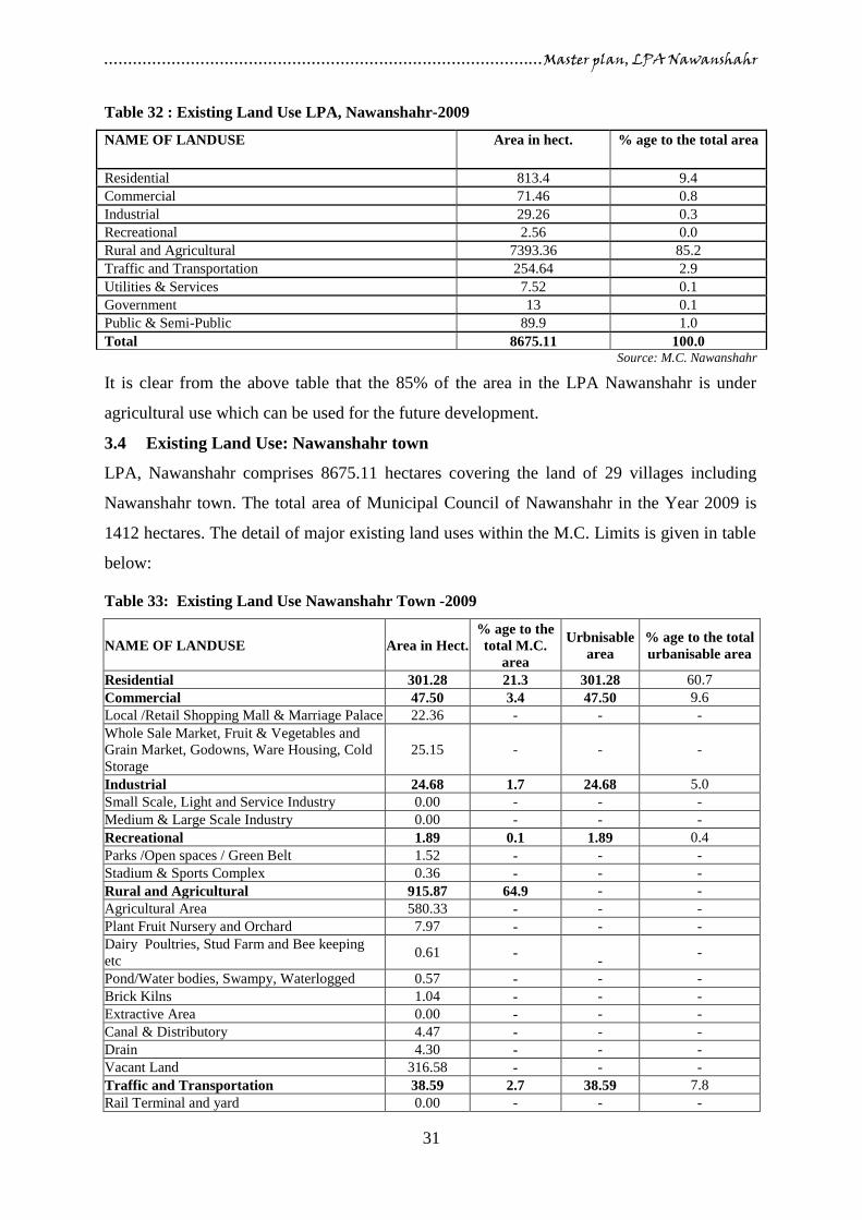
…………………………………………………………………………….…Master plan, LPA Nawanshahr
31
Table 32 : Existing Land Use LPA, Nawanshahr-2009
NAME OF LANDUSE Area in hect. % age to the total area
Residential 813.4 9.4
Commercial 71.46 0.8
Industrial 29.26 0.3
Recreational 2.56 0.0
Rural and Agricultural 7393.36 85.2
Traffic and Transportation 254.64 2.9
Utilities & Services 7.52 0.1
Government 13 0.1
Public & Semi-Public 89.9 1.0
Total 8675.11 100.0 Source: M.C. Nawanshahr
It is clear from the above table that the 85% of the area in the LPA Nawanshahr is under
agricultural use which can be used for the future development.
3.4 Existing Land Use: Nawanshahr town
LPA, Nawanshahr comprises 8675.11 hectares covering the land of 29 villages including
Nawanshahr town. The total area of Municipal Council of Nawanshahr in the Year 2009 is
1412 hectares. The detail of major existing land uses within the M.C. Limits is given in table
below:
Table 33: Existing Land Use Nawanshahr Town -2009
NAME OF LANDUSE Area in Hect.
% age to the
total M.C.
area
Urbnisable
area
% age to the total
urbanisable area
Residential 301.28 21.3 301.28 60.7
Commercial 47.50 3.4 47.50 9.6
Local /Retail Shopping Mall & Marriage Palace 22.36 - - -
Whole Sale Market, Fruit & Vegetables and
Grain Market, Godowns, Ware Housing, Cold
Storage
25.15 - - -
Industrial 24.68 1.7 24.68 5.0
Small Scale, Light and Service Industry 0.00 - - -
Medium & Large Scale Industry 0.00 - - -
Recreational 1.89 0.1 1.89 0.4
Parks /Open spaces / Green Belt 1.52 - - -
Stadium & Sports Complex 0.36 - - -
Rural and Agricultural 915.87 64.9 - -
Agricultural Area 580.33 - - -
Plant Fruit Nursery and Orchard 7.97 - - -
Dairy Poultries, Stud Farm and Bee keeping
etc 0.61 -
- -
Pond/Water bodies, Swampy, Waterlogged 0.57 - - -
Brick Kilns 1.04 - - -
Extractive Area 0.00 - - -
Canal & Distributory 4.47 - - -
Drain 4.30 - - -
Vacant Land 316.58 - - -
Traffic and Transportation 38.59 2.7 38.59 7.8
Rail Terminal and yard 0.00 - - -

…………………………………………………………………………….…Master plan, LPA Nawanshahr
32
Rail Circulation 0.00 - - -
Bus Terminal and depot 4.17 - - -
Truck Terminal 0.99 - - -
Major Roads/Other Roads 33.42 - - -
Utilities & Services 3.26 0.2 3.26 0.7
Power house/Sub Station 0.83 - - -
Sewerage Disposal area 0.70 - - -
Solid Waste dumping/ Sanitary landfill 0.60 - - -
Water works 1.13 - - -
Government 25.83 1.8 25.83 5.2
Government /Public Office 9.94 - - -
Govt. Land 15.89 - - -
Public & Semi-Public 53.10 3.8 53.10 10.7
Hospital and Health institution 3.72 - - -
Educational And Research Centre Specialized
Educational institutes 32.39 - - -
Social , Cultural and Religious 14.66 - - -
Post offices 0.33 - - -
Cremation and Burial grounds 2.00 - - -
Total 1412.00 100.0 496.13 100.0 Source: M.C. Nawanshahr
3.4.1 Residential
It is very much clear from table that the residential use has a larger share of town area
comparing to other uses. Out of the total Municipal area of 1412 hectares about 301.28
hectares 21.3 % of the total M.C. area is under residential use which includes both planned
and unplanned development. The percentage of residential use to the total developed area is
60.7%. The gross density of the town is 31.2persons/hectare. The population density is high
in inner areas (>150 persons/hectare) as compared to outer areas (< 50 persons/hectare). In
addition to old town localities, some new unauthorized colonies are coming up in the town.
3.4.2 Commercial
The commercial use is the most important use of the urban areas. It may have lesser share in
area but plays an important role in town character. In case of Nawanshahr town the total area
covered under commercial use is 3.4% of the total M.C area and 9.6% of the total developed
area. Besides the commercial areas along major roads, fruit and vegetable market are the
other commercial areas located in the town. The commercial areas of the town lack adequate
parking and other public amenities. The commercial area of the town is in the form of semi-
organized bazaars along streets and roads. Apart from this there are informal bazaars in the
form of temporary shops like Rehri walas, farhi walas and kiosks located in the existing
commercial areas and near the bus stand, railway station, grain market, and near other
important economic activities. These activities are not of permanent nature and are using the
roads therefore areas covered under this use are not shown separately.

…………………………………………………………………………….…Master plan, LPA Nawanshahr
33
The Wholesale grain market covering an area of about 11.48 hectares is located in the
southern part of the town along the Rahon road.
3.4.3 Industrial
As table depicts that the total area under industrial use is 24.68 hectares which is 1.7% of the
total M.C. and 5% of the total developed area. The town of Nawanshahr has one large scale
industrial unit i.e. Sugar mill along with small scale industrial units dealing with products
like manufacturing of utensils, farm implements, kinnow polishing, cotton ginning etc. It is
evident from Existing Land Use plan that majority of industrial units are located to the west
of the town on Jalandhar road including the only planned industrial area i.e. Industrial Focal
Point (outside M.C. limits of the town) whereas a number of small scale or service industries
are spread around Rahon and Phillaur Roads.
3.4.4 Recreational
The total area under recreational use is just 1.89 hectares which is 0.1 % of the total
municipal area and 0.4% of the total developed area. Recreational aspect is also covered in
detail in part of social infrastructure of Chapter 4. Mostly the town lacks the recreational
facilities. There are no organized parks and open spaces in the town for recreational purposes
except one i.e. Baradari garden.
3.4.5 Traffic & Transportation
The total area under traffic and transportation is 38.59 hectares which is 2.7% of the total
M.C area and 7.8% of the total developed area, which is quite low as compared to norms and
standards. The major problems related to this aspect are missing road hierarchy, lack of
parking places, traffic bottlenecks, encroachment of roads, lack of traffic signals etc. The
detailed study of traffic & transportation is also covered in the part under Existing Road and
Rail network of Chapter 5. The details of existing road network and other uses relating to
traffic transportation are shown in Existing Land Use Plan, Nawanshahr Drg No. DTP (J)
32/2010 dated 03.09.2010
3.4.6 Utilities & Services
Utilities such as Water Works, Electric Grid Station, (E.G.S) Sewerage Disposal Works,
Solid Waste Dump site etc. cover an area of about 3.26 hectares which is only 0.2% of total
M.C. area and 0.7% of the total developable area. Utilities like E.G.S. are evenly distributed
in the town. Solid waste site is located on the Musapur road as it is clear from Existing Land
Use Plan, Nawanshahr Drg. No. DTP (J) 32/2010 dated 03.09.2010

…………………………………………………………………………….…Master plan, LPA Nawanshahr
34
3.4.7 Government
This use comprises the area under Govt. /Semi Govt. office, Govt. land and reserved land.
The total area covered under this use is 25.83 hectares which is 1.8% of the total M.C area.
3.4.8 Public & Semi-Public
This Use comprises the areas covered under Education, Health, Socio-Cultural, cremation
grounds etc. The total area covered by this use is about 53.10 hectares which is 3.8% of total
municipal area and 10.7% of total developed area. The most of public and semi-public uses
are concentrated in the central part of the town whereas few uses of this category are also
seen in the outer parts of the town.
3.4.9 Agricultural / Rural
There are some chunks of land falling within municipal limits which are still being used for
agricultural purposes. 915.87 hectares area is under agricultural use which is 64.9% of total
M.C. area which shows that the most of the area under the M.C. limit is not developed.
Availability of such large areas under agriculture use means there is sufficient land available
for urban growth at cheaper rates and it also implies good potential for the scope of
development of agro based industries. The Existing Land Use Plan of Nawanshahr, Drg. No.
DTP (J) 32/2010 dated 03.09.2010 shows the spatial distribution of all the uses under
agriculture within and outside the limits of municipal council, Nawanshahr.
3.5 Environmental Status
The intensity of the pollution in terms of air, water and noise is evaluated in order to clearly
understand the level and causes of pollution existing within the town so that appropriate
strategies are put in place to tackle the problem of pollution. Though there is no scientific
data collection by Punjab Pollution Control Board in Nawanshahr. The present analysis of
environment in Nawanshahr is based upon Primary observations and residents views.
3.5.1 Air Pollution
Major contributors to the air pollution are:-
Vehicular exhaust due to the presence of large number of vehicles and higher use of
personalized vehicles.
Narrow road width, low capacity of the roads and high intensity of traffic.
Use of low grade fuel (by adding kerosene/diesel in petrol by auto rickshaws)
Presence of large number of intermediate public transport vehicles and use of
kerosene as the fuel.
…………………………………………………………………………….…Master plan, LPA Nawanshahr
35
Smoke emitted by various Industries
3.6 Heritage & Conservation in LPA Nawanshahr
The basic objectives of urban and regional planning are very clearly related to those of
conservation of historic towns, area and monuments. Land use plans, Master Plan, Zoning
Regulations and building bye-laws etc. help in achieving these objectives. Town planning for
existing old areas in cities needs care of the architectural fabric in urban areas. Therefore
conservation needs to be an integral part of the town planning process, i.e. of land use plans,
building regulations and development policies.
LPA Nawanshahr does not have any place/site of archeological, historical or artistic interest.

…………………………………………………………………………….…Master plan, LPA Nawanshahr
36
4. EXISTING INFRASTRUCTURE
Physical Infrastructure
4.1 Water supply
In Nawanshahr 92% of the total area is served with water supply facility. There are 8 tube
wells and 3 water tanks overheads serving the whole town having the total capacity of 7.35
MLD out of which the OHR’s has the total storage capacity of 2.05 MLD. The water is
supplied by gravity- through overhead reservoirs. The Water supply system of Nawanshahr
town is dependent mainly on ground water, which is available at 60 feet below the ground
level and suitable for drinking purpose.
4.1.1 Water Connections
The town at present has 6351registered water connections to different category of users. The
table indicates that during the year 2004-2008, a growth of 9.97% has been recorded in
number of water connections. It has been observed that larger proportions of the connections
fall under the category of domestic use which constitute about 98.43% whereas commercial
water connections constitute only 1.57% of the total water connections. It is worth
mentioning here that besides the above number of registered connections there are many
unregistered illegal water connections that avail the facility of getting water from the existing
network putting burden on the supply network.
Table 34: Detail of water supply connections in Nawanshahr from 2002-2008
Years
Water supply
Domestic Commercial Total
2004 5685 90 5775
2005 5880 92 5972
2006 6087 95 6182
2007 6184 99 6283
2008 6251 100 6351 Source: Municipal Council, Nawanshahr
Table 35: Existing Water supply
Category Amount of
Water supplied/ Day
Registered
connections
Population
Water
supply in
LPCD
Municipal Council Area 7.35 MLD 6351 29400 250 Source: PWSSB
4.1.2 Water demand & Supply
The estimated population as per PWSSB for the year 2001 which is served by piped water
system is 29, 400 which is 92% of total population. This gives gross per capita supply of 250
lpcd. As per as the norms prescribed, the amount of water supplied is 135 lpcd. Accordingly,

…………………………………………………………………………….…Master plan, LPA Nawanshahr
37
the amount of water supplied is higher than the prescribed norms. The duration of water
supply is 3 times a day and the total duration work out is 3 hours on daily basis.
4.2 Sewerage Network
Municipal Council of Nawanshahr with association of Punjab Water Supply & Sewerage
Board (PWSSB since 1977) provides the facility of sewerage network to the areas falling
with in the municipal council. The sewerage includes the waste generated from domestic,
industrial, commercial and institutional units etc. operating in the town. At present, 85.93%
of the population could be provided with the sewerage facility where as the remaining 14% of
the population is still to be provided with this facility.
Key Issues
The disposal of untreated sullage into the open land thus causing environmental problems
and many health problems to the residents of the surrounding localities.
The second challenging problem is that about 14% part of the town lacks this facility.
Immediate need for a sewerage treatment plant to treat and dispose the sewerage.
4.3 Storm Water Drainage
Following the analogy of sewerage network, the town has high degree of deficiency in the
storm water network also. Besides the fact of inadequate sewerage system, no storm water
drain exists in the town. In the absence of storm water system, the rain water is largely
discharged into the sewer network. This results in heavy loading of the sewerage network,
ultimately leading to choking of the pipes, overflow of the sullage and backflow of the
sewage. This calls for the urgency of having a separate storm water network to be put in the
place for the whole town to dispose off the rainwater effectively.
4.4 Solid Waste Management
Solid waste is a combination of unwanted and discarded materials from households,
commercial and industrial operations besides street sweeping. Solid waste management is the
prime responsibility of Nawanshahr Municipal Council within its boundaries. The Municipal
Council organizes the collection and transportation through its own conservancy workers and
tractor trolleys. Municipal Council collects solid waste from all the residential areas within its
limits and then transports it to the dumping site. The process of solid waste management can
be broadly classified into following stages:-
i. Primary and secondary collection
ii. Waste Storage & segregation.
iii. Waste transportation
iv. Disposal of Waste.

…………………………………………………………………………….…Master plan, LPA Nawanshahr
38
The solid waste is first collected from the points where it is generated and taken to the
collection centers defined by the Municipal Council. After the garbage is dumped at the
identified places it is transported by the Municipal Council to the dumping site for final
disposal. At present Nawanshahr municipal council uses only one site for dumping the solid
waste. The site is located on Musapur road. The area used for dumping is 2 acres but at
present the site is overfilled and the M.C. has not having the land for future disposal. There
are about 125persons deployed by the municipal council for this purpose.
Table 36: Details of Waste Dumping Site
Sr.
No. Site
Land area
(acres) Capacity (in metric tons) Remarks
1. Musapur road 2 Maximum 200 mt. may be filled
within site The site is overfilled
Source: M.C. Nawanshahr
4.5 Traffic and Transportation
Transportation is an integral part of any city/town that is totally responsible for the existence
and prevailing characteristics of the city. Without transportation, the functional differentiation
of the city/town into areas of specialized land uses could not have occurred, and without
transportation, the functionality of the town cannot be achieved or in other words it acts as
the spinal cord of the city/town
4.5.1 Existing Road-Rail Network
Road and Rail play a significant role in the transport sector in Nawanshahr and surrounding
areas. The road network is studied in terms of classification of roads, length of roads, cross
section of roads, area of road network and major road intersections. Similar data regarding
rail network and Railway crossings is also studied.
4.5.2 Road network at Local Planning Area, Nawanshahr level
There are two scheduled roads i.e. Phagwara - Chandigarh Road (also an M.D.R) and
Nawanshahr – Rahon road passing through the town. All the roads passing through Local
Planning Area, Nawanshahr have undivided carriageways outside the M.C. limits. The
details of width of ROW, carriageway and length of major roads falling within and outside
M.C. limit are given in the table 37:

…………………………………………………………………………….…Master plan, LPA Nawanshahr
39
Table 37: Detail of Major Roads falling within M.C. limits and outside M.C. limits in LPA,
Nawanshahr
Sr.
No.
Name of Road Total Within MC MC to LPA, Nawanshahr
Road
Length
(km)
Right of
Way (ft.)
Carriage
Way (ft.)
Road
length
(km)
Right of
Way(ft.)
Carriage
Way (ft.)
1 Nawanshahr-Banga
Road 7.2 2.8 100 56 4.4 113 33
2 Nawanshahr-
Chandigarh Road 8.4 4.4 100 56 4.0 113 33
3 Nawanshahr-Rahon
Road 4.9 2.4 78 32 2.5 78 24
4 Nawanshahr-Phillaur
Road 5.1 3.9 70 24 1.2 70 24
5 Nawanshahr –
Garhshankar Road 5.2 1.6 74 24 3.6 74 24
6 Nawanshahr-Kulam
road (link Road) 4.2 1.4 22 - 2.8 22 -
Source: PWD central works, Nawanshahr
Field survey 2008
This is very much evident from the above table that the Right of Way of all the roads varies
from 22 ft. to 100 ft. while the carriageway varies from 22 ft. to 56 ft. Despite the adequate
width of M.D.R’s and other roads, the right of way varies at certain points due to
encroachments. Therefore, the efficiency of these sufficiently wide carriageways decreases
due to these encroachments.
Existence of main roads in LPA, Nawanshahr shows that this area is well served by the
regional roads, which provide a high level of road connectivity with other parts of the State.
The length of these roads is 35 km within LPA, Nawanshahr boundaries out of which about
16.5 Kilometers fall within the limits of Municipal Council of Nawanshahr. There is very
good network of rural roads in LPA, Nawanshahr.
4.5.3 Road Network at town level
In Nawanshahr all the major roads converge literally at one point thus making junctions
which results in choking of traffic. The Rahon road and Kulam road meet Nawanshahr –
Chandigarh road at one point and Garhshankar road meets Nawanshahr – Chandigarh road
making T-junction at about 200mtr. from above junction.
The important roads entering the town are listed below:
Nawanshahr –Phagwara Road (M.D.R & Scheduled road no. 36)
Nawanshahr –Chandigarh Road (M.D.R & Scheduled road no. 36)
Nawanshahr – Rahon Road (Scheduled road no. 35)
Nawanshahr –Garhshankar Road
Nawanshahr –Phillaur Road
Nawanshahr –Kulam Road

…………………………………………………………………………….…Master plan, LPA Nawanshahr
40
As per the existing positions of these roads, it becomes clear that the town have wide road
network. The inner town road network has irregular alignments, inadequate width and
frequent intersections leading to serious capacity constraints.
4.5.4 Road Intersections
While examining the road network of the town a total number of 7 road intersections have
been identified within the limits of Municipal Council, Nawanshahr which remains busy
throughout the day. These road intersections are listed in the table below:
Table 38: Detail of Road Intersections in Nawanshahr Town
Sr.
No.
Name of Junction Type of Junction
1 Phagwara-Chandigarh and Garhshankar road T-Junction
2 Phagwara-Chandigarh and Kulam road T-Junction
3 Phagwara-Chandigarh and Rahon road Y-Junction
4 Rahon road- Railway road T-Junction
5 Phagwara-Chandigarh and Barnala Kalan road Y-Junction
6 Rahon-Saloh road Y-Junction
7 Rahon road-Saloh road-Begampur road Cross Junction Source: Field survey 2008
Besides these identified road intersections there are many other intersections in the inner part
of the town, which have not been listed over here as these are very minor intersections. The
position of above listed road intersections has been shown on the thematic plan.
4.5.5 Vehicular Growth
The number of vehicles increased from 7240 to 9042 during 2004 and 2005, thus registering
a growth rate of 24.88%. But from the year 2005 to 2006, the numbers of vehicles have
highly decreased in Nawanshahr town. This phenomenon continues in the next year i.e. after
increasing in the next year 2007 it slightly decrease in 2008 and then again increase in the
year 2009. This is perhaps due to registration of vehicles in other offices of the district. Out
of the total number of vehicles majority of vehicles are the two wheelers followed by the
other vehicles including cars, jeeps and tractors. There is an increase in personalized vehicles
ownership that leads to the growth of vehicles in the town. Table below indicates the pattern
of growth of registered vehicles category wise in the town on annual basis.
Table 39: Registered vehicles category wise 2004-09
Year Two wheelers Three wheeler Four wheelers Others Total registered vehicles Growth rate %
2004 4025 245 4025 168 7240 -
2005 5705 266 5705 130 9042 24.88
2006 3392 197 3392 98 6654 -26.41
2007 3594 203 3594 105 7225 8.58
2008 3910 252 3910 123 7178 -0.65
2009 4722 375 4722 144 8644 20.42
Source: District Transport Office, Nawanshahr

…………………………………………………………………………….…Master plan, LPA Nawanshahr
41
Figure 17 : Vehicular Growth, Nawanshahr Town 2004 – 2009
4.5.6 Vehicle composition on main road network
It has been noticed that there is mixed traffic running on the main town road network such as
heavy vehicles (Trucks, Trailers, Buses etc.), medium vehicles, light vehicles, three wheelers,
two wheelers, cycles, carts etc. As per the observation the outer roads of the town are having
a large number of heavy vehicles whereas the main roads falling in the inner part of the town
normally have large number of light vehicles and two wheelers.
4.5.7 Road Accidents
With a view to assess the safety of the road users in Nawanshahr it is important to study the
road accidents in the town. As per the figures made available by the Police deptt., the total
no. of accidents increased from 143 in 2005 to 151 in 2007 and then decrease to 137 in 2008
and increase to 144 in 2009. So despite the increase in vehicular population, the number of
accidents has by and large remained at the same level but the number of fatal accidents is
more than the non-fatal accidents. So there is a need of strict regulations and enforcement
mechanism of these regulations. The accident prone areas in the town are mostly the road
junctions likely as Phagwara-Chandigarh and Garhshankar road T-junction, Phagwara-
Chandigarh and Kulam road T-junction, Phagwara-Chandigarh and Rahon road Y-junction,
Rahon - Railway road T-junction, Phagwara-Chandigarh and Barnala Kalan road Y-junction
and Rahon – Saloh road Y-junction. The table below shows the no. of accidents from 2003 to
2008.
Table 40: Year wise Fatal and Non-Fatal accidents in Nawanshahr town 2005-09
Year Total No. of accidents Fatal Non Fatal
2005 143 85 58
2006 139 61 78
2007 151 92 59
2008 137 87 50
2009 144 86 58 Source: Senior Supdt. of Police, Nawanshahr

…………………………………………………………………………….…Master plan, LPA Nawanshahr
42
4.5.8 Terminals
4.5.8.1 Bus Terminal and Frequency of bus Service
There is one Bus Terminal in Nawanshahr town
which is situated on Garhshankar-Nawanshahr
road near Ambedkar Chowk having an area of
12 acres which is not sufficient to accommodate
all the components as per the norms given in
UDPFI Guidelines. Since bus terminal lie at the
center of the town it creates congestion in the
areas surrounding it and the main road passing
in front of it. With large number of cycle rickshaws, auto rickshaws, taxies occupying the
space around the bus terminal, movement of traffic in the area largely remains chaotic for
most part of the day.
4.5.8.2 Bus Routes and Intercity Bus Service
As per data supplied by General Manager PRTC Nawanshahr, total number of 440 buses
operates from this bus stand daily and 150 mini buses are also operating. The town is well
connected by bus service with the important towns and cities of the state. The maximum
numbers of buses which are coming and going from the bus stand are about 1, 58,400 per
year and near about 54000 mini buses per year are entering and going from the bus stand.
As informed by General Manager, Punjab Roadways Transport Corporation, about 65,
44,000 passengers are picked up from Nawanshahr bus stand yearly by buses and minibuses.
The detail of yearly bus traffic route wise in Nawanshahr is given in table below:
Table 41: Yearly Bus traffic route-wise in Nawanshahr 2007-09
Sr. no. Year Per day No. of Routes No. of Buses
Incoming Outgoing Total
1 2007 420 17 210 210 151200
2 2008 440 17 220 220 158400
3 2009 440 17 220 220 158400 Source: Punjab Roadways Transport Corporation, Nawanshahr
Table 42: Yearly Mini-Bus traffic route-wise in Nawanshahr 2007-09
Sr. no. Year Per day No. of Routes No. of Buses
Incoming Outgoing Total
1 2007 140 16 70 70 50400
2 2008 150 16 75 75 54000
3 2009 150 16 75 75 54000 Source: Punjab Roadways Transport Corporation, Nawanshahr

…………………………………………………………………………….…Master plan, LPA Nawanshahr
43
Table 43: Yearly Number of Passengers
Sr. no. Year Passengers/Year
1 2007 63,00,000
2 2008 65,44,000
3 2009 65,44,000 Source: Punjab Roadways Transport Corporation, Nawanshahr
4.5.8.3 Intra city bus service
There is no public transport system in Nawanshahr town. Due to the inefficient services and
unorganized system of public transport, predominant modes used for intra city passenger
travel are personalized vehicles, cycle rickshaws, auto-rickshaws etc. which exaggerate the
problems like congestion, accidents, parking as well as pollution. However some mini buses
going to rural areas from bus stand pick up the passengers and drop at various stops in the
town to facilitate the general public, hence functioning partly as public transport. Preferred
mode of transport in the town has been witnessed as use of auto rickshaws which have been
found to be highly convenient by the users because of affordable fare and convenience of
getting on and getting down at any place in the town. Looking at the existing pattern of
transportation it has been observed that for the smaller distance and intra city travel, auto
rickshaws & cycle rickshaws are the preferred mode of travel whereas for inter-city and
longer distance bus travel remains the popular mode of travel
4.5.8.4 Truck Terminal
In spite of development of small and medium industries in the town and wholesale activities
consisting of grain market, vegetable markets, godowns, whole sale trade etc. Nawanshahr
have one authorized truck terminal located on Rahon road. Beside this trucks are parked
along the main roads i.e. Rahon road, Phillaur road, Phagwara road, Garhshankar road and on
vacant spaces. Besides giving shabby look to the area parking along the roads also cause
traffic problems. Various workshops have been developed along Nawanshahr – Rahon road,
Nawanshahr – Phagwara road and to some extend at Nawanshahr – Garhshankar road. These
workshops attract vehicles which lead to encroach the road creating bottlenecks in free flow
of traffic.
4.5.9 Parking demand and availability
Parking remains another critical area for the
Nawanshahr town. In case of Nawanshahr town the
main Bazaars and roads of the town i.e.
Nawanshahr-Chandigarh road, Nawanshahr-Rahon
road, Nawanshahr-Phillaur road and Station road
are totally devoid of parking spaces. On all roads due to lack of parking space, the vehicles

…………………………………………………………………………….…Master plan, LPA Nawanshahr
44
remain parked right on the road thus creating traffic congestion and problems. Similar is the
case on all the main commercial streets in the town where the parking problem is there due to
commercial activities on those roads.
4.5.10 Rail Based Transport
In addition to road traffic, railway also has a reasonable volume of goods and passenger
traffic into Nawanshahr town. Nawanshahr town has a rail network connecting the town with
Jalandhar, Rahon and Garhshankar. There are three railway lines entering in the town one
from north-west side i.e. Jalandhar and 2nd
from north side i.e. Garhshankar and third from
southern side i.e. Rahon. In all 6 pairs of passenger trains pass through the town on daily
basis which caters to the traffic on Nawanshahr – Jalandhar, Nawanshahr- Jaijon railway
line. Besides long distance travelling, railway also caters to daily commuting passengers
which mainly comprises of govt. employees, industrial and agricultural workers. Railway
being the economical and efficient mode of transportation, largely catering to the intercity
long distance traffic would continue to attract large volume of passenger traffic.
Table 44: Detail of passenger trains passing through Nawanshahr town
Name of route Incoming Outgoing
Nawanshahr – Jalandhar 3 3
Nawanshahr- Jaijon 3 3
Source: Station Supdt. Railway, Nawanshahr
In addition to 6 pairs of Passenger trains large number of goods trains i.e. near about 40 -50
trains per year are also passing through the town for transportation of raw material and
finished goods. Railway plays an important role in the movement of goods.
4.5.10.1 Railway Crossings
Because of railway line passing through the town there are two level crossings on various
roads. A total number of 2 level crossings have been identified in Nawanshahr town which
are manned i.e. on Phagwara – Nawanshahr road and Nawanshahr – Phillaur road.
Social Infrastructure
4.6 Educational Facilities
Nawanshahr is the educational hub in its Local Planning Area, which serves not only the
Nawanshahr town but also its surrounding villages. There are numbers of colleges/institutes
in Nawanshahr town which cater to the educational requirement of Nawanshahr town as well
as its surrounding villages. These institutes mostly include ITI, Degree Colleges, and
veterinary & nursing institutes. For getting the study of medical and engineering, students
have to go to nearby cities like Ludhiana, Jalandhar, and Phagwara etc.
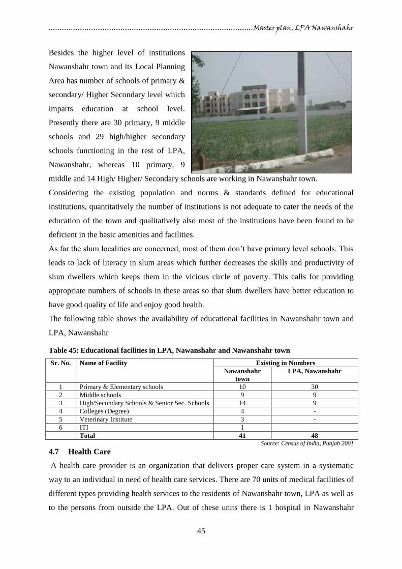
…………………………………………………………………………….…Master plan, LPA Nawanshahr
45
Besides the higher level of institutions
Nawanshahr town and its Local Planning
Area has number of schools of primary &
secondary/ Higher Secondary level which
imparts education at school level.
Presently there are 30 primary, 9 middle
schools and 29 high/higher secondary
schools functioning in the rest of LPA,
Nawanshahr, whereas 10 primary, 9
middle and 14 High/ Higher/ Secondary schools are working in Nawanshahr town.
Considering the existing population and norms & standards defined for educational
institutions, quantitatively the number of institutions is not adequate to cater the needs of the
education of the town and qualitatively also most of the institutions have been found to be
deficient in the basic amenities and facilities.
As far the slum localities are concerned, most of them don’t have primary level schools. This
leads to lack of literacy in slum areas which further decreases the skills and productivity of
slum dwellers which keeps them in the vicious circle of poverty. This calls for providing
appropriate numbers of schools in these areas so that slum dwellers have better education to
have good quality of life and enjoy good health.
The following table shows the availability of educational facilities in Nawanshahr town and
LPA, Nawanshahr
Table 45: Educational facilities in LPA, Nawanshahr and Nawanshahr town
Sr. No. Name of Facility Existing in Numbers
Nawanshahr
town
LPA, Nawanshahr
1 Primary & Elementary schools 10 30
2 Middle schools 9 9
3 High/Secondary Schools & Senior Sec. Schools 14 9
4 Colleges (Degree) 4 -
5 Veterinary Institute 3 -
6 ITI 1
Total 41 48 Source: Census of India, Punjab 2001
4.7 Health Care
A health care provider is an organization that delivers proper care system in a systematic
way to an individual in need of health care services. There are 70 units of medical facilities of
different types providing health services to the residents of Nawanshahr town, LPA as well as
to the persons from outside the LPA. Out of these units there is 1 hospital in Nawanshahr

…………………………………………………………………………….…Master plan, LPA Nawanshahr
46
town, 3 Primary Health Centers, CHC in LPA, Nawanshahr and Nawanshahr town and 16
Nursing homes providing medical facilities to the inhabitants of Nawanshahr town. Also
about 160 private doctors and RMPS are looking after the health of the citizens of
Nawanshahr town and 320 chemists are providing the health facilities to the people of
Nawanshahr and its surroundings villages.
The details of different medical facilities available in Nawanshahr town and Local Planning
Area, Nawanshahr is given in table below:
Table 46: Medical Facilities in LPA, Nawanshahr
Sr. No. Name of the Facility Existing numbers
1 Civil hospitals 1
2 Dispensary 47
3 PHC 3
4 CHC 3
5 Private practitioners 79
6 RMP 81
7 Chemists 320
8 Nursing homes 16
Source: CMO, Nawanshahr and Census of India, Punjab 2001
4.8 Sports and Recreational Facilities
Recreational facilities constitute an important element of physical and social development of
an individual and for that reason, their provision and balanced spatial distribution at the local,
sub-city and city level assumes importance Recreational facilities have been found to exist in
the shape of parks and open spaces, cinemas, stadiums, museums, sports related activities,
clubs, library and amusement parks etc. Recreational facilities have also been divided into
active and passive recreational facilities. Provision of both these facilities has to be made in
order to cater to the essential needs of the individuals and communities.
4.9 Parks and Open Spaces
As per the record of the M.C. Nawanshahr
there are only two parks in the town located
in Pandora mohalla and Ravi mohalla.
Baradari garden is the famous garden of the
town located on Rahon road. The most parts
of the town are virtually lacking the parks
and open spaces. All the above parks cover
an area of about 1.52 hectares. Major parts
of the Nawanshahr town have been developed in unplanned way, so most of these do not
have parks and open spaces. Similarly old parts of the town also lack parks and open spaces.

…………………………………………………………………………….…Master plan, LPA Nawanshahr
47
So the existing land for parks and open spaces is inadequate and don’t match the planning
norms and standards.
4.10 Cinemas & Multiplexes
There are 2 cinemas in the town catering to the entertainment needs of the residents. Besides
this, no new cinema or multiplexes are coming up due to slow development of the town.
4.11 Other Recreational facilities
In addition to the above there are 1 public library/reading room and one stadium in
Nawanshahr town which provide recreational facilities to the general public. However, any
well-organized cultural or drama club has not been noticed in the town thus town is lacking
the facility of good theater. There is no museum, no Art Gallery etc. in the town for
recreational purposes.
4.12 Sports
There is only one public indoor stadium in Nawanshahr town, which lies on Chandigarh road.
Besides this, there are two playgrounds one each in I.T.I and R.K. Arya College in the town.
The sports facilities available in town are not according to norms & standards.
However, looking at the growing population it is important that adequate level of recreational
facilities are to be created in the town and distributed to cover the entire population of the
town.
4.13 Post and Telegraph
Due to advancement in the technology and policy of liberalization adopted, post and
telegraph has emerged as an important medium of communication. There are in all 15 post
offices operating in the town. These facilities serve considerable proportion of population
both at the town and LPA level. Their provision should be made as per defined norms in
order to cater to the needs of vast majority of town population.
…………………………………………………………………………….…Master plan, LPA Nawanshahr
48
5. VISUALISING THE FUTURE
5.1 Population Projections
The population is the basic human factor for which planning is done. The requirements of
different types of infrastructure for Nawanshahr town and for surrounding villages of LPA,
Nawanshahr in 2031 would be based on the projected population for that year and also
migration of population that seeks livelihood in the town. For the purpose of population
projections, following two methods have been applied:
1. Ratio method or sharing pattern method
2. Extrapolation method: Extrapolation of the past trends and assuming that the trend
will continue in future.
In addition to this, the government policies and the opportunities affecting the growth of
Nawanshahr town and rural areas of LPA, Nawanshahr have also been kept in mind. The
following table gives the detail of decadal growth rate of population of Nawanshahr town,
population of rural areas and total population of LPA, Nawanshahr:
Table 47: Growth of Population of LPA, Nawanshahr (Total, urban & Rural)
Year Nawanshahr Town Rural Total
Population Growth rate
(in percent)
Population Growth rate
(in percent)
Population Growth rate
(in percent)
1981 26726 - 38516 - 65242 -
1991 29955 12.08 45333 17.69 75288 15.40
2001 31967 6.72 50359 11.09 82326 9.35 (Source: Census of India, Punjab, 1981, 1991, 2001)
Method 1: Ratio Method or Sharing Pattern Method
In order to achieve more realistic picture of projected population it has been decided to
follow the share of urban and rural population of LPA, Nawanshahr to the total urban and
rural population of Punjab state. Report of the technical group on Population projections
constituted by the National Commission on Population entitled "POPULATION
PROJECTIONS FOR INDIA AND STATES 2026" has provided projection of Punjab urban,
Punjab rural and their share in the total population of the state upto year 2026 as represented
in table below:
…………………………………………………………………………….…Master plan, LPA Nawanshahr
49
Table 48: Projected Population of Punjab Total, Punjab Urban and Punjab Rural 2001-2026
Year 2001 2006 2011 2016 2021 2026
Punjab Total 24359 26059 27678 29112 30323 31345
Punjab Urban 8263 9439 10681 11940 13185 16456
Percentage Urban 33.92 36.22 38.59 41.01 43.48 52.50
Growth rate of Punjab
Urban in % - 14.23 13.16 11.79 10.43 24.81
Punjab Rural 16096 16620 16997 17172 17138 14889
Percentage Rural 66.08 63.78 61.41 58.99 56.52 47.50
Growth rate of Punjab
rural in % - 3.28 2.26 1.03 -0.20 -13.14
(Population in Thousands)
The percentage share of Nawanshahr town and rural population of LPA, Nawanshahr to total
urban and rural population respectively of Punjab is calculated and is given in table below:
Table 49: Percentage share of Nawanshahr town and Rural Population of LPA, Nawanshahr
Percentage share of Nawanshahr town to the Total
Urban Population of Punjab
Percentage share of Rural Population of LPA,
Nawanshahr to Total Rural Population of Punjab
1981 1991 2001 1981 1991 2001
0.57 0.49 0.39 0.31 0.31 0.31 (Source: Census of India 1981, 1991, 2001)
For projecting the urban population i.e. of Nawanshahr town, the percentage of urban
population (Nawanshahr town) is derived from the total urban population of Punjab in year
2001 which comes out as 0.39%. This figure of 0.39% has been used constantly for
projecting the urban population for Nawanshahr town for the year 2006, 2011, 2016, 2021,
and 2026. For calculating the projected population of 2031, the growth rate of previous five
years is taken. Besides this, the floating population of about 5% has also been added to the
projected population.
Similarly, for projecting the rural population of LPA, Nawanshahr, the percentage share of
LPA, Nawanshahr’s rural population has been derived from total rural population of Punjab
in the year 2001 which comes out as 0.31% and the same has been used constantly for
projecting rural population upto the year 2016. Thereafter growth rate of 2011 – 16 i.e. 1.03%
has been taken for calculating the projected population of LPA, Nawanshahr rural for the
year 2021, 2026 and 2031 because the growth rate of Punjab rural during the year 2016 -
2021 and 2021 – 2026 is negative. The Projected population of Nawanshahr town and LPA,
Nawanshahr rural is given in the table 50:

…………………………………………………………………………….…Master plan, LPA Nawanshahr
50
Table 50: Projected Population and Growth Rate of LPA, Nawanshahr
Year
Nawanshahr Town Rural Areas LPA, Nawanshahr
Projected
Population
Total
Projected
Population
including
5% of
total as
floating
Population
Growth
Rate (in
percent)
Projected
Population
Growth
rate (in
percent)
Projected
Population
Growth
Rate (in
percent)
2001 32187 33796 - 49898 - 83694 -
2006 36812 38653 14.37 51522 3.26 90175 7.74
2011 41656 43739 13.16 52691 2.27 96429 6.94
2016 46566 48894 11.79 53233 1.03 102128 5.91
2021 51422 53993 10.43 53782 1.03 107774 5.53
2026 64178 67387 24.81 54335 1.03 121723 12.94
2031 80101 84106 24.81 54895 1.03 139001 14.19
(Source: Computed values)
Method 2: Population Projection by Extrapolation Method:
Apart from above method, another method is extrapolation of past trends and assuming that
the trend will continue in future.
The average growth rate of Nawanshahr town for past two decades 1971-1981, 1981-1991
and 1991 – 2001 comes out around 24% whereas for rural areas it is about 14.39% for past
two decades 1981-1991 and 1991-2001. For calculating the projected population of
Nawanshahr town, the average growth rate of 30% is assumed for 2001 - 2011 and 2011-
2021 years and 35% for the year 2021 – 2031. For rural areas, taking into account the trend of
growth of LPA, Nawanshahr rural, overall growth pattern and Projection of rural areas of
Punjab, the growth rate for the decade 2001 – 2011 is assumed as 14% and then further for
the decade 2011 – 2021 it is assumed as 9% and then again taking into account decreasing
trend for the decade 2021 – 2031 it is assumed as 7%. The above future rates of growth for
Nawanshahr town and rural areas of LPA, Nawanshahr have been projected on certain
assumptions given next to table below. The projected population of Nawanshahr town,
including rural areas of LPA, Nawanshahr and LPA, Nawanshahr up to year 2031 is given in
table below:
Table 51: Projected Population for LPA, Nawanshahr
Year Nawanshahr Town Rural Areas LPA,
Nawanshahr
Population Average
Growth Rate
in % age
Population Average
Growth rate in
%age
2011 44000 30 58000 14 101400
2021 58000 30 63000 9 120000
2031 78000 35 67000 7 145000 (Source: Computed values)

…………………………………………………………………………….…Master plan, LPA Nawanshahr
51
Assumptions for Population Projection
1. Nawanshahr town is the District Headquarter of the Shaheed Bhagat Singh Nagar
District.
2. The growth rate for calculating population projection of the next decades (2011-2021 and
2021 – 2031) is taken as 30% and 35% as the upcoming new development of industrial
and trade sector will boost up because of the industrial policy of Punjab.
3. Nawanshahr has the strong linkages with Chandigarh, Jalandhar, Phagwara and it also
connects with Jammu which makes it a transit point for goods transport helping to boost
the economy of the region by acting as a major infrastructure development for industrial
sector and also helpful for the development of the town.
4. The development of the 4 lane Mohali-Phagwara expressway will also contribute a lot to
boost the economy of the region in the future.
5. The region has a hub of NRI’s which plays a major role in the development of the town.
The following table gives the comparative picture of projected population for Nawanshahr
town, rural areas and LPA, Nawanshahr for 2031 by two methods:
Table 52: Comparison of Projected Population of LPA, Nawanshahr
Method Nawanshahr Town
Projected Population
Rural Areas
Projected Population
LPA, Nawanshahr
Projected Population
Method 1 84000 55000 139000
Method 2 77000 67000 144000
Out of the above two methods, Population Projected by Method No.1 is adopted for the plan
formulation, as there will be development of trade commerce, industrial sector in planned
manner and in anticipation of new govt. policies likely to be framed by the Govt. to develop
this region. Despite general trend of reduced population growth rate, Nawanshahr town is
likely to retain its share of urban population. The Projected Population of Nawanshahr town
therefore has been taken as around 84,000 persons for the year 2031.
5.2 Workforce Projections
For calculating the workforce projection, LPA, Nawanshahr is divided into two parts:
1. Nawanshahr town
2. Villages in LPA, Nawanshahr (Rest of LPA, Nawanshahr)
Employment data category wise is not available for Nawanshahr town and including LPA. To
estimate the 2031 employment data category wise for rest of LPA, percentage of main
workers to population for the year 2031 forecast (which is based on %age of 2001) for the
year 2031 for the above said constituents are calculated as given in tables below:

…………………………………………………………………………….…Master plan, LPA Nawanshahr
52
Table 53: Workforce projections for LPA Nawanshahr
Year LPA, NAWANSHAHR
Total Population Total workers %Age
1981 65242 11162 17.1
1991 75288 21521 28.6
2001 82326 32858 39.9
2011 96429 38572 40.0
2021 107774 43110 40.0
2031 139000 55600 40.0 (Source: Computed values)
Table 54: Workforce projections for Nawanshahr town
NAWANSHAHR TOWN
Year Total Population Total workers %Age
1991 29955 8848 29.5
2001 31967 11676 36.5
2011 43739 15978 36.5
2021 53993 19724 36.5
2031 84000 30724 36.5 (Source: Computed values)
5.3 Infrastructural requirements
5.3.1 Water Requirements
General: In true sense, the term water demand refers to the estimated quantity of water
required for a town to fulfill water needs of the people residing in the town. The estimated
water demand includes per capita consumption, system loses, industrial and commercial
consumption, firefighting demand etc. The water demand is broadly classified as domestic
and non-domestic water demand.
Rate of water supply:
Domestic water demand
The Indian Codal Precisions recommended a minimum water supply of 135 lpcd for cities
and the same has been adopted for Nawanshahr. The residential area in Nawanshahr is
expected to have a much higher demand due to better life style adopted by the residents.
However, considering the availability of water and the norms followed by the PWSSB,
supply of 135 lpcd for domestic purpose will be adopted for requirement purpose.
Industrial water demand
Bulk supply to industrial establishment will be considered as per specific requirement of each
industry. However, the figures of 135 lpcd include water requirements for commercial,
institutional and minor industries.
Unaccounted for water (UFW)
As per Central Public Health and Environmental Engineering Organization (COPHEEO)
manual, a maximum provision of 15% towards losses, unaccounted water shall be made.

…………………………………………………………………………….…Master plan, LPA Nawanshahr
53
Estimation of Water Demand
The net water demand comprises consumption of domestic and non domestic purposes. Non
domestic uses include consumption by Institutions (Colleges, Schools and Hospitals),
Commercial Establishments, Industries, Public Parks, Hotels, Tourist places etc. Gross water
demand@135lpcd comprises net water demand and unaccounted water non-physical @ 15%
losses.
Table 55: Projected Gross water Demand for Nawanshahr Town 2031
Service Head Existing/Desired level Service levels and requirements
Indicator Unit By year 2011 By year 2021 By year 2031
Daily Supply Per capita supply
(LPCD) MLD 6.8 8.4 13.0
Treatment Treatment capacity
against supply MLD 6.8 8.4 13.0
Metering system 7955 9818 15291
(Source: Computed values)
The water requirements for the rural settlements (village abadis) have not been projected
since this aspect is independently handled by the department of Public Health.
5.3.2 Sewerage requirements
Per capita waste water flow
The rate of waste water flow depends upon the rate of water supply to community and the
rate of ground water infiltration.
The entire spent water of community should normally contribute to the total flow in a sewer.
However, the actual dry weather flow quantities usually are slightly less than the per capita
water consumption. Since some water is lost in evaporation, seepage into ground, leakage etc.
Generally, 80% of the water supply may be expected to reach the sewers unless there is data
available to the contrary.
Projected waste water flows
Considering 80% of the water supplied to the consumers reaching the sewer the projected
waste water flows has been calculated.
Table 56: Projected Gross Waste Water Flows of Nawanshahr town 2031
Service Head Existing/Desired level Service levels and requirements
Indicator Unit By year 2011 By year 2021 By year 2031
Waste water flow Per capita supply
(LPCD) MLD 5.4 6.7 10.4
Treatment Treatment capacity
against supply MLD 5.4 6.7 10.4
(Source: Computed values)

…………………………………………………………………………….…Master plan, LPA Nawanshahr
54
5.3.3 Solid waste generation
The production of solid waste in an urban area is a function of the socio economic profile of
the population and activities in the area. As per UDPFI guidelines, the generating of waste
varies from about over a quarter of a kilogram in small towns to about half a kilogram per
capita in large and metro cities. For Nawanshahr town which is medium sized town the waste
generation is assumed 3/8 of kilogram per capita and total waste generation will be 3/8 x
348000 = 31538 kg = 31.5 metric tons per day.
5.4 Constitution of Think Tank
As per the D O letter dated 2-12-2008 of Chief Secretary, Govt. of Punjab, addressed to all
the Deputy Commissioners of the Punjab state, circulated vide Chief Town Planner's Endst.
No. 9526-45 CTP (Pb) /sp 135 dated 10-12-08, there is a proposal to set up a ‘think tank’
under the chairmanship of Deputy Commissioner concerned for each town/town to envisage a
vision 2031 for that town/city.
Based on the instructions contained in the above referred letter, the ‘Think Tank’ for
visualizing the future of the Nawanshahr town (vision 2031) was constituted by Deputy
Commissioner Nawanshahr. The Think Tank comprised various members from various
sectors. On the basis of discussions held in the ‘Think Tank’ meetings, a SWOT analysis of
the town/LPA has been prepared and accordingly a Vision for the town has been finalized.
The meetings of the Think Tank committee were held on dated 17/09/2009 and 27/08/2010.
5.5 The Strengths, Weaknesses, Opportunities, Threats (SWOT) Analysis
The present strengths, the opportunities likely to be presented by the town itself and the
surrounding region, the present weaknesses of Nawanshahr town and the threats emanating in
the region have been outlined. The following Strengths, Weaknesses, Opportunities and
Threats for LPA, Nawanshahr have been identified:
5.5.1 Strengths and Opportunities
The strengths and opportunities are the factors which allow positive change or present
development options or alternatives. The following are the strengths and opportunities in the
context of vision and strategies for LPA, Nawanshahr.
Road connectivity – Located on Jalandhar Banga Chandigarh road and on Rahon
Garhshankar road.
Important urban centre of Doaba region and district Headquarter
High per capita income of the people
No threat of competition from any major city in the region.

…………………………………………………………………………….…Master plan, LPA Nawanshahr
55
Regional linkages - It is well connected to surrounding towns/cities as Chandigarh,
Jalandhar, Pathankot, Rahon, Ludhiana of the state and with other states like Jammu
through road network
Proposal of new Mohali - Phagwara Expressway will make the region more accessible
in future.
Rail connectivity - Presence of Railway line in the town making it more accessible is
also helpful in the economic development of the town because of goods transport
railway yard.
Industrial Sector - Wooden, steel, agro based industries etc. are there in the town
boosting the economy of the town
Employment Potential - Good employment generation due to industries, trade and
commerce.
Regional level Commercial centre - Grain market and vegetable market
Health Infrastructure - Hospitals, PHC’s, CHC’s and Nursing homes to cater the
medical needs of the region.
Agricultural products - A vast fertile hinterland producing various crops like wheat,
rice etc. is a potential source for the economic development of the town especially for
the development of agro based industries.
Availability of land - A vast tracts of land are available at cheaper rates for the
expansion of the town
Demography - High percentage of literacy rate in the town offers a valuable skill
manpower resource for the economic development of the region.
Nawanshahr is called a hub of NRI’s which is the potential of the town is, helping in
the economic and social development of the town.
5.5.2 Weaknesses and Threats:
Weak regional linkages: The town is not connected with any N.H. or S.H. only M.D.R
is passing through the town.
Locational disadvantages: Economic Subsidies in the nearly surrounding areas i.e.
Kandi areas.
Urban Growth and Land Management: Most of the urban development is unplanned
and haphazard in the town. No planned scheme of PUDA, Improvement Trust and
Local body.

…………………………………………………………………………….…Master plan, LPA Nawanshahr
56
There are 16 slums with at least 65% population of the town which create hindrance
to the planned development of town.
Concentration of commercial activities in congested areas of the old part of the town
with narrow streets, no parking spaces etc. are creating major traffic and
environmental problems.
Lack of urban basic services: Only 86% of the town served by water supply and
sewerage networks whereas remaining area/population is still devoid of these basic
facilities. Absence of sewerage treatment plant and storm water drainage and disposal
of solid waste unscientifically – a potential threat to living environment.
Poor road geometry, narrow streets, encroachment of roads, lack of parking spaces,
lack of recreational facilities like open spaces, parks, stadiums renders the town unfit
for comfortable living.
Educational Infrastructure is not sufficient for the town and for its surrounding areas
because of which students have to go to other towns for getting quality and higher
education.
Poor industrial base: Closure of some existing industries in Industrial focal point,
sharp decline in the number of small scale industries and lack of new investment in
industrial sector are posing threats for further development/growth of the town.
Water logging problem in some parts of the town and region is another threat to
building activity and agriculture sector.
5.6 Vision- 2031
The year 2031 is taken the vision year for the master plan so as to tally the data as per the
census year. Therefore based on the outcome of discussions held in the meetings of ‘Think
Tank’, the Vision Nawanshahr 2031 is articulated as follows:
“To transform ‘NAWANSHAHR TOWN’ into an administrative, economic and service
centre of Doaba sub region by providing high quality physical and social infrastructure
to all its citizens in an inclusive and environmentally sustainable manner.”
5.6.1 Strategies to attain Vision 2031
In order to achieve the objectives and goals enshrined in the vision statement, mission
statements for various focused areas have been detailed below:

…………………………………………………………………………….…Master plan, LPA Nawanshahr
57
Growth management
Promoting planned development through effective town planning.
Rationalizing land use pattern for effective traffic management and provision of basic
services and amenities.
Making effective plan implementation and enforcement as integral part of town planning
and development process.
Strengthening the economic base of the town through provisions of more areas for
industrial development especially the development of agro based industries.
Conserving the cultural fabric.
Making growth management process participatory.
Review of master plan on regular basis.
Improving system of approvals of building plan through use of IT and GIS.
Making urban development self-sustaining.
Urban Environment
Urban environment to be made integral and essential part of town development process.
Environment to be made integral part of planning and decision making process.
Effective treatment of all sewage generated within the town.
Improving solid waste management.
Creating / developing new and improving existing parks and open spaces.
Promoting better water management.
Making town free from air, water and noise pollution.
Discouraging the growth of slums and improving existing slums.
Urban Services:
Water supply
To ensure safe, equitable, reliable, adequate and quality water supply
To ensure 100% coverage of the town
Sewerage and Drainage
Total coverage of the town with sewerage and drainage system including slums.
To promote eco-friendly decentralized treatment system.
To minimize sewerage generation through water saving appliances
To promote recycling of sewage
To promote protection of natural water bodies

…………………………………………………………………………….…Master plan, LPA Nawanshahr
58
To promote optimum use of storm water as an alternate source of water supply.
Solid waste management
To improve the solid waste management in the town using best practices.
To use PPP model for Solid waste management.
To promote “Recycling” system of SWM.
To make solid waste management people centric
Storm water disposal
To introduce the storm water disposal system in the entire town
To improve the capacity of the water bodies existing within the town
To improve the natural water drainage channels by de silting and stopping the sewage
water from entering the channels.
Traffic and Transportation
To improve safety, mobility and efficiency of traffic within and outside the town
To segregate and rationalize the inter and intra town traffic
To improve road geometry and road capacity of existing network
To minimize pollution caused by traffic and transportation and improve environment.
To create new road network and to improve the existing network to promote operational
efficiency of traffic.
To provide adequate parking spaces to remove traffic bottlenecks.
To plan and provide effective public transport services
Social Infrastructure
To provide adequate sites based on norms, for creating / developing various social
infrastructures.
To involve private and corporate sectors for providing/developing and maintenance of
social infrastructure.
To make optimum use of mechanism of planned development for developing adequate
and quality infrastructure.
To promote community participation in maintenance and upkeep of social infrastructure.

…………………………………………………………………………….…Master plan, LPA Nawanshahr
59
6 THE MASTER PLAN NAWANSHAHR - 2031
6.1 Components of the Master Plan
The scope of a master plan is limited to the broad proposals and allocation of land
for various uses such as residential, industrial, commercial, recreational, public and semi-
public etc. It proposes a network of major roads to have better traffic circulation systems for
the present and the future. It will include zoning regulations for regulating development
within each zone. Therefore, the Master Plan is an important instrument for guiding and
regulating development of a town over a period of time and contributing to planned
development both conceptually and operationally. Master Plan of LPA, Nawanshahr – 2031
comprises following components as described below:
1. Existing Land use Plan
2. Proposed Land use Plan
3. Zoning Regulations & Development Controls
6.2 Master Plan Objectives
The long term vision and the mission statements would require spatial land use planning,
infrastructure planning, financing and implementation, effective management and operation
of infrastructure services, and regulating and enforcing plan proposals. The objective of the
Master Plan is to create enabling spatial Land Use Planning framework to achieve the Vision
of LPA, Nawanshahr. More specifically, the following are the objectives:
To make Nawanshahr town as the most vibrant administrative and economic center to
promote the balanced regional growth.
To make land allocation in an environmentally friendly manner.
To provide better quality of life by minimizing haphazard, unplanned and sub – standard
growth and development within LPA and to promote planned growth in order to maintain
healthy living environment.
To effectively manage the traffic and transportation within the town through the
mechanism of rationalizing the landuse pattern defined in the Master Plan.
To make land available for public purposes.
To minimize travel within the town by creating self-contained and self-sufficient
communities
Adequate parking spaces to be created in the town as an integral part of commercial,
industrial and institutional planning and development process.
To strengthen the basic infrastructure favourable for Agro based industries.

…………………………………………………………………………….…Master plan, LPA Nawanshahr
60
To rationalize the distribution of physical and social infrastructure in order to have better
reach and to ensure appropriate quality of life to all the residents of the town.
To optimize the use of available land resource through well-defined development norms.
6.3 Evaluation of Existing Structure
Understanding of existing town structure is prerequisite to visualize future structure for
accommodating projected growth. The structure of the town can be appreciated by noting the
relationship between living and work areas in terms of their connectivity with each other. A
thematic map of LPA, Nawanshahr shows such a structure as it exists at present. A careful
study of this map brings out the following facts of the existing structure:
The Central part of town where main bazaars are located is the main work area of the
town where most of the people are engaged in trade and commerce. The second work area
is the Rahon Road, Phillaur road and Phagwara road where the concentration of various
activities like grain market, many industrial units and godowns, focal point, sugar mill,
shops, workshops are located. The other work areas that are mainly commercial units are
located along Nawanshahr – Chandigarh Road on South east side of the town.
The main living areas are spread all over the town except for Grain market and the areas
under godowns on the South–West side. Most of the old living areas are developed in a
grid iron pattern but the other residential areas (except very small planned pockets) have
developed in unplanned and haphazard manner. It becomes clear from the thematic map
that all the living areas have good connectivity with the work areas.
There is no doubt about potentiality of Nawanshahr because of railway line link but at the
same time town has been fragmented into two segments which have poor connectivity
with each other. This fragmentation is an unavoidable feature of the town.
The town has a linear type of development structure as the town grows along the major
roads like Chandigarh road, Rahon road etc. Because of the potential of the Nawanshahr –
Chandigarh road most of the residential development is coming along this road in a linear
pattern.
6.4 Proposed town structure -2031
Cities grow organically depending upon the availability of land and potential for growth,
sometimes leap frogging the natural as well as manmade barriers. On the basis of studies
conducted by the office of District Town Planner Jalandhar, it is observed that most of the
development activities around Nawanshahr are concentrated in the areas located in the
vicinity of existing developed areas and also along the main roads. Keeping in view, the

…………………………………………………………………………….…Master plan, LPA Nawanshahr
61
present growth trend and the future size of the town, only the following town structure has
been envisaged as most suitable for the development of future town of Nawanshahr:
COMPACT CORE WITH EXPANSION ON ALL SIDES IN THE VICINITY OF THE
EXISTING DEVELOPED AREAS.
The pattern of this town structure has the following merits and demerits:
Merits:
Minimum invasion upon fertile and scarce land resource of the state.
Compact and integrated development of the town, avoiding sprawl
An effective, economic and efficient infrastructure development
Close relationship of work-place and residential areas
Demerits:
It may create a feeling of congestion and more load on existing infrastructures
Improving core town infrastructure to cope with increased population may be difficult.
6.5 Land use Requirements
Before proceeding to prepare proposed land use plan and transport network the areas required
for different purposes is to be worked out on the basis of norms and standards of various
organizations.
Land required for main land uses:
The land requirements for different uses for the projected population of Nawanshahr and the
villages falling in fringe area of Nawanshahr town have been worked out on the basis of
norms given in UDPFI. The assessment of the urbanisable area is normally based on the
proposed residential area which is considered to be 40% of total proposed urbanisable area of
cities like Nawanshahr as per the norms given in UDPFI. Though the residential area
requirements for urban area of LPA, Nawanshahr as per UDPFI guidelines works to 678
hectares, but the proposed road network would open up many new areas for urban uses.
Therefore keeping in view the proposed road network particularly the Ring Road, the new
proposed areas are required to be put under different uses out of which major share is to be
covered by residential use.
6.5.1 Residential use:
As per the data available from census of India as described in table 19 in Housing Chapter,
out of total house holds about 19% have one room, 30% have two rooms and 23% have three
rooms per dwelling unit. For the purpose of working out the requirements for residential use,
the average of these three categories (which comes to be two rooms accommodation) has

…………………………………………………………………………….…Master plan, LPA Nawanshahr
62
been taken. For calculating the housing requirements, following assumptions have been kept
in view:
Table 57: Calculation of average plot area in Nawanshahr Town
Sr. No. Description Area in sq.m
1 Carpet area of average dwelling unit. 1 Living Room,2 Bed Rooms, 1
Kitchen and other sub units etc.
120
2 Built up area inclusive of walls, verandahs etc. 144
3 Plot area @ footprint to plot ratio of 0.65 222
Table 58: Stage Wise Residential Area Requirements for Nawanshahr Town (2011-2031)
Year Projected
Population
No. of Families Net Land Required in
Hectares (Assumed 1
family per plot)
Gross Land Required
in Hectares
2006 38653 7028 156 312
2011 43739 7953 177 354
2016 48894 8890 197 394
2021 53993 9817 218 436
2026 67387 12252 272 544
2031 84000 15292 339 678 (Source: Computed values)
Note:
The number of households in the above table has been calculated on the basis of the
assumed family size of 5.5 members per family for the year of 2031. It is further
assumed one family per plot.
Keeping in view the present character of the town and also future, it is assumed that
most of the residential development will be in the shape of plotted development.
The gross residential area has been calculated by adding 50% more area to net
residential area for provision of roads, parks, convenient shopping area, health,
educational and utilities etc.
The proposed residential area includes the requirements of the all the sections of the
society. It also includes the housing needs of the urban poor.
6.5.2 Commercial Use
The area requirements for commercial activities have been calculated as per UDPFI
guidelines. The classification of towns given by UDFPI guidelines, the towns having
population up to 1,00,000 persons qualify in the category of small size town. The projected
population of Nawanshahr town for 2031 has been worked out to be about 84,000 which is
just close to the category of 1 lac size, thus it is quite convincing that Nawanshahr town
would remain a small size town in the future to come. Therefore, the norms applicable to a
small size town have been adopted for calculating area requirements for commercial use as
per table below:

…………………………………………………………………………….…Master plan, LPA Nawanshahr
63
Table 59: Area of Commercial Centers
Name of Centre Area in sq. mts per 1000 persons Number of shops
Cluster Centre 220 1 for 110 persons
Sector Centre 300 1 for 200 persons
Community Centre 500 1 for 200 persons
Total 1020 (Source: UDPFI Guidelines)
As per the figures given in the table above, 1020 sq. mts. area for different categories of
commercial areas has been proposed for 1000 persons thus 1.02 sq. mts area is required per
person. Therefore keeping in view the projected population of 84000 persons for Nawanshahr
town and the urban fringe, the total area required for commercial activities of the town has
been worked out as below:
Table 60: Commercial area requirements of Nawanshahr town
Name of Town Projected Population Commercial Area Required@
1.02 sq. mtrs. per person
Nawanshahr town 84000 8.6 hectares
6.5.3 Industrial
For calculating the industrial use requirements the proposed land use structure standards
cited in UDPFI guidelines are considered,
Total existing industrial area of Nawanshahr town. 28.81 Hectare
(Including Industrial Focal Point)
Industrial workers (2001) 11676
Industrial workers density 400 persons/hectare
Existing industrial use as a percentage 5%
of town area. (Includes Industrial Focal Point)
Norms and standards for percentage of 10-12%
Industrial use (as per UDPFI standards)
As the existing industrial use is 5% of the total town area but the industrial workers density is
400 persons/ hectare which is very high as compared to norms and standards. Thus, workers
projected on the basis of the figures of workers of 2001 census may not be sufficient. In order
to accommodate such uncertainty and taking into account the vision of making Nawanshahr
a hub for Agro based industries and for accommodating ancillary units for large scale units
existing in kandi canal area and District Nawanshahr, more areas are required for industrial
use. As per above narration, 10 - 12% of the total urbanisable area is assumed to be required
for industrial use in LPA, Nawanshahr which needs bigger chunks of areas for industries at

…………………………………………………………………………….…Master plan, LPA Nawanshahr
64
potential sites. Besides this, the efforts have been made to work out the actual requirements
of industrial area for Nawanshahr town as follows:
Table 61: Projected Urbanisable Area Requirements for Nawanshahr Town - 2031
Town Year Gross Residential Land
required
Urbanisable area
required*
Industrial use
requirement **
Nawanshahr
2011 354 885 106
2016 394 985 118
2021 436 1090 131
2026 544 1360 163
2031 678 1695 203
Note:
*For calculating the Urbanisable area the residential use is assumed as 40% of the total
urbanisable area.
**Assumed % age of industrial use is 12% for Nawanshahr town and urbanisable area as per
UDPFI standards.
6.5.4 Recreational facilities
As per PAPR Act 1995, about 45 % of the area of a colony is to be left for non-saleable
purposes out of which 10 % is to be left for public buildings. It has been found that normally
28-30% area is under circulation i.e. roads, pavements etc. Assuming the figure at 28-30% for
roads, the remaining 5-6% has been considered for recreational, sports etc. By this formula if
we have one hectare area of a colony then 600sq.mt. is supposed to be provided for this
category. Keeping in view the average size of plots as 222 sq.mts., about 25 plots can be
adjusted in one hectare area (assuming 55% saleable area), which would accommodate about
25 families taking average size of one family as 5.5 members a total of 137.5 say 137
persons are estimated to live in one hectare. Therefore, by this calculation about 4 sq.mt.
recreational area works as share of each person. However at town level approx. 2 sq.mt. per
capita area is to be added for town level open spaces. Thus total 6 sq.mt. per capita area is
required at town level for recreational facilities.
Total area required at town level = 84,000 x 6 sq. mts.
= 50.4 hec
6.5.5 Road Network and Termini Required
6.5.5.1 Network Required at Town level
In absence of detailed traffic studies regarding growth of traffic during the past years, the
IRC standards for calculating the vehicular traffic have been taken into account. According to
which if reliable data is not available 7.5% growth per annum should be taken for national
highways. In case of urban roads, growth rate of 7.5% is assumed whereas in case of other
rural roads (out of urban area) rate of 6% per annum has been assumed. Since there are many

…………………………………………………………………………….…Master plan, LPA Nawanshahr
65
factors which govern the growth of traffic volume thus the long term projections of traffic
volume may not be factual, but taking into account above growth rate for projections, it is
estimated that major roads of the town will be overloaded. The detailed traffic studies are
required separately for mass transit system and road improvement plan. However on the
basis of broad studies conducted, and for long term planning there is an urgent need for outer
Ring Road along with bye pass connecting various radial roads for better, efficient and free
flow of traffic at the regional level. Besides this, the roads of lower hierarchy are required to
be proposed for inter connection of ring road with the existing main town roads.
6.5.5.2 Road Network at Local Planning Area, Nawanshahr Level:
Besides the road network required at town level, there would be an ardent necessity to
connect the regional roads with each other so that the regional traffic may be diverted out of
town. In addition to the town road network, an additional outer ring road is also which may
link the regional roads such as Chandigarh road, Rahon road, Garhshankar road and Phillaur
road.
In addition to the outer ring road, many other lower hierarchy roads are required for better
connectivity between proposed ring road, the existing bye pass and regional roads. Besides
interlinking ring and radial roads, these lower hierarchy links provide access to interior areas
and increase the scope of potentialities of these left out pockets.
6.5.5.3 Terminals Required:
For the town like Nawanshahr for which 84,000 populations has been projected for the year
2031, only one Bus Stand and one Truck Terminus of adequate size would be sufficient as
per the UDPFI standards. At present these terminals are not suitably located in the town.
Both the terminals are located within the town creating problems in the town. So, there is a
need to shift these terminals outside the town area.
However an area of 15-20 hectares for Bus Stand and 25-35 hectares for Truck Terminus
would be sufficient to accommodate all the components required as per the UDPFI standards.
6.5.6 Land required for social infrastructure
The land requirement of social infrastructure for Health, Police, Fire, Education and
Recreational facilities for Nawanshahr town and LPA has been shown in annexure IV
6.6 Space Norms and Standards
6.6.1 Social Infrastructure and Public Utilities:
Basically UDPFI norms and standards have been followed for calculating the area
requirements for different social infrastructure and public utilities however the Punjab State
Govt. policies issued from time to time have also been adopted wherever these are

…………………………………………………………………………….…Master plan, LPA Nawanshahr
66
applicable. There are three different sets of norms and standards taken into consideration, the
comparative chart of these is given in Annexure VII.
6.7 Strategy for obtaining Land for public purposes
A town typically requires 40 to 50% of its area for variety of public purposes. Where land is
owned by the state as in Delhi, Chandigarh or Navi Mumbai it is easier to allocate land for
public purposes. However where private land market is active, the land for public purpose is
a major challenge for proper implementation of Master Plans. Conventional master planning
relied on the powers of compulsory acquisition of land designated in the master plan for
public purposes. However limitations of this approach have been painfully exposed. At the
same time not addressing the question of land for public purposes may limit the utility of the
master plan itself.
With this background a wide menu of strategies to obtain land for public purposes is
examined in this part. The land required for public purpose can be divided into four-fold
classification as illustrated in diagram below.
A Specific Location B Flexible Location
A.
Positive impact on land prices AA Arterial Road network
AB Parks, play grounds, schools etc.
B.
Negative impact on land price
or environmental impact
invoking NIMBY response.
BA Sewage Pumping Stations and
treatment plants
BB
Solid waste disposal sites
(In many cases necessity of a particular activity at the town scale is recognized e.g. solid
waste disposal site or a slaughterhouse. But they are locally undesirable and invoke “Not in
My Backyard” response.)
No single alternative needs to be used throughout the town. It may vary for example, in core
areas vs. outlying areas. Similarly different alternatives may be suitable for different types of
public purposes. The possible alternatives for obtaining land for public purposes such as
roads, educational, health, parks, water supply, sewerage, social and religious institutes, old
age homes, community centers etc with their limitations are listed as below.
6.7.1 Through O.U.V.G.L. Scheme:
Identifying vacant government land (including municipal land) and using it as source for
providing land for public purposes. However given the need for using government land for
generating financial resources, entire stock of government land need not be assigned to non-
remunerative public purposes. In fact government land would offer many opportunities for

…………………………………………………………………………….…Master plan, LPA Nawanshahr
67
PPP where part of the land could be used for public purpose. For example a plot of
government land could be allocated for an intercity bus terminal with a budget hotel.
Rationalizing obsolete uses of public lands could be another way of putting public land to
more relevant public purpose. But this requires public land at other location.
Make specific designations on the master plan and then proceed with compulsory acquisition
of land. Impracticability of this is too well known to be recounted here. But this may be
unavoidable in certain cases – particularly 'A' category public purpose.
6.7.2 Through T.D.R.:
Alternative to monetary compensation could be award of Transfer of Development Rights
either to remainder of the land or to a distant location. This could be in three generic cases
viz.
Roads and Road widening: Development rights calculated at the FAR permissible in
adjoining area may be allowed to be used in the remainder of the plot up to a limit.
Development rights that cannot be so consumed can be transferred elsewhere in receiving
areas. If FAR is related to width of the road, resistance to widening may get reduced.
Public purposes on open land or exclusive plots: Lands required for parks and playgrounds or
exclusive uses like secondary school, fire station etc. can receive TDRs in lieu of
compensation. Weight related to price differentials in originating and receiving zones could
be considered as an incentive.
Public purposes that require built-up space but not necessarily exclusive plot: Examples of
this could be municipal vegetable market, library etc. In such cases landowner may be
allowed to fully use his development rights provided that he offers the built up space required
for the public purpose.
6.7.3 Through PAPR Act 1995
Layout and Sub-division Regulations: These regulations depending upon the total area of
layout can provide for some reservation for general public purpose in addition to local
requirements. This is currently being used under the colonization rules operated under the
PAPRA Act.
6.7.4 Through Land Pooling or Town Planning (Development) Schemes:
As per the provisions of section 91 (Chapter XII) of Punjab Regional and Town Planning &
Development (Amendment) Act, 2006, the concerned Authority may for the purpose of
implementation of the provision of the Master Plan or for providing amenities where the
same are not available or are inadequate, frame the Town Development Scheme and land for
various amenities can be earmarked as per the provisions of sub section 2(g) of section 91.

…………………………………………………………………………….…Master plan, LPA Nawanshahr
68
The strategic approach would relate to geographically depicting the sites required for public
purpose and proposing regulatory framework for obtaining the land for public purpose
whether shown on the plan or not. For this, master plan has to consider a wide menu.
Described below is a possible menu. Admittedly all items on the menu may not be available
for every city.
Table 62: Strategy for Obtaining Land for Public Purpose
Alternative Land
Acquisition
through 1894
Act
TDR Development of
land through
PAPR Act 1995,
TDS under
PRTPD Act 2006
and Development
Schemes under
PTI Act, 1922
Land Pooling Govt. /
Panchayat /
Waqf Board
lands
Plan
Proposal
Land designated
for public
purposes
Land designated
for public
purposes
Land designated
for public
purposes
Land designated for
public purposes
Land designated
for public
purposes
Regulation No separate
regulatory
provision
necessary
Regulation about
use of TDR on
receiving plots is
necessary
Certain proportion
(about 40%) of
land is dedicated
for public
purposes.
This requires a
separate legal
process to be
followed of
reconstitution of
plots along with
evaluation of
compensation and
betterment as
provided in Chapter
XII of the 1995 Act.
No separate
regulatory
provision
necessary
Means of
securing land
Compulsory
acquisition by
paying monetary
compensation
Monetary
compensation
substituted by
Transfer of
Development
Rights (TDR)
Availability of
land through
layout plan
provisions
Land can be made
available through
transfer of
ownership from
one department to
another. No
monetary
compensation is
involved.
Limitations Lack of finances
for compensation
Lack of finances
for compensation
This is to be
market driven and
present response
is said to be not so
encouraging.
Comprehensive Land
Pooling Policy is
required to be
framed.
Locational
disadvantages in
certain cases.
Landowners’
resistance
Landowners’
resistance
Difficulty in pooling
of land of large
number of owners.
Minimum area
requirement may
not be fulfilled
Iniquitous
distribution of
costs and benefits.
Cost borne by
those who lose
land and benefits
enjoyed by
surrounding
landowners
Iniquitous
distribution of
costs and benefits.
Cost borne by
those who lose
land and benefits
enjoyed by
surrounding
landowners
Time consuming and
complicated process
Source of revenue
for Panchayat
Bodies / Waqf
Board gets
depleted.

…………………………………………………………………………….…Master plan, LPA Nawanshahr
69
Alternative Land
Acquisition
through 1894
Act
TDR Development of
land through
PAPR Act 1995,
TDS under
PRTPD Act 2006
and Development
Schemes under
PTI Act, 1922
Land Pooling Govt. /
Panchayat /
Waqf Board
lands
But where real
estate prices are
high particularly
where land price
is several times
the construction
cost, chances of
success are high.
Equitable
distribution of costs
and benefits to
different
shareholders.
New concept
difficult to be
implemented.
New concept
difficult to be
implemented.
Could also be
used for heritage
conservation.
Given the details included in the Master Plan, it is not possible to specify which of the above
techniques will be used for obtaining land for public purpose. This would be addressed in the
detail zone plans.
6.8 Proposed Land Use Plan - 2031
After going through the detailed studies conducted by the office of DTP Jalandhar
pertaining to LPA, Nawanshahr and discussions held at different levels i.e. with Govt., Chief
Town Planner and Think Tank and further based on analysis, assumptions and projected
population of LPA, Nawanshahr, the Proposed Land Use Plan 2031 has been prepared.
As discussed earlier in the chapter the existing pattern of town structure i.e. compact core
with expansion on all sides has been broadly adopted while preparing proposed land use plan
of LPA, Nawanshahr, in which pattern of continuous growth of Nawanshahr town spreading
over adjoining area has been kept in view. Draft master plan of LPA Nawashahar bearing
drawing no. DTP (J) 41/2010 Dated 04/10/2010 was prepared and published for public
objections under section 70(3) of the Punjab Regional and Town Planning and Development
(Amendment) Act, 2006. The publication invited four public objections which were
considered in the 23rd
meeting of Punjab Regional and Town Planning and Development
Board held on 23/09/2011. After careful consideration of the objections by the board, Master
Plan Nawashahar was approved with minor changes suggested by the board members.
As per the decision of the aforesaid meeting, the previous drawing no. 41/2010 dated
04/10/2010 has been amended and proposed landuse plan (2010-2031) bearing drawing no.
DTP (J) 18/2011 Dated 18/10/2011 has been prepared. The details of proposed areas are
given in table below:

…………………………………………………………………………….…Master plan, LPA Nawanshahr
70
Table 63 : Break-up of Major Proposed Landuses LPA, Nawanshahr-2031
Sr. No. Proposed Landuse Developable Area*
Total LPA, Nawanshahr
Area in Hact. %age Area in Hact. %age
1 Residential 4576.10 75.67 4576.10 52.75
2 Commercial 71.50 1.18 71.50 0.82
3 Industrial Mix 229.00 3.79 229.00 2.64
4 Industrial (includes warehousing) 366.00 6.05 366.00 4.22
5 Rural and Agricultural 0.00 0.00 2904.00 33.48
6 Designated Areas
i) Traffic & Transportation 650.60 10.76 650.60 7.50
ii) Utilities 7.50 0.12 7.50 0.09
iii) Government 13.00 0.21 13.00 0.15
iv) Recreational Areas 2.60 0.04 2.60 0.03
v) Public, Semi-Public 89.90 1.49 89.90 1.04
Total 6047.14 100.00 8675.11 100.00
*Developable Area excludes the area proposed to be retained as predominantly ‘Rural and Agricultural’
It would be observed that the area requirements calculated earlier are considerably less than
the areas allocated in the proposed land use plan. It needs to be appreciated that farmland
incrementally acquires potential for physical growth as the road network and other
infrastructure develops. Consequently all the fringe areas are neither converted to urban use
nor are they developed at the same density at any given point in time. The proposed land use
plan apart from the area requirement based on the norms, takes cognizance of this fact. As a
result some of the fringe areas may not be converted to urban use till 2031.
6.8.1 Residential:
The projected population of Nawanshahr town works to be around 84, 000 persons by the
year 2031 which is little less than three time than the number of 2001 census figures,
therefore the rise in demand for residential areas is inevitable. In order to accommodate the
projected population within the limits of proposed urbanisable area of Nawanshahr, the
proposals have been made on the pockets which have been identified as most potential and
suitable for residential purpose. Besides this, the rural settlements falling in LPA,
Nawanshahr are proposed to expand around its existing built up areas (Abadis) upto about
200 meters as shown on Proposed Land Use Plan Drg. No. DTP (J) 18/2011 Dated
18/10/2011.
The total residential area proposed is 4576.10 hectares i.e. 75.67% of total urbanisable area
and 52.75% of total LPA, Nawanshahr area as given in table no.63.
Proposed Density Gradient LPA, Nawanshahr – 2009-2031
Residential zone is divided into two sub-zones as shown on proposed landuse plan drawing
no. DTP (J) 18/2011 dated 18/10/2011. The maximum average residential density of different
sub-zones is given as under:

…………………………………………………………………………….…Master plan, LPA Nawanshahr
71
Table 64: Proposed Net Residential Density Gradient for LPA, Nawanshahr 2031
Density zone Proposed Residential density
Area within MC limits (RD1) Not more than 300 persons per acre
Outside MC limits and within urbanizable
limits (RD2)
Not more than 200 persons per acre
In case of standalone group housing projects/chunk sites reserved for group housing purpose,
maximum average residential density @ 60 dwelling units per acre shall be permissible
irrespective of the density zone. The areas zoned for residential use are not derived from
affordable densities but are based on potential for growth. A large proportion of the areas of
these density zones particularly on the periphery may remain undeveloped by 2031.
6.8.2 Mixed land use zones
The co-existence of residential with commercial and residential with industrial activities is a
common character of our cities. This character is more prevalent in inner zone of the town.
This character of land use generally called “Mixed Land use” has developed over a period of
time necessitated by the socio-economic habits of the people. This juxtaposed character of
land uses have compact built form, narrow street circulation and low rise-high density
development accommodating a mixture of land uses in a single building. The economic role
played by these areas cannot be ignored. Hence an attempt is made in the present Master Plan
to make these areas continue to play an active economic role and the strategy is to provide
suitable framework for allowing mixed use activities appropriate to the character of the areas
with greater flexibility in terms of permitting a variety of uses like commercial (retail shops),
household and green category industry or outlets for specialized services etc. along with
residential use.
6.8.2.1 Mixed Use in Residential Areas- Need for differentiated approach:
The need for differentiated approach to mixed use policy arises due to the fact that
Nawanshahr being a center of economic and industrial activity has a large diversity in the
typology of residential areas. There are unauthorized unplanned residential areas within and
outside the urban limits of the town. There are also regularized unauthorized colonies as well
as slums and jhuggi jhompris, cluster in various parts of Nawanshahr.
Moreover, the extent of non-residential activity, as being necessary or desirable by the
residents themselves, varies from area to area based on the socio economic status of the
residents as well as the past pattern of development in the area. While certain colonies may
need non-residential activity as an integral part of their livelihood, some others may wish to
preserve the residential character of their colonies and neighborhood.
…………………………………………………………………………….…Master plan, LPA Nawanshahr
72
6.8.2.2 Mixed Land use along major roads
The areas along all the major roads i.e. Banga road, Chandigarh road, Rahon road,
Garhshankar road and Phillaur road upto the depth of 200 mts. or as shown on proposed
landuse plan Drg. No. DTP (J) 18/2011 Dated 18/10/2011 is marked as mixed landuse zone
where all the activities as permissible in Residential, Commercial, Industrial (except Red and
orange category industries), Institutional use zones shall be allowable. The area under the
Mixed Zone is 229 hectares i.e. 3.97% of total developed area and 2.64% of total LPA area.
6.8.2.3 Governing Principles for Mixed Land Use
The principles governing the mixed land use in old built up residential area shall be:-
Mixed use means the provision for non-residential activity in residential premises.
The proposal aims to balance the socio-economic need for such activity and minimize
the environmental impact of the said activity on residential areas.
Mixed use allows access to commercial activity and industrial activity (as permitted by
Punjab Pollution Control Board in non-industrial zone (except approved residential
areas) in the proximity of the residences and reduces the need for commuting across
zones in the town i.e. walk to work principle. However, at the same time, it needs to be
regulated in order to manage and to mitigate the associated adverse impact related to
congestion, increased traffic and increased pressure on civic amenities.
Mixed use shall not be permitted in approved Town Planning Schemes, residential
development schemes developed by Improvement Trust Nawanshahr, residential Urban
Estates set up by Punjab Urban Planning and Development Authority (now GLADA),
Government housing, Institutional / staff houses of public and private agencies and
buildings and residential colonies developed by private developers after due approval of
competent authority. However, the streets / roads declared as commercial by
Department of Local body before the final approval of this Master Plan may
continue to be treated as commercial streets irrespective of the fact that whether
they form a part of Town Planning / Development Scheme etc.
The mixed use shall not be permissible in the streets / roads having width less than 10
meters. However the existing mixed use in the streets having width less than 10 meters
may continue (excluding obnoxious, hazardous, inflammable, non-compatible and
polluting substance or process) without any further extension / expansion. These streets
should be declared as pedestrian mixed use streets and should not be open to motorized
transport. However, this need to be debated and the inhabitants of the area are provided

…………………………………………………………………………….…Master plan, LPA Nawanshahr
73
with workable alternatives of mobility. The Municipal Council may evolve a package
after consensus on the issue.
Note:
However, the commercial activity existing in commercial mix use streets / localities at the
time of final approval of this Master Plan may continue to exist without any further extension
/ expansion. But in case of approval of new commercial activity / any addition to the existing
commercial activity, the condition of minimum road width of 10 meters shall apply.
6.8.2.4 Identification of mixed use in the existing urban areas in future:
The identification of mixed use areas / streets in both the urbanized as well as urbanisable
areas of Nawanshahr in future would be as follows:
In already urbanized areas / urban areas, mixed use (except industrial use) shall be
permissible in the following areas:
i) On all streets / roads already declared commercial by the department of Local
Government Punjab subject to the decision of case / cases pending in Honourable Court if
any.
ii) Streets / areas where commercial use was allowed in the previous Master Plan of
Nawanshahr shall continue to the extent as permissible in the previous Master Plan,
Nawanshahr.
Future identification and notification of mixed use streets / areas falling in (i) and ii) above
shall be based on the criteria and procedure prescribed below and given vide publicity by the
concerned local body / authority / any other Competent Authority.
6.8.2.5 Mixed use Areas / streets in Urbanisable areas in future
The mixed land use in future shall be permissible in the following areas:
Roads and localities earmarked in the Master Plan as mixed use streets and areas where
abutting road shall have ROW 18 meters or above. However, in old built up area of the
town the minimum road width shall be 10 meters.
The layout plan in newly developed urban extension shall earmark such stretches / plots
and notify them under the mixed use category at the time of grant of permission for
layout plan, provided provision of adequate parking as per norms specified is provided .
However in such cases 50% of such area shall be counted towards the commercial area
subject to the overall limit of commercial component permitted.
The notification / declaration of mixed use areas / streets by the government would
necessitate compliance to the following terms and conditions:

…………………………………………………………………………….…Master plan, LPA Nawanshahr
74
The layout plan / scheme for such areas / streets shall be subject to the prior approval of
the local body / GLADA.
The layout plan / scheme for such areas / streets should indicate provision for circulation,
parking, and open spaces as per building byelaws and other planning norms applicable
from time to time.
Common parking areas shall be provided as per norms considering the additional load of
traffic and parking consequent upon declaration of area/street as mixed use.
The plot owners / allottee on these areas / streets will have to pay land use conversion
and other fees/ charges at the rates fixed by the government for that particular category
of land use at the time of approval of their building plans from the local body / GLADA
or any other concerned agency.
Any other condition that may be prescribed by the government from time to time.
Permission for mixed use can be cancelled or revoked by the concerned local body /
Government in case of violation of any of the conditions under which such mixed use
was permitted or considering the larger interest of the locality / community / town.
6.8.2.6 General Terms and Conditions Governing Mixed Use in Individual Plots
Mixed land use shall be permitted subject to the following terms and conditions:
No encroachment shall be permitted on the streets or public land.
Development controls/norms as applicable for the particular residential use will be
applicable, even if the plot / dwelling unit is put to mixed use.
Where service road is available or provided by the concerned authority the mixed use
premises shall have approach from such service road and not directly from the main
road.
The parking as per prescribed norms by the State Govt. / concerned development
authority from time to time shall be applicable within the premises. The present parking
norms are as under:
Commercial - 2 ECS / 100 square meters covered area
Industrial - 1 ECS / 100 square meters or fraction thereof
Institutional - 2 ECS / 100 square meters
However, in case the project is approved by Municipal Council / Local Body then the
parking norms as prescribed by the local body shall be applicable provided that the land
use proposals of the Master Plan are adhered to.
…………………………………………………………………………….…Master plan, LPA Nawanshahr
75
If no parking space is available on the said street, parking should be made available by
the applicant or trader association either by acquiring additional area for construction or
by creating multilevel parking. Development of such parking facilities shall be done by
either the applicant solely or traders association of that area or by the local body subject
to the payment of the cost by the beneficiaries.
The existing obnoxious, hazardous, inflammable, non-compatible and polluting
industries shall have to move out to the designated industrial zone within a period of ten
years from the publication of notification of the Master Plan.
However, in case of voluntary shifting of this industry before the specified period, to
designated industrial zones, the owner shall be eligible to put his/her plot, so vacated, to
any other compatible use (including commercial use) subject to the provision of building
bye laws and Master Plan conditions applicable for that particular land use in that
particular area by paying conversion charged as fixed by the Local Body / government
from time to time besides providing incentive as may be decided by the government.
The conversion of land use shall be subject to the payment of defined charges.
6.8.2.7 Mixed use premises and payment of charges
In case of residential premises already under mixed use or intended to be put to mixed use in
mixed land use as earmarked in the Master Plan Nawanshahr, the owner / allottee of the
dwelling unit/plot shall be liable to pay such fee and charges on the rate fixed by the State
Government from time to time.
No modification to the building for using residential premises for non residential activities
under mixed use zone shall be permitted unless owners/ allottee has obtained sanction of
revised building plans and has paid necessary fee and charges to the concerned authority.
6.8.3 Commercial:
General Business
The studies reveal that the existing commercial areas in the town are very congested where
the lack of parking facilities and narrow approach etc. are the major problems. Therefore to
serve the additional population of the town more new commercial areas are required to be
developed in the new expansions. The existing wholesale grain market and vegetable market
will function as such on the present site.
Informal Sector
It is felt that organized sites for informal sector are required to be created near the main town
functions such as Railway Station, Bus stand, Hospital, Major institutions, Courts and other

…………………………………………………………………………….…Master plan, LPA Nawanshahr
76
transport nodes etc. It is suggested that the organized well planned sites for rehri markets
shall be proposed in the new planned colonies.
Policy for existing areas
With a view to make informal sector, an integral part of the planning process and keeping in
view the National Policy on Urban Street vendors, the following provisions are proposed to
be made for the informal sector:
The location/concentration of present stationary informal units shall be considered on
case to case basis and steps for relocation/improvement shall be taken. It should be
ensured that such activities do not spill over on the road network in the right of way. The
Govt. /concerned local agency would coordinate to achieve the objective.
The areas of informal sector shall have suitable public conveniences and solid waste
disposal arrangements.
Formulation of guidelines for schemes would include ‘Hawking’ and ‘No Hawking’
zones. Specific areas would be earmarked for stationary and mobile street vendors by the
concerned local authority.
The local authorities would take up new design of stalls, push-carts and mobile vans of
various sizes and with cleaning facilities, giving due consideration to urban design
requirement of specific area, where informal shopping is being permitted.
No informal unit should be permitted along/near the intersection in order to avoid traffic
congestion and accidents.
Planning norms for informal trade
As already stated informal sector is proposed to be made an integral part of planning process.
Accordingly, the informal sector trade would be incorporated in the planned development in
various use zones. The provision of informal sector trade units should be ensured at the time
of sanction of building plans/layout plans as per the norms given in the table below:
Table 65: Planning Norms for Informal Sectors
Sr. No. Use zones/use premises No. of informal shops/units
i Retail trade:
Metropolitan city centre, district centre, community
centre, convenience shopping centre
3 to 4 units per 10 formal shops(to be provided in
informal bazaar/service market components)
ii Government and commercial offices 5 to 6 units per 1000 employees
iii Wholesale trade and freight complexes 3 to 4 units per 10 formal shops
iv Hospital 3 to 4 units per 100 beds
v Bus terminal 1 unit for 2 bus bay
vi Schools
Primary Secondary/ 3to 4 units
Senior secondary/integrated 5 to 6 units
vii Parks
District parks 8 to 10 units at each major entry
…………………………………………………………………………….…Master plan, LPA Nawanshahr
77
Neighborhood parks 2 to 3 units
viii Residential 5 unit/1000 population
ix Industrial 5 to 6 units per 1000 employees
6.8.4 Industrial
At present area under Industrial use is 24.68 hectares which is proposed to be increased to
366 hectares i.e. 6.05% of total developed area and 4.22% of total LPA. To provide more
economic opportunities to the existing and future population of the town and depending upon
the requirements of the town four pockets of industrial zones are proposed in the town. One
existing industrial areas i.e. focal point on Phagwara road marked as an industrial zone in the
master plan and other three new zones are proposed at Nawanshahr-Phagwara road,
Nawanshahr-Rahon road and Nawanshahr - Chandigarh road outside the M.C. limit of the
town. While proposing this zone, the wind direction is also kept in view. These zones will
promote the establishment of small/medium/large scale industrial units by providing
developed plots supported by required infrastructure. Development of the industrial area will
be governed by the guidelines defined in the master plan.
Incentives for shifting of existing industries:
Industries existing within the non-designated industrial zone, which are in operation as on
date of Master Plan notification, shift outside this zone to any of the designated industrial
zone within the state of Punjab or within the designated industrial zone of the master plan and
generate at least the same number of jobs at the new location, will enjoy the following
benefits:
1) No CLU, EDC or License Fee on the present site if used for plotted residential purposes
provided the industry shifts within three years of the notification of the Master Plan. If
used for any permissible land use other than plotted residential, the difference between
CLU, EDC and License Fee of the new land use and plotted residential has to be paid. In
case that particular land is put to a land use for which CLU, EDC or License Fee is less
than the plotted residential, the difference between these fees / charges for the plotted
residential and proposed land use shall not be payable by the Government / Urban
Development Authority.
2) If the industry shifts in the subsequent two years of the above mentioned period of three
years, it will enjoy 50% discount on CLU, EDC and License Fee on the present site if
used for plotted residential purposes. If used for any permissible land use other than
plotted residential, the difference between the CLU, EDC and License Fee of the new
land use and that of 50% of plotted residential has to be paid. In case that particular land

…………………………………………………………………………….…Master plan, LPA Nawanshahr
78
is put to land use for which CLU, EDC or License Fee is less than the plotted residential,
the difference between these fees / charges for the plotted residential and proposed land
use shall not be payable by the Government / Urban development Authority.
3) No CLU, EDC or License fee on the new industrial site if the industry shifts within five
years of the notification of the Master Plan.
4) After shifting to the new location, the type of such industry may change.
The prescribed distance for residential development in the non-designated industrial zone
from existing red industries shall be as prescribed by the Department of Environment,
Government of Punjab or Punjab Pollution Control Board.
Note:
i. No industry in the Master Plan shall be permitted on a road having less than 40’-0”
ROW. In case, the existing road is less than 40’-0” width, then it shall be widened to
40’-0” by taking equal strip of land from both sides of the road.
ii. A minimum buffer of 15 meters of broad leaf trees shall be provided for segregating
industrial zone from the residential zone. The provision of buffer strip shall be made
by the owner of Land use which comes later.
iii. The standards prescribed by Punjab Pollution Control Board from time to time would
have to be met by all industrial units in addition to other specific conditions in terms
of plot size, ground coverage, F.A.R., height, parking norms etc.
iv. The existing industrial units falling under red category (as classified by Punjab
Pollution Control Board) located in non – designated industrial areas need to relocate
to designated areas themselves within period of 10 years from date of publication of
this Master Plan.
Exception
In case of Nawanshahr town industrial clusters (one is industrial focal point and Sugar Mill
on Banga road and an other on Karyam road) available in the town on which economic
growth of the town is dependent. These industries units not only provide employment but
also generate income through processing of agriculture/ food products. Hence industrial units
located at Karyam road, Nawashahar proposed to be accommodated (as per the decision of
the 23rd
meeting of the Punjab Regional and Town Planning and Development Board held on
23-09-2011) with following controls:

…………………………………………………………………………….…Master plan, LPA Nawanshahr
79
No new industry shall be permissible in this zone.
The further expansion of these units shall only be permissible within their existing
premises only (the premises existing at the time of final approval of the master plan) and
no new area shall be allowable to be added to the existing industrial premises for further
expansion of the units.
6.8.5 Rural and Agricultural Zone:
With the intention of preserving the basic character of agriculture, the remaining of the rural
area, which has not been proposed for other uses, will be retained as Rural and agricultural
zone. Out of total area of 8675.11 hectares of LPA, Nawanshahr 2904 hectares have been
retained as rural and agriculture, which is 33.48% of total LPA as shown in proposed land use
plan Drg. No. DTP (J) 18/2011 Dated 18/10/2011.
6.8.6 Traffic and Transportation
Transport network and proposed land use need to be considered in an integrated manner. For
Master Plan of LPA Nawanshahr, extensive road network has been proposed taking into
account the connectivity requirements. The entire network may develop in phases as the
traffic demand builds. However, it is emphasized that landuse proposals of Master Plan may
be reviewed as the road network actually develops.
Entire LPA, Nawanshahr and Nawanshahr Town will be served by well-structured and well
defined road hierarchy in order to cater the traffic needs of the town population and arising
from living areas to work areas and vice versa. This would include redefining of existing road
network and the network to be created in the areas proposed to be brought under
urbanization. Keeping in view the future shape and size of Nawanshahr urban area, there is a
need to create/ propose an efficient network in the shape of ring and radial roads. This would
be distinctly beneficial in reducing congestion and air pollution.
Proposed Road Network:
The proposed road network for LPA, Nawanshahr has been developed concurrently with the
proposed land use pattern as shown in the Plan, Drg. No. DTP (J) 18/2011 Dated 18/10/2011
covering an area of 650.6 hectares i.e. 10.76% of total developable area and 7.50% of total
LPA. In order to provide relief to the town roads and keeping in view the existing roads and
the increased volume of traffic in future, the concept of ring radial road pattern has been
followed.
Ring Roads

…………………………………………………………………………….…Master plan, LPA Nawanshahr
80
Looking forward for the year 2031 and keeping in view the proposed town structure of LPA,
Nawanshahr, Outer ring road on northern side of the town, having a right of way of 200 feet
(R1) has been proposed for bypassing the traffic and to provides connectivity among Banga
road, Garhshankar road and Chandigarh road and to the existing town roads. Also to
interconnect all the major roads and to reduce congestion on the southern side of the town,
ring road having width of 200 feet has been proposed to divert regional traffic coming from
Machhiwara town via Rahon to Jammu/ Pathankot side.
While proposing these roads, the existing physical features and revenue boundaries of the
villages and existing roads have been taken care of. The alignment of all these proposed roads
has been shown in proposed land use plan Drg. No. DTP (J) 18/2011 Dated 18/10/2011.
Existing Roads:
To provide link with the proposed ring roads so that to make the various settlements of LPA
Nawanshahr more accessible and to provide smooth and comfortable journey to them,
various link roads have been proposed to be widened to 60’, 80’ and 100’. The roads
proposed for widening have been shown on Drg. No. DTP (J) 18/2011 Dated 18/10/2011.
It is proposed that tree plantation along the main roads may be done in consultation with the
landscape Architects, Horticulture department and Forest Department. The selection of trees
should be in such a manner that the greenery of trees and blooming of flowers may be seen
throughout the year. The list of trees is attached at Annexure VI.
Proposals for Urban Roads:
The study of existing town road network reveals that although for now most of the existing
roads are not overcrowded but in future, some of these roads may become overcrowded due
to increase in traffic volume. Although, there is little scope of improvement of Right Of Way
(R.O.W.) but still some measures of road engineering can be adopted for improving the
capacity of these roads, as per the guidelines for capacity enhancement of Urban Roads in
plain areas published by the Indian Road Congress. Some of the measures that could be
considered for enhancement of capacity of roads are as under:
Prohibiting on–street parking of vehicles, and simultaneously developing off–street
parking facility;
Segregating the bi-directional traffic flow through central verge/median wherever it is
possible;
Provision of segregation of slow moving vehicles such as animal drawn carts,
rickshaws/ tongas etc.;

…………………………………………………………………………….…Master plan, LPA Nawanshahr
81
Imposing restrictions on the movement of animal drawn /other slow moving vehicles,
and/ or heavy commercial vehicles on these roads during selected periods, specially the
peak hours;
Reduction of roadside congestion through control of abutting land–use and roadside
commercial activity;
Provision of adequate facilities for pedestrians and cycles wherever it is possible;
Banning certain conflicting movements at major intersections, particularly during peak
hours;
Controlling the cross traffic and side–street traffic by regulating the gaps in medias; and
Improving traffic discipline such as proper lane use and correct over taking, through
appropriate road markings, education and publicity.
The following urban roads in LPA, Nawanshahr have been identified and proposed for
adopting the traffic engineering measures inside the town area.
Proposed roads for capacity enhancement in Urban Areas -2031
Nawanshahr -Banga Road
Nawanshahr –Chandigarh Road
Nawanshahr – Rahon Road
Nawanshahr –Garhshankar Road
Nawanshahr –Phillaur Road
R.O.B’s and R.U.B’s
At present there are two Railway over bridges presently there in the town. In order to ensure
the smooth flow of regional and local traffic over the proposed road network of LPA,
Nawanshahr more R O.B’s and R.U.B's are proposed. The list of these in order of priority is
given as below:
R.O.B. on Ring road over Nawanshahr Jalandhar railway line (Proposed) R.O.B. on Bypass road over Nawanshahr Garhshankar railway line (Proposed) R.O.B. on Ring road over Nawanshahr – Rahon railway line (Proposed)
Designated Areas
Terminals
Bus Terminal:
The Existing bus stand having an area of 12 acres is located in the center of the town and at
present is overcrowded. In order to provide relief to town roads the site for new bus stand for

…………………………………………………………………………….…Master plan, LPA Nawanshahr
82
inter-city traffic is proposed outside the town on north side of the town near the intersection
of Garhshankar and proposed ring road after carrying out detailed studies and surveys.
However, the existing site for bus stand is proposed to be partly used for local bus stand,
workshop and part of site can be used for commercial purposes and the fund so raised may be
used for the construction of the new bus stand.
Truck Terminal:
As already stated in the chapter related to Traffic and Transportation study, there is one truck
stand functioning in the town having an area of 2.86 acre but due to its location it creates
problems to the town traffic. So site for truck stand having area of 20-25 acre is proposed to
the south of the town near the junction of Rahon road and proposed ring road after carrying
out detailed studies and surveys.
6.8.7 Utilities
The existing utilities like water works, Electric Grid stations, etc. which are available within
the boundaries of LPA, Nawanshahr are proposed to be retained as such. However, no
additional sites for water works and electric grid stations are being proposed in the master
plan. As far as the existing site of garbage disposal is concerned, this is fully utilized and a
new site is needed for the future as per the rules quoted in the solid waste management rules.
The location and area of the site may be finalized after conducting detailed surveys and
studies in consultation with the concerned department. The environmental considerations are
very important to be observed while selecting the location of the garbage disposal site.
6.8.8 Government, Public & Semi-public
As it has already been discussed in earlier part of the report, there are several categories of
designated areas such as Public & Semi-public uses existing in the Nawanshahr town and
LPA, Nawanshahr. All these designated areas have been proposed to be retained as such.
Also Govt. and semi Govt. offices existing in the, Nawanshahr town will be merged at one
place i.e. at the existing location of Mini-Secretariat.
6.8.9 Recreational Areas
Different trees as notified by Govt. will be planted on the strips along the Ring road and
Bypass. Existing parks, open spaces and stadiums and other recreational areas will be
retained as such. Other recreational areas will be carved out in the planned colonies under
PAPRA Act 1995.
6.8.10 Heritage Conservation
There is no heritage building or Prescient in LPA, Nawanshahr declared as protected
monument under the “The Punjab Ancient & Historical Monuments and Archaeological sites
…………………………………………………………………………….…Master plan, LPA Nawanshahr
83
and Remains Act, 1964”. This act provides for the Preservation of Ancient and Historical
Monuments and Archeological sites and Remains other than those of national importance, for
the regulations of Archeological excavation and for the protection of sculpture carvings and
other like objects which are in existence for not less than 100 years. Study regarding
identification of such buildings in the town has been conducted but sufficient record
regarding this subject could not be found.
6.8.11 Environment
Creation of a sustainable physical and social environment for improving quality of life is the
vision of the plan. The unplanned and haphazard urbanization in Nawanshahr is putting
enormous pressures on the physical environment with increasing adverse impact in terms of
pollution. To overcome this problem following measures should be taken in future.
Air
The air quality in the town, in terms of pollution levels is a matter of concern, and has been
responsible for a number of respiratory diseases, heart ailments, eye irritation etc. The three
main sources of air pollution in Nawanshahr are vehicular emission, industrial emissions and
from other sources such as diesel generator sets and domestic cooking etc.
Apart from the issue of pollution on account of industries, the major area of planning and
intervention would relate to transport planning. With the phenomenal growth in the number
of vehicles, the oil based emission in the air has increased beyond permissible limits. The
most significant aspect in the context of congestion and pollution, relates to the growth in
personalized transport as compare to the availability of public transport. Private vehicles in
Nawanshahr creates tremendous pressure on road space, parking and creates pollution
directly and through congestion.
Public transportation planning must, therefore, drive the future policy. So far public
transport is largely seen as the transport mode for the poorer sections of the community, who
cannot afford to own / use personal transport. An important element of policy should now
also have to aim to make public transport a mode for personal vehicle owners and users
through a mix of incentives and disincentives.
The other elements which would need carefully thought out policy measures relates to the
operation of existing industries, both in terms of pollution control in designated industrial
areas, and relocation of non- conforming industries.
To control ambient air quality of Nawanshahr, it may be made mandatory that all commercial
vehicles (like trucks local buses, taxis / auto rickshaws and tempos etc) are converted into
CNG. But before that CNG needs to be made available in Local Planning Area, Nawanshahr.
…………………………………………………………………………….…Master plan, LPA Nawanshahr
84
Noise
Noise is emerging as a major pollutant and irritant as well as a constant source of disturbance
and health hazards. Against a permissible level of 50-60 dB (A), the sound level in Indian
cities often exceeds 80 dB (A). Faulty and leaking silencers, over use of pressure horns and
vehicles plying on roads accentuate noise level, besides the noise from commercial and
industrial activities, unabated use of sound amplifiers, generator sets and fire- crackers etc
also causes noise pollution.
The Noise Pollution (Regulation & Control) Rules 2000 specify the noise levels in the
industrial area, commercial area, residential area and silence zone. It also specifies banning of
all noise creating activities between 10 PM to 6 AM, which may be adhered to by the
concerned agencies.
By proper land use planning, a buffer can be created between location of public, semi-public
and commercial activities along major transport routes and residential zones. Green buffer of
thin leaved trees, land formations, mounds embankment, etc along major roads could also
provide effective barriers to transmission of noise. The characteristics of trees to be planted
are given in Annexure VII. It is also necessary to improve monitoring and implementation of
the Noise Pollution, (Level) Rules 2000 and, to notify certain areas as ‘No Horn Zones'. The
design and surface material of roads and pavements should also ensure reduction of noise.
Working in night shifts for household industries or non-conforming industries in the
residential areas should be prohibited. Pressure horns on vehicles should be strictly
prohibited.
Disaster Management
Disaster Management is one of the important aspects in today’s context. The region of
Nawanshahr falls in seismic zone 4. In order to safeguard the LPA Nawanshahr following
measures have been suggested:
1. Disaster Management Plan for the area should be immediately prepared.
2. All building plan approval should be permitted where structural designs have been
submitted with the building applications.
3. The concerned local body should carry out surveys to identify the vulnerable buildings /
areas in the town especially the core area of the town.
4. Special training programs for preparing earthquake resistant designs should be conducted
for engineers / architects etc.

…………………………………………………………………………….…Master plan, LPA Nawanshahr
85
5. The concerned local body responsible for sanctioning of building plans should have
technically well trained staff to scrutinize the building plans.
6. The implementation of approved building design should be ensured at site through site
inspections at three stages of construction activity i.e., when the building is at plinth level,
door level and roof level.
7. Public awareness campaign through electronic / print media and through seminars
/workshops should also be taken up by the local body.

…………………………………………………………………………….…Master plan, LPA Nawanshahr
86
7 SPECIAL AND DETAILED CONTROLS
7.1 Section – I: Zoning Regulations
Chief Town Planner, Punjab being the planning agency designated under Section 57 of the
Punjab Regional and Town Planning and Development (Amendment) Act, 2006 for the Local
Planning Area declared under Section 56 of the said Act, following the requirement under
clause (d) of sub section 1 of Section 70 of the Punjab Regional and Town Planning and
Development (Amendment) Act, 2006 hereby makes following Zoning Regulations as a part
of the Master Plan prepared for the Local Planning Area.
The zoning regulations proposed under this Master Plan are primarily concerned with the
control of land use. The proposed land use plan includes following land use zones:
Residential
Commercial
Mixed land use
Industrial
Recreational
Rural and Agricultural
In addition specific designated uses have been shown in respect of proposed traffic and
transportation, utilities, governmental and public and semi-public facilities etc.
As explained earlier since sub – division of land, design and construction of buildings is
being controlled through well-established building byelaws / regulations by the concerned
authorities. The zoning regulations under the Master Plan are seen as the guiding parameters
for these agencies to ensure that the development permitted by them is in conformity with the
Master Plan. The Development controls/Guidelines/Norms & Standards revised from
time to time by the Government shall have overriding effect on the Development
controls mentioned in the master plan.
7.1.1 Use and development of land to be in conformity with Master Plan:
As provided under Section 79 of the Punjab Regional and Town Planning and Development
(Amendment) Act 2006, after coming into operation of this Master Plan, no person shall use
or permit to be used any land or carry out any development in any area otherwise than in
conformity with this Master Plan.
Provided that the competent authority may allow the continuance of any use of any land, for a
period not exceeding ten years, upon such terms and conditions as may be provided by
regulations made in this behalf, for the purpose and to the extent, for and to which it was
being used on the date on which this Master Plan came into operation.

…………………………………………………………………………….…Master plan, LPA Nawanshahr
87
7.1.2 Short Title, Scope, Extent & Commencement
1. Title
These regulations shall be called the Zoning Regulations for Local Planning Area
Nawanshahr (herein after referred to as “these regulations”).
2. Scope of the regulations
The scope of these regulations is limited to defining permissible land use activities in various
land use zones depicted in the proposed land use plan forming part of the Master Plan. Other
aspects of development such as sub - division and layout of land or intensity of development
measured through FAR, ground coverage, parking requirements, building design and
construction etc. will be governed by other Acts and regulations promulgated by Government
from time to time. Competent Authorities under such regulations shall ensure that the
developments permitted by them are in conformity with these regulations.
3. Jurisdiction
These regulations shall apply to all “development” in the Local Planning Area Nawanshahr
declared under Section 56 of the Punjab Regional and Town Planning and Development
(Amendment) Act, 2006 vide Notification No. 12/16/2008-4HG1/6062 dated 11.09.2008 and
amended Notification No. 12/16/08-4HG1/2871 dated 31-08-2010
4. Date of coming in to force
These regulations shall come into force on the day on which the designated Planning Agency
publishes the final Master Plan along with these regulations in the Official Gazette after
obtaining the approval of the State Government under sub section (5) of Section 70 of the
Punjab Regional and Town Planning and Development (Amendment) Act, 2006. Till such
approval, the authorities considering the application for permission for development shall
give due regard to the draft proposals including these regulations.
7.1.3 Definitions
For the purpose of these zoning regulations, the following definitions, unless the context
otherwise requires, shall apply:
a) “Act” means The Punjab Regional and Town Planning and Development (Amendment) Act,
2006 (Punjab Act No.11 of 1995).
b) “Government” means the Government of the State of Punjab.
c) "Chief Town Planner” means the Chief Town Planner of the Department of Town & Country
Planning, Punjab or any other officer to whom his powers are delegated.
…………………………………………………………………………….…Master plan, LPA Nawanshahr
88
d) “Planning Agency” means the Chief Town Planner, Punjab designated as such under Section 57
of the Punjab Regional and Town Planning and Development (Amendment) Act, 2006 for Local
Planning Area Nawanshahr.
e) “Existing Land use Plan” means the plan showing the different land use existing at the time of
preparation of the Existing Land Use Plan of Local Planning Area, Nawanshahr and as indicated
on Drawing No. DTP (J) 32/2010 dated 03.09.2010
f) Local Planning Area” means the Local Planning Area declared under section 56(1) of the Punjab
Regional and Town Planning and Development (Amendment) Act 2006 vide Notification No.
12/16/2008-4HG1/6062 dated 11.09.2008 and amended vide Notification No. 12/16/08-
4HG1/2871 dated 31-08-2010 published in the Punjab Govt. Gazette.
g) “Non-Conforming Building or Use” means use in respect of any land or building in the Local
Planning Area, the existing use of which land or building is contrary to the prescribed land use in
the Master Plan and its zoning regulations.
h) “Proposed Land use Plan” means the plan showing the proposed / admissible uses for different
areas and land use zones covered in the Local Planning Area, Nawanshahr and as indicated on
Drawing No. DTP (J) 18/2011 Dated 18/10/2011.
i) “Sector Plan” (Zonal Plan) means the detailed plan of a sector as delineated in the Master Plan
and approved by the Chief Town Planner, Punjab showing all or any of the following:-
Major road network, green belts/buffers, water bodies or other restrictions imposed on the
development.
Area temporarily or permanently prohibited for the building operation.
Permissible land uses
Any other detail provided in the layout plan.
j) “Zoning Plan” means the plan of an area or part thereof or supplementary layout plan approved
by the Chief Town Planner, Punjab and maintained in the office of Competent Authority showing
the permitted use of land and such other restrictions on the development of land as may be
prescribed in the zoning regulations for any part or whole of the area such as sub-division of plots,
open spaces, streets, position of protected trees and other features in respect of each plot,
permitted land use, building lands, height, coverage and restrictions with regard to the use and
development of each plot in addition to such other conditions as laid down in these regulations
hereafter.
k) "Mixed land use" means the multiple use of land (except orange & red category industry) is
allowed to co-exist subject to fulfillment of environmental safeguards.
l) “Farm House” means a building allowed on a holding of agricultural land for residential and
agricultural activity of the land holder.

…………………………………………………………………………….…Master plan, LPA Nawanshahr
89
m) “Atta Chakki” is categorized as service industry where:
Grinding of only food grains is carried out through the process of crushing under the load and
rotational movement of two plates or blocks.
The maximum electric load does not exceed 20 kW.
The Atta Chakki shall be used for grinding food grains supplied by the consumers only and no
sale / purchase of food grains / flour shall be carried out by the Atta Chakki owner at
commercial level.
The Atta Chakki shall only be permitted on roads having minimum 12 m ROW.
n) “House Hold Industry” means house hold occupation / industry conducted only by family
members / persons residing in the dwelling with or without power and not contrary to the
provisions of the Water Pollution (Prevention and Control) Act 1974, Air Pollution (Prevention
and Control) Act 1981 and Environment (Protection) Act 1986.
o) “Industry”: Means a specific branch of manufacture and trade which includes green,
orange and red category and any other category as categorized by PPCB/Department of
Industries or as amended from time to time. It excludes mining and quarrying.
p) “Cottage Industry”: Industrial units employing less than 10 workers, not creating
excessive traffic and not omitting fumes, noise and effluents injurious to the existing
sewers and not contrary to the provisions of the Water Pollution (Prevention and Control)
Act 1974, Air Pollution(Prevention and Control ) Act 1981 and Environment (Protection)
Act 1986.
q) “Public and semi-public activities” means governmental / semi-governmental offices,
educational / cultural, religious and medical / health institutions, community centers etc.
excluding privately run establishments.
Terms and phrases used, but not defined in these regulations, shall have the same meaning as assigned
to them in Act.
7.1.4 Land use zones
The proposed land use plan incorporated in the Master Plan of LPA Nawanshahr depicts the
following land use zones:
Residential
Commercial
Mixed land use
Industrial
Recreational
Rural and Agricultural

…………………………………………………………………………….…Master plan, LPA Nawanshahr
90
Besides this the following designated landuses have also been depicted on the proposed land
use plan:
Traffic & Transportation
Utilities
Government
Public, Semi-Public
7.1.5 Land use classes
For the purposes of these regulations various land uses are grouped into following land use
classes:
Sr. No. Land use Class Use Class Code
1 Housing A
2 Trade and Commerce B
3 Manufacturing C
4 Transport, Storage and Warehousing D
5 Offices E
6 Education, Training and Research Institutes F
7 Healthcare facilities G
8 Recreation, Entertainment H
9 Public utilities and services I
10 Agriculture, forestry and fishing J
7.1.6 Use provisions in land use zones
Following table describe the land use classes and their further sub – classes permitted in
various land use zones. The shaded cells in the table indicate that the use is generally
permissible. A number in the cell indicates the conditions listed at the end of the table subject
to which the use is permissible.
LAND USE ZONES AND PERMISSIBLE LAND USES
Use
class
Land use zones
Sub
code
Description
Resi
den
tia
l
Co
mm
erc
ial
Mix
ed
la
nd
use
Ind
ust
ria
l
Recrea
tio
na
l
Ru
ra
l a
nd
Ag
ric
ult
ura
l
A Housing
A-1 Residential houses in the form of plotted development, group
housing, farm houses for customary residence including household
industry, EWS Housing
1 2
A-2 Old age homes, Orphanages, Hostels for students, working women etc.
A-3 Service apartments, Hotels including Star Hotels, Motels, Guest
Houses, Dharamshalas, Lodging Houses
3
A-4 Jails, asylums, reformatories and the like
A-5 Residences for watch and ward staff, residences for industrial workers/ management
A-6 Housing not classified above
B Trade and Commerce
B-1 Retail trade including markets for fruits and vegetables, meat and
fish; super markets

…………………………………………………………………………….…Master plan, LPA Nawanshahr
91
LAND USE ZONES AND PERMISSIBLE LAND USES
Use
class
Land use zones
Sub
code
Description
Resi
den
tia
l
Co
mm
erc
ial
Mix
ed
la
nd
use
Ind
ust
ria
l
Recrea
tio
na
l
Ru
ra
l a
nd
Ag
ric
ult
ura
l
B-2 Department stores, Malls including super market, retail trade,
restaurants and multiplexes
B-3 Personal and community services like laundry, hair dressing, beauty parlors, tailoring, coaching classes, cyber cafes, Atta Chakki, Repair
of Household Appliances, Bank Branches, ATM
B-4 Wholesale trade with storage of commodities 4 4
B-5 Filling Station **
B-6 Kerosene Storage/Gas Godown 13
B-7 Gas Distribution (without storage of cylinders)
B-8 Trade Fares, Exhibition and Conventional centers
B-9 Showroom of Mills/ Factory Retail Outlets
B-10 Trade not classified above
C Manufacturing (NIC Section C) *
C-1 Manufacture of food products (NIC Division 10) 10 9
C-2 Manufacture of beverages (NIC Division 11)
C-3 Manufacture of textiles (NIC Division 13)
C-4 Manufacture of wearing apparel (NIC Division 14) 9
C-5 Manufacture of leather and related products (NIC Division 15)
C-6 Manufacture of wood and products of wood and cork, except
furniture; (NIC Division 16)
9
C-7 Manufacture of paper and paper products (NIC Division 17)
C-8 Printing and reproduction of recorded media (NIC Division 18) 14
C-9 Manufacture of coke and refined petroleum products (NIC Division
19)
C-10 Manufacture of chemicals and chemical products (NIC Division 20)
C-11 Manufacture of pharmaceuticals, medicinal chemical and botanical
products (NIC Division 21)
C-12 Manufacture of rubber and plastics products (NIC Division 22)
C-13 Manufacture of other non-metallic mineral products (NIC Division 23)
5
C-14 Manufacture of basic metals (NIC Division 24)
C-15 Manufacture of fabricated metal products, except machinery and
equipment (NIC Division 25)
C-16 Manufacture of computer, electronic and optical products (NIC Division 26)
C-17 Manufacture of electrical equipment (NIC Division 27)
C-18 Manufacture of machinery and equipment n.e.c.(NIC Division 28)
C-19 Manufacture of motor vehicles, trailers and semi-trailers (NIC
Division 29)
C-20 Manufacture of other transport equipment (NIC Division 30)
C-21 Manufacture of furniture (NIC Division 31) 15
C-22 Other manufacturing (NIC 32)
C-23 Repair of machinery and equipment (NIC Division 33)
C-24 Milk Chilling(independent plot), Pasteurization plant, Cold Storage 11
C-25 Rice Shellers, Processing of Farm Products, Brick Kilns, Lime/ Charcoal Kilns
C-26 Cottage Industry, Repair of Household Articles, Cycles and scooters
C-27 I.T. Parks, Knowledge Park
C-28 Cement, Sand and Concrete Mixing Plant(Batching plant), Bitumen,
Sand, Concrete Mixing Plant(Hot Mix Plant)
C-29 Manufacturing and Storage of Fire Works

…………………………………………………………………………….…Master plan, LPA Nawanshahr
92
LAND USE ZONES AND PERMISSIBLE LAND USES
Use
class
Land use zones
Sub
code
Description
Resi
den
tia
l
Co
mm
erc
ial
Mix
ed
la
nd
use
Ind
ust
ria
l
Recrea
tio
na
l
Ru
ra
l a
nd
Ag
ric
ult
ura
l
D Transport Storage and Warehousing
D-1 Warehousing and storage activities for transportation (NIC Division
52) and Loading & unloading yard
6
D-2 Rail and Air Freight Terminals
D-3 Truck Terminals
D-4 Bus Terminals, Auto-Rickshaw/ Taxi Stand
D-5 Warehousing, Logistic Park, Storage & Godowns, Freight complex,
Container Yards
E Offices
E-1 Publishing of books, periodicals and other publishing activities (NIC
Group 581) Software publishing (NIC Group 582)
9
E-2 Motion picture, video and television programme production, sound recording and music publishing activities (NIC Division 59)
E-3 Broadcasting and programming activities (NIC Division 60)
E-4 Telecommunications (NIC Group 61), Govt./ Semi-Govt. / Private
Business offices
E-5 Computer programming, consultancy and related activities (NIC Division 62)
E-6 Information service activities (NIC Division 63)
E-7 Finance, Banking and insurance (NIC Section K)
E-8 Real estate activities (NIC Section L)
E-9 Professional, scientific and technical activities (NIC Section M)
E-10 Administrative and support services (NIC Section N)
E-11 Public administration and defence; compulsory social security (NIC Section O)
E-12 Professional Services like Lawyers, Accountants, Architects, Charted
engineers
F Educational, Training and Research Institutes
F-1 Pre-Primary Schools, Play schools Kinder Garden
F-2 Primary Schools,
F-3 Secondary Schools, Colleges, Vocational Training Institutes,
F-4 Research and Training Centre’s, Universities, Centre’s of Advanced Education and training like IIM or IIT, Medical Institute
F-5 Educational, Training and Research Institutes not classified above
G Health care facilities
G-1 Medical and Dental Clinics and Dispensaries 8
G-2 Hospitals (NIC Group 861) and Health Center 8 8
G-3 Nursing care facilities (NIC Group 871) 8
G-4 Residential care activities for mental retardation, mental health and
substance abuse (NIC Group 872)
G-5 Residential care activities for the elderly and disabled (NIC Group 873)
G-6 Veterinary services
G-7 Health care facilities not classified above.
H Arts, entertainment, recreation, cultural and religious activities
H-1 Arts, entertainment and recreation (NIC Section R) and Multimedia
H-2 Libraries, archives, museums and other cultural activities (NIC
Division 91)
H-3 Gambling and betting activities (NIC Division 92)e.g. Race Course
H-4 Sports activities and amusement and recreation activities (NIC
Division 93) tot-lots, playgrounds, stadia, golf courses etc.
H-5 Places of worship
H-6 Marriage Palaces
H-7 Arts, entertainment and recreation activities not classified above

…………………………………………………………………………….…Master plan, LPA Nawanshahr
93
LAND USE ZONES AND PERMISSIBLE LAND USES
Use
class
Land use zones
Sub
code
Description
Resi
den
tia
l
Co
mm
erc
ial
Mix
ed
la
nd
use
Ind
ust
ria
l
Recrea
tio
na
l
Ru
ra
l a
nd
Ag
ric
ult
ura
l
I Public Utilities and Services
I-1 Electricity, gas, steam and air conditioning supply (NIC Section D)
I-2 Water collection, treatment and supply (NIC Division 36)
I-3 Sewerage (NIC Division 37)
I-4 Waste collection, treatment and disposal activities; materials
recovery (NIC Division 38) and Carcass Disposal Site 7
I-5 Postal and courier activities (NIC Division 53)
I-6 Police station
I-7 Fire Station
I-8 Public utilities and Services not classified above
I-9 Cemeteries, Graveyards, Cremation grounds
I-10 Telecommunication Towers / Antenna
J Agriculture, forestry and fishing (NIC Section A)
J-1 Crop and animal production, hunting and related service activities
(NIC Division 01) 12
J-2 Land Conservation and Preservation measures such as Storage,
Check Dams and other water harvesting measures
J-3 Fishing and aquaculture (NIC Division 03)
J-4 Quarrying of stone, sand and clay (NIC Group 081)
J-5 Plant Nursery and Greenhouses related to Nursery, Floriculture
Notes:
NIC National Industrial Classification (All Economic Activities) 2008, Central Statistical Organization, Ministry of Statistics and
Programme Implementation, Government of India, www.mospi.nic.in
A Shaded areas indicate that the use class is permissible in the zone
B Shaded area with number / notation indicates the conditions attached
EWS Housing only 1
Only farm houses permissible 2
Guest Houses and Star hotels only 3
Wholesale trade in agricultural commodities only provided it is minimum 200 m away from village abadies /
residential areas
4
Only Manufacture of bricks, earthen pots, country tiles etc. 5
Warehousing for agricultural commodities only. 6
Permissible till time the residential or any other activity compatible to residential zone occurs within a radius of
500 meters from the site, after which NOC / permission issued to the applicant shall cease to exist and the activity
shall relocate itself to another suitable site / zone.
7
Subject to fulfillment of conditions of Pb. Govt. Notification No. 17/17/5-Hg2/311 dated 11.01.08 and instructions issued from time to time
8
Only Green Industries 9
Only bakery 10
Outside M. C. limits with the condition that it is located minimum 100mtr away from the lal lakir/ phirni or a village abadi. In case, a cold store is to be set up within a distance of 100mtr from already approved residential
area (other than being a village abadi) or an approved residential colony is to be set within 100mtr of an existing
cold store, then the owner of land use which comes later shall be bound to provide a minimum of 15mtr wide
green buffer of broad leaves trees to the site in which approved residential area or cold store is located.
11
Except animal production. 12
Only for retail sale/ distribution without storage of Gas cylinders 13
Provided that the site abuts on atleast 60 feet wide existing/proposed road of master plan 14
Independent saw mill activity is permissible till the time residential or any other activity compatible to residential
zone occurs within a radius of 100mtrs from the site, after which NOC/ Permission issued to the applicant shall
cease to exist and activity shall relocate itself to another suitable site/zone
15
* All types of industries permitted in the designated land use zone are subject to the fulfillment of requirements of different departments
** The siting of petrol pumps shall be subject to instruction / guidelines of IRC/ MORTH/TCPO/Punjab govt. issued from time to time.
C Minimum area required for Educational and Health care facilities shall be as prescribed by government or the accrediting authorities
from time to time
All developments will be subject to Environmental Clearance wherever required.
Minimum width of the access road for all public places and involving “Assembly” occupancy shall be 18 m.

…………………………………………………………………………….…Master plan, LPA Nawanshahr
94
The activities / uses not mentioned in the above table but found compatible for a particular
land use zone shall also be permissible with permission of the competent authority.
7.1.7 Designated uses
Following uses have been specifically designated in the proposed land use plan:
Traffic and Transportation
Utilities
Public and semi-public facilities
7.1.8 Use provisions in designated areas
Following uses are permissible in the designated areas mentioned above:
i) Traffic and Transportation: Permissible uses
Rail yards, Railway Station and sidings, Transport Nagar (including Post and Telegraph
Offices and Telephone Exchange, Dhabas, Labor Yards, Areas for loading and unloading,
Stores, Depots and Offices of goods booking agencies, Petrol Filling Station and Service
Garages, Parking Spaces, public utilities and buildings), Bus Terminus and Depot, Bus
Stop Shelter, Taxi / Tonga / Rickshaw / Scooter Stands, Parking Spaces.
ii) Utilities: Permissible uses
Water Supply, Drainage, Storm Water, Waste Processing and disposal, Electricity,
Communication Systems and related installations etc.
iii) Public and semi Public facilities: Permissible uses
Governmental and semi-Governmental offices, Governmental Administrative Centre’s,
Secretariat, Educational – Cultural and Religious Institutions including Theatres,
Auditoriums etc., Medical Health Institutions, Community Centre’s, Club, Orphanage,
Old Age Home, Bank, Police Station etc.
7.1.9 Special Conditions
The siting of Petrol Pump / Filling Station shall be subject to instructions/guidelines of
IRC/MORTH/TCPO /Punjab Govt. issued from time to time.
Minimum width of access road for warehousing uses shall be 80 feet.
All public and semi-public uses in residential zone shall be located on independent plots
with minimum access of 18 meters.
7.1.10 Residential Densities
Residential zone is divided into two sub-zones as shown on proposed landuse plan drawing
no. DTP (J) 18/2011 dated 18/10/2011. The maximum average residential density of different
sub-zones which given as under:

…………………………………………………………………………….…Master plan, LPA Nawanshahr
95
Table 66: Proposed Net Residential Density Gradient for LPA, Nawanshahr 2031
Density zone Proposed Residential density
Area within MC limits (RD1) Not more than 300 persons per acre
Outside MC limits and within urbanizable
limits (RD2)
Not more than 200 persons per acre
In case of stand alone group housing projects/chunk sites reserved for group housing
purpose, maximum average residential density @ 60 dwelling units per acre shall be
permissible irrespective of the density zone. The areas zoned for residential use are not
derived from affordable densities but are based on potential for growth. A large proportion of
the areas of these density zones particularly on the periphery may remain undeveloped by
2031.
7.1.11 Implementation of these regulations
All authorities competent to grant permission for layout or sub – division of land or
construction of building or development of land in any other form shall ensure that the
permitted development is in compliance with these regulations.
Land owners desirous of developing their land can obtain, by applying to the designated
authority in writing and giving details of their land along with necessary maps, a list of
permissible uses.
The land owners proposing development of certain uses on their land shall obtain a
certificate of “Compliance with Master Plan” from a designated authority.
7.2 Section – II: Development Control regulations
The purpose of the Development Control Regulations (DCR) is to assist developers and end –
users within the Local Planning Area to strive for a quality and environment – friendly
development.
These Development Control Regulations are applicable to new and future developments and
developers shall have to abide by the zoning and planning intentions of the Master Plan.
However, development proposals / projects that have been granted approval (including
CLU) by the Competent Authority before coming these into operation will continue to be
honored subject to the terms and conditions of approval and shall not be affected by these
controls.
7.2.1 Residential
a) Minimum plot size Category Low Potential Zone (I & II) Low Potential Zone III
Residential Plotted 10 acres 10 acres
Group Housing
a) General
b) EWS
5 acres independent
2.5 acres
5 acres independent
2.5 acres

…………………………………………………………………………….…Master plan, LPA Nawanshahr
96
Note:
1. Any area if decided by the Govt. from time to time shall be developed as colony for residential
purposes.
2. In case of left out pocket, i.e., where on all sides the construction has already taken place that left
out area without any minimum stipulation can be developed as a residential colony.
3. Within Municipal Limits any area of land can be developed as a colony.
Parking requirements for plotted developments are shown in following table:
Plot size Parking requirements
85 sq m and less (100 sq yd and less) 2 scooter parking spaces
86 – 168 sq m (101 – 200 sq yd) 1.5 car parking spaces within plot area
169 – 425 sq m (201 – 500 sq yd) 2 car parking spaces within plot area
425 sq m and more (500 sq yd and more) 3 car parking spaces within plot area
Note:
1. Deviation of up to 10% of this control is allowed, if it is arising from site conditions / constraints.
2. The minimum width of roads within residential areas shall not be less than 12 m, if the existing road
is less than 12 m, the proportionate land on both sides shall be safeguarded for widening to comply
with the minimum requirement. The height of buildings on these roads shall not exceed ground plus
two (G+2) storey’s.
3. Size of the front gate on boundary wall and construction of front boundary wall is optional to meet the
parking requirements.
4. Any decision or changes decided by the Govt. at later stage shall be applicable.
7.2.1.1 Group Housing
Minimum Plot size
Within MC limits 4000 square meters
Outside MC limits
a) For General Category
b) For EWS
5 acres
2.5 acres
Minimum Road width For group housing stand-alone projects, minimum width of approach road is 60’
but the promoter is required to leave space from his own land for widening it to
80’ and the space so left shall be public space. In the planned colony, group
housing shall not be permissible on a road less than 60’ wide.
Minimum Frontage 20 meters
Permissible FAR 1:1.75
Permissible Height There shall be no restrictions on the height of building subject to clearance from Air
Force Authority and fulfillment of other rules such as setbacks, distance between
buildings etc. However, structural safety and fire safety requirements as per N.B.C.
shall be compulsory.
Parking provisions For group housing developments, the requisite parking provision is 1.5 ECS per 100
sq. m of covered area. The maximum provision allowable for group housing projects
is 3 ECS per dwelling unit.
Note:
1. Construction of residential houses sold by promoters on floor basis shall also be considered as
Group / Flatted housing developments and parking requirements shall be as per the norms
applicable to the group housing.
2. Any decision or changes at later date taken by the Govt. shall be applicable.

…………………………………………………………………………….…Master plan, LPA Nawanshahr
97
7.2.1.2 Farm House
Minimum area 2.5 acres
FAR 0.04
Ground Coverage 0.2%
Number of storey’s 2
Height Single Storey 18’-0”
Double Storey 28’-0”
Hard Surface 10%
Note:
1. Farm House shall only be allowed to upkeep the farm operations and it shall not be used for
independent residential or any other purpose.
7.2.2 Commercial
At local level
There will be provisions for small scale, double storey commercial facilities at the local level
within as well as outside the Municipal limits, subject to the condition that abutting road shall
have a minimum width of 18 m with minimum 6 m front setback from road for parking
purposes. However the area requirements for low rise commercial developments within M.C.
limits shall be as per the local body/Municipal’s rules and regulations.
Stand-Alone Commercial Complexes
For stand-alone commercial complexes with height greater than two storeys’ within as well
as outside the Municipal limits, the criteria listed in following table shall apply.
Criteria for stand – alone commercial complexes (more than three storeys)
Item Permissible Norms / Standards
Minimum Plot size 1000 sq. m
Minimum Road
width
80 feet
Minimum Frontage 20 m
FAR 1:1.75
Maximum Ground
coverage
40%
Parking
For projects with no multiplexes, the minimum parking shall be 2 ECS per 100 sq m of
covered area (including circulation area)
For projects with multiplexes/cinemas/theatres, the minimum parking shall be:
b) 3 ECS per 100 sq. m of covered area, in respect of the covered area of the multiplex
component + 30% of the total covered area of that component and
c) 2 ECS per 100 sq. m of covered area, in respect of balance commercial component
and circulation area
Total parking requirement shall be provided in the compulsory front set back and within
the development site boundary or in the basement.
If the site area is one acre or above, minimum 15% of the total area is to be reserved for
landscaping purposes
Landscaping The minimum setback distance is to comply with the existing norms and standards.
For movement of
fire tender

…………………………………………………………………………….…Master plan, LPA Nawanshahr
98
Note:
1. The ground coverage, F.A.R., Height of the building and parking norms shall be as provided in the local
body/municipal building byelaws, if the project is located within M.C. limit of the town.
2. Any decision or changes decided by the Govt. at later stage shall be applicable.
3. The ECS shall be counted as below:
23 square meters for open parking
28 square meters for parking under stilts on ground floor
32 square meters for parking in the basement.
These commercial facilities are intended to serve the needs of local residents only and will
not be shown separately on the Draft Master Plan. Instead, they are subsumed under the
predominant residential land use.
7.2.3 No Construction Zone along major roads
All properties within the jurisdiction of LPA Nawanshahr, that abut Major District roads
(Scheduled Roads) and proposed ring roads – R1 & R2 (width 150’ and above) shall
have access through service lanes and shall have no construction zone as below irrespective
of the landuse shown in the proposed land use plan Drawing No. DTP (J) 18/2011 Dated
18/10/2011.
Sr.
No.
Category of Road Proposed Right of way of the road
(in mtr.) Outside M.C. Limits
No construction
zone on both sides of
the R.O.W.
MAJOR DISTRICT ROADS (SCHEDULED ROADS)
1 Nawanshahr – Phagwara road 45 5
2 Nawanshahr – Chandigarh road 45 5
3 Nawanshahr – Rahon road 45 5
7.2.4 Institutional Buildings
The development controls for institutional buildings are tabulated as follows:
Item Permissible Norms / Standards
Plot size Area and size shall be as per the affiliation authority norms.
Frontage 200 feet
FAR 1:1
Ground Coverage 40%
Road width The minimum road in front of institutional developments should be 18 m. The only exceptions
are nursery and primary schools.
Parking provisions For institutional developments, the requisite parking provision is 1 ECS per 100 sq m of
covered area
Note:
1. Other building regulations shall be governed by the zoning plan approved by the competent
authority.
2. Any decision or changes decided by the Govt. at later stage shall be applicable.
7.2.5 Sports and Recreational use
The proposed development parameters for this zone are listed as follows: Item Sports activities Recreational activities
Minimum size As per the specification of the concerned authority
Maximum FAR 1:0.02 1:0.05

…………………………………………………………………………….…Master plan, LPA Nawanshahr
99
Maximum Ground Coverage 1% 3%
Maximum number of storey’s 2 2
Maximum height 28 feet 28 feet
Maximum hard surface area 5% 10%
Examples of sports and recreational facilities that can be allowed within this zone include:
Sports Stadium Indoor Stadium Swimming Complex
Golf Course Lifestyle Sports Hub Amusement Park
Open Air Theatre Theme Park Other leisure and recreational spaces
Ancillary commercial uses (for instance Banking and Finance Outlets) may be allowed within
this zone to cater to the needs of future users. However, this shall be limited to a maximum of
5% of the total Ground Floor Area. Pure commercial uses such as shopping malls, cinema
halls, multiplexes and the like are not allowed in this zone.
14.2.7 Industrial Site coverage
For the first 2420 sq. yds. 50% of the site
For the next 2420 sq. yds. 33% of the site
In excess of 4840 sq. yds. 25% of the site
FAR 1:1.0
Parking 1 ECS / 100 sq. m of covered area
Road width The minimum road width for industrial unit shall be 12 m.
Height There shall be no restrictions on height of building subject to clearance
from Air Force Authority and fulfillment of other rules such as setbacks,
distance between buildings etc. However, structural safety and fire safety
requirements as per N.B.C. shall be compulsory.
Note:
1. The minimum road width for each land use shall be as specified in the Master Plan or by
the Government policy / guidelines issued from time to time. However, in case the
existing road width is less than the minimum specified width in the Master Plan /
Government policy then the proportionate land on both sides shall be safeguarded for
widening to comply with the minimum requirement. In case, where habitation / settlement
come in alignment, in that case widening shall be on other side of habitation / settlement.
2. In case the site of any project is situated within Municipal limits and the project is
submitted to Municipal Council / Local Body for approval then the building byelaws
of the concerned local body shall be applicable provided the land use is in
conformity to Master Plan.
3. Residential component in the industrial plot / premises shall not exceed 5% of the area of
the site and shall be within the maximum permissible covered area.
4. Industrial / IT Park shall have minimum 10 acres area. In IT Park, IT component shall
have FAR 2. In industrial park, for an industry component FAR shall be 1 and other
components shall have FAR as mentioned under different uses in the Master Plan.

…………………………………………………………………………….…Master plan, LPA Nawanshahr
100
7.2.6 Environmental considerations
1. All the textile / dying and electroplating units shall set up treatment plants
individually or collectively to achieve zero liquid discharge.
2. Minimum buffer of 15 meters green belt of broad leaf trees should be provided around
the boundary of village abadies falling in industrial zone of Master Plan. A buffer
strip of 15 meters of broad leaf trees shall also be provided between residential areas
and red category industries falling in industrial zone of Master Plan, boundaries of
which are located within 100 m from the boundary of such areas. It is clarified that 15
meter buffer shall be provided by the owner of the project who comes later.
3. All residential colonies, commercial establishments like shopping malls, multiplexes
etc. shall maintain a minimum distance of 250 meters from the hazardous (maximum
accident hazardous) industries notified by the competent authority. The distance
should be measured from source of pollution / hazard in the industrial premises to the
building lines as per zoning plan of the colony / complex. However for specified type
of industry like Rice Sheller / sella plants, stone crushers, hot mix plants, brick kilns
etc. standards prescribed by PPCB or any other agency shall apply.
7.2.7 Other development controls and guidelines required
1. Expansion of village Abadies: Contiguous expansion of village abadies in non-
residential zones of Master Plan is permissible up to the extent shown in the Master
Plan.
2. The contiguous expansion of village abadies falling under agricultural zone of Local
Planning Area is also permissible to accommodate the natural growth of village
abadies.
3. Regulation for village abadi: Special building regulation shall be prepared for the
development and regulation of an area falling within the Lal Dora or phirni of the
villages falling in the Local Planning Area.
4. The existing High Tension lines shall be shifted along the road but outside the Right
of way to ensure unhindered ROW for traffic and other services for all times.
5. Minimum 10 meters wide green strips on each side of minor drain shall be maintained
and other major water bodies shall have minimum 30 meters green strips on each side.
Realignment of water bodies shall be permissible wherever feasible, subject to the
certification by the Drainage / Engineering Department to ensure free flow of storm
water. After any such realignment, the river mouth, the river bed and the green strip
on either side shall be maintained at least to the minimum prescribed level. In these

…………………………………………………………………………….…Master plan, LPA Nawanshahr
101
green strips, golf course, sports and recreational activities shall be permissible but no
construction would be allowed. The supporting facilities for these activities shall be
constructed outside the green strips.
7.3 Section III: Exceptions
1. Notwithstanding the above, the uses specifically provided in the Sector/ Zonal Plans
shall be permissible or as may be allowed by the Chief Town Planner, Punjab.
2. Uses determined by the Chief Town Planner, Punjab as compatible with uses
permissible shall be allowed in respective zones.
3. Use of land covered under Optimum Utilization of Vacant Government Land
(OUVGL) Scheme or any other project of the State / Central Government shall be
determined by the Government at any appropriate time notwithstanding the provisions
of this Master Plan.
4. Development / projects approved prior to coming in to force of these regulations shall
be deemed to be in compliance with these Regulations.
5. In the event of conflict in interpretation of data within the study area, the information
in the GIS format will be deemed as the accurate version and will prevail.
6. In case the area of a project falls partially under no construction zone along a water
body, relaxation of maximum upto 5% on the total area of the project shall be allowed
towards calculation of saleable area in lieu of the area falling under the no
construction zone. In case, the area falling under no construction zone is less than 5%
of the total area of the project then the relaxation shall be proportionately less.
7. The buildings / premises for which the existing (present) land use has been retained as
such in the Master Plan may continue to operate without time limit. However, in case
the present use of the buildings / premises is discontinued (partially or wholly) these
buildings / premises or part thereof may be put to any compatible use (except
industry) with the surrounding use zone in the Master Plan provided it fulfills the
other development regulations / controls as laid down in the Master Plan or as
prescribed by the Govt. /Local Body from time to time.
8. The lands which come under the optimum utilization of vacant Govt. Lands
(OUVGL) scheme of the state Govt., the use of such lands/sites shall be determined
by the Govt. later on at any appropriate time, irrespective of their existing / proposed
landuse.

…………………………………………………………………………….…Master plan, LPA Nawanshahr
102
9. The sites on which various projects have been approved or whose change of landuse
has already been permitted by competent authority/govt., such sites shall be deemed
to be adjusted as sanctioned/permitted.
10. Within the existing M.C. limits the buildings rules notified by the local Govt. shall be
applicable.
Annexure-I

…………………………………………………………………………….…Master plan, LPA Nawanshahr
103

…………………………………………………………………………….…Master plan, LPA Nawanshahr
104
ANNEXURE II
…………………………………………………………………………….…Master plan, LPA Nawanshahr
105

…………………………………………………………………………….…Master plan, LPA Nawanshahr
106
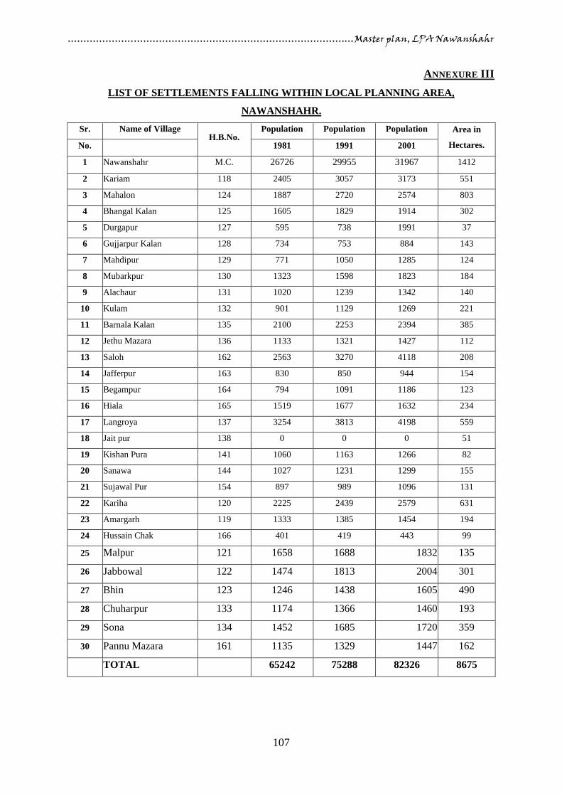
…………………………………………………………………………….…Master plan, LPA Nawanshahr
107
ANNEXURE III
LIST OF SETTLEMENTS FALLING WITHIN LOCAL PLANNING AREA,
NAWANSHAHR.
Sr. Name of Village H.B.No.
Population Population Population Area in
Hectares. No. 1981 1991 2001
1 Nawanshahr M.C. 26726 29955 31967 1412
2 Kariam 118 2405 3057 3173 551
3 Mahalon 124 1887 2720 2574 803
4 Bhangal Kalan 125 1605 1829 1914 302
5 Durgapur 127 595 738 1991 37
6 Gujjarpur Kalan 128 734 753 884 143
7 Mahdipur 129 771 1050 1285 124
8 Mubarkpur 130 1323 1598 1823 184
9 Alachaur 131 1020 1239 1342 140
10 Kulam 132 901 1129 1269 221
11 Barnala Kalan 135 2100 2253 2394 385
12 Jethu Mazara 136 1133 1321 1427 112
13 Saloh 162 2563 3270 4118 208
14 Jafferpur 163 830 850 944 154
15 Begampur 164 794 1091 1186 123
16 Hiala 165 1519 1677 1632 234
17 Langroya 137 3254 3813 4198 559
18 Jait pur 138 0 0 0 51
19 Kishan Pura 141 1060 1163 1266 82
20 Sanawa 144 1027 1231 1299 155
21 Sujawal Pur 154 897 989 1096 131
22 Kariha 120 2225 2439 2579 631
23 Amargarh 119 1333 1385 1454 194
24 Hussain Chak 166 401 419 443 99
25 Malpur 121 1658 1688 1832 135
26 Jabbowal 122 1474 1813 2004 301
27 Bhin 123 1246 1438 1605 490
28 Chuharpur 133 1174 1366 1460 193
29 Sona 134 1452 1685 1720 359
30 Pannu Mazara 161 1135 1329 1447 162
TOTAL 65242 75288 82326 8675

…………………………………………………………………………….…Master plan, LPA Nawanshahr
108
ANNEXURE IV
Requirements for social infrastructure

…………………………………………………………………………….…Master plan, LPA Nawanshahr
109
ANNEXURE V

…………………………………………………………………………….…Master plan, LPA Nawanshahr
110
ANNEXURE VI
List of trees recommended for plantation on the main roads within urban limits / Master Plan
Areas Sr. No. Name of Tree (Botanical /
Common)
Description
1 Alstonia Scholaris
(Chhatim)
Tall tree with columnar shape, evergreen, very ornamental.
Bears greenish-white flowers in October – December.
2 Barringtonia Acuitangula
(Smudhar Phal)
Medium tree with spreading habits, deciduous from April to May.
Ornamental foliage and flowers in pendulous branches. Bears
crimson flowers in April and September.
3 Bauhinia Blackiana
(Kachnar)
Small tree, evergreen with columnar form, highly attractive and
ornamental.
Propagated by layers and cuttings.
Flowers deep pink from January to April and from September to
November.
4 Bauhinia Purpurea
(Kachnar)
Medium tree with columnar form, evergreen
Bears purple coloured flowers in November.
5 Bauhinia Variegata
(Kachnar)
Medium tree with columnar form.
Sheds leaves in January, February, profusely flowering tree,
highly beautiful when in bloom.
Bears pink, white and purple coloured flowers in February, March
and April.
6 Cassia Fistula (Amaltas) Tall columnar shaped tree, leafless in April – May, very hardy
tree, looks very ornamental when in bloom.
Bright yellow flowers in April – May.
7 Cassia Grandis (Pink
Mohur)
Medium in height with spreading habit.
Highly ornamental tree.
Bears deep carmine flowers in November and December.
8 Cassia Javanica (Java – ki –
Rani)
Medium in height, leafless in April – May.
It is the most beautiful flowering tree.
Bears clusters of pink flowers in May – June.
9 Cassia Marginata (Pink
Mohur)
Medium in height, spreading and graceful tree.
Bears deep pink flowers in May and June.
10 Cedrela Tuna (Tun) Tall columnar shaped tree, leafless in December – January.
Fairly fast growing and hardy tree with creamy white flowers in
March – April.
11 Chakassia Tabularis Tall spreading tree, evergreen and hardy.
Excellent for shade.
Flowers are greenish, white in April – May.
12 Chorisia Speciosa (Mexican
Silk Cotton Tree)
Medium in height, pyramidal in shape, leafless from October to
January, fast growing and bottle shaped green trunk.
Flowers are of pink and yellow colour in October – November.
13 Delonix Regia (Gulmohar) Tall tree with spreading crown, leafless from January – March.
Fast growing, very ornamental creates mass effect with orange red
flowers from April to June.
14 Ficus Religiosa (Pipal) Tall columnar shaped tree, leafless in February – March, very
hardy and fast growing flowers pale green in April.
15 Ficus Infectoria (Pilkhan) Tall spreading, fast growing and hardy tree, leafless in March,
good for shade, need protection from cattle, green yellow flowers
in November and December.
16 Hetrophragma Roxburghii
(Marour Phaly)
Tall columnar tree, evergreen, flowers are of pale, yellow brown
colour in March.
17 Jacranda Mimosaefolia
(Jakaranada or Neely
Gulmohar)
Medium in height, leafless when in bloom, good for parks and
houses, fern like bipinnate leaves.
Bears flowers of violet-blue colour in April – May.
18 Kigelia Pinnata (Jhar
Phanoos)
Tall and spreading tree, evergreen hardy.
Fast growing flowers are of crimson, yellow and brown colour in
April – May.

…………………………………………………………………………….…Master plan, LPA Nawanshahr
111
19 Lagerstroemia Frosreginae
(Queen’s Flower)
Medium sized tree, columnar shape, very pretty, leafless in winter
(December – February). Purple and pinkish blooms in April – May
and July – August.
20 Lagerstroemia Thorelli
(Pride of India)
Medium in height, columnar in shape, beautiful tree, leafless from
December – February, flowers of mauve colour from June to
December.
21 Lagerstroemia Rosea Medium in height, columnar tree, very pretty. Leafless in winter
(December – February) with deep pink flowers from April to
September.
22 Pongamia Glabra (Karanj) Tall spreading and fast growing tree, leafless in March.
Bears mauve colour coloured flowers in April – May.
23 Pterospermum acerifolium
(Kanak Champa)
Tall columnar tree, ever green, handsome, bear’s sweet scented
flowers of creamy white colour in March – April.
24 Putranjaniva Roxburghii
(Jiva Pota)
Medium in height, pyramidal shaped, ever green, handsome and
very graceful tree, good for shade and beautiful form.
Flowers are of pale yellowish colour in March – April.
25 Saraca Indica (Sita Ashok) Height medium, spreading tree, evergreen, very hardy, foliage
glossy and ornamental.
Highly flow growing takes 30 years to become a good tree.
Bears highly attractive scarlet coloured flowers in large compact
clusters in February and March.
26 Schleichera Frijuga
(Kusum)
Tall columnar shaped tree, evergreen, good for shade, leaves
become red in March and April and again in July and September.
Flowers are of green colour in February and March.
27 Sweitnia (Mahogany) Evergreen, shady, attractive foliage, very hardy, tall tree with
columnar shape, blooms in April and tree is slowing growing and
very good for avenues.
28 Tabeuia Rosea Small in height, columnar in shape, deciduous from December to
February, scanty foliage and flower colour is purple – pink in
February to March.
29 Terminalia Arjuna (Arjan) Tall, columnar shaped tree sheds leaves in March.
Very hardy tree, flowers of pale – yellowish white colour appear
in September to October.
30 Terminalia Chebula
(Bahera)
Tall, columnar shaped tree, leafless in March, pale – yellow
flowers all the year round.

…………………………………………………………………………….…Master plan, LPA Nawanshahr
112
ANNEXURE VII
SPACE NORMS AND STANDARDS Aspect As per zoning regulations
and sub-division clauses
for Master Plan in
Punjab/Govt. Policies
UDPFI Guidelines Delhi Master Plan
Primary school Population:3,000-4,000
No. of students: 600
Area
a) Old city (over 650
ppha) : 0.2 ha
b) Outer areas (less
than 650ppha):0.5
ha
Population: 5,000
Number of students :500
Area per school:0.4 ha
Covered area:0.20 ha
Minimum play field area: 0.20
ha
Population: 10,000
Area:2000-4000 sq m
Senior Secondary
School Population:12,000-20,000
No. of students: 1000
Area
a) Old city (over 650
ppha) : 1.00 ha
b) Outer areas (less
than 650 ppha):2.5
ha
Population: 7,500
Number of students :1000
Area per school:1.60 ha
Covered area:0.60 ha
Minimum play field area: 1.00
ha
Population: 10,000
Area:6000-8000 sq.
m.
College Population:30,000
No. of students: 800
Area
a) Old city (over 650
ppha) : 2.50 ha
b) Outer areas (less
than 650
ppha):5.00 ha
Population: 1,25,000
Number of students :1000-
1500
Area per college:4.00 ha
Covered area:1.80 ha
Play field area:1.80ha
Residential/hostel area: 0.40 ha
Population: 5,00,000
Area: As per UGC
Norms
University N.A. New University Area:60.00ha sites in urban
extension to be
provided at city level
Area: up to 20.00 ha
Technical Education
Centre
N.A. Population :10,00,00
Area per centre 4.00 ha
Area per technical centre:2.10
ha
Area per ITI:1.40 ha
Area per coaching centre:0.30
ha
Population :5,00,000
Area : 4000 sq m
New Engineering
College
Number of students :300
Area
a) Old city:(over 650
ppha): 1.00 ha
b) Outer areas (less than
650ppha):2.50 ha
1 2 Number to be provided in
urban extension
2 Number of students:1500-1700
3 Area per college:60.00ha
Population :5,00,000
Area: As per AICTE
norms
Medical/Pharmacy
College
Area :5 acres(Rural)
Area: 2.5 acres (Distt.
Headquarter Corporation
Limit)
4 2 site of 15 ha each in urban
extension including space for
specialized general hospital.
Population: 10,00,00
Area :As per Medical
Council of India
/Regulatory body
Dispensary Population :5,000
Area: 0.1ha
5 Population:15,000
6 Area :0.08 to 0.12 ha
Population:10,000
Area :800-2000 sq m
Primary Health
Center
7
Nursing Home N.A. 8 Population :45,000-1,00,000
9 Capacity:25 to 30 beds
10 Area:0.20 to 0.30 ha
Population :50,000
Area:1000-2000sq m
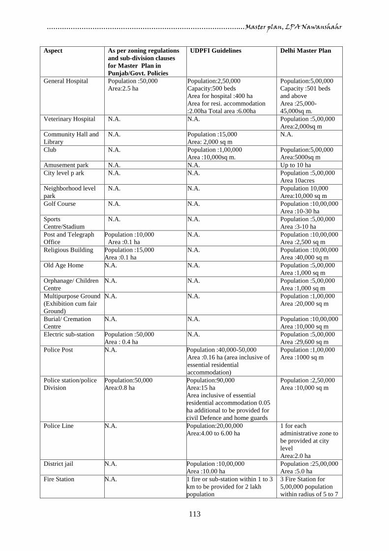
…………………………………………………………………………….…Master plan, LPA Nawanshahr
113
Aspect As per zoning regulations
and sub-division clauses
for Master Plan in
Punjab/Govt. Policies
UDPFI Guidelines Delhi Master Plan
General Hospital Population :50,000
Area:2.5 ha
11 Population:2,50,000
12 Capacity:500 beds
13 Area for hospital :400 ha
14 Area for resi. accommodation
:2.00ha Total area :6.00ha
Population:5,00,000
Capacity :501 beds
and above
Area :25,000-
45,000sq m.
Veterinary Hospital N.A. 15 N.A. Population :5,00,000
Area:2,000sq m
Community Hall and
Library
N.A. 16 Population :15,000
17 Area: 2,000 sq m
N.A.
Club N.A. 18 Population :1,00,000
19 Area :10,000sq m.
Population:5,00,000
Area:5000sq m
Amusement park N.A. 20 N.A. Up to 10 ha
City level p ark N.A. 21 N.A. Population :5,00,000
Area 10acres
Neighborhood level
park
N.A. 22 N.A. Population 10,000
Area:10,000 sq m
Golf Course N.A. 23 N.A. Population :10,00,000
Area :10-30 ha
Sports
Centre/Stadium
N.A. 24 N.A. Population :5,00,000
Area :3-10 ha
Post and Telegraph
Office
Population :10,000
Area :0.1 ha
25 N.A. Population :10,00,000
Area :2,500 sq m
Religious Building Population :15,000
Area :0.1 ha
26 N.A. Population :10,00,000
Area :40,000 sq m
Old Age Home N.A. 27 N.A. Population :5,00,000
Area :1,000 sq m
Orphanage/ Children
Centre
N.A. 28 N.A. Population :5,00,000
Area :1,000 sq m
Multipurpose Ground
(Exhibition cum fair
Ground)
N.A. 29 N.A. Population :1,00,000
Area :20,000 sq m
Burial/ Cremation
Centre
N.A. 30 N.A. Population :10,00,000
Area :10,000 sq m
Electric sub-station Population :50,000
Area : 0.4 ha
31 N.A. Population :5,00,000
Area :29,600 sq m
Police Post N.A. Population :40,000-50,000
32 Area :0.16 ha (area inclusive of
essential residential
accommodation)
Population :1,00,000
Area :1000 sq m
Police station/police
Division
Population:50,000
Area:0.8 ha
Population:90,000
Area:15 ha
Area inclusive of essential
residential accommodation 0.05
ha additional to be provided for
civil Defence and home guards
Population :2,50,000
Area :10,000 sq m
Police Line N.A. Population:20,00,000
Area:4.00 to 6.00 ha
1 for each
administrative zone to
be provided at city
level
Area:2.0 ha
District jail N.A. Population :10,00,000
Area :10.00 ha
Population :25,00,000
Area :5.0 ha
Fire Station N.A. 1 fire or sub-station within 1 to 3
km to be provided for 2 lakh
population
3 Fire Station for
5,00,000 population
within radius of 5 to 7

…………………………………………………………………………….…Master plan, LPA Nawanshahr
114
Aspect As per zoning regulations
and sub-division clauses
for Master Plan in
Punjab/Govt. Policies
UDPFI Guidelines Delhi Master Plan
Area for fire station with
essential residential
accommodation :1.00 ha
Area for sub-fire station with
essential residential
accommodation :0.60 ha
km
Area: 10,000 sq m
From the comparative table of norms and space standards as given above, the norms
suggested by UDPFI Guidelines have been found more suitable for the preparation of Master
Plan Nawanshahr because of the following reasons:
The norms and standards suggested by UDPFI Guidelines are more detailed and cover
almost each physical and social infrastructure as compared to Present Master Plan
Zoning Regulation /Govt. policies
Norms and standards suggested by UDPFI Guidelines are more realistic and suit to
local conditions such as prevailing development controls, availability of land, land
prices etc.
UDPFI Guidelines suggest different norms and standards for different category of
towns like small and medium towns, large cities and hill areas which is not available in
other guidelines.
The Norms and standards of Present Master Plan Zoning regulation are not detailed and
do not cover the whole of activities, hence are not being adopted.
Norms and standards suggested by Delhi Master Plan have not been found suitable for
LPA, Nawanshahr because these norms are of higher level, formed especially for Mega
city like Delhi, where development controls are very tight, population is more than 1.25
crores and the land is scarce and costly.
Note:
The norms and space standards as suggested by Punjab Govt. policies from time to time shall
have the overriding effect on the norms and standards of UDPFI Guidelines adopted for the
preparation of Master Plan, Nawanshahr.
For the aspects which are not covered under UDPFI Guidelines, the norms and standards as
suggested by Master Plan zoning Regulations shall be adopted and where these zoning
regulations are also silent, only in that case, the norms and standards suggested by Delhi
Master Plan shall be followed.

…………………………………………………………………………….…Master plan, LPA Nawanshahr
115
Traffic and Transportation
The norms and standards for Traffic and transportation as given in UDPFI Guidelines were
discussed with higher authorities, following roads hierarchy has been adopted;
Road hierarchy
R-1 200 feet wide
R-2 150 feet wide
R-3 100 feet wide
R-4 80 feet wide
Footpath
The width of footpaths is listed as below;
Minimum width 1.5 m
Adjoining shopping frontage At least 3.5 m
Longer shopping Frontage Minimum 4.5 m
Width should be increased by 1m in business/ shopping areas
Cycle Track
The minimum width of cycle tracks should be 2m. Each additional lane, where required,
should be one meter. The capacity of cycle tracks recommended is as below:
Width of Cycle Tracks Width in meters Capacity (Cycle /hr.)
One way Two way
Two lanes 3 250-600 50-250
Three lanes 4 >600 250-600
Four lanes 5 >600
Parking
Group housing 2 ECS per 100 square meters covered area on all floors subject to
maximum 3 ECS per dwelling unit.
Commercial 2 ECS per 100 square meters covered area
Institutional/ Hotel/ Hospital/Multi-media 1 ECS per 100 square meters of the covered
area (if the project is covered under notification no. 17/171/5-Hg 2/311 dated 11 /01/08,
otherwise the parking norms meant for commercial uses i.e. 2 ECS /100sq meters
covered area shall apply.)
Note:
The E.C.S shall be counted as below:
23 sq. meters for open parking
28 sq. meters for parking under stilts on ground floor
32 sq. meters for parking in the basement