Embed Size (px)
Citation preview

i
Table of Contents
The Sea Level Rise Initiative……………….………….…………..……….1
Compendium Purpose………………………………….……………..……2
The Climate Change Action Plan…………..…….…………………….….2
Sea Level Rise Initiative Flow Chart Project……………….…………….3
Timelines.…………………………….…………….……………...………...4
Project Descriptions……………………………………………………..…7
I: Scientific and Technical Support…..………….………….. 7
Bombay Hook Hydrology/Sediment Movement Study……………………9
Coastal Impoundment Accretion Study…………..….………..………….11
Coastal Monitoring Gap Analysis………………...…..…………………..13
Coastal Storm History……………………..……...……..…..……………15
Development of Coastal Inundation Maps………………………………17
Kitts Hummock Hydrologic Monitoring…………….…..………………19
Lidar Marsh Elevation Correction…….…...………....…..…………........21
Marsh Loss Analysis…………………………………..…………………23
Marsh Vulnerability Index (Phases I-IV)………...….……..…………....25
Sediment Elevation Tables………………….…..….……...…………….28
Digital Coast……………………………………………………………..30
II: Implementation Actions……………………….…………33
Development of a Coastal Resiliency Action Plan for Bowers Beach......34
City of New Castle Coastal Resiliency Project…………….…..………..36
Development of a Coastal Flood Monitoring System….….….…………38
III: Policy Development……………………...………..........41
Statewide Adaptation Plan……………………….…….….…………….42
Sustainable Coastal Communities Project…………….…….…………..46
Mid-Atlantic Regional Council on Oceans…………...………….……..49
ii
IV: Communication, Training, and Public Involvement….51
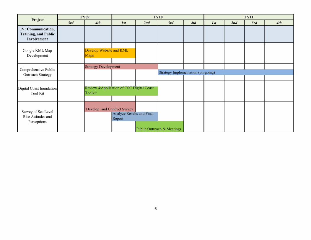
Google KML Map Development………………………….….…………52
Comprehensive Public Outreach Strategy………….…………...………54
Survey of Sea Level Rise Attitudes and Perceptions…..……...………..56
1
The Sea Level Rise Initiative
Sea level rise has the potential to significantly impact Delaware’s economy, coastal resources
and communities over the next several decades. Rising sea levels can submerge low-lying lands;
erode beaches; convert wetlands to open water; contribute to more severe coastal flooding; and
increase the salinity of estuaries and aquifers.
Sea level rise is currently occurring in Delaware; data has shown that sea level has increased by
over a foot over the past century. Scientists believe that the rate of sea level rise will accelerate
in the coming years. Both the Intergovernmental Panel on Climate Change and the U.S. Climate
Change Science Program have concluded that it is very likely that rates of sea level rise will be
greater in the coming century than in the last century. Although sea levels have fluctuated
significantly throughout the Earth’s history, due to human development and alterations of the
landscape, the coastline can no longer adapt naturally to these changes as it has in the past.
In order to prepare for sea level rise and prevent future damages to coastal communities, we must
understand and plan for the potential impacts of accelerated sea level rise. To help reach this
goal, the Delaware Coastal Programs Section of the Delaware Department of Natural Resources
and Environmental Control has begun its multi-year Sea Level Rise Initiative. The goal of the
Initiative is to develop policies that address sea level rise through the Statewide Sea Level Rise
Adaptation Plan, provide scientific technical decision support for these policies, successfully
implement the policies in order to effectively address sea level rise, and educate stakeholders and
the public on sea level rise issues and adaptation strategies. These goals complement one
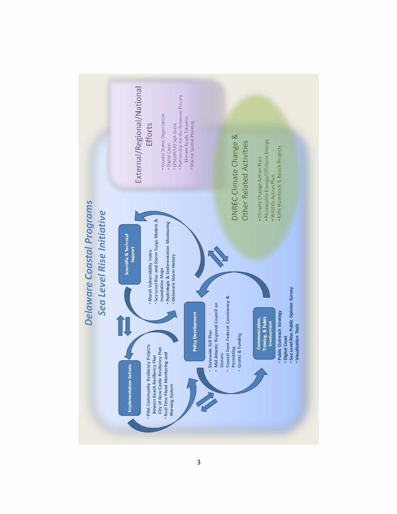
another, and are interconnected with DNREC’s climate change interests and its external,
regional, and national efforts (see page 3).
The projects that have been initiated under the Sea Level Rise Initiative help Delaware reach the
final goal of effectively preparing coastal communities and habitats for sea level rise in four
ways. First, some projects are designed to provide the necessary data needed to assess
vulnerabilities and to make policy decisions. For instance, the Marsh Vulnerability Index will
use biomass sampling to assess which of Delaware’s marshes are most vulnerable to sea level
rise. This will allow decision makers to decide which marshes to protect and where to allocate
resources. Second, some projects are designed to be pilot implementation projects, providing
needed assistance to coastal communities while providing a learning opportunity for state staff.
Pilot projects are currently underway in Bowers Beach and the City of New Castle; assistance
will be provided to other communities in future years. Third, some projects are designed to
provide tools, training and information to stakeholders, managers and the public. An on-line tool
will soon be available to assist with inundation mapping and a Statewide survey of public
attitudes and perceptions is underway. A comprehensive outreach strategy will be designed
based upon the results of these, and other, initiatives. Lastly, all of the data, information and
tools that are developed throughout the Sea Level Rise Initiative will be used to inform policy
development through the Statewide Sea Level Rise Adaptation Plan. This plan will bring
stakeholders together to develop plans and policies to address sea level rise.
The Sea Level Rise Initiative is designed to be iterative and will grow and change as new data,
outreach and policy needs are identified.
2
Purpose of this Compendium of Sea Level Rise Initiative Projects
The purpose of this compendium is to provide an at-a-glance inventory and timeline of projects
(see pages 4-6) that are currently underway as part of the Delaware Coastal Programs’ Sea Level
Rise Initiative. It also provides a way to visualize how these projects fit together. Projects
conducted by other agencies are not represented in this document, but there are many other
agencies whose work will be essential to preparing for sea level rise and coastal inundation.
The projects listed in this document are evolving. The timelines, process and intended outcomes
of each project within this compendium are subject to change. However, it is the intent to update
this document on a routine basis so that our partner agencies can be kept up to date on sea level
rise activities.
Linkages to the Climate Change Action Plan
The Delaware Department of Natural Resources and Environmental Control is in the process of
creating a Climate Change Action Plan for the state of Delaware. This Sea Level Rise Initiative
will be an important part of the Climate Change Action Plan, and the projects within this
compendium will play an important role preparing the state for the effects of climate change.
For More Information
For more information about projects contained within the Sea Level Rise Initiative
Compendium, please contact us at (302) 739-9283 or see our website:
http://www.swc.dnrec.delaware.gov/coastal/Pages/SeaLevelRiseAdaptation.aspx
3
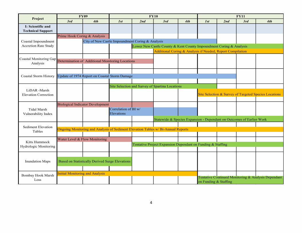
4
3rd 4th 1st 2nd 3rd 4th 1st 2nd 3rd 4th
Update of 1974 Report on Coastal Storm Damage
Site Selection and Survey of Spartina Locations
Site Selection & Survey of Targeted Species Locations
Biological Indicator Development
Correlation of BI w/
Elevations
Statewide & Species Expansion - Dependant on Outcomes of Earlier Work
Ongoing Monitoring and Analysis of Sediment Elevation Tables w/ Bi-Annual Reports
Water Level & Flow Monitoring
Tentative Project Expansion Dependant on Funding & Staffing
Based on Statistically Derived Surge Elevations
Initial Monitoring and Analysis
Prime Hook Coring & Analysis
City of New Castle Impoundment Coring & Analysis
Additional Coring & Analysis if Needed, Report Compilation
Determination of Additional Monitoring Locations
Tentative Continued Monitoring & Analysis Dependant
on Funding & Staffing
Coastal Monitoring Gap
Analysis
Coastal Storm History
LiDAR -Marsh
Elevation Correction
Tidal Marsh
Vulnerability Index
Sediment Elevation
Tables
Kitts Hummock
Hydrologic Monitoring
Inundation Maps
Bombay Hook Marsh
Loss
Coastal Impoundment
Accretion Rate Study
ProjectFY09 FY10 FY11
I: Scientific and
Technical Support
Lower New Castle County & Kent County Impoundment Coring & Analysis
5
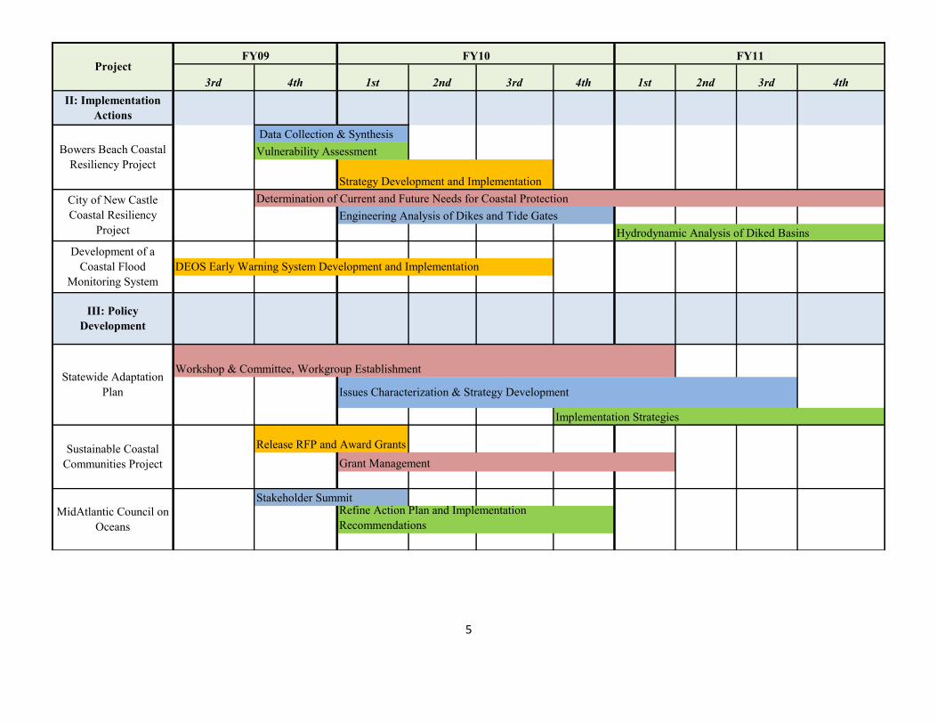
3rd 4th 1st 2nd 3rd 4th 1st 2nd 3rd 4th
ProjectFY09 FY10
Refine Action Plan and Implementation
Recommendations
Stakeholder Summit
Vulnerability Assessment
Strategy Development and Implementation
Determination of Current and Future Needs for Coastal Protection
Engineering Analysis of Dikes and Tide Gates
Hydrodynamic Analysis of Diked Basins
DEOS Early Warning System Development and Implementation
Implementation Strategies
Release RFP and Award Grants
Grant Management
Issues Characterization & Strategy Development
Workshop & Committee, Workgroup Establishment
Data Collection & Synthesis
FY11
III: Policy
Development
Statewide Adaptation
Plan
Sustainable Coastal
Communities Project
MidAtlantic Council on
Oceans
Development of a
Coastal Flood
Monitoring System
II: Implementation
Actions
Bowers Beach Coastal
Resiliency Project
City of New Castle
Coastal Resiliency
Project
6
3rd 4th 1st 2nd 3rd 4th 1st 2nd 3rd 4th
Develop and Conduct Survey Analyze Results and Final
Report
Public Outreach & Meetings
ProjectFY09 FY10
Develop Website and KML
Maps
Strategy Development
Strategy Implementation (on-going)
Review &Application of CSC Digital Coast
Toolkit
FY11
Comprehensive Public
Outreach Strategy
Digital Coast Inundation
Tool Kit
Survey of Sea Level
Rise Attitudes and
Perceptions
IV: Communication,
Training, and Public
Involvement
Google KML Map
Development
7
Scientific and Technical
Decision Support

8
9
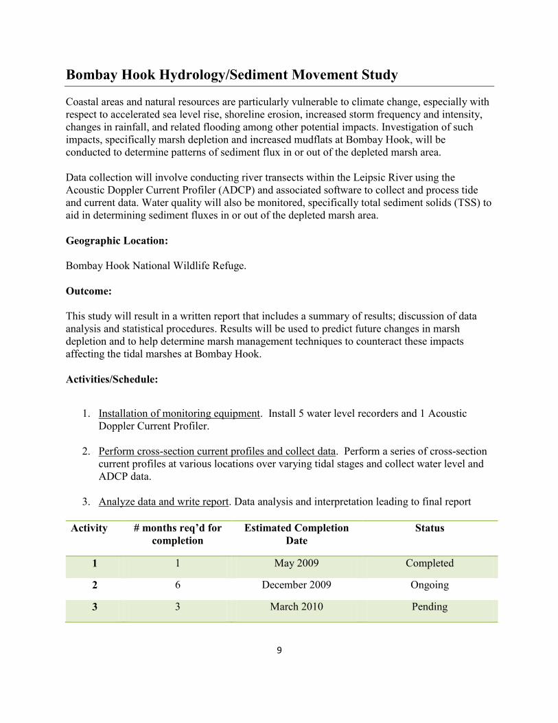
Bombay Hook Hydrology/Sediment Movement Study
Coastal areas and natural resources are particularly vulnerable to climate change, especially with
respect to accelerated sea level rise, shoreline erosion, increased storm frequency and intensity,
changes in rainfall, and related flooding among other potential impacts. Investigation of such
impacts, specifically marsh depletion and increased mudflats at Bombay Hook, will be
conducted to determine patterns of sediment flux in or out of the depleted marsh area.
Data collection will involve conducting river transects within the Leipsic River using the
Acoustic Doppler Current Profiler (ADCP) and associated software to collect and process tide
and current data. Water quality will also be monitored, specifically total sediment solids (TSS) to
aid in determining sediment fluxes in or out of the depleted marsh area.
Geographic Location:
Bombay Hook National Wildlife Refuge.
Outcome:
This study will result in a written report that includes a summary of results; discussion of data
analysis and statistical procedures. Results will be used to predict future changes in marsh
depletion and to help determine marsh management techniques to counteract these impacts
affecting the tidal marshes at Bombay Hook.
Activities/Schedule:
1. Installation of monitoring equipment. Install 5 water level recorders and 1 Acoustic
Doppler Current Profiler.
2. Perform cross-section current profiles and collect data. Perform a series of cross-section
current profiles at various locations over varying tidal stages and collect water level and
ADCP data.
3. Analyze data and write report. Data analysis and interpretation leading to final report
Activity # months req’d for
completion
Estimated Completion
Date
Status
1 1 May 2009 Completed
2 6 December 2009 Ongoing
3 3 March 2010 Pending
10
Agencies Involved:
DNREC Delaware Coastal Programs
USFWS
11
Coastal Impoundment Accretion Rate Study
As an accelerated rate of relative sea-level rise further stresses impounded marshes, there is a
greater need to evaluate the long-term sustainability and utility of impoundments in Delaware.
In order to do this, baseline data regarding historic sedimentation rates is needed.
Baseline data sets of long-term sedimentation rates in impounded and natural wetlands can be
utilized to evaluate the impounded wetlands’ ability to achieve optimal habitat benefit under
different management strategies and under different sea level rise scenarios
Long-term sedimentation rates over the past 100 and 50 years can be calculated by collecting
radioisotopic cores from wetland areas and analyzing them for 210
Pb and 137
Cs, . All core sites
and the adjacent wetland will be surveyed to tie all data to the tidal datum (NAVD 88).
Correlating long-term wetland sedimentation rates to current wetland elevation will enable a
detailed analysis of the potential sedimentation deficits that exist within the impoundments, as
compared to the reference wetlands. The elevation and sedimentation gradients between the
reference and impounded wetlands can be used to calculate potential future elevation trajectories
under different sea-level rise and management scenarios.
Geographic Location:
Monitoring sites were chosen within impounded and reference (natural marsh) sites throughout
the State based upon a wetland area change analysis (using a time-series of available imagery),
and basins that have been identified as needing detailed study to aid in their management to
optimize the future available habitat. Sites that will be studied include: marshes along the
Delaware River near New Castle; Ted Harvey Wildlife Area; St. Augustine Wildlife Area; and
Primehook National Wildlife Refuge.
Outcome:
When complete, this study will provide information to coastal managers regarding marsh
susceptibility to sea level rise under different marsh management scenarios and under different
sea level rise scenarios A long-term comparison of the wetland elevation and sedimentation
conditions between the impounded marsh and the “natural” marsh will enable a detailed analysis
and comparison of the potential long-term growth conditions and highlight the potential
implications for impoundment management that could affect the sustainability of the interior
wetlands. This information will allow marsh managers to understand the potential outcomes of
sea level rise and adapt their management techniques.
Activities/Schedule:
1. Initial Impoundment Core Collection. Radioisotopic cores will be collected from selected
marshes. All core sites and adjacent wetlands will be surveyed. Samples will be sent for
gamma spectroscopy analysis at the University of Delaware College of Earth, Ocean and
Environment. Core analysis is scheduled to be complete by December 2009.
12
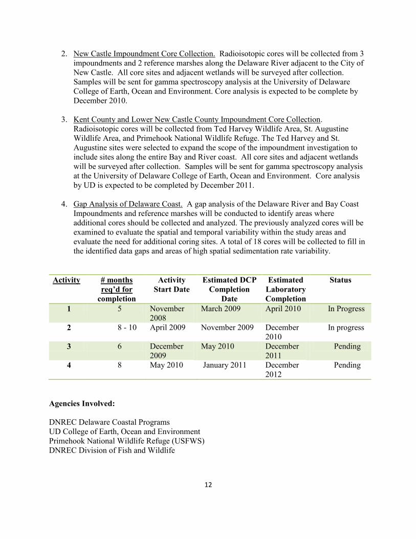
2. New Castle Impoundment Core Collection. Radioisotopic cores will be collected from 3
impoundments and 2 reference marshes along the Delaware River adjacent to the City of
New Castle. All core sites and adjacent wetlands will be surveyed after collection.
Samples will be sent for gamma spectroscopy analysis at the University of Delaware
College of Earth, Ocean and Environment. Core analysis is expected to be complete by
December 2010.
3. Kent County and Lower New Castle County Impoundment Core Collection.
Radioisotopic cores will be collected from Ted Harvey Wildlife Area, St. Augustine
Wildlife Area, and Primehook National Wildlife Refuge. The Ted Harvey and St.
Augustine sites were selected to expand the scope of the impoundment investigation to
include sites along the entire Bay and River coast. All core sites and adjacent wetlands
will be surveyed after collection. Samples will be sent for gamma spectroscopy analysis
at the University of Delaware College of Earth, Ocean and Environment. Core analysis
by UD is expected to be completed by December 2011.
4. Gap Analysis of Delaware Coast. A gap analysis of the Delaware River and Bay Coast
Impoundments and reference marshes will be conducted to identify areas where
additional cores should be collected and analyzed. The previously analyzed cores will be
examined to evaluate the spatial and temporal variability within the study areas and
evaluate the need for additional coring sites. A total of 18 cores will be collected to fill in
the identified data gaps and areas of high spatial sedimentation rate variability.
Activity # months
req’d for
completion
Activity
Start Date
Estimated DCP
Completion
Date
Estimated
Laboratory
Completion
Status
1 5 November
2008
March 2009 April 2010 In Progress
2 8 - 10 April 2009 November 2009 December
2010
In progress
3 6 December
2009
May 2010 December
2011
Pending
4 8 May 2010 January 2011 December
2012
Pending
Agencies Involved:
DNREC Delaware Coastal Programs
UD College of Earth, Ocean and Environment
Primehook National Wildlife Refuge (USFWS)
DNREC Division of Fish and Wildlife
13
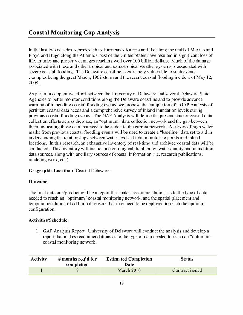
Coastal Monitoring Gap Analysis
In the last two decades, storms such as Hurricanes Katrina and Ike along the Gulf of Mexico and
Floyd and Hugo along the Atlantic Coast of the United States have resulted in significant loss of
life, injuries and property damages reaching well over 100 billion dollars. Much of the damage
associated with these and other tropical and extra-tropical weather systems is associated with
severe coastal flooding. The Delaware coastline is extremely vulnerable to such events,
examples being the great March, 1962 storm and the recent coastal flooding incident of May 12,
2008.
As part of a cooperative effort between the University of Delaware and several Delaware State
Agencies to better monitor conditions along the Delaware coastline and to provide advance
warning of impending coastal flooding events, we propose the completion of a GAP Analysis of
pertinent coastal data needs and a comprehensive survey of inland inundation levels during
previous coastal flooding events. The GAP Analysis will define the present state of coastal data
collection efforts across the state, an “optimum” data collection network and the gap between
them, indicating those data that need to be added to the current network. A survey of high water
marks from previous coastal flooding events will be used to create a “baseline” data set to aid in
understanding the relationships between water levels at tidal monitoring points and inland
locations. In this research, an exhaustive inventory of real-time and archived coastal data will be
conducted. This inventory will include meteorological, tidal, buoy, water quality and inundation
data sources, along with ancillary sources of coastal information (i.e. research publications,
modeling work, etc.).
Geographic Location: Coastal Delaware.
Outcome:
The final outcome/product will be a report that makes recommendations as to the type of data
needed to reach an “optimum” coastal monitoring network, and the spatial placement and
temporal resolution of additional sensors that may need to be deployed to reach the optimum
configuration.
Activities/Schedule:
1. GAP Analysis Report. University of Delaware will conduct the analysis and develop a
report that makes recommendations as to the type of data needed to reach an “optimum”
coastal monitoring network.
Activity # months req’d for
completion
Estimated Completion
Date
Status
1 9 March 2010 Contract issued

14
Agencies Involved:
DNREC Delaware Coastal Programs
University of Delaware
15
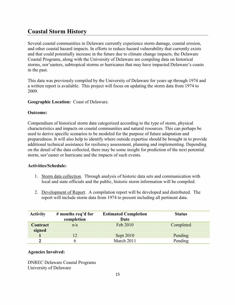
Coastal Storm History
Several coastal communities in Delaware currently experience storm damage, coastal erosion,
and other coastal hazard impacts. In efforts to reduce hazard vulnerability that currently exists
and that could potentially increase in the future due to climate change impacts, the Delaware
Coastal Programs, along with the University of Delaware are compiling data on historical
storms, nor’easters, subtropical storms or hurricanes that may have impacted Delaware’s coasts
in the past.
This data was previously compiled by the University of Delaware for years up through 1974 and
a written report is available. This project will focus on updating the storm data from 1974 to
2009.
Geographic Location: Coast of Delaware.
Outcome:
Compendium of historical storm data categorized according to the type of storm, physical
characteristics and impacts on coastal communities and natural resources. This can perhaps be
used to derive specific scenarios to be modeled for the purpose of future adaptation and
preparedness. It will also help to identify where outside expertise should be brought in to provide
additional technical assistance for resiliency assessment, planning and implementing. Depending
on the detail of the data collected, there may be some insight for prediction of the next potential
storm, nor’easter or hurricane and the impacts of such events.
Activities/Schedule:
1. Storm data collection. Through analysis of historic data sets and communication with
local and state officials and the public, historic storm information will be compiled.
2. Development of Report. A compilation report will be developed and distributed. The
report will include storm data from 1974 to present including all pertinent data.
Activity # months req’d for
completion
Estimated Completion
Date
Status
Contract
signed
n/a Feb 2010 Completed
1 12 Sept 2010 Pending
2 6 March 2011 Pending
Agencies Involved:
DNREC Delaware Coastal Programs
University of Delaware

16
17
Development of Coastal Inundation Maps
Sea Level Rise inundation maps are necessary to determine areas and extent of coastal
vulnerability to sea level rise, and will be a key component guiding the development of a
Statewide Sea Level Rise Adaptation Plan. While it is relatively straight forward to overlay
elevated sea level changes onto existing digital elevation models (DEMs), certain factors must be
considered. Primarily, mean tide levels vary along the Delaware Bay Coast and any maps
developed must take this into consideration. Secondly, solely using sea level rise will not give a
true perspective of inundation, since the major concern will be the flooding from coastal storm
surges.
To develop these maps (GIS Layers) a statistical evaluation from the existing 2 long-term NOAA
tide level datasets of Lewes (Breakwater Harbor) and Delaware City (Reedy Point) will be
performed to establish storm surge elevations above Mean Higher High Water (MHHW) for
selected return periods (i.e. 10, 25 50, 100-year return periods). Once these are calculated, the
current MHHW levels along the length of the coast will be determined using the NOAA VDatum
software. These two datasets will be combined to establish the appropriate elevations to use for
coastal inundation. After the Delaware Bay coast is completed, a similar effort will be performed
for the Inland Bays and Atlantic Coast.
Geographic Location:
Coastal Delaware
Outcome:
The final outcome/product will be a series of maps in GIS format that will be based on the bare
earth LIDAR data. Several scenarios will be developed using on current sea level rise, predicted
average sea level rise and predicted maximum sea level rise for the years 2050 and 2100.
Estimates of storm surge added to the predicted elevations will also be provided. These surges
will be based on historic data and statistical analysis.
Activities/Schedule:
1. Statistical Analysis of existing tide data. Based on existing data for Lewes and Delaware
City, develop expected storm surge levels for certain return periods.
2. Determine MHHW for Bay Coast. Using VDatum, determine MHHW along Delaware
Bay coastline corrected to NAVD88
3. Develop Inundation Maps for Delaware Bay Coast. Combining the two developed
datasets, produce GIS maps for different seal level and storm surge scenarios
4. Inland Bays and Atlantic Coast Maps. Repeat 1-3 for Inland Bays and Atlantic Coast.
18
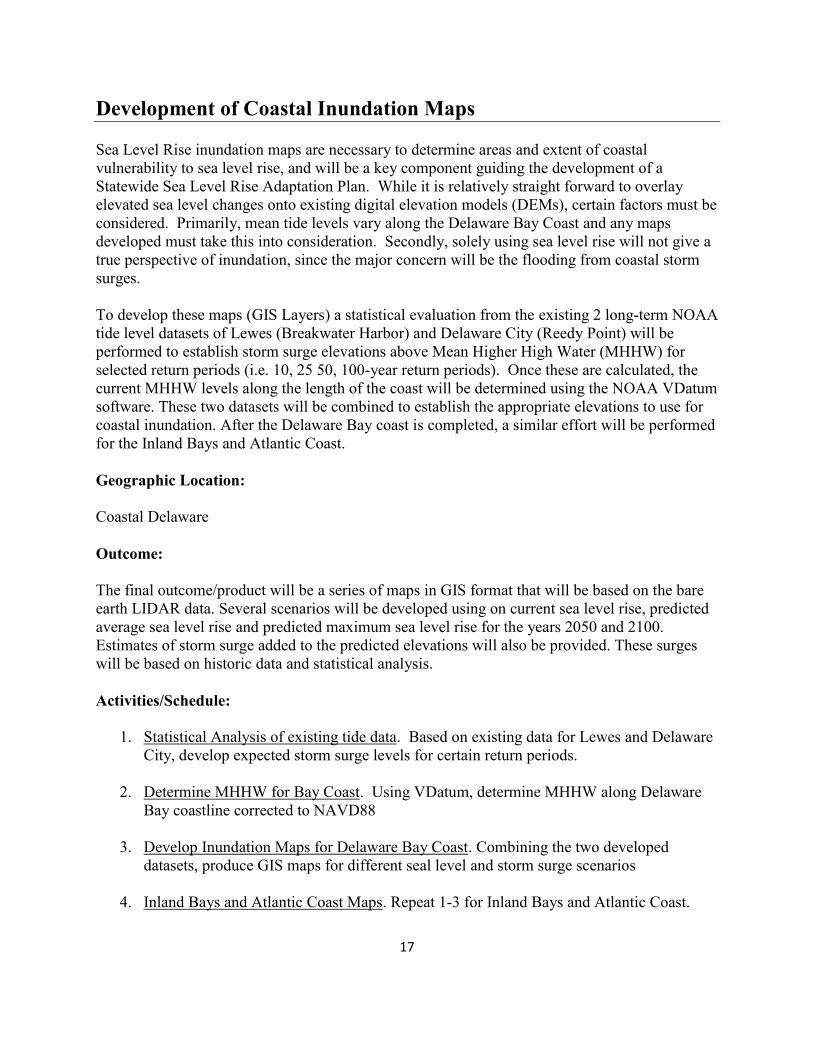
Activity # months req’d for
completion
Estimated Completion
Date
Status
1 2 September, 2009 Completed
2 <1 October, 2009 Completed
3 2 December, 2009 Completed
4 1 January, 2010 Completed
It is anticipated that all inundation maps will be frequently updated as new information on
sea level rise becomes available.
Agencies Involved:
DNREC Delaware Coastal Programs
19
Hydrologic Monitoring of the Kitts Hummock Area
To properly understand the relationships between the Delaware Bay, interior marsh water levels,
ponds, impoundments and the drainage ditch network around Kitts Hummock, a comprehensive
water level monitoring program will be established. Establishing a water level monitoring
network at key locations will aid in the understating the interrelationships between the water
bodies and the influence of the drainage network in the community on these water bodies. This
baseline monitoring is one of the prerequisite needs for conducting any defensible modeling and
evaluation of the effectiveness of any proposed drainage improvements to the Kitts Hummock
area. Additional needs prior to modeling include validation of marsh elevations, detailed
documentation and assessment of previous storms, and engineering designs of proposed
alterations
This baseline network will use a total of 8 Inset HOBO water level recorders in conjunction with
the USGS Tide gauge located approximately 5 kilometers south at Bowers Beach and other
currently monitored parameters. Two water level recorders will be placed on the north and south
sides of Kitts Hummock Road in the primary N/S drainage ditch approximately 250 meters
inland from the Delaware Bay. An additional three water level recorders will be used to examine
the effects of marsh water elevation and the northern impoundment of the Logan Lane Tract of
the Ted Harvey Conservation Area on the open water area of a private property and the South
Bay Drive drainage ditch. The final two water level recorders will be installed in open water
areas of the marsh northeast of the community of Kitts Hummock to estimate the tidal backwater
effects north of Kitts Hummock Road. A final recorder will be housed at the Delaware National
Estuarine Research Reserve (DNERR) to measure barometric pressure changes which will be
used to atmospherically correct the readings of the water level recorders. The recorders will be
surveyed to an accuracy of +- 2 cm vertical, and maintained and downloaded monthly by staff
from the DNERR.
Geographic Location:
This project encompasses the area surrounding Kitts Hummock, Kent County, DE, including the
private marsh lands north and south of the community and the DNREC/DFW Logan Lane Tract
of the Ted Harvey Conservation Area.
Outcome:
Once sufficient data has been collected, which includes a minimum of 3 months of data and at
least 3 significant storm events, the data will be compiled. Data on rainfall and wave height,
period and direction, currently being monitored by the DNERR, will be incorporated into the
data set and then the dataset will be analyzed. This analysis will include examining the Bay tide
effects on marsh water/drainage ditch elevations; relationships of surrounding water levels on the
Thompson open water area; probable pathways of tide related flooding; and a qualitative
evaluation of the expected effectiveness of drainage ditches in the area during different tidal
cycles/storm events.

20
Activities/Schedule:
1. Data Collection. Install data recorders, survey locations and collect data.
2. Data Analysis. Analyze data, run computer simulations, develop qualitative evaluation of
storm event drainage scenarios.
Activity # months req’d for
completion
Estimated Completion
Date
Status
1 3-5 October 2009 Complete
2 3 December 2009 Complete
No further monitoring will be initiated unless the town requests a community grant.
Agencies Involved:
DNREC Delaware Coastal Programs
DNREC Drainage and Stormwater Section
DNREC District Operations

21
LiDAR -Marsh Elevation Correction
Light Detection and Ranging (LiDAR) data elevation models (DEMs) are now available state
wide. LiDAR elevation data can be within a few centimeters of the actual elevation on a smooth,
hard surface, however, over heavily vegetative or rough surfaces the accuracy can severely
degrade to 20 to 30 cm or more. When developing maps or models for sea level rise and coastal
inundation, these discrepancies can become critical. This project will examine various marsh
habitats across the state to determine if a correction algorithm can be developed to refine the
accuracy of the DEMs over the marsh.
Geographic Location:
The wetland cover from select watershed from each county will be used for the initial assessment
stage of the project. The DNERR sites will be used for New Castle County (Blackbird Creek
Watershed) and Kent County (St. Jones Watershed), while Rehoboth and Indian River Bay
Wetlands will be used for Sussex County.
Outcome:
If successful, algorithms will be developed based on location (county) and predominate marsh
species to correct existing LiDAR data to provide better elevation accuracy within marshes.
These algorithms will be applied to the LiDAR GIS layers for the corresponding areas or species
to produce Marsh DEMs of suitable accuracy for other sea level rise projects.
Activities/Schedule:
1. Preliminary Feasibility Assessment. An initial assessment will determine the reasonable
feasibility of developing a wetland correction factor for the existing LiDAR. Real-Time
Kinematic (RTK) GPS surveys will be conducted during March and April (the same time
period in which the LiDAR was collected), throughout the three study areas to determine
the amount of offset between the LiDAR and the true wetland surface elevation. Trends
and difference statistics will be calculated to highlight the elevation offsets among the
three largest vegetative covers within the marshes (potential species could include:
Spartina alterniflora, Phragmites australis, Spartina cynosuroides, and/or high marsh
community). An algorithm will be created for each of the wetland species for each study
area. These algorithms will be then used to create new digital elevation models (DEM’s)
for each study area. The prototype corrected LiDAR for the three study wetland areas
will then be validated through additional RTK surveys to assess the reliability of the
correction algorithm. A statistical analysis of the predicted prototype wetland elevation
comparison to the true RTK elevations will be reported at the completion of this activity.
A detailed assessment of the feasibility of creating statewide wetland LiDAR corrections
will be included in the final preliminary assessment report. This will include detailed
expected timelines, data needs, and an assessment of the density of surveying that will
need to be conducted.
22
2. RTK Surveys of Statewide Wetlands. RTK Surveys will be conducted in wetlands in all
three counties, in the three dominate vegetation covers. Algorithms will be developed for
each watershed in each county.
3. Develop new Statewide DEMs. New DEMs will be produced for marsh areas using
existing LiDAR and developed algorithms.
Activity # months req’d
for completion
Estimated
Start Date
Estimated
Completion Date
Status
1 6 March 2010 August 2010 Proposed
2 7 March 2011 September 2011 Proposed
3 3 Sept 2011 December 2011 Proposed
Agencies Involved:
DNREC Delaware Coastal Programs
Center for the Inland Bays
DNREC Watershed Assessment

23
Marsh Loss Analysis (Interior Open Water Creation)
Staff from Bombay Hook NWR contacted the Delaware Coastal Programs for assistance with
their 5-year Biologic Review of the refuge. Refuge staff felt that DCP’s experience with GIS
analysis could help them answer some questions they had about the changing habitat of the
refuge. Coastal change, rising sea levels, erosion and land subsidence are increasingly tough
issues facing coastal managers, engineers, and planners charged with developing and protecting
coastal habitats and communities in vulnerable coastal zones. Understanding these threats
depends on early detection, and solutions will require vigorous public debate over engineering
solutions vs. strategic retreat. The drastic changes at Bombay Hook National Wildlife Refuge
(NWR) may be a harbinger of coast-wide habitat changes in the future.
The coastal areas of Bombay Hook NWR have historically been subjected to significant erosion.
Historical shorelines from as far back as 1842 paint a much different picture than exists today.
Shores that face the East and Southeast take the worst damage. These areas have the longest
fetch allowing the winds to add more power to the waves that break on these shores. For the
period 1937-2002, roughly 1700 ft. of erosion occurred along the southern shoreline of Bombay
Hook (26 ft/yr). This habitat loss is now coupled with increasing amounts of open water creation
in the interior marsh.
Aerial photos from 1979, 1992, and 2002 were examined for expansion of open water areas in
the interior marsh. Photos were viewed on a geographic information system and areas of open
water were outlined. Results showed that, over the years, open water areas were growing larger
and combining together. What had been a mosaic of small areas of open water mixed in
vegetated marsh are becoming large tracts of open water with vegetation around the edges. This
Study revealed that since 1979, the Refuge has lost a total of 12% of its wetland area; 10%
attributed to the creation of interior, open water areas.
No single, direct cause for the wetland loss has yet been identified. Some potential causes
including sea level rise, marsh/land subsidence, and snow goose grazing are being looked into.
These effects are inter-related and tend to work together to make matters worse. Currently DCP
and others are using sediment elevation tables to explore subsidence and sedimentation in
regional marshes. It is hoped that if a cause(s) can be determined, adjustments in marsh
management can be made to stem the loss of interior area.
This project will investigate the expansion of open water areas in four additional areas
throughout the state: the Thousand Acre Marsh region; Blackbird Creek; Milford Neck and
Primehook National Wildlife Refuge. For each area, open water areas will be digitized using
ArcGIS from historic aerial photographs to determine extent of open water areas over time.
Geographic Location:
DCP is now expanding the study to other similar marsh areas around the State: 1000 Acre
Marsh, Blackbird Creek, Milford Neck Wildlife Area and surrounding private conservation
lands; and Prime Hook NWR with nearby areas in Broadkill Beach.
24
Outcome:
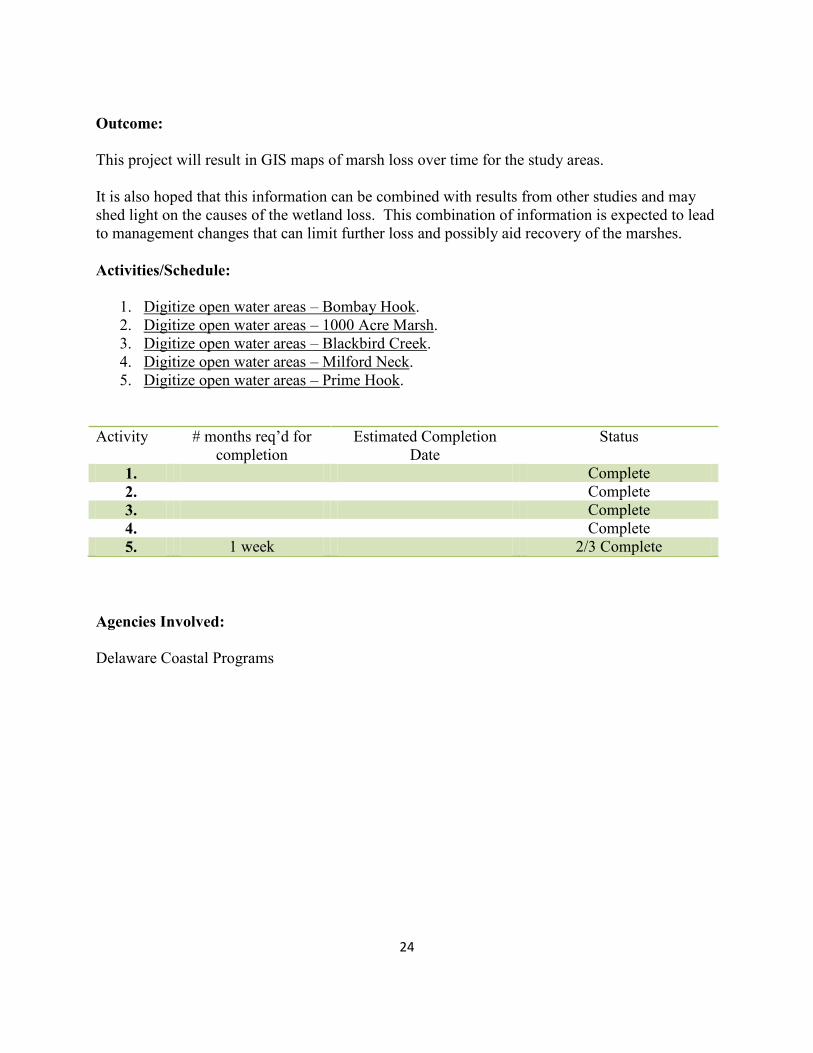
This project will result in GIS maps of marsh loss over time for the study areas.
It is also hoped that this information can be combined with results from other studies and may
shed light on the causes of the wetland loss. This combination of information is expected to lead
to management changes that can limit further loss and possibly aid recovery of the marshes.
Activities/Schedule:
1. Digitize open water areas – Bombay Hook.
2. Digitize open water areas – 1000 Acre Marsh.
3. Digitize open water areas – Blackbird Creek.
4. Digitize open water areas – Milford Neck.
5. Digitize open water areas – Prime Hook.
Activity # months req’d for
completion
Estimated Completion
Date
Status
1. Complete
2. Complete
3. Complete
4. Complete
5. 1 week 2/3 Complete
Agencies Involved:
Delaware Coastal Programs
25
Tidal Marsh Vulnerability Index
An index is needed to allow assessment of the long-term viability of Delaware’s marshes under
differing sea level rise scenarios and to target areas for conservation, restoration and monitoring.
The Tidal Marsh Vulnerability Index will be based upon the positive correlation between mean
tidal range and elevational growth range of tidal wetland plant species. Biomass sampling, taken
from the Mid-Atlantic Wetland Rapid Assessment Method (MidTRAM), will also be
incorporated into the Marsh Vulnerability Index to assess marsh health. Once developed, the Sea
Level Rise Index for Tidal Marshes tool could be transferred to other states and used for regional
comparisons and regional planning.
The Tidal Marsh Vulnerability Index will classify marshes as healthy, degrading or severely
degrading. These classifications will be utilized to select areas to conduct detailed sediment
accretion rate and other monitoring. Degraded and severely threatened marshes are known to
have lower elevations, relative to the tidal prism, and are more prone to catastrophic losses due to
sea-level rise and storm events. Understanding the current and historic sedimentation accretion
rates of these marshes can help to better predict the longevity and the sediment deficits of these
areas and possible management practices that might be implemented to prevent marsh elevation
losses (i.e. thin layer application of sediment, vegetation plantings, etc.).
The Tidal Marsh Vulnerability Index, in conjugation with time-series analysis of aerial imagery,
will be essential for evaluating wetland vulnerability on a watershed or statewide basis, while
enabling the strategic placement of monitoring resources to enhance our efforts to understand the
future evolution potential of Delaware’s tidal wetlands. All field based monitoring and sampling
efforts can be initiated and implemented to evaluate the most severely threatened marsh areas
first; the monitoring can then be expanded to encompass other marsh regions as resources
become available. Marsh Vulnerability Index classification optimizes the monitoring efforts and
resources to the highest levels possible, so the broadest extent of Delaware’s tidal wetlands may
be evaluate and managed.
Geographic Location:
Phase I & II will occur in the two components of the Delaware National Estuarine Research
Reserve, and the National Estuary Program, Center for the Inland Bays. Phase III & IV will
occur in tidal marshes along the Delaware Bay Coast and Inland Bays
Outcome:
Phase I will develop a marsh vulnerability index for Spartina alterniflora at three test sites
located within the Delaware National Estuarine Research Reserve and the National Estuary
Program’s Center for the Inland Bays. These three target sites encompass all three counties and
three different salinity regimes. This phase will use GIS data, aerial photos, LiDAR data and the
Statewide Wetland Mapping Program data along with field validation to develop a Spartina
alterniflora tidal growth range. These site specific values will be compared with the other
regions and values the literature to determine if a Statewide or regional Marsh Vulnerability
26
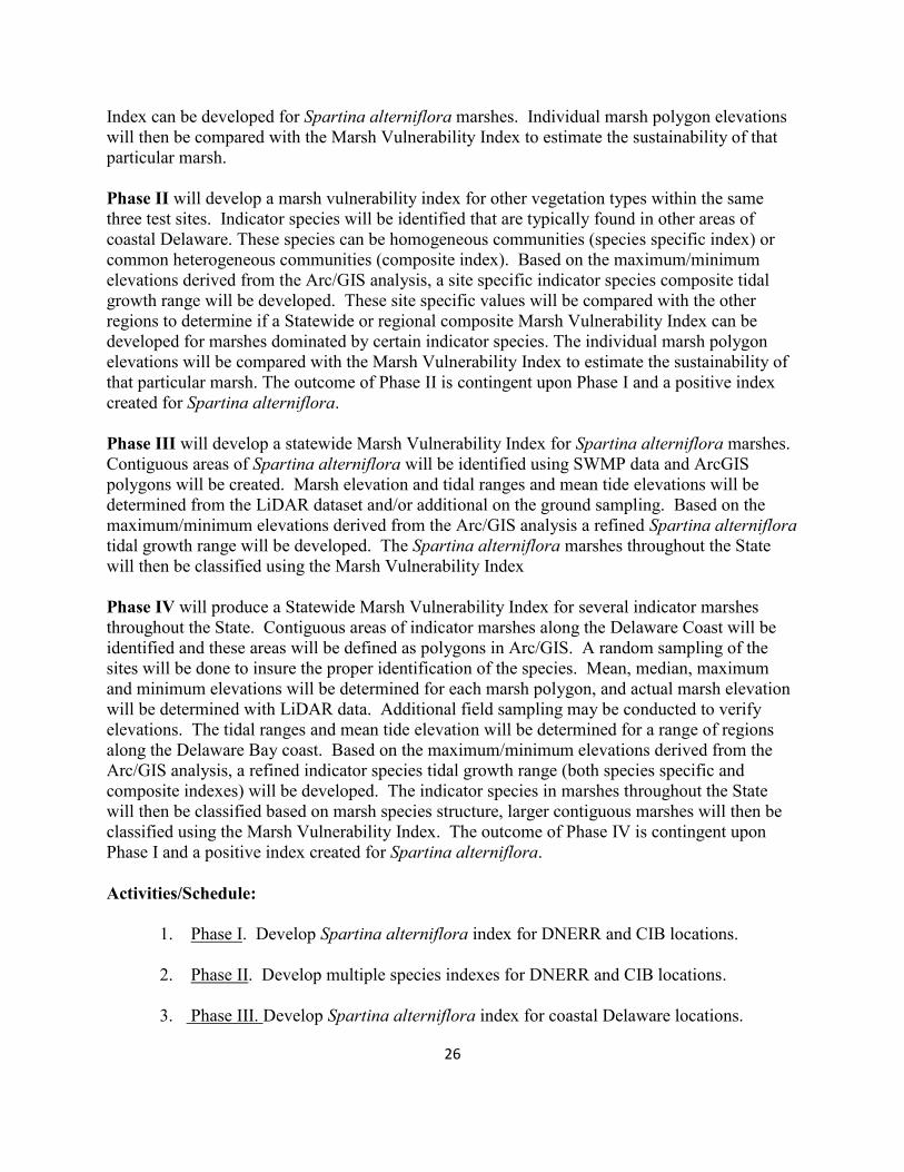
Index can be developed for Spartina alterniflora marshes. Individual marsh polygon elevations
will then be compared with the Marsh Vulnerability Index to estimate the sustainability of that
particular marsh.
Phase II will develop a marsh vulnerability index for other vegetation types within the same
three test sites. Indicator species will be identified that are typically found in other areas of
coastal Delaware. These species can be homogeneous communities (species specific index) or
common heterogeneous communities (composite index). Based on the maximum/minimum
elevations derived from the Arc/GIS analysis, a site specific indicator species composite tidal
growth range will be developed. These site specific values will be compared with the other
regions to determine if a Statewide or regional composite Marsh Vulnerability Index can be
developed for marshes dominated by certain indicator species. The individual marsh polygon
elevations will be compared with the Marsh Vulnerability Index to estimate the sustainability of
that particular marsh. The outcome of Phase II is contingent upon Phase I and a positive index
created for Spartina alterniflora.
Phase III will develop a statewide Marsh Vulnerability Index for Spartina alterniflora marshes.
Contiguous areas of Spartina alterniflora will be identified using SWMP data and ArcGIS
polygons will be created. Marsh elevation and tidal ranges and mean tide elevations will be
determined from the LiDAR dataset and/or additional on the ground sampling. Based on the
maximum/minimum elevations derived from the Arc/GIS analysis a refined Spartina alterniflora
tidal growth range will be developed. The Spartina alterniflora marshes throughout the State
will then be classified using the Marsh Vulnerability Index
Phase IV will produce a Statewide Marsh Vulnerability Index for several indicator marshes
throughout the State. Contiguous areas of indicator marshes along the Delaware Coast will be
identified and these areas will be defined as polygons in Arc/GIS. A random sampling of the
sites will be done to insure the proper identification of the species. Mean, median, maximum
and minimum elevations will be determined for each marsh polygon, and actual marsh elevation
will be determined with LiDAR data. Additional field sampling may be conducted to verify
elevations. The tidal ranges and mean tide elevation will be determined for a range of regions
along the Delaware Bay coast. Based on the maximum/minimum elevations derived from the
Arc/GIS analysis, a refined indicator species tidal growth range (both species specific and
composite indexes) will be developed. The indicator species in marshes throughout the State
will then be classified based on marsh species structure, larger contiguous marshes will then be
classified using the Marsh Vulnerability Index. The outcome of Phase IV is contingent upon
Phase I and a positive index created for Spartina alterniflora.
Activities/Schedule:
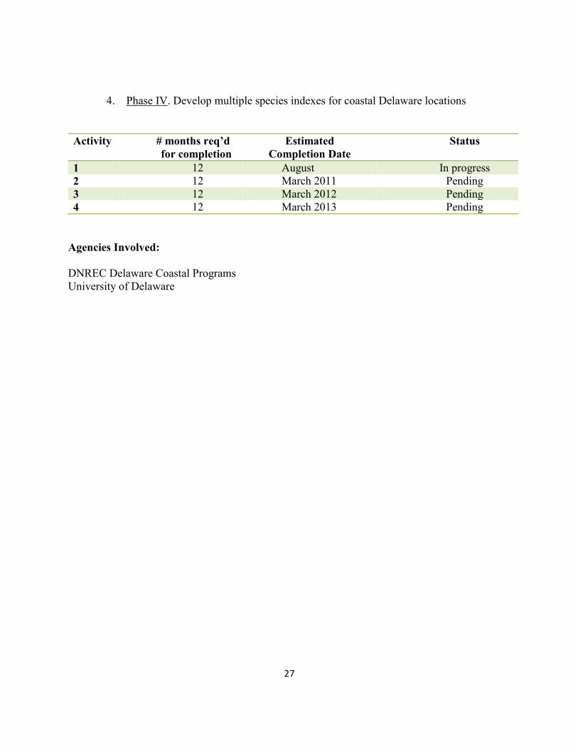
1. Phase I. Develop Spartina alterniflora index for DNERR and CIB locations.
2. Phase II. Develop multiple species indexes for DNERR and CIB locations.
3. Phase III. Develop Spartina alterniflora index for coastal Delaware locations.
27
4. Phase IV. Develop multiple species indexes for coastal Delaware locations
Activity # months req’d
for completion
Estimated
Completion Date
Status
1 12 August In progress
2 12 March 2011 Pending
3 12 March 2012 Pending
4 12 March 2013 Pending
Agencies Involved:
DNREC Delaware Coastal Programs
University of Delaware
28
Sediment Elevation Tables Sediment elevation tables (SETs) provide a nondestructive method for making highly accurate
and precise measurements of sediment elevation in intertidal and subtidal wetlands over long
periods of time, relative to a fixed subsurface datum. Data collected using SETs can be used to
determine both the influence of a single meteorological event on sediment surface elevation and
a long-term trend in elevation change. This information will help increase our understanding of
sedimentation rates in different marshes, sea level rise effects in these marshes, and potential
management techniques.
This project will continue to collect data from established SETs within the St. Jones and
Blackbird Creek estuaries. These SET’s have datasets that began in 2004-2005 for Blackbird
Creek and 2004 and 2007 for St. Jones River. The datasets contain total surface elevation
change, shallow surface elevation change, sedimentation, deep subsidence, and shallow
subsidence trends.
Marsh surface elevation changes are not merely being controlled by sediment deposition or
erosion; subsurface processes are playing a major role in controlling elevation. Separating the
influences of the biological (root growth), geological (soil compaction) and hydrological
processes (groundwater storage) can be very difficult at best. Measurements from the deep
benchmark will document and illustrate the effect that subsidence and compaction (the
consolidation and dewatering of the fine grained material deep in the marsh sediments) are
having on marsh surface elevation, with these changes in the zone of deep subsidence. The
shallow benchmark will localize the effects that occur in the root zone (from the surface to ~ 30
to 50 cm below the sediment surface), such as enhanced growth due to nutrient fluxes,
decomposition, compaction, dewatering, and pore water fluxes. Thus, it can be determined
whether the subsurface influences are occurring (in the root zone or at deeper depths) and make a
first approximation of which processes are dominating elevation change.
Geographic Location:
The project will be conducted within the St. Jones Estuary in Kent County, Delaware and the
Blackbird Creek Estuary in New Castle County, Delaware.
Outcome:
This study will result in a written report that includes a summary of results, discussion of data
analysis and statistical procedures. Results can then be used to determine both the influence of a
single meteorological event on sediment surface elevation and a long-term trend (i.e. decades) in
elevation change, as well as make predictions for future elevation changes in our local marshes.
29
Activities/Schedule:
1. SET Monitoring. SETs will be monitored and read in the St. Jones and Blackbird
watershed every 3 months, approximately, at the end of each season (i.e. fall, winter, etc.)
on the same lunar cycle. Readings will take a total of 4 days per monitoring cycle (2 days
each for the St. Jones and Blackbird), for a total of 16 field days for the year. Winter
readings could be skipped due to high ice volumes on the marsh surface, which negate
the ability to reliable measure the marsh surface.
2. Status and Trends Report. A status and trends report of the SET data will be drafted and
peer reviewed every two years, for both the St. Jones and Blackbird SET networks. The
first report will be completed by May 2010. The report will also include a gap analysis on
the current coverage of SET networks across the state and highlight the gaps in spatial
distribution, and make recommendations for future SET placements that could help
increase the wetland monitoring.
Activity # months req’d for
completion
Estimated Completion
Date
Status
1 On going Expected 15 to
20 year data set (2019)
On going
2 2 First report, May 2010 On going
Agencies Involved:
DNREC Delaware Coastal Programs
DNREC Watershed Assessment
Center for the Inland Bays
30
Digital Coast
The Digital Coast is a nationwide initiative that is designed to ensure the wise use and
management of coastal resources by providing coastal managers with data, training, tools and
examples to assist them with emerging and priority coastal issues. The partner network
identifies Digital Coast priorities and then works together to address coastal issues.
Currently, the Digital Coast partnership is focused on providing data, tools and examples to
coastal managers regarding coastal inundation and sea level rise. Projects to address other
coastal issues (i.e., marine spatial planning, conservation) will be developed in the future.
One of the goals behind the creation of the Digital Coast was to unify groups that might not
otherwise work together and build a strong collaboration of coastal professionals intent on
addressing coastal conservation needs. The Digital Coast Partnership Group is currently
comprised of representatives from the Association of State Floodplain Managers, the Coastal
States Organization, the National Association of Counties, the National States Geographic
Information Council, The Nature Conservancy, and the NOAA Coastal Services Center.
Delaware Coastal Programs staff have actively served as part of the Coastal States Organization
representatives on this project. The National Oceanic and Atmospheric Administration’s
(NOAA) Coastal Services Center is the lead organization for Digital Coast efforts.
Outcome:
In the fall of 2009, the current phase of the digital coast project, the Coastal Inundation Toolkit,
will be released. The toolkit is being developed by the Digital Coast Partnership Group to help
communities understand and address coastal inundation issues. Website components include:
Understand – Learn about inundation basics and common hazard concepts
Identify – Download the county-specific charts and graphs that tell your story
Map – Use the steps provided to discover and map areas of potential impact
Assess – Use inundation maps to assess community risk, vulnerability, and resilience
Inform – Use risk communication strategies to illicit change
Discover – See how other communities are addressing this issue
This tool is expected to be of enormous value as a resource tool for the many groups concerned
with and working to address coastal flooding and Sea Level Rise issues in Delaware.
Current and future Modules of Digital Coast resources are available at:
http://www.csc.noaa.gov/digitalcoast/

31
32
Implementation Actions

33
34
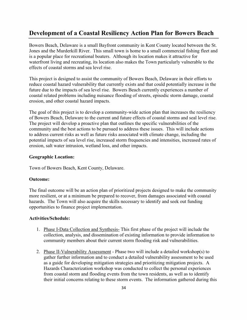
Development of a Coastal Resiliency Action Plan for Bowers Beach
Bowers Beach, Delaware is a small Bayfront community in Kent County located between the St.
Jones and the Murderkill River. This small town is home to a small commercial fishing fleet and
is a popular place for recreational boaters. Although its location makes it attractive for
waterfront living and recreating, its location also makes the Town particularly vulnerable to the
effects of coastal storms and sea level rise.
This project is designed to assist the community of Bowers Beach, Delaware in their efforts to
reduce coastal hazard vulnerability that currently exists and that could potentially increase in the
future due to the impacts of sea level rise. Bowers Beach currently experiences a number of
coastal related problems including nuisance flooding of streets, episodic storm damage, coastal
erosion, and other coastal hazard impacts.
The goal of this project is to develop a community-wide action plan that increases the resiliency
of Bowers Beach, Delaware to the current and future effects of coastal storms and seal level rise.
The project will develop a proactive plan that outlines the specific vulnerabilities of the
community and the best actions to be pursued to address these issues. This will include actions
to address current risks as well as future risks associated with climate change, including the
potential impacts of sea level rise, increased storm frequencies and intensities, increased rates of
erosion, salt water intrusion, wetland loss, and other impacts.
Geographic Location:
Town of Bowers Beach, Kent County, Delaware.
Outcome:
The final outcome will be an action plan of prioritized projects designed to make the community
more resilient, or at a minimum be prepared to recover, from damages associated with coastal
hazards. The Town will also acquire the skills necessary to identify and seek out funding
opportunities to finance project implementation.
Activities/Schedule:
1. Phase I-Data Collection and Synthesis- This first phase of the project will include the
collection, analysis, and dissemination of existing information to provide information to
community members about their current storm flooding risk and vulnerabilities.
2. Phase II-Vulnerability Assessment - Phase two will include a detailed workshop(s) to
gather further information and to conduct a detailed vulnerability assessment to be used
as a guide for developing mitigation strategies and prioritizing mitigation projects. A
Hazards Characterization workshop was conducted to collect the personal experiences
from coastal storm and flooding events from the town residents, as well as to identify
their initial concerns relating to these storm events. The information gathered during this
35
workshop will be used by a technical workgroup, comprised of State and County experts
in project planning and hazard preparations and town representatives, for development of
a formal vulnerability assessment and initial mitigation strategy.
3. Phase III-Strategy Development- Phase three will utilize the detailed results of the
vulnerability assessment to develop a final prioritization of needs and a set of strategies to
address these needs.
4. Phase IV-Implementation- This phase will be a longer term effort to implement the action
plan. Delaware Coastal Programs will take on an advisory role in assisting the town with
procuring funding, project design and tracking.
Activity # months req’d for
completion
Estimated Completion
Date
Status
Phase I 4 Fall/Winter 2009 Data collection on-going;
project webpage published
Phase II 3 Fall 2009/Spring 2010 Hazard Workshop
conducted and summary
document completed;
Assessment workgroup
to meet in October, 2009
Phase III 9 Winter 2010 Spring 2011 --------
Phase IV 12 Winter 2010 /Spring 2011 --------
Agencies Involved:
Town of Bowers Beach
Division of Soil and Water Conservation-Shoreline and Waterway Management Section and
Drainage Section
Delaware Emergency Management Agency
Kent County Emergency Management
Federal Emergency Management Agency
Delaware Department of Transportation
UD Sea Grant
36
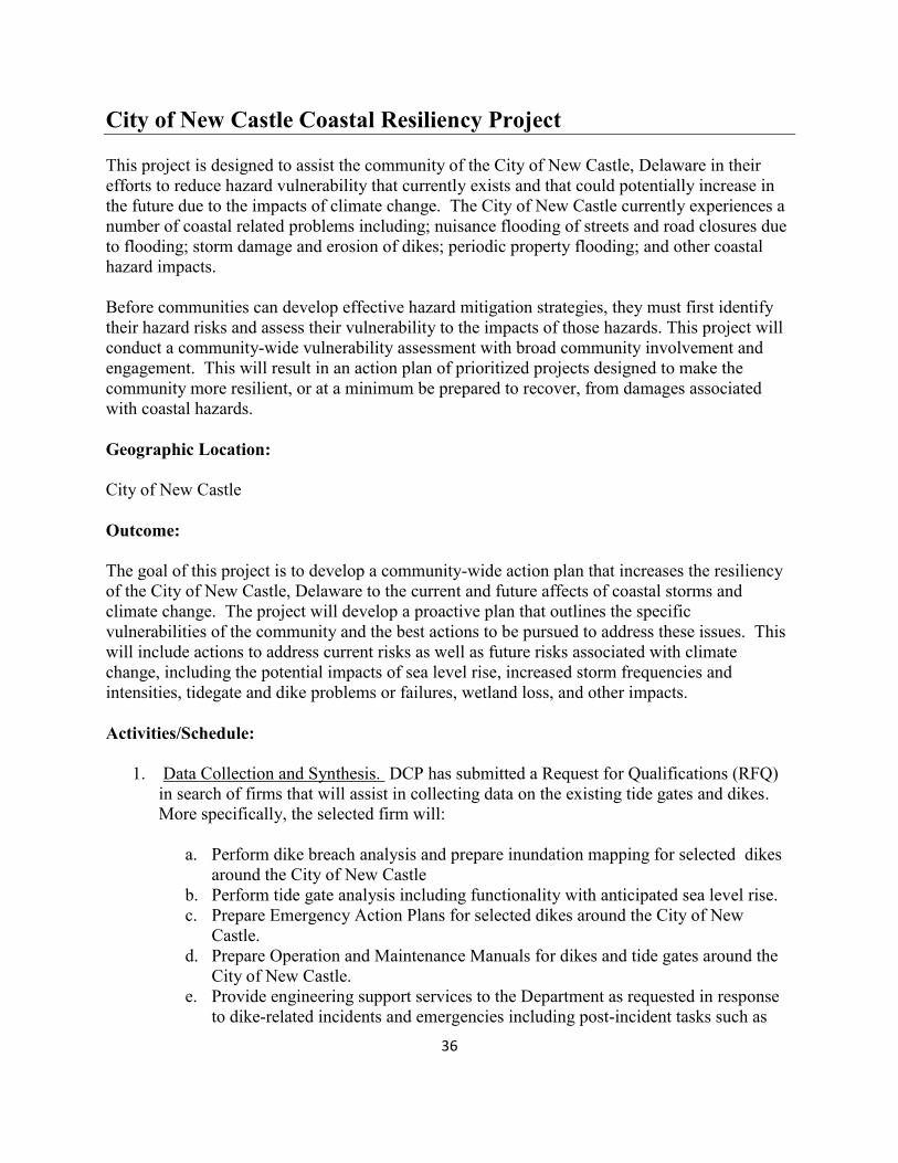
City of New Castle Coastal Resiliency Project
This project is designed to assist the community of the City of New Castle, Delaware in their
efforts to reduce hazard vulnerability that currently exists and that could potentially increase in
the future due to the impacts of climate change. The City of New Castle currently experiences a
number of coastal related problems including; nuisance flooding of streets and road closures due
to flooding; storm damage and erosion of dikes; periodic property flooding; and other coastal
hazard impacts.
Before communities can develop effective hazard mitigation strategies, they must first identify
their hazard risks and assess their vulnerability to the impacts of those hazards. This project will
conduct a community-wide vulnerability assessment with broad community involvement and
engagement. This will result in an action plan of prioritized projects designed to make the
community more resilient, or at a minimum be prepared to recover, from damages associated
with coastal hazards.
Geographic Location:
City of New Castle
Outcome:
The goal of this project is to develop a community-wide action plan that increases the resiliency
of the City of New Castle, Delaware to the current and future affects of coastal storms and
climate change. The project will develop a proactive plan that outlines the specific
vulnerabilities of the community and the best actions to be pursued to address these issues. This
will include actions to address current risks as well as future risks associated with climate
change, including the potential impacts of sea level rise, increased storm frequencies and
intensities, tidegate and dike problems or failures, wetland loss, and other impacts.
Activities/Schedule:
1. Data Collection and Synthesis. DCP has submitted a Request for Qualifications (RFQ)
in search of firms that will assist in collecting data on the existing tide gates and dikes.
More specifically, the selected firm will:
a. Perform dike breach analysis and prepare inundation mapping for selected dikes
around the City of New Castle
b. Perform tide gate analysis including functionality with anticipated sea level rise.
c. Prepare Emergency Action Plans for selected dikes around the City of New
Castle.
d. Prepare Operation and Maintenance Manuals for dikes and tide gates around the
City of New Castle.
e. Provide engineering support services to the Department as requested in response
to dike-related incidents and emergencies including post-incident tasks such as
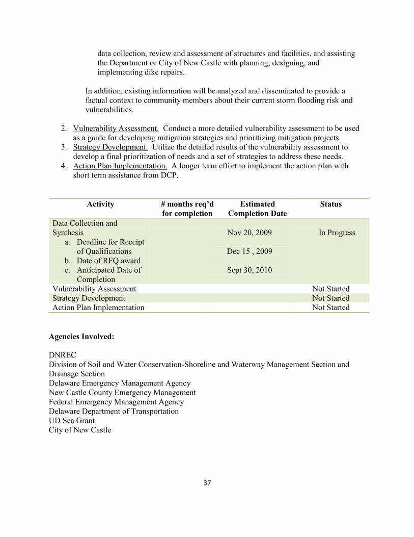
37
data collection, review and assessment of structures and facilities, and assisting
the Department or City of New Castle with planning, designing, and
implementing dike repairs.
In addition, existing information will be analyzed and disseminated to provide a
factual context to community members about their current storm flooding risk and
vulnerabilities.
2. Vulnerability Assessment. Conduct a more detailed vulnerability assessment to be used
as a guide for developing mitigation strategies and prioritizing mitigation projects.
3. Strategy Development. Utilize the detailed results of the vulnerability assessment to
develop a final prioritization of needs and a set of strategies to address these needs.
4. Action Plan Implementation. A longer term effort to implement the action plan with
short term assistance from DCP.
Activity # months req’d
for completion
Estimated
Completion Date
Status
Data Collection and
Synthesis
a. Deadline for Receipt
of Qualifications
b. Date of RFQ award
c. Anticipated Date of
Completion
Nov 20, 2009
Dec 15 , 2009
Sept 30, 2010
In Progress
Vulnerability Assessment Not Started
Strategy Development Not Started
Action Plan Implementation Not Started
Agencies Involved:
DNREC
Division of Soil and Water Conservation-Shoreline and Waterway Management Section and
Drainage Section
Delaware Emergency Management Agency
New Castle County Emergency Management
Federal Emergency Management Agency
Delaware Department of Transportation
UD Sea Grant
City of New Castle
38
Development of a Coastal Flood Monitoring System for Delaware
In the last two decades, storms such as Hurricanes Katrina and Ike along the Gulf of Mexico and
Floyd and Hugo along the Atlantic Coast of the United States have resulted in significant loss of
life, injuries and property damages reaching well over 100 billion dollars. Much of the damage
associated with these and other tropical and extra-tropical weather systems is associated with
severe coastal flooding. The Delaware coastline is extremely vulnerable to such events,
examples being the great March 1962 storm and the recent coastal flooding incident of May 12,
2008 which left at least one person dead and many homeless after ocean flood waters destroyed
homes, especially along the Delaware Bay Coast of Kent County. The added concern of sea-
level rise and its effect on the frequency and intensity of coastal flooding events, further
emphasizes the need for a modern, dependable coastal flood monitoring system for Delaware’s
coastal communities.
This project will develop a real-time coastal flood monitoring and warning system for the coastal
communities within Kent County, Delaware. This system will serve as a prototype for similar
protection along the entire Delaware coast. We will build on the existing competencies of the
Delaware Environmental Observing System (DEOS) and the Delaware Geological Survey
(DGS) in the development of this prototype system. The deliverables from this project will
directly impact several State agencies including the Delaware Department of Natural Resources
and Environmental Control (DNREC), the Delaware Emergency Management Agency (DEMA),
the Delaware Department of Transportation (DelDOT) and the Delaware National Estuarine
Research Reserve (DNERR). Moreover, the proposed system will have a direct impact upon the
safety and well-being of Delaware’s coastal communities. The system will allow State
constituencies to be informed as to tidal conditions and possible flooding situations up to 120-
hours in advance of their occurrence. Moreover, the system will indicate those areas that are
most likely to be affected by any tidal flooding (roadways, facilities, homes, etc.) allowing for
immediate response by appropriate State and County agencies.
Geographic Location:
Coastal Kent County Delaware
Outcome:
When complete, DEOS and DGS observation sites will continuously monitor environmental
conditions across the Delmarva Peninsula. The DEOS will also ingest forecasted tidal levels,
based upon astronomical and meteorological conditions, provided through NOAA. When a
forecasted (or real-time) critical tidal level is reached, the DEOS ALERTS system will send a
message to all interested State officials warning that a coastal flooding situation is possible,
which will prompt them to go to the Coastal Flood Monitoring web page. The web page will
contain pertinent real-time and forecasted tidal and meteorological information as well as flood
inundation maps for each major coastal community along the Kent County coast. Maps will be
produced at appropriate flood levels using the latest LIDAR elevation data. Both paper (for
39
dissemination to State and County agencies) and digital (for inclusion on the Coastal Flood
Monitoring web page) maps will be produced.
Development of the system will proceed in tandem with the completion of the coastal monitoring
GAP Analysis and the inland flood inundation survey. The GAP Analysis will both inform and
be informed by the coastal flood monitoring system development. The survey of high water
marks during previous coastal flooding events will be conducted using standard surveying
techniques by the Delaware Geological Survey. High water marks will be identified, their
history confirmed and the inundation level recorded. This data will be used in conjunction with
observed tide heights at USGS tidal monitoring points to better understand the inland inundation
associated with various tidal levels along the coast. The association between tide levels at
current coastal monitoring sites and inland flood levels is critical in developing statistical
relationships that can be used in the development of a coastal flood model that accurately depicts
possible inland flooding given a prediction of tidal anomalies at current monitoring sites.
Activities/Schedule:
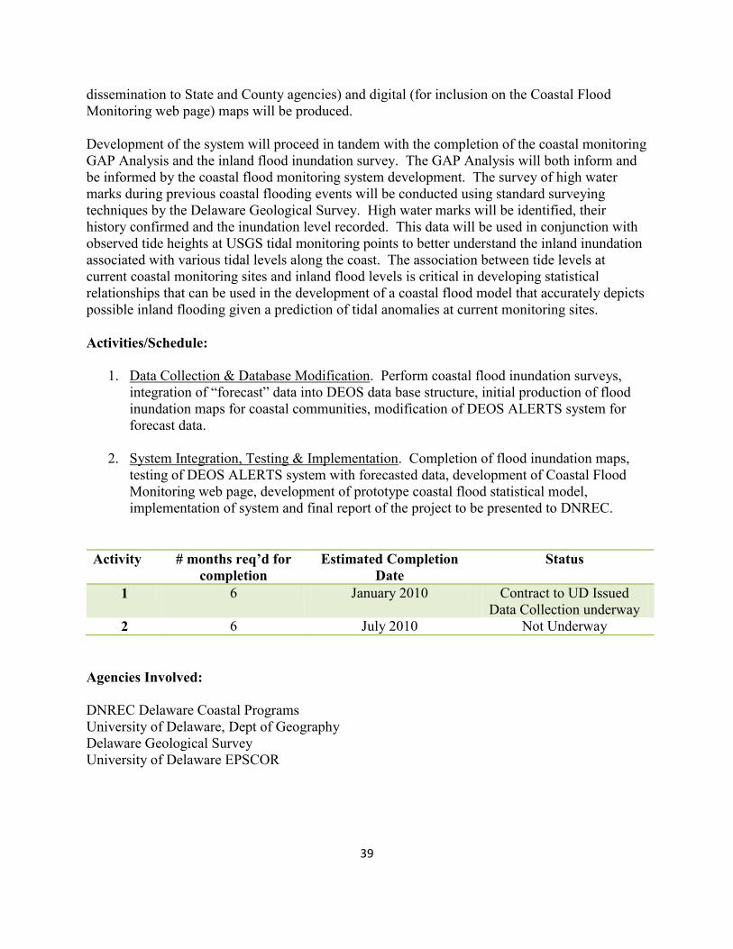
1. Data Collection & Database Modification. Perform coastal flood inundation surveys,
integration of “forecast” data into DEOS data base structure, initial production of flood
inundation maps for coastal communities, modification of DEOS ALERTS system for
forecast data.
2. System Integration, Testing & Implementation. Completion of flood inundation maps,
testing of DEOS ALERTS system with forecasted data, development of Coastal Flood
Monitoring web page, development of prototype coastal flood statistical model,
implementation of system and final report of the project to be presented to DNREC.
Activity # months req’d for
completion
Estimated Completion
Date
Status
1 6 January 2010 Contract to UD Issued
Data Collection underway
2 6 July 2010 Not Underway
Agencies Involved:
DNREC Delaware Coastal Programs
University of Delaware, Dept of Geography
Delaware Geological Survey
University of Delaware EPSCOR
40
Policy Development

41
42
Development of a Statewide
Sea Level Rise Adaptation Plan
Sea level rise will have economic, social and environmental effects throughout the State of
Delaware. Sea level rise increases the height of storm waves, making more areas vulnerable to
storm damage and can inundate low lying areas, causing losses to tidal wetlands, habitat, and
agricultural areas. Sea level rise also can cause higher water tables and salt water intrusion,
interfering with the septic systems, drinking water and irrigation water. These effects have
implications for coastal access and recreation, transportation networks, public safety and land use
patterns.
To address these issues, the Delaware Coastal Programs will develop a Statewide Adaptation
Plan for Sea Level Rise. The adaptation plan will recommend policy changes and practices that
will ensure that Delaware makes informed policy and investment decisions today to prevent
damage and losses to infrastructure, resources and homes tomorrow. Recommendations will be
based upon a careful assessment of potential effects to landowners, communities, economies,
natural resources and infrastructure using the best available science and technology.
The Plan will be developed with a team of stakeholders from a diverse network of interests
including municipal governments, highway planners, landowners, emergency managers, wildlife
managers, agricultural professionals, insurance agents, and tourism officials.
The Adaptation Plan will include the following phases:
An issues characterization and prioritization phase, during which, teams of experts will
research and document environmental, economic and social resources at risk from the
effects of sea level rise
A strategy development phase, during which, teams of experts will recommend ways to
address the issues and minimize loss of resources
An implementation phase, during which, recommendations will be incorporated into policies
and programs at all levels of government and where additional research will occur.
Geographic Location:
This project will be Statewide.
Outcomes:
The final outcome of this project will be the publication of a Statewide Sea Level Rise
Adaptation Strategy that will outline recommended policies and management strategies to reduce
the State’s vulnerability to the impacts of Sea Level Rise.
Additional outcomes will include:
43
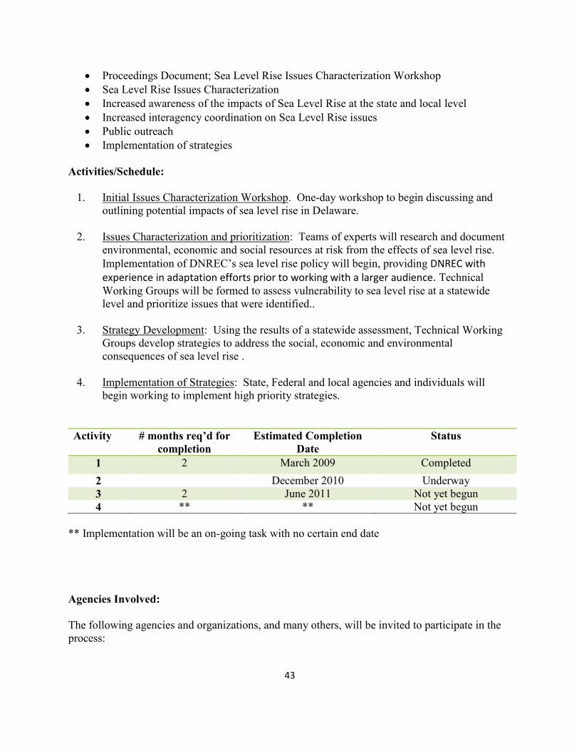
Proceedings Document; Sea Level Rise Issues Characterization Workshop
Sea Level Rise Issues Characterization
Increased awareness of the impacts of Sea Level Rise at the state and local level
Increased interagency coordination on Sea Level Rise issues
Public outreach
Implementation of strategies
Activities/Schedule:
1. Initial Issues Characterization Workshop. One-day workshop to begin discussing and
outlining potential impacts of sea level rise in Delaware.
2. Issues Characterization and prioritization: Teams of experts will research and document
environmental, economic and social resources at risk from the effects of sea level rise.
Implementation of DNREC’s sea level rise policy will begin, providing DNREC with experience in adaptation efforts prior to working with a larger audience. Technical
Working Groups will be formed to assess vulnerability to sea level rise at a statewide
level and prioritize issues that were identified..
3. Strategy Development: Using the results of a statewide assessment, Technical Working
Groups develop strategies to address the social, economic and environmental
consequences of sea level rise .
4. Implementation of Strategies: State, Federal and local agencies and individuals will
begin working to implement high priority strategies.
Activity # months req’d for
completion
Estimated Completion
Date
Status
1 2 March 2009 Completed
2 December 2010 Underway
3 2 June 2011 Not yet begun
4 ** ** Not yet begun
** Implementation will be an on-going task with no certain end date
Agencies Involved:
The following agencies and organizations, and many others, will be invited to participate in the
process:
44
Delaware Department of Natural Resources and Environmental Control
Delaware Department of Transportation
Delaware Department of Agriculture
Delaware Department of Safety and Homeland Security
Delaware Department of Health and Human Services
Delaware Economic Development Office
Delaware Office of Management and Budget
Delaware League of Local Governments
Other local government entities
University of Delaware
The Nature Conservancy, Delaware Chapter
The Sierra Club, Delaware Chapter
Positive Growth Alliance
Delaware Farm Bureau
Tidewater Utilities
Delaware Homebuilders Association
Delaware Realtors Association

45
46
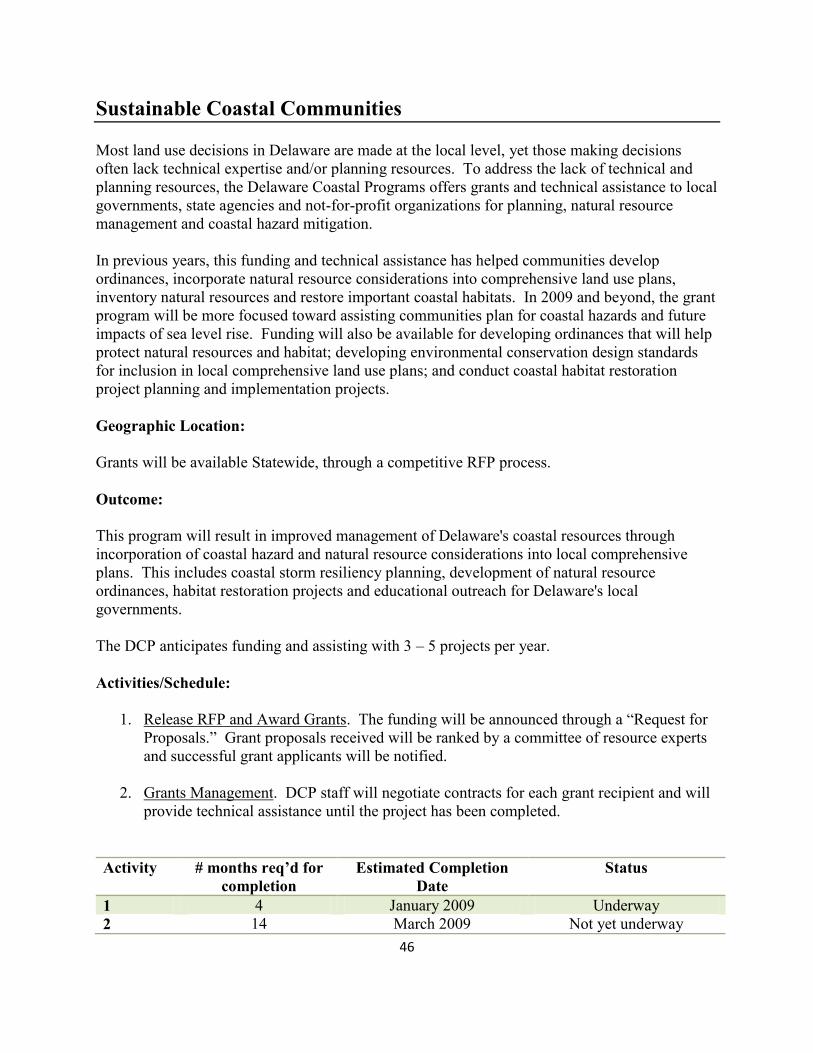
Sustainable Coastal Communities
Most land use decisions in Delaware are made at the local level, yet those making decisions
often lack technical expertise and/or planning resources. To address the lack of technical and
planning resources, the Delaware Coastal Programs offers grants and technical assistance to local
governments, state agencies and not-for-profit organizations for planning, natural resource
management and coastal hazard mitigation.
In previous years, this funding and technical assistance has helped communities develop
ordinances, incorporate natural resource considerations into comprehensive land use plans,
inventory natural resources and restore important coastal habitats. In 2009 and beyond, the grant
program will be more focused toward assisting communities plan for coastal hazards and future
impacts of sea level rise. Funding will also be available for developing ordinances that will help
protect natural resources and habitat; developing environmental conservation design standards
for inclusion in local comprehensive land use plans; and conduct coastal habitat restoration
project planning and implementation projects.
Geographic Location:
Grants will be available Statewide, through a competitive RFP process.
Outcome:
This program will result in improved management of Delaware's coastal resources through
incorporation of coastal hazard and natural resource considerations into local comprehensive
plans. This includes coastal storm resiliency planning, development of natural resource
ordinances, habitat restoration projects and educational outreach for Delaware's local
governments.
The DCP anticipates funding and assisting with 3 – 5 projects per year.
Activities/Schedule:
1. Release RFP and Award Grants. The funding will be announced through a “Request for
Proposals.” Grant proposals received will be ranked by a committee of resource experts
and successful grant applicants will be notified.
2. Grants Management. DCP staff will negotiate contracts for each grant recipient and will
provide technical assistance until the project has been completed.
Activity # months req’d for
completion
Estimated Completion
Date
Status
1 4 January 2009 Underway
2 14 March 2009 Not yet underway

47
Agencies Involved:
Delaware Coastal Programs
48
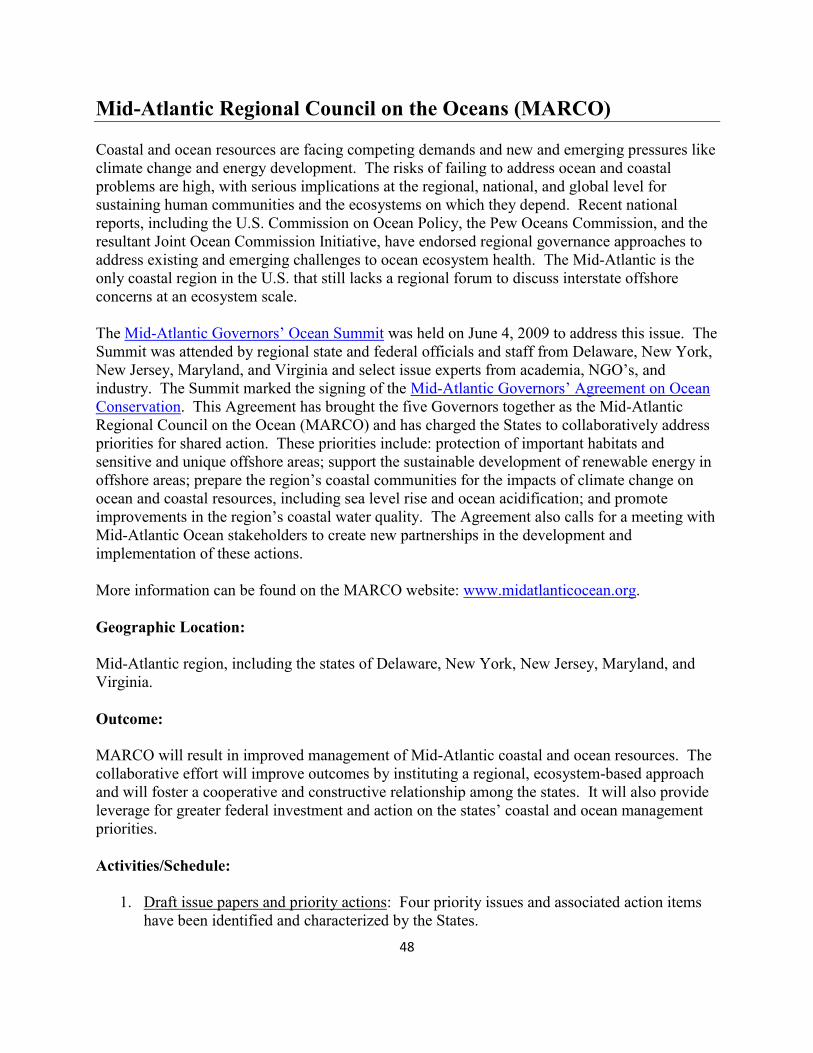
Mid-Atlantic Regional Council on the Oceans (MARCO)
Coastal and ocean resources are facing competing demands and new and emerging pressures like
climate change and energy development. The risks of failing to address ocean and coastal
problems are high, with serious implications at the regional, national, and global level for
sustaining human communities and the ecosystems on which they depend. Recent national
reports, including the U.S. Commission on Ocean Policy, the Pew Oceans Commission, and the
resultant Joint Ocean Commission Initiative, have endorsed regional governance approaches to
address existing and emerging challenges to ocean ecosystem health. The Mid-Atlantic is the
only coastal region in the U.S. that still lacks a regional forum to discuss interstate offshore
concerns at an ecosystem scale.
The Mid-Atlantic Governors’ Ocean Summit was held on June 4, 2009 to address this issue. The
Summit was attended by regional state and federal officials and staff from Delaware, New York,
New Jersey, Maryland, and Virginia and select issue experts from academia, NGO’s, and
industry. The Summit marked the signing of the Mid-Atlantic Governors’ Agreement on Ocean
Conservation. This Agreement has brought the five Governors together as the Mid-Atlantic
Regional Council on the Ocean (MARCO) and has charged the States to collaboratively address
priorities for shared action. These priorities include: protection of important habitats and
sensitive and unique offshore areas; support the sustainable development of renewable energy in
offshore areas; prepare the region’s coastal communities for the impacts of climate change on
ocean and coastal resources, including sea level rise and ocean acidification; and promote
improvements in the region’s coastal water quality. The Agreement also calls for a meeting with
Mid-Atlantic Ocean stakeholders to create new partnerships in the development and
implementation of these actions.
More information can be found on the MARCO website: www.midatlanticocean.org.
Geographic Location:
Mid-Atlantic region, including the states of Delaware, New York, New Jersey, Maryland, and
Virginia.
Outcome:
MARCO will result in improved management of Mid-Atlantic coastal and ocean resources. The
collaborative effort will improve outcomes by instituting a regional, ecosystem-based approach
and will foster a cooperative and constructive relationship among the states. It will also provide
leverage for greater federal investment and action on the states’ coastal and ocean management
priorities.
Activities/Schedule:
1. Draft issue papers and priority actions: Four priority issues and associated action items
have been identified and characterized by the States.
49
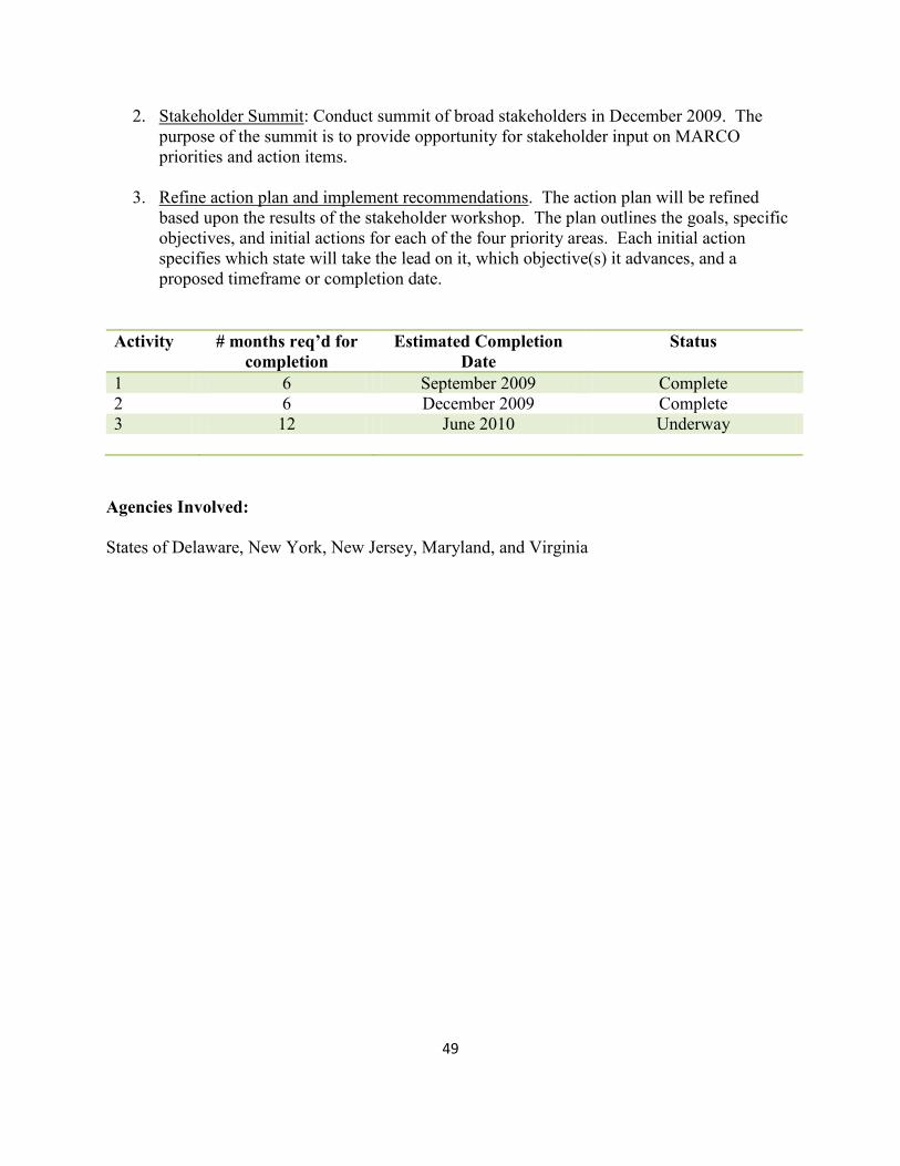
2. Stakeholder Summit: Conduct summit of broad stakeholders in December 2009. The
purpose of the summit is to provide opportunity for stakeholder input on MARCO
priorities and action items.
3. Refine action plan and implement recommendations. The action plan will be refined
based upon the results of the stakeholder workshop. The plan outlines the goals, specific
objectives, and initial actions for each of the four priority areas. Each initial action
specifies which state will take the lead on it, which objective(s) it advances, and a
proposed timeframe or completion date.
Activity # months req’d for
completion
Estimated Completion
Date
Status
1 6 September 2009 Complete
2 6 December 2009 Complete
3 12 June 2010 Underway
Agencies Involved:
States of Delaware, New York, New Jersey, Maryland, and Virginia
50
Communication, Training,
and Public Involvement

51
52
Google KML Map Development
Land-use decisions in Delaware are primarily made at the local level yet, often these smaller towns lack
the GIS infrastructure that would allow large scale planning efforts, particularly those related to coastal
hazards. Delaware Coastal Programs has made significant investment in GIS data, personnel, and
hardware over the years. Transferring the benefits of this investment to community decision makers is
vital to the success of these planning efforts.
As part of DCP’s efforts assisting local governments with Coastal Hazard and Community Resilience
Planning, data will be created and shared with the local decision makers and the community. Internet
based mapping applications, particularly those based on KML, can be a useful tool to affect this sharing.
Most local governments and citizens have access to basic internet browsers either at home or in public
libraries. Online mapping tools such as Google Maps and Virtual Earth provide free, lightweight mapping
tools that members of the public can use to participate in planning efforts. More robust applications, such
as ArcIMS and Google Earth, allow for more complex views of Community Resiliency information while
keeping costs at a minimum (i.e. free to end user).
DCP will utilize data distribution functions built into current GIS software (ESRI ArcGIS) and available
extensions (Arc2Earth) to produce and distribute Community Resilience information for these planning
efforts. This will involve exporting existing data layers to KML; creating KML versions of new data as
acquired; and producing map products that can be used during planning workshops and distributed in this
open format.
Geographic Location:
Distribution will initially focus on individual communities undergoing resiliency planning (i.e. Town of
Bowers and City of New Castle).
Outcome:
Website(s) providing citizen access to Community Resilience Planning Maps.
Activities/Schedule:
1. Software needs assessment and acquisition. Evaluate capabilities of various software to provide
mapping data to public through open GIS browsers. Acquire selected software.
2. Data List. Develop and initial list of data to be distributed to community members.
3. Data Conversion. Convert selected data and maps for distribution.
4. Website creation. Establish a new set of pages within DCP’s Sea Level Rise web section for
distribution of mapping information.

53
Activity # months req’d for
completion
Estimated Completion
Date
Status
1 1 month Complete
2 1 month Complete
3 1 month 9/1/2009 Complete
4 1 month 9/1/2009 April 2010
Check this timeline with carl. This project is mostly complete – may need a tweak or two
Agencies Involved:
Delaware Coastal Programs
DNREC – Office of Information Technology
54
Comprehensive Marketing & Outreach Strategy for Sea Level Rise
The Coastal Training Program (CTP), a national initiative to provide skill-building opportunities
and up-to-date scientific information to Delaware’s coastal decision makers, will lead marketing,
training, and outreach for the Delaware Coastal Programs’ Sea Level Rise initiatives. In order to
effectively reach a target audience, the CTP will develop comprehensive sea level rise marketing
and outreach strategy. This strategy will provide a clear, coordinated message with information
and materials developed and disseminated by the Coastal Training Program. The most suitable
delivery mechanism will be identified to present this message, supplying participants
(public/Delaware coastal decision makers) with up-to-date scientific information regarding sea
level rise in Delaware.
In order to effectively design and implement a successful educational and outreach program on
sea level rise, a statewide survey to gauge public knowledge and opinions on sea level rise and
its impacts on Delaware will be conducted in the fall of 2009. This survey will provide
information about Delaware residents’ awareness and understanding of key issues regarding
climate change and sea level rise; determine their perception of its overall effect on the economy
and ecology of the state; and explore public opinion regarding long range planning for sea level
rise loss and damage prevention. Using the results of this survey, a comprehensive marketing
and outreach strategy will be designed and targeted towards enhancing the public and coastal
stakeholders’ awareness and response to sea level rise.
The strategy will consider several audiences (such as local, county, and state government
officials, local and regional planners, economic development representatives, agriculture
representatives, university researchers, and property owners) and could include workshops,
seminars, brochures, factsheets, public service announcements, website development and/or
outreach displays.
Geographic Location:
Statewide
Outcome:
A comprehensive marketing and outreach strategy will be developed and an implementation plan
will be put into place.
Activities/Schedule:
1. Strategy Development. An inventory of existing Sea Level Rise marketing and outreach
programs will be completed and will be analyzed along with results of the Sea Level Rise
Attitudes and Perception Survey. This analysis will then be interpreted to design a
targeted Marketing and Outreach program.
2. Strategy Implementation. Activities listed in the strategy will be implemented.
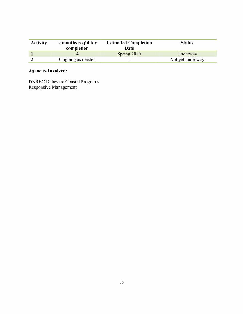
55
Activity # months req’d for
completion
Estimated Completion
Date
Status
1 4 Spring 2010 Underway
2 Ongoing as needed - Not yet underway
Agencies Involved:
DNREC Delaware Coastal Programs
Responsive Management
56
Statewide Survey to Gauge Public Knowledge and Opinions on Sea
Level Rise and its Impact in Delaware
In order to effectively plan and target sea level rise outreach and technical assistance, it is
important to understand the public perception of sea level rise. However, there is currently no
statewide information available regarding the level of knowledge Delawareans possess regarding
sea level rise and its future impacts; nor whether Delawareans are motivated to change their
behaviors to reduce their risk to impacts associated with sea level rise.
In order to address this need, the Delaware Coastal Programs, in cooperation with The Nature
Conservancy and with contractual assistance from Responsive Management Inc. will conduct a
statewide telephone survey during the summer of 2009. The survey will be designed to be
statistically significant and to assess Delaware residents’ awareness and understanding of key
issues regarding climate change and sea level rise; to determine their perception of its overall
effect on the economy and ecology of the state; and to explore public opinion regarding long
range planning for sea level rise loss and damage prevention.
The survey will result in a written report that includes a summary of results; discussion of data
analysis and statistical procedures, a tabular data report, survey graphs and tables, frequency
distributions and cross-tabulations. Several workshops will also be held to explain the results of
the survey to targeted audiences.
Geographic Location:
The telephone survey will be conducted statewide. Workshops will be held at locations across
the state.
Outcome:
The survey will result in a written report that includes a summary of results; discussion of data
analysis and statistical procedures, a tabular data report, survey graphs and tables, frequency
distributions and cross-tabulations. Several workshops will also be held to explain the results of
the survey to targeted audiences.
Activities/Schedule:
1. Develop survey instrument. In cooperation with other interested agencies and
Responsive Management, design and test the survey.
2. Conduct Telephone Survey. Responsive Management will conduct the phone survey
using random dialing.
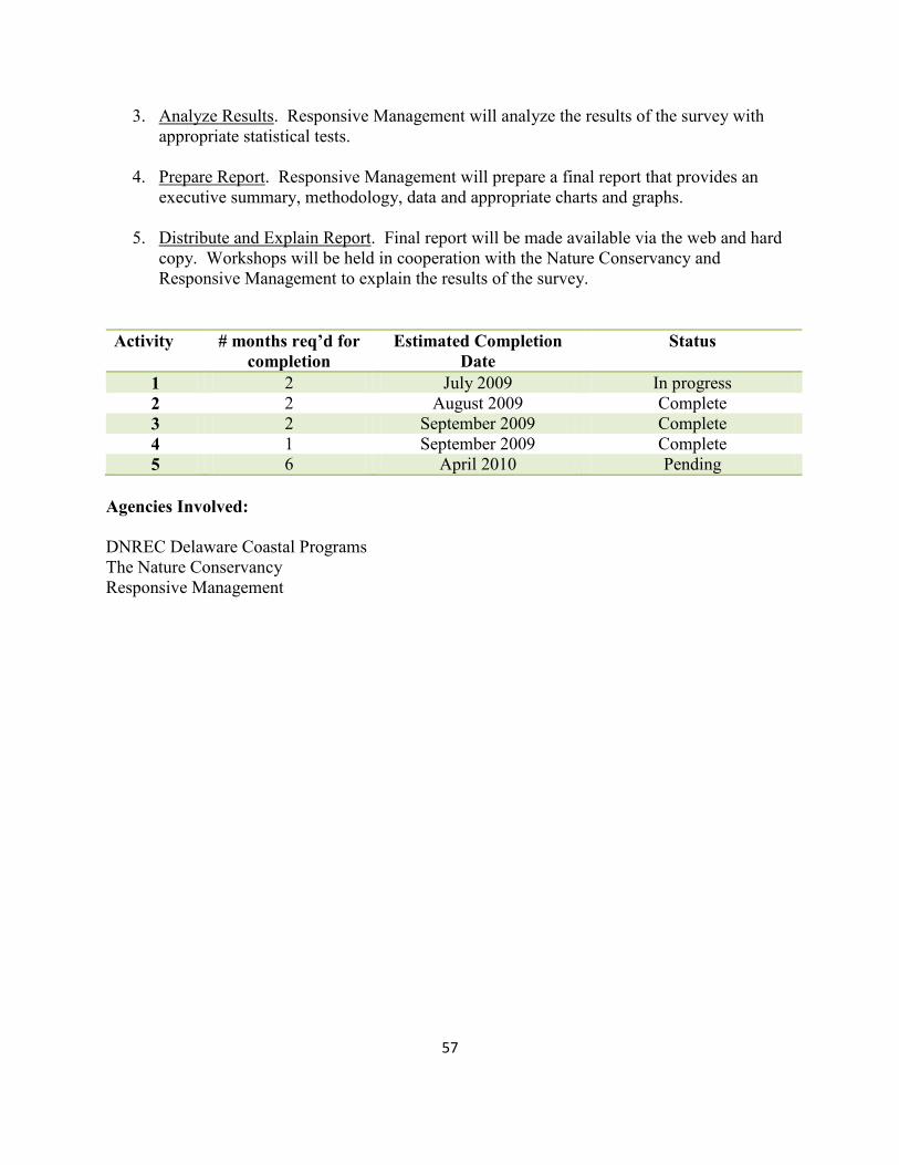
57
3. Analyze Results. Responsive Management will analyze the results of the survey with
appropriate statistical tests.
4. Prepare Report. Responsive Management will prepare a final report that provides an
executive summary, methodology, data and appropriate charts and graphs.
5. Distribute and Explain Report. Final report will be made available via the web and hard
copy. Workshops will be held in cooperation with the Nature Conservancy and
Responsive Management to explain the results of the survey.
Activity # months req’d for
completion
Estimated Completion
Date
Status
1 2 July 2009 In progress
2 2 August 2009 Complete
3 2 September 2009 Complete
4 1 September 2009 Complete
5 6 April 2010 Pending
Agencies Involved:
DNREC Delaware Coastal Programs
The Nature Conservancy
Responsive Management