Embed Size (px)
Citation preview
1
Rines Forest General Management Plan
Table of Contents
Executive Summary ....................................................................................................... 2 Introduction .................................................................................................................... 3 Purpose and Objective of Management Plan ................................................................. 4
Town Council Charge ....................................................................................................... 4 Rines Forest Mission Statement ...................................................................................... 4 Rines Forest Stewardship Principles ................................................................................ 5
Description of Land and Natural Resources .................................................................. 5 Historic Uses of the Land ............................................................................................... 6 Town Open Space Goals ................................................................................................. 7 Location of the Forest ..................................................................................................... 9 Current Uses ................................................................................................................. 10 Rines Forest Trail Map .................................................................................................. 11 Facility Use Rules ......................................................................................................... 12 Future Acquisitions ..................................................................................................... 13 Forest Management Plan Overview ............................................................................. 13 Future Forest Management Plan ................................................................................... 15 Management Matrix .......................................................................................................... 16
A. Recreational/Educational Activities .................................................................... 16 B. Resource Management Activities ....................................................................... 18 C. Trail Maintenance ............................................................................................... 19

Rines Forest General Management Plan 14 December 2020 2
Executive Summary
The 2010 Rines Forest Management Plan was developed by the volunteer citizen Rines Forest Advisory Committee with guidance and input from Town Manager Bill Shane, Town Councilors Jeff Porter and Steve Moriarty, and contract forester Jay Braunscheidel. The committee was ably supported by Nancy Stroud and Anne Brushwein. The Plan was updated in 2020 by the Forestry Subcommittee of the Cumberland Lands and Conservation Commission (CLCC) and approved by the Town Council.
The overall goal of the plan is to ensure the Rines Forest will be managed to:
• forever conserve the area as a forest • improve the condition and diversity of the forest and wildlife habitat • provide opportunity for passive recreation • maintain the snowmobile trail connecting Bruce Hill and Blanchard Roads with
Range Road • encourage educational use of the property • periodically harvest timber and pulpwood
The Property is governed by a permanent Conservation Easement held by the Chebeague and Cumberland Land Trust (CCLT) to "protect the Forest's natural beauty, wildlife and varied ecosystems." The Easement states "The Protected Property shall be used only for conservation and low-impact outdoor recreation and educational activities that do not rely on substantial alteration to the natural resources."
The Easement also states "...any cutting of trees should be done under the guidance of a forest management plan developed by a professional forester with input from a professional wildlife biologist. The forest management plan must include provisions for protecting soils, water quality and high value plant and animal habitat."
This Management Plan was designed to meet the conservation goals outlined in the Conservation Easement. It includes background and history of the Rines Forest, physical and biological descriptions of the Forest, a copy of the Conservation Easement, a list of allowable and prohibited uses, and a detailed matrix of management recommendations for recreational / educational activities and natural resources. There is also a short discussion of how this property fits into a larger vision for conserving open space in the town of Cumberland.
The Appendix includes copies of the deed, trail map, warranty deeds, conservation easement and its amendment, a zoning map of the region, and an extensive forest management plan.
The acquisition and conservation of the Rines Forest by the Town of Cumberland, along with the recommendations included in the Rines Forest Management Plan, meet many of the goals of the 2014 Comprehensive Plan as they relate to sustainability, critical natural resources, environmental protection, land use planning, recreation, and open space.
The Comprehensive Plan notes that while other resources discussed in the plan can be built (infrastructure, public utilities) or enhanced (fiscal capacity), natural resources are finite and usually irreplaceable. Consequently, their protection is of paramount importance. The plan goes on to state that, the largest threat to habitat and natural resources in Cumberland has been and continues to be incremental growth. As the landscape is divided up into smaller and smaller pieces, it becomes inhospitable to a greater number of species, both plant and animal. As development increases, not only does the character of the town change,
Rines Forest General Management Plan 14 December 2020 3
but such development can cause other adverse impacts to the natural resources such as non-point source pollution (i.e., run-off that contains pesticides and fertilizers), oil spills, etc., can pollute the rivers, streams and coastline and diminish our shellfish and fishery resources.
Please see the Introduction to the Forest Management Plan for an overview of the goals and plans for sustainable management and harvesting of the forest. As stated there, the Rines Forest will be managed to provide timber and pulpwood for local markets at a sustainable rate; to protect soils, water, and wildlife habitat; to grow older successional forests that will add to the diversity of forest types across the landscape; and to provide a variety of recreational opportunities for the people of Cumberland and their neighbors. All harvesting will be done in accordance with the Cumberland Town Forests Management Guiding Principles adopted in 2017 using state-of-the-art equipment and Best Management Practices. The Forest Management Plan will be reviewed and updated as needed approximately every 10 years.
Introduction
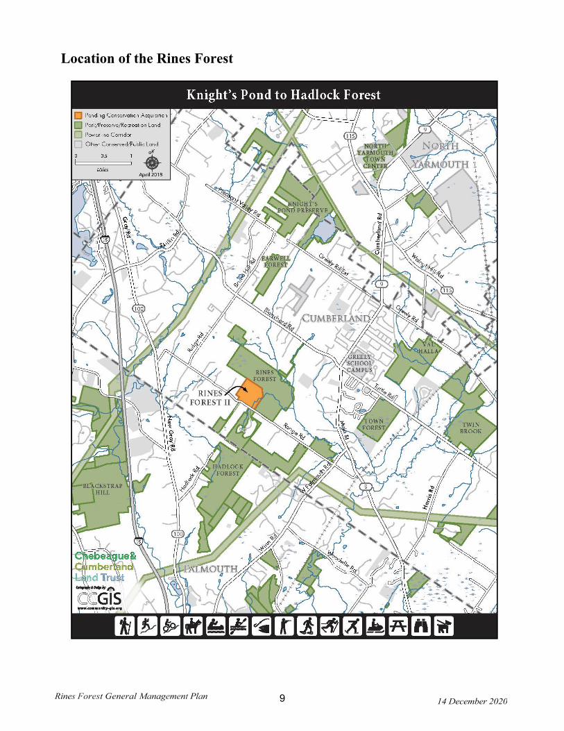
The Rines Forest Management Plan is intended to provide guidance in the oversight and maintenance of the Rines Forest according to the Rines Forest Mission Statement and Rines Forest Stewardship Principles. As with sound management practices, this is a living document, which should be reviewed periodically to ensure that it is achieving the goals of the Mission Statement and Stewardship Principles. The Plan acknowledges the balancing act required between changes in ecological practices and needs as outside pressures impact the property while encouraging passive recreation by members of the community. In addition, we recognize the Rines Forest is a cornerstone of a multi-town greenbelt that stretches from the Hadlock Forest in Falmouth to Knight’s Pond and Blueberry Hill in Cumberland/North Yarmouth, and is adjacent to CCLT’s Frog Pond and Salamander Swamp along Range Road.
The Rines Forest is an undeveloped parcel, approximately 300 acres in size, located off of Range Road in the Town of Cumberland, Cumberland County, Maine. The Rines Forest comprises 268 acres previously owned by the Rines family, 30 acres previously owned by the Godsoe Family, and 4 acres previously owned by the Milliken Family. The conservation easement held by the Chebeague & Cumberland Land Trust encumbers the 268-acre portion previously owned by the Rines family. At the time the Town acquired the first 216 acres in 2003, the Rines family of Gorham had maintained the parcel as a tree farm. A large block had been planted to red pine in the 1940's and managed for harvest. Management activities up to the time of purchase included thinning, trimming, and selective harvesting according to common forest practices. The primary access to the site was from Range Road, within the 52-acre parcel retained by Dale and Elizabeth Rines, but purchased by the town in 2019. The woods road runs from Range Road northward approximately ¼ mile where it divides, one branch going to the northwest corner of the property while the other branch goes to the northeast. Skidder trails crisscross the site. The 216-acre property was last harvested by Dale Rines in 1999 and again by the town in 2011, and the 52-acre property was last harvested in the winter of 2018.
There are two small borrow pits on the site, which were used as a source of material for construction of the access road. The portion of the site not planted to red pine is primarily mixed forest of hemlock, red oak, white pine and maple. The eastern half of the site is riddled with a series of hillocks and steep ravines associated with tributaries of Mill Brook. The western half of the site is gently rolling, moderately to well-drained soils. Forested wetlands occur along the western property boundary, and within the northeastern portion of the property bordering Mill Brook and associated tributaries. The Godsoe property, donated in 2013, consists of a mixed hardwood-softwood stand, with some small scrub shrub wetlands interspersed, and a large scrub shrub wetland just to the east of the property. Much of the land was harvested in approximately 2010. Roger and Margo Milliken donated approximately 4 acres of woodland
Rines Forest General Management Plan 14 December 2020 4
in 2016 that sat at the back of their lot on Blanchard Road and abuts the Rines Forest on the northcentral edge near the waterfall, plus a linear sliver of land along the side of their fields for a trail to connect from Blanchard Road to the Rines Forest. That section of forest has not been harvested recently, and consists of a hardwood-dominated forest on the upper flat areas but a mixedwood forest, dominated by hemlock and pine, on the slopes and floodplains leading to and surrounding Mill Brook.The following document provides an overview of the history of the parcel prior to acquisition by the Town, an inventory of natural resources, and management recommendations relative to recreational/educational activities, resource management, and general maintenance.
Purpose and Objective of Management Plan
Through the direction of the Cumberland Town Council, the Rines Forest Citizens Advisory Committee was established in 2003. The Advisory Committee's primary focus was to provide guidance to the Council regarding matters related to the management of this community resource by developing a management plan for the Rines Forest. In 2017, the Town Council disbanded the Rines Forest Advisory Committee and moved the responsibility for overseeing the Rines Forest to a new Forestry Subcommittee of the Cumberland Lands and Conservation Commission. Recommendations from the Forestry Subcommittee are forwarded to the CLCC for final approval before being acted upon or being sent to the Town Council.
The purpose and objective of the management plan is to incorporate the mission statement and stewardship principles into a living document that will be used as a guide by the citizens of the Town of Cumberland pertaining to the use, improvement and preservation of the Rines Forest.
Town Council Charge
The Town Council has charged the Forestry and Natural Resources Subcommittee of the Cumberland Lands and Conservation Commission with the following responsibilities, per Chapter 30 of the Town Code, Boards and Commissions: B. The Forestry and Natural Resources subcommittee shall make recommendations to the Commission on all matters pertaining to the use, preservation, management and maintenance of the town forests and other natural resources. The subcommittee will:
1. Create programs to promote public awareness of and appreciation for the town forests and to enhance the use of these forests for educational and conservation purposes.
2. Create and maintain trails through the forests to facilitate public access and to encourage the use of the forests for educational and recreational purposes.
3. Create a forest management plan, to include recommendations for planting, pruning, harvesting, and replacing trees and other vegetation within the forests, and such other recommendations to protect the conservation values of the forests as may be necessary.
4. Retain a licensed forester or similarly qualified individual to provide advice in all aspects of forest management and maintenance.
5. Create programs or plans to coordinate the use and management of the town forests with other Town-owned properties.
6. Provide, execute and monitor forestry management and conservation management plans for each of the larger forested parcels owned by the Town.
7. Ensure sustainability and conservation of the properties. 8. Identify, monitor and mitigate invasive plant/insect species where cost-effective. 9. Identify and monitor wildlife habitats and corridors.
Rines Forest General Management Plan 14 December 2020 5
Rines Forest Mission Statement
The Cumberland Town Council holds that the Rines Forest property is a unique tract of land that shall remain forever in its undeveloped forested state. To this end, it is the collective responsibility of the community to protect the Forest's natural beauty, wildlife and varied ecosystems. Citizens and friends are encouraged to passively recreate within the property's boundaries while conserving its natural environment.
Rines Forest Stewardship Principles
1. The Town Council endorses the· maintenance of the Forest to assure its present undeveloped forested state and will, within limits established by the Town Council, provide the human and fiscal resources necessary to do so.
2. A Forest Management Plan will be adopted and updated approximately every 10 years.
3. Within the scope of the management plan, areas determined to be environmentally sensitive and vulnerable shall receive specific attention.
4. A citizen-based Forestry Subcommittee of the CLCC shall submit a summary of activities to the CLCC, which will incorporate that into an annual report to the Town Council.
5. A network of trails including access from Range Road shall be maintained and improved.
6. Future acquisition for connectivity is encouraged and future planning shall be coordinated with the Town Lands and Conservation Commission and the Chebeague and Cumberland Land Trust.
7. Citizens are encouraged to passively recreate within the boundaries of the forest.
8. Educational use of the property for individuals or organizations shall be encouraged.
9. A list of acceptable uses of the Forest will be created and incorporated into a "Use Policy".
10. An informational brochure outlining the property's environmental attributes, a map of trails, and other related issues of interest will be published and maintained.
Description of Land and Natural Resources
The Rines Forest today is a mixture of 70-year-old red pine plantations, old pasture fields grown up to mixed hardwood-softwood stands, hemlock stands, scrub-shrub wetlands, forested wetlands, and floodplain forests. The red pine plantations predominate but some sections have been regularly pruned and harvested leaving an intermittent canopy with scattered understory saplings and other sections have abundant hardwoods and softwoods of different ages mixed in with the pines. Hemlock stands can be found on steep slopes rising from the streams, while hardwood floodplain forests are common along the flatter, meandering stretches.
The property has large sections of relatively flat sandy soils and terrain where the red pines were planted and a smaller area to the south that is characterized by steep rolling hills interspersed with intermittent cascading streams. The northern and northwestern perimeters of the former Rines property are dominated by forested wetlands, with shallow standing water much of the year.
Several streams run through the Rines Forest, the largest being Mill Brook, which begins at Knight’s Pond and eventually feeds into the Piscataqua River, which feeds into the Presumpscot River and then Casco Bay. Several permanent and intermittent streams feed into Mill Brook as well. These generally flow down steep,
Rines Forest General Management Plan 14 December 2020 6
rocky beds between upland ridges and carry especially heavy flows during and after large rainstorms. Mill Brook meanders through flat sandy floodplain forests in the upper reaches, cascades over rocky falls and through a small rocky canyon in the middle section, and then spreads out into shrubby or open marshes in the lower sections before leaving the property and heading towards Winn Road. The streams are generally clear except following rainstorms or snowmelt when they are laden with eroded sediment from upstream of the property. A variety of aquatic invertebrates, dusky salamanders and small brook trout can all be found in Mill Brook. Because the Rines Forest has a variety of habitats and terrain and sits in the middle of the single largest forested area remaining in Cumberland, it is home to many wildlife species. Amphibians include red-backed salamanders that live under downed logs or in the forest duff; spotted salamanders and wood frogs that live in and under the forest floor but breed in vernal pools (especially Frog Pond on the west side of Range Road); and American toads that live above ground in the forest but migrate to and from shallow wetlands to breed. A number of bird species are residents of the forest, including black- capped chickadees, downy and hairy woodpeckers, ruffed grouse, American crows, and wild turkeys. These birds feed on seeds, buds, or insect larvae, which they can find any time of the year. Barred and great-horned owls have been heard calling in the forest; they nest in early spring and hunt smaller birds and mammals for their food. Other bird species use the forest as an important stopover during migration, including the palm warbler, black-and-white warbler, and dark-eyed junco; these species all breed further north where they can successfully raise their young on the abundant insects. Others, including black-throated-green warblers, black-throated blue warblers, yellow-rumped warblers, ovenbirds, eastern wood peewees, great crested flycatchers, hermit thrushes, veery, and blue jays return to the forest each spring from the south to breed, nest and raise their young.
Mammals seen commonly in the Forest include white-footed mice, red-backed voles, gray, red and flying squirrels, snowshoe hare, and white-tailed deer. River otter, fisher, porcupine, red foxes and coyotes also can be found in the forest but probably wander on and off the property in search of food, mates, and den sites. Signs of black bears and moose have been seen on the property in the past but these were probably only dispersing juveniles looking for a more permanent home. ·
Woods roads are common throughout the Forest, most only temporary and covered with slash, but two are more permanent, underlain with sand and gravel taken from a gravel pit on site. The two permanent roads form the backbone of a trail network, and some of the other woods roads have been integrated into a rustic trail network, although several sections need to be upgraded to better handle the increased amount of public use that has occurred since the Town purchased the property. During the fall hunters use these woods roads and in winter they are frequently used for cross-country skiing, snowshoeing and fat tire biking. At other times of the year, the trail network is regularly used for walking, running, bird-watching, berry picking, and mountain biking, and occasionally horseback riding. Raspberry and blackberry bushes are common along the woods roads, especially where cutting has occurred recently.
Historic Uses of the Land
Cumberland's Rines Forest is a beautiful, tranquil natural environment. Within its 302 acres grow large hemlock and white pine trees, as well as a sprinkling of red oak, ash, birch, poplar and maple. It is a perfect canopy for the forest's diverse wildlife, which includes white-tail deer, coyote, fox, wild turkey, ruffed grouse and numerous songbirds. Along its boundaries flows Mill Brook which winds its way through the forest providing visitors with beautiful waterfalls and places of solitude. Except for an occasional rock wall and a logging road or two, one can easily sense that they have escaped to a remote oak-pine forest far removed from a suburb of Maine's largest city.
Although the core tract of land where the forest exists today was first surveyed by the E.G. Jordan Company of Portland in 1918 for J. Henry Rines, the history of the area suggests that the property experienced considerable change from the late 1700's until the turn of the twentieth century. Prior to 1821, when

Rines Forest General Management Plan 14 December 2020 7
Cumberland became a town, settlers of ancient North Yarmouth were occupied primarily with hunting, fishing and lumbering. Because Cumberland had as many as six sawmills and two grist mills during the early 1800's with at least two found on Mill Brook, it's reasonable to assume that much of the land was initially forest. The wood from the Rines tract of land was most probably used not only for constructing homes, barns and the like but also for ship building. We know that the towering "king pine" trees found in nearby Gorham, North Yarmouth and other surrounding communities were used for ship's masts. Since there were boat yards in North Yarmouth, Yarmouth and Cumberland well into the nineteenth century, it is likely that the timber from the area was also used for boat building. It wasn't long before the forests of Cumberland and North Yarmouth were cleared of timber and replaced with farmland, mostly pasture for sheep and cattle. Certainly, the remnants of rock walls found on the Rines Forest property suggests that the land was used for farming purposes by the mid 1800's. Supporting this claim is the fact that by 1860 Cumberland had 230 buildings and a population of approximately 1,700 people, with their primary occupation being agriculture.
In 1918, J. Henry Rines combined several parcels of land totaling 275 acres along Range Road. The land was to be used as pasture for his cattle which were walked each spring thirteen miles to Cumberland from the main farm in Gorham. The property had a house, two barns and a well. According to Dale Rines, great-grandson of J. Rines, the property on Range Road was a typical farm with its cleared land enclosed by stone walls. For approximately twenty years the Rines family maintained the property for farming and supporting their livestock. In 1941, Dale Rines' grandfather decided to return the property to forest land. Seventy acres of open fields were planted with red pine and white spruce. From this point until the 1960's the forest grew and was pretty much left alone until the Rines family began to thin the forest. It was also at this time when the forest's major woods roads were built by Dale Rines and his father. This enabled the Rines family to harvest wood from the front to the rear of the lot. In more recent years Dale Rines, a forest engineer by training, has managed the property by thinning and selectively harvesting trees as well as maintaining the land. The result is a healthy working forest.
The Town of Cumberland acquired 216.15 acres of the Rines Forest property in 2003, and the remaining 52 acres in 2019. It is currently part of a 900-acre contiguous “block of unfragmented forest habitat," with the remaining acreage owned by a variety of private individuals. A comprehensive management plan for the property has been developed by the Town's Forestry Subcommittee of the Cumberland Lands and Conservation Commission. for the expressed purpose of ensuring that the Forest will remain in its undeveloped state. In addition to management considerations, the Cumberland Town Council voted to place the property under the protection of a conservation easement, in perpetuity, with the Chebeague and Cumberland Land Trust on September 12, 2005. When the additional 52 acres was purchased, the conservation easement was amended to include this additional acreage. Funding for the acquisition came in part from a grant from the US Forest Service’s Community Forest Program.
References
Everts and Peck, History of Cumberland County, Philadelphia: J.B. Lippincott, 1880.
Mitchell, Russell and Strout, The Cumberland / North Yarmouth Register of 1904, Salem, Massachusetts: Higginson Bock Co., 1955.
Rines, Dale, Cumberland "Rines Forest" History, unpublished paper, 2004.
Sweetser, Phyllis Sturdivant, Cumberland Maine, Town of Cumberland, Maine: 1976.
Rines Forest General Management Plan 14 December 2020 8
Town Open Space Goals
The acquisition and conservation of the Rines Forest ("Rines") by the Town of Cumberland meets many of the highest priority objectives identified in the Cumberland Open Space plan ("plan") which was adopted in 1998.
In general, the Rines conservation easement meets four of eight broad goals outlined in the plan:
• Preservation of significant land for future generations • Preservation or postponement of development • Expansion of recreational opportunities for residents • Preservation of wildlife habitat and corridors
Rines meets all of the listed reasons for preserving forest land as identified in the plan:
• To preserve the aesthetics of large wooded tracts of land • To keep land out of development • Preserve wildlife habitat • Preserve historic trails • Preserve woodland • Prevent the further fragmentation of contiguous forestland • Establish a greenbelt buffering the developed parts of Cumberland from the less
developed areas
The plan strives to apply a ranking system to forested property with the concept that greater acreage equates to a higher value. At the same time it singles out the exceptional value of individual parcels of forested land of more than 50 acres. It should be noted that the Rines property is approximately 300 acres.
In regards to preserving wildlife natural resources, the plan states that large blocks of forest provide habitat for many more species than do smaller blocks, especially if streams and wetlands traverse them. The Rines Forest contains several streams and includes at least two waterfalls of exceptional note.
The plan notes that to promote the preservation of forest the Town should purchase conservation easements and rights-of-first-refusal, along with maintaining public access of trails if appropriate. As noted above, today the Rines Forest comprises four different parcels totaling 302 acres, yet this is a small portion of the total 900-acre undeveloped forest block, so there are still opportunities to add to the long-term conservation of this forest through additional purchases or conservation easements from willing adjacent landowners. The Rines conservation easement, which currently encumbers 268 acres of the Rines Forest, stipulates that there shall be no future development on the property, and provides for continued public access and a trail system, as long as they are consistent with the conservation goals of the easement.
Finally, the plan notes that the Chebeague and Cumberland Land Trust (CCLT) plays a significant role in the preservation of land, especially environmentally sensitive land such as wildlife habitat. The plan also states that the Town Council should work with CCLT to achieve the goals of this Plan.
Rines Forest General Management Plan 14 December 2020 9
Location of the Rines Forest
Rines Forest General Management Plan 14 December 2020 10
Current Uses
The Rines Forest provides an ideal site for low-impact passive recreation. In an effort to maintain the property in its natural state, uses may be subject to change or suspension when overuse or negative impact to the land is identified. The list of current uses is below. Please also refer to the General Management Matrix for more specific information regarding user's responsibility and/or limitations for each activity.
• Cross country skiing
• Educational study
• Fishing
• Geocaching
• Horseback riding
• Dog walking
• Picnicking
• Hiking
• Hunting
• Snowmobiling on designated trails
• Trapping
• Mountain biking and fat tire biking
Rines Forest General Management Plan 14 December 2020 11
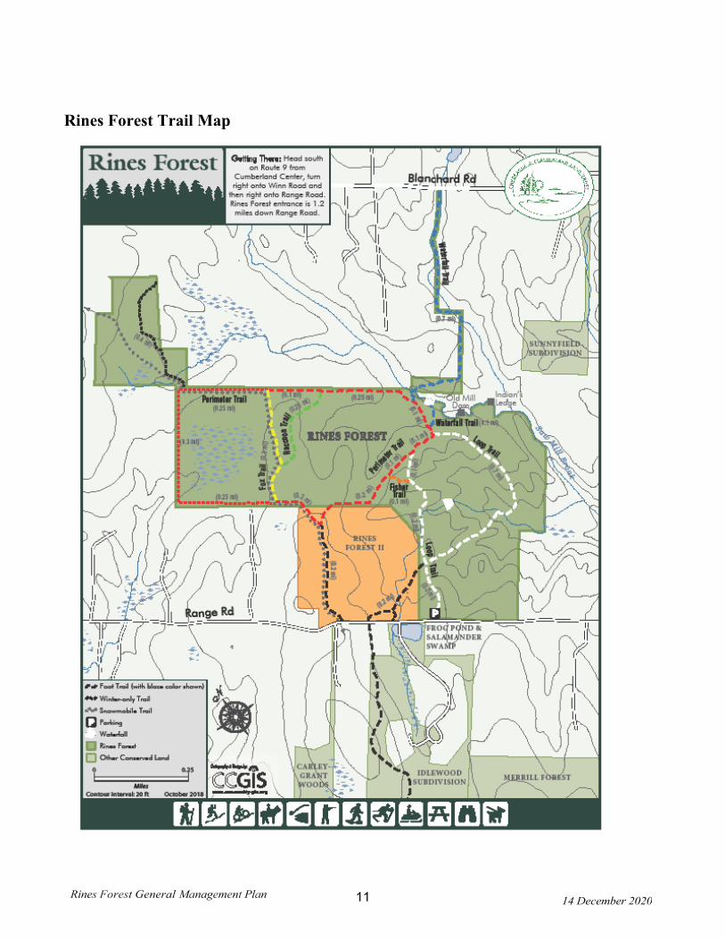
Rines Forest Trail Map

Rines Forest General Management Plan 14 December 2020 12
Facility Use Rules These rules have been adopted by the Cumberland Town Council to govern activities at Rines Forest: Allow. able Uses: The Rines Forest provides an ideal site for low-impact outdoor recreation, including, but not limited to, nature study, cross country skiing, snowshoeing, snowmobiling on designated trails, mountain biking and fat tire biking, horseback riding, pet walking, fishing, hunting, temporary tree stands (daily removal required), picnicking, hiking, plant study, and bird-watching by the general public. The Forest is home to numerous plant and animal species and habitats. The Town of Cumberland is experiencing steady, accelerated development that often closes or restricts access to open space traditionally used and enjoyed by the public and therefore has established the Forestry Subcommittee of the CLCC to review and periodically update the Rines Forest Stewardship Principles, a Forest Management Plan, and to oversee the general management of this Town protected Property. The Forest is protected by a conservation easement which ensures the permanent availability of the Forest for traditional recreational uses by the general public. The easement will permanently preserve the property's important recreational, scenic and natural resources and habitat for indigenous flora and fauna, while providing permanent public access. Prohibited Uses: • No unauthorized motor vehicles, ATV's or motorbikes. • No camping except by written permission of the Town Manager. • No open fires or charcoal fires. • Carry In - Carry Out - No littering or trash disposal; all activities and users to remove all refuse carried
in. • No target shooting. • Except for brushing and maintenance of approved trail systems, no cutting of trees, limbs, bushes, or
removal of vegetation except as approved by the CLCC. • No application of herbicides, pesticides or fungicides except with the approval of the CLCC. • No person shall deface, injure, remove or destroy any fences, signs, gates or any other structures or
creations in or on the Forest. • No construction or improvements are allowed without the express written permission of the CLCC. • The Rines Forest shall use, but not be limited to, the State of Maine hunting, fishing and trapping laws. Any person aggrieved by the decision of the Town Manager or CLCC may appeal to the Town Council.
Rines Forest General Management Plan 14 December 2020 13
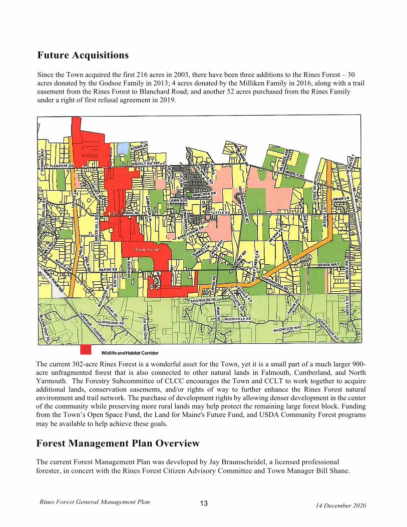
Future Acquisitions Since the Town acquired the first 216 acres in 2003, there have been three additions to the Rines Forest – 30 acres donated by the Godsoe Family in 2013; 4 acres donated by the Milliken Family in 2016, along with a trail easement from the Rines Forest to Blanchard Road; and another 52 acres purchased from the Rines Family under a right of first refusal agreement in 2019.
The current 302-acre Rines Forest is a wonderful asset for the Town, yet it is a small part of a much larger 900-acre unfragmented forest that is also connected to other natural lands in Falmouth, Cumberland, and North Yarmouth. The Forestry Subcommittee of CLCC encourages the Town and CCLT to work together to acquire additional lands, conservation easements, and/or rights of way to further enhance the Rines Forest natural environment and trail network. The purchase of development rights by allowing denser development in the center of the community while preserving more rural lands may help protect the remaining large forest block. Funding from the Town’s Open Space Fund, the Land for Maine's Future Fund, and USDA Community Forest programs may be available to help achieve these goals. Forest Management Plan Overview
The current Forest Management Plan was developed by Jay Braunscheidel, a licensed professional forester, in concert with the Rines Forest Citizen Advisory Committee and Town Manager Bill Shane.
Widlife and Habitat Corridor
Rines Forest General Management Plan 14 December 2020 14
Jay patiently met many times with the Committee to discuss various management goals, strategies, and techniques that could be adopted in the plan. Following is the collective wisdom of this group.
In 2017 the Forestry Subcommittee of the CLCC drafted and the Cumberland Town Council approved the Cumberland Town Forests Management Guiding Principles to guide forest management on all town-owned forest lands, including the Rines Forest. Based on these guiding principles and a review of the current plan and the results of harvesting during the past 10 years, the Forestry Subcommittee of the CLCC is planning to update the Forest Management Plan during 2020, working with our current licensed professional forester Paul Larrivee, and under the guidance of Cumberland’s Code Enforcement Officer, Bill Longley.
Following is a summary of the current plan, finalized and adopted in 2009:
The Plan is designed to build on the good forest stewardship of the previous owners, Dale Rines and his father and grandfather, and slowly transform large areas planted to red pine in the 1940s to a more diverse forest characterized by a mixture of white pine, red and white oak, sugar maple, beech and hemlock - all species that naturally occur at the site, but in many places are overshadowed by the plantation of red pines. In addition, the management plan is designed to encourage a diversity of ages and sizes of trees, allow for a few small openings that mimic natural disturbances, and especially to foster the growth of older trees that are becoming increasingly uncommon across the Maine landscape. This will be accomplished by carefully thinning and removing certain trees to provide light and room for other trees to grow up and out over time - just like thinning the carrots or beets in your garden. And just like in the garden, one thinning usually isn't enough. Thus, the current plan includes harvesting strategies for 2010, 2020, and 2025-2030, with different sections of the forest and different amounts of thinning planned for each harvesting.
The plan is also designed to protect key natural assets of the forest, including streams, wetlands, steep slopes and riparian areas (areas alongside water) and to protect and maintain productive soil, clean water, and diverse wildlife habitat. This means there will be no cutting near streams, wetlands or on the steepest slopes and that no new skid trails or harvesting equipment will be allowed in these sensitive areas. Also, special features important to wildlife such as dead standing trees, fruit and nut trees, and dead wood on the forest floor will be retained. A forest reserve of at least 20 and up to 60 acres will be established in the southern area of the forest where steep slopes, streams, wetlands, riparian habitat and some older trees can be found and where no cutting will be allowed.
The future forest should provide habitat for animals with large home ranges, such as white-tailed deer, fisher, river otter, goshawks, and barred owls; nesting songbirds that need expansive "interior" forest habitat to successfully breed, such as ovenbirds, wood thrush, and black-throated blue warblers; cavity-nesting species like black-capped chickadees, pileated woodpeckers, flying squirrels, and raccoons; and species needing dead and down wood on the forest floor such as red-backed and spotted salamanders, long- tailed weasels, and ruffed grouse. A few small openings of early successional forest may provide habitat for species like chestnut-sided warblers and eastern towhee.
Invasive species such as the glossy buckthorn, which is widespread throughout the forest and on
Rines Forest General Management Plan 14 December 2020 15
adjacent lands and is out-competing native species that provide food and shelter for our native wildlife, will be aggressively reduced through active mechanical thinning and herbicide control where necessary.
All cutting will be done using state-of-the-art equipment and Best Management Practices, including harvesting only on frozen ground so as not to disturb the forest floor or leave ruts, and will be directly supervised by Mr. Braunscheidel.
Under this plan, the Rines Forest will be managed to provide timber and pulpwood for local markets at a sustainable rate; to protect soils, water, and wildlife habitat; to grow older successional forests that will add to the diversity of forest types across the landscape; and to provide a variety of recreational opportunities for the people of Cumberland and their neighbors.
Because it was important to the members of the Rines Forest Citizen Advisory Committee to adopt exemplary sustainable forestry practices, the Rines Forest will be certified under the internationally recognized gold standards of the Forest Stewardship Council, with periodic audits to ensure we continue to meet the standards. We hope the management of the Rines Forest may serve as an example for other landowners in the region who also may want to manage their forest lands for multiple purposes in a sustainable way.
Future Forest Management Plan
Following a January 2020 walk through the Rines Forest with the Forestry Subcommittee and Town Forester Paul Larrivee, the subcommittee decided that the next update to the current plan will likely focus on enlarging the reserve area and directing any near-term harvesting in the red pine plantations, using expanding small gap openings to both increase diversity of the plants and animals in the plantation, and manage the invasive buckthorn that has formed a thick mat underneath. The Plan will adhere to and follow the Town of Cumberland Forest Management Guidelines, included below.

Rines Forest General Management Plan 14 December 2020 16
Cumberland Town Forests Management Guiding Principles
The Town of Cumberland owns multiple properties that are forested and may be appropriate for active forest management. Below is a list of forest management goals for all primary town-owned forest sites, including as of July 2017 the Town Forest, Rines Forest, Knights Pond, and Twin Brook. This list refers specifically to forest management and related activities and not to all other management considerations that are pertinent to each site, such as what types of use are allowed. That will be covered in the other parts of the Management Plan for each property. A site-specific Forest Management Plan shall be developed for each primary forest site that is consistent with these guiding principles and is designed to protect and reflect the unique characteristics of each of the town’s forested properties (such as landscape setting, geography, important natural resources, and public use). The Town will strive to manage the town’s forests as models of a well-managed community forest.
• Maintain and protect productive soils and water quality, including using Stream Smart cross-
ings, with a particular emphasis on the Mill Creek and Presumpscot River watersheds (see Maine Forest Service 2017 Water Quality BMPs).
• Protect special ecological features and functionality intrinsic to each Forest (i.e. rare plant or animal sites, wetlands, riparian areas, vernal pools, deer wintering areas, rare or exemplary natural communities, late successional forests, dead and downed wood, etc.).
• Manage forest stands in a manner that maintains or improves habitat and the overall biodiversity of native plant communities and fish and wildlife species to the extent possible. Particular emphasis will be on maintaining and expanding structurally complex, mature portions of the forest, balanced by special and unique areas, small gaps of early successional habitat, and reserve areas. Two programs that can help guide this approach are Focus Species Forestry and Forestry for Maine Birds.
• Identify and protect reserve areas as forest stands or compartments which express the fol- lowing attributes: large blocks of forest, older forest, unusual natural areas (e.g. streams, wetlands, riparian areas, rare natural communities), presence of legacy trees, and topo- graphically or geologically diverse or interesting areas.
• Focus long-rotation silvicultural efforts on stands and compartments with productive soils, good access and of reasonable size and quality. Long-term goals may include increasing structural and species diversity, emphasizing the growth of high-quality sawlogs of commer- cially important species, promoting the continued sequestration of carbon, and contributing to the local wood products market.
• Maintain resilience of native biodiversity and ecosystem processes in the face of climate change. Increase resilience by managing for multiple age classes; managing for the forest types and species best suited to the site; avoiding conversion to other types (e.g. spruce-fir dominated to hardwood-dominated); and using natural regeneration to retain and increase species diversity characteristic of the site and forest type, including the proportion of species predicted to be better adapted to future conditions, such as white pine and red oak. In addition, plan for high-volume runoff by using Stream Smart crossings.

Rines Forest General Management Plan 14 December 2020 17
• The actual balance of forest type, age, and silvicultural treatment recommended within each forest should be determined in consideration of the habitat matrix of the surrounding landscape. This would include an analysis of the extent and age-class structure of habitats in the surrounding lands as well as opportunities for maintaining and enhancing both terrestrial and aquatic habitat connections and recreational trail connections; and management opportunities across all town forests. In other words, different properties may be managed for different site-specific goals as long as the sum of the whole meets the overall town’s forest management goals.
• Make every reasonable effort to control invasive plant species in the forest while reaching out to adjacent landowners to encourage the same.
• Implement exemplary forest management that is consistent with sustainable forestry standards such as those provided by the Forest Stewardship Council (FSC).
• Strive to keep forest harvesting activities revenue neutral over the long run (this is separate from the cost of managing other activities in the forests such as reducing invasive species, building and maintaining trails, and providing educational signs etc.).
• Offer quality aesthetic, educational and recreational opportunities to the community for the benefit of the public as long as it doesn’t detract from above goals. All trails should be built and maintained to minimize soil erosion and compaction and limit disturbance to fish and wildlife.
• Conduct all harvests in a manner that minimizes impacts to soil, water, and fish and wildlife, including avoiding or minimizing the use of new roads and road-stream crossings; using Stream Smart crossings where crossings are needed; putting unused roads to bed; giving preference to harvesting on frozen ground or dry-soil conditions; avoiding harvesting during peak amphibian and bird nesting times (April 1-July 31); and using appropriate equipment given the silvicultural goals.

18
Management Matrix A. Recreational/Educational Activities
Cumberland Lands & Conservation Commission (LCC)
Activity Potential Natural Conflict Potential Neighbor
Relation Conflicts Management Activities
Walking / Hiking
Habitat disturbance Tree carving Erosion / soil compaction
Disturbance of solitude-seekers. Littering
Evaluate condition of trails on a yearly basis. Repair natural or human damage in a timely manner. Develop limited number of trails including some loops. Close trails to give the land time to recover. Establish ‘Carry-In / Carry-Out’ policy for litter management. Pick up after pets and abide with Town leash laws.
Picnicking
Soil compaction Localized habitat
disturbance Forest fire
Littering Disturbance to trail users
Establish strict regulations regarding fire. ‘Carry-In / Carry-Out’. No Open Fires
Cross Country skiing
Erosion/compaction of soil without enough snow cover
Accidents on steep slopes, difficult turns Collisions at intersections
Designated Trails not anticipated X-Country Skiing to have a shared use with snowmobiles Caution signs displayed on Trails to warn of Shared Usage
Horseback Riding
Soil erosion adjacent to trails Sedimentation of streams and wetlands Additional width may degrade trail edge
Messes left by horses in trails Surprise encounters with walkers and other non-horse users
Develop guidelines for horseback use if/when the need arises.
19
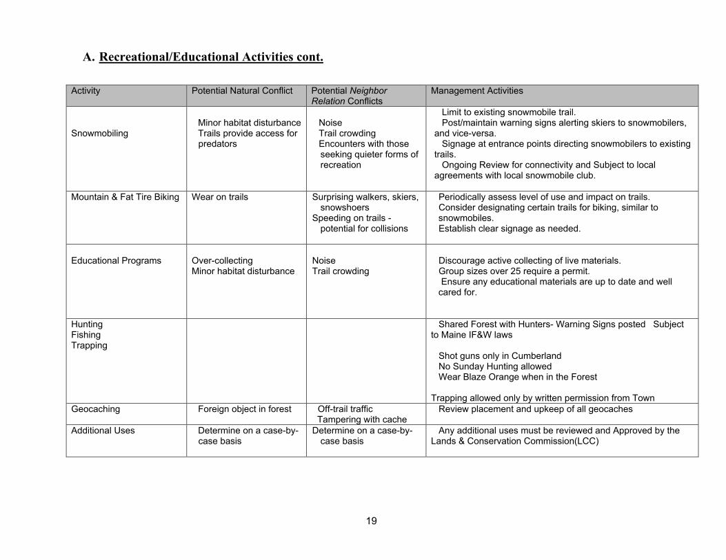
A. Recreational/Educational Activities cont.
Activity Potential Natural Conflict Potential Neighbor Relation Conflicts
Management Activities
Snowmobiling
Minor habitat disturbance Trails provide access for predators
Noise Trail crowding Encounters with those seeking quieter forms of recreation
Limit to existing snowmobile trail. Post/maintain warning signs alerting skiers to snowmobilers, and vice-versa. Signage at entrance points directing snowmobilers to existing trails. Ongoing Review for connectivity and Subject to local agreements with local snowmobile club.
Mountain & Fat Tire Biking Wear on trails Surprising walkers, skiers,
snowshoers Speeding on trails -
potential for collisions
Periodically assess level of use and impact on trails. Consider designating certain trails for biking, similar to
snowmobiles. Establish clear signage as needed.
Educational Programs
Over-collecting Minor habitat disturbance
Noise Trail crowding
Discourage active collecting of live materials. Group sizes over 25 require a permit. Ensure any educational materials are up to date and well
cared for.
Hunting Fishing Trapping
Shared Forest with Hunters- Warning Signs posted Subject to Maine IF&W laws Shot guns only in Cumberland No Sunday Hunting allowed Wear Blaze Orange when in the Forest Trapping allowed only by written permission from Town
Geocaching Foreign object in forest Off-trail traffic Tampering with cache
Review placement and upkeep of all geocaches
Additional Uses
Determine on a case-by-case basis
Determine on a case-by-case basis
Any additional uses must be reviewed and Approved by the Lands & Conservation Commission(LCC)
20
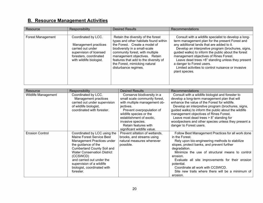
B. Resource Management Activities
Resource Responsibility Desired Results Recommendations Forest Management Coordinated by LCC.
Management practices carried out under supervision of licensed foresters, coordinated with wildlife biologist.
Retain the diversity of the forest types and other habitats found within the Forest. Create a model of biodiversity in a small-scale community forest, with multiple management objectives. Retain features that add to the diversity of the Forest, mimicking natural disturbance regimes.
Consult with a wildlife specialist to develop a long-term management plan for the present Forest and any additional lands that are added to it. Develop an interpretive program (brochures, signs, guided walks) to inform the public about the forest management objectives of Rines Forest. Leave dead trees >8” standing unless they present a danger to Forest users. Limited activities to control nuisance or invasive plant species.
Resource Responsibility Desired Results Recommendations Wildlife Management Coordinated by LCC.
Management practices carried out under supervision of wildlife biologist, coordinated with forester.
Conserve biodiversity in a small scale community forest, with multiple management ob-jectives. Prevent overpopulation of wildlife species or the establishment of exotic, invasive species. Retain features with significant wildlife value.
Consult with a wildlife biologist and forester to develop a long-term management plan that will enhance the value of the Forest for wildlife. Develop an interpretive program (brochures, signs, guided walks) to inform the public about the wildlife management objectives of Rines Forest. Leave most dead trees > 8” standing for woodpeckers and other species unless they present a danger to Forest users.
Erosion Control Coordinated by LCC using the Maine Forest Service Best Management Practices under the guidance of the Cumberland County Soil and Water Conservation District (CCSWCD)
and carried out under the supervision of a wildlife biologist, coordinated with forester.
Prevent siltation of wetlands, brooks, and streams using natural measures whenever possible.
Follow Best Management Practices for all work done in the Forest. Rely upon bio-engineering methods to stabilize slopes, protect banks, and prevent further degradation. Minimize the use of structural means to control erosion. Evaluate all site improvements for their erosion potential. Coordinate all work with CCSWCD. Site new trails where there will be a minimum of erosion.
21
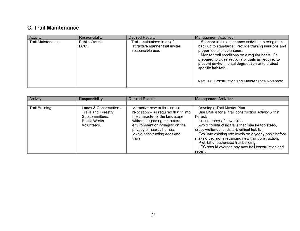
C. Trail Maintenance
Activity Responsibility Desired Results Management Activities Trail Maintenance Public Works.
LCC.
Trails maintained in a safe, attractive manner that invites responsible use.
Sponsor trail maintenance activities to bring trails back up to standards. Provide training sessions and proper tools for volunteers. Monitor trail conditions on a regular basis. Be prepared to close sections of trails as required to prevent environmental degradation or to protect specific habitats. Ref: Trail Construction and Maintenance Notebook.
Activity Responsibility Desired Results Management Activities Trail Building
Lands & Conservation - Trails and Forestry Subcommittees. Public Works. Volunteers.
Attractive new trails – or trail relocation – as required that fit into the character of the landscape without degrading the natural environment or infringing on the privacy of nearby homes. Avoid constructing additional trails.
Develop a Trail Master Plan. Use BMP’s for all trail construction activity within Forest. Limit number of new trails. Avoid constructing trails that may be too steep, cross wetlands, or disturb critical habitat. Evaluate existing use levels on a yearly basis before making decisions regarding new trail construction. Prohibit unauthorized trail building. LCC should oversee any new trail construction and repair.